|
AGENDA R |

Local Traffic Committee Meeting
MONDAY 21 JUNE 2021
10.00AM
|
|
Local Traffic Committee Meeting 21 June 2021 |
Function of the Local Traffic Committee
Background
Roads and Maritime Services (RMS) is legislated as the Authority responsible for the control of traffic on all NSW Roads. The RMS has delegated certain aspects of the control of traffic on local roads to councils. To exercise this delegation, councils must establish a local traffic committee and obtain the advice of the RMS and Police. The Inner West Council Local Traffic Committee has been constituted by Council as a result of the delegation granted by the RMS pursuant to Section 50 of the Transport Administration Act 1988.
Role of the Committee
The Local Traffic Committee is primarily a technical review and advisory committee which considers the technical merits of proposals and ensures that current technical guidelines are considered. It provides recommendations to Council on traffic and parking control matters and on the provision of traffic control facilities and prescribed traffic control devices for which Council has delegated authority. These matters are dealt with under Part A of the agenda and require Council to consider exercising its delegation.
In addition to its formal role as the Local Traffic Committee, the Committee may also be requested to provide informal traffic engineering advice on traffic matters not requiring Council to exercise its delegated function at that point in time, for example, advice to Council’s Development Assessment Section on traffic generating developments. These matters are dealt with under Part C of the agenda and are for information or advice only and do not require Council to exercise its delegation.
Committee Delegations
The Local Traffic Committee has no decision-making powers. The Council must refer all traffic related matters to the Local Traffic Committee prior to exercising its delegated functions. Matters related to State Roads or functions that have not been delegated to Council must be referred directly to the RMS or relevant organisation.
The Committee provides recommendations to Council. Should Council wish to act contrary to the advice of the Committee or if that advice is not supported unanimously by the Committee members, then the Police or RMS have an opportunity to appeal to the Regional Traffic Committee.
Committee Membership & Voting
Formal voting membership comprises the following:
· one representative of Council as nominated by Council;
· one representative of the NSW Police from each Local Area Command (LAC) within the LGA, being Newtown, Marrickville, Leichhardt and Ashfield LAC’s.
· one representative from the RMS; and
· State Members of Parliament (MP) for the electorates of Summer Hill, Newtown, Heffron, Canterbury, Strathfield and Balmain or their nominees.
Where the Council area is represented by more than one MP or covered by more than one Police LAC, representatives are only permitted to vote on matters which effect their electorate or LAC.
Informal (non-voting) advisors from within Council or external authorities may also attend Committee meetings to provide expert advice.
Committee Chair
Council’s representative will chair the meetings.
Public Participation
Members of the public or other stakeholders may address the Committee on agenda items to be considered by the Committee. The format and number of presentations is at the discretion of the Chairperson and is generally limited to 3 minutes per speaker. Committee debate on agenda items is not open to the public.
|
|
Local Traffic Committee Meeting 21 June 2021 |
|
AGENDA |
1 Apologies
2 Disclosures of Interest
3 Confirmation of Minutes Page
Minutes of 17 May 2021 Local Traffic Committee Meeting 5
4 Matters Arising from Council’s Resolution of Minutes
5 Part A – Items Where Council May Exercise Its Delegated Functions
Traffic Matters
ITEM Page
LTC0621(1) Item 1 Henry Street, Sydenham From Railway Road to George Street – Road and Footpath Improvement Works – Design Plan 10161 (Midjuburi-Marrickville Ward / Heffron Electorate / Inner West PAC) 30
LTC0621(1) Item 2 Ferris Lane, Annandale - Proposed Permanent Road Closure (Gulgadya-Leichhardt Ward/ Balmain Electorate/ Leichhardt PAC) 32
Parking Matters
ITEM Page
LTC0621(1) Item 3 Dalhousie Street, Haberfield - Bus Zone Permanent Relocation (Gulgadya-Leichhardt Ward/Summer Hill Electorate/Burwood PAC) 39
LTC0621(1) Item 4 Smith
Street, Summer Hill- Appeal On Refused Application of a Mobility (Disabled)
Parking Space Outside No.60 Smith Street.
(Djarrawunang-Ashfield Ward/Summer Hill Electorate/Burwood PAC) 41
LTC0621(1) Item 5 Arthur
Street, Ashfield (at Joseph Street)- Proposed New Speed Cushion and Kerb
Blister.
(Djarrawunang-Ashfield Ward/Summer Hill Electorate/Burwood PAC) 44
LTC0621(1) Item 6 Spencer
Street and Carrington Street, Summer Hill-Proposed Extension of Resident
Parking Scheme (AREA 13).
(Djarrawunang-Ashfield Ward/Summer Hill Electorate/Burwood PAC) 47
LTC0621(1) Item 7 Carrington
Street, Summer Hill- Request for 1/2 Hour Period Parking Adjacent to No. 162
Old Canterbury Road, Summer Hill.
(Djarrawunang-Ashfield Ward/Summer Hill Electorate/Burwood PAC) 51
Late Items
Nil at time of printing.
6 Part B - Items for Information Only
ITEM Page
LTC0621(1) Item 8 Moodie Street, Rozelle - Proposed No Left Turn Restrictions (Baludarri - Balmain /Balmain Electorate/ Leichhardt PAC) 54
LTC0621(1) Item 9 Council
Resolution for Local Traffic Committee March 2021 Item 7 - Unwins Bridge Road,
Way Street, Toyer Street & Collins Street, St Peters - Formalising Parking
Restrictions Around Tempe High School
(Midjuburi - Marrickville Ward/ Heffron Electorate/ Inner West PAC) 57
LTC0621(1) Item 10 Campbell Street ST PETERS – C0621(1) Item 30 Mayoral Minute and C0621(1) Item 17 Notice of Motion - Pedestrian safety on Campbell Street, St Peters (MIDJUBURI - MARRICKVILLE WARD/ HEFFRON ELECTORATE/ INNER WEST PAC) 59
7 Part C - Items for General Advice
ITEM Page
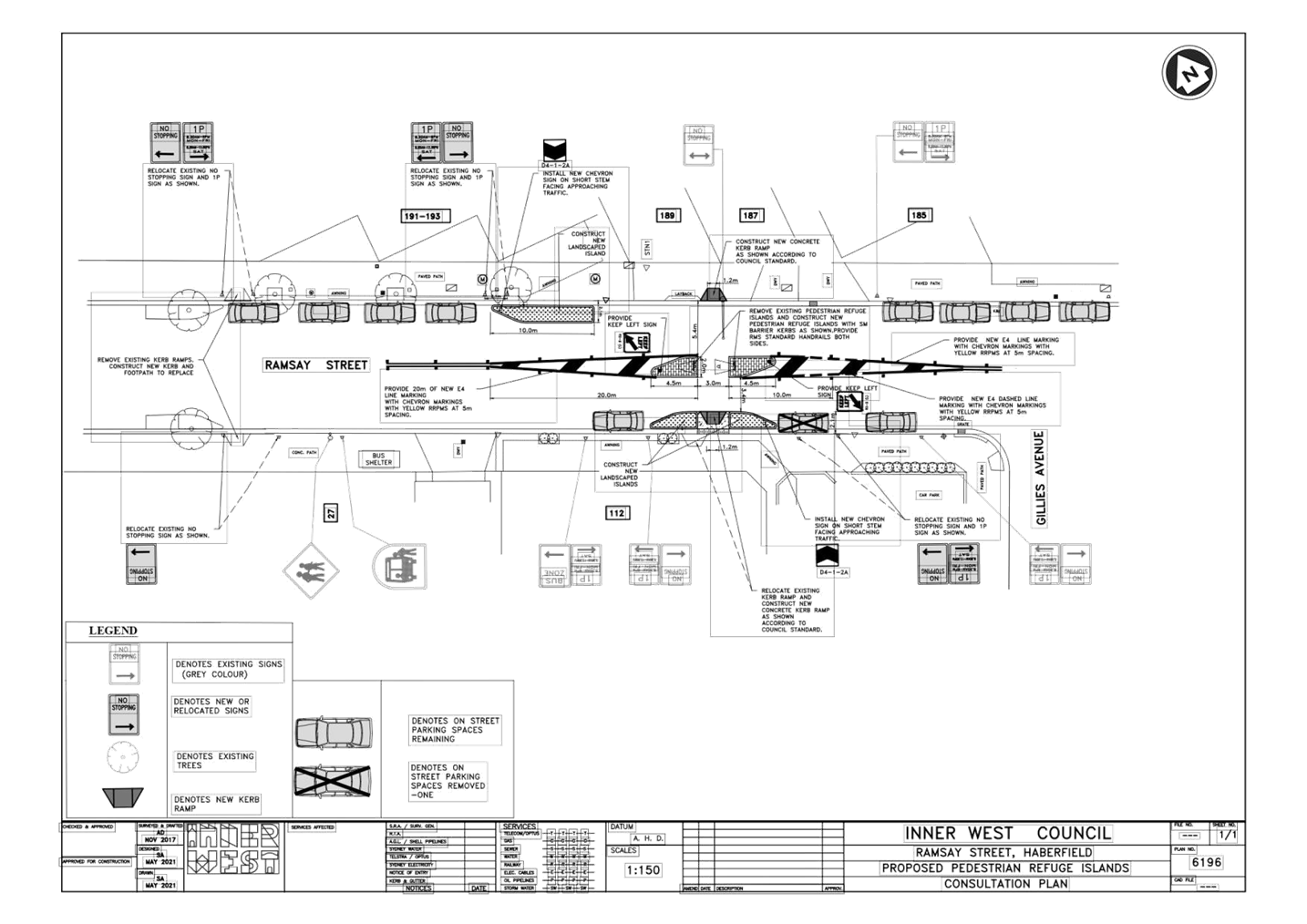
LTC0621(1) Item 11 Ramsay Street, Haberfield - New Pedestrian Refuge Island (Gulgadya-Leichhardt Ward/ Summer Hill Electorate/ Burwood PAC) 64
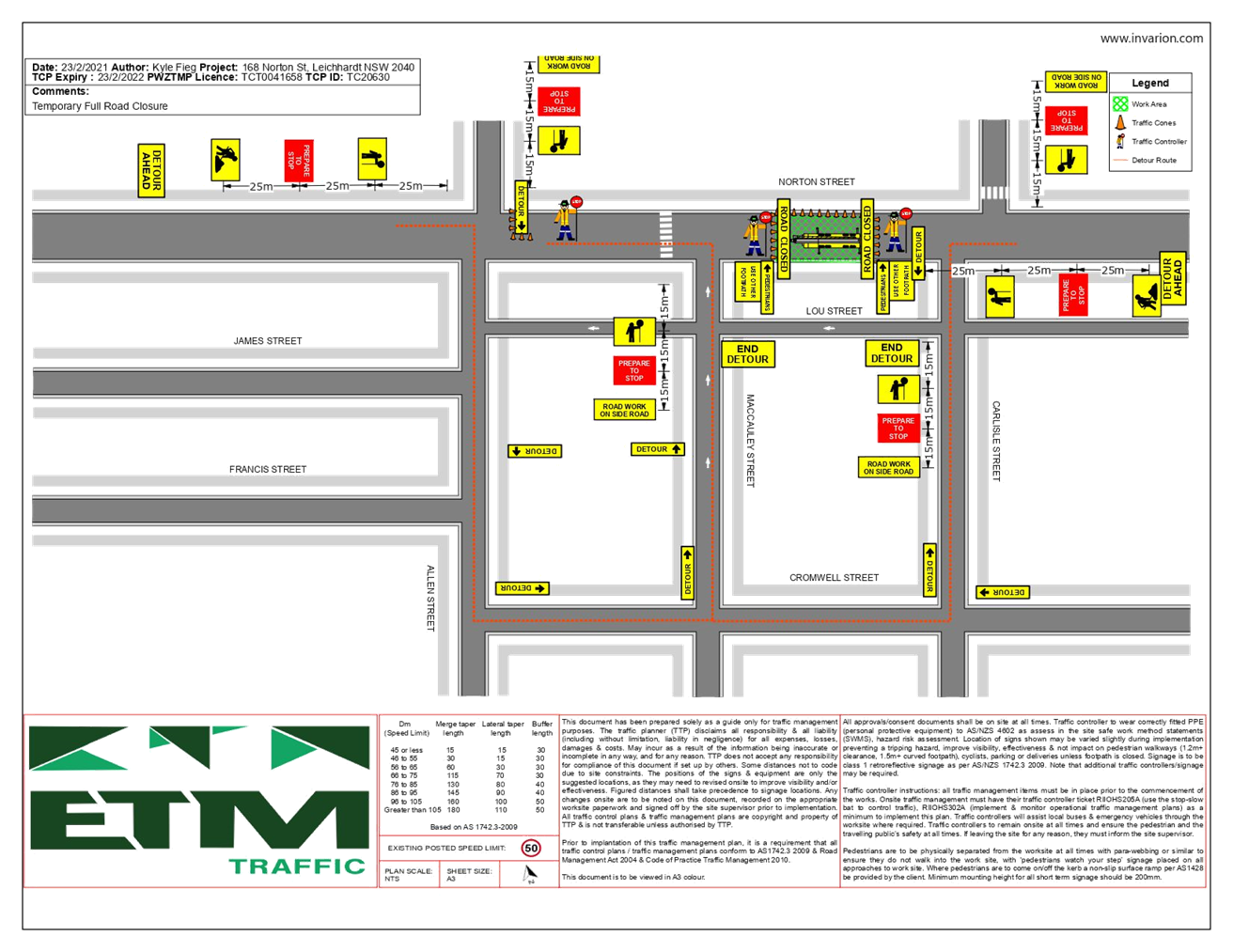
LTC0621(1) Item 12 168 Norton Street (Between Carlisle Street and Maccauley Street), Leichhardt - Road Occupancy (Gulgadga - Leichhardt/ Balmain Electorate/ Leichhardt PAC) 67
8 General Business
9 Close of Meeting
|
|
Local Traffic Committee Meeting 21 June 2021 |
Minutes of Local Traffic Committee Meeting
Held at Level 6, Ashfield Service Centre
Meeting commenced at 10.00AM
ACKNOWLEDGEMENT OF COUNTRY BY CHAIRPERSON
I acknowledge the Gadigal and Wangal people of the Eora nation on whose country we are meeting today, and their elders past and present.
COMMITTEE REPRESENTATIVES PRESENT
|
Clr Victor Macri |
Councillor – Midjuburi-Marrickville Ward (Chair) |
|
Bill Holliday |
Representative for Jamie Parker MP, Member for Balmain |
|
Chris Woods |
Representative for Ron Hoenig MP, Member for Heffron |
|
Maryanne Duggan |
Representative for Jodi McKay MP, Member for Strathfield |
|
SC Germaine Grant |
NSW Police – Burwood Police Area Command |
|
SC Anthony Kenny |
NSW Police – Inner West Police Area Command |
|
Tanmila Samin Islam |
Transport for NSW (TfNSW) |
|
Mark Carruthers |
Transport for NSW (TfNSW) |
|
|
|
|
NON VOTING MEMBERS IN ATTENDANCE |
|
|
|
|
|
Colin Jones |
Inner West Bicycle Coalition (IWBC) |
|
Clr Marghanita da Cruz |
Councillor – Gulgadya-Leichhardt Ward (Alternative Chair) |
|
Manod Wickramasinghe |
IWC’s Traffic and Transport Planning Manager |
|
George Tsaprounis |
IWC’s Coordinator Traffic Engineering Services (South) |
|
Sunny Jo |
IWC’s Coordinator Traffic Engineering Services (North) |
|
Stephen Joannidis |
IWC’s Urban Amenity Improvement Delivery Manager |
|
Ryan Hawken |
IWC’s Greenway Delivery Project Manager |
|
Christina Ip |
IWC’s Business Administration Officer |
|
|
|
|
VISITORS |
|
|
|
|
|
Nil. |
|
|
|
|
|
APOLOGIES: |
|
|
|
|
|
Cathy Peters |
Representative for Jenny Leong MP, Member for Newtown |
|
|
|
DISCLOSURES OF INTERESTS:
Nil.
CONFIRMATION OF MINUTES
|
The Minutes of the Local Traffic Committee meeting held in April 2021 were confirmed. |
MATTERS ARISING FROM COUNCIL’S RESOLUTION OF MINUTES
It was noted that amendment (a) to the Local Traffic Committee March 2021, as adopted at Council’s meeting on 13 April 2021, was incorrect. The correct amendment is as follows:
a) That Council refer concerns on Item 7 Unwins Bridge Road, Way Street, Toyer Street & Collins Street, St Peters - Formalising Parking Restrictions around Tempe High School (Midjuburi - Marrickville Ward/ Heffron Electorate/ Inner West PAC) by residents in Toyer Street back to the Local Traffic Committee to amend point 5 to a ‘10 metre No Stopping’ on the Northern side of Toyer Street east of Collins Street and delete point 4.
The Local Traffic Committee recommendations of its meeting held in April 2021 are awaiting adoption.
EMAIL CONFIRMATION OF OFFICER’S RECOMMENDATION:
The representative for NSW Police – Inner West supported the Officer’s recommendations for the items in their PAC.
The representative for the Member for Strathfield supported the Officer’s recommendations.
|
LTC0521(1) Item 1 Westconnex M5 – St Peters Interchange Active Transport Works Part 2: Proposed Cycleway Extension at Bedwin Road (Midjuburi - Marrickville and Damun – Stanmore Ward / Summer Hill and Newtown Electorate / Inner West PAC) |
|
SUMMARY · As part of Westconnex Planning Condition (B51, Pedestrian and Cycle Implementation Strategy), Council has engaged a Consultant to design and construct the connection between Council’s existing bicycle network on Edgeware Road, Darley Street and Lord Street to the newly constructed Bedwin Road Bridge. The design will provide: · A dedicated off-road cycle path as part of the newly constructed Bedwin Road Bridge and Council’s existing bicycle network on Darley Street, Lord Street and Edinburgh Road, · Upgrades to the signalised intersection of Edgeware Road, Edinburgh Road and Bedwin Road, and · Upgraded infrastructure to the existing network on Edgeware Road and Darley Street. · · Council is seeking the approval of the Local Traffic Committee to progress with construction of the measures contained herein.
Officer’s Recommendation
THAT the detailed design plans from Certus Projects (drawing no’s 0224-RP-003, 0224-RD-0101 and 0224-RD-0102 dated 16 April 2021) be approved for construction commencement.
DISCUSSION
The IWBC representative raised concerns with the proposed removal of the cycle lane markings on Bedwin Road at the intersection of Edgeware Road. Council Officers advised that the proposal to remove the cycle lane is based on safety reasons in not wanting to direct cyclists to a road that is not a designated cycle route.
The TfNSW representative had no issues with the plans; however, requested that the recommendation state that the plans be approved for construction commencement, subject to approval from TfNSW in relation to the traffic signal related works. The Committee members agreed with this amendment to the Officer’s recommendation.
COMMITTEE RECOMMENDATION
THAT the detailed design plans from Certus Projects (drawing no’s 0224-RP-003, 0224-RD-0101 and 0224-RD-0102 dated 16 April 2021) be approved for construction commencement, subject to Transport for NSW approval.
For motion: Unanimous
|
|
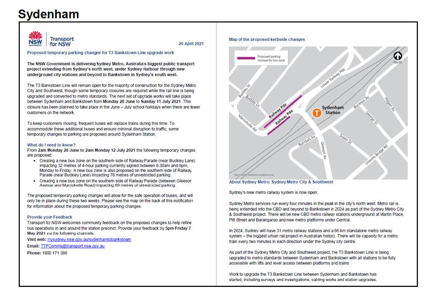
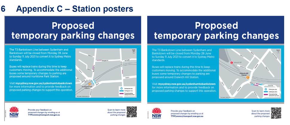
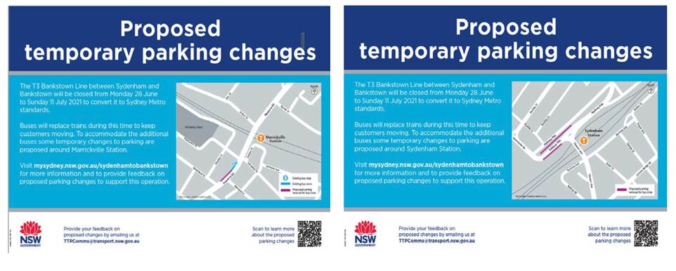
LTC0521(1) Item 2 Garnet Street and Dudley Street, Dulwich Hill; Illawarra Road and Marrickville Road, Marrickville; and (Lower) Railway Parade, Sydenham - Bus Replacements During Major Rail Shutdown - Temporary Parking Changes During T3 Line Upgrade For Sydney Metro - (Midjuburi -Marrickville Ward / Summer Hill Electorate / Inner West PAC) |
|
SUMMARY
Council has been notified by Transport for NSW (TfNSW) that Sydney Metro works will involve a major rail shutdown of the Sydenham to Bankstown rail line (3) between 28 June and 11 July 2021. During the shutdown buses will replace train services along the T3 line and to accommodate the increased bus movements and necessary holding areas some short-term parking changes are required at a number of locations. Specifically, TfNSW is requesting approval for the temporary conversion of multiple parking spaces at the following locations: Garnet Street and Dudley Street, Dulwich Hill; Illawarra Road and Marrickville Road, Marrickville; and Railway Parade (lower section), Sydenham. It is recommended that no objections be raised, and Council approves the temporary short-term parking changes at the identified locations during the rail shutdowns.
Officer’s Recommendation
THAT this report be received and noted and the following temporary short-term parking changes from Friday 25 June 2021 to Monday 12 July 2021 be approved and implemented by TfNSW:
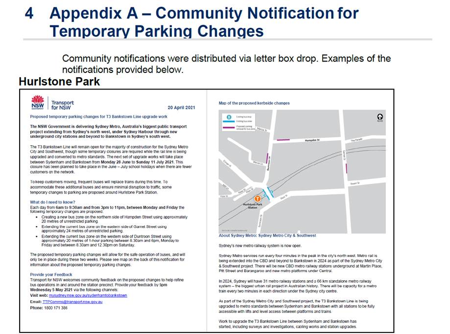
Garnet Street - Hurlstone Park Station Precinct (4 parking spaces) 1. The short-term conversion of 24m (4 parking spaces) ‘unrestricted parking’ on the eastern side of Garnet Street (between The Parade and Ewart Street) to a ‘Bus Zone M-F 6 am – 9:30 am and 3 pm – 11 pm’; be APPROVED, in order to provide a temporary bus layover area with adequate draw-in and out length;
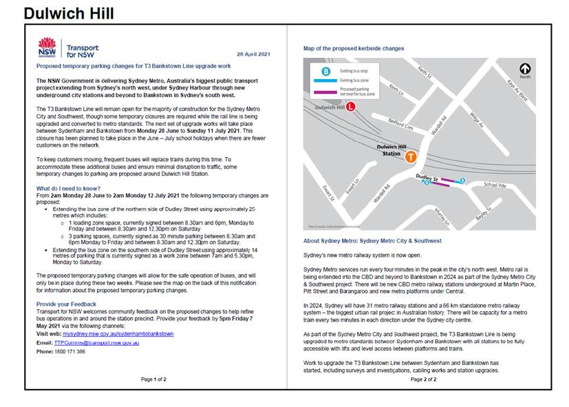
Dudley Street - Dulwich Hill Station Precinct (6 parking spaces) 2. The short-term conversion of 7m (1 parking space) ‘Loading Zone 8:30 am – 6 pm Mon – Fri & 8:30 am – 12:30 pm Sat’ on the northwestern side of Dudley Street (between Wardell Road and School Parade) to a ‘Bus Zone’; be APPROVED in order to provide an additional bus bay with adequate draw-in length; 3. The short-term conversion of 18m (3 parking spaces) ‘P30 min 8:30 am – 6 pm Mon – Fri & 8:30 am – 12:30 pm Sat’ on the northwestern side of Dudley Street (between Wardell Road and School parade) to a ‘Bus Zone’; be APPROVED in order to provide an additional bus bay with adequate draw-in length; 4. The short-term conversion of 18m (2 parking spaces) ‘Works Zone 7 am – 5:30 pm Mon – Sat’ on the southeastern side of Dudley Street (between School Parade and Wardell Road) to a ‘Bus Zone’; be APPROVED in order to provide an additional bus bay with adequate draw-in length;
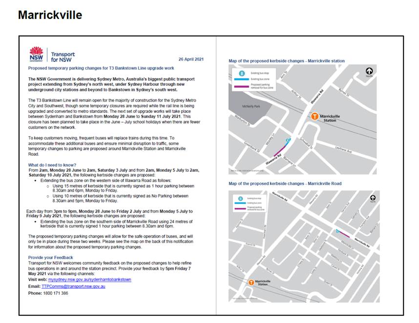
Illawarra Road - Marrickville Station Precinct (4 parking spaces) 5. The short-term conversion of 15m (2 parking spaces) ‘1P 8:30 am – 6 pm’ on the northwestern side of Illawarra Road (between Warburton Street and Greenbank Street) to a ‘Bus Zone Mon-Fri only’; be APPROVED in order to provide an additional bus bay with adequate draw-in length; 6. The short-term conversion of 10m (2 parking spaces) ‘No Parking 8:30 am – 5 pm Mon - Fri’ on the northwestern side of Illawarra Road (between Warburton Street and Greenbank Street) to a ‘Bus Zone Mon-Fri only’; be APPROVED in order to provide an additional bus bay with adequate draw-in length;
Marrickville Road, Marrickville NSW 2204 (4 parking spaces)
7. The short-term conversion of 24m (4 parking spaces) ‘1P 8:30 am – 6 pm’ on the southeast kerb of Marrickville Road (between Frampton Avenue and Gladstone Street) to a ‘Bus Zone 3pm – 9pm Mon-Fri only’; be APPROVED in order to provide an additional bus bay with adequate draw-in length;
8. The short-term conversion of 69m (11 parking spaces) ‘unrestricted parking’ on the southeast kerb of Railway Parade (between Gleeson Avenue and Marrickville Road) to a ‘Bus Zone’; be APPROVED in order to provide additional layover bus bays with adequate draw-in length;
9. The short-term conversion of 78m (28 parking spaces) ‘unrestricted parking’ on the northwest kerb of Railway Parade (Lower) (between Sydenham Road and Marrickville Road) to a ‘Bus Zone’; be APPROVED in order to provide additional layover bus bays with adequate draw-in length;
10. The short-term conversion of 32m (11 parking spaces) ‘4P 8:30 am – 6 pm Mon - Fri’ on the northwest kerb of Railway Parade (Lower) (between Gleeson Avenue and Marrickville Road) to a ‘Bus Zone’; be APPROVED in order to provide additional layover bus bays with adequate draw-in length; and
11. The applicant and Council Rangers be advised in terms of this report.
DISCUSSION
Council Officers advised that TfNSW have recently sent the consultation outcomes report to Council. The report is attached to these minutes.
The TfNSW representative questioned who is responsible for removal of the signs. Council Officers advised that the applicant is responsible for installing and removing signs at the applicant’s cost.
The Committee members agreed with the Officer’s recommendation.
COMMITTEE RECOMMENDATION
THAT this report be received and noted and the following temporary short-term parking changes from Friday 25 June 2021 to Monday 12 July 2021 be approved and implemented by TfNSW:
Garnet Street - Hurlstone Park Station Precinct (4 parking spaces) 1. The short-term conversion of 24m (4 parking spaces) ‘unrestricted parking’ on the eastern side of Garnet Street (between The Parade and Ewart Street) to a ‘Bus Zone M-F 6 am – 9:30 am and 3 pm – 11 pm’; be APPROVED, in order to provide a temporary bus layover area with adequate draw-in and out length;
Dudley Street - Dulwich Hill Station Precinct (6 parking spaces) 2. The short-term conversion of 7m (1 parking space) ‘Loading Zone 8:30 am – 6 pm Mon – Fri & 8:30 am – 12:30 pm Sat’ on the northwestern side of Dudley Street (between Wardell Road and School Parade) to a ‘Bus Zone’; be APPROVED in order to provide an additional bus bay with adequate draw-in length; 3. The short-term conversion of 18m (3 parking spaces) ‘P30 min 8:30 am – 6 pm Mon – Fri & 8:30 am – 12:30 pm Sat’ on the northwestern side of Dudley Street (between Wardell Road and School parade) to a ‘Bus Zone’; be APPROVED in order to provide an additional bus bay with adequate draw-in length; 4. The short-term conversion of 18m (2 parking spaces) ‘Works Zone 7 am – 5:30 pm Mon – Sat’ on the southeastern side of Dudley Street (between School Parade and Wardell Road) to a ‘Bus Zone’; be APPROVED in order to provide an additional bus bay with adequate draw-in length;
Illawarra Road - Marrickville Station Precinct (4 parking spaces) 5. The short-term conversion of 15m (2 parking spaces) ‘1P 8:30 am – 6 pm’ on the northwestern side of Illawarra Road (between Warburton Street and Greenbank Street) to a ‘Bus Zone Mon-Fri only’; be APPROVED in order to provide an additional bus bay with adequate draw-in length; 6. The short-term conversion of 10m (2 parking spaces) ‘No Parking 8:30 am – 5 pm Mon - Fri’ on the northwestern side of Illawarra Road (between Warburton Street and Greenbank Street) to a ‘Bus Zone Mon-Fri only’; be APPROVED in order to provide an additional bus bay with adequate draw-in length;
Marrickville Road, Marrickville NSW 2204 (4 parking spaces)
7. The short-term conversion of 24m (4 parking spaces) ‘1P 8:30 am – 6 pm’ on the southeast kerb of Marrickville Road (between Frampton Avenue and Gladstone Street) to a ‘Bus Zone 3pm – 9pm Mon-Fri only’; be APPROVED in order to provide an additional bus bay with adequate draw-in length;
8. The short-term conversion of 69m (11 parking spaces) ‘unrestricted parking’ on the southeast kerb of Railway Parade (between Gleeson Avenue and Marrickville Road) to a ‘Bus Zone’; be APPROVED in order to provide additional layover bus bays with adequate draw-in length;
9. The short-term conversion of 78m (28 parking spaces) ‘unrestricted parking’ on the northwest kerb of Railway Parade (Lower) (between Sydenham Road and Marrickville Road) to a ‘Bus Zone’; be APPROVED in order to provide additional layover bus bays with adequate draw-in length;
10. The short-term conversion of 32m (11 parking spaces) ‘4P 8:30 am – 6 pm Mon - Fri’ on the northwest kerb of Railway Parade (Lower) (between Gleeson Avenue and Marrickville Road) to a ‘Bus Zone’; be APPROVED in order to provide additional layover bus bays with adequate draw-in length; and
11. The applicant and Council Rangers be advised in terms of this report.
For motion: Unanimous
|
|
LTC0521(1) Item 3 Eliza Street, Newtown - Proposed 'Motor Bike Only' Restrictions (Damum-Stanmore Ward / Newtown Electorate / Inner West PAC) |
|
SUMMARY
Council has received concerns regarding inadequate motorbike parking in the Newtown area in the vicinity of Lennox Street and/or Eliza Street, Newtown. A proposal to install a 4.0 metre ‘Motor Bike Only’ parking zone on the eastern side of Eliza Street south of its intersection with Lennox Street, Newtown was distributed to local residents and subsequent to the feedback and observation it is now recommended that the location of the dedicated motorbike parking be located around the corner on Lennox Street outside No.80 Lennox Street. This report provides the results of the motorbike parking investigation.
Officer’s Recommendation
THAT a length of 4.0m of ‘Motor Bike Only’ parking be installed on the southern side of Lennox Street, outside No.80 Lennox Street, Newtown starting from the existing ‘No stopping’ restrictions and replacing the existing 2P restrictions.
DISCUSSION
The Committee members agreed with the Officer’s recommendation.
COMMITTEE RECOMMENDATION
THAT a length of 4.0m of ‘Motor Bike Only’ parking be installed on the southern side of Lennox Street, outside No.80 Lennox Street, Newtown starting from the existing ‘No stopping’ restrictions and replacing the existing 2P restrictions.
For motion: Unanimous
|
|
LTC0521(1) Item 4 Hollands Avenue, Marrickvilleway Street, Tempe – Request For 'No Parking' Restrictions (Midjuburi – Marrickville Ward / Summer Hill Electorate / Inner West PAC) |
|
SUMMARY
Currently vehicles, including Council Waste Services vehicles, are having difficulty in manoeuvring around the bend in Hollands Avenue, Marrickville due to vehicles being parked near the bend therefore Council is proposing to install a 20 metre length of ‘No Parking’ restrictions on the inner side of the bend in Hollands Avenue, Marrickville to improve access in the street.
Officer’s Recommendation
THAT a 20 metre length ‘No Parking’ zone be installed on the inner bend in Hollands Avenue, Marrickville (northern end starting opposite No.52 extending eastern side to the midpoint of property No. 17) be approved in order to improve access in the one-way street.
DISCUSSION
The Committee members agreed with the Officer’s recommendation.
COMMITTEE RECOMMENDATION
THAT a 20 metre length ‘No Parking’ zone be installed on the inner bend in Hollands Avenue, Marrickville (northern end starting opposite No.52 extending eastern side to the midpoint of property No. 17) be approved in order to improve access in the one-way street.
For motion: Unanimous
|
|
LTC0521(1) Item 5 Local Bicycle Route 3 (LR03) - Frazer Park to Marrickville Road – Amendment to Detailed Design Plans at Two Intersections (Marrickville Ward / Summer Hill Electorate / Inner West LAC) |
|
SUMMARY
It is proposed to make a minor amendment to the approved detailed design plans for Local Route 3 (LR03) bicycle route at two separate intersections. The current approved construction plans only specify resurfacing treatments with AC10 at George Street/Livingstone Road and Pile Street/Livingstone Road intersections and it is proposed, for consistency, to match those intersections with a similar treatment to that of the existing stamped AC “Duratherm” finish entry treatment at Enfield Street/Livingstone Road, Marrickville. It is recommended that the proposed detailed design plan amendments be approved.
Officer’s Recommendation
THAT an amendment to the detailed design plans for LR03 at the intersections of George Street/Livingstone Road and Pile Street/Livingstone Road to incorporate a stamped AC “Duratherm” finish entry treatment be approved.
DISCUSSION
The Committee members agreed with the Officer’s recommendation.
COMMITTEE RECOMMENDATION
THAT an amendment to the detailed design plans for LR03 at the intersections of George Street/Livingstone Road and Pile Street/Livingstone Road to incorporate a stamped AC “Duratherm” finish entry treatment be approved.
For motion: Unanimous
|
|
LTC0521(1) Item 6 Bay Run Upgrade and Diversion Route (Gulgadya-Leichhardt and Baludarri-Balmain/Summer Hill and Balmain Electorates/Burwood and Leichhardt PAC) |
|
SUMMARY
Council is proposing upgrade of the Bay Run between UTS Haberfield Rowers Club and Lilyfield Road, including the Lilyfield Road bridge. Due to the limited width between the City West Link and Iron Cove, a diversion route for all pedestrians and cyclists is proposed for the duration of the works to facilitate construction.
Officer’s Recommendation
THAT:
1. The plans for the proposed Bay Run upgrade be approved for construction.
2. The proposed diversion plan for pedestrian and cyclists for works along the Bay Run be approved.
3. A request be made to Transport for NSW to consider the introduction of an eastern pedestrian leg at the Intersection of City West Link, Timbrell Drive and Mortley Ave as part of future upgrades planned for the intersection
DISCUSSION
A number of concerns were noted from Committee members including the accessibility of the Robson Park path at the intersection of Boomerang Street and Crescent Street, and how the restricted turning area and cul de sac will impact users of the boat ramp and potentially create conflict with road users and pedestrians.
The representative for the Member for Balmain requested an additional signalised pedestrian crossing leg on the eastern side of the City West Link where it intersects with Mortley Avenue and Timbrell Drive. The TfNSW representative advised that this has been considered previously and it was decided that a crossing would not work due to congestion at the intersection during peak hours. However, an additional pedestrian crossing can be considered again after WestConnex works in the area are completed.
The Committee members agreed with the Officer’s recommendation.
COMMITTEE RECOMMENDATION
THAT:
1. The plans for the proposed Bay Run upgrade be approved for construction.
2. The proposed diversion plan for pedestrian and cyclists for works along the Bay Run be approved.
3. A request be made to Transport for NSW to consider the introduction of an eastern pedestrian leg at the Intersection of City West Link, Timbrell Drive and Mortley Ave as part of future upgrades planned for the intersection
For motion: Unanimous
|
|
LTC0521(1)
Item 7 Review- Detailed Works (Traffic & Parking) in Trafalgar
Street, Petersham-RSL
Petersham Development- DA201800173& Implementation
of Regional Bicycle Route 7 (RR7). |
|
SUMMARY
Council at its meeting on the 13 April 2021 resolved that the detailed works pertaining to the above subject matter go back to the Local Traffic Committee (LTC) for further review. The detailed works were explained in the report to the Local Traffic Committee at its meeting on the 15 March 2021 (Item 3) with attachments and the recommendation below as supported by the Traffic Committee. Concerns by Council were only raised with regards to recommendation point No. 5 of the Local Traffic Committee recommendation, that is, as to the need and necessity in applying permanent ‘No Right Turn 3.00pm-7.00pm Monday-Friday’ restrictions from New Canterbury Road into Regent Street with the affect and need to detour long distances around the area. Further information is provided in this report in relation to recommendation point no. 5, including comments from TfNSW regarding this requirement.
Officer’s Recommendation
THAT:
1. The report be received and noted;
In reference to the report to the Local Traffic Committee meeting on 15 March 2021:
2. The detailed proposed traffic and parking works in Trafalgar Street and its intersection with Regent Street, Petersham, on attached drawing by Norton-Jago/ACE Pty Ltd- signage and line marking plan revision C Sheet 1 drawing No. C46.8, be APPROVED, subject to the following;
a) Double barrier BB lines be extended in Trafalgar Street right through across the RSL carpark access and Forzzard Lane; b) An additional ‘No Right Turn’ sign be placed on the eastern footway side of the RSL carpark facing east bound traffic in Trafalgar Street; c) The ‘No Right Turn’ as shown on the northern kerb side island in Trafalgar Street opposite the RSL carpark and Forzzard Lane, have a supplementary sign underneath reading ‘INTO RSL CAR PARK & FOZZARD LANE’; d) The ‘No Stopping (arrow right)’ sign on the southern side of Trafalgar Street, to the west of Fozzard Lane be changed to read ‘No Stopping (arrow left)’ and the ‘No Parking’ restrictions be reinstated over the driveways between Fozzard Lane and no. 313-315 Trafalgar Street; e) No trees be planted along the footway within the Bus Zone due to the likelihood of interference to the operation of the Bus Stop; f) The builder prepare/provide for the bus pad/footings and other infrastructure works for the relocation of the bus stop and Council approved shelter as shown on the plan to the satisfaction of Council; g) The builder is to install all signs and line marking as per attached drawing by Norton-Jago/ACE Pty Ltd- signage and line marking plan revision C Sheet 1 drawing No. C46.8, including all modifications (a) to (f) as listed above to the satisfaction of Council;
3. The revised drawing C46.8 with modifications be submitted to TFNSW for its review and approval.
4. The temporary relocation of the Bus Stop on the southern side of Trafalgar Street, to a position further east of Regent Street between No. 273 and No. 265 Trafalgar Street be approved, subject to specific dates being provided to Council’s Traffic & Transport Planning Manager and affected residents being notified at least two weeks prior to the changes.
5. The Traffic Management Plan prepared by Barker Ryan Steward in Attachment 11 for the installation of ‘No Right Turn 3.00pm-7.00pm Mon-Fri.,’ from New Canterbury Road into Regent Street, be submitted to TFNSW for consideration and approval, and that the builder work with the TFNSW to install the required signs.
DISCUSSION
The Committee members agreed with the Officer’s recommendation.
COMMITTEE RECOMMENDATION
THAT:
1. The report be received and noted;
In reference to the report to the Local Traffic Committee meeting on 15 March 2021:
2. The detailed proposed traffic and parking works in Trafalgar Street and its intersection with Regent Street, Petersham, on attached drawing by Norton-Jago/ACE Pty Ltd- signage and line marking plan revision C Sheet 1 drawing No. C46.8, be APPROVED, subject to the following;
a) Double barrier BB lines be extended in Trafalgar Street right through across the RSL carpark access and Forzzard Lane; b) An additional ‘No Right Turn’ sign be placed on the eastern footway side of the RSL carpark facing east bound traffic in Trafalgar Street; c) The ‘No Right Turn’ as shown on the northern kerb side island in Trafalgar Street opposite the RSL carpark and Forzzard Lane, have a supplementary sign underneath reading ‘INTO RSL CAR PARK & FOZZARD LANE’; d) The ‘No Stopping (arrow right)’ sign on the southern side of Trafalgar Street, to the west of Fozzard Lane be changed to read ‘No Stopping (arrow left)’ and the ‘No Parking’ restrictions be reinstated over the driveways between Fozzard Lane and no. 313-315 Trafalgar Street; f) The builder prepare/provide for the bus pad/footings and other infrastructure works for the relocation of the bus stop and Council approved shelter as shown on the plan to the satisfaction of Council; g) The builder is to install all signs and line marking as per attached drawing by Norton-Jago/ACE Pty Ltd- signage and line marking plan revision C Sheet 1 drawing No. C46.8, including all modifications (a) to (f) as listed above to the satisfaction of Council;
3. The revised drawing C46.8 with modifications be submitted to TFNSW for its review and approval.
4. The temporary relocation of the Bus Stop on the southern side of Trafalgar Street, to a position further east of Regent Street between No. 273 and No. 265 Trafalgar Street be approved, subject to specific dates being provided to Council’s Traffic & Transport Planning Manager and affected residents being notified at least two weeks prior to the changes.
5. The Traffic Management Plan prepared by Barker Ryan Steward in Attachment 11 for the installation of ‘No Right Turn 3.00pm-7.00pm Mon-Fri.,’ from New Canterbury Road into Regent Street, be submitted to TFNSW for consideration and approval, and that the builder work with the TFNSW to install the required signs.
For motion: Unanimous
|
|
LTC0521(1) Item 8 Trafalgar Lane, Annandale - Proposed 'No Parking' Restrictions (Baludarri-Balmain/Balmain Electorate/Leichhardt PAC) |
|
SUMMARY
Council has received concerns from a resident of Trafalgar Street, Annandale regarding vehicles parking on the eastern side of Trafalgar Lane, Annandale and subsequently obstructing rear driveway access for properties No.195 and No.197 Trafalgar Street, Annandale. An investigation has now been completed and is presented in this report.
Officer’s Recommendation
THAT a 11.1m ‘No Parking’ zone be installed on the eastern side of Trafalgar Lane between the rear access driveways of No.222 and No.226 Nelson Street and opposite to the rear garage of No.195 and No.197 Trafalgar Street, Annandale.
DISCUSSION
Council Officers advised that a number of residents wished to address the Committee on this matter; however, could not attend today. As such the Committee members agreed to defer this item to the next LTC meeting when the residents can attend.
COMMITTEE RECOMMENDATION
THAT the item be deferred to the Local Traffic Committee meeting on 21 June 2021.
For motion: Unanimous
|
General Business
|
LTC0521 Item 9 Request for 40km speed zone on Campbells Street, St Peters
|
|
The representative for the Member for Heffron tabled correspondence to Council requesting that the speed limit on Campbell Street be reduced to 40km/h, in light of a recent near-miss involving a heavy vehicle that ran a red light while school children were crossing at the intersection of Campbell Street and St Peters Street. |
|
LTC0521 Item 10 Tempe Bunnings LATM
|
|
Due to concerns from residents, the representative for the Member for Heffron requested that:
Council Officer advised that TfNSW have to agree on the traffic signals and the developer has to agree to modify the design. TfNSW has previously not supported the provision of the traffic signals because of the impact to traffic flow along Princes Highway and the distance between the existing traffic signals. The developer have previously indicated that they are unlikely to change the approved plans. The provision of the traffic signals will be reconsidered by TfNSW. The finalisation of the LATM will be on hold until an outcome on the traffic signals is determined.
|
|
LTC0521 Item 11 Request for 40km/h speed limit on Marion Street, Leichhardt
|
|
Clr da Cruz stated that an accident between a vehicle and pedestrian occurred recently on Marion Street outside Leichhardt Town Hall and requested that the speed limit be reduced to 40km/h. Council Officers stated that they have been supportive of reducing the speed limit on this section of Marion Street/Leichhardt Street to connect the existing 40km/h HPAA on Norton Street to the 40km/h area on Styles Street and have requested for this through TfNSW.
|
|
LTC0521 Item 12 Greenway works on Old Canterbury Road, Edward Street and Weston Street, Summer Hill
|
|
The IWBC representative asked about the status of the lights at Old Canterbury Road /Edwards Street/Weston Street and the closure of Weston Street in relation to the Greenway project. Council Officers advised that the developer was notified last year that if they did not submit their detailed design to Council by September 2020, the developer’s bond would be confiscated and used by Council to undertake the works. Council will now be undertaking the works that will become part of the main agreement works package, along with the other corridor works. Council Officers expect the works to be undertaken in 2023.
|
|
LTC0521 Item 13 Update to one-way treatment for Warren Road, Marrickville
|
|
Clr Macri asked for an update to the Warren Road one-way treatment. Council Officers advised that they are awaiting feedback from TfNSW regarding the most recent plans. The TfNSW project team have prioritised this proposal.
|
|
LTC0521 Item 14 Bus stop on Gordon Crescent in front of Stanmore Station
|
|
Clr Macri stated that since the widening of the Gordon Crescent footpath in front of Stanmore Station, buses have not been stopping close enough to the kerb at the bus stop and blocking traffic as a result. Council Officers advised that Transit Systems will be contacted regarding the issue and the bus bay will be assessed to determine if it complies with the appropriate standards.
|
|
LTC0521 Item 15 Temporary ‘No Left Turn’ restriction on Moodie Street, Rozelle
|
|
Clr Macri commented that residents of Moodie Street have raised concern that there has been no consultation on making the ‘No Left Turn’ restriction from Moodie Street into Victoria Road permanent. Council Officers clarified that access out of Moodie Street is currently blocked due to a WestConnex road closure and Council had resolved to temporarily install the ‘No Left Turn’ restriction after this road closure is complete. An LATM study would then be completed to further consider a permanent movement ban. Consultation is currently underway to install the temporary ‘No Left Turn’ restriction with the results to be reported to the Committee for consideration.
|
|
LTC0521 Item 16 Update on proposed timed parking on Princes Highway, St Peters
|
|
The TfNSW representative advised that consultation has been completed for the proposed timed parking on Princes Highway, between Barwon Park Road and Campbell Street, St Peters. Notification of site works is underway and implementation is expected to commence in June.
|
|
LTC0521 Item 17 New TfNSW representative
|
|
The Committee welcomed the new TfNSW representative for Inner West, Mark Carruthers and thanked Tanmila Samin Islam for her work with the Committee over the past year.
|
Meeting closed at 11.40 am.
ATTACHMENTS
|
|
Local Traffic Committee Meeting 21 June 2021 |
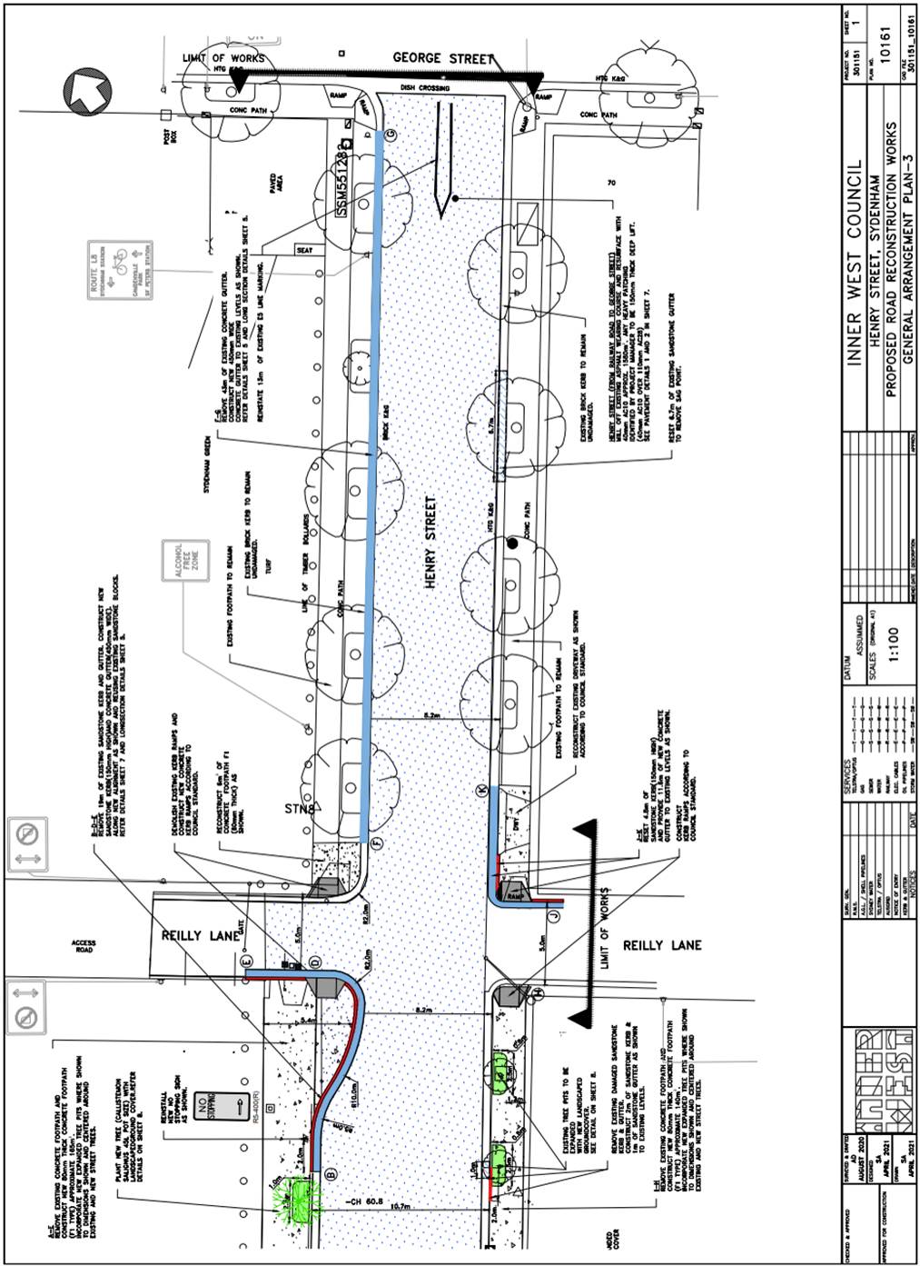
Subject: Henry Street, Sydenham From Railway Road to George Street – Road and Footpath Improvement Works – Design Plan 10161 (Midjuburi-Marrickville Ward / Heffron Electorate / Inner West PAC)
Prepared By: Jennifer Adams - Engineer – Traffic and Parking Services
Authorised By: Manod Wickramasinghe - Traffic and Transport Planning Manager
SUMMARY
|
RECOMMENDATION
THAT the detailed design plan for the road and footpath improvement works in Henry Street Sydenham from Railway Road to George Street and associated signs and line markings in Henry Street, Sydenham (as per Plan No.10161) be APPROVED.
|
BACKGROUND
Future improvement works in Henry Street have been listed on Council’s forward Capital Works Program for 2020/2021 and now the Design Plan for those improvement works is submitted for consideration.
This proposal will result in no loss of legal on-street parking space in Henry Street, Sydenham.
FINANCIAL IMPLICATIONS
The road and footpath improvement works in Henry Street, Sydenham is listed on Council’s Capital Works budget for 2020/2021 and funding of $175,600 has been allocated to this project.
PUBLIC CONSULTATION
As the works are adjacent to Sydenham Green and does not impact any residences and/or businesses directly, consultation has not been carried out.
|
|
Local Traffic Committee Meeting 21 June 2021 |
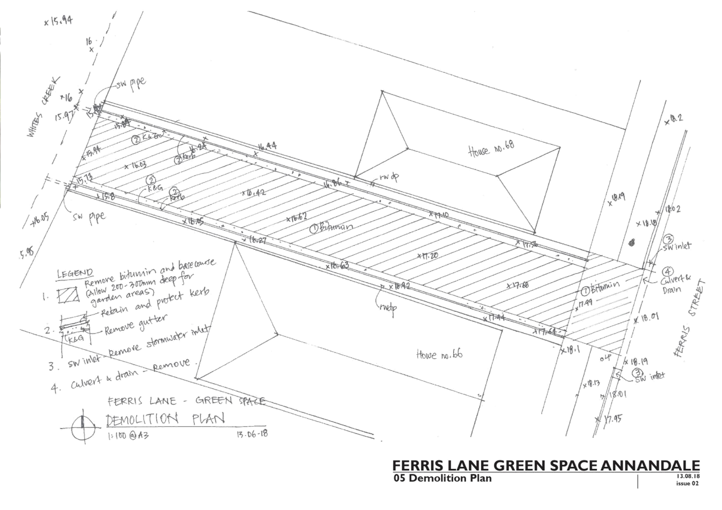
Subject: Ferris Lane, Annandale - Proposed Permanent Road Closure (Gulgadya-Leichhardt Ward/ Balmain Electorate/ Leichhardt PAC)
Prepared By: Vinoth Srinivasan - Engineer - Traffic and Parking Services
Authorised By: Sunny Jo - Coordinator Traffic Engineering Services (North)
SUMMARY
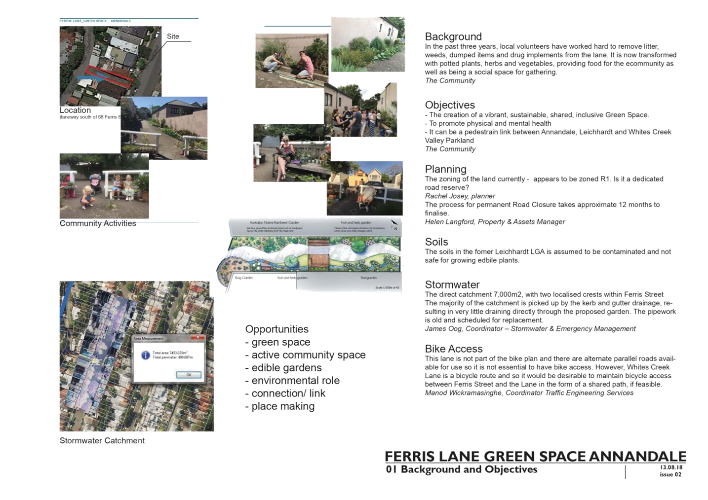
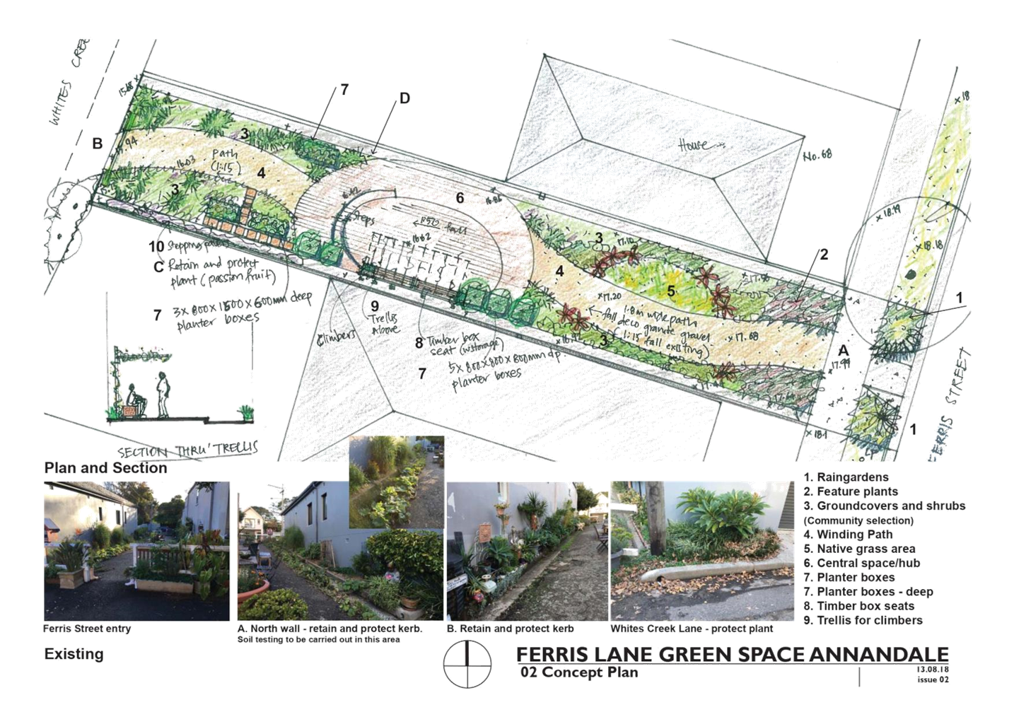
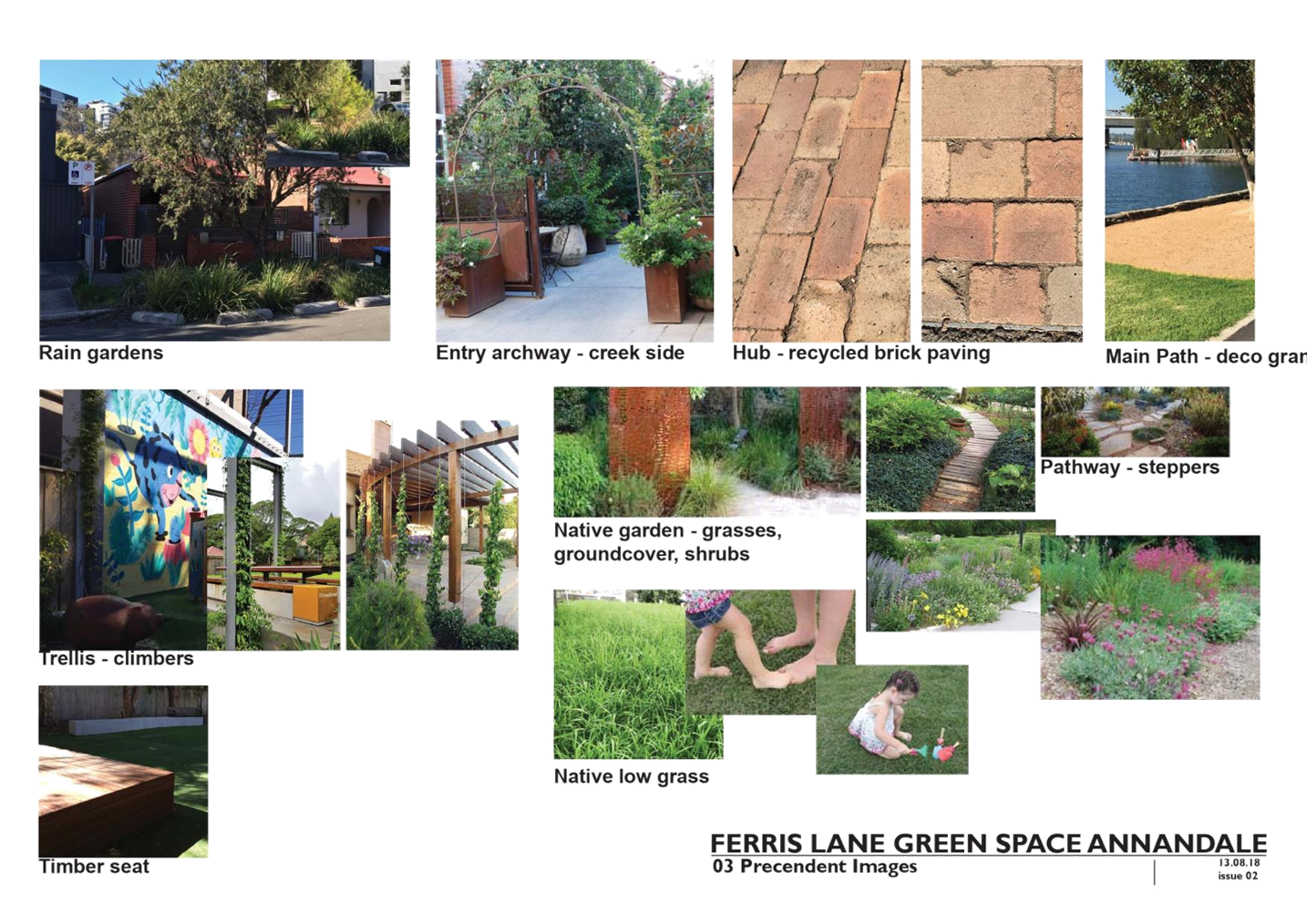
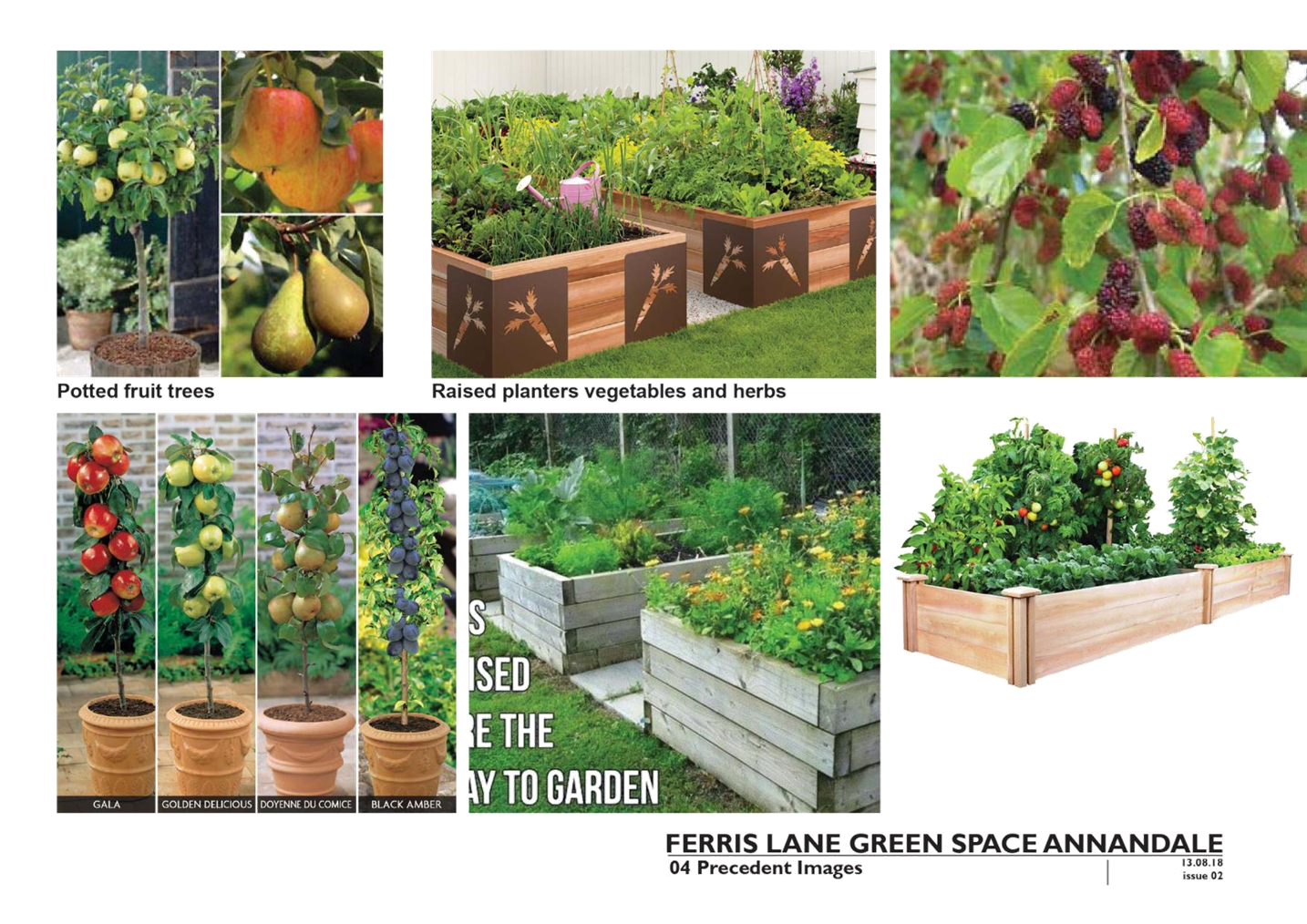
Council at its meeting held on 28 August 2018 resolved to permanently close Ferris Lane (between Whites Creek Lane and Ferris Street), Annandale to create a licensed community garden.
|
RECOMMENDATION
THAT the permanent full road closure of Ferris Lane between Whites Creek Lane and Ferris Street, Annandale be approved subject to a Traffic Management Plan (TMP) be prepared and forwarded to TfNSW for approval.
|
BACKGROUND & OTHER STAFF COMMENTS
Council at its meeting held on 28 August 2018 resolved to permanently close Ferris Lane (between Whites Creek and Ferris Street), Annandale to create a licensed community garden.
For the past six years, local residents have adopted the laneway as an open space. This adoption has included transforming the laneway into an informal garden space with many found objects being utilised to grow both decorative and edible plants. The laneway, commonly referred to as the Magic Lane has become an area for residents to socialise, meet and greet as well as an attractive space for informal recreation and socialisation.
The laneway provides an important pedestrian link from Ferris Street to Whites Creek lane, which subsequently links up to Evan Jones Park. Importantly residents have maintained the laneway to make it an attractive and well-maintained space.
Ferris Lane is currently not providing a traffic function and allows pedestrian access only. The permanent closure of the Laneway will formalise the removal of the road reserve classification from Ferris Lane so that a formal community garden can be established.
The community were asked to provide feedback on measures to support community activity in Ferris Lane, Annandale, between 19 April and 17 May 2021. They were asked for input on whether Council permanently closes Ferris Lane to vehicles and indicate if they wanted to form a group to manage proposed green space.
FINANCIAL IMPLICATIONS
This project is listed on Council’s Capital Works Program and will be funded out of the Parks Capital Budget.
PUBLIC CONSULTATION
A letter outlining the proposal was mailed out to 850 properties that were within a 250m radius of the catchment.
172 responses were received with 164 in support, 7 in objection and one (1) unsure about the proposal. No comments were received regarding the traffic impacts of this project.
Furthermore, the proposal has been advertised in a local newspaper for 28 days in accordance with the Roads Act.
|
1.⇩ |
Ferris Lane Concept Plans |
|
Local Traffic Committee Meeting 21 June 2021 |
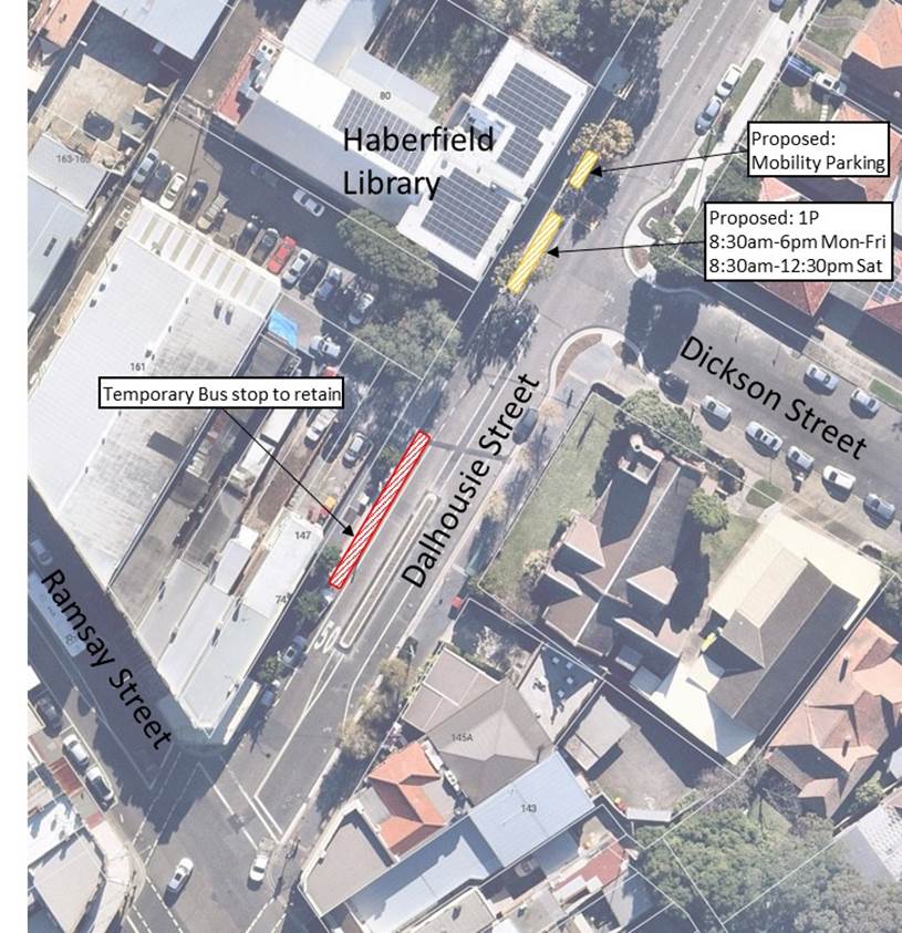
Subject: Dalhousie Street, Haberfield - Bus Zone Permanent Relocation (Gulgadya-Leichhardt Ward/Summer Hill Electorate/Burwood PAC)
Prepared By: Felicia Lau - Engineer - Traffic and Parking Services
Authorised By: Manod Wickramasinghe - Traffic and Transport Planning Manager
SUMMARY
Following completion of works to Haberfield Library, Transit Systems have proposed that the temporary relocation of the Bus Zone in Dalhousie Street, 30m north of Ramsay Street be made permanent. At its previous location, (No.78 Dalhousie Street, Haberfield) a mobility parking space and a ‘1P 8:30am-6pm Mon-Fri, 8:30am-12:30pm Sat’ zone is proposed.
|
RECOMMENDATION
THAT:
1. The temporary 36m length Bus Zone on the western side of Dalhousie Street, currently located 30m north of Ramsay Street to be made permanent. 2. A 6m length mobility parking space and a 14m length ‘1P 8:30am-6pm Mon-Fri, 8:30am-12:30pm Sat’ zone be installed along the frontage of Haberfield Library replacing the existing temporary ‘Works Zone’ restrictions.
|
BACKGROUND
The bus stop (TSN 204524) located near Haberfield Library (No.78 Dalhousie Street, Haberfield) was temporarily relocated in June 2020 to approximately 20m south in Dalhousie Street towards the Ramsay Street intersection to allow a ‘Works Zone’ to be established for the Haberfield Library upgrade works.
The refurbishment works for the Haberfield Library is now completed and the ‘Works Zone’ is to be removed. Transit Systems has indicated that they prefer the current location over its previous location as it is located closer to Ramsay Street and thus provides better pedestrian access.
In place of the former ‘Bus Zone’ location, a 6m length mobility parking space is proposed directly in front of Haberfield Library to allow a person with mobility parking permit to have direct access to the library and a 14m length ‘1P 8:30am-6pm Mon-Fri, 8:30am-12:30pm Sat’ zone is proposed to support existing business parking restrictions along Dalhousie Street from its intersection with Ramsay Street.
The proposal is shown in the following figure.
FINANCIAL IMPLICATIONS
Nil.
PUBLIC CONSULTATION
A letter outlining the above proposal was mailed out to the directed affected properties in Dalhousie Street, Dickson Street and Ramsay Street by Transit Systems. No responses were received.
|
|
Local Traffic Committee Meeting 21 June 2021 |
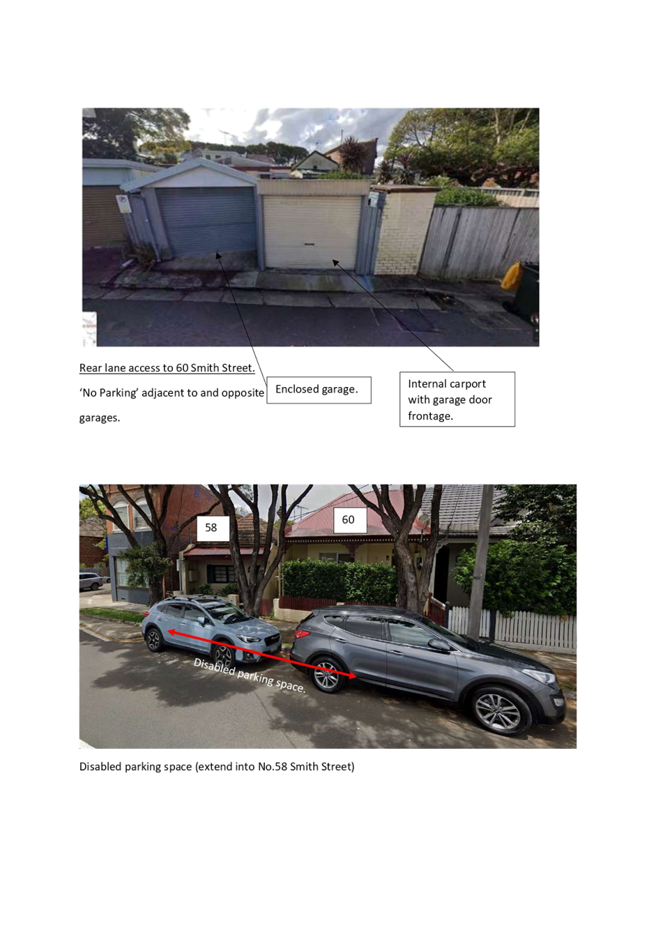
Subject: Smith Street, Summer Hill- Appeal On Refused
Application of a Mobility (Disabled) Parking Space Outside No.60 Smith Street.
(Djarrawunang-Ashfield Ward/Summer Hill Electorate/Burwood PAC)
Prepared By: Boris Muha - Engineer – Traffic and Parking Services
Authorised By: Manod Wickramasinghe - Traffic and Transport Planning Manager
SUMMARY
A Notice of Motion (in part) was carried at Council meeting on the 13 April 2021 as follow:
That the application for a mobility parking space outside 60 Smith Street Summer Hill be referred to the Local Traffic Committee for review.
This report outlines the above application for a mobility parking space as per the Public Domain Parking Policy for Inner West Council. The applicant is required to carry out reasonable rectification for off-street parking accessibility, or provide evidence after rectification, if parking is still inaccessible, to re-apply for re-consideration of a mobility parking space.
|
RECOMMENDATION
THAT:
1. Under current circumstances, the placement of a mobility parking space outside 60 Smith Street, be not supported. 2. The applicant be requested to clear material and/or modify/provide access from either of the existing off-street parking spaces. 3. Should accessibility issues remain following clearance and modification of the car/garage, the applicant is to provide to Council a report from My Age Care or an Occupational Therapist who has examined the property, to support any future request; and 4. A ‘Letter of support’ be attained from the applicant’s neighbour at 58 Smith Street, Summer Hill as any mobility parking space would overhang the frontage of this property
|
BACKGROUND
The resident of No. 60 Smith Street, Summer Hill is seeking secondary appeal on the request for a mobility parking space to the front of his property on claim that off-street parking in his property is inaccessible due to his disability.
FINANCIAL IMPLICATIONS
NIL
OTHER STAFF COMMENTS
Under the current Public Domain Parking Policy, Council may consider establishing a mobility parking space outside a residents’ home where there is consistent difficulty in finding parking that is accessible within a reasonable distance of the property, provided:
(a) The resident holds a current individual mobility parking permit issued by the RMS [now TfNSW] and;
(b) Medical certification is provided confirming the person requires the use of a mobility aid to walk and/or cannot walk more than 50 metres without detrimentally impacting their physical condition; and
(c) On-site parking space of suitable dimensions and accessibility is not available and cannot be reasonably be provided within the property; and
(d) The vehicle used for transport is registered to the resident’s home address.
This application has met all requirements the exception of part C above.
Council officers have examined the site and have revealed that the resident has 2 off-street parking facilities, both serviced from a rear lane. An enclosed garage exists to one side and a car port with garage door entry to the other side. (see Attachment 1). Apart from the garage, the internal carport is considered of sufficient width to park a vehicle and allow door opening from one side provided that the resident clear/relocate existing pot planting, material, and waste bins currently placed along side of the carport. The car parking facilities are at near level to the rear of the house with little or no expense required to modify accessibility to the house. Reasonable provision can therefore be made.
The resident has been advised by Council to carry out these remedial measures. If after carrying out these remedial measures and the resident still has accessible issues, the applicant would need to provide Council a report from My Age Care or an Occupational Therapist who has examined the property, to support any future requests. Council has also conveyed this to the applicant.
Furthermore, the mobility parking space cannot be properly contained within the narrow frontage of No.60 Smith Street and would need to extend into the neighboring property of No.58 Smith Street for proper maneuvering and space allocation. As per standard procedure, a ‘Letter of support’ would need to be attained from the applicant’s neighbour at No.58 Smith Street, Summer Hill in conjunction with any report by My Age Care or Occupational Therapist. The applicant to present has not carried out any remedial works. The applicant has not provided any documentation above to re-consider a mobility parking space. Due to this, the application for a mobility parking space has not been supported.
|
1.⇩ |
Requested Disabled parking space and rear lane access to 60 Smith Street, Summer Hill. |
|
|
Local Traffic Committee Meeting 21 June 2021 |
Subject: Arthur Street, Ashfield (at Joseph Street)-
Proposed New Speed Cushion and Kerb Blister.
(Djarrawunang-Ashfield Ward/Summer Hill Electorate/Burwood PAC)
Prepared By: Boris Muha - Engineer – Traffic and Parking Services
Authorised By: Manod Wickramasinghe - Traffic and Transport Planning Manager
SUMMARY
Council has prepared a design plan to install a new speed cushion with associated new kerb blister in front of No.26 Arthur Street, Ashfield. The intention of the proposal is to slow traffic on approach to the intersection of Joseph Street and improve road safety for pedestrian and motorists at the intersection.
|
RECOMMENDATION
THAT the design plan (Design Plan No. 10172) for the proposed speed cushion, kerb blister, and associated signs and line marking at the intersection of Arthur Street and Joseph Street be APPROVED.
|
BACKGROUND
The above work is part of the 2021/2022 Traffic facilities (LATM) Capital Works Program as captured under the Ashfield Traffic Management Strategy in providing a traffic calming treatment at the intersection of Arthur Street and Joseph Street.
FINANCIAL IMPLICATIONS
Funding of $20,000 has been allocated to this project for construction in 2021/2022 Capital Works Program.
OTHER STAFF COMMENTS
Arthur Street is one-way east, approximately 6.2 metres in width kerb to kerb. It acts as a local collector road feeding mainly by-pass traffic around the Ashfield CBD from Milton Street to Victoria Street. Arthur Street carries around 5000 vehicle per day with a speed limit of 50 km/h. Speeds are controlled below 50 km/h in Arthur Street, west of Holden Street where a series of traffic calming devices exist.
The proposed device will not only improve traffic calming around the intersection of Arthur Street and Joseph Street, but it will also assist to lower the speed profile between the traffic signalised intersection of Arthur & Holden Streets and the roundabout intersection of Arthur & Streets.
Available traffic accident statistics from the TfNSW identified (1) off left into object (RUM 71)
incident in Arthur Street, east of Joseph Street in 2020, and (2) cross-traffic (RUM 10) incidences at the intersection of Arthur Street and Joseph Street in 2012 and 2014.
The proposal will not result in the loss of any on-street parking spaces.
PUBLIC CONSULTATION
A letter outlining the above proposal was distributed to the directly affected properties (30 properties) in Arthur Street and Joseph Street with the closing of submissions being the 4 June 2021.
(1) response was only received with a resident requesting guardrail to the south-eastern corner of the intersection. The resident is concerned to vehicles colliding into the property. Guardrail is required to be to TfNSW standard and needs to be of long length to be secured for effectiveness. It would need to be set well into the footpath and can interfere with pedestrian access where the footpath is narrow. Guardrail can also pose a hazard if damaged and leans into the footpath or roadway.
The proposed device aims to control traffic through the intersection. It aims to avoid/minimise conflict with adjacent traffic in Joseph Street. The Stop lines, central double barrier line approaches in Joseph Street, and the median islands in Joseph Street will be repainted to further enhance traffic control around the intersection. Guardrail in this case is not considered necessary or viable.
|
1.⇩ |
Detailed plan of speed cushon and kerb blister in Arthur Street at Joseph Street, Ashfield. |
|
|
Local Traffic Committee Meeting 21 June 2021 |
Subject: Spencer Street and Carrington Street, Summer
Hill-Proposed Extension of Resident Parking Scheme (AREA 13).
(Djarrawunang-Ashfield Ward/Summer Hill Electorate/Burwood PAC)
Prepared By: Boris Muha - Engineer – Traffic and Parking Services
Authorised By: Manod Wickramasinghe - Traffic and Transport Planning Manager
SUMMARY
Council has finalised an investigation into an extension of the Resident Parking Scheme (RPS) (AREA 13) in sections of Spencer Street, between Wellesley Street and Old Canterbury Road, and Carrington Street, between Wellesley Street and Old Canterbury Road Summer Hill. The RPS was proposed to address issues with long-term parking by non-resident vehicles in the above sections of Spenser Street and Carrington Street.
|
RECOMMENDATION
THAT:
1. ‘2P 8am-6pm Mon-Fri, Permit Holders Excepted, AREA 13 parking restrictions be installed on the eastern side of Spencer Street, between premises No.28 Spencer Street to Wellesley Street, Summer Hill. 2. No further action be carried out at present to extend Resident Parking Scheme into Carrington Street, between Wellesley Street and Old Canterbury Road, Summer Hill due to insufficient support from residents in Carrington Street. 3. Any further request for residential parking not be considered for a minimum of 24 months in the above section of Carrington Street as per Inner West Council Parking Domain Parking. |
BACKGROUND
Council has received requests from residents in Spencer Street, between Wellesley Street and Old Canterbury Road to provide an RPS (AREA 13) zone within their street to address long-term parking by non-resident vehicles. Council has also noted that Carrington Street, between Wellesley Street and Old Canterbury Road has no RPS zone. All other sections of Spencer Street and Carrington Street and surrounding local streets such as Wellesley Street and Edward Street fall under the RPS (AREA 13) as initially introduced around 2016.
FINANCIAL IMPLICATIONS
NIL
OTHER STAFF COMMENTS
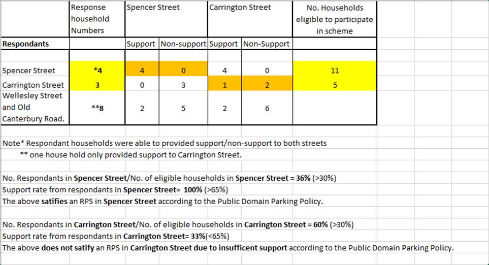
Parking occupancy surveys have indicated that parking occupancy levels in the above sections of Spencer Street and Carrington Street were high around 85%, Spencer Street higher than Carrington Street, which warranted a further investigation for a resident parking scheme.
Under the Public Domain Parking Policy, at least 65% of respondents, from different households within the proposed zone that are eligible to participate in the scheme, must be in support of the proposal and that a minimum rate of 30% in household responses need to be received to consider the proposal. The proposed RPS zone restrictions for both street sections are shown in the diagram below.
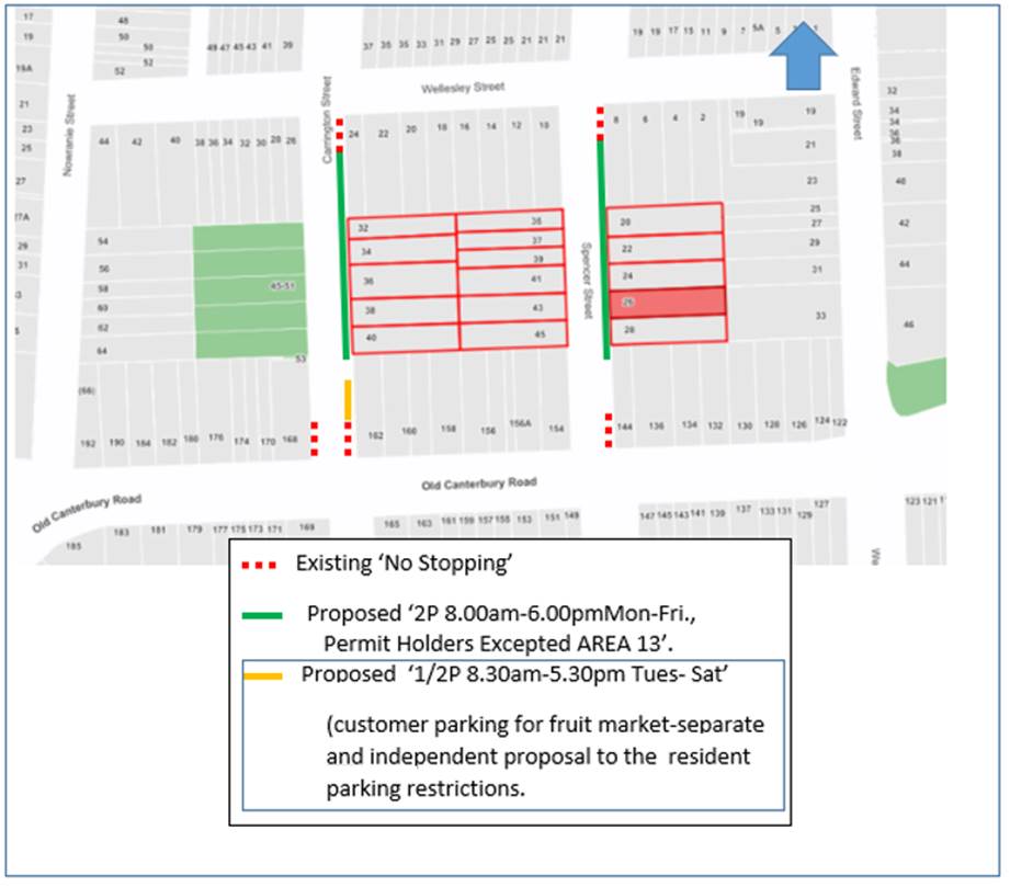
PUBLIC CONSULTATION
Residents of properties fronting and addressed along the above sections of streets, as being directly affected, and eligible to participate in the scheme (as shown highlighted in the diagram), were invited to fill out a survey form if they support or do not support the proposed RPS in the streets. Other surrounding residents in Wellesley Street and Old Canterbury Road in proximity of the zones were also given the opportunity to comment on the proposal.
A total of 90 letters were mailed out to residents and non-residing owners of properties.
The response results are tabled below.
The main issues, non-support or objections from the consultation are summarised below:
· RPS should be placed to both sides of the street.
· Restricting parking would impact on residents and those persons required to park longer periods of time that are ineligible for permits or need to or wish to conveniently park on the street.
· Parking is taken up more so by residents with multiple cars. Residents in Old Canterbury Road should be included in the Resident Parking Scheme. Do not extend the restricted parking beyond the frontage of 20 Spencer Street/32 Carrington Street to Wellesley Street. Why do some residents get 2 permits in one street and the other street none?
· Allocation of permits to company vehicles and support careers.
· Residents placing cones out to prevent parking or driveway access interference outside their property.
Under the Policy (for Summer Hill) one side of the street is only made for resident parking, thereby maintaining unrestricted parking to the other side in fairness and balance for residents and persons ineligible for permits. Any person can park short term up to 2 hours without a permit, or park longer periods of time outside the times and dates of the restrictions. The RPS zones are extended to Wellesley Street to provide more opportunity and relief for permit holders to park in the street. Any AREA 13 permit holder can park in the proposed zones. Old Canterbury Road residents may be able to apply for permits, and Council would need to consider the nature of the request pending if they fall within the RPS AREA 13 and whether they have adequate off-street parking. The RPS is proposed to be extended in these remaining street sections to bring those residents into the scheme for permit eligibility.
The Policy should be referred to for other conditions and any other permit issues (e.g. company car, support careers). Unless authorised, residents should contact Council in the regard to cones or barriers being placed on-street. This needs to be resolved under enforcement.
CONCLUSION
In conclusion, it is recommended to proceed in the placement of resident parking restrictions along the eastern side of Spencer Street, between premises No.28 to Wellesley Street given there is satisfactory response and support by residents in Spencer Street that were eligible to participate in the scheme under the policy.
No further action be caried out in placing resident parking restriction in Carrington Street, between Wellesley Street to Old Canterbury Road, due to insufficient support raised by residents in Carrington Street. However resident parking could be re-visited for consideration in Carrington Street following a period of 24 months, unless parking is substantially affected with major new developments occurring in the vicinity to consider a lesser time frame.
|
|
Local Traffic Committee Meeting 21 June 2021 |
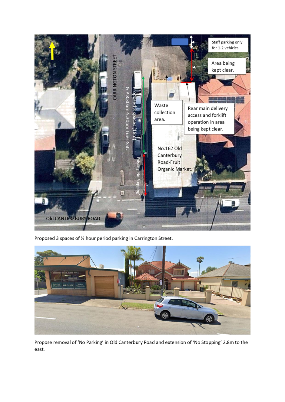
Subject: Carrington Street, Summer Hill- Request for
1/2 Hour Period Parking Adjacent to No. 162 Old Canterbury Road, Summer Hill.
(Djarrawunang-Ashfield Ward/Summer Hill Electorate/Burwood PAC)
Prepared By: Boris Muha - Engineer – Traffic and Parking Services
Authorised By: Manod Wickramasinghe - Traffic and Transport Planning Manager
SUMMARY
The proprietor of the Summer Hill Organic Fruit Market, premises No162 Old Canterbury Road, Summer Hill, has requested ½ hour period parking to the side of the market shop in Carrington Street to assist in customer parking to the store.
|
RECOMMENDATION
THAT: 1. (3) carparking spaces on the eastern side of Carrington Street, side of No. 162 Old Canterbury Road, Summer Hill be allocated as ‘½ P 8.30am-5.30pm Tues-Sat’; 2. A request to TfNSW be made to: a. Remove the short section of ‘No Parking’ to the front of No.162 Old Canterbury Road; and b. Extend the ‘No Stopping’ in length from 14 m to 16.8 m on the northern side of Old Canterbury Road, east of Carrington Street, Summer Hill. |
BACKGROUND
Summer Organic Fruit Market is a small family run local business located on the corner of Carrington Street and Old Canterbury Road and has operated over 30 years servicing the community. The proprietor has requested 3 spaces of ½ hour period parking along the side boundary of the store, with restrictions operating during business hours.
FINANCIAL IMPLICATIONS
NIL
OTHER STAFF COMMENTS
It has been advised that parking in the area over the years have increased and customers at certain times find it difficult to park anywhere near the store, with business being affected. Customers find it difficult conveying heavy groceries to the car. It is further advised that at times, vehicles have been left parked in the area outside the store for weeks.
The store has an off-street facility which caters for staff parking only (approx. 2 vehicles), and that the rest of the area needs to be kept clear at all times for delivery services and waste collection from the rear of the property (see Attachment 1).
PUBLIC CONSULTATION
Consultation was carried out in conjunction with the proposals for resident parking in Spencer Street and Carrington Street. The resident parking proposals have been dealt through a separate report to the Traffic Committee.
(90) letters were issued out to residents and non-residing owners. (3) responses were received specifically commenting on this proposal. (1) resident was in support of the proposal and (2) in non-support of the proposal.
The resident in support has advised the proposal would assure short term parking for the shoppers. Many of the customers buy large amounts of groceries, and often require staff to assist to carry groceries to the car.
Regarding the non-support to the proposal the following is made:
· Parking has always been available for the customers in the street
· The carpark is rarely used and can be made available for the customers.
· The proposed restrictions would not be enforced together with ‘No Stopping’ and ‘No Parking’ on the corners of Old Canterbury Road and Carrington Street.
· Is the ‘No Parking’ to the front of the site in Old canterbury Road in accordance with the sites Development approval?
Parking is not always conveniently available for customers to the shops. The proprietor has advised that deliveries come frequently at all times of the day often in very large trucks. Hence the area to the rear is needing to be kept clear. Although noted that the restrictions may not always be enforced, the proprietor can call up Council to attend the site to book any illegally parked vehicles.
The ‘No Parking’ to the front of the site (on Old Canterbury Road) may not have been placed under the DA (see Attachment 1). The proprietor has informed that the ‘No Parking’ was never requested by the business and has no objection to removing it.
The ‘No Parking’ zone in question is short approx. up 4.0m in length, which is insufficient to stand a normal size vehicle. This is followed by a short parking space (approx. 4.8m) west thereof. It is considered that the ‘No Parking’ could be removed and have the ‘No Stopping’ aside extended some 2.8m west. This will allow and maintain good sight view from the intersection and allow a nominal size car to park between the ‘No Stopping’ and the neighbouring driveway. As Old Canterbury Road is a State Road under the jurisdiction of TfNSW, a request for this amendment will be made to TfNSW.
|
1.⇩ |
Proposed 1/2 hour period parking in Carrington St, and removal of 'No Parking' & extension of 'No Stopping' in Old Canterbury Road, Summer Hill. |
|
|
Local Traffic Committee Meeting 21 June 2021 |
Subject: Moodie Street, Rozelle - Proposed No Left Turn Restrictions (Baludarri - Balmain /Balmain Electorate/ Leichhardt PAC)
Prepared By: David Yu - Engineer - Traffic and Parking Services
Authorised By: Sunny Jo - Coordinator Traffic Engineering Services (North)
SUMMARY
Council at its meeting held on March 2021 resolved to temporarily introduce a ‘No Left Turn’ restriction from Moodie Street into Victoria Road with a Local Area Traffic Management (LATM) Study to be undertaken within 6 months so that a permanent change, pending the outcome of the LATM, can be considered. Community engagement for this change has now been completed with 83 responses being received with 43% of residents supporting the proposal and 57% in objection.
|
RECOMMENDATION
THAT: 1. Due to the level of non-support from the community, the temporary ‘No Left Turn’ restriction from Moodie Street at Victoria Road not be supported at this time; 2. The Local Area Traffic Management (LATM) study for this area be undertaken after the completion of the WestConnex Rozelle Interchange in 2023; 3. The area continue to be monitored after the WestConnex construction works in Moodie Street are completed.
|
BACKGROUND & OTHER STAFF COMMENTS
A temporary road occupation/closure of Moodie Street is currently in place to facilitate stormwater work associated with WestConnex, this occupation prevents vehicles entering and exiting Moodie Street at Victoria Road and is intended to be removed following the completion of works.
Requests were received from residents of Moodie Street to introduce a ‘No Left Turn’ restriction on traffic turning from Moodie Street into Victoria Road in order to maintain the benefits brought by the stormwater upgrade works, including reduced traffic in the street and improved road safety.
Subsequently, Council at its meeting held on 9 March 2021 resolved to temporarily introduce a ‘No Left Turn’ restriction from Moodie Street into Victoria Road with a Local Area Traffic Management (LATM) Study to be undertaken within 6 months so that a permanent change, pending the outcome of the LATM, can be considered.
Therefore, Council proposed to implement the following:
· Install a temporary ‘No Left Turn’ restriction from Moodie Street into Victoria Road
· Install three ‘No access to Victoria Road’ signs to notify drivers
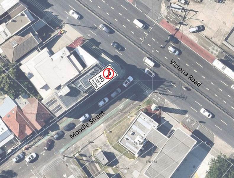
Map showing the location of the proposed ‘No Left Turn’ restriction.
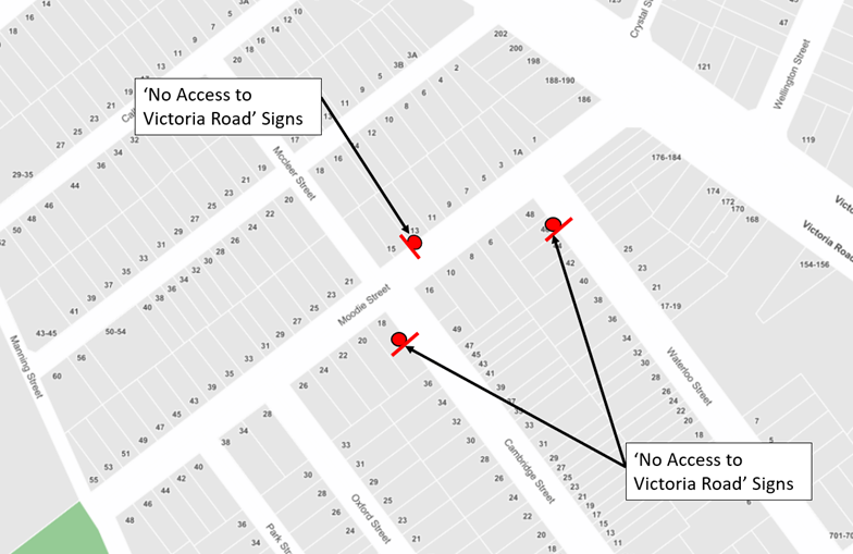
Map showing the location of three ‘No Access to Victoria Road’ signs on Cambridge Street, Moodie Street and Waterloo Street.
FINANCIAL IMPLICATIONS
Nil.
PUBLIC CONSULTATION
A letter outlining the proposal was mailed out to the 454 properties within the boundary of Victoria Road, Manning Street, Darling Street and Byrnes Street, Rozelle.
The proposal received a total of 83 responses, with 36 in support and 47 in objection to the proposal (support rate of 43%). 14 of these responses were received from Moodie Street properties of which 12 were in support.
A summary of the main objections from the consultation are summarised below:
· Objection to the increase travel time for local residents as traffic will need to travel further south up to Darling Street and turn left at the Darling Street/Victoria Road signalised intersection.
· Darling Street is congested during peak periods and this will create additional traffic congestion.
· Traffic rat-running will occur along alternative routes (primarily to Callan Street and Darling Street) and create pedestrian and safety concerns along these routes.
· Resulting congestion will encourage illegal driving behavior such as vehicles travelling in the opposing direction, down one-way streets (McCleer Street) to access Callan Street to turn left or vehicles will illegally turn left at Moodie Street to avoid traffic detours.
· Vehicles will travel through 7Eleven at the corner of Moodie Street and Victoria Road to turn left and avoid the left turn restriction.
· Restricted access to Victoria Road from Moodie Street should be during peak hour times only.
CONCLUSION
Given the level of non-support in the community for the introduction of the temporary ‘No Left’ turn restriction from Moodie Street into Victoria Road and the important traffic function currently performed by Moodie Street, a local collector road, it is recommended that the ‘No left Turn’ restriction not be implemented at this time.
It is also noted that traffic patterns in the vicinity of Victoria Road will change substantially once the toll-free Iron Cove Link is finalised and as motorists adapt to this new route which bypasses Victoria Road. Due to these changes, it is expected that traffic congestion on and near Victoria Road, Rozelle will reduce, therefore, it is further recommended that the LATM study be conducted following completion of Iron Cove Link works in 2023 so that these changes can be better considered.
|
|
Local Traffic Committee Meeting 21 June 2021 |
Subject: Council Resolution for Local Traffic Committee
March 2021 Item 7 - Unwins Bridge Road, Way Street, Toyer Street & Collins
Street, St Peters - Formalising Parking Restrictions Around Tempe High School
(Midjuburi - Marrickville Ward/ Heffron Electorate/ Inner West PAC)
Prepared By: Scipio Tam - Engineer – Traffic and Parking Services
Authorised By: Manod Wickramasinghe - Traffic and Transport Planning Manager
SUMMARY
During the Local Traffic Committee Meeting held in March 2021, the recommendations for Item 7 Unwins Bridge Road, Way Street, Toyer Street & Collins Street, St Peters for formalising parking restrictions around Tempe High School were adopted as per Council Officer’s recommendation.
Subsequent to Local Traffic Committee adoption, residents of Toyer Street requested Councillors to amend the proposed ‘No Stopping’ restrictions in Toyer Street, Tempe.
During the Council Meeting held on 11th May 2021, Council adopted an amended recommendation for ‘No Stopping’ restrictions in Toyer Street and requested the concerns of the residents be referred back to the Local Traffic Committee (LTC).
|
RECOMMENDATION
THAT the findings of this report be noted.
|
BACKGROUND
In the initial report addressing the matter of bus access around Tempe High School, points 4 and 5 were recommended to introduce:
4. A statutory 10 metre ‘No Stopping’ on the southern side of Toyer Street, east of its intersection with Collins Street; and
5. A 14 metre ‘No Stopping’ zone on the northern side of Toyer Street, east of its intersection with Collins Street.
Subsequently residents of Toyer Street raised concerns with Councillors regarding the lack of parking along Toyer Street. At the Council Meeting held on 11th May 2021, Council resolved that the recommendation be amended with point 4 of the item 7 to be deleted and point 5 of item 7 to be amended as follows;
5. A 10 metre ‘No Stopping’ zone on the northern side of Toyer Street, east of its intersection with Collins Street.
FINANCIAL IMPLICATIONS
Nil.
OTHER STAFF COMMENTS
Although point 4 has been deleted from the list of recommendation, it is still illegal to park within 10m of an unsignalised intersection. Furthermore, the ‘No Stopping’ restrictions were developed in consultation with the local bus operator and Tempe High School in response to issues difficulties faced by bus drivers maneuvering at this intersection.
PUBLIC CONSULTATION
Not Applicable.
|
|
Local Traffic Committee Meeting 21 June 2021 |
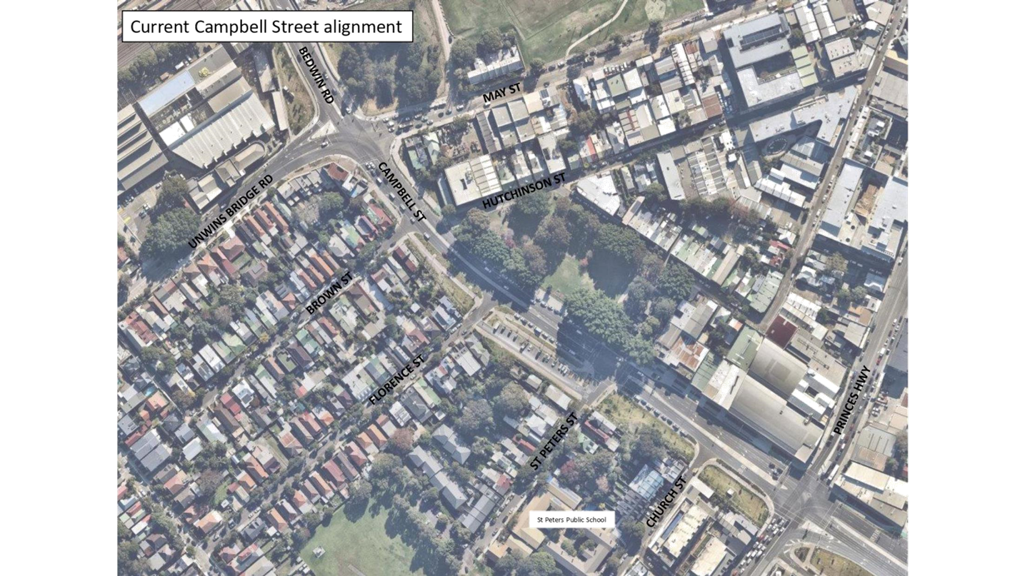
Subject: Campbell Street ST PETERS – C0621(1) Item 30 Mayoral Minute and C0621(1) Item 17 Notice of Motion - Pedestrian safety on Campbell Street, St Peters (MIDJUBURI - MARRICKVILLE WARD/ HEFFRON ELECTORATE/ INNER WEST PAC)
Prepared By: Jennifer Adams - Engineer – Traffic and Parking Services
Authorised By: Manod Wickramasinghe - Traffic and Transport Planning Manager
SUMMARY
This report has been prepared in response to Council’s Mayoral Minute C0621(1) Item 30 and Notice of Motion C0621(1) Item 17 regarding Pedestrian safety on Campbell Street, St Peters.
|
RECOMMENDATION
THAT this report be received and noted. |
BACKGROUND
Council at its meeting on 8 June 2021 raised the following Motion - C0621(1) Item 30 Mayoral Minute: Pedestrian safety at Campbell St Peters and C0621(1) Item 17 Notice of Motion: Pedestrian Safety at St Peters:
THAT Council:
1. Notes the letter from Ron Hoenig, MP, Member for Heffron, in regards to pedestrian safety on Campbell Street, St Peters. Notes the serious concerns of parents for the safety of their children as they cross Campbell Street St Peters to attend St Peters Public School;
2. Writes to the Minister for Transport requesting that a school zone be installed along Campbell Street, St Peters as a matter of urgency;
3. Places the issue of pedestrian safety on Campbell Street, St Peters, on the agenda of Council’s next Local Traffic Committee;
4. Notes the advice of parents that there have been a number of near misses of children by vehicles;
5. Writes to the Minster for Transport, the Hon Andrew Constance, asking him to direct Transport for NSW to upgrade pedestrian safety on Campbell Street St Peters by the installation of rumble strips, flashing lights and implantation of a 40km zone; and
6. Investigates any remedial action Council can take to alert drivers that they are driving in a residential area.
This report address Point 3 of the above Motion.
OFFICER COMMENTS
There is a history of pedestrian / school children safety concerns being raised with regards to Campbell Street, St Peters which dates back prior to WestConnex. In late 2018 (during WestConnex Works) concerns were raised by parents of children at St Peters Public School and Council Officers were at the time requested to write to the Minister for WestConnex regarding the ‘implementation of a 40kph school zone along Campbell Street, St Peters near St Peters Public School’ (C0217 Item 1 WestConnex update report). Council’s submission on the New M5 Urban Design and Landscape Plan (UDLP) in 2017 also referenced the need to improve pedestrian safety along Campbell Street by installation of a 40kph school zone. Even earlier in 2009 Council Officers wrote to RMS on behalf of St Peters Public School requesting a School Zone and 40km/h speed limit in Campbell Street, St Peters.
Council recognises that TfNSW’s usual criteria for implementing these zones is that the school must have a frontage and gate directly onto the street. Although St Peters Primary School does not meet this criteria, a school zone is justified on the basis of the numbers of parents and their children needing to cross Campbell Street to access the school on a daily basis. With additional residential development proposed for the St Peters triangle area, pedestrian numbers will increase in the future. Council staff have previously discussed this matter with the Principal of St Peters Primary School, who indicated support for the school zone
Campbell Street has been transformed via the WestConnex works. It once was a narrow two-way Regional Road (6.4 metre carriageway) running east-west between Unwins Bridge Road and Barwon Park Road flanked by a mixture of residential and commercial properties as well as a public park (Simpson Park). An at grade pedestrian zebra crossing transversed Campbell Street east of St Peters Street and was regularly used by school children attending nearby St Peters Public School.
On-street parking was not permitted on Campbell Street due to the narrow carriageway and double barrier lines extended along its full length. Traffic volumes averaged around 8,000 vehicles per day, including between 200 and 300 heavy vehicles. As all traffic movements were confined to one lane in each direction, lengthy queuing regularly occurred, particularly in the southbound direction. The queued traffic frequently extended back to the pedestrian zebra crossing and often stopped over the crossing raising safety concerns for pedestrians.
Post-WestConnex works, Campbell Street is a 4-lane road, likely carrying in excess of the previous traffic volumes of 8,000 vehicles per day and connects motorists with the St Peters Interchange, south of the Princes Highway. The Campbell Road bridge has also been built which has provided motorists with a new connection between Mascot and St Peters by extending Campbell Road south across the Alexandra Canal to Bourke Road.
A new signalised intersection (as shown in the following image) has been provided at St Peters Street and Campbell Street replacing the original at-grade pedestrian zebra crossing. However, safety concerns for pedestrians crossing Campbell Street are still being raised stating the increased speed of traffic along Campbell Street and vehicles failing to stop at the traffic signals as being safety issues for school children attending St Peters Public School.
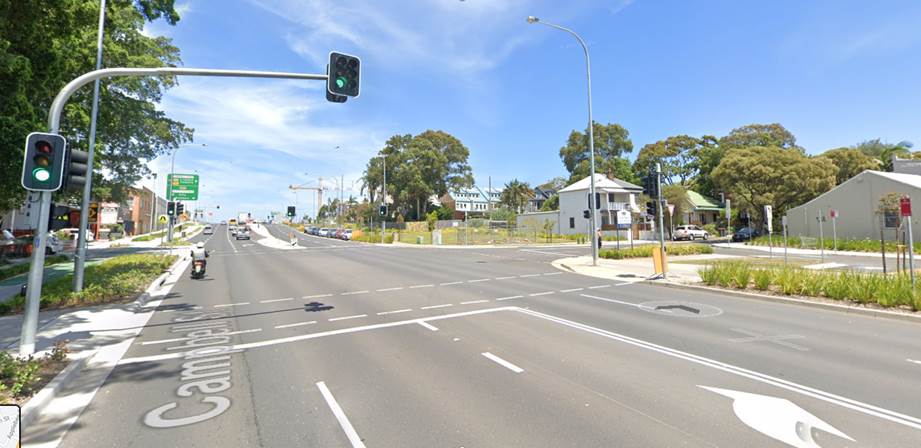
|
1.⇩ |
Campbell Street, St Peters - Previous and Current Road Alignment |
|
|
Local Traffic Committee Meeting 21 June 2021 |
Subject: Ramsay Street, Haberfield - New Pedestrian Refuge Island (Gulgadya-Leichhardt Ward/ Summer Hill Electorate/ Burwood PAC)
Prepared By: Vinoth Srinivasan - Engineer - Traffic and Parking Services
Authorised By: Sunny Jo - Coordinator Traffic Engineering Services (North)
SUMMARY
Council has finalised a design plan for the proposed upgrade of the existing pedestrian refuge island on Ramsay Street west of Gillies Avenue, Haberfield. The upgrade will widen the existing refuge island, improving pedestrian safety crossing Ramsay Street and assist in reducing vehicle speeds.
|
RECOMMENDATION
THAT the attached detailed design plan (Design Plan No.6196) for the proposed upgrade of the existing pedestrian refuge on Ramsay Street, at Gillies Avenue, Haberfield be approved. |
BACKGROUND & OTHER STAFF COMMENTS
The detailed design plan shown in Attachment 1 outlines the proposed upgrade works on Ramsay Street, Haberfield and includes the following treatments:
- Reconstruct pedestrian refuge island to facilitate pedestrians movements across the road in two stages, with a 2m wide island design to meet current standards;
- Install line markings and signage associated with the new pedestrian refuge island;
- Construct new concrete kerb access ramp on north side;
- Narrow the road pavement by providing new landscaped kerb extension on one side of the road;
- Relocate four (4) ‘No Stopping’ signs and three (3) “1P” signs as shown on plan to better rationalise parking and to accommodate the new pedestrian refuge island;
- Remove two (2) redundant concrete kerb ramps approximately 40m west as shown on plan.
The proposal will result in the loss of one (1) on-street parking space.
FINANCIAL IMPLICATIONS
Funding of $51,000 has been allocated to this project for construction in the 2021/2022 Capital Works Program.
PUBLIC CONSULTATION
A letter outlining the proposal was mailed out to ten (10) properties in Ramsay Street, Gillies Avenue, Empire Street and Rawson Street, Haberfield. One (1) response was received in objection to the proposal.
The main concern raised by the resident is outlined below:
· Our business on 185 Ramsay Street, Haberfield requires an 8-pallet truck (8 metres in length) to travel along Ramsay Street to deliver goods. Council’s proposal will not allow us to drive through the back of the shop to unload the stock.
Council officers have provided the following response in regard to the resident’s concerns.
· A swept path analysis revealed that the delivery vehicle can enter and exit Ramsay Street without mounting the proposed pedestrian refuge.
|
1.⇩ |
Detailed Design Plan - Ramsay Street, Haberfield |
|
|
Local Traffic Committee Meeting 21 June 2021 |
Subject: 168 Norton Street (Between Carlisle Street and Maccauley Street), Leichhardt - Road Occupancy (Gulgadga - Leichhardt/ Balmain Electorate/ Leichhardt PAC)
Prepared By: David Yu - Engineer - Traffic and Parking Services
Authorised By: Sunny Jo - Coordinator Traffic Engineering Services (North)
SUMMARY
Council has received an application from Growth Built Pty Ltd for approval of a temporary full road closure of Norton Street (in front of No.168 Norton Street), between Carlisle Street and Macauley Street, Leichhardt from 9:00pm Monday, 19 July 2021 to 5:00am Tuesday, 20 July 2021 (with a contingency period of six weeks) for dismantling of a tower crane at 168 Norton Street, Leichhardt.
|
RECOMMENDATION
THAT the proposed temporary full road closure of Norton Street, between Carlisle Street and Macauley Street, Leichhardt from 9:00pm Monday, 19 July 2021 to 5:00am Tuesday, 20 July 2021 (with a contingency period of six weeks – only between Sundays and Wednesdays) be approved for dismantling of a tower crane at No.168 Norton Street, Leichhardt subject to, but not limited to, the following conditions:
1. A Traffic Management Plan (TMP) for the attached Traffic Control Plan (TCP) be submitted to TfNSW prior to the start of works;
2. A Road Occupancy License be obtained by the applicant from the Transport Management Centre;
3. All affected residents and businesses, including, Transit Systems, STA, NSW Police Area Command, Fire & Rescue NSW and the NSW Ambulance Services be notified in writing, by the applicant, of the proposed temporary full road closure at least 7 days in advance of the closure with the applicant making reasonable provision for stakeholders; and
4. The occupation of the road carriageway must not occur until the road has been physically closed.
|
BACKGROUND
Council has received an application from Growth Built Pty Ltd for the approval of a temporary full road closure of Norton Street, between Carlisle Street and Macauley Street, Leichhardt from 9:00pm Monday 19 July 2021 to 5:00am Tuesday 20 July 2021 (with a contingency period of six weeks). This road closure application is sought for dismantling of a tower crane at No.168 Norton Street, Leichhardt.
The Traffic Control Plan (TCP) and vehicle detour route submitted with the application is available in Attachment 1.
Transit Systems have been advised of the road closure and will detour buses (routes 437 & 440) on Norton Street via Allen Street, Flood Street and Marion Street.
FINANCIAL IMPLICATIONS
Under Council’s Fees & Charges, the applicant is to pay a fee for the temporary full road closure.
PUBLIC CONSULTATION
The applicant is to notify all affected residents and businesses in writing at least 7 days prior to the commencement of works.
The proposed road closure is currently advertised on Council’s website in accordance with the Roads Act 1993.
|
1.⇩ |
Traffic Control Plan - 168 Norton Street, Leichhardt |