|
AGENDA R |

Local Traffic Committee Meeting
MONDAY 19 JULY 2021
10.00AM
|
|
Local Traffic Committee Meeting 19 July 2021 |
Function of the Local Traffic Committee
Background
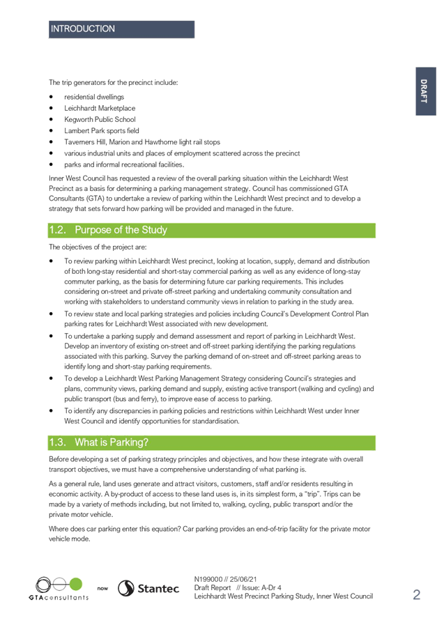
Roads and Maritime Services (RMS) is legislated as the Authority responsible for the control of traffic on all NSW Roads. The RMS has delegated certain aspects of the control of traffic on local roads to councils. To exercise this delegation, councils must establish a local traffic committee and obtain the advice of the RMS and Police. The Inner West Council Local Traffic Committee has been constituted by Council as a result of the delegation granted by the RMS pursuant to Section 50 of the Transport Administration Act 1988.
Role of the Committee
The Local Traffic Committee is primarily a technical review and advisory committee which considers the technical merits of proposals and ensures that current technical guidelines are considered. It provides recommendations to Council on traffic and parking control matters and on the provision of traffic control facilities and prescribed traffic control devices for which Council has delegated authority. These matters are dealt with under Part A of the agenda and require Council to consider exercising its delegation.
In addition to its formal role as the Local Traffic Committee, the Committee may also be requested to provide informal traffic engineering advice on traffic matters not requiring Council to exercise its delegated function at that point in time, for example, advice to Council’s Development Assessment Section on traffic generating developments. These matters are dealt with under Part C of the agenda and are for information or advice only and do not require Council to exercise its delegation.
Committee Delegations
The Local Traffic Committee has no decision-making powers. The Council must refer all traffic related matters to the Local Traffic Committee prior to exercising its delegated functions. Matters related to State Roads or functions that have not been delegated to Council must be referred directly to the RMS or relevant organisation.
The Committee provides recommendations to Council. Should Council wish to act contrary to the advice of the Committee or if that advice is not supported unanimously by the Committee members, then the Police or RMS have an opportunity to appeal to the Regional Traffic Committee.
Committee Membership & Voting
Formal voting membership comprises the following:
· one representative of Council as nominated by Council;
· one representative of the NSW Police from each Local Area Command (LAC) within the LGA, being Newtown, Marrickville, Leichhardt and Ashfield LAC’s.
· one representative from the RMS; and
· State Members of Parliament (MP) for the electorates of Summer Hill, Newtown, Heffron, Canterbury, Strathfield and Balmain or their nominees.
Where the Council area is represented by more than one MP or covered by more than one Police LAC, representatives are only permitted to vote on matters which effect their electorate or LAC.
Informal (non-voting) advisors from within Council or external authorities may also attend Committee meetings to provide expert advice.
Committee Chair
Council’s representative will chair the meetings.
Public Participation
Members of the public or other stakeholders may address the Committee on agenda items to be considered by the Committee. The format and number of presentations is at the discretion of the Chairperson and is generally limited to 3 minutes per speaker. Committee debate on agenda items is not open to the public.
|
|
Local Traffic Committee Meeting 19 July 2021 |
|
AGENDA |
1 Apologies
2 Disclosures of Interest
3 Confirmation of Minutes Page
Minutes of 21 June 2021 Local Traffic Committee Meeting 5
4 Matters Arising from Council’s Resolution of Minutes
5 Part A – Items Where Council May Exercise Its Delegated Functions
Traffic Matters
ITEM Page
LTC0721(1) Item 1 Wardell Road/Riverside Crescent, Marrickville/Dulwich Hill - No Left Turn Restriction (Djarrawunang-Marrickville Ward/Summer Hill Electorate/Inner West PAC 18
LTC0721(1) Item 2 Liberty Street and Kingston Road, Enmore / Newton / Camperdown – Trucks and Request to Reclassify Road – LTC0321 item 15 General Business (Damum-Stanmore ward / Newtown Electorate /Inner West PAC) 21
LTC0721(1) Item 3 Bailey Street, at Enmore Road, Newtown – 10km/h 'Shared Zone' Treatment – Design Plan 10133 (Damum -Stanmore Ward / Newtown Electorate / Inner West PAC) 23
LTC0721(1) Item 4 Terminus Street, Petersham – TfNSW Petersham Station Upgrade Project - Signs and Line Markings Plan 150272-Pet-Ci-Drg-45402 (Damun -Stanmore Ward/ Newtown Electorate/ Inner West PAC) 53
LTC0721(1) Item 5 Fred
Street, Dulwich Hill - Proposed Painted Island Treatment
Summer Hill Electorate 60
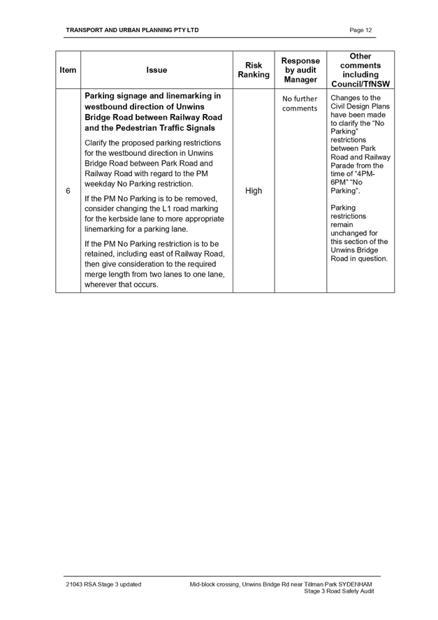
LTC0721(1) Item 6 Unwins Bridge Road, Adjacent to Tillman Park, Tempe – Proposed New Mid-Block Signalised Pedestrian Crossing – Design Plan 10111 (Midjuburi – Marrickville Ward / Summer Hill Electorate/ Inner West PAC) 62
LTC0721(1) Item 7 Alt Street at intersections with Church Street and Charlotte Street, Ashfield- Invesigation on the warrant of Pedestrian crossings. (Djarrawunang- Ashfield Ward/Summer Hill Electorate/Burwood PAC) 89
Parking Matters
ITEM Page
LTC0721(1) Item 8 Leichhardt West Precinct Parking Study (Gulgadya-Leichhardt Ward/Balmain Electorate/Leichhardt PAC) 97
LTC0721(1) Item 9 Rozelle North Precinct Parking Study (Baludarri-Balmain Ward/Balmain Electorate/Leichhardt PAC) 140
LTC0721(1) Item 10 Henry Lane,
Lewisham - Proposed 'No Stopping' restrictions
Damun- Stanmore Ward/ Summer Hill Electorate/ Inner West PAC 188
LTC0721(1) Item 11 Victoria
Road, Marrickville - Proposed short-term parking
Midjuburi- Marrickville Ward/ Summer Hill Electorate/ Inner West PAC) 190
LTC0721(1) Item 12 Constitution Road, Dulwich Hill - Proposed 'No Parking' restrictions Djarrawunang - Ashfield Ward/ Summer Hill Electorate/ Inner West PAC) 192
LTC0721(1) Item 13 Cavendish Street, Stanmore - Resident Parking Scheme
Proposal Damun - Stanmore Ward/ Newtown Electorate/ Inner
West PAC 194
LTC0721(1) Item 14 Proposed
Resident Parking Scheme in Rozelle (Baludarri-
Balmain Ward/ Balmain Electorate/ Leichhardt PAC) 196
Late Items
Nil at time of printing.
6 Part B - Items for Information Only
Nil at the time of printing.
7 Part C - Items for General Advice
Nil at the time of printing.
8 General Business
9 Close of Meeting
|
|
Local Traffic Committee Meeting 19 July 2021 |
Minutes of Local Traffic Committee Meeting
Held at Level 6, Ashfield Service Centre
Meeting commenced at 10.21AM
ACKNOWLEDGEMENT OF COUNTRY BY CHAIRPERSON
I acknowledge the Gadigal and Wangal people of the Eora nation on whose country we are meeting today, and their elders past and present.
COMMITTEE REPRESENTATIVES PRESENT
|
Clr Victor Macri |
Councillor – Midjuburi-Marrickville Ward (Chair) |
|
Bill Holliday |
Representative for Jamie Parker MP, Member for Balmain |
|
Mark Carruthers |
Transport for NSW (TfNSW) |
|
Ben Borger |
Transport for NSW (TfNSW) |
|
|
|
|
OFFICERS IN ATTENDANCE |
|
|
|
|
|
Colin Jones |
Inner West Bicycle Coalition (IWBC) |
|
Manod Wickramasinghe |
IWC’s Traffic and Transport Planning Manager |
|
Sunny Jo |
IWC’s Coordinator Traffic Engineering Services (North) |
|
Christina Ip |
IWC’s Business Administration Officer |
|
|
|
|
VISITORS |
|
|
|
|
|
Kristine Wyld |
Item 13 – Resident |
|
Rocco Ranieri |
Item 13 – Resident |
|
Helen |
Item 7 – Summer Hill Organic Fruit Market |
|
Alexandra |
Item 7 – Summer Hill Organic Fruit Market |
|
|
|
|
APOLOGIES: |
|
|
|
|
|
Chris Woods |
Representative for Ron Hoenig MP, Member for Heffron |
|
Maryanne Duggan |
Representative for Jodi McKay MP, Member for Strathfield |
|
SC Anthony Kenny |
NSW Police – Inner West Police Area Command |
|
Cathy Peters |
Representative for Jenny Leong MP, Member for Newtown |
|
Clr Marghanita da Cruz |
Councillor – Gulgadya-Leichhardt Ward (Alternative Chair) |
DISCLOSURES OF INTERESTS:
Nil.
CONFIRMATION OF MINUTES
|
The minutes of the Local Traffic Committee meeting held on Monday, 17 May 2021 were confirmed. |
MATTERS ARISING FROM COUNCIL’S RESOLUTION OF MINUTES
The Local Traffic Committee recommendations of its meeting held in April 2021 were adopted at Council’s meeting held on 24 May 2021.
The Local Traffic Committee recommendations of its meeting held on 17 May 2021 were adopted subject to the following amendments:
a) That point 5 of Item 7 Review- Detailed Works (Traffic & Parking) in Trafalgar Street, Petersham-RSL Petersham Development- DA201800173 & Implementation of Regional Bicycle Route 7 (RR7) (Stanmore Ward- Damun/Newtown Electorate/Inner West PAC) in the Traffic Committee Minutes of 17 May 2021 be deferred to enable Council to seek information from Transport for NSW in relation to contingency plans for access from New Canterbury Road to Regent Street, given that the alternative right turns from New Canterbury Road into Crystal Street and West Street are heavily congested by traffic and difficult to access; and
b) That Council writes to Transport for NSW requesting further leafleting of residents affected by the shutdown of the Sydenham to Bankstown Rail Line in regards to Item 2 Garnet Street and Dudley Street, Dulwich Hill; Illawarra Road and Marrickville Road, Marrickville; and (Lower) Railway Parade, Sydenham - Bus Replacements During Major Rail Shutdown - Temporary Parking Changes During T3 Line Upgrade For Sydney Metro - (Midjuburi -Marrickville Ward / Summer Hill Electorate / Inner West PAC).
EMAIL CONFIRMATION OF OFFICER’S RECOMMENDATION
The representative for NSW Police – Inner West supported the Officer’s recommendations for the items in their PAC.
The representative for the Member for Strathfield supported the Officer’s recommendations.
The representative for the Member for Newtown supported the Officer’s recommendations.
|
LTC0621(1) Item 1 Henry Street, Sydenham from Railway Road to George Street – Road and Footpath Improvement Works – Design Plan 10161 (Midjuburi-Marrickville Ward / Heffron Electorate / Inner West PAC) |
|
SUMMARY
Council has finalised a design plan (10161) for road and footpath improvement works in Henry Street Sydenham from Railway Road to George Street. The proposed works will realign the road and footpath at Reilly Lane adjacent to Sydenham Green.
Officer’s Recommendation
THAT the detailed design plan for the road and footpath improvement works in Henry Street Sydenham from Railway Road to George Street and associated signs and line markings in Henry Street, Sydenham (as per Plan No.10161) be APPROVED.
DISCUSSION
The Committee members agreed with the Officer’s recommendation.
COMMITTEE RECOMMENDATION
THAT the detailed design plan for the road and footpath improvement works in Henry Street Sydenham from Railway Road to George Street and associated signs and line markings in Henry Street, Sydenham (as per Plan No.10161) be APPROVED.
For motion: Unanimous
|
|
LTC0621(1) Item 2 Ferris Lane, Annandale - Proposed Permanent Road Closure (Gulgadya-Leichhardt Ward/ Balmain Electorate/ Leichhardt PAC) |
|
SUMMARY
Council at its meeting held on 28 August 2018 resolved to permanently close Ferris Lane (between Whites Creek Lane and Ferris Street), Annandale to create a licensed community garden.
Officer’s Recommendation
THAT the permanent full road closure of Ferris Lane between Whites Creek Lane and Ferris Street, Annandale be approved subject to a Traffic Management Plan (TMP) be prepared and forwarded to TfNSW for approval.
DISCUSSION
The Committee members agreed with the Officer’s recommendation.
COMMITTEE RECOMMENDATION
THAT the permanent full road closure of Ferris Lane between Whites Creek Lane and Ferris Street, Annandale be approved subject to a Traffic Management Plan (TMP) be prepared and forwarded to TfNSW for approval.
For motion: Unanimous
|
|
LTC0621(1) Item 3 Dalhousie Street, Haberfield - Bus Zone Permanent Relocation (Gulgadya-Leichhardt Ward/Summer Hill Electorate/Burwood PAC) |
|
SUMMARY
Following completion of works to Haberfield Library, Transit Systems have proposed that the temporary relocation of the Bus Zone in Dalhousie Street, 30m north of Ramsay Street be made permanent. At its previous location, (No.78 Dalhousie Street, Haberfield) a mobility parking space and a ‘1P 8:30am-6pm Mon-Fri, 8:30am-12:30pm Sat’ zone is proposed.
Officer’s Recommendation
THAT:
1. The temporary 36m length Bus Zone on the western side of Dalhousie Street, currently located 30m north of Ramsay Street to be made permanent. 2. A 6m length mobility parking space and a 14m length ‘1P 8:30am-6pm Mon-Fri, 8:30am-12:30pm Sat’ zone be installed along the frontage of Haberfield Library replacing the existing temporary ‘Works Zone’ restrictions.
DISCUSSION
The Committee members agreed with the Officer’s recommendation.
COMMITTEE RECOMMENDATION
THAT:
1. The temporary 36m length Bus Zone on the western side of Dalhousie Street, currently located 30m north of Ramsay Street to be made permanent. 2. A 6m length mobility parking space and a 14m length ‘1P 8:30am-6pm Mon-Fri, 8:30am-12:30pm Sat’ zone be installed along the frontage of Haberfield Library replacing the existing temporary ‘Works Zone’ restrictions.
For motion: Unanimous |
|
LTC0621(1) Item 4 Smith
Street, Summer Hill- Appeal On Refused Application of a Mobility (Disabled)
Parking Space Outside No.60 Smith Street. |
|
SUMMARY
A Notice of Motion (in part) was carried at Council meeting on the 13 April 2021 as follow: That the application for a mobility parking space outside 60 Smith Street Summer Hill be referred to the Local Traffic Committee for review. This report outlines the above application for a mobility parking space as per the Public Domain Parking Policy for Inner West Council. The applicant is required to carry out reasonable rectification for off-street parking accessibility, or provide evidence after rectification, if parking is still inaccessible, to re-apply for re-consideration of a mobility parking space.
Officer’s Recommendation
THAT:
1. Under current circumstances, the placement of a mobility parking space outside 60 Smith Street, be not supported. 2. The applicant be requested to clear material and/or modify/provide access from either of the existing off-street parking spaces. 3. Should accessibility issues remain following clearance and modification of the car/garage, the applicant is to provide to Council a report from My Age Care or an Occupational Therapist who has examined the property, to support any future request; and 4. A ‘Letter of support’ be attained from the applicant’s neighbour at 58 Smith Street, Summer Hill as any mobility parking space would overhang the frontage of this property
DISCUSSION
The Committee members agreed with the Officer’s recommendation.
COMMITTEE RECOMMENDATION
THAT:
1. Under current circumstances, the placement of a mobility parking space outside 60 Smith Street, be not supported. 2. The applicant be requested to clear material and/or modify/provide access from either of the existing off-street parking spaces. 3. Should accessibility issues remain following clearance and modification of the car/garage, the applicant is to provide to Council a report from My Age Care or an Occupational Therapist who has examined the property, to support any future request; and 4. A ‘Letter of support’ be attained from the applicant’s neighbour at 58 Smith Street, Summer Hill as any mobility parking space would overhang the frontage of this property.
For motion: Unanimous |
|
LTC0621(1) Item 5 Arthur Street, Ashfield (at Joseph Street)- Proposed New Speed Cushion and Kerb Blister (Djarrawunang-Ashfield Ward/Summer Hill Electorate/Burwood PAC) |
|
SUMMARY
Council has prepared a design plan to install a new speed cushion with associated new kerb blister in front of No.26 Arthur Street, Ashfield. The intention of the proposal is to slow traffic on approach to the intersection of Joseph Street and improve road safety for pedestrian and motorists at the intersection.
Officer’s Recommendation
THAT the design plan (Design Plan No. 10172) for the proposed speed cushion, kerb blister, and associated signs and line marking at the intersection of Arthur Street and Joseph Street be APPROVED.
DISCUSSION
Clr Macri requested that only low plantings be used in the landscaped kerb blister to ensure sightlines are maintained. Council Officers will pass this onto Council’s Design Services team.
The Committee members agreed with the Officer’s recommendation.
COMMITTEE RECOMMENDATION
THAT the design plan (Design Plan No. 10172) for the proposed speed cushion, kerb blister, and associated signs and line marking at the intersection of Arthur Street and Joseph Street be APPROVED.
For motion: Unanimous
|
|
LTC0621(1) Item 6 Spencer
Street and Carrington Street, Summer Hill-Proposed Extension
of Resident Parking Scheme (AREA 13) |
|
SUMMARY
Council has finalised an investigation into an extension of the Resident Parking Scheme (RPS) (AREA 13) in sections of Spencer Street, between Wellesley Street and Old Canterbury Road, and Carrington Street, between Wellesley Street and Old Canterbury Road Summer Hill. The RPS was proposed to address issues with long-term parking by non-resident vehicles in the above sections of Spenser Street and Carrington Street.
Officer’s Recommendation
THAT:
1. ‘2P 8am-6pm Mon-Fri, Permit Holders Excepted, AREA 13 parking restrictions be installed on the eastern side of Spencer Street, between premises No.28 Spencer Street to Wellesley Street, Summer Hill. 2. No further action be carried out at present to extend Resident Parking Scheme into Carrington Street, between Wellesley Street and Old Canterbury Road, Summer Hill due to insufficient support from residents in Carrington Street. 3. Any further request for residential parking not be considered for a minimum of 24 months in the above section of Carrington Street as per Inner West Council Parking Domain Parking.
DISCUSSION
The Committee members agreed with the Officer’s recommendation.
COMMITTEE RECOMMENDATION
THAT:
1. ‘2P 8am-6pm Mon-Fri, Permit Holders Excepted, AREA 13 parking restrictions be installed on the eastern side of Spencer Street, between premises No.28 Spencer Street to Wellesley Street, Summer Hill. 2. No further action be carried out at present to extend Resident Parking Scheme into Carrington Street, between Wellesley Street and Old Canterbury Road, Summer Hill due to insufficient support from residents in Carrington Street. 3. Any further request for residential parking not be considered for a minimum of 24 months in the above section of Carrington Street as per Inner West Council Parking Domain Parking.
For motion: Unanimous
|
|
LTC0621(1) Item 7 Carrington
Street, Summer Hill- Request for 1/2 Hour Period Parking
Adjacent to No. 162 Old Canterbury Road, Summer Hill. |
|
SUMMARY
The proprietor of the Summer Hill Organic Fruit Market, premises No162 Old Canterbury Road, Summer Hill, has requested ½ hour period parking to the side of the market shop in Carrington Street to assist in customer parking to the store.
Officer’s Recommendation
THAT: 1. (3) carparking spaces on the eastern side of Carrington Street, side of No. 162 Old Canterbury Road, Summer Hill be allocated as ‘½ P 8.30am-5.30pm Tues-Sat’; 2. A request to TfNSW be made to: a. Remove the short section of ‘No Parking’ to the front of No.162 Old Canterbury Road; and b. Extend the ‘No Stopping’ in length from 14 m to 16.8 m on the northern side of Old Canterbury Road, east of Carrington Street, Summer Hill.
DISCUSSION
Public speaker: Helen and Alexandra, Summer Hill Organic Fruit Market, attended at 10.52am.
Helen and Alexandra supported the proposed ‘½ P 8.30am-5.30pm Tues-Sat’ parking zone as it will provide parking turnover for their customers in Carrington Street.
(Helen and Alexandra left at 10.56am)
The Committee members agreed with the Officer’s recommendation.
COMMITTEE RECOMMENDATION
THAT: 1. (3) carparking spaces on the eastern side of Carrington Street, side of No. 162 Old Canterbury Road, Summer Hill be allocated as ‘½ P 8.30am-5.30pm Tues-Sat’; 2. A request to TfNSW be made to: a. Remove the short section of ‘No Parking’ to the front of No.162 Old Canterbury Road; and b. Extend the ‘No Stopping’ in length from 14 m to 16.8 m on the northern side of Old Canterbury Road, east of Carrington Street, Summer Hill.
For motion: Unanimous
|
|
LTC0621(1) Item 8 Moodie Street, Rozelle - Proposed No Left Turn Restrictions (Baludarri - Balmain /Balmain Electorate/ Leichhardt PAC) |
|
SUMMARY
Council at its meeting held on March 2021 resolved to temporarily introduce a ‘No Left Turn’ restriction from Moodie Street into Victoria Road with a Local Area Traffic Management (LATM) Study to be undertaken within 6 months so that a permanent change, pending the outcome of the LATM, can be considered. Community engagement for this change has now been completed with 83 responses being received with 43% of residents supporting the proposal and 57% in objection.
Officer’s Recommendation
THAT: 1. Due to the level of non-support from the community, the temporary ‘No Left Turn’ restriction from Moodie Street at Victoria Road not be supported at this time; 2. The Local Area Traffic Management (LATM) study for this area be undertaken after the completion of the WestConnex Rozelle Interchange in 2023; 3. The area continue to be monitored after the WestConnex construction works in Moodie Street are completed.
DISCUSSION
The representative for the Member for Balmain raised concerns with the impact the ‘No Left Turn’ restriction from Moodie Street will have on motorists, particularly residents from streets south of Callan Street who need the left turn from Moodie Street to head westbound on Victoria Road. The representative commented that the impact will likely worsen if the Norton Street, James Street, Darley Road and City West Link intersections are upgraded and when Rozelle Interchange traffic merges with traffic from Darling and Moodie Streets going towards the Iron Cove Bridge.
The TfNSW representative noted the concerns raised; however, they could not comment on the potential impacts the wider major project could have on Moodie Street and surrounding local streets.
The Committee members agreed with the Officer’s recommendation.
COMMITTEE RECOMMENDATION
THAT: 1. Due to the level of non-support from the community, the temporary ‘No Left Turn’ restriction from Moodie Street at Victoria Road not be supported at this time; 2. The Local Area Traffic Management (LATM) study for this area be undertaken after the completion of the WestConnex Rozelle Interchange in 2023; 3. The area continue to be monitored after the WestConnex construction works in Moodie Street are completed.
For motion: Unanimous
|
|
LTC0621(1) Item 9 Council Resolution for Local Traffic Committee March 2021 Item 7 - Unwins Bridge Road, Way Street, Toyer Street & Collins Street, St Peters - Formalising Parking Restrictions Around Tempe High School (Midjuburi - Marrickville Ward/ Heffron Electorate/ Inner West PAC) |
|
SUMMARY
During the Local Traffic Committee Meeting held in March 2021, the recommendations for Item 7 Unwins Bridge Road, Way Street, Toyer Street & Collins Street, St Peters for formalising parking restrictions around Tempe High School were adopted as per Council Officer’s recommendation. Subsequent to Local Traffic Committee adoption, residents of Toyer Street requested Councillors to amend the proposed ‘No Stopping’ restrictions in Toyer Street, Tempe. During the Council Meeting held on 11th May 2021, Council adopted an amended recommendation for ‘No Stopping’ restrictions in Toyer Street and requested the concerns of the residents be referred back to the Local Traffic Committee (LTC).
Officer’s Recommendation
THAT the findings of this report be noted.
DISCUSSION
The Committee members agreed with the Officer’s recommendation.
COMMITTEE RECOMMENDATION
THAT the findings of this report be noted.
For motion: Unanimous
|
|
LTC0621(1) Item 10 Campbell Street ST PETERS – C0621(1) Item 30 Mayoral Minute and C0621(1) Item 17 Notice of Motion - Pedestrian safety on Campbell Street, St Peters (Midjuburi - Marrickville Ward/ Heffron Electorate/ Inner West Pac) |
|
SUMMARY
This report has been prepared in response to Council’s Mayoral Minute C0621(1) Item 30 and Notice of Motion C0621(1) Item 17 regarding Pedestrian safety on Campbell Street, St Peters.
Officer’s Recommendation
THAT this report be received and noted.
DISCUSSION
The representative for the Inner West Police Area Command advised by email that they had recently spoken to numerous parents of St Peters Primary School regarding pedestrian safety at the Campbell Street intersection during the morning school zone period. Highway Patrol vehicles have had a presence at the intersection and noted that their presence was enough of a deterrent for motorists during those times. It was however acknowledged that this is not a long-term solution.
The TfNSW representative advised that the area now has more signage advising of school children crossing and traffic signals on approach to the intersection. The Committee members agreed to acknowledge the increased signage in the recommendation.
COMMITTEE RECOMMENDATION
THAT:
1. this report be received and noted; and
2. it be noted that: a) TfNSW has increased signposting, advising motorists of traffic signals and school children crossing, on approach to the Campbell Street signalised pedestrian crossing; b) TfNSW will arrange an on-site meeting with Council Officers to go over the safety concerns on Campbell Street.
For motion: Unanimous
|
|
|
|
LTC0621(1) Item 11 Ramsay Street, Haberfield - New Pedestrian Refuge Island (Gulgadya-Leichhardt Ward/ Summer Hill Electorate/ Burwood PAC) |
|
SUMMARY
Council has finalised a design plan for the proposed upgrade of the existing pedestrian refuge island on Ramsay Street west of Gillies Avenue, Haberfield. The upgrade will widen the existing refuge island, improving pedestrian safety crossing Ramsay Street and assist in reducing vehicle speeds.
Officer’s Recommendation
THAT the attached detailed design plan (Design Plan No.6196) for the proposed upgrade of the existing pedestrian refuge on Ramsay Street, at Gillies Avenue, Haberfield be approved.
DISCUSSION
Clr da Cruz emailed correspondence from a resident who raised concerns with the loss of parking near the medical centre and pharmacy on Ramsay Street. Council Officers advised that the loss of parking has been minimised with the proposed kerb extension on one side of Ramsay Street that will reduce length of the statutory 20m ‘No Stopping’ zone from the corner of Gillies Avenue.
The Committee members agreed with the Officer’s recommendation.
COMMITTEE RECOMMENDATION
THAT the attached detailed design plan (Design Plan No.6196) for the proposed upgrade of the existing pedestrian refuge on Ramsay Street, at Gillies Avenue, Haberfield be approved.
For motion: Unanimous
|
|
LTC0621(1) Item 12 168 Norton Street (Between Carlisle Street and Maccauley Street), Leichhardt - Road Occupancy (Gulgadga - Leichhardt/ Balmain Electorate/ Leichhardt PAC) |
|
SUMMARY
Council has received an application from Growth Built Pty Ltd for approval of a temporary full road closure of Norton Street (in front of No.168 Norton Street), between Carlisle Street and Macauley Street, Leichhardt from 9:00pm Monday, 19 July 2021 to 5:00am Tuesday, 20 July 2021 (with a contingency period of six weeks) for dismantling of a tower crane at 168 Norton Street, Leichhardt.
Officer’s Recommendation
THAT the proposed temporary full road closure of Norton Street, between Carlisle Street and Macauley Street, Leichhardt from 9:00pm Monday, 19 July 2021 to 5:00am Tuesday, 20 July 2021 (with a contingency period of six weeks – only between Sundays and Wednesdays) be approved for dismantling of a tower crane at No.168 Norton Street, Leichhardt subject to, but not limited to, the following conditions:
1. A Traffic Management Plan (TMP) for the attached Traffic Control Plan (TCP) be submitted to TfNSW prior to the start of works;
2. A Road Occupancy License be obtained by the applicant from the Transport Management Centre;
3. All affected residents and businesses, including, Transit Systems, STA, NSW Police Area Command, Fire & Rescue NSW and the NSW Ambulance Services be notified in writing, by the applicant, of the proposed temporary full road closure at least 7 days in advance of the closure with the applicant making reasonable provision for stakeholders; and
4. The occupation of the road carriageway must not occur until the road has been physically closed.
DISCUSSION
The Committee members agreed with the Officer’s recommendation.
COMMITTEE RECOMMENDATION
THAT the proposed temporary full road closure of Norton Street, between Carlisle Street and Macauley Street, Leichhardt from 9:00pm Monday, 19 July 2021 to 5:00am Tuesday, 20 July 2021 (with a contingency period of six weeks – only between Sundays and Wednesdays) be approved for dismantling of a tower crane at No.168 Norton Street, Leichhardt subject to, but not limited to, the following conditions:
1. A Traffic Management Plan (TMP) for the attached Traffic Control Plan (TCP) be submitted to TfNSW prior to the start of works;
2. A Road Occupancy License be obtained by the applicant from the Transport Management Centre;
3. All affected residents and businesses, including, Transit Systems, STA, NSW Police Area Command, Fire & Rescue NSW and the NSW Ambulance Services be notified in writing, by the applicant, of the proposed temporary full road closure at least 7 days in advance of the closure with the applicant making reasonable provision for stakeholders; and
4. The occupation of the road carriageway must not occur until the road has been physically closed.
For motion: Unanimous
|
|
LTC0621(1) Item 13 Trafalgar Lane, Annandale - Proposed 'No Parking' Restrictions (Baludarri-Balmain/Balmain Electorate/Leichhardt PAC) |
|
SUMMARY
Council has received concerns from a resident of Trafalgar Street, Annandale regarding vehicles parking on the eastern side of Trafalgar Lane, Annandale and subsequently obstructing rear driveway access for properties No.195 and No.197 Trafalgar Street, Annandale. An investigation has now been completed and is presented in this report.
Officer’s Recommendation
THAT a 11.1m ‘No Parking’ zone be installed on the eastern side of Trafalgar Lane between the rear access driveways of No.222 and No.226 Nelson Street and opposite to the rear garage of No.195 and No.197 Trafalgar Street, Annandale.
DISCUSSION
Public speaker: Kristine Wyld attended at 10.23am.
Ms Wyld read a statement from her neighbours, David and Kim Cox, who could not attend the meeting: Mr and Ms Cox do not support the reasoning for the recommendation and commented that the laneway provides rear access for deliveries, maintenance workers, and residents and visitors with mobility issues who cannot easily access the steep frontages of properties on Nelson Street.
Ms Wyld also did not support the recommendation for similar reasons and stated that it will further increase parking pressure in the laneway. Ms Wyld suggested only restricting parking during the morning and evening hours when the proponent is most affected by vehicle obstruction.
(Ms Wyld left at 10.37am)
Public speaker: Rocco Ranieri attended at 10.37am.
Mr Ranieri supported the recommendation as access to his garage has been increasingly difficult due to vehicle obstruction and stated that the proposed ‘No Parking’ zone will ensure continual access to his garage.
The Committee members noted that there is unrestricted parking on the northern end of Trafalgar Lane that allow for maintenance workers to park, and tree loppers typically apply for standing plant permits to park on the street. It was also noted that it is permissible for deliveries and drop-offs/pick-ups to be made in ‘No Parking’ zones.
(Mr Ranieri left at 10.50am)
Clr Macri requested that the Committee recommend that Council Officers write to residents who did not support the proposal informing them of behaviour that is permitted in ‘No Parking’ zones. The Committee members agreed to include this in the recommendation.
COMMITTEE RECOMMENDATION
THAT: 1. a 11.1m ‘No Parking’ zone be installed on the eastern side of Trafalgar Lane between the rear access driveways of No.222 and No.226 Nelson Street and opposite to the rear garage of No.195 and No.197 Trafalgar Street, Annandale. 2. Council Officers write to the residents who did not support the proposal to inform them of permitted behaviours within a ‘No Parking’ zone.
For motion: Unanimous
|
General Business
LTC0621 Item 14 Request for angle parking in School Parade, Marrickville
Clr Macri received a request for angle parking in School Parade to address a shortfall in parking in the street. Council Officers will investigate.
LTC0621 Item 15 Request for more parking in The Boulevarde, Lewisham
Residents of The Boulevarde have requested increasing parking supply in the street. It was noted that Council does not typically remove vegetation to increase parking supply due to the streetscape impacts. The residents of The Bourlevarde also requested for verge gardens that they can implement themselves.
LTC0621 Item 16 Update on the one way proposal for Warren Road, Marrickville
TfNSW is continuing to process the proposed one way treatment for Warren Road and will be contacting Council this week to discuss.
LTC0621 Item 17 Increase in parking issues in the LGA
Clr Macri raised concerns that parking issues seem to be increasing in the LGA and questioned how Council is responding strategically to the demand for more on-site residential and business parking, particularly in preparation for increasing use of electric vehicles. Council Officers advised that an Electric Vehicle Charging Strategy and a holistic Inner West Parking Strategy is currently in development and these strategies will feed into planning controls related to on-site parking. Various stakeholders will be engaged during the development of the draft strategies and the community will be given opportunities to provide input when the drafts are publicly exhibited.
LTC0621 Item 18 Maintenance request for footpath between City West Link and Iron Cove Creek, Haberfield
The IWBC representative commented that the footpath between the City West Link and Iron Cove Creek needs maintenance works. The TfNSW representative will submit a request for footpath maintenance for that location.
LTC0621 Item 19 Works at the intersection of Livingstone Road and Hastings Street, Marrickville
Clr Macri raised concern with the current works at the intersection of Livingstone Road and Hastings Street, Marrickville with regards to drainage and the tight left turn that has been created. Council Officers will investigate.
Meeting closed at 11.50am.
|
|
Local Traffic Committee Meeting 19 July 2021 |
Subject: Wardell Road/Riverside Crescent, Marrickville/Dulwich Hill - No Left Turn Restriction (Djarrawunang-Marrickville Ward/Summer Hill Electorate/Inner West PAC
Prepared By: Jason Scoufis - Traffic and Parking Planner
Authorised By: Manod Wickramasinghe - Traffic and Transport Planning Manager
SUMMARY
A ‘No Left Turn’ restriction was installed in early 2021 to ban vehicles heading northeast in Wardell Road from making a left turn into Riverside Crescent, Dulwich Hill/ Marrickville.
Since the sign was installed, Council has received numerous correspondence from the community regarding the negative impact the banned left turn movement restriction has had on traffic delays and travel times in Wardell Road , in particular in the weekday AM peak period heading towards Dulwich Hill.
A number of treatments are proposed to alleviate traffic congestion whilst supporting cycling for the on-road sections of the Greenway.
|
RECOMMENDATION
THAT:
1. The ‘No Left Turn’ sign in Wardell Road facing northeast bound motorists at Riverside Crescent be replaced with a ‘No Left Turn Vehicles over 6 metres’ sign subject to TfNSW approval of a TMP. 2. The BB lines in Riverside Crescent at Wardell Road be adjusted by relocating 1m northeast for a length of 10 metres. 3. A concept design for traffic calming in the form of kerb extensions at the Tennyson Street/Riverside Crescent be prepared for consideration by Traffic Committee 4. A 30 km/h speed limit in Ness Avenue along the on-road Greenway route be supported for a 12-month trial period subject to approval of the trial by TfNSW
|
BACKGROUND
A ‘No Left Turn’ restriction was installed in early 2021 to ban vehicles heading northeast in Wardell Road from making a left turn into Riverside Crescent, Dulwich Hill/Marrickville.
The left turn ban was imposed as part of the Greenway Project, with the aim of reducing traffic volumes and improving safety and amenity for cyclists in and around Ness Avenue, which forms part of the on- road section of the Greenway.
The restriction was installed after consultation with residents regarding various options to reduce traffic volumes in Ness Avenue.
Since the sign was installed, Council has received numerous correspondence from the community regarding the negative impact the banned left turn movement restriction has had on traffic delays and travel times in Wardell Road , in particular in the weekday AM peak period heading towards Dulwich Hill. This has been exacerbated by the traffic which use to make the left turn into Riverside Crescent being redistributed to a left turn into Ewart Street adding extra traffic volumes in this section of Wardell Road.
As a result of these concerns, Council requested TfNSW investigate adjusting the traffic signal timings at the Wardell Road/Ewart Street signals to provide additional time for northeast bound traffic in Wardell Road on approach to Ewart Street. TfNSW subsequently advised that they were able to adjust the timings and these were made in early June which has reduced traffic delays.
Whilst the traffic signal adjustments have improved traffic flow there is still considerable traffic queueing. This results in a significant number of vehicles which continue to illegally make the left turn into Riverside Crescent, or alternatively make the left turn by travelling through the Budget Petrol station on the corner of Riverside Crescent/Wardell Road.
In order to assess how many vehicles, continue to make this left turn, a traffic count was carried out on Thursday 24th June 2021 between 8:00am and 9:00am with the following results:
· Left turn from Wardell Road into Riverside Crescent - 52 vehicles
· Left turn by travelling through the Budget Petrol Station - 12 vehicles
These traffic volumes are significant. No further physical constraints can be installed at the intersection to prevent this from occurring as they would further reduce options for traffic to travel through this area by needing to ban additional movements. This would likely result in additional traffic using the Budget Petrol station to make this turn, which is a safety concern.
In order to continue to provide safe conditions for cyclists, whilst providing adequate access for motorists, the following measures are proposed:
· Replace the ‘No Left Turn’ sign in Wardell Road facing northeast bound motorists at Riverside Crescent with a ‘No Left Turn Vehicles over 6 metres’ sign which will allow cars to make the left turn but all trucks will be banned . It will also allow cyclists to make the left turn which they currently are not permitted to do. It will slightly reduce traffic volumes in and around the local road network.
· Adjust the double centrelines (BB) line in Riverside Crescent at Wardell Road by relocating 1.0 metre northeast to provide additional width for large vehicles to make the right turn from Wardell Road into Riverside Crescent, and also allow vehicles to make the left turn from Wardell Road into Riverside Crescent without travelling over the BB lines. This currently occurs as a result of the kerb blister installed on the south western corner of the intersection as part of the on-road Greenway improvements.
· Provide additional traffic calming measures at the Riverside Crescent/Tennyson Street intersection in the form of kerb extensions in and around the kerb returns to narrow the road width and slow turning traffic.
· Introduce a 30km/h speed limit in Ness Avenue along the on-road section of the Greenway for a 12 month trial period to provide additional safety and amenity for cyclists in line with Council’s Integrated Transport Strategy which advocates for an LGA wide 40km/h zone, with investigative areas of 30km/h in areas of demonstrated high pedestrian flow or pedestrian/cyclist crash clusters.
It should be noted that the 'No Left Turn Vehicles over 6 metres' sign will require a TMP to be submitted to TfNSW for approval. Similarly, the 30km/h speed limit trial will require approval from TfNSW.
A concept design for the kerb extensions at the Riverside Crescent/Tennyson Street will be bought back to a future traffic committee meeting for approval.
FINANCIAL IMPLICATIONS
The cost to adjust the linemarking and signposting at the Wardell Road/Riverside Crescent intersection will be funded from Council’s Traffic Facilities Budget, whilst the kerb extension works at the Tennyson Street/Riverside Crescent intersection will be funded as part of the Greenway on-road works.
PUBLIC CONSULTATION
Nil. Subsequent consultation will be undertaken as required in finalising the concept design, TMP and speed limit trial.
|
|
Local Traffic Committee Meeting 19 July 2021 |
Subject: Liberty Street and Kingston Road, Enmore / Newton / Camperdown – Trucks and Request to Reclassify Road – LTC0321 item 15 General Business (Damum-Stanmore ward / Newtown Electorate /Inner West PAC)
Prepared By: Jennifer Adams - Engineer – Traffic and Parking Services
Authorised By: Manod Wickramasinghe - Traffic and Transport Planning Manager
SUMMARY
Council has received concerns regarding truck movements along Liberty Street and Kingston Road, Enmore and an Item was raised in General Business at the March 2021 Committee meeting to assess the need for reclassification of the existing Regional Road. Past traffic count data was compared with current traffic volume counts and it is recommended that no action be taken at this time and the traffic situation in the area continue to be monitored.
|
RECOMMENDATION
THAT this report be received and noted. |
BACKGROUND
At the March 2021 LTC meeting in ‘General Business’ an item was listed regarding heavy vehicle access in Liberty Street and Kingston Road (LTC0315 Item 15):
“ A resident of Kingston Road contacted the Member for Newtown’s Office indicating that she and many neighbours are concerned about the number and type of large vehicles using Liberty Street and Kingston Road including cement trucks, Newington school buses (large tourist buses), semitrailers (including one with containers on it) and WestConnex ‘truck and dogs’. The resident has also contacted Newtown Police about this issue.
The representative for the Member for Newtown indicated that they have raised the issue of construction trucks on many key roads in the Inner West including King Street, Edgeware Road and Enmore Road in the past, while realising that these roads come under the control of TfNSW. However, given the high pedestrian and cycle usage as well as the size of these streets, the representative suggested that Council look at whether some of these roads need to be assessed for reclassification with TfNSW.”
OTHER STAFF COMMENTS
Liberty Street is a street running north from Stanmore Road to a rail underpass where it connects with Kingston Road which carries on through to Salisbury Road. These roads which are mainly residential in composition, are classified as Regional Roads and provide an important connecting link between Parramatta Road and Stanmore Road and beyond.
A considerable volume of traffic uses the subject streets particularly as access under the railway line is possible via the underpass near the junction of Liberty and Trafalgar Streets. Traffic volumes on Liberty Street between London Street and Cambridge Street, presently (May 2021) are approximately 12,000 vehicles per day with trucks (all sizes) representing approximately 5.5% of the total, which is normal for this class of road. It is noted that comparison counts from 2014 reveal a traffic volume of approximately 15,500 vehicles per day with 7.2% being trucks. That is, both the traffic volume and amount of trucks using Liberty Street currently is now less than it was in 2014.
Traffic volumes on Kingston Road, between Rowley Street and Gilpin Street, presently (May 2021) are approximately 16,500 vehicles per day with trucks (all sizes) representing approximately 7.3% of the total. Comparison counts from 2014 reveal a traffic volume of approximately 16,100 vehicles per day with 5.3% being trucks. Thus, traffic volumes currently using Kingston Road are comparable with 2014 despite a slight increase in the number of trucks using Kingston Road, which is still considered acceptable for a Regional Road. It is noted that the 85th percentile speeds are less now at 37.9km/h (2021) down from 43.2km/h (2014).
Kingston Road, Camperdown/Newtown and Liberty Street Enmore/Newtown are classed as Regional Roads and are under Council’s jurisdiction. From a functional road hierarchy, they are expected to carry heavy vehicles and provide an important north-south corridor between Salisbury Road (Regional road) and Stanmore Road (State road). Alternative routes for trucks should they not use this road network link would be Crystal Street and/or West Street (where access over the railway line is available) which are also partially residential streets.
Regional Roads are also eligible for annual assistance grants from the State Government in recognition of their relative importance (e.g. the Repair Program provides 50 per cent funding for specific rehabilitation or enhancement works). Thus, reclassification is not considered practicable at this time therefore it is recommended that no action be taken now and the traffic situation in the area continue to be monitored.
|
|
Local Traffic Committee Meeting 19 July 2021 |
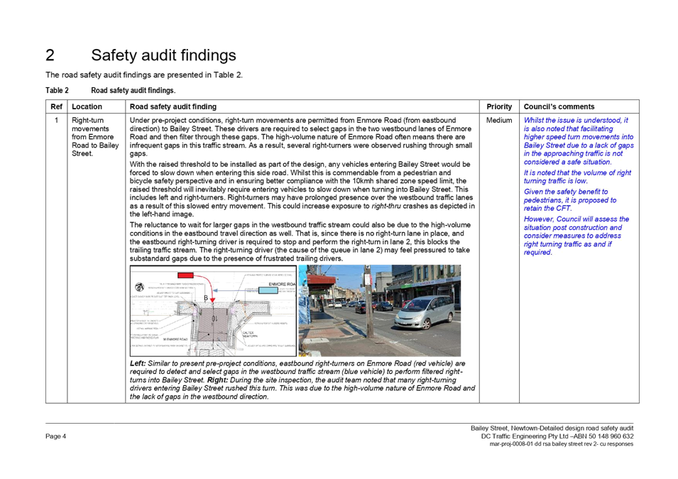
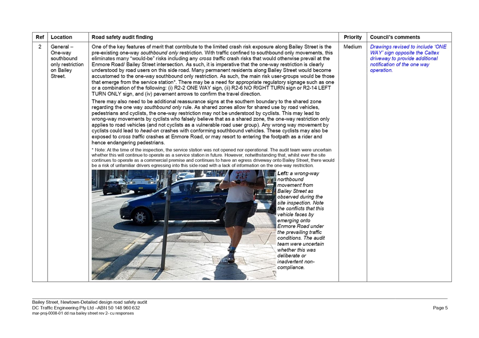
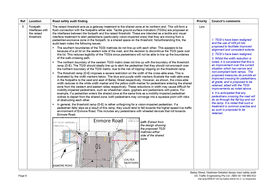
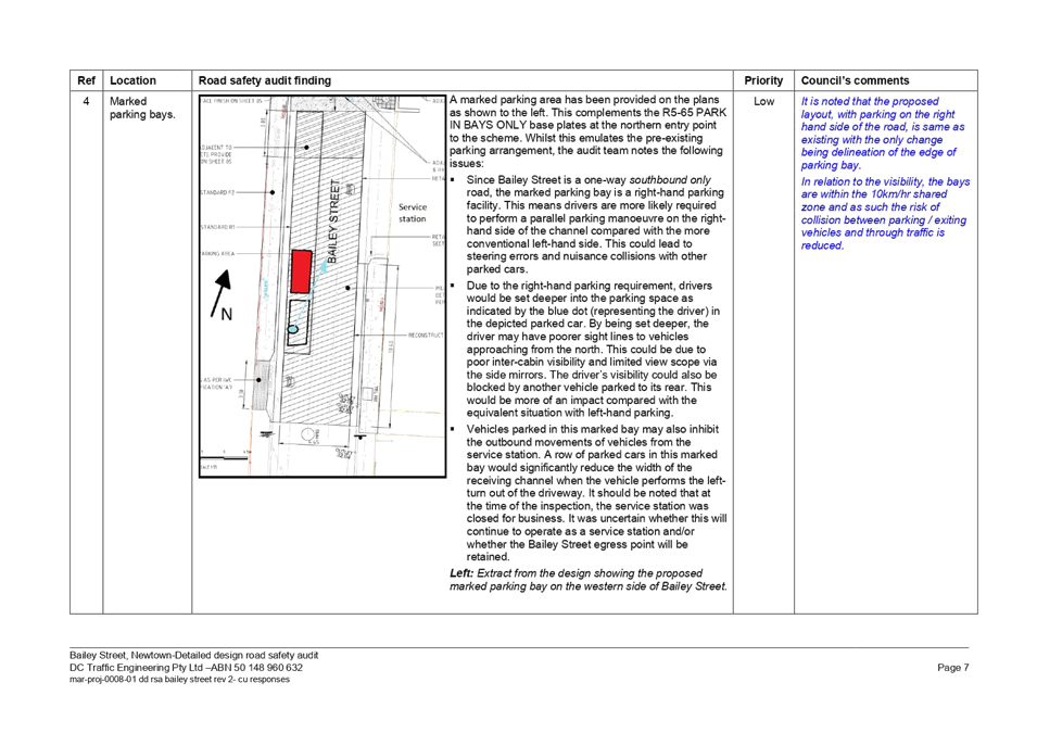
Subject: Bailey Street, at Enmore Road, Newtown – 10km/h 'Shared Zone' Treatment – Design Plan 10133 (Damum -Stanmore Ward / Newtown Electorate / Inner West PAC)
Prepared By: Jennifer Adams - Engineer – Traffic and Parking Services
Authorised By: Manod Wickramasinghe - Traffic and Transport Planning Manager
SUMMARY
Council has finalised a design plan (10133) for a 10km/h ‘Shared Zone’ treatment in Bailey Street at Enmore Road, Newtown. The proposal for a ‘Shared Zone’ with threshold treatments and associated signs and line markings will improve safety and accessibility for pedestrians and traffic conditions at this location. The proposed works are part of recommendations endorsed in September 2019 and listed in the Newtown Local Area Traffic Management (LATM) report.
|
RECOMMENDATION
THAT the detailed design plan for the 10km/h ‘Shared Zone’ treatment in Bailey Street at Enmore Road, Newtown and associated signs and line markings (as per Plan No.10133) be APPROVED, subject to separate TfNSW approval. |
Council is planning to construct a ‘Shared Zone’ treatment in Bailey Street at Enmore Road, Newtown to increase safety for pedestrians and motorists. At its meeting in September 2019, Council endorsed the final Newtown Local Area Traffic Management (LATM) report. The proposals within the report were based on community input and analysis offered back from the Public Exhibition period in April 2019. Following project prioritisation, the shared zone proposal in Bailey Street was selected to proceed to detailed concept design development and eventually construction implementation in the 2021/22 financial year.
The 30m ‘Shared Zone’, when proposed as part of the Newtown ATM Strategy, received in-principle support from TfNSW prior to Traffic Committee and Council adoption. The ‘Shared Zone’ treatment (Category 2) will prioritise pedestrians, as this is a high pedestrian area off the Enmore Road shopping strip. Benefits of this treatment include improved pedestrian safety, reduced vehicular speeds, enhanced quality and liveability of the area including walking and cycling. By creating a 10km/h ‘Shared Zone’ treatment on side streets along the Enmore Road commercial areas this will meet the public domain principles by creating a respite area and improving walkability through the commercial areas.
A ‘Shared Zone’ application was submitted to the TfNSW for consideration and approval. On 25 September 2020 TfNSW commented:
“Approval to the Shared Zone and for the construction of the treatments will be provided following the results of a Road Safety Audit and Community Consultation. Any corrective actions that may be necessary as a result of the Road Safety Audit should also be made.
Consultation is to also include presentation to the Local Traffic Committee as well as consultation with emergency services.
The results of these, along with the previously provided information should be submitted in a report format once complete. (Similar to a TMP).”
A detailed design road safety audit was prepared for the project, a copy of which is attached at the end of this report. Minor changes were subsequently made to the final design plan. It was noted that vehicles wishing to turn into Bailey Street, which is one-way south bound, from the eastbound inner lane of Enmore Road had the potential to hold up traffic and/or take risks in choosing small gaps. This was acknowledged and though the volume of right turning traffic is relatively low this situation will be assessed post construction and measures will be considered to address this if required. A review of the last five years of TfNSW recorded crash data revealed two ‘Right thru’ (RUM 21) crashes, one in December 2017 and the other in June 2018.
Currently a TMP is being prepared to submit to TfNSW to obtain final approval. The proposed ‘10km/h Shared Zone’ and associated regulatory signage is now presented to the Traffic Committee for approval, subject to TfNSW approval.
FINANCIAL IMPLICATIONS
The works are listed on Council’s Capital Works budget for 2021/2022 and funding of $100,000 has been allocated to this project.
STAFF COMMENTS
The detailed design plan for the provision of a ‘Shared Zone’ with threshold treatments in Bailey Street, at Enmore Road, Newtown including the proposed signs and line markings (ATTACHMENT - design plan No. 10133) are submitted for consideration.
The proposed scope of work includes the following:
· Removal of existing kerb ramps in Enmore Road and construct a new raised stenciled threshold in Bailey Street so that footpath and road are the same level;
· Providing a terracotta coloured stenciled treatment for the length of the proposed ‘Shared Zone’;
· Repairing paving surrounding the works (The paving extent shown on the plans are indicative only and will be finalised in the detailed design);
· Reconstructing existing concrete footpath within the area of works
· Marking parking bays within the ‘Shared Zone’ area
· Installing associated signage and line marking.
This proposal will result in no loss of legal on-street parking spaces in Bailey Street, Newtown.
PUBLIC CONSULTATION
A letter outlining the proposal was distributed to all effected surrounding properties in the area. Consultation was conducted between 7 June and 28 June 2021. A total of 145 letters were distributed.
In total five (5) responses were received. Two were not related to the project works and were complaints about works in the area being carried out by Sydney Water. The other three (3) responses were all in general support of the proposed ‘Shared Zone’ works. In addition to general support all three respondents commented on various unrelated issues in the locality and/or with requests for various other traffic calming works (deterrents for stopping local rat running; lower speed limit etc). Accordingly, the suggestions offered for these other traffic calming facilities have been listed for review in the next LATM Scheme Review for Newtown – Area 6.
|
1.⇩ |
210527 3051-01 Bailey St - Detailed design plan |
|
2.⇩ |
MAR-PROJ-0008-01 DD RSA Bailey Street Rev 2 |
|
Local Traffic Committee Meeting 19 July 2021 |
Subject: Terminus Street, Petersham – TfNSW Petersham Station Upgrade Project - Signs and Line Markings Plan 150272-Pet-Ci-Drg-45402 (Damun -Stanmore Ward/ Newtown Electorate/ Inner West PAC)
Prepared By: Jennifer Adams - Engineer – Traffic and Parking Services
Authorised By: Manod Wickramasinghe - Traffic and Transport Planning Manager
SUMMARY
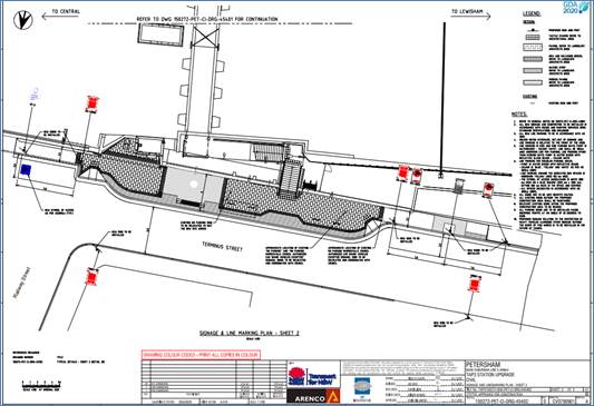
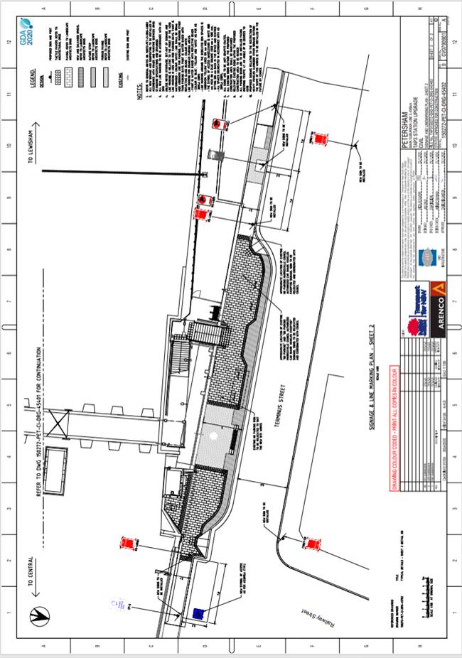
The signs and line marking plan for the proposed traffic / parking changes in Terminus Street, Petersham associated with Petersham Station Upgrade Project works have been submitted to Council (150272-PET-CI-DRG-45402) by Arenco, on behalf of TfNSW. It is recommended that the signs and line marking plan be approved.
|
THAT the detailed signs and line marking plan for Terminus Street, Petersham (as part of Petersham Station Upgrade works) as per the attached plan (Signage and Line Marking Plan - Sheet 2 - 150272-PET-CI-DRG-45402) be approved. |
BACKGROUND
TfNSW have engaged Arenco to undertake the Petersham Station Upgrade works to facilitate their Transport Access Program across railway stations in the Sydney Metropolitan area.
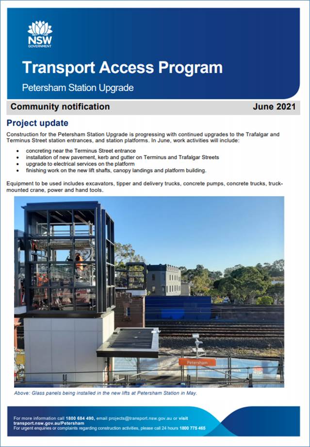
According to an October 2019 leaflet distributed locally by TfNSW the Petersham Station Upgrade works involves remodelling the station to include:
- two new lifts connecting the existing footbridge to the Terminus Street station entrance and the station platform
- a new access ramp/stairs from the Trafalgar Street station entrance to the existing footbridge
- upgrade works to the existing footbridge and stairs
- a new accessible parking space adjacent to the Terminus Street lift
- a formalised kiss and ride area on Terminus Street
- new bicycle parking on both sides of the station
- improved amenities such as new male and female ambulant toilets, a new family accessible toilet, CCTV and lighting.
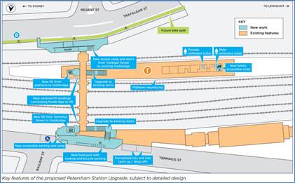
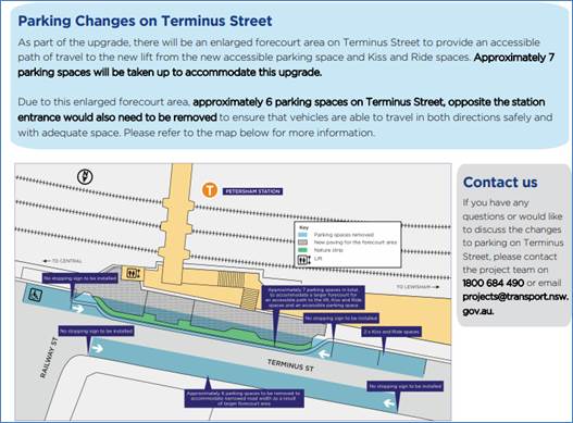
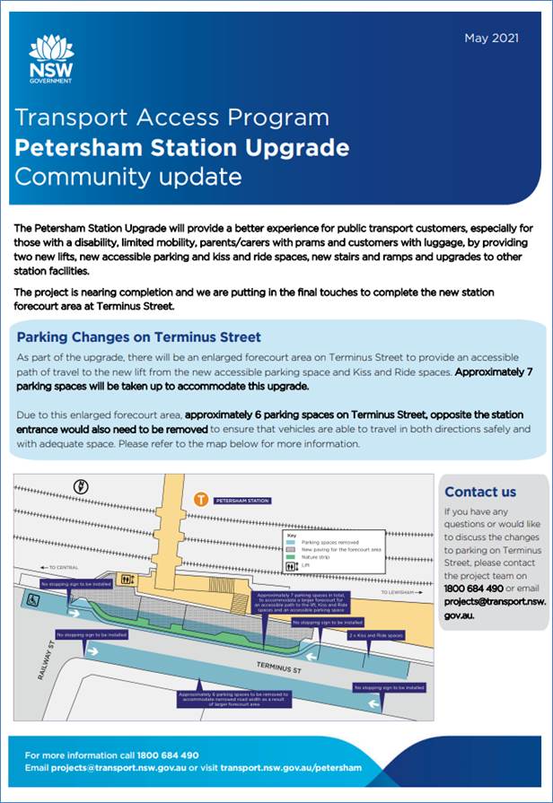
In Terminus Street specific works included pushing the kerb out further for the new station entry necessitating the removal of parking on the other side of the street as part of the permanent design. It is noted that the Project results in the loss of 14 on-street parking spaces in Terminus Street.
The attached plan (reproduced at a larger scale at the end of the report) shows the new kerb alignment and associated signage.
FINANCIAL IMPLICATIONS
All works and costs of implementation works associated with the project will be borne by the applicant.
PUBLIC CONSULTATION
TfNSW has undertaken the community consultation for these works. TfNSW undertook additional consultation with the community regarding the loss of approximately 14 parking spaces on Terminus Street as part of the Petersham Station Upgrade. Consultation occurred in late May/early June 2021, and below is a summary of their consultation activity and feedback received.
Consultation included doorknocking of the residents on Terminus Street and Railway Street (between Terminus Street and Brighton Street) on Friday 28 May, and inclusion of the information in our June community notification which was distributed within a 500 metre radius of Petersham Station (see May 2021 and June 2021 ‘Community Update’ notices attached at the end of this report).
“Notification - Date: 28 May 2021
Location: Residents on Terminus Street and Railway Street (between Terminus Street and Brighton Street)
Properties engaged face-to-face: 23
Properties unattended – left “Sorry we missed you” contact cards and notification: 33
Total properties reached: 56
During the doorknocking activity, residents highlighted that parking has been an ongoing issue in the area, prior to the station upgrade. One request that was raised by multiple residents was to convert some of the untimed parking spots on Terminus and Railway Street into timed parking spaces. One resident also suggested extending the current timed parking spots to timed during the weekend, as well as being timed from Monday to Friday. We also received 4 emails via our transport email address post-doorknocking regarding the parking changes, all from residents of Terminus Street. Two of these emails asked for more untimed parking spots in the area, and the other two wanted to find out more about the removal of parking.”
CONCLUSION
It is recommended that the signage and line marking plan be approved.
|
|
Local Traffic Committee Meeting 19 July 2021 |
Subject: Fred Street, Dulwich Hill - Proposed Painted
Island Treatment
Summer Hill Electorate
Prepared By: Scipio Tam - Engineer – Traffic and Parking Services
Authorised By: Manod Wickramasinghe - Traffic and Transport Planning Manager
SUMMARY
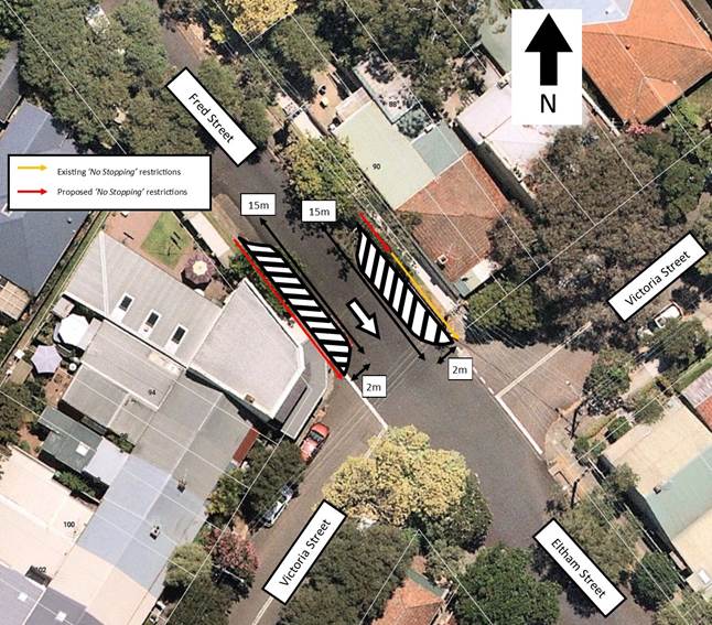
Council has received concerns raised by a number of residents and motorists regarding safety along Fred Street and at the intersection of Fred Street/ Victoria Street and Eltham Street. It has been raised with Council that on many occasions, vehicles drive into Fred Street, against the one-way direction of travel with drivers either unaware of the current ‘No Entry’ signage or willful intent to disobey the no entry restrictions. Council has proposed a painted island treatment in order to enhance the current no entry restrictions and to possibly deter illegal traffic behavior.
|
RECOMMENDATION
THAT 1. the proposed painted island treatment, including travel direction arrow and extension of existing ‘No Stopping’ restrictions to 15m, on both sides of Fred Street north of the intersection of Fred Street, Victoria Street and Eltham Street, Dulwich Hill, be approved. 2. Physical kerb blister islands to replace the painted island treatment be approved in principle and listed on Council’s forward Capital Works Program.
|
OTHER STAFF COMMENTS
Residents of Fred Street have reported on many occasions, vehicles travelling north bound along Fred Street, contrary to ‘one-way’ signage.
It has been reported to Council that offenders travelling against the direction travel include both visitors to the area unaware of the ‘One-way’ direction and residents of the area intentionally travelling through Fred Street against direction of travel as a shortcut. The combination of a wider road and generally good sight lines make it easier for some motorist to disobey the one way and no entry restrictions.
Therefore, the proposal for road narrowing via painted islands and arrowing markings along with ‘No Stopping’ extension have been developed at the intersection of Fred Street/ Eltham Street and Victoria Street to provide a visual narrowing through delineation and support the ‘One-way’ and ‘No Entry’ signage currently in existence. It should be understood that this solution should provide a benefit, however, will not entirely solve the current problem due to the road geometry factors as mentioned above.
PUBLIC CONSULTATION
A consultation letter outlining the proposal was mailed out to 37 surrounding properties and respective owners. A total of eleven (11) responses were received; eight (8) supported the proposal, two (2) conditionally support and one (1) objected the proposal.
All residents who commented noted that a raised structure/ traffic island would be more effect in deterring vehicles travelling wrong way through Fred Street.
Residents who conditionally supported the proposal raised concerns of the extension of ‘No Stopping’/ removal of on-street parking in an already high demand area.
Resident who opposed the proposal also did not support the on-street parking removal/ extension of ‘No Stopping’ and request a single continuous white line differentiating the parking lane and travel lane. However, this does not address the issue where some motorists are not aware of the signposted ‘One-way’ and ‘No Entry’ signs and continue through Fred Street against the direction of travel. The extended ‘No Stopping’ zones and painted islands are expected to reinforce this restriction and address the primary issue.
|
|
Local Traffic Committee Meeting 19 July 2021 |
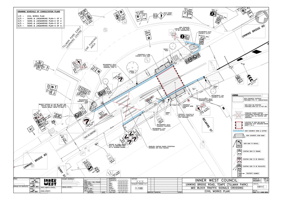
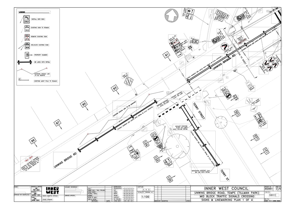
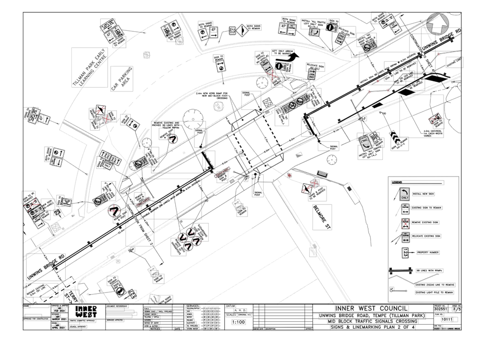
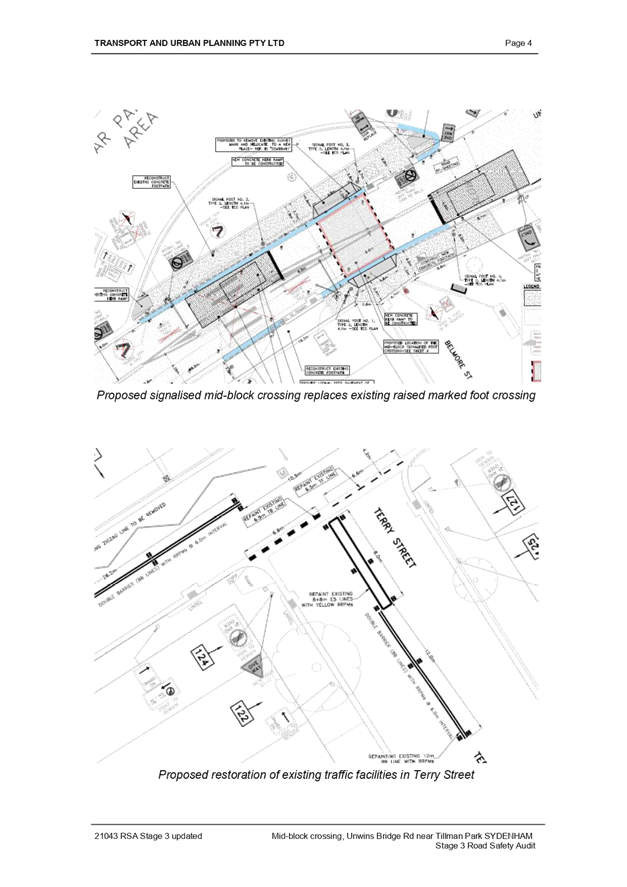
Subject: Unwins Bridge Road, Adjacent to Tillman Park, Tempe – Proposed New Mid-Block Signalised Pedestrian Crossing – Design Plan 10111 (Midjuburi – Marrickville Ward / Summer Hill Electorate/ Inner West PAC)
Prepared By: Jennifer Adams - Engineer – Traffic and Parking Services
Authorised By: Manod Wickramasinghe - Traffic and Transport Planning Manager
SUMMARY
Detailed design plans have now been finalised for the proposed new mid-block signalised pedestrian crossing in Unwins Bridge Road, adjacent to Tillman Park, Tempe. The purpose of the proposed works is to increase pedestrian safety at the existing raised pedestrian zebra crossing which has a poor road safety history. The proposed works received funding from the TfNSW Blackspot Program and the works will improve pedestrian and motorists' safety and addresses residents' concerns about speeding, driver behaviour and pedestrian safety at this location. Consultation has been undertaken with nearby owners and occupiers of properties along Unwins Bridge Road regarding the proposal. It is recommended that the proposed detailed design plans be approved.
|
RECOMMENDATION
THAT the detailed design plans for the proposed new mid-block signalised pedestrian crossing on Unwins Bridge Road, adjacent to Tillman Park, Tempe, including associated signposting and line marking (as per the attached plans No. 10111) be APPROVED.
|
BACKGROUND
Council is proposing to install a new mid-block signalised pedestrian crossing on Unwins Bridge Road, adjacent to Tillman Park, Tempe by removing the existing raised pedestrian zebra crossing and pedestrian refuge. The community has formerly raised road safety concerns in relation to the existing crossing and reported that motorists regularly do not stop for pedestrians using the crossing. The crossing has a poor road safety record including a fatal and serious injury crash. A submission for the new signalised crossing was made through the Federal Blackspot Program and the Fatal and Serious injury crash response programs and was successful in the 2020-2021 round.
FINANCIAL IMPLICATIONS
Funding of $300,000 has been allocated by Council under the 2020/2021 Capital Works Program for Traffic Facilities. Funding of $250,000 was received as part of the Australian Government’s 2019/2020 Black Spot Program.
OTHER STAFF COMMENTS
Unwins Bridge Road is classified as a Regional Road, has a speed limit of 50 km/h and is approximately 8 metres wide at the subject location. Traffic volumes are approximately 16,500 vehicles per day.
The proposed work includes:
Traffic Facilities Works
· Installation of a new Mid-Block Pedestrian Operated Signalised Crossing and associated road signage, signal posts, pedestrians’ operated signals/lights.
· Installation of two auto vehicle detectors on both approaches to the crossing.
· Additional associated signs to be installed/altered as shown on plans.
· Some existing pavement markings/lines are to be removed fully or partly and some new line markings are to be marked/remarked, as shown on plans.
Road Works
· Demolish/Remove existing Raised Pedestrian Crossing, and related road signs.
· Demolish existing surface and replace with AC-14 asphaltic mix.
· Installation of a Kerb extension at north side of the street as shown on plans.
· Two wider width kerb ramps to be installed at the new location of the new signalised pedestrian crossing.
· Deep asphalt cut and excavate at the new locations for installing the two vehicle detector devices.
· New road re-sheeting program is included surrounding existing raised pedestrian crossing and at the new pedestrian crossing.
· Reconstruct existing concrete kerb and gutter, and footpath as shown on plans.
A Road Safety Audit was conducted for the new mid-block signalised pedestrian crossing and is attached at the end of this report. Specific details of the proposed scope of works appear below and are detailed in the attached plans.
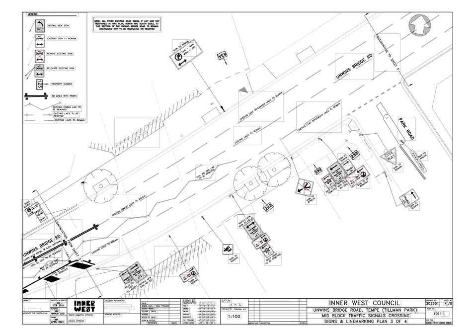
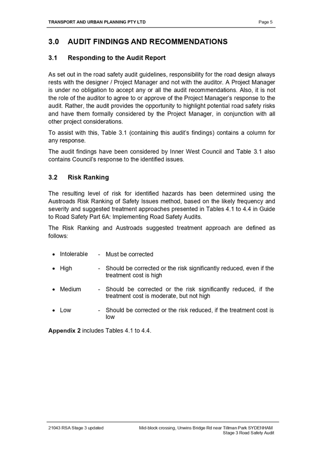
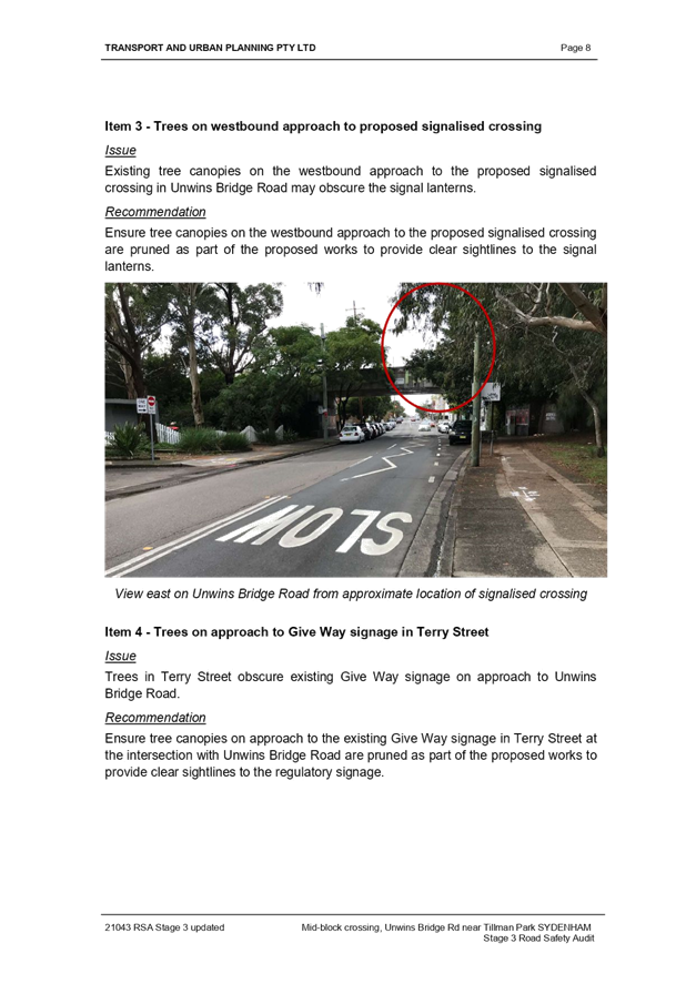
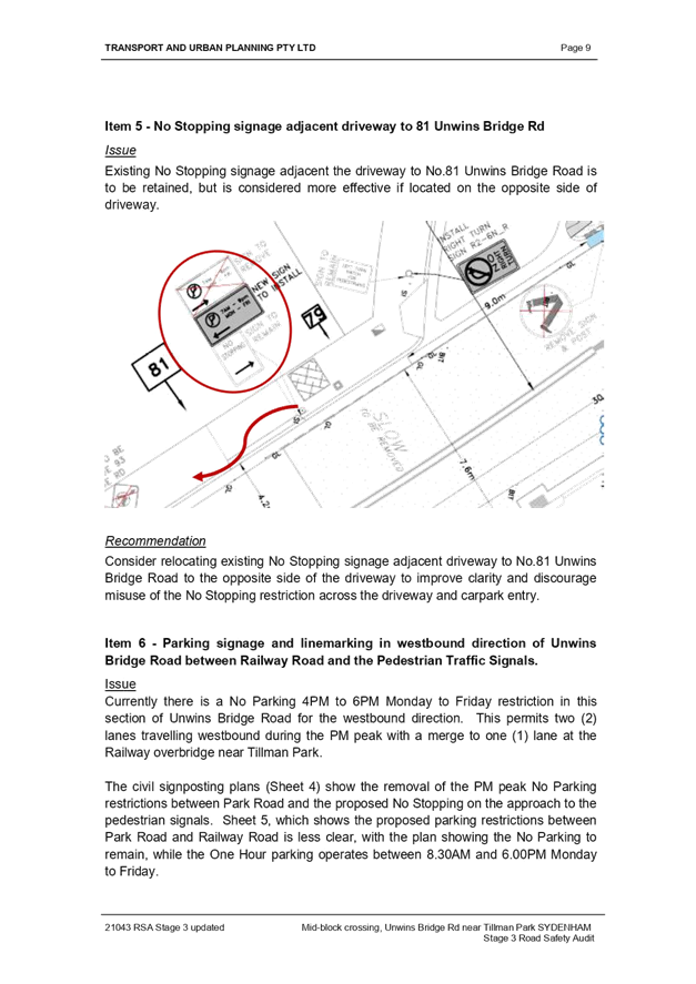
This proposal will result in no loss of existing on-street parking spaces however, it is noted that minor changes will be made to current parking restrictions on the south side of Unwins Bridge Road from Railway Road up to the railway over bridge. Specifically:
1) Removal of redundant signage and line markings associated with the existing raised pedestrian crossing in Unwins Bridge Road.
2) West of Terry Street to east of Belmore Street: Provide new line markings associated with the new signalised pedestrian crossing (refer to Signs & Line marking Plans - Sheets 2/5 and 3/5).
3) East of Belmore Street: Adjust the parking lane on the south side of Unwins Bridge Road to provide better transition for traffic on approach to the new signalised pedestrian crossing (refer to Signs & Line marking Plans - Sheets 3/5 and 4/5).
4) Railway Overbridge east of Belmore Street to Park Road, south side only:
i. Adjust existing “No Stopping” sign by approximate 3.5m, moved toward east,
ii. Adjust existing Parking signage to provide new “1P Parking, 8.30am–6pm from Monday–Friday” and “8.30am–4pm Saturday” only (refer to Signs & Line marking Plan - Sheet 4/5).
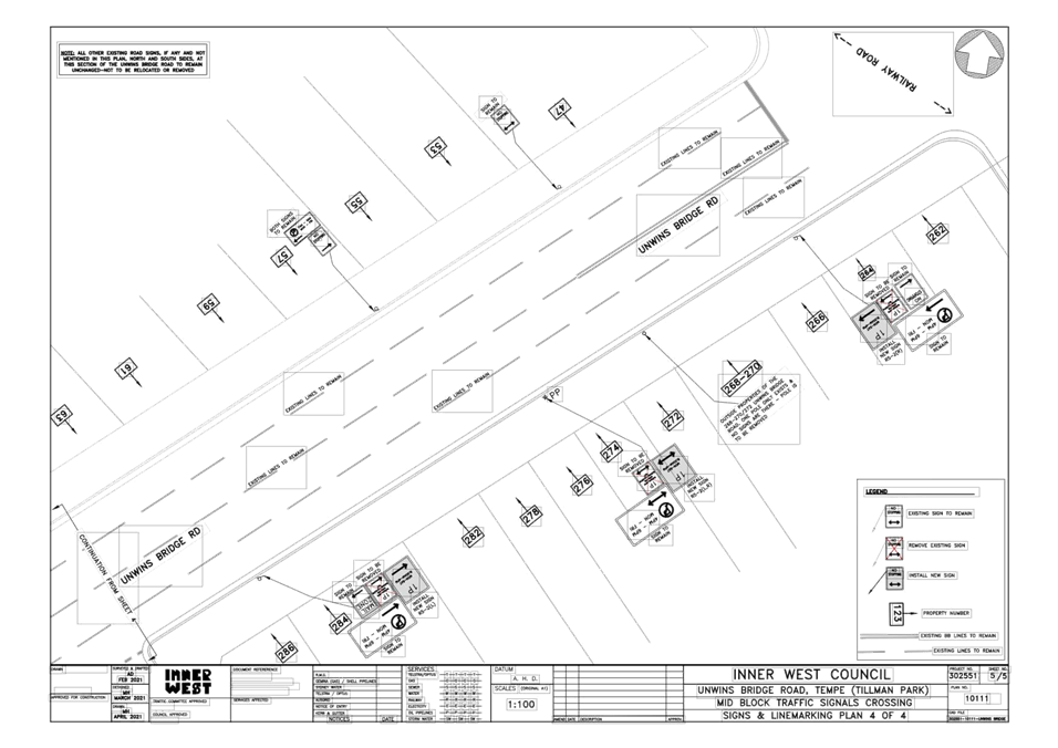
5) Park Road to Railway Road, south side only:
i. Adjust existing Parking signage to provide new “1P Parking, 8.30am–4pm from Monday–Saturday” and
ii. “No Parking 4pm–6pm from Monday–Friday” restriction to remain unchanged (refer to Signs & Line marking Plan - Sheet 5/5).
PUBLIC CONSULTATION
Proposal consultation letters were sent to 43 surrounding residents and businesses on 2 June 2021. The consultation period closed on the 22 June 2021.
A total of Twelve (12) responses were received; seven (7) responses were received in support of the proposal and three (3) objected indicating that the signalised crossing may not be the most appropriate remedy for the road safety issues experienced at the crossing. Two (2) responses were requests for copy of the proposed plans by other local residents.
CONCLUSION
It is recommended that the detailed design plans (10111) for the proposed mid-block signalized crossing on Unwins Bridge Road adjacent to Tillman Park and associated works, signs and line markings be approved, to improve road safety at this location.
|
1.⇩ |
302551-10111_A-Consultation-Plans-Community |
|
2.⇩ |
11-Road-Safety-Audit |
|
Local Traffic Committee Meeting 19 July 2021 |
Subject: Alt Street at intersections with Church Street
and Charlotte Street, Ashfield- Invesigation on the warrant of Pedestrian
crossings.
(Djarrawunang- Ashfield Ward/Summer Hill Electorate/Burwood PAC)
Prepared By: Boris Muha - Engineer – Traffic and Parking Services
Authorised By: Manod Wickramasinghe - Traffic and Transport Planning Manager
SUMMARY
The Inner West Bicycle Coalition representative, at the Local Traffic Committee meeting of the 3 August 2020, under General Business, requested that traffic, speed and pedestrian counts be conducted in Alt Street, between Church Street and Charlotte Street, Ashfield, with view to installing a pedestrian crossing if warrant permits under the Transport for NSW (TfNSW) or RMS guidelines.
Council at its meeting on the 25 August 2020 resolved or noted that:
Staff will arrange a pedestrian/traffic volume count in the area to determine if the site meets the warrants for a crossing. The Ashfield Traffic Management Study (ATMS) also recommended the need to calm traffic in Alt Street at this location.
This report outlines the results of traffic and pedestrian count survey carried out in November 2020 at the proximity intersections of Alt Street/Church Street and Alt Street/Chandos Street where pedestrian activity is most occurrent.
The outcome of the results generally determined that there is a low or non-consistent pedestrian activity in crossing the road through the day or week to warrant the establishment of crossings under the TfNSW or RMS guidelines. Council will review and investigate alternate possible cross-over and/or traffic control measures for improved safety to pedestrians under the recommendation of the ATMS and Ashfield/Inner West Council Pedestrian Access Mobility Plan (PAMP)
|
RECOMMENDATION
THAT:
1. The report be received and noted that no warrant can be made to justify the installation of a pedestrian crossing in Alt Street between Charlotte Street and Church Street, nor the intersection sides of Church Street and Charlotte Street, Ashfield; and 2. Council staff review and investigate other alternate and possible cross-over and/or traffic control measures to improve pedestrian safety in the area.
|
BACKGROUND
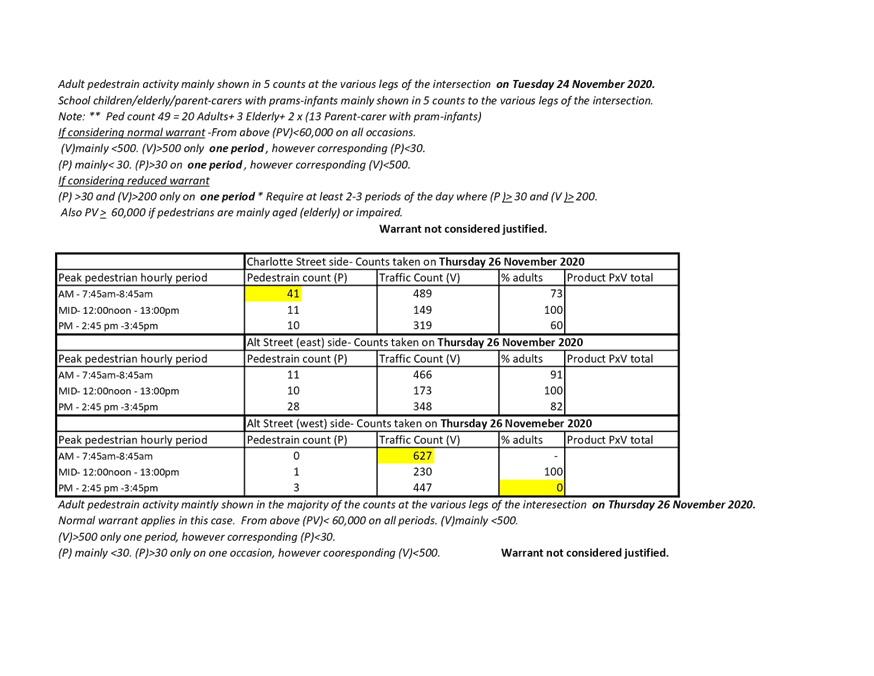
Alt Street is a local road. The section of Alt Street between Charlotte Street and Church Street is a local-collector section of road that acts a cross-link for traffic traveling to/from Church Street and Charlotte Street. Volume counts taken late last year registered around 3500 vehicle per day in Alt Street, east of Charlotte Street and west of Church Street. Alt Street, between Charlotte Street and Church Street registered around 5000 vehicles per day.
Pedestrian activity is more evident around the intersections, with pedestrians tending to cross over Alt Street from Church Street, and across Charlotte Street. Pedestrian desire lines appear more directed to and from the St John’s Anglian Church Grounds, Ashfield. The church grounds provides a children’s playground area (to the north of Church Street), community hall facilities and access through to the St.John’s Preschool and Bland Street (See locality plan below).
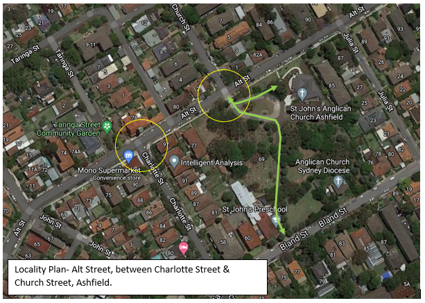
Alt Street measures approx. 10.1 metres from kerb to kerb with parking to both sides of the street. Church Street and Charlotte Street near to Alt Street are similar in road width to Alt Street and provide parking to both sides of the streets.
Speed counts taken in the above section of Alt Street, late last year, registered around 44.4 to 47.5km/h.
Available TfNSW accident records in the above section of Alt Street for the last 5 years identify (2) accidents. Both are shown at the intersection of Church and Alt Street. One being in 2016, RUM 42-leaving from parking spot, incurring minor injury. The other in 2018, RUM 19- adjacent vehicle collision- incurring non-injury (tow-away).
FINANCIAL IMPLICATIONS
NIL
OTHER STAFF COMMENTS
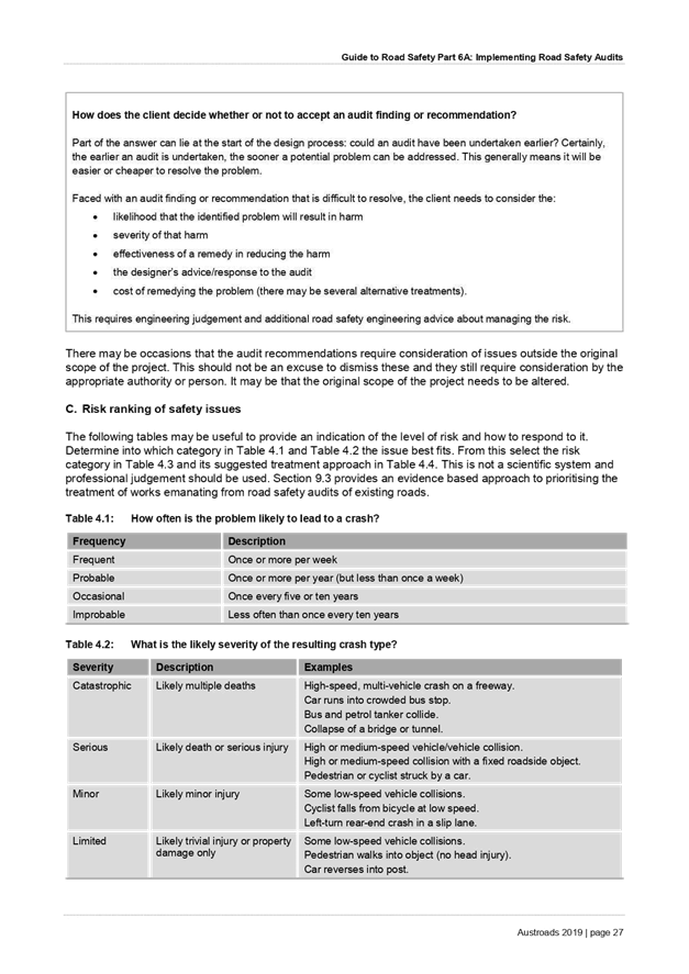
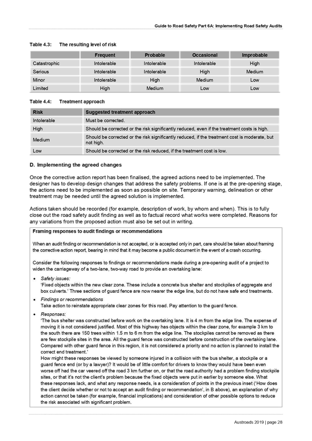
An analysis of traffic volume and pedestrian counts were carried out at the intersection of Alt Street and Church Street, and Alt Street and Charlotte Street in November 2020 prior to the school holidays. Optimum counts through peak hourly periods in the AM, Midday and PM times of the day were obtained. The counts were also done on a Tuesday, Thursday, and Saturday to sample pedestrians crossing the road as spread out through the day and week. The results are tabled and shown in Attachment 1. An analysis of these results was then done in reference to the TfNSW/RMS guidelines for pedestrian crossings (as shown in Attachment 2).
In view of the results, most pedestrians crossing the road are adults. Other pedestrians are either school children, elderly, or parents/careers with prams or infants in hand. School children numbers were to a lesser degree.
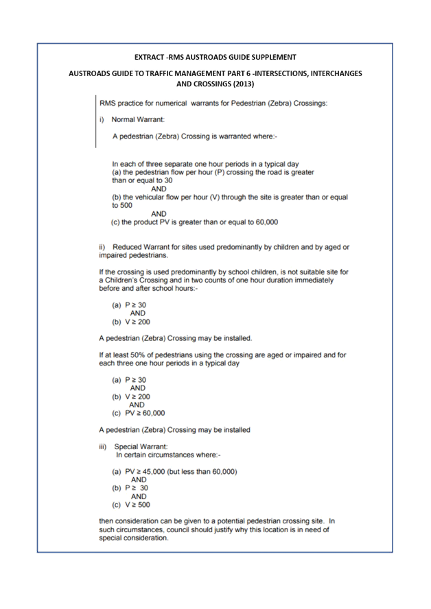
Apart from the traffic volumes, it is considered there is generally low pedestrian crossing activity in the area, with (P- pedestrians) below 30 in given hourly periods. Any high pedestrian crossing activity is infrequent and only occurs on a single or one (hour) period during the day. 3 hourly periods with (P)> 30 and (V Traffic hourly volumes) > 500 and (PV)> 60,000 in the day are required to justify normal warrant for a pedestrian crossing. (P)>30 in 2-3 hourly periods of the day are required if considering a reduced warrant. The product (PV) is less than 45000 on all accounts and justification cannot be made under alternate special warrant in accordance to the TfNSW/RMS guidelines.
No new development in the area has been caried out to alter the above pattern of results to date.
PUBLIC CONSULTATION
NIL under this report.
CONCLUSION
In view of the above, no warrant can be made to justify the installation of a pedestrian crossing in Alt Street between Charlotte Street and Church Street, nor the intersection sides to Church Street and Charlotte Street. Council, however, will review and examine alternate possible cross-over and/or traffic control measures for improved safety to pedestrians under the recommendation of the ATMS and Ashfield/Inner West Council Pedestrian Access Mobility Plan (PAMP).
|
1.⇩ |
Pedestrian and Traffic volume counts- Intersections Alt Street with Church and Charlotte Streets, Ashfield. |
|
2.⇩ |
Pedestrian crossing warrant criteria-TfNSW/RMS guidelines. |
|
|
Local Traffic Committee Meeting 19 July 2021 |
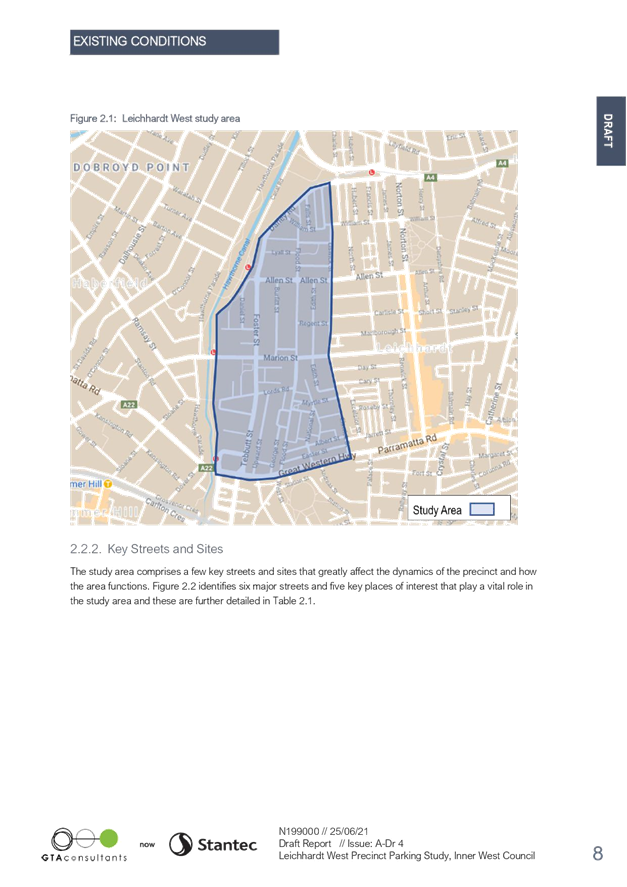
Subject: Leichhardt West Precinct Parking Study (Gulgadya-Leichhardt Ward/Balmain Electorate/Leichhardt PAC)
Prepared By: Jason Scoufis - Traffic and Parking Planner
Authorised By: Manod Wickramasinghe - Traffic and Transport Planning Manager
SUMMARY
The Leichhardt West Precinct Parking Study reviewed the location, supply, demand and distribution of short and long stay parking, commercial, residential, employee, and commuter parking. The work consisted of examining existing conditions including parking data, community submissions, observed parking conditions, existing permit allocation, and future land uses within the Leichhardt West precinct.
A community survey was also undertaken to gauge the parking issues faced by different users. With consideration of the above a draft parking management strategy for Leichhardt West was developed.
|
RECOMMENDATION
THAT:
1. The Draft Leichhardt West Precinct Parking Study including the Draft Leichhardt West Parking Strategy be endorsed for community consultation; and 2. The draft report be placed on Public Exhibition, providing a minimum 28 days for submissions and the results be reported back to the Traffic Committee.
|
BACKGROUND
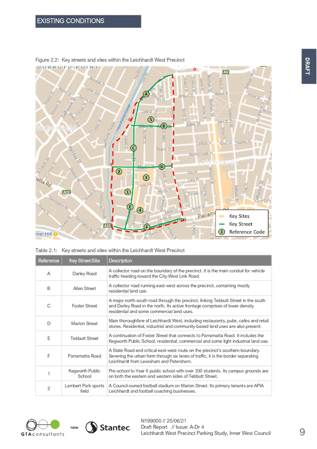
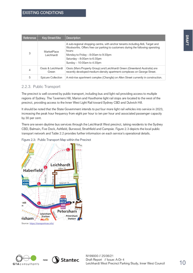
The Study was initiated as part of Council’s Parking Strategy Program in order to review the existing parking issues in Leichhardt West which include streets near trip generators such as Kegworth Public School, Lambert Park Sportsfield, Leichhardt Marketplace, Oasis, Leichhardt Green and Epicure Collection currently under construction, Inner West light rail stops and significant land use.
FINANCIAL IMPLICATIONS
The cost to implement the Leichhardt West Parking Management Strategy will be funded from Council’s traffic facilities budget, subject to Local Traffic Committee support and adoption by Council. Subsequent reports during implementation of the Strategy will provide estimates on signage and administrative costs to expand the resident parking permit scheme if required.
OTHER STAFF COMMENTS
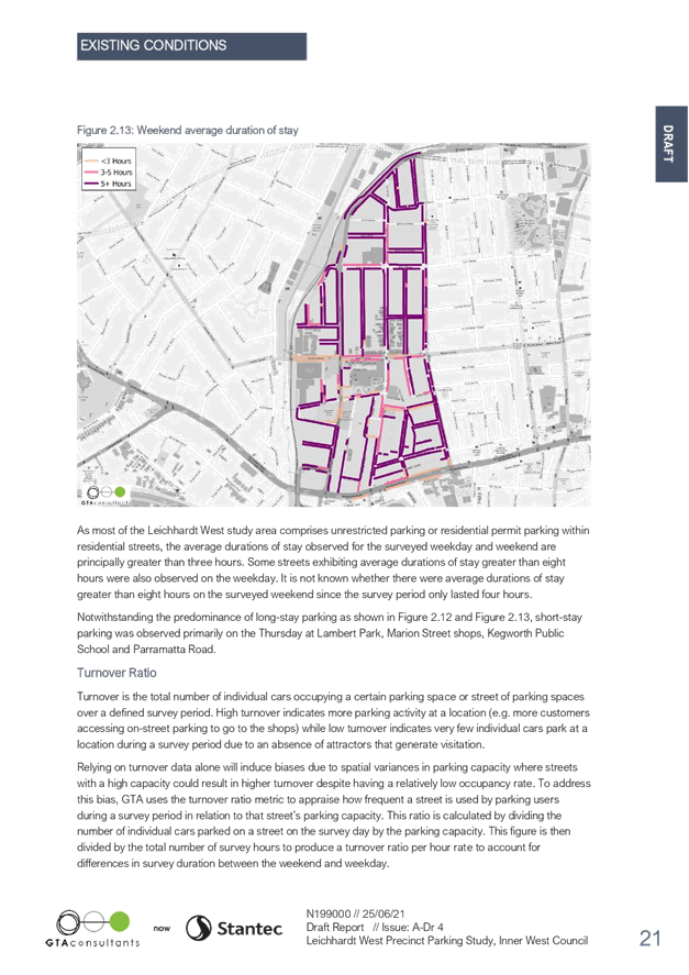
The Leichhardt west Precinct Parking Study was undertaken by GTA Consultants by examining the parking occupancy and parking duration data collected in November 2020, existing on-street parking inventory, current supply and demand, existing parking permit issued, and feedback received through Council’s Community Engagement undertaken in November and December 2020.
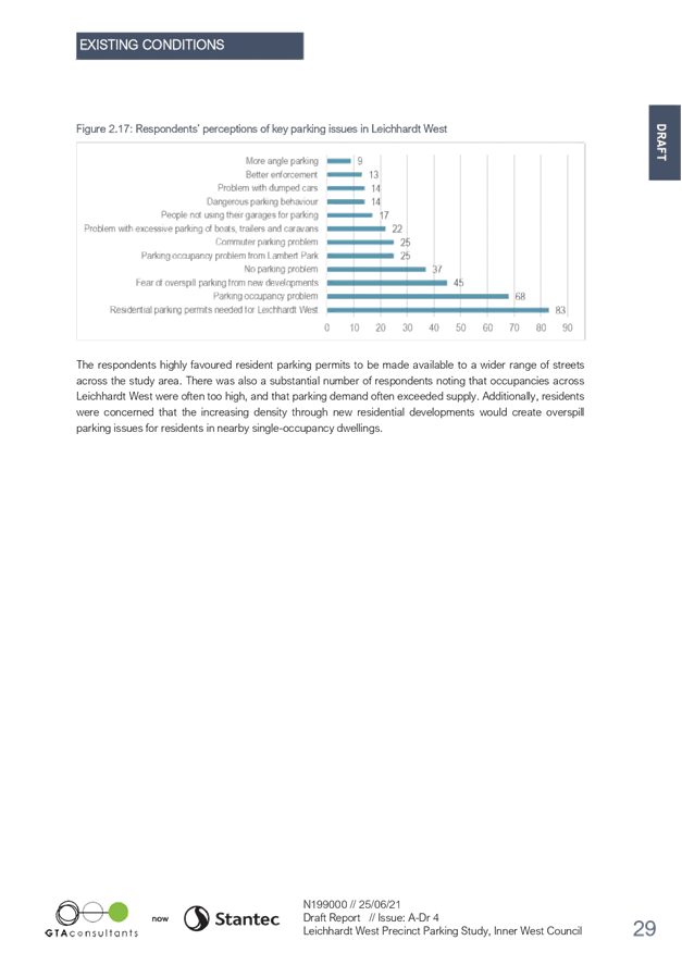
Parking trends within the study area had the following characteristics:
· Average peak parking occupancies are at a high level during weekdays in selected unrestricted streets and also in existing resident parking permit parking streets in the southern half of the precinct near the major landuses of Kegworth Public School, Leichhardt Marketplace, Oasis and Leichhardt Green apartments. Parking occupancies generally reduce in the northern section of the precinct.
· On weekends, average peak parking occupancies are significantly lower than on a weekday, in particular in and around St Columbia’s Catholic Primary where parking is unrestricted and likely used by school staff and parents on weekdays. This suggests residents are taking their cars out on weekends for excursions. In some areas higher parking occupancies were evident on weekends where off street parking is minimal.
· Average duration of stay and turnover ratios during weekday and weekend are consistent with a predominantly residential area , generally long stay with low turnover rates with the exception of short stay parking on a weekday in and around Lambert Park, Marion Street shops, Kegworth Public School and Parramatta Road.
· Streets with much lower turnover rate on the weekend relative to the weekday tend to include streets that are part of a resident parking permit scheme near the Oasis and Leichhardt Green developments as these permit schemes do not apply on weekends.
The draft study concluded with the following draft strategies for consideration:
|
Short term (0-5 years) |
|
|
|
|
Item Number |
Description |
Streets affected |
High |
|
1 |
Aim to have the overall number of L1 resident parking permits in Leichhardt West Study Area not exceed the total L1 parking capacity within the Leichhardt West Study Area |
Area wide (whole study area) |
High |
|
2 |
Expand RPS to streets surrounding the Epicure Collection residential complex |
Area generally bounded by Foster Street, Regent Street, Elswick Street, Athol Street, Whiting Street as detailed in Figure 4.1 in report |
High |
|
3 |
All current RPS streets in the study area adopt the proposed restriction ‘2P 8am-10pm (Mon-Sun) Permit Holders Excepted Area L1’ for consistency |
All current RPS streets |
High |
|
4 |
Replace redundant, faded and damaged signs |
As identified in the signage audit |
Medium |
|
5 |
Dedicate parking enforcement efforts to streets near Lambert Park to promote and enforce safe and legal parking behaviour |
Streets within 200 metres of Lambert Park |
High |
|
6 |
Introduce angled parking in Elswick Street North between William Street and Darley Road |
Elswick Street North |
Medium |
|
7 |
Introduce angled parking in Edith Street between Marion Street and Elswick Street |
Edith Street |
Medium |
|
8 |
Monitor commuter parking at Taverners Hill, Marion and Hawthorne Light Rail stops following peak hour capacity increase in 2023 |
Streets nearby identified light rail stops |
Medium |
|
Long term (5 + years) |
|
|
|
|
Item Number |
Description |
Streets affected |
High |
|
9 |
Subject to timing of the redevelopment, expand RPS to streets in both the Taverners Hill Precinct and Leichhardt Marketplace Precincts. Ensure restriction duration is consistent across the expanded RPS with times of ‘2P 8am-10pm (Mon-Sun) Permit Holders Excepted Area L1’ |
Taverners Hill Precinct generally bounded by Hawthorne Canal, Parramatta Road, Elswick Street, Myrtle Street Lords Road, Lambert Park as detailed in Figure 4.1 in report.
Leichhardt Marketplace Precinct generally bounded by Foster Street, Lords Road, Elswick Street, Regent Street as detailed in Figure 4.1 in report.
|
High |
|
10 |
Advocate for the PRCUTS maximum parking rates in future Inner West DCP for PRCUTS redevelopment |
PRCUTS redevelopment sites |
High |
|
11 |
Introduce pricing on second residential parking permits, subject to Council approving the fee in a future Fees and Charges schedule. |
Current and future RPS streets |
Medium |
|
12 |
Investigate reform of visitor parking permits to one day use only permits |
Current and future RPS streets |
Medium |
PUBLIC CONSULTATION
Council posted 4,319 letters to residents, businesses, organisations and institutions in December 2020 inviting to participate in an online questionnaire on parking in Leichhardt West Precinct. Members of the public could also request a paper-based copy of the questionnaire.
A total of 579 submissions were received, with the main findings as follows:
• Highly favoured that Resident Parking Schemes be made available to a wider range of streets across the study area.
· Concerned that parking occupancies were high and that demand often exceeded supply.
· Residents were concerned that increasing density through new residential developments would create overspill parking issues for residents in nearby single occupancy dwellings.
|
1.⇩ |
Leichhardt West Precinct Parking Study GTA Report June 2021 |
|
Local Traffic Committee Meeting 19 July 2021 |
Subject: Rozelle North Precinct Parking Study (Baludarri-Balmain Ward/Balmain Electorate/Leichhardt PAC)
Prepared By: Jason Scoufis - Traffic and Parking Planner
Authorised By: Manod Wickramasinghe - Traffic and Transport Planning Manager
SUMMARY
The Rozelle North Precinct Parking Study reviewed the location, supply, demand and distribution of short and long stay parking, commercial, residential, employee, and commuter parking. The work consisted of examining existing conditions including parking data, community submissions, observed parking conditions, existing permit allocation, and future land uses within the Rozelle North precinct.
A community survey was also undertaken to gauge the parking issues faced by different users. With consideration of the above a draft parking management strategy for Rozelle North was developed.
|
RECOMMENDATION
THAT:
1. The Draft Rozelle North Precinct Parking Study including the Draft Rozelle North Precinct Parking Strategy be endorsed for community consultation; and 2. The draft report be placed on Public Exhibition, providing a minimum 28 days for submissions and the results be reported back to the Traffic Committee.
|
BACKGROUND
The Study was initiated as part of Council’s Parking Strategy Program in order to review the existing parking issues in Rozelle North which include streets near trip generators such as Rozelle Public School, Union Residential, the Light Industrial Area near Robert Street/Mullens Street and Victoria Road bus corridor.
FINANCIAL IMPLICATIONS
The cost to implement the Rozelle North Parking Management Strategy will be funded from
Council’s traffic facilities budget, subject to Local Traffic Committee support and adoption by
Council. Subsequent reports during implementation of the Strategy will provide estimates on
signage and administrative costs to expand the resident parking permit scheme if required.
OTHER STAFF COMMENTS
The Leichhardt West Precinct Parking Study was undertaken by GTA Consultants by examining the parking occupancy and parking duration data collected in November 2020, existing on-street parking inventory, current supply and demand, existing parking permit issued, and feedback received through Council’s Community Engagement undertaken in November and December 2020.
Parking trends within the study area had the following characteristics:
· Average peak parking occupancies are at a high-level during weekdays in selected unrestricted residential streets. This is most likely due to residents parking their car during the week and commuting via public transport, commuters taking advantage of unrestricted parking and catching the bus on Mullens Street towards to city and also local staff parking.
· Average peak parking occupancies are much lower on a weekend than on a weekday most likely due to residents not using their cars during the weekday whilst on weekends they take their car out for excursions.
· Average duration of stay on both weekday and weekend is generally greater than 3 hours (long stay parking), with short stay parking observed near the shops in Darling Street and Nagurra Place which is as expected.
· Turnover ratios per hour are generally higher on the weekend than a weekday as people park their cars for longer durations on weekdays making it more difficult to find a parking space. Turnover is highest near Darling Street, Terry Street and Nagurra Place as expected due to adjacent retail land uses.
The draft study concluded with the following draft strategies for consideration:
|
Short term (0-5 years) |
|
|
|
|
Item Number |
Description |
Streets affected |
High |
|
1 |
Aim to have the overall number of R1 and B1 resident parking permits in Rozelle North Study Area not exceed the total R1 and B1 parking capacity within the Rozelle North Study Area |
Area wide (whole study area) |
High |
|
2 |
Extension of resident parking permit area as detailed in section 5.3.1 |
R1 Zone Area generally bounded by Victoria Road, Crescent Street, Parsons Street, Mullens Street, Reynolds Street, George Street, Clare Street, Beattie Street, Wise Street, Wellington Street and Nagurra Place as detailed in Figure 5.1 in report
B1 Zone Area generally bounded by Mullens Street, Mansfield Street, Batty Street, Reynolds Street, Wortley Street, Valley Street, Beattie Street as detailed in Figure 5.1 in report. |
High |
|
3 |
Work with carshare operators to introduce additional fixed car share spaces in Rozelle North |
n/a |
Medium |
|
4 |
Replace redundant, faded and damaged signs |
As identified in the signage audit |
Medium |
|
5 |
Additional short-term parking restrictions (2P 6am-4pm Mon-Fri) for 8 parking spaces in Robert Street |
Southern side of Robert Street immediately east of Mullens Street |
High |
|
Long term (5 + years) |
|
|
|
|
Item Number |
Description |
Streets affected |
High |
|
6 |
Introduce pricing on second residential parking permits, subject to approving the fee in a future Fees and Charges Schedule |
Current and future RPS streets
|
Medium |
|
7 |
Investigate reform of visitor parking permits to one day use only |
Current and future RPS streets
|
Medium |
PUBLIC CONSULTATION
Council posted 3,886 letters to residents, businesses, organisations and institutions in November/December 2020 inviting to participate in an online questionnaire on parking in Rozelle North Precinct. Members of the public could also request a paper-based copy of the questionnaire.
A total of 334 submissions were received, with the main findings as follows:
· Strong support that the Resident Permit Parking Scheme be extended to include the entire Rozelle North Study Area.
· Concerned with parking associated with non- residents including commuter parking, school parking and lack of enforcement of current restrictions.
· Concerned with parking too close to intersections and across driveways and inability for workers to park more than the existing 2 hour restrictions.
|
1.⇩ |
Rozelle North Precinct Parking Study GTA report June 2021 |
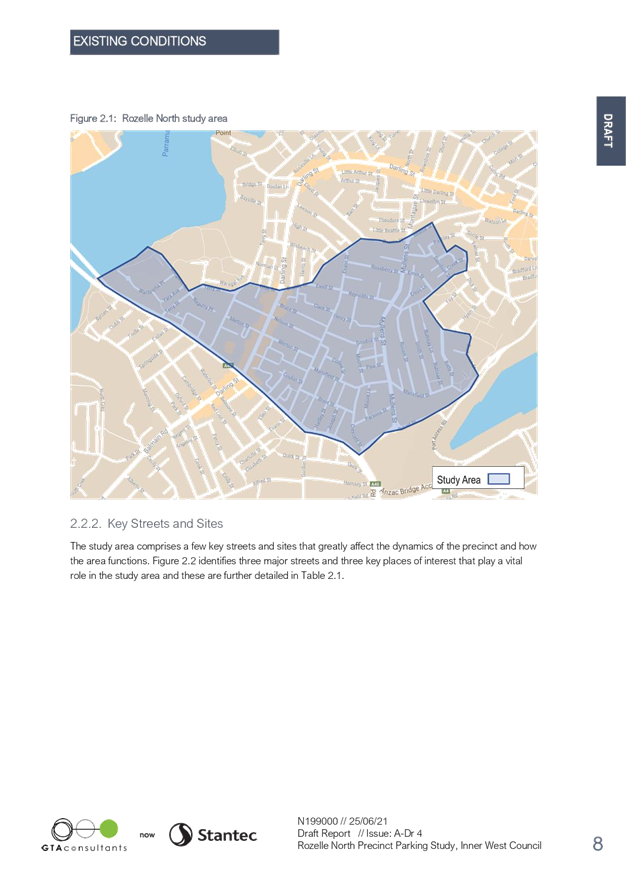
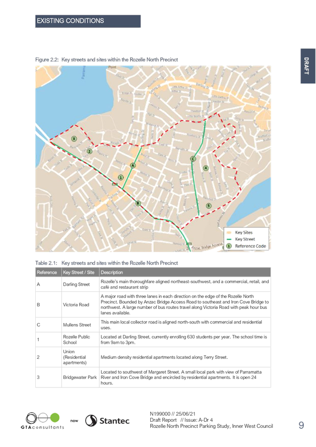
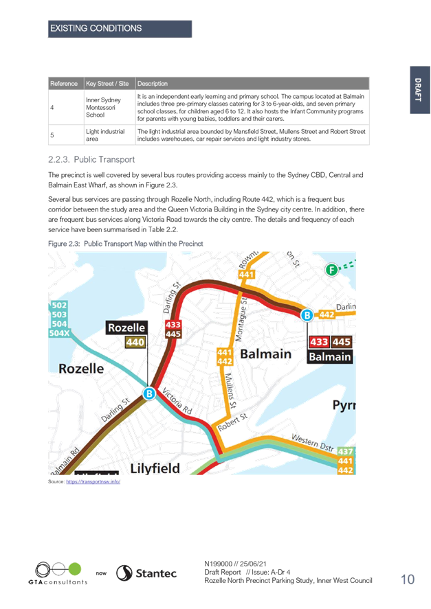
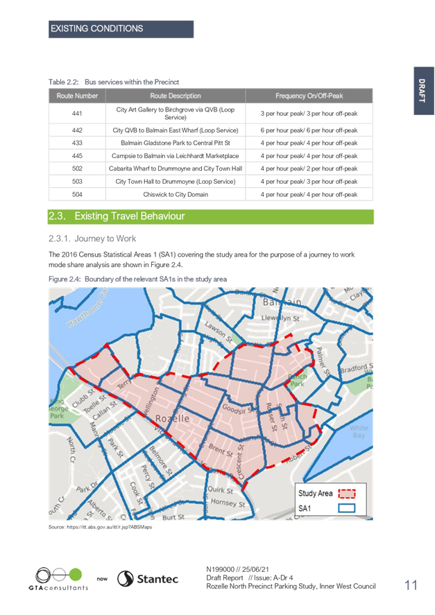
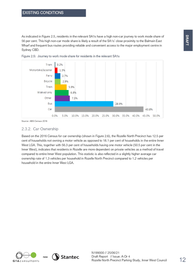
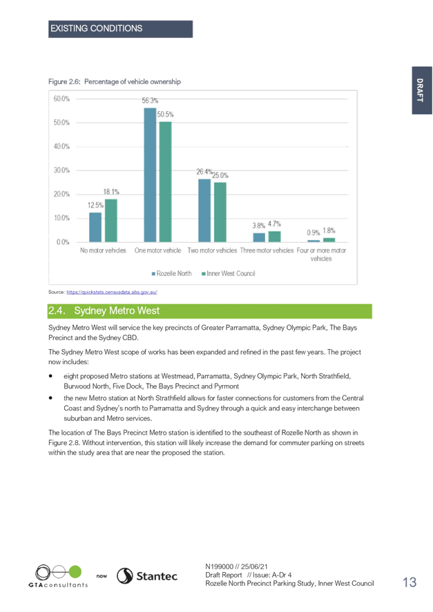
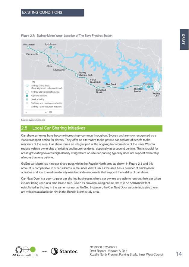
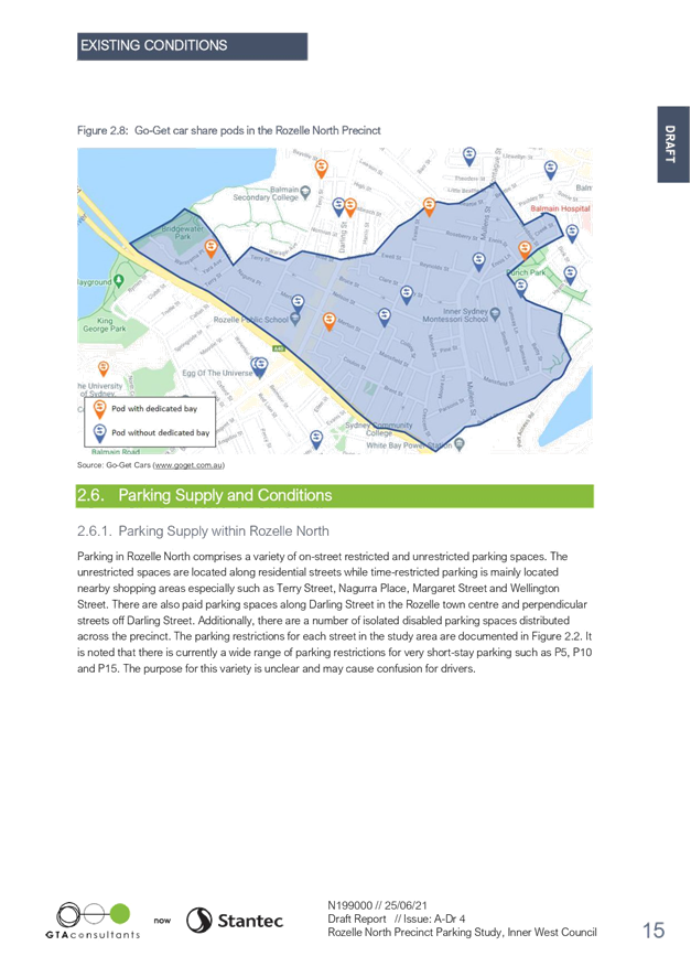
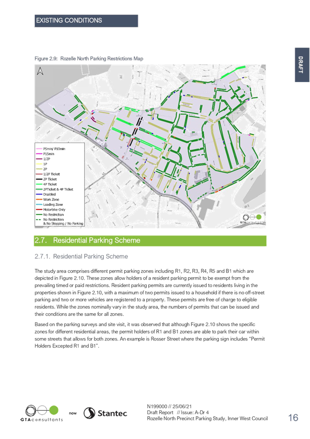
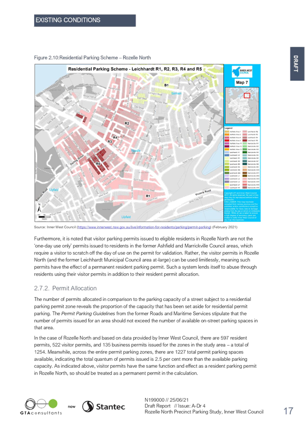
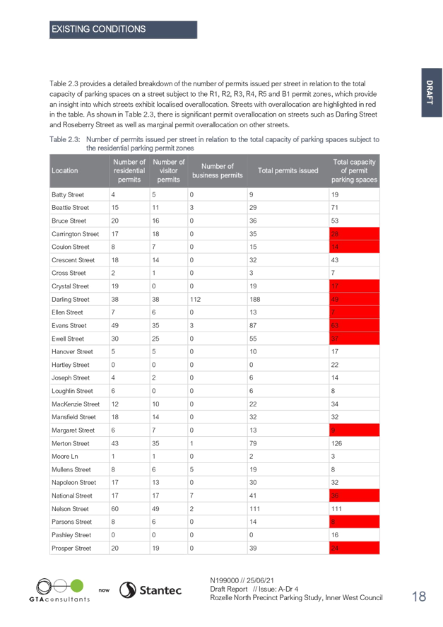
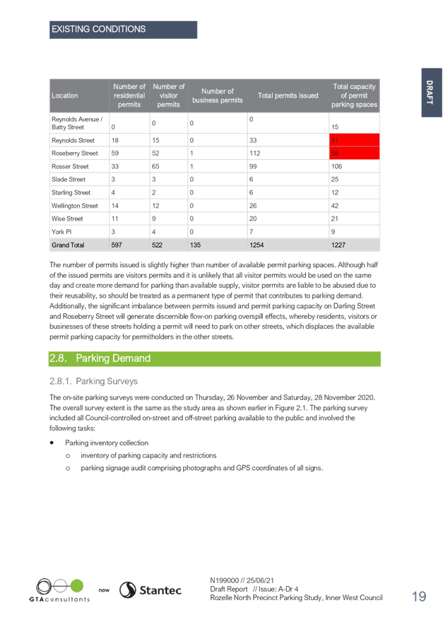
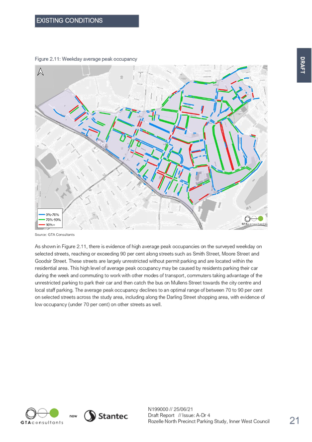
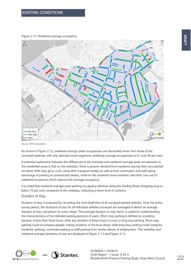
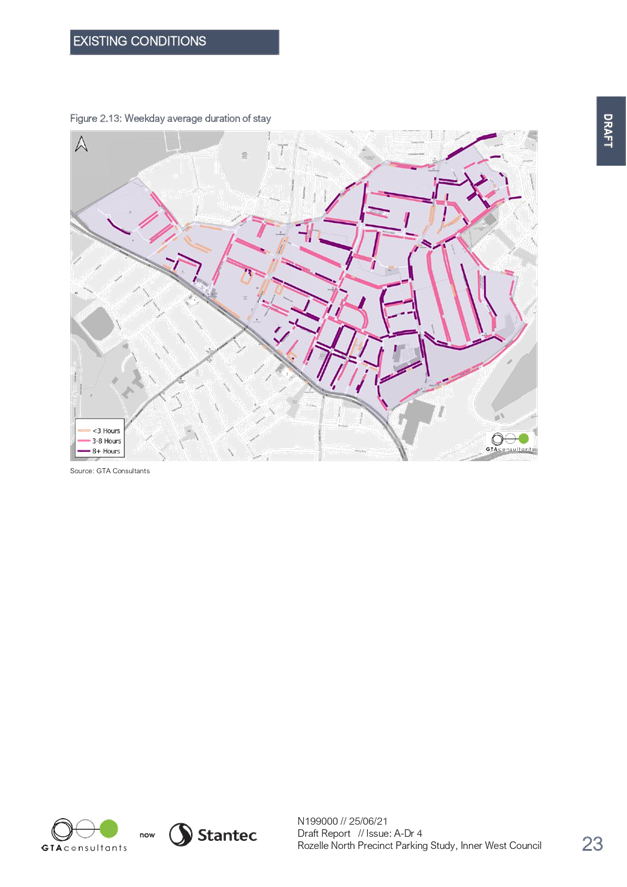
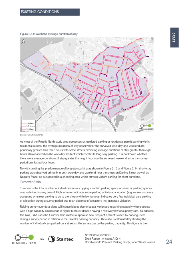
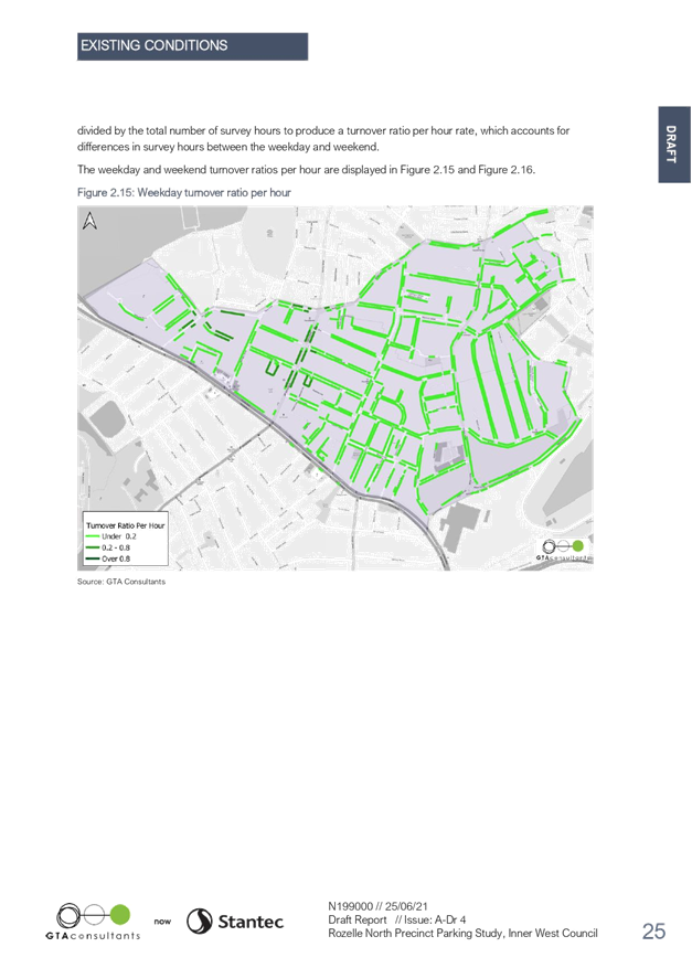
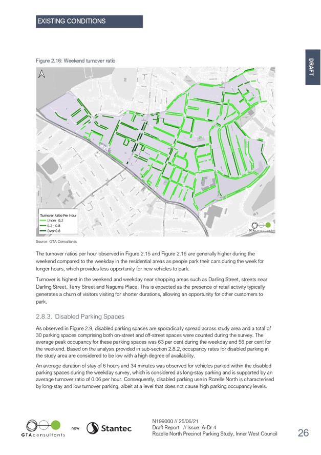
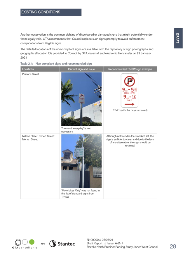
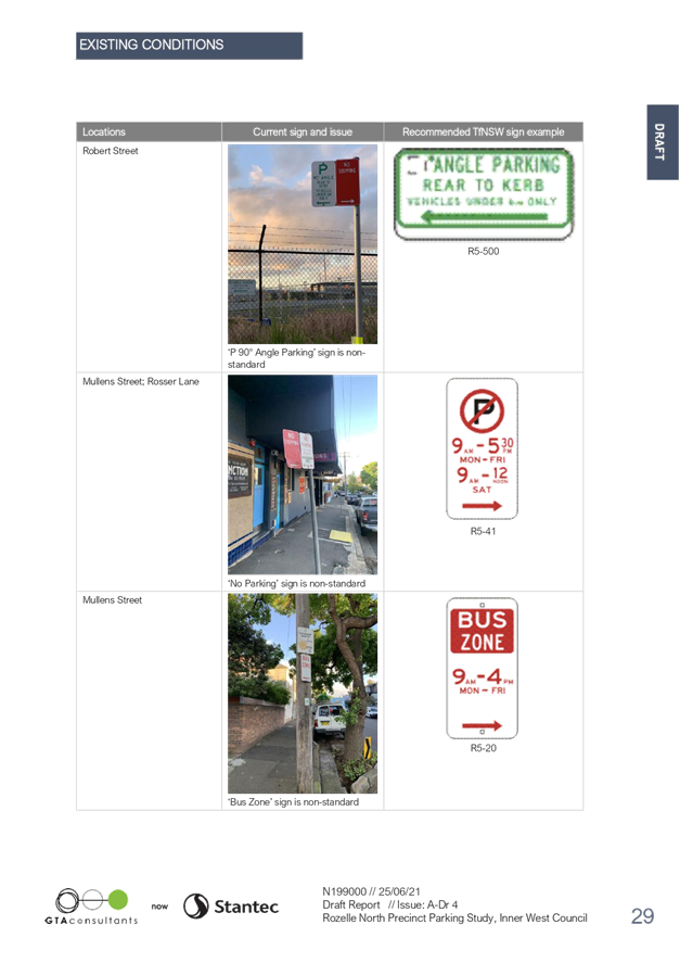
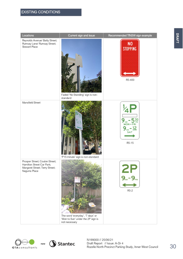
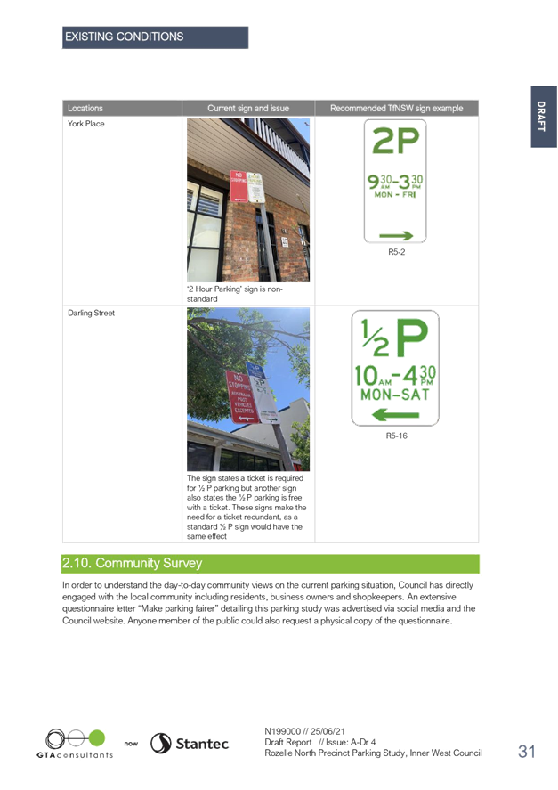
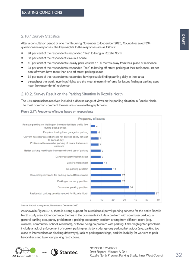
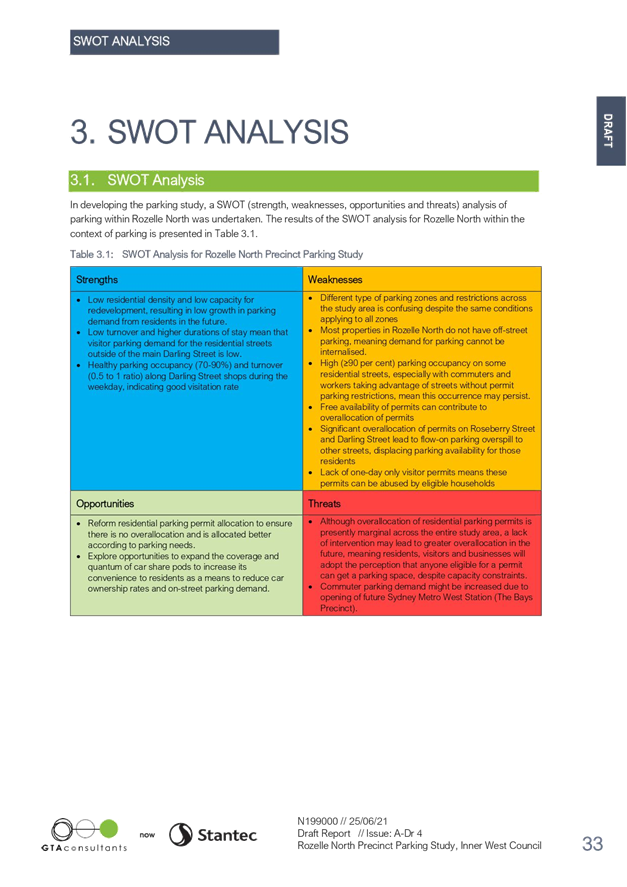
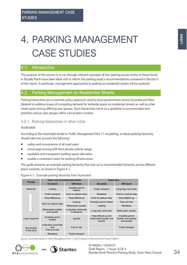
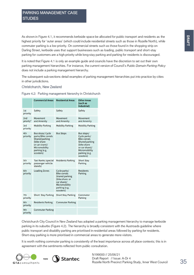
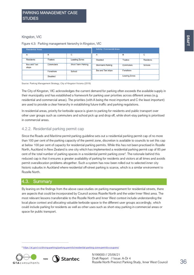
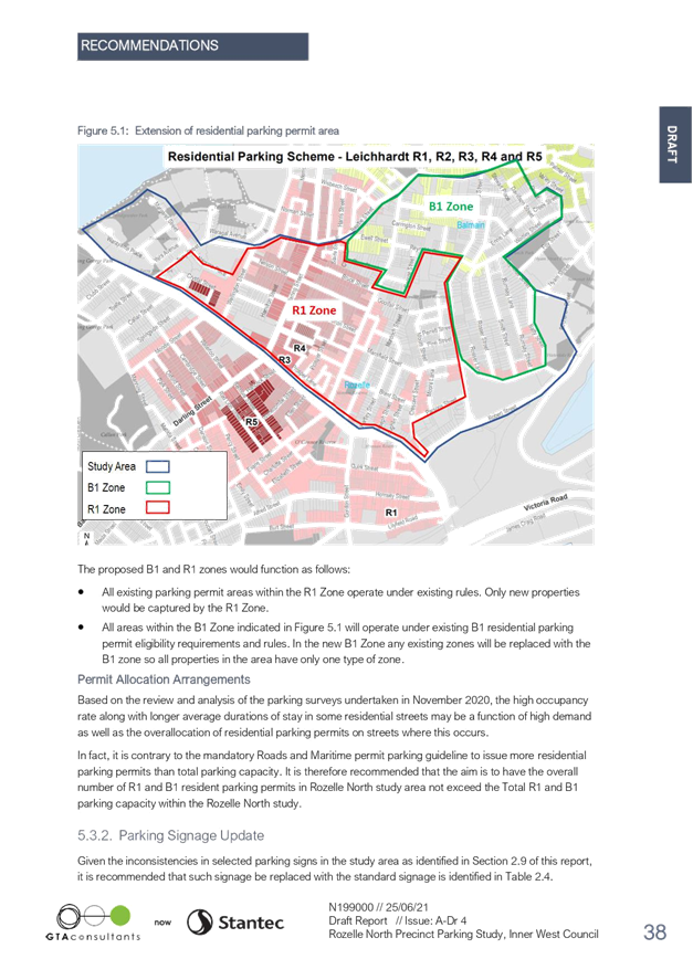
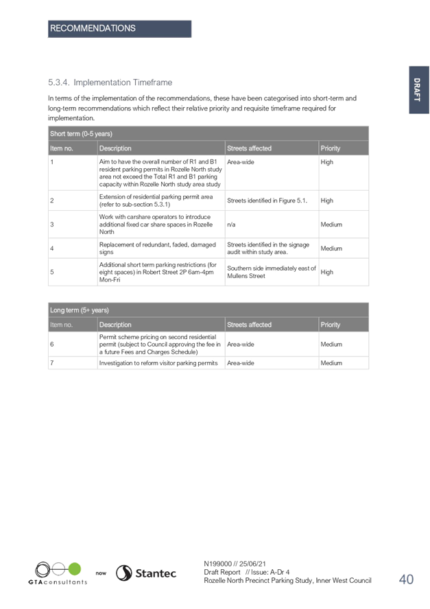

|
Local Traffic Committee Meeting 19 July 2021 |
Subject: Henry Lane, Lewisham - Proposed 'No Stopping'
restrictions
Damun- Stanmore Ward/ Summer Hill Electorate/ Inner West PAC
Prepared By: Scipio Tam - Engineer – Traffic and Parking Services
Authorised By: Manod Wickramasinghe - Traffic and Transport Planning Manager
SUMMARY
Council has received concerns of parked vehicles at the T-junction of Henry Lane, Lewisham resulting in difficulties for some residents maneuvering at the T-junction due to the narrowness of the two laneways. Therefore, Council is proposing to implement a 6 metre length of ‘No Stopping’ restriction to remove potential obstructions and improve the ability of motorists to maneuver at the T-junction.
|
RECOMMENDATION
THAT a 6 metre ‘No Stopping’ zone on the western side of Henry Lane, Lewisham, along the eastern boundary of property No.16 Henry Street, Lewisham.
|
PUBLIC CONSULTATION
|
|
Local Traffic Committee Meeting 19 July 2021 |
Subject: Victoria Road, Marrickville - Proposed
short-term parking
Midjuburi- Marrickville Ward/ Summer Hill Electorate/ Inner West PAC)
Prepared By: Scipio Tam - Engineer – Traffic and Parking Services
Authorised By: Manod Wickramasinghe - Traffic and Transport Planning Manager
SUMMARY
Following representations from local businesses, Council is proposing to implement a 50 metre section of one-hour parking, along the western side of Victoria Road, north of its intersection with Sydenham Road. Council has now undertaken community consultation to gauge the community’s view in relation to introducing a section of time-restricted parking on Victoria Road, Marrickville, immediately north of Sydenham Road, in order to improve parking turnover in the vicinity of the local businesses.
|
RECOMMENDATION
THAT a 50-metre section of ‘1P 9am – 5pm Monday to Saturday’ on western side of Victoria Road, Marrickville between the signalised intersection of Victoria & Sydenham Road and northern boundary of property 191 Victoria Road, Marrickville be APPROVED.
|
OTHER STAFF COMMENTS
Council is proposing to implement 1P parking restrictions to a 50-metre section of unrestricted parking along the western side of Victoria Road, Marrickville. With the subject section of Victoria Road being a Regional Road with peak hour ‘No Parking’ restrictions to maintain peak hour traffic thoroughfare, the new parking restrictions will be outside of those hours.
Provisions for short term parking on the southern side of Sydenham Road, between Frampton Lane and Victoria Road, adjacent to businesses was also considered. However, as Sydenham Road is a State Road under the jurisdiction of Transport for NSW (TfNSW), Council have submitted a request to TfNSW representatives for consideration.
PUBLIC CONSULTATION
During community engagement, a consultation letter was sent to 18 property occupiers and owners in close proximity to the subject section of Victoria Road, Marrickville. A total of six (6) responses were received from both property occupiers/owners and visitors; five (5) in support and one (1) opposed of the proposal. Of these submissions, one (1) response against the proposal was concerned about the loss of unrestricted parking for workers in the area. However, the 5 responses in support expressed their difficulty finding parking when visiting their local businesses.
![]()
|
|
Local Traffic Committee Meeting 19 July 2021 |
Subject: Constitution Road, Dulwich Hill - Proposed 'No
Parking' restrictions
Djarrawunang - Ashfield Ward/ Summer Hill Electorate/ Inner West PAC)
Prepared By: Scipio Tam - Engineer – Traffic and Parking Services
Authorised By: Manod Wickramasinghe - Traffic and Transport Planning Manager
SUMMARY
Council’s Resource Recovery department have raised concerns of traffic and pedestrian safety during garbage collection times outside 115 – 117 Constitution Road, Dulwich Hill. Following an investigation into this matter by a Council Traffic Officer, it is now recommended that a 12 metre section of ‘No Parking’ restriction during the waste collection times be approved on the southern side of Constitution Road, immediately east of driveway to 115-117 Constitution Road, Dulwich Hill.
|
RECOMMENDATION
THAT a 12-metre section of ‘No Parking 4pm Monday – 10am Tuesday’ restriction on southern side of Constitution Road, Dulwich Hill, immediately east of driveway to 115 – 117 Constitution Road, Dulwich Hill be APPROVED. |
OTHER STAFF COMMENTS
During the course of the investigation, it was revealed that a finalised Waste Management Plan was not submitted to Council as per the Development Application conditions for 115 – 117 Constitution Road, Dulwich Hill. Additionally, the height clearance of the driveway of 115 – 117 Constitution Road was not constructed to accommodate waste collection vehicles, which has resulted in waste collection vehicles being parked adjacent to the driveway whilst bins are being emptied.
Due to the presence of a traffic refuge island immediately east of the driveway, it has been reported that waste collection vehicle’s which are parked adjacent to the driveway whilst collecting bins create a pinch point for vehicles travelling westbound on Constitution Road.
During the community engagement, all fourteen (14) responses received requested Council amend the proposal to a full-time ‘No Parking’ restriction instead of a part-time to increase sight lines for residents exiting the driveway of 115-117 Constitution Road. However, noting the presence of an entry driveway into the property immediately west of the exit driveway, an 8-metre section of statutory ‘No Parking’ already exist for residents exiting the property to sight vehicles travelling westbound. It should also be noted that on-street parking in this vicinity is scarce and this has also been considered as part of the proposal.
PUBLIC CONSULTATION
A total of 198 consultation letters outlining the proposal was sent to surrounding properties and respective owners (where applicable) and fourteen (14) responses were received. All received responses were in conditional support of the proposal. All responses requested Council to reconsider the restrictions be a full-time ‘No Parking’ restrictions as opposed to from 4pm Monday to 10am Tuesdays to assist with sight lines for vehicles exiting the property 115-117 Constitution Road, Dulwich Hill. However, as outlined above, Council’s recommendation has remained unchanged.
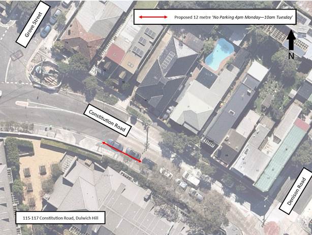
|
|
Local Traffic Committee Meeting 19 July 2021 |
Subject: Cavendish Street, Stanmore - Resident Parking
Scheme Proposal
Damun - Stanmore Ward/ Newtown Electorate/ Inner West PAC
Prepared By: Scipio Tam - Engineer – Traffic and Parking Services
Authorised By: Manod Wickramasinghe - Traffic and Transport Planning Manager
SUMMARY
In response to a community petition received from a number of residents of Cavendish Street, Stanmore between Holt Street and Merchant Street, Council has investigated a proposal for Residential Parking Scheme. This report provides the results of the residential parking scheme investigation into Cavendish Street, Stanmore, between Holt Street and Merchant Street, with the recommendation of not to support the proposal.
|
RECOMMENDATION
THAT the proposed Residential Parking Scheme in Cavendish Street, Stanmore between Holt Street and Merchant Street is not be supported at the present time due to less than required Level of Support as outlined in Inner West Council’s Public Domain Parking Policy.
|
OTHER STAFF COMMENTS
A number of residents in Cavendish Street, Stanmore, between Holt Street and Merchant Street have requested the implementation of Residential Parking Scheme (RPS) in their street. Consequently, park occupancy surveys were undertaken in the subject section of Cavendish Street, in accordance with Council’s Parking Scheme Investigation guidelines.
The survey results indicated consistently high parking occupancy levels (equal to or over 85%) in the street during four main survey times: 7am, 11:30am, 4pm, 8pm. With high parking demand outside of working hours (7am & 8pm), this typically indicates the parking demand originating from residents within the area as opposed to visitors, commuters and workers.
As the northern side of Cavendish Street, Stanmore between Holt Street and Property No. 121 Cavendish Street serves as the western entrance and side boundary for Stanmore Public School, the southern side of Cavendish Street was chosen for the proposed Residential Parking Scheme to best balance the parking demand for all road users. This is consistent with Council’s guidelines to typically have RPS proposed along frontages of eligible residential properties and on one side of the road only.
PUBLIC CONSULTATION
A total of 167 consultation letters outlining the proposal sent to surrounding properties and respective owners (where applicable) and eighteen (18) responses were received. Consultation survey results are summarised as follows:
|
Number of Residential Properties |
- 84 |
|
Number of Non-Residential Properties |
- 2 |
|
|
|
|
Total Responses |
- 18 |
|
Total Support |
- 10 |
|
Total Support Rate |
- 55.6% |
|
Total Oppose |
- 8 |
|
Total Oppose Rate |
- 44.4% |
|
|
|
|
Residential Properties |
|
|
Properties Responded |
- 14 |
|
Properties Support |
- 10 |
|
Properties Oppose |
- 4 |
|
|
|
|
Overall Response Rate |
- 17% |
|
Overall Support Rate |
- 71% |
|
|
|
|
|
|
|
Non-Residential Properties |
|
|
Responses |
- 4 |
|
Support |
- 0 |
|
Oppose |
- 4 |
Within the subject of Cavendish Street, Stanmore, there are 84 residential properties, a Council operated Child Care Centre and Stanmore Public School.
Based on Council’s Resident Parking Policy, a minimum response rate of 30% of households and a minimum of 65% support from respondents are required in order to for Council to proceed with implementation. It would seem that both minimum response rate and support thresholds were not met in this case.
CONCLUSION
Based on the above results, the RPS proposal in Cavendish Street, Stanmore between Holt Street and Merchant Street is not supported at the present time due to less than required response rate received from the consulted residents. In any case, it is unlikely that an RPS in this case would have relieved that parking problem to a great extent given that the problem also occurs outside of the hours where commuters, employees or others could pose parking problems.
|
|
Local Traffic Committee Meeting 19 July 2021 |
Subject: Proposed Resident Parking Scheme in Rozelle (Baludarri-Balmain Ward/ Balmain Electorate/ Leichhardt PAC)
Prepared By: Felicia Lau - Engineer - Traffic and Parking Services
Authorised By: Manod Wickramasinghe - Traffic and Transport Planning Manager
SUMMARY
Council has received multiple requests from residents of Foucart Street, Hutcheson Street and Denison Street for a Resident Parking Scheme (RPS) to address issues with WestConnex workers’ long-term parking within the residential streets.
|
RECOMMENDATION
THAT:
1. A ‘2P 8am-6pm, Permit Holders Excepted, Area R1’ parking restriction be installed on: a. Both sides of Foucart Street between Albert Street and Lilyfield Road, Rozelle; b. Both sides of Hutcheson Street, Rozelle; c. Western side of Alice Street between Albert Street and Mary Street, Rozelle; d. Western side of Denison Street between Cashman Street and Cheltenham Street, Rozelle; e. Both sides of Cashman Street, Rozelle. f. Northern side of Lilyfield Road between Foucart Lane and Foucart Street. 2. 10m ‘No Stopping’ zone to be installed at intersections where Resident Parking Scheme is implemented; 3. A ‘2P 8am-6pm Mon-Fri, 4P 8am-1pm Sat’ restriction be installed on the angle parking spaces only on the eastern side of Denison Street along Easton Park.
|
BACKGROUND
Construction works for the M4-M5 Link Rozelle Interchange commenced in 2019 and resulted in an increase in parking demand as WestConnex workers compete for on-street parking on nearby local streets. It is for this reason last year, Transport for NSW (TfNSW) undertook community engagement on an area wide Rozelle Resident Parking Scheme (RPS) to address concerns from residents regarding the parking situation. The proposal at that time did not receive enough support and was not implemented.
Council is aware of the ongoing concerns and have continuously received requests from residents to implement a RPS to address their daily parking issues. A smaller more localized RPS area was proposed to the residents shown in Figure 1 during June 2021.
FINANCIAL IMPLICATIONS
Nil.
OTHER STAFF COMMENTS
Parking occupancy levels in Foucart Street, Hutcheson Street, Alice Street, Denison Street, Albert Street, Cashman Street, Mary Street and Easton Street, Rozelle were generally over 85%, which warranted further investigation. The proposed RPS took into consideration the number of properties with no or very limited off-street parking spaces, proximity to Rozelle Interchange, and the number of spaces available under the scheme area. The RPS is intended to deter the existing long-term non-resident parking in residential streets, and improve the chance of find an on-street parking space for eligible permit holders.
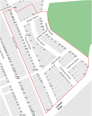
Figure 1: Local Area
The initial proposed RPS plan that was consulted with the residents are shown in Figure 2.
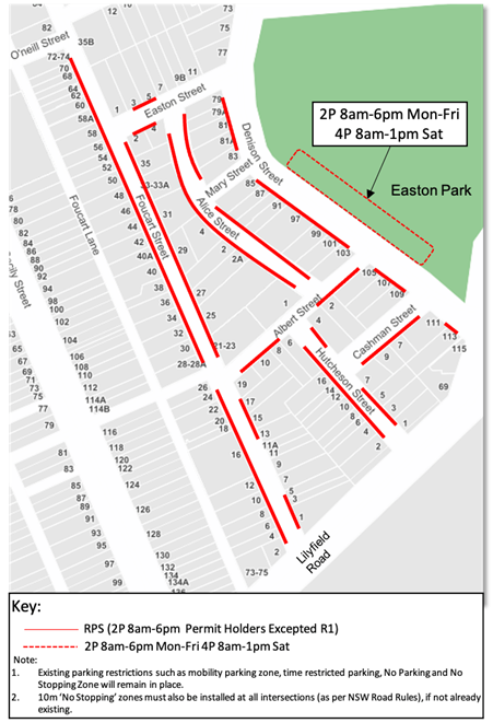
Figure 2: Proposed Resident Parking Scheme – Consulted Plan
After assessing feedback from the community, a revised RPS plan as shown in Figure 3 was developed. The changes take into consideration the support rates received during the public consultation, with street sections having low support remaining as unrestricted parking.
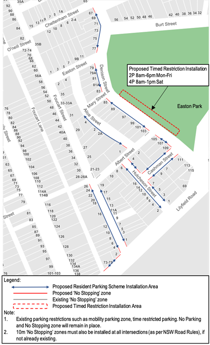
Figure 3: Revised RPS Plan
The review of the consultation feedback has resulted in the following recommendations:
· Some dual-occupancies approved/strata subdivided properties post January 2001 that do not have an off-street parking available on premises were identified in Foucart Street and Lilyfield Road. These properties are not eligible for resident permits in accordance to Council’s current RPS Policy, however, understanding the current parking situation around the WestConnex Interchange work site, it is proposed to include these properties as part of the scheme and would be eligible for one residential parking permit.
· There were 4 out of 6 properties on Denison Street between Easton Street and Cheltenham Street which was initially excluded in the RPS plan has requested that they are to be included in the RPS area; the revised RPS plan has taken this into consideration.
· Although, there were no responses received from properties on both Cashman Street and Dennison Street, south of Cashman Street, the revised RPS plan has included Cashman Street as the properties in Cashman Street do not have an off-street parking in the premises and the revised proposed RPS would expect to significantly impact on the parking in Cashman Street if it is excluded.
The RPS permit eligibility is in accordance to Council’s current Resident Parking Policy and one visitor permit will be issued to each eligible property.
PUBLIC CONSULTATION
A letter outlining the initial proposal (Figure 2) was mailed out to the directly affected properties within the local area (Figure 1) and nearby properties at the boundary.
Consultation survey results are summarised in Figure 4 below.
The consultation resulted an overall response rate of 45% for the local area. There were a mix of high and low support levels for the RPS, with a high level of support (above 50%) generally from streets closest to the Rozelle Interchange site and from individual properties that do not have an off-street parking within their premises and solely rely on on-street parking availability. The assessment has resulted in a revised RPS plan as shown in Figure 3 for street sections meeting 50% and higher, in which is in accordance to Council’s current Resident Parking Scheme Policy for Council implementation.
Summary of some main objections from the consultation comprise of the following:
· The existing parking works well. Parking supply only reduces when the work site is in operation and this is a temporary situation.
· The installation of 10m ‘No Stopping’ signage reduces the parking capacity.
· Has a rear access/ off-street parking in the premises that is not suitable for a vehicle to be parked in it.
· To be included in the RPS regardless of the dual occupancy approved/strata subdivided post January 2001.
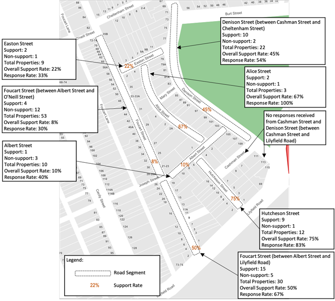
CONCLUSION
The revised Resident Parking Scheme recommendation to be supported.