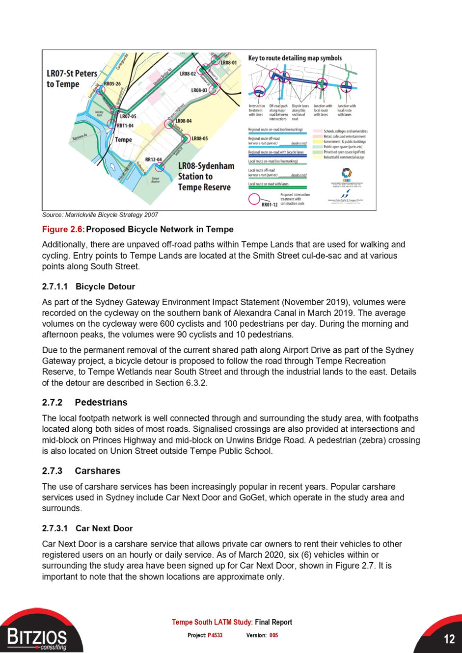
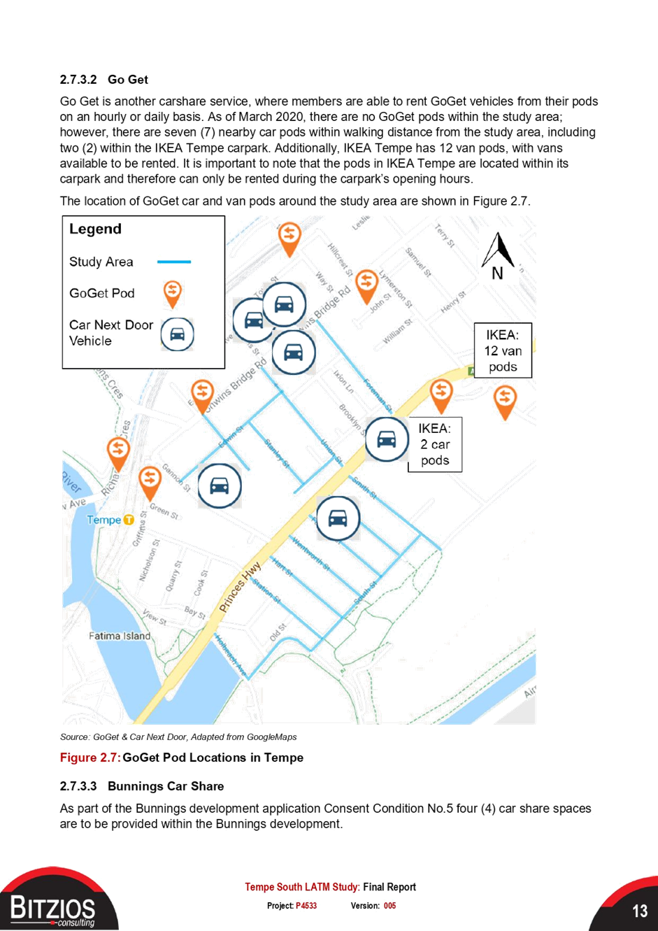
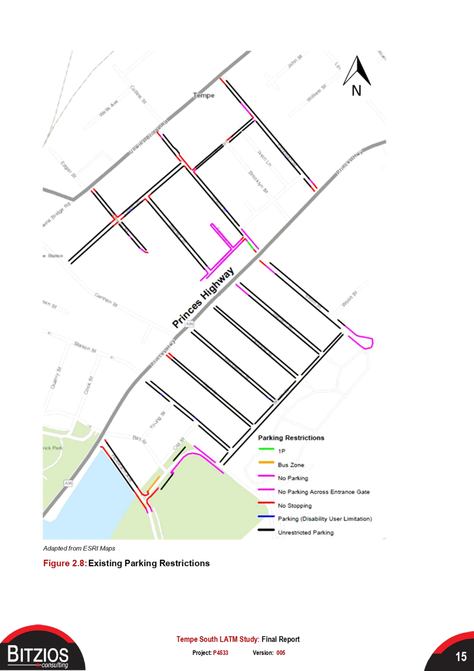
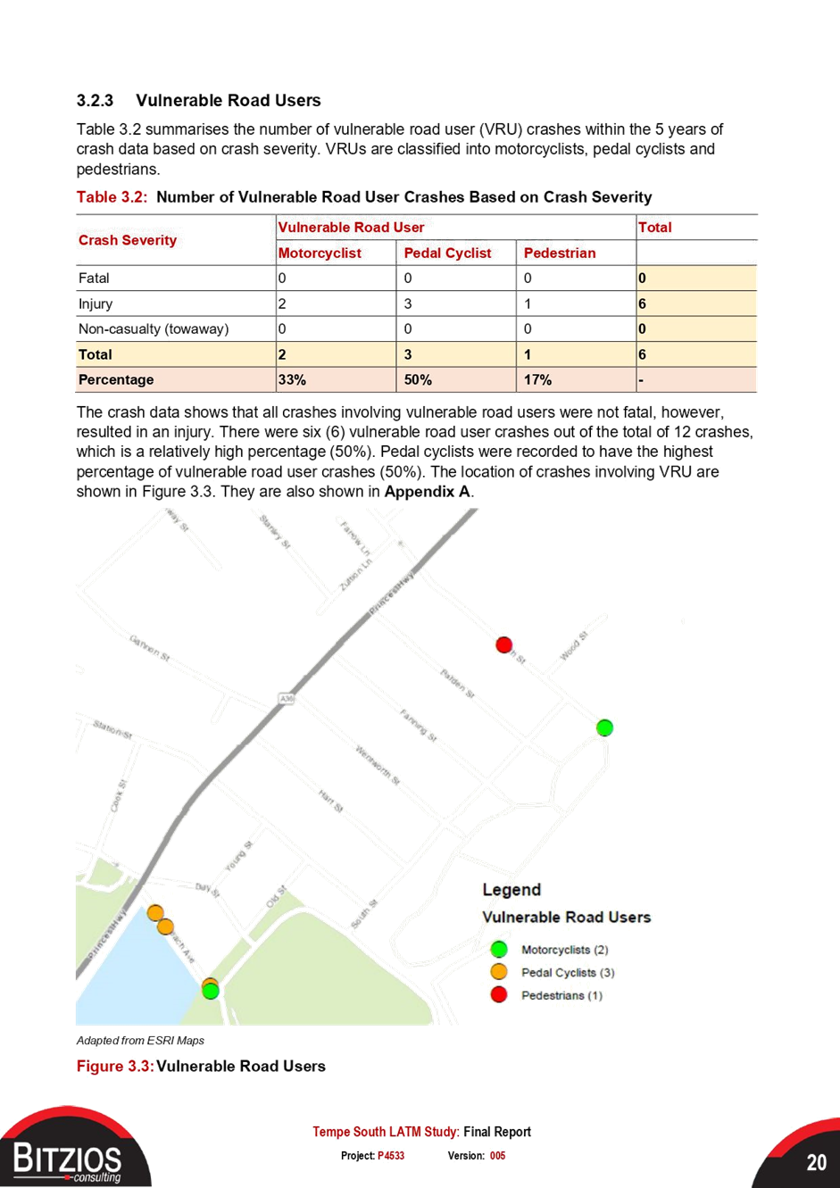
|
AGENDA R |

Local Traffic Committee Meeting
MONDAY 16 AUGUST 2021
10.00AM
|
|
Local Traffic Committee Meeting 16 August 2021 |
Function of the Local Traffic Committee
Background
Roads and Maritime Services (RMS) is legislated as the Authority responsible for the control of traffic on all NSW Roads. The RMS has delegated certain aspects of the control of traffic on local roads to councils. To exercise this delegation, councils must establish a local traffic committee and obtain the advice of the RMS and Police. The Inner West Council Local Traffic Committee has been constituted by Council as a result of the delegation granted by the RMS pursuant to Section 50 of the Transport Administration Act 1988.
Role of the Committee
The Local Traffic Committee is primarily a technical review and advisory committee which considers the technical merits of proposals and ensures that current technical guidelines are considered. It provides recommendations to Council on traffic and parking control matters and on the provision of traffic control facilities and prescribed traffic control devices for which Council has delegated authority. These matters are dealt with under Part A of the agenda and require Council to consider exercising its delegation.
In addition to its formal role as the Local Traffic Committee, the Committee may also be requested to provide informal traffic engineering advice on traffic matters not requiring Council to exercise its delegated function at that point in time, for example, advice to Council’s Development Assessment Section on traffic generating developments. These matters are dealt with under Part C of the agenda and are for information or advice only and do not require Council to exercise its delegation.
Committee Delegations
The Local Traffic Committee has no decision-making powers. The Council must refer all traffic related matters to the Local Traffic Committee prior to exercising its delegated functions. Matters related to State Roads or functions that have not been delegated to Council must be referred directly to the RMS or relevant organisation.
The Committee provides recommendations to Council. Should Council wish to act contrary to the advice of the Committee or if that advice is not supported unanimously by the Committee members, then the Police or RMS have an opportunity to appeal to the Regional Traffic Committee.
Committee Membership & Voting
Formal voting membership comprises the following:
· one representative of Council as nominated by Council;
· one representative of the NSW Police from each Local Area Command (LAC) within the LGA, being Newtown, Marrickville, Leichhardt and Ashfield LAC’s.
· one representative from the RMS; and
· State Members of Parliament (MP) for the electorates of Summer Hill, Newtown, Heffron, Canterbury, Strathfield and Balmain or their nominees.
Where the Council area is represented by more than one MP or covered by more than one Police LAC, representatives are only permitted to vote on matters which effect their electorate or LAC.
Informal (non-voting) advisors from within Council or external authorities may also attend Committee meetings to provide expert advice.
Committee Chair
Council’s representative will chair the meetings.
Public Participation
Members of the public or other stakeholders may address the Committee on agenda items to be considered by the Committee. The format and number of presentations is at the discretion of the Chairperson and is generally limited to 3 minutes per speaker. Committee debate on agenda items is not open to the public.
|
|
Local Traffic Committee Meeting 16 August 2021 |
|
AGENDA |
1 Apologies
2 Disclosures of Interest
3 Confirmation of Minutes Page
Minutes of 19 July 2021 Local Traffic Committee Meeting 5
4 Matters Arising from Council’s Resolution of Minutes
5 Part A – Items Where Council May Exercise Its Delegated Functions
Traffic Matters
ITEM Page
LTC0821(1) Item 1 182-198 Victoria Road and 28-30 Faversham Street, Marrickville – DA 201900096 – Consent Conditions 30 and 31 – Amended Signs and Line Markings Plan for Hans Place at Faversham Street N156271-08-01 (Midjuburi - Marrickville Ward / Summer Hill Electorate / Inner West PAC) 20
LTC0821(1) Item 2 Grosvenor
Crescent (between Dover Street and Smith/Longport Street), Summer Hill-
Temporary Full Road Closure.
(Boundary Gulgadya-Liechhardt Ward&Djarrawunang-Ashfield Ward/Summer Hill
Electorate/Burwood PAC) 26
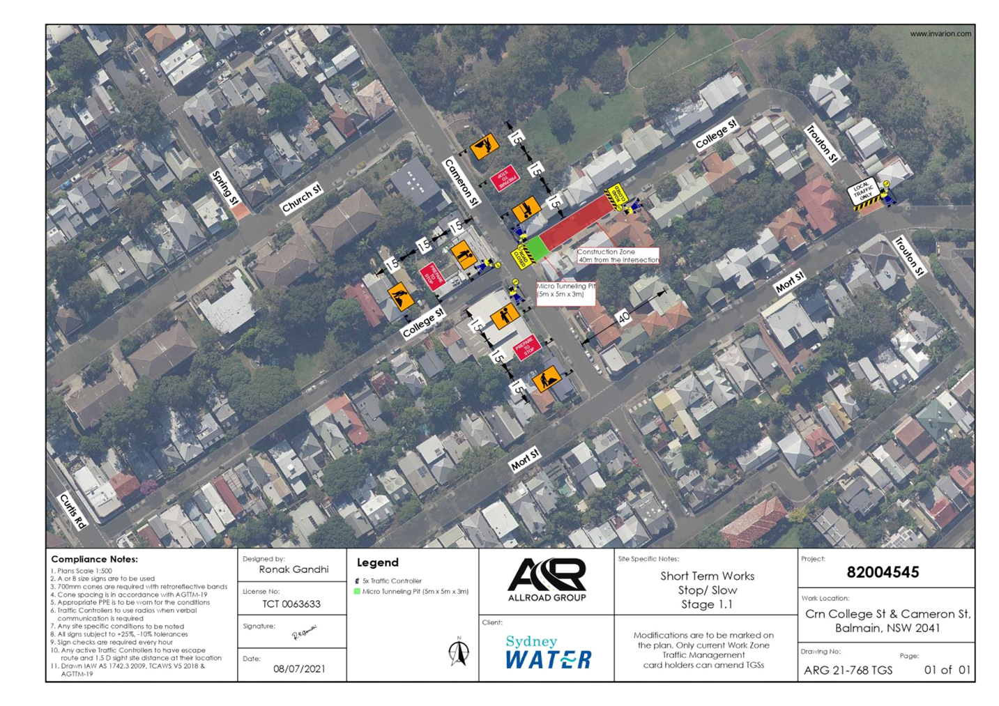
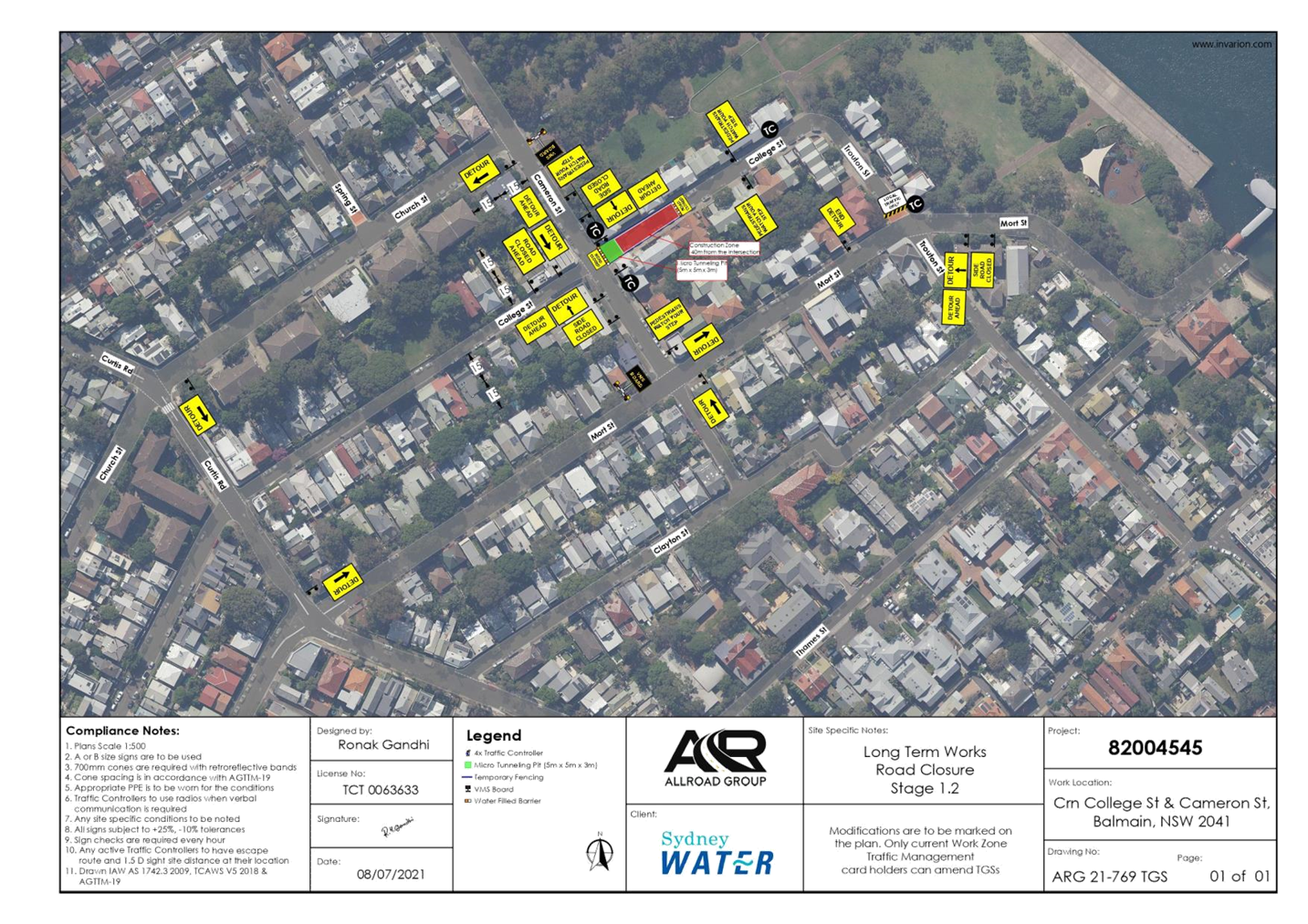
LTC0821(1) Item 3 College Street, Balmain - Temporary Full Road Closure for Underground Pipe Works (Baludarri - Balmain/ Balmain Electorate/ Leichhardt PAC) 30
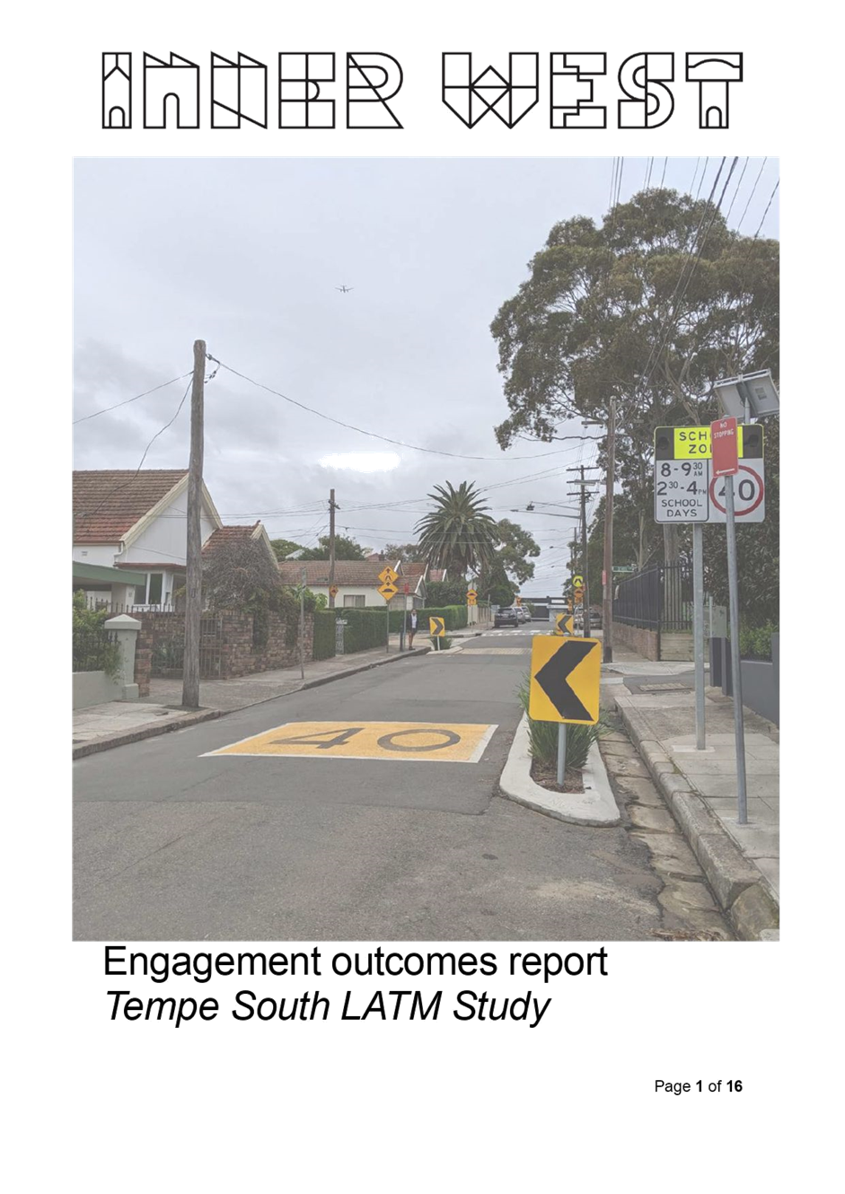
LTC0821(1) Item 4 Tempe South
Final Local Area Traffic Management (Latm) Study
(Midjuburi-Marrickville Ward/Heffron Electorate/Inner West Pac) 59
Parking Matters
Nil at the time of printing.
Late Items
Nil at time of printing.
6 Part B - Items for Information Only
Nil at the time of printing.
7 Part C - Items for General Advice
Nil at the time of printing.
8 General Business
9 Close of Meeting
|
|
Local Traffic Committee Meeting 16 August 2021 |
Minutes of Local Traffic Committee Meeting
Held remotely on 19 July 2021
Meeting commenced at 10.08AM
ACKNOWLEDGEMENT OF COUNTRY BY CHAIRPERSON
I acknowledge the Gadigal and Wangal people of the Eora nation on whose country we are meeting today, and their elders past and present.
COMMITTEE REPRESENTATIVES PRESENT
|
Clr Victor Macri |
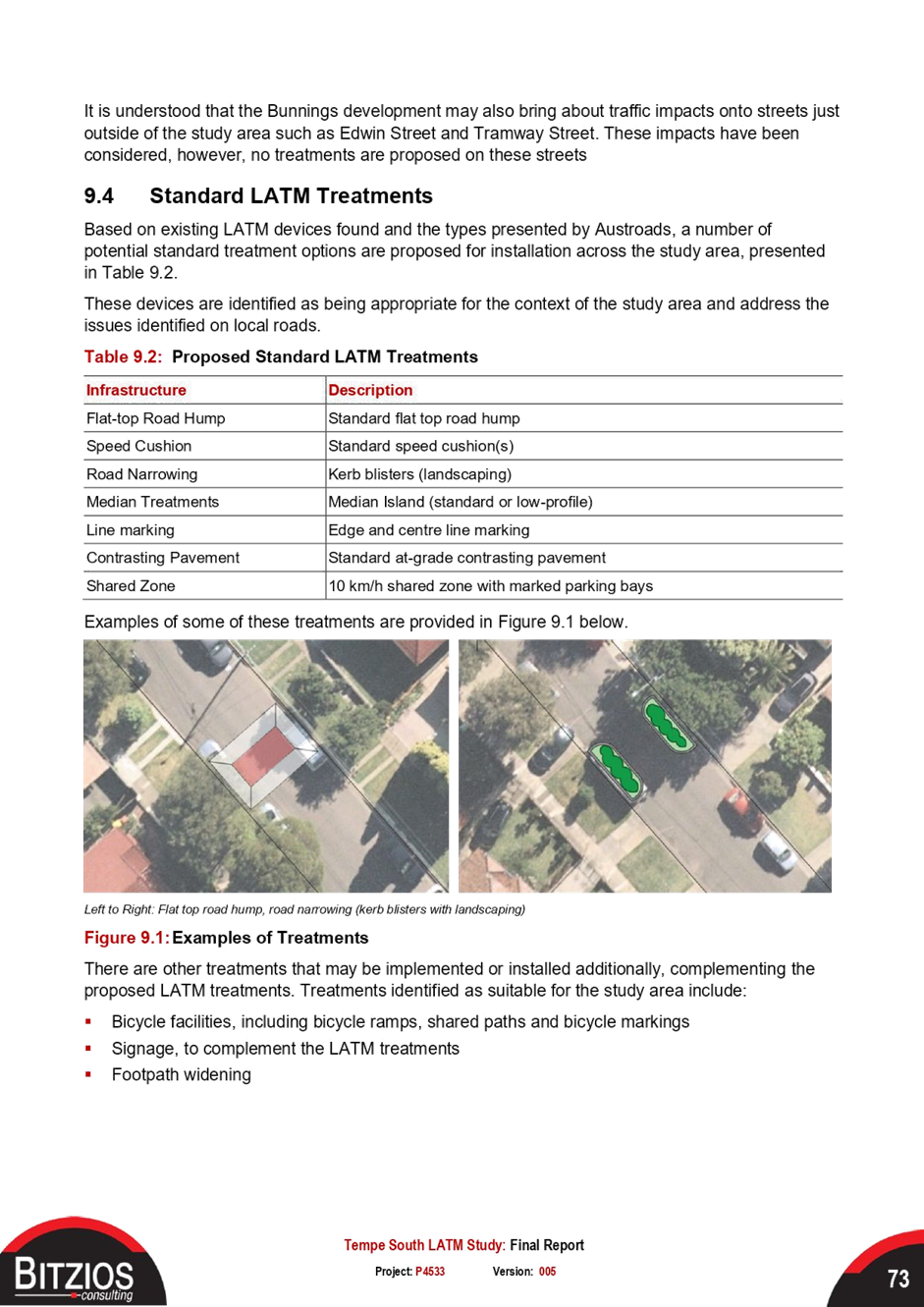
Councillor – Midjuburi-Marrickville Ward (Chair) |
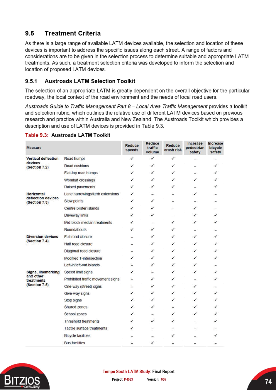
|
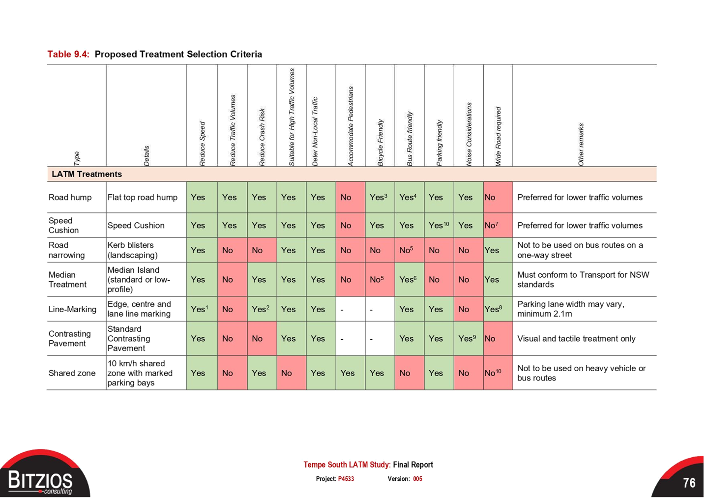
Bill Holliday |
Representative for Jamie Parker MP, Member for Balmain |
|
Omar Rodriguez |
Representative for Ron Hoenig MP, Member for Heffron |
|
Roisin Murphy |
Representative for Jo Haylen MP, Member for Summer Hill |
|
Maryanne Duggan |
Representative for Jodi MacKay MP, Member for Strathfield |
|
SC Anthony Kenny |
NSW Police – Inner West Police Area Command |
|
SC Germaine Grant |
NSW Police – Burwood Police Area Command |
|
James Suprain |
Transport for NSW (TfNSW) |
|
|
|
|
NON VOTING MEMBERS IN ATTENDANCE |
|
|
|
|
|
Clr Marghanita da Cruz |
Councillor – Gulgadya-Leichhardt Ward (Alternative Chair) |
|
Colin Jones |
Inner West Bicycle Coalition (IWBC) |
|
Inner West Bicycle Coalition (IWBC) |
|
|
John McNeil |
Inner West Bicycle Coalition (IWBC) |
|
Adrian Prichard |
Transit Systems – Inner West Bus Services |
|
Manod Wickramasinghe |
IWC’s Traffic & Transport Planning Manager |
|
George Tsaprounis |
IWC’s Coordinator Traffic Engineering Services (South) |
|
Sunny Jo |
IWC’s Coordinator Traffic Engineering Services (North) |
|
Jason Scoufis |
IWC’s Traffic & Parking Planner |
|
Jenny Adams |
IWC’s Engineer – Traffic & Parking Services |
|
Mohammed Haque |
IWC’s Civil Engineer |
|
Pierre Ayoub |
IWC’s Civil Engineer |
|
Christina Ip |
IWC’s Business Administration Officer |
|
|
|
|
VISITORS |
|
|
|
|
|
Charmila Sathianandan |
Item 4 - Transport for NSW (TfNSW) |
|
Bonnie Mo |
Item 4 - Transport for NSW (TfNSW) |
|
Gauam Pathmanathan |
Item 4 - Arenco |
|
Angelo Stratikopoulos |
Item 4 - Arenco |
|
Anthony Leung |
Item 8 and 9 - Stantec |
|
|
|
|
APOLOGIES: |
|
|
|
|
|
SC Sam Tohme |
NSW Police – Burwood Police Area Command |
|
Sgt Charles Buttrose |
NSW Police – Leichhardt Police Area Command |
DISCLOSURES OF INTERESTS:
Nil.
CONFIRMATION OF MINUTES
|
The minutes of the Local Traffic Committee meeting held on 21 June 2021 were confirmed, with amendments to the discussion of Item 8 to record comments from the representative for the Member for Balmain, as follows:
The representative for the Member for Balmain commented that the consultation does not consider that there are two distinct areas, the areas north and south of Springside Street, that would be impacted differently by a ‘No Left Turn’ restriction from Moodie Street. The representative raised the following concerns:
1. Residents from the area south of Springside Street would suffer from the out-of-area traffic avoiding the bank up at Darling Street to turn left at Moodie Street but would benefit from being able to turn left at Moodie Street. 2. Residents from the area north of Springside Street cannot access their area from Darling Street as a result of the one way sections of McCleer and Manning Streets and this also applies to any out-of-area rat runners. On the other hand they can readily turn left at Callan Street and also at Toelle Street when it is re-opened. 3. A ‘No Left Turn’ restriction would impact residents from streets south of Callan Street who need the left turn from Moodie Street to head westbound on Victoria Road. This impact will likely worsen if the Norton Street, James Street, Darley Road and City West Link intersections are upgraded and when Rozelle Interchange traffic merges with traffic from Darling and Moodie Streets going towards the Iron Cove Bridge. 4. Traffic in the side streets of Victoria Road, between Darling Street and Gordon Street will worsen when the City West Link intersections are upgraded and traffic is increased. Residents in these side streets will face the same problem Moodie Street residents face now.
|
MATTERS ARISING FROM COUNCIL’S RESOLUTION OF MINUTES
The Local Traffic Committee recommendations of its meeting held on 21 June 2021 are awaiting adoption.
EMAIL CONFIRMATION OF OFFICER’S RECOMMENDATION
The representative for NSW Police – Inner West supported the Officer’s recommendations for the items in their PAC.
The representative for NSW Police – Burwood supported the Officer’s recommendations for the items in their PAC.
The representative for the Member for Strathfield supported the Officer’s recommendations.
|
LTC0721(1) Item 1 Wardell Road/Riverside Crescent, Marrickville/ Dulwich Hill - No Left Turn Restriction (Djarrawunang-Marrickville Ward/Summer Hill Electorate/Inner West PAC) |
|
SUMMARY
A ‘No Left Turn’ restriction was installed in early 2021 to ban vehicles heading northeast in Wardell Road from making a left turn into Riverside Crescent, Dulwich Hill/ Marrickville. Since the sign was installed, Council has received numerous correspondence from the community regarding the negative impact the banned left turn movement restriction has had on traffic delays and travel times in Wardell Road , in particular in the weekday AM peak period heading towards Dulwich Hill.
A number of treatments are proposed to alleviate traffic congestion whilst supporting cycling for the on-road sections of the Greenway.
Officer’s Recommendation
THAT:
1. The ‘No Left Turn’ sign in Wardell Road facing northeast bound motorists at Riverside Crescent be replaced with a ‘No Left Turn Vehicles over 6 metres’ sign subject to TfNSW approval of a TMP. 2. The BB lines in Riverside Crescent at Wardell Road be adjusted by relocating 1m northeast for a length of 10 metres. 3. A concept design for traffic calming in the form of kerb extensions at the Tennyson Street/Riverside Crescent be prepared for consideration by Traffic Committee 4. A 30 km/h speed limit in Ness Avenue along the on-road Greenway route be supported for a 12-month trial period subject to approval of the trial by TfNSW
DISCUSSION
The Committee members agreed with the Officer’s recommendation.
COMMITTEE RECOMMENDATION
THAT:
1. The ‘No Left Turn’ sign in Wardell Road facing northeast bound motorists at Riverside Crescent be replaced with a ‘No Left Turn Vehicles over 6 metres’ sign subject to TfNSW approval of a TMP. 2. The BB lines in Riverside Crescent at Wardell Road be adjusted by relocating 1m northeast for a length of 10 metres. 3. A concept design for traffic calming in the form of kerb extensions at the Tennyson Street/Riverside Crescent be prepared for consideration by Traffic Committee 4. A 30 km/h speed limit in Ness Avenue along the on-road Greenway route be supported for a 12-month trial period subject to approval of the trial by TfNSW
For motion: Unanimous
|
|
LTC0721(1) Item 2 Liberty Street and Kingston Road, Enmore / Newtown / Camperdown – Trucks and request to reclassify road – LTC0321 Item 15 General Business (Damum-Stanmore Ward / Newtown Electorate /Inner West PAC) |
|
SUMMARY
Council has received concerns regarding truck movements along Liberty Street and Kingston Road, Enmore and an Item was raised in General Business at the March 2021 Committee meeting to assess the need for reclassification of the existing Regional Road. Past traffic count data was compared with current traffic volume counts and it is recommended that no action be taken at this time and the traffic situation in the area continue to be monitored.
Officer’s Recommendation
THAT this report be received and noted.
DISCUSSION
The Committee members agreed with the Officer’s recommendation.
COMMITTEE RECOMMENDATION
THAT this report be received and noted.
For motion: Unanimous |
|
LTC0721(1) Item 3 Bailey Street, at Enmore Road, Newtown – 10km/h 'Shared Zone' Treatment – Design Plan 10133 (Damum -Stanmore Ward / Newtown Electorate / Inner West PAC) |
|
SUMMARY
Council has finalised a design plan (10133) for a 10km/h ‘Shared Zone’ treatment in Bailey Street at Enmore Road, Newtown. The proposal for a ‘Shared Zone’ with threshold treatments and associated signs and line markings will improve safety and accessibility for pedestrians and traffic conditions at this location. The proposed works are part of recommendations endorsed in September 2019 and listed in the Newtown Local Area Traffic Management (LATM) report.
Officer’s Recommendation
THAT the detailed design plan for the 10km/h ‘Shared Zone’ treatment in Bailey Street at Enmore Road, Newtown and associated signs and line markings (as per Plan No.10133) be APPROVED, subject to separate TfNSW approval.
DISCUSSION
The Committee members agreed with the Officer’s recommendation.
COMMITTEE RECOMMENDATION
THAT the detailed design plan for the 10km/h ‘Shared Zone’ treatment in Bailey Street at Enmore Road, Newtown and associated signs and line markings (as per Plan No.10133) be APPROVED, subject to separate TfNSW approval.
For motion: Unanimous |
|
LTC0721(1) Item 4 Terminus Street, Petersham – TfNSW Petersham Station Upgrade Project - Signs and Line Markings Plan 150272-PET-CI-DRG- 45402 (Damun -Stanmore Ward/ Newtown Electorate/ Inner West PAC) |
|
SUMMARY
The signs and line marking plan for the proposed traffic / parking changes in Terminus Street, Petersham associated with Petersham Station Upgrade Project works have been submitted to Council (150272-PET-CI-DRG-45402) by Arenco, on behalf of TfNSW. It is recommended that the signs and line marking plan be approved.
Officer’s Recommendation
THAT the detailed signs and line marking plan for Terminus Street, Petersham (as part of Petersham Station Upgrade works) as per the attached plan (Signage and Line Marking Plan - Sheet 2 - 150272-PET-CI-DRG-45402) be approved.
DISCUSSION
Public speakers: Charmila Sathianandan, Bonnie Mo, Gauam Pathmanathan and Angelo Stratikopoulos attended at 10.08am.
TfNSW project managers made a presentation on how parking will be impacted by the Petersham Station Upgrade Project works and presented results of community consultation noting that:
Committee members raised a number of issues which were addressed by the speakers as follows:
(Speakers left at 10.30am)
Due to concerns with the substantial loss of parking, the Chair requested that Council Officers investigate any design changes that could help retain some parking spaces, including seeking advice from an arborist to determine if the tree, which is located within the proposed kerb blister area, is at the end of its lifecycle and whether more trees could be incorporated into the design in lieu of this tree being removed. Council Officers were also asked to consult residents and businesses regarding the loss of parking.
The Item was deferred until Council Officers obtained the requested information.
The TfNSW representative requested that Council Officers keep the project manager informed on how they intend to proceed.
COMMITTEE RECOMMENDATION
THAT the detailed signs and line marking plan for Terminus Street, Petersham (as part of Petersham Station Upgrade works) as per the attached plan (Signage and Line Marking Plan - Sheet 2 - 150272-PET-CI-DRG-45402) be deferred until Council Officers investigate changes to the design to retain some of the parking spaces lost in Terminus Street (including consideration of the removal of the large tree in the kerb blister area and replacement of this tree with a number of smaller trees), and consult with affected residents and businesses regarding the loss in parking.
For motion: Clr Macri
Abstained: TfNSW |
|
LTC0721(1) Item 5 Fred Street, Dulwich Hill - Proposed Painted Island Treatment |
|
SUMMARY
Council has received concerns raised by a number of residents and motorists regarding safety along Fred Street and at the intersection of Fred Street/ Victoria Street and Eltham Street. It has been raised with Council that on many occasions, vehicles drive into Fred Street, against the one-way direction of travel with drivers either unaware of the current ‘No Entry’ signage or wilful intent to disobey the no entry restrictions. Council has proposed a painted island treatment in order to enhance the current no entry restrictions and to possibly deter illegal traffic behaviour.
Officer’s Recommendation
THAT 1. the proposed painted island treatment, including travel direction arrow and extension of existing ‘No Stopping’ restrictions to 15m, on both sides of Fred Street north of the intersection of Fred Street, Victoria Street and Eltham Street, Dulwich Hill, be approved. 2. Physical kerb blister islands to replace the painted island treatment be approved in principle and listed on Council’s forward Capital Works Program.
DISCUSSION
The Committee members agreed with the Officer’s recommendation.
COMMITTEE RECOMMENDATION
THAT 1. the proposed painted island treatment, including travel direction arrow and extension of existing ‘No Stopping’ restrictions to 15m, on both sides of Fred Street north of the intersection of Fred Street, Victoria Street and Eltham Street, Dulwich Hill, be approved. 2. Physical kerb blister islands to replace the painted island treatment be approved in principle and listed on Council’s forward Capital Works Program.
For motion: Unanimous
|
|
LTC0721(1) Item 6 Unwins Bridge Road, adjacent to Tillman Park, Tempe – Proposed New Mid-Block Signalised Pedestrian Crossing – Design Plan 10111 (Midjuburi – Marrickville Ward / Heffron Electorate/ Inner West PAC) |
|
SUMMARY
Detailed design plans have now been finalised for the proposed new mid-block signalised pedestrian crossing in Unwins Bridge Road, adjacent to Tillman Park, Tempe. The purpose of the proposed works is to increase pedestrian safety at the existing raised pedestrian zebra crossing which has a poor road safety history. The proposed works received funding from the TfNSW Blackspot Program and the works will improve pedestrian and motorists' safety and addresses residents' concerns about speeding, driver behaviour and pedestrian safety at this location. Consultation has been undertaken with nearby owners and occupiers of properties along Unwins Bridge Road regarding the proposal. It is recommended that the proposed detailed design plans be approved.
Officer’s Recommendation
THAT the detailed design plans for the proposed new mid-block signalised pedestrian crossing on Unwins Bridge Road, adjacent to Tillman Park, Tempe, including associated signposting and line marking (as per the attached plans No. 10111) be APPROVED.
DISCUSSION
It was noted that this item is within the Heffron Electorate, not the Summer Hill Electorate as stated in the report.
The Member for Heffron, Ron Hoenig MP, submitted his support for the proposal.
The Committee members agreed with the Officer’s recommendation.
COMMITTEE RECOMMENDATION
THAT the detailed design plans for the proposed new mid-block signalised pedestrian crossing on Unwins Bridge Road, adjacent to Tillman Park, Tempe, including associated signposting and line marking (as per the attached plans No. 10111) be APPROVED.
For motion: Unanimous |
|
LTC0721(1) Item 7 Alt Street at intersections with Church Street and Charlotte Street, Ashfield- Investigation on the warrant of pedestrian crossings (Leichhardt – Gulgadya Ward/Summer Hill Electorate/Burwood PAC) |
|
SUMMARY
The Inner West Bicycle Coalition representative, at the Local Traffic Committee meeting of the 3 August 2020, under General Business, requested that traffic, speed and pedestrian counts be conducted in Alt Street, between Church Street and Charlotte Street, Ashfield, with view to installing a pedestrian crossing if warrant permits under the Transport for NSW (TfNSW) or RMS guidelines.
Council at its meeting on the 25 August 2020 resolved or noted that:
Staff will arrange a pedestrian/traffic volume count in the area to determine if the site meets the warrants for a crossing. The Ashfield Traffic Management Study (ATMS) also recommended the need to calm traffic in Alt Street at this location.
This report outlines the results of traffic and pedestrian count survey carried out in November 2020 at the proximity intersections of Alt Street/Church Street and Alt Street/Chandos Street where pedestrian activity is most occurrent.
The outcome of the results generally determined that there is a low or non-consistent pedestrian activity in crossing the road through the day or week to warrant the establishment of crossings under the TfNSW or RMS guidelines. Council will review and investigate alternate possible cross-over and/or traffic control measures for improved safety to pedestrians under the recommendation of the ATMS and Ashfield/Inner West Council Pedestrian Access Mobility Plan (PAMP).
Officer’s Recommendation
THAT:
1. The report be received and noted that no warrant can be made to justify the installation of a pedestrian crossing in Alt Street between Charlotte Street and Church Street, nor the intersection sides of Church Street and Charlotte Street, Ashfield; and 2. Council staff review and investigate other alternate and possible cross-over and/or traffic control measures to improve pedestrian safety in the area.
DISCUSSION
It was noted that this item is within the Gulgadya-Leichhardt Ward, not the Djarrawunang- Ashfield Ward as stated in the report.
The Committee members agreed with the Officer’s recommendation.
COMMITTEE RECOMMENDATION
THAT:
1. The report be received and noted that no warrant can be made to justify the installation of a pedestrian crossing in Alt Street between Charlotte Street and Church Street, nor the intersection sides of Church Street and Charlotte Street, Ashfield; and 2. Council staff review and investigate other alternate and possible cross-over and/or traffic control measures to improve pedestrian safety in the area.
For motion: Unanimous
|
|
LTC0721(1) Item 8 Leichhardt West Precinct Parking Study (Gulgadya-Leichhardt Ward/ Balmain Electorate/ Leichhardt PAC) |
|
SUMMARY
The Leichhardt West Precinct Parking Study reviewed the location, supply, demand and distribution of short and long stay parking, commercial, residential, employee, and commuter parking. The work consisted of examining existing conditions including parking data, community submissions, observed parking conditions, existing permit allocation, and future land uses within the Leichhardt West precinct.
A community survey was also undertaken to gauge the parking issues faced by different users. With consideration of the above a draft parking management strategy for Leichhardt West was developed.
Officer’s Recommendation
THAT:
1. The Draft Leichhardt West Precinct Parking Study including the Draft Leichhardt West Parking Strategy be endorsed for community consultation; and 2. The draft report be placed on Public Exhibition, providing a minimum 28 days for submissions and the results be reported back to the Traffic Committee.
DISCUSSION
Clr da Cruz stated that residents of Hawthorne Street are interested in angle parking and asked whether this within the scope of the study. Council Officers are not aware of this request; however, they advised that the request may be considered if raised during the consultation.
The Committee members agreed with the Officer’s recommendation.
COMMITTEE RECOMMENDATION
THAT:
1. The Draft Leichhardt West Precinct Parking Study including the Draft Leichhardt West Parking Strategy be endorsed for community consultation; and 2. The draft report be placed on Public Exhibition, providing a minimum 28 days for submissions and the results be reported back to the Traffic Committee.
For motion: Unanimous |
|
LTC0721(1) Item 9 Rozelle North Precinct Parking Study (Baludarri-Balmain Ward/Balmain Electorate/Leichhardt PAC) |
|
SUMMARY
The Rozelle North Precinct Parking Study reviewed the location, supply, demand and distribution of short and long stay parking, commercial, residential, employee, and commuter parking. The work consisted of examining existing conditions including parking data, community submissions, observed parking conditions, existing permit allocation, and future land uses within the Rozelle North precinct.
A community survey was also undertaken to gauge the parking issues faced by different users. With consideration of the above a draft parking management strategy for Rozelle North was developed.
Officer’s Recommendation
THAT:
1. The Draft Rozelle North Precinct Parking Study including the Draft Rozelle North Precinct Parking Strategy be endorsed for community consultation; and 2. The draft report be placed on Public Exhibition, providing a minimum 28 days for submissions and the results be reported back to the Traffic Committee.
DISCUSSION
The Committee members agreed with the Officer’s recommendation.
COMMITTEE RECOMMENDATION
THAT:
1. The Draft Rozelle North Precinct Parking Study including the Draft Rozelle North Precinct Parking Strategy be endorsed for community consultation; and 2. The draft report be placed on Public Exhibition, providing a minimum 28 days for submissions and the results be reported back to the Traffic Committee.
For motion: Unanimous
|
|
LTC0721(1) Item 10 Henry Lane, Lewisham - Proposed 'No Stopping' Restrictions (Damun- Stanmore Ward/ Summer Hill Electorate/ Inner West PAC) |
|
SUMMARY
Council has received concerns of parked vehicles at the T-junction of Henry Lane, Lewisham resulting in difficulties for some residents maneuvering at the T-junction due to the narrowness of the two laneways. Therefore, Council is proposing to implement a 6 metre length of ‘No Stopping’ restriction to remove potential obstructions and improve the ability of motorists to maneuver at the T-junction.
Officer’s Recommendation
THAT a 6 metre ‘No Stopping’ zone on the western side of Henry Lane, Lewisham, along the eastern boundary of property No.16 Henry Street, Lewisham.
DISCUSSION
The Committee members agreed with the Officer’s recommendation.
COMMITTEE RECOMMENDATION
THAT a 6 metre ‘No Stopping’ zone on the western side of Henry Lane, Lewisham, along the eastern boundary of property No.16 Henry Street, Lewisham.
For motion: Unanimous
|
|
LTC0721(1) Item 11 Victoria Road, Marrickville - Proposed Short-Term Parking (Midjuburi- Marrickville Ward/Summer Hill Electorate/Inner West PAC) |
|
SUMMARY
Following representations from local businesses, Council is proposing to implement a 50 metre section of one-hour parking, along the western side of Victoria Road, north of its intersection with Sydenham Road. Council has now undertaken community consultation to gauge the community’s view in relation to introducing a section of time-restricted parking on Victoria Road, Marrickville, immediately north of Sydenham Road, in order to improve parking turnover in the vicinity of the local businesses.
Officer’s Recommendation
THAT a 50-metre section of ‘1P 9am – 5pm Monday to Saturday’ on western side of Victoria Road, Marrickville between the signalised intersection of Victoria & Sydenham Road and northern boundary of property 191 Victoria Road, Marrickville be APPROVED.
DISCUSSION
The Committee members agreed with the Officer’s recommendation.
COMMITTEE RECOMMENDATION
THAT a 50-metre section of ‘1P 9am – 5pm Monday to Saturday’ on western side of Victoria Road, Marrickville between the signalised intersection of Victoria & Sydenham Road and northern boundary of property 191 Victoria Road, Marrickville be APPROVED.
For motion: Unanimous
|
|
LTC0721(1) Item 12 Constitution Road, Dulwich Hill - Proposed 'No Parking' Restrictions (Djarrawunang - Ashfield Ward/ Summer Hill Electorate/ Inner West Pac) |
|
SUMMARY
Council’s Resource Recovery department have raised concerns of traffic and pedestrian safety during garbage collection times outside 115 – 117 Constitution Road, Dulwich Hill. Following an investigation into this matter by a Council Traffic Officer, it is now recommended that a 12 metre section of ‘No Parking’ restriction during the waste collection times be approved on the southern side of Constitution Road, immediately east of driveway to 115-117 Constitution Road, Dulwich Hill.
Officer’s Recommendation
THAT a 12-metre section of ‘No Parking 4pm Monday – 10am Tuesday’ restriction on southern side of Constitution Road, Dulwich Hill, immediately east of driveway to 115 – 117 Constitution Road, Dulwich Hill be APPROVED.
DISCUSSION
The Committee members agreed with the Officer’s recommendation.
COMMITTEE RECOMMENDATION
THAT a 12-metre section of ‘No Parking 4pm Monday – 10am Tuesday’ restriction on southern side of Constitution Road, Dulwich Hill, immediately east of driveway to 115 – 117 Constitution Road, Dulwich Hill be APPROVED.
For motion: Unanimous
|
|
LTC0721 Item 13 Cavendish Street, Stanmore - Resident Parking Scheme Proposal (Damun - Stanmore Ward/ Newtown Electorate/ Inner West PAC) |
|
SUMMARY
In response to a community petition received from a number of residents of Cavendish Street, Stanmore between Holt Street and Merchant Street, Council has investigated a proposal for Residential Parking Scheme. This report provides the results of the residential parking scheme investigation into Cavendish Street, Stanmore, between Holt Street and Merchant Street, with the recommendation of not to support the proposal.
Officer’s Recommendation
THAT the proposed Residential Parking Scheme in Cavendish Street, Stanmore between Holt Street and Merchant Street is not be supported at the present time due to less than required Level of Support as outlined in Inner West Council’s Public Domain Parking Policy.
DISCUSSION
The Committee members agreed with the Officer’s recommendation.
COMMITTEE RECOMMENDATION
THAT the proposed Residential Parking Scheme in Cavendish Street, Stanmore between Holt Street and Merchant Street is not be supported at the present time due to less than required Level of Support as outlined in Inner West Council’s Public Domain Parking Policy.
For motion: Unanimous
|
|
LTC0721(1) Item 14 Proposed Resident Parking Scheme in Rozelle (Baludarri- Balmain Ward/ Balmain Electorate/ Leichhardt PAC) |
|
SUMMARY
Council has received multiple requests from residents of Foucart Street, Hutcheson Street and Denison Street for a Resident Parking Scheme (RPS) to address issues with WestConnex workers’ long-term parking within the residential streets.
Officer’s Recommendation
THAT:
1. A ‘2P 8am-6pm, Permit Holders Excepted, Area R1’ parking restriction be installed on: a. Both sides of Foucart Street between Albert Street and Lilyfield Road, Rozelle; b. Both sides of Hutcheson Street, Rozelle; c. Western side of Alice Street between Albert Street and Mary Street, Rozelle; d. Western side of Denison Street between Cashman Street and Cheltenham Street, Rozelle; e. Both sides of Cashman Street, Rozelle. f. Northern side of Lilyfield Road between Foucart Lane and Foucart Street. 2. 10m ‘No Stopping’ zone to be installed at intersections where Resident Parking Scheme is implemented; 3. A ‘2P 8am-6pm Mon-Fri, 4P 8am-1pm Sat’ restriction be installed on the angle parking spaces only on the eastern side of Denison Street along Easton Park.
DISCUSSION
Council Officers tabled a number of submissions received regarding the amended proposal. Residents raised concerns that:
Clr Macri asked what the process is for residents, who will not be part of the RPS, to later request to be included. Council Officers advised that the Traffic & Transport Planning Manager has delegated authority to make minor modifications to an existing RPS and this would allow a small number of properties not included in the proposed RPS to be later considered for inclusion.
The Committee members agreed with the Officer’s recommendation.
COMMITTEE RECOMMENDATION
THAT:
1. A ‘2P 8am-6pm, Permit Holders Excepted, Area R1’ parking restriction be installed on: a. Both sides of Foucart Street between Albert Street and Lilyfield Road, Rozelle; b. Both sides of Hutcheson Street, Rozelle; c. Western side of Alice Street between Albert Street and Mary Street, Rozelle; d. Western side of Denison Street between Cashman Street and Cheltenham Street, Rozelle; e. Both sides of Cashman Street, Rozelle. f. Northern side of Lilyfield Road between Foucart Lane and Foucart Street. 2. 10m ‘No Stopping’ zone to be installed at intersections where Resident Parking Scheme is implemented; 3. A ‘2P 8am-6pm Mon-Fri, 4P 8am-1pm Sat’ restriction be installed on the angle parking spaces only on the eastern side of Denison Street along Easton Park. 4. Based on additional feedback, ‘2P 8am-6pm, Permit Holders Excepted, Area R1’ parking restriction be also installed on: a. the southern side of Joseph Street between Foucart Street and Foucart Lane with the existing parking on the northern side of the street being relocated to the southern side of the street and replaced with appropriate ‘No Parking’ restrictions b. the south side of Albert Street, between Hutcheson Street and Foucart Street
For motion: Unanimous
|
General Business
LTC0721 Item 15 Request for 10km/h ‘Shared Zone’ in Prospect Street, Leichhardt
Clr da Cruz requested for a 10km/h ‘Shared Zone’ in Prospect Street, Leichhardt as the street has no footpath, has high pedestrian volume and is close to schools and a child care centre. Council Officers advised that Prospect Street has been identified in the Pedestrian Access and Mobility Plan as a location for further investigation.
LTC0721 Item 16 Proposed Whites Creek Lane, Leichhardt cycleway and 10km/h ‘Shared Zone’
Clr da Cruz questioned the status of the proposed cycleway and 10km/h ‘Shared Zone’ along Whites Creek Lane. Council Officers will follow up on this and provide an update.
LTC0721 Item 17 Request to designate McCarthy Lane and Cahill Lane, Annandale, a cycle route
The representative for the Member for Balmain requested that Council consider connecting McCarthy Lane with Cahill Lane in Annandale and designating it as a bike route.
LTC0721 Item 18 Request for cycle route improvements on Albion Street, Annandale
Clr da Cruz asked for improvements to the Albion Street cycle route at the intersection of Johnston Street to make it safer for cyclists to cross Johnston Street.
LTC0721 Item 19 Request for 10km/h ‘Shared Zone’ on Etonville Parade, Croydon
Clr da Cruz requested a 10km/h ‘Shared Zone’ for Etonville Parade, Croydon as it connects to the Iron Cove cycleway.
LTC0721 Item 20 Request for traffic calming in Wetherill Street, Croydon
Residents of Wetherill Street, Croydon have requested for a 10km/h ‘Shared Zone’ or other traffic calming treatment in the street.
Meeting closed at 11.02am.
|
|
Local Traffic Committee Meeting 16 August 2021 |
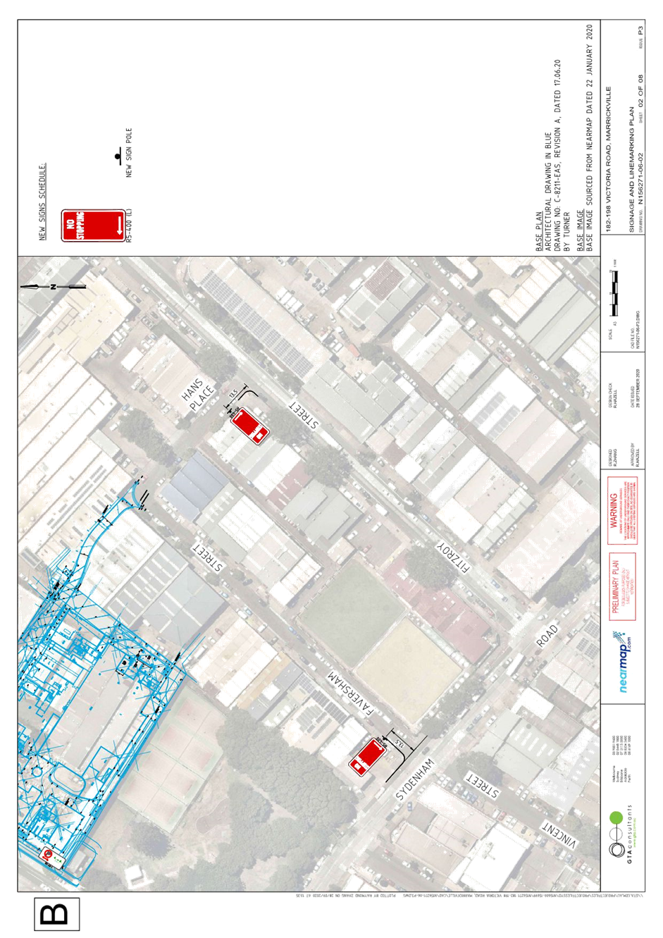
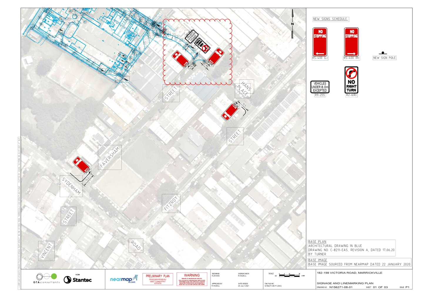
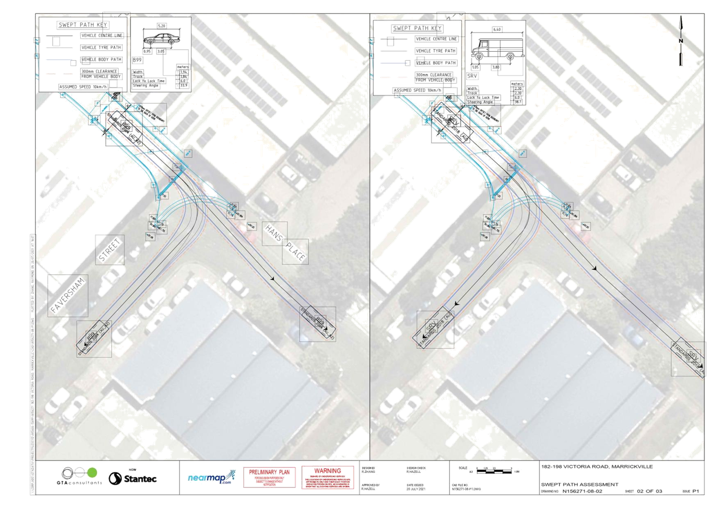
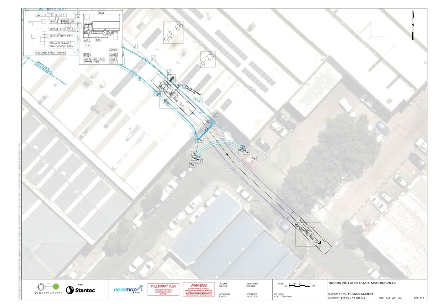
Subject: 182-198 Victoria Road and 28-30 Faversham Street, Marrickville – DA 201900096 – Consent Conditions 30 and 31 – Amended Signs and Line Markings Plan for Hans Place at Faversham Street N156271-08-01 (Midjuburi - Marrickville Ward / Summer Hill Electorate / Inner West PAC)
Prepared By: Jennifer Adams - Engineer – Traffic and Parking Services
Authorised By: Manod Wickramasinghe - Traffic and Transport Planning Manager
SUMMARY
An amended detailed line marking and signage plan for Hans Place and Faversham Street, Marrickville has been submitted by TOGA Wicks Park Development as part of development consent conditions for DA201900096 for the proposed mixed-use development at 182-198 Victoria Road and 28-30 Faversham Street, Marrickville. The amendment proposes to introduce new ‘No Stopping’ signage and a new ‘No Right Turn’ ban for vehicles over 8 metres exiting the private access way. It is recommended that the submitted plan be supported in principle subject to TfNSW’s approval.
|
THAT:
1. The amended detailed line marking and signage plan for Hans Place and Faversham Street, Marrickville showing new ‘No Stopping’ restrictions and a new ‘No Right Turn’ ban for vehicles over 8 metres exiting the private access way (as per the attached Plan B – N156271-08-01) be approved; and
2. The costs of the supply and installation of the associated signage are to be borne by the applicant in accordance with Council’s Fees and Charges.
|
BACKGROUND
A report went to the Committee at its 15 February 2021 meeting (LTC0221 – Item1) detailing the signage and line marking plans to satisfy DA201900096 consent conditions 30 and 31 (Plan B – N156271-06-02 and Plan C – N156271-06-01 Victoria Road). These plans were approved at Council’s meeting 9 March 2021. An amended detailed line marking and signage plan has now been received by Council for Hans Place and Faversham Street, Marrickville (N156271-08-01).
The amendment proposes to introduce new ‘No Stopping’ signage and a new ‘No Right Turn’ ban for vehicles over 8 metres exiting the private access way.
FINANCIAL IMPLICATIONS
All works and costs of implementation works associated with the proposal will be borne by the applicant.
DISCUSSION
The approved plan are provided in Attachment 1 and following that is the amended plan in Attachment 2. Changes are enclosed within the ‘cloud’. It is recommended that the submitted amended plan be supported in principle subject to concurrence of TfNSW that no TMP is required. No further consultation is considered necessary due to it being a new section of road.
ATTACHMENTS
|
1.⇩ |
Approved Plans - 182-198 Victoria Road and 28-30 Faversham Street, Marrickville |
|
2.⇩ |
Updated Plans - 182-198 Victoria Road and 28-30 Faversham Street, Marrickville |
|
Local Traffic Committee Meeting 16 August 2021 |
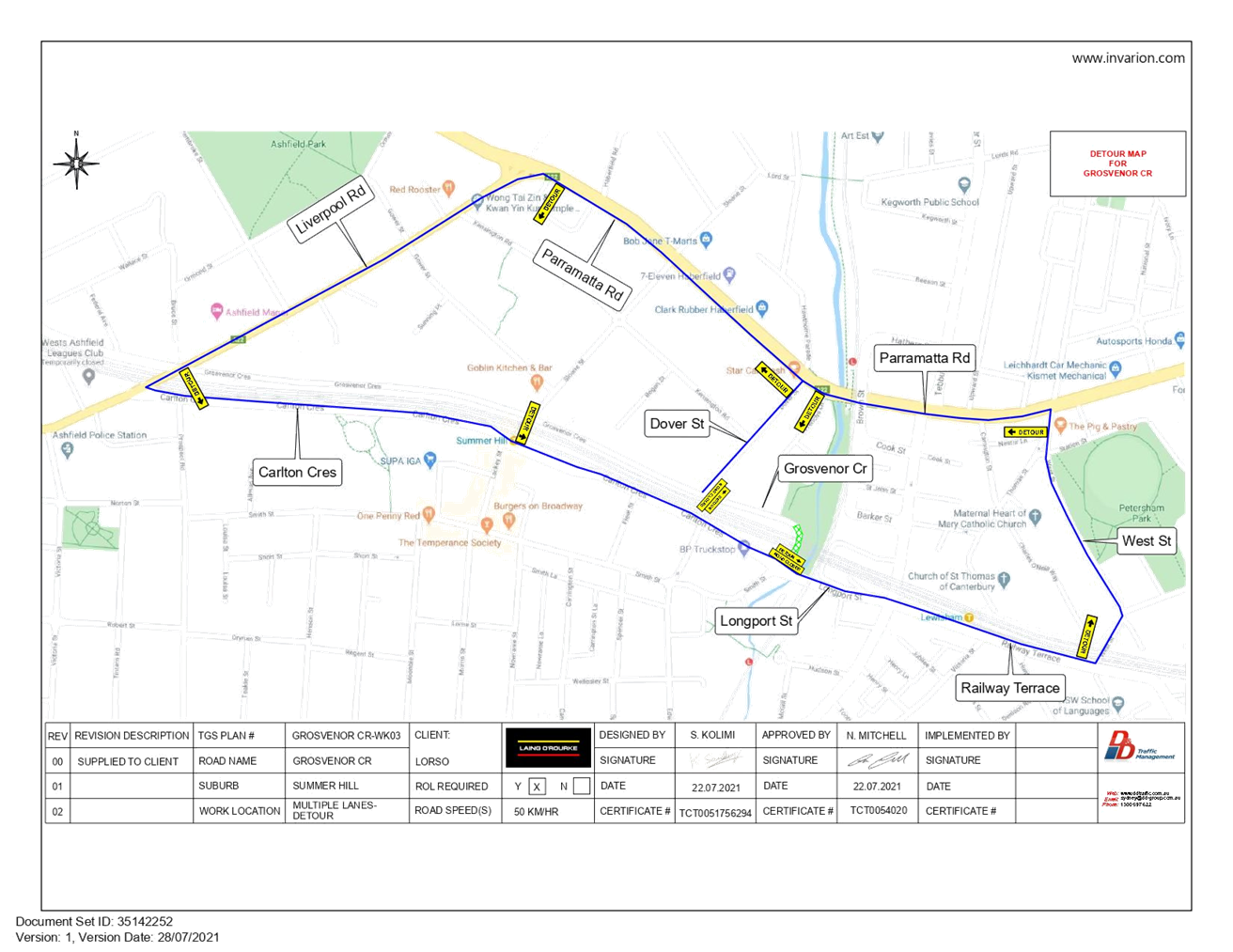
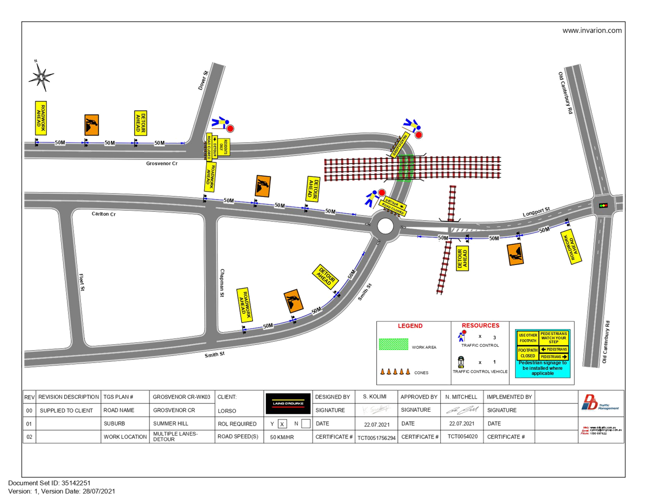
Subject: Grosvenor Crescent (between Dover Street and
Smith/Longport Street), Summer Hill- Temporary Full Road Closure.
(Boundary Gulgadya-Liechhardt Ward&Djarrawunang-Ashfield Ward/Summer Hill
Electorate/Burwood PAC)
Prepared By: Boris Muha - Engineer – Traffic and Parking Services
Authorised By: Manod Wickramasinghe - Traffic and Transport Planning Manager
SUMMARY
Council has received an application from DD Traffic Management Pty Ltd for approval of a temporary full road closure of Grosvenor Crescent, between Dover Street and Carlton Crescent/Longport Street, Summer Hill from 5.00AM Saturday 9th October 2021 through to 5.00AM on Monday 11th October 2021 (with a contingency period of 1 week) for essential rail overbridge works around a scheduled weekend rail closure.
|
RECOMMENDATION
THAT the proposed temporary full road closure of Grosvenor Crescent, between Dover Street and Carlton Crescent/Longport Street, Summer Hill from 5.00AM Saturday 9th October 2021 through to 5.00AM on Monday 11th October 2021 (with a contingency period of 1 week) BE APPROVED for essential rail overbridge works around a scheduled weekend rail closure subject to, but not limited to, the following conditions:
1. A Traffic Management Plan (TMP) for the attached Traffic Control Plan (TCP) be submitted to TfNSW prior to the start of works;
2. The Traffic Control Plan (TCP) be amended to include electronic VMS notification boards at all approaches to the closed section of Grosvenor Street and placed out at least (14) day prior to the closure. The boards are to be positioned at locations and worded appropriately to the satisfaction of Council;
3. A Road Occupancy License be obtained by the applicant from the Transport Management Centre;
4. All affected residents and businesses, including, Transit Systems, STA, NSW Police Area Command, Fire & Rescue NSW and the NSW Ambulance Services be notified in writing, by the applicant, of the proposed temporary full road closure at least 7 days in advance of the closure with the applicant making reasonable provision for stakeholders; and
5. The occupation of the road carriageway must not occur until the road has been physically closed.
|
BACKGROUND
The above section of Grosvenor Crescent has been previously closed off in the past to carry out essential inspection and maintenance of the rail bridge (beneath, aside, and atop) during rail closure weekend periods. Appropriate traffic control is to be carried out to detour motorists via alternate routes.
See Attachment 1 for Detour Plan and Attachment 2 for Traffic Control Plan (TCP)
FINANCIAL IMPLICATIONS
Under Council’s Fees & Charges, the applicant is to pay a fee for the temporary full road closure.
OTHER STAFF COMMENTS
A full road closure is required to carry out all works effectively and efficiently around the given time of the rail closure period on that weekend.
The applicant has been advised to amend their TCP to include electronic variable message signage (VMS) at all approach locations to the closed section of Grosvenor Street and placed out at least 14 days prior to the closure. This allows motorists beforehand to determine and seek alternate routes around the closure.
PUBLIC CONSULTATION
The applicant is to notify all affected residents and businesses in writing at least 7 days prior to
the commencement of works.
The proposed road closure is currently advertised on Council’s website in accordance with the
Roads Act 1993.
|
1.⇩ |
Grosvenor Crescent- Detour Map |
|
2.⇩ |
Crosvenor Crescent- Traffic Control Plan (TCP) |
|
|
Local Traffic Committee Meeting 16 August 2021 |
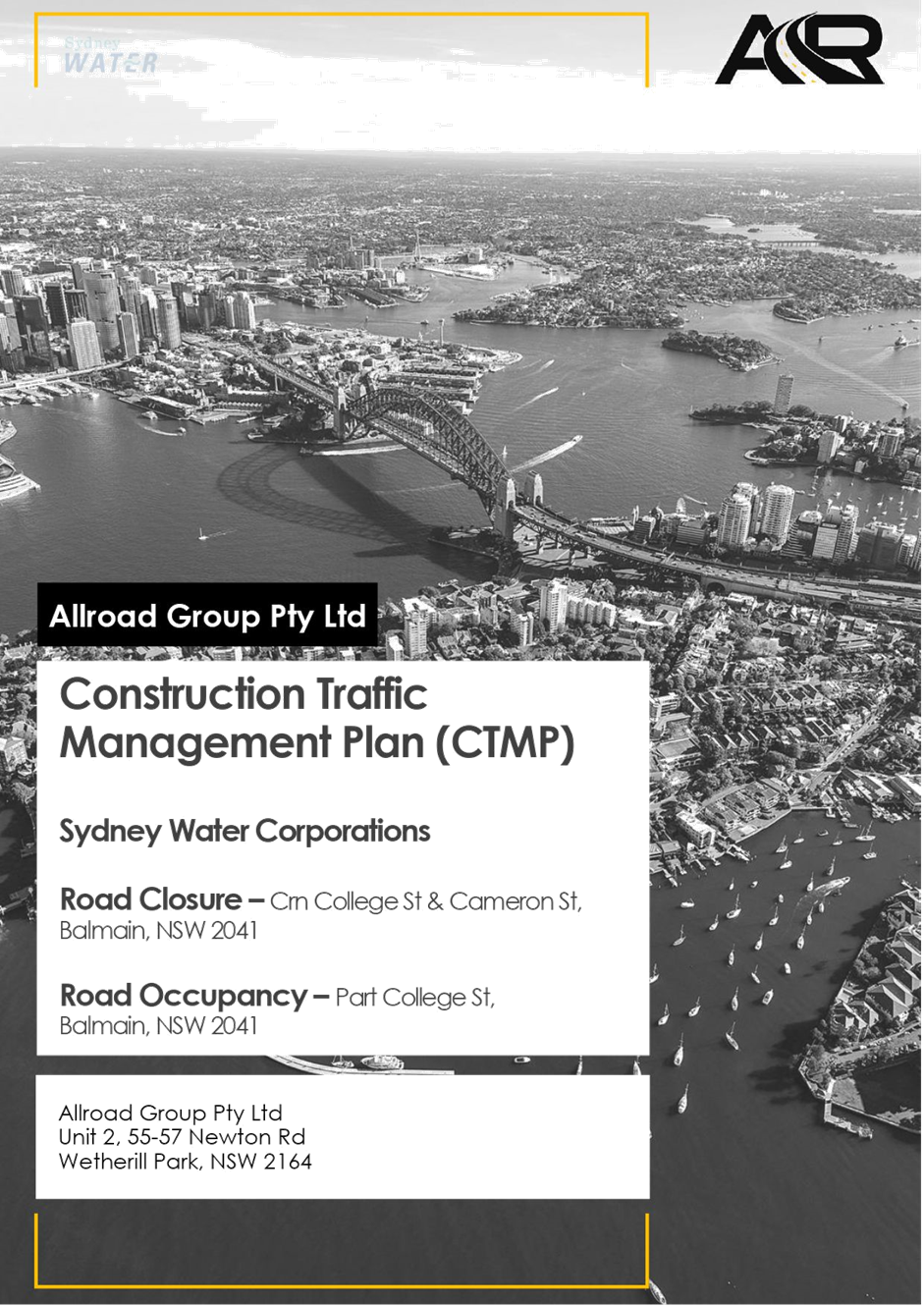
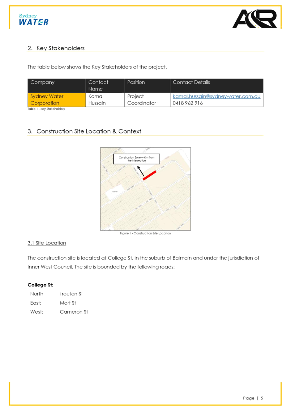
Subject: College Street, Balmain - Temporary Full Road Closure for Underground Pipe Works (Baludarri - Balmain/ Balmain Electorate/ Leichhardt PAC)
Prepared By: Vinoth Srinivasan - Engineer - Traffic and Parking Services
Authorised By: Sunny Jo - Coordinator Traffic Engineering Services (North)
Council has received an application from Sydney Water for the approval of a temporary full road closure of College Street, between Cameron Street and Trouton Street, Balmain from Tuesday, 7 September 2021 to Tuesday 30 November 2021 to facilitate underground pipe works in College Street, Balmain.
|
RECOMMENDATION
THAT the proposed temporary full road closure of College Street, between Cameron Street and Trouton Street, Balmain from Tuesday, 7 September 2021 to Tuesday 30 November 2021 (contingency period 4 weeks) be approved for the proposed underground pipe works in College Street, Balmain subject to, but not limited to the following conditions:
1. A Road Occupancy License be obtained by the applicant from the Transport Management Centre;
2. All affected residents and businesses, including NSW Police Area Command, Fire & Rescue NSW and the NSW Ambulance Services be notified in writing, by the applicant, of the proposed temporary full road closure at least 7 days in advance of the closure with the applicant making reasonable provision for stakeholders; and
3. The occupation of the road carriageway must not occur until the road has been physically closed. |
BACKGROUND & OTHER STAFF COMMENTS
Council has received an application from All Road Group on behalf of Sydney Water for approval of a temporary full road closure of College Street, between Cameron Street and Trouton Street, Balmain from Tuesday, 7 September 2021 to Tuesday 30 November 2021.
This road closure application is sought for the renewal of existing 150mm sewer pipe at College Street, Balmain.
The Traffic Management Plan (TMP) and Traffic Control Plan (TCP) submitted with the application is attached.
FINANCIAL IMPLICATIONS
Under Council’s Fees & Charges, the applicant is to pay a fee for the temporary full road closure.
PUBLIC CONSULTATION
The applicant is to notify all affected residents and businesses in writing at least 7 days prior to the commencement of works.
The proposed road closure is currently advertised on Council’s website in accordance with the Roads Act 1993.
|
1.⇩ |
College Street, Balmain - Traffic Management Plan and Traffic Control Plan |
|
|
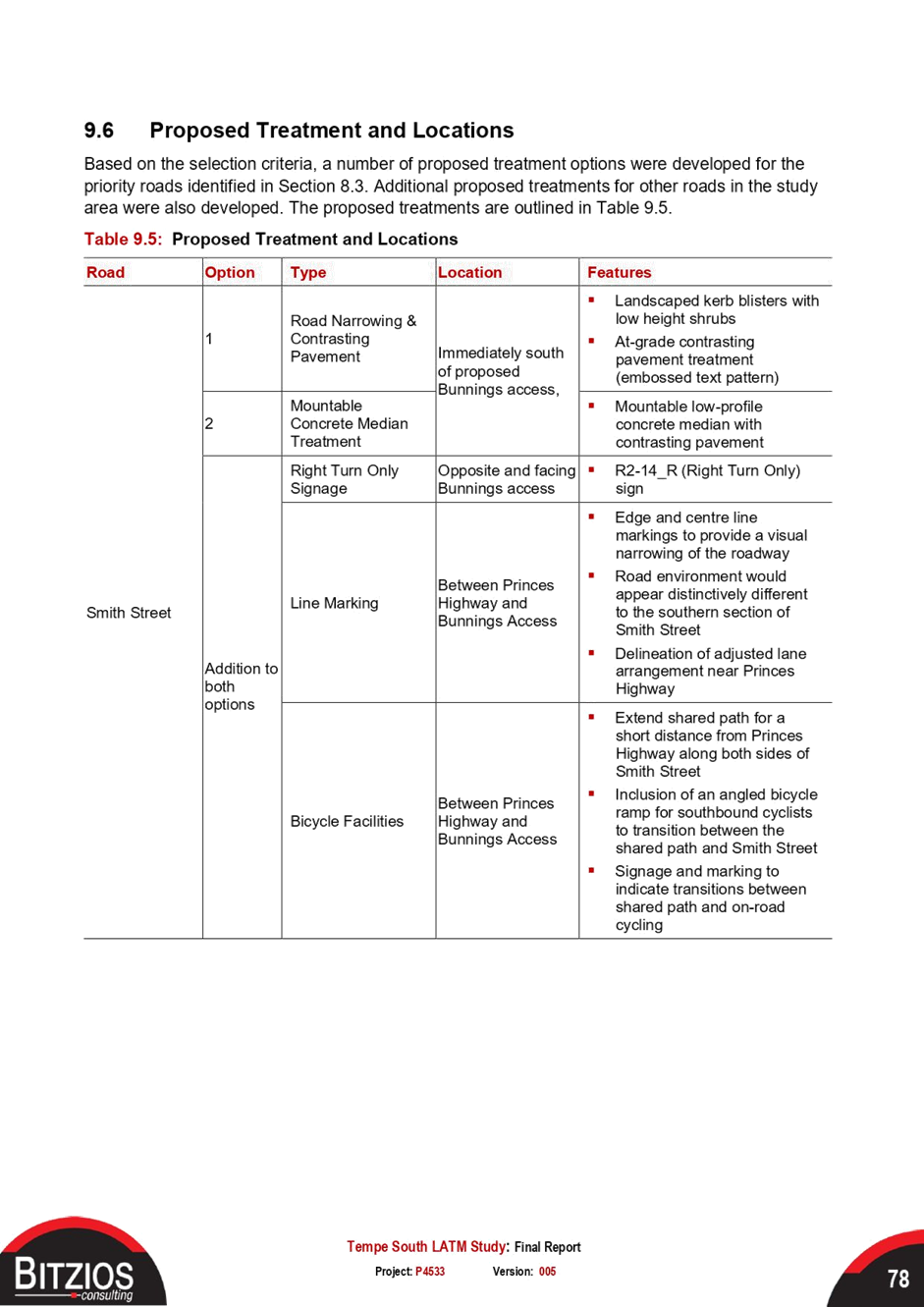
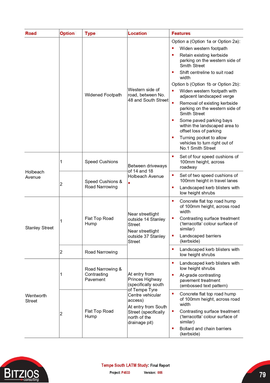
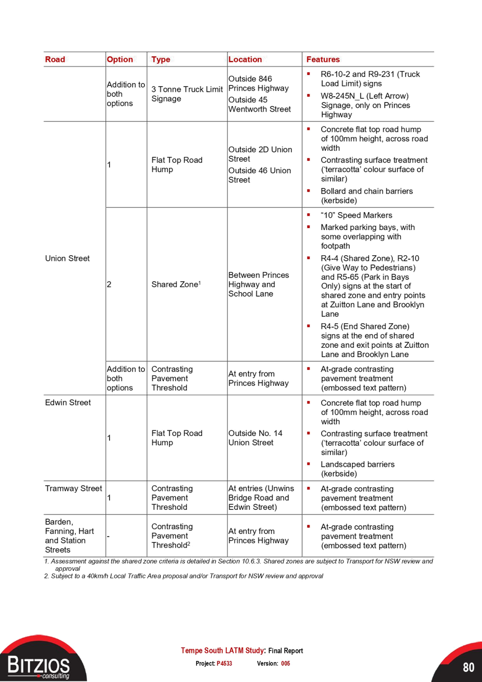
Local Traffic Committee Meeting 16 August 2021 |
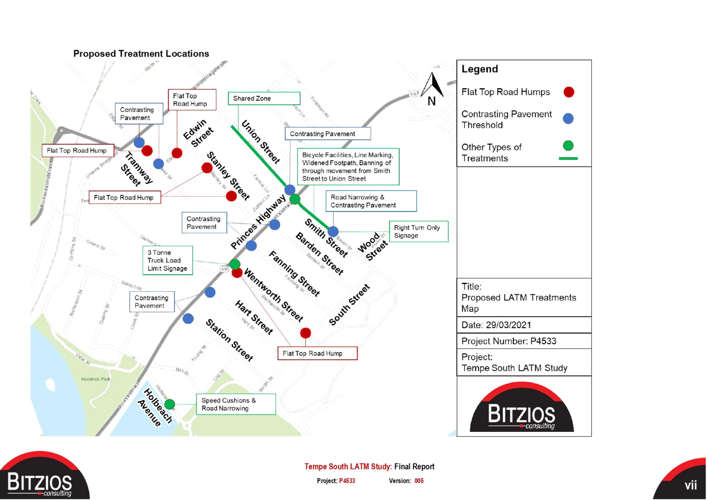
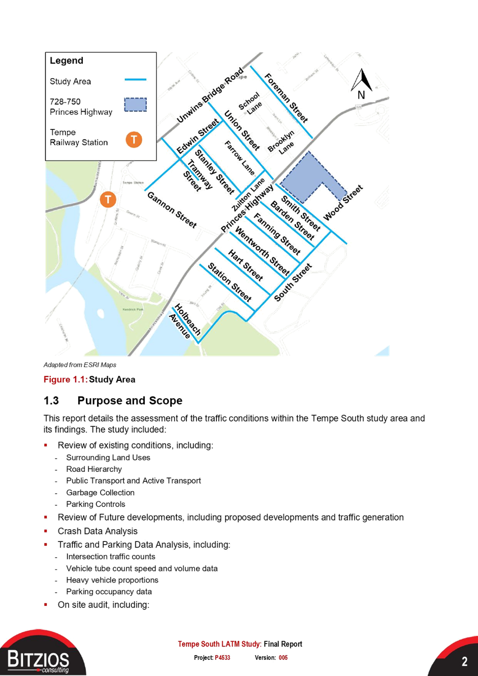
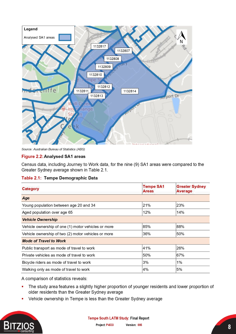
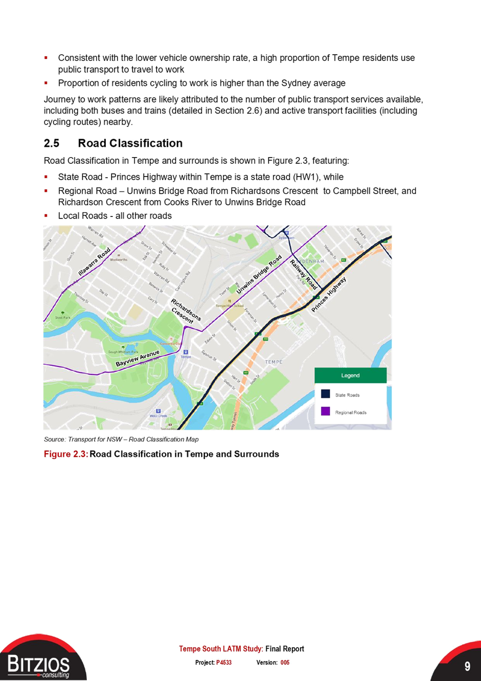
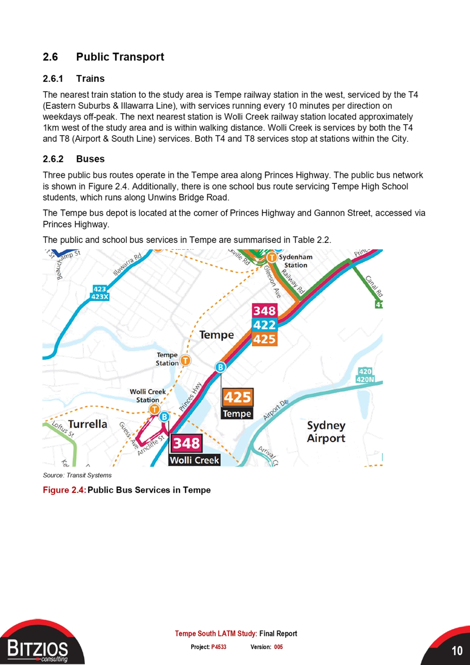
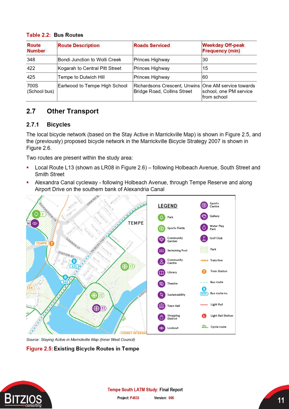
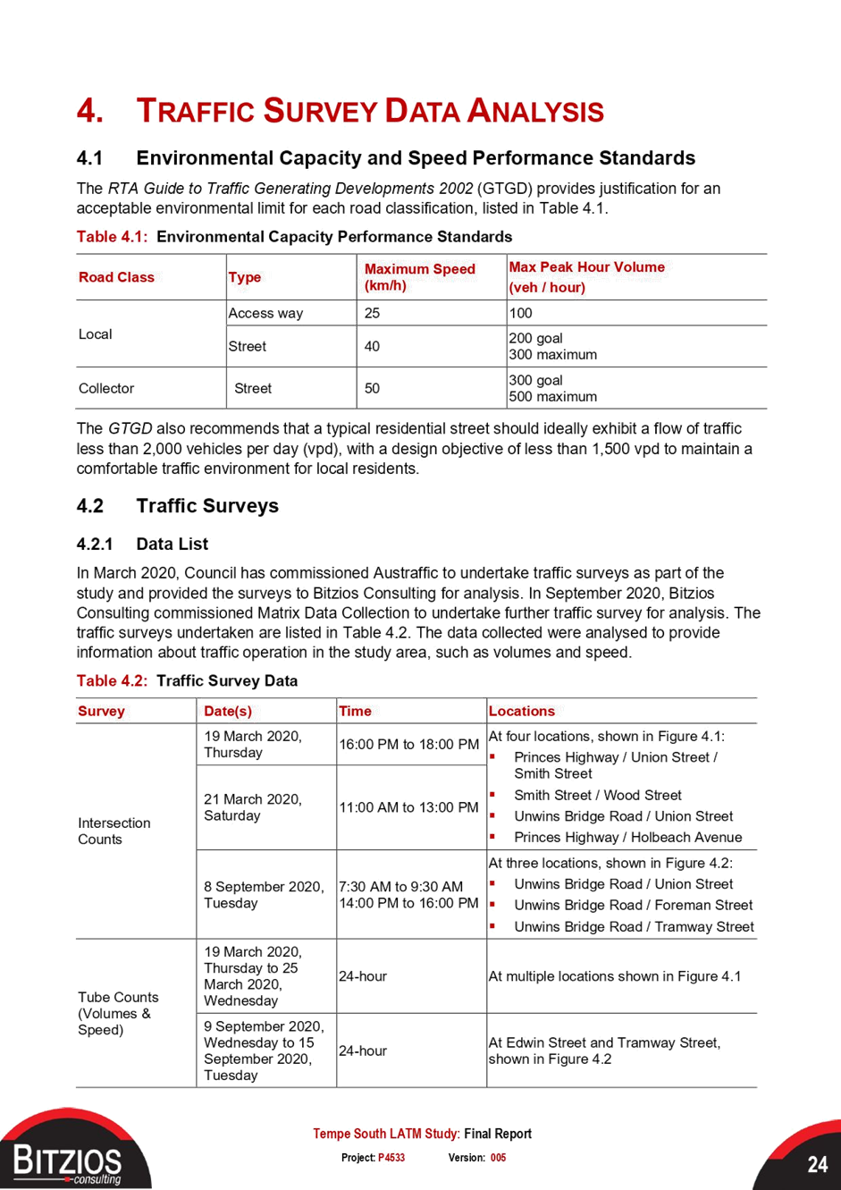
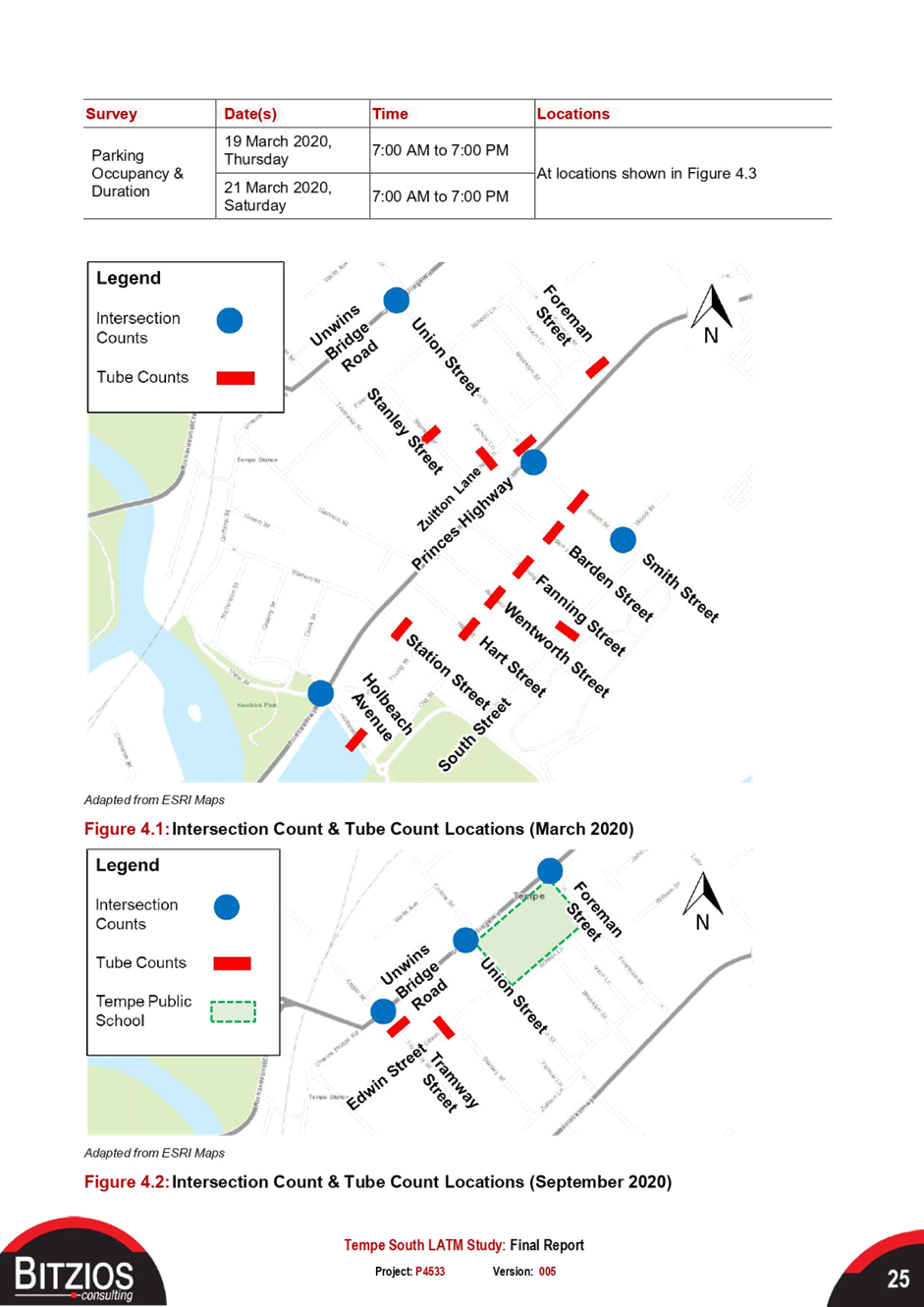
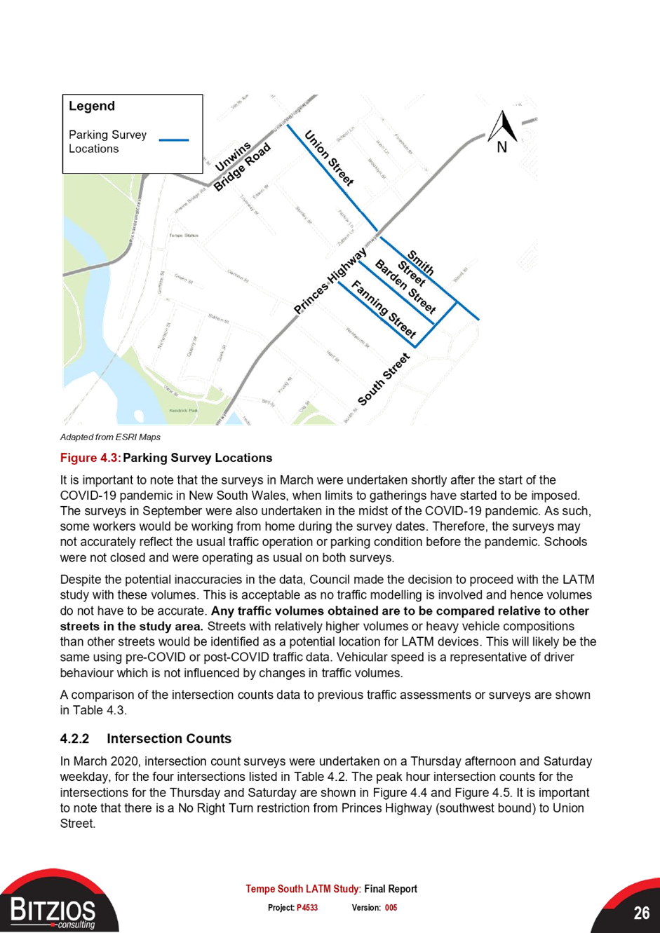
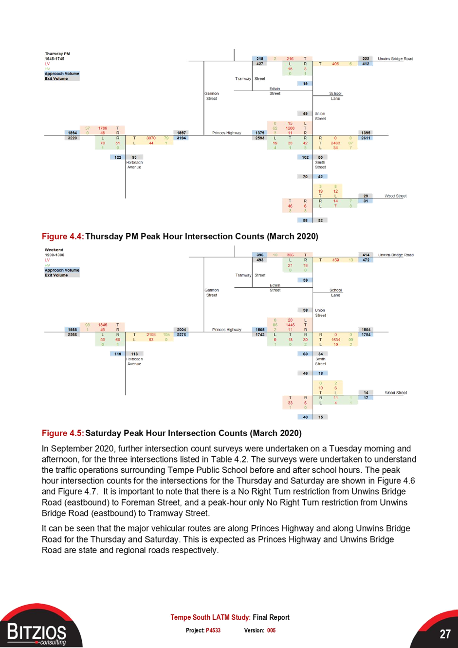
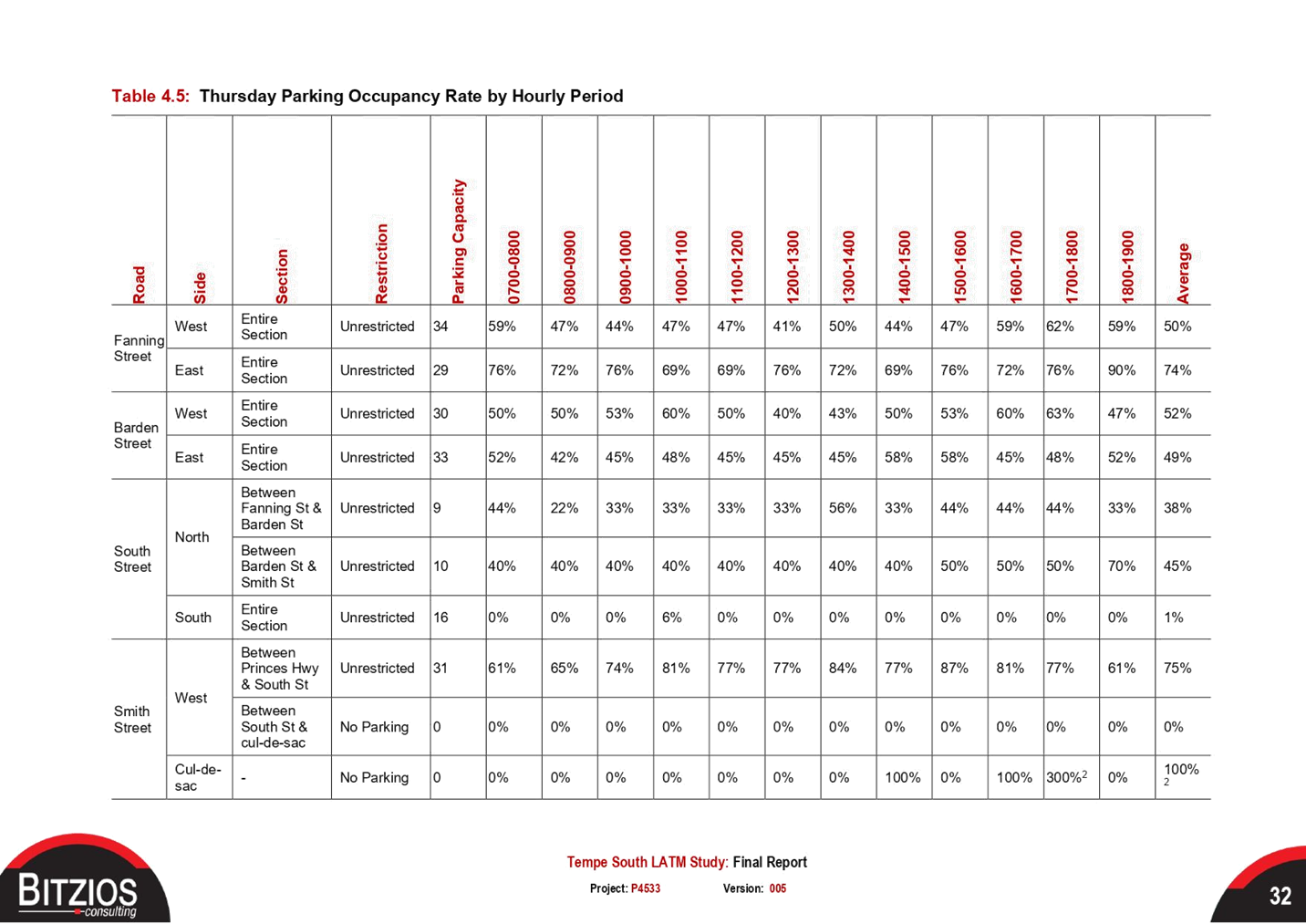
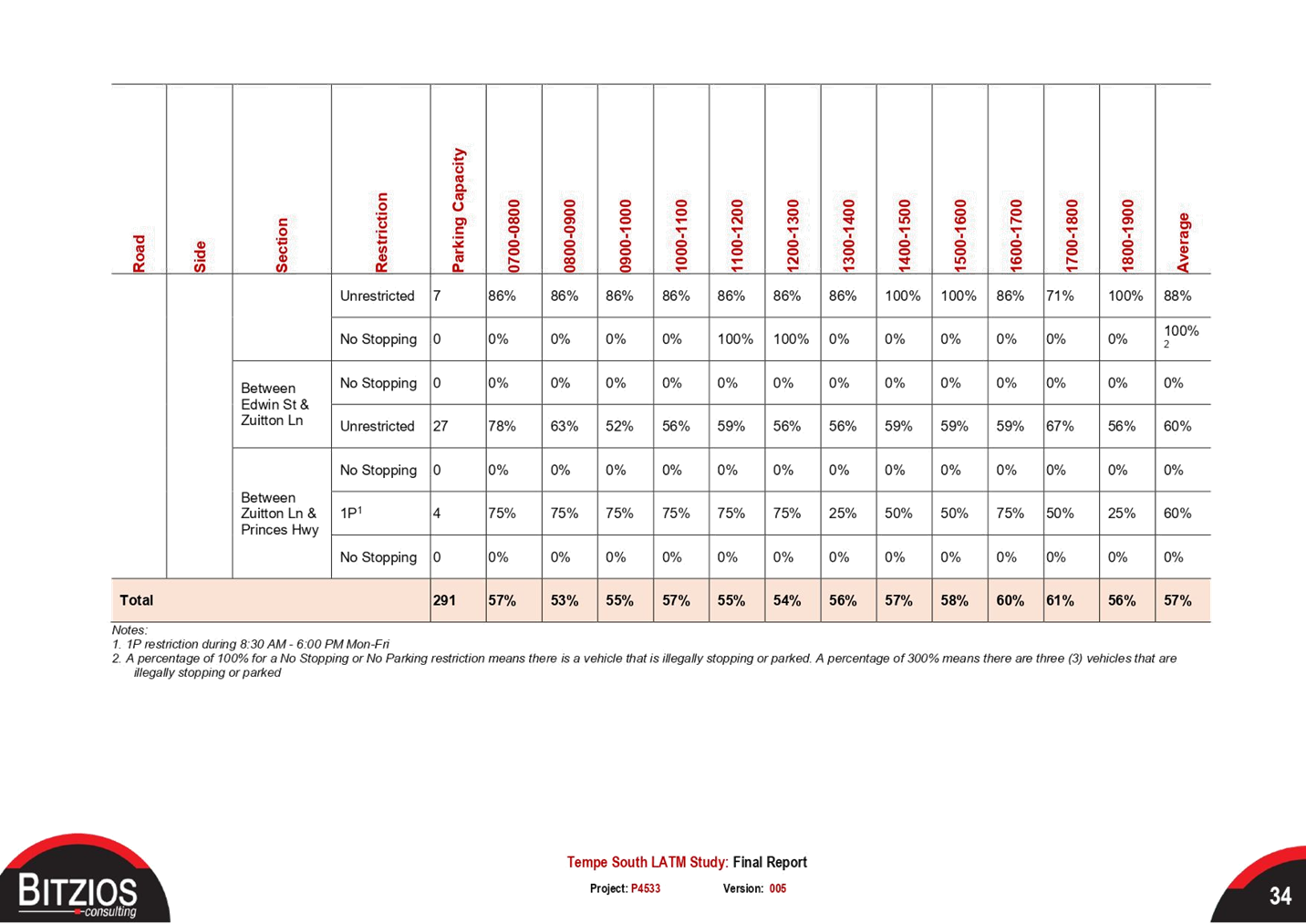
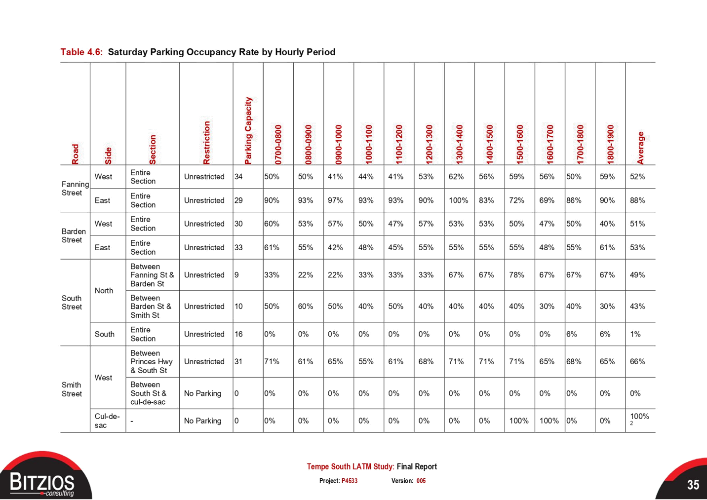
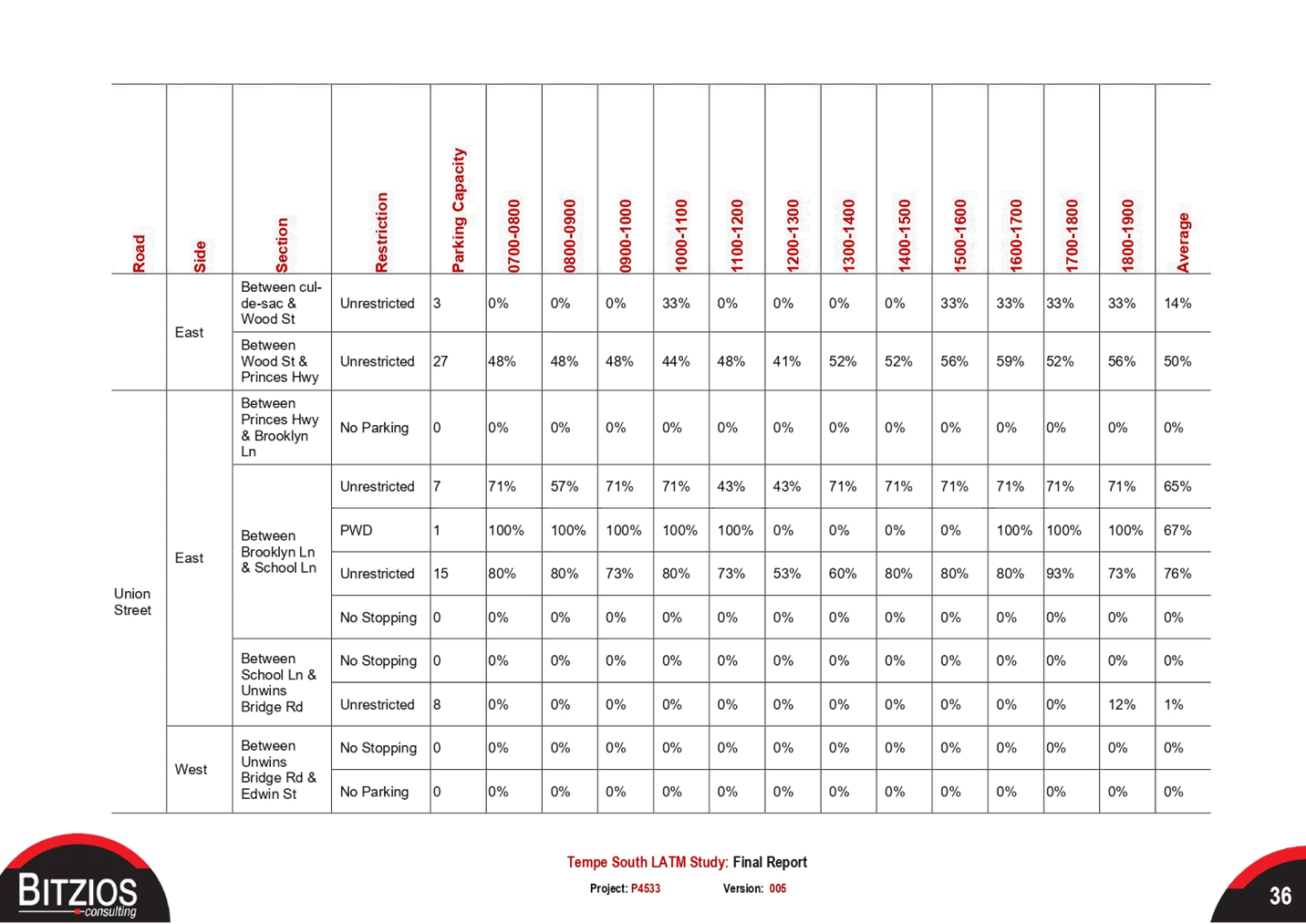
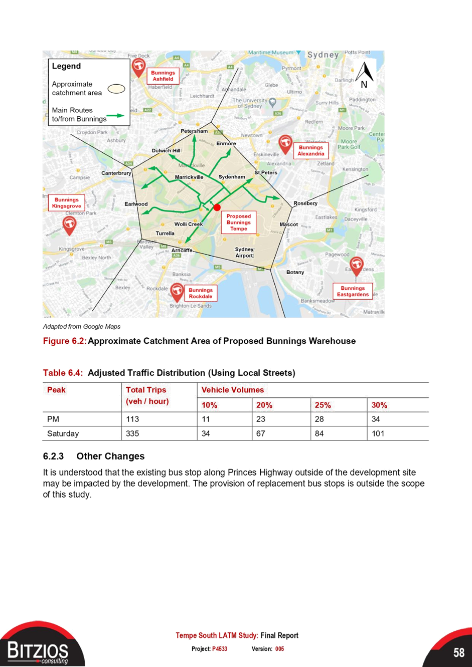
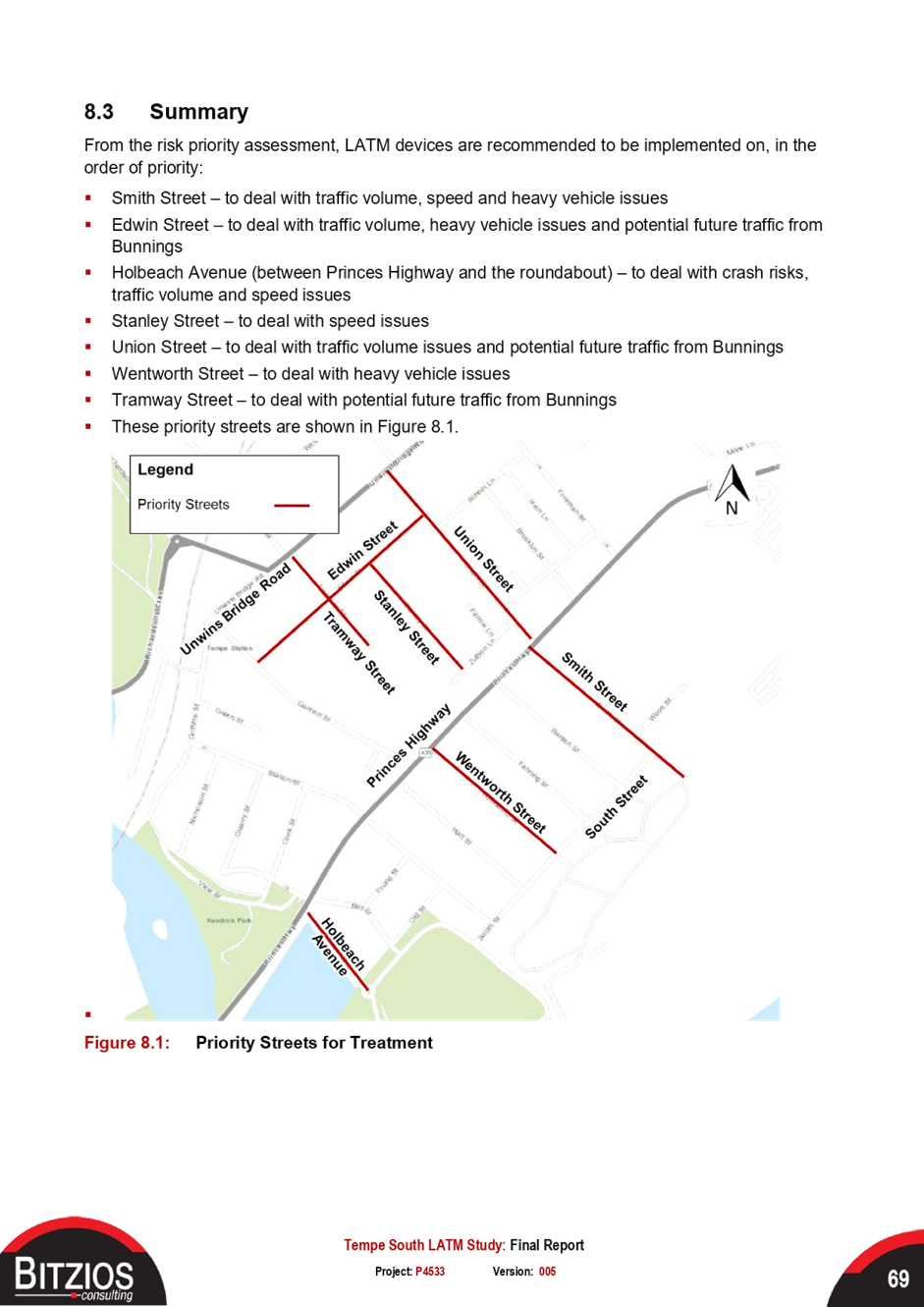
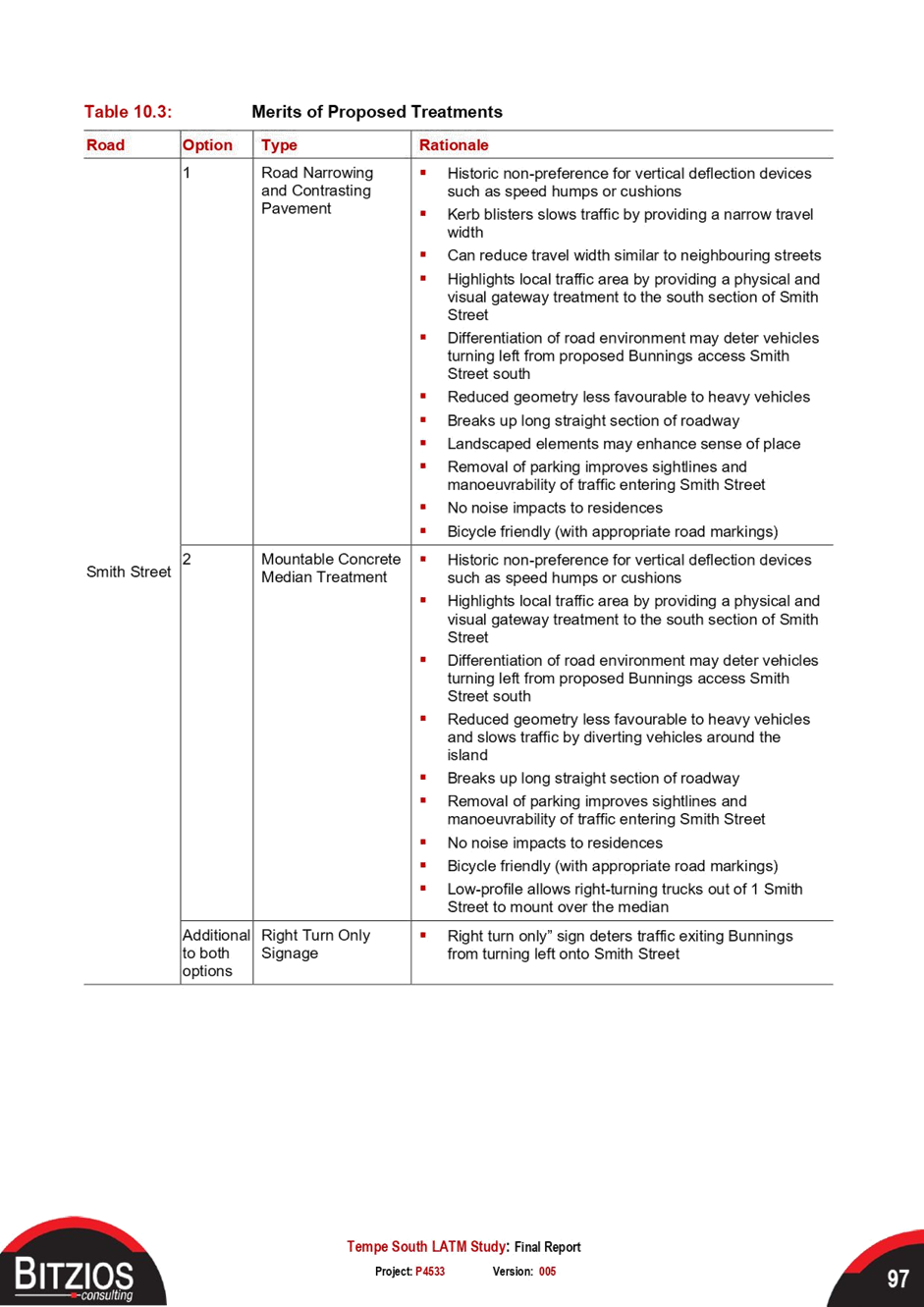
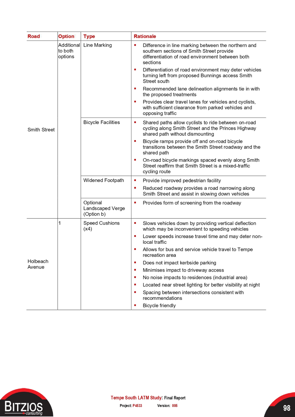
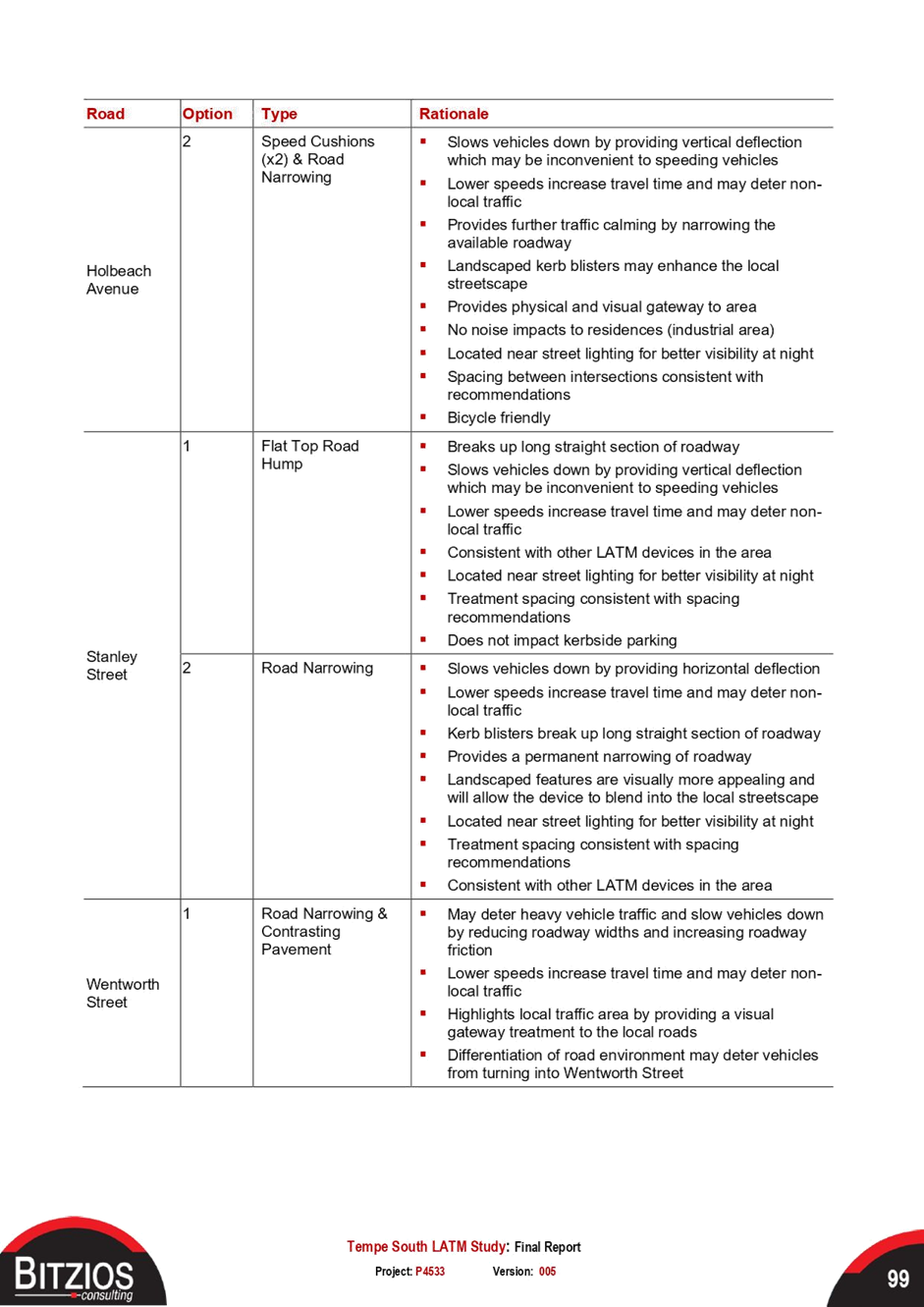
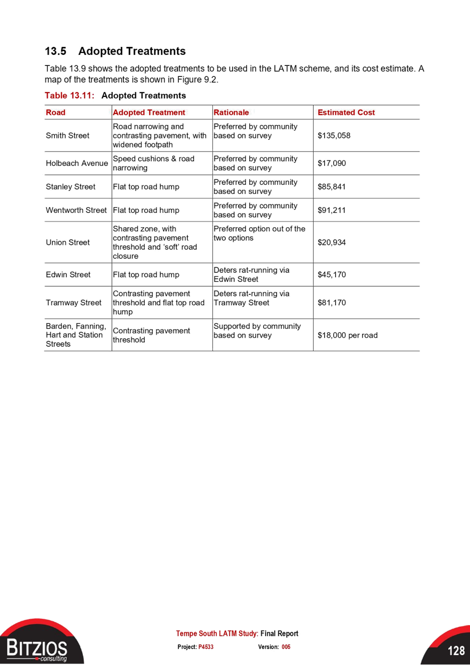
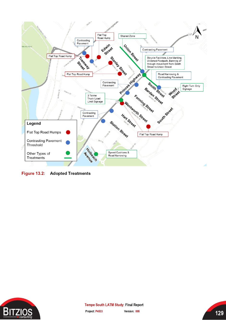
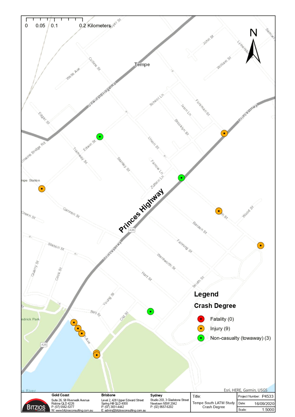
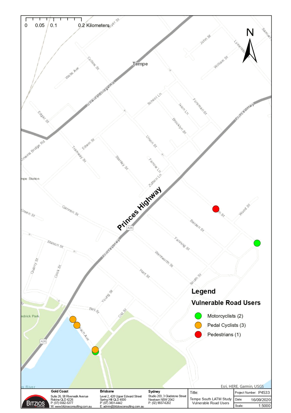
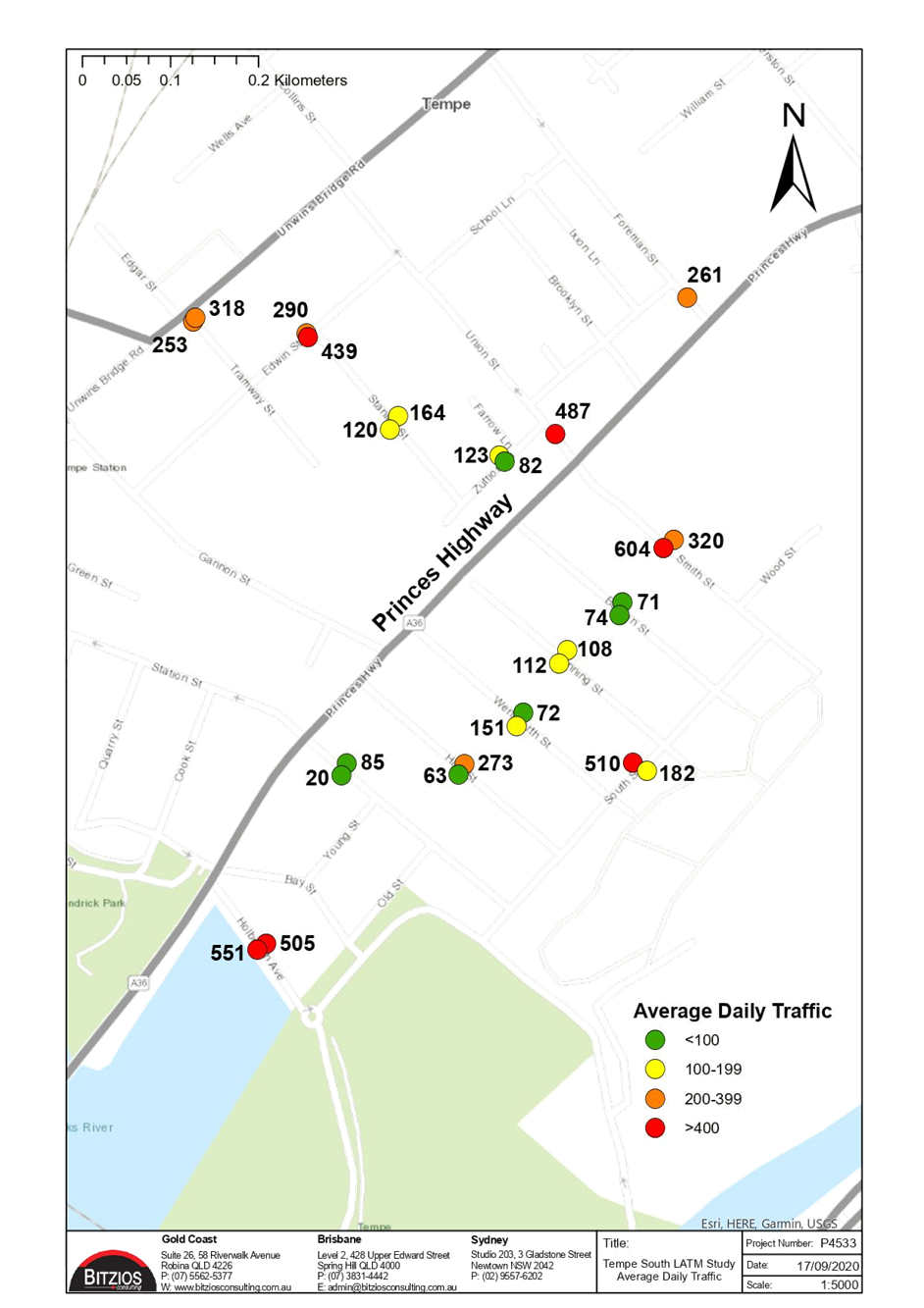
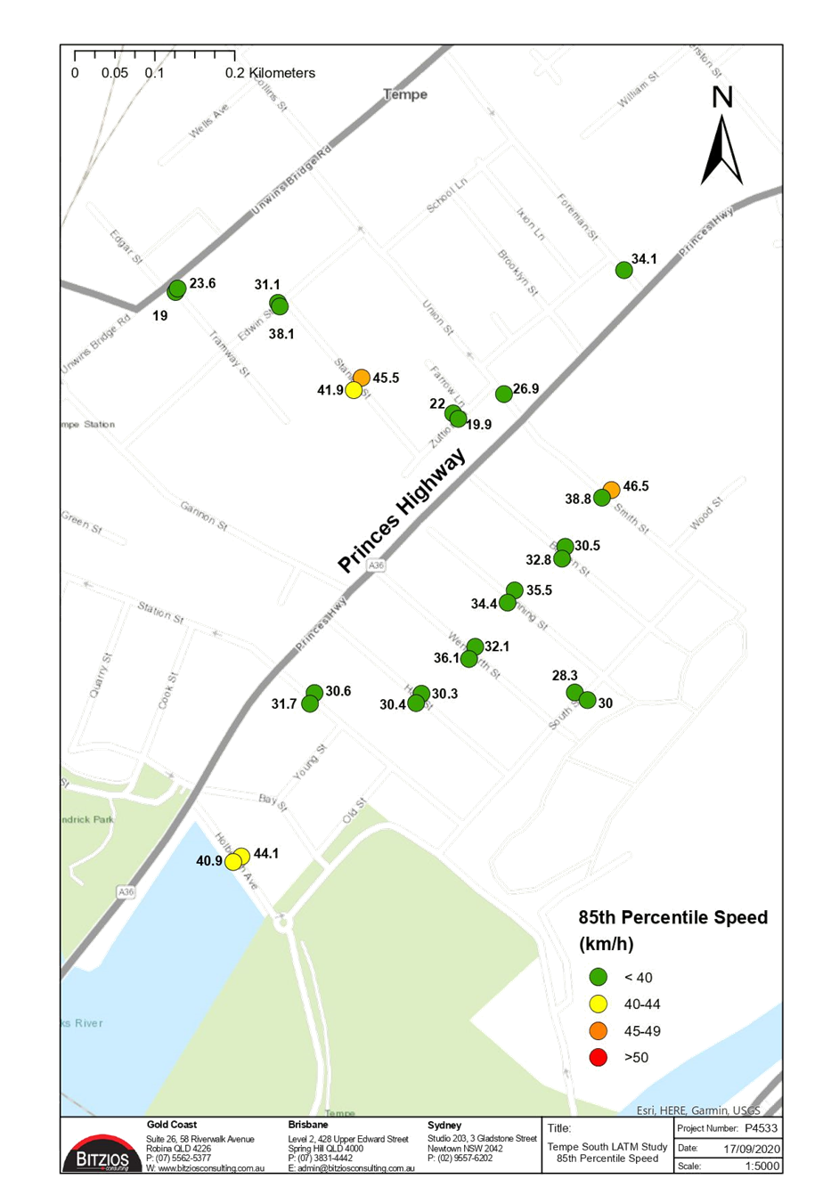
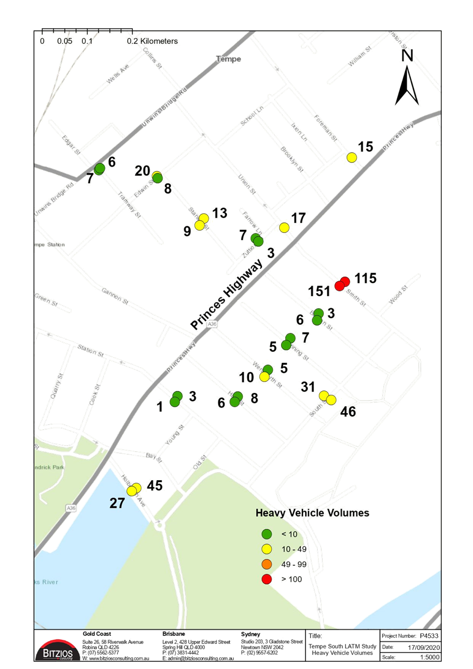
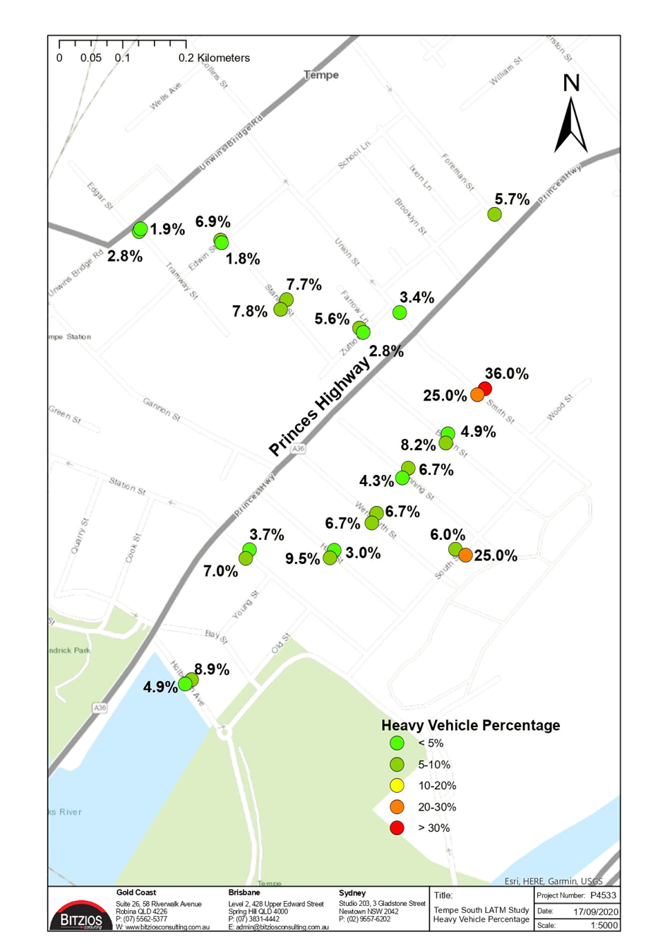
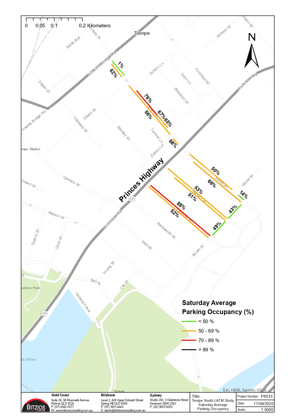
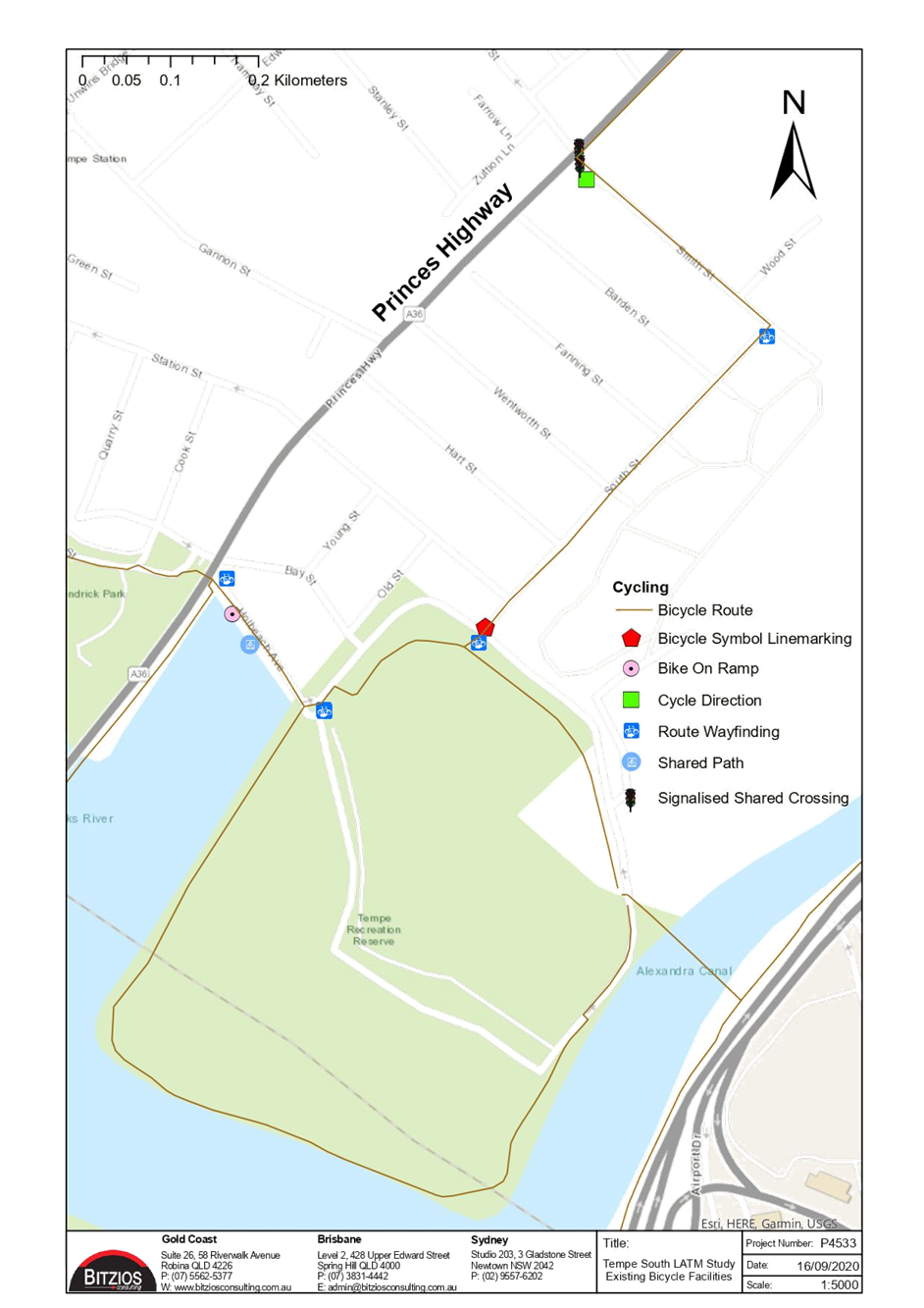
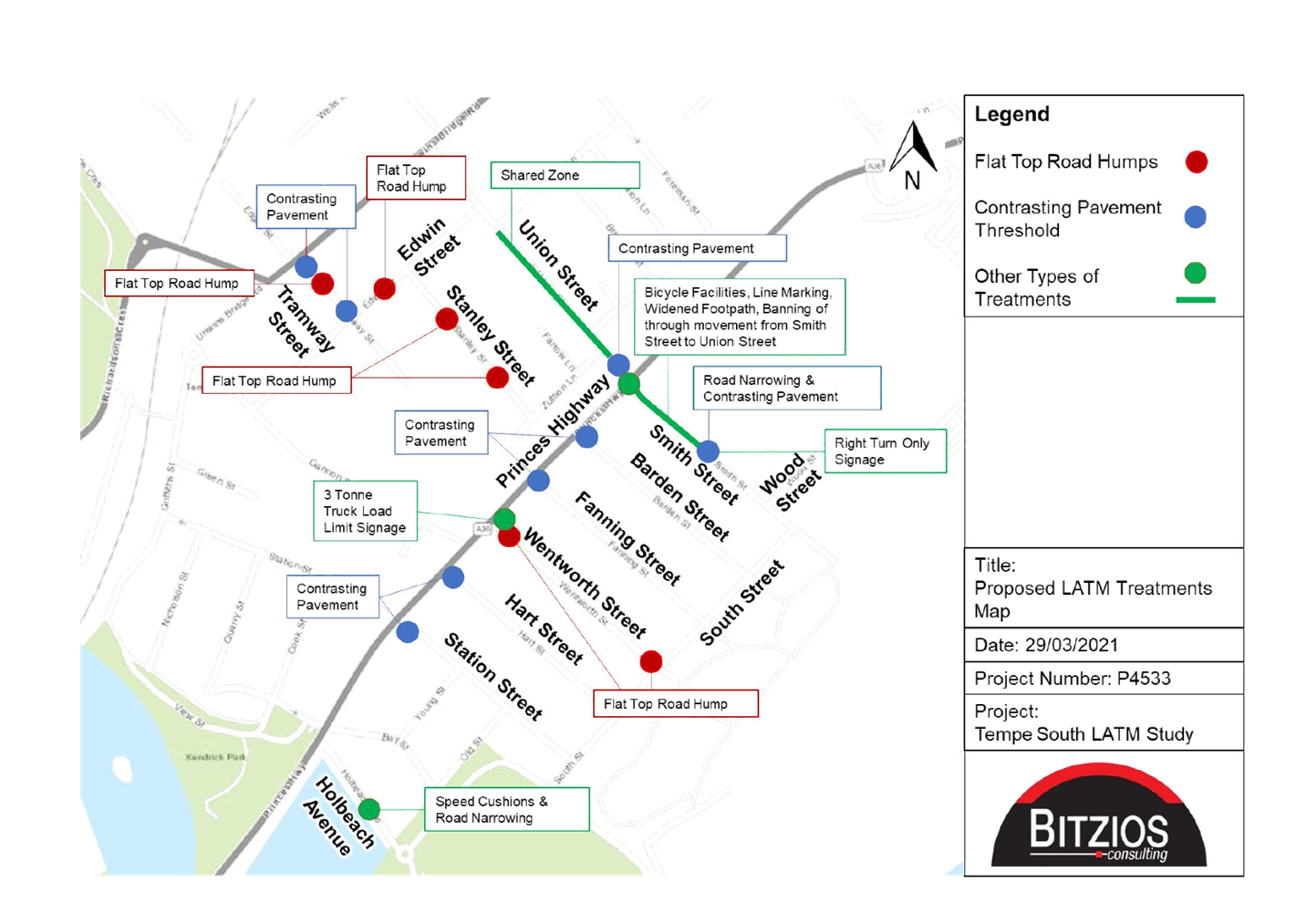
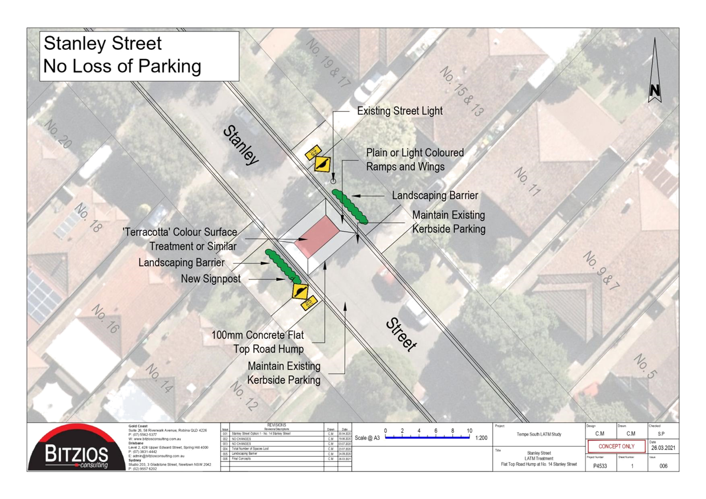
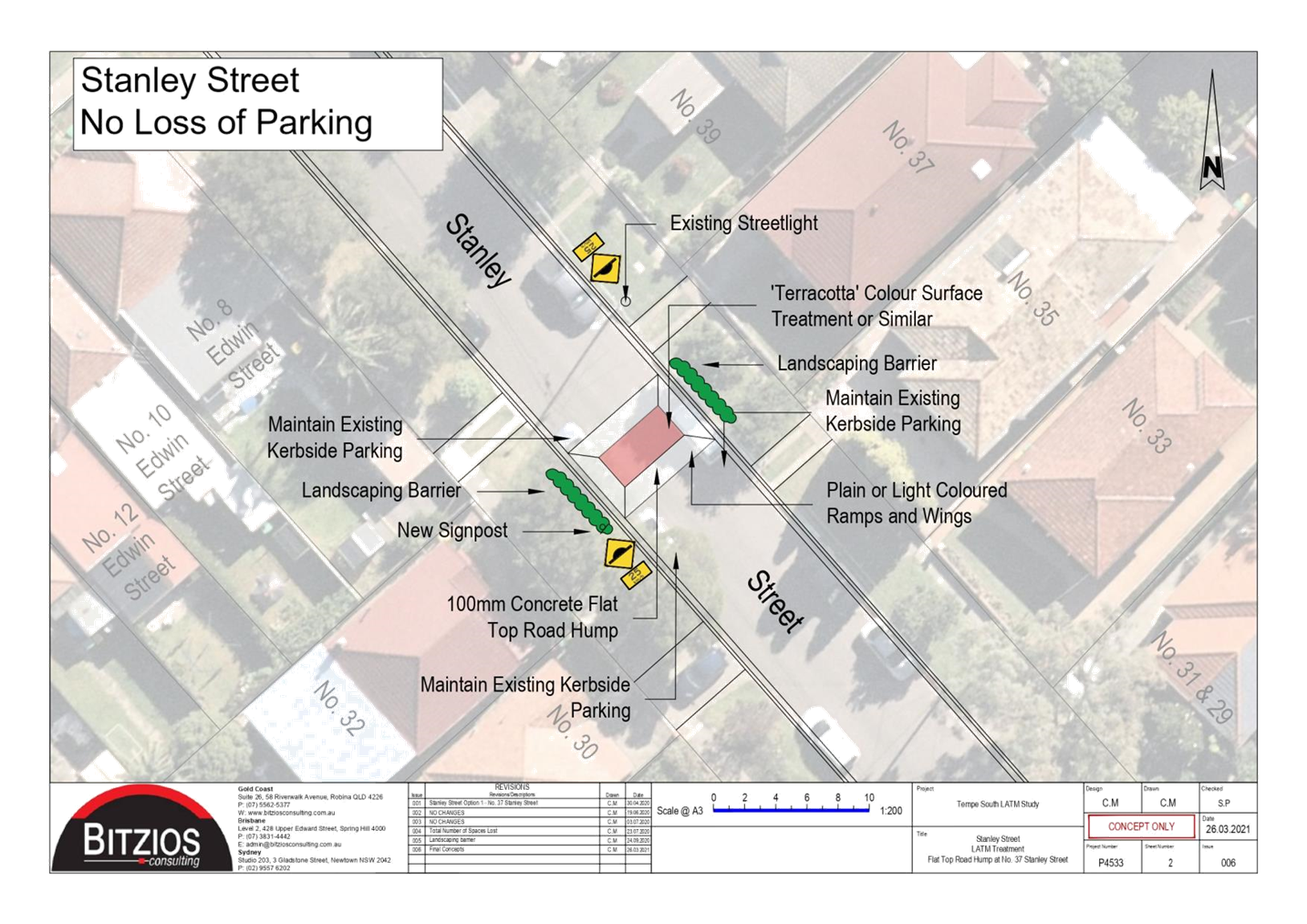
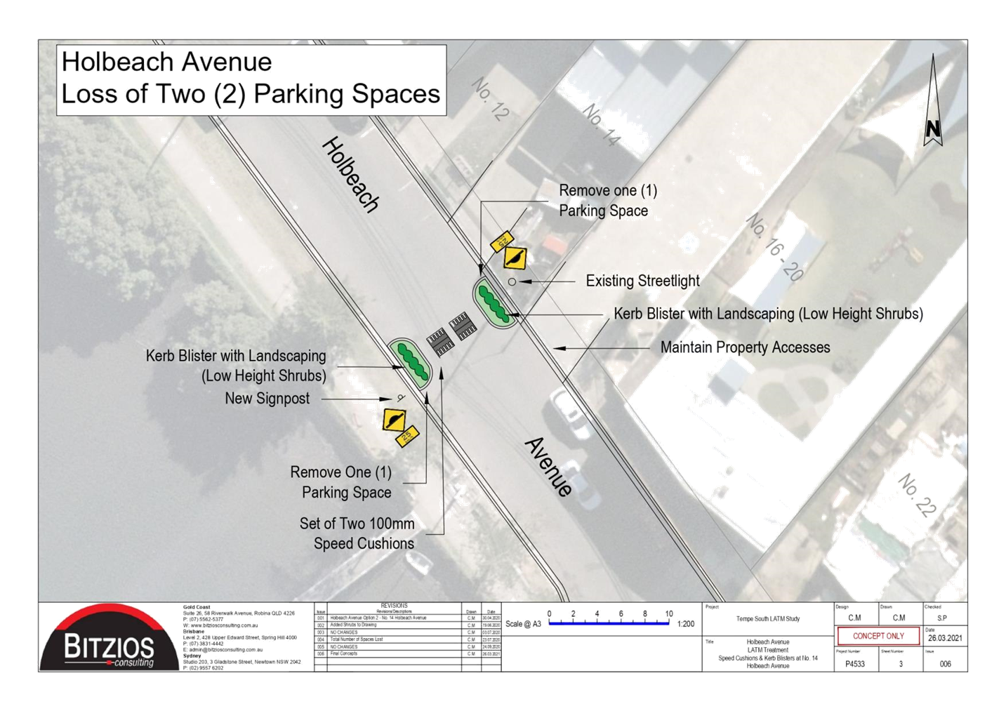
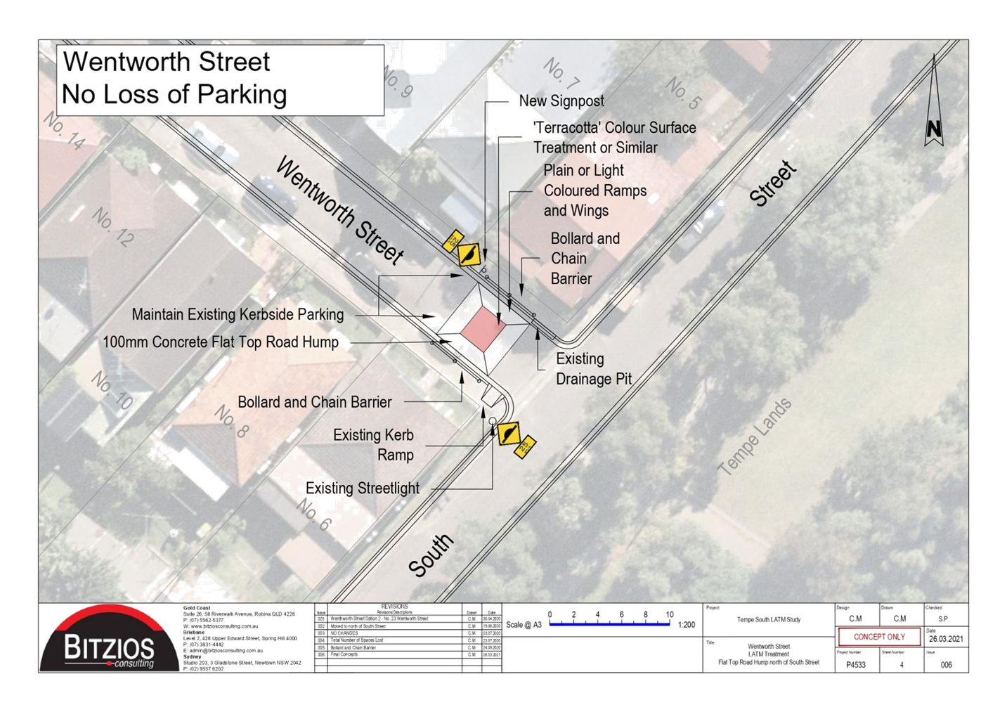
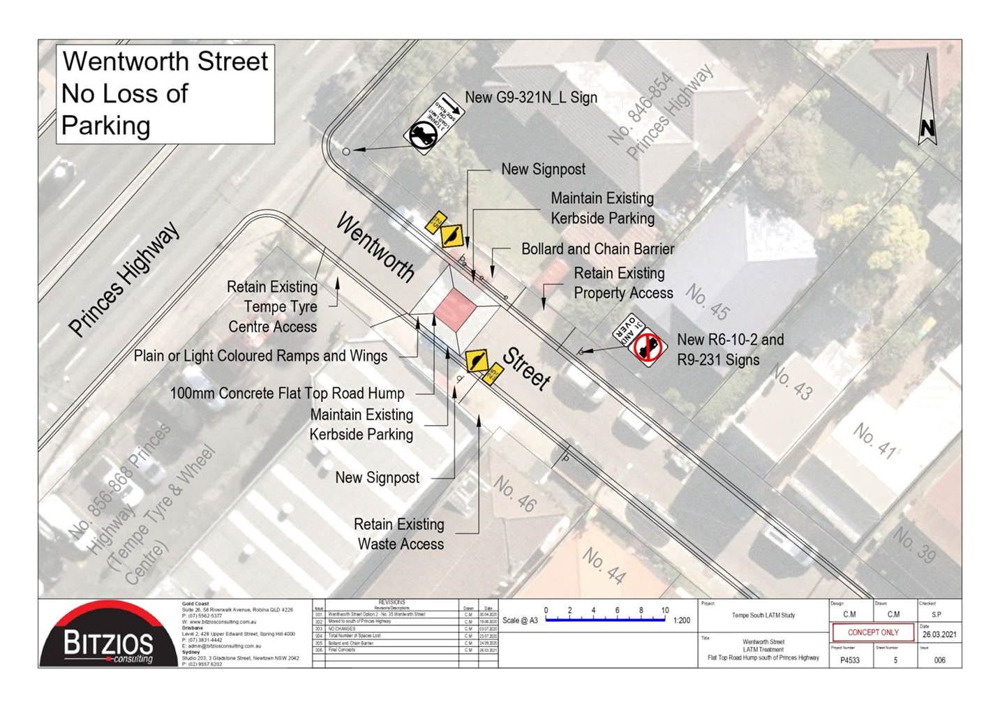
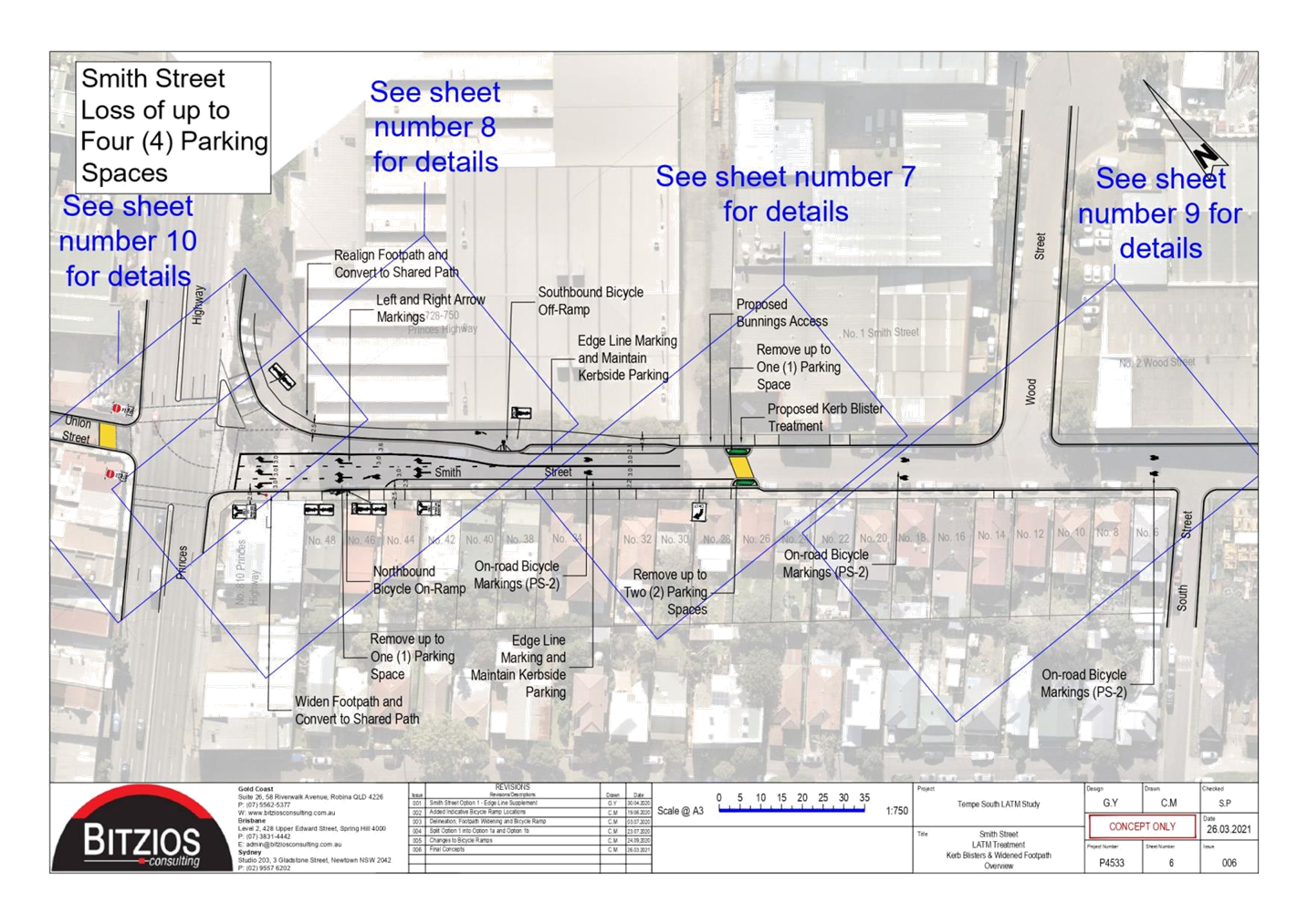
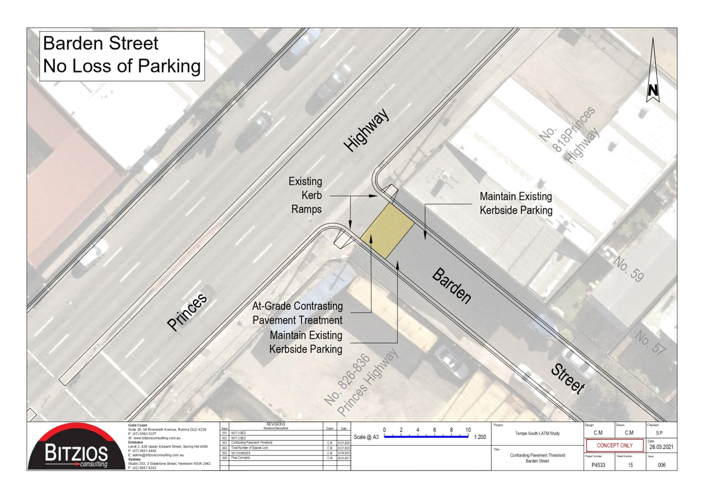
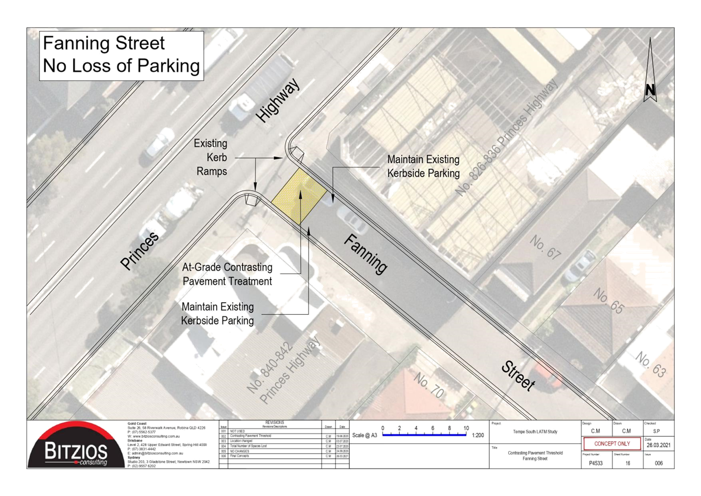
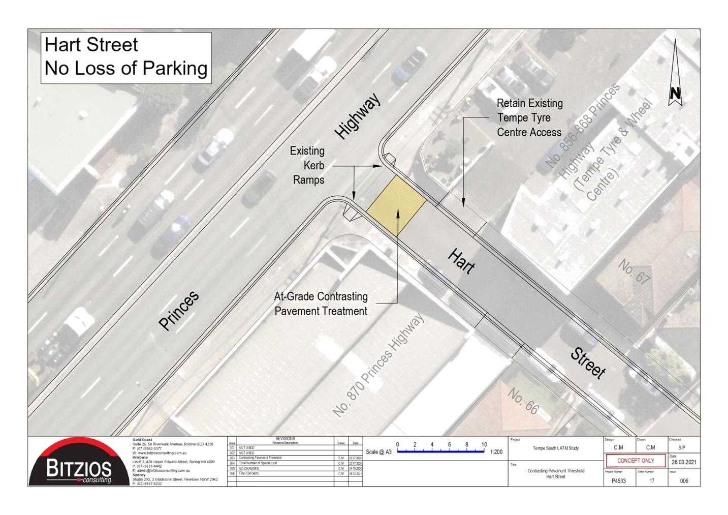
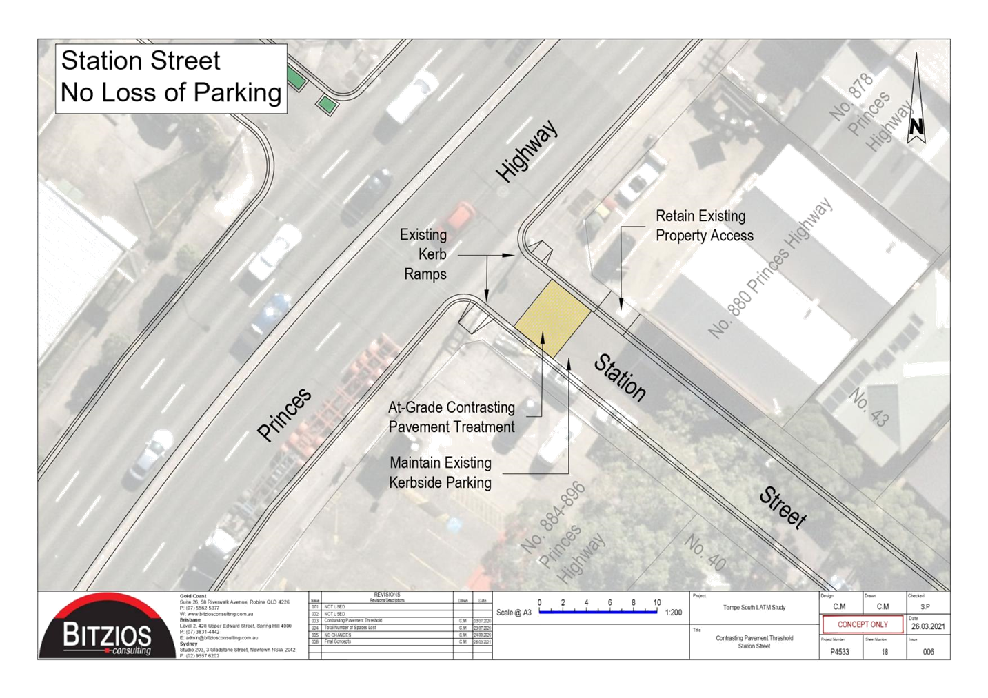
Subject: Tempe South Final Local Area Traffic
Management (Latm) Study
(Midjuburi-Marrickville Ward/Heffron Electorate/Inner West Pac)
Prepared By: Sunny Jo - Coordinator Traffic Engineering Services (North)
Authorised By: Manod Wickramasinghe - Traffic and Transport Planning Manager
SUMMARY
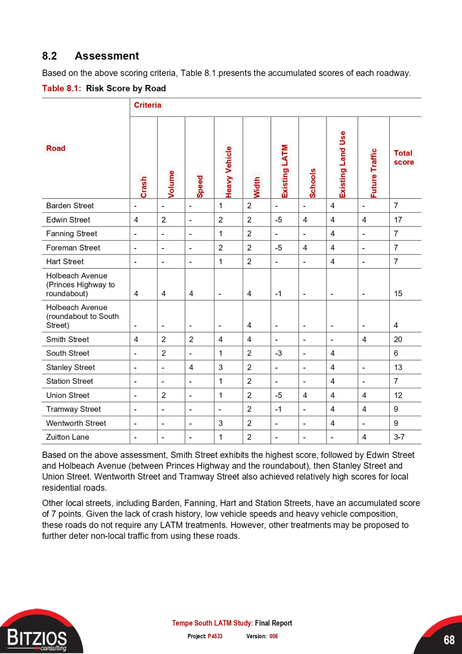
The Tempe South Local Area Traffic Management (LATM) study has been finalized for consideration and adoption.
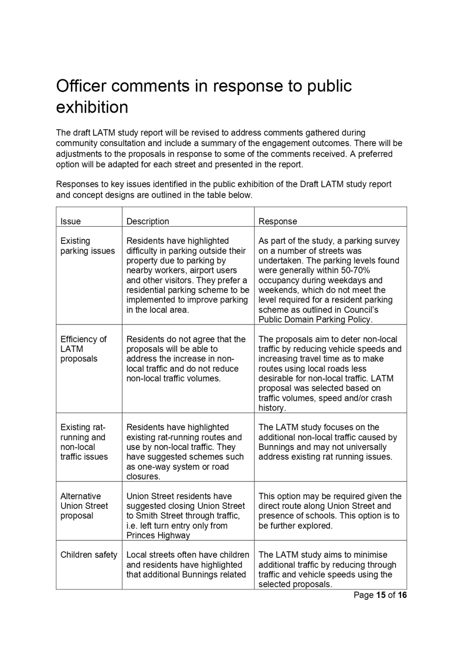
This report was previously considered by the Traffic Committee on 19 April 2021 and was deferred ‘until a determination regarding the signalized exit from Bunnings was received from the minster for Transport’.
Since the deferral, Council held meetings with Transport for NSW (TfNSW) and Bunnings regarding vehicular access arrangements for the Tempe Bunnings site (728-750 Princes Highway, Tempe). A number of options were discussed, including the feasibility of traffic signals at the exit driveway in Princes Highway between Brooklyn Street and Foreman Street, to facilitate alternate vehicular access to and from Princes Highway. This option was not supported by TfNSW due to safety and network efficiency reasons, with Bunnings also indicating that they do not intend to modify their development consent and the approved layout design. Additionally, TfNSW did not support the provision of banning traffic from Smith Street into Union Street by signage as there is insufficient space to install a physical island to block travel.
Public Exhibition of the draft Tempe South LATM study was undertaken between November 2020 and January 2021, with community feedback and revised final recommendations as outlined in Attachment 1.
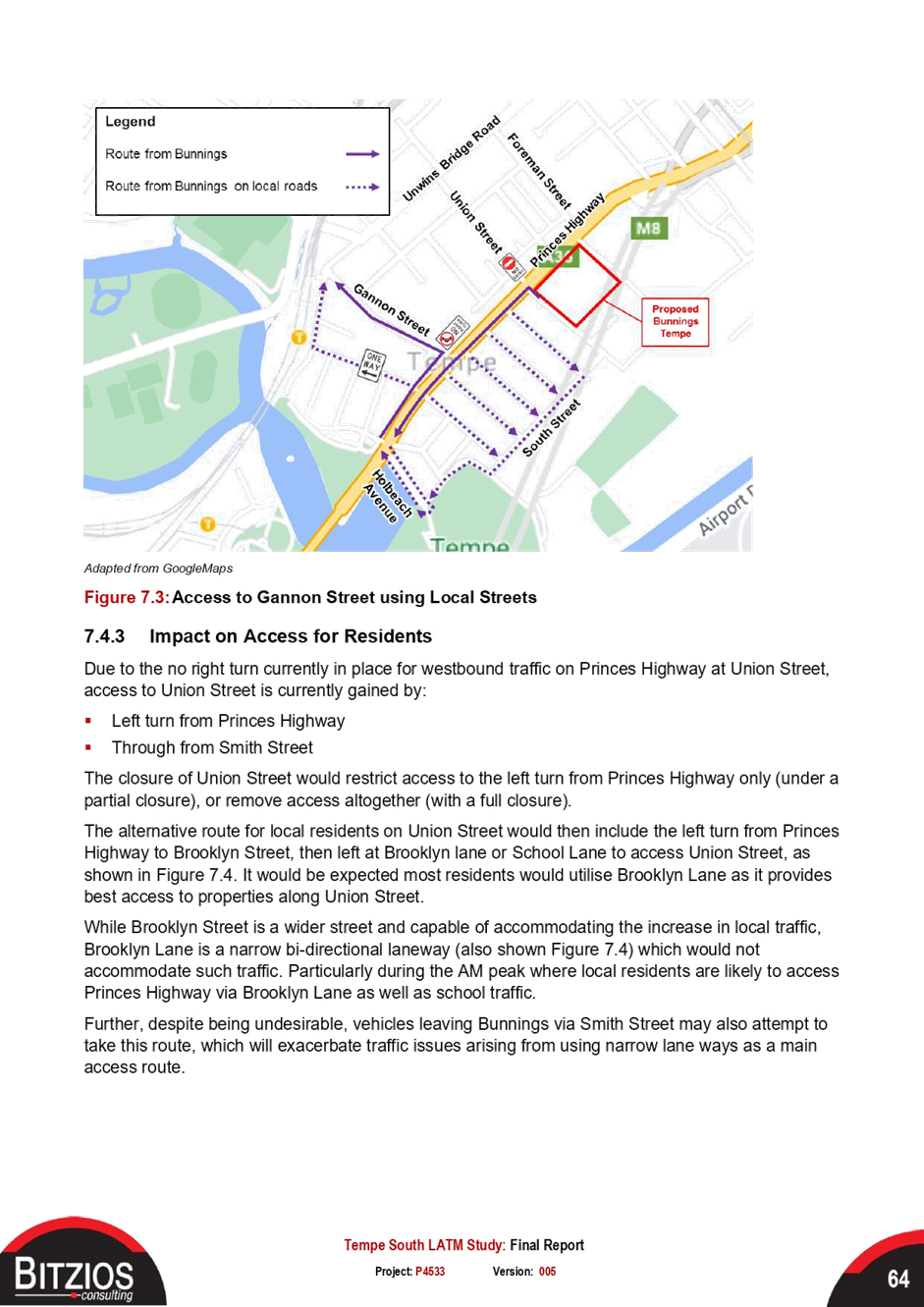
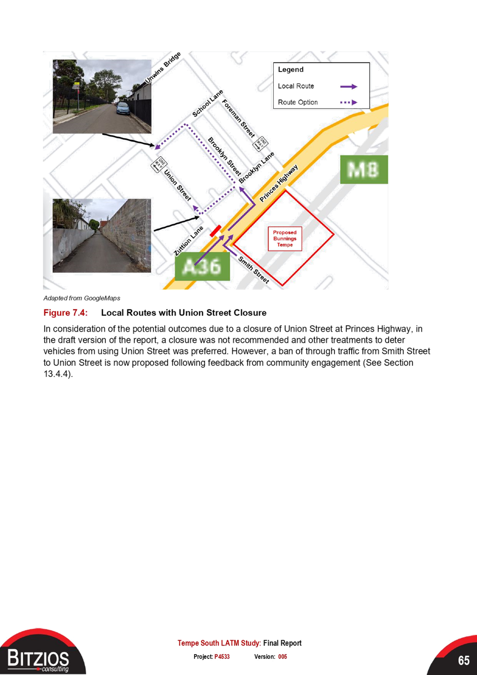
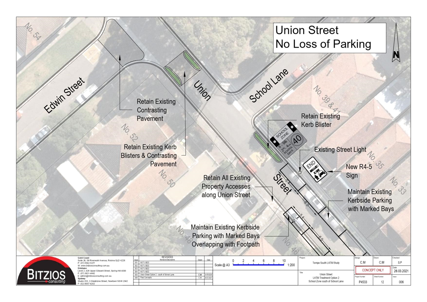
The revised recommendations mostly remain unchanged except Union Street, where an alternative treatment with minimal changes have been adopted by Council.
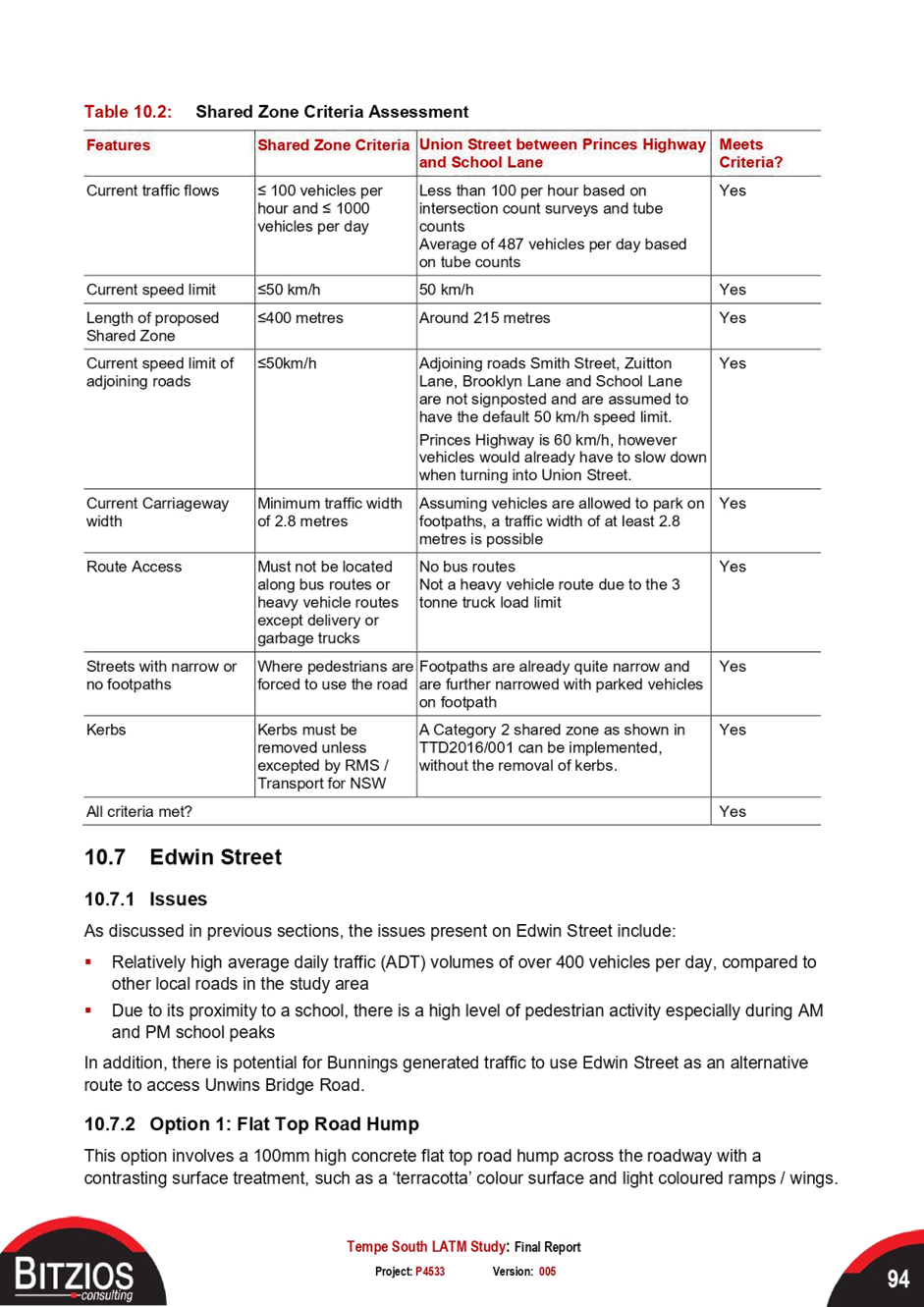
Having considered the submissions, a review was undertaken for a ‘No Entry’ treatment from Smith Street to Union Street at Princess Highway traffic signals, a shared zone treatment in Union Street and a partial road closure in Brooklyn Street. Further consultation for these treatments is required.
The remaining treatments were generally supported by the community, and these are outlined in Appendix E: Engagement Outcomes Report.
|
RECOMMENDATION
THAT:
1. The final Tempe South Local Area Traffic Management (LATM) Study and proposed treatments be noted; 2. The recommended treatments as outlined in Attachment 2 be adopted; 4. Detailed design of the recommended treatments be reported back to the Traffic Committee; and 5. After a 12-month period following the issue of an Occupation Certificate for the Bunnings Development at 728-750 Princess Highway, a LATM review be undertaken by Council and reported back to the Traffic Committee. |
BACKGROUND
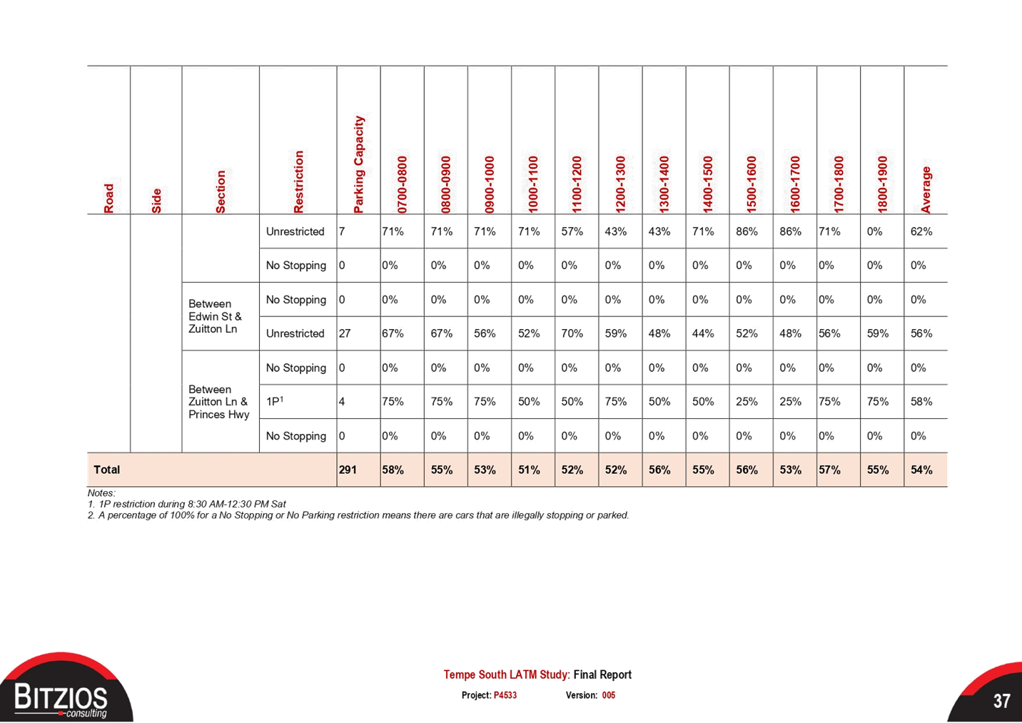
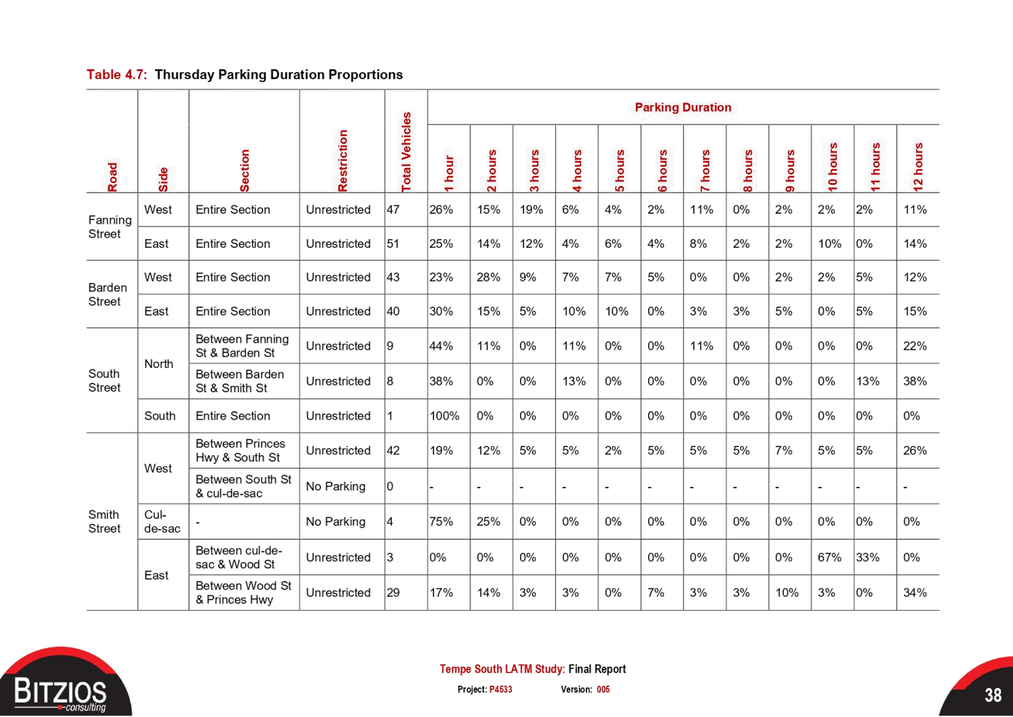
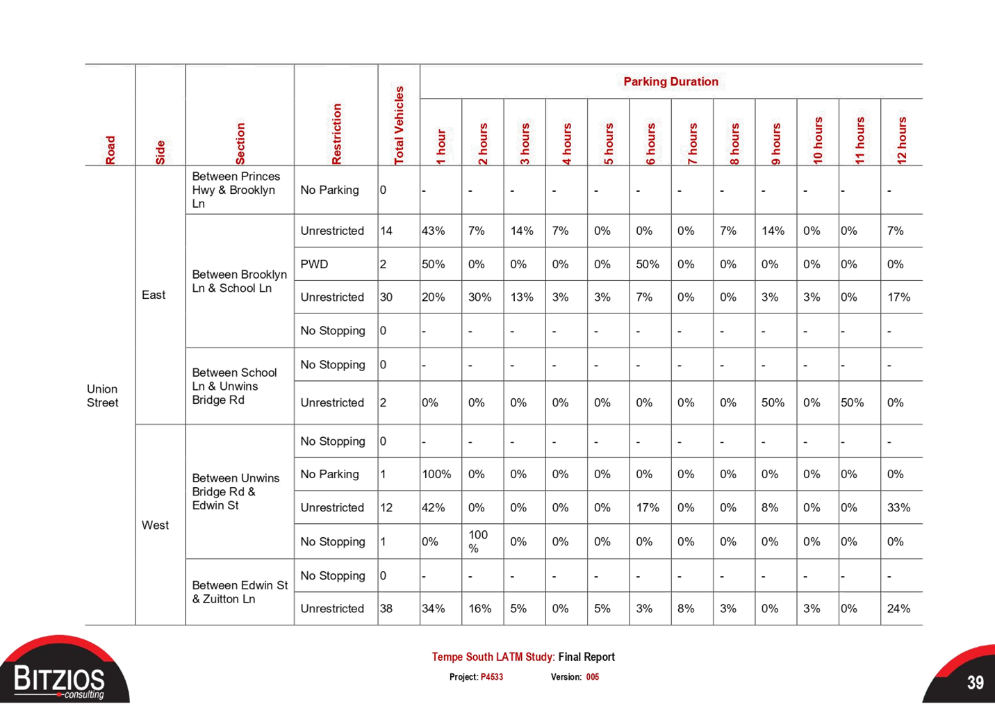
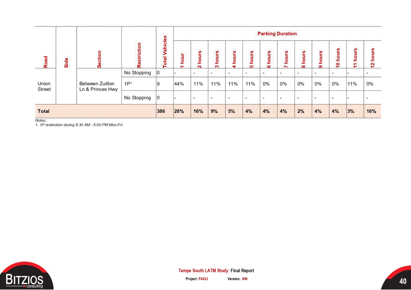
The Tempe South LATM study was undertaken as a condition of consent for the Tempe Bunnings development at 728-750 Princes Highway, Tempe. The study was developed to address traffic and parking impacts arising from the Tempe Bunnings development.
Using intersection counts, traffic count and parking data collected in March 2020, site audits, and crash history, a draft report was exhibited during December 2020 and January 2021. Assessing the community feedback, the proposed treatment list was revised and listed in Attachment 2.
FINANCIAL IMPLICATIONS
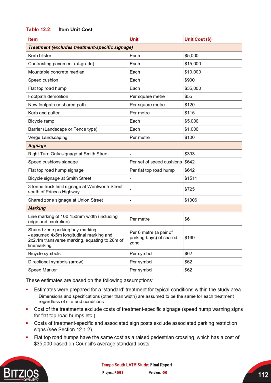
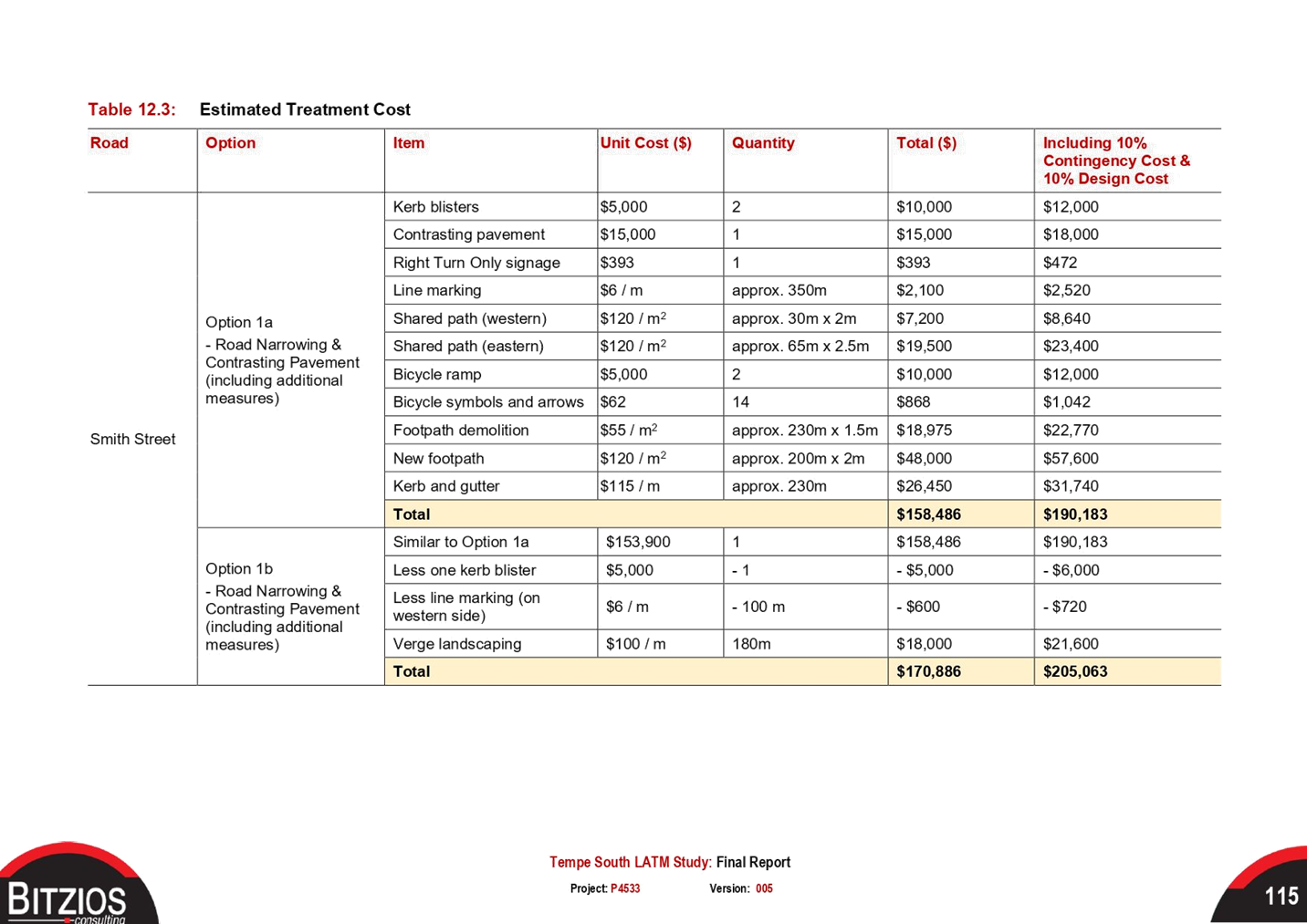
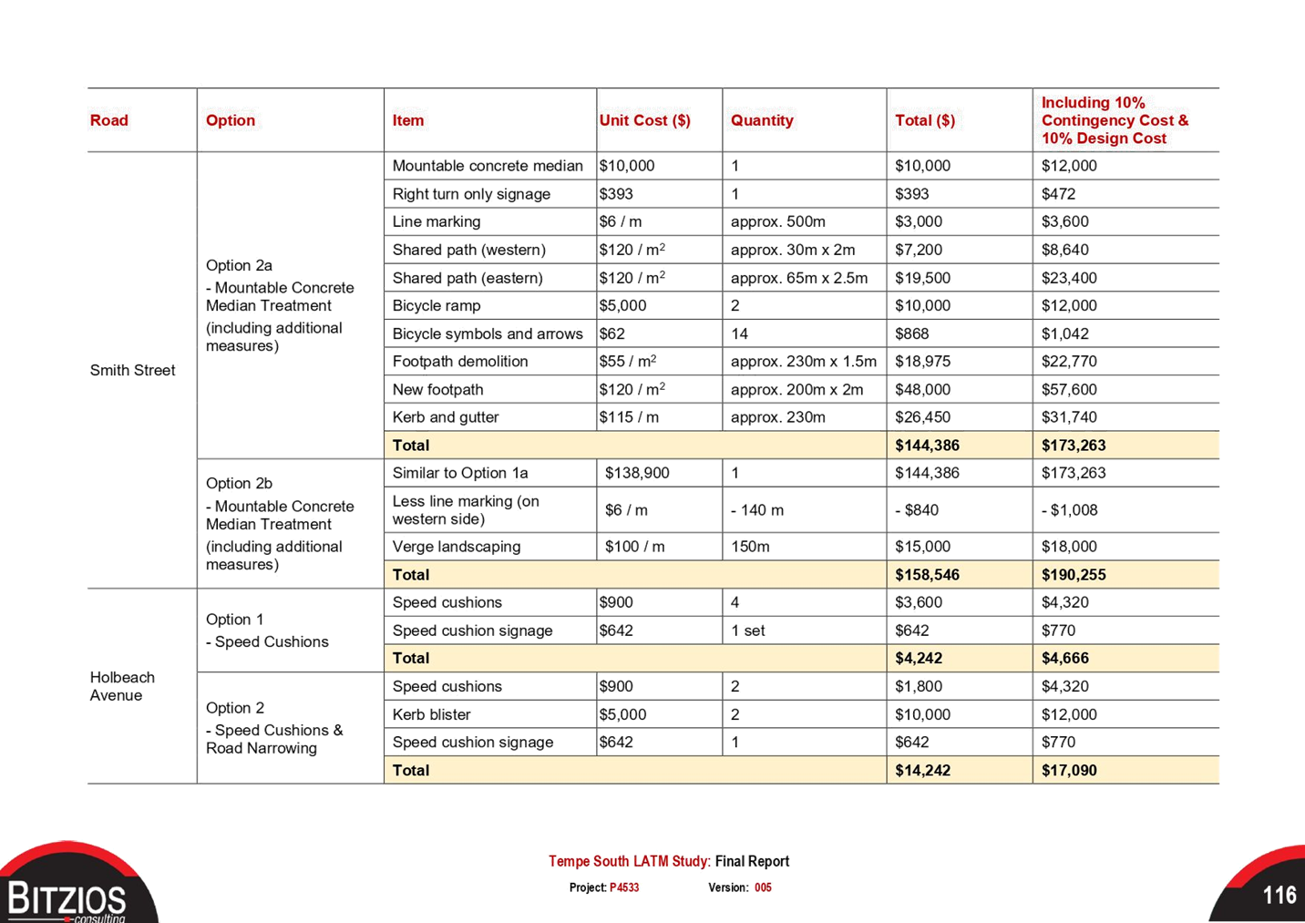
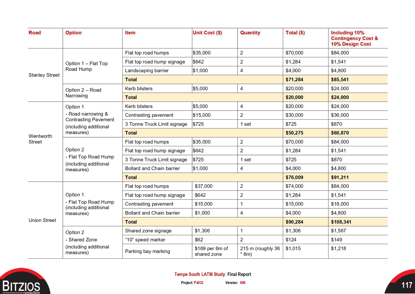
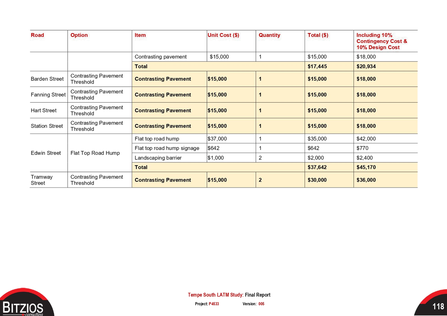
The estimated cost for the proposed works total $1,370,994 including a 10% contingency and 10% design costs. Under the consent conditions for the Bunnings development, the applicant is expected to cover the design and construction of the adopted LATM treatments, including a review of the LATM scheme following a 12-month period.
OTHER STAFF COMMENTS
Additional feasibility study was undertaken by Bitzios Consulting examining traffic signals at the Bunnings Warehouse driveway on Princes Highway. The signalized access is to provide an alternative access point onto Princes Highway, so that Bunnings traffic on residential roads can be minimised. The report looked at two options for vehicular access to and from the site and found that the site met the warrant assessment as outlined in TfNSW’s Traffic Signal Design – Section 2 Warrants. However during the initial DA assessment stage, Roads and Maritime Services were unable to support traffic signals as there were concerns with network operations. Recent discussions with TfNSW staff confirmed that this position has remained unchanged.
A number of suggestions and alternate proposals raised by the community, MP representatives and councillors were considered and discussed in detail with TfNSW. These are discussed ad tabled below.
|
Treatment Option |
Comments |
|
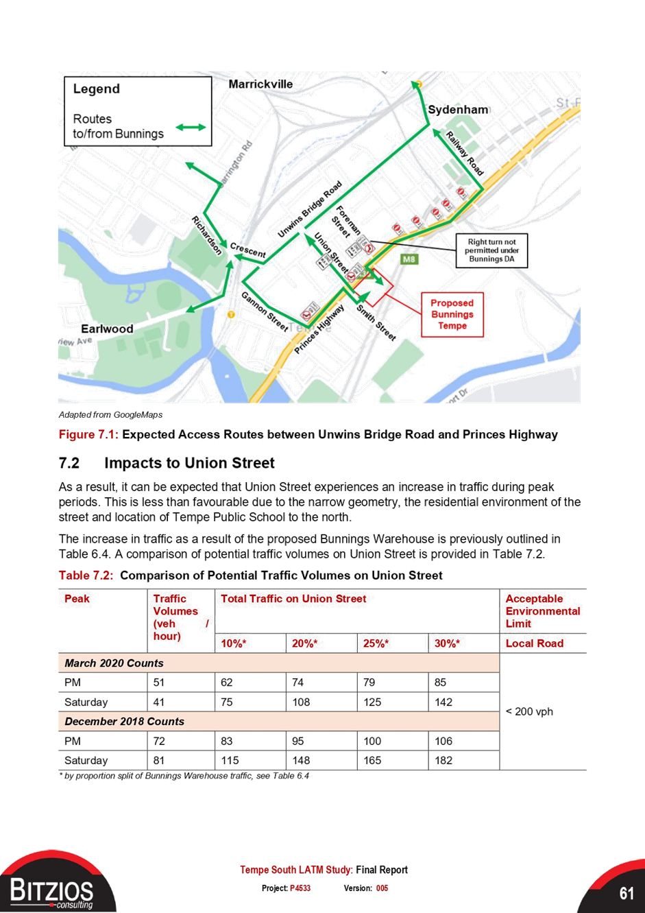
‘Left and right only’ signage treatment at traffic signals from Smith Street to Union Street at Princes Highway |
This proposal was discussed with TfNSW. The left and right proposal northbound from Smith Street without any physical control is a hazard for the pedestrian movement across Union Street. Due to the narrow road width of Union Street, there is insufficient space a physical island to block travel from Smith Street to Union Street. Additionally, there are safety issues for the pedestrian crossing leg across Union Street as the wait time is very long, and pedestrians may try to cross illegally and may conflict with an illegal vehicular movement from Smith Street. TfNSW experience with these trialed in other locations has not worked, with NSW Police not supporting such signage. |
|
Bunnings development site to change its vehicle access arrangements, including new traffic signals at the exit driveway of 750 Princes Highway |
The vehicular access arrangements for the Bunnings development was discussed at great lengths between the applicant, TfNSW and Council.
TfNSW position regarding the provision of traffic control signals (TCS) on Princes Highway for access directly into the development site (Bunnings) has not changed. The provision of an TCS site at this location would create a ‘see through affect’ with neighbouring existing TCS sites, posing significant safety concerns for the network users but would also significantly impact the operation and efficiency of the classified network (Princes Highway). As such TfNSW does not support the provision of TCS for access directly into the Bunnings site due to the impact to network safety and efficiency. |
|
Suggest Bunnings modify their development application to change its vehicle access arrangements |
Changes to vehicle access arrangements would be a substantial change to the original development application which may not fit the criteria of a MOD (section 4.55). Bunnings have confirmed that they do not intend to pursue this option. |
|
Shared zone in Union Street from Princes Highway to Edwin Street |
This was included in the draft LATM study and had a low level of support from Union Street residents. With the ‘left and right only’ proposal at traffic signals not being feasible, the road conditions would not meet the requirements for a shared zone. As an alternative, at grade contrasting pavement, installation of mountable kerbs, marked parking bays, and a reduced 40km/h speed limit for Union Street is recommended. |
|
Speed humps in Union Street |
This was included in the draft LATM study and had a low level of support from Union Street residents. As an alternative, at grade contrasting pavement, installation of mountable kerbs, marked parking bays, and a reduced 40km/h speed limit for Union Street is recommended. |
|
Partial road closure in Brooklyn Street at Princes Highway |
With the ‘left and right only’ restriction at Union Street not being feasible, a partial road closure in Brooklyn Street is not required. |
PUBLIC CONSULTATION
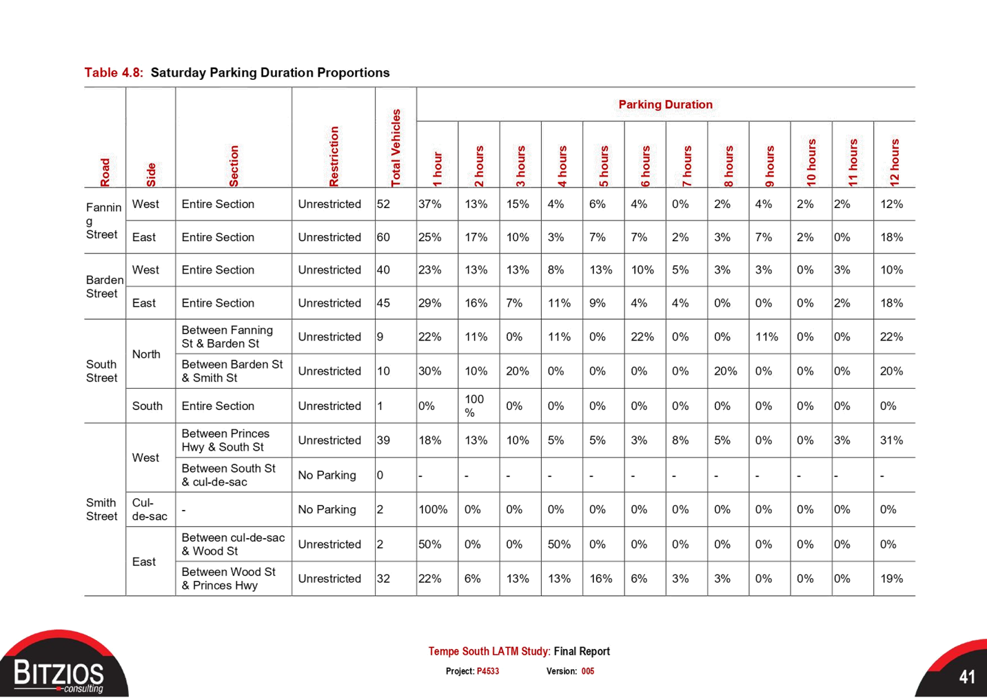
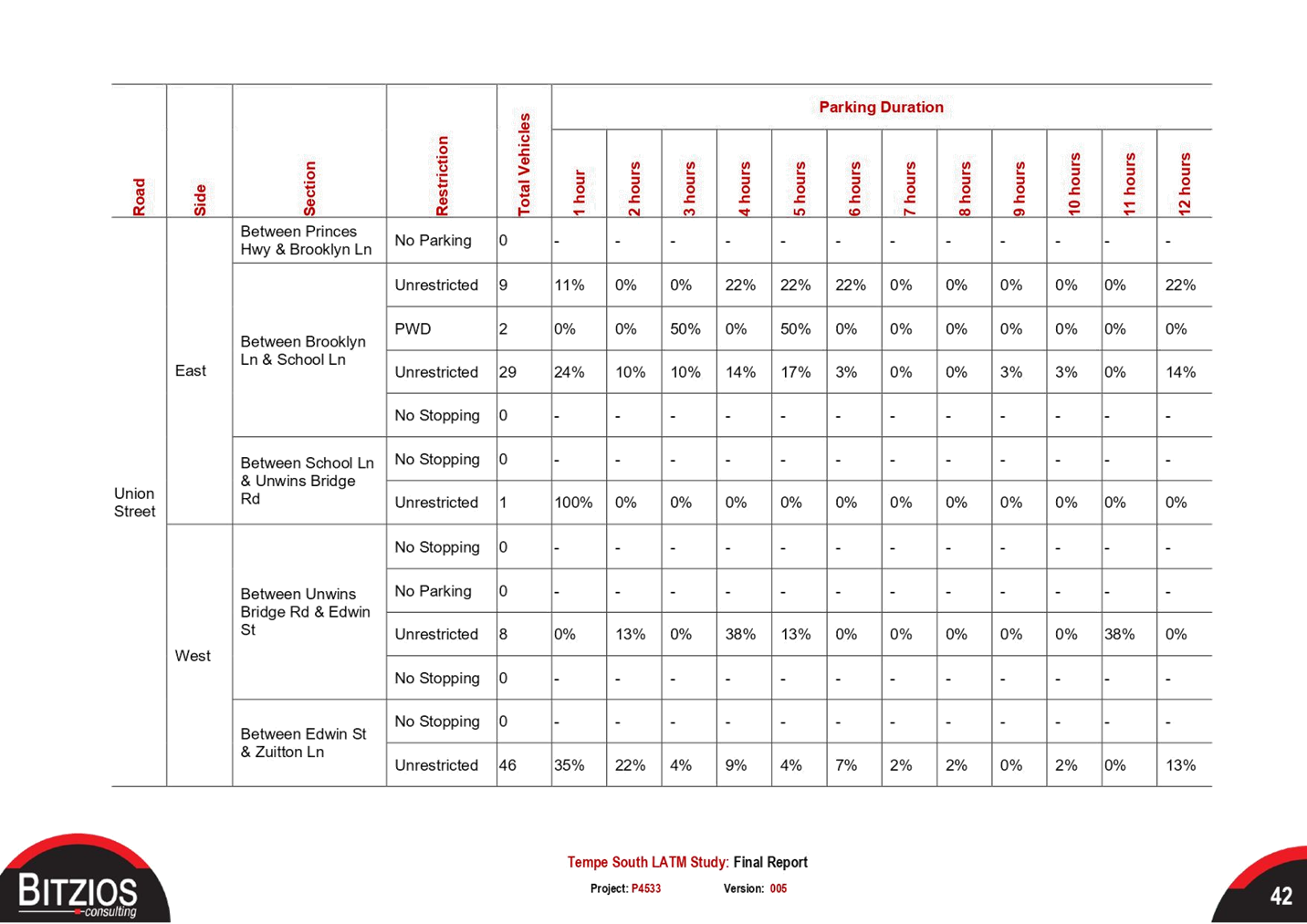
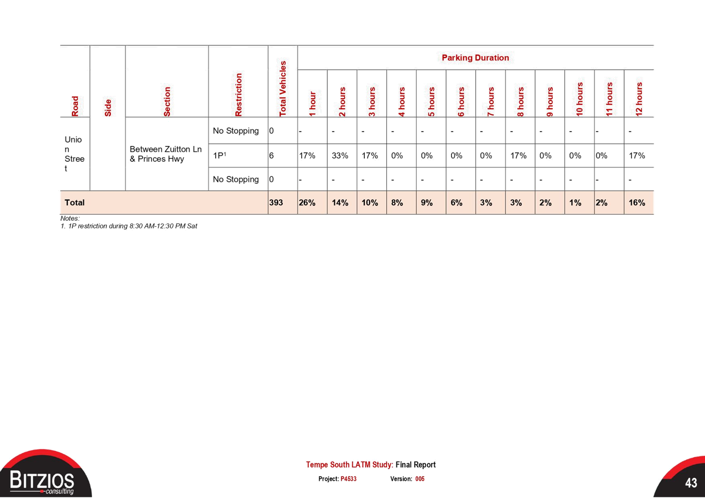
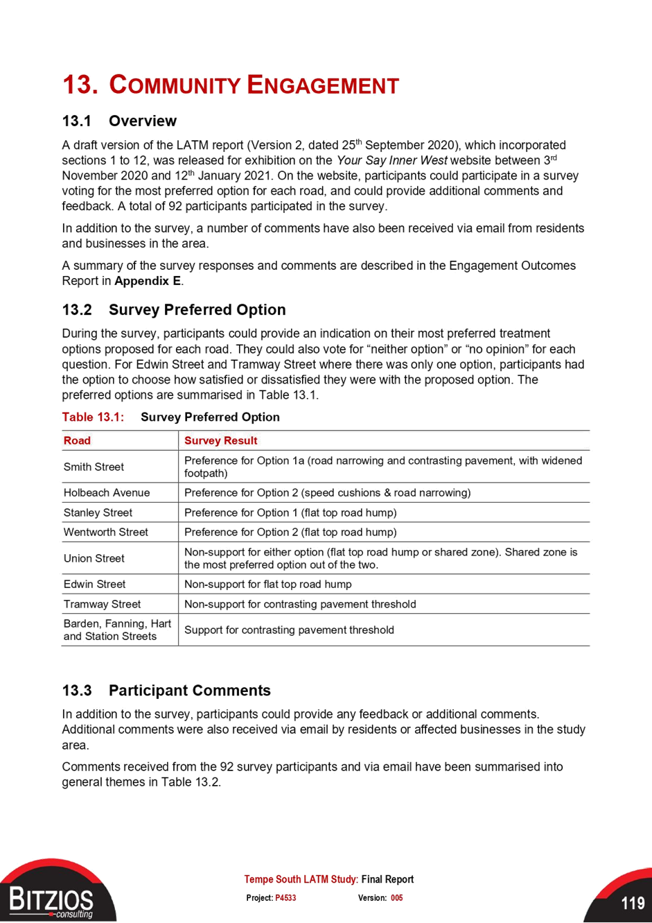
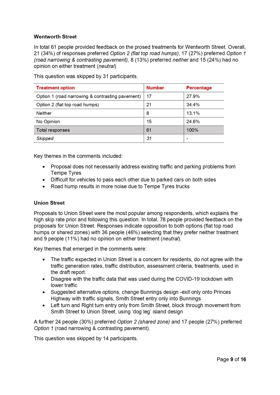
Public exhibition for the draft study was undertaken during November 2020 to January 2021, with 519 visits to Council’s YourSay project page, about 92 completing the online survey. Council also received submissions from Union Street and Smith Streets resident groups, as well as submissions from businesses from nearby Woods Street and Princes Highway.
Survey responses were categorized based on each treatment being proposed, with most generally indicating a preference for one option over another.
For Union Street, a high level of objection to both options (46%) over shared zone (27%) or flat top humps (30%). Considering the close proximity of this street to the Bunnings site, an alternate proposal of providing at grade contrasting pavement, installation of mountable kerbs, marked parking bays, and a reduced 40km/h speed limit is recommended.
As noted in the previous report, additional tasks were undertaken following a review of the submissions, including an additional tube count survey in February 2021, recalculation of traffic volumes, changes to the concept design based on community feedback, and the development of recommended treatments.
|
1.⇩ |
Recommended treatments |
|
2.⇩ |
Tempe South LATM Study Final Report |
|
3.⇩ |
Appendix A Crash Data Maps |
|
4.⇩ |
Appendix B Tube Counts & Parking Data Maps |
|
5.⇩ |
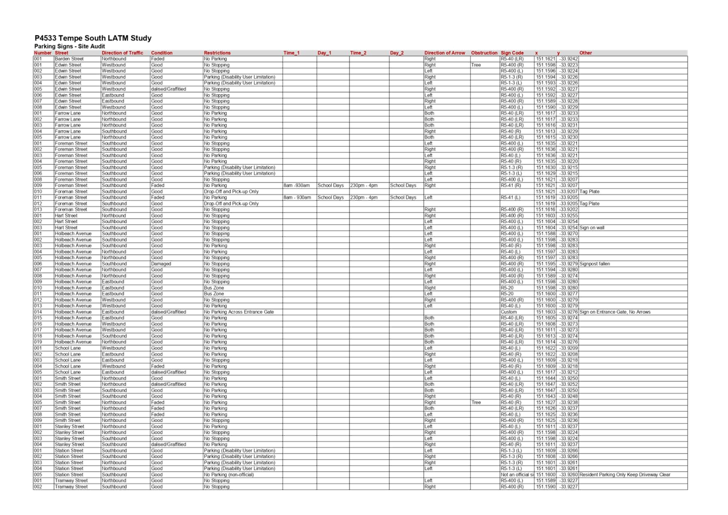
Appendix C Site Audit Data and Maps |
|
6.⇩ |
Appendix D LATM Treatment Concept Designs |
|
7.⇩ |
Appendix E Engagement Outcomes Report |