|
AGENDA R |
Local Traffic Committee Meeting
MONDAY 18 OCTOBER 2021
10.00AM
|
|
Local Traffic Committee Meeting 18 October 2021 |
Function of the Local Traffic Committee
Background
Roads and Maritime Services (RMS) is legislated as the Authority responsible for the control of traffic on all NSW Roads. The RMS has delegated certain aspects of the control of traffic on local roads to councils. To exercise this delegation, councils must establish a local traffic committee and obtain the advice of the RMS and Police. The Inner West Council Local Traffic Committee has been constituted by Council as a result of the delegation granted by the RMS pursuant to Section 50 of the Transport Administration Act 1988.
Role of the Committee
The Local Traffic Committee is primarily a technical review and advisory committee which considers the technical merits of proposals and ensures that current technical guidelines are considered. It provides recommendations to Council on traffic and parking control matters and on the provision of traffic control facilities and prescribed traffic control devices for which Council has delegated authority. These matters are dealt with under Part A of the agenda and require Council to consider exercising its delegation.
In addition to its formal role as the Local Traffic Committee, the Committee may also be requested to provide informal traffic engineering advice on traffic matters not requiring Council to exercise its delegated function at that point in time, for example, advice to Council’s Development Assessment Section on traffic generating developments. These matters are dealt with under Part C of the agenda and are for information or advice only and do not require Council to exercise its delegation.
Committee Delegations
The Local Traffic Committee has no decision-making powers. The Council must refer all traffic related matters to the Local Traffic Committee prior to exercising its delegated functions. Matters related to State Roads or functions that have not been delegated to Council must be referred directly to the RMS or relevant organisation.
The Committee provides recommendations to Council. Should Council wish to act contrary to the advice of the Committee or if that advice is not supported unanimously by the Committee members, then the Police or RMS have an opportunity to appeal to the Regional Traffic Committee.
Committee Membership & Voting
Formal voting membership comprises the following:
· one representative of Council as nominated by Council;
· one representative of the NSW Police from each Local Area Command (LAC) within the LGA, being Newtown, Marrickville, Leichhardt and Ashfield LAC’s.
· one representative from the RMS; and
· State Members of Parliament (MP) for the electorates of Summer Hill, Newtown, Heffron, Canterbury, Strathfield and Balmain or their nominees.
Where the Council area is represented by more than one MP or covered by more than one Police LAC, representatives are only permitted to vote on matters which effect their electorate or LAC.
Informal (non-voting) advisors from within Council or external authorities may also attend Committee meetings to provide expert advice.
Committee Chair
Council’s representative will chair the meetings.
Public Participation
Members of the public or other stakeholders may address the Committee on agenda items to be considered by the Committee. The format and number of presentations is at the discretion of the Chairperson and is generally limited to 3 minutes per speaker. Committee debate on agenda items is not open to the public.
|
|
Local Traffic Committee Meeting 18 October 2021 |
|
AGENDA |
1 Apologies
2 Disclosures of Interest
3 Confirmation of Minutes
Minutes of 20 September 2021 Local Traffic Committee Meeting 5
4 Matters Arising from Council’s Resolution of Minutes
5 Part A – Items Where Council May Exercise Its Delegated Functions
Traffic Matters
ITEM Page
LTC1021(1) Item 1 Unwins Bridge Road at Gannon Street, Tempe - Proposed Line Marking Treatment at roundabout Midjuburi - Marrickville Ward/ Summer Hill Electorate/ Inner West PAC) 10
LTC1021(1) Item 2 TRAFFIC MANAGEMENT PLAN FOR THE 2021 NEW YEAR'S EVE EVENT (BALUDARRI-BALMAIN WARD/ BALMAIN ELECTORATE/ LEICHHARDT PAC) 13
LTC1021(1) Item 3 Intersection of Hardy Street/ Church Street and Princess Street, (at suburb boundaries) Canterbury/Ashbury/Hurlstone Park- Proposed Roundabout - Design Plan CBC No. 01470 (Djarrawunang-Ashfield Ward/Canterbury Electorate/Ashfield PAC) 50
LTC1021(1) Item 4 Addison Road, Marrickville – Proposed new pedestrian refuge - Design Plan 10117 ((Midjuburi-Marrickville Ward / NEWTOWN ELECTORATE / INNER WEST PAC) 58
LTC1021(1) Item 5 DUDLEY STREET, DULWICH HILL; ILLAWARRA ROAD, MARRICKVILLE; AND (LOWER) RAILWAY PARADE, SYDENHAM - BUS REPLACEMENTS DURING MAJOR RAIL SHUTDOWN 26 DECEMBER 2021 TO 9 JANUARY 2022 - TEMPORARY PARKING CHANGES DURING T3 LINE UPGRADE FOR SYDNEY METRO - (MIDJUBURI -MARRICKVILLE WARD / SUMMER HILL ELECTORATE / INNER WEST PAC) 65
LTC1021(1) Item 6 LORDS ROAD AND FLOOD STREET, LEICHHARDT - PROPOSED RAISED PEDESTRIAN CROSSINGS (GULGADYA-LEICHHARDT WARD/BALMAIN ELECTORATE/LEICHHARDT PAC) 76
Parking Matters
ITEM Page
LTC1021(1) Item 7 Probert
Street, Walenore Avenue & Holt Street, Newtown - Dedicated Car Share
parking restrictions
Damun - Stanmore Ward/ Newtown Electorate/ Inner West PAC 79
LTC1021(1) Item 8 JAMES STREET, LEICHHARDT - PROPOSED EXTENSION TO TIME RESTRICTION IN EXISTING RESIDENT PARKING SCHEME (GULGADYA-LEICHHARDT WARD/BALMAIN ELECTORATE/LEICHHARDT PAC) 81
LTC1021(1) Item 9 LILYFIELD ROAD, LILYFIELD - PROPOSED REMOVAL OF EXISTING BUS ZONE (GULGADYA-LEICHHARDT WARD/BALMAIN ELECTORATE/LEICHHARDT PAC) 83
LTC1021(1) Item 10 Nowranie Lane, Summer Hill- Proposed extension of ‘No Stopping’ and installation of ‘No Parking’ zone (Djarrawunang-Ashfield Ward/Summer Hill Electorate/Ashfield PAC) 85
Late Items
Nil at time of printing.
6 Part B - Items for Information Only
Nil at the time of printing.
7 Part C - Items for General Advice
Nil at the time of printing.
8 General Business
9 Close of Meeting
|
|
Local Traffic Committee Meeting 18 October 2021 |
Minutes of Local Traffic Committee Meeting
Held remotely on 20 September 2021
Meeting commenced at 10.10AM
ACKNOWLEDGEMENT OF COUNTRY BY CHAIRPERSON
I acknowledge the Gadigal and Wangal people of the Eora nation on whose country we are meeting today, and their elders past and present.
COMMITTEE REPRESENTATIVES PRESENT
|
Cr Victor Macri |
Councillor – Midjuburi-Marrickville Ward (Chair) |
|
Bill Holliday |
Representative for Jamie Parker MP, Member for Balmain |
|
Aislinn Stein-Magee |
Representative for Jo Haylen MP, Member for Summer Hill |
|
Solon Ghosh |
Transport for NSW (TfNSW) |
|
|
|
|
NON VOTING MEMBERS IN ATTENDANCE |
|
|
|
|
|
Cr Marghanita da Cruz |
Councillor – Gulgadya-Leichhardt Ward (Alternative Chair) |
|
Adrian Prichard |
Transit Systems – Inner West Bus Services |
|
Manod Wickramasinghe |
IWC’s Traffic & Transport Planning Manager |
|
George Tsaprounis |
IWC’s Coordinator Traffic Engineering Services (South) |
|
Sunny Jo |
IWC’s Coordinator Traffic Engineering Services (North) |
|
Christina Ip |
IWC’s Business Administration Officer |
|
|
|
|
VISITORS |
|
|
|
|
|
Nil. |
|
|
|
|
|
APOLOGIES: |
|
|
|
|
|
SC Anthony Kenny |
NSW Police – Inner West Police Area Command |
|
Sgt Charles Buttrose |
NSW Police – Leichhardt Police Area Command |
|
Maryanne Duggan |
Representative for Jodi MacKay MP, Member for Strathfield |
DISCLOSURES OF INTERESTS:
Nil.
CONFIRMATION OF MINUTES
|
The minutes of the Local Traffic Committee meeting held on 16 August 2021 were confirmed. |
MATTERS ARISING FROM COUNCIL’S RESOLUTION OF MINUTES
The Local Traffic Committee recommendations of its meeting held on 16 August 2021 were adopted at Council’s meeting on 14 September 2021.
EMAIL CONFIRMATION OF OFFICER’S RECOMMENDATION
The representative for NSW Police – Inner West supported the Officer’s recommendations for the items in their PAC.
The representative for NSW Police – Leichhardt supported the Officer’s recommendations for the items in their PAC.
The representative for the Member for Strathfield supported the Officer’s recommendations.
General Business
Meeting closed at 10.46am.
|
|
Local Traffic Committee Meeting 18 October 2021 |
Subject: Unwins Bridge Road at Gannon Street, Tempe -
Proposed Line Marking Treatment at roundabout
Midjuburi - Marrickville Ward/ Summer Hill Electorate/ Inner West PAC)
Prepared By: Scipio Tam - Engineer – Traffic and Parking Services
Authorised By: Manod Wickramasinghe - Traffic and Transport Planning Manager
SUMMARY
Council has received concerns raised by residents within the area regarding safety relating to the intersection roundabout of Unwins Bridge Road, Gannon Street and Griffith Street, Tempe. It has come to Council’s attention that on several occasions, motorists entering the roundabout, possibly at speed, have lost control of their vehicle, especially during wet weather.
|
RECOMMENDATION
THAT the proposed treatment at the intersection of Unwins Bridge Road, Gannon Street and Griffith Street, including reinstatement of roundabout signage, edge line marking, remarking of faded BB lines at all approaches/ departures of intersecting roads (as per Diagram 1 of this report) and installation of bollards along the kerbside frontage of Property No. 155 & 157 Unwins Bridge Road, Tempe (as per Diagram 2 of this report) be APPROVED.
|
BACKGROUND
Residents within the area have reported that on occasions vehicles travelling northbound on Unwins Bridge Road lose control after exiting roundabout
Furthermore, it has been reported to Council that within the last 6 years, three (3) vehicular accidents have occurred in close proximity to the roundabout, with two (2) separate accidents involving vehicles exiting roundabout on Unwins Bridge Road, losing control and damaging the same private residential fence.
OTHER STAFF COMMENTS
The concept plan below illustrates the proposed line marking treatment that would provide greater deflection for vehicles when navigating the roundabout as well as guiding vehicles through narrowed roundabout approaches and departures at this location. This treatment is typically utilised for reducing vehicular speeds when approaching and departing roundabouts as well as clearly delineating the intersection.
It should be noted, the installation of bollards on the kerbside verge along the frontages of Property No. 155 & 157 Unwins Bridge Road, Tempe is part of the proposal as an additional measure as previously the fence has been damaged at this location. This will assist in reducing property damage.
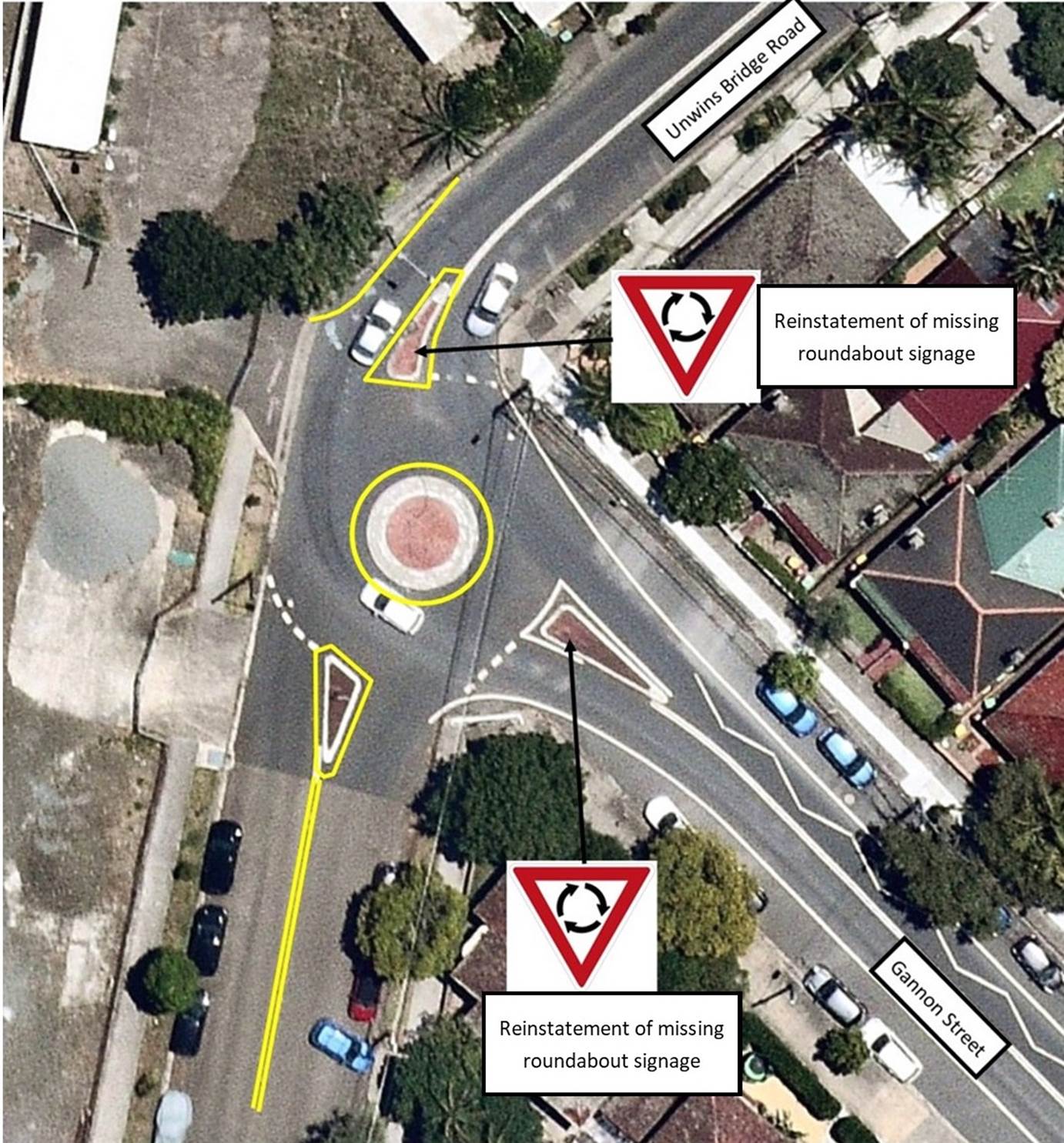
Diagram 1: Concept Plan for Unwin Bridge Road, Gannon Street & Griffith Street intersection.
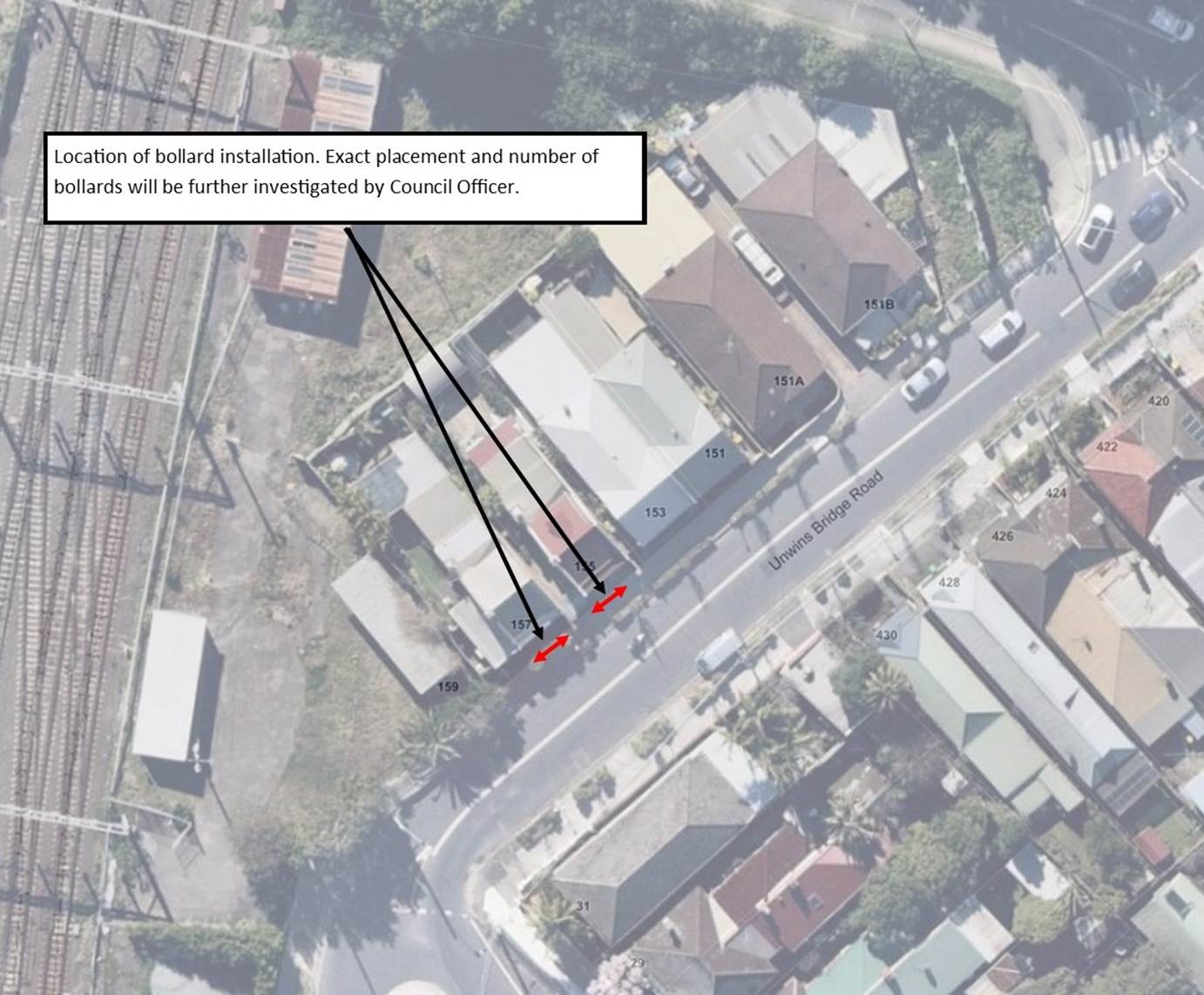
Diagram 2: Concept Plan for installation of bollards along frontage of Property No. 155 & 157 Unwins Bridge Road, Tempe.
PUBLIC CONSULTATION
A consultation letter outlining the proposal was mailed out to 41 surrounding properties. Four (4) responses were received in support of proposal. All responses were in support of proposal; however, each response had raised additional concerns. These concerns are summarised below:
|
Concern Raised |
Officer’s Comments |
|
During rainfall, the blocked drains and road camber contributes to potential vehicles losing control. Pockets of water on roadway is also causing havoc. |
Council’s Stormwater and Maintenance department will be notified of such matters to ensure pooling of water will be minimized. |
|
It has been a hard journey to have green foliage planted along Unwins Bridge Road. Hopefully, the installation of bollards will not mean the removal of the plants. |
The installation of bollards will require structural footing into the ground. However, additional removal of plants adjacent to the bollards is not necessary. |
|
|
Local Traffic Committee Meeting 18 October 2021 |
Subject: TRAFFIC MANAGEMENT PLAN FOR THE 2021 NEW YEAR'S EVE EVENT (BALUDARRI-BALMAIN WARD/ BALMAIN ELECTORATE/ LEICHHARDT PAC)
Prepared By: Vinoth Srinivasan - Engineer - Traffic and Parking Services
Authorised By: Manod Wickramasinghe - Traffic and Transport Planning Manager
SUMMARY
As instructed by the Police, access to the Balmain peninsula is closed to vehicular traffic every New Year’s Eve. This report outlines the traffic management associated with the event.
|
RECOMMENDATION
THAT:
1. The Traffic Management Plan (Attachment 1) detailing the traffic arrangements for the 2021 New Year’s Eve be supported;
2. The Traffic Management Plan (Attachment 1) be forwarded to Council’s Parks and Streetscapes Coordinator, Transport Management Centre and the Major Events & Incidents Group (NSW Police);
3. A temporary ‘No Stopping’ zone be installed on the eastern side of Montague Street between Darling Street and Beattie Street, Balmain;
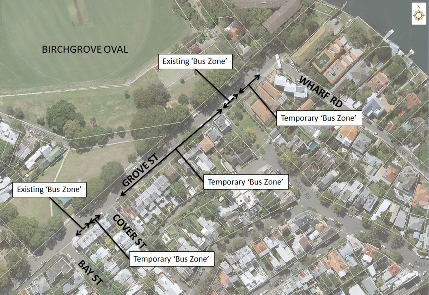
4. That the following temporary modifications to bus stops be approved: a. On the northern side of Darling Street: i. Install temporary ‘Bus Zones’ between Mort Street and Ford Street ii. Extend the ‘Bus Zone’ between Ford Street and McDonald Street iii. Extend the ‘Bus Zone’ between McDonald Street and Curtis Road, outside Nos.217-223 Darling Street b. On the southern side of Darling Street: i. Install a temporary ‘Bus Zone’ between Booth Street and Beattie Street, outside No. 244-270 Darling Street. c. On the eastern side of Grove Street between Wharf Road and Bay Street, Birchgrove.
5. The Transit Systems representative be requested to place adequate notices on buses regarding the establishment of an alcohol free zone in the Balmain East area (details to be provided by Council);
6. The taxi/hire car access to the Peninsula be restricted from 7:00pm;
7. Taxis/hire cars carrying mobility impaired or infirmed residents be permitted access at all hours into the Peninsula; and
8. The NSW Taxi Council be advised of the Committee’s recommendation.
|
BACKGROUND & OTHER STAFF COMMENTS
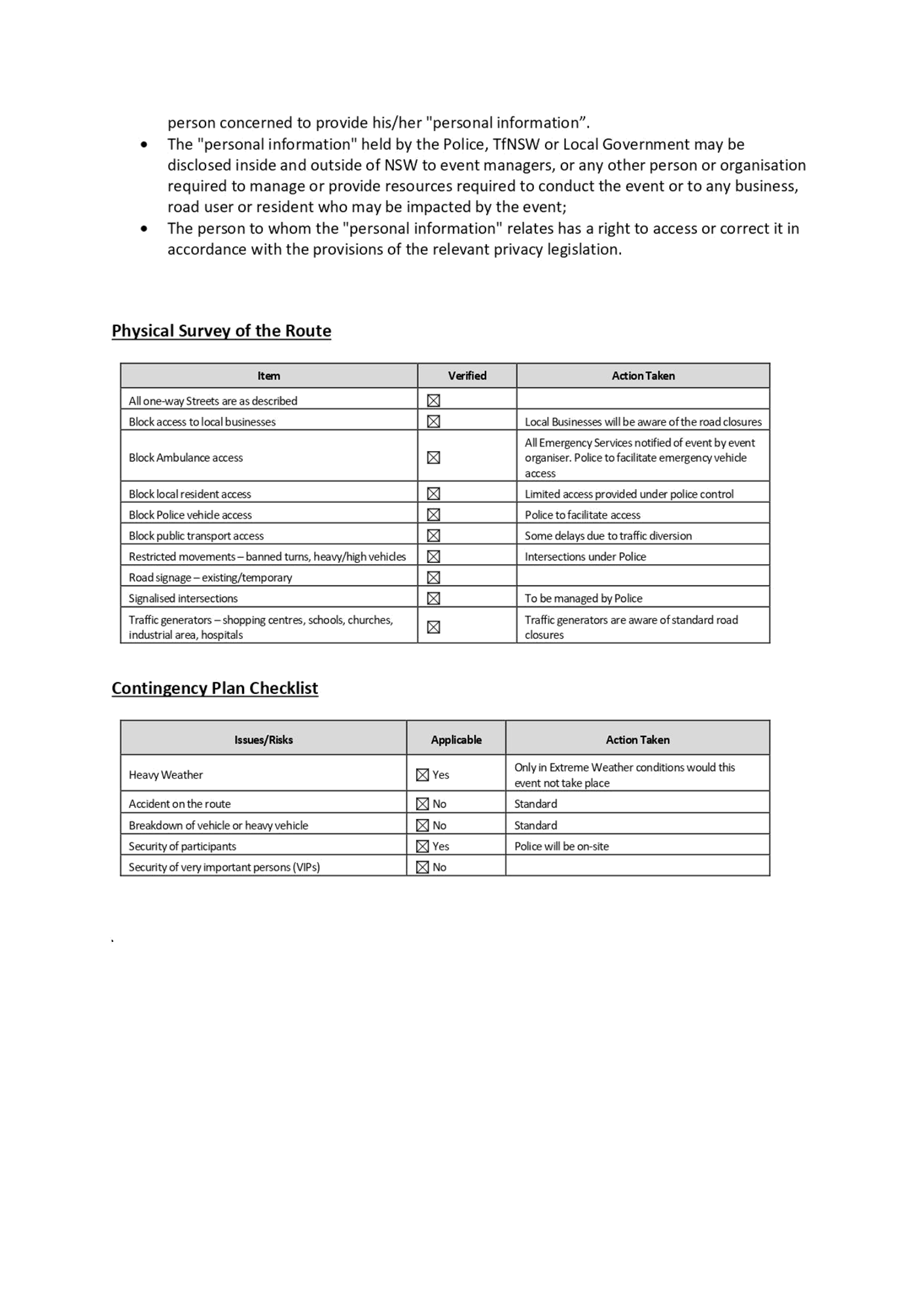
Traffic Management
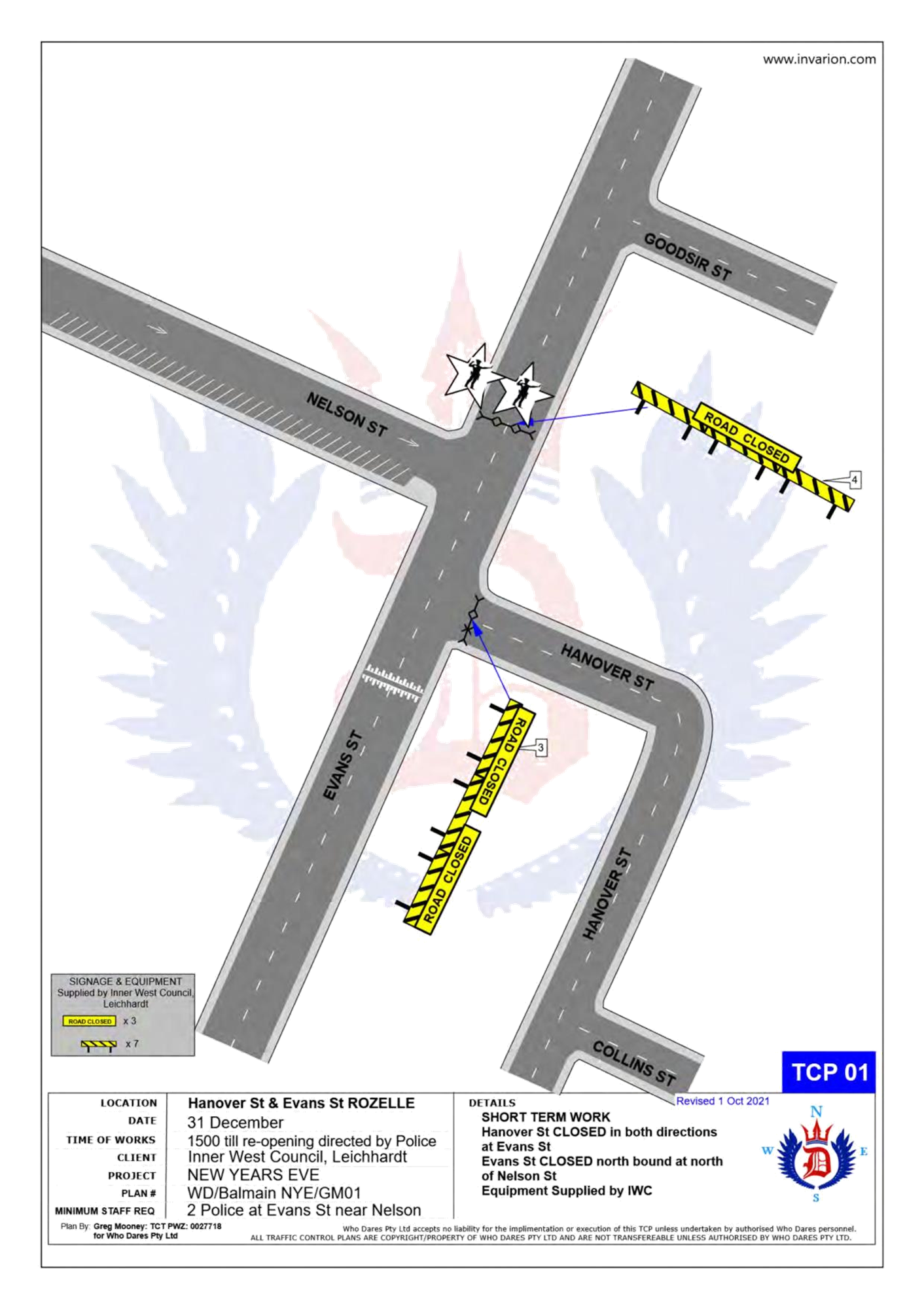
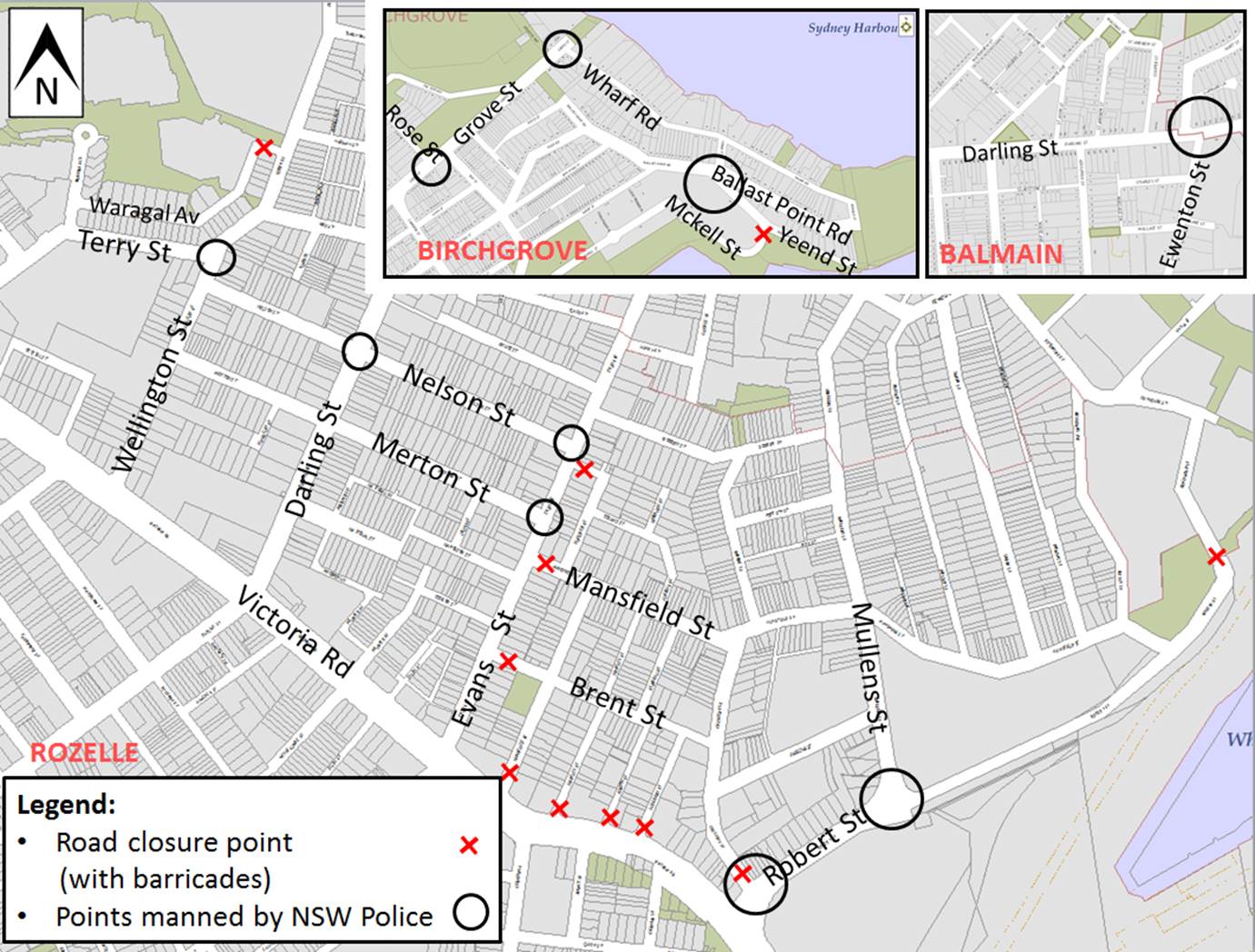
The following roads will be closed to all vehicular traffic between 3:00pm Friday, 31 December 2021 and 12:00am on Saturday, 1 January 2022 to cater for the New Year’s Eve celebrations:
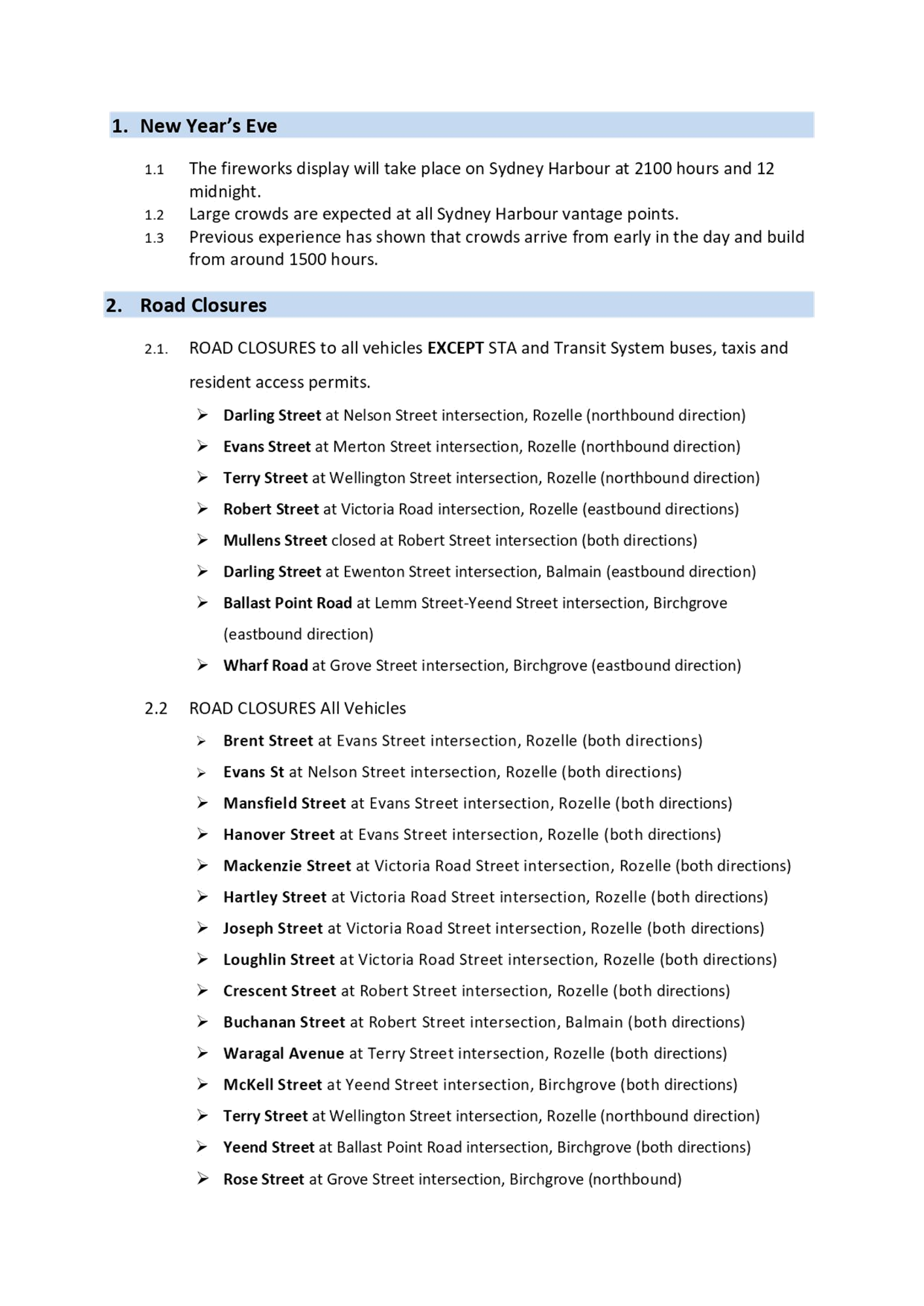
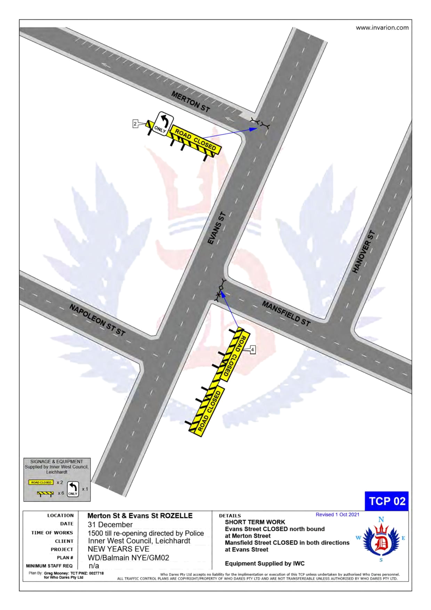
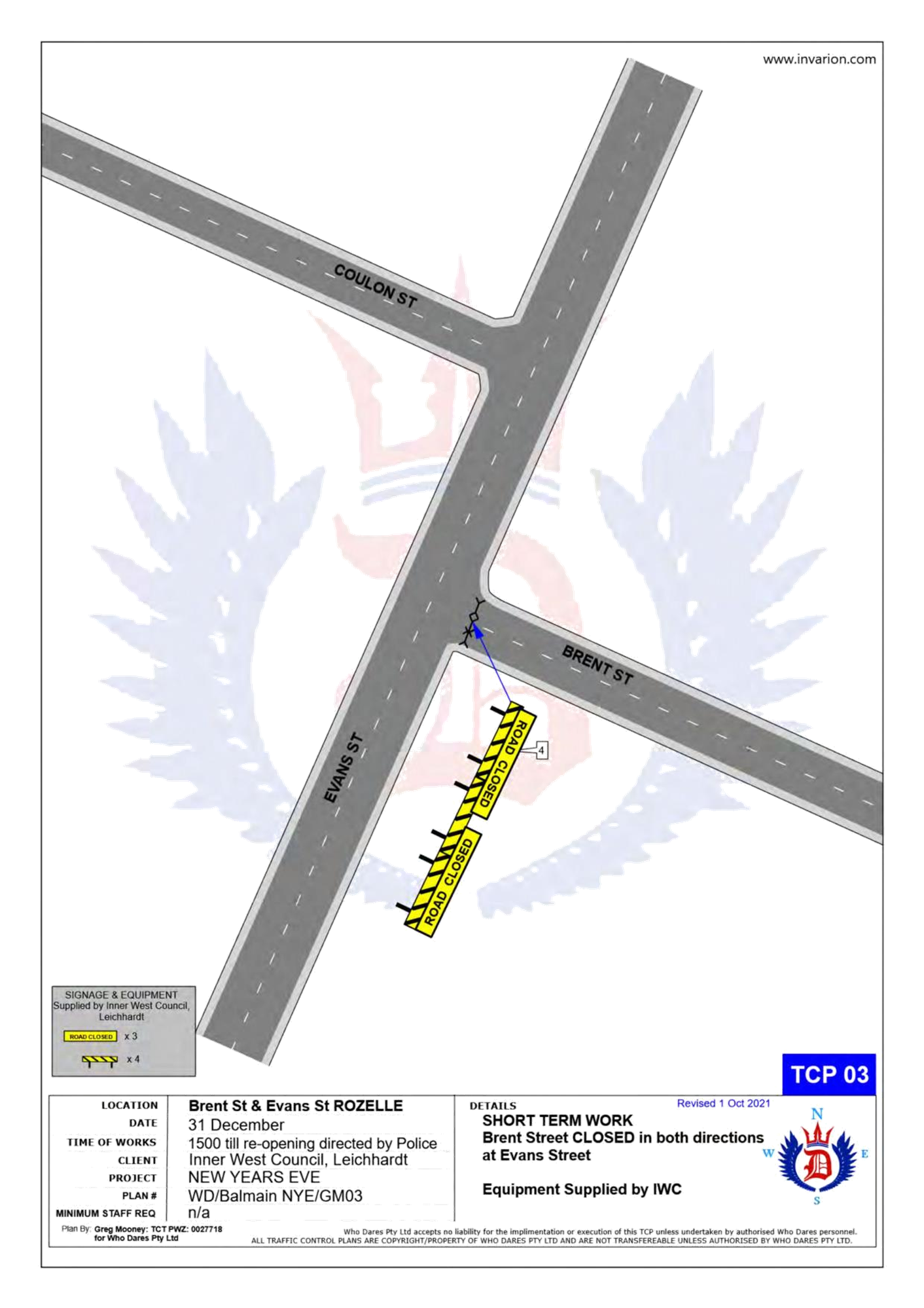
· Brent Street at Evans Street intersection, Rozelle (both directions)
· Mansfield Street at Evans Street intersection, Rozelle (both directions)
· Hanover Street at Evans Street intersection, Rozelle (both directions)
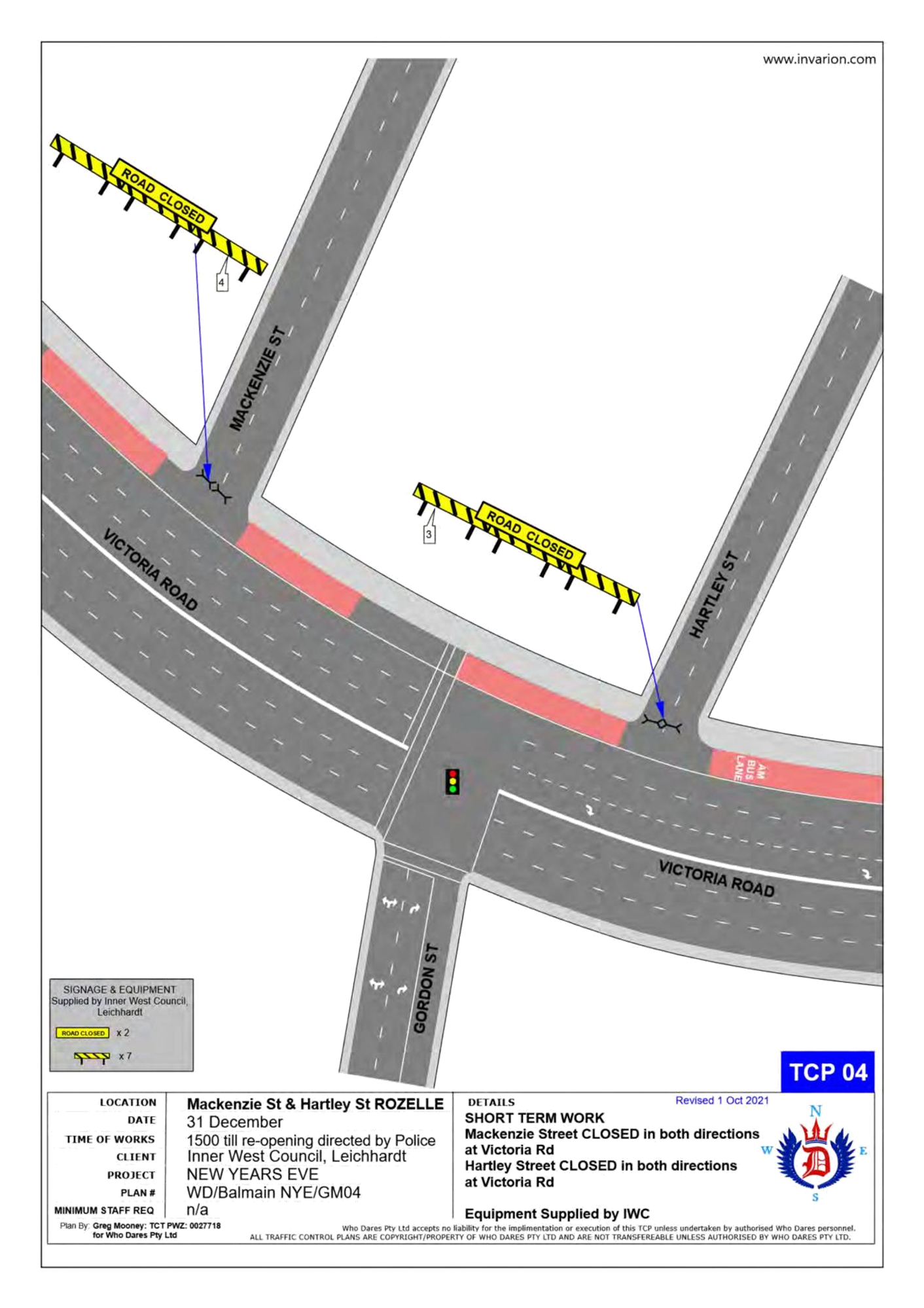
· Mackenzie Street at Victoria Road Street intersection, Rozelle (both directions)
· Hartley Street at Victoria Road Street intersection, Rozelle (both directions)
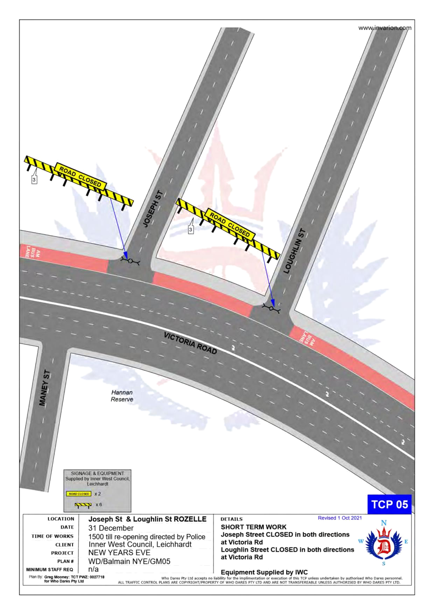
· Joseph Street at Victoria Road Street intersection, Rozelle (both directions)
· Loughlin Street at Victoria Road Street intersection, Rozelle (both directions)
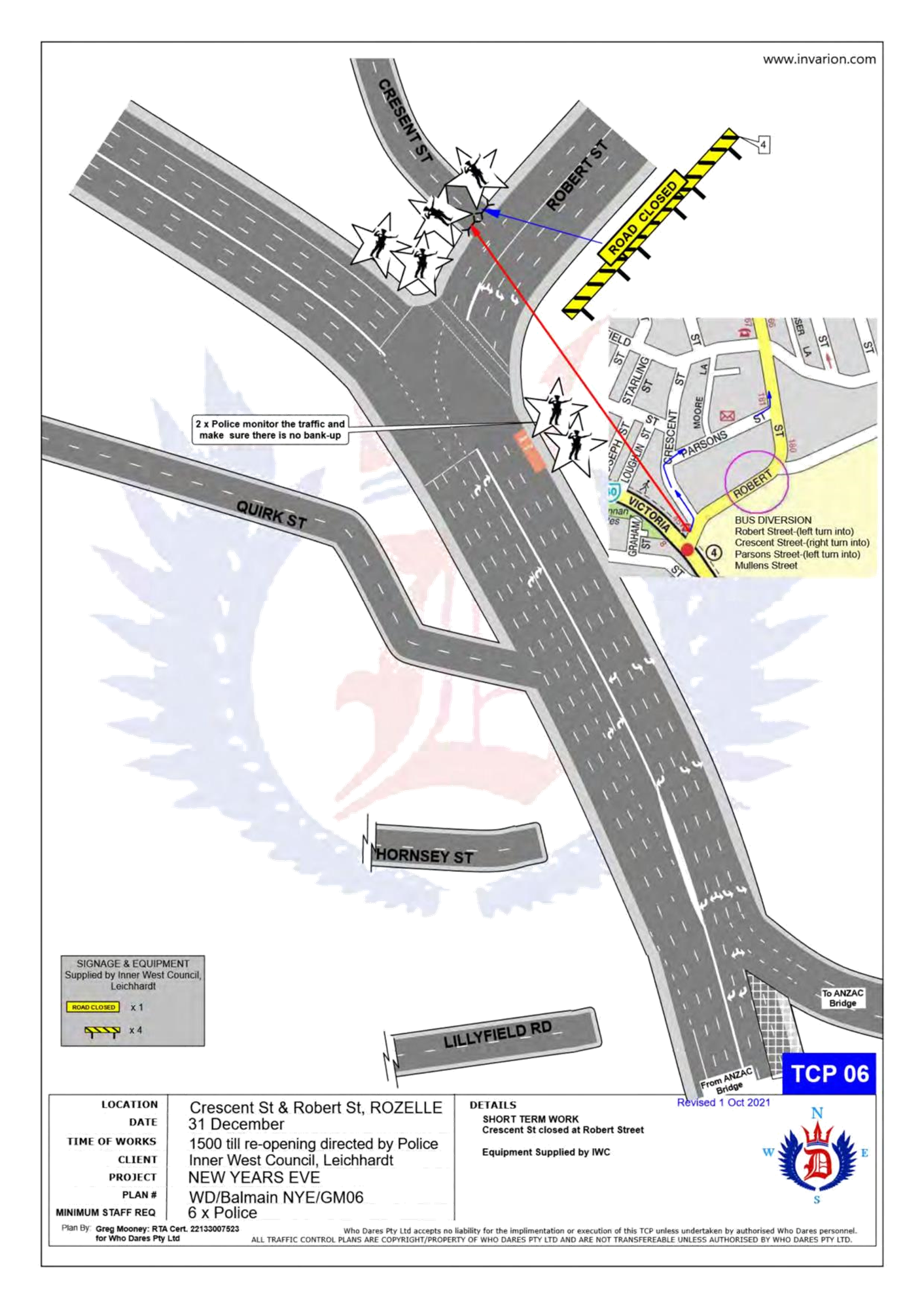
· Crescent Street at Robert Street intersection, Rozelle (both directions)
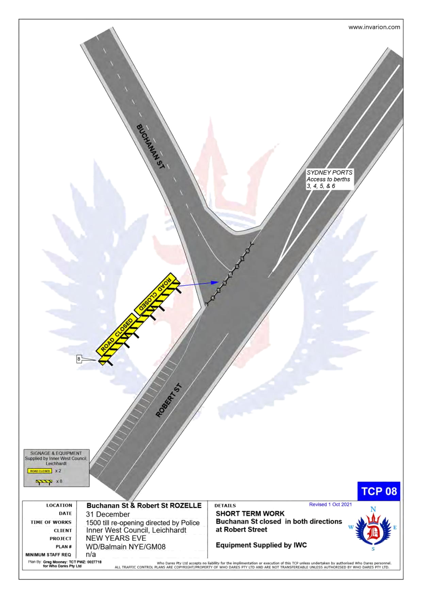
· Buchanan Street at Robert Street intersection, Balmain (both directions)
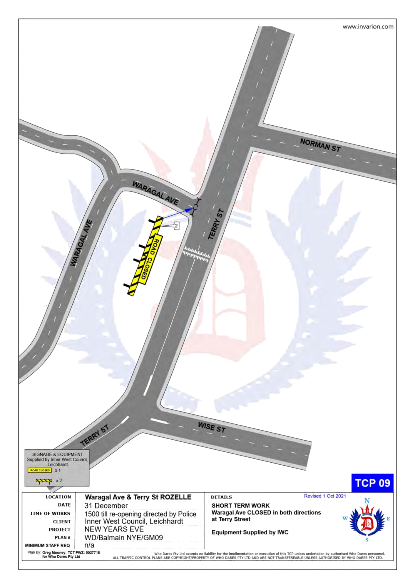
· Waragal Avenue at Terry Street intersection, Rozelle (both directions)
· McKell Street at Yeend Street intersection, Birchgrove (both directions)
In addition, the following roads will be closed to all vehicular traffic except State Transit Authority/Transit Systems buses, Taxis, Hire Cars and Balmain Access Permit holders and will be manned by NSW Police officers between 3:00pm Friday, 31st December 2021 and 12:00am on Saturday, 1st January 2022:
· Terry Street at Wellington Street intersection, Rozelle (northbound direction)
· Darling Street at Nelson Street intersection, Rozelle (northbound direction)
· Darling Street at Ewenton Street intersection, Balmain (eastbound direction)
· Evans Street at Merton Street intersection, Rozelle (northbound direction)
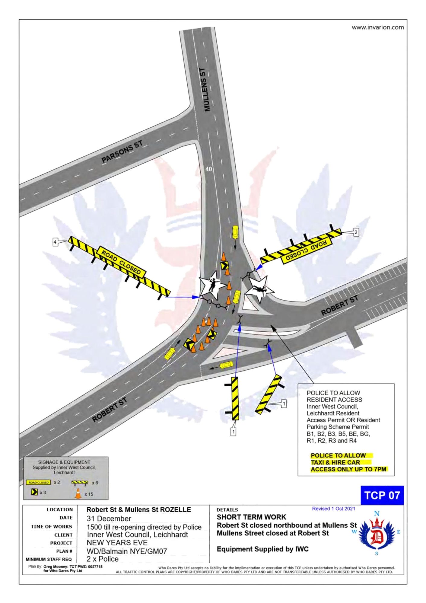
· Mullens Street at Robert Street intersection, Rozelle (both directions)
· Ballast Point Road at Lemm Street-Yeend Street intersection, Birchgrove (south and eastbound directions)
· Wharf Road at Grove Street intersection, Birchgrove (eastbound direction)
· Robert Street at Crescent Street, Rozelle (northbound direction)
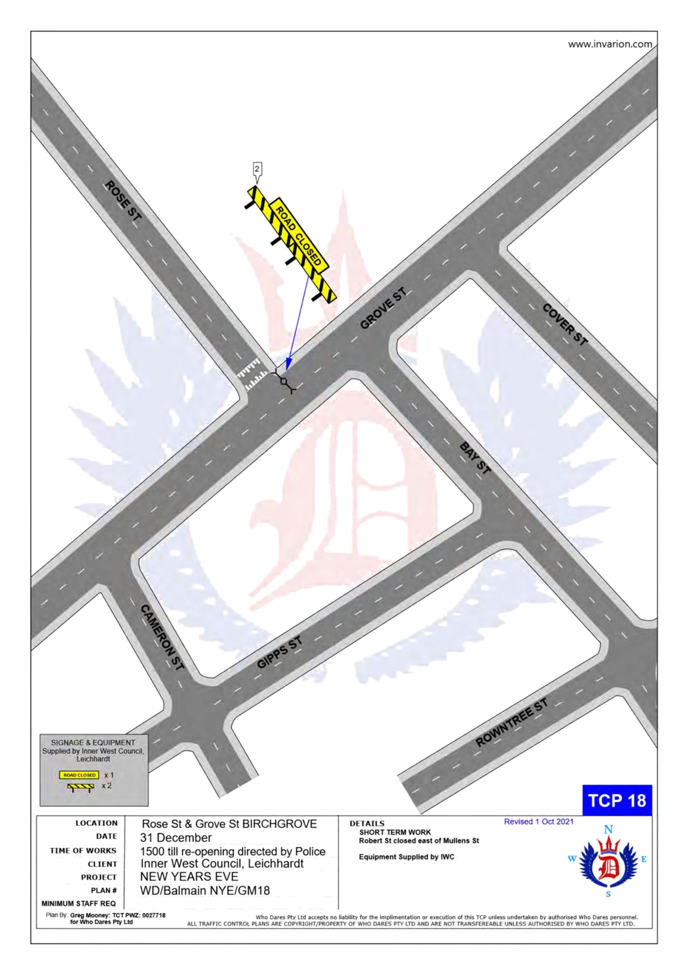
· Grove Street at Rose Street, Birchgrove (eastbound direction)
The following plan indicates the road closure points.
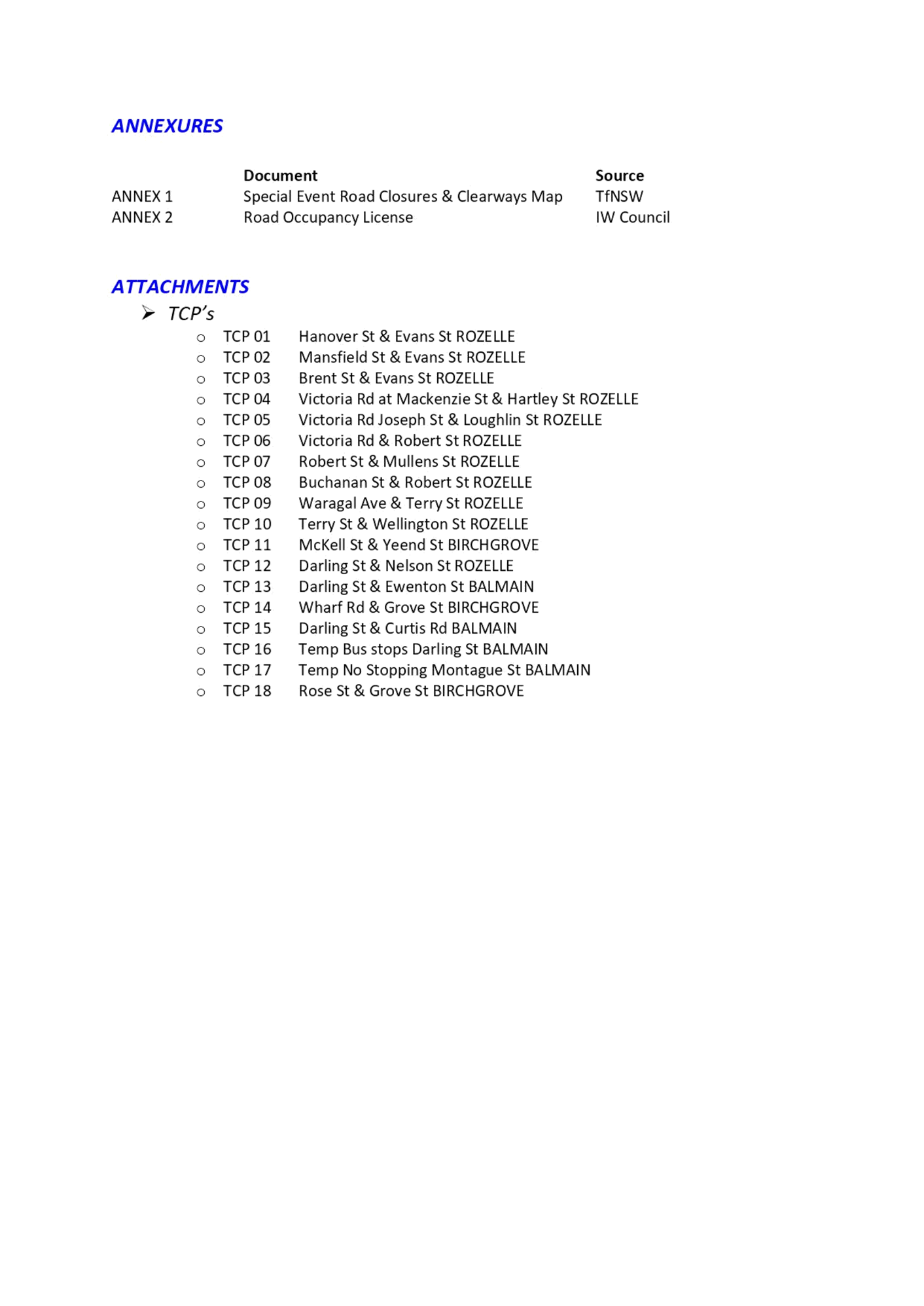
A Traffic Management Plan including Traffic Control Plans outlining the above road closures and the bus route changes is attached in Attachment 1.
Taxi Access
As previously recommended, the NSW Taxi Council will again be requested to inform their members of the proposed taxi access restriction after 7pm to minimise traffic congestion in the peninsula and improve pedestrian safety. Taxis will therefore need to use the following drop-off point locations:
· Taxis entering Terry Street - In the unrestricted parking on the eastern side of Terry Street or ‘Bus Zone’ and timed kerbside parking along Wellington Street
· Taxis entering Darling Street - In the ticket parking areas along Darling Street and Nelson Street
· Taxis entering Robert Street – In the restricted parking area and ‘Bus Zone’
Public Transport Access
Transit Systems will be scheduling additional services into the Balmain peninsula to cater for the New Year’s Eve celebrations.
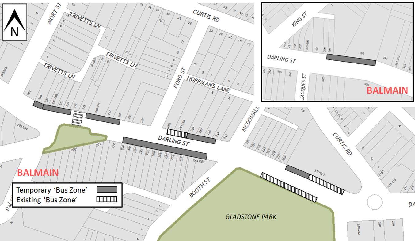
As such, temporary ‘Bus Zones’ will be installed at the following locations:
· Darling Street and the existing ‘Bus Zones’ on Darling Street between Mort Street and Curtis Road, Balmain
· Eastern side of Grove Street between Wharf Road and Bay Street, Birchgrove
The ‘Bus Zones’ on Grove Street will be used by Transit Systems and the Police to store buses on New Year's Eve. This is required for the safe bump out of the general public from Birchgrove as identified from a debrief from a previous New Year's Eve event conducted in the Balmain Peninsular.
The signs defining the temporary restrictions be in place after 12 Noon on 31 December 2021 and will be removed the following day.
Based on discussions held in previous years regarding disruptions to bus services leaving Gladstone Park/Curtis Road roundabout due to the gathering of large crowds, the Glebe Police representative introduced Police bike units to manage the crowds in the area.
In addition, to avoid delays that occurred at the Robert Street/Mullens Street intersection (which is a Police check point), buses entering Robert Street from Victoria Road are proposed to use Crescent Street and Parsons Street to access Mullens Street (see TCP 06/07 in Attachment 1).
It should be noted that Council will install variable message signs (“Balmain Peninsula is closed” and “Alcohol Free Zone”) on the main access roads into Balmain Peninsula a few days in advance of the event;
Temporary ‘No Stopping’ Restrictions
Following a previous year’s event, the Sydney Buses representative advised that several vehicles parked on Montague Street out from the kerb thus narrowing the carriageway and preventing buses from passing each other. Therefore, it is proposed to install temporary ‘No Stopping’ zone on the eastern side of Montague Street between Darling Street and Beattie Street. The residents will be advised of this arrangement in advance of the event.
Resident Access
To ensure resident access is maintained, the following permits will be accepted for access to the Balmain / Rozelle peninsula:
· Inner West Council Resident Access Permit.
· Inner West Council current Resident Parking Scheme Permit for Areas; B1, B2, B3, B5, BE, BG, R1, R2, R3 & R4.
· Australian Mobility Parking Scheme permit
Alcohol Free Zones
Council has already received approval to re-establish the Alcohol Free Areas for the New Year’s Eve celebrations in 2020, 2021 & 2022 at the following locations:
· Illoura Reserve
· 2-8 Weston Street
· Thornton Park
· Lookes Avenue Reserve
· Simmons Point Reserve
· Yurulbin Park
· Birchgrove Park
· Miklouho-Maclay Park
· Mort Bay Park
· College Street playground
· Harris Reserve
· Brownlee Reserves
· Darling Street from Duke Street to Darling Street Wharf
· Darling Street Wharf, Balmain East;
· Lookes Avenue
· Weston Street
These alcohol restrictions are proposed to be in place from 12.00pm (noon) 31 December 2021 to 3.00am 1 January 2022.
PUBLIC CONSULTATION
The proposed road closures are currently being advertised on Council’s website in accordance with the Roads Act 1993 for a period of 28 days from 28 September 2021 to 26 October 2021. No comments have been received.
In December, the details of these traffic arrangements will be re-advertised on Council’s website and via a mail out to all occupants in the Balmain peninsula.
The road closures and other event information will also be available on the Sydney New Year’s Eve Event website.
FINANCIAL IMPLICATIONS
Funding for costs associated with New Year’s Eve including labour, notifications and permits have been budgeted for in the 2021-22 operational plan.
|
1.⇩ |
New Year's Eve Road Closures - TMP |
|
Local Traffic Committee Meeting 18 October 2021 |
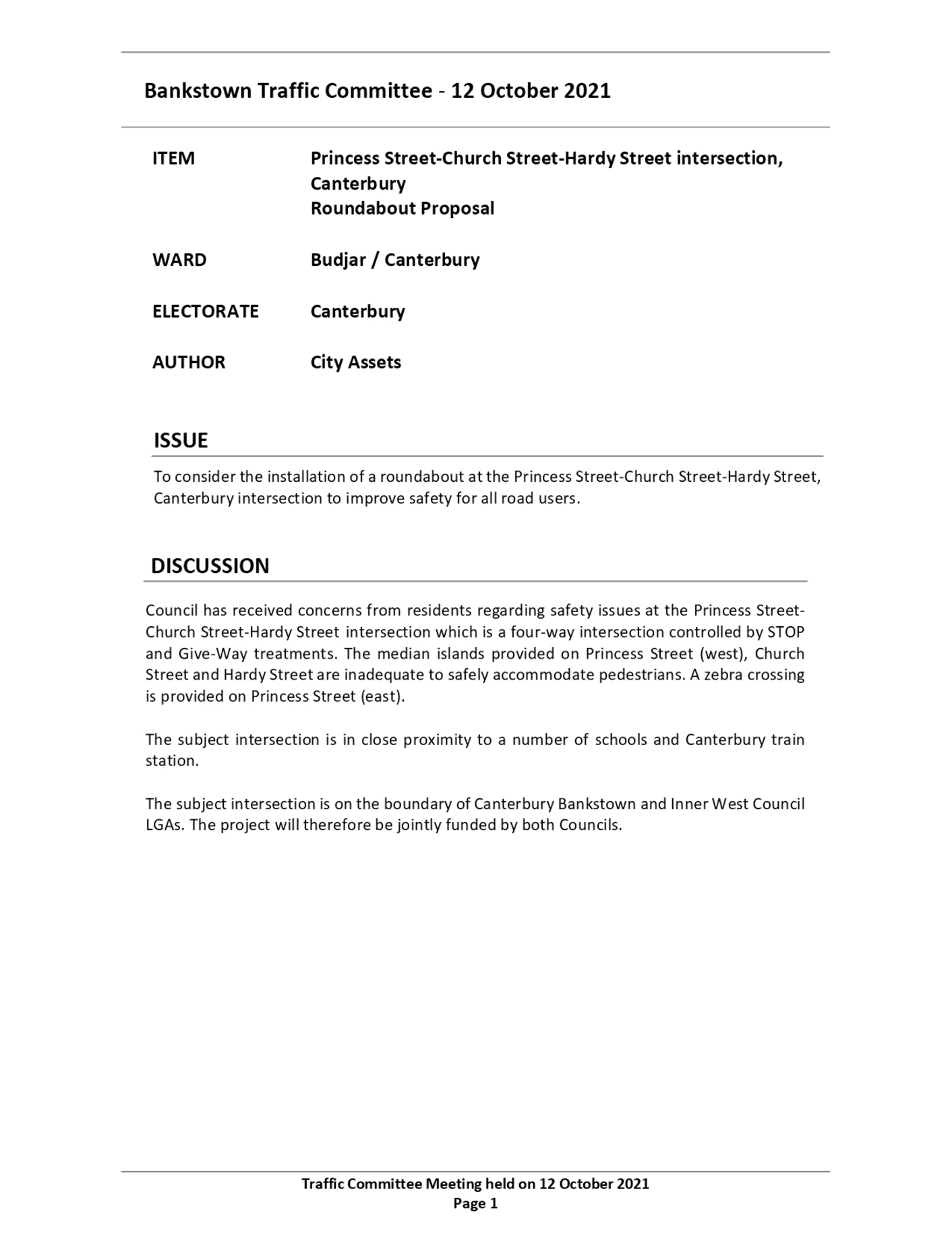
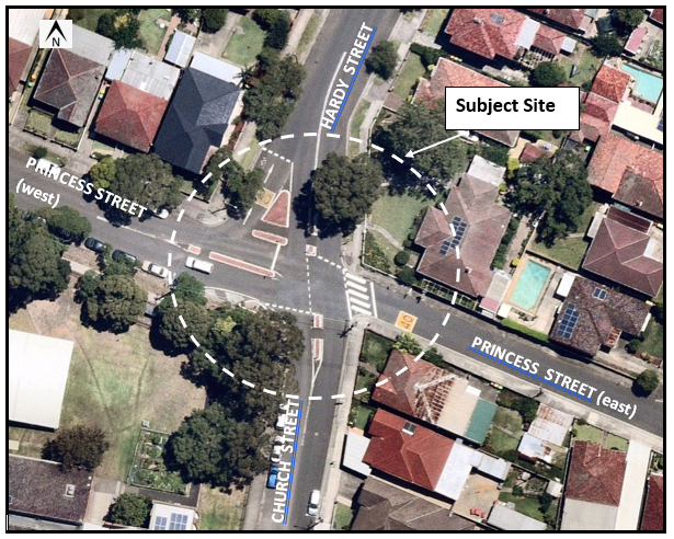
Subject: Intersection of Hardy Street/ Church Street
and Princess Street, (at suburb boundaries) Canterbury/Ashbury/Hurlstone Park-
Proposed Roundabout - Design Plan CBC No.
01470
(Djarrawunang-Ashfield Ward/Canterbury Electorate/Ashfield PAC)
Prepared By: Boris Muha - Engineer – Traffic and Parking Services
Authorised By: Manod Wickramasinghe - Traffic and Transport Planning Manager
SUMMARY
Canterbury Bankstown Council in conjunction with Inner West Council has finalised a plan to propose a roundabout at the intersection of Hardy Street/Church Street and Princess Street, Canterbury/Ashbury/Hurlstone Park. The intersection is bounded by both Councils. The proposed roundabout would replace the current crossroad treatment at the intersection to improve safety for all road users.
|
RECOMMENDATION
THAT the detailed design plan for a proposed roundabout at the intersection Hardy Street/Church Street and Princess Street, Canterbury/Ashbury/Hurlstone Park, with the removal of a slip lane and associated signs and line markings (as per Plan CBC No.01470) be APPROVED.
|
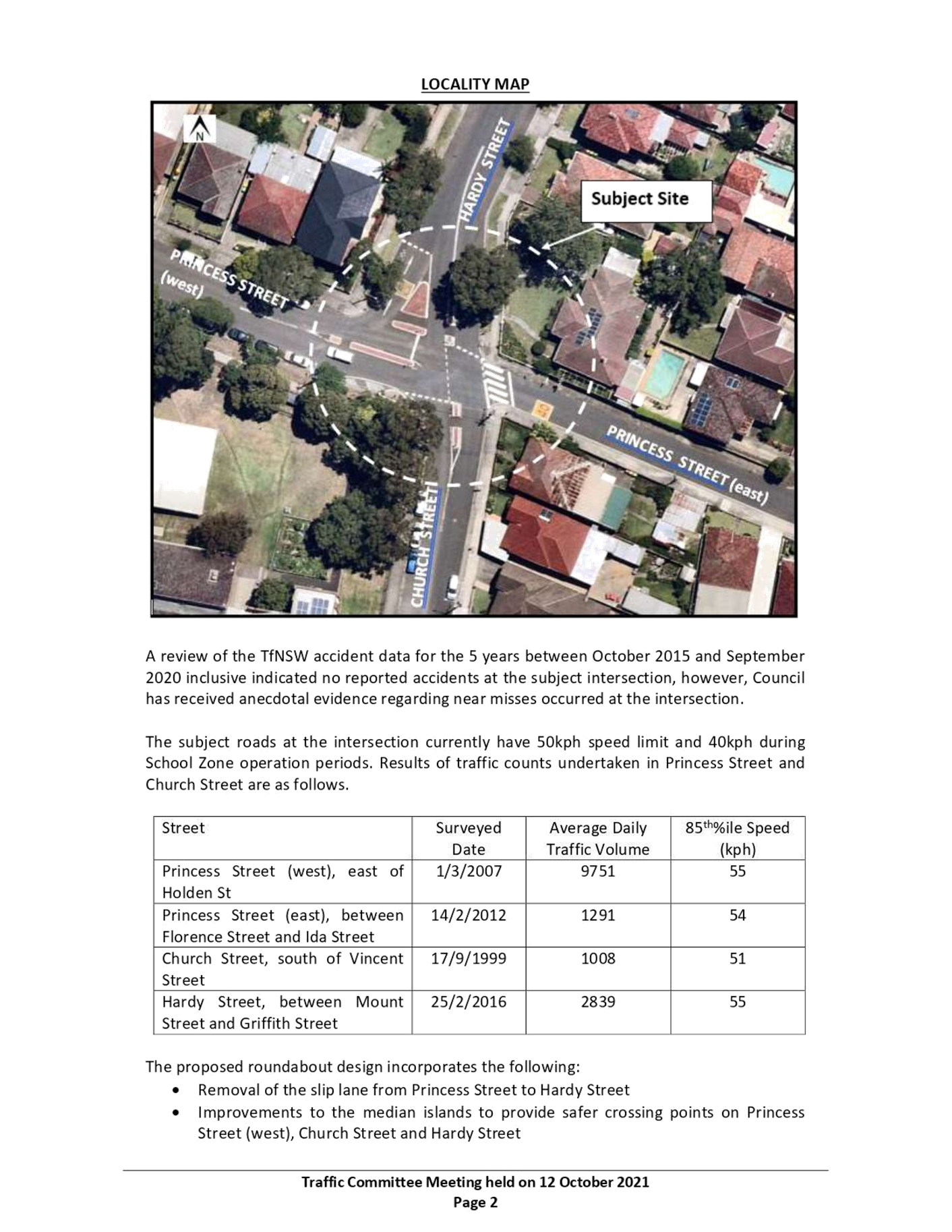
The intersection currently facilitates a crossroad treatment with a STOP control at Princess Street and GIVE-WAY control at Hardy Street/Church Street. A slip lane exists to the north- western corner of the intersection to separate and independently allow left turn movement from Princess Street into Hardy Street.
The boundary line between the two LGAs runs through the middle of Princess Street at the intersection.
The existing crossroad facility was implemented over 15 years ago in aim to control speed entry from all sides of the intersection. However numerous complaints over time have been received from the community and via Councillors and State Members of Parliament, regarding the confusion to the existing STOP and GIVE-WAY measures in place.
A site meeting was held in March 2021 between officers of both Councils and Police, and it was concluded that a roundabout could be implemented at this particular intersection to alleviate the problem of confusion and improve safety for all road users at the intersection.
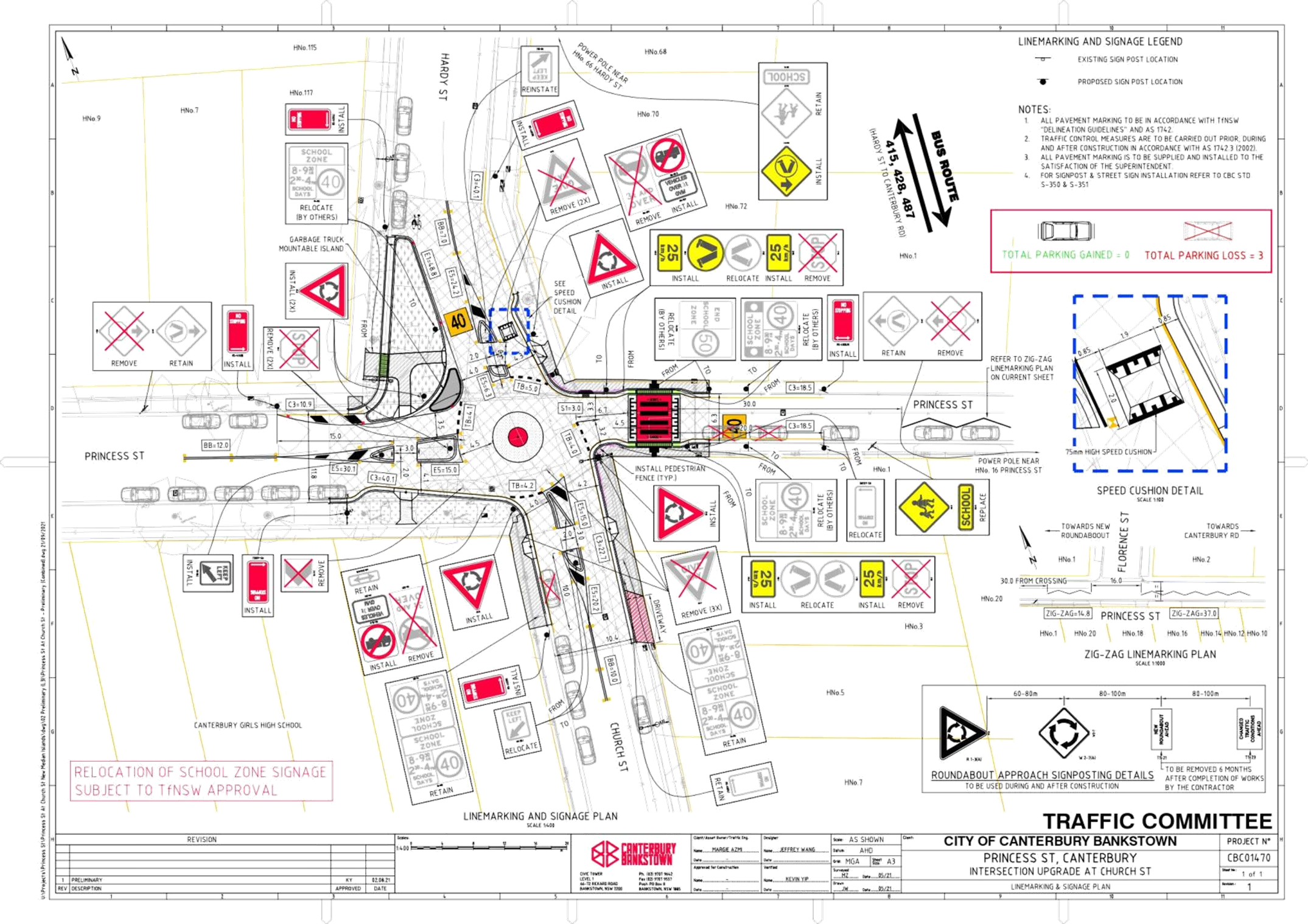
See below existing locality plan and crossroad treatment, and proposed plan of roundabout with associated works in Attachment 1.
FINANCIAL IMPLICATIONS
The project is listed on Canterbury Bankstown Council’s Capital Works Program for 2021/2022 with a total (detailed) estimated cost of approximately $500,560. Inner West Council will contribute to its component of the cost.
OTHER STAFF COMMENTS
The following works are proposed and are illustrated on the attached Plan designed by Canterbury Bankstown Council (Plan CBC No. 01470) in Attachment 1.
The proposal is to install a roundabout which incorporates:
· Removal of the slip lane from Princess Street to Hardy Street
· Improvements to the median islands to provide safer crossing points on Princess Street (west), Church Street and Hardy Street
· Relocation of the pedestrian crossing on Princess Street (east)
· Install a speed hump on Hardy Street (approach)
The proposal will result in the following parking losses due to the installation of statutory ‘No Stopping’ restrictions in line with Australian Standards and Transport for NSW (TfNSW) Technical Guidelines:
· two (2) parking spaces on Princess Street (east) and
· one (1) parking space on Church Street
The following information is also provided:
· Canterbury Bankstown Council will be reporting to its Local Traffic Committee to consider the proposal at its meeting on the 12 October 2021. A copy of the Canterbury Bankstown Council’s report to its traffic committee committee is shown in Attachment 2 which provides further details to dicussion and background on the matter.
· Both Council’s have co-ordinated in consultation with the affected community in the area. See Consultaion for further details.
· The proposed roundabout (romulus) is positioned to the the eastern side of the intersection to effectively allow for the safe and proper movement of vehicles through the intersection.
· A speed cushion is proposed In Hardy Street to compensate in the lack of deflection in the roundabout to control vehicle entry from the north.
· The existing slip lane to the north-western corner is removed to allow all traffic to compliantly manouvre through the roundabout. The extended area will be landscaped and serve to asthetically improve the street-scape and enhance the pedestrain movement on the northern side of the intersection.
· The kerb to the north-western corner will be kerb blistered and extended out to reallign and formulate a signal lane roundabout at the intersection.
· A garbage truck mountable island is provided to the north-west corner to allow Inner West Council waste collection vehicles (8.8 -9.5m in length) to negotiate the left turn from Princess Street into Hardy Street. All other vehicles will be able to left turn in front of the mountable island.
· The existing road level pedestrian crossing in Princess Street (east) will be upgraded to a raised crossing and moved approx. 5-6 metres away from the corner to prevent the standing of a vehicle over the crossing under Give-way. Fencing will be errected at both corner sides of the street to direct pedestrains to the raised crossing.
· At this point of time, it is viewed that there is low pedestrain activity at the other legs of the intersection. Crossings may be considered and retrofited to the other legs, if conditions permit and warrants are met in the future.
· Certain 40km/h school zone signs and marking will need to be relocated. As this facility is under the care and control of the Transport for NSW, Canterbury Bankstown Council has applied for TfNSW to relocate any of the 40 km/h school zone facilities around the intersection prior to commencement of the proposed works.
· Canterbury Bankstown Council will project manage and oversee the work.
CONSULTATION
Inner West Council mailed out consultation letters with the proposed plan to 18 surrounding properties (24 letters to residents and owners) in Princess Street (north side) and Hardy Street within the Inner West Council LGA. Canterbury Bankstown Council in turn mailed out consultation letters with plan to 10 properties (including Canterbury Girls High School) on Princess Street (southern side) and Church Street within Canterbury Bankstown Council LGA. See distribution map below.
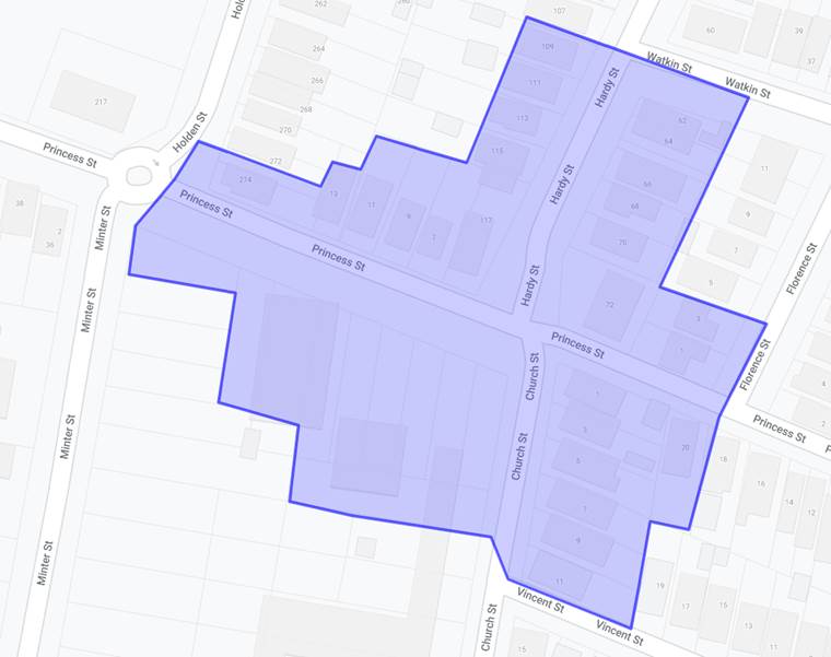
Letters were sent out on 10 September 2021. Closure on submissions was the 1 October 2021. No responses were received.
Canterbury Bankstown Council will be reporting the matter to its local Traffic Committee on the 12 October 2021. Its report is shown as Attachment 2. The minutes of the Canterbury Bankstown Council Traffic Committee pertaining to the item will be forwarded to Inner West Council Traffic Committee members prior to or tabled at the meeting.
CONCLUSION:
It is recommended that the detailed design plan for a proposed roundabout at the intersection Hardy Street/Church Street and Princess Street, Canterbury/Ashbury/Hurlstone Park, with the removal of a slip lane and associated signs and line markings (as per Plan CBC No.01470) be APPROVED.
|
1.⇩ |
CBC01470 -Princess St at Church St - Roundabout |
|
2.⇩ |
Canterbury Bankstown Councl LTC report for 12 Oct 2021 |
|
Local Traffic Committee Meeting 18 October 2021 |
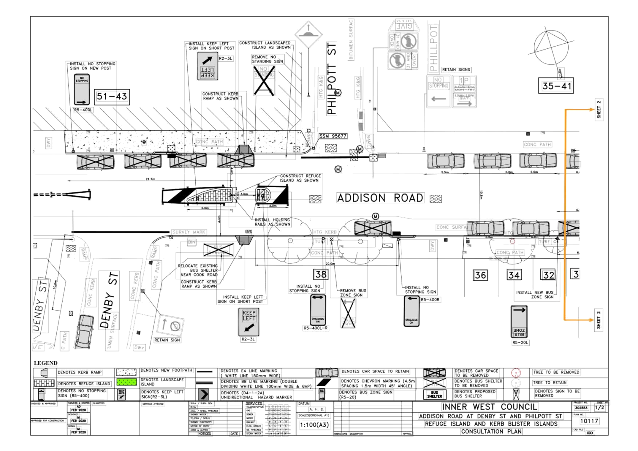
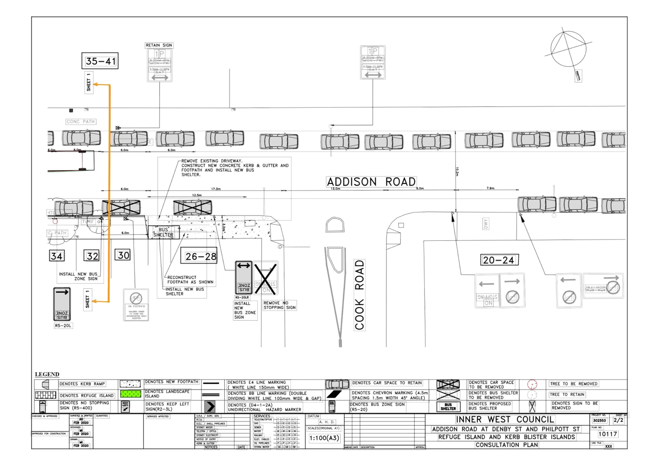
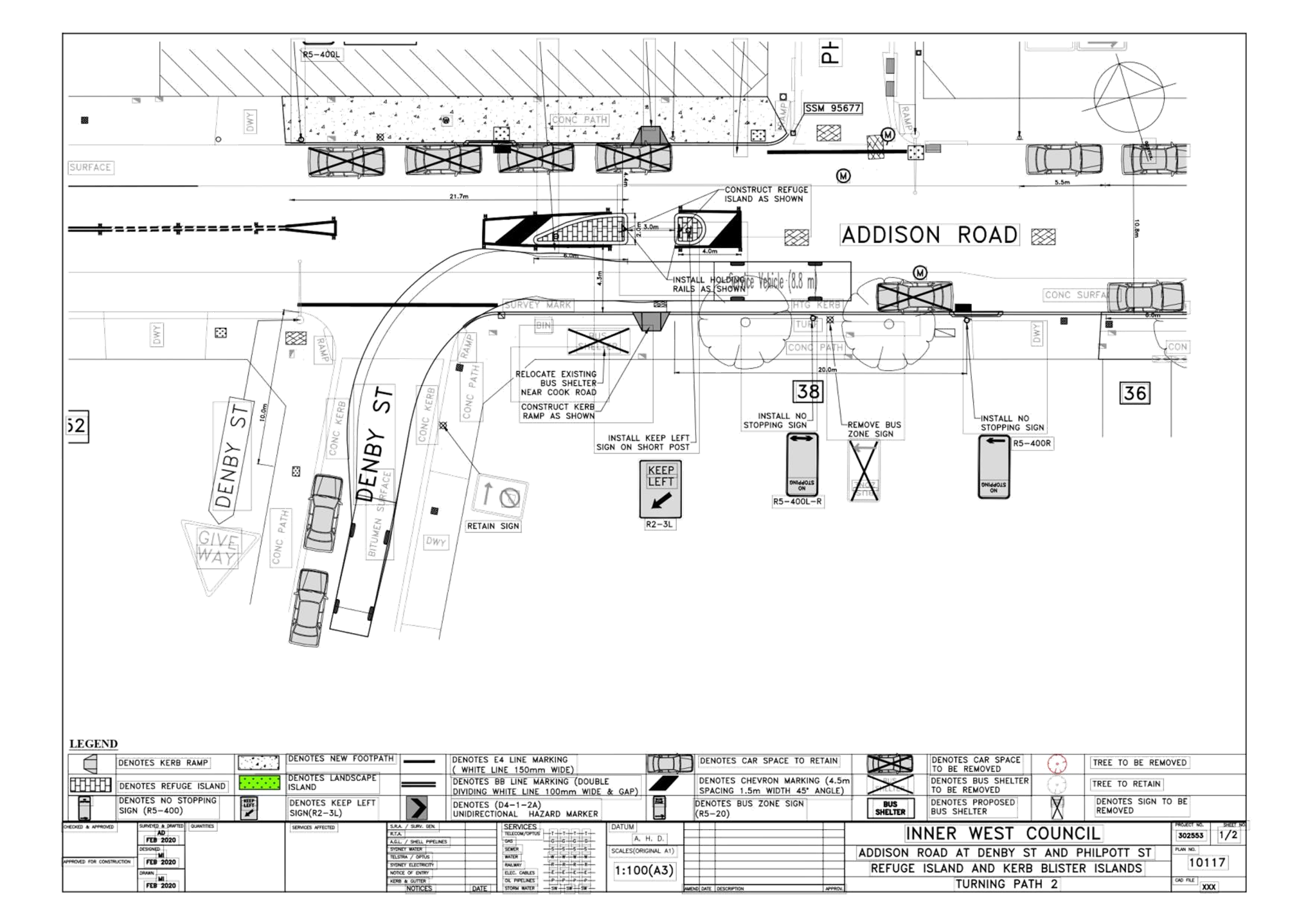
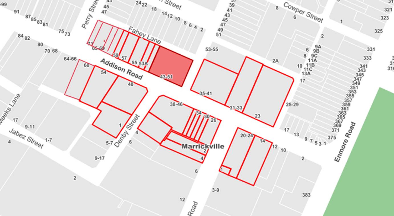
Subject: Addison Road, Marrickville – Proposed new pedestrian refuge - Design Plan 10117 ((Midjuburi-Marrickville Ward / NEWTOWN ELECTORATE / INNER WEST PAC)
Prepared By: Jennifer Adams - Engineer – Traffic and Parking Services
Authorised By: Manod Wickramasinghe - Traffic and Transport Planning Manager
SUMMARY
Council has finalised a design plan for the proposed construction of a new pedestrian refuge on Addison Road, Marrickville near Denby Street. Council received funding from the TfNSW Blackspot Program and the proposed works will improve pedestrian safety and motorist safety and addresses concerns about pedestrian safety and driver behaviour in the area. It is recommended that the proposed detailed design plan be approved.
|
RECOMMENDATION
THAT the detailed design plan for the proposed new pedestrian refuge on Addison Road, Marrickville near Denby Street and associated signs and line markings (as per Plan No.10117) be APPROVED.
|
Council is planning to improve pedestrian safety in Addison Road, Marrickville near Denby Street by constructing a new pedestrian refuge island. The proposed works will improve both pedestrian safety and motorist safety in the area. The proposed works are part of recommendations endorsed in August 2019 and listed in the Newington Local Area Traffic Management (LATM) report.
A Blackspot funding application was submitted in 2020 to install a pedestrian refuge and this application was successful. The application noted 5 injury crashes at this location, two of which involved pedestrians. Consultation has now been undertaken with nearby owners and occupiers of properties along Addison Road regarding the proposal and is summarised in the report
FINANCIAL IMPLICATIONS
Funding of $70,000 was received as part of the Australian Government’s Black Spot Program for these works and has been allocated to this project under the 2021/2022 Traffic Facilities Capital Works Program.
OTHER STAFF COMMENTS
Addison Road is a Regional Road running east-west between Victoria Road and Livingstone Road, Marrickville. Addison Road is used as a bus route and caries a traffic volume of approximately 12,500 vehicles per day. It provides one traffic lane in each direction, in addition to kerbside parking.
The following works are proposed and are illustrated on the attached Consultation Plans (Plan No.10117 – Attachment 1) which illustrates the proposed new works. Also included are swept path diagrams for an 8.8m service vehicle.
Addison Road, Marrickville (Plan No. 10117):
- Installing new Pedestrian Refuge Island.
- Installing associated pavement line marking and signage as required;
- Constructing new concrete kerb ramps on both sides of the proposed refuge island;
- Reconstructing some damaged sections of concrete footpath with new concrete footpath;
- Relocating the existing Bus shelter and Bus Zone east from its current location (towards Cook Road) as shown on the plan;
- Implementing new “No Stopping” zones and signage and relocating the Bus Stop and “Bus Zone” signs as shown on the plan.
Parking Changes
The proposal will affect existing on-street parking by removing some spaces. Overall, seven (7) legal car parking spaces will be removed along Addison Road as a result of the proposed works.
Closure of existing driveway (26-28 Addison Road):
As part of the works, Council proposes to remove the existing driveway access from Addison Road to 26-28 Addison Road and replace with kerb & gutter and footpath to facilitate the relocation of the Bus Zone and Bus Shelter. It is noted that the property has another driveway accessed off Cook Road.
PUBLIC CONSULTATION
Consultation was conducted between 10 September and 8 October 2021. A letter along with a copy of the design plan was sent to residents/businesses in Addison Road, as highlighted in the following plan. A total of 49 letters were distributed. Five responses were received in objection to the proposal as shown in the following table.
|
Officer’s response |
|
|
Concern due to loss of parking (total of 5 similar comments) |
Loss of Parking is a result of the statutory ‘No Stopping’ required with the introduction of a Pedestrian Refuge |
|
Increasing hazards at the intersection of Cook Road (total of 3 similar comments) |
The relocation of the bus stop is a result of the introduction of a Pedestrian Refuge. The proposed new bus stop location is the only feasible location. |
|
Attracting smoking outside their residence where new bus stop is proposed |
Noted. |
|
Removal of trees as part of the proposal |
There are no trees proposed to be removed as part of this proposal. |
|
Lost opportunities for tree planting in bus zone (total of 2 similar comments) |
Noted. This feedback can be passed to Council's tree section for other planting opportunities |
Transit Systems were also consulted as the proposed works involved relocation of an existing Bus Zone and bus shelter. Transit Systems responded that the relocation would have a financial cost of approximately $420 for the installation of new B/Pole at the relocated stop and for the installation of tactiles. Transit Systems will provide details of their contractor or they will have it installed and invoice Council accordingly.
CONCLUSION
It is recommended that the detailed design plans (10117) for the proposed construction of a new pedestrian refuge on Addison Road, Marrickville near Denby Street. and associated works, signs and line markings be approved, to improve road safety at this location.
|
1.⇩ |
Detailed design plans (10117) - construction of a new pedestrian refuge on Addison Road, Marrickville near Denby Street |
|
Local Traffic Committee Meeting 18 October 2021 |
Subject: DUDLEY STREET, DULWICH HILL; ILLAWARRA ROAD, MARRICKVILLE; AND (LOWER) RAILWAY PARADE, SYDENHAM - BUS REPLACEMENTS DURING MAJOR RAIL SHUTDOWN 26 DECEMBER 2021 TO 9 JANUARY 2022 - TEMPORARY PARKING CHANGES DURING T3 LINE UPGRADE FOR SYDNEY METRO - (MIDJUBURI -MARRICKVILLE WARD / SUMMER HILL ELECTORATE / INNER WEST PAC)
Prepared By: Jennifer Adams - Engineer – Traffic and Parking Services
Authorised By: Manod Wickramasinghe - Traffic and Transport Planning Manager
SUMMARY
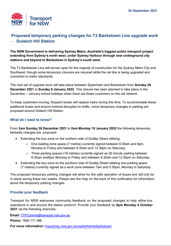
Council has been notified by Transport for NSW (TfNSW) that Sydney Metro works will involve a major rail shutdown of the Sydenham to Bankstown rail line (T3) between Sunday 26 December 2021 to Sunday 9 January 2022 (inclusive). During the shutdown buses will replace train services along the T3 line and to accommodate the increased bus movements and necessary holding areas some short-term parking changes are required at a number of locations.
Specifically, TfNSW is requesting approval for the temporary conversion of multiple parking spaces at the following locations: Dudley Street, Dulwich Hill; Illawarra Road, Marrickville; and Railway Parade (lower section), Sydenham. It is recommended that no objections be raised, and Council approves the temporary short-term parking changes at the identified locations during the rail shutdowns. TfNSW will reinstate all existing parking arrangements and signage by/on Monday 10 January 2022.
|
RECOMMENDATION
THAT this report be received and noted and the following temporary short-term parking changes from Sunday 26 December 2021 to Sunday 9 January 2022 be approved and implemented by TfNSW:
Dudley Street - Dulwich Hill Station Precinct (5 parking spaces) 1. The short-term conversion of 7m (1 parking space) ‘Loading Zone 8:30 am – 6 pm Mon – Fri & 8:30 am – 12:30 pm Sat’ on the northwestern side of Dudley Street (between Wardell Road and School Parade) to a ‘Bus Zone’ be APPROVED in order to provide an additional bus bay with adequate draw-in length; 2. The short-term conversion of 18m (3 parking spaces) ‘P30 min 8:30 am – 6 pm Mon – Fri & 8:30 am – 12:30 pm Sat’ on the northern side of Dudley Street (between Wardell Road and School Parade) to a ‘Bus Zone’ be APPROVED in order to provide an additional bus bay with adequate draw-in length; and 3. The short-term conversion of 7m (1 parking space) ‘Works Zone 7 am – 5:30 pm Mon – Sat’ on the southeastern side of Dudley Street (between School Parade and Wardell Road) to a ‘Bus Zone’; be APPROVED in order to provide an additional bus bay with adequate draw-in length.
Illawarra Road - Marrickville Station Precinct (1 parking space)
4. The short-term conversion of 7m (1 parking space) ‘1P 8:30 am – 6 pm’ on the northern side of Illawarra Road (between Warburton Street and Greenbank Street) to a ‘Bus Zone Mon-Fri only’; be APPROVED in order to provide an additional bus bay with adequate draw-in length.
5. The short-term conversion of 69m (11 parking spaces) ‘unrestricted parking’ on the southeast kerb of Railway Parade (between Gleeson Avenue and Marrickville Road) to a ‘Bus Zone’ be APPROVED in order to provide additional layover bus bays with adequate draw-in length;
6. The short-term conversion of 118m (40 parking spaces) ‘unrestricted parking’ on the northwest kerb of Railway Parade (Lower) (between Sydenham Road and Marrickville Road) to a ‘Bus Zone’; be APPROVED in order to provide additional layover bus bays with adequate draw-in length;
7. The short-term conversion of 32m (11 angle parking spaces) ‘4P 8:30 am – 6 pm Mon - Fri’ on the northwest kerb of Railway Parade (Lower) (between Gleeson Avenue and Marrickville Road) to a ‘Bus Zone’; be APPROVED in order to provide additional layover bus bays with adequate draw-in length; and
8. The applicant and Council Rangers be advised in terms of this report.
|
BACKGROUND
Sydney Metro City & Southwest - Sydenham to Bankstown project will upgrade all 10 stations between Marrickville and Bankstown to meet metro standards before converting the T3 Bankstown Line to Metro operations.
During this possession, rail services on the T3 Bankstown Line will not operate and Temporary Transport Plan (TTP) buses will operate instead necessitating some short-term changes in parking at a number of locations.
All changes to street signage will be made by TfNSW contractor(s) from 10pm the night before the closures and will be reinstated at the completion of the planned shutdowns.
FINANCIAL IMPLICATIONS
There are no financial implications for Council associated with this matter. The cost of the work will be borne by Transport for NSW.
OFFICER COMMENTS
It is noted that the proposed parking changes are between the period of Sunday, 26 December 2021 to Sunday, 9 January 2022 (inclusive). Lower Railway Parade, Marrickville will only be required between Wednesday, 29 December 2021 and Sunday, 9 January 2022 (short term period).
Plans of the proposed Bus Zone requirements for each station will be detailed separately below.
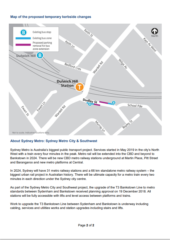
Dulwich Hill Station Precinct (5 parking spaces)
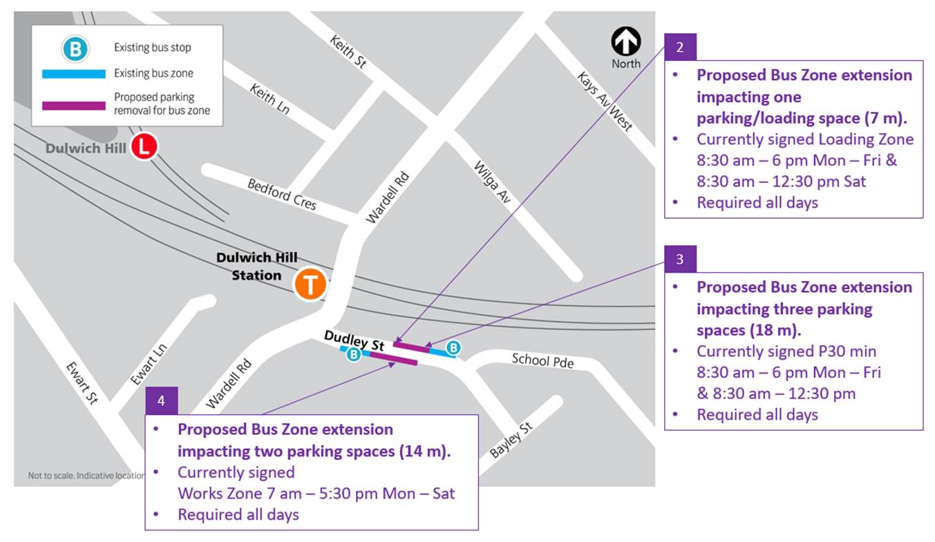
1. Section A of Dulwich Hill Station, Dudley Street, northern side (Stop ID: 220433) - Bus stop extension (1 parking space)
· Dudley Street (northern kerb between Wardell Road and School Parade)
· Currently signed Loading Zone 8:30am – 6pm Mon – Fri & 8:30am – 12:30pm Sat
· Proposed Bus Zone extension is required for all days of the TTP bus operation
· Proposed temporary change will impact approximately one parking space (7m).
· This change is proposed to create the extra space required for the additional TTP buses using the stop.
2. Section B of Dulwich Hill Station, Dudley Street northern side (Stop ID: 220433) - Bus stop extension (3 parking spaces)
· Dudley Street (northern kerb between Wardell Road and School Parade)
· Currently signed P30 min 8:30am – 6pm Mon – Fri & 8:30am – 12:30pm Sat
· Proposed Bus Zone extension is required for all days of the TTP bus operation
· Proposed temporary change will impact approximately 3 parking spaces (18m).
· This change is proposed to create the extra space required for the additional TTP buses using the stop
3. Dudley Street opposite Dulwich Hill Station, southern side (Stop ID: 220432) - Bus stop extension (1 parking space)
· Dudley Street (southern kerb between School Parade and Wardell Road)
· Currently signed Works Zone 7am – 5:30pm Mon – Sat
· Proposed Bus Zone extension is required for all days of the TTP bus operation
· This proposed change is to create the extra space required for the additional TTP buses using the stop
· Proposed temporary change will impact approximately one parking space (7 m).
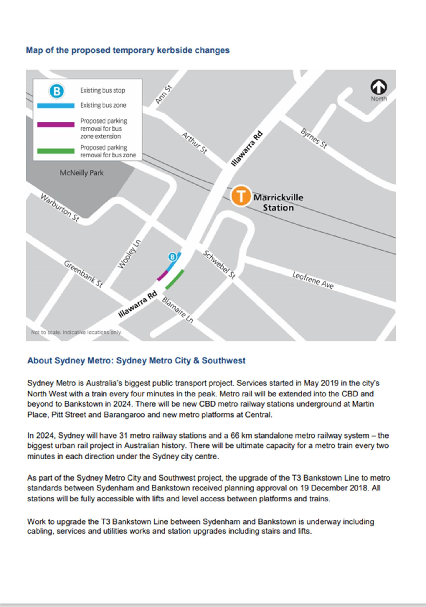
Marrickville Station Precinct (1 parking space)
4. Illawarra Road opposite Marrickville Station (Stop ID: 2204102) - Bus stop extension (1 parking space)
· Illawarra Road (northwest kerb between Warburton Street and Greenbank Street)
· Currently signed 1P 8:30 am – 6 pm
· Proposed Bus Zone extension is required for the duration of the TTP bus operation
· Proposed temporary change will impact approximately one parking space (7 m).
· This change is proposed to create the extra space required for the additional TTP buses using the stop.
Note: Marrickville Station, Illawarra Road (Stop ID: 2204101) will also be used by TTP buses but no regulatory signage changes are required.
It is noted that the above diagram differs from that from the TfNSW’s public consultation leaflet for Illawarra Road in that the proposed bus stop on the eastern side of Illawarra Road, north of Blamire Lane, is no longer required as the bus stop directly outside Marrickville Station entrance on Illawarra Road will be available for TTP buses to use during the rail shutdown. This minimizes temporary on-street parking loss. Originally, a bus stop was to be created on the eastern side of Illawarra Road, north of Blamire Lane by utilising five parking spaces (33 metres) currently signed P30 (half hour) 8.30am to 6pm.
Sydenham Station Precinct (50 parking spaces)
5. Railway Parade, Marrickville NSW 2204 – Layover Bus Zone (11 parking spaces)
· Railway Parade (southwestern kerb between Gleeson Ave and Marrickville Road)
· Currently Unrestricted parking
· Proposed Bus Zone is required for all days of the TTP bus operation
· This proposed change is to create the space required for buses to layover. This location is proposed as it is (i) reasonably close to the active bus stop; and (ii) located along the route path used between the last and first stops.
· Proposed temporary change will impact approximately eleven parking spaces (69 m).
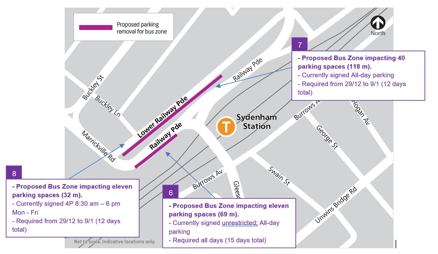
6. Section A of Lower Railway Parade 90 degree angled parking, Marrickville – Layover Bus Zone and Standby area (40 parking spaces)
· Lower Railway Parade Parallel Parking (southern side between Sydenham Road and Marrickville Road)
· Currently Unrestricted parking
· Proposed Bus Zone is required for 12 days of the TTP bus operation between 29/12/2021 to 9/01/2022.
· Proposed temporary change will impact approximately 40 angled parking spaces (118 m).
· This proposed change is to create the space required for buses to layover. This location is proposed as it is (i) reasonably close to the active bus stop; (ii) located along the route path used between the last and first stops; and (iii) as far as removed from residential dwellings.
7. Section B of Lower Railway Parade 90 degree angled parking, Marrickville NSW 2204 – Layover Bus Zone (11 parking spaces)
· Lower Railway Parade Parallel Parking (southern side between Gleeson Avenue and Marrickville Road)
· Currently 4P 8:30 am – 6 pm Mon - Fri
· Proposed Bus Zone is required for 12 days of the TTP bus operation between 29/12/2021 to 9/01/2022.
· Proposed temporary change will impact approximately eleven angled parking spaces (32 m).
· This proposed change is to create the space required for buses to layover. This location is proposed as it is (i) reasonably close to the active bus stop; and (ii) located along the route path used between the last and first stops.
PUBLIC CONSULTATION
Council Officers met with Transport for NSW in early September 2021 to discuss the temporary parking changes and the consultation and approval process. TfNSW is responsible for the consultation with local businesses and residents and they proposed to carry out this in mid-September 2021.
The consultation program will consist of the following activities:
· Two-week public consultation period to impacted areas with a printed community notification outlining the proposed kerbside changes.(copies of which are reproduced at the end of this report)
· Media release regarding the consultation period issued by Transport for NSW.
A Consultation Outcomes Report will be prepared collating feedback received as part of TfNSW’s consultation process. The report will be submitted prior to the October 2021 Council Traffic Committee Meeting.
|
|
Local Traffic Committee Meeting 18 October 2021 |
Subject: LORDS ROAD AND FLOOD STREET, LEICHHARDT - PROPOSED RAISED PEDESTRIAN CROSSINGS (GULGADYA-LEICHHARDT WARD/BALMAIN ELECTORATE/LEICHHARDT PAC)
Prepared By: David Yu - Engineer - Traffic and Parking Services
Authorised By: Manod Wickramasinghe - Traffic and Transport Planning Manager
SUMMARY
Council is planning to improve pedestrian safety in Lords Road and Flood Street, Leichhardt by converting the two (2) existing at-grade pedestrian crossings into raised pedestrian crossings at these locations. The proposed works aim to improve pedestrian safety by narrowing the width of road that needs to be crossed and addresses concerns about driver behaviour by slowing traffic as they enter the streets.
|
RECOMMENDATION
THAT the attached detailed design plan (Design Plan No.10179) for the proposed upgrade of the existing two (2) pedestrian crossings into raised pedestrian crossings at Lords Road and Flood Street, Leichhardt be approved.
|
BACKGROUND & OTHER STAFF COMMENTS
The detailed design plan shown in Attachment 1 outlines the proposed upgrade works on Lords Road and Flood Street, Leichhardt and includes the following treatments:
- Upgrading the existing at grade marked pedestrian crossing to a raised pedestrian crossing;
- Constructing new kerb blister islands;
- Incorporating central median island as well as concrete and landscaped kerb blister islands;
- Reconstructing damaged sections of concrete footpath with new concrete footpath
- Reconstructing some concrete footpath with new decorative paved footpath matching the existing surrounding main street pavers (where shown on plans);
- Relocating one ‘No Stopping’ sign by approximately 2m;
- Provide additional floodlighting directed towards the pedestrian crossing to ensure it is lit to the required Australian Standard;.
- Reconstructing some sections of concrete kerb and gutter with new concrete kerb & gutter;
- Reconstructing two kerb ramps in Myrtle Lane;
- Installing new and repainting existing pavement line marking;
- Installing new signage associated with the works;
The proposal will not result any loss of on-street parking space.
FINANCIAL IMPLICATIONS
Funding of $120,000 has been allocated to this project for construction in the 2021/2022 Capital Works Program.
PUBLIC CONSULTATION
A letter outlining the proposal was mailed out to 32 properties in Lords Road and Flood Street, Leichhardt. No responses were received in regards to the proposal.
|
1.⇩ |
Detailed Design Plan – Lords Road and Flood Street, Leichhardt – Proposed Raised Pedestrian Crossings |
|
|
Local Traffic Committee Meeting 18 October 2021 |
Subject: Probert Street, Walenore Avenue & Holt Street,
Newtown - Dedicated Car Share parking restrictions
Damun - Stanmore Ward/ Newtown Electorate/ Inner West PAC
Prepared By: Scipio Tam - Engineer – Traffic and Parking Services
Authorised By: Manod Wickramasinghe - Traffic and Transport Planning Manager
SUMMARY
A request has been received from a GoGet Car Share representative for the installation of three (3) on-street dedicated ‘Car Share’ parking spaces for existing floating car share vehicles around Newtown.
|
RECOMMENDATION
THAT the following ‘No Parking Authorised Car Share Vehicles Excepted’ restrictions be approved:
1. A 5.5m restriction in the first parking space on the western side of Probert Street, Newtown, immediately north of Lennox Street; 2. A 5.5m restriction in the first parking space on the western side of Walenore Avenue, Newtown, immediately south of driveway servicing Property No. 32-60 Alice Street, Newtown; and 3. A 5.5m restriction in the first parking space on the southern side of Holt Street, Newtown, immediately west of King Street.
|
BACKGROUND
On 9 March 2021 Council endorsed public exhibition of the draft Car Share Policy. The draft policy was publicly exhibited between 17 March and 28 April 2021 to obtain feedback from the community and car share operators. Most comments received were supportive of car sharing services, making a number of suggestions about how the policy could be improved. The policy has been amended in response to feedback received and subsequently adopted.
Research indicates that each car share space can replace up to 8 vehicles on the road. Council’s adopted Car Share Policy will potentially reduce demand for on-street parking, resulting in less cars on public roads, leading to less pollution and greenhouse emissions. The policy is part of a holistic approach to transport planning, along with improvements to public transport services and enhanced facilities for cycling and walking.
Generally, car share schemes rely on having convenient dedicated on-street parking spaces. The designated space will be in operation 24 hours a day, 7 days a week, during which only specifically marked car share vehicles will be permitted to park in this space.
FINANCIAL IMPLICATIONS
Nil.
OTHER STAFF COMMENTS
A request has been received from GoGet representative for the installation of on-street dedicated car share parking spaces within Newtown. The nominated locations are:
· Western side of Walenore Avenue, Newtown, first available on-street parking immediately south of driveway servicing 32-60 Alice Street, Newtown;
· Western side of Probert Street, first available on-street parking immediately north of Lennox Street; and
· Southern side of Holt Street, Newtown, first available on-street parking immediately west of King Street.
Initially, a car share restriction was proposed on Denison Street, Newtown, between Lennox Street and Bedford Street. Upon reviewing feedback from the applicant’s community engagement, it was a welcomed addition to the community, however with the request to relocate to Probert Street, Newtown.
PUBLIC CONSULTATION
Community consultation was led by GoGet representatives during the period between 31 August and 14 September 2020. A letter was distributed to the local residents in the area. A summary of the consultation results was presented to Council.
For Probert Street, Newtown, four (4) responses were received, all in support of the implementation of the car share restrictions with two (2) requests to relocate from Denison Street to Probert Street.
For Holt Street, Newtown, three (3) response was received, two (2) in support and one (1) opposing the proposal. However, no further explanation was given regarding resident’s rejecting views.
For Walenore Street, Newtown, four (4) responses were received, two (2) in support, one (1) in support however in alternative location and one (1) in rejection the proposal. Resident who rejected the proposal is concerned of the increase demand for on-street parking for local residents within the already high demand area.
CONCLUSION
It is recommended that the installation of the proposed on-street dedicated car share parking spaces be approved in order to provide improved parking opportunities for local residents who participate in the car share scheme. Car share parking is an efficient use of parking space because a single car share vehicle can replace many private vehicles that would otherwise compete for local parking. Council supports car sharing as a part of its drive to reduce greenhouse gas emissions; reduce on-street parking demand; and encourage active lifestyles by reducing dependency on private cars
|
|
Local Traffic Committee Meeting 18 October 2021 |
Subject: JAMES STREET, LEICHHARDT - PROPOSED EXTENSION TO TIME RESTRICTION IN EXISTING RESIDENT PARKING SCHEME (GULGADYA-LEICHHARDT WARD/BALMAIN ELECTORATE/LEICHHARDT PAC)
Prepared By: David Yu - Engineer - Traffic and Parking Services
Authorised By: Manod Wickramasinghe - Traffic and Transport Planning Manager
SUMMARY
Council has received correspondence from a number of residents of James Street, Leichhardt, requesting the extension to the time restriction in the existing Residential Parking Scheme (RPS) streets to deter daytime long stay parking.
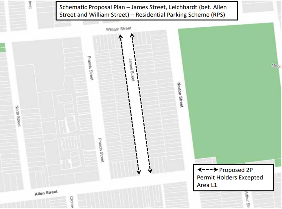
Currently James Street between William Street and Allen Street has a ‘2P 6pm-10pm Permit Holders Excepted Area L1’ restriction.
This report provides the result of the resident parking scheme investigation in James Street, Leichhardt.
|
RECOMMENDATION
THAT the proposed changes to the existing Resident Parking Scheme in James Street, Leichhardt not be supported at the present time due to low level of support from the community. |
BACKGROUND & OTHER STAFF COMMENTS
Council has received requests from residents of James Street, Leichhardt between William Street and Allen Street for the extension to the time restriction in the existing Resident Parking Scheme (RPS) to address issues with long term parking by non-resident vehicles during the day.
James Street is a local street predominantly surrounded by residential homes and is adjacent to the Norton Street shopping village. The street has 45 degree angle rear to kerb parking on the west side and parallel parking on the east side. Existing restrictions on both sides of James Street (between William Street and Allen Street) is ‘2P 6pm-10pm Permit Holders Excepted Area L1’.
Parking occupancy surveys throughout the day have indicated that parking occupancy levels in this section of James Street were high (over 85%) which warranted further investigation for a review of the current RPS. Hence changes were proposed to alleviate parking concerns raised by residents of James Street, Leichhardt as shown in the following figure.
Community engagement was undertaken during July and August, inviting to provide feedback on two options:
· Option 1: ‘2P 8am-10pm (Mon-Fri), 6pm-10pm (Sat-Sun) Permit Holders Excepted Area L1’
· Option 2: ‘2P 8am-10pm Permit Holders Excepted Area
L1’
FINANCIAL IMPLICATIONS
Nil.
PUBLIC CONSULTATION
A letter outlining the above proposal was mailed out to the directly affected properties in James Street and adjacent properties.
Consultation survey results are summarized as follows:
Number of properties within RPS area - 59
Number of properties responded - 19
Number of properties supported - 18 (12 for Option 1 and 6 for Option 2)
The support rate for the extension of the existing RPS restriction is 31% of consulted properties, which does not satisfy Council’s Resident Parking Scheme policy requirements of 50% support.
The main objections raised during the consultation are summarised below:
· Restricts people visiting restaurants in Norton Street.
· Parking situation is not at a point where further restriction is required.
|
|
Local Traffic Committee Meeting 18 October 2021 |
Subject: LILYFIELD ROAD, LILYFIELD - PROPOSED REMOVAL OF EXISTING BUS ZONE (GULGADYA-LEICHHARDT WARD/BALMAIN ELECTORATE/LEICHHARDT PAC)
Prepared By: David Yu - Engineer - Traffic and Parking Services
Authorised By: Manod Wickramasinghe - Traffic and Transport Planning Manager
SUMMARY
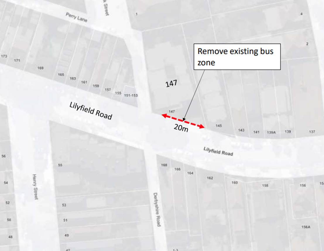
Council has received a request to remove a redundant existing ‘Bus Zone’ on the northern side of Lilyfield Road, Lilyfield (in front of 147 Lilyfield Road) to reinstate unrestricted parking at this location.
|
RECOMMENDATION
THAT the existing 20m ‘Bus Zone’ zone on the northern side of Lilyfield Road, Lilyfield (in front of 147 Lilyfield Road) be removed and reinstated with unrestricted parking. No Stopping (L) sign east of Perry Lane be retained. |
BACKGROUND & OTHER STAFF COMMENTS
Council has been advised by Transit Systems that the existing ‘Bus Zone’ in Lilyfield Road is no longer used by Transit System buses and is therefore redundant. It is proposed to remove the 20m existing ‘Bus Zone’ on the northern side of Lilyfield Road, Lilyfield (in front of 147 Lilyfield Road) and reinstate unrestricted parking at this location, with the existing ‘No Stopping’ zone east of Perry Lane to be retained.
FINANCIAL IMPLICATIONS
Nil.
PUBLIC CONSULTATION
Nil.
|
|
Local Traffic Committee Meeting 18 October 2021 |
Subject: Nowranie Lane, Summer Hill- Proposed extension of ‘No Stopping’ and installation of ‘No Parking’ zone (Djarrawunang-Ashfield Ward/Summer Hill Electorate/Ashfield PAC)
Prepared By: Boris Muha - Engineer – Traffic and Parking Services
Authorised By: Manod Wickramasinghe - Traffic and Transport Planning Manager
SUMMARY
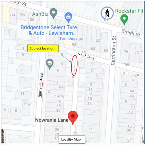
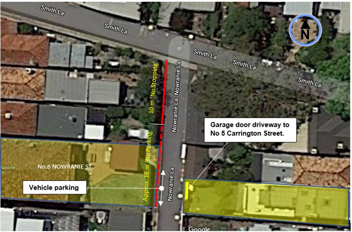
Council has received complaints regarding vehicles parking in Nowranie Lane obstructing driveway access and vehicle movement near to the intersection of Smith Lane, Summer Hill.
To alleviate this issue, it is proposed that the western corner side of Nowranie Lane, south of Smith Lane, have its existing ‘No Stopping’ restrictions extended from 5 metres to 10 metres and introduce ‘No Parking’ to a distance of approximately 16 metres south thereof.
|
RECOMMENDATION
THAT the western corner side of Nowranie Street, south of Smith Lane, Summer Hill be signposted with an extended distance of ‘No Stopping’ (from 5 metres) to 10 metres commencing from Smith Lane followed by ‘No Parking’ approximately 16 metres south thereof.
|
BACKGROUND
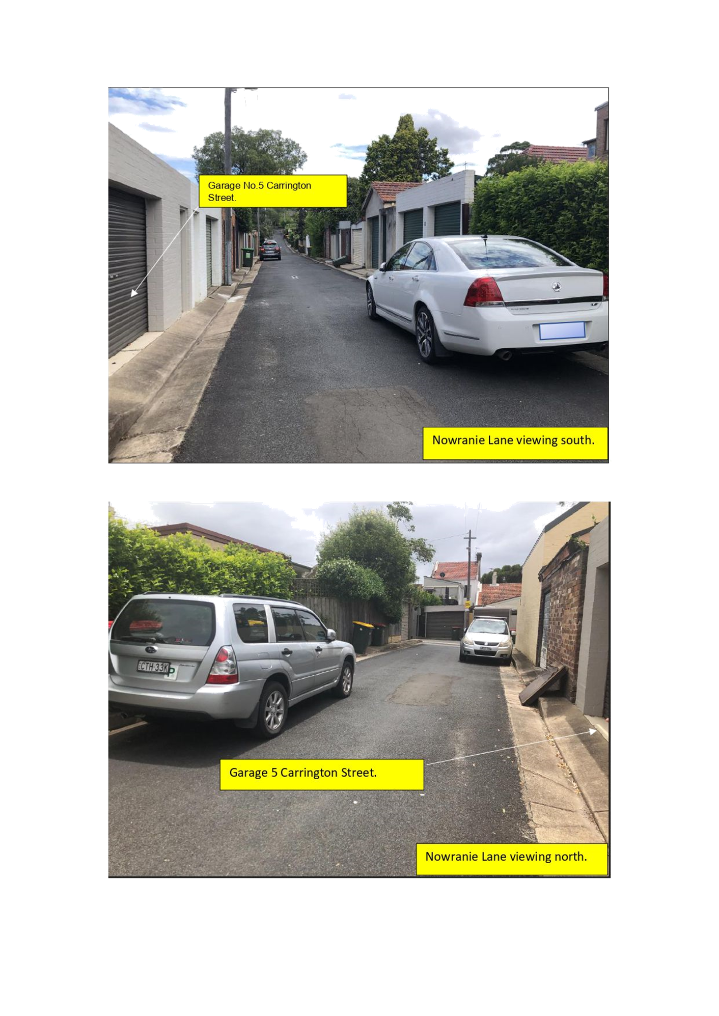
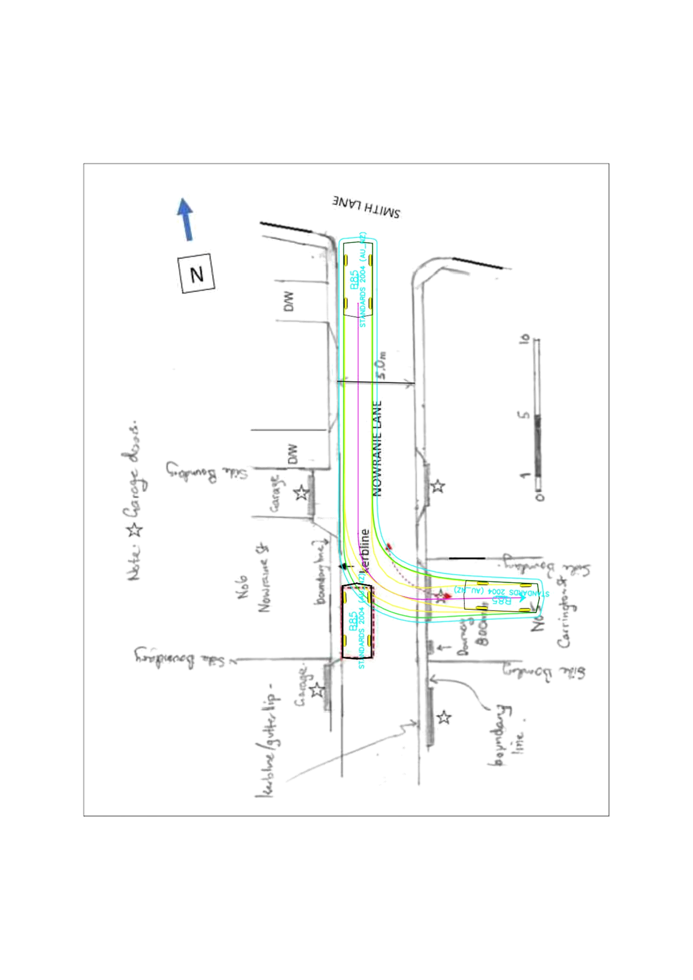
Nowraine Lane measures approximately 5.0 metres in width kerb to kerb with numerous clusters of rear driveways to various properties.
The western side of Nowranie Lane is unrestricted and eastern side signposted with ‘No Parking 6.00am - 3.00pm Monday Only’ on days for waste collection. Vehicles are known to ‘pocket’ park between driveways where possible. Within the subject location a kerb length of approx. 7.9 metres exists between garages and encourages vehicles to park to the rear of No 6 Nowranie Street. However, a vehicle parking in this location obstructs the opposing driveway access to No 5 Carrington Street. See locality map, and diagram below further identifying the problematic parking area and opposing affected garage. Photos are also provided in Attachment 1.
‘No Parking’ was previously proposed and supported by the Traffic Committee at this location but deferred by Council for further investigation due to disputing objection in the loss of parking.
Council officers have re-visited the site and provide the following information.
FINANCIAL IMPLICATIONS
NIL
OTHER STAFF COMMENTS
Laneways were solely constructed for the purpose of access to properties. It is known that vehicles opt to park where they can in laneways, provided they do not obstruct traffic passage- way within the lane or driveway access.
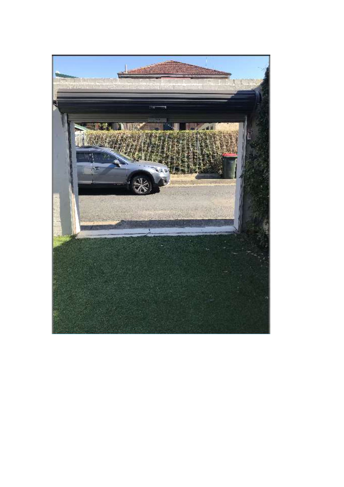
The owner of No.5 Carrington Street has identified that his driveway is active and that it is properly constructed with a 3m wide garage door to provide access to the rear yard of open space area designed to accommodate a vehicle off-street.
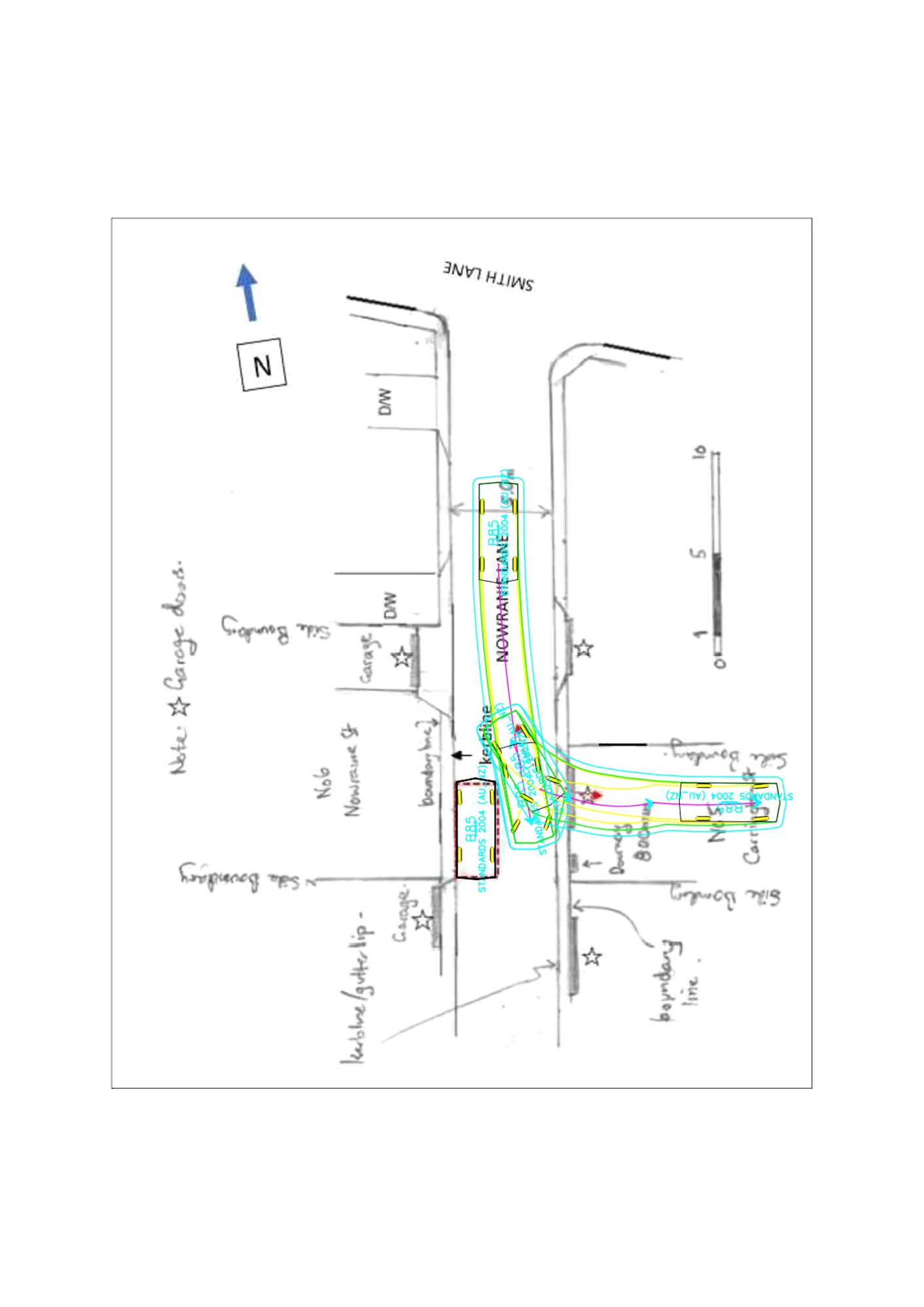
The photo (Attachment 2) endeavours to show a vehicle (as viewed from the inside of the property-No 5 Carrington Street) parked as far south along the frontage of No. 6 Nowranie Street. An attempt is made to show with diagrammatic swept path movements, a vehicle entering the driveway in a proper forward direction and at an angled forward and reverse direction on the assumption that a vehicle could be parked as far south opposite the garage (Attachment 3-5).
The forward in direction (Attachment 3) clearly indicates contact with the parked vehicle. This swept path similarly accounts for reversing into the driveway. The green line is the vehicle overhang and blue line provides a minimum 300mm circulation clearance. Australian Standards advise that the outside curve clearance should be a min 600 mm.
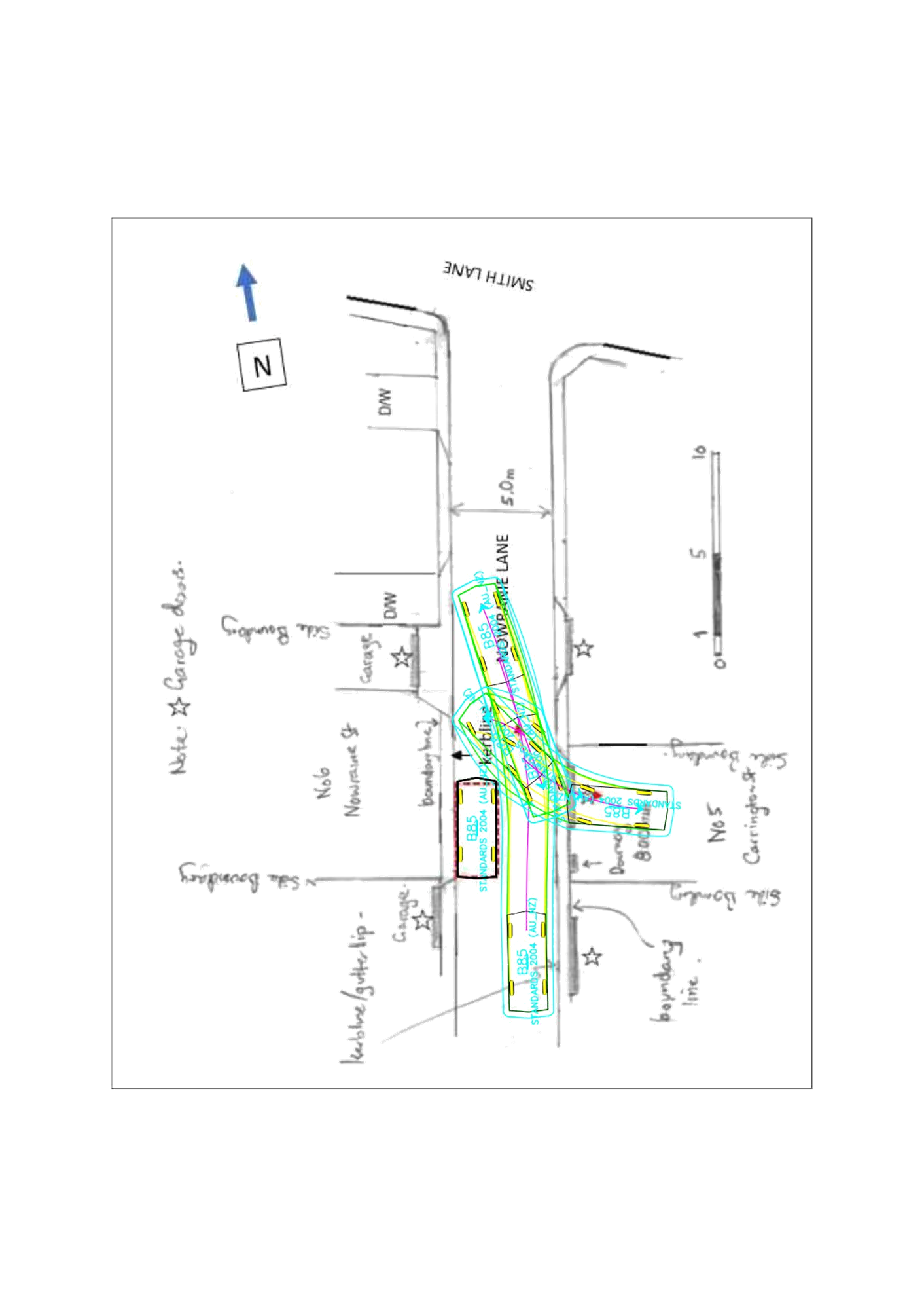
Attachment 4 and 5 show acute angle movements in and out of the garage under a 3- point turn. However, contact/uncomfortable clearance is made with the garage wall ends if not the parked vehicle. At least a 4- point movement would need to be carried out to safely negotiate the garage opening. The parked vehicle prevents any further point movements from being carried out. Sharp angle driveway access movements should not be expectant upon the driveway owner to carry out.
If the parked vehicle was moved forward, it would not only obstruct the driveway to No.5 Carrington Street, but it would also infringe onto the driveway of No.6 Nowranie Street and obstruct access to driveways to the north.
The Inner West Council Public Domain Parking Policy Section 7.7 -Parking in Laneways states that: Council will prioritise access to off-street parking spaces over parking provision within the laneway.
The proposed ‘No Parking’ to the rear of No.6 Nowranie Street can permit the short time to drop off and pick up persons or goods (including materials) and that the driver thereafter moves the vehicle to an area which would allow that driver to park their vehicle. The ‘No Parking’ under the Road Rules permits the vehicle to park up to 2 minutes and that the driver must be within 3 metres of the vehicle.
CONSULTATION
Consultation letters were sent out to household occupants and owners in the vicinity (approx. 25 letters). The letters were posted on the 21 September 2021 with closure on submissions being Wednesday 6 October 2021.
(3) responses were received, (2) in support and (1) objection.
One of the support submissions was from the owner of 5 Carrington Street re-affirming the need for driveway access to his property and that his need far exceeds the convenience of persons parking opposite his driveway.
The (1) objection is made from the owner of the unit block No. 6 Nowranie Street. They claim to occasionally park there to check or oversee gardening/mowing works to her property or deliver gardening tools etc. The owner is elderly and has limited ability to walk at even short distances. The owner and tradespeople conveniently rely to park at the rear of premises. The owner finds it difficult to park elsewhere bearing on a health condition and seeks on compassionate grounds to maintain the parking. A garage is located to the rear of this property; however the owner claims the garage is leased out to one of the tenants, and similarly is inaccessible based on their condition (e.g. internal garage clearance inadequate-needing to fully open car doors out)
As stated above under the policy Council must consider and prioritise access to off-street parking spaces over parking provision within the laneway. The following options are suggested to assist the owner of No.6 Nowranie to explore other avenues to park on street or off-street.
· Park in other ‘pocket’ locations in the laneway not interfering in laneway or driveway access.
· Drop off and pick up persons or goods under the proposed area of ‘No Parking’ and move the vehicle to areas permitting longer stay parking.
· Investigate under the policy possible permits for trades persons/gardeners to apply and park longer periods of time in designated 2P (permit holder excepted) parking zones in surrounding streets or lanes, if unable to park in ‘unrestricted’ parking zones.
· If holding and displaying a Mobility Parking Permit within a vehicle, the person can park longer periods of time under (Road Rule) concession in designated 2P (permit holder excepted) parking zones in the surrounding streets or lanes, if unable to park in ‘unrestricted’ parking zones.
· If inaccessible, seek to modify the garage to improve off-street parking opportunity.
· Seek (pending on planning criteria) to extend layback and provide additional back yard off-street access aside of the garage. The off-street space could be open concrete slab or grassed covered with/without wheel strips.
CONCLUSION:
In view of the above, it is recommended that western corner side of Nowranie Street, south of Smith Lane, Summer Hill proceed to be signposted with an extended distance of ‘No Stopping’ to 10 metres followed by ‘No Parking’ approximately 16 metres south thereof.
|
1.⇩ |
Photos of parked cars opposite Garage (5 Carrington Street) in Nowranie Lane. |
|
2.⇩ |
View from inside garage-backyard (5 Carrington St) with car parked opposite laneway as far south. |
|
3.⇩ |
Swept Path A - Forward and proper entry movement into Garage No5. Carrington Street |
|
4.⇩ |
Swept Path B - Forward angled entry into rear garage to No.5 Carrington Street |
|
5.⇩ |
Swept Path C - Reverse angle entry into rear garage 5 Carrington Street. |