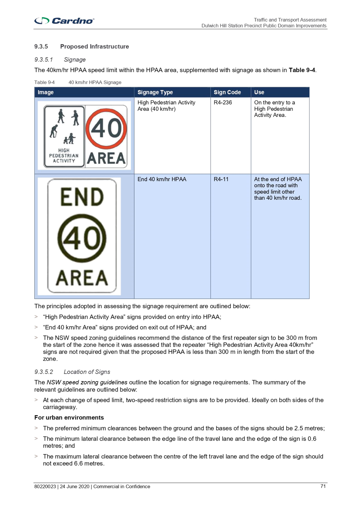
|
AGENDA R |

Local Traffic Committee Meeting
MONDAY 7 FEBRUARY 2022
10.00am
|
|
Local Traffic Committee Meeting 7 February 2022 |
Function of the Local Traffic Committee
Background
Roads and Maritime Services (RMS) is legislated as the Authority responsible for the control of traffic on all NSW Roads. The RMS has delegated certain aspects of the control of traffic on local roads to councils. To exercise this delegation, councils must establish a local traffic committee and obtain the advice of the RMS and Police. The Inner West Council Local Traffic Committee has been constituted by Council as a result of the delegation granted by the RMS pursuant to Section 50 of the Transport Administration Act 1988.
Role of the Committee
The Local Traffic Committee is primarily a technical review and advisory committee which considers the technical merits of proposals and ensures that current technical guidelines are considered. It provides recommendations to Council on traffic and parking control matters and on the provision of traffic control facilities and prescribed traffic control devices for which Council has delegated authority. These matters are dealt with under Part A of the agenda and require Council to consider exercising its delegation.
In addition to its formal role as the Local Traffic Committee, the Committee may also be requested to provide informal traffic engineering advice on traffic matters not requiring Council to exercise its delegated function at that point in time, for example, advice to Council’s Development Assessment Section on traffic generating developments. These matters are dealt with under Part C of the agenda and are for information or advice only and do not require Council to exercise its delegation.
Committee Delegations
The Local Traffic Committee has no decision-making powers. The Council must refer all traffic related matters to the Local Traffic Committee prior to exercising its delegated functions. Matters related to State Roads or functions that have not been delegated to Council must be referred directly to the RMS or relevant organisation.
The Committee provides recommendations to Council. Should Council wish to act contrary to the advice of the Committee or if that advice is not supported unanimously by the Committee members, then the Police or RMS have an opportunity to appeal to the Regional Traffic Committee.
Committee Membership & Voting
Formal voting membership comprises the following:
· one representative of Council as nominated by Council;
· one representative of the NSW Police from each Local Area Command (LAC) within the LGA, being Newtown, Marrickville, Leichhardt and Ashfield LAC’s.
· one representative from the RMS; and
· State Members of Parliament (MP) for the electorates of Summer Hill, Newtown, Heffron, Canterbury, Strathfield and Balmain or their nominees.
Where the Council area is represented by more than one MP or covered by more than one Police LAC, representatives are only permitted to vote on matters which effect their electorate or LAC.
Informal (non-voting) advisors from within Council or external authorities may also attend Committee meetings to provide expert advice.
Committee Chair
Council’s representative will chair the meetings.
Public Participation
Members of the public or other stakeholders may address the Committee on agenda items to be considered by the Committee. The format and number of presentations is at the discretion of the Chairperson and is generally limited to 3 minutes per speaker. Committee debate on agenda items is not open to the public.
|
|
Local Traffic Committee Meeting 7 February 2022 |
|
AGENDA |
1 Apologies
2 Disclosures of Interest
3 Confirmation of Minutes
Minutes of 6 December 2021 Local Traffic Committee Meeting 5
4 Matters Arising from Council’s Resolution of Minutes
5 Part A – Items Where Council May Exercise Its Delegated Functions
Traffic Matters
ITEM Page
LTC0222(1) Item 1
Canal Road and Charles Street, Leichhardt – Proposed Traffic
Calming and Pedestrian Facility (GULGADYA-LEICHHARDT
WARD/BALMAIN ELECTORATE/LEICHHARDT PAC)
10
LTC0222(1) Item 2
Dulwich Hill Station Precinct Public Domain Improvements -
Stage 2 Works (Djarrawunang-Ashfield Ward / Summer Hill
Electorate / Inner West PAC) 14
LTC0222(1) Item 3
Addison Road, Marrickville – Proposed new pedestrian refuge -
Design Plan 10117_A ((Midjuburi-Marrickville Ward /
NEWTOWN and SUMMER HILL ELECTORATES / INNER
WEST PAC) 127
LTC0222(1) Item 4
O'Neill Street, Lilyfield (West of Foucart Street) - Proposed 'No
Parking' restrictions (Baludarri-Balmain Ward/Balmain
Electorate/Leichhardt PAC) 133
LTC0222(1) Item 5
Kegworth Street, Leichhardt At Intersection
With Tebbutt Street–Intersection Development
For Pedestrian And Children Safety–Traffic
Facilities (GULGADYA-LEICHHARDT WARD/BALMAIN
ELECTORATE/LEICHHARDT PAC) 135
LTC0222(1) Item 6
Intersection of Edward Street and Mungo Scott
Place/WellesleyStreet-Interim treatment of intersection for
improved sight line. (DJARRAWUNANG-ASHFIELD
WARD/SUMMER HILL ELECTORATE/ASHFIELD PAC) 138
Parking Matters
ITEM Page
LTC0222(1) Item 7
Annandale Street, Annandale - Removal of 'No Parking Police
Vehicles Excepted' restrictions (GULGADYA-LEICHHARDT
WARD/BALMAIN ELECTORATE/LEICHHARDT PAC) 142
LTC0222(1) Item 8
Marrickville Road, Marrickville near Livingstone Road -
Implementation of short-term parking restrictions (MIDJUBURI-
MARRICKVILLE WARD/ SUMMER HILL ELECTORATE/
INNER WEST PAC) 144
Late Items
Nil at time of printing.
6 Part B - Items for Information Only
Nil at the time of printing.
7 Part C - Items for General Advice
Nil at the time of printing.
8 General Business
9 Close of Meeting
|
|
Local Traffic Committee Meeting 7 February 2022 |
Minutes of Local Traffic Committee Meeting
Held remotely on 6 December 2021
Meeting commenced at 10.04AM
ACKNOWLEDGEMENT OF COUNTRY BY CHAIRPERSON
I acknowledge the Gadigal and Wangal people of the Eora nation on whose country we are meeting today, and their elders past and present.
COMMITTEE REPRESENTATIVES PRESENT
|
Manod Wickramasinghe |
IWC’s Traffic and Transport Planning Manager (Chair) |
|
Bill Holliday |
Representative for Jamie Parker MP, Member for Balmain |
|
Cathy Peters |
Representative for Jenny Leong MP, Member for Newtown |
|
Solon Ghosh |
Transport for NSW (TfNSW) |
|
|
|
|
NON VOTING MEMBERS IN ATTENDANCE |
|
|
|
|
|
Adrian Prichard |
Transit Systems – Inner West Bus Services |
|
Colin Jones |
Inner West Bicycle Coalition (IWBC) |
|
George Tsaprounis |
IWC’s Coordinator Traffic Engineering Services (South) |
|
Sunny Jo |
IWC’s Coordinator Traffic Engineering Services (North) |
|
Jason Scoufis |
IWC’s Traffic and Parking Planner |
|
Christina Ip |
IWC’s Business Administration Officer |
|
|
|
|
VISITORS |
|
|
|
|
|
Nil. |
|
|
|
|
|
APOLOGIES: |
|
|
|
|
|
SC Germaine Grant |
NSW Police – Burwood Police Area Command |
|
Sgt Charles Buttrose |
NSW Police –Leichhardt Police Area Command |
DISCLOSURES OF INTERESTS:
Nil.
CONFIRMATION OF MINUTES
|
The minutes of the Local Traffic Committee meeting held on 15 November 2021 were confirmed. |
MATTERS ARISING FROM COUNCIL’S RESOLUTION OF MINUTES
The minutes of the Local Traffic Committee meeting held on 15 November 2021 are awaiting adoption.
EMAIL CONFIRMATION OF OFFICER’S RECOMMENDATION
The representative for NSW Police – Burwood supported the Officer’s recommendations for the items in their PAC.
The representative for NSW Police – Leichhardt supported the Officer’s recommendations for the items in their PAC.
|
The proposed schedule of the Local Traffic Committee meetings has been prepared for the 2022 calendar year. It is recommended that the proposed meeting schedule be received and noted.
Officer’s Recommendation
THAT the proposed schedule of meetings of the Local Traffic Committee for the 2022 calendar year be received and noted.
DISCUSSION
Meetings are proposed to be held face-to-face at Ashfield Service Centre, subject to COVID restrictions.
The Committee members agreed with the Officer’s recommendation.
COMMITTEE RECOMMENDATION
THAT the proposed schedule of meetings of the Local Traffic Committee for the 2022 calendar year be received and noted.
For motion: Unanimous |
General Business
|
LTC1021(1) Item 6 Pedestrian access to Callan Park from Perry Street, Lilyfield |
|
The representative for the Member for Balmain received feedback from a resident that Perry Street, Lilyfield is difficult to cross to access Callan Park and asked whether a marked pedestrian crossing has been considered to improve access this state road. The TfNSW representative advised that they are considering pedestrian access improvements at the Balmain Road/Perry Street and Balmain Road/Cecily Street intersections. |
Meeting closed at 10.24am.
|
|
Local Traffic Committee Meeting 7 February 2022 |
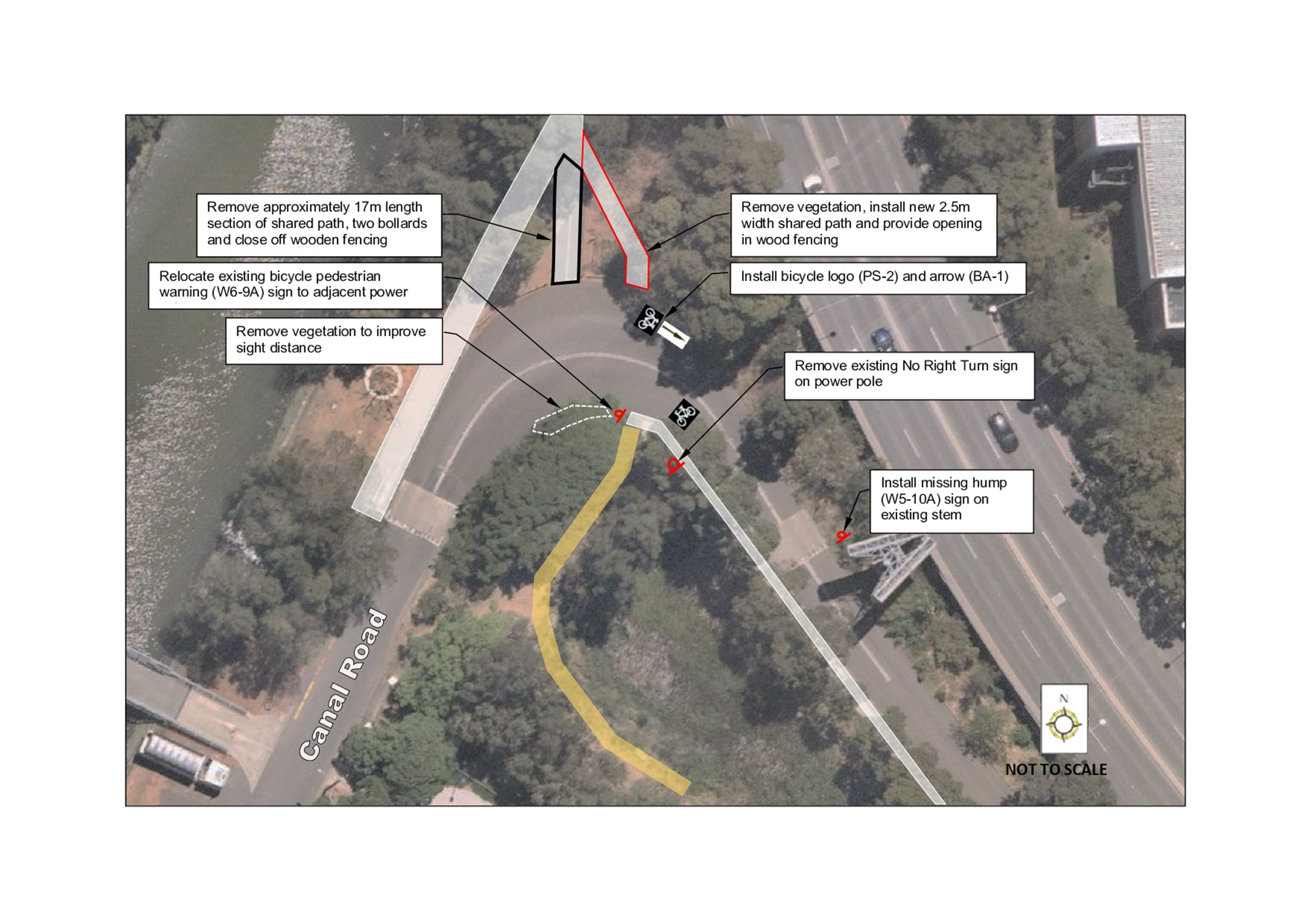
Subject: Canal Road and Charles Street, Leichhardt – Proposed Traffic Calming and Pedestrian Facility (GULGADYA-LEICHHARDT WARD/BALMAIN ELECTORATE/LEICHHARDT PAC)
Prepared By: Sunny Jo - Coordinator Traffic Engineering Services (North)
Authorised By: Manod Wickramasinghe - Traffic and Transport Planning Manager
SUMMARY
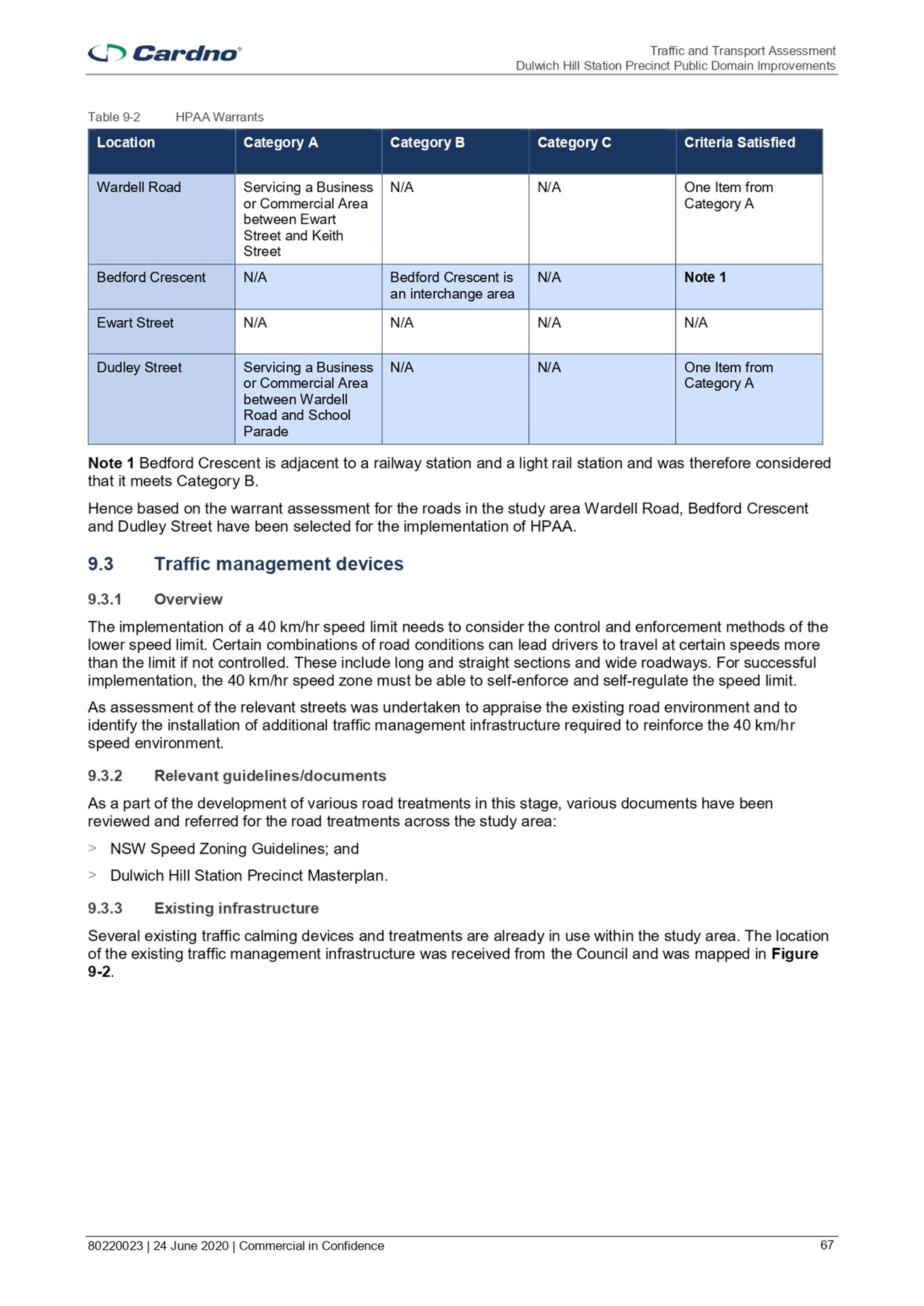
A review has been undertaken in Canal Road and Charles Street following a request for an improvement to pedestrian facilities to improve road safety. Adjustments to the shared path, kerb ramp locations, removal of some vegetation to improve sight distances, and speed cushions are proposed to improve safety.
Canal Road and Charles Street provides vehicular access to Blackmore Oval and the Canal Road Filming Centre. It is also an active transport link from Hawthorne Light Rail stop to the Bays Run circuit and to the Leichhardt North Light Rail stop and the pedestrian overpass across City West Link Road.
|
RECOMMENDATION
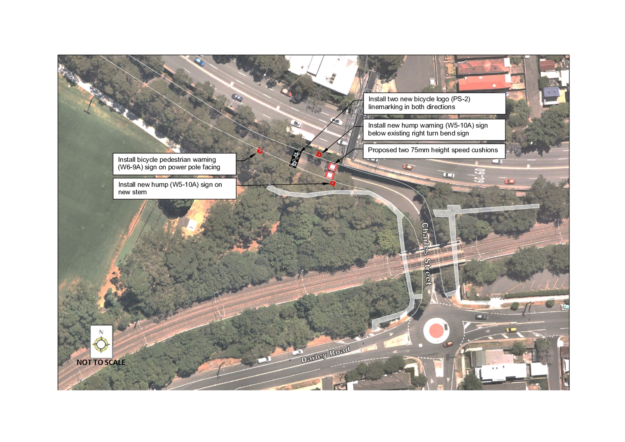
THAT: 1. The kerb ramps and path adjustments be made at the road bend of Canal Road and Charles Street as shown in the attached plan; 2. That changes be made to signage in Charles Street and Canal Road as shown in the attached plan; and 3. Two asphalt speed cushions and associated line marking and signage in Charles Street approximately 50m west of the road bend near the light rail underpass be included in Council’s future Capital Works Program with an estimated cost of $20,000.
|
BACKGROUND AND OTHER STAFF COMMENTS
Council received a request for pedestrian facility improvements including a pedestrian crossing at Canal Road, Leichhardt. The location is used by pedestrians to access the Leichhardt North Light Rail stop and the pedestrian overpass across City West Link Road.
Two crossing locations were reviewed by Council staff and examined ways to improve the existing pedestrian crossing facilities. Both locations are widely used by the community as a recreational path from Hawthorne Light Rail stop to the Bays Run circuit, and to the Leichhardt North Light Rail stop and the pedestrian overpass across City West Link Road.
An examination of the crash database indicates no reported accidents in the subject section of Canal Road or Charles Street.
Canal Road comprises of mainly unformed angle parking along the Hawthorne Canal frontage and provides two way carriageway with low traffic volumes. The roadway is generally shared with recreational users and a separated path is provided from Blackmore Oval, connecting to the Bay Run circuit. Along Charles Street, the road layout is two-way with no on-street parking.
Speed and volume data in Canal Road (2017), indicated an average traffic volume of 830 vehicles per day with 85th percentile speeds of 44.6km/h and 49.6km/h for eastbound and westbound speeds respectively.
At the western road bend at Canal Road, two existing raised thresholds are set up on both approaches to lower vehicle speeds as the area has a high level of pedestrian and bicycle movements. Currently the pedestrian ramps on both sides of the bend do not align and require pedestrians to cross at an angle and not the shortest distance across the road. It is proposed to relocate the crossing location so that visibility is maximised to both approaches.
At the eastern road bend, a kerb ramp is provided along the western side and is intended to connect to a driveway on the other side in order to reach the Leichhardt North Light Rail stop and the City West Link Road overpass. Site investigations suggest that this location would not be a suitable location for a marked foot crossing as visibility is compromised and the warrants for a pedestrian crossing would not be met given the low traffic numbers. As an alternative, pedestrian warning signs are proposed with a 75mm height asphalt speed cushions in Charles Street, approximately 50m west of this location.
FINANCIAL IMPLICATIONS
The estimated cost of two asphalt speed cushions is $20,000, with the path adjustment estimated at $10,000. These will be listed for consideration in Council’s future Capital Works Program.
|
1.⇩ |
Proposed works and signage - Canal Road and Charles Street, Leichhardt |
|
Local Traffic Committee Meeting 7 February 2022 |
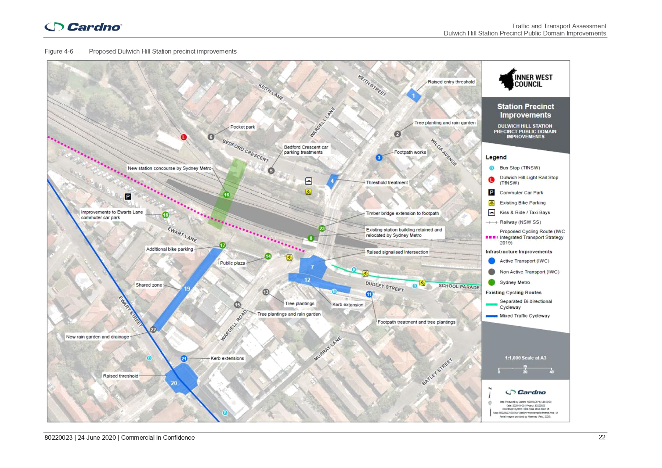
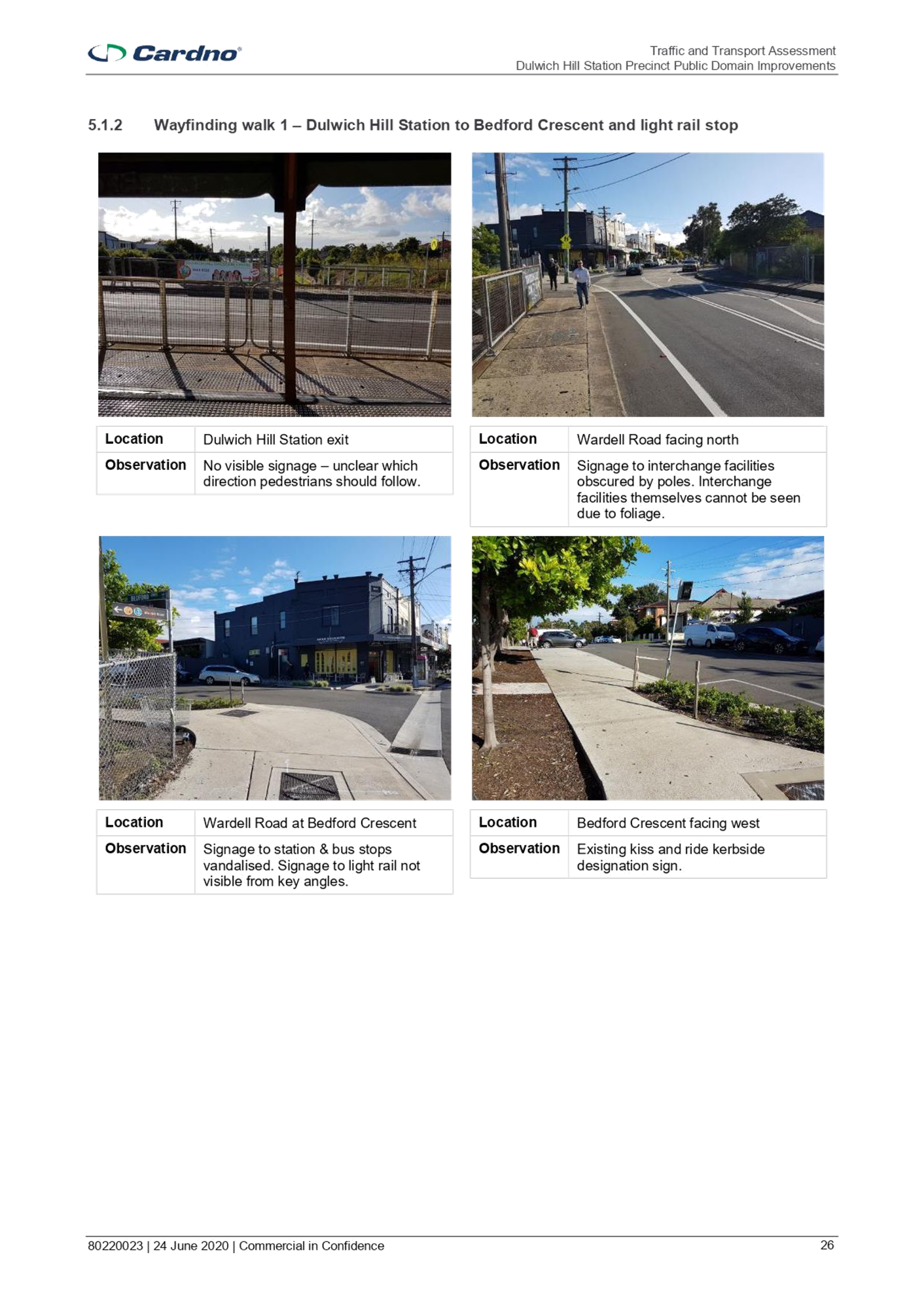
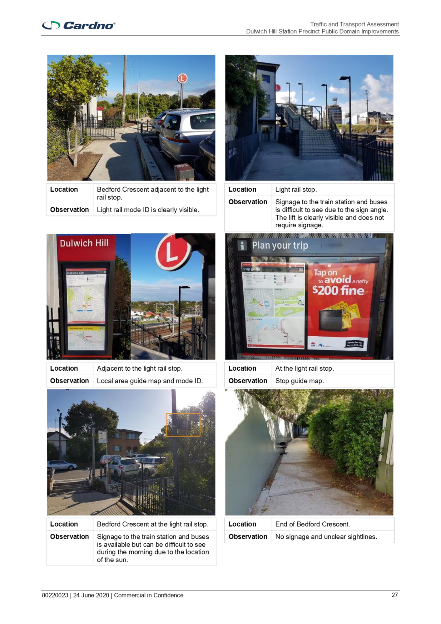
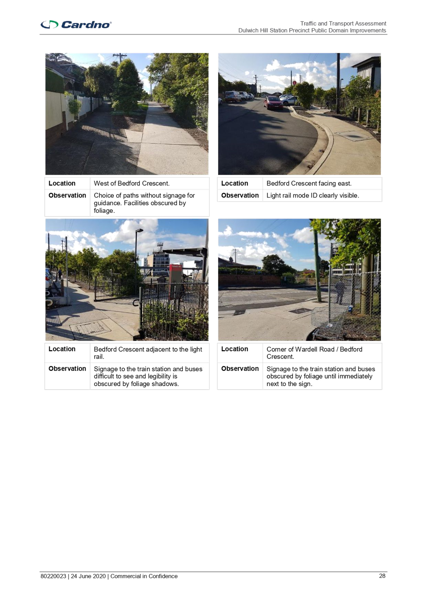
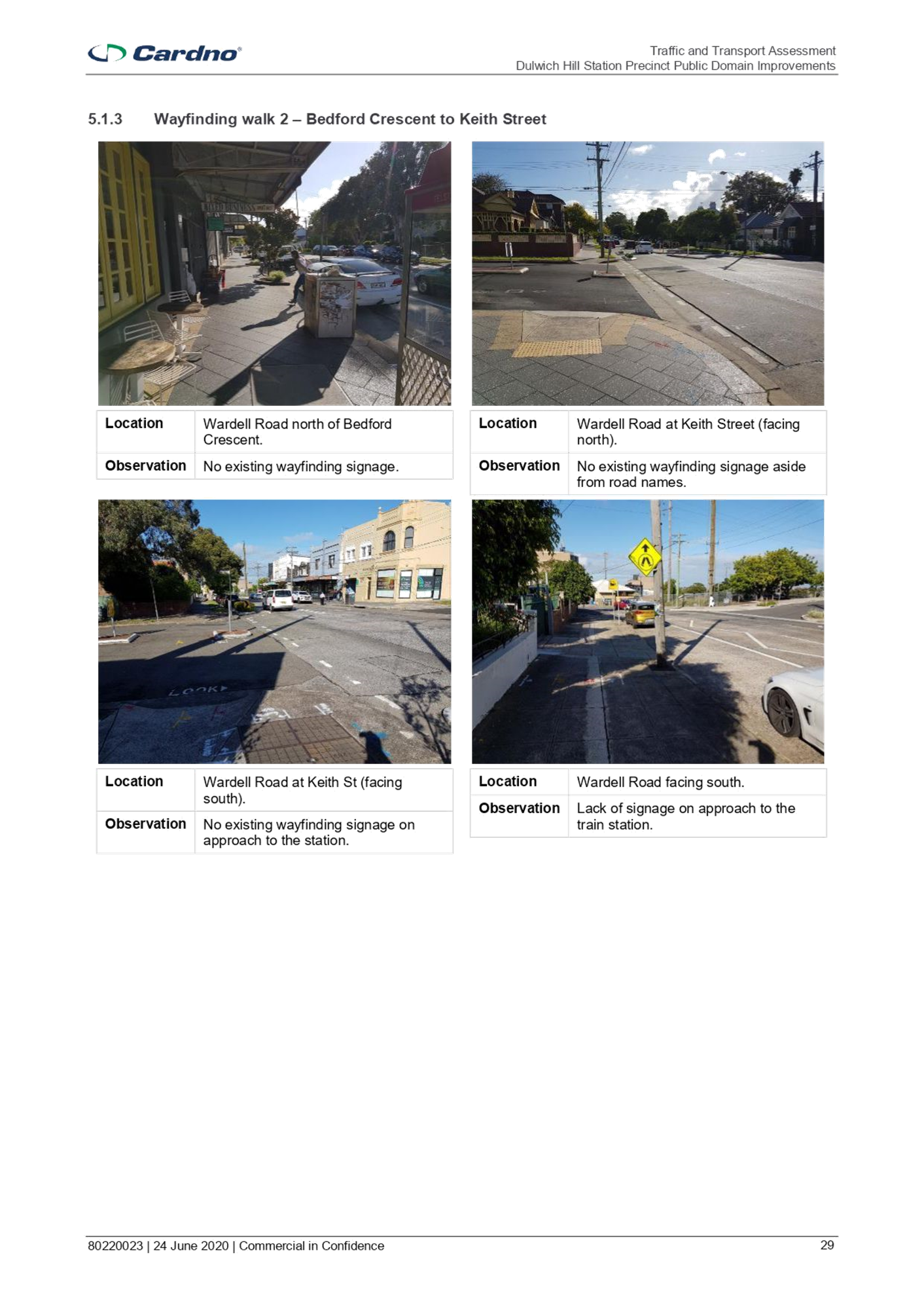
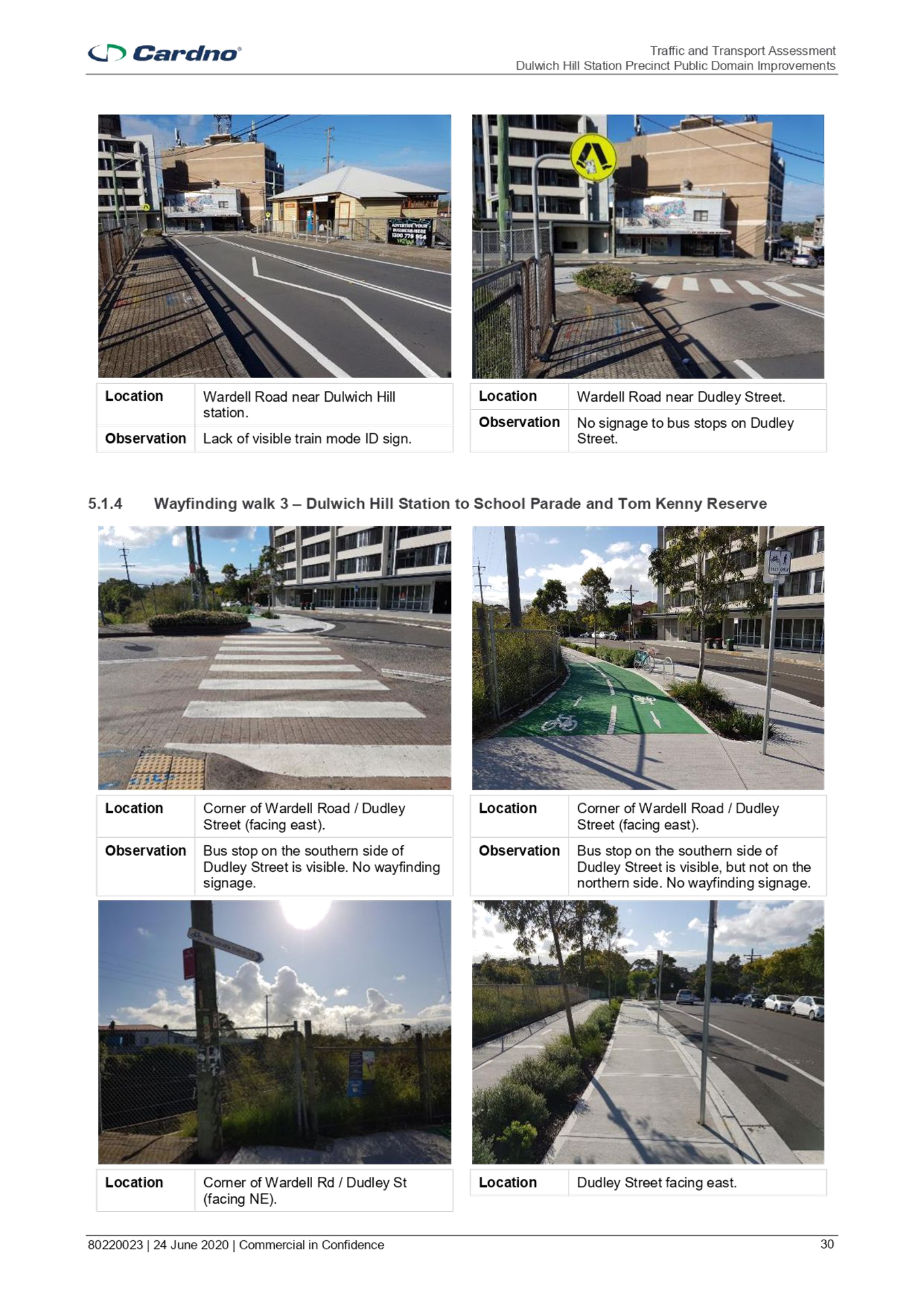
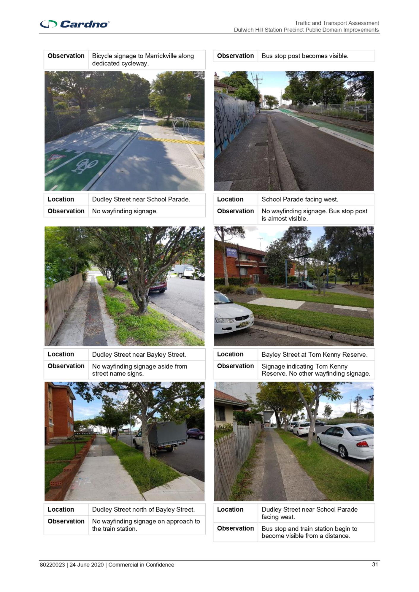
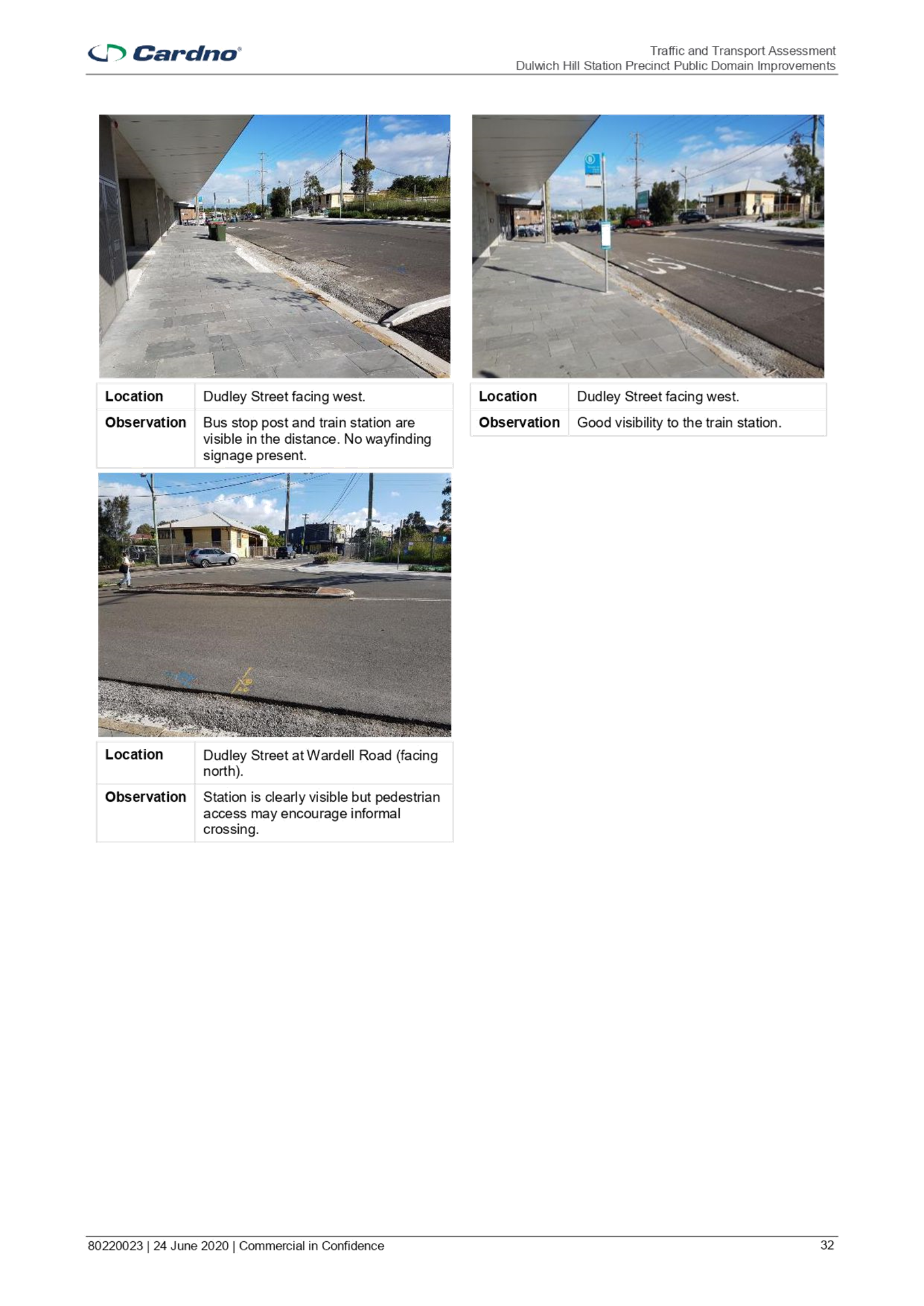
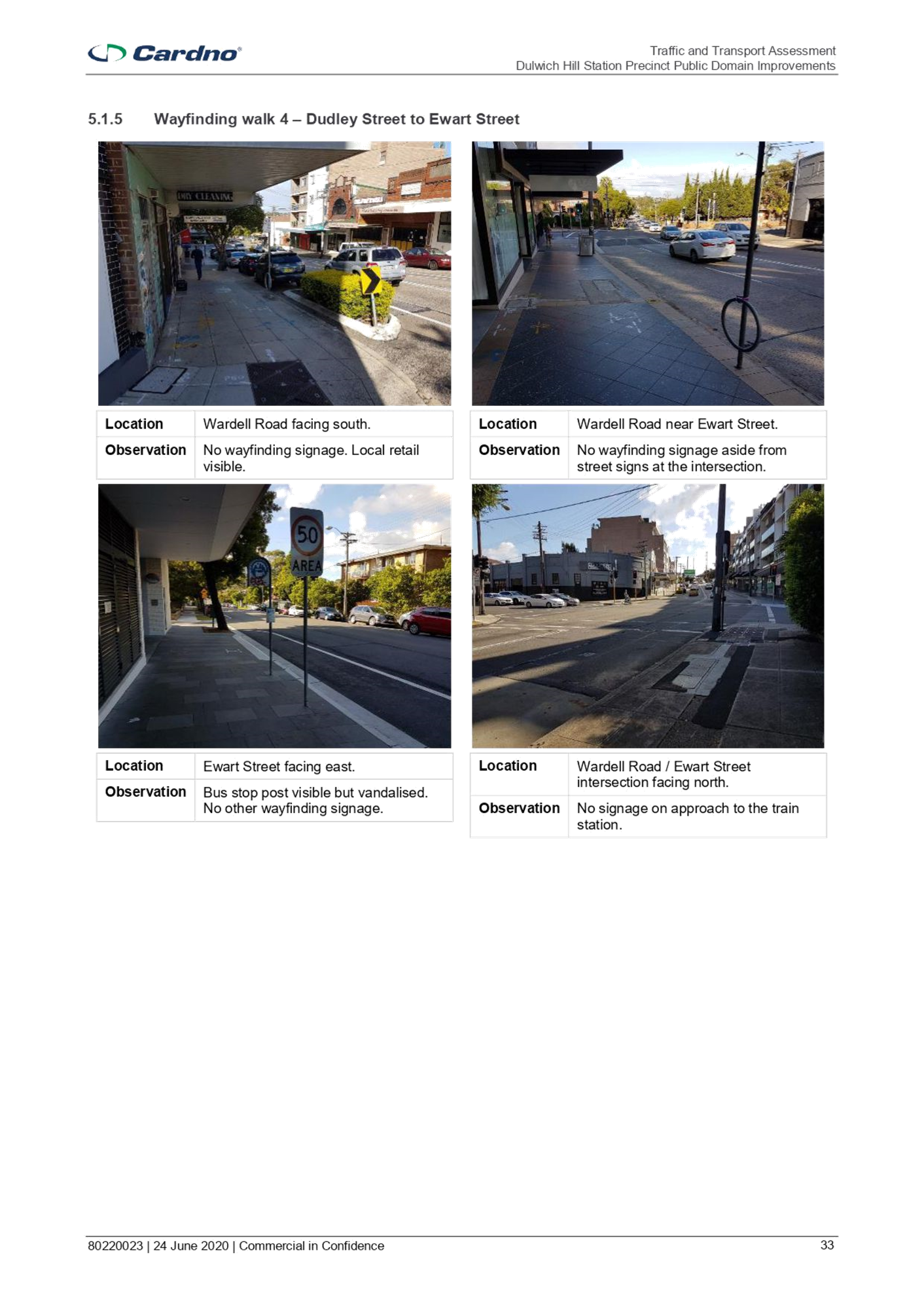
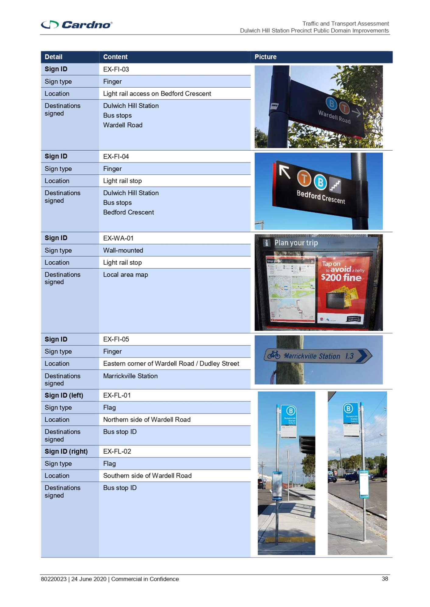
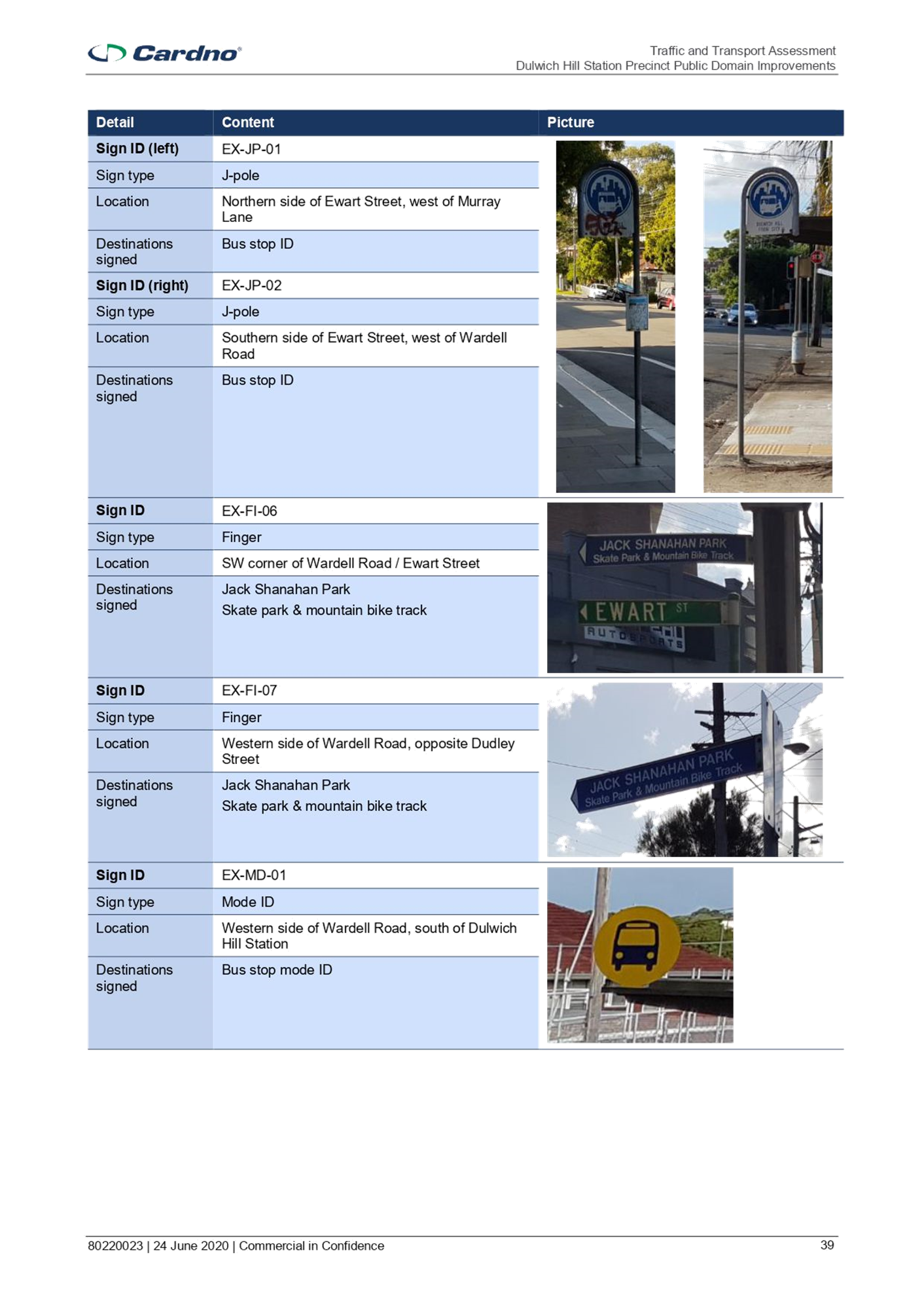
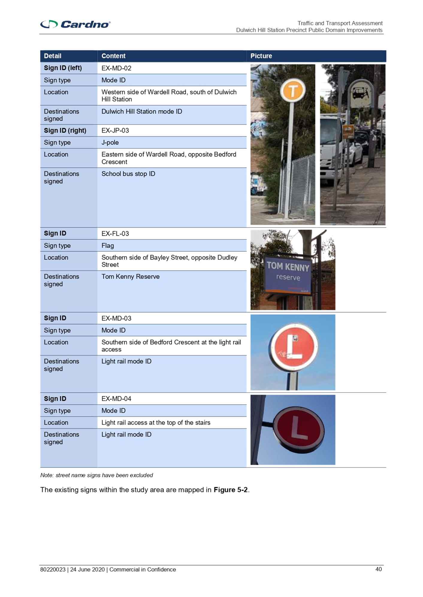
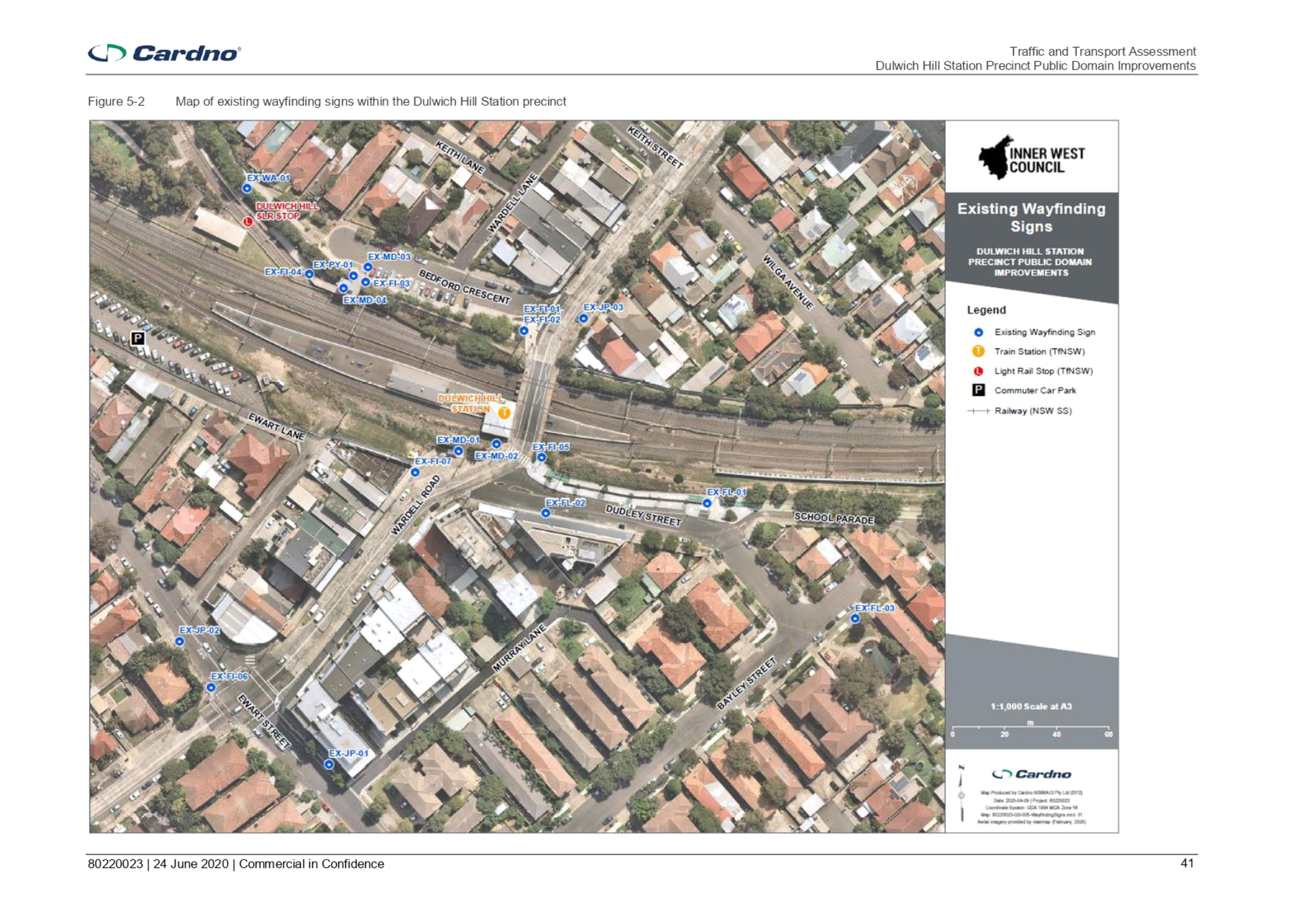
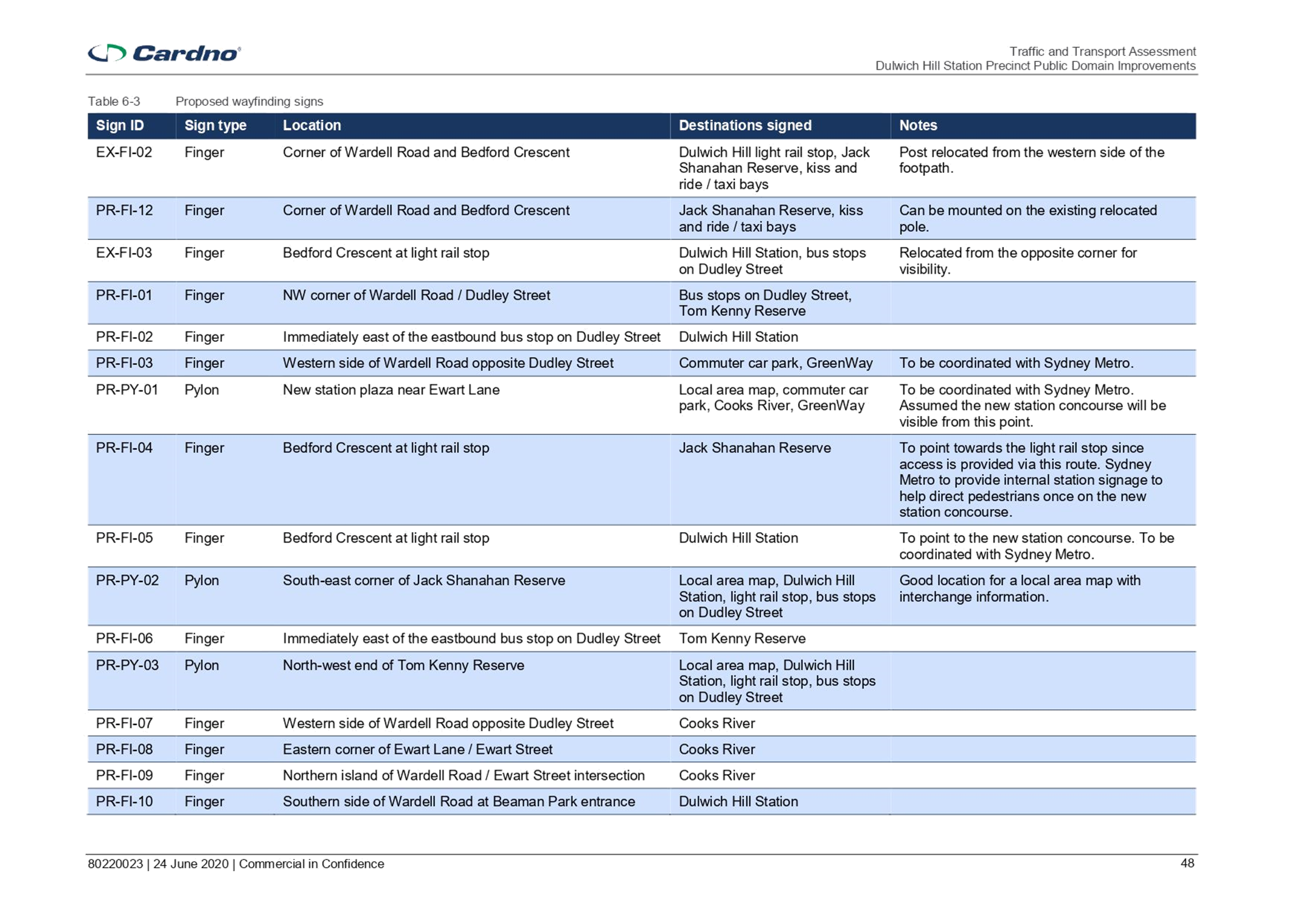
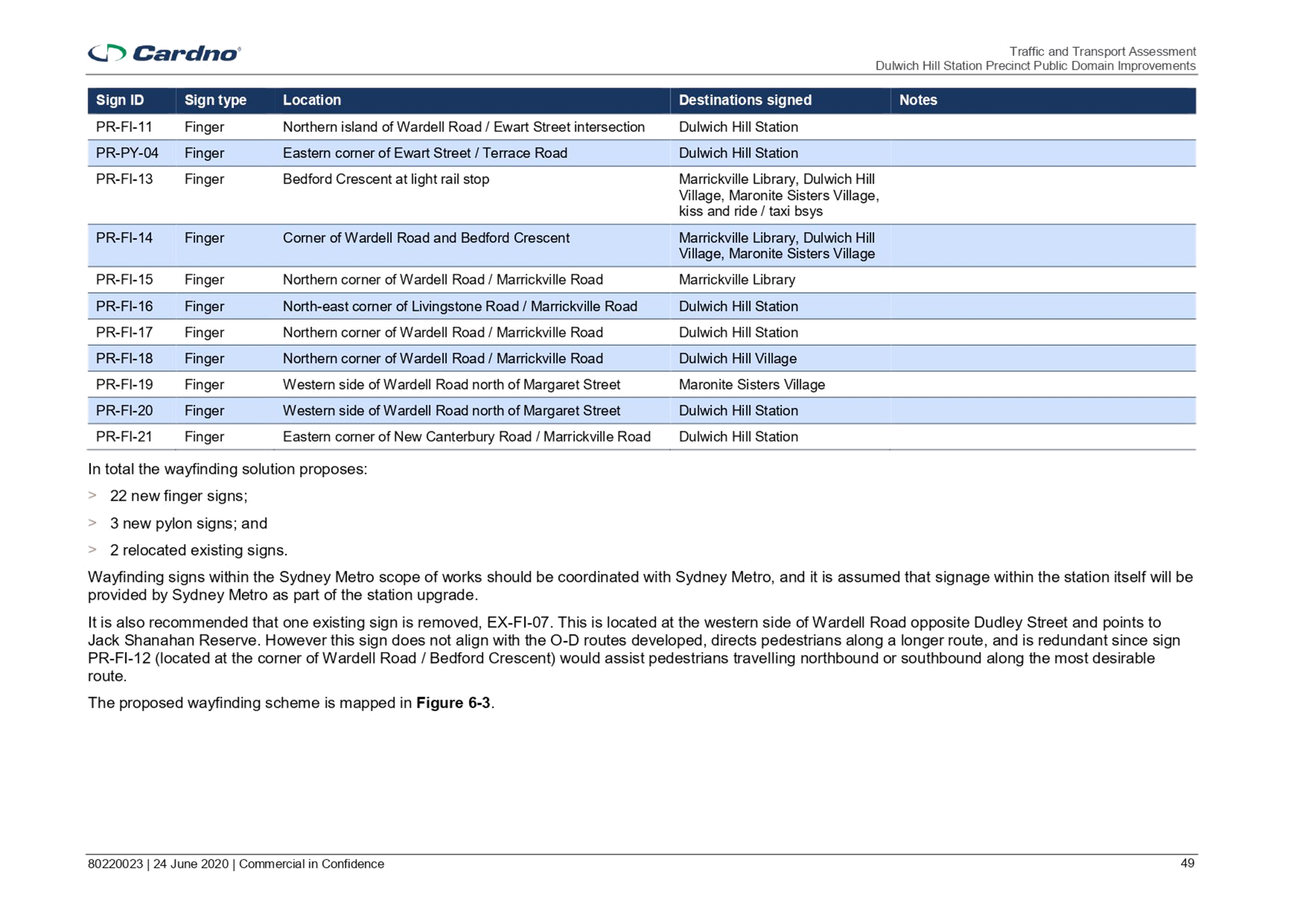
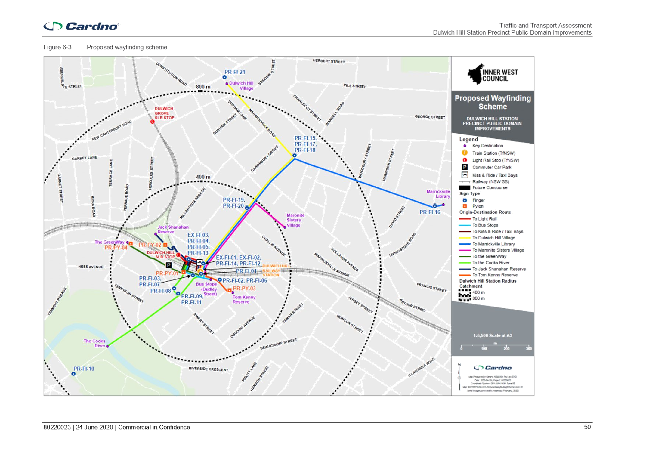
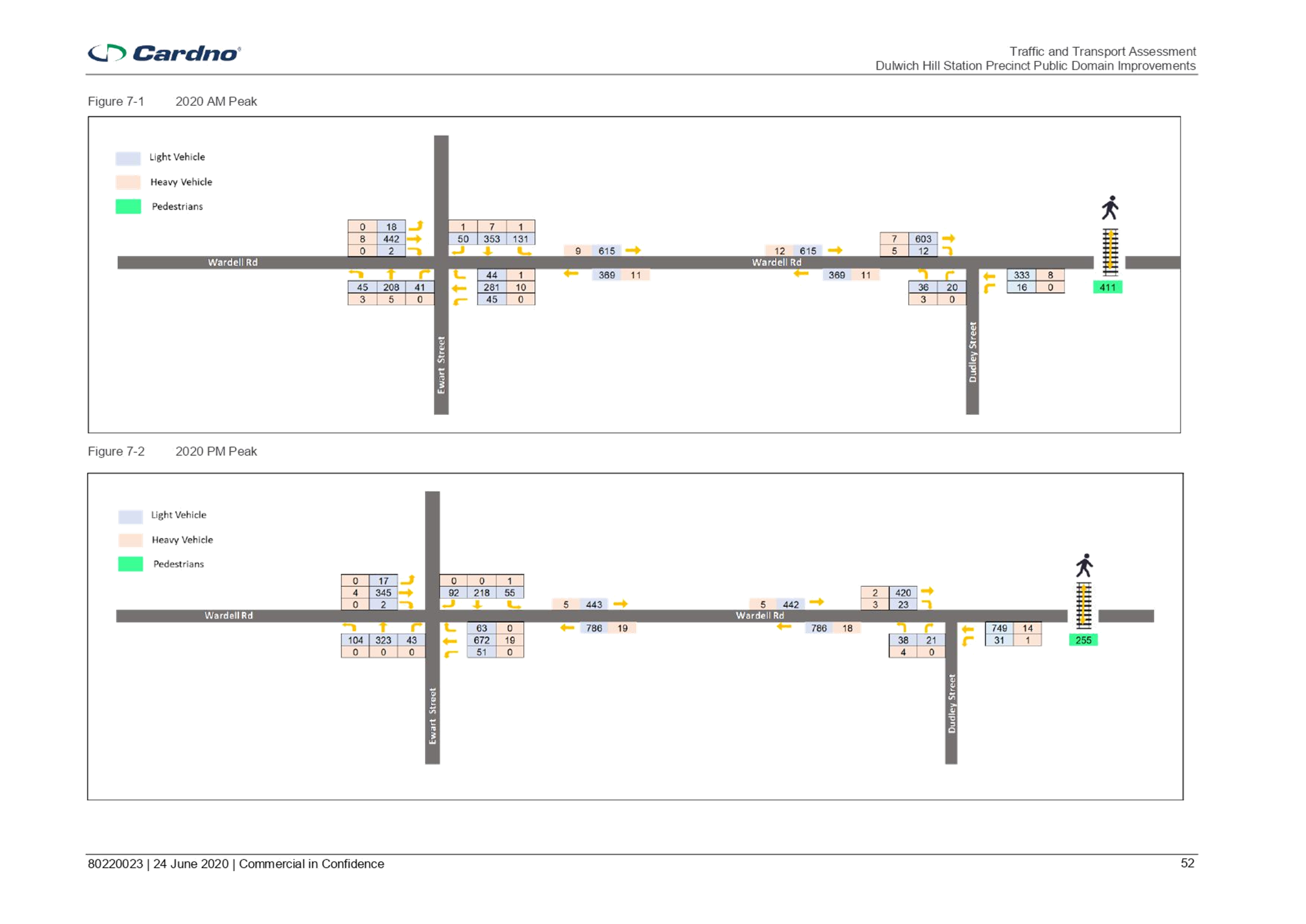
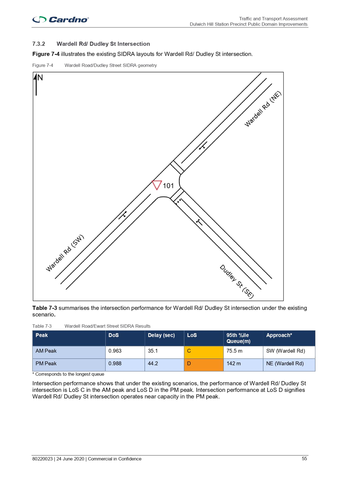
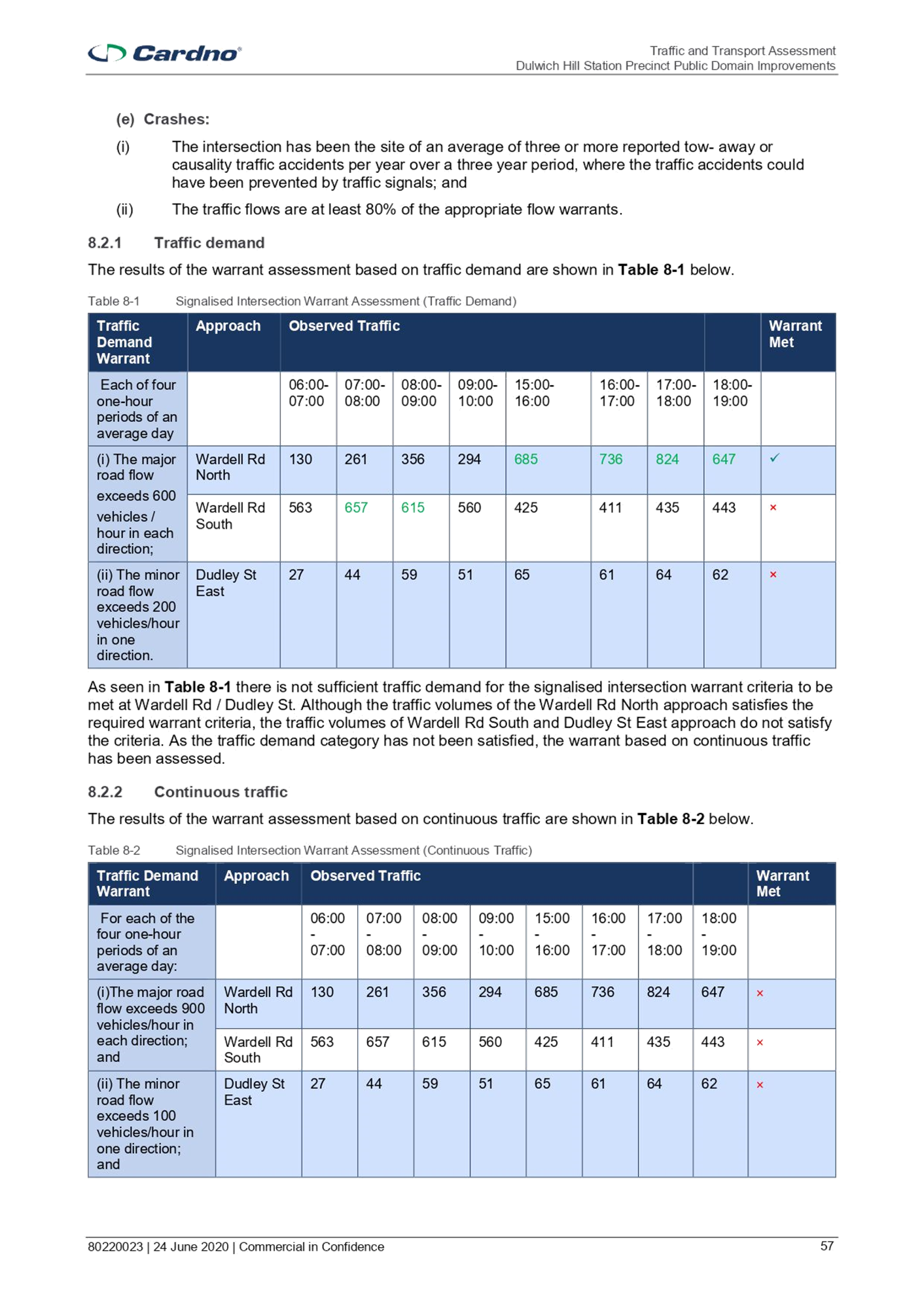
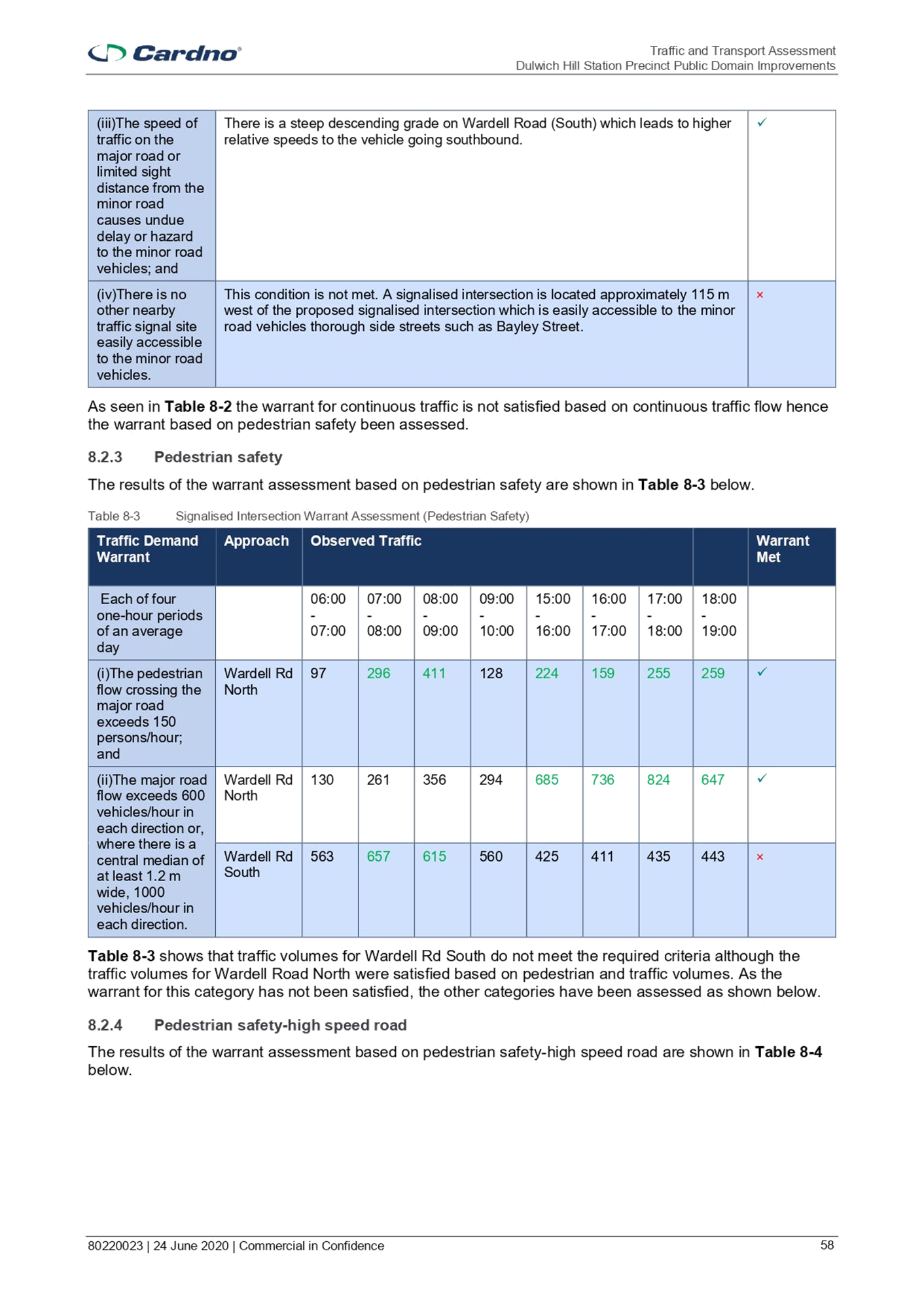
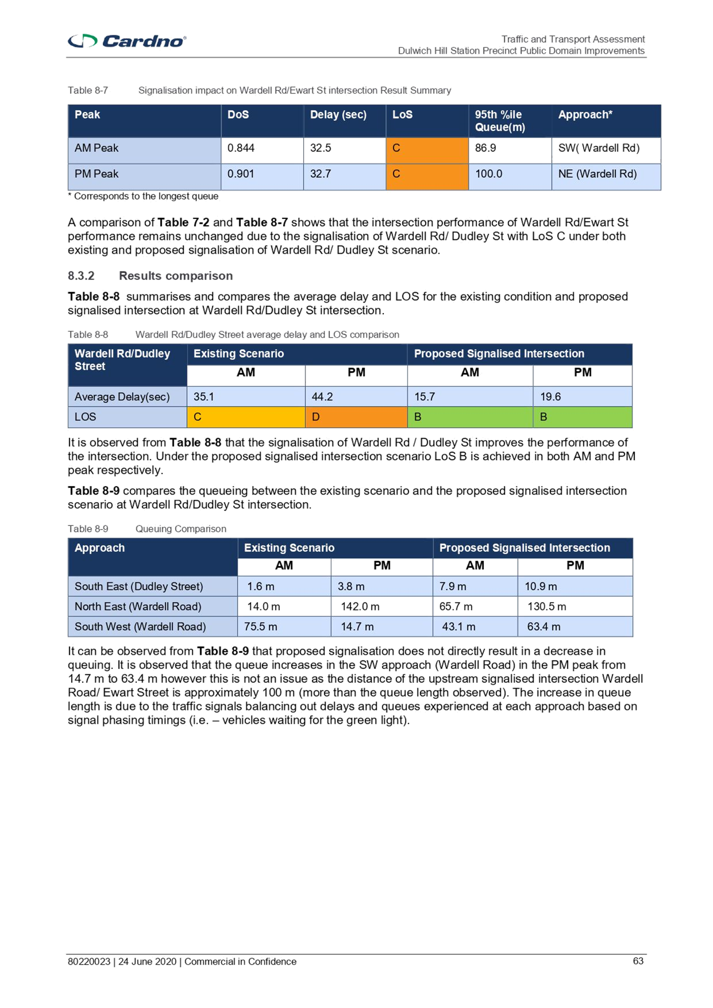
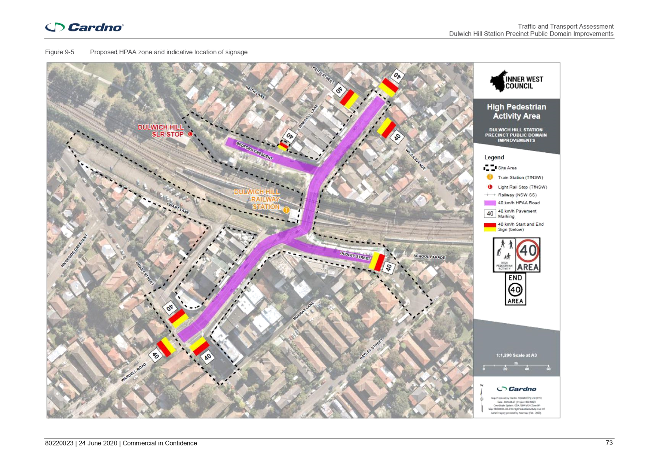
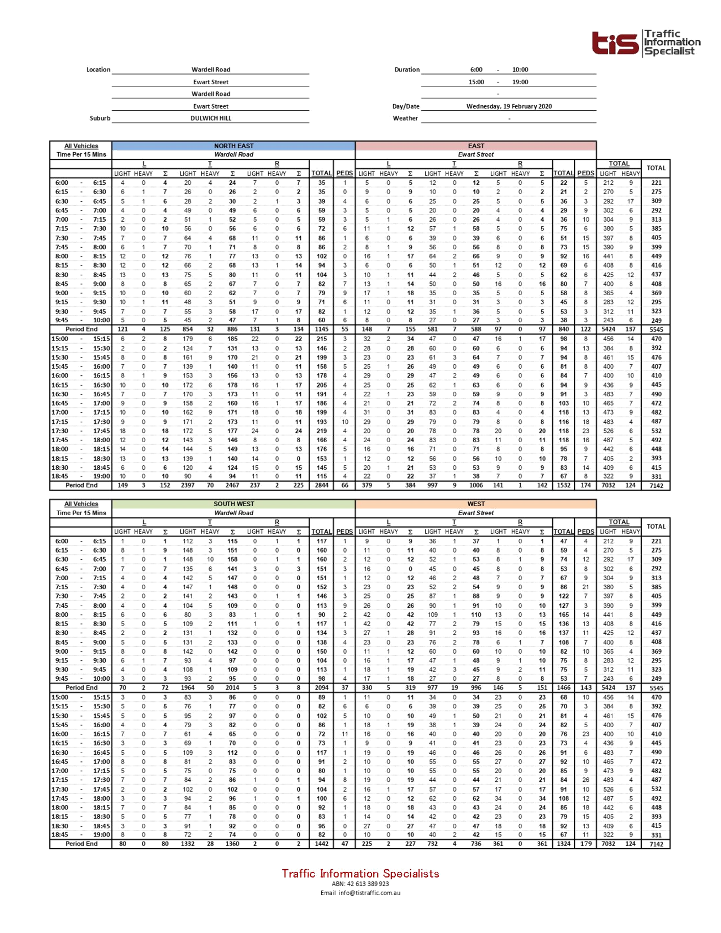
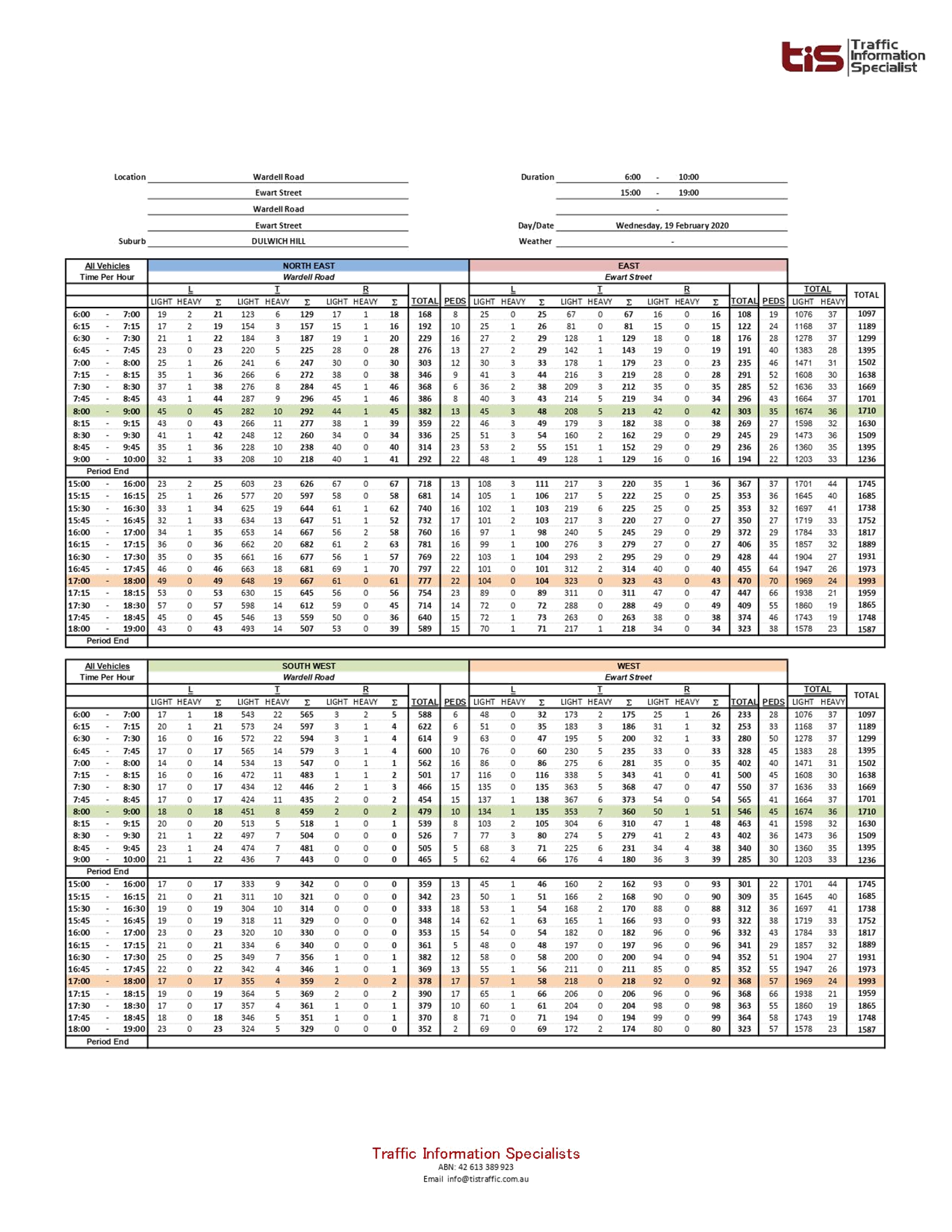
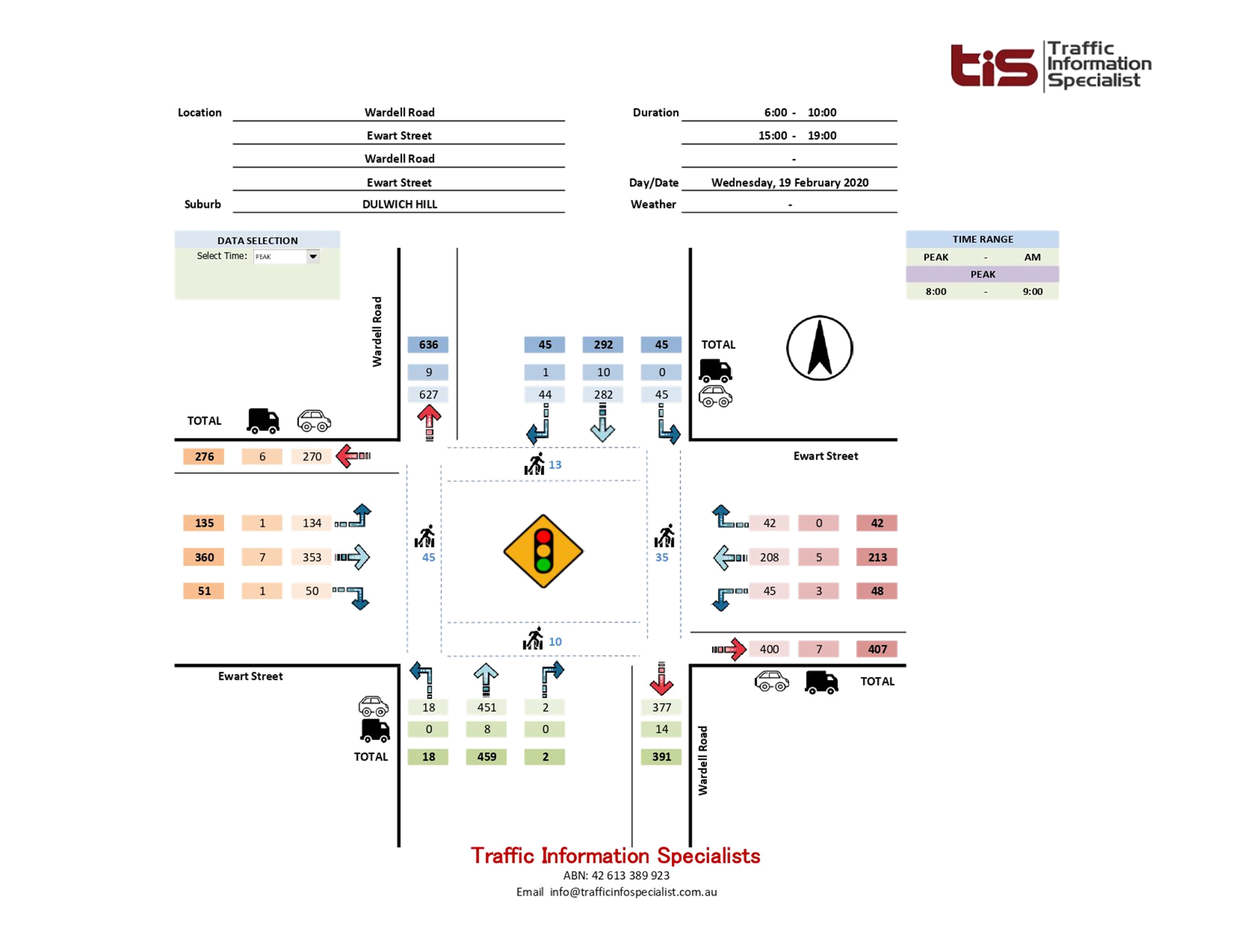
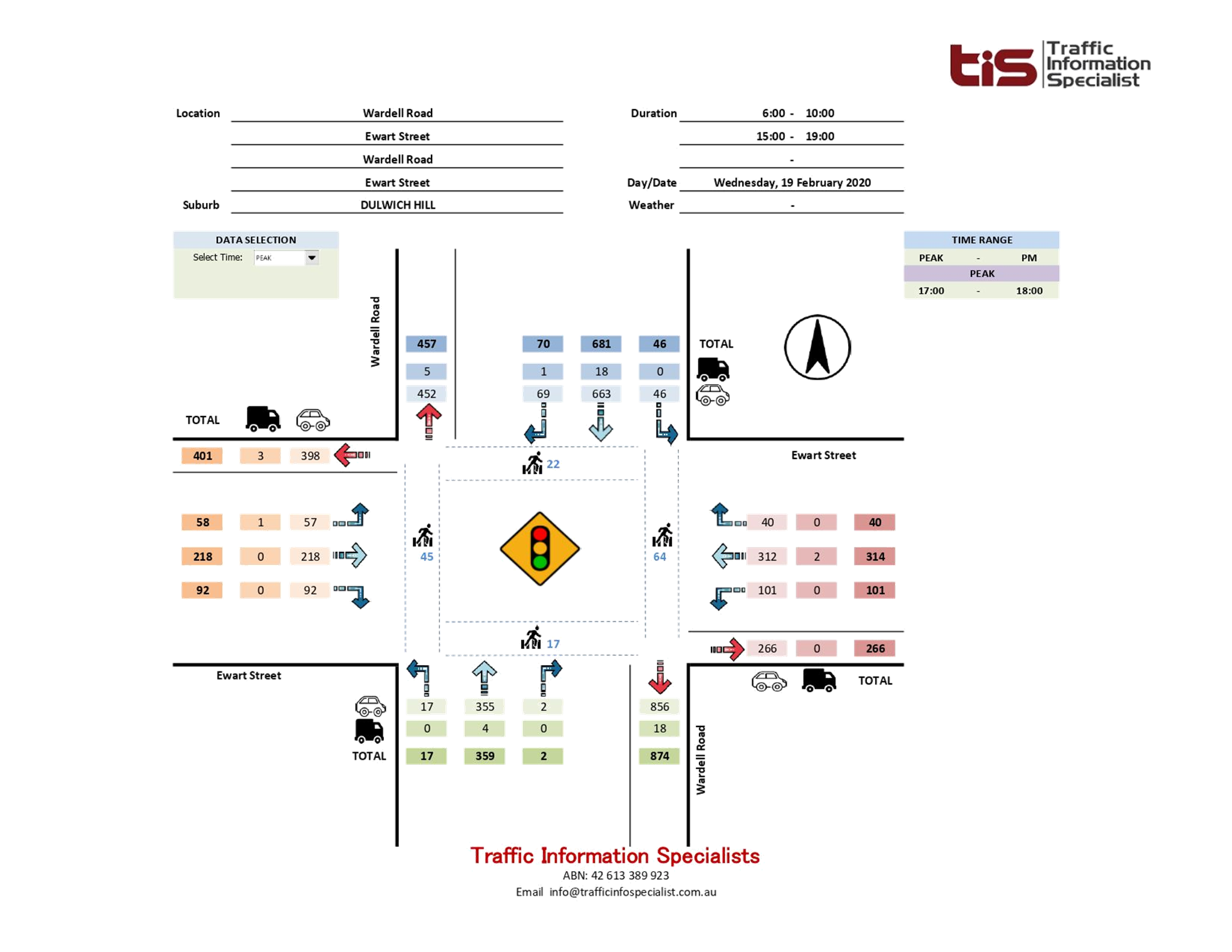
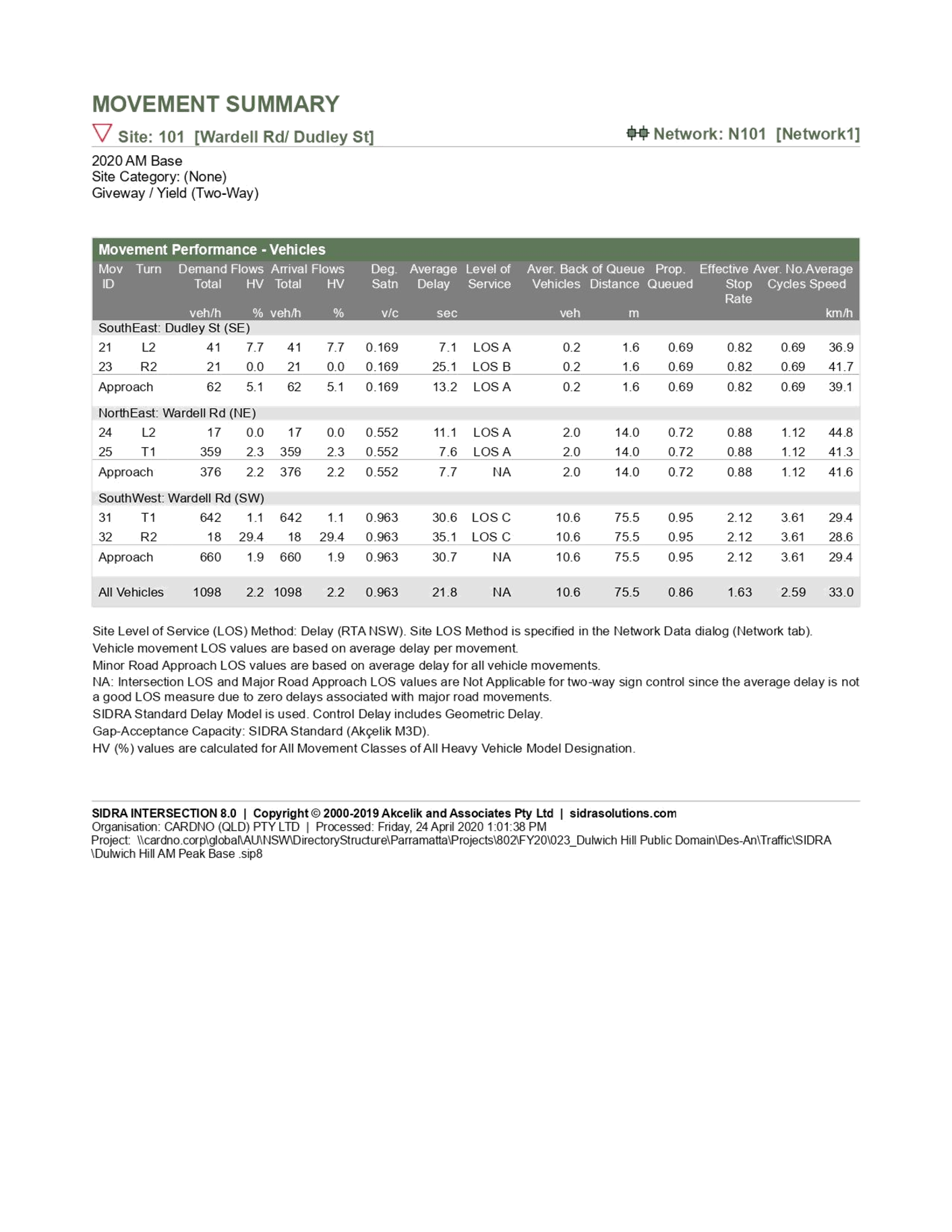
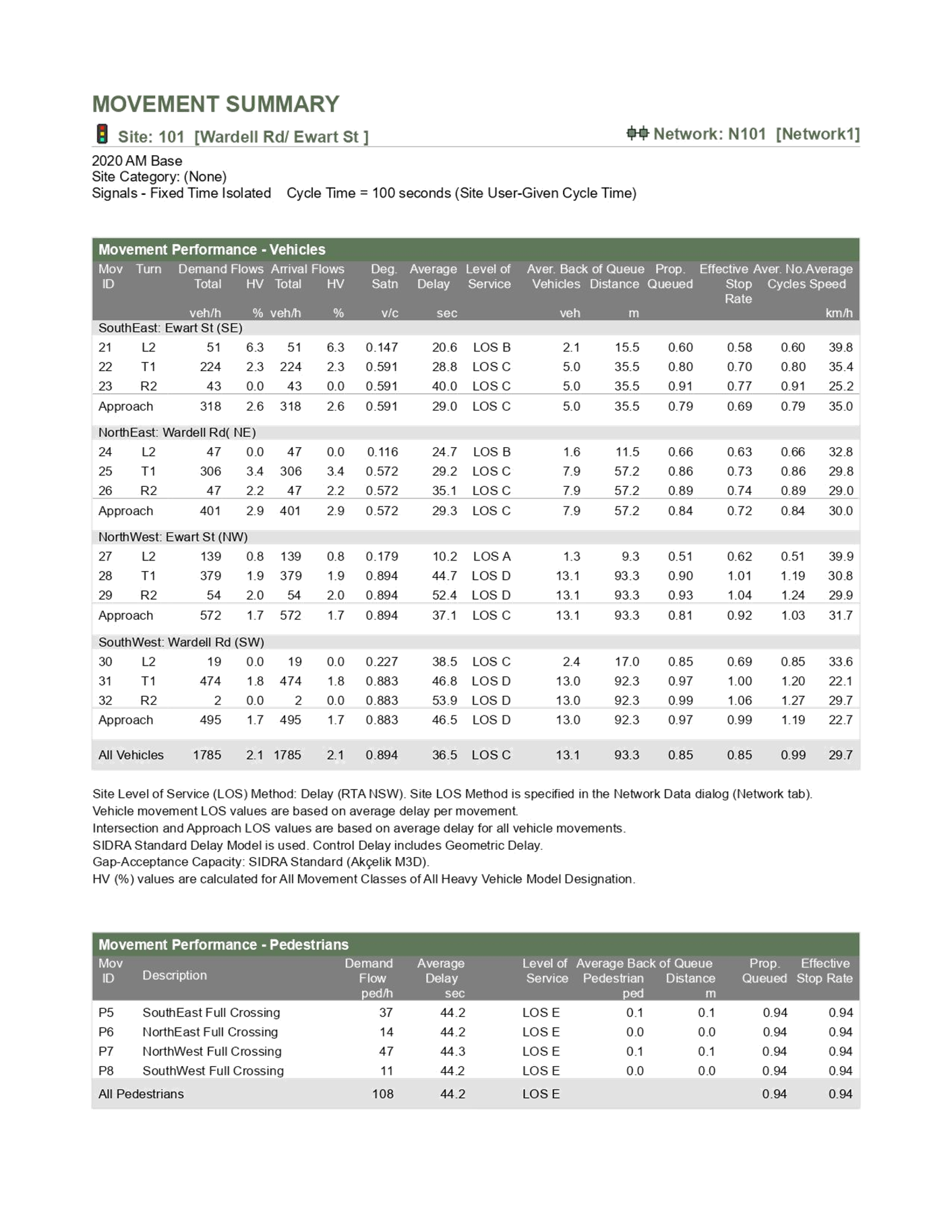
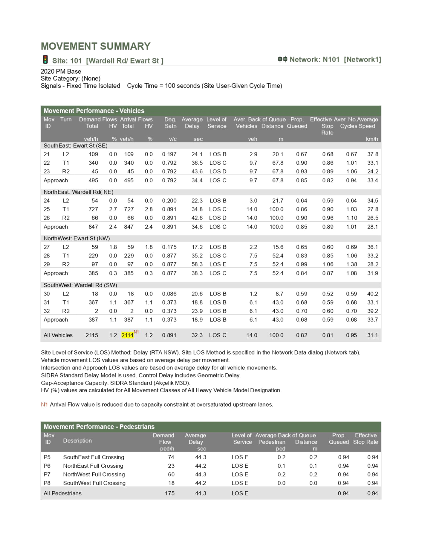
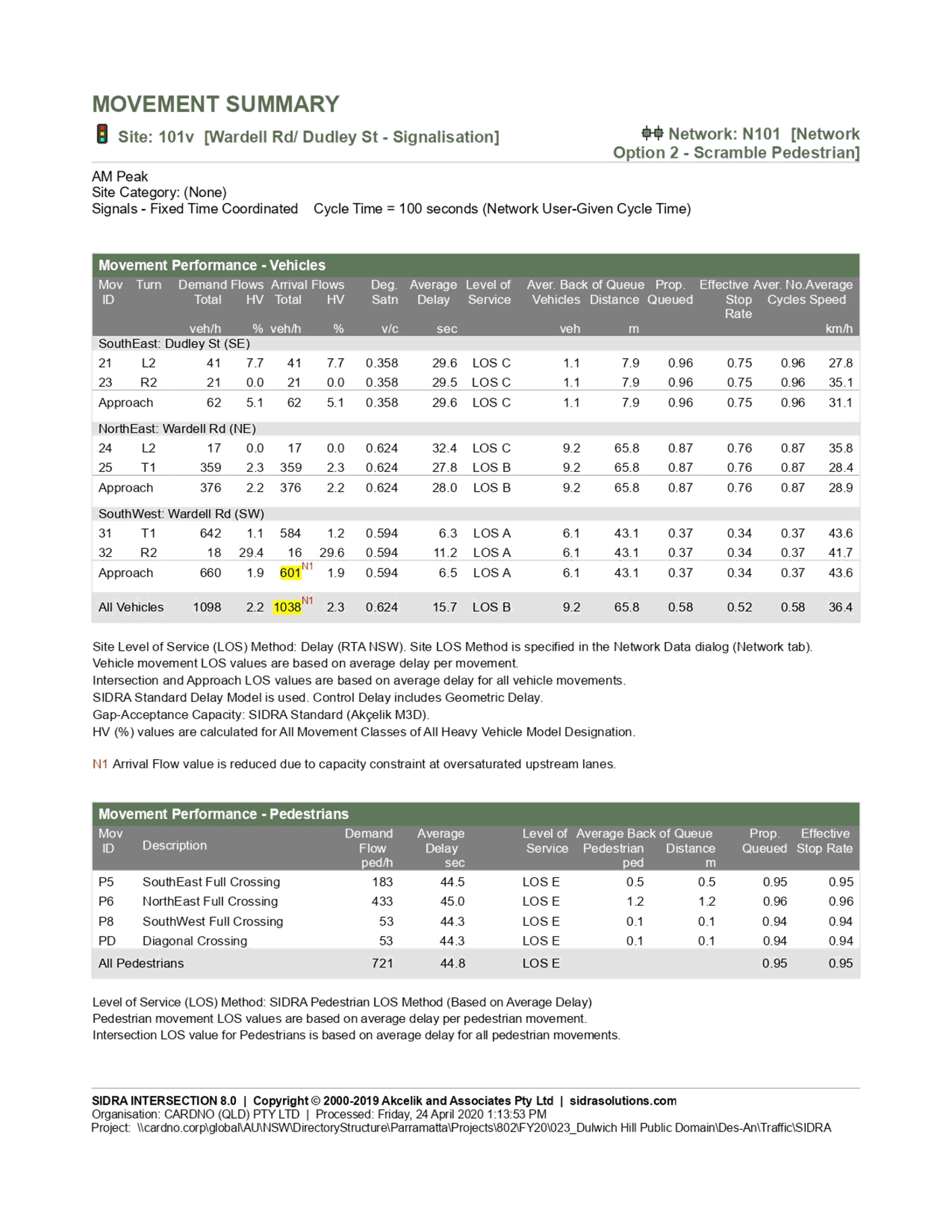
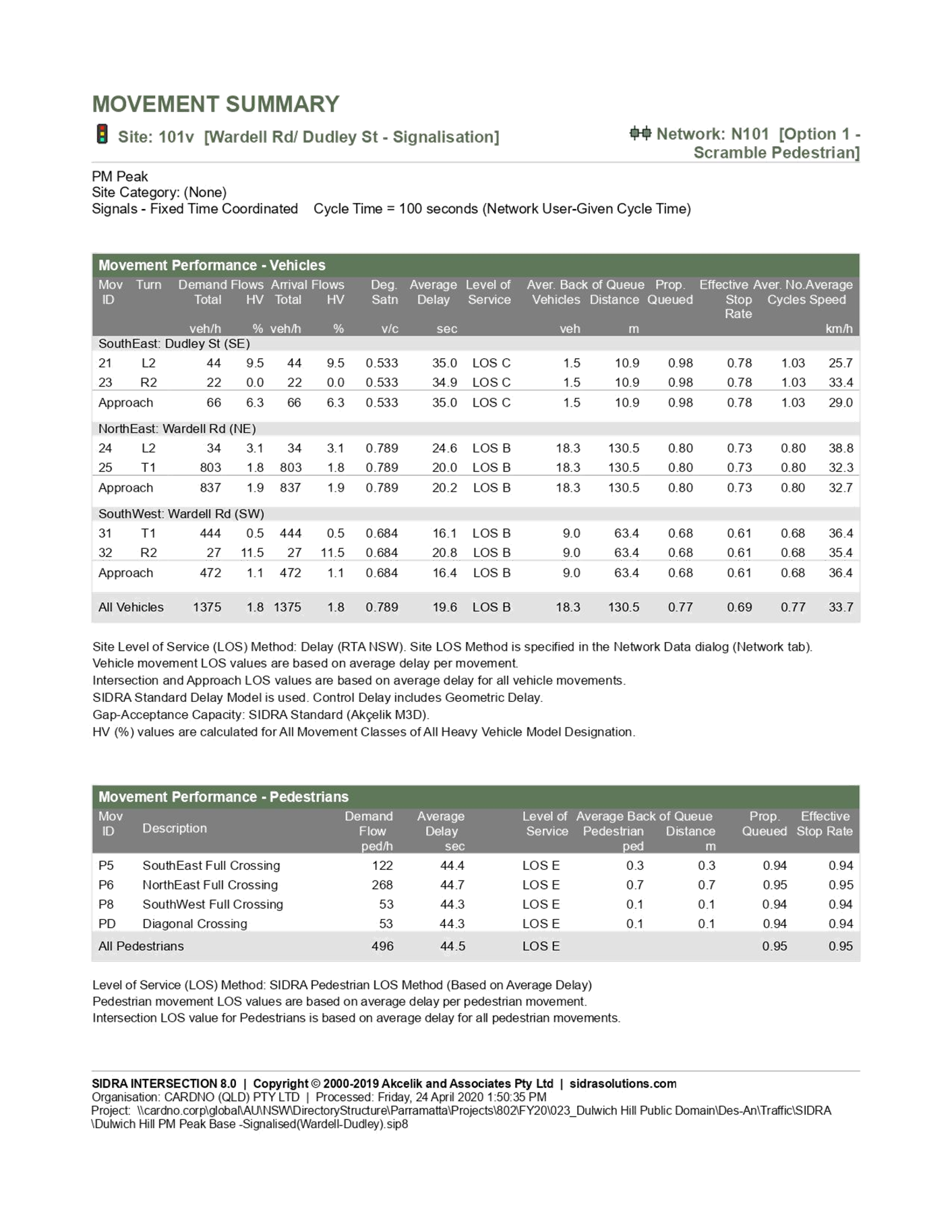
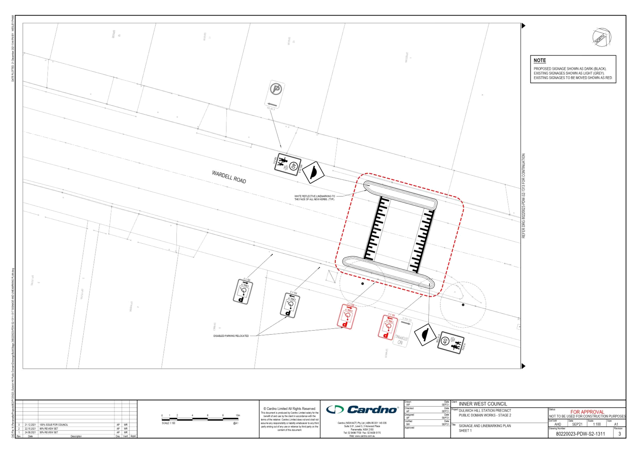
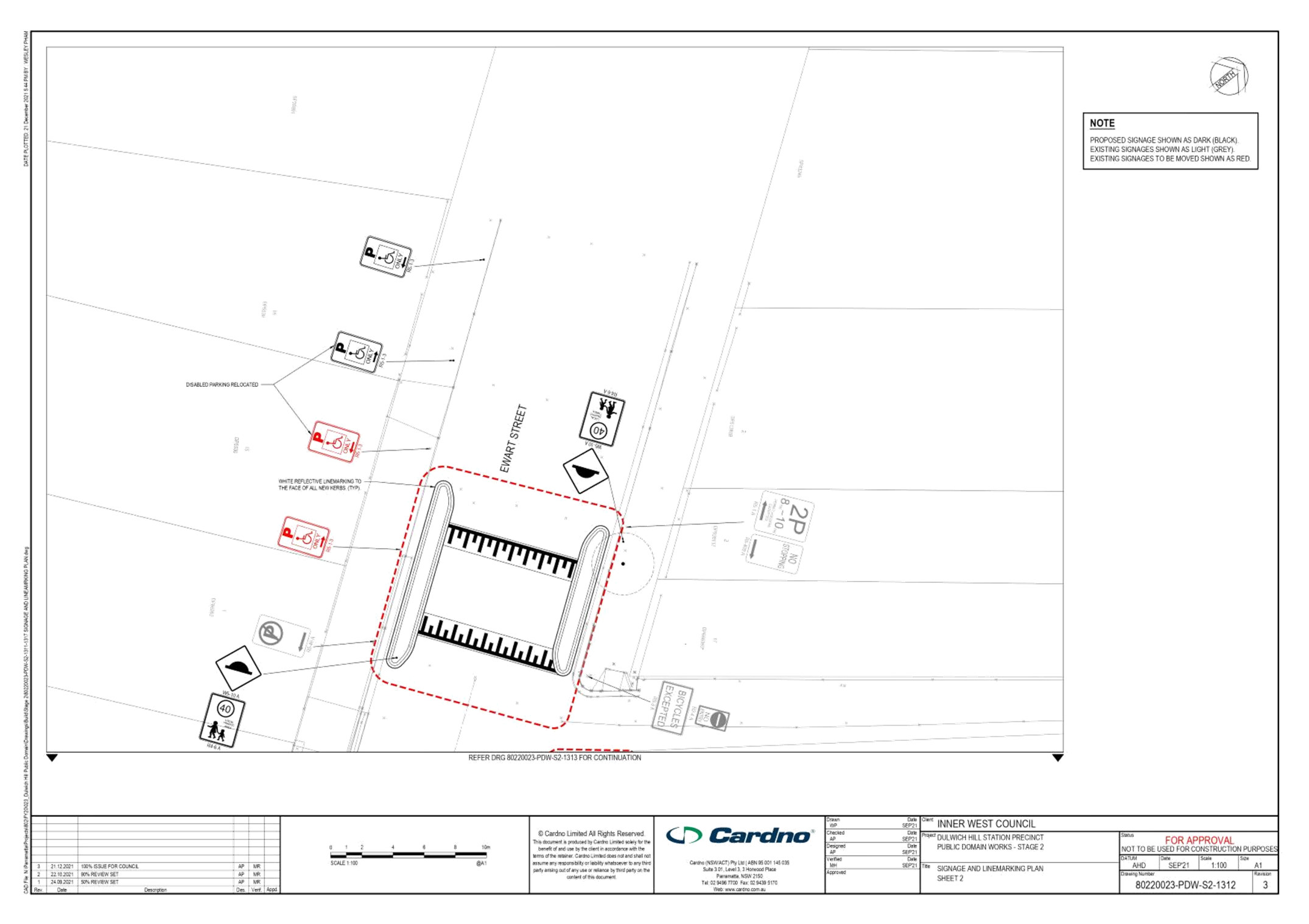
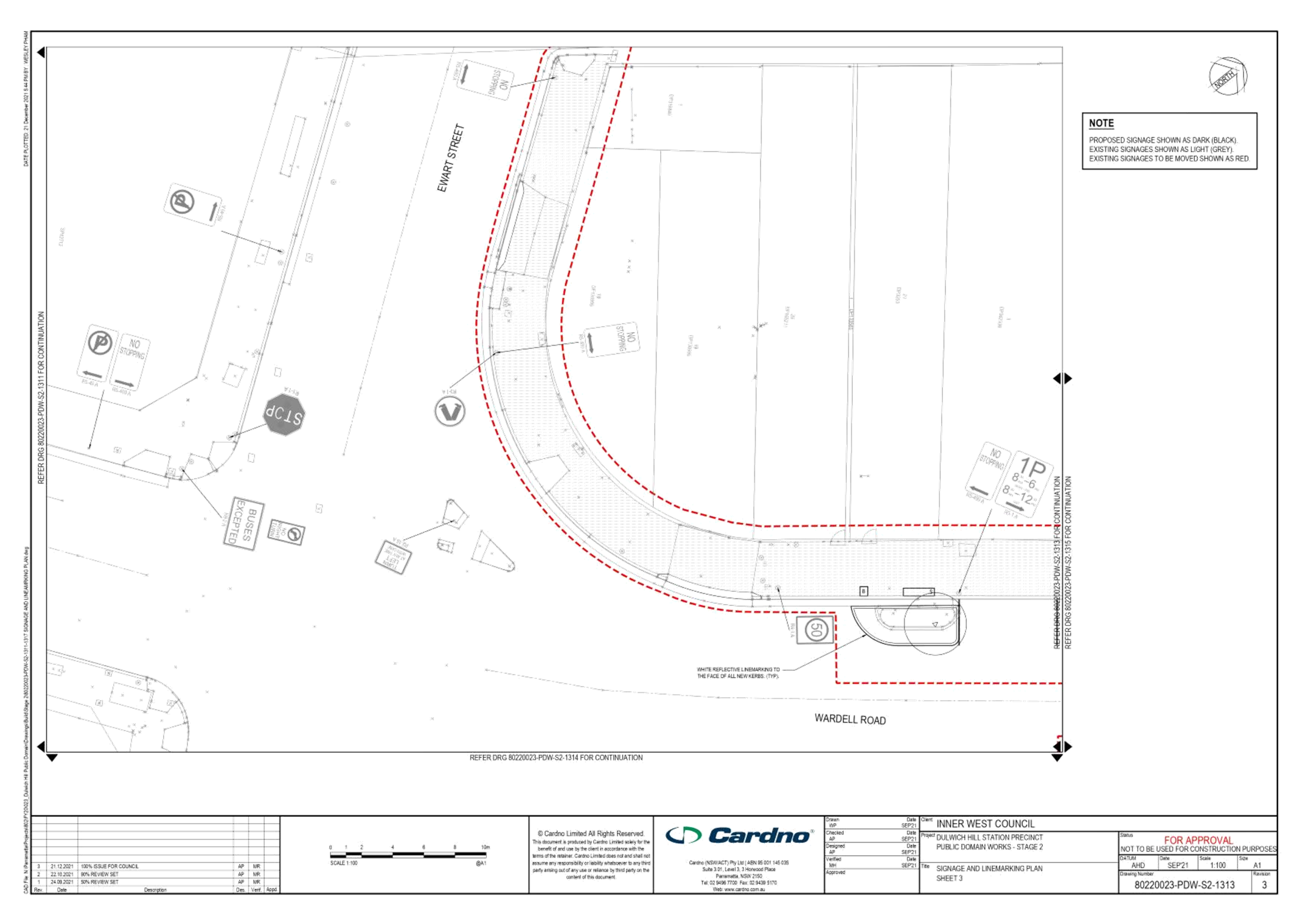
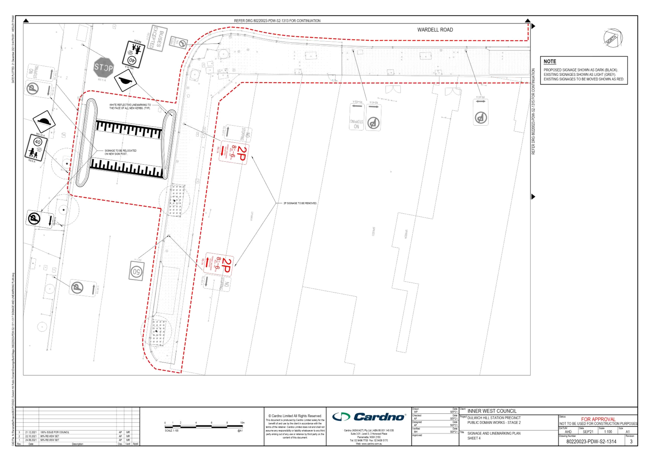
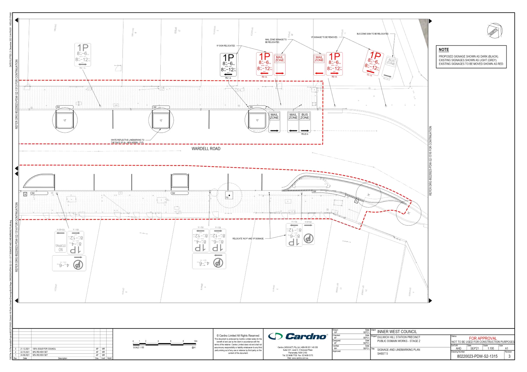
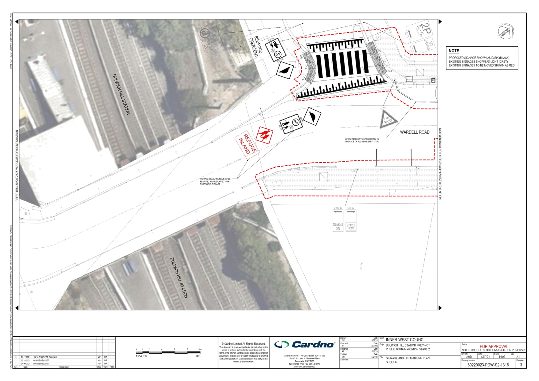
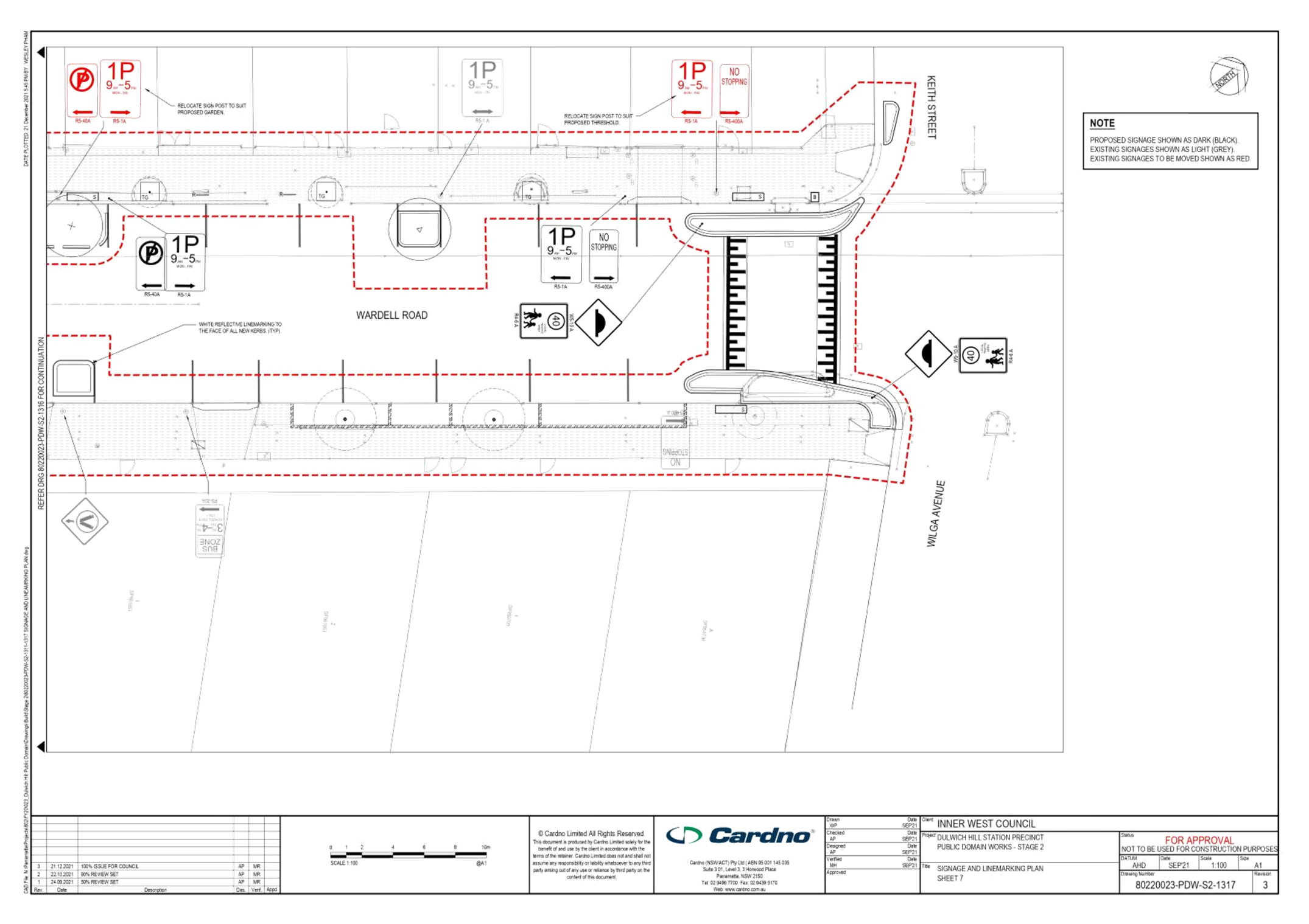
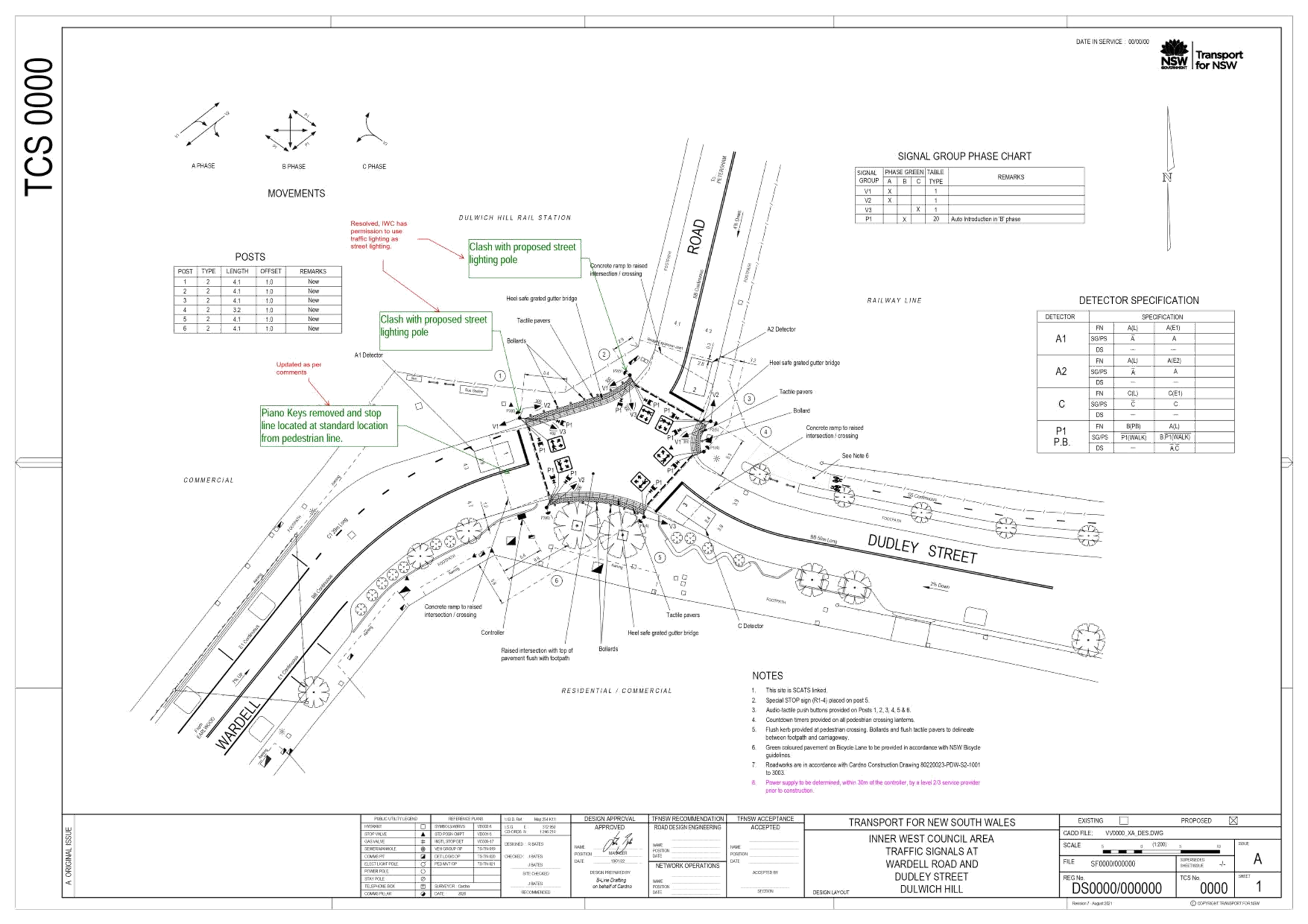
Subject: Dulwich Hill Station Precinct Public Domain Improvements - Stage 2 Works (Djarrawunang-Ashfield Ward / Summer Hill Electorate / Inner West PAC)
Prepared By: Stephen Joannidis - Urban Amenity Improvement - Delivery Manager
Authorised By: Manod Wickramasinghe - Traffic and Transport Planning Manager
SUMMARY
Cardno was commissioned for the traffic and transport assessment for the detailed design of the Dulwich Hill Station Precinct Public Domain Improvements (DHSPPDI). Council adopted the Master Plan for Dulwich Hill Station Precinct at its meeting held on 13 August 2019. The Dulwich Hill Station Public Domain Master Plan provides the Dulwich Hill community with a plan to transform the streets and public spaces around the station into a pedestrian oriented village.
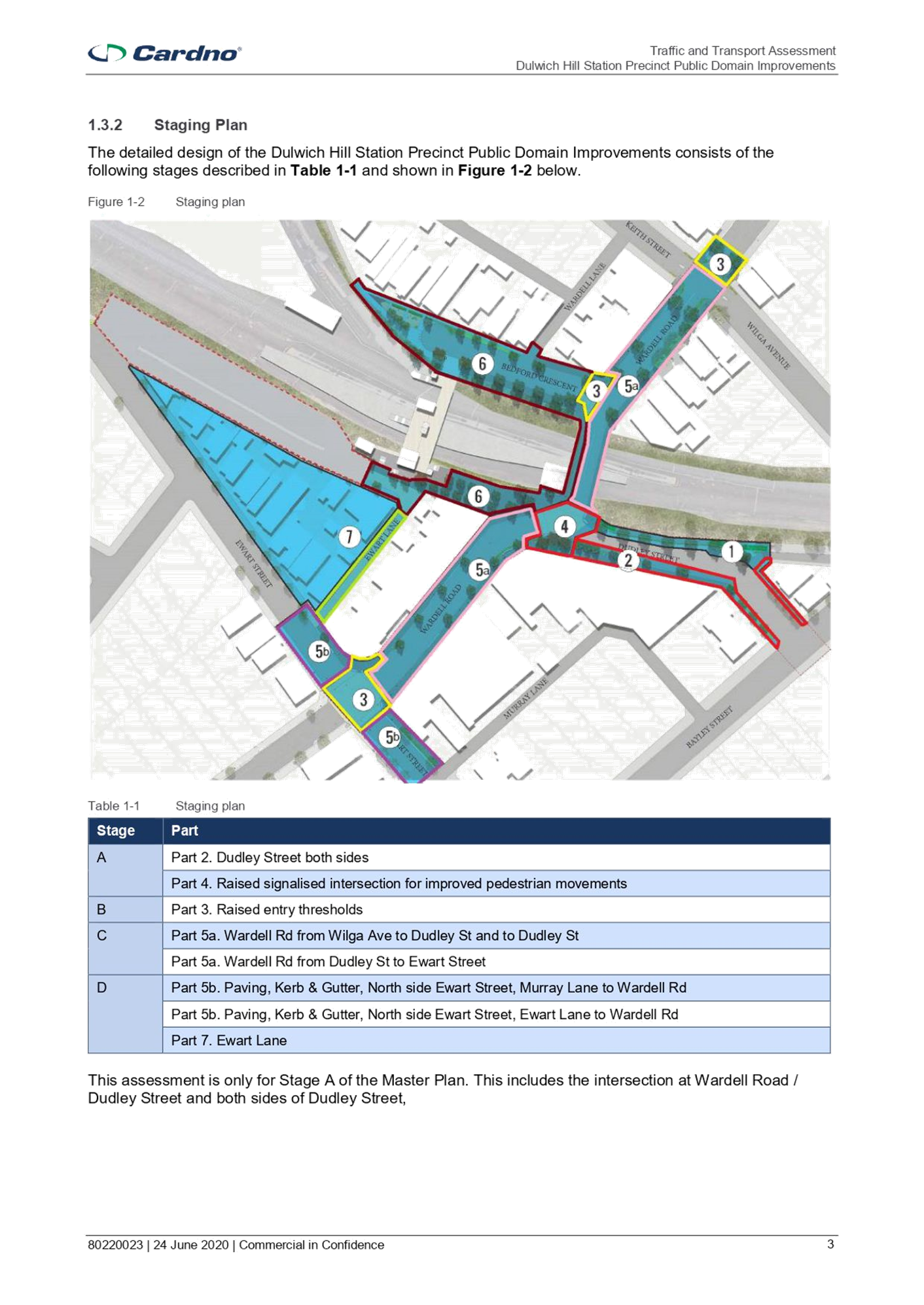
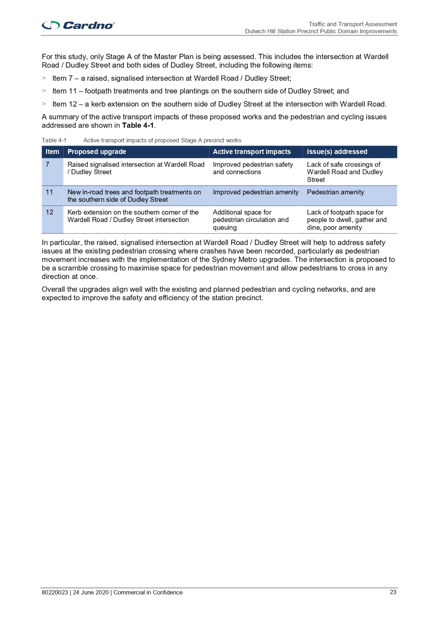
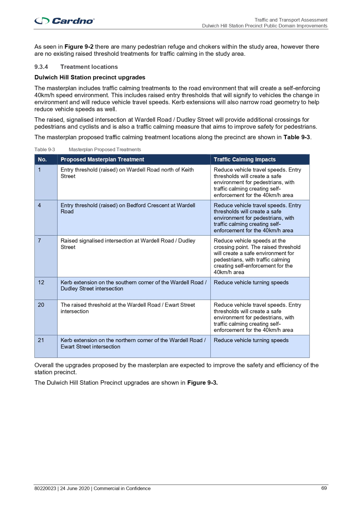
Dulwich Hill Station Precinct Public Domain Improvement works are to be delivered in two stages. Approval for relevant works in Stage 1 were submitted and approved by the Local Traffic Committee in July, 2020. Stage 1 works involved:
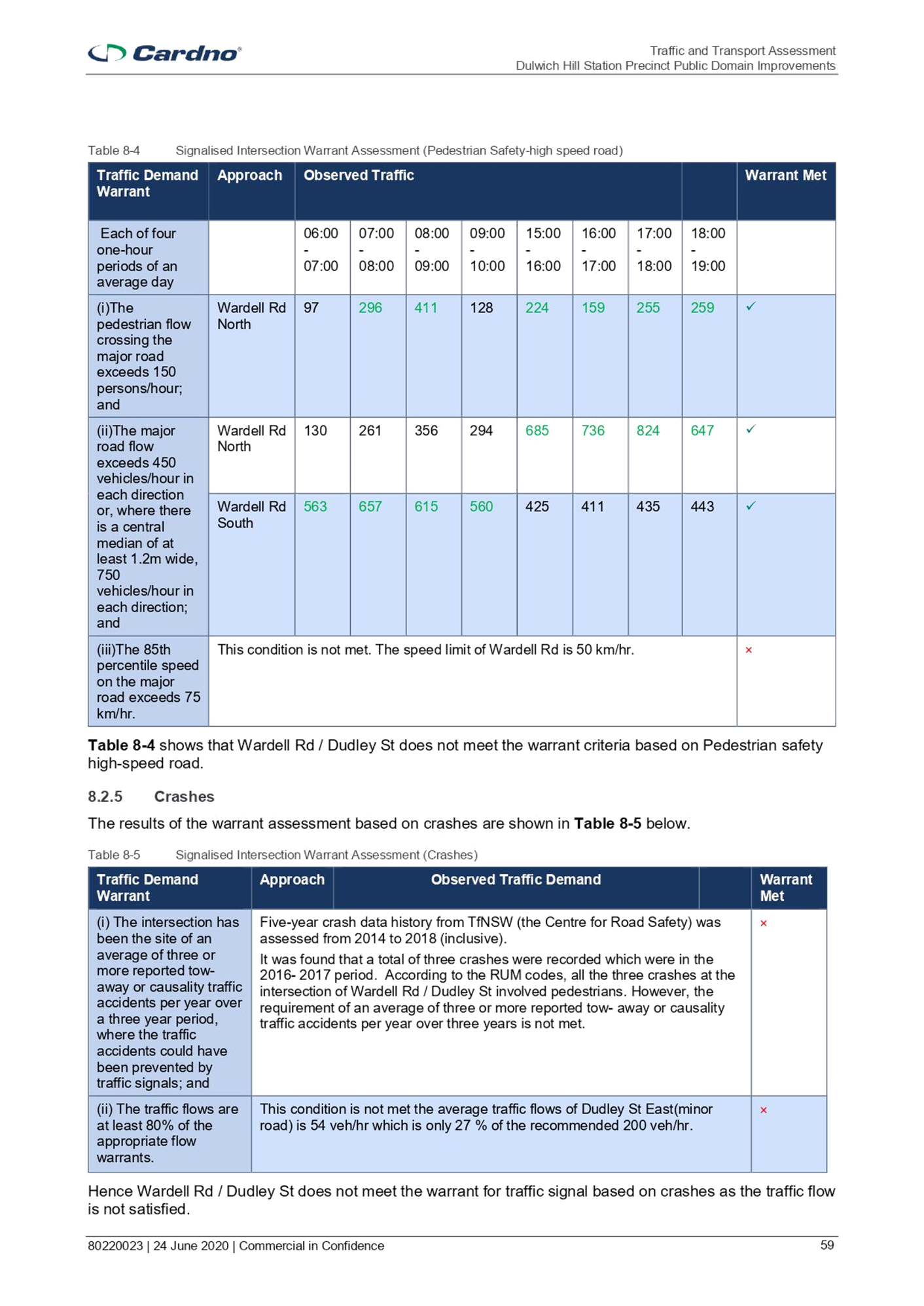
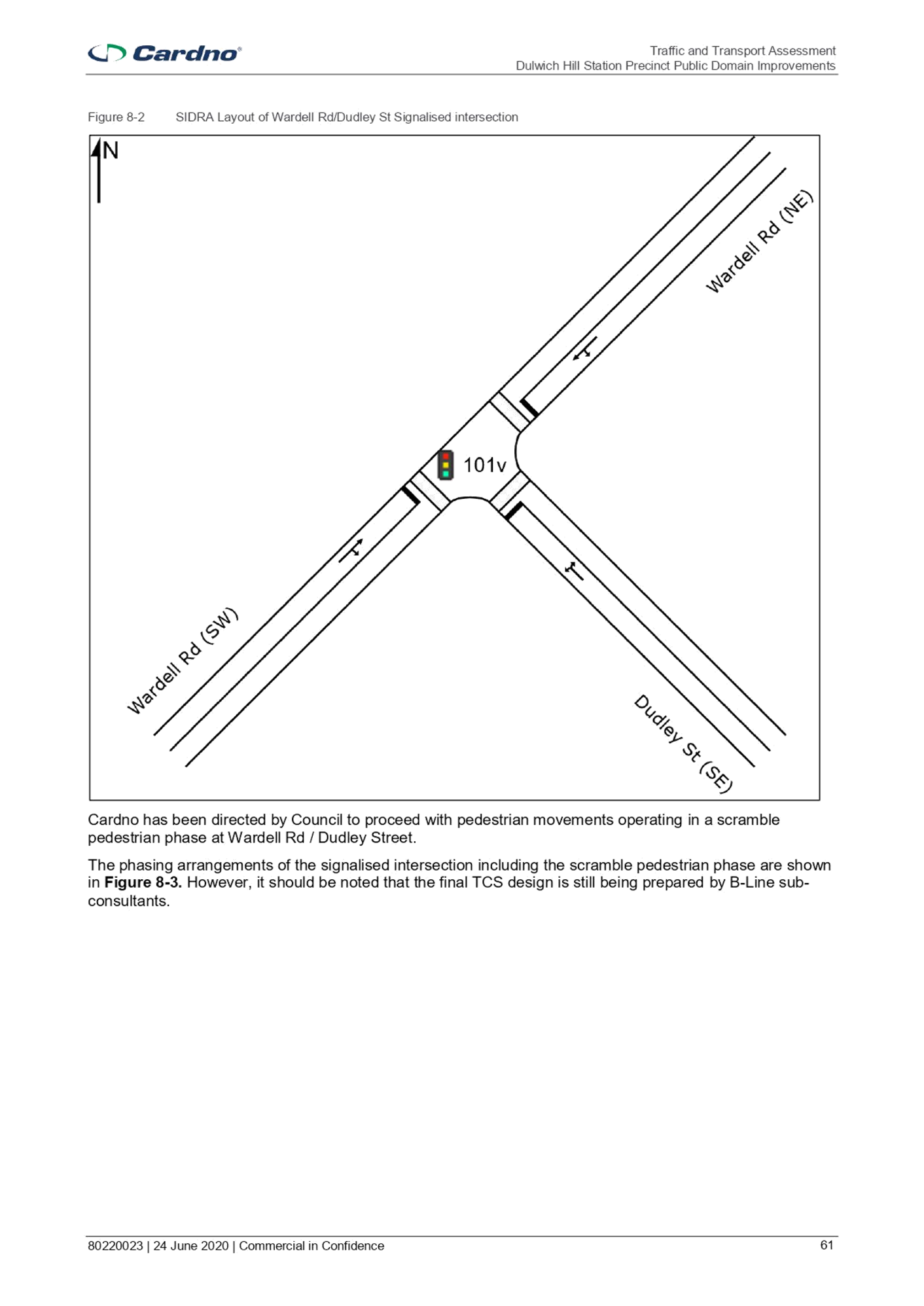
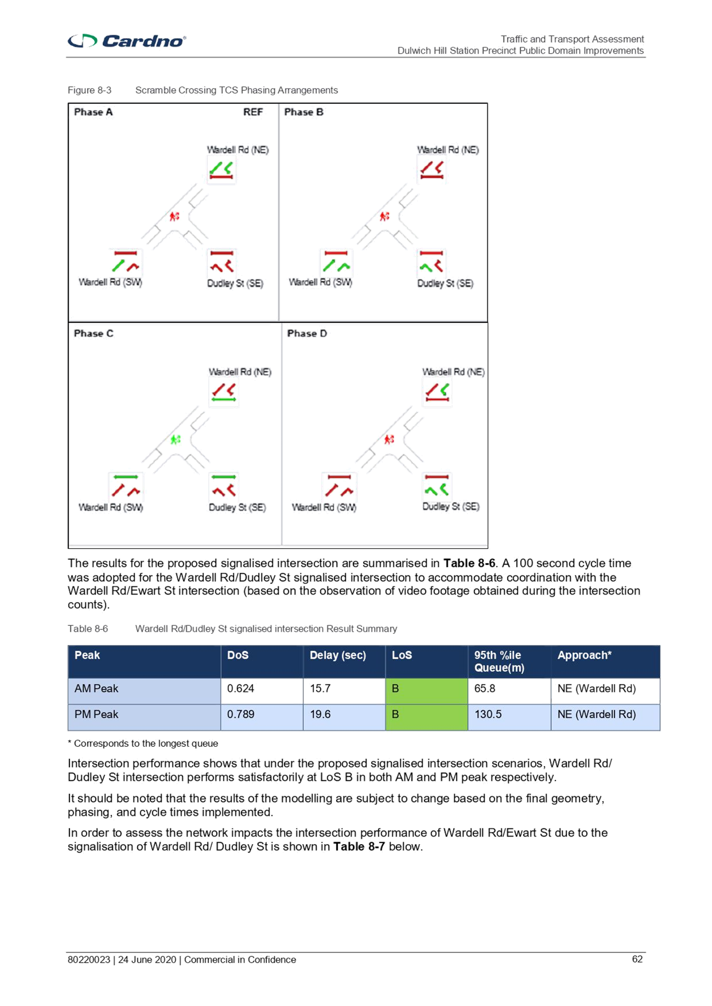
· A raised, signalised intersection at Wardell Road / Dudley Street;
· Footpath treatments and tree plantings on the southern side of Dudley Street; and
· A kerb extension on the southern side of Dudley Street at the intersection with Wardell Road.
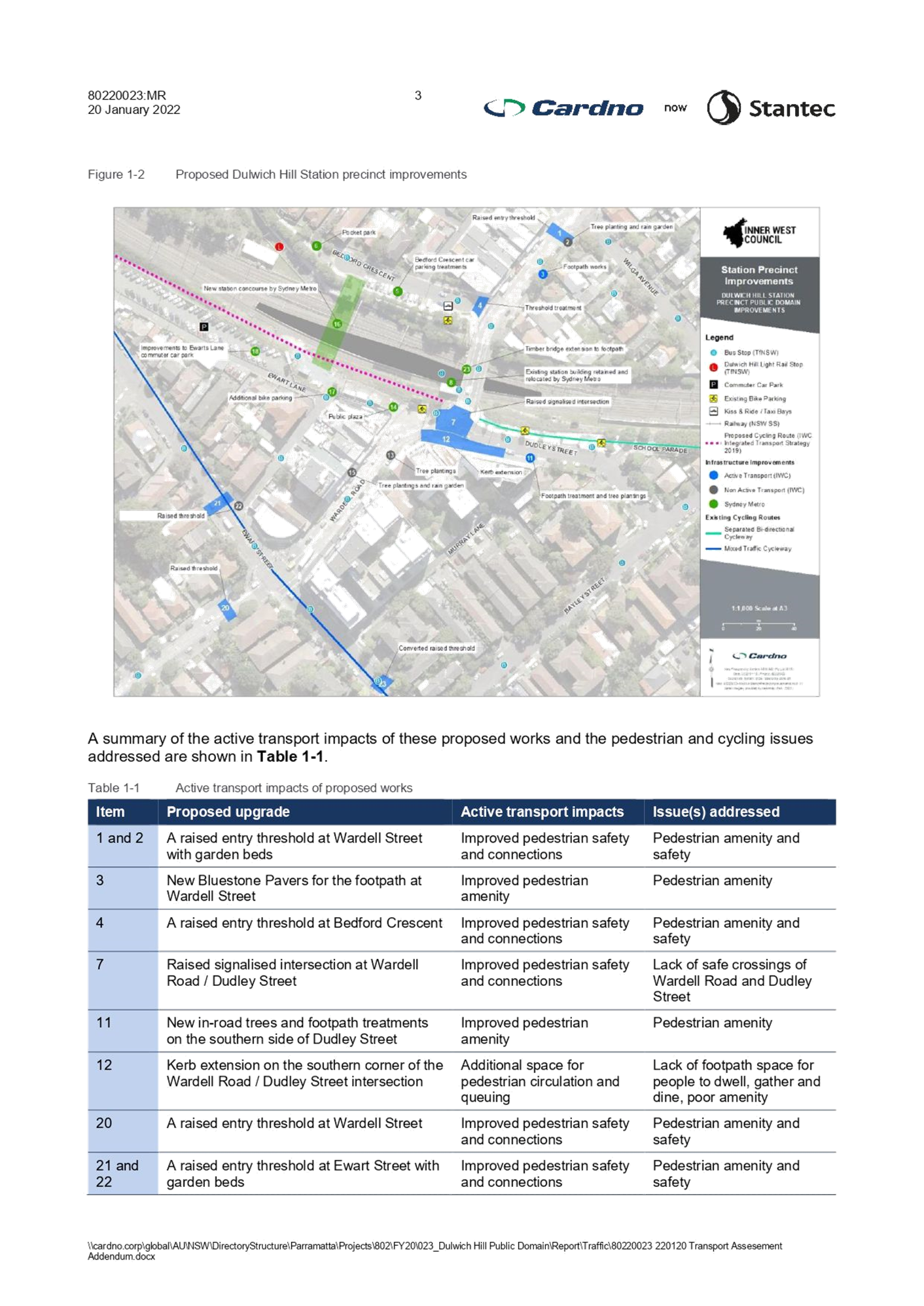
This assessment is for Stage 2 works. The following works proposed to be undertaken within Stage 2 include:
· A raised entry threshold at the approach roads to Wardell Road and Ewart Street intersection (i.e. one on Wardell Road and a second one on Ewart Street – west of the intersection)
· Converting the existing Ewart Street threshold to a raised entry threshold, in line with the other thresholds built for the Dulwich Hill Station Precinct Public Domain Improvements;
· Tree plantings, garden beds and a rain garden; and
· New Bluestone Pavers for footpaths.
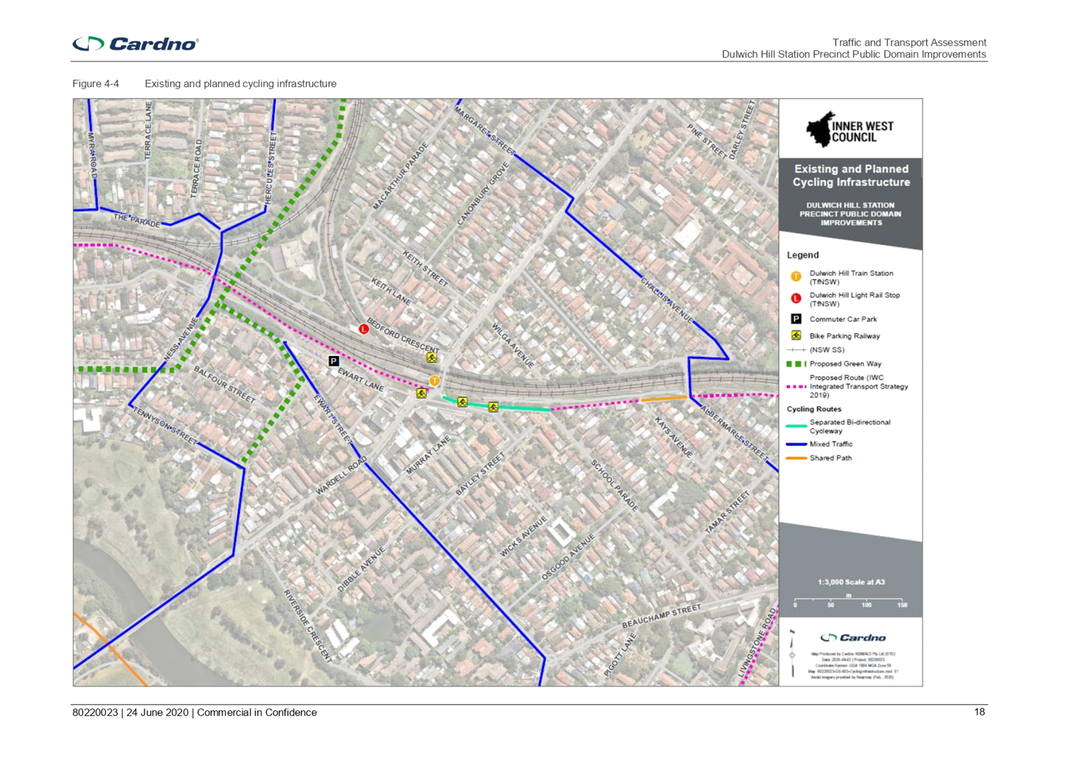
The proposed upgrades will transform the public spaces surrounding the station into a pedestrian oriented village. Many of the upgrades were developed to improve pedestrian and cyclist safety and efficiency throughout the precinct and facilitate access to and from the station. Overall, the upgrades align well with the existing and planned pedestrian and cycling networks and are expected to improve the safety and efficiency of the station precinct. It is noted that Council has received Blackspot funding to upgrade the entry thresholds.
|
RECOMMENDATION
THAT the following works proposed to be undertaken as part of Stage 2 be APPROVED: 1. New in road trees, garden beds, raingarden and footpath treatments; 2. A raised threshold with pedestrian (zebra) crossing at Bedford Crescent (subject to meeting TfNSW warrants); and Raised thresholds to reduce vehicle speeds and signify the extent of a pedestrian-oriented village. |
BACKGROUND
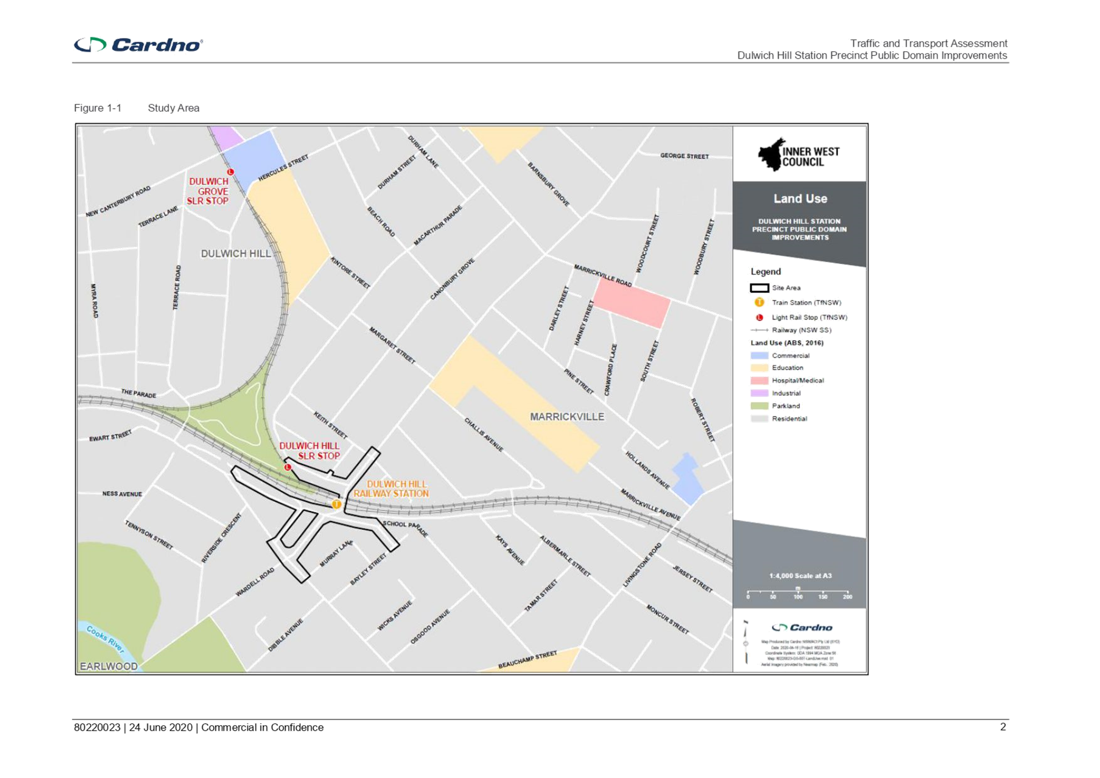
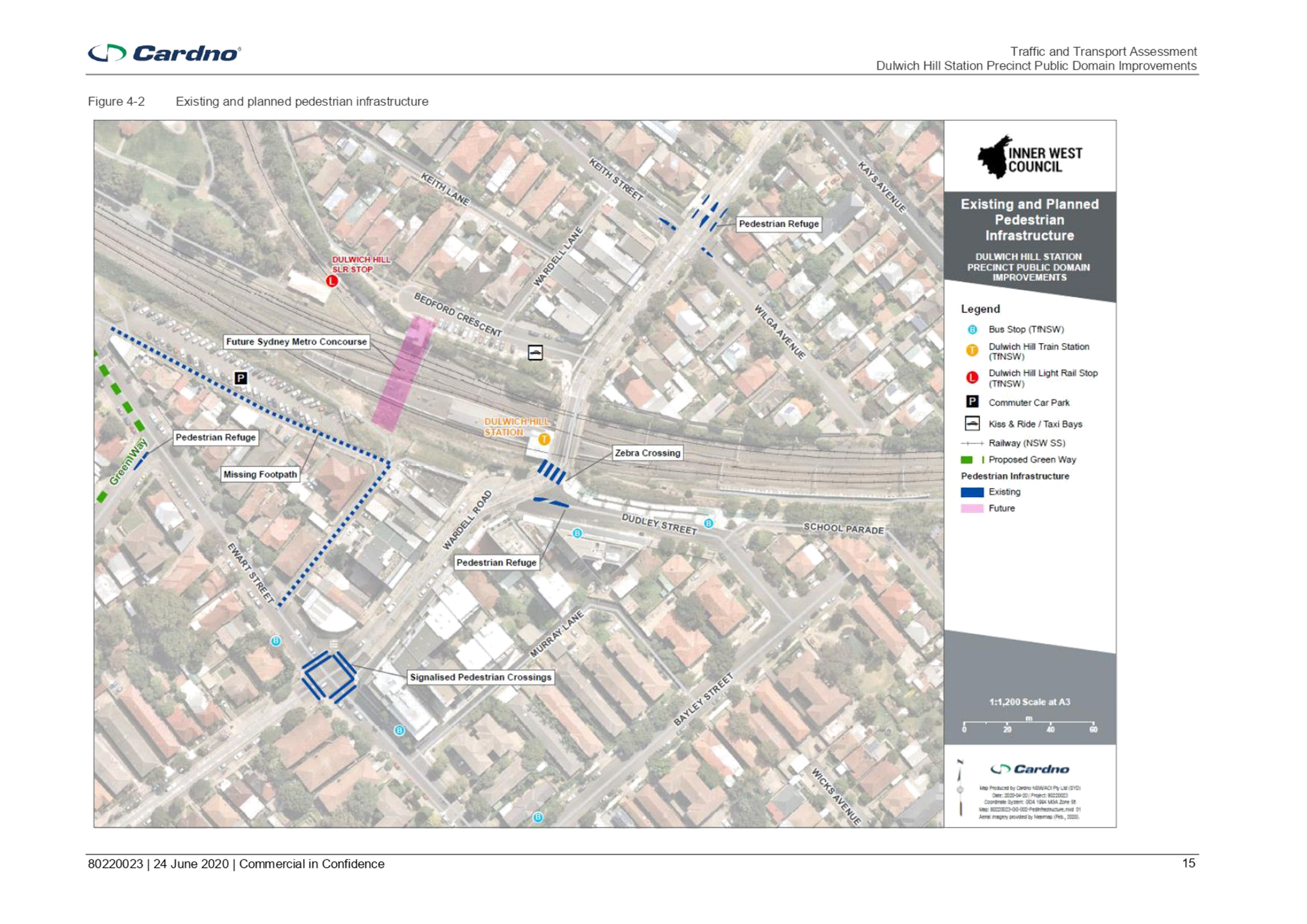
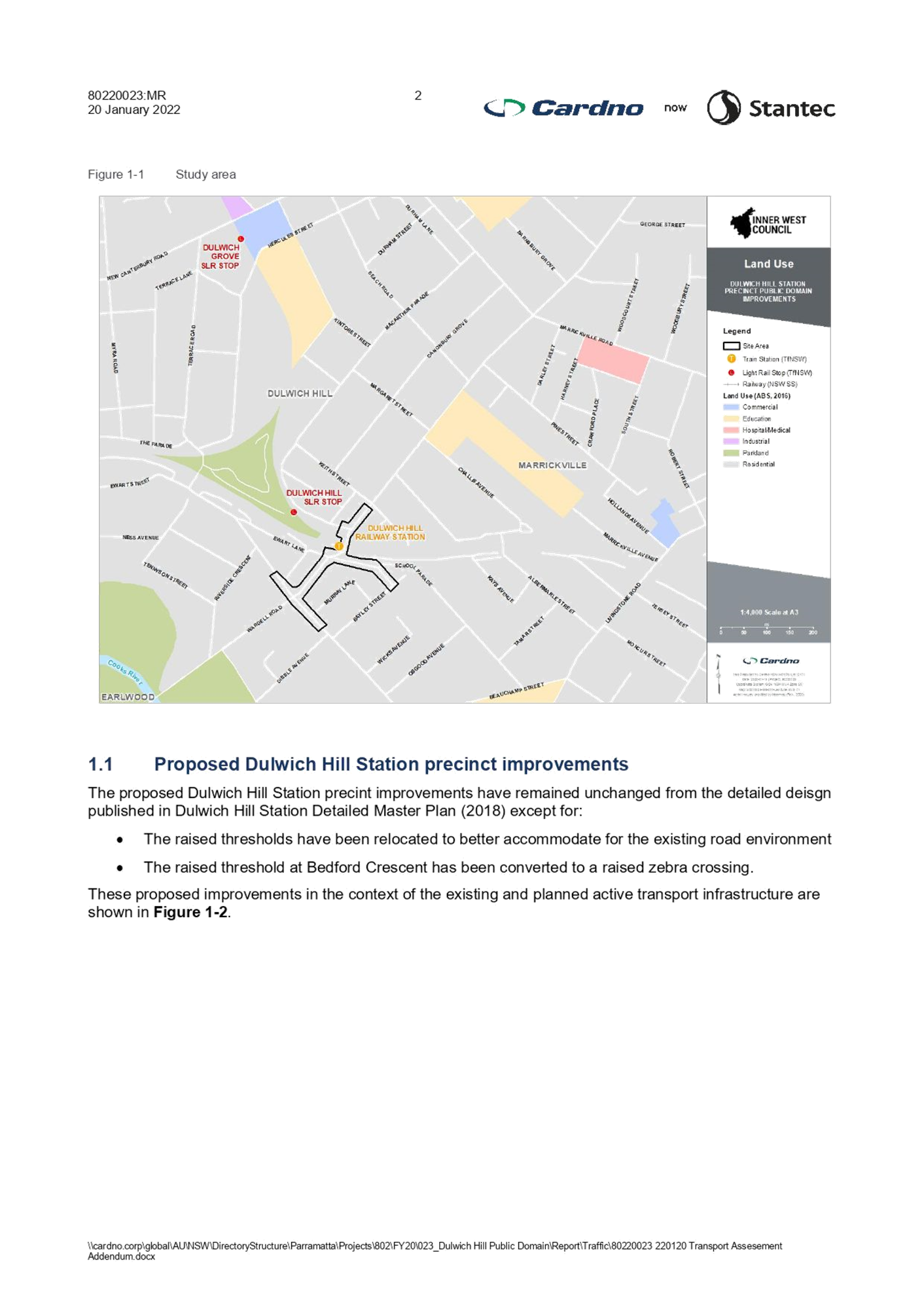
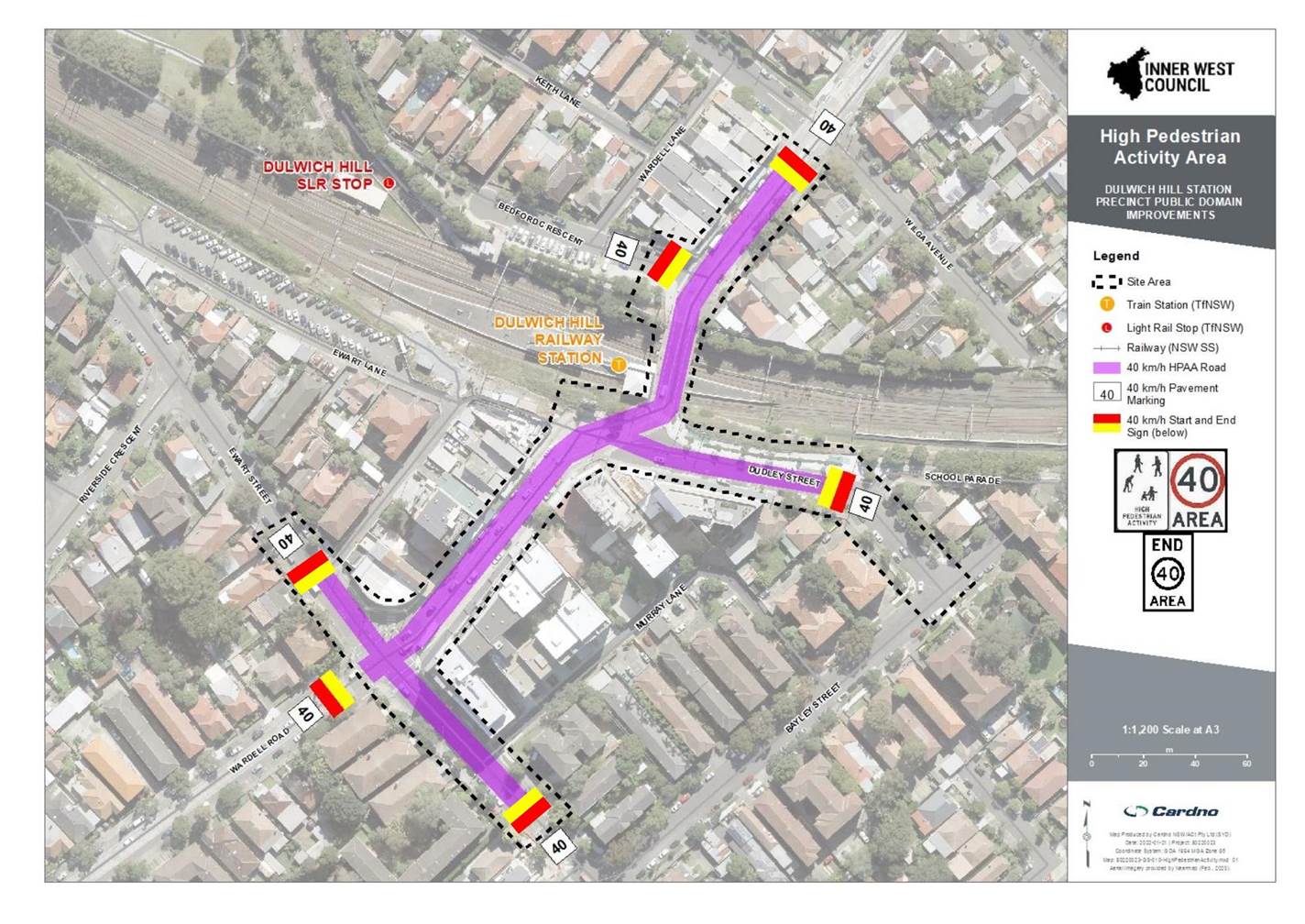
The Dulwich Hill Station Precinct (DHSP) site area includes:
· Wardell Road from Ewart Street to the north side of the Keith Street / Wilga Avenue intersection;
· Dudley Street;
· Ewart Street between Ewart Lane and Murray Lane; and
· Bedford Crescent.
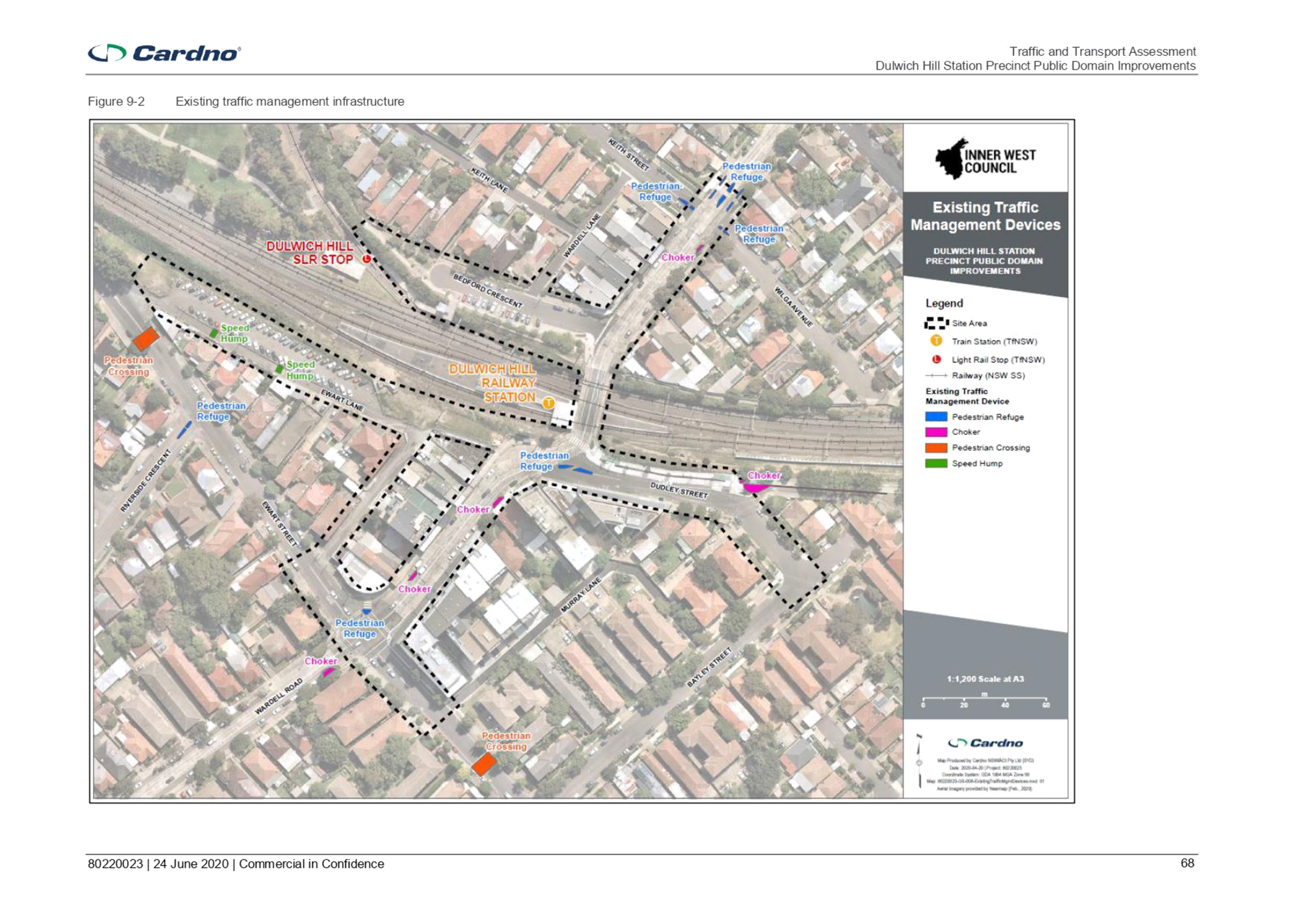
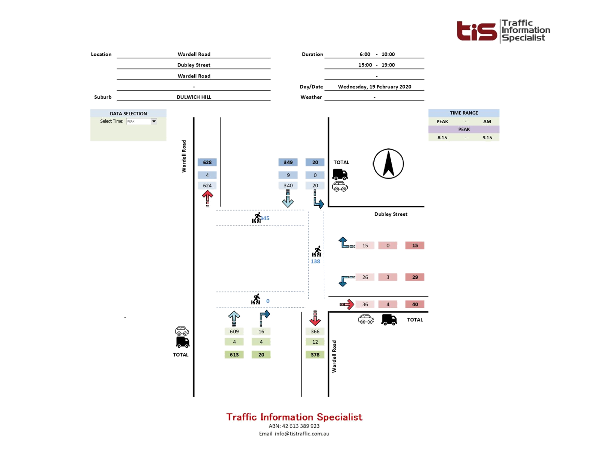
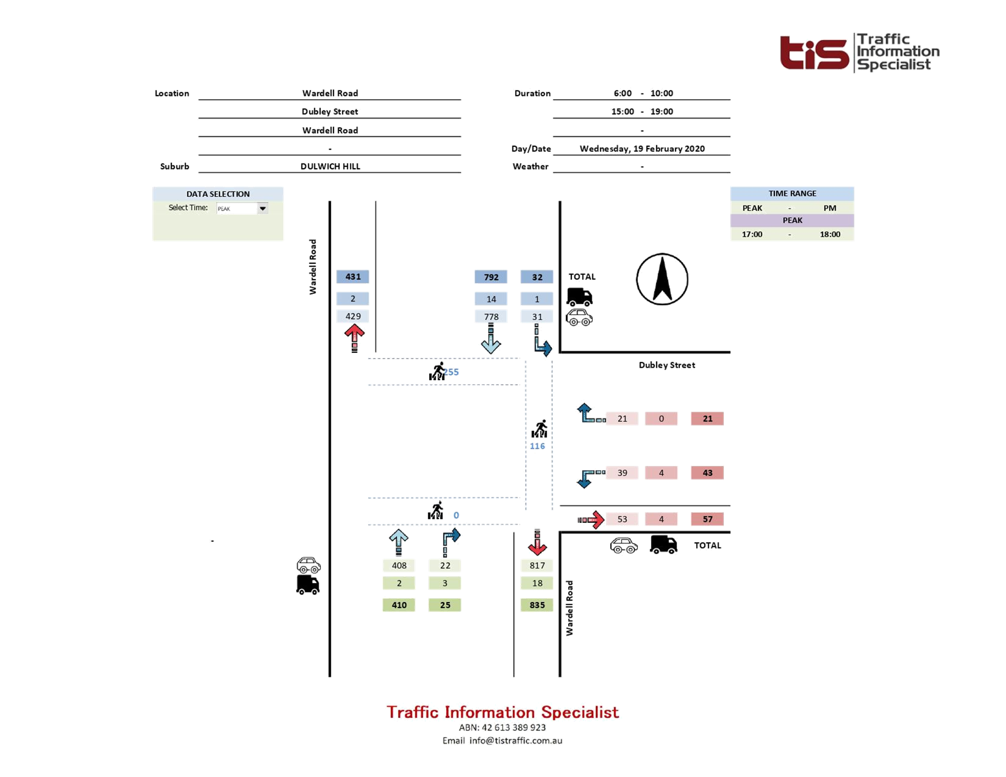
The figure below illustrates the study area relative to the surrounding road network and different land uses around the study area. The study area consists of primarily residential along with some commercial/business area along Wardell Road between Ewart Street and Keith Street.
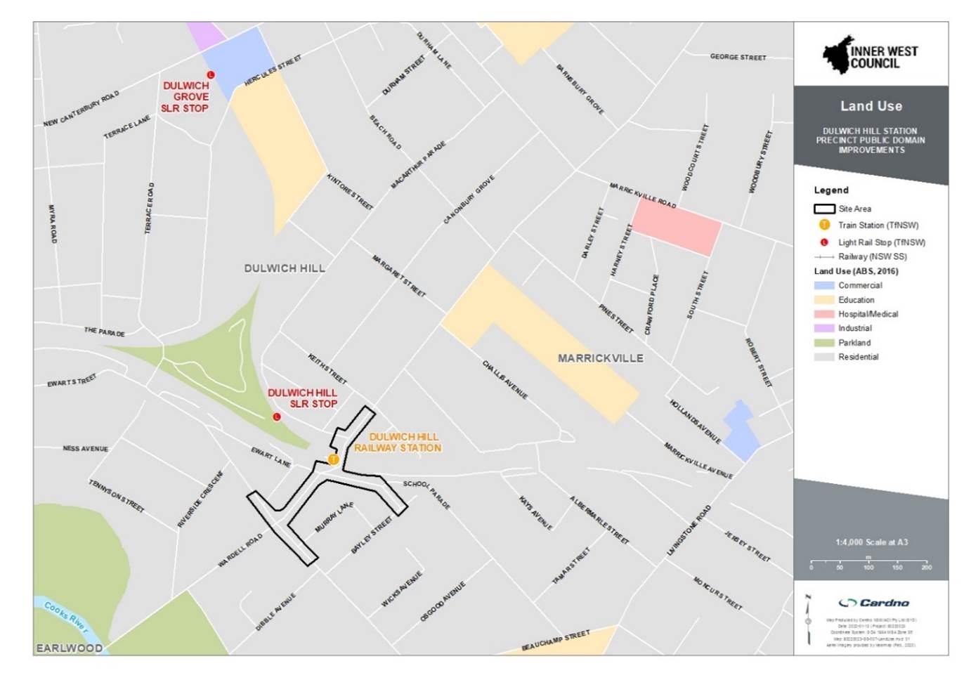
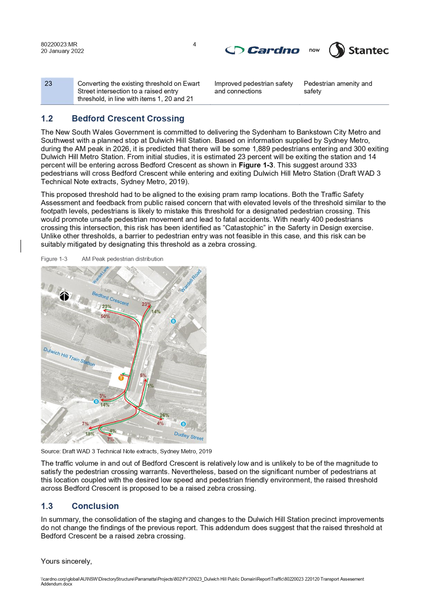
Dulwich Hill Station is a busy railway station and it along with the local commercial area generates significant pedestrian activity. Wardell Road is a busy regional road carrying a high volume of traffic and in combination with the high pedestrian activity it has been a Blackspot for numerous years.
In addition, local development and the implementation of the Sydney Metro Upgrades will see higher volumes of pedestrian movements which may compound the already poor crash history of the locality.
In 2020 a Blackspot funding application was submitted, and funding of $341,250 was approved on 18 May 2021 for Dulwich Hill Station Precinct Upgrade works. Specifically, works to install entry thresholds, install slow point, raised threshold / horizontal deviation at mid-block location and conflict points (intersections and pedestrian crossings).
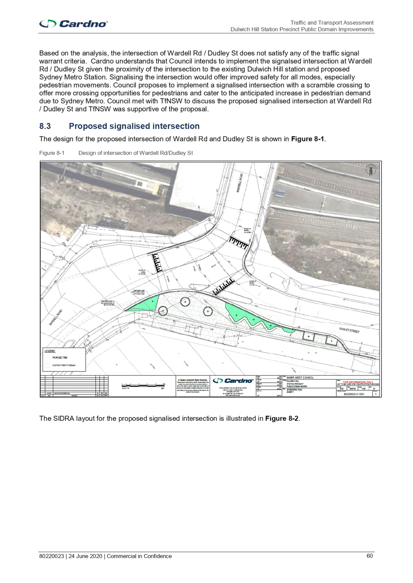
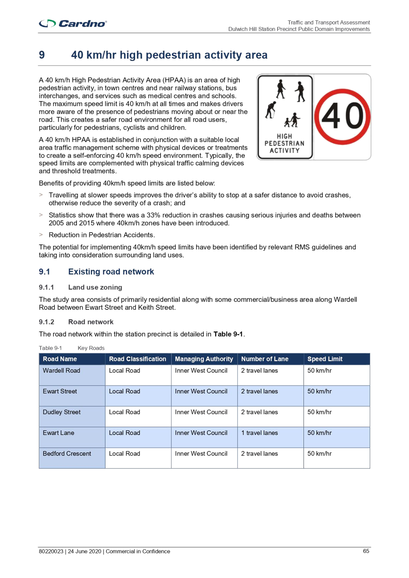
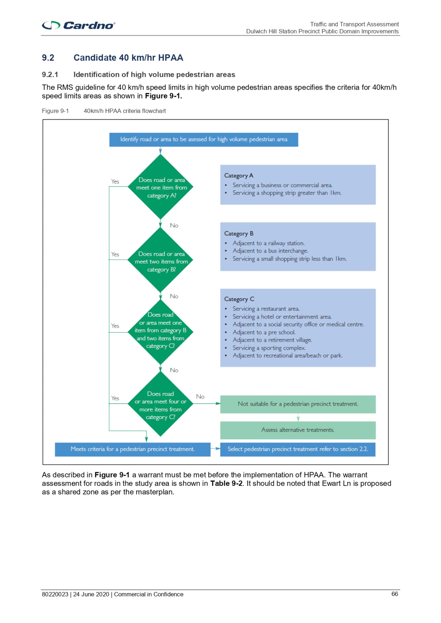
In the previous Traffic Committee report for Stage 1 works (6 July 2020 - LTC0720 Item 7) approval was sought for the raised, signalised intersection at Wardell Road / Dudley Street to address safety issues at the existing pedestrian crossing where crashes have been recorded, particularly as pedestrian movement increases with the implementation of the Sydney Metro upgrades. In Stage 2, thresholds are proposed to be utilised to establish a 40kmph zone at the DHSPPDI as part of works to transform this area into a pedestrian friendly zone in accordance with the masterplan by Plummer & Smith.
Financial Implications
The project is fully funded by the Inner West Council and DPIE. It is noted that TfNSW has also contributed $342,250 through the Blackspot Program.
The project has been listed in Councils Capital Works Program and funding has been committed for stage 2 in the 2021/22 financial year budget.
PUBLIC CONSULTATION
Public Consultation has already been undertaken during the master plan stage. This proposal has also received community feedback. Feedback included concerns over pedestrians mistaking the raised thresholds for right of way, light pollution, desire for more greenery and concerns for reduced parking, especially mobility parking scheme parking spots. Actions undertaken as a result of public consultation include:
· Converting the proposed raised threshold at Bedford Crescent to a zebra crossing to address concerns over right of way at raised thresholds;
· Removing tactile indicators and extending garden beds at remaining proposed raised thresholds to address concerns over right of way at raised thresholds;
· Clarifying that Mobility Parking Scheme parking spots have been shifted, not removed;
· Reviewing lighting to satisfy community concerns over light pollution; and
· Adding more road trees to increase greenery.
CONCLUSION
The upgrades will improve the safety and efficiency of pedestrians and cyclist movements throughout the precinct and facilitate access to and from the station.
|
1.⇩ |
Traffic and Transport Assessment |
|
2.⇩ |
80220023-PDW-1311-1317 - Signage and Linemarking plans, Cardno |
|
3.⇩ |
80220023 220120 Transport Assessment Addendum for Stage 2 |
|
4.⇩ |
DHSPPDI - TCS for the intersection with Wardell Road and Dudley Street |
|
5.⇩ |
DHSPPDI-40k zones |
|
6.⇩ |
DHSPPDI - TCS for the intersection with Wardell Road and Ewart Street |
|
|
Local Traffic Committee Meeting 7 February 2022 |
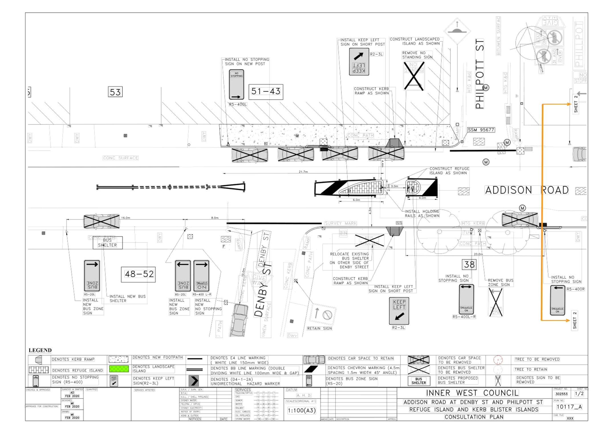
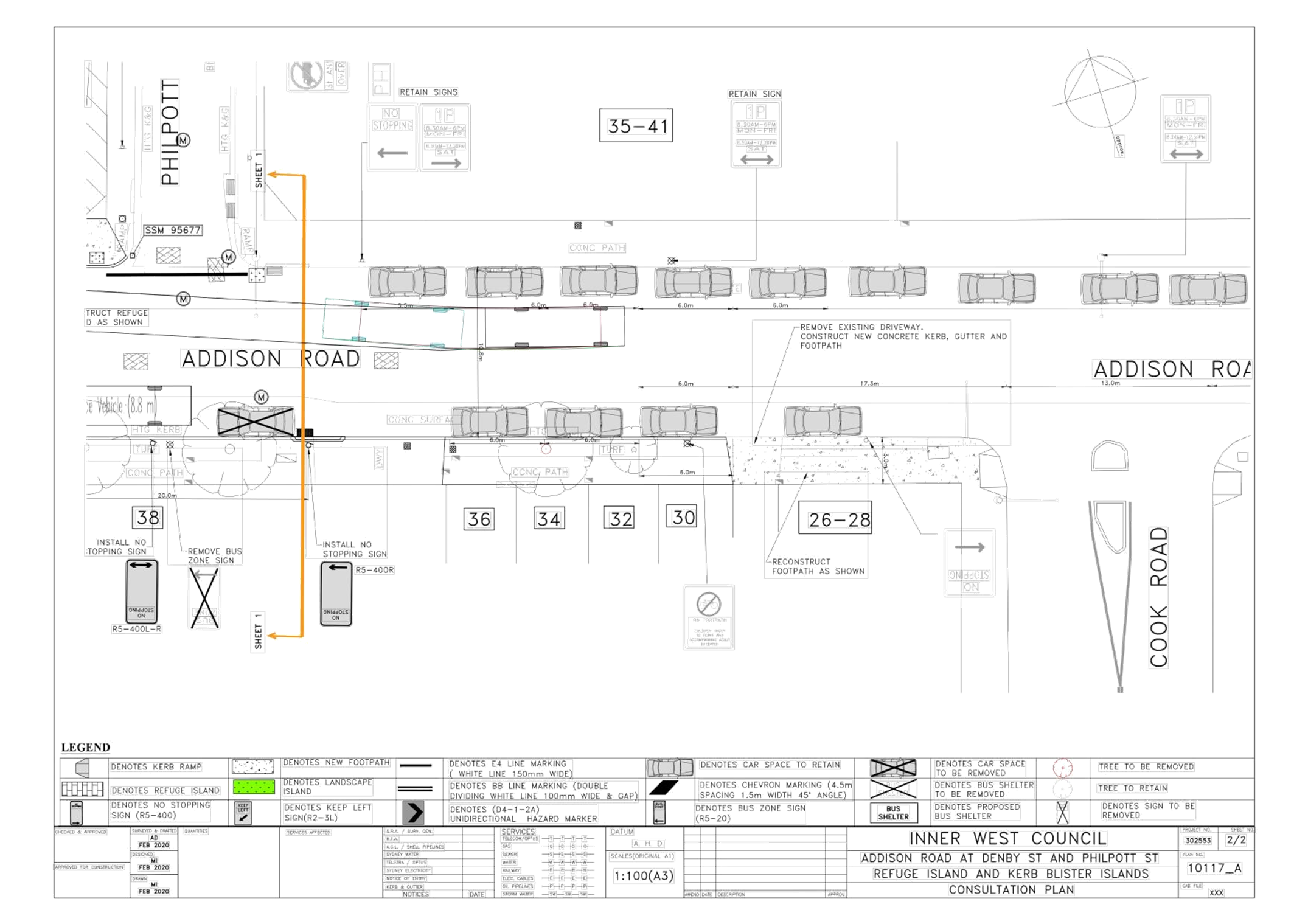
Subject: Addison Road, Marrickville – Proposed new pedestrian refuge - Design Plan 10117_A ((Midjuburi-Marrickville Ward / NEWTOWN and SUMMER HILL ELECTORATES / INNER WEST PAC)
Prepared By: Jennifer Adams - Engineer – Traffic and Parking Services
Authorised By: Manod Wickramasinghe - Traffic and Transport Planning Manager
SUMMARY
Council has finalised an amended design plan for the proposed construction of a new pedestrian refuge on Addison Road, Marrickville near Denby Street. Council received funding from the TfNSW Blackspot Program and the proposed works will improve pedestrian safety and motorist safety in the area. It is recommended that the proposed detailed design plan be approved.
|
RECOMMENDATION
THAT the detailed design plan for the proposed new pedestrian refuge on Addison Road, Marrickville near Denby Street and associated signs and line markings (as per Plan No.10117_A) be APPROVED.
|
BACKGROUND
Council is planning to improve pedestrian safety in Addison Road, Marrickville near Denby Street by constructing a new pedestrian refuge island. The proposed works address concerns about pedestrian safety and driver behaviour in the area. The proposed works are part of recommendations endorsed in August 2019 and listed in the Newington Local Area Traffic Management (LATM) report.
A Blackspot funding application was submitted in 2020 to install a pedestrian refuge in Addison Road at Denby Street and this was successful.
A design plan (10117) was developed for the proposed new pedestrian refuge and consultation was undertaken in September 2021 and a report went to the 18 October 2021 Local Traffic Committee. The Traffic Committee subsequently deferred this item for further investigation noting concerns raised during the consultation. These primarily related to the loss of parking outside of residential properties.
Further investigation was undertaken, and a revised proposal was developed relocating the bus stop westward resulting in no loss of parking outside of residential properties. The revised plan (100117_A) was sent out for consultation to nearby owners and occupiers of properties along Addison Road in early December 2021 and the outcomes of the consultation are summarized in this report.
FINANCIAL IMPLICATIONS
Funding of $70,000 was received as part of the Australian Government’s Black Spot Program for these works and has been allocated to this project under the 2021/2022 Traffic Facilities Capital Works Program.
OTHER STAFF COMMENTS
Addison Road is a Regional Road running east-west between Victoria Road and Livingstone Road, Marrickville. Addison Road is used as a bus route and caries a traffic volume of approximately 12,500 vehicles per day. It provides one traffic lane in each direction, in addition to kerbside parking.
Many pedestrians cross Addison Road in the vicinity of Denby Street and over the years local residents continually requested a pedestrian facility at this location. Bus stops are located on
both sides of the road and residents cross to access these. This was also identified in the Newington Local Area Traffic Management (LATM) report (Area 8).
Data submitted for the Blackspot submission identified five injury crashes on Addison Road near Denby Street, Marrickville. Two of these involved pedestrians and one involved a cyclist.
Proposed new pedestrian refuge
The following works are proposed and are illustrated on the attached Consultation Plan (Plan No.10117_A) which illustrates the proposed works and amendment:
- Installing new Pedestrian Refuge Islands.
- Installing associated pavement line marking and signage as required;
- Constructing new concrete kerb ramps on both sides of the proposed refuge island;
- Reconstructing some damaged sections of concrete footpath with new concrete footpath;
- Implementing new “No Stopping” zones and signage and relocating the Bus Stop and “Bus Zone” signs as shown on the plan.
The Amendment
- In Addison Road: Relocating the existing bus shelter and Bus Zone west from its current location to the other side of Denby Street, as shown on the plan (Attachment 1);
Parking Changes
The proposal will affect existing on-street parking by removing some spaces. Overall, six (6) legal car parking space will be removed in Addison Road as a result of the proposed works; There is no loss of parking outside of residential properties.
PUBLIC CONSULTATION
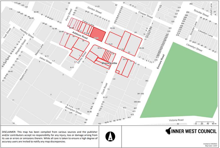
Consultation was conducted between 3 December 2021 and 21 December 202. A letter along with a copy of the amended design plan was sent to residents/businesses in Addison Road, as highlighted in the plan below. A total of 49 letters were distributed. There was one response.
|
Resident’s Comments |
Officer’s response |
|
The revised proposal moving the bus stop west of Denby Street is a significant improvement on the first proposal which would have seriously effected the amenity of the residents.
We note that the parking spaces (two not one) between the current bus stop and the driveway to 38 Addison Road will still be removed. This will leave only four spaces in front of the residences 28 to 36 Addison Road. We suggest that a resident parking scheme be introduced for these houses. It should also apply to the three spaces around the corner in Cook Road.
The report does not address the question of when and where the accidents in Addison Road occurred. We would still like this information.
Overall we are no longer opposed to the proposal subject to the introduction of a resident parking scheme |
The relocation of the bus stop is a result of the introduction of a Pedestrian Refuge. The proposed new bus stop location is the only feasible location.
Loss of Parking is a result of the statutory No Stopping required with the introduction of a Pedestrian Refuge. Possible residential parking was a consideration when the bus stop was proposed to be situated in front of the residential properties and because that is now no longer the situation any further request for a residential permit parking scheme would have to be in accordance with Council’s Parking Policy.
Noted and addressed in this report.
Noted and addressed above.
|
|
|
|
|
|
|
Transit Systems was consulted as the proposed works involved relocation of an existing Bus Zone and bus shelter. They raised no objection to the amended plan and relocation of the bus stop. Transit Systems responded that the relocation would have a financial cost of approximately $420 for the installation of new B/Pole at the relocated stop and for the installation of tactiles. Transit Systems will provide details of their contractor or they will have it installed and invoice Council accordingly. Installation plans for DDA compliancy were supplied and reproduced below.
CONCLUSION
It is recommended that the amended detailed design plans (10117_A) for the proposed construction of a new pedestrian refuge on Addison Road, Marrickville near Denby Street. and associated works, signs and line markings be approved, to improve road safety at this location.
|
1.⇩ |
Detailed design plans (10117_A) - construction of a new pedestrian refuge on Addison Road, Marrickville near Denby Street |
|
Local Traffic Committee Meeting 7 February 2022 |
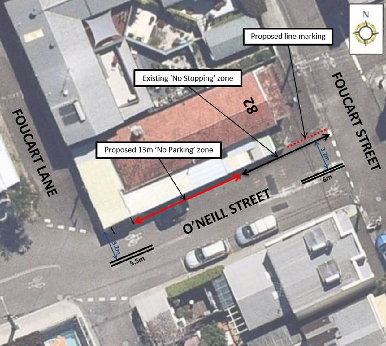
Subject: O'Neill Street, Lilyfield (West of Foucart Street) - Proposed 'No Parking' restrictions (Baludarri-Balmain Ward/Balmain Electorate/Leichhardt PAC)
Prepared By: Vinoth Srinivasan - Engineer - Traffic and Parking Services
Authorised By: Sunny Jo - Coordinator Traffic Engineering Services (North)
SUMMARY
Council has received concerns regarding vehicles parking on the northern side of O’Neill Street, west of Foucart Street and subsequently causing localised traffic congestion and queuing on both O’Neill Street and Foucart Street.
|
RECOMMENDATION
THAT a 13m ‘No Parking’ zone be installed in the northern side of O’Neil Street, Lilyfield between the existing ‘No Stopping’ zone and the driveway access of No. 82 Foucart Street, Rozelle.
|
BACKGROUND & OTHER STAFF COMMENTS
Council has received requests from residents raising concerns regarding the existing traffic arrangement in O’Neill Street, Lilyfield. Currently vehicles parked on the northern side of O’Neill Street, between Foucart Street and Foucart Lane only allow for a single travelling lane for passing which subsequently causes minor delays and at times queuing along both O’Neill Street and Foucart Street.
In order to alleviate this issue and allow for two-way passing on O’Neill Street, it is proposed to install a 13m ‘No Parking’ zone in the northern side of O’Neill Street, Lilyfield between the existing ‘No Stopping’ zone and the driveway access of No. 82 Foucart Street, Rozelle. Slight adjustments to the existing linemarking and a holding line for pedestrians are proposed along the north side of O’Neill Street at Foucart Street as there is no defined footpath boundary.
The proposed changes will result in the loss of two (2) on-street parking spaces.
Further details of the proposal are shown in the signage and linemarking plan below.
FINANCIAL IMPLICATIONS
Nil.
PUBLIC CONSULTATION
A letter outlining the proposal was mailed out to the affected properties (8 properties) in O’Neil Street, Cecily Street, Foucart Street and Cheltenham Street, Lilyfield. Two (2) responses were received, in objection to the proposal. The main concerns are outlined below:
· Parking spaces are scare and are in demand in this area due to WestConnex workers.
· Removing parking spaces will create safety concerns as it will allow vehicles to speed through O’Neill Street.
Council has provided additional comments in regard to the residents’ concerns. These are detailed below:
· The Give-Way line marking on O’Neill Street at the intersection of Foucart Street and the bend on O’Neill Street at the intersection of Foucart Lane will reduce travel speeds in that particular part of O’Neill Street.
|
|
Local Traffic Committee Meeting 7 February 2022 |
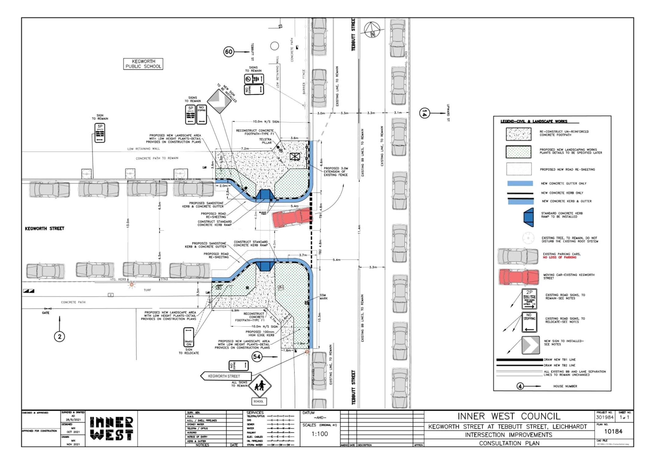
Subject: KEGWORTH STREET, LEICHHARDT AT INTERSECTION WITH TEBBUTT STREET–INTERSECTION DEVELOPMENT FOR PEDESTRIAN AND CHILDREN SAFETY–TRAFFIC FACILITIES (GULGADYA-LEICHHARDT WARD/BALMAIN ELECTORATE/LEICHHARDT PAC)
Prepared By: David Yu - Engineer - Traffic and Parking Services
Authorised By: Sunny Jo - Coordinator Traffic Engineering Services (North)
SUMMARY
Council is planning to improve pedestrian safety in Kegworth Street at the intersection of Tebbutt Street, Leichhardt by constructing kerb extensions at this location. The proposed works aim to improve pedestrian safety by reducing the crossing distance.
|
RECOMMENDATION
THAT the attached detailed design plan (Design Plan No.10184) for the proposed kerb extensions and associated works at Kegworth Street, Leichhardt at the intersection of Tebbutt Street be approved.
|
BACKGROUND & OTHER STAFF COMMENTS
The detailed design plan shown in Attachment 1 outlines the proposed upgrade works on Kegworth Street and Tebbutt Street, Leichhardt and includes the following treatments:
- Construction of new kerb extension on both sides of Kegworth Street;
- Reconstruction of existing concrete footpath;
- Construction of new landscaped area (with low height plants);
- Constructing two (2) kerb ramps;
- Installing new and repainting existing pavement line marking; and
- Relocating signage associated with the works.
The proposal will not result any loss of on-street parking space.
The modification of the existing intersection will improve safety for pedestrians and school children by reducing the crossing distance, improving sight lines and controlling vehicle speeds when turning into the street.
FINANCIAL IMPLICATIONS
The 2021-22 budget allocation for this project is $35,000.
PUBLIC CONSULTATION
A letter outlining the proposal was mailed out to 52 properties in Kegworth Street and Tebbutt Street, Leichhardt. Three (3) responses were received in regard to the proposal, two in support and one in objection.
The main objections raised during the consultation are summarised below:
- request made to install speed humps in Kegworth Street.
- concern regards increased pedestrian danger with reduced road width and creation of traffic congestion with the narrow street.
In response, it is noted that the proposed device will have a traffic calming impact on vehicles entering the street, and the device will improve pedestrian safety at this location by shortening the crossing distance. Additionally, there is an existing 40km/h School Zone in operation which is considered to be adequate given the low traffic volume in the street. It is further noted that traffic peaks only during the morning and afternoon school hours for short period of time.
|
1.⇩ |
Detailed Design Plan – Kegworth Street and Tebbutt Street, Leichhardt – Proposed Intersection Improvements |
|
|
Local Traffic Committee Meeting 7 February 2022 |
Subject: Intersection of Edward Street and Mungo Scott
Place/WellesleyStreet-Interim treatment of intersection for improved sight
line. (Djarrawunang-Ashfield Ward/Summer Hill Electorate/Ashfield
PAC)
Prepared By: Boris Muha - Engineer – Traffic and Parking Services
Authorised By: Manod Wickramasinghe - Traffic and Transport Planning Manager
SUMMARY
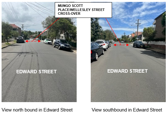
Council has received numerous concerns from the community (via councillor and requests alone) regarding sight line obstruction at the crossroad intersection of Edward Street and Wellesley Street /Mungo Scott Place, Summer Hill.
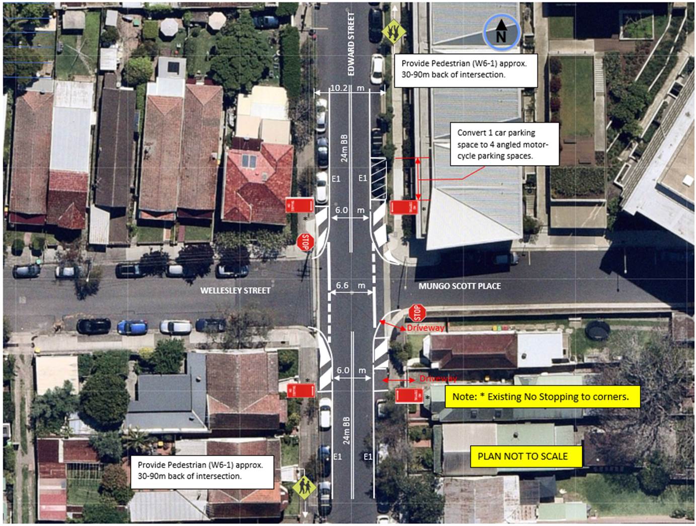
To alleviate this issue in the interim, it is proposed that the intersection be treated via signs and line marking by building out the corners of Edward Street in paint and introduce STOP control markings in Wellesley Street and Mungo Scott Place out in/near line of the build outs. Associated variation to parking, edge line and centreline introduction with advance warning ‘Pedestrian’ signs in Edward Street will further enhance traffic and pedestrian safety though the intersection.
|
RECOMMENDATION
THAT the interim works for treatment (via signs and markings) of the intersection of Edward Street and Wellesley Street/Mungo Scott Place, Summer Hill BE APPROVED as follows:
1. Provide painted built outs to all corners in Edward Street, 2. Provide STOP control markings for Wellesley Street and Mungo Scott Place out in/near line of the painted build outs in Edward Street, with new STOP signs added, 3. Provide edge lines (E1) and double barrier centrelines (BB) in Edward Street at 24 metres to both sides of the intersection, 4. The first unrestricted car space on the eastern side of Edward Street, north of Mungo Scott Place be converted to angled parking for motorcyclists, and 5. Provide advance ‘Pedestrian’ warning signs in Edward Street on both approach sides to the intersection.
|
BACKGROUND
The intersection in question was previously a T-intersection with Wellesley Street serving as the minor local Street and Edward Street being the major local street.
Mungo Scott Place is a private road constructed under the Floor Mill development. The intersection now acts as a crossroad with Wellesley Street and Mungo Scott Place needing to Give-way to traffic in Edward Street.
Edward Street and Wellesley Street measure approximately 10.2m from kerb to kerb with parking to both sides of the streets. Mungo Scott Place is narrower measuring approximately 6-8.5m kerb to kerb (6m being near the junction with Edward Steet). Parking is permitted to the northern side of Mungo Scott Place. Mungo Scott Place serves as a major access to units south of the Floor Mill complex.
Traffic counts in Edward Street (taken in 2018) show volumes around 3200 vehicles per day with 85% speeds around 46km/h. No accidents are identified in the last 5 years from available TfNSW accident records for the intersection. Residents have claimed near miss or minor unreported incidences and are concerned with likely build-up of traffic and speeding in Edward Street once traffic lights are installed south at the intersection at Edward Steet and Old Canterbury Road (under the DA conditions for the Floor Mill). There is also concern as to who should clearly give-way at the intersection.
Council has also recently received a pre-DA for a hotel development on the corner of Edward Street and Mungo Scott Place. The proposed hotel is in the early stage of design development and currently includes loading and car parking from the rear.

FINANCIAL IMPLICATIONS
The proposed interim works to the intersection of Edward Street and Wellesley Street/Mungo Scott Place is estimated at around $7,500 and will funded under the Council’s general signs and line marking budget.
Proposed interim works at the intersection of Edward Street and Wellesley Street/Mungo Scott Place.
OTHER STAFF COMMENTS
The intersection has been captured under the Ashfield Traffic Management Strategy (ATMS) and listed under the capital works program to investigate a permanent intersection treatment revolving around traffic and pedestrian safety, and any other perceived developments at the intersection.
Given that there is community concern to resolve the main issue of sight lines, the following interim works are proposed (at this point of time) in treatment of the intersection.
1. Provide painted built outs to all corners in Edward Street.
Painted islands area only marked out to the extent of the existing ‘No Stopping’ at the corners of the intersection. No parking is lost because of this.
2. Provide STOP control markings for Wellesley Street and Mungo Scott Place out in/near line of the painted build outs in Edward Street, with new STOP signs added.
Clear indication is required for vehicles in Wellesley Street and Mungo Scott Place to give-way to traffic in Edward Street. STOP control is proposed over GIVE-WAY control as lines are marked out in near line to the painted build outs close to traffic In Edward Street.
3. Provide edge lines (E1) and double barrier centrelines (BB) in Edward Street at 24 metres to both sides of the intersection.
This will assist to guide and control traffic and reduce the speed in Edward Street though the intersection.
4. The first unrestricted car space on the eastern side of Edward Street, north of Mungo Scott Place be converted to angled parking for motorcyclists.
To further enhance the sight line view for Floor Mill residents exiting out of Mungo Scott Place, the first unrestricted car space north on the approach to Mungo Scott Place and outside the units is proposed to be removed and altered for motorcycle parking. Cars can view over parked motorcycles. This measure will allow parking to be retained in the area rather whilst improving sightlines. The use of the motorcycle parking would be further monitored and considered if still required under investigation for permanent treatment of the intersection.
5. Provide advance ‘Pedestrian’ warning signs in Edward Street on both approach sides to the intersection.
Certain requests were also raised to providing pedestrian crossings at the location. Observations on site do not reveal high pedestrian usage to warrant pedestrian crossings. ‘Pedestrian’ warnings signs are considered in this case as an alternative. Pedestrian movement would be further investigated in line with any permanent treatment to the intersection.
It should be noted that any permanent treatment may involve either to physically reinforce the build outs and retain line marking and STOP control as proposed under interim, or devise a different treatment based on the speed, traffic/pedestrian safety and any development at the intersection.
CONSULTATION
Nil. The proposal is of an interim measure. Parking is only varied with the one car space on the eastern side of Edward Street, north of Mungo Scott Place on basis of traffic safety. No other parking is lost in the area.
Residents in the vicinity will be notified on the interim works prior to implementation.
CONCLUSION:
In view of the above, it is recommended that interim works, at this point of time, be carried out in the treatment of the intersection of Edward Street and Wellesley Street/Mungo Scott Place as shown in the recommendation above.
|
|
Local Traffic Committee Meeting 7 February 2022 |
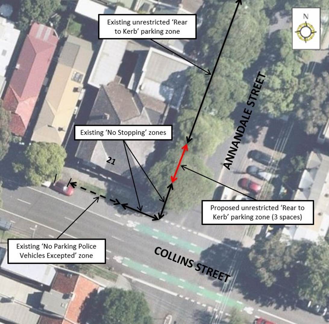
Subject: Annandale Street, Annandale - Removal of 'No Parking Police Vehicles Excepted' restrictions (Gulgadya-Leichhardt Ward/Balmain Electorate/Leichhardt PAC)
Prepared By: Vinoth Srinivasan - Engineer - Traffic and Parking Services
Authorised By: Sunny Jo - Coordinator Traffic Engineering Services (North)
SUMMARY
Council has been notified by NSW Police that the three (3) existing ‘No Parking Police Vehicles Excepted’ angle parking spaces on the west side of Annandale Street north of Collins Street, Annandale in front of the Police Station may be reverted to unrestricted parking.
|
RECOMMENDATION
THAT three (3) ‘No Parking Police Vehicles Excepted’ angle parking spaces on the west side of Annandale Street, Annandale near No.21 Collins Street, Annandale be reverted back to unrestricted angle parking. |
BACKGROUND & OTHER STAFF COMMENTS
Council has been notified by NSW Police that the utilization of the existing ‘No Parking Police Vehicles Excepted’ angle spaces on the eastern side of Annandale Street, Annandale in front of the Police Station is low and the spaces can be reverted to unrestricted parking.
The removal of three (3) ‘No Parking Police Vehicles Excepted’ angle parking spaces will increase on-street parking supply for the community.
NSW Police has advised that the existing ‘No Parking Police Vehicle Excepted’ parking spaces on the northern side of Collins Street, Annandale, west of Annandale Street is still required.
The proposal is shown in the following plan.
FINANCIAL IMPLICATIONS
Nil.
PUBLIC CONSULTATION
Nil.
|
|
Local Traffic Committee Meeting 7 February 2022 |
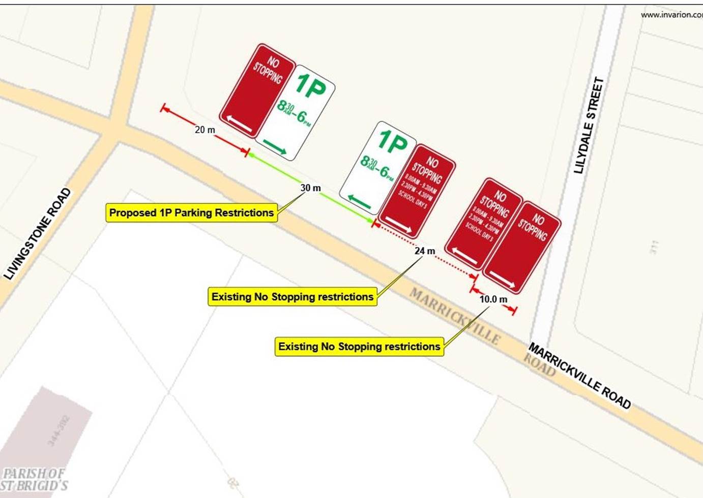
Subject: Marrickville Road, Marrickville near Livingstone Road - Implementation of short-term parking restrictions (Midjuburi- Marrickville Ward/ Summer Hill Electorate/ Inner West PAC)
Prepared By: Jennifer Adams - Engineer – Traffic and Parking Services
Authorised By: Manod Wickramasinghe - Traffic and Transport Planning Manager
SUMMARY
Council is proposing to introduce a section of time-restricted parking along Marrickville Road, Marrickville, in order to improve parking turnover along the frontage of Marrickville Library and in the vicinity of the local businesses along the above-mentioned road.
|
RECOMMENDATION
THAT thirty (30) metre section of unrestricted parking be converted to ‘1P 8.30am – 6pm’ on northern side of Marrickville Road, Marrickville between the signalized intersection of Marrickville Road/Livingstone Road and existing ‘No Stopping 8am-930am 2.30pm-4.30pm School Days’ located 23.6m west of Lilydale Street. |
BACKGROUND & OTHER STAFF COMMENTS
Council is proposing to introduce a section of time-restricted parking along Marrickville Road, Marrickville, in order to improve parking turnover along the frontage of Marrickville Library and in the vicinity of the local businesses along the above-mentioned road.
Please note, there will be no change to existing ‘No Parking’ restrictions during peak hour traffic thoroughfare.
The proposal is shown in the following plan.
FINANCIAL IMPLICATIONS
Nil.
PUBLIC CONSULTATION
A letter outlining the proposal was mailed out to properties in close proximity to the proposed parking restriction location. To date, (3) three responses were received, all against the proposal. All responses indicate the lack of unrestricted parking within the area for staff, residents and visitors with the library having off-street parking to cater for visitors.
CONCLUSION
It is noted that the proposed restrictions would be consistent with parking restrictions along other commercial sections of Marrickville Road and will improve parking turnover for nearby business including the library, it is therefore recommended for approval.