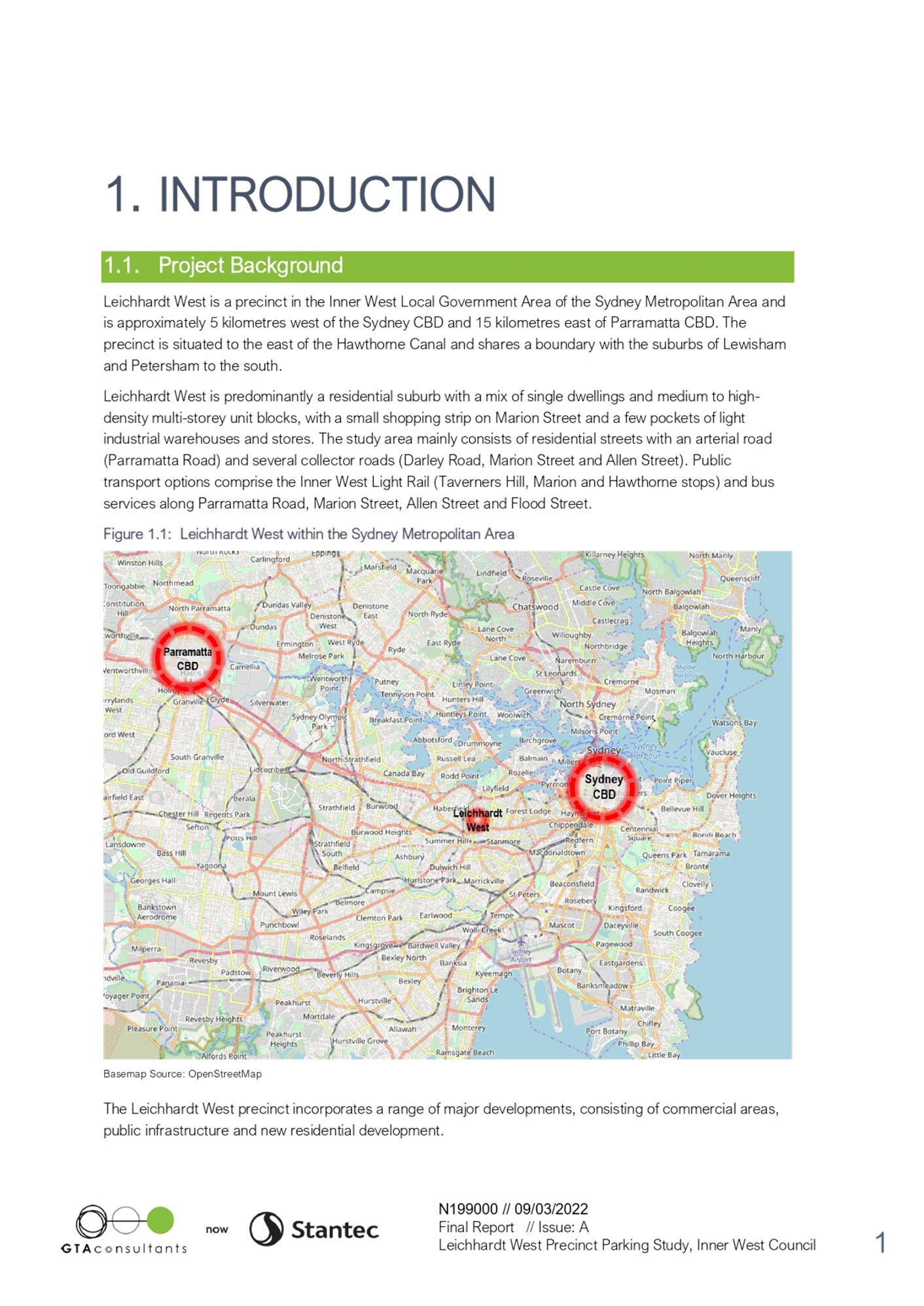
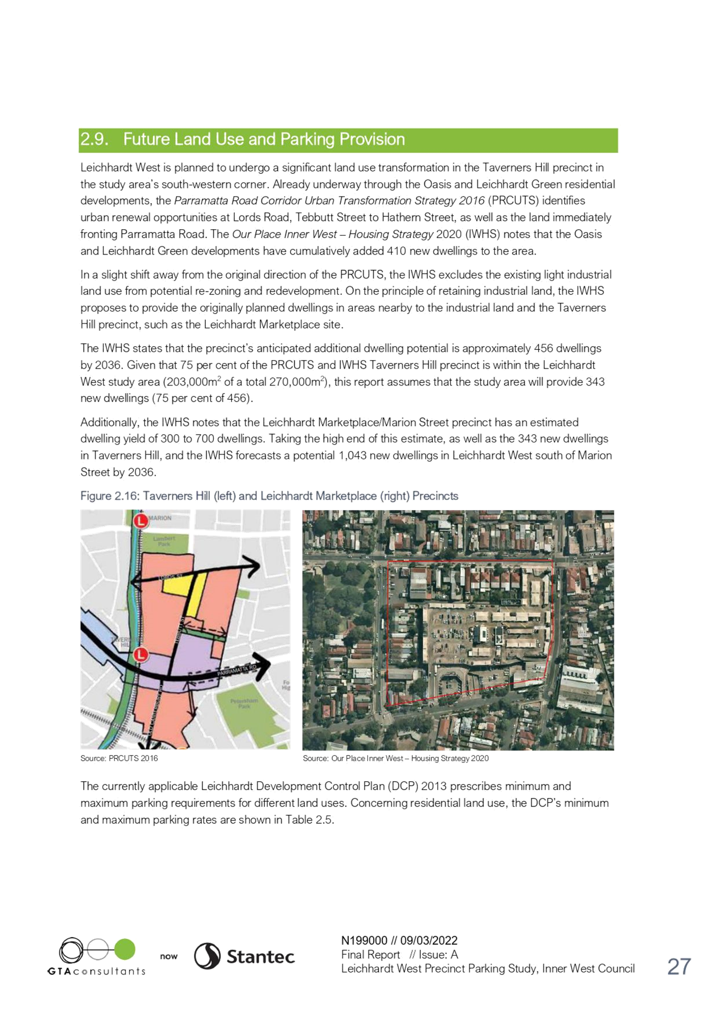
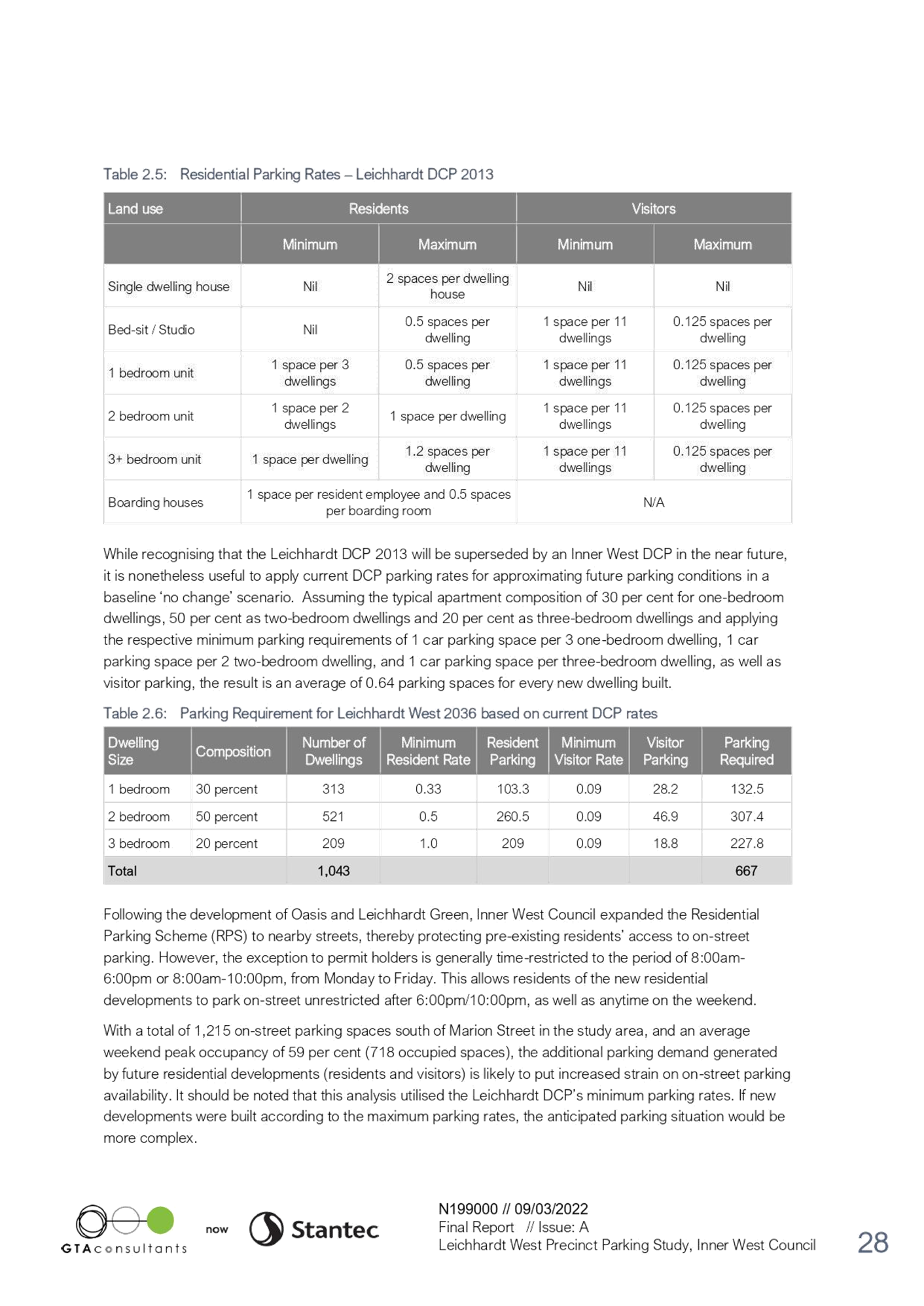
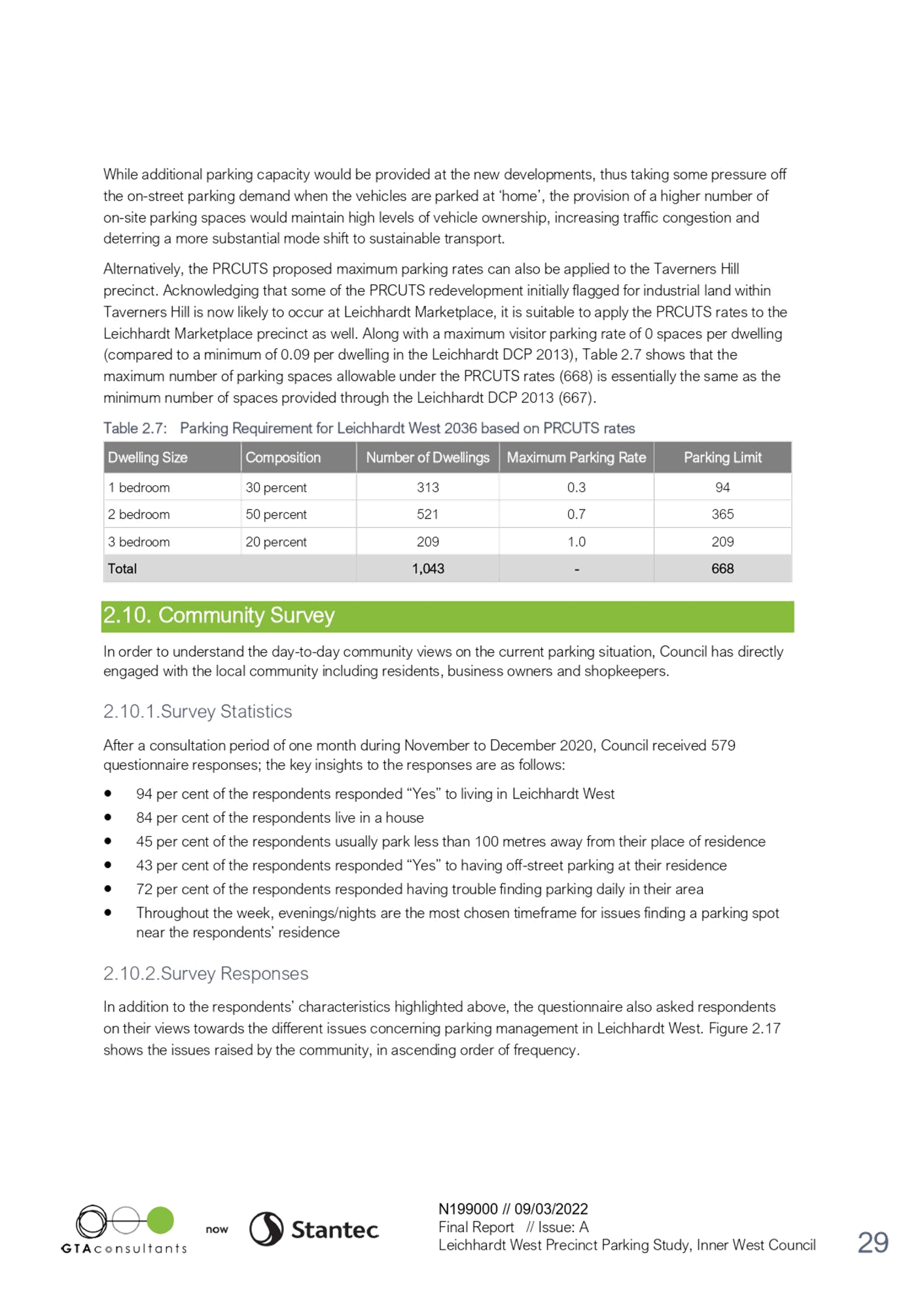
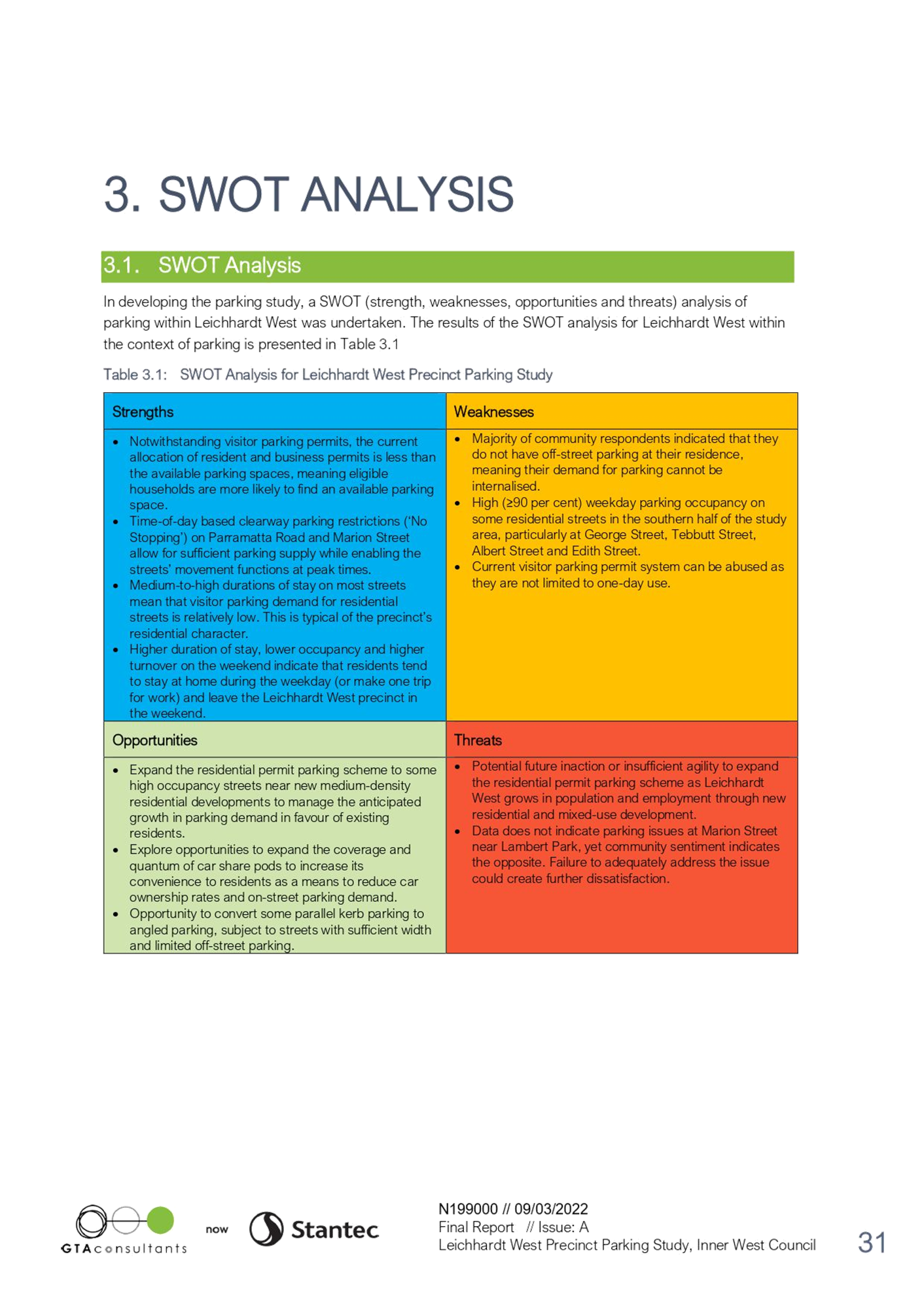
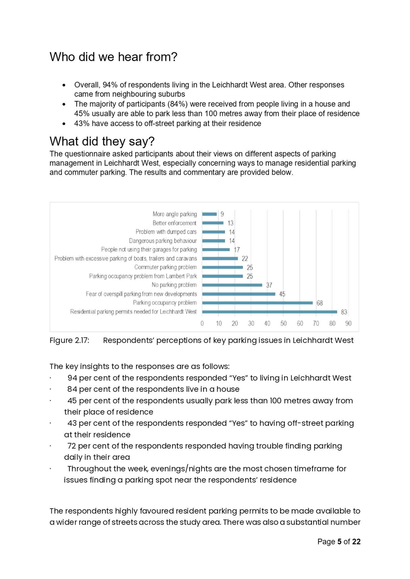
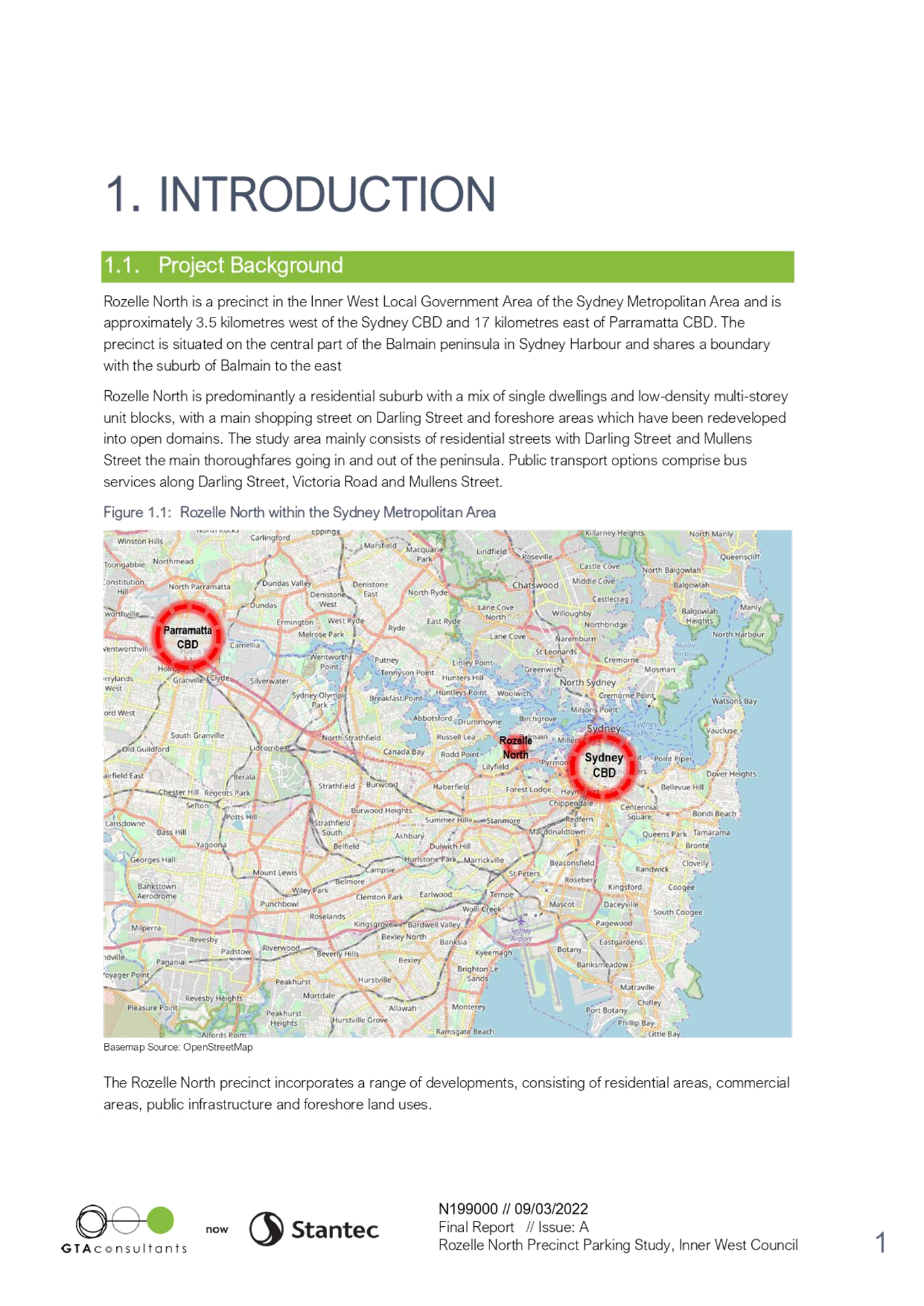
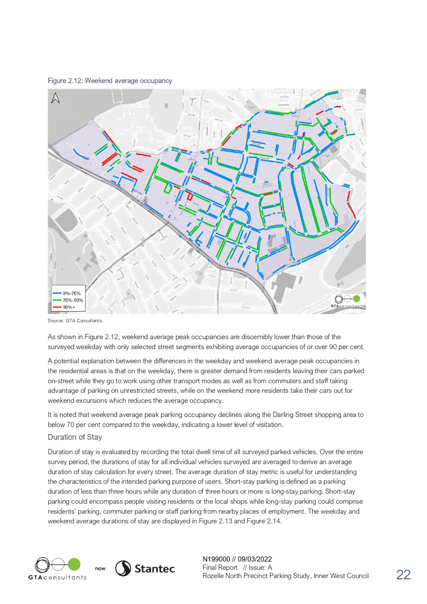
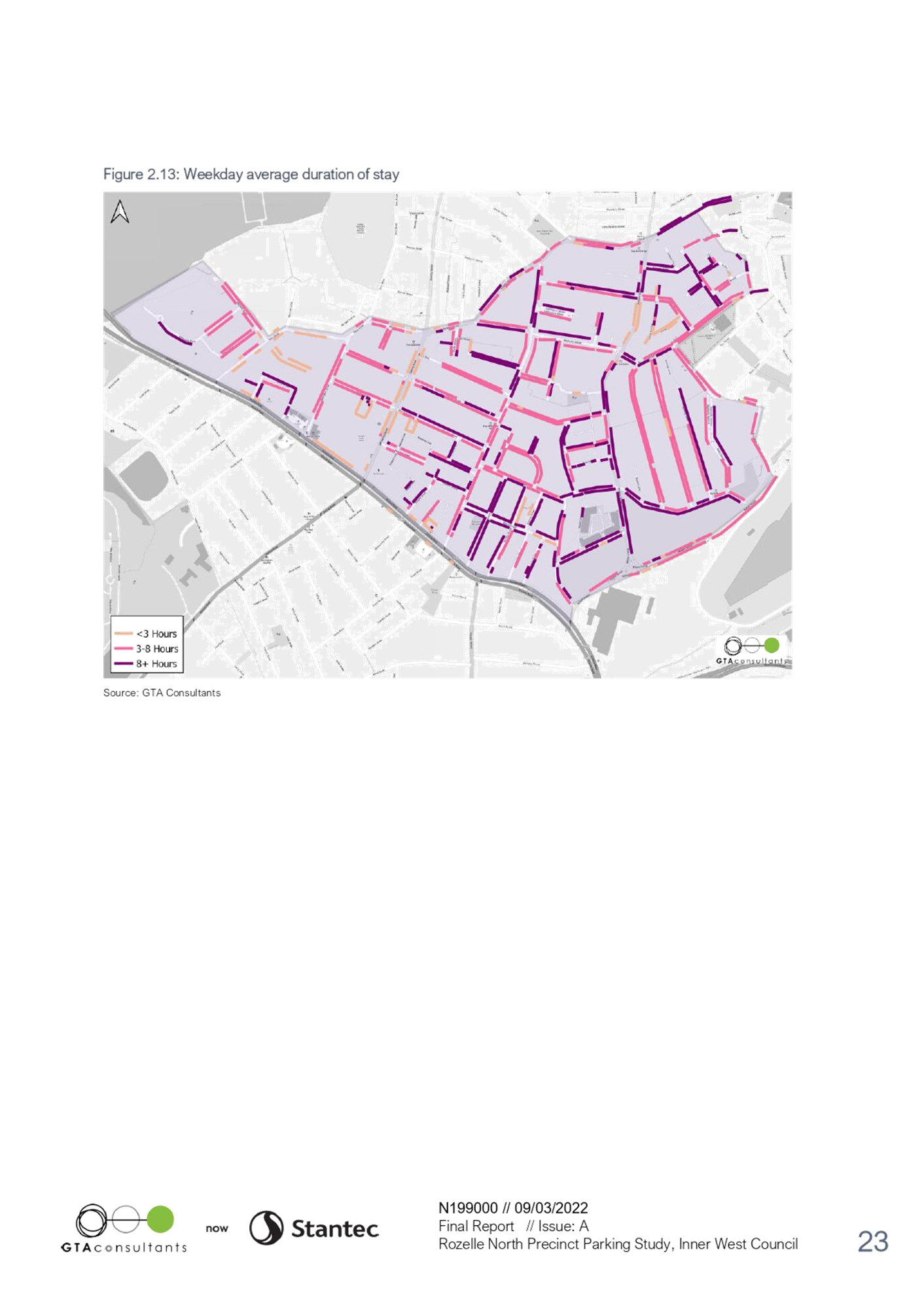
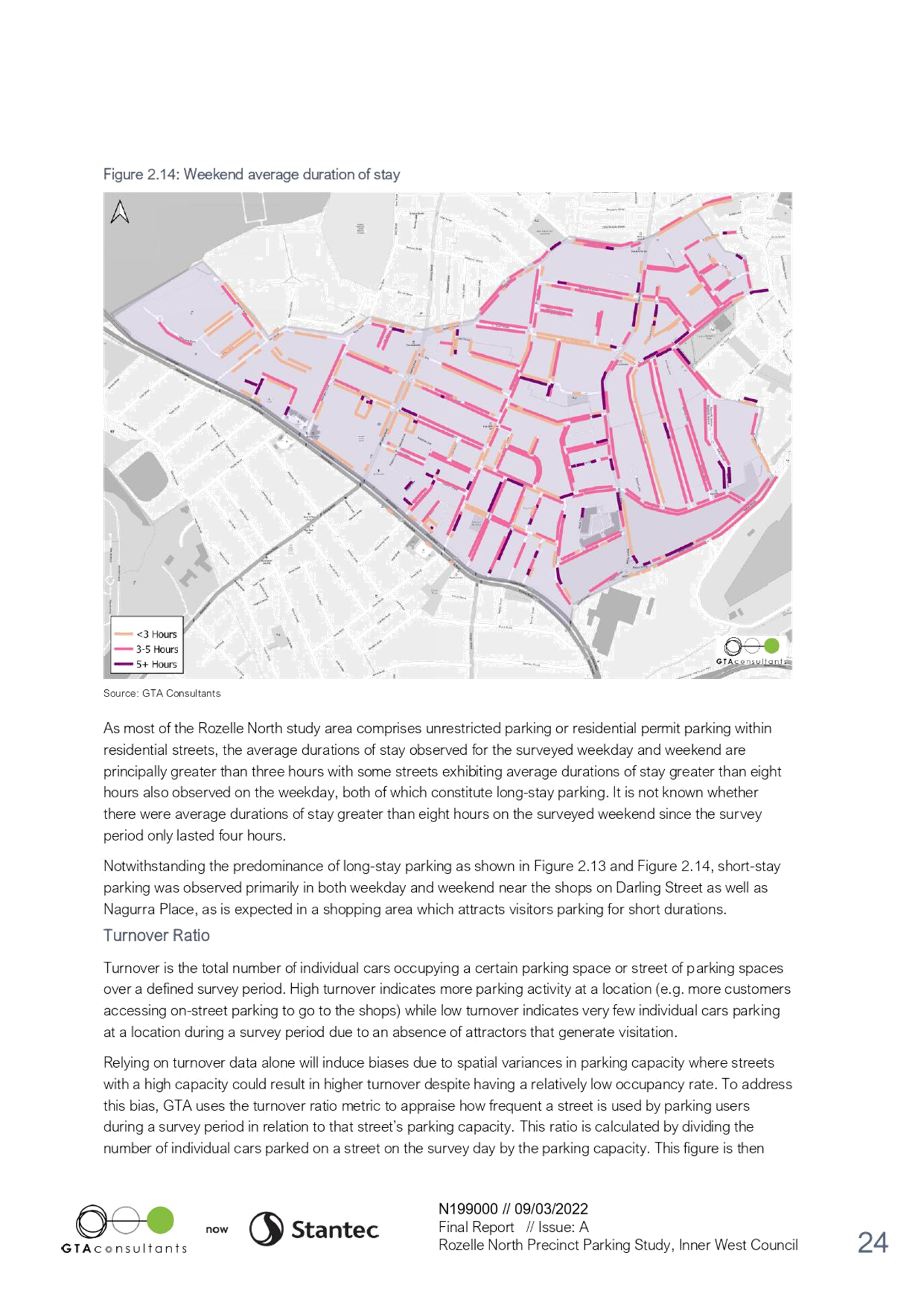
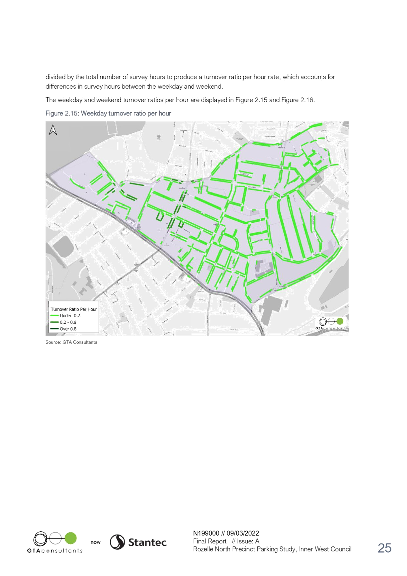
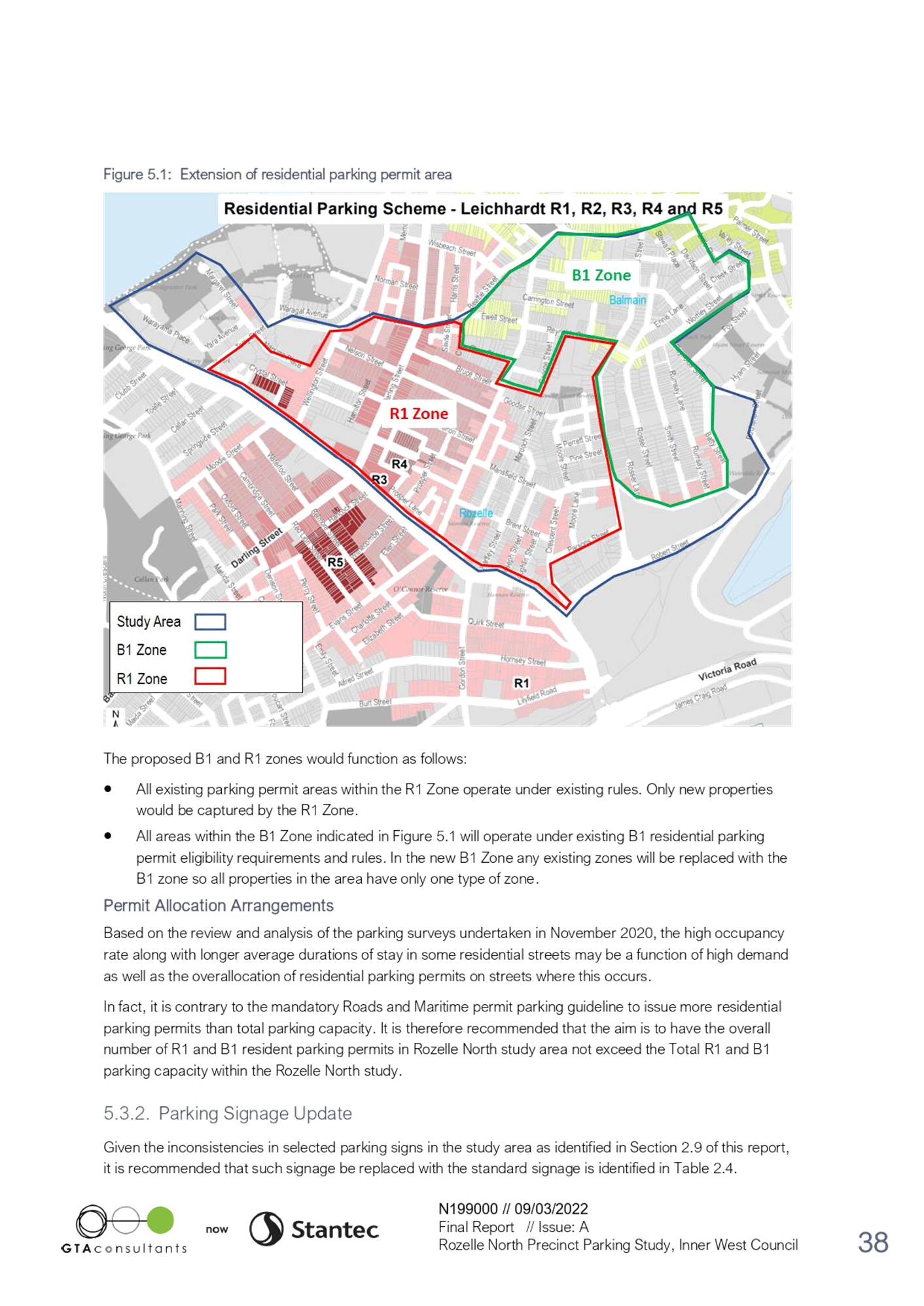
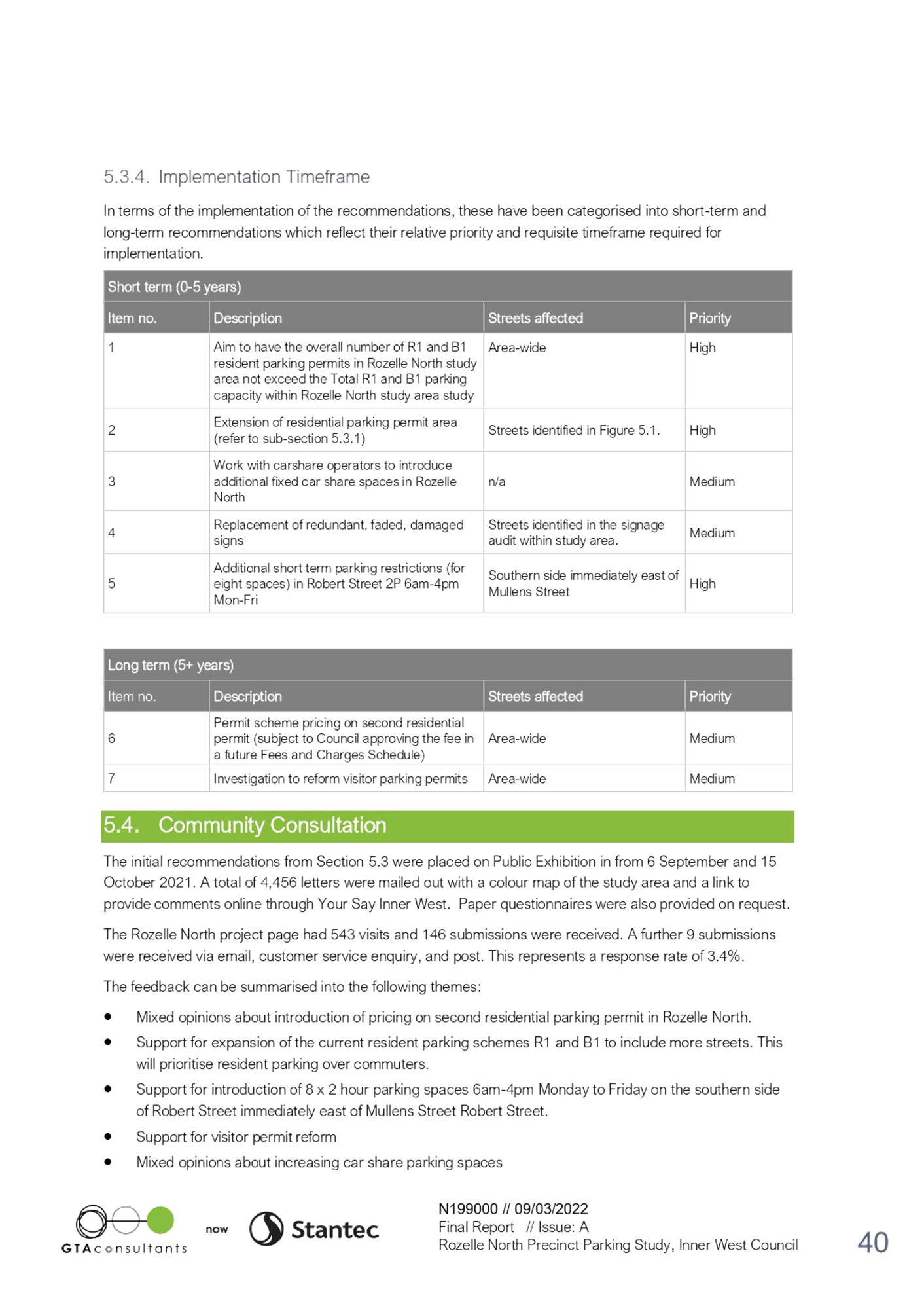
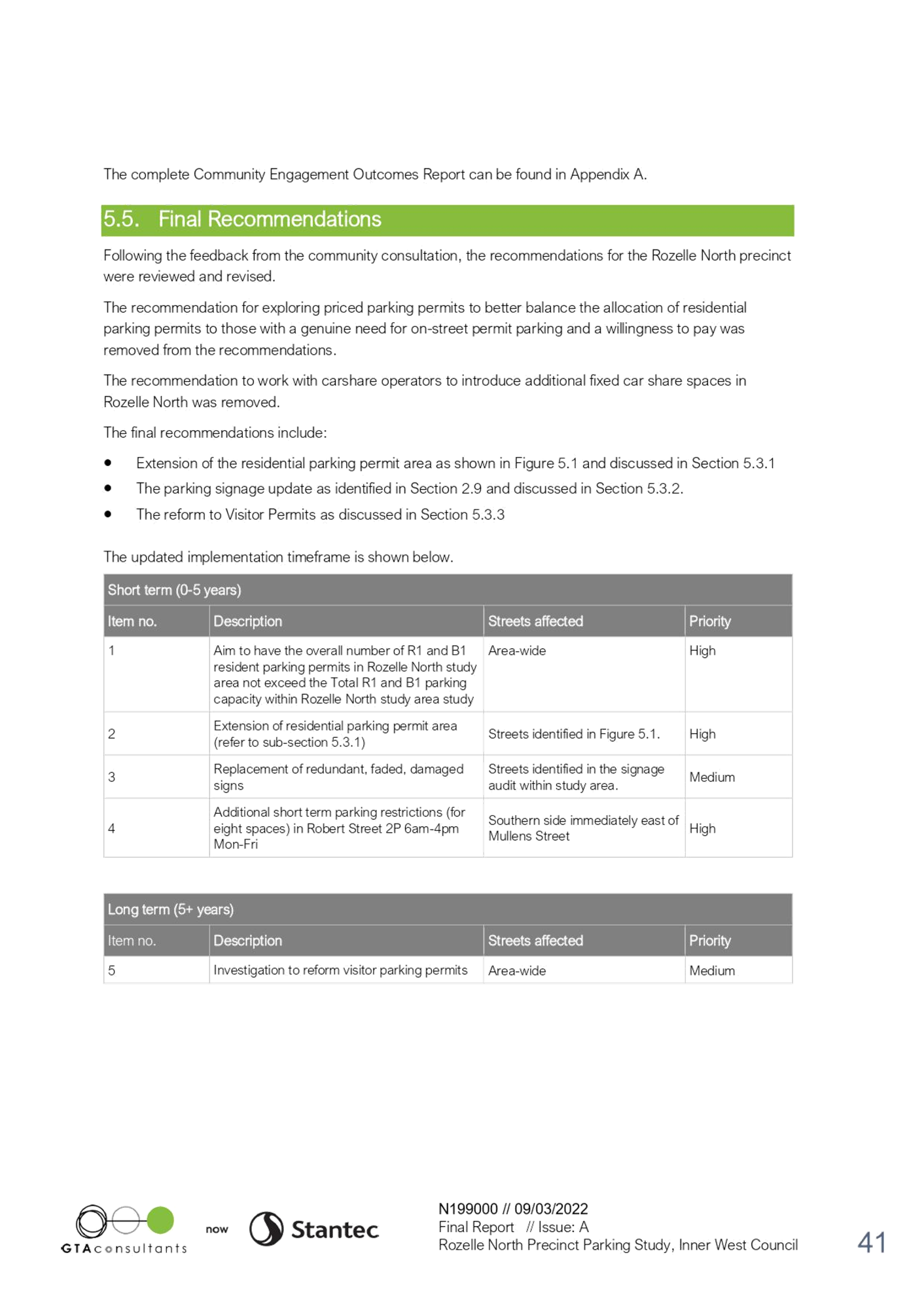
|
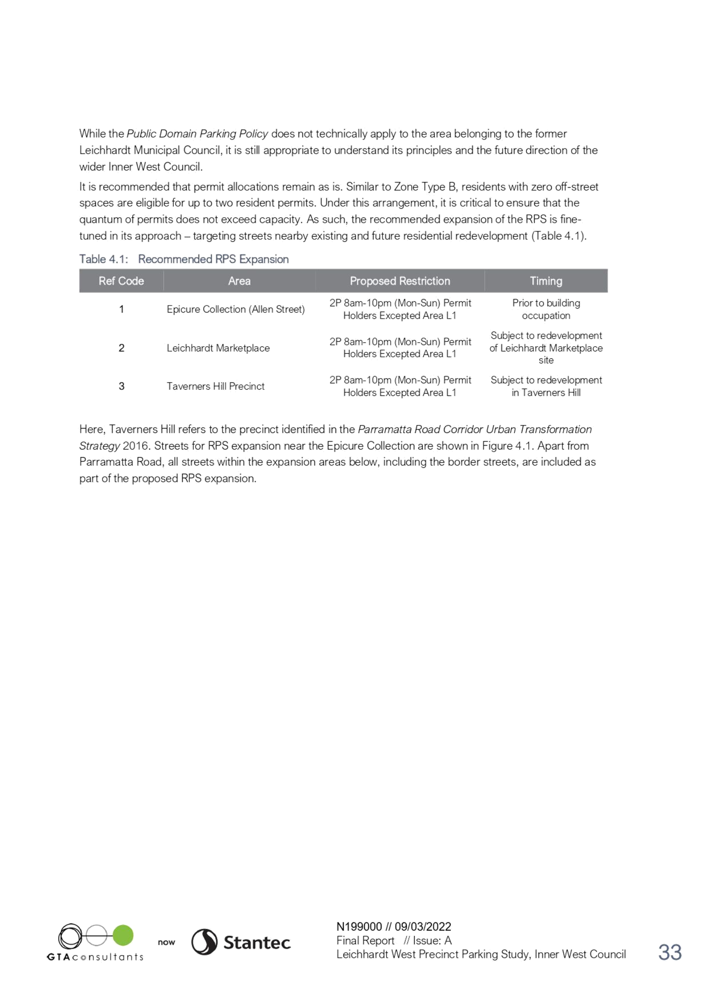
AGENDA R |

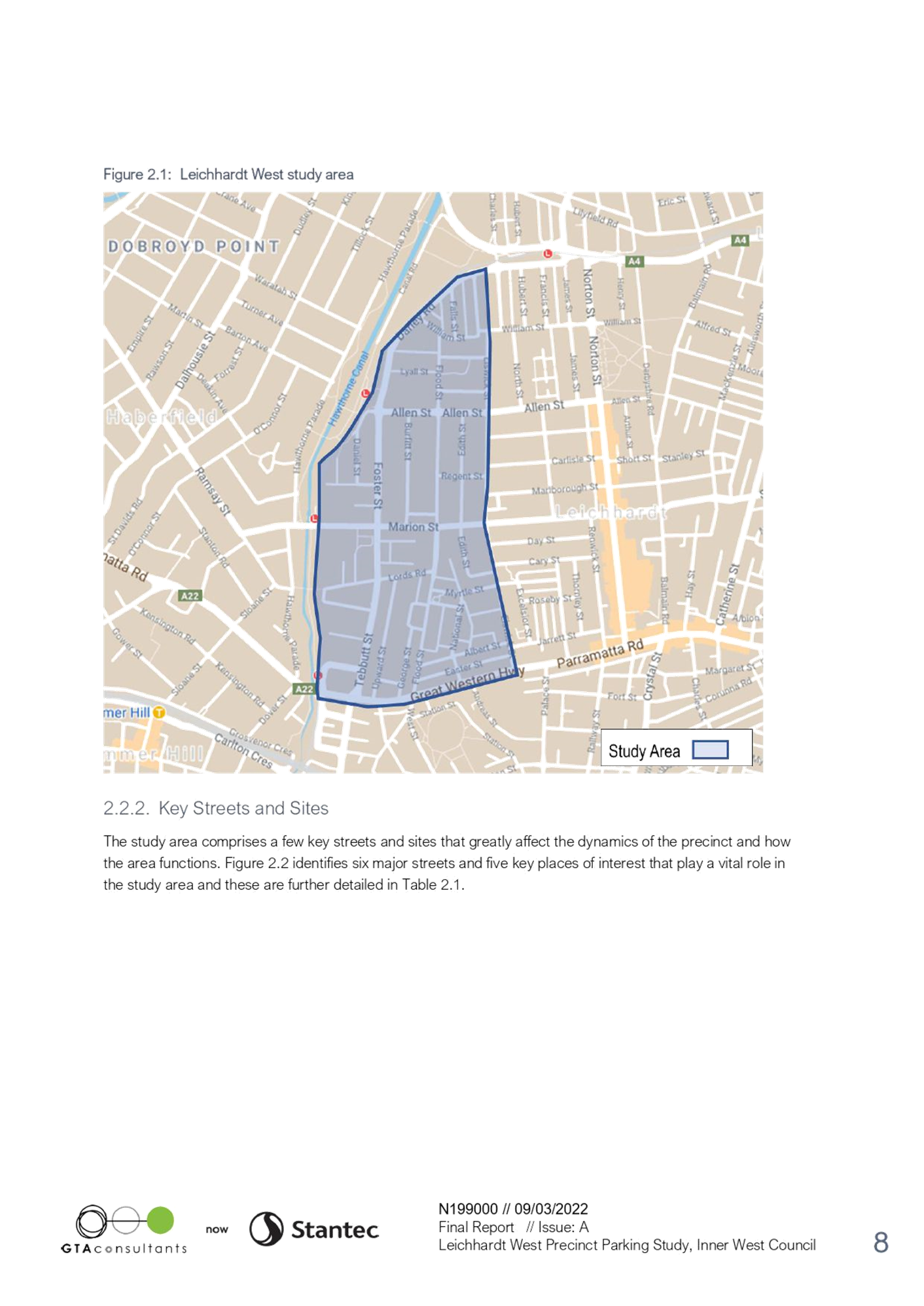
Local Traffic Committee Meeting
MONDAY 21 MARCH 2022
11.00am
|
|
Local Traffic Committee Meeting 21 March 2022 |
Function of the Local Traffic Committee
Background
Roads and Maritime Services (RMS) is legislated as the Authority responsible for the control of traffic on all NSW Roads. The RMS has delegated certain aspects of the control of traffic on local roads to councils. To exercise this delegation, councils must establish a local traffic committee and obtain the advice of the RMS and Police. The Inner West Council Local Traffic Committee has been constituted by Council as a result of the delegation granted by the RMS pursuant to Section 50 of the Transport Administration Act 1988.
Role of the Committee
The Local Traffic Committee is primarily a technical review and advisory committee which considers the technical merits of proposals and ensures that current technical guidelines are considered. It provides recommendations to Council on traffic and parking control matters and on the provision of traffic control facilities and prescribed traffic control devices for which Council has delegated authority. These matters are dealt with under Part A of the agenda and require Council to consider exercising its delegation.
In addition to its formal role as the Local Traffic Committee, the Committee may also be requested to provide informal traffic engineering advice on traffic matters not requiring Council to exercise its delegated function at that point in time, for example, advice to Council’s Development Assessment Section on traffic generating developments. These matters are dealt with under Part C of the agenda and are for information or advice only and do not require Council to exercise its delegation.
Committee Delegations
The Local Traffic Committee has no decision-making powers. The Council must refer all traffic related matters to the Local Traffic Committee prior to exercising its delegated functions. Matters related to State Roads or functions that have not been delegated to Council must be referred directly to the RMS or relevant organisation.
The Committee provides recommendations to Council. Should Council wish to act contrary to the advice of the Committee or if that advice is not supported unanimously by the Committee members, then the Police or RMS have an opportunity to appeal to the Regional Traffic Committee.
Committee Membership & Voting
Formal voting membership comprises the following:
· one representative of Council as nominated by Council;
· one representative of the NSW Police from each Local Area Command (LAC) within the LGA, being Newtown, Marrickville, Leichhardt and Ashfield LAC’s.
· one representative from the RMS; and
· State Members of Parliament (MP) for the electorates of Summer Hill, Newtown, Heffron, Canterbury, Strathfield and Balmain or their nominees.
Where the Council area is represented by more than one MP or covered by more than one Police LAC, representatives are only permitted to vote on matters which effect their electorate or LAC.
Informal (non-voting) advisors from within Council or external authorities may also attend Committee meetings to provide expert advice.
Committee Chair
Council’s representative will chair the meetings.
Public Participation
Members of the public or other stakeholders may address the Committee on agenda items to be considered by the Committee. The format and number of presentations is at the discretion of the Chairperson and is generally limited to 3 minutes per speaker. Committee debate on agenda items is not open to the public.
|
|
Local Traffic Committee Meeting 21 March 2022 |
|
AGENDA |
1 Apologies
2 Disclosures of Interest
3 Confirmation of Minutes
Minutes of 7 February 2022 Local Traffic Committee Meeting 5
4 Matters Arising from Council’s Resolution of Minutes
5 Part A – Items Where Council May Exercise Its Delegated Functions
Traffic Matters
ITEM Page
LTC0322(1) Item 1 Proposed Shared Path between Longport Street and Grosvenor Crescent and Smith Street 14
LTC0322(1) Item 2 Byrnes Street, Marrickville and Trafalgar Street, Petersham - Dedicated Car Share Parking Restrictions (SUMMER HILL ELECTORATE / INNER WEST PAC) 18
LTC0322(1) Item 3 Smidmore Street, Marrickville – ENRC/2022/0007 - Temporary Full Road Closure for Marrickville Metro Market Events on First Weekend Each Month Throughout 2022 and Related Temporary Changes to Victoria Road Kerbside Parking Restrictions to Accommodate Relocation of Community Bus (Midjuburi – Marrickville Ward / Heffron Electorate / Inner West PAC) 22
LTC0322(1) Item 4 Gannon Lane, Tempe – Proposed New Kerb Extension - Design Plan 10195 (Midjuburi-Marrickville Ward / NEWTOWN ELECTORATE/INNER WEST PAC) 29
LTC0322(1) Item 5 Elizabeth
Street and Alt Street, Ashfield- Proposed New Speed Cushions and Associated
Works at the Roundabout Intersection- Design Plan 10197.
(Gulgadya-Leichhardt Ward/Summer Hill Electorate/Ashfield LAC) 33
LTC0322(1) Item 6 Holt Street, Stanmore – Pedestrian Safety Improvement Works – Raised Pedestrian Crossing - Design Plan 10193 (DAMUN - STANMORE WARD/ NEWTOWN ELECTORATE/ INNER WEST PAC) 46
LTC0322(1) Item 7 Thomas and Edwin Street, Croydon-Intersection Improvement Works-Design Plan 10199. (Djarrawunang-Ashfield Ward/Strathfield Electorate/Ashfield LAC) 49
LTC0322(1) Item 8 Church and Lucy Street, Ashfield-Intersection Improvement Works-Design Plan 10198. (Gulgadya-Leichhardt Ward/Strathfield Electorate/Ashfield LAC) 56
LTC0322(1) Item 9 Albion Street And Young Street, Annandale - Proposed Stormwater Drainage Upgrade (GULGADYA-LEICHHARDT WARD/ BALMAIN ELECTORATE/ LEICHHARDT PAC) 67
LTC0322(1) Item 10 Beattie
Street, Balmain (At Darling Street) - Proposed Raised
Pedestrian Crossing (BALUDARRI -BALMAIN WARD/ BALMAIN
ELECTORATE/ LEICHHARDT PAC) 69
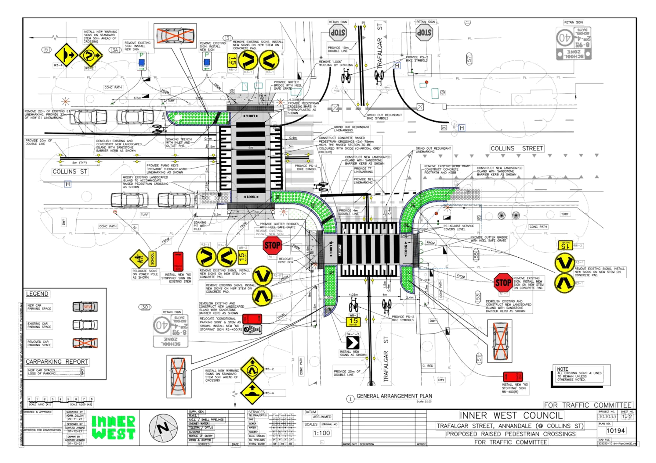
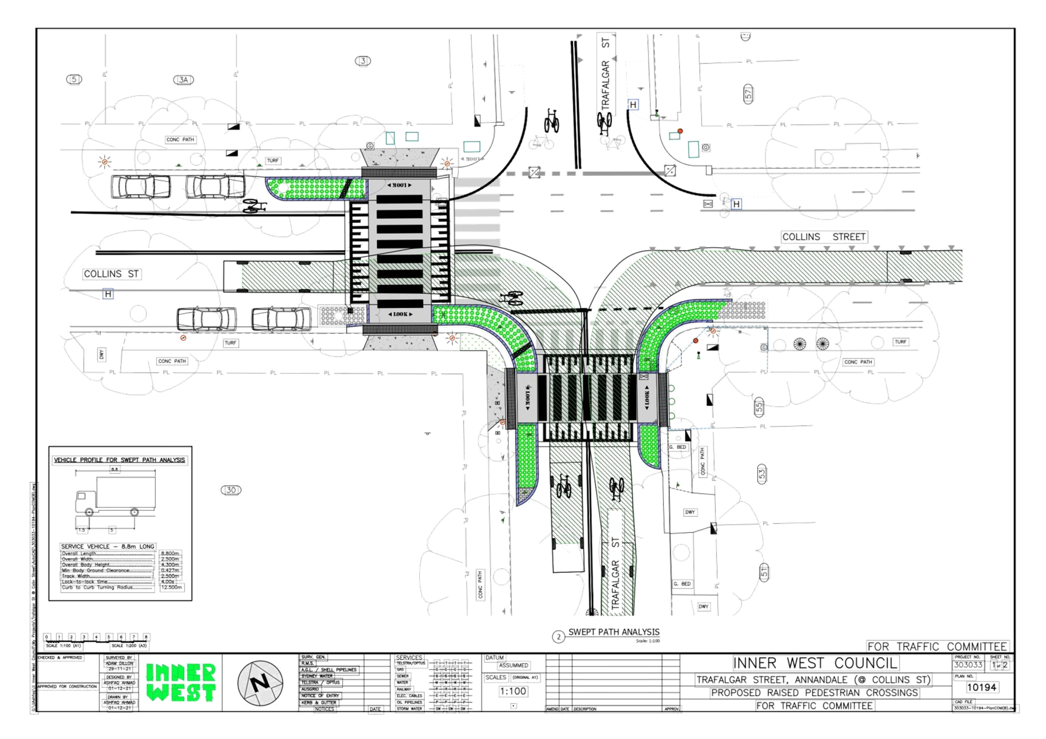
LTC0322(1) Item 11 Trafalgar
Street and Collins Street, Annandale - Proposed
Raised Pedestrian Crossings (GULGADYA - LEICHHARDT
WARD/ BALMAIN ELECTORATE/ LEICHHARDT PAC) 72
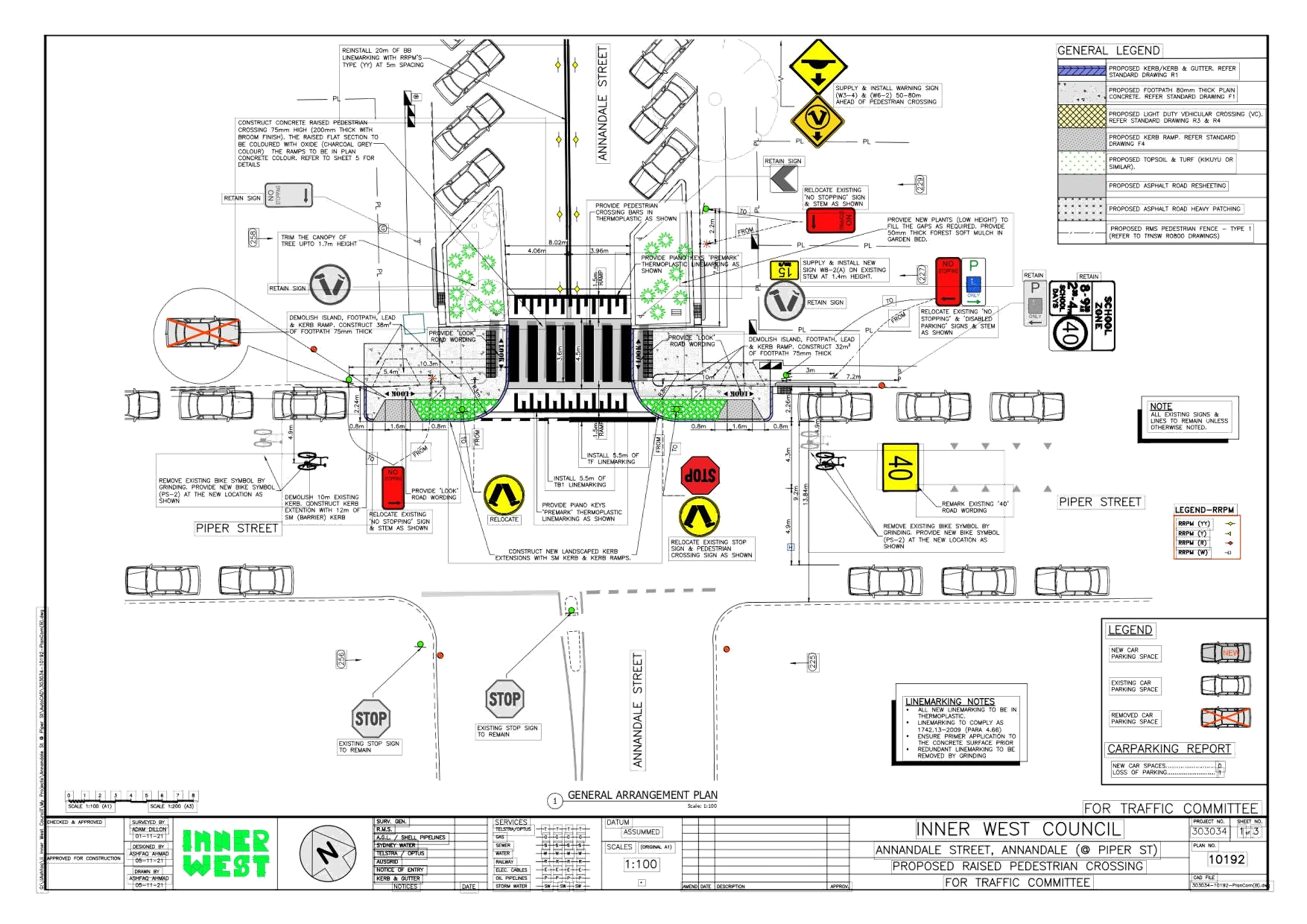
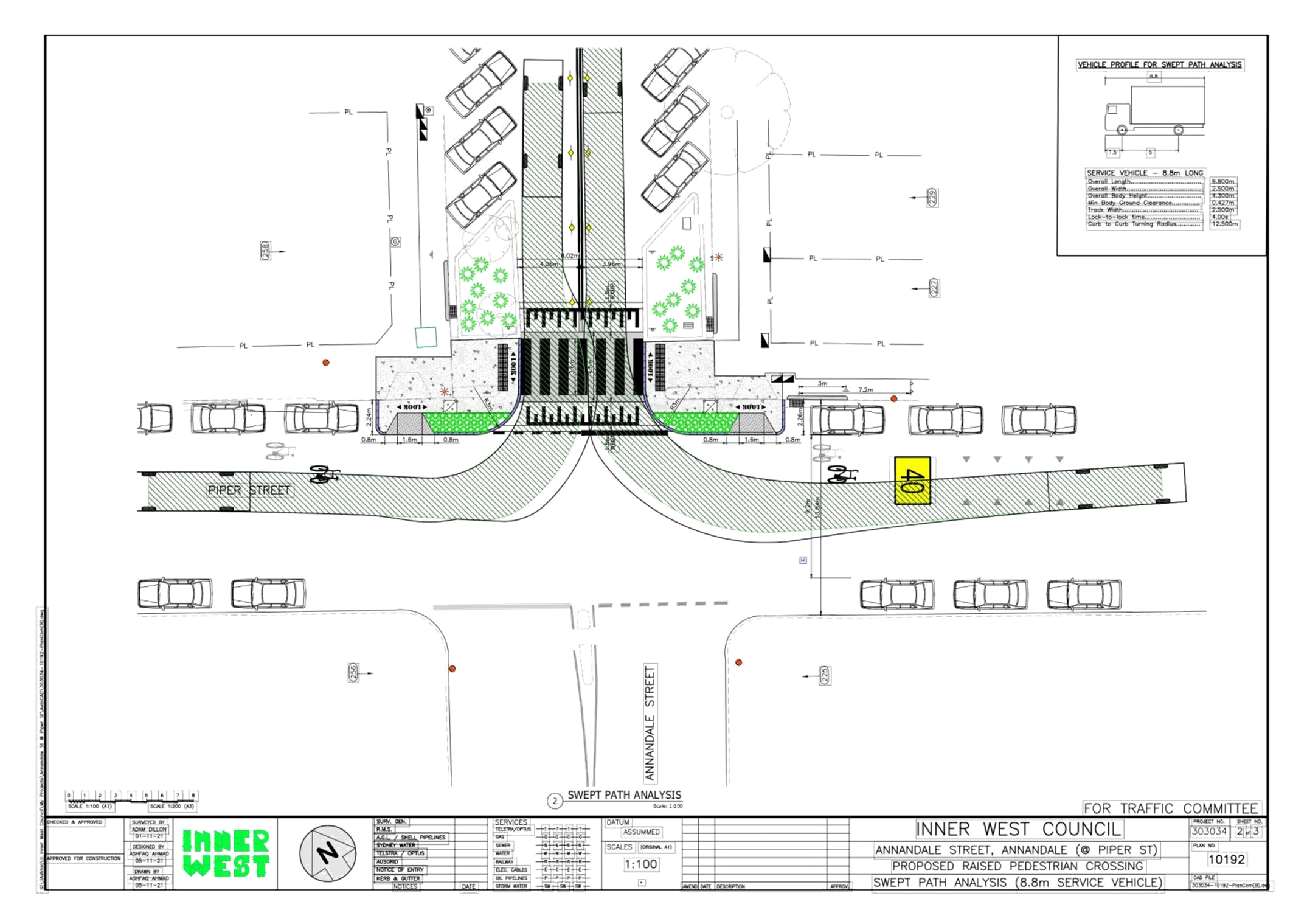
LTC0322(1) Item 12 Annandale
Street, Annandale (At Piper Street) - Proposed
Raised Pedestrian Crossing (GULGADYA - LEICHHARDT
WARD/ BALMAIN ELECTORATE/ LEICHHARDT PAC) 76
Parking Matters
ITEM Page
LTC0322(1) Item 13 Leichhardt
West Precinct Parking Study (Gulgadya-Leichhardt
Ward/Balmain Electorate/Leichhardt PAC) 81
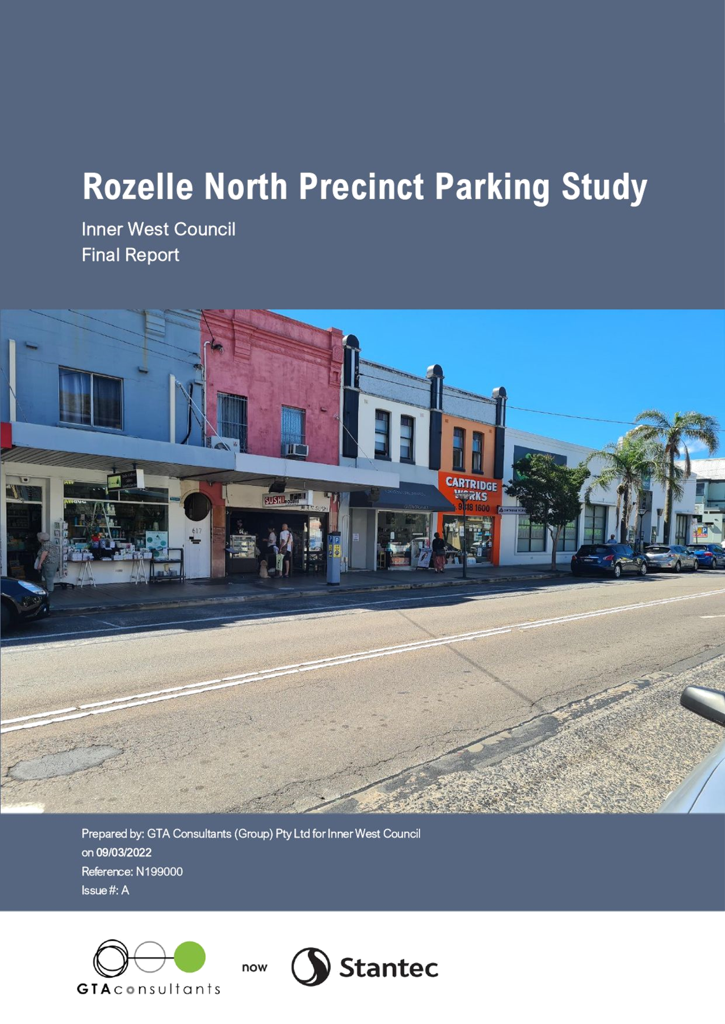
LTC0322(1) Item 14 Rozelle North
Precinct Parking Study (Baludarri-Balmain
Ward/Balmain Electorate/Leichhardt PAC) 154
Late Items
Nil at time of printing.
6 Part B - Items for Information Only
ITEM Page
LTC0322(1) Item 15 Traffic Committee Schedule Update 2022 224
LTC0322(1) Item 16 Holbeach
Avenue, Tempe – Temporary Full Road Closures for
Ms Sydney to The Gong Bike Ride on Sunday 1 May 2022 –
(MIDJUBURI - MARRICKVILLE WARD/HEFFRON
ELECTORATE/NEWTOWN LAC) 225
LTC0322(1) Item 17 Johnston
Street, Annandale - Proposed Kerb Blisters (Gulgadya-
Leichhardt Ward/Balmain Electorate/Leichhardt PAC) 240
7 Part C - Items for General Advice
Nil at the time of printing.
8 General Business
9 Close of Meeting
|
|
Local Traffic Committee Meeting 21 March 2022 |
Minutes of Local Traffic Committee Meeting
Held remotely on 7 February 2022
Meeting commenced at 10.00am
ACKNOWLEDGEMENT OF COUNTRY BY CHAIRPERSON
I acknowledge the Gadigal and Wangal people of the Eora nation on whose country we are meeting today, and their elders past and present.
COMMITTEE REPRESENTATIVES PRESENT
|
Manod Wickramasinghe |
IWC’s Traffic and Transport Planning Manager (Chair) |
|
Bill Holliday |
Representative for Jamie Parker MP, Member for Balmain |
|
Aislinn Stein-Magee |
Representative for Jo Haylen MP, Member for Summer Hill |
|
Solon Ghosh |
Transport for NSW (TfNSW) |
|
|
|
|
NON VOTING MEMBERS IN ATTENDANCE |
|
|
|
|
|
Colin Jones |
Inner West Bicycle Coalition (IWBC) |
|
Adrian Prichard |
Transit Systems – Inner West Bus Services |
|
George Tsaprounis |
IWC’s Coordinator Traffic Engineering Services (South) |
|
Sunny Jo |
IWC’s Coordinator Traffic Engineering Services (North) |
|
Stephen Joannidis |
IWC’s Urban Amenity Improvement Delivery Manager |
|
Joe di Cesare |
IWC’s Design Services Coordinator |
|
Christina Ip |
IWC’s Business Administration Officer |
|
|
|
|
VISITORS |
|
|
|
|
|
Nil. |
|
|
|
|
|
APOLOGIES: |
|
|
|
|
|
SC Anthony Kenny |
NSW Police – Inner West Police Area Command |
|
Jacqui Thorburn |
Representative for Jodi MacKay MP, Member for Strathfield |
|
Chris Woods |
Representative for Ron Hoenig MP, Member for Heffron |
|
Sgt Charles Buttrose |
NSW Police – Leichhardt Police Area Command |
DISCLOSURES OF INTERESTS:
Nil.
CONFIRMATION OF MINUTES
|
The minutes of the Local Traffic Committee meeting held on 6 December 2021 were confirmed. |
MATTERS ARISING FROM COUNCIL’S RESOLUTION OF MINUTES
The minutes of the Local Traffic Committee meeting held on 15 November 2021 and 6 December 2021 are awaiting adoption.
EMAIL CONFIRMATION OF OFFICER’S RECOMMENDATION
The representative for NSW Police – Inner West supported the Officer’s recommendations for the items in their PAC.
The representative for NSW Police – Leichhardt supported the Officer’s recommendations for the items in their PAC.
|
LTC0222(1) Item 3 Addison Road, Marrickville – Proposed new pedestrian refuge - Design Plan 10117_A (Midjuburi-Marrickville Ward / Newtown and Summer Hill Electorates / Inner West PAC) |
|
Council has finalised an amended design plan for the proposed construction of a new pedestrian refuge on Addison Road, Marrickville near Denby Street. Council received funding from the TfNSW Blackspot Program and the proposed works will improve pedestrian safety and motorist safety in the area. It is recommended that the proposed detailed design plan be approved.
Officer’s Recommendation
THAT the detailed design plan for the proposed new pedestrian refuge on Addison Road, Marrickville near Denby Street and associated signs and line markings (as per Plan No.10117_A) be APPROVED.
DISCUSSION
The Transit Systems representative supported the proposed relocation of the bus stop and requested that 28 days of notice be provided to Transit Systems prior to construction.
The TfNSW representative asked if the 1.5m pram ramp can be extended to match the 3m crossing width. Council Officers indicated that they will investigate this request.
The Committee members agreed with the Officer’s recommendation.
COMMITTEE RECOMMENDATION
THAT the detailed design plan for the proposed new pedestrian refuge on Addison Road, Marrickville near Denby Street and associated signs and line markings (as per Plan No.10117_A) be APPROVED. For motion: Unanimous |
|
LTC0222(1) Item 6 Intersection of Edward Street and Mungo Scott Place/ Wellesley Street - Interim treatment of intersection for improved sight line (Djarrawunang-Ashfield Ward/Summer Hill Electorate/Ashfield PAC) |
|
SUMMARY
Council has received numerous concerns from the community (via councillor and requests alone) regarding sight line obstruction at the crossroad intersection of Edward Street and Wellesley Street /Mungo Scott Place, Summer Hill. The intersection has been captured under the Ashfield Traffic Management Strategy (ATMS) and is listed under the capital works program to investigate a permanent treatment to the intersection in view of traffic and pedestrian safety, and any other perceived developments to the intersection. To alleviate this issue in the interim, it is proposed that the intersection be treated via signs and line marking by building out the corners of Edward Street in paint and introduce STOP control markings in Wellesley Street and Mungo Scott Place out in/near line of the build outs. Associated variation to parking, edge line and centreline introduction with advance warning ‘Pedestrian’ signs in Edward Street will further enhance traffic and pedestrian safety though the intersection.
Officer’s Recommendation
THAT the interim works for treatment (via signs and markings) of the intersection of Edward Street and Wellesley Street/Mungo Scott Place, Summer Hill BE APPROVED as follows:
1. Provide painted built outs to all corners in Edward Street, 2. Provide STOP control markings for Wellesley Street and Mungo Scott Place out in/near line of the painted build outs in Edward Street, with new STOP signs added, 3. Provide edge lines (E1) and double barrier centrelines (BB) in Edward Street at 24 metres to both sides of the intersection, 4. The first unrestricted car space on the eastern side of Edward Street, north of Mungo Scott Place be converted to angled parking for motorcyclists, and 5. Provide advance ‘Pedestrian’ warning signs in Edward Street on both approach sides to the intersection.
DISCUSSION
The Committee members agreed with the Officer’s recommendation.
COMMITTEE RECOMMENDATION
THAT the interim works for treatment (via signs and markings) of the intersection of Edward Street and Wellesley Street/Mungo Scott Place, Summer Hill BE APPROVED as follows:
1. Provide painted built outs to all corners in Edward Street, 2. Provide STOP control markings for Wellesley Street and Mungo Scott Place out in/near line of the painted build outs in Edward Street, with new STOP signs added, 3. Provide edge lines (E1) and double barrier centrelines (BB) in Edward Street at 24 metres to both sides of the intersection, 4. The first unrestricted car space on the eastern side of Edward Street, north of Mungo Scott Place be converted to angled parking for motorcyclists, and 5. Provide advance ‘Pedestrian’ warning signs in Edward Street on both approach sides to the intersection.
For motion: Unanimous |
|
LTC0222(1) Item 7 Annandale Street, Annandale - Removal of 'No Parking Police Vehicles Excepted' Restrictions (Gulgadya-Leichhardt Ward/ Balmain Electorate/Leichhardt PAC) |
|
SUMMARY
Council has been notified by NSW Police that the three (3) existing ‘No Parking Police Vehicles Excepted’ angle parking spaces on the west side of Annandale Street north of Collins Street, Annandale in front of the Police Station may be reverted to unrestricted parking.
Officer’s Recommendation
THAT three (3) ‘No Parking Police Vehicles Excepted’ angle parking spaces on the west side of Annandale Street, Annandale near No.21 Collins Street, Annandale be reverted back to unrestricted angle parking.
DISCUSSION
The Committee members agreed with the Officer’s recommendation.
COMMITTEE RECOMMENDATION
THAT three (3) ‘No Parking Police Vehicles Excepted’ angle parking spaces on the west side of Annandale Street, Annandale near No.21 Collins Street, Annandale be reverted back to unrestricted angle parking.
For motion: Unanimous |
|
LTC0222(1) Item 8 Marrickville Road, Marrickville near Livingstone Road - Implementation Of Short-Term Parking Restrictions (Midjuburi- Marrickville Ward/ Summer Hill Electorate/ Inner West PAC) |
|
SUMMARY Council is proposing to introduce a section of time-restricted parking along Marrickville Road, Marrickville, in order to improve parking turnover along the frontage of Marrickville Library and in the vicinity of the local businesses along the above-mentioned road.
Officer’s Recommendation
THAT thirty (30) metre section of unrestricted parking be converted to ‘1P 8.30am – 6pm’ on northern side of Marrickville Road, Marrickville between the signalized intersection of Marrickville Road/Livingstone Road and existing ‘No Stopping 8am-930am 2.30pm-4.30pm School Days’ located 23.6m west of Lilydale Street.
DISCUSSION
The Committee members agreed with the Officer’s recommendation.
COMMITTEE RECOMMENDATION
THAT thirty (30) metre section of unrestricted parking be converted to ‘1P 8.30am – 6pm’ on northern side of Marrickville Road, Marrickville between the signalized intersection of Marrickville Road/Livingstone Road and existing ‘No Stopping 8am-930am 2.30pm-4.30pm School Days’ located 23.6m west of Lilydale Street.
For motion: Unanimous |
General Business
|
LTC0222(1) Item 9 Monthly reports for State funded projects |
|
The TfNSW representative stated that they are waiting on the January and February monthly reports for State funded projects from Council. Council Officers will follow this up with the appropriate officer. |
|
LTC0222(1) Item 10 Overgrown vegetation near Smith Street and Longport Street roundabout, Summer Hill |
|
The IWBC representative stated that vegetation has grown over the footpath and obstructed sightlines near the roundabout at Smith Street and Longport Street and requested the vegetation be cleared. Council Officers will forward this request to the relevant maintenance manager for action.
|
Meeting closed at 10.56am.
|
|
Local Traffic Committee Meeting 21 March 2022 |
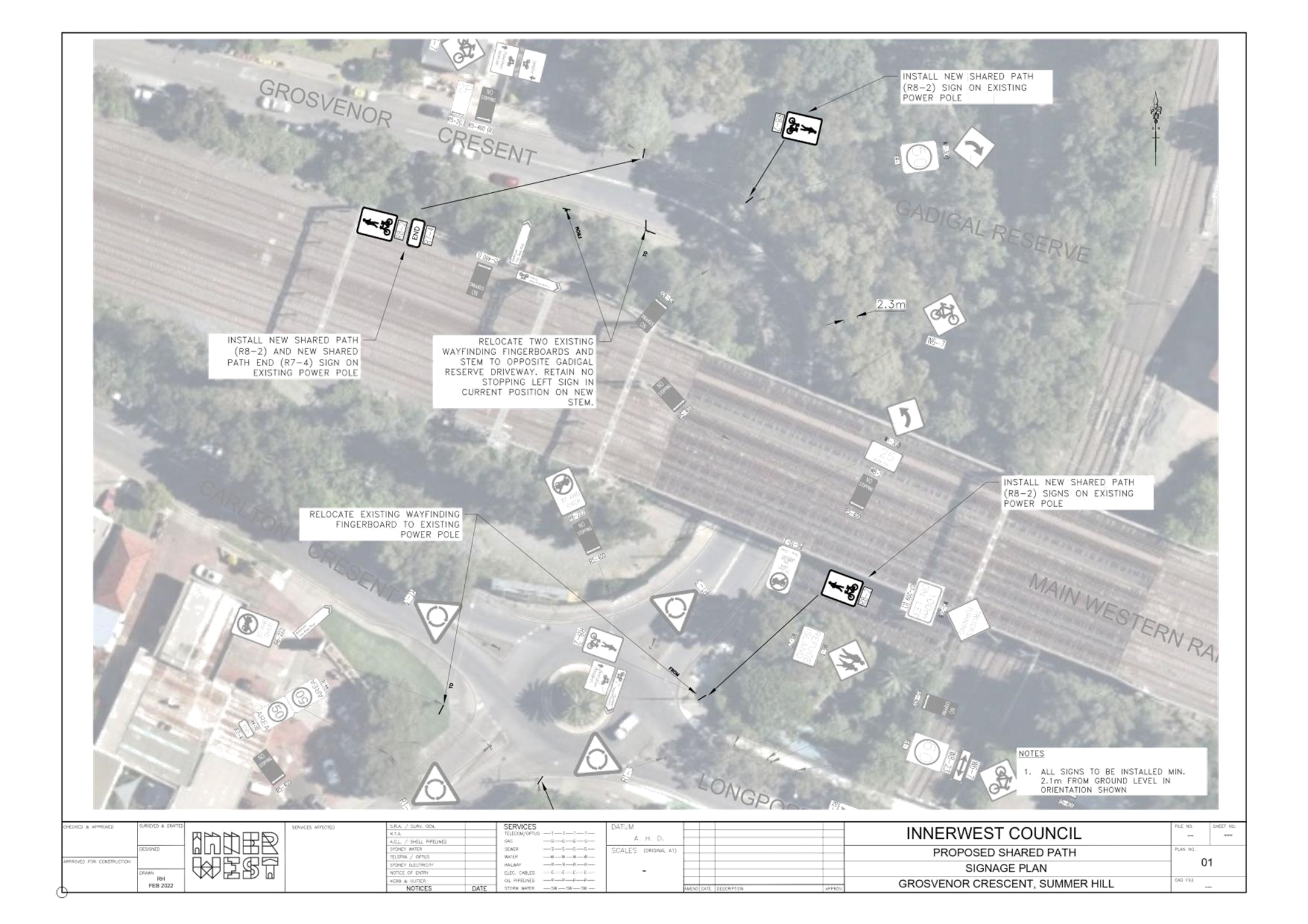
Subject: Proposed Shared Path between Longport Street and Grosvenor Crescent and Smith Street
Prepared By: Ryan Hawken - Project Manager Greenway Delivery
Authorised By: Manod Wickramasinghe - Traffic and Transport Planning Manager
SUMMARY
Council has received a request to provide safer connections for cyclists from the newly completed Regional Route 7 cycleway on Longport Street to Smith Street and Grosvenor Crescent, as well as the future Greenway. In the short term it is proposed to install shared paths along Smith Street and Grosvenor Crescent to improve cyclist safety in the area.
It is recommended that the signage plan for the proposed shared paths be approved.
|
RECOMMENDATION
That the signage plan for the proposed shared paths between Longport Street and Grovesnor Crescent and Smith Street be APPROVED.
|
BACKGROUND
Council was contacted by Inner West Bicycle Coalition in January requesting that Inner West Council provide improved cycle connections from the newly completed Regional Route 7 cycleway on Longport Street to Smith Street and Grosvenor Crescent, as well as the future Greenway via Gadigal Reserve.
Grosvenor Crescent is identified as a regional cycle route, and would form any future stage of the Regional Route 7 cycleway, while Smith Street is a local cycle route connecting to the Summer Hill town center and the future Greenway via Malthouse Way.
Connection from Longport Street to Gadigal Reserve and Grosvenor Crescent
The current Regional Route 7 (RR7) works include a shared path along the northern side of Longport Street which ends at the corner of Grosvenor Crescent. The intersection of Longport Street and Grosvenor Crescent is a roundabout with significant traffic volumes and transition from path to road here is difficult.
In the short term it is proposed to install shared path signage to enable bicycles to use the existing northern/eastern footpath in Grosvenor Crescent as a shared path until Gadigal Reserve. Refer Attachment 1 for the proposed signage plan.
The path in this area is typically 2.3m wide, and the existing guardrail means the useable path width narrows to 2.0m around the bend. There is no carparking or properties adjacent to the path. Whilst 2.3m is marginally narrower than the minimum 2.5m width recommended for shared paths in Austroads, the introduction of a shared path is considered appropriate given the benefits to safety at this location and low user volumes.
The proposed signage would enable cyclists to transition from the road on Grosvenor Crescent and continue up the shared path to Longport Street where they can connect to the existing RR7 shared path on the northern side of Longport Street.
In the longer term RR7 would continue from Longport Street along Grosvenor Crescent. The design of this future stage would need to consider the best structural solution for cyclists.
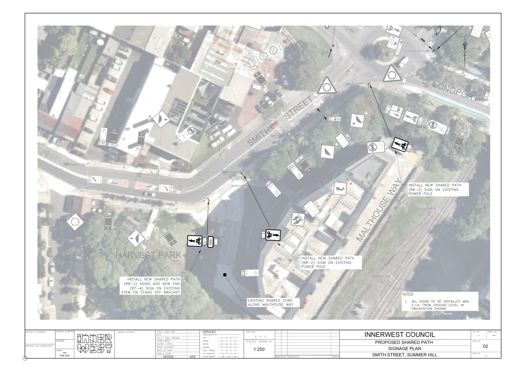
Connection from Longport Street to Smith Street
Council is planning to install a connection between RR7 and Malthouse Way as part of the Greenway in-corridor works in 2023/24. This would be either be a widened shared path or a separated bi-directional with suitable widths achieved by widening into the existing roadway.
In the short term it is proposed to include shared path signage to enable bicycles to use the existing eastern footpath in Smith Street as a shared path until Malthouse Way. Refer Attachment 1 for the proposed signage plan.
The path in this area is typically 2.4m wide, with some narrower pinch-points. There is no carparking or properties adjacent to the path. Whilst this 2.4m is marginally narrower than the minimum 2.5m width recommended for shared paths in Austroads, the introduction of a shared path is considered appropriate given the benefits to safety at this location and low user volumes.
The proposed signage would enable cyclists to transition from the separated path on Longport and continue down a shared path to Malthouse Way where they can transition safely back on-road to Smith Street at the existing driveway.
FINANCIAL IMPLICATIONS
Works would be undertaken within the existing Regional Route 7 budget.
PUBLIC CONSULTATION
Inner West Bike Coalition has been consulted with respect to the proposed signage changes and is generally supportive of the introduction of the shared paths until further works can be undertaken as part of the Greenway and/or next stage of Regional Route 7.
|
1.⇩ |
Shared Path Signage Plan |
|
Local Traffic Committee Meeting 21 March 2022 |
Subject: Byrnes Street, Marrickville and Trafalgar Street, Petersham - Dedicated Car Share Parking Restrictions (SUMMER HILL ELECTORATE / INNER WEST PAC)
Prepared By: Jennifer Adams - Engineer – Traffic and Parking Services
Authorised By: Manod Wickramasinghe - Traffic and Transport Planning Manager
SUMMARY
A request has been received from a GoGet Car Share representative for the installation of three (3) on-street dedicated ‘Car Share’ parking spaces for existing floating car share vehicles around the Inner West. Due to community feedback and opposition to one location only two nominated car share spaces are recommended for installation.
|
RECOMMENDATION
That the following ‘No Parking Authorised Car Share Vehicles Excepted’ restrictions be approved:
1. A 5.0m restriction in the first parking space on the southern side of Byrnes Street, Marrickville east of Illawarra Road, between the driveways of the adjacent complex; and 2.
A 5.5m restriction in the first parking space on the northern side of
Trafalgar
|
BACKGROUND
On 9 March 2021 Council endorsed public exhibition of the draft Car Share Policy. The draft policy was publicly exhibited between 17 March and 28 April 2021 to obtain feedback from the community and car share operators. Most comments received were supportive of car sharing services, making a number of suggestions about how the policy could be improved. The policy has been amended in response to feedback received and subsequently adopted by Council at its meeting 5 August 2021.
Research indicates that each car share space can replace up to 8 vehicles on the road. Council’s adopted Car Share Policy will potentially reduce demand for on-street parking, resulting in less cars on public roads, leading to less pollution and greenhouse emissions. The policy is part of a holistic approach to transport planning, along with improvements to public transport services and enhanced facilities for cycling and walking.
Generally, car share schemes rely on having convenient dedicated on-street parking spaces. The designated space will be in operation 24 hours a day, 7 days a week, during which only specifically marked car share vehicles will be permitted to park in this space.
FINANCIAL IMPLICATIONS
Nil. The costs of the supply and installation of the signposting associated with the dedicated car share parking space is to be borne by the applicant in accordance with Council’s Fees and Charges.
OTHER STAFF COMMENTS
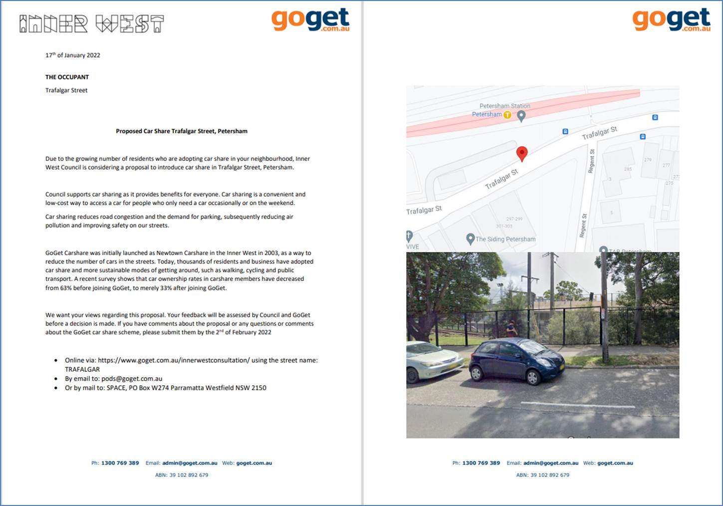
A request has been received from GoGet representative for the installation of on-street dedicated car share parking spaces within Inner West. The nominated locations are:
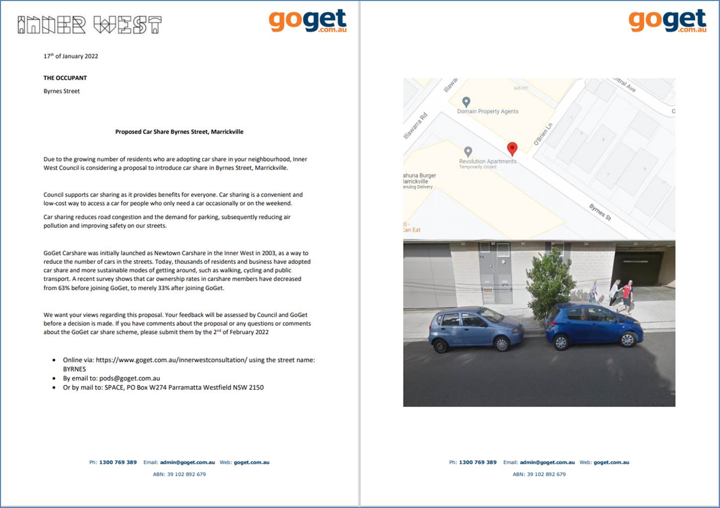
· Byrnes Street, Marrickville (beside the driveway of the multi-unit development) south side of Byrnes Street opposite O’Brien Lane (existing signposted restriction – ‘unrestricted’)
· Trafalgar Street, Petersham (across the road from the multi-unit development) on the north side of Trafalgar Street before the bus stop at Petersham train station (existing signposted restriction – ‘unrestricted’)
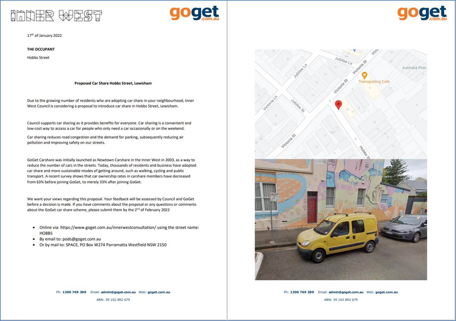
· Hobbs Street, Lewisham (near Lewisham Train Station) on the north side of Hobbs Street south of Victoria Street (existing signposted restriction - ‘2P 8.30am-6pm Mon-Fri’)
PUBLIC CONSULTATION
Community consultation was led by GoGet representatives during the period between 18 January and 2 February 2022. Letters were distributed to local residents within 100 metres of each proposed space. A copy of each respective community consultation letter is presented at the end of this report.
The following summary of the consultation results was presented to Council:
Letters were delivered to residents within 100 metres of each proposed space:
x 220 letters on Byrnes Street
x 30 letters on Trafalgar
Street
x 20 letters on Hobbs Street
Byrnes Street x 5 in support and 2 in support but in an alternate location.
Trafalgar Street x 0 responses
Hobbs Street x 8 negative responses
For Byrnes Street, Marrickville, seven (7) responses were received, all in support of the implementation of the car share restrictions with two (2) requests to relocate to an alternative location.
For Trafalgar Street, Petersham, no (0) responses were received. It is noted that the locality is currently being redeveloped with the Petersham RSL development works.
For Hobbs Street, Lewisham, eight (8) responses were received, all in objection to the proposal. Residents who rejected the proposal are concerned about the increase demand for on-street parking for local residents within the already high demand area. Victoria Street was cited to be an alternative location
CONCLUSION
Due to community feedback and opposition to one location only two nominated car share spaces are recommended for installation. The Hobbs Street, Lewisham car share location is recommended not to proceed.
It is recommended that the installation of the proposed other two on-street dedicated car share parking spaces in Byrnes Street, Marrickville and Trafalgar Street, Petersham be approved in order to provide improved parking opportunities for local residents who participate in the car share scheme.
|
|
Local Traffic Committee Meeting 21 March 2022 |
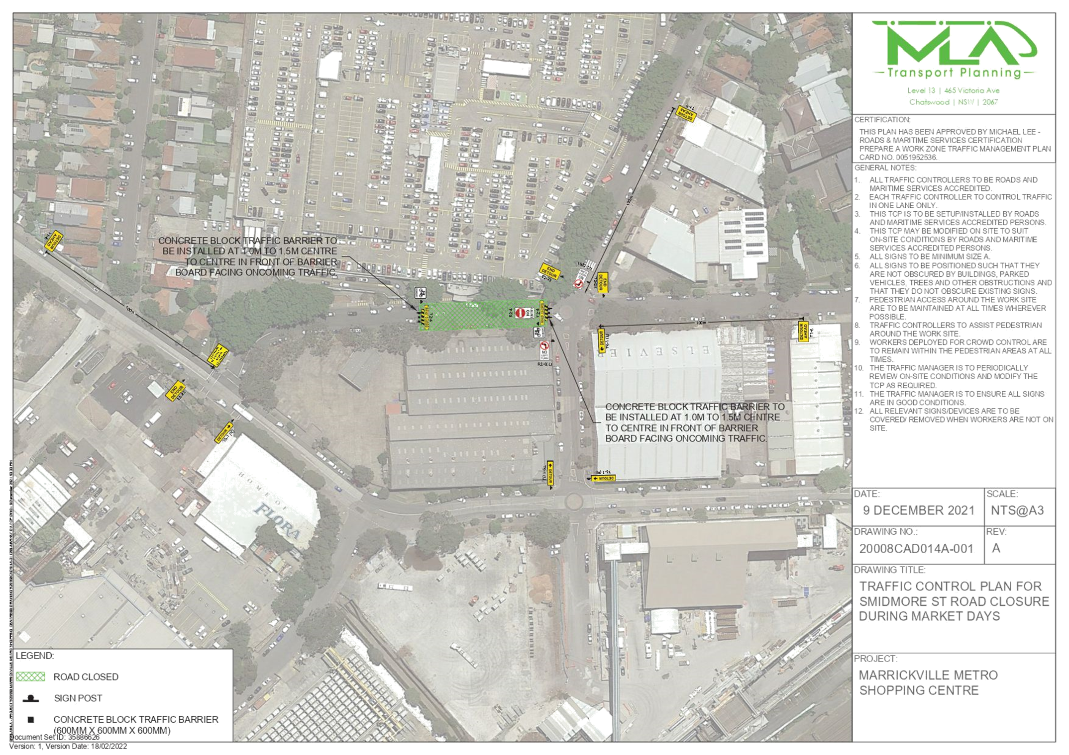
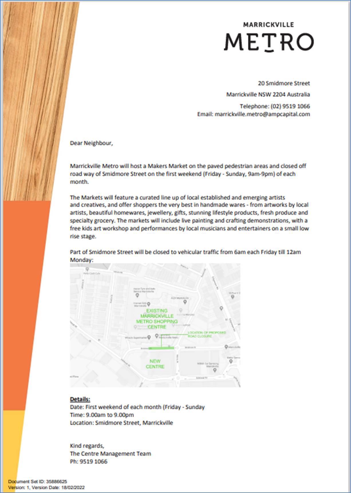
Subject: Smidmore Street, Marrickville – ENRC/2022/0007 - Temporary Full Road Closure for Marrickville Metro Market Events on First Weekend Each Month Throughout 2022 and Related Temporary Changes to Victoria Road Kerbside Parking Restrictions to Accommodate Relocation of Community Bus (Midjuburi – Marrickville Ward / Heffron Electorate / Inner West PAC)
Prepared By: Jennifer Adams - Engineer – Traffic and Parking Services
Authorised By: Manod Wickramasinghe - Traffic and Transport Planning Manager
SUMMARY
Council has been notified by MLA Transport Planning, on behalf of Marrickville Metro Shopping Centre, about proposed temporary full road closure of Smidmore Street, between Murray Street and the Centre’s Smidmore Street car park access, Marrickville for Marrickville Metro Market events on the first weekend each month throughout 2022. The closure will involve related temporary changes to Victoria Road kerbside parking restrictions to accommodate relocation of the community bus stop. It is recommended that the proposed temporary road closure be approved subject to all standard Council conditions for a temporary full road closure. Furthermore, the related changes to kerbside signage also be approved subject to all works and costs associated with the signage changes for the relocated 'Community Bus zone' and reinstatement of Council’s original parking restrictions is to be borne by the applicant.
|
RECOMMENDATION
1. That the proposed temporary full road closure of Smidmore Street, between Murray Street and the Smidmore Street car park access, Marrickville from 6am Friday to midnight Sunday on the first weekend of each month throughout 2022 (contingency period to the end of 12 month trial period) for the purpose of hosting Marrickville Mertro Markets be APPROVED, subject to the approval of the associated Development Application (DA/2021/1334) and the applicant complying with, but not limited to, the following conditions: a. A Road Occupancy License application be obtained by the applicant from the Transport Management Centre; b. All affected residents and businesses, including NSW Police Local Area Commander, Transit Systems, Fire and Rescue NSW and NSW Ambulance Services, shall be notified in writing by the applicant of the proposed temporary road closure at least 7 days prior to the event, with the applicant making reasonable provision for residents and businesses; c. The occupation of the road carriageway must not occur until the road has been physically closed; d. A clear unobstructed 4-metre-wide path of travel throughout the site is recommended to be maintained at all times for emergency vehicle access, in order to provide safe egress in case of fire or other emergency; and e. The TMP/TCP be reviewed after an initial three (3) month period and updated accordingly to address any issues experienced to ensure the markets run safely and efficiently throughout this period and to address any unforeseen issues arising.
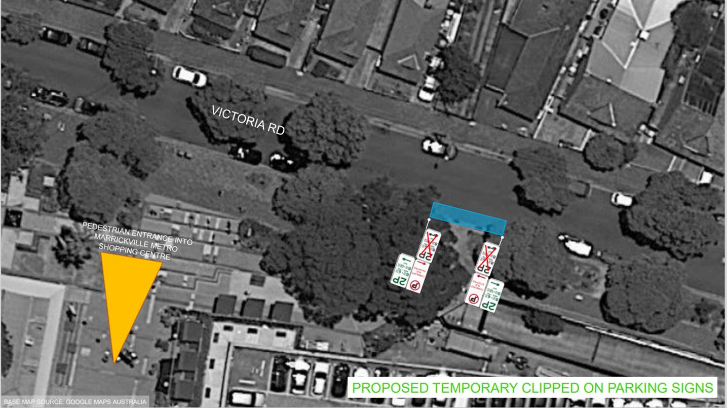
2. That the proposed short-term temporary changes to parking restrictions in Victoria Road, Marrickville as per plans submitted by MLA Transport Planning (20008ppt05A-220225 Community Bus Stop Relocation Plan (002)) be approved subject to the following conditions:
a. All works and cost of the supply, installation and removal of the signage associated with the temporary community bus relocation is to be borne by the applicant; b. The temporary removal and reinstatement of any Council assets will be at the applicants cost and to Council’s Traffic Engineers satisfaction; and Notification of surrounding properties be undertaken at least 7 Days prior to installation of the temporary changes and relocated 'Bus Zone'.
|
BACKGROUND
Marrickville Metro Shopping Centre is proposing to host a Makers Market in front of the shopping centre within the paved pedestrian areas on Smidmore Street between Murray Street and the Smidmore Street car park access. The proposal will require the relevant section of Smidmore Street to be closed when the proposed market is being held.
The proposed market will offer a range of handmade wares, artworks, homewares, jewellery, gifts, fresh produce and specialty grocery. It is also proposed to provide live painting and crafting demonstrations with a free kids art workshop and performances by local musicians and entertainers on a small low rise stage.
The market is proposed to be held over three consecutive days, namely Friday, Saturday and Sunday in the first weekend of each month commencing from March 2021. The market will open from 9:00am and close at 9:00pm each day.
The proposed market will accommodate 25 stalls of mixed sizes as follows:
• 14 x 3m by 3m marquees
• 2 x 2.5m by 2.5m marquees, and
• 9 x 2m by 1.2m marquees.
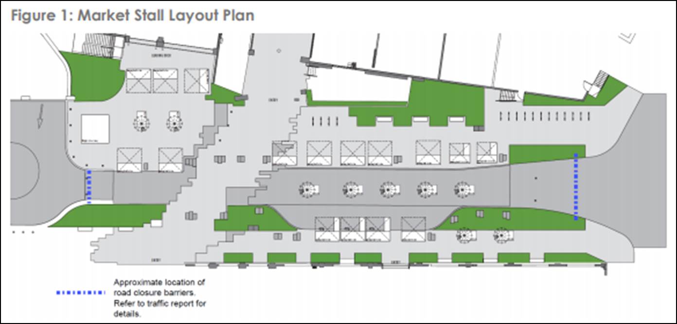
As shown in the market layout plan in Figure 1, the smaller stalls are generally proposed to be located in the middle of the closed section of Smidmore Street while the larger stalls are located on either side of Smidmore Street.
As noted above, it is proposed to close Smidmore Street between Murray Street and the car park access when the market is being held. It is proposed to close Smidmore Street from 6:00am Friday and re-open to the public at 12 midnight the following Monday. The proposed road closure are proposed to commence three hours prior to the start of the market and three hours after the market closes so to allow additional time for bump in and bump out.
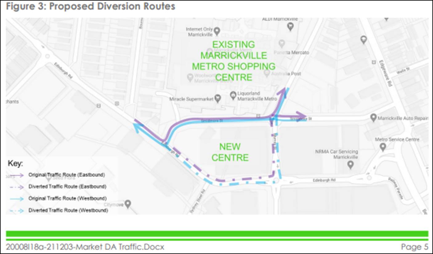
The section of Smidmore Street between Edinburgh Road and the car park access will remain open to continue to permit access to the car park and the taxi rank on the southern side of Smidmore Street. Through traffic along Smidmore Street to/from Murray Street will not be permitted except for cyclists. However, cyclists will be required to dismount from their bicycle whilst using the closed section of Smidmore Street.
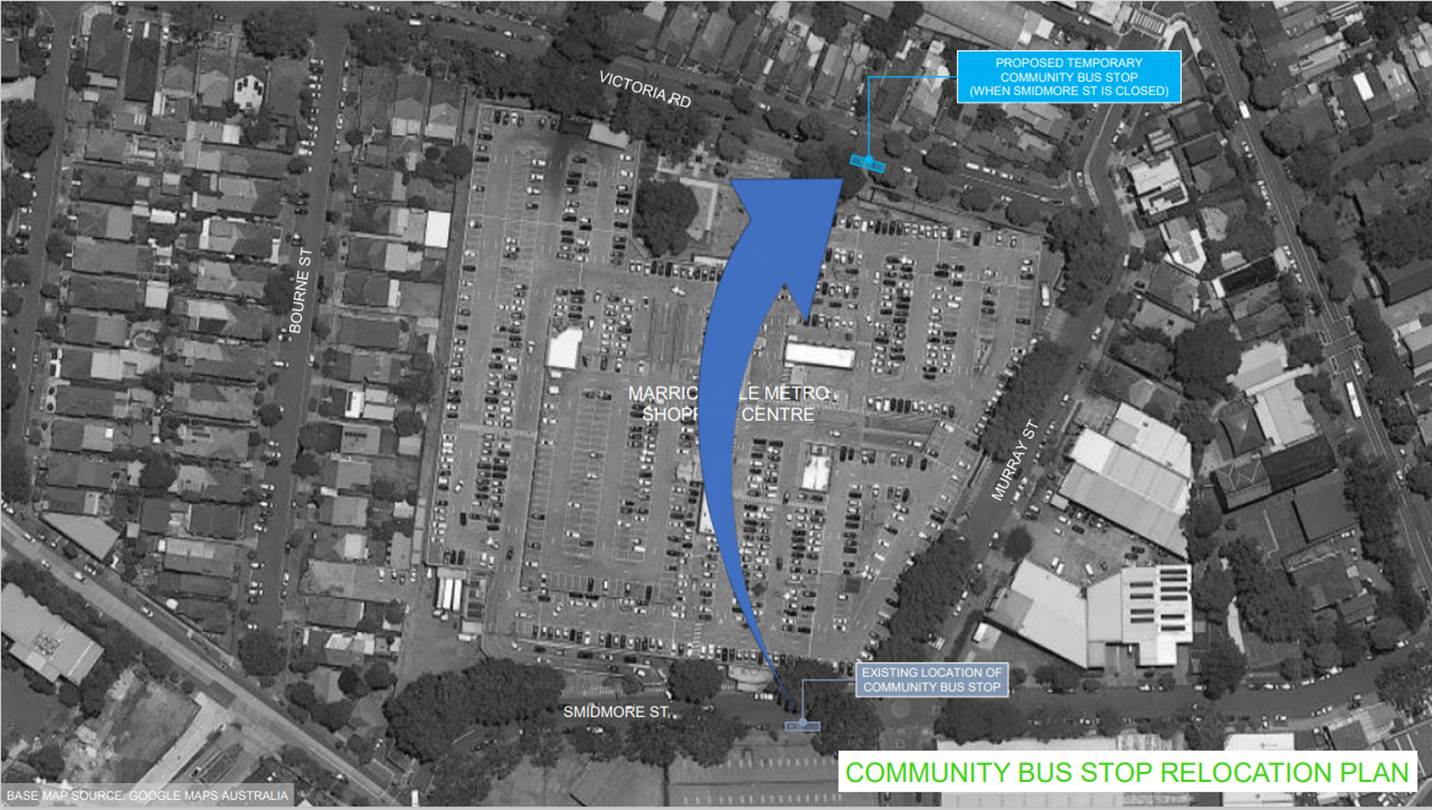
During the road closure period, the community bus stop is proposed to be relocated to Victoria Road in front of the main pedestrian entrance to the existing Centre. In addition, the taxi rank on Smidmore Street (near Edinburgh Road) will continue to operate as per normal. Bus services in the area will not be affected by the proposed market as buses do not require to access the section of Smidmore Street that is proposed to be closed.
The shopping centre (existing and new Centres) and their respective new car parks will be fully operational and open to the public including the new pedestrian bridge across Smidmore Street when the market is being held. All accesses to the new and existing Centre car parks will not be impeded.
During the road closure period, through traffic to/from Murray Street via Smidmore Street will be directed to use Edinburgh Road instead – see accompanying traffic control plan for further details. The existing and proposed diversion routes are shown Figure 3.
The applicant’s traffic assessment statement said that “It is not expected that the proposed market would generate any noticeable additional traffic demand. The proposed market is expected to attract a high proportion of the visitors from the local area who will walk to the market. In addition, customers who are already visiting the Centre as part of their general shopping activities (would) also visit the market stalls.”
In relation to parking they said “assuming that the proposed market requires 47 car parking spaces to be provided, the existing car parks in the old and new Centres have the available capacity to absorb the additional parking demand generated by the proposed markets….the existing and new Centres have a combined parking capacity of 1,511 car parking spaces following the recent addition of 493 car parking spaces as part of the new Centre.”
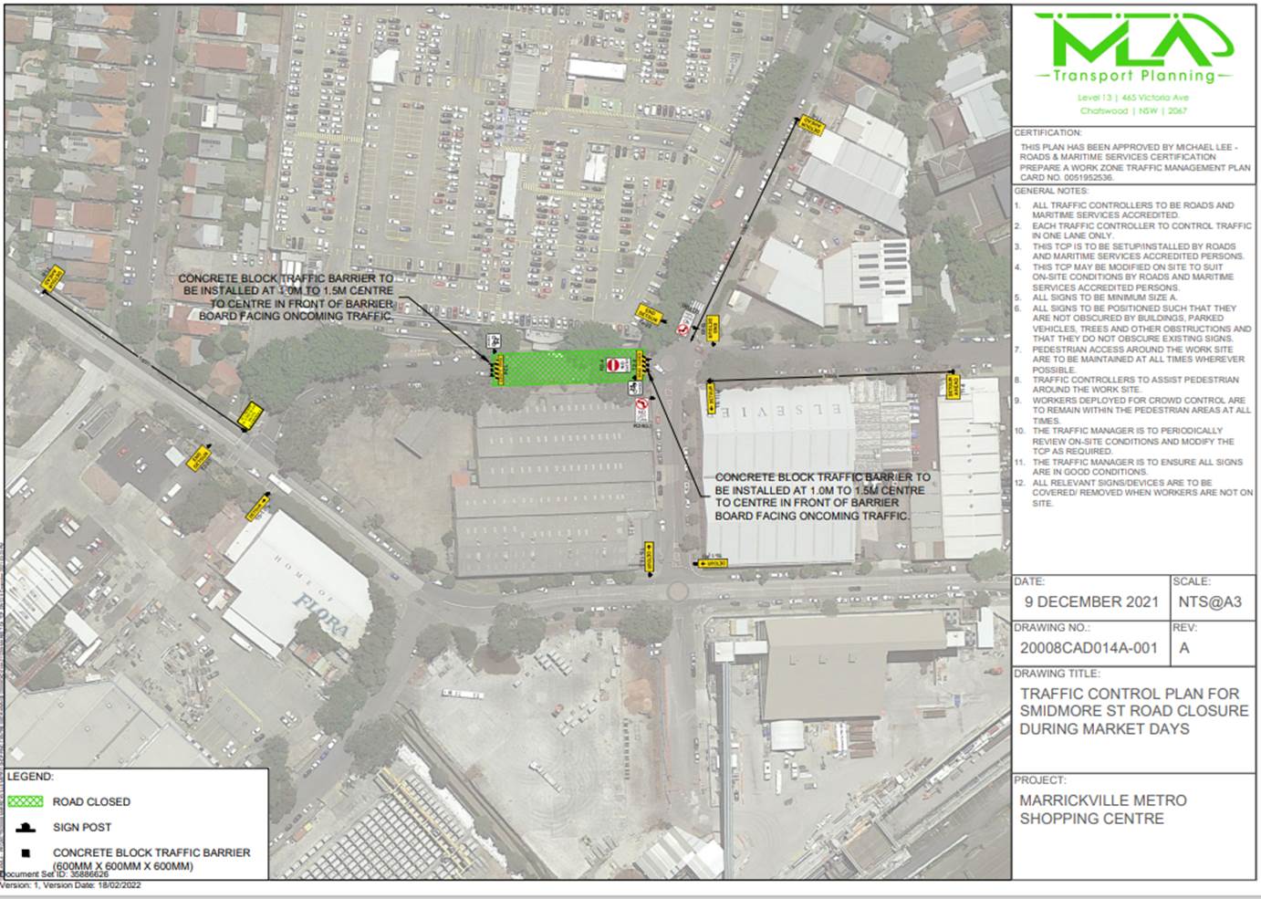
Traffic Control Plan
The supplied TCP is reproduced below and attached at the end of this report.
Emergency Access
A clear unobstructed 4-metre-wide path of travel throughout the site is recommended to be maintained at all times for emergency vehicle access, in order to provide safe egress in case of fire or other emergency.
Temporary relocation of Community Bus Zone
In relation to the proposed road closures for the markets it is proposed to relocate the community bus zone to Victoria Road outside the Centre’s main entrance. The proposed removal of signage and new temporary community bus zone is shown in the diagram below.
Under Council’s Fees & Charges, the applicant is to pay a fee for the temporary full road closure along with any other required road occupancy and/or road opening permit fees.
All works and costs of implementation works associated with the recommended temporary relocation of the Community Bus Zone relocations will be borne by the applicant as will the reinstatement of any of Council approved signage at the end of the temporary relocation period.
PUBLIC CONSULTATION
The applicant is to notify all affected residents and businesses in writing at least 7 days prior to the commencement of works. A copy of the notification is attached at the end of this report.
The proposed road closure has been advertised on Council’s website in accordance with the Roads Act 1993.
In relation to the relocation of the community bus the applicant is to notify all affected residents and businesses in writing at least 7 days prior to the commencement of works
|
1.⇩ |
ECM_35886626 - 20008CAD014A-211209 |
|
|
Local Traffic Committee Meeting 21 March 2022 |
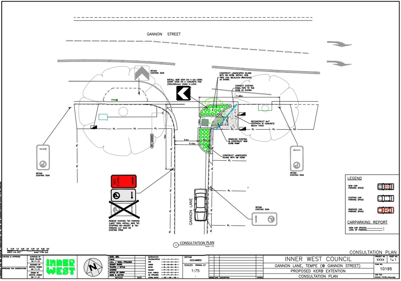
Subject: Gannon Lane, Tempe – Proposed New Kerb Extension - Design Plan 10195 (Midjuburi-Marrickville Ward / NEWTOWN ELECTORATE/INNER WEST PAC)
Prepared By: Jennifer Adams - Engineer – Traffic and Parking Services
Authorised By: Manod Wickramasinghe - Traffic and Transport Planning Manager
SUMMARY
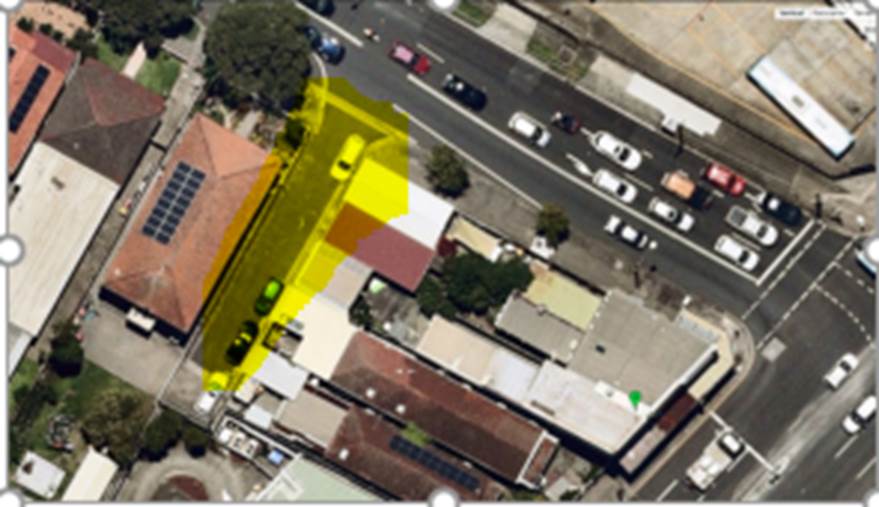
Council finalised a design plan for the proposed construction of a new kerb extension on the eastern corner of Gannon Lane, south of Gannon Street, Tempe. The proposed works were the subject of a Notice of Motion to rescind a previous Council decision, However, subsequent to community feedback from the recent design plan consultation it is now recommended that the proposed detailed design plan NOT be approved and that no change be made to the present parking restrictions in place in Gannon Lane, Tempe.
|
RECOMMENDATION
That the detailed design plan for the proposed new kerb extension on the eastern corner of Gannon Lane, south of Gannon Street, Tempe and associated signs and line markings (as per Plan No.10195) NOT be approved.
|
BACKGROUND
A report (LTC0419 Item 6) went to 1 April 2019 Local Traffic Committee meeting that recommended the approval of the installation of 10m ‘No Stopping’ signage on the eastern side of Gannon Lane, Tempe, between the rear access of property Nos.767 & 769 Princes Highway (replacing the current ‘No Parking 5am-10am Fridays’ signage).
The report stated that a request had been received from a local resident for the provision of 10m ‘No Stopping’ restrictions to deter illegal parking on the eastern side of Gannon Lane, adjacent to the corner of Gannon Street, Tempe. The resident had advised that vehicles are regularly illegally parking within 10m of the corner, often blocking the rear driveway of No.767 Princes Highway restricting their ingress and egress movements from their off-street parking. The report also noted that the proposal reinforces current NSW Road Rules and “is an attempt to deter illegal parking and providing access to off-street parking for all residents of Gannon Lane, Tempe.”
At the LTC meeting the Committee amended the recommendation to the approval of 10m ‘No Parking’ signage on the eastern side of Gannon Lane, Tempe, between the rear access of property Nos.767 & 769 Princes Highway (replacing the current ‘No Parking 5am-10am Fridays’ signage).
At Council’s Ordinary meeting 25 August 2020, a Notice of Motion to Rescind was made to Council’s decision C0419(1) Item 5 Local Traffic Committee meeting LTC0419 Item 6 – Gannon Lane, Tempe – 30 April 2019. The Motion carried was That Council:
1. Removes the existing signage on the eastern side of Gannon Lane, Tempe, between the rear access of property Nos.767 & 769 Princes Highway;
2. Installs a ‘No Parking’ sign on the eastern side of Gannon Lane, Tempe, between the rear access of property Nos.767 & 769 Princes Highway; and
3. Consult with affected residents about installing a plant blister in the 10m zone of Gannon Lane, and an appropriate shrub or tree be planted that both prevents illegal parking and provides some small amount of shade. The funds be allocated from the Street Tree Renewal Planting Budget.
The design plan for the proposed new kerb extension was finalised and this report details the results of the public consultation associated with the design plan.
FINANCIAL IMPLICATIONS
The estimated cost for these works was $20,000 and would have been funded by Council from the Street Tree Renewal Budget as per Council Motion C0820(2). Project number is 303078.
OTHER STAFF COMMENTS
The following works were proposed and are illustrated on the attached plan No. 10195:
- Installing new landscaped kerb extension;
- Installing new tree;
- Re-constructing kerb ramp;
- Reconstructing some of the concrete footpath; and
- Installing associated pavement line marking and signage as required.
The proposal does not change any of the existing parking arrangements in Gannon Lane and Gannon Street. Therefore, there will be NO LOSS of parking spaces resulting from the proposed works.
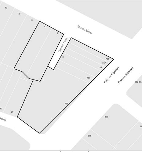
Site location & road network
|
Street Name |
Gannon Lane |
|
Section |
between Gannon Street and cul-de-sac |
|
Carriageway Width (m) |
5 |
|
Carriageway Type |
Two-way lane |
|
Classification |
Local |
|
Reported Crash History (latest 5 year period) |
No crashes recorded. |
|
Parking Arrangements |
No parking permitted on western side of the lane. |
PUBLIC CONSULTATION
A notification letter regarding the proposed design plan to implement a new kerb extension with associated signs and line marking as well as a copy of the detailed design plans was sent on 25 January 2022 to the owners and occupiers of the surrounding properties. A total of 8 letters were distributed. The closing date for submissions ended on 18 February 2022. There were two (2) responses one supporting the project the other objecting to the project.
|
Resident’s Comments |
Officer’s response |
|
Support. For many years we have had difficulty accessing our property due to illegal parking that encroaches on our driveway. Such a proposal will prevent vehicles from encroaching on access to my property. |
Illegal parking in the street and the blocking of driveways are enforcement issues and can be handled accordingly in accordance to NSW Road Rules. |
|
Objection. The garden bed proposal would remove No Parking behind our workshop onto Gannon Lane…and hinder our business’ loading / unloading ability …. It’s an ill-conceived proposal not considering the full scope of the location or simpler resolutions. |
The business is considering creating a garage door entry at the rear of the property and if this occurs the proposed new kerb blister / garden bed would interfere with this application and their potential access to Gannon Lane, Tempe. |
CONCLUSION
The previously installed full time ‘No Parking’ restrictions allow for loading and unloading operations without the potential for a vehicle to be parked in the laneway over extended periods of time. The inclusion of a kerb blister will only result in a vehicle being parked closer to the neighbouring property garage leading to possibly access issues in future.
Subsequent to community feedback from the recent design plan consultation it is now recommended that the proposed detailed design plan NOT be approved and that no change be made to the present parking restrictions in place in Gannon Lane, Tempe.
|
|
Local Traffic Committee Meeting 21 March 2022 |
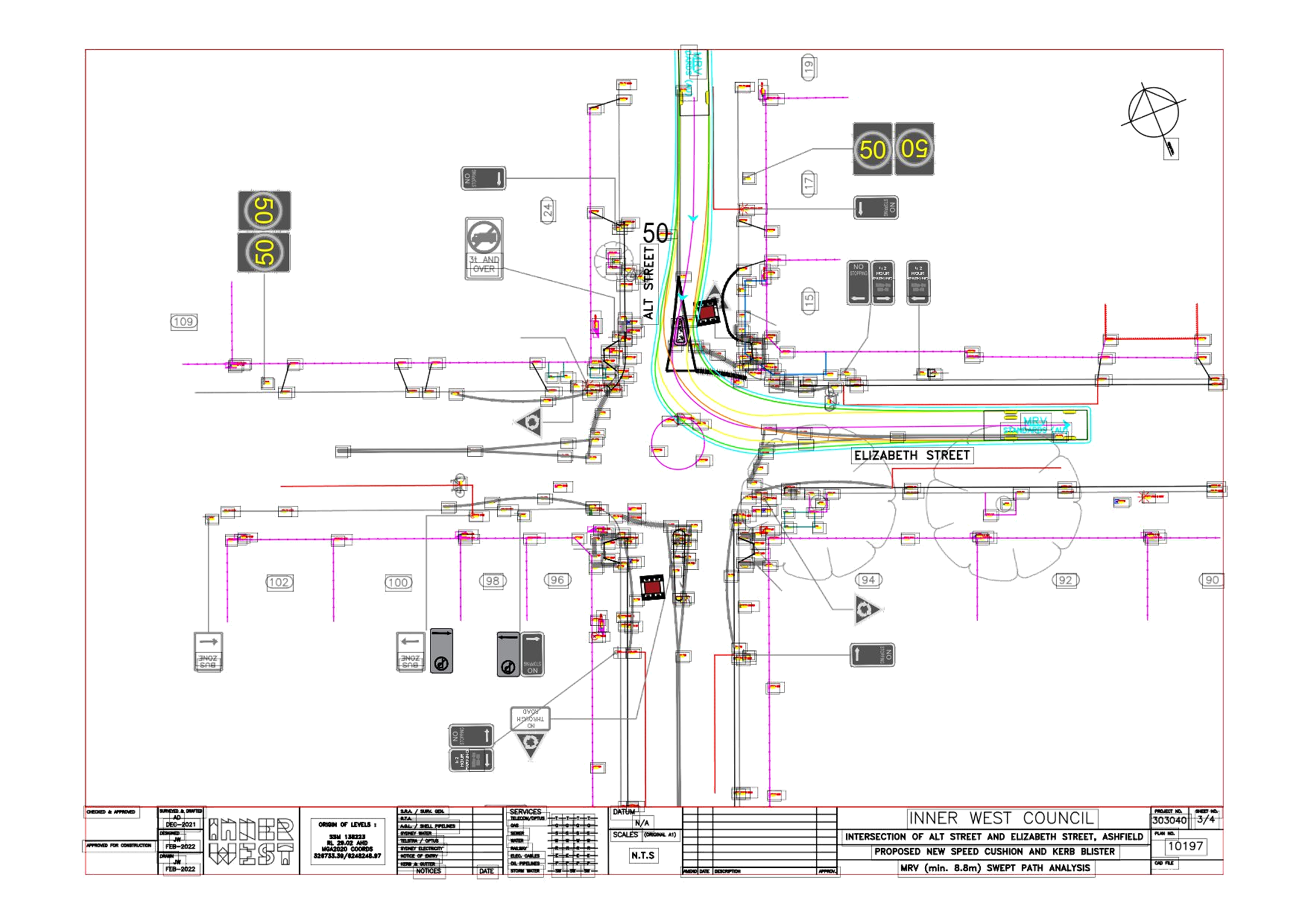
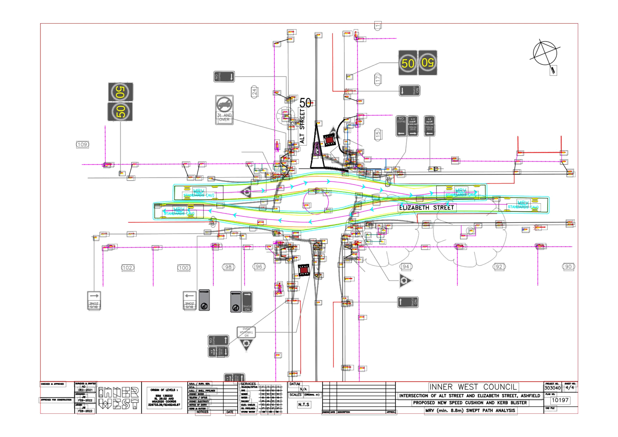
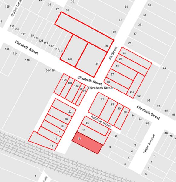
Subject: Elizabeth Street and Alt Street, Ashfield-
Proposed New Speed Cushions and Associated Works at the Roundabout
Intersection- Design Plan 10197.
(Gulgadya-Leichhardt Ward/Summer Hill Electorate/Ashfield LAC)
Prepared By: Boris Muha - Engineer – Traffic and Parking Services
Authorised By: Manod Wickramasinghe - Traffic and Transport Planning Manager
SUMMARY
Council has finalised design plans to construct two new speed cushions at the Alt Street approaches to the roundabout intersection of Elizabeth Street and Alt Street, Ashfield, as well as adjusting the line marking in Alt Street to better accommodate pedestrians crossing the road. Furthermore, a low profile central (mountable) median will be constructed on the Alt Street northern leg side of the intersection.
The intention of the proposal is to slow/control traffic movement and improve road safety for pedestrians and motorists at the intersection. Funding for these works has been provided under the NSW Safe Roads Program for the financial year of 2021/2022.
|
RECOMMENDATION
That the detailed design plan for new speed cushions, associated construction of a low profile central mountable median, existing pram ramp modification and inclusion/modification of signs and line marking (as shown per plan 10197) be APPROVED.
|
BACKGROUND
Alt and Elizabeth Streets both provide 2-way traffic flow and they measure approximately 10-10.1m respectively in width from kerb to kerb. Parking is allowed on both sides of the street. Alt Street (north), i.e. the Alt Street leg north of the intersection, is a major local road, linking traffic between Elizabeth Street and Parramatta Road. This section of Alt Street carries around 3500 vehicle per day with 85th percentile speeds within the 50km/h speed limit. Alt Street (south) is a dead- end section of road leading towards the railway line. It only provides local access to residential properties and would have low volumes of traffic less than 300 vehicles per day. Elizabeth Street east and west of the intersection, is a Regional Road carrying some 12,000-13,000 vehicles per day with 85th percentile speeds within the 50km/h speed limit.
Elizabeth Street is a major and frequent bus route. Alt Street (north) in the southbound direction has a few public-school service bus movements and private excursion buses from the De La Salle Boy’s and Bethlehem Girl’s High schools situated north of Alt Street.
The crash history statistics from TfNSW for the 5 year period ending in 2019 was used for funding and revealed the following reported crashes at the site:
· One (1) x RUM 59 (2016)- overtaking on eastern side of Elizabeth Street, non -casualty tow -away.
· Two (2) x RUM 30 (2015 and 2016) -rear end on western side of Elizabeth Street, injuries.
· One (1) x RUM 10 (2014)-cross-traffic Alt Street (north) and Elizabeth Street (west), injury.
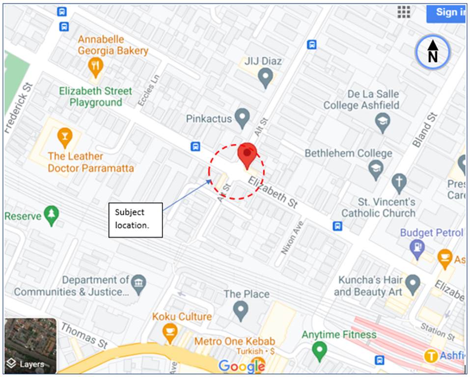
Locality Plan-Roundabout intersection of Elizabeth Street and Alt Street, Ashfield.
FINANCIAL IMPLICATIONS
Funding of $28,000 through the NSW Safe Roads Program has been allocated to this project for construction in the 2021/22 Capital Works Program.
OTHER STAFF COMMENTS
The following works are proposed and are illustrated on the attached plan as Attachment 1:
· install 2 new asphalt speed cushions on the approach to the roundabout in Alt Street;
· construct 1 new low-profile (mountable) concrete median island on the approach to the roundabout in Alt Street;
· install 1 new painted kerb blister island in Alt Street next to one of the new asphalt speed cushions;
· reconstruct 3 existing concrete kerb ramps;
· reconstruct some damaged sections of kerb, gutter and footpath in concrete (where shown in plan);
· resurface some damaged sections of road with new asphalt (where shown in plan); and
· install associated signs and line markings (where shown in plan).
It is further advised as follows:
· The speed cushions aim to slow and reinforce Alt Street traffic to give-way to the primary traffic on the right, being that of Elizabeth Street and to prevent/minimise further accidents, including the severity of those accidents.
· The central concrete median (splitter) island on the approach to the roundabout in Alt Street (north) is constructed to avoid general traffic from going around the speed cushion on the wrong side of the road. The median island and painted kerb blister island to eastern side of Alt Streets assists and move traffic over the speed cushion.
· Large vehicle movements through the roundabout are known to manoeuvre out wide over the existing central painted median (splitter) islands both in Alt Street and Elizabeth Street. Large vehicles turning left from Alt Street into Elizabeth Street are required to avoid corner and shop awning contact. The above proposed concrete median island will be made of low-profile mountable type for large vehicles and infrequent buses to travel over when negotiating to turn in and out of Alt Street (north).
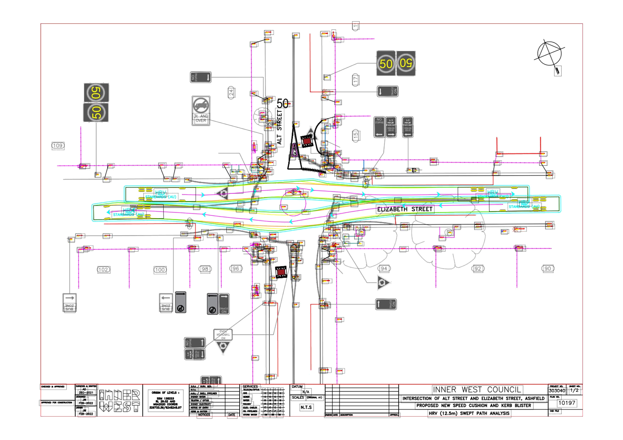
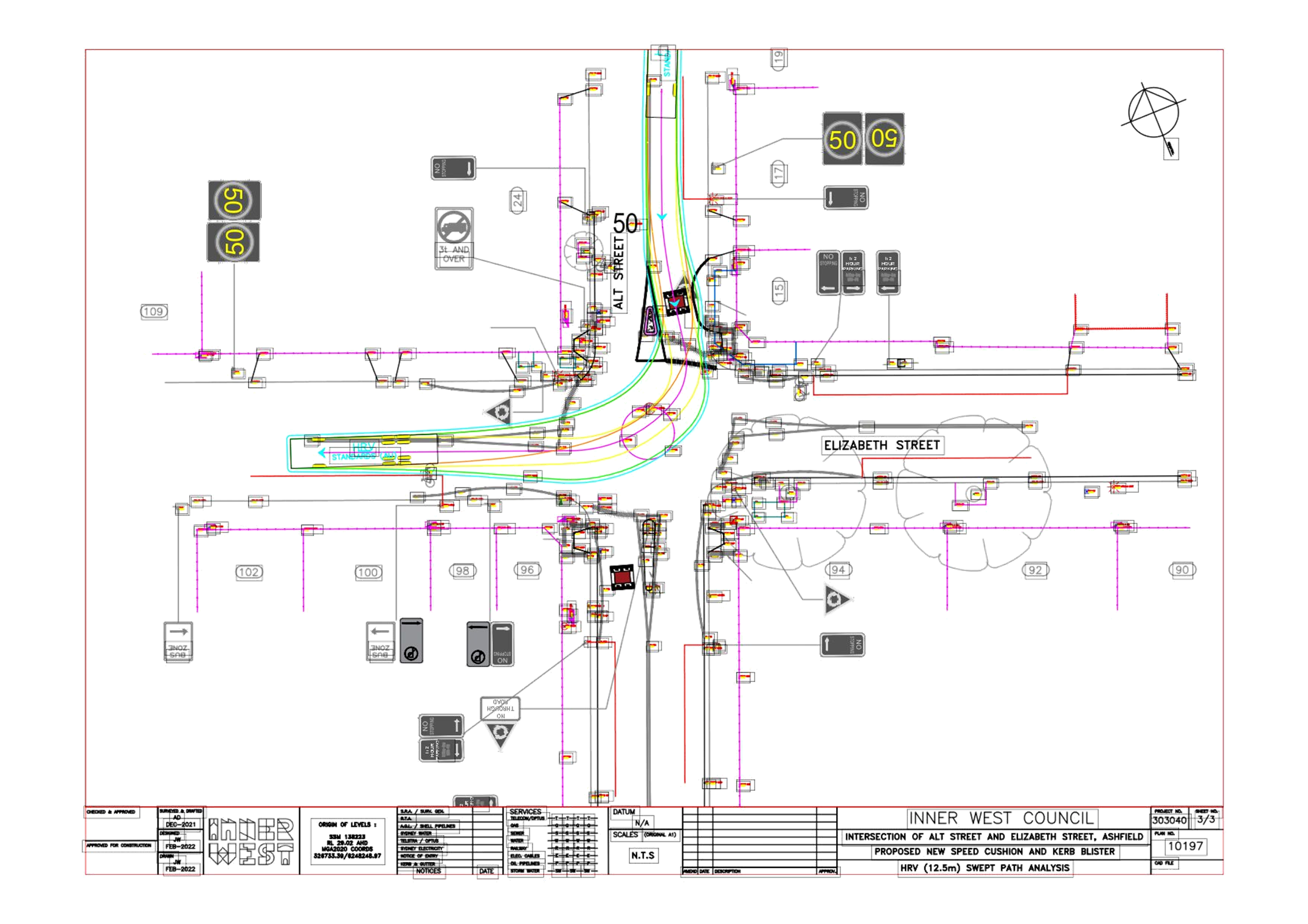
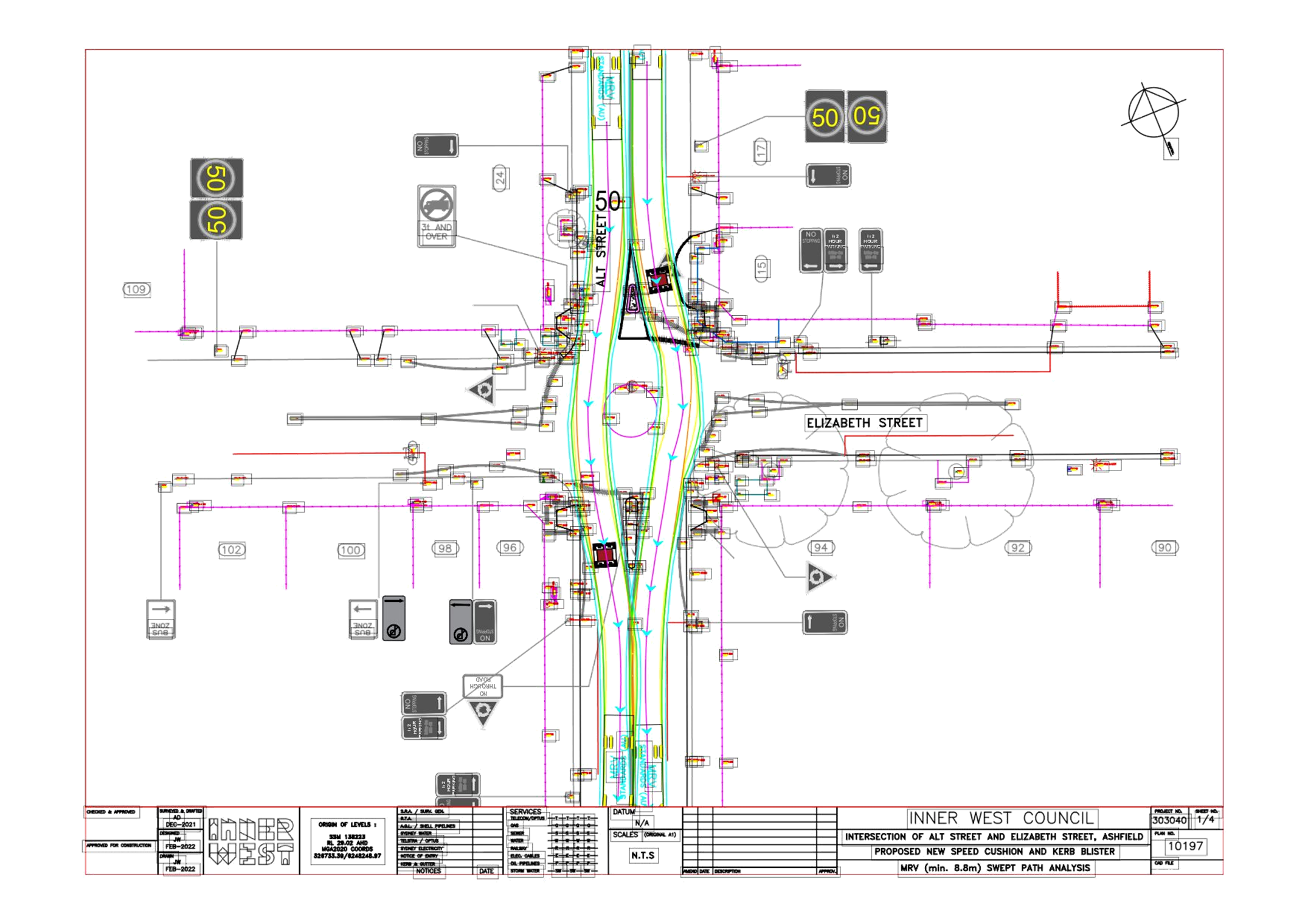
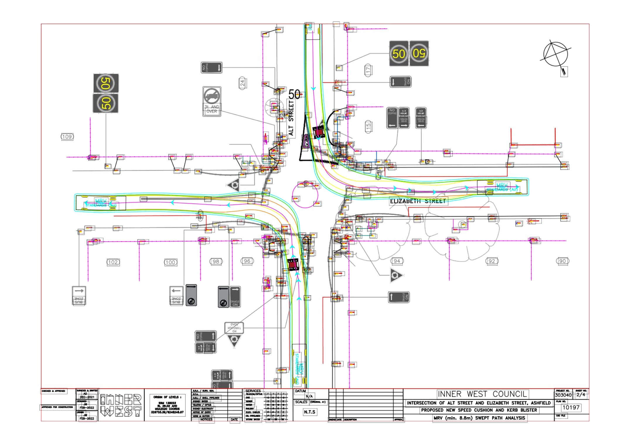
See Swept path movements for design garbage trucks and buses Attachments 2 & 3.
Plan sheets 2 and 3 on Attachment 3 show two scenarios of garbage trucks turning left from Alt Steet into Elizabeth Street.
The Give-way line in Alt Street (north) shall be moved forward to have pedestrians, when crossing on that side, properly and safely walk behind the Give-way line and in front of the central median island. Pedestrians are currently walking in front of the give-way line within the roundabout. The pram ramps will be made to re-align and direct pedestrian to the back of the new Give-Way line.
Parking Changes
No changes are proposed to the existing on-street parking arrangements. Therefore, this proposal will not result in the loss of any on-street parking spaces.
PUBLIC CONSULTATION
A letter outlining the above proposal was distributed to (27) directly affected properties (115 letters) in Alt Street and Elizabeth Street, Ashfield. Similarly, letters were also forwarded to Council’s Waste Collection Services and Transit Systems seeking any comments on waste collection and bus vehicle movements though the area.
Consultation Area for distribution of letters.
Submissions closed on the 23 February 2022. Two (2) responses were received with concerns or request for added or changed works to be carried out.
|
Resident comments |
Officers Response |
|
Resident 1.
· Seeks that traffic calming devices be placed also in Elizabeth Street. There have been significantly more vehicles (including motorbikes, police cars and ambulances) along the street.
· Provide also suitable traffic calming device that will also slow down speeding motorbikes at the intersection (e.g. watts profile road hump or flat top road humps rather than speed cushions.) |
· Elizabeth Street is a Regional Road carrying high volumes of traffic. The inclusion of traffic calming in Elizabeth Street may disrupt or conflict with primary traffic flow along this road and any driveway interference at the intersection. The narrowness of Elizabeth Street with parking on both sides provides a ‘defacto’ traffic calming measure, more so to the western side.
· Elizabeth Street is a bicycle route. Care should be taken if further consideration is made to traffic calm in Elizabeth Street so as not to discomfort motorcyclist and bicyclists being vulnerable road users. There appears reasonable deflection at the roundabout to control through traffic movement in Elizabeth Street. The condition of line markings and warning signposting on Elizabeth Street will be investigated under maintenance.
· Funding is limited at this stage for works to the Alt Street sides of the intersection. However, this shall be noted and considered under separate investigation for any further traffic/pedestrian safety measures in Elizabeth Street. |
|
Resident 2.
Recommendation for added/changed works:
· Remove speed cushion on the Alt Street (south of the roundabout). It’s a dead- end street, only 100m long, very quite. No need for it at all.
· Make Alt Street (north of roundabout) one -way (southbound only).
· Install Median islands /crossings on Elizabeth Street, both sides. It is a death trap for pedestrians to cross from Alt Street south to north. There is a tunnel at the end of Alt Street south [at the railway line] that takes you to the shops. Very popular route, so many people cross the street at Elizabeth Street/Alt intersection. You will also need to create KR [presumed kerb returns] on Elizabeth Street.
· Install Safety Railing on south- west corner of intersection. Cars come flying westbound on Elizabeth. Cars have smashed into the corner shop a few times. A matter of time a pedestrian will be standing there waiting to cross when a car hits them. |
· The speed cushions aim to slow and reinforce Alt Street traffic to give-way to the primary traffic on the right, being that of Elizabeth Street, irrespective of volumes from the minor road being Alt Street. · One-way is not recommended, as this will severely impact on local street access and direct traffic through other streets. · The inclusion of physical central medians in Elizabeth Street would not effectively fit and are very likely to impact and conflict with primary and high volume/heavy vehicle traffic flow in Elizabeth Street. Crossings are not recommended at roundabouts owing to added confliction. The matter will be examined further to see if other viable measures could be considered for pedestrian cross-over at Elizabeth Street, if required.
· The traffic accident patterns under funding investigation did not identify property collisions, nor has there been any request from the corner shop owners for safety railing at the corners of the intersection. However, this shall be noted and considered under separate investigation for any further traffic/pedestrian safety measures in Elizabeth Street. |
CONCLUSION
In view of the above, it is recommended that the detailed design plan for new speed cushions, associated construction of a low profile central mountable median, existing pram ramp modification and inclusion/modification of signs and line marking (as shown per plan 10197) be APPROVED.
|
1.⇩ |
Proposed intersection treatment -Plan No 10197 |
|
2.⇩ |
Design Swept path movements of HRV buses (12.5m length) |
|
3.⇩ |
Design swept path movement of MRV (garbage) trucks (8.8m length). |
|
Local Traffic Committee Meeting 21 March 2022 |
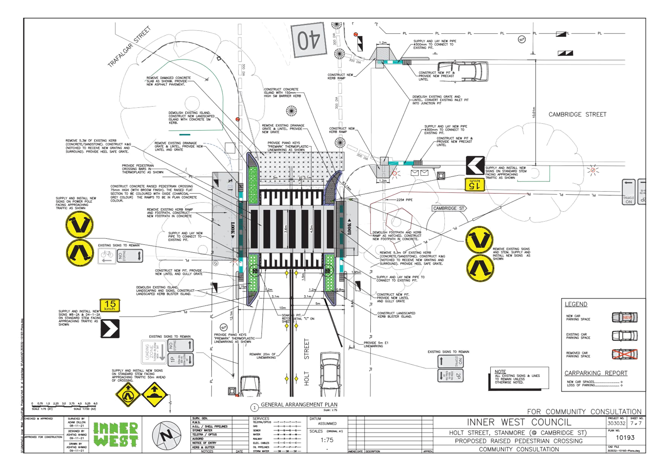
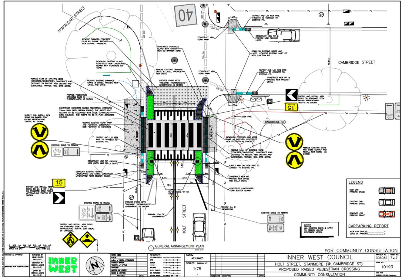
Subject: Holt Street, Stanmore – Pedestrian Safety Improvement Works – Raised Pedestrian Crossing - Design Plan 10193 (DAMUN - STANMORE WARD/ NEWTOWN ELECTORATE/ INNER WEST PAC)
Prepared By: Jennifer Adams - Engineer – Traffic and Parking Services
Authorised By: Manod Wickramasinghe - Traffic and Transport Planning Manager
SUMMARY
Council has finalised a design plan for pedestrian safety improvement works in Holt Street, Stanmore near Cambridge Street south of Stanmore Rail Station. The proposed works will include upgrading the existing pedestrian zebra crossing and some reconstruction works of the adjacent stormwater drainage pits. The project is expected to improve pedestrian safety in the locality.
|
RECOMMENDATION
That the detailed design plan for the raising of the existing pedestrian crossing and new adjacent kerb ramps and associated signs and line markings in Holt Street, Stanmore near Cambridge Street (as per Plan No.10193) be APPROVED.
|
BACKGROUND
Council is planning to implement pedestrian safety improvement works in Holt Street, Stanmore near Cambridge Street south of Stanmore Rail Station by raising the existing at-grade pedestrian crossing to improve pedestrian safety. Funding for this project is part of the Federal Stimulus Program for Road Safety around schools Program. This report details the Design Plan for those improvement works and its related consultation results.
FINANCIAL IMPLICATIONS
The project is listed on Council’s Traffic Facilities Capital Works budget for 2021/2022 and funding of $122,000 has been allocated to this project. Project number is 303032.
OTHER STAFF COMMENTS
The following works are proposed and are illustrated on the attached Consultation Plan (Plan No. 10193). The proposed works will improve pedestrian safety and addresses concerns about pedestrian and driver behaviour in the area.
Specifically, the proposed scope of works includes the following:
· Installing new Raised Pedestrian Crossing.
· Constructing three (3) landscaped kerb blister islands and one (1) new concrete kerb blister island;
· Constructing gutter bridges with heel safe grating to provide safe access over existing kerb and guttering to the new raised pedestrian crossing;
· Reconstructing some of the concrete footpath on both sides of the proposed pedestrian crossing;
· Constructing new stormwater drainage pits and pipes within the street to better manage street drainage; and
· Installing associated pavement line marking and signage as detailed.
Parking Changes
This proposal does not change any of the existing parking arrangements in Holt Street and
Cambridge Street. Therefore, there will be no loss of any parking spaces resulting from the proposed works.
Streetlighting
The existing flood lighting at the location is deemed adequate for the new raised pedestrian
crossing. Therefore, there will be no changes to the existing street lighting due to the proposed works.
PUBLIC CONSULTATION
Consultation was conducted between 27 January and 18 February 2022. A letter along with a copy of the design plan was sent to residents and businesses in the immediate locality. A total of 52 letters were distributed.
At the time of this report one (1) response was received. Generally, the response was supportive of the design plan to raise the existing pedestrian crossing. Other comments, outside the scope of the proposed design works, included a request to replace the adjacent large Casuarina Glauca pine tree with other more suitable vegetation that does not shed ‘pine needles’ or that their roots do not uplift the footpath pavement, and to make the area ‘more people friendly’.
|
1.⇩ |
303032-10193-Holt Street |
|
|
Local Traffic Committee Meeting 21 March 2022 |
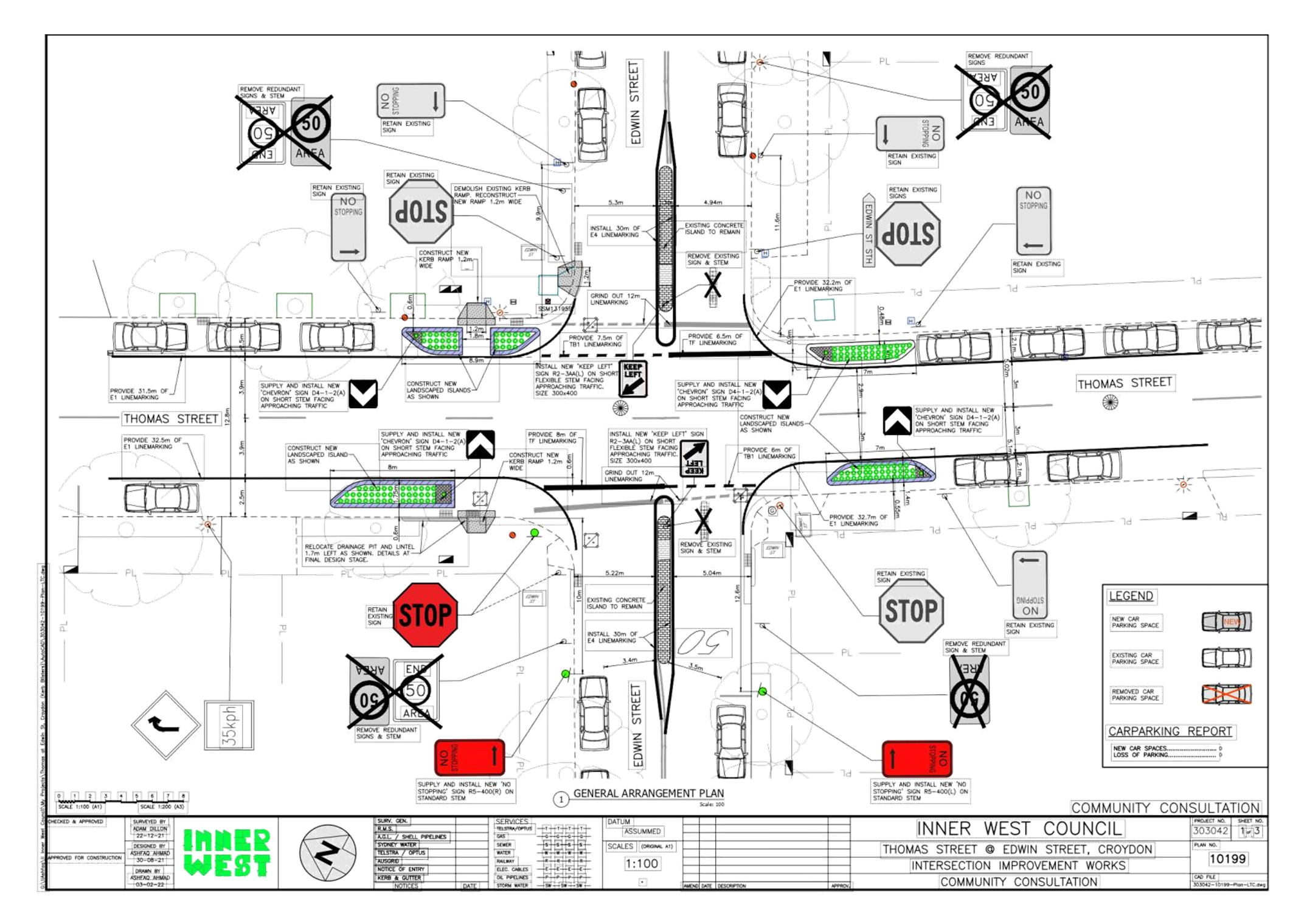
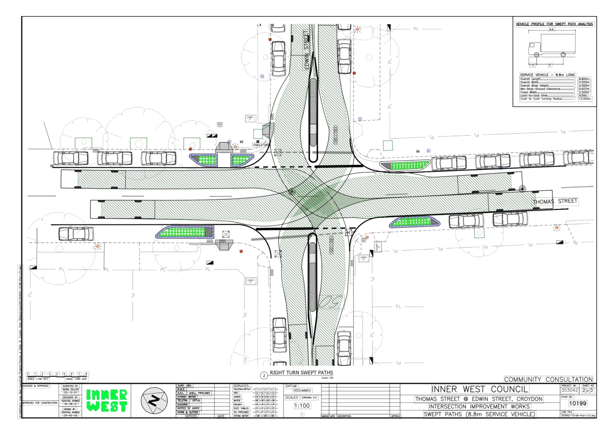
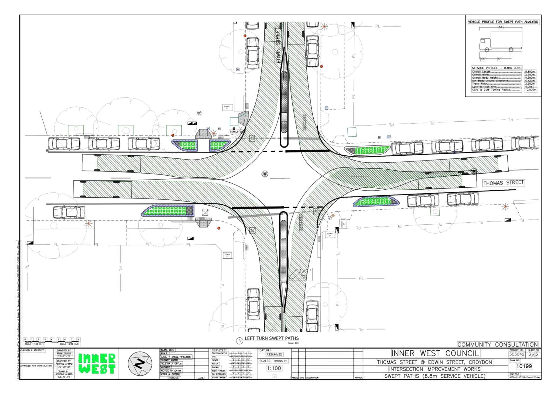
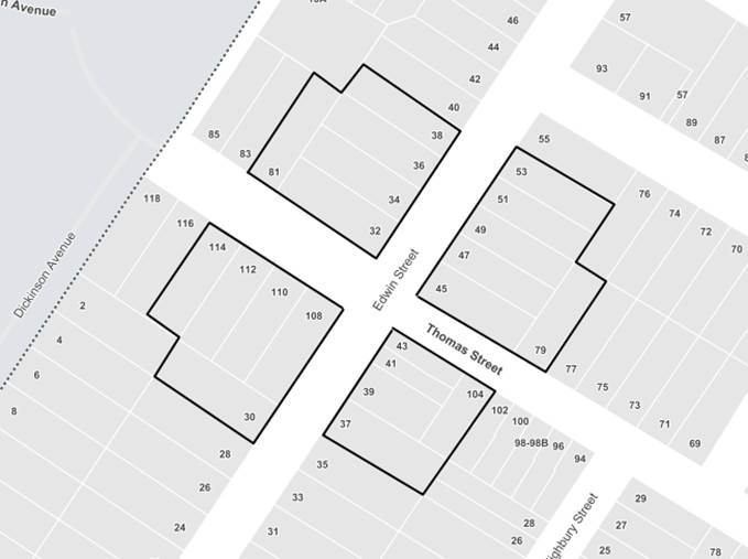
Subject: Thomas and Edwin Street, Croydon-Intersection
Improvement Works-Design Plan 10199.
(Djarrawunang-Ashfield Ward/Strathfield Electorate/Ashfield LAC)
Prepared By: Boris Muha - Engineer – Traffic and Parking Services
Authorised By: Manod Wickramasinghe - Traffic and Transport Planning Manager
SUMMARY
Council has finalised design plans to improve safety at the intersection of Thomas Street and Edwin Street, Croydon, by constructing new kerb blister islands to the corners of Thomas Street to facilitate safer vehicle turning movements and by bring out the STOP holding lines in Edwin Street near to front of the kerb blisters. A pram ramp (pedestrian) cross-over facility will also be provided on the western side of the intersection in Thomas Street under protection of the kerb blister islands and line marking. The intention of the proposal is to slow traffic and improve sight distances for drivers using this intersection which will improve road safety for both pedestrians and motorists.
Funding for these works has been provided under the Australian Government Blackspot Program for the financial year of 2021/2022.
|
RECOMMENDATION
That the detailed design plan to construct new kerb blister islands, move the STOP holding lines out in Edwin Street, and provide a new pedestrian cross-over facility (with associated signs and markings) at the intersection of Thomas Street and Edwin Street, Croydon (as shown per attached plan 10199) be APPROVED.
|
BACKGROUND
Thomas and Edwin Streets both provide 2-way traffic flow. Parking is allowed to both sides of the streets. Edwin Street, both north and south of the intersection of Thomas Street measures approximately 10-10.1 metres in width kerb to kerb. Thomas Street (east), measures approximately 10-10.1 metres, whilst Thomas Street (west) measures approximately 12.8m in width kerb to kerb. Thomas Street is a Regional Road, linking traffic between Liverpool Road and Croydon/Burwood to the west. Edwin Street is a minor Local Road. Thomas Street carries approximately 8,000-9,000 vehicle per day with 85th percentile speeds consistent with the 50km/h speed limit. Edwin Street (north) is short section of road accessing to the southern end of Croydon Station and has around 1,000 vehicles per day. Edwin Street (south) links to Liverpool Road and is considered to have less than 3,000-4,000 vehicles a day. 85% speeds in Edwin Street are considered consistent with the 50 km/h speed limit.
Edwin Street and Thomas Street are not bus route.
· x RUM 21 (2016)- right through -vehicle turning left from Thomas Steet (south) into Edwin Street (north) in contact with vehicle heading east in Thomas Street -injury
· x RUM 16 (2017) – left near- vehicle turning left from Edwin Street (south) into Thomas Street (west) in contact with vehicle heading west in Thomas Street .-injury
· x RUM 10 (2017)-cross traffic- vehicle in Edwin Street (south) in contact with vehicle heading west in Thomas Street.
The updated TfNSW accident statistics shows a further (1) RUM 10 (2019)- cross traffic-vehicle in Edwin Street (north) in contact with vehicle heading west in Thomas Street.
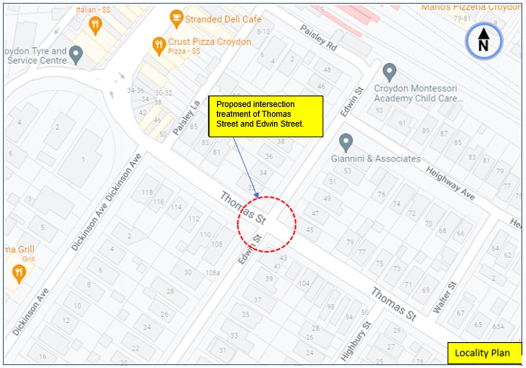
Locality Plan – Thomas and Edwin Street, Croydon.
FINANCIAL IMPLICATIONS
Funding of $85,125 through the Australian Government Black Spot Program has been allocated to this project for construction in the 2021/22 Capital Works Program.
OTHER STAFF COMMENTS
The following works are proposed and are illustrated on the attached plan as shown in Attachment 1.
Thomas Street and Edwin Street, Croydon (Plan No. 10199):
- Install 4 new landscaped kerb blister islands in Thomas Street;
- Bring forward existing “STOP” signage for motorists wishing to exit Edwin into Thomas Street;
- Extend the new STOP holding lines into Thomas Street (aligned with new landscaped kerb blister islands) to improve sight distance for motorists wishing to exit Edwin into Thomas Street;
- Construct 2 new kerb ramps for pedestrians to cross Thomas Street more safely;
- Reconstruct 1 existing kerb ramp for pedestrians to cross Edwin Street more safely;
- Relocate and reconstruct 1 existing stormwater drainage pit & lintel in Thomas Street to accommodate the proposed new kerb ramp;
- Install 2 new ‘No Stopping’ restrictions in Edwin Street to improve vehicle movements within the street (as shown on plans);
- Removing of redundant “50 AREA” & “End 50 AREA” signs in Edwin Street;
- Installing associated pavement line marking and signage (as shown on plans)
It is further advised as follows:
· Kerb blisters to the corners are provided to assist and supplement in bringing out the STOP lines near to the front of the blisters. The blisters emphasis and provide the presence of road narrowing together with line marking in effort to control and slow traffic through the intersection in Thomas Street. They are landscaped to enhance the presence of the blisters and provide aesthetic improvements to the street landscape.
· A pram ramp pedestrian cross-over facility is provided on the western side of the intersection in Thomas Street and addresses the IWC Pedestrian Access Mobility Plan (PAMP) recommendations for added pedestrian cross-over facility to be provided for in Thomas Street at the intersection.
· See Swept path movements for design garbage trucks also on Attachments 1.
Parking Changes
It is proposed to provide 2 new ‘No Stopping’ signs in Edwin Street (west of Thomas Street) to ensure current minimum standards are met and to better manage vehicles movements in Edwin Street.
As the proposed ‘No Stopping’ signs are located 10m and 12.6m respectively from the corner of Thomas Street, the proposal will result in the loss of no legal or practical (existing) use of on-street parking spaces.
Streetlighting
There will be no changes to the existing street lighting due to the proposed works.
.
PUBLIC CONSULTATION
A letter outlining the above proposal was distributed to (21) directly affected properties (38 letters) in Thomas Street and Edwin Street, Croydon.
 Area
of consultation letter distribution.
Area
of consultation letter distribution.
Submissions closed on the 24 February 2022. Two (2) responses were received in support of the proposal with further comments provided in the following table.
|
Resident comments |
Officers Response |
|
· Does the deletion of the 50km/hour signs this mean the street is now rated at 60km/hour.
· Request for Speed humps approaching the intersection on Edwin Street between Liver pool street and Thomas Street.
· Request for good visibly- i.e. the indicated plantings need to be less than 600mm high.
· Request for improved street lighting so that pedestrians are clearly visible.
· Request for Zebra crossing parallel with Thomas Street ideally raised (drainage permitting).
|
· The 50km/h signs were placed in some 20 years ago in perimeter areas leading into the local street network. Legislation has since been made that all local streets in built up areas are 50 km/h speed limits without the need of signposting. Council is no longer replacing these signs under maintenance or is gradually removing them under new works.
· The request for speed humps in Edwin Street is outside the scope of works for this project. The street will be listed for speed counts to assess justification for traffic calming devices or request police enforcement. · Planting will be of low scrub species. · Lighting will be examined under a separate program. · Pedestrian activity is considered too low to warrant crossings. Improved/added pram ramp cross-over facilities are provided under the project. |
|
Resident 2.
· Thank you for the project. I will have much better visibility when exiting Edwin St onto Thomas St. · It is disappointing that the change in the speed limit to the safer 40 km/h for local roads hasn't been made yet, but I understand that this is the responsibility of TfNSW? Would it be possible to roll out the speed limit change throughout the section of Croydon bound by Liverpool Rd, Frederick St, and the railway line as part of this project · I am worried about the impact it might have on people riding bikes. Pinch points can be dangerous.
|
· Noted.
· This is outside of the scope of this project and is a separate issue. Council has canvased a request to TfNSW to consider and introduce 40kph in the overall Inner West Council Area.
· Thomas Street is an on-road bicycle route where bicyclists travel along with the traffic. The travel lane widths both ways through the device remain the same or are not narrowed in between parked cars or the kerb blister islands. |
CONCLUSION
In view of the above, it is recommended that the detailed design plan to construct new kerb blister islands, move the STOP holding lines out in Edwin Street, and provide a new pedestrian cross-over facility (with associated signs and markings) at the intersection of Thomas Street and Edwin Street, Croydon (as shown per attached plan 10199) be APPROVED.
|
1.⇩ |
Design Plan 10199 and Swept path design garbage MRV (8.8m) truck movements. |
|
Local Traffic Committee Meeting 21 March 2022 |
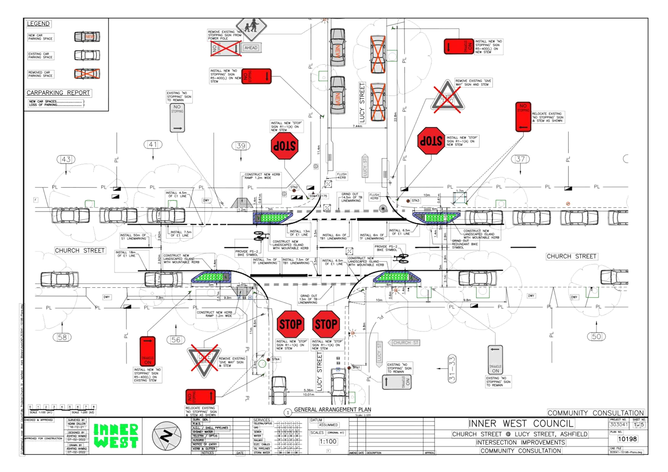
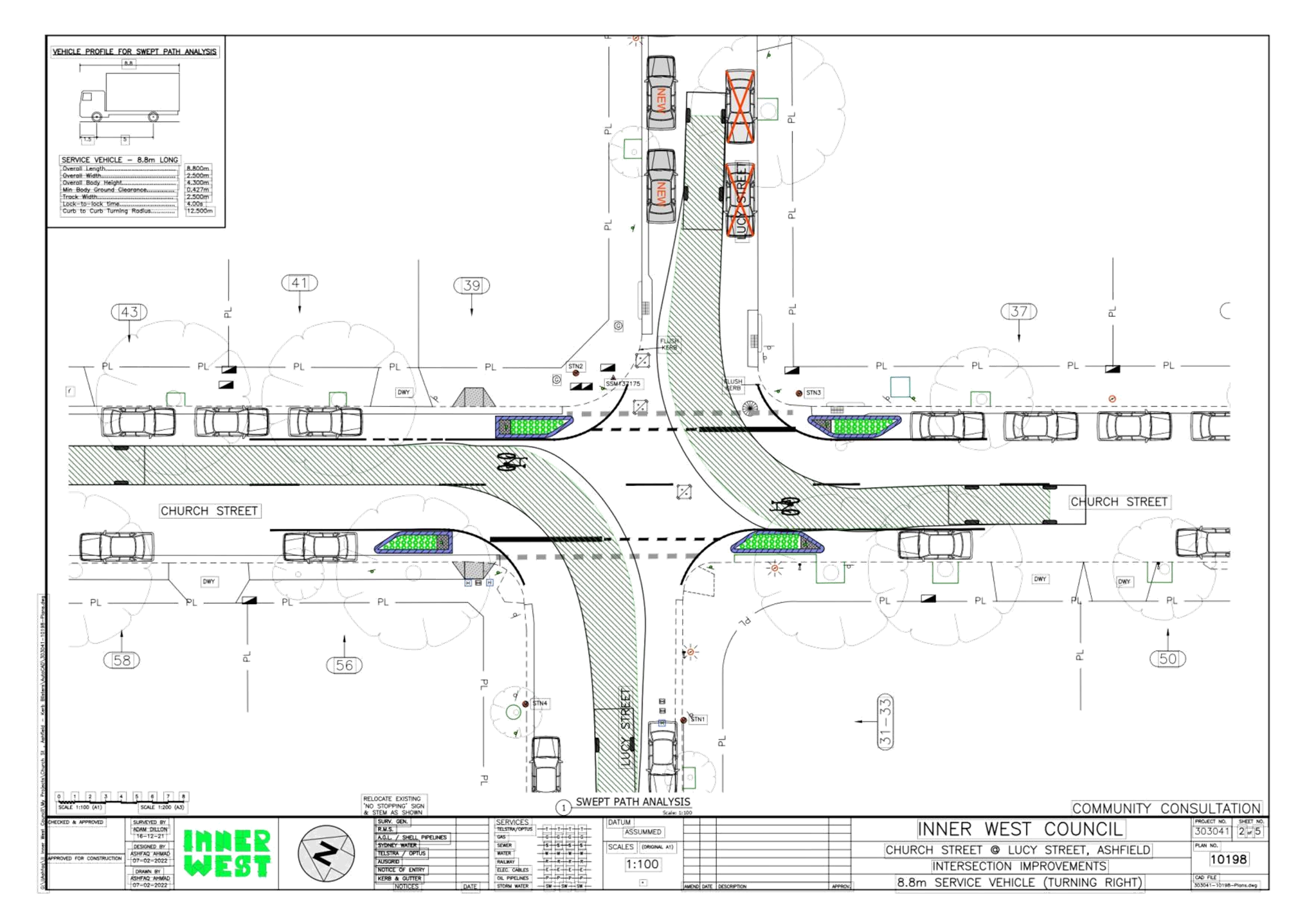
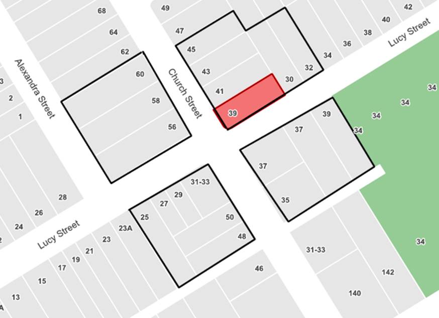
Subject: Church and Lucy Street, Ashfield-Intersection
Improvement Works-Design Plan 10198.
(Gulgadya-Leichhardt Ward/Strathfield Electorate/Ashfield LAC)
Prepared By: Boris Muha - Engineer – Traffic and Parking Services
Authorised By: Manod Wickramasinghe - Traffic and Transport Planning Manager
SUMMARY
Council has finalised design plans to improve safety at the intersection of Church Street and Lucy Street, Ashfield, by constructing new kerb blister islands at the Church Street intersection. The proposal is expected to facilitate safer vehicle turning movements by replacing the existing Give Way control with a Stop sign and extended STOP lines. A pram ramp facility will also be provided on the western side of the intersection, under protection of the kerb blister islands and line marking. The intention of the proposal is to slow traffic and improve sight distances for drivers using this intersection which will improve road safety for both pedestrians and motorists.
Funding for these works has been provided under the Australian Government Blackspot Program for the financial year of 2021/2022.
|
RECOMMENDATION
|
BACKGROUND
Church Street is a local road carrying 3,500-4,000 vehicles per day with 85th percentile speed near the 50km/h speed limit. The road carriageway is 10m between kerbs, which allows for on-street parking on both sides of the road.
Lucy Street is estimated to carry about 1,000 vehicles per day and provides connection to Hammond Park. As it is 7.4m wide to the east of Church Street, only a single travelling carriageway remains in sections with parking on both sides. Lucy Street west of Church Street is wider at 10m, and allows for two way passing with parking on both sides.
Both Church Street and Lucy Street are not bus routes.
The crash history statistics from TfNSW for the 5 year period ending in 2019 was used for funding and revealed the following reported crashes at the site:
· RUM Code 16 (2017)- left near- vehicle turning left from Lucy Street (west) into Church Street (north) in contact with vehicle heading north in Church Street. -injury
· RUM Code 10 (2018)- cross traffic- vehicle in Lucy Street (east) in contact with vehicle heading south in Church Street. - injury
· RUM Code 20 (2018) – head on- vehicle heading south in Thomas Street in contact with vehicle heading north in Thomas Street. -injury
· RUM Code 12(2018) – left far-vehicle turning left from Lucy Street (east) in Thomas Street (south) in contact with vehicle heading north in Church Street. - injury
No further accidents were found between 2019 and 2020 from TfNSW crash database.
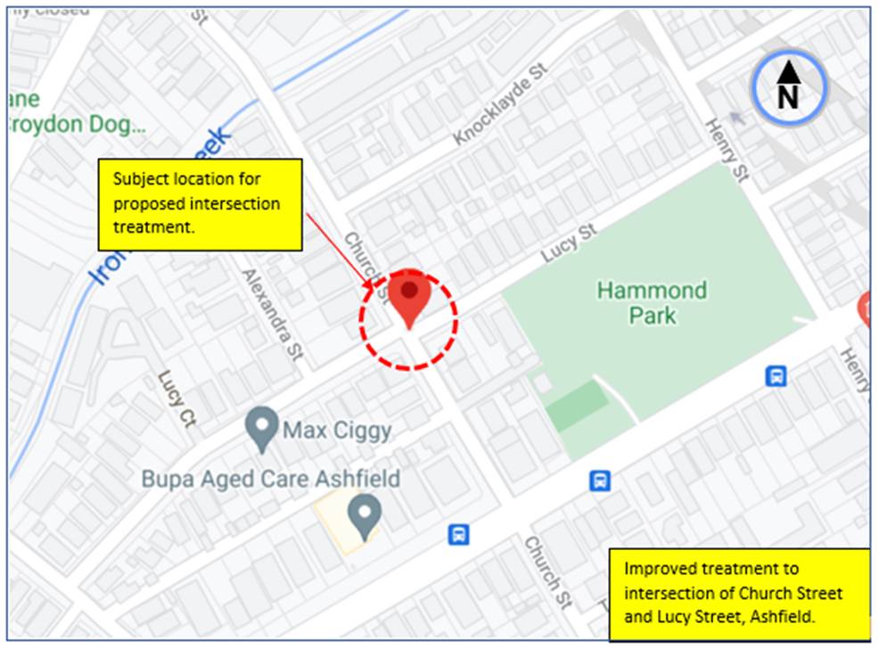
Locality Plan- Proposed intersection treatment at Church and Lucy Street, Ashfield
FINANCIAL IMPLICATIONS
Funding of $67,150 through the Australian Government Black Spot Program has been allocated to this project for construction in the 2021/22 Capital Works Program.
OTHER STAFF COMMENTS
The following works are proposed and are illustrated on the attached plan as shown in Attachment 1.
Church Street & Lucy Street, Ashfield (Plan No. 10198):
- Install four (4) new landscaped kerb blister islands in Church Street;
- Convert existing ‘Give Way’ priority to ‘Stop’ control for both approaches in Lucy Street;
- Extend the new STOP holding lines into Church Street (aligned with new landscaped kerb blister islands) to improve sight distance for motorists wishing to exit Lucy Street into Church Street
- Construct two (2) new kerb access ramps pedestrians to cross Church Street;
- A 22.8m length ‘No Stopping’ zone restriction in Lucy Street to improve vehicle movements within the street (as shown on plans)
- Installing associated pavement line marking and signage (as shown on plan).
It is further advised as follows:
· Kerb blisters to the corners are provided to assist and supplement in bringing out the STOP lines near to the front of the blisters. The blisters emphasis and provide the presence of road narrowing together with line making an effort to control and slow traffic through the intersection in Church Street. They are landscaped to enhance the presence of the blisters and provide aesthetical improvements to the street landscape.
· A kerb access ramp pedestrian facility is provided on the northern side of the intersection in Church Street and addresses the IWC Pedestrian Access Mobility Plan (PAMP) recommendations for pedestrian cross-over facility to be provided in Church Street at the intersection.
· STOP lines are provided in lieu of the existing GIVE-WAY lines as traffic in Lucy Street will need to stop near to the traffic flow in Church Street.
· Swept path movements for design garbage trucks is also shown in Attachment 1.
Parking Changes
It is proposed to adjust existing ‘No Stopping’ zones and signage within Lucy Street to ensure current minimum standards are met and to better manage vehicles movements in Lucy Street.
This will result in a loss of two (2) car parking spaces on the south side of Lucy Street however two (2) new car parking spaces will be created on the opposite side of the Street with the reduction of the existing ‘No Stopping’ zone. Overall, there will be a no net loss of on-street parking spaces.
Streetlighting
There will be no changes to the existing street lighting due to the proposed works.
PUBLIC CONSULTATION
A letter outlining the above proposal was distributed to directly affected properties (19 properties- 25 household letters) in Lucy Street and Church Street, Ashfield.
Consultation area map for letter distribution.
Submissions closed on the 24 February 2022. Three (3) responses were received with objections/concerns or reasons as to providing such a treatment to the intersection.
|
Resident comments |
Officers Response |
|
Resident 1.
I wish to object to the following items of the planned works. · Kerb Blister Islands in Church Street. By installing these islands, cars will not be able to go around cars waiting to turn right into Lucy St. During peak times of morning and afternoon school drop off and pick up and the usual peak hour traffic, cars back up all the way beyond Lucy St when the lights at Frederick St are red. Cars turning right from Church St into Lucy St will hold the traffic up and stop the flow of traffic down Church St when the lights change to green, if cars cannot have access to go around on the left. · The removal of parking on Lucy Street alongside the property of 37 Church St and replacing with parking alongside the property of 39 Church St. When vehicles enter Lucy Street they are often congested when there are vehicles parked alongside 39 Church St and there is oncoming traffic along Lucy St, from the Hammond Park end. Having parked cars on that side of the road will make the congestion worse. · Having the ‘No Stopping’ sign extended to the other side of the 39 Church St driveway would be a much safer option, providing a good clear distance for cars to pass each other safely. · I agree with the change of the “Give Way” signs to “Stop” signs in Lucy St.-noted.
|
· Right turn movements are observed to be low with vehicles experiencing little or no delay in waiting time to turn right due to gaps in traffic or with traffic not queuing across the intersection in Church Street back from the lights at Frederick Street.
· Vehicles are not generally observed to park on the approach side of Lucy Street outside No.37 Church Street. Reconfiguration of parking will see that two legal parking spots in Lucy Street to the side of No.37 be relocated to the opposite (No.39) side in line with the (predominant) parking to that side of the road.
Two-way traffic would flow more safely to the southern side of Lucy Street away from the north-eastern corner of the intersection (corner to No.39). Formalising parking to the southern approach side (side to No.37) may force eastbound traffic to mount over the north -eastern corner and that of a low dipped kerb & guttered drainage pit on the departure side of the corner if confronted by an opposing vehicle in Lucy Street. This would cause hazard to pedestrians and traffic.
The two new parking spots will be placed as far east as possible on the northern side of Lucy Street. ‘No Stopping’ will be reduced from approximately 26.0m to 13.5-15.0m on the northern side east of the intersection to still provide adequate clearance/maneuvering/holding area. ‘No Stopping’ will be signposted on the southern side of Lucy Street up to the side driveway of No.37 Church Street. This will allow ease in access to No.37 particularly when exiting.
· It is not intended under this proposal to extend ‘No Stopping’ on the northern side of Lucy Street to the other side of the driveway to No.39 Church Street. This would entail loss of one (1) parking space.
|
|
Resident 2.
· Stop signs on Lucy Street will be a good idea. · Traffic island seems a great waste of money. A lot of inconvenience for very little benefit.
· Our driveway is in Lucy St, so parked cars opposite it will make it very difficult for us to get in and out of our garage. It would be way more beneficial to move the "No Stopping" sign that is currently on Lucy St, outside the 39 Church St residence, to the far side of their driveway, and keeping parking on the side which runs alongside our land, as that will not block any driveways.
· Why are islands of mountable kerbs?
· Are the four corners of the intersection going to be rounded or will there be curved lines painted on the road surface?
|
· Noted.
· The proposed treatment for the intersection was assessed under approval for black spot funding by the TfNSW to address particular accidents and to prevent/minimise further accidents, including the severity of those accidents. See also Other Staff Comments above for reasons and purpose of the islands.
· Refer to response above to resident 1. Adequate access to driveways is still maintained with relocation of parking to the opposite side in Lucy Street.
· The intersection treatment is designed to cater for design garbage trucks movements. There can be the odd larger vehicle or emergency vehicle needing to ride over the kerbsides the islands. They are not intended for pedestrians to walk over.
· The physical concrete corners are not touched. Line marking is painted to guide vehicles round the islands and concrete corners. |
|
Resident 3.
· No problem changing the give-way to Stop signs. · Would like to know more what has led to this decision. I view that the intersection is not busy enough to warrant all these changes. All these changes would make Church Street appear a lot busier than it is in practise. Queuing at best only stretches from the Frederick Street lights to No.50 Church Street more during morning and afternoon peak times between 9am-5pm. All other times the street is quiet. Concerned that the proposed works are not keeping with or sympathetic to the actual context, character and environment of the street and the streets and surrounds. · Draw more attention to the rear (unnamed lane between 46 and 48 Church Street which is considered more dangerous than the Lucy Street intersection. Visibility of cars and pedestrians coming out of the lane into Church Street is zero and condition of the street and kerb is terrible A dip exists which can cause vehicle underside scratches, and vehicles coming close to neighbouring houses to avoid the dip. |
· Noted.
· The proposed treatment for the intersection was assessed under approval for black spot funding by the TfNSW to address particular accidents and to prevent/minimise further accidents, including the severity of those accidents. See also Other Staff Comments above for reasons and purpose of the islands and associated works.
· This is outside the scope of works for the project and will need to be investigated separately based on the information as provided. |
CONCLUSION
In view of the above, it is recommended that the detailed design plan to construct new kerb blister islands, relocated STOP lines (in lieu of Give-way lines) at Lucy Street, and kerb access ramps (with associated signs and markings) at the intersection of Church Street and Lucy Street, Ashfield, (as shown per attached plan 10198) be APPROVED.
|
1.⇩ |
Design Plan 10198 and Swept path movement of a design garbage MRV (8.8m) length vehicle. |
|
Local Traffic Committee Meeting 21 March 2022 |
Subject: Albion Street And Young Street, Annandale - Proposed Stormwater Drainage Upgrade (GULGADYA-LEICHHARDT WARD/ BALMAIN ELECTORATE/ LEICHHARDT PAC)
Prepared By: Brinthaban Baskaran - Graduate Traffic Engineer
Authorised By: Sunny Jo - Coordinator Traffic Engineering Services (North)
SUMMARY
Council is planning drainage improvement works at the intersection of Albion Street and Young Street, Annandale to better manage stormwater in the area by replacing and upgrading ageing stormwater infrastructure.
|
RECOMMENDATION
That the attached detailed design plan (Design Plan No.10157) for the proposed stormwater drainage upgrade at the intersection of Albion Street and Young Street, Annandale be approved. |
BACKGROUND & OTHER STAFF COMMENTS
The detailed design plan shown in Attachment 1 outlines the proposed works at the intersection of Albion Street and Young Street and includes the following treatments:
- Installation of a new and upsized stormwater pipe system to better manage stormwater flows
- Replacement of two (2) existing ‘head on’ pits with two (2) new stormwater inlet pits;
- Removal of one (1) existing stormwater junction pit;
- Construction of four (4) new stormwater junction pits to facilitate connects;
- Construction of two (2) new stormwater pits with grated cover to act as surcharge pits;
- Reconstruct sections of kerb, gutter, footpaths, kerb ramps and driveways as needed to facilitate the works;
- Construction of kerb extension in front of No.6 Young Street, Annandale;
- Resurfacing the road with new asphalt over the area affected by the installation of the new pipe system; and
- Construction of new junction pit over existing Sydney Water stormwater pipe as per Sydney Water approved plan.
The proposal will not result in any loss of on-street parking.
FINANCIAL IMPLICATIONS
Funding of $190,000 has been allocated to this project for construction in the 2021/2022 Capital Works Program.
PUBLIC CONSULTATION
A letter outlining the proposal was mailed out to 11 properties in Young Street and Albion Street, Annandale. No responses were received regarding the proposal.
|
1.⇩ |
Detailed Design Plan - Albion Street and Young Street, Annandale - Proposed Stormwater Drainage Upgrade |
|
|
Local Traffic Committee Meeting 21 March 2022 |
Subject: Beattie Street, Balmain (At Darling Street) - Proposed Raised Pedestrian Crossing (BALUDARRI -BALMAIN WARD/ BALMAIN ELECTORATE/ LEICHHARDT PAC)
Prepared By: Vinoth Srinivasan - Engineer - Traffic and Parking Services
Authorised By: Manod Wickramasinghe - Traffic and Transport Planning Manager
SUMMARY
Council is planning to improve pedestrian safety in Beattie Street, Balmain at Darling Street by upgrading the existing at-grade pedestrian crossing to a raised pedestrian (wombat) crossing. The proposed works aims to improve pedestrian safety and addresses concerns about pedestrian and driver behavior in the area.
|
RECOMMENDATION That the attached detail design plan (Design Plan No.10178) for the proposed installation of a new raised pedestrian crossing on Beattie Street, Balmain (at Darling Street) be approved. |
BACKGROUND & OTHER STAFF COMMENTS
The detailed design plan shown in Attachment 1 outlines the proposed works on Beattie Street, Balmain (at Darling Street) and includes the following treatments:
- Construction of a new concrete Raised Pedestrian Crossing in place of the existing at-grade pedestrian crossing;
- Removal of existing asphalt footpath and construction of new landscaped garden bed together with a new tree;
- Removal of existing asphalt footpath and providing a new decoratively paved footpath;
- Construction of a new footpath connection to provide better access between top and bottom tier footpath levels;
- Relocation of the existing bike rack to new location;
- Relocation of the existing decorative metal bollards and chain fence to the new location;
- Removal of existing damaged concrete road pavement and reconstruction of new asphalt road pavement;
- Providing a new street stormwater pit to better manage storm water; and
- Installation of pavement line marking and signage associated with the works
There is no change to existing on-street parking. Accordingly, no on-street parking spaces will be lost as result of the proposed works.
FINANCIAL IMPLICATIONS
Funding of $100,000 has been allocated to this project for construction in the 2021/2022 Capital Works Program.
PUBLIC CONSULTATION
A letter outlining the proposal was mailed out to 17 properties in Darling Street and Beattie Street, Haberfield requesting residents’ views regarding the proposal. No responses were received regarding to the proposal.
|
1.⇩ |
Detailed Design Plan - Beattie Street, Balmain - Proposed raised pedestrian crossing |
|
|
Local Traffic Committee Meeting 21 March 2022 |
Subject: Trafalgar Street and Collins Street, Annandale - Proposed Raised Pedestrian Crossings (GULGADYA - LEICHHARDT WARD/ BALMAIN ELECTORATE/ LEICHHARDT PAC)
Prepared By: Vinoth Srinivasan - Engineer - Traffic and Parking Services
Authorised By: Manod Wickramasinghe - Traffic and Transport Planning Manager
SUMMARY
Council is planning to improve pedestrian safety at the intersection of Trafalgar Street & Collins Street, Annandale by upgrading the existing at-grade pedestrian crossings to a raised pedestrian (Wombat) crossing. The proposed works will improve pedestrian and motorist safety and addresses concerns about pedestrian and driver behaviour in the area.
|
RECOMMENDATION
That the attached detailed design plan (Design Plan No.10194) for the proposed installation of the two (2) new raised pedestrian crossings on Trafalgar Street and Collins Street, Annandale be approved.
|
BACKGROUND & OTHER STAFF COMMENTS
The detailed design plan shown in Attachment 1 outlines the proposed works on Trafalgar Steet and Collins Street, Annandale and includes the following treatments:
- Installation of two new Raised Pedestrian (Wombat) Crossings;
- Construction of landscaped kerb blister islands as shown on attached plan;
- Construction of gutter bridges with heel safe gratings to provide safe access over existing kerb and guttering to the new raised pedestrian crossing;
- Reconstruction of some sections of concrete footpath on both sides of the proposed pedestrian crossing; and
- Installation of associated pavement line marking and signage as required.
It is proposed to adjust existing No Stopping zones and signage to ensure current minimum standards are met. This will result in the loss of three (3) on-street parking spaces on Trafalgar Street and Collins Street.
FINANCIAL IMPLICATIONS
Funding of $240,000 has been allocated to this project for construction in the 2021/2022 Capital Works Program.
PUBLIC CONSULTATION
A letter outlining the proposal was mailed out to 18 properties in Collins Street and Trafalgar Street, Annandale requesting residents’ views regarding the proposal. 10 responses were received with one (1) in support, four (4) in general support with request for changes and five (5) in objection.
The main traffic and parking related concerns raised by the residents are outlined in the below table:
|
Residents’ Comments |
Officer Comments |
|
The proposal will result in the loss of four (4) on-street parking spaces. Parking is already a premium in Annandale |
The revised plans allow for two (2) additional on-street parking spaces to be retained compared to the original design. |
|
Council should implement a resident parking scheme (RPS) on Collins Street, Annandale |
The implementation of a resident parking scheme on Collins Street will be considered as part of a separate investigation |
|
The proposal will result in the reduction of the existing pick up and drop off zone in front of St Brendan’s Catholic Primary School. Council should extend the existing pick up and drop off zone. A crossing marshal would still be considered the best course of action. |
The extension of the existing pick up and drop off zone in front of the school will result in the loss of parking in front of residential properties. The operation of the pick up and drop off zone will be monitored after implementation and if required will be modified accordingly. |
|
The location of the proposed raised crossings is too close to the intersection of Trafalgar Street and Collins Street. The crossing on Trafalgar Street should be relocated in the southern direction closer to Albion Street by 15-20m. The crossing on Collins Street should be relocated by a similar distance in the western direction closer to Johnston Street. |
Although positioning the crossing at the intersection would be desirable for pedestrians, this was not achieved due to the existing stormwater system, street trees and power poles. Locating the pedestrian crossings at the suggested 15-20m away from the intersection would result in the pedestrian crossings being underutilized. |
|
The ‘No Stopping’ zone opposite No.3A Collins Street should be removed to obtain a parking space. |
Noted and the revised plans have allowed for the parking space to be retained. |
|
The proposed pedestrian crossing will only be utilized during school hours but will have negative impacts throughout the entire day. |
The upgrade of the pedestrian crossing helps reduce vehicle speeds and improves pedestrian safety. |
|
Appropriate signage at the intersection of Johnston Lane and Collins Street be improved to provide a safer footpath use. |
This issue will be considered as part of a separate investigation. |
|
Unsafe stop-start-stop approach and unsafe line of sight created by setting back Trafalgar Street pedestrian crossing. |
The proposed design does not change the number of stop and starts required at this location. This design also minimizes the occurrence of a vehicle obstructing the pedestrian crossing at the Stop line. |
|
1.⇩ |
Detailed Design Plan - Collins Street and Trafalgar Street, Annandale - Proposed raised pedestrian crossings |
|
Local Traffic Committee Meeting 21 March 2022 |
Subject: Annandale Street, Annandale (At Piper Street) - Proposed Raised Pedestrian Crossing (GULGADYA - LEICHHARDT WARD/ BALMAIN ELECTORATE/ LEICHHARDT PAC)
Prepared By: Vinoth Srinivasan - Engineer - Traffic and Parking Services
Authorised By: Manod Wickramasinghe - Traffic and Transport Planning Manager
SUMMARY
Council is planning to improve pedestrian safety in Annandale Street, Annandale near Piper Street by upgrading the existing at-grade pedestrian crossing to a raised pedestrian crossing. The proposed works will improve pedestrian and motorist safety and addresses concerns about pedestrian and driver behaviour in the area.
|
RECOMMENDATION
That the attached detailed design plan (Design Plan No.10192) for the proposed installation of a new raised pedestrian crossing at Annandale Street at Piper Street, Annandale be approved.
|
BACKGROUND & OTHER STAFF COMMENTS
The detailed design plan shown in Attachment 1 outlines the proposed works on Annandale Street, Annandale at Piper Street and includes the following treatments:
- Installing new Raised Pedestrian Crossing in place of the existing at-grade pedestrian crossing;
- Constructing 2 landscaped kerb blister islands (in Piper Street) integrated with the existing footpath;
- Widening the footpath in Piper Street and constructing 2 new kerb ramps to improve pedestrian safety across Piper Street;
- Constructing gutter bridges with heel safe grating to provide safe access over existing kerb and guttering to the new raised pedestrian crossing;
- Reconstructing some of the concrete footpath on both sides of the proposed pedestrian crossing;
- Adjustments to some of the street drainage system as needed to accommodate the new works;
- Minor adjustments to the existing No Stopping and parking signs in both Piper Street and Annandale Street; and
- Installing associated pavement line marking and signage as required.
It is proposed to adjust the existing No Stopping and street parking signage to ensure current minimum standards are met and to accommodate the new raised pedestrian crossing facility. This will result in the loss of one (1) on-street parking space on the north side of Piper Street, immediately west of Annandale Street.
FINANCIAL IMPLICATIONS
Funding of $80,000 has been allocated to this project for construction in the 2021/2022 Capital Works Program.
PUBLIC CONSULTATION
A letter outlining the proposal was mailed out to 14 properties in Annandale Street and Piper Street, Annandale requesting residents’ views regarding the proposal. One (1) response was received in objection to the proposal. The main concerns raised by the resident are outlined below in the table.
|
Residents’ Comments |
Officer Comments |
|
- The proposal does not address the high speeds of the vehicles - Replacing the Stop sign with a Give Way sign will encourage speeding - Drivers will need to divide their attention to both pedestrians crossing and the raised pedestrian crossing |
- The raised crossing will reduce the vehicle speed as they pass through the crossing - The proposed Give Way sign have been retained as a Stop sign |
|
1.⇩ |
Detailed Design Plan - Annandale Street, Annandale - Proposed raised pedestrian crossing |
|
Local Traffic Committee Meeting 21 March 2022 |
Subject: Leichhardt West Precinct Parking Study (Gulgadya-Leichhardt Ward/Balmain Electorate/Leichhardt PAC)
Prepared By: Jason Scoufis - Traffic and Parking Planner
Authorised By: Manod Wickramasinghe - Traffic and Transport Planning Manager
SUMMARY
This is a recommendation to endorse the findings of the Final Leichhardt West Precinct Parking Study report. Council has recently undertaken Public Exhibition of the draft Leichhardt West Precinct Parking Study through Yoursay Inner West. The draft report proposed several changes, including an expansion of the Resident Parking Scheme (RPS) as shown in Attachment 1.
The response results indicate that the community generally supported most of the proposed changes, with a majority support for the short-term proposal to expand the Resident Parking Scheme in the streets surrounding the Epicure Collection residential complex, however the majority did not support the extension of the Resident Parking Scheme into the Taverners Hill Precinct or the Leichhardt Marketplace Precinct.
After considering the Public Exhibition feedback, a review on the proposed scheme was undertaken with adjustments made to the proposed parking strategy. As the changes included both short term and long term strategies, this would require Council to implement the changes over a 5-10 year life cycle of the study.
|
RECOMMENDATION
That:
1. The final Leichhardt West Precinct Parking Study be received and noted; 2. The Resident Parking Scheme (RPS) be expanded to include the streets surrounding the Epicure Residential complex in the area generally bounded by Foster Street, Regent Street, Elswick Street, Athol Street and Whiting Street with 2P 8am-6pm (Mon-Fri) Permit Holders Excepted Area L1 signposting. 3. ‘90 degree angled parking rear to kerb’ in Elswick Street North between William Street and Darley Road be approved subject to a final signposting plan being supported by Traffic Committee. 4. ‘90 degree angled parking rear to kerb’ in Edith Street between Marion Street and the southern boundary of No. 4 Edith Street be approved subject to a final signposting plan being supported by Traffic Committee. 5. Replace redundant, faded and damaged signs as identified in the signage audit. 6. Further detailed assessment be undertaken to review potential for angled parking in Elswick Street, Allen Street, Athol Street, Albert Street, Fenwick Street, Jarrett Street, Davies Street, Flood Street, Burfitt Street, Charles Street, Lords Road and Kegworth Road. 7. Further detailed parking and traffic assessment be undertaken in Myrtle Street between Ivory Street and Elswick Street, Leichhardt to provide safe condition for pedestrians. 8. Aim that the overall number of L1 resident parking permits in Leichhardt West Study Area not exceed the total L1 parking capacity within the Leichhardt West Study Area 9. Dedicate parking enforcement efforts to streets near and within 200 metres of Lambert Park to promote and enforce safe and legal parking behaviour 10. Should peak hour capacity increase on the Inner West Light Rail, monitor commuter parking at Taverners Hill, Marion and Hawthorne Light Rail Stations by undertaking parking surveys in surrounding residential streets. 11. Support be provided for the Parramatta Road Urban Transportation Strategy (PRCUTS) maximum parking rates in the future Inner West DCP. |
BACKGROUND
The parking study reviewed the current parking management in place, location, supply demand, and distribution of residential, commercial parking, as well as other evidence of long-stay and short stay parking. This includes current parking strategies and policies, including permit allocation in the existing Resident Parking Scheme.
Local issues including streets near trip generators such as the Kegworth Public School, Lambert Park Sportsfield, Leichhardt Marketplace, Oasis, Leichhardt Green Epicure Collection and Light Rail stops were considered in the study.
The Study was undertaken by Stantec (formerly known as GTA Consultants) using parking occupancy and parking duration data collected in November 2020, site observations, and feedback received during the initial community engagement period in November/December 2020 and subsequent community engagement during the public exhibition of the draft report in September/October 2021.
The map of the study area is provided in Attachment 2.
FINANCIAL IMPLICATIONS
The cost to implement the Leichhardt West Precinct Parking Strategy will be funded from Council’s traffic facilities budget, subject to Local Traffic Committee support and adoption by Council. Subsequent reports during implementation of the Strategy will provide estimates on signage and administrative costs to expand the resident parking permit scheme if required.
PUBLIC CONSULTATION
The Public Exhibition of the draft Study commenced 6th September 2021 and ended 15 October 2021. A total of 4,319 letters were mailed out, inviting to provide comments online and via separate email and paper submissions.
Council’s Have Your Say in Leichhardt West website had 901 visits and 265 submissions received. A further 14 submissions were received via email, customer service enquiry, and post. This represents a response rate of 6.5%.
The feedback is summarised below with further details provided in the Leichhardt West Precinct Parking Study Final Report which includes the Community Engagement Outcomes Report in Attachment 3:
The proposed changes included a short term proposal to expand the Resident Parking Scheme (RPS) to include streets around the Epicure Collection residential complex in the area bounded by Foster Street, Regent Street, Elswick Street, Athol Street, Whiting Street and High Street. The majority of participants supported the proposal (58% support including those that said ‘yes’ and ‘yes with changes’) hence it has been included in the final recommendations. Given that a number of residents commented that the proposed hours should be reduced to weekdays only and extend up to 6pm on weekdays so as to allow visitors, the recommendation has been modified from the draft report to reflect these concerns.
A longer-term proposal included the expansion of the RPS in the Taverners Hill Precinct bounded by Hawthorne Canal, Parramatta Road, Elswick Street, Myrtle Street, Lords Road and Lambert Park and Leichhardt Marketplace Precinct bounded by Foster Street, Lords Road, Elswick Street and Regent Street. The majority of participants supported these proposals (54% support including ‘yes’ and ‘yes with changes’) however more participants specifically answered ‘no’ as opposed to ‘yes’ in regard to the proposal hence it has been excluded from the final recommendations. It should be noted however that this does not preclude further investigation of this scheme at a later date. The final proposed expansion of the resident parking scheme is detailed in Attachment 4.
The long-term proposal to introduce pricing for a second residential permit was not supported (only 42% support rate including yes and yes with changes) hence it has been removed from the final recommendations of this report.
Similarly, the majority of participants supported the introduction a consistent restriction for current RPS streets (55% support including ‘yes’ and ‘yes with changes’) however more participants specifically answered ‘no’ as opposed to ‘yes’ hence it has been excluded from the final recommendations.
The majority of participants supported the proposal to reform visitor parking permits (52% support including ‘yes’ and ‘yes with changes’) however more participants specifically answered ‘no’ as opposed to ‘yes’ in regard to the proposal hence it has been excluded from the final recommendations.
An additional recommendation has also been included as a result of concerns raised from residents of Myrtle Street, Leichhardt regarding parking behaviour where vehicles straddle the footpath impacting on pedestrian safety. Similarly, during the public exhibition, the community suggested angled parking in additional streets. This will require additional assessment to determine if appropriate and has therefore been included as a recommendation for further assessment.
|
1.⇩ |
ATTACHMENT 1 - PROPOSED DRAFT REPORT EXPANSION OF RPS |
|
2.⇩ |
ATTACHMENT 2 STUDY AREA |
|
3.⇩ |
ATTACHMENT 3 LEICHHARDT WEST PRECINCT PARKING STUDY FINAL REPORT |
|
4.⇩ |
ATTACHMENT 4- FINAL PROPOSED EXPANSION OF RESIDENT PARKING SCHEME |
|
Local Traffic Committee Meeting 21 March 2022 |
Subject: Rozelle North Precinct Parking Study (Baludarri-Balmain Ward/Balmain Electorate/Leichhardt PAC)
Prepared By: Jason Scoufis - Traffic and Parking Planner
Authorised By: Manod Wickramasinghe - Traffic and Transport Planning Manager
SUMMARY
This is a recommendation to endorse the findings of the Final Rozelle North Precinct Parking Study report. Council has recently undertaken Public Exhibition of the draft Rozelle North Precinct Parking Study through Yoursay Inner West. The draft report proposed several changes, most notably an expansion of the existing R1and B1 Resident Parking Scheme (RPS) as shown in Attachment 1 to include additional streets within these zones.
The response results indicate that the community generally supported most of the proposed changes, with a majority support for the short-term proposal to expand the Resident Parking Scheme in the R1 and B1 Zones to generally encompass the study area. There were mixed opinions for the longer term proposal to introduce pricing on the second residential permit.
After considering the Public Exhibition feedback, a review on the proposed scheme was undertaken with adjustments made to the proposed parking strategy. As the changes included both short term and long term strategies, this would require Council to implement the changes over a 5-10 year life cycle of the study.
|
RECOMMENDATION
THAT:
1. The final Rozelle North Precinct Parking Study be received and noted; 2. The Resident Parking Scheme (RPS) be expanded to include the additional streets in the R1 Zone and B1 Zone as identified in Attachment 1 with ‘2P 8am-6pm (Mon-Fri) Permit Holders Excepted Area R1’ signposting in those streets not currently signposted with an RPS in the R1 Zone and ‘2P 8am-6pm (Mon-Fri) Permit Holders Excepted Area B1’ signposting in those streets not currently signposted with an RPS in the B1 Zone. 3. The existing time limit restrictions and hours of operation of current streets in the B1 Zone that have an existing RPS will be retained, however the restriction be converted to a B1 zone. 4. Replace redundant, faded and damaged signs as identified in the signage audit. 5. Aim that the overall number of R1 and B1 resident parking permits in Leichhardt West Study Area not exceed the total R1and B1 parking capacity within the Rozelle North Study Area 6. Further investigation be carried out regarding reform to visitor parking permits in the form of scratch and display one day permits and review of personal carer permits, trade permits and support worker permits 7. Convert 8 unrestricted parking spaces on the southern side of Robert Street immediately east of Mullens Street to ‘2P 6am-4pm Mon-Fri’.
|
BACKGROUND
The parking study reviewed the current parking management in place, location, supply demand, and distribution of residential, commercial parking, as well as other evidence of long-stay and short stay parking. This includes current parking strategies and policies, including permit allocation and extent of existing Resident Parking Scheme.
Local issues including streets near trip generators such as Rozelle Public School, Rozelle shops, Union Residential, light industrial areas near Robert Street/Mullens Street, and Victoria Road bus corridor were considered in the study.
The Study was undertaken by Stantec (formerly known as GTA Consultants) using parking occupancy and parking duration data collected in November 2020, site observations, and feedback received during the initial community engagement period in November/December 2020 and subsequent community engagement during the public exhibition of the draft report in September/October 2021.
The map of the study area is provided in Attachment 2.
FINANCIAL IMPLICATIONS
The cost to implement the Rozelle North Precinct Parking Strategy will be funded from Council’s traffic facilities budget, subject to Local Traffic Committee support and adoption by Council. Subsequent reports during implementation of the Strategy will provide estimates on signage and administrative costs to expand the resident parking permit scheme if required.
PUBLIC CONSULTATION
The Public Exhibition of the draft Study commenced 6 September 2021 and ended 15 October 2021. A total of 4,456 letters were mailed out with a colour map of the study area and a link to provide comments online through yoursay. Paper questionnaires were also provided on an as requested basis.
Council’s Have Your Say in Rozelle North website had 543 visits and 146 submissions received. A further 9 submissions were received via email, customer service enquiry, and post. This represents a response rate of 3.4%.
The feedback can be summarised into the following themes with further details provided in the Rozelle North Precinct Parking Study Final Report which includes the Community Engagement Outcomes Report in Attachment 3:
· Support for expansion of the current resident parking schemes R1 and B1 to include more streets. This will prioritise resident parking over commuters.
· Mixed opinions about introduction of pricing on second residential parking permit in Rozelle North and introduction of additional car share parking.
· Support for introduction of 8 x 2 hour parking spaces 6am-4pm Monday to Friday on the southern side of Robert Street immediately east of Mullens Street.
· Support for visitor permit reform
The proposed changes included a short term proposal to expand the Resident Parking Scheme (RPS) for R1 and B1 zones to generally include all streets within the study area that were not currently part of the scheme. The R1 Zone area is generally bounded by Victoria Road, Crescent Street, Parsons Street, Mullens Street, Reynolds Street, George Street, Clare Street, Beattie Street, Wise Street, Wellington Street and Nagurra Place as detailed in the Attachment 1. The B1 Zone area is generally bounded by Mullens Street, Mansfield Street, Batty Street, Reynolds Street, Wortley Street, Valley Street and Beattie Street.
Note that whilst the expansion of the RPS details the extent of the proposed areas that will be able to participate in the scheme, not every parking space will be subject to resident parking scheme restrictions. Some sections may remain unsignposted e.g. along park frontages, non-residential land uses and along frontages along sites not eligible to particulate in the scheme so as to allow parking or those that are not eligible for a permit.
The proposed R1 and B1 Zones will function as follows;
· All existing parking permit areas within the proposed R1 Zone will operate under existing rules. Only new properties would be captured by the R1 Zone. This means that existing R5, R4, R3 and R2 Zone will remain unchanged.
· All areas within the proposed B1 Zone will operate under existing B1 residential parking eligibility requirements and rules. In the new B1 Zone any existing RPS zones will be replaced with the B1 permit so all properties in the area have only one type of permit. The existing time limit restrictions and hours of operation of current streets in the B1 Zone that have an existing RPS will be retained, however the restriction will convert to a B1 zone.
The majority of the participants (78% including those that answered ‘yes’ and ‘yes with changes’ as opposed to those that answered ‘no’) support this short-term proposal to extend the RPS, agreeing that the current resident parking scheme should be expanded. It is recommended that the scheme operate from 8am-6pm Mon-Fri as per the standard hours for these schemes. The hours that the schemes operates can be extended at a later date should the need arise.
The short- term proposal to install short-term parking restrictions (2P 6am-4pm Mon-Fri) for 8 parking spaces in Robert Street was supported by the majority of the participants (81% including those that answered ‘yes’ and ‘yes with changes’ as opposed to those that answered ‘no’) hence it has been included in the recommendations.
The long-term proposal to investigate reform into visitor parking permits had majority of participants support the proposal (60% support including ‘yes’ and ‘yes with changes’) hence it has been included in the recommendations.
The proposal to introduce pricing for a second residential permit had majority of the participants (51% including those that answered ‘yes’ and ‘yes with changes’ as opposed to those that answered ‘no’) support this long-term proposal however more participants answered ‘no’ as opposed to ‘yes’ in regards to introducing pricing on second residential permits hence it has not been included in the recommendations of this report.
|
1.⇩ |
ATTACHMENT 1 - PROPOSED RPS EXPANSION |
|
2.⇩ |
ATTACHMENT 2- STUDY AREA |
|
3.⇩ |
ATTACHMENT 3 ROZELLE NORTH PRECINCT PARKING STUDY FINAL REPORT |
|
Local Traffic Committee Meeting 21 March 2022 |
Subject: Traffic Committee Schedule Update 2022
Prepared By: David Yu - Engineer - Traffic and Parking Services
Authorised By: Sunny Jo - Coordinator Traffic Engineering Services (North)
SUMMARY
The proposed schedule of the Local Traffic Committee meetings has been updated for the 2022 calendar year. It is recommended that the proposed meeting schedule be received and noted.
|
RECOMMENDATION
THAT the proposed updated schedule of meetings of the Local Traffic Committee for the 2022 calendar year be received and noted. |
BACKGROUND
A schedule for the 2022 Local Traffic Committee meetings was reported at the 6 December 2021 meeting.
Since that time, Council has amended its meeting schedule and so it is proposed that the Local Traffic Committee meeting dates be amended to better align the Council meeting date changes. To assist Committee members with forward planning, the updated schedule of meetings of the Local Traffic Committee for 2022 is detailed below.
The meeting start time has also been updated to 11am.
OTHER STAFF COMMENTS
All meetings will be held on the 3rd Monday of each month, excluding April during which has been moved to avoid Easter Day and December which has been brought forward due to the Christmas and New Year’s break. The meetings will commence at 10.00am, with the revised meeting dates for 2022 as follows:
|
Date |
Time |
|
Monday, 21 March 2022 |
11.00am |
|
Tuesday, 19 April 2022 |
11.00am |
|
Monday, 16 May 2022 |
11.00am |
|
Monday, 20 June 2022 |
11.00am |
|
Monday, 18 July 2022 |
11.00am |
|
Monday, 15 August 2022 |
11.00am |
|
Monday, 19 September 2022 |
11.00am |
|
Monday, 17 October 2022 |
11.00am |
|
Monday, 21 November 2022 |
11.00am |
|
Monday, 5 December 2022 |
11.00am |
|
|
Local Traffic Committee Meeting 21 March 2022 |
Subject: Holbeach Avenue, Tempe – Temporary Full Road Closures for Ms Sydney to The Gong Bike Ride on Sunday 1 May 2022 – (MIDJUBURI - MARRICKVILLE WARD/HEFFRON ELECTORATE/NEWTOWN LAC)
Prepared By: Jennifer Adams - Engineer – Traffic and Parking Services
Authorised By: Manod Wickramasinghe - Traffic and Transport Planning Manager
SUMMARY
It is recommended that the comments of the Local Traffic Committee be referred to Council’s Development Assessment Section for consideration in determining the Development Application.
|
RECOMMENDATION
THAT the report be received and noted. |
BACKGROUND
Council has received an application (S68201800006) under Section 68 of the Local Government Act 1993 to use Holbeach Avenue and Tempe Recreation Reserve to hold the annual 'MS Sydney to the Gong Bike Ride' supported by Multiple Sclerosis (MS) Australia on Sunday, 1 May 2022.
The application is required to be referred to the Local Traffic Committee for consideration under State Environmental Planning Policy (Infrastructure) 2007.
The S68201900006 approval dated 27 September 2019 approves the holding of the MS Sydney to Gong bike ride event at Tempe Recreation Reserve annually on every first Sunday of November from 2019 – 2023 between 5.00am to 9.00am. Due to Covid the event was cancelled in 2020 1nd 2021 and this year the event has been brought forward to May 2022.
This years’ course will mostly follow that of previous years with the 82Km start location in Tempe Recreation Reserve Tempe, and the 58Km start location in Cooper Reserve Engadine. The riders then join the 82Km riders on Princes Highway following the traditional course through the Royal National Park, traveling south along the coast to Thirroul, riding over Sea Cliff Bridge then following Sandon Point Reserve, at the end of the cycle way through Woonona, East Corrimal, Towradgi, Fairy Meadow, North Wollongong to Finish in W. A. Lang Park, Wollongong.
The number of participant registrations for the 2022 Gong Bike Ride will remain capped at 10,000.
FINANCIAL IMPLICATIONS
Nil.
OFFICER COMMENTS
MS Australia will ultilise the IKEA car park as a drop off zone and riders will ride down Princes Highway (southbound) to the starting location at Tempe Recreation Reserve. The traffic management company will put in an access lane along Princes Highway to keep riders safe while entering the event at Tempe Recreation Reserve where this location will be the start of the cycling course.
The event will start at Tempe Recreation Reserve, Tempe (see Figure below). On departing, cyclists will ride west on Holbeach Avenue and then turn left onto Princes Highway. Cyclists will then ride along the southbound lanes on Princes Highway as they make their way south over the Cooks River Bridge and beyond.
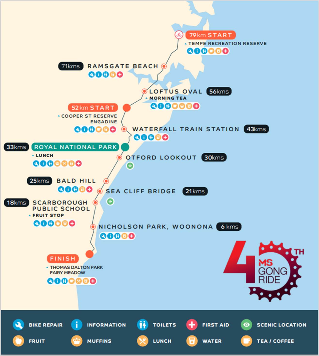
The applicant advised that support of the NSW Police and RMS will be sought and a detailed Traffic Management Plan has been forwarded to the RMS, NSW Police and relevant Councils and authorities.
NSW Police and the MS Australia Course Marshals will be at critical locations to ensure that participants and motorists follow all proposed traffic management measures. The event will be held on a Sunday morning where traffic volumes are expected to be lower than average.
It is proposed that the traffic control measures would be in place between 4:00am and no later than 10:00am as the event commences at 6.00am and is expected to be concluded by 9.00am. Affected residents and businesses will be allowed access at Police discretion.
PUBLIC CONSULTATION
The applicant advised that the traffic control management on the day of the event will be controlled by NSW Police and MS Australia Course Marshals. The Traffic Control Plans for relevant Inner West locations are reproduced at the end of this report.
A Traffic Management Plan will be submitted to Transport for New South Wales (TfNSW) for consideration and approval as well as a Road Occupancy License application will be submitted to the Transport Management Centre.
CONCLUSION
It is proposed that the following traffic related comments be forwarded to Council’s Development Assessment section.
Based on the information presented in the applicant’s submission to Council with regards to the proposed cycling event on Sunday 1 May 2022 with the inclusion of a temporary full road closure of Holbeach Avenue, Tempe, it is acknowledged that the event will be controlled by NSW Police and the MS Australia Course Marshals. Therefore, Council supports the temporary full road closure of Holbeach Avenue, Tempe during the course of the event subject to:
· the applicant submitting a Traffic Management Plan to TfNSW for consideration and approval;
· a Road Occupancy License be obtained from the Transport Management Centre: and
· advice of the proposed event being forwarded all affected properties and to the appropriate authorities including emergency services.
Location of start and relevant Traffic Control Plans (TCPs) and sections of TMP
![]()
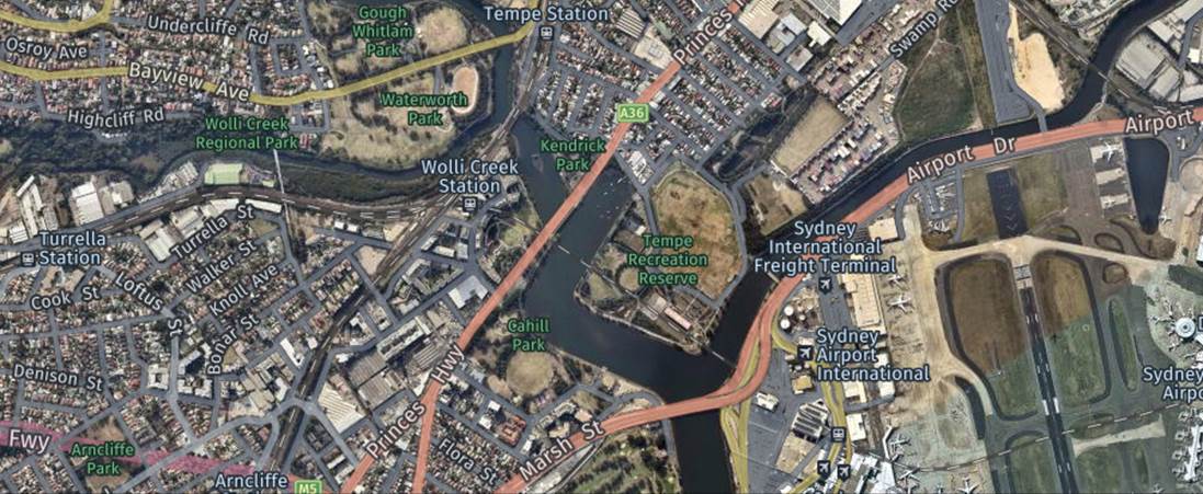
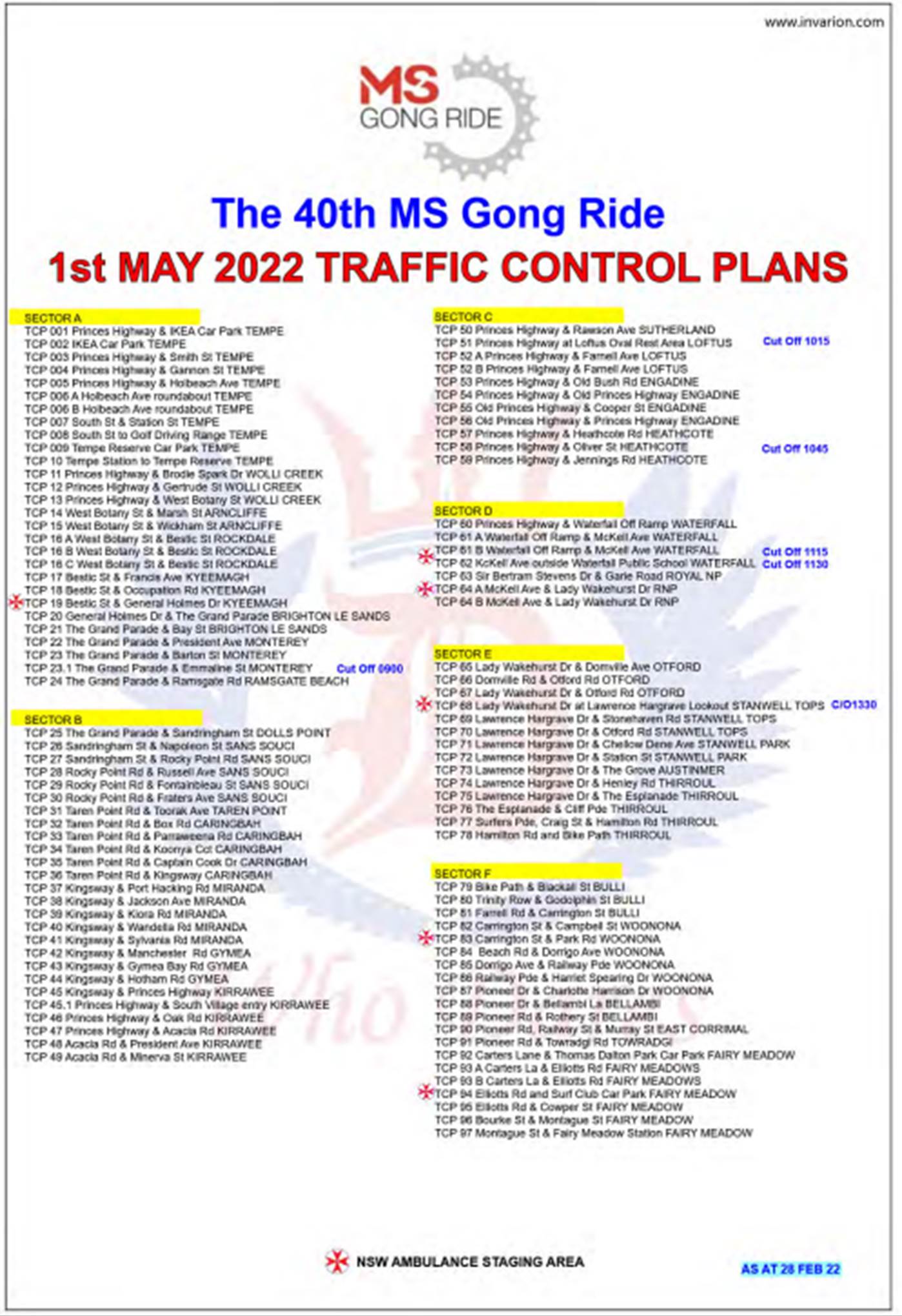

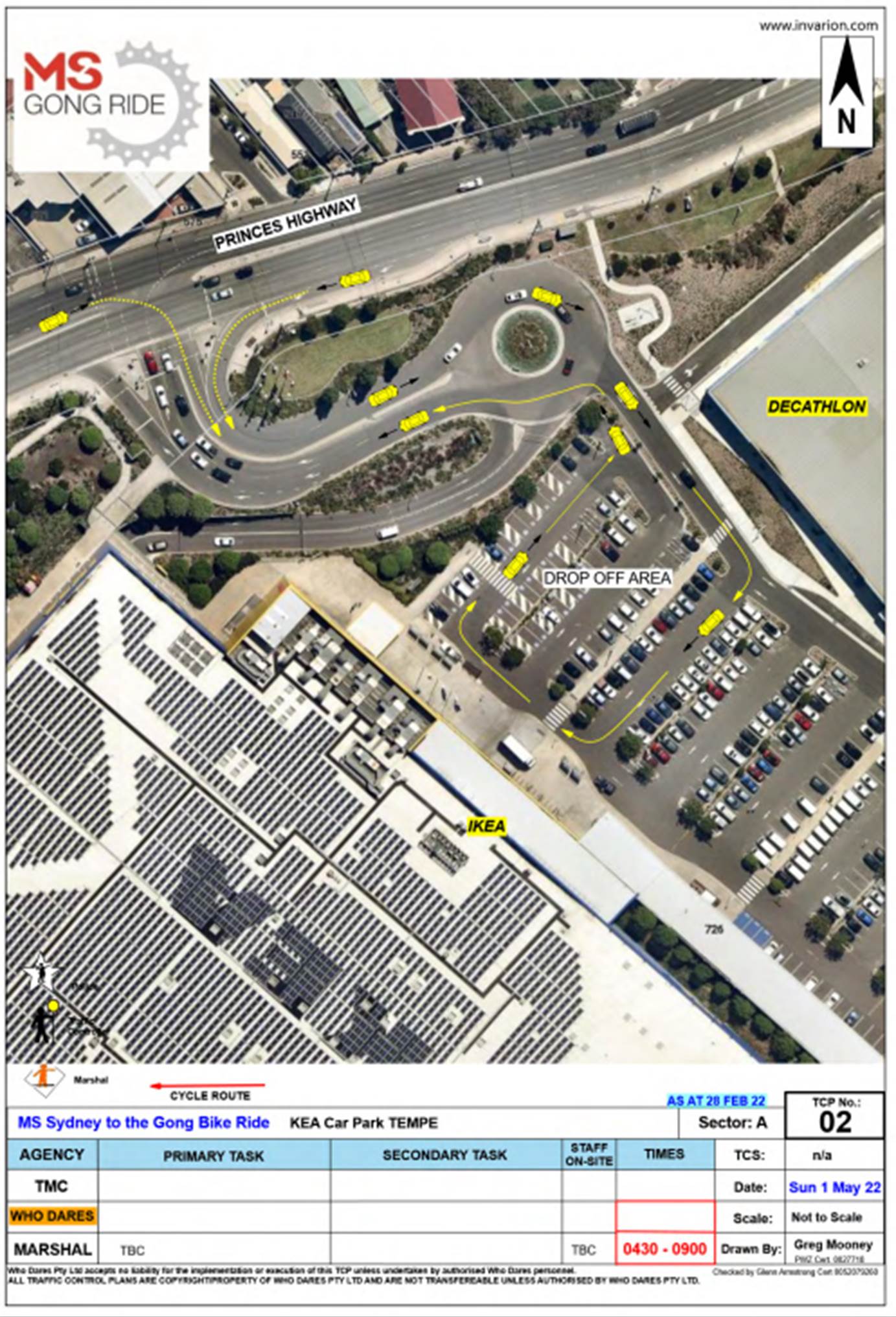
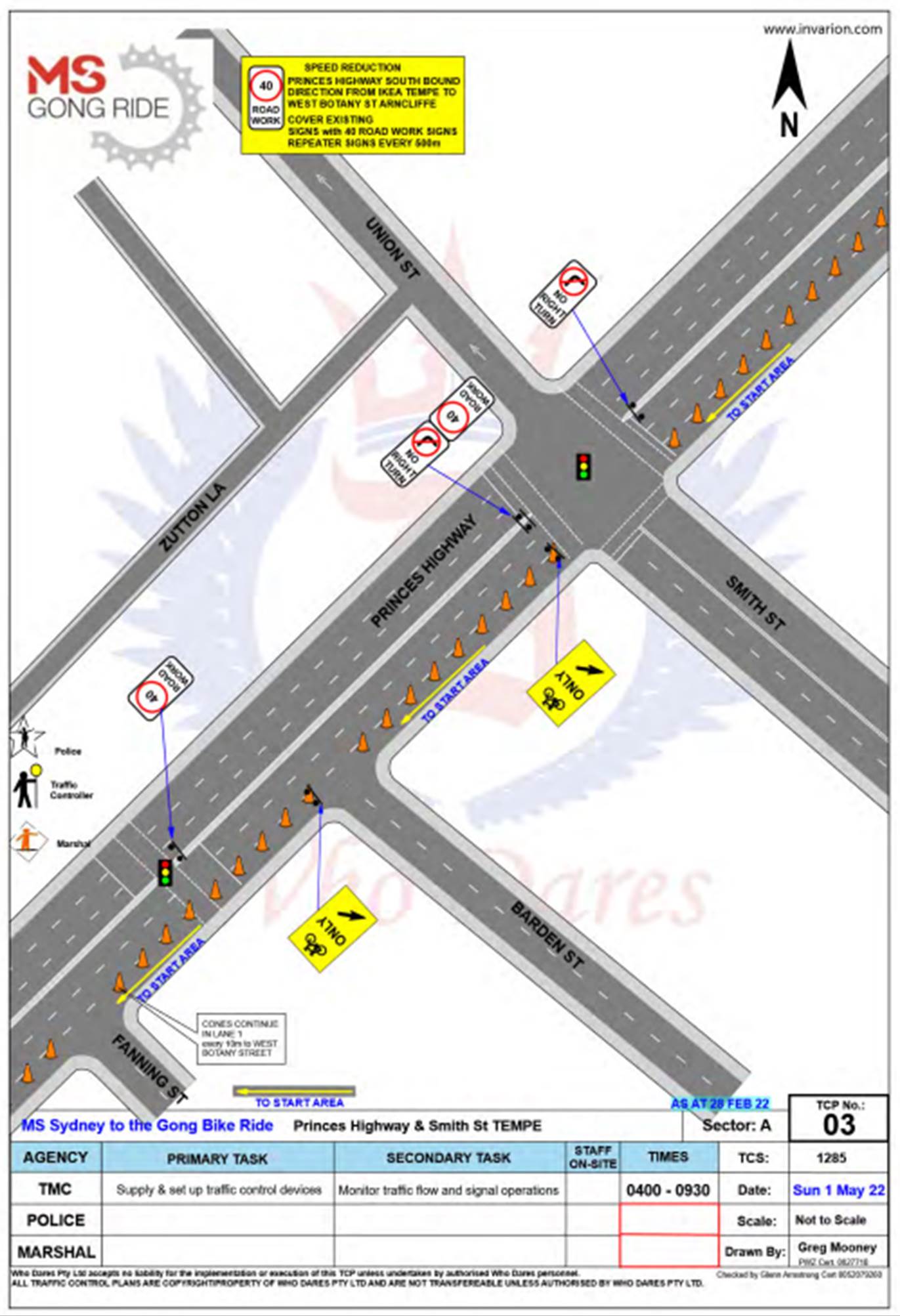
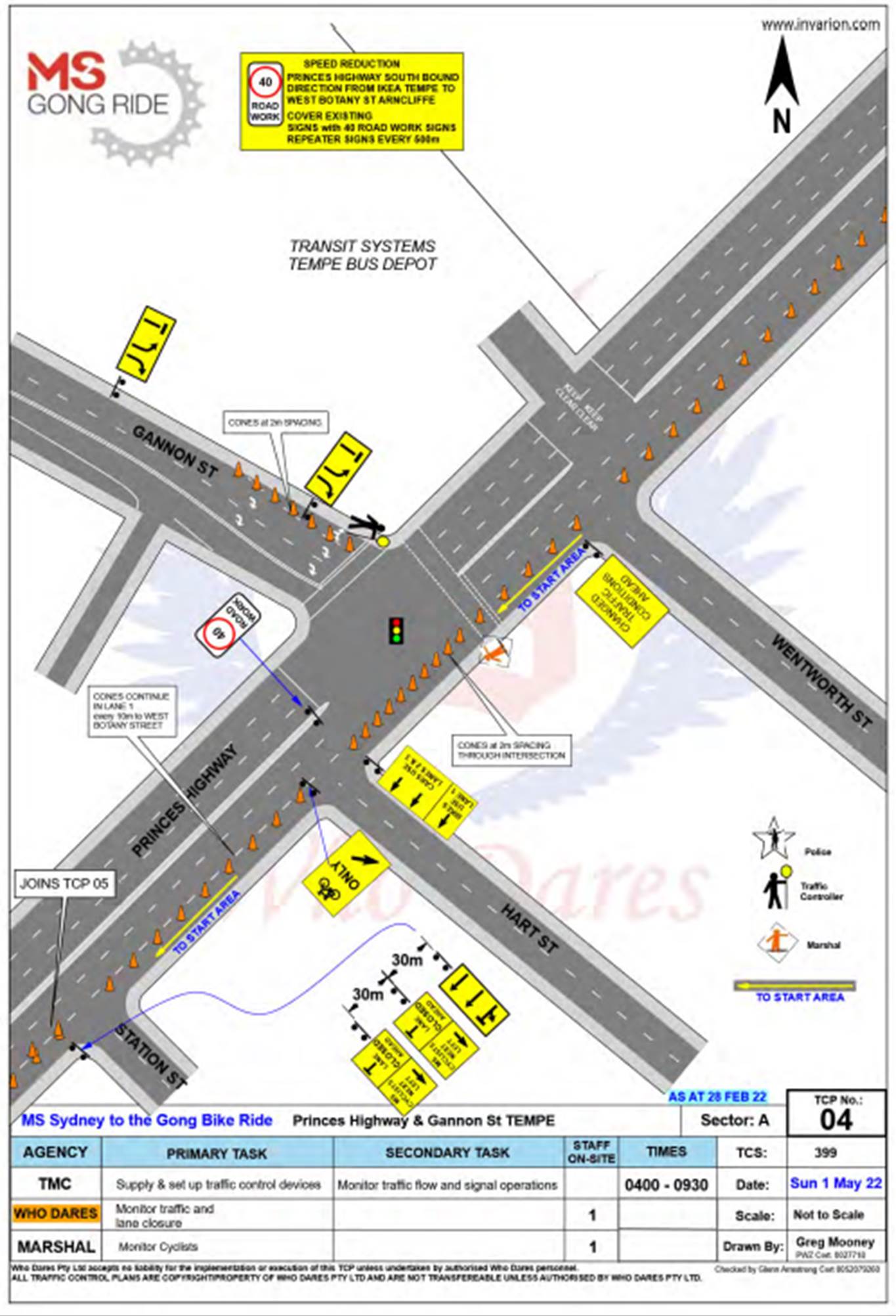
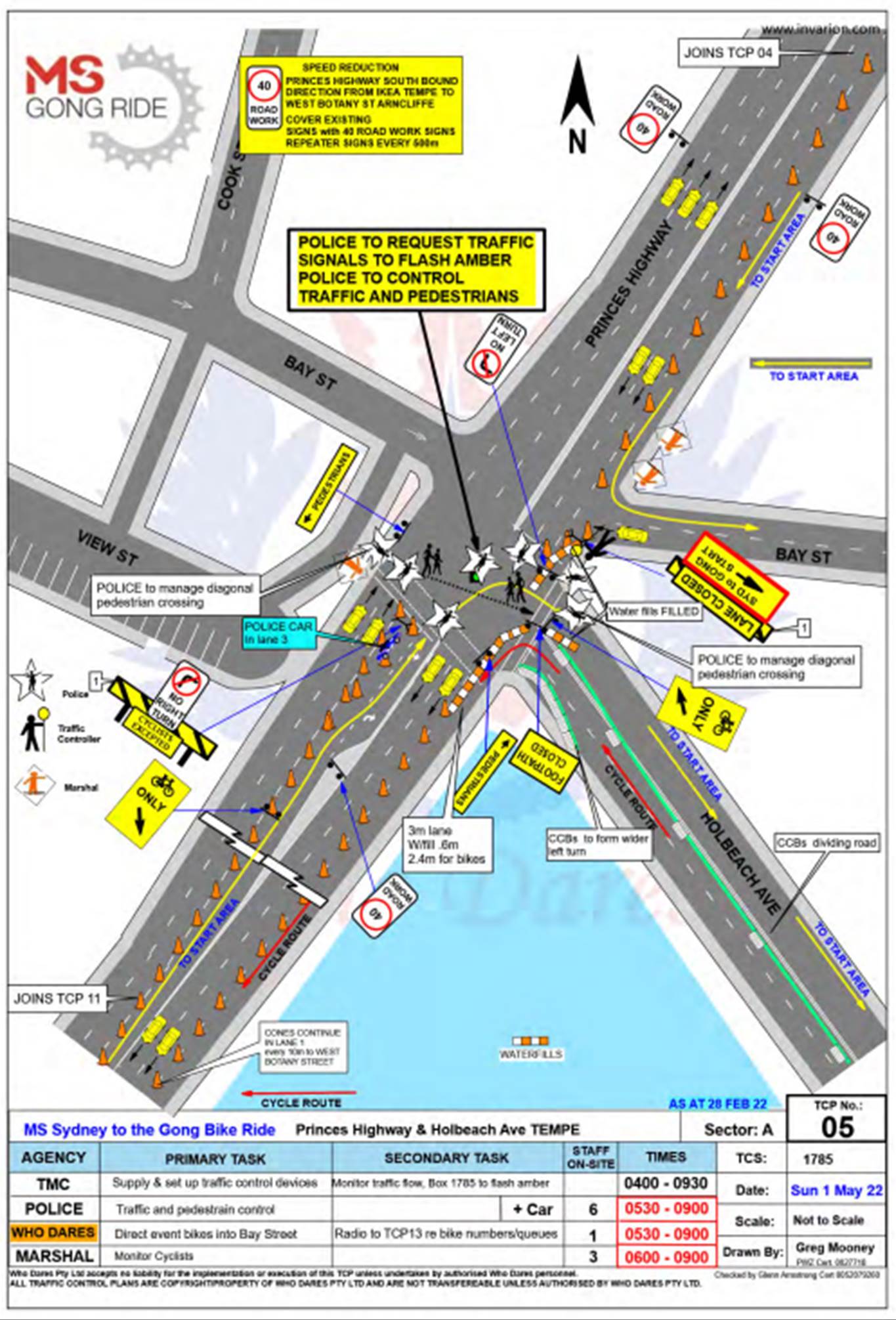
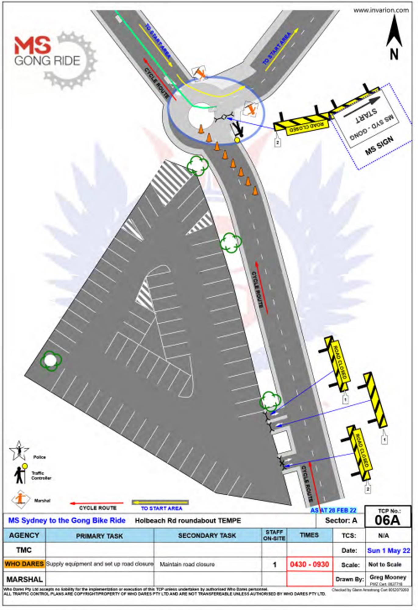
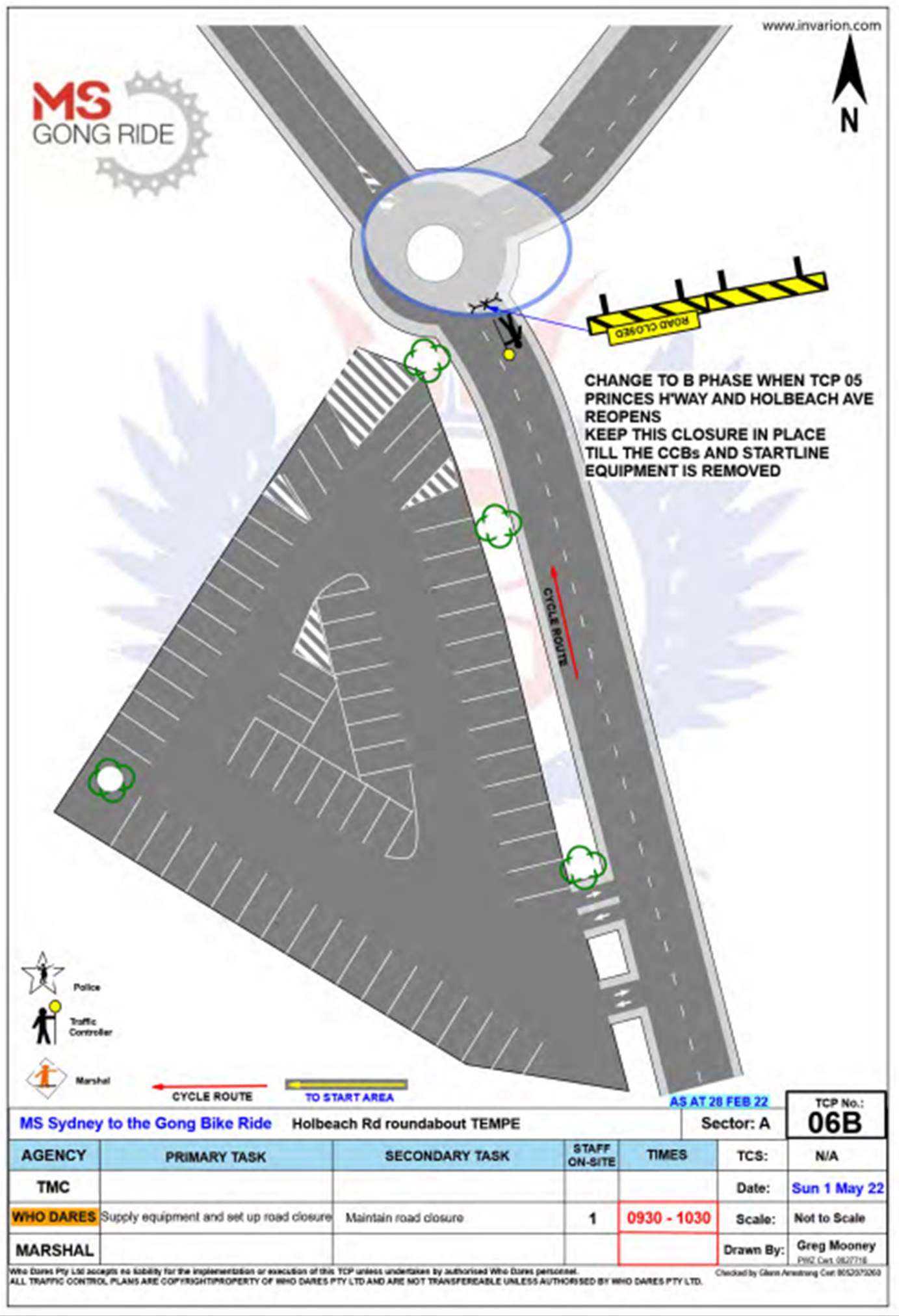
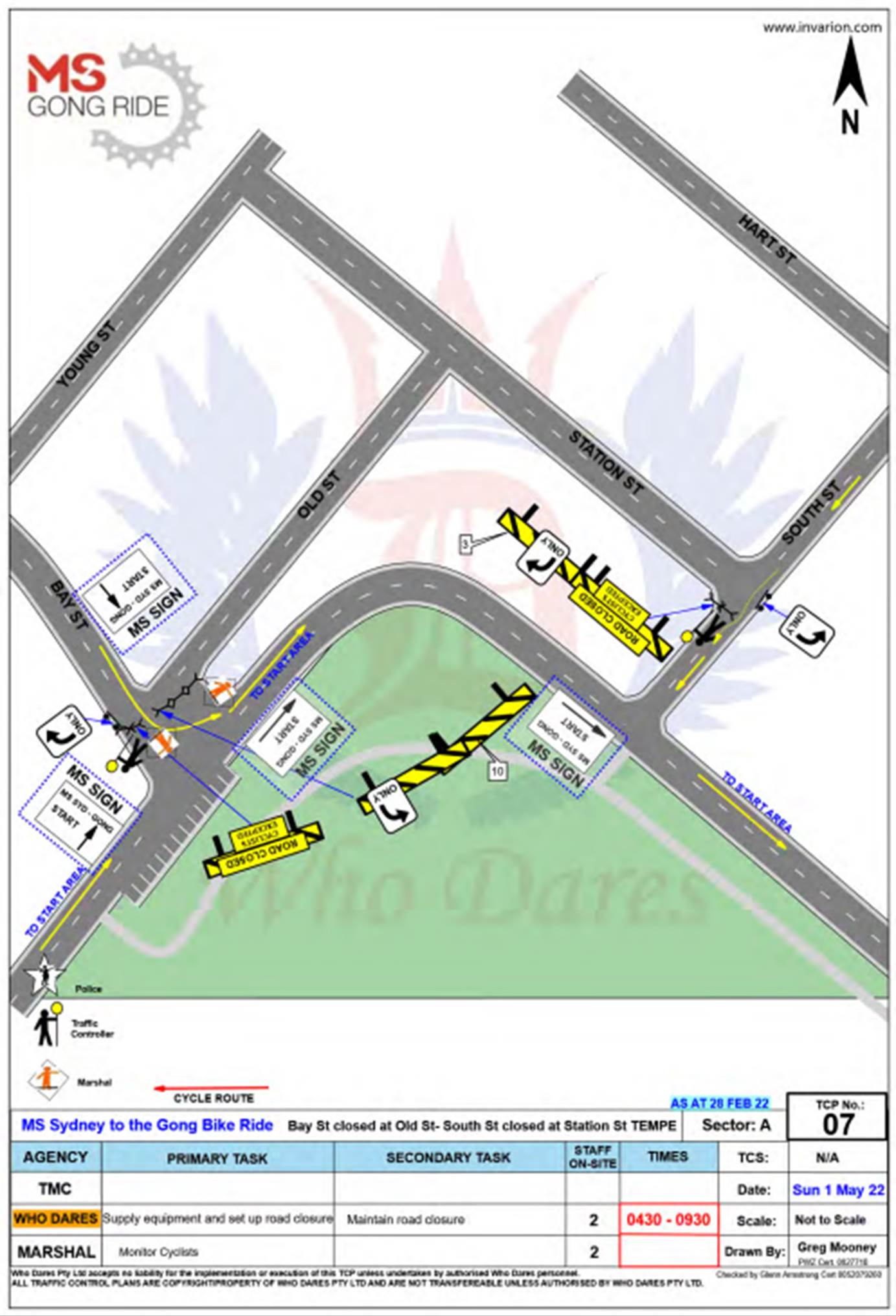
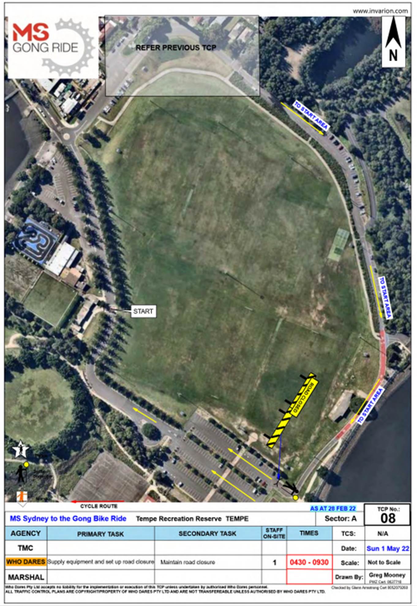
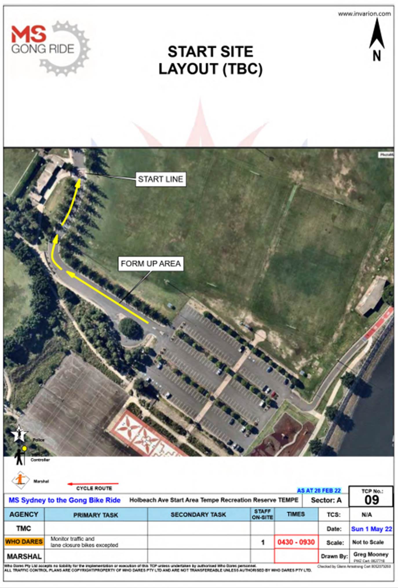
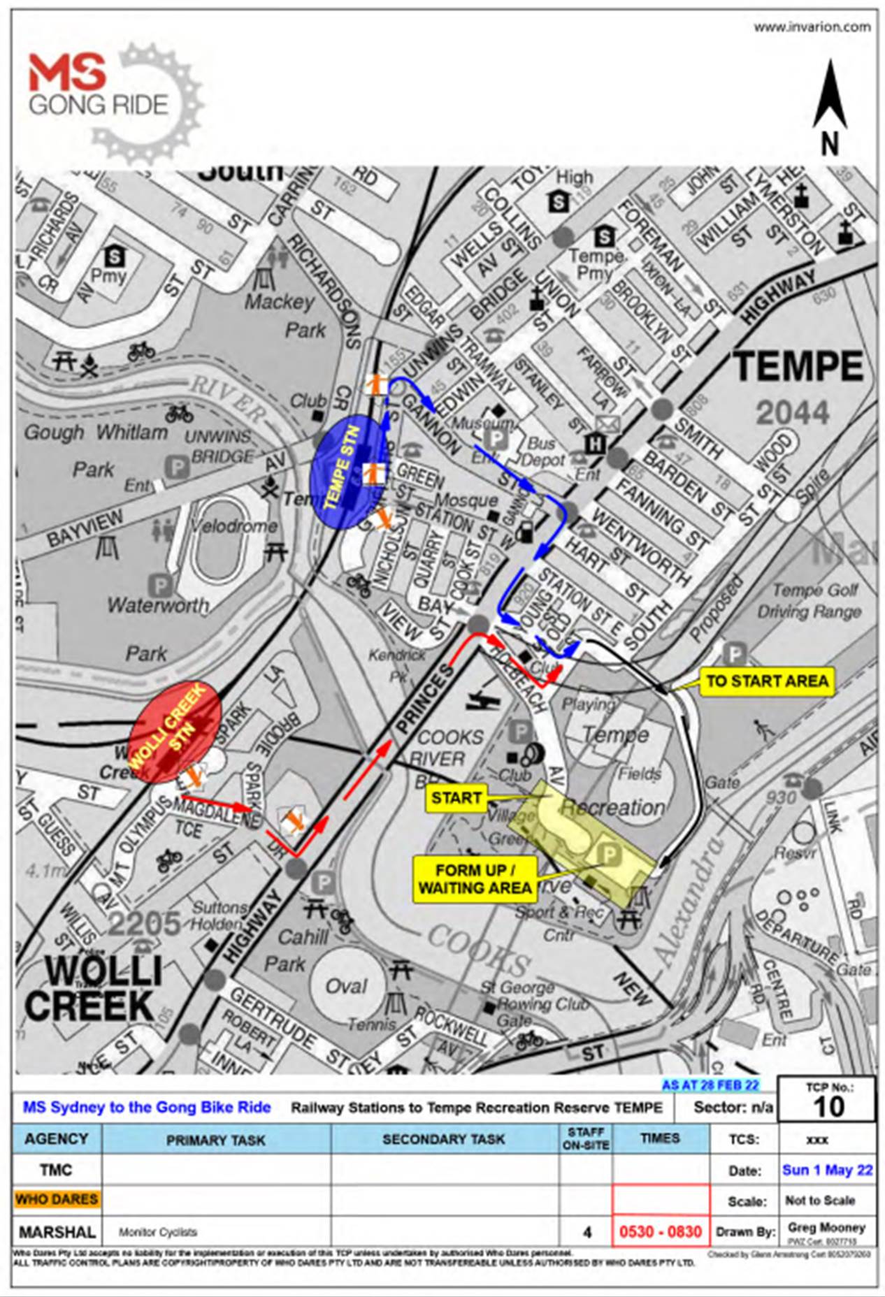
|
|
Local Traffic Committee Meeting 21 March 2022 |
Subject: Johnston Street, Annandale - Proposed Kerb Blisters (Gulgadya-Leichhardt Ward/Balmain Electorate/Leichhardt PAC)
Prepared By: David Yu - Engineer - Traffic and Parking Services
Authorised By: Manod Wickramasinghe - Traffic and Transport Planning Manager
SUMMARY
Council has received concerns from the Annandale North Public School P&C regarding the safety of school children and parents at the signalised pedestrian crossing located on Johnston Street, north of Piper Street, Annandale. Johnston Street is a state road under the jurisdiction of TfNSW and this report outlines a proposal for kerb extensions that will be submitted for TfNSW consideration.
|
RECOMMENDATION
That:
1. This report be received and noted and the proposed concept deign for two (2) kerb extensions at Johnston Street, Annandale (Option 1) be submitted for consideration by Transport for NSW; 2. Council continue advocating for pedestrian safety at this location with Transport for NSW, and request that they undertake further assessment, design and construction. |
BACKGROUND
Concerns have been raised regarding regarding the safety of school children crossing at the signalised pedestrian crossing located on Johnston Street, north of Piper Street, Annandale.
A site inspection was held between Council officers and representatives of the school P&C in December 2021 to review the operation of the existing signalised pedestrian crossing, the following concerns of the school community were noted:
· Speeding concerns on Johnston Street
· Car travelling through red lights at the signalised pedestrian crossing
· Illegal parking in the existing ‘No Stopping’ zone
· Long crossing distance for pedestrians across Johnston Street
· Pedestrians crossing on a diagonal rather than in the marked pedestrian crossing area
· Trees obstructing sight-distance to pedestrians and traffic lights
· Insufficient area for storage in the existing concrete median island located at the signalised pedestrian crossing
This matter was also considered by Council at its meeting held on 28 September 2021 were it was resolved that Council:
1. Writes to the Transport Minister requesting that Transport for NSW install risk mitigation measures to reduce the danger to children crossing Johnston Street, Annandale, in front of Annandale North Public School. This will also include a request for Transport for NSW to employ a Crossing Supervisor at the site to increase visibility and correct crossing behavior;
2. Investigates what road calming measures Council can install near the crossing to increase the safety for people crossing Johnston Street in front of Annandale North Public School with the results of the investigation to be reported to an ordinary Council meeting; and
3. Refer this item to the next Local Traffic Committee and the committee commence immediate assessment and investigation.
OTHER STAFF COMMENTS
In 2017, Council prepared the Annandale North Neighbourhood Movement Plan and one of its recommendations included a pedestrian crossing facility across Johnston Street at Piper Street. The concept included a contrasting road pavement, a relocation of the existing signalised pedestrian crossing outside of Annandale North Public School, and full road closure at Piper Street, including additional changes to cycle path and footpaths. It is understood that upon review, TfNSW was not supportive of the proposed pedestrian crossing facility at Piper Street as outlined in the Annandale North Neighbourhood Movement Plan.
It has been identified that improvements at the existing signalised pedestrian crossing north of Piper Street and outside of Annandale North Public School is a suitable alternative.
There are two (2) potential options:
Option 1: Kerb extensions on both sides of the crossing on Johnston Street while maintaining the existing two travel lanes in each direction.
Option 2: Kerb extensions on both sides of the crossing with cycle ways on both sides of Johnston Street with one travel lane in each direction.
There will be no loss of on-street parking with the proposals.
These proposals would improve pedestrian and motorists’ safety on Johnston Street by:
· Reducing the crossing distance for pedestrian movements (this would also reduce the time needed for the pedestrian crossing phase)
· Reducing speeds by narrowing the carriageway
· Preventing illegal parking in the ‘No Stopping’ zones
· Allowing for low planting in kerb extensions to prevent diagonal pedestrian crossing movements
· Making pedestrians more prominent by bringing them forward beyond the mature street trees and angle parking on Johnston Street
· Allowing for a pedestrian gutter bridge to be constructed to prevent pedestrians traversing through stormwater moving along the kerb and gutter (subject to design)
· Incorporating a potential future cycleway on Johnston Street, Annandale (option 2)
ANALYSIS
In order to consider the impact of these options, Johnston Street was modelled using SIDRA Intersection to assess delays and level of service for Johnston Street at the existing signalised pedestrian crossing north of Piper Street.
Noting that traffic volumes Johnston Street will change when WestConnex is completed, the future traffic volumes for Johnston Street was considered using the WestConnex Stage 3 current and future traffic volumes from the WestConnex Environmental Impact Statement (EIS).
This data was also compared with the transport modelling from Council’s Local Area Traffic Improvement Strategy (LAIS) which examined traffic flow in Johnston Street during different stages of the WestConnex project.
Data collection for existing pedestrian and motorist volumes was also undertaken in February 2022.
The existing traffic and pedestrian volumes for Johnston Street are shown in the tables below:
Traffic Volumes
|
|
Traffic Volumes (peak Hour) |
|
AM |
|
|
Northbound |
609 |
|
Southbound |
393 |
|
PM |
|
|
Northbound |
595 |
|
Southbound |
496 |
Pedestrian Volumes
|
|
Pedestrian Volumes (peak Hour) |
|
AM |
280 |
|
PM |
228 |
The SIDRA Intersection Modelling results show that the pedestrian signalised crossing at Johnston Street, Annandale will operate at a satisfactory with a Level of Service (LoS) of A during the AM and PM peak periods for Option 1 and 2.
The pedestrian signalised crossing was also modelled in the future 2033 scenario with the proposed Sydney Metro forecasted traffic in Johnstone Street. The results showed that this intersection will operate at a satisfactory level of service A in the AM and PM peak periods for both Option 1 and 2.
SIDRA Intersection Modelling Results
|
|
Option 1: Two travel lanes each direction |
Option 2: One travel lane each direction & cycle lanes |
||||
|
|
Deg sat (v/c) |
Delay (s) |
LoS |
Deg sat (v/c) |
Delay (s) |
LoS |
|
2021 |
||||||
|
AM Peak |
0.516 |
12.0 |
A |
0.789 |
12.5 |
A |
|
PM Peak |
0.380 |
10.9 |
A |
0.797 |
13.2 |
A |
|
2033 |
||||||
|
AM Peak |
0.516 |
12.0 |
A |
0.789 |
12.5 |
A |
|
PM Peak |
0.380 |
10.9 |
A |
0.797 |
13.2 |
A |
CONCLUSION
Based on the initial analysis undertaken by Council, it is considered that both options are feasible. Therefore it is recommended that the concept deigns for two (2) kerb extensions at Johnston Street, Annandale (north of Piper Street) be submitted for consideration by Transport for NSW.