|
AGENDA R |

Local Traffic Committee Meeting
MONDAY 16 MAY 2022
11.00AM
|
|
Local Traffic Committee Meeting 16 May 2022 |
Function of the Local Traffic Committee
Background
Roads and Maritime Services (RMS) is legislated as the Authority responsible for the control of traffic on all NSW Roads. The RMS has delegated certain aspects of the control of traffic on local roads to councils. To exercise this delegation, councils must establish a local traffic committee and obtain the advice of the RMS and Police. The Inner West Council Local Traffic Committee has been constituted by Council as a result of the delegation granted by the RMS pursuant to Section 50 of the Transport Administration Act 1988.
Role of the Committee
The Local Traffic Committee is primarily a technical review and advisory committee which considers the technical merits of proposals and ensures that current technical guidelines are considered. It provides recommendations to Council on traffic and parking control matters and on the provision of traffic control facilities and prescribed traffic control devices for which Council has delegated authority. These matters are dealt with under Part A of the agenda and require Council to consider exercising its delegation.
In addition to its formal role as the Local Traffic Committee, the Committee may also be requested to provide informal traffic engineering advice on traffic matters not requiring Council to exercise its delegated function at that point in time, for example, advice to Council’s Development Assessment Section on traffic generating developments. These matters are dealt with under Part C of the agenda and are for information or advice only and do not require Council to exercise its delegation.
Committee Delegations
The Local Traffic Committee has no decision-making powers. The Council must refer all traffic related matters to the Local Traffic Committee prior to exercising its delegated functions. Matters related to State Roads or functions that have not been delegated to Council must be referred directly to the RMS or relevant organisation.
The Committee provides recommendations to Council. Should Council wish to act contrary to the advice of the Committee or if that advice is not supported unanimously by the Committee members, then the Police or RMS have an opportunity to appeal to the Regional Traffic Committee.
Committee Membership & Voting
Formal voting membership comprises the following:
· one representative of Council as nominated by Council;
· one representative of the NSW Police from each Local Area Command (LAC) within the LGA, being Newtown, Marrickville, Leichhardt and Ashfield LAC’s.
· one representative from the RMS; and
· State Members of Parliament (MP) for the electorates of Summer Hill, Newtown, Heffron, Canterbury, Strathfield and Balmain or their nominees.
Where the Council area is represented by more than one MP or covered by more than one Police LAC, representatives are only permitted to vote on matters which effect their electorate or LAC.
Informal (non-voting) advisors from within Council or external authorities may also attend Committee meetings to provide expert advice.
Committee Chair
Council’s representative will chair the meetings.
Public Participation
Members of the public or other stakeholders may address the Committee on agenda items to be considered by the Committee. The format and number of presentations is at the discretion of the Chairperson and is generally limited to 3 minutes per speaker. Committee debate on agenda items is not open to the public.
|
|
Local Traffic Committee Meeting 16 May 2022 |
|
AGENDA |
1 Apologies
2 Disclosures of Interest
3 Confirmation of Minutes
Minutes of 19 April 2022 Local Traffic Committee Meeting 5
4 Matters Arising from Council’s Resolution of Minutes
5 Part A – Items Where Council May Exercise Its Delegated Functions
Traffic Matters
ITEM Page
LTC0522(1) Item 1 Dudley Street, Dulwich Hill; Illawarra Road, Marrickville; Burrows Avenue, Railway Road, Gleeson Avenue And (Lower) Railway Parade, Sydenham - Temporary Parking Changes During Major Rail Shutdown of T3 Line for Sydney Metro Upgrade Works - Bus Replacements 2 Week Period 2 – 15 July 2022 (Midjuburi -Marrickville Ward / Summer Hill Electorate / Inner West PAC) 14
LTC0522(1) Item 2 Victoria Road, Marrickville at the Rail overbridge between Charlotte Avenue and Meeks Street – temporary full road closure ENRC/2022/0014 - 8 day period from 2 July to 10 July 2022 - Southwest Metro Upgrade Project - Sydney Metro City & Southwest (MIDJUBURI-MARRICKVILLE WARD / SUMMER HILL ELECTORATE / INNER WEST PAC) 27
LTC0522(1) Item 3 Albion Lane, St Peters – Proposed One-Way northbound restriction in Albion Lane, St Peters (between Grove Street and Mary Street) and reversal of the current northbound one-way in Rolf Lane, St Peters to southbound (between Mary Street and Grove Street) (Midjuburi-Marrickville Ward / Summer Hill Electorate / Inner West PAC) 32
LTC0522(1) Item 4 Trafalgar Street and Collins Street, Annandale - Proposed Raised Pedestrian Crossings (Gulgadya - Leichhardt Ward/ Balmain Electorate/ Leichhardt PAC) 36
Parking Matters
Nil at the time of printing.
Late Items
Nil at time of printing.
6 Part B - Items for Information Only
Nil at the time of printing.
7 Part C - Items for General Advice
Nil at the time of printing.
8 General Business
9 Close of Meeting
|
|
Local Traffic Committee Meeting 16 May 2022 |
Minutes of Local Traffic Committee Meeting
Held on 19 April 2022 at Ashfield Service Centre
Meeting commenced at 11.05AM
ACKNOWLEDGEMENT OF COUNTRY BY CHAIRPERSON
I acknowledge the Gadigal and Wangal people of the Eora nation on whose country we are meeting today, and their elders past and present.
COMMITTEE REPRESENTATIVES PRESENT
|
Manod Wickramasinghe |
IWC’s Traffic and Transport Planning Manager (Chair) |
|
Bill Holliday |
Representative for Jamie Parker MP, Member for Balmain |
|
Graeme McKay |
Representative for Jo Haylen MP, Member for Summer Hill |
|
Solon Ghosh |
Transport for NSW (TfNSW) |
|
Sgt Charles Buttrose |
NSW Police – Leichhardt Police Area Command |
|
SC Germaine Grant |
NSW Police – Burwood Police Area Command |
|
SC Sam Tohme |
NSW Police – Burwood Police Area Command |
|
|
|
|
NON VOTING MEMBERS IN ATTENDANCE |
|
|
|
|
|
Colin Jones |
Inner West Bicycle Coalition (IWBC) |
|
Boris Muha |
IWC’s Engineer – Traffic and Parking Services |
|
Christina Ip |
IWC’s Business Administration Officer |
|
|
|
|
VISITORS |
|
|
|
|
|
Nil. |
|
|
|
|
|
APOLOGIES: |
|
|
|
|
|
Mayor Darcy Byrne |
Councillor – Baludarri-Balmain Ward |
|
Cr Justine Langford |
Councillor – Midjuburi-Marrickville Ward |
|
Colin Hesse |
Representative for Jenny Leong MP, Member for Newtown |
|
Cathy Peters |
Representative for Jenny Leong MP, Member for Newtown |
|
Sgt Anthony Kenny |
NSW Police – Inner West Police Area Command |
DISCLOSURES OF INTERESTS:
Mr McKay declared a significant, non-pecuniary interest in Item 4 - Bland Street, Haberfield - Proposed Raised Pedestrian Crossing, as he lives in the consultation area and made a submission. Mr McKay will abstain from voting on behalf of the Member for Summer Hill.
CONFIRMATION OF MINUTES
|
The minutes of the Local Traffic Committee meeting held on 21 March 2022 were confirmed. |
MATTERS ARISING FROM COUNCIL’S RESOLUTION OF MINUTES
The Local Traffic Committee recommendations of its meeting on 21 March 2022 were adopted at Council’s meeting on 12 April and moved additionally that Council conduct further investigation of the expansion of the RPS in the Taverners Hill Precinct bounded by Hawthorne Canal, Parramatta Road, Elswick Street, Myrtle Street, Lords Road and Lambert Park and Leichhardt Marketplace Precinct bounded by Foster Street, Lords Road, Elswick Street and Regent Street.
General Business
Meeting closed at 12.04pm.
|
|
Local Traffic Committee Meeting 16 May 2022 |
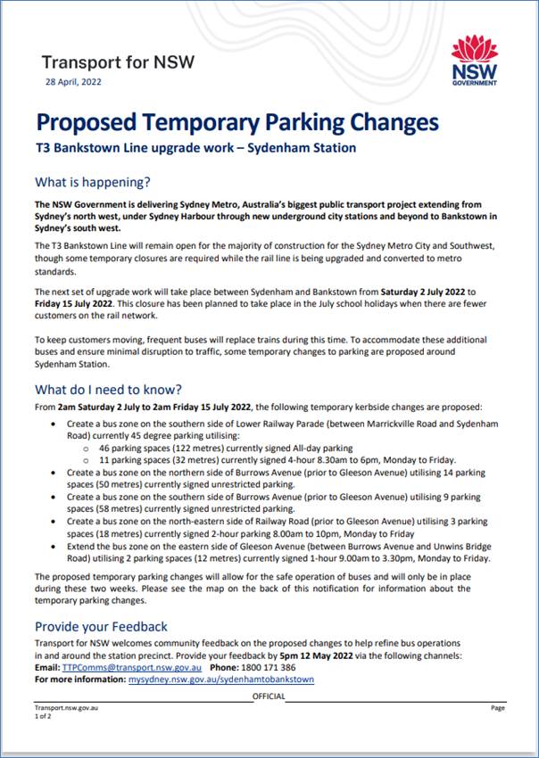
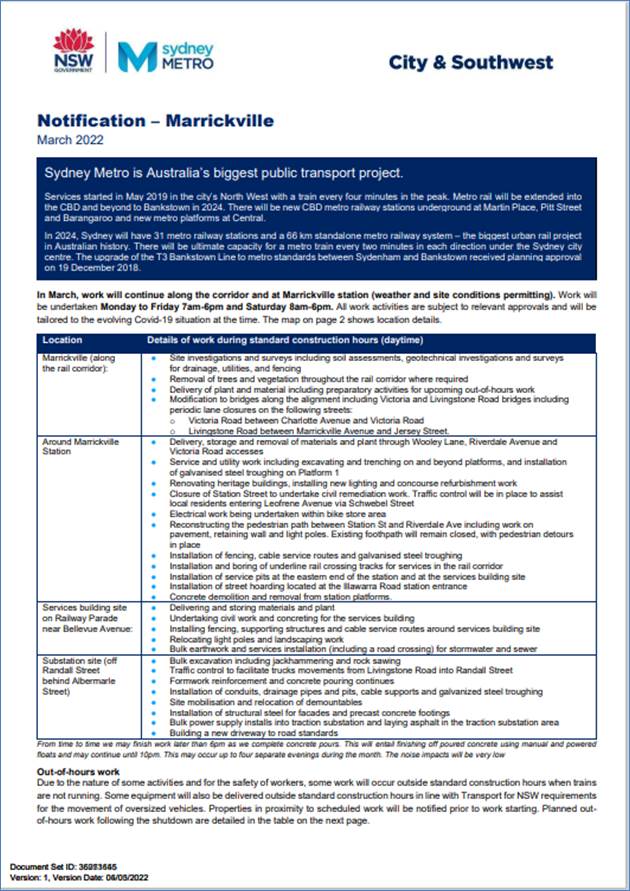
Subject: Dudley Street, Dulwich Hill; Illawarra Road, Marrickville; Burrows Avenue, Railway Road, Gleeson Avenue And (Lower) Railway Parade, Sydenham - Temporary Parking Changes During Major Rail Shutdown of T3 Line for Sydney Metro Upgrade Works - Bus Replacements 2 Week Period 2 – 15 July 2022 (Midjuburi -Marrickville Ward / Summer Hill Electorate / Inner West PAC)
Prepared By: Jennifer Adams - Engineer – Traffic and Parking Services
Authorised By: Manod Wickramasinghe - Traffic and Transport Planning Manager
SUMMARY
Council has been notified by Transport for NSW (TfNSW) that Sydney Metro works will involve a major rail shutdown of the Sydenham to Bankstown rail line (T3) for a 2 week period between Saturday 2 July and Friday 15 July 2022. During the shutdown buses will replace train services along the T3 line and to accommodate the increased bus movements and necessary holding areas some short-term parking changes are required at a number of locations.
Specifically, TfNSW is requesting approval for the temporary conversion of multiple parking spaces at the following locations: Dudley Street, Dulwich Hill; Illawarra Road, Marrickville; Burrows Avenue, Railway Road, Gleeson Avenue and (Lower) Railway Parade, Sydenham. It is recommended that no objections be raised, and Council approves the temporary short-term parking changes at the identified locations during the rail shutdowns.
|
RECOMMENDATION
THAT this report be received and noted and the following temporary short-term parking changes from Saturday 2 July to Friday 15 July 2022 (inclusive) be approved and implemented by TfNSW:
Dulwich Hill Station Precinct - Dudley Street (5 parking spaces) 1. The short-term conversion of 7m (1 parking space) ‘Loading Zone 8:30 am – 6 pm Mon – Fri & 8:30 am – 12:30 pm Sat’ on the northern side of Dudley Street (between Wardell Road and School Parade) to a ‘Bus Zone’ be APPROVED in order to provide an additional bus bay with adequate draw-in length; 2. The short-term conversion of 18m (3 parking spaces) ‘P30 min 8:30 am – 6 pm Mon – Fri & 8:30 am – 12:30 pm Sat’ on the northern side of Dudley Street (between Wardell Road and School Parade) to a ‘Bus Zone’ be APPROVED in order to provide an additional bus bay with adequate draw-in length; 3. The short-term conversion of 7m (1 parking space) ‘Unrestricted Parking’ on the southern side of Dudley Street (between School Parade and Wardell Road) to a ‘Bus Zone’ be APPROVED in order to provide an additional bus bay with adequate draw-in length;
Marrickville Station Precinct - Illawarra Road (1 parking space) 4. The short-term conversion of 7m (1 parking space) ‘1P 8:30 am – 6 pm’ on the western side of Illawarra Road (between Warburton Street and Greenbank Street) to a ‘Bus Zone’ be APPROVED in order to provide additional space for adequate bus draw-in/draw-out length;
Sydenham Station Precinct - Burrows Avenue (23 parking spaces)
5. The short-term conversion of 50m (14 parking spaces) rear to kerb ‘unrestricted parking’ on the northern kerb of Burrows Avenue (west of Gleeson Avenue) to a ‘Bus Zone’ be APPROVED in order to provide additional bus bays for adequate bus draw-in/draw-out length;
6. The short-term conversion of 58m (9 parking spaces) ‘unrestricted parking’ on the southern kerb of Burrows Avenue (west of Gleeson Avenue) to a ‘Bus Zone’ be APPROVED in order to provide additional bus bays for bus layover purposes;
Sydenham Station Precinct – Railway Road (3 parking spaces) 7. The short-term conversion of 18m (3 parking spaces) ‘2P 8:30 am – 10 pm Mon - Fri’ on the eastern side kerb of Railway Road (between Burrows Avenue and Gleeson Avenue) to a ‘Bus Zone’ be APPROVED in order to provide additional bus bays for bus layover purposes; Sydenham Station Precinct - Gleeson Avenue (2 parking spaces)
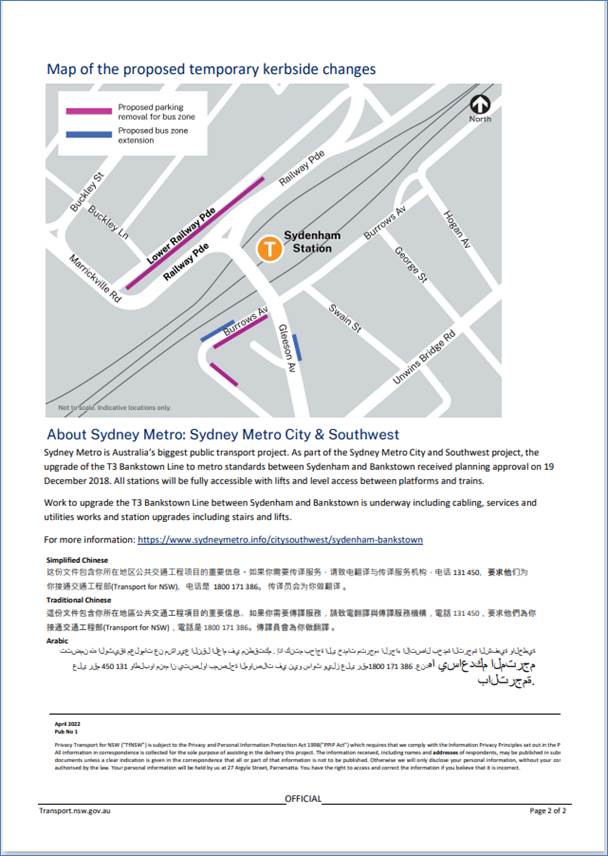
8. The short-term conversion of 12m (2 parking spaces) ‘1P 9:00 am – 3:30 pm Mon - Fri and No Parking 6 am-9 am & 3:30 pm – 6:30 pm’ on the eastern kerb of Gleeson Avenue (between Burrows Avenue and Unwins Bridge Road) to a ‘Bus Zone’ be APPROVED in order to provide a bus stop extension with adequate draw-in/draw-out length; Sydenham Station Precinct - 9. The short-term conversion of 122m (46 parking spaces) 45 degree angled ‘unrestricted parking’ on the southern side kerb of Lower Railway Parade (between Sydenham Road and Marrickville Road) to a ‘Bus Zone’ be APPROVED in order to provide additional layover and standby bus bays;
10. The short-term conversion of 32m (11 parking spaces) 45 degree angled parking ‘4P 8:30 am – 6 pm Mon - Fri’ on the southwest kerb of Lower Railway Parade (between Gleeson Avenue and Marrickville Road) to a ‘Bus Zone’ be APPROVED in order to provide additional layover bus bays with adequate draw-in length; and
11. The applicant and Council Rangers be advised in terms of this report.
|
BACKGROUND
Sydney Metro City & Southwest - Sydenham to Bankstown project will upgrade all 10 stations between Marrickville and Bankstown to meet metro standards before converting the T3 Bankstown Line to Metro operations.
During this possession, rail services on the T3 Bankstown Line will not operate and Temporary Transport Plan (TTP) buses will operate instead necessitating some short-term changes in parking at a number of locations. To support this winter closure (during school holidays), TTP buses and additional T8 Airport & South Line trains will operate from Saturday 2 July 2022 to Friday 15 July 2022 (inclusive).
All changes to street signage will be made by TfNSW contractor(s) from 10pm the night before the closures and will be reinstated at the completion of the planned shutdowns.
FINANCIAL IMPLICATIONS
There are no financial implications for Council associated with this matter. The cost of the work will be borne by Transport for NSW.
OFFICER COMMENTS
Each of the locations will be detailed separately.
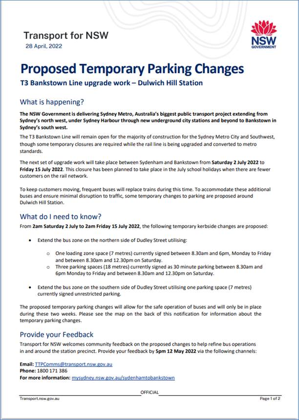
Dulwich Hill Station Precinct (5 parking spaces)
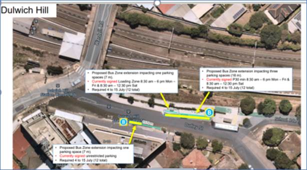
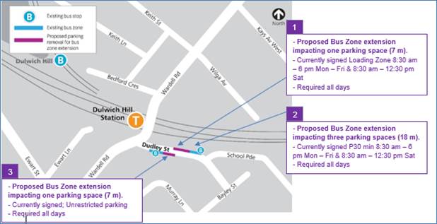
1. Section A of Dulwich Hill Station, Dudley Street, northern side (Stop ID: 20433) - Bus stop extension (1 parking space)
· Dudley Street (northern kerb between Wardell Road and School Parade)
· Currently signed ‘Loading Zone 8:30am – 6pm Mon – Fri & 8:30am – 12:30pm Sat
· Proposed Bus Zone extension is required for all days of the TTP bus operation
· Proposed temporary change will impact approximately one parking space (7m)
· This change is proposed to create the extra space required for the additional TTP buses using the stop.
2. Section B of Dulwich Hill Station, Dudley Street, northern side (Stop ID: 220433) - Bus stop extension (3 parking spaces)
· Dudley Street (northern kerb between Wardell Road and School Parade)
· Currently signed ‘P30 min 8:30am – 6pm Mon – Fri & 8:30am – 12:30pm Sat’
· Proposed Bus Zone extension is required for all days of the TTP bus operation
· Proposed temporary change will impact approximately 3 parking spaces (18m)
· This change is proposed to create the extra space required for the additional TTP buses using the stop.
3. Dudley Street opposite Dulwich Hill Station, southern side (Stop ID: 220432) - Bus stop extension (1 parking space)
· Dudley Street (southern kerb between School Parade and Wardell Road)
· Currently signed ‘Unrestricted Parking’
· Proposed Bus Zone extension is required for all days of the TTP bus operation
· This proposed change is to create the extra space required for the additional TTP buses using the stop
· Proposed temporary change will impact approximately one parking space (7m).
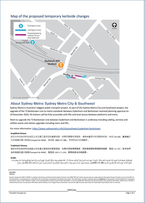
Marrickville Station Precinct (1 parking space)
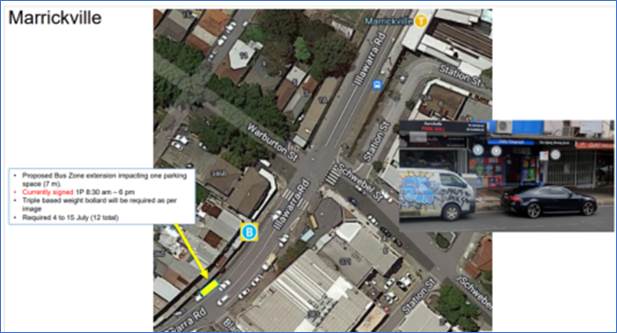
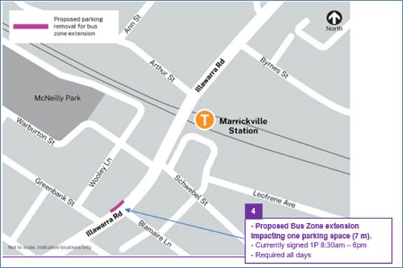
4. Illawarra Road opposite Marrickville Station (Stop ID: 2204102) - Bus stop extension (1 parking space)
· Illawarra Road (northwest kerb between Warburton Street and Greenbank Street)
· Currently signed ‘1P 8:30 am – 6 pm’
· Proposed Bus Zone extension is required for the duration of the TTP bus operation
· Proposed temporary change will impact approximately one parking space (7 m).
· This change is proposed to create the extra space required for the additional TTP buses using the stop.
Sydenham Station Precinct (85 parking spaces)
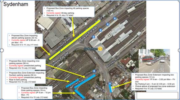
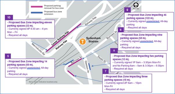
5. Burrows Avenue, Sydenham (Stop ID: 204421) Rear to kerb parking – Bus Zone Extension (14 parking spaces)
· Burrows Avenue (northern kerb west of Gleeson Avenue)
· Currently ‘Unrestricted parking’
· Proposed Bus Zone is required for all days of the TTP bus operation
· This proposed change is to create the space required for buses to layover and to provide adequate space for draw-in/draw-out purposes.
· Proposed temporary change will impact approximately 14 rear to kerb parking spaces (50 m).
6. Burrows Avenue, Sydenham – (Southern kerb) – Bus Zone (9 parking spaces)
· Burrows Avenue (southern kerb west of Gleeson Avenue)
· Currently ‘Unrestricted parking’
· Proposed Bus Zone is required for all days of the TTP bus operation
· This proposed change is to create the space required for buses to layover safely.
· Proposed temporary change will impact approximately 9 parking spaces (58 m).
7. Railway Road, Sydenham NSW 2204 – (Northeastern kerb) – Bus Zone (3 parking spaces)
· Railway Road (northeastern kerb between Gleeson Avenue and Burrows Avenue)
· Currently ‘2P 8am – 10pm Mon-Fri’
· Proposed Bus Zone is required for all days of the TTP bus operation
· This proposed change is to create the space required for buses to layover safely and to provide adequate turning circle space.
· Proposed temporary change will impact approximately 3 parking spaces (18 m).
8. Gleeson Avenue, Sydenham Bus Zone extension (2 parking spaces)
· Gleeson Avenue (eastern kerb between Burrows Avenue and Unwins Bridge Rd)
· Currently ‘1P 9:00 am – 3:30 pm Mon - Fri and No Parking 6 am-9 am & 3:30 pm – 6:30 pm’
· Proposed Bus Zone is required for all days of the TTP bus operation
· Proposed temporary change will impact approximately 2 parking spaces (12 m).
· This change is proposed to create the extra space required for the additional TTP buses using the stop.
9. Section A of Lower Railway Parade, Sydenham 90 degree angled parking – Layover Bus Zone and Standby area (46 parking spaces)
· Lower Railway Parade Parallel Parking (southern side between Sydenham Road and Marrickville Road)
· Currently’ Unrestricted parking’
· Proposed Bus Zone is required for all days of the TTP bus operation
· Proposed temporary change will impact approximately 46 angled parking spaces (122 m).
· This proposed change is to create the space required for buses to layover. This location is proposed as it is (i) reasonably close to the active bus stop; (ii) located along the route path used between the last and first stops; and (iii) as far as removed from residential dwellings.
10. Section B of Lower Railway Parade, Sydenham 90 degree angled parking - Layover Bus Zone (11 parking spaces)
· Lower Railway Parade Parallel Parking (southern side between Gleeson Avenue and Marrickville Road)
· Currently ‘4P 8:30 am – 6 pm Mon – Fri’
· Proposed Bus Zone is required for all days of the TTP bus operation
· Proposed temporary change will impact approximately eleven angled parking spaces (32 m).
· This proposed change is to create the space required for buses to layover. This location is proposed as it is (i) reasonably close to the active bus stop; and (ii) located along the route path used between the last and first stops.
PUBLIC CONSULTATION
Transport for NSW met with Council Officers in April 2022 to discuss the temporary parking changes and the consultation and approval process. Consultation with local businesses and residents will be carried out in May 2022.
The consultation program will consist of the following activities:
Two-week public consultation period to impacted areas with a printed community notification outlining the proposed kerbside changes. A copy of the community notifications will also be available on the ‘My Sydney’ website (and copies are attached at the end of this report) - https://www.mysydney.nsw.gov.au/SydenhamtoBankstown
A Consultation Outcomes Report will be prepared collating feedback and TfNSW’s comment on that feedback received as part of TfNSW consultation process. The report will be submitted to June 2022 Local Traffic Committee Meeting.
ATTACHMENTS
Nil.
|
|
Local Traffic Committee Meeting 16 May 2022 |
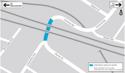
Subject: Victoria Road, Marrickville at the Rail overbridge between Charlotte Avenue and Meeks Street – temporary full road closure ENRC/2022/0014 - 8 day period from 2 July to 10 July 2022 - Southwest Metro Upgrade Project - Sydney Metro City & Southwest (MIDJUBURI-MARRICKVILLE WARD / SUMMER HILL ELECTORATE / INNER WEST PAC)
Prepared By: Jennifer Adams - Engineer – Traffic and Parking Services
Authorised By: Manod Wickramasinghe - Traffic and Transport Planning Manager
SUMMARY
An application (ENRC/2022/0014) has been received from Sydney Metro City & Southwest for the temporary full road closure of Victoria Road, Marrickville at the Rail overbridge between Charlotte Avenue and Meeks Street, for an 8 day period scheduled for Saturday 2 July to Sunday 10 July 2022 in order to facilitate the Shutdown Rail Possession activities at the Victoria Road Bridge location. The road will be temporarily closed to all vehicular traffic, including emergency vehicles. It is recommended that the proposed temporary full road closures be approved, subject to the conditions outlined in this report.
|
RECOMMENDATION
THAT the proposed temporary full road closure of Victoria Road, Marrickville at the Rail overbridge between Charlotte Avenue and Meeks Street, for an 8 day period scheduled for Saturday 2 July to Sunday 10 July 2022 be approved, in order to facilitate the Shutdown Rail Possession activities for Sydney Metro Upgrade works at the Victoria Road Bridge location subject to, but not limited to, the following conditions:
1. A Road Occupancy License be obtained by the applicant from the Transport Management Centre;
2. All affected residents and businesses, including the NSW Police Local Area Commander, Fire & Rescue NSW and the NSW Ambulance Services be notified in writing, by the applicant, of the proposed temporary road closure at least 7 days in advance of the closure with the applicant making reasonable provision for stakeholders; and
3. The occupation of the road carriageway must not occur until the road has been physically closed.
|
BACKGROUND
Sydney Metro City & Southwest works involve the upgrading to metro rail standards the more than 125-year-old Bankstown Line between Sydenham and Bankstown. The joint venture John Holland Pty Ltd and Laing O’Rourke Australia Construction Pty Ltd, has been appointed to undertake the works which includes:
· Upgrading 15 bridges that cross over or under the railway, including installation of safety screens;
· Civil construction including work on retaining walls, culverts and track drainage;
· Fencing along the rail corridor and the segregation of the existing freight line from the new driverless railway tracks;
· Rail systems work including new track crossovers, upgrading and refurbishing overhead wiring and work to support signalling and communication equipment; and
· Utility modifications.
Sydney Metro works will also involve a major rail shutdown of the Sydenham to Bankstown rail line (T3) between Saturday 2 July to Sunday 10 July 2022 (inclusive). These works were planned to be completed during the 2021 Christma2 week Shutdown however did not go ahead. This temporary full road closure is to facilitate the Shutdown Rail Possession activities at the Victoria Road Bridge location. Upgrade works to Victoria Road Bridge will continue and include pilling and installation of safety barrier. To safely accommodate these activities, there will be a road closure along Victoria Road between Meeks Road and Charlotte Avenue.
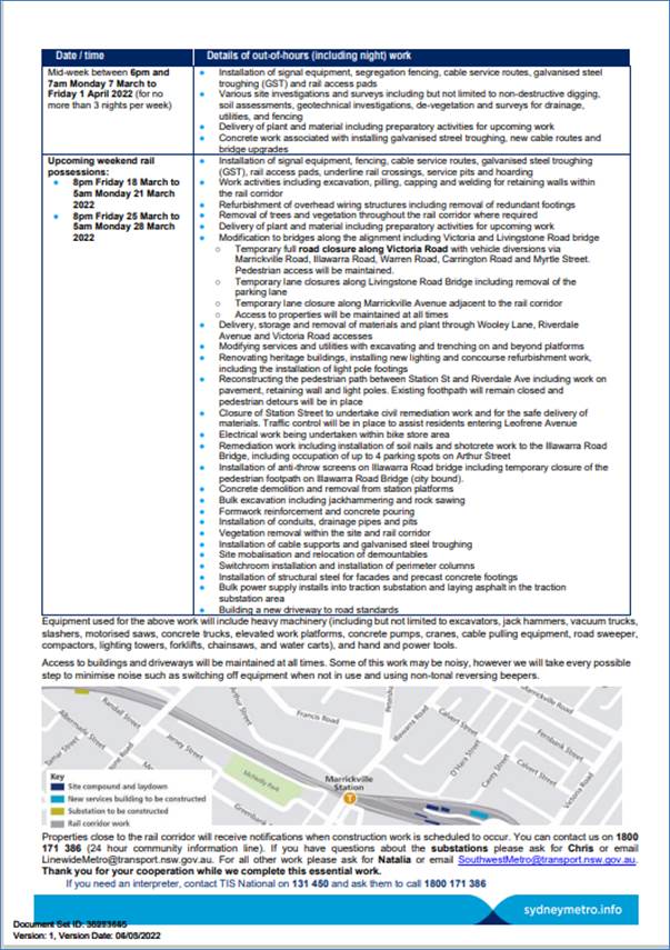
· Road closure on Victoria Road, Marrickville (rail underbridge section) between Meeks Road and Charlotte Avenue. Please see map below.
· Vehicle diversions will be in place. From the southern side of Victoria Road diversions will be via Carrington Road, Schwebel Street, Illawarra Road and onto Marrickville Road. From the northern side of Victoria Road diversions will be from Calvert Street, Gladstone Street and onto Marrickville Road.
· Pedestrian access will be maintained during the road closure.
· Traffic control and directional signage will be in place for the safety of workers and the community.
· There may be an increase in traffic movements around the local area.
· Motorists may experience minor delays.
Equipment used across all of the above work will include excavators, vacuum trucks, motorised saws, concrete trucks, sucker trucks, delivery vehicles, borehole drillers, rollers, generators, whacker packers, dump trucks, telehandlers, drilling rigs, lifting machinery, elevated work platforms, mounted trucks, bobcats, concrete pumps, cranes, cable pulling equipment, road sweeper, compactors, lighting towers, forklifts, water carts, road sweepers, vibrating plates, and hand and power tools.
Access to buildings and driveways will be maintained at all times. Some of this work may be noisy, however Sydney Metro will take every possible step to minimise noise such as switching off equipment when not in use and installing non-tonal reversing beepers on vehicles.
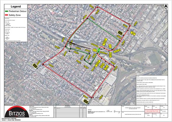
The Traffic Management Plan for the Shutdown Full Closure of Victoria Road for the Southwest Metro Upgrade Project is attached below. Traffic movements will be managed in accordance with the attached TCP. Traffic controllers will be on duty to assist both pedestrians and vehicle movements.
FINANCIAL IMPLICATIONS
Under Council’s Fees & Charges, the applicant is to pay a fee for the temporary full road closure. This fee includes advertising the proposal in accordance with the Roads Act 1993.
The applicant is to notify all affected residents and businesses in writing at least 7 days prior to the commencement of works. Community notification by Sydney Metro (SSJ) will include:
· Residents within a 200m radius of the works will be door knocked 7 days prior to any works commencing.
· Notification will be distributed 7 days prior to work commencing to the suburb and surrounding suburbs along the rail corridor.
· A door knock of local businesses with the potential to be impacted will be carried out 14 days before work commences.
The proposed road closure has been advertised on Council’s website in accordance with the Roads Act 1993.
CONCLUSION
It is recommended that the proposed temporary full road closure be approved, subject to but not limited to the conditions outlined in this report.
|
|
Local Traffic Committee Meeting 16 May 2022 |
Subject: Albion Lane, St Peters – Proposed One-Way northbound restriction in Albion Lane, St Peters (between Grove Street and Mary Street) and reversal of the current northbound one-way in Rolf Lane, St Peters to southbound (between Mary Street and Grove Street) (Midjuburi-Marrickville Ward / Summer Hill Electorate / Inner West PAC)
Prepared By: Jennifer Adams - Engineer – Traffic and Parking Services
Authorised By: Manod Wickramasinghe - Traffic and Transport Planning Manager
SUMMARY
This report deals with the results of a survey of residents regarding a proposal to introduce a "one-way" restriction in a northerly direction in Albion Lane, between Mary Street and Grove Street, St Peters and concurrently, reversing the current one-way northbound restriction in Rolf Lane, St Peters to southbound. It is recommended that due to the level of opposition to the proposal and the potential impact to the residents in the surrounding area, no changes be made to the existing traffic flows at this time.
|
RECOMMENDATION
THAT:
1. The findings of the resident consultation be received and noted;
2. Given the low current traffic volumes and the low number of reported crashes in the laneways, in addition to the feedback from residents not indicating an overwhelming support for the proposed ‘One-way’ northbound traffic flow in Albion Lane (from Grove Street to Mary Street) and the reversal of the current one-way northbound to southbound in Rolf Lane (from Mary Street to Grove Street), St Peters the proposal NOT be approved at this time; and
3. The traffic conditions in the subject laneways be revisited and any nominated one-way proposals in the locality be reconsidered as part of wider area review of the Local Area Traffic Management Scheme of the Sydenham area (Area11), as the installation of one-way restrictions generally has major implications on vehicular access for residents and traffic volumes on adjacent streets and intersections.
|
BACKGROUND
Council was requested to investigate potential improvements to the management of traffic along Albion Lane and Rolf Lane between Mary Street and Grove Street, St Peters through the introduction of an ‘one-way’ northbound traffic flow along Albion Lane between Mary Street and Grove Street and at the same time, a reversal of the current ‘one-way’ northbound in Rolf Lane to southbound. It was envisaged that these improvements would reduce the potential for ‘rat running’ and improve general safety for local residents whilst still maintaining access between Mary Street and Grove Street. A questionnaire survey of all residents/occupants in the area surrounding the subject lanes was sent out and the results of the feedback from residents are presented in this report for consideration.
FINANCIAL IMPLICATIONS
Nil.
DISCUSSION
The proposal presented to residents is reproduced below.
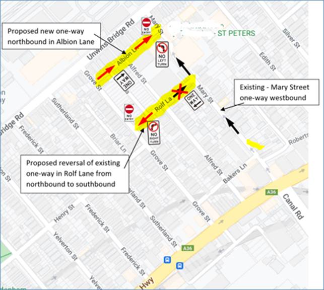
Mary Street is a narrow (6.4 metres) local street, operating “one-way” in a north-westerly direction from Princes Highway to Unwins Bridge Road. The street has mixed industrial and residential development and presently carries around 7,000 vehicles a day, the majority of which is through traffic from Canal Road. Some traffic calming measures in the form of light traffic (3 tonne) restrictions and three speed humps were installed in 1992 as part of the Sydenham LATM Scheme (Area 11).
Albion Lane is a local narrow laneway running in a southwest-northeast direction between Mary Street and Grove Street. It operates currently as a two-way single lane with mostly unrestricted parking on the northern side, except for a 38 metre section of timed ‘No Parking 7AM-6PM MON-FRI’ restrictions at the southern end north side. ‘No Parking‘ restrictions are in place along the entire southern side. The laneway is approximately 4.5 metres wide.
Rolf Lane runs parallel to Albion Lane and is currently one-way northward in an eastbound direction. It is approximately 4.0 metres wide and has ‘No Parking’ restrictions along both sides. Both Albion Lane and Rolf Lane have low traffic volumes, less than 150 and 400 vehicles per day respectively. One TfNSW recorded casualty crash occurred at the intersection of Alfred Street and Rolf Lane on Saturday 22 August 2020. The RUM 10 cross traffic incident happened when a vehicle travelling on Alfred Street was impacted by a vehicle travelling north on Rolf Lane and failed to stop at the stop control.
The proposal originated from residents concerned about local ‘rat-running’ and an associated road rage incident in Albion Lane. Thus, given that Albion Lane is narrow with the land uses of this laneway changing from previously industrial to residential over the last 5 years or so and that there is little to no footpath present between Alfred Street and Mary Street, it is acknowledged that potential rat running may create some problems along this laneway on occasions. Council Officers therefore examined a potential solution to this “rat running” via an investigation into a “one-way” system northbound between Grove Street and Mary Street.
As part of the investigation Council Officers also examined reversing the current ‘one-way’ flow along Rolf Lane between Mary Street and Grove Street from northbound to southbound. Traffic data was analysed and community engagement was undertaken and results of the survey feedback are now presented to the Committee for consideration and Council resolution.
It is noted that generally advantages for introducing ‘one-way’ traffic flow are to prevent conflict between oncoming vehicles in opposite directions due to the narrow carriageways and to reduce the number of conflict points at an intersection. Disadvantages include increased travel distance and travel times for residents, possible increased speeds due to the removal of friction from oncoming vehicles and traffic diverted to adjacent streets may lead to increased volume and/or congestion.
PUBLIC CONSULTATION
A consultation letter for the Albion Lane ‘one-way’ proposal was sent to owners and occupiers of all residential/other properties in the area bounded by Unwins Bridge Road, Grove Street, Princes Highway and Mary Street. 233 letters were sent out in March 2022 providing them with an opportunity for feedback. At the end of the survey period provided for comments (3 weeks), a total of eleven (11) submissions were received.
The submissions received were detailed and support was mixed. A summary of feedback received from residents is as follows: (1) Support for this concept as this will most definitely increase pedestrian safety along the lane; (2) Support with changes such as extending the one-way proposal to Bakers Lane; (3) Support, however Albion Lane to be southbound rather than northbound; (4) Strongly opposed to the proposed change. Rolf Lane and Grove Street intersection is at a narrow point in the road, with limited traffic calming measures on Grove Street. Safer to retain the current arrangements; (5) Where is the traffic survey supporting this proposal; (6) Insufficient information to determine best solution; (7) Issues with truck access as a result of the proposal; (8) Concerned about the potential impact of this proposal. Believe it will exacerbate the problem of “rat runs” in St Peters making the streets more hazards for residents. Support Albion Lane being one-way, but southbound would be more appropriate. Also issues with making Rolf Lane one way northbound; (9) Changing priority in Alfred Street west of Rolf Lane instead of current proposal; (10) Don’t object to making Albion Lane one way but issues with reversing traffic flow in Rolf Lane; (11) I am very concerned about the proposal to reverse the direction of Rolf Lane as I believe this will create a significant increase in traffic seeking to avoid the traffic lights at Mary St and Unwin's Bridge Road, i.e. a much bigger 'rat run' than is currently the case; and (12) I don't support the proposed changes. I see the proposed direction changes to Albion Lane as making things more difficult for residents and drivers using the lane as a throughfare.
CONCLUSION
Traffic calming can be used to discourage non-local traffic, commonly known as ‘rat-running’ in local streets, however, while the implementation of one-way traffic flow(s) may provide a solution to the potential for traffic conflicts caused by opposing traffic, it may create other issue(s) including the potential increase of vehicle speeds which can result when you remove two-way traffic movements on narrow roads
Given the low current traffic volumes and the low number of reported crashes in Albion Lane and Rolf Lane, St Peters in addition to the extensive feedback from residents not indicating an overwhelming support for the proposed ‘One-way’ northbound traffic flow in Albion Lane (from Grove Street to Mary Street) and the reversal of the current one-way northbound to southbound in Rolf Lane (from Mary Street to Grove Street), St Peters it is recommended that the proposal not be approved at this time.
It is also recommended that the traffic conditions in the subject laneways be revisited and any nominated one-way proposals in the locality be reconsidered as part of wider area review of the Local Area Traffic Management (LATM) Scheme of the Sydenham area (Area11), as the installation of one-way restrictions generally has major implications on vehicular access for residents and traffic volumes on adjacent streets and intersections.
|
|
Local Traffic Committee Meeting 16 May 2022 |
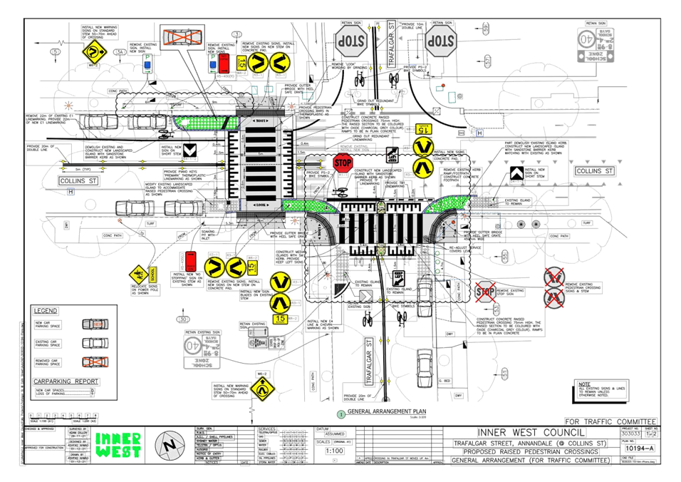
Subject: Trafalgar Street and Collins Street, Annandale - Proposed Raised Pedestrian Crossings (Gulgadya - Leichhardt Ward/ Balmain Electorate/ Leichhardt PAC)
Prepared By: Vinoth Srinivasan - Engineer - Traffic and Parking Services
Authorised By: Manod Wickramasinghe - Traffic and Transport Planning Manager
SUMMARY
The Traffic Committee raised pedestrian safety concerns about the proposed location of the raised pedestrian crossing on Trafalgar Street and resolved that Council consider these issues and the matter be reported back to the Committee.
|
RECOMMENDATION
THAT the attached revised detailed design plan (Design Plan No.10194) for the proposed installation of the two (2) new raised pedestrian crossings on Trafalgar Street and Collins Street, Annandale be approved. |
BACKGROUND & OTHER STAFF COMMENTS
The Traffic Committee at its meeting held in March 2022 considered a proposal put forward by Council to upgrade the two (2) existing at-grade pedestrian crossings to new raised pedestrian crossings on Trafalgar Street and Collins Street, Annandale. The works were proposed to improve pedestrian and motorist safety and address concerns about pedestrian and driver behavior in the area.
The Traffic Committee reviewed the initial proposal and was deferred due to safety concerns about the proposed relocation of the raised pedestrian crossing on Trafalgar Street as a queuing vehicle travelling north on Trafalgar Street could prevent a vehicle on Collins Street for seeing pedestrians to crossing behind the queued vehicle in Trafalgar Street .
Council reviewed the initial proposal and a revised plan shows the subject crossing relocated north by 3.5m.
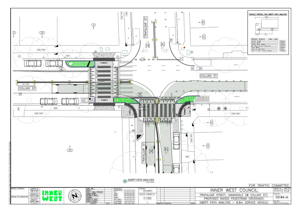
The revised detailed design plan shown in Attachment 1 outlines the proposed works on Trafalgar Steet and Collins Street, Annandale and includes the following treatments:
- Installation of two new Raised Pedestrian (Wombat) Crossings;
- Construction of landscaped kerb blister islands as shown on attached plan;
- Construction of two (2) median islands;
- Construction of gutter bridges with heel safe gratings to provide safe access over existing kerb and guttering to the new raised pedestrian crossing;
- Reconstruction of some sections of concrete footpath on both sides of the proposed pedestrian crossing; and
- Installation of associated pavement line marking and signage as required.
It is proposed to adjust existing No Stopping zones and signage to ensure current minimum standards are met.
The relocation of the raised pedestrian crossing on Trafalgar Street, Annandale back to its original location also allows for one (1) additional on-street parking space to be retained that addresses the parking issue raised by a resident at the previous Traffic Committee meeting.
The revised proposal will result in the loss of one (1) on-street parking space on Trafalgar Street and Collins Street.
FINANCIAL IMPLICATIONS
Funding of $240,000 has been allocated to this project for construction in the 2021/2022 Capital Works Program.
PUBLIC CONSULTATION
Previous respondents have been notified of the modified proposal.
|
1.⇩ |
Detailed Design Plan - Collins Street and Trafalgar Street, Annandale - Proposed Rasied Pedestrian Crossings |