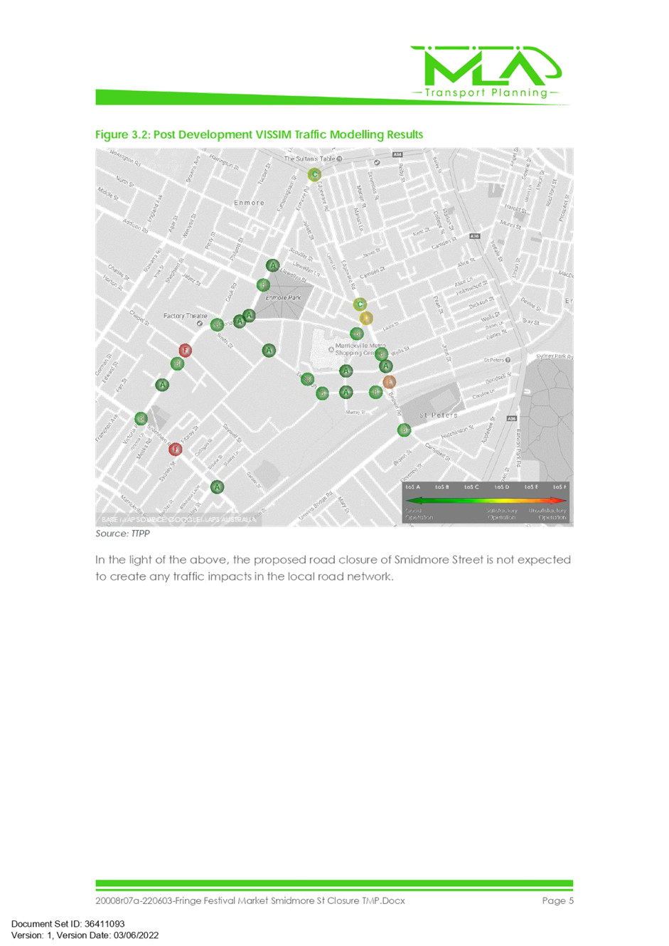
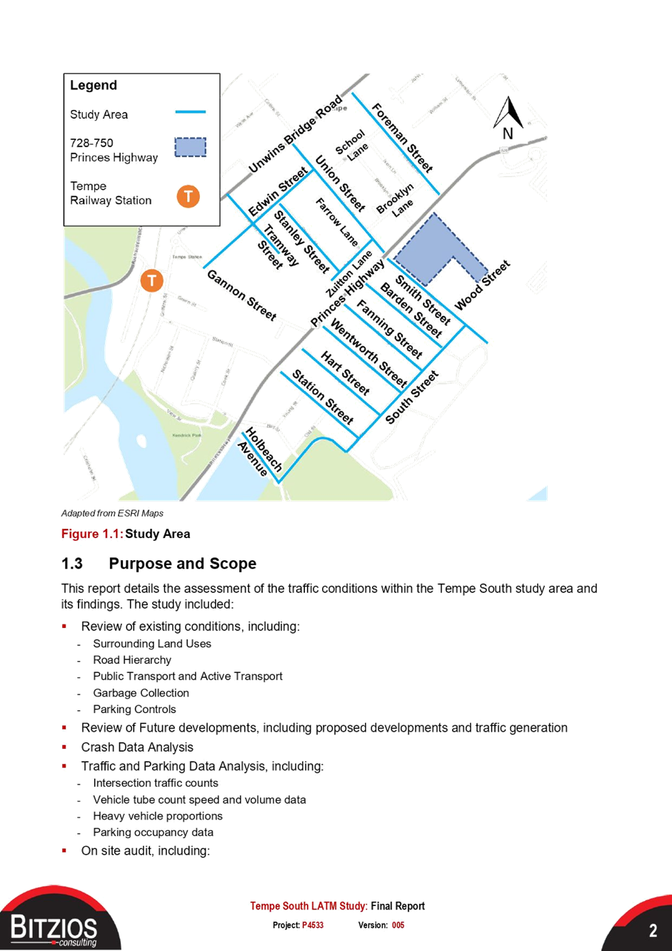
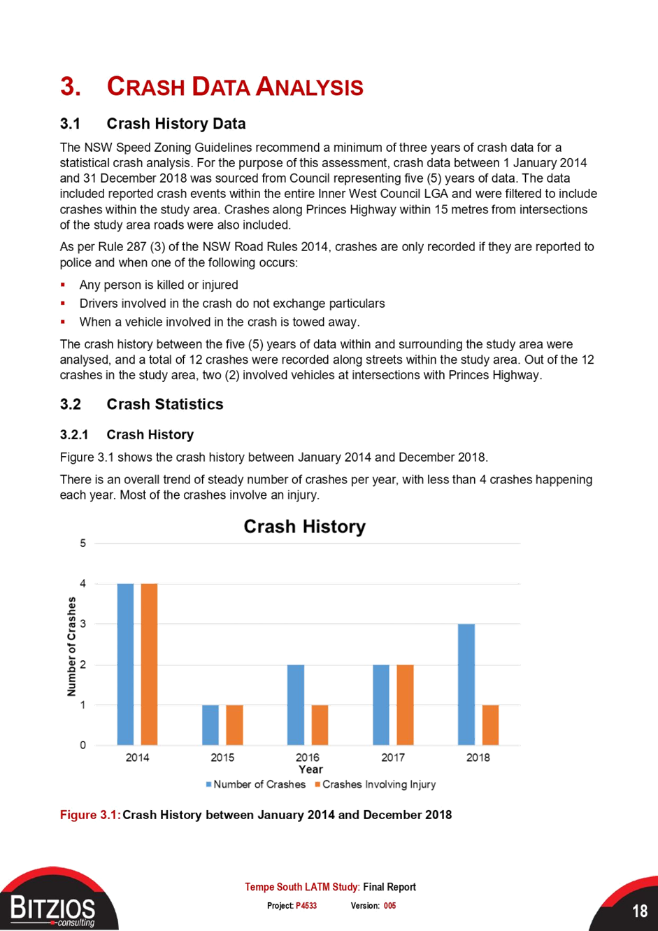
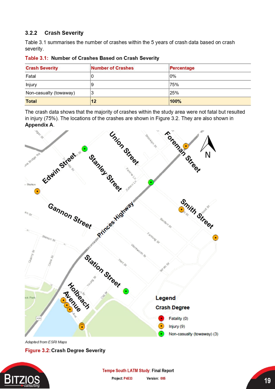
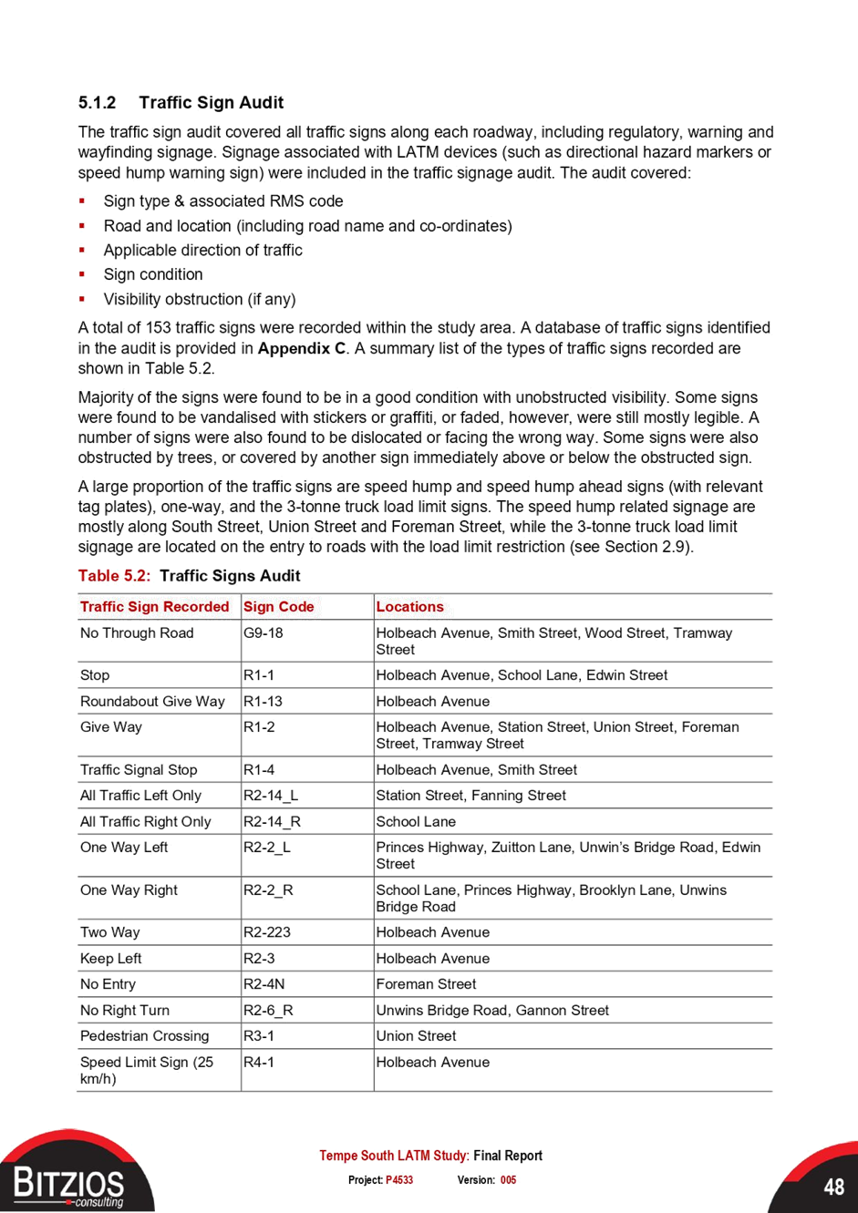
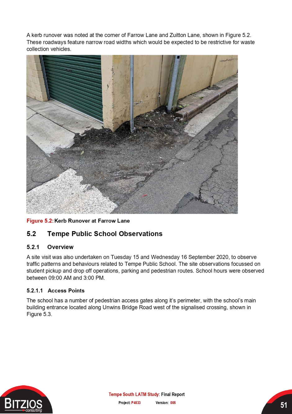
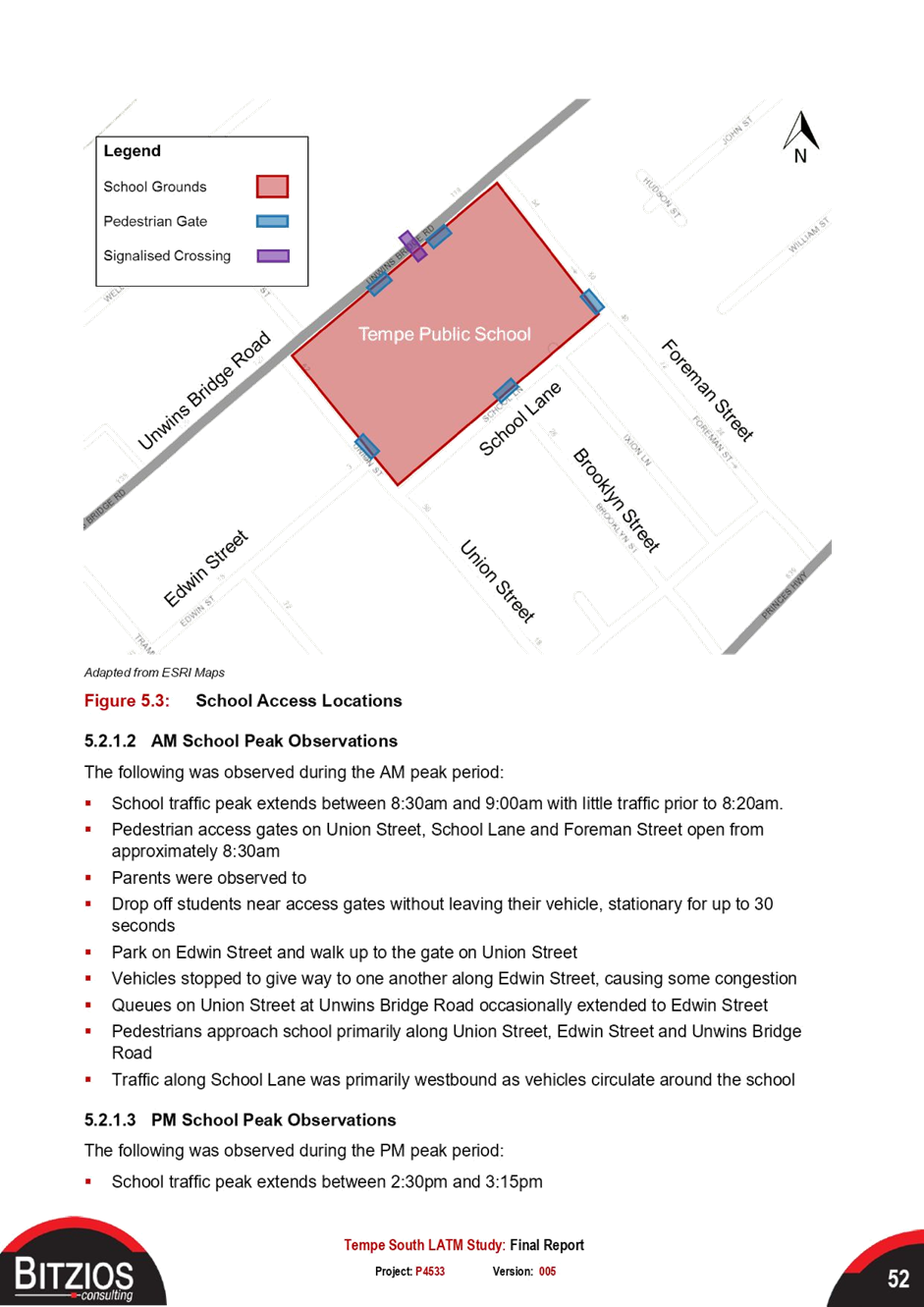
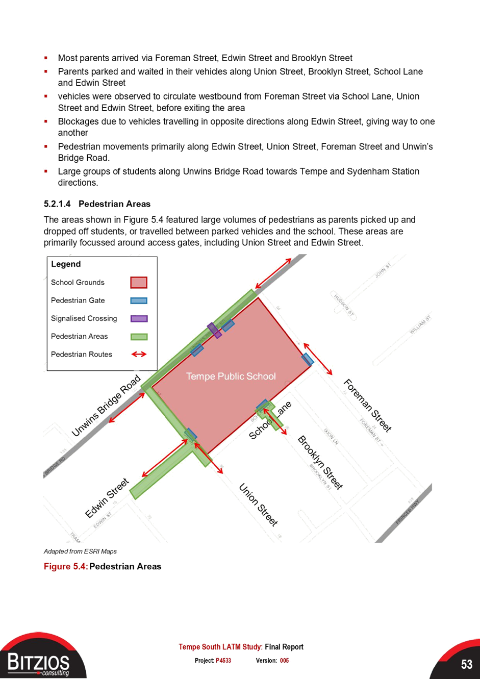
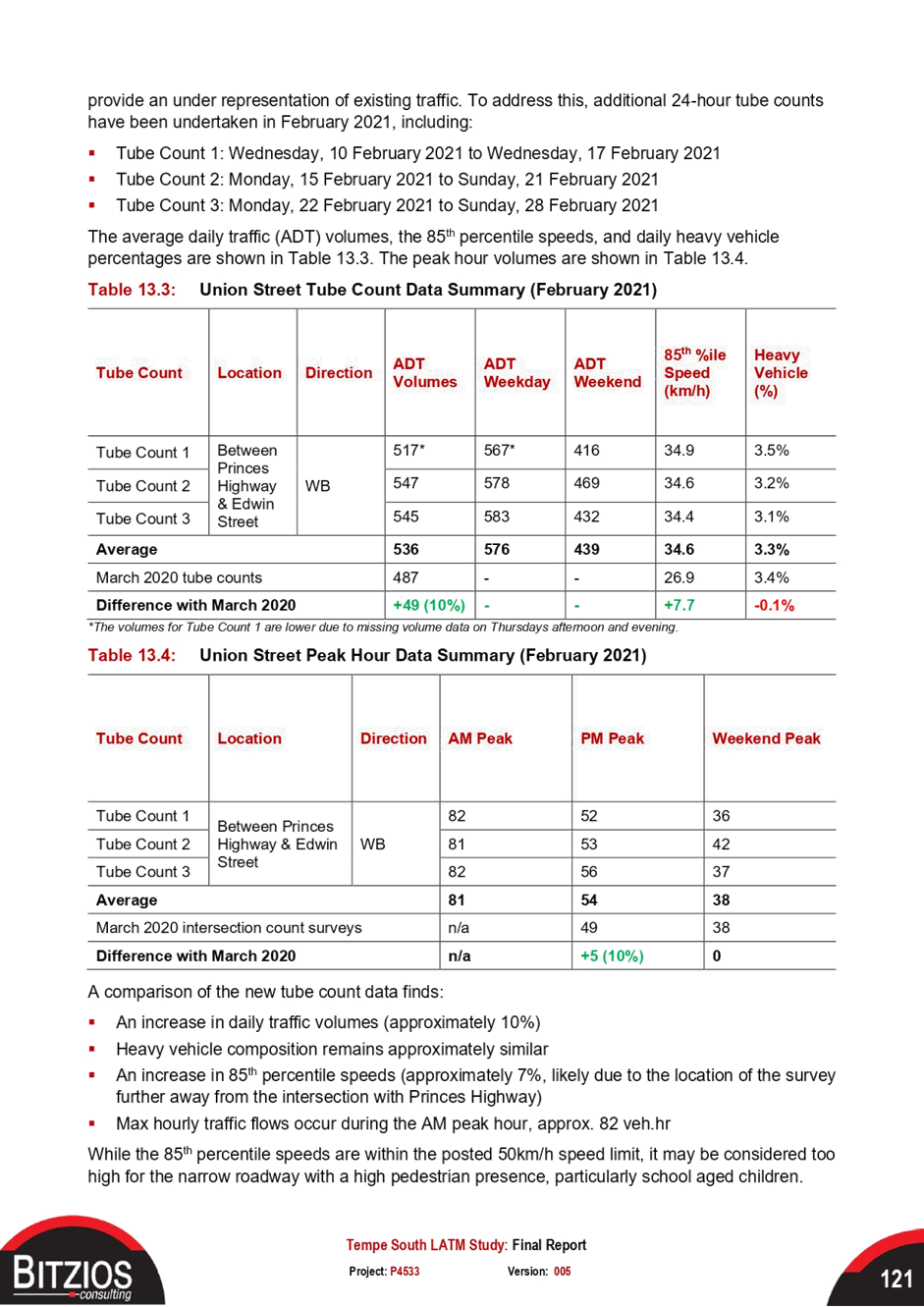
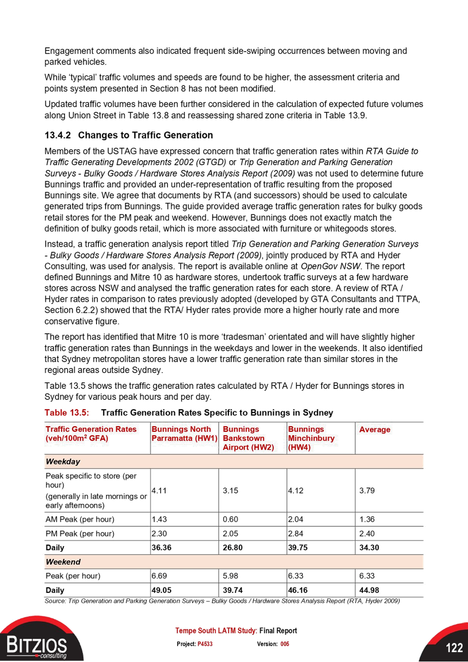
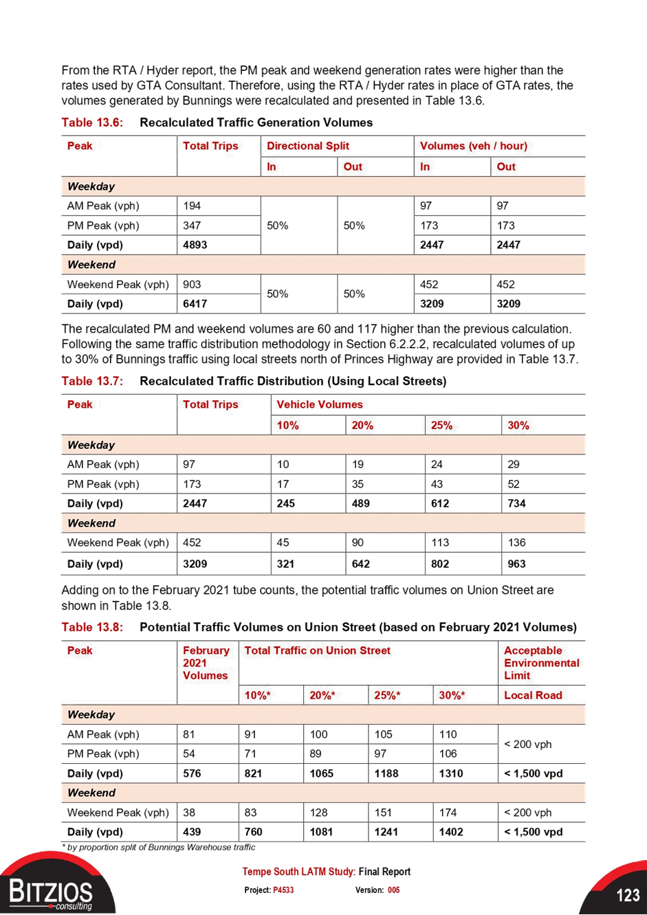
|
AGENDA R |

Local Traffic Committee Meeting
MONDAY 20 JUNE 2022
11.00AM
|
|
Local Traffic Committee Meeting 20 June 2022 |
Function of the Local Traffic Committee
Background
Roads and Maritime Services (RMS) is legislated as the Authority responsible for the control of traffic on all NSW Roads. The RMS has delegated certain aspects of the control of traffic on local roads to councils. To exercise this delegation, councils must establish a local traffic committee and obtain the advice of the RMS and Police. The Inner West Council Local Traffic Committee has been constituted by Council as a result of the delegation granted by the RMS pursuant to Section 50 of the Transport Administration Act 1988.
Role of the Committee
The Local Traffic Committee is primarily a technical review and advisory committee which considers the technical merits of proposals and ensures that current technical guidelines are considered. It provides recommendations to Council on traffic and parking control matters and on the provision of traffic control facilities and prescribed traffic control devices for which Council has delegated authority. These matters are dealt with under Part A of the agenda and require Council to consider exercising its delegation.
In addition to its formal role as the Local Traffic Committee, the Committee may also be requested to provide informal traffic engineering advice on traffic matters not requiring Council to exercise its delegated function at that point in time, for example, advice to Council’s Development Assessment Section on traffic generating developments. These matters are dealt with under Part C of the agenda and are for information or advice only and do not require Council to exercise its delegation.
Committee Delegations
The Local Traffic Committee has no decision-making powers. The Council must refer all traffic related matters to the Local Traffic Committee prior to exercising its delegated functions. Matters related to State Roads or functions that have not been delegated to Council must be referred directly to the RMS or relevant organisation.
The Committee provides recommendations to Council. Should Council wish to act contrary to the advice of the Committee or if that advice is not supported unanimously by the Committee members, then the Police or RMS have an opportunity to appeal to the Regional Traffic Committee.
Committee Membership & Voting
Formal voting membership comprises the following:
· one representative of Council as nominated by Council;
· one representative of the NSW Police from each Local Area Command (LAC) within the LGA, being Newtown, Marrickville, Leichhardt and Ashfield LAC’s.
· one representative from the RMS; and
· State Members of Parliament (MP) for the electorates of Summer Hill, Newtown, Heffron, Canterbury, Strathfield and Balmain or their nominees.
Where the Council area is represented by more than one MP or covered by more than one Police LAC, representatives are only permitted to vote on matters which effect their electorate or LAC.
Informal (non-voting) advisors from within Council or external authorities may also attend Committee meetings to provide expert advice.
Committee Chair
Council’s representative will chair the meetings.
Public Participation
Members of the public or other stakeholders may address the Committee on agenda items to be considered by the Committee. The format and number of presentations is at the discretion of the Chairperson and is generally limited to 3 minutes per speaker. Committee debate on agenda items is not open to the public.
|
|
Local Traffic Committee Meeting 20 June 2022 |
|
AGENDA |
1 Apologies
2 Disclosures of Interest
3 Confirmation of Minutes
Minutes of 16 May 2022 Local Traffic Committee Meeting 5
4 Matters Arising from Council’s Resolution of Minutes
5 Part A – Items Where Council May Exercise Its Delegated Functions
Traffic Matters
ITEM PAGE #
LTC0622(1) Item 1 Draft Pedestrian Crossing Warrant Policy 14
LTC0622(1) Item 2 Draft Traffic Management Investigation Policy 20
LTC0622(1) Item 3 Elswick Street North, Charles Street, William Street, Leichhardt - Proposed Traffic Calming, Angled Parking and Pedestrian Facilties (GULGDAYA-LEICHHARDT WARD/BALMAIN ELECTORATE/LEICHHARDT PAC) 27
LTC0622(1) Item 4 Tobruk Avenue, Balmain - Temporary Full Road Closure for Excavation works (Baludarri - Balmain/ Balmain Electorate/ Leichhardt PAC) 35
LTC0622(1) Item 5 Seven Bridges Walk - Special Event (Gulgadga - Leichhardt & Baludarri - Balmain Ward/ Balmain Electorate/ Leichhard PAC) 60
LTC0622(1) Item 6 Trafalgar Street, Annandale - Proposed Raised Pedestrian Crossing (Gulgadya - Leichhardt Ward/ Balmain Electorate/ Leichhardt PAC) 92
LTC0622(1) Item 7 Smidmore Street, Marrickville – ENRC/2022/0022 - Temporary full road closure for two Marrickville Metro events the Fringe Festival 8-12 September 2022 and 10-12 December 2022 Markets and related temporary changes to Victoria Road kerbside parking restrictions to accommodate relocation of community bus (Midjuburi – Marrickville Ward / Heffron Electorate / Inner West PAC) 95
LTC0622(1) Item 8 YEO PARK,
SUMMER HILL-FORMALISATION OF OFF-ROAD SHARED BICYCLE-PEDESTRIAN PATH, BETWEEN
VICTORIA STREET AND PROSPECT ROAD.
(DJARRAWUNANG-ASHFIELD WARD/SUMMER HILL ELECTORATE/ASHFIELD PAC) 122
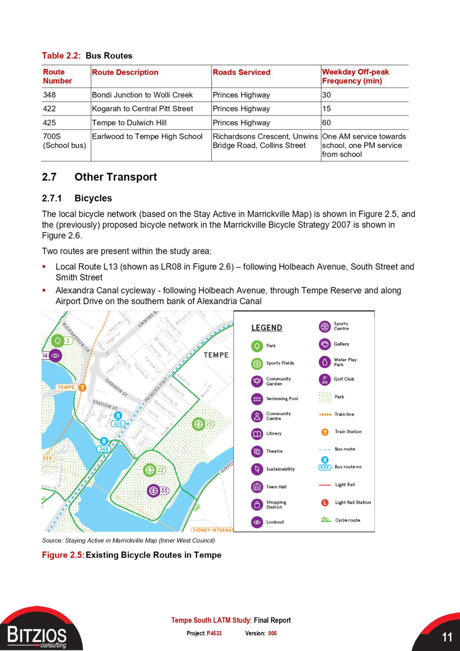
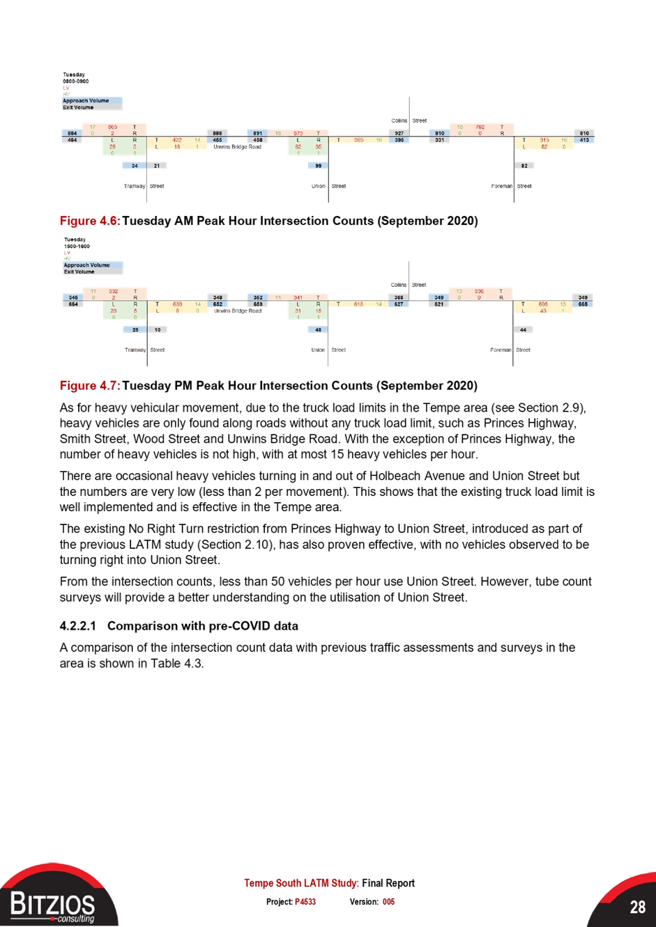
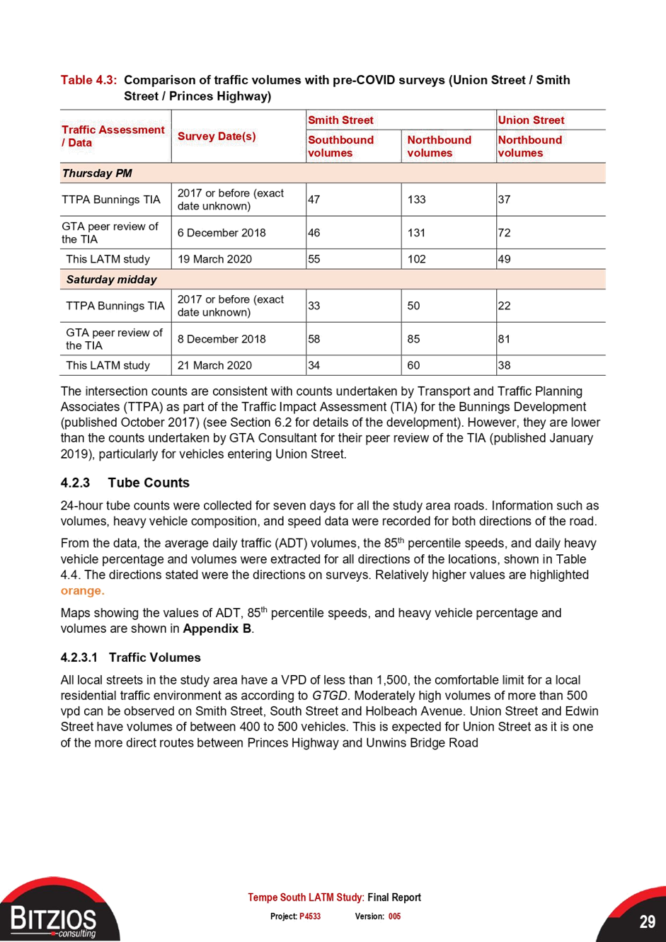
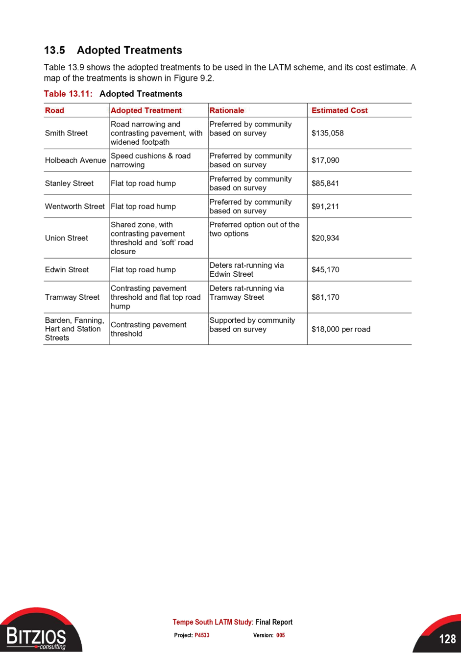
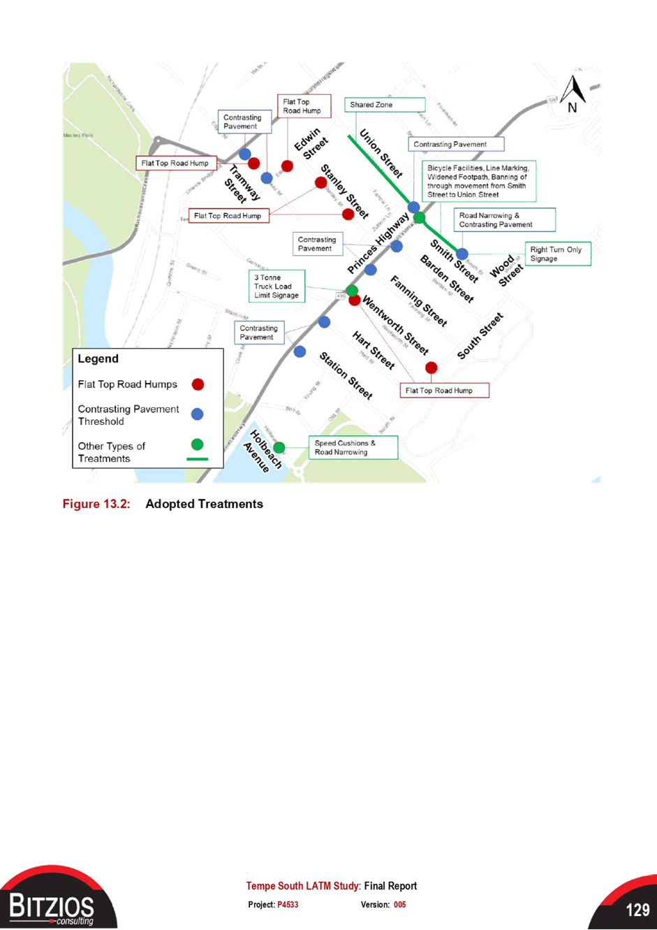
LTC0622(1) Item 9 Tempe South Local Area Traffic Management Study - Revised Report (Midfuburi-Marricville Ward/Heffron Electorate/Inner West PAC) 127
Parking Matters
ITEM PAGE #
LTC0622(1) Item 10 George Street, Leichhardt - Proposed 'Motor Bike Only' parking restrictions (Gulgadya - Leichhardt Ward/ Balmain Electorate/ Leichhardt PAC) 345
LTC0622(1) Item 11 Nelson Lane, Annandale - Proposed No Parking Restrictions (Baludarri-Balmain Ward/ Balmain Electorate/ Leichhardt PAC) 348
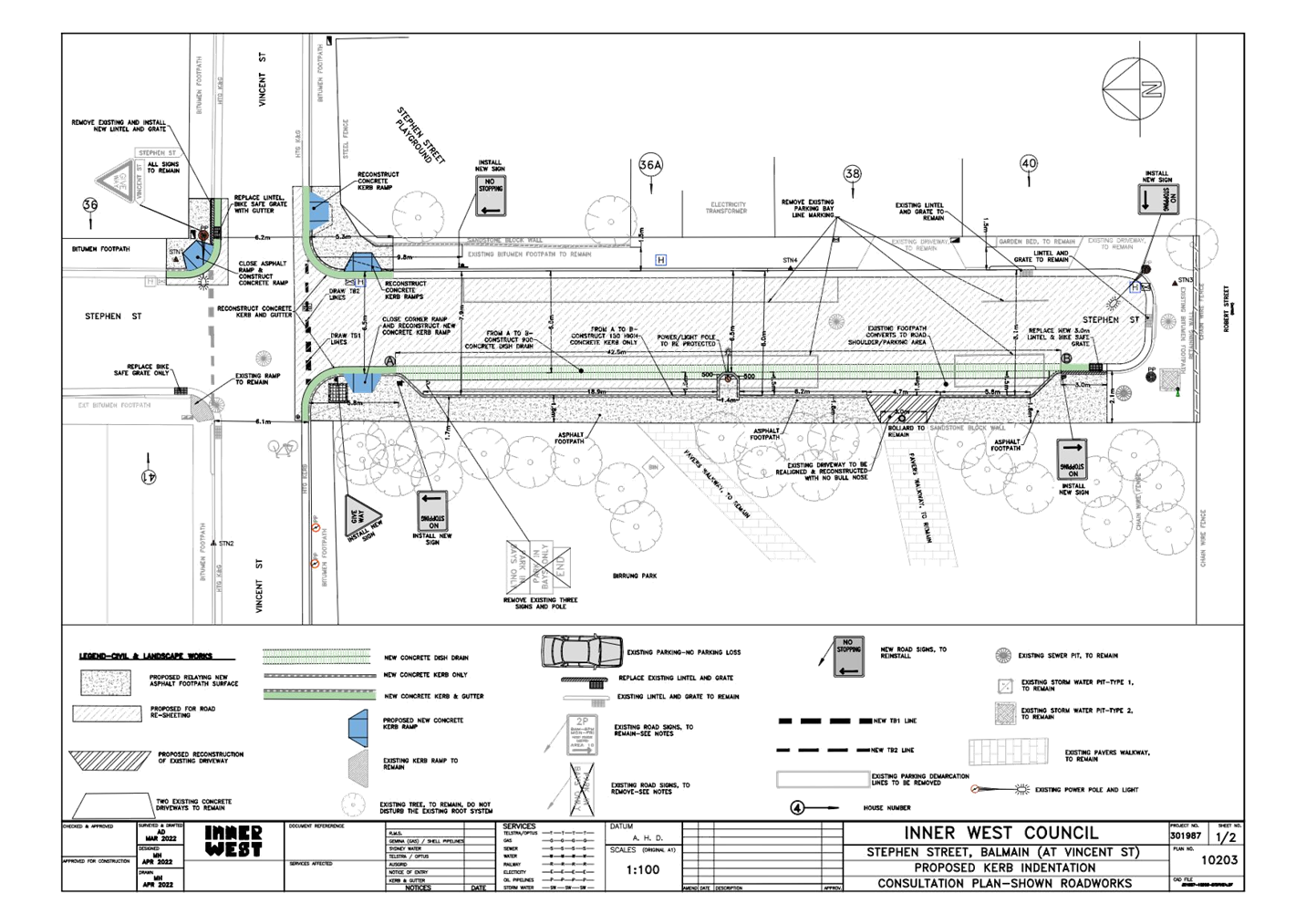
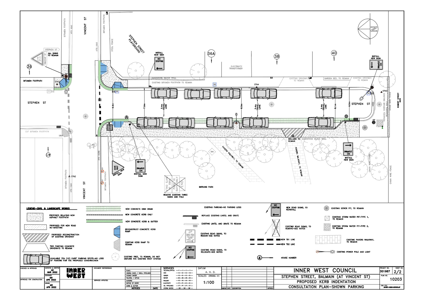
LTC0622(1) Item 12 Stephen Street, Balmain (At Vincent Street) - Proposed Kerb Indentation (Baludarri - Balmain/ Balmain Electorate/ Leichhardt PAC) 352
Late Items
Nil at time of printing.
6 Part B - Items for Information Only
Nil at the time of printing.
7 Part C - Items for General Advice
Nil at the time of printing.
8 General Business
9 Close of Meeting
|
|
Local Traffic Committee Meeting 20 June 2022 |
Minutes of Local Traffic Committee Meeting
Held on 16 May 2022 at Ashfield Service Centre
Meeting commenced at 11.00AM
ACKNOWLEDGEMENT OF COUNTRY BY CHAIRPERSON
I acknowledge the Gadigal and Wangal people of the Eora nation on whose country we are meeting today, and their elders past and present.
COMMITTEE REPRESENTATIVES PRESENT
|
Mayor Darcy Byrne |
Councillor – Baludarri-Balmain Ward (Chair) |
|
Bill Holliday |
Representative for Jamie Parker MP, Member for Balmain |
|
Graeme McKay |
Representative for Jo Haylen MP, Member for Summer Hill |
|
Sgt Charles Buttrose |
NSW Police – Leichhardt Police Area Command |
|
Solon Ghosh |
Transport for NSW (TfNSW) |
|
Anwar Subel |
Transport for NSW |
|
Taskira Islam |
Transport for NSW |
|
|
|
|
OFFICERS IN ATTENDANCE |
|
|
|
|
|
Colin Jones |
Inner West Bicycle Coalition (IWBC) |
|
Cr Justine Langford |
Councillor – Midjuburi-Marrickville Ward |
|
Manod Wickramasinghe |
IWC’s Traffic and Transport Services Manager |
|
George Tsaprounis |
IWC’s Coordinator Traffic Engineering Services (South) |
|
Sunny Jo |
IWC’s Coordinator Traffic Engineering Services (North) |
|
Christina Ip |
IWC’s Business Administration Officer |
|
|
|
|
VISITORS |
|
|
|
|
|
Nil. |
|
|
|
|
|
APOLOGIES: |
|
|
|
|
|
Sgt Anthony Kenny |
NSW Police – Inner West Police Area Command |
|
Colin Hesse |
Representative for Jenny Leong MP, Member for Newtown |
|
Maryanne Duggan |
Representative for Jason Yat-Sen Li, Member for Strathfield |
DISCLOSURES OF INTERESTS:
Nil.
CONFIRMATION OF MINUTES
|
The minutes of the Local Traffic Committee meeting held on 19 April 2022 were confirmed. |
MATTERS ARISING FROM COUNCIL’S RESOLUTION OF MINUTES
The Local Traffic Committee recommendations of its meeting on 19 April 2022 were adopted at Council’s meeting on 10 May 2022.
|
LTC0522(1) Item 1 Dudley Street, Dulwich Hill; Illawarra Road, Marrickville; Burrows Avenue, Railway Road, Gleeson Avenue And (Lower) Railway Parade, Sydenham - Temporary Parking Changes During Major Rail Shutdown of T3 Line for Sydney Metro Upgrade Works - Bus Replacements 2 Week Period 2 – 15 July 2022 (Midjuburi - Marrickville Ward / Summer Hill Electorate / Inner West PAC) |
|
Council has been notified by Transport for NSW (TfNSW) that Sydney Metro works will involve a major rail shutdown of the Sydenham to Bankstown rail line (T3) for a 2 week period between Saturday 2 July and Friday 15 July 2022. During the shutdown buses will replace train services along the T3 line and to accommodate the increased bus movements and necessary holding areas some short-term parking changes are required at a number of locations. Specifically, TfNSW is requesting approval for the temporary conversion of multiple parking spaces at the following locations: Dudley Street, Dulwich Hill; Illawarra Road, Marrickville; Burrows Avenue, Railway Road, Gleeson Avenue and (Lower) Railway Parade, Sydenham. It is recommended that no objections be raised, and Council approves the temporary short-term parking changes at the identified locations during the rail shutdowns.
Officer’s Recommendation
THAT this report be received and noted and the following temporary short-term parking changes from Saturday 2 July to Friday 15 July 2022 (inclusive) be approved and implemented by TfNSW:
Dulwich Hill Station Precinct - Dudley Street (5 parking spaces) 1. The short-term conversion of 7m (1 parking space) ‘Loading Zone 8:30 am – 6 pm Mon – Fri & 8:30 am – 12:30 pm Sat’ on the northern side of Dudley Street (between Wardell Road and School Parade) to a ‘Bus Zone’ be APPROVED in order to provide an additional bus bay with adequate draw-in length; 2. The short-term conversion of 18m (3 parking spaces) ‘P30 min 8:30 am – 6 pm Mon – Fri & 8:30 am – 12:30 pm Sat’ on the northern side of Dudley Street (between Wardell Road and School Parade) to a ‘Bus Zone’ be APPROVED in order to provide an additional bus bay with adequate draw-in length; 3. The short-term conversion of 7m (1 parking space) ‘Unrestricted Parking’ on the southern side of Dudley Street (between School Parade and Wardell Road) to a ‘Bus Zone’ be APPROVED in order to provide an additional bus bay with adequate draw-in length;
Marrickville Station Precinct - Illawarra Road (1 parking space) 4. The short-term conversion of 7m (1 parking space) ‘1P 8:30 am – 6 pm’ on the western side of Illawarra Road (between Warburton Street and Greenbank Street) to a ‘Bus Zone’ be APPROVED in order to provide additional space for adequate bus draw-in/draw-out length;
Sydenham Station Precinct - Burrows Avenue (23 parking spaces)
5. The short-term conversion of 50m (14 parking spaces) rear to kerb ‘unrestricted parking’ on the northern kerb of Burrows Avenue (west of Gleeson Avenue) to a ‘Bus Zone’ be APPROVED in order to provide additional bus bays for adequate bus draw-in/draw-out length;
6. The short-term conversion of 58m (9 parking spaces) ‘unrestricted parking’ on the southern kerb of Burrows Avenue (west of Gleeson Avenue) to a ‘Bus Zone’ be APPROVED in order to provide additional bus bays for bus layover purposes;
Sydenham Station Precinct – Railway Road (3 parking spaces) 7. The short-term conversion of 18m (3 parking spaces) ‘2P 8:30 am – 10 pm Mon - Fri’ on the eastern side kerb of Railway Road (between Burrows Avenue and Gleeson Avenue) to a ‘Bus Zone’ be APPROVED in order to provide additional bus bays for bus layover purposes; Sydenham Station Precinct - Gleeson Avenue (2 parking spaces)
8. The short-term conversion of 12m (2 parking spaces) ‘1P 9:00 am – 3:30 pm Mon - Fri and No Parking 6 am-9 am & 3:30 pm – 6:30 pm’ on the eastern kerb of Gleeson Avenue (between Burrows Avenue and Unwins Bridge Road) to a ‘Bus Zone’ be APPROVED in order to provide a bus stop extension with adequate draw-in/draw-out length; Sydenham Station Precinct - 9. The short-term conversion of 122m (46 parking spaces) 45 degree angled ‘unrestricted parking’ on the southern side kerb of Lower Railway Parade (between Sydenham Road and Marrickville Road) to a ‘Bus Zone’ be APPROVED in order to provide additional layover and standby bus bays;
10. The short-term conversion of 32m (11 parking spaces) 45 degree angled parking ‘4P 8:30 am – 6 pm Mon - Fri’ on the southwest kerb of Lower Railway Parade (between Gleeson Avenue and Marrickville Road) to a ‘Bus Zone’ be APPROVED in order to provide additional layover bus bays with adequate draw-in length; and
11. The applicant and Council Rangers be advised in terms of this report.
DISCUSSION
The Committee members agreed with the Officer’s recommendation.
COMMITTEE RECOMMENDATION
THAT this report be received and noted and the following temporary short-term parking changes from Saturday 2 July to Friday 15 July 2022 (inclusive) be approved and implemented by TfNSW:
Dulwich Hill Station Precinct - Dudley Street (5 parking spaces) 1. The short-term conversion of 7m (1 parking space) ‘Loading Zone 8:30 am – 6 pm Mon – Fri & 8:30 am – 12:30 pm Sat’ on the northern side of Dudley Street (between Wardell Road and School Parade) to a ‘Bus Zone’ be APPROVED in order to provide an additional bus bay with adequate draw-in length; 2. The short-term conversion of 18m (3 parking spaces) ‘P30 min 8:30 am – 6 pm Mon – Fri & 8:30 am – 12:30 pm Sat’ on the northern side of Dudley Street (between Wardell Road and School Parade) to a ‘Bus Zone’ be APPROVED in order to provide an additional bus bay with adequate draw-in length; 3. The short-term conversion of 7m (1 parking space) ‘Unrestricted Parking’ on the southern side of Dudley Street (between School Parade and Wardell Road) to a ‘Bus Zone’ be APPROVED in order to provide an additional bus bay with adequate draw-in length;
Marrickville Station Precinct - Illawarra Road (1 parking space) 4. The short-term conversion of 7m (1 parking space) ‘1P 8:30 am – 6 pm’ on the western side of Illawarra Road (between Warburton Street and Greenbank Street) to a ‘Bus Zone’ be APPROVED in order to provide additional space for adequate bus draw-in/draw-out length;
Sydenham Station Precinct - Burrows Avenue (23 parking spaces)
5. The short-term conversion of 50m (14 parking spaces) rear to kerb ‘unrestricted parking’ on the northern kerb of Burrows Avenue (west of Gleeson Avenue) to a ‘Bus Zone’ be APPROVED in order to provide additional bus bays for adequate bus draw-in/draw-out length;
6. The short-term conversion of 58m (9 parking spaces) ‘unrestricted parking’ on the southern kerb of Burrows Avenue (west of Gleeson Avenue) to a ‘Bus Zone’ be APPROVED in order to provide additional bus bays for bus layover purposes;
Sydenham Station Precinct – Railway Road (3 parking spaces) 7. The short-term conversion of 18m (3 parking spaces) ‘2P 8:30 am – 10 pm Mon - Fri’ on the eastern side kerb of Railway Road (between Burrows Avenue and Gleeson Avenue) to a ‘Bus Zone’ be APPROVED in order to provide additional bus bays for bus layover purposes; Sydenham Station Precinct - Gleeson Avenue (2 parking spaces)
8. The short-term conversion of 12m (2 parking spaces) ‘1P 9:00 am – 3:30 pm Mon - Fri and No Parking 6 am-9 am & 3:30 pm – 6:30 pm’ on the eastern kerb of Gleeson Avenue (between Burrows Avenue and Unwins Bridge Road) to a ‘Bus Zone’ be APPROVED in order to provide a bus stop extension with adequate draw-in/draw-out length; Sydenham Station Precinct - 9. The short-term conversion of 122m (46 parking spaces) 45 degree angled ‘unrestricted parking’ on the southern side kerb of Lower Railway Parade (between Sydenham Road and Marrickville Road) to a ‘Bus Zone’ be APPROVED in order to provide additional layover and standby bus bays;
10. The short-term conversion of 32m (11 parking spaces) 45 degree angled parking ‘4P 8:30 am – 6 pm Mon - Fri’ on the southwest kerb of Lower Railway Parade (between Gleeson Avenue and Marrickville Road) to a ‘Bus Zone’ be APPROVED in order to provide additional layover bus bays with adequate draw-in length; and
11. The applicant and Council Rangers be advised in terms of this report.
For motion: Unanimous |
|
LTC0522(1) Item 2 Victoria Road, Marrickville at the Rail overbridge between Charlotte Avenue and Meeks Street – temporary full road closure ENRC/2022/0014 - 8 day period from 2 July to 10 July 2022 - Southwest Metro Upgrade Project - Sydney Metro City & Southwest (Midjuburi-Marrickville Ward / Summer Hill Electorate / Inner West PAC) |
|
An application (ENRC/2022/0014) has been received from Sydney Metro City & Southwest for the temporary full road closure of Victoria Road, Marrickville at the Rail overbridge between Charlotte Avenue and Meeks Street, for an 8 day period scheduled for Saturday 2 July to Sunday 10 July 2022 in order to facilitate the Shutdown Rail Possession activities at the Victoria Road Bridge location. The road will be temporarily closed to all vehicular traffic, including emergency vehicles. It is recommended that the proposed temporary full road closures be approved, subject to the conditions outlined in this report.
Officer’s Recommendation
THAT the proposed temporary full road closure of Victoria Road, Marrickville at the Rail overbridge between Charlotte Avenue and Meeks Street, for an 8 day period scheduled for Saturday 2 July to Sunday 10 July 2022 be approved, in order to facilitate the Shutdown Rail Possession activities for Sydney Metro Upgrade works at the Victoria Road Bridge location subject to, but not limited to, the following conditions:
1. A Road Occupancy License be obtained by the applicant from the Transport Management Centre;
2. All affected residents and businesses, including the NSW Police Local Area Commander, Fire & Rescue NSW and the NSW Ambulance Services be notified in writing, by the applicant, of the proposed temporary road closure at least 7 days in advance of the closure with the applicant making reasonable provision for stakeholders; and
3. The occupation of the road carriageway must not occur until the road has been physically closed.
DISCUSSION
Council Officers advised that there was an error in the Traffic Control Plan which showed the diversion through Warren Road in both directions. It was noted that Warren Road has recently become one-way westbound. As such, Council Officers will advise the applicant to modify the diversion so that it uses Renwick Street for eastbound traffic instead.
The Committee members agreed with the Officer’s recommendation and the modified diversion.
COMMITTEE RECOMMENDATION
THAT the proposed temporary full road closure of Victoria Road, Marrickville at the Rail overbridge between Charlotte Avenue and Meeks Street, for an 8 day period scheduled for Saturday 2 July to Sunday 10 July 2022 be approved, in order to facilitate the Shutdown Rail Possession activities for Sydney Metro Upgrade works at the Victoria Road Bridge location subject to, but not limited to, the following conditions:
1. A Road Occupancy License be obtained by the applicant from the Transport Management Centre;
2. All affected residents and businesses, including the NSW Police Local Area Commander, Fire & Rescue NSW and the NSW Ambulance Services be notified in writing, by the applicant, of the proposed temporary road closure at least 7 days in advance of the closure with the applicant making reasonable provision for stakeholders;
3. The occupation of the road carriageway must not occur until the road has been physically closed; and,
4. The applicant be requested to provide an updated Traffic Control Plan to Council showing the diversion being modified to use Renwick Street (westbound direction) instead of Warren Road.
For motion: Unanimous
|
|
LTC0522(1) Item 3 Albion Lane, St Peters – Proposed One-Way northbound restriction in Albion Lane, St Peters (between Grove Street and Mary Street) and reversal of the current northbound one-way in Rolf Lane, St Peters to southbound (between Mary Street and Grove Street) (Midjuburi-Marrickville Ward / Summer Hill Electorate / Inner West PAC) |
|
This report deals with the results of a survey of residents regarding a proposal to introduce a "one-way" restriction in a northerly direction in Albion Lane, between Mary Street and Grove Street, St Peters and concurrently, reversing the current one-way northbound restriction in Rolf Lane, St Peters to southbound. It is recommended that due to the level of opposition to the proposal and the potential impact to the residents in the surrounding area, no changes be made to the existing traffic flows at this time.
Officer’s Recommendation
THAT:
1. The findings of the resident consultation be received and noted;
2. Given the low current traffic volumes and the low number of reported crashes in the laneways, in addition to the feedback from residents not indicating an overwhelming support for the proposed ‘One-way’ northbound traffic flow in Albion Lane (from Grove Street to Mary Street) and the reversal of the current one-way northbound to southbound in Rolf Lane (from Mary Street to Grove Street), St Peters the proposal NOT be approved at this time; and
3. The traffic conditions in the subject laneways be revisited and any nominated one-way proposals in the locality be reconsidered as part of wider area review of the Local Area Traffic Management Scheme of the Sydenham area (Area11), as the installation of one-way restrictions generally has major implications on vehicular access for residents and traffic volumes on adjacent streets and intersections.
DISCUSSION
The Committee members agreed with the Officer’s recommendation.
COMMITTEE RECOMMENDATION
THAT:
1. The findings of the resident consultation be received and noted;
2. Given the low current traffic volumes and the low number of reported crashes in the laneways, in addition to the feedback from residents not indicating an overwhelming support for the proposed ‘One-way’ northbound traffic flow in Albion Lane (from Grove Street to Mary Street) and the reversal of the current one-way northbound to southbound in Rolf Lane (from Mary Street to Grove Street), St Peters the proposal NOT be approved at this time; and
3. The traffic conditions in the subject laneways be revisited and any nominated one-way proposals in the locality be reconsidered as part of wider area review of the Local Area Traffic Management Scheme of the Sydenham area (Area11), as the installation of one-way restrictions generally has major implications on vehicular access for residents and traffic volumes on adjacent streets and intersections.
For motion: Unanimous |
General Business
Meeting closed at 11.30am.
|
|
Local Traffic Committee Meeting 20 June 2022 |
Subject: Draft Pedestrian Crossing Warrant Policy
Prepared By: Jason Scoufis - Traffic and Parking Planner
Authorised By: George Tsaprounis - Coordinator – Traffic and Parking Services
SUMMARY
TfNSW Supplements to Australian Standards sets out the warrant for the installation of a pedestrian (zebra) crossing to be used on state roads. Council has prepared a Pedestrian Crossing Warrant Policy as per Attachment 1, to be used when assessing the suitability of locations on local and regional roads.
The Policy aligns with the Strategic Plan Objective 2: Unique, liveable, networked neighbourhoods.
|
RECOMMENDATION
THAT:
1. That the Committee support the draft Pedestrian Crossing Warrant Policy in principle; and 2. The draft Pedestrian Crossing Warrant Policy be put on public exhibition for a period of 28 days for comment with the results being bought back to the Committee for consideration. |
BACKGROUND
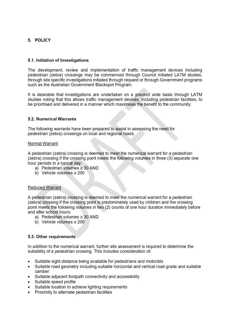
TfNSW Supplements to Australian Standards sets out the warrant for the installation of a pedestrian (zebra) crossing to be used on state roads. A warrant is the minimum criteria that must be met before such a device can be installed. The warrants for a pedestrian (zebra) crossing include the requirements for the number of pedestrians who cross the road at the crossing point and the number of vehicles that travel through the crossing point.
In the absence of a specific TfNSW warrants for roads that are not state roads (ie. local and regional roads), this Policy sets out an interim warrant for the installation of a pedestrian (zebra) crossing on local and regional roads.
The policy includes two types of warrants to be used in the assessment. A ‘Normal Warrant’ and a ‘Reduced Warrant’ with the ‘Reduced Warrant’ being applied at locations where the crossing point is predominantly used by children.
In addition to the numerical warrant, further site assessment is required to determine the suitability of a pedestrian (zebra) crossing include sight distance, road geometry, pedestrian connectivity, speed profile, lighting and proximity to alternate pedestrian crossing facilities.
FINANCIAL IMPLICATIONS
There is no cost associated with the Policy.
PUBLIC CONSULTATION
Not applicable.
|
1.⇩ |
Pedestrian Crossing Warrant Policy |
|
Local Traffic Committee Meeting 20 June 2022 |
Subject: Draft Traffic Management Investigation Policy
Prepared By: Jason Scoufis - Traffic and Parking Planner
Authorised By: George Tsaprounis - Coordinator – Traffic and Parking Services
SUMMARY
Council has prepared a Traffic Management Investigation Policy to be used when assessing the suitability of locations on local and regional roads for traffic management devices. This policy as detailed in attachment 1 provides guidance regarding when to initiate investigation and assistance in assessing the need for traffic calming measures to control speeding.
The Policy aligns with the Strategic Plan Objective 2: Unique, liveable, networked neighbourhoods.
|
RECOMMENDATION
THAT:
1. That the Committee support the draft Traffic Management Investigation Policy in principle; and 2. The draft Traffic Management Investigation Policy be put on public exhibition for a period of 28 days for comment with the results being bought back to the Committee for consideration. |
BACKGROUND
Council receives numerous requests for the installation of traffic management measures to control perceived speeding or high vehicle volumes concerns in local streets.
In general, the travelling speed of a vehicle is difficult to quantify from observations, particularly in a narrow road width environment. Speeding by a few vehicles could also give a perception of constant speeding. Similarly, the average volume of traffic is difficult to quantify from observations alone.
These requests may therefore require detailed investigation over several months including data collection in the form of speed and volume tube counts, intersection counts, pedestrian counts, review of crash data and warrant checks prior to concept development, modelling, community engagement and approval through the Local Traffic Committee.
This Policy provides guidance regarding when to initiate investigation, taking into consideration whether a Local Area Traffic Management (LATM) Study has been recently prepared and also the number of resident enquiries received by Council. It also includes guidelines to assist in assessing the need for traffic calming measures to control speeding taking into consideration the number of report crashes, traffic volume and speed data.
Once this assessment is completed, funding will need to be considered on a priority basis.
FINANCIAL IMPLICATIONS
Nil.
PUBLIC CONSULTATION
Not applicable.
|
1.⇩ |
Traffic Management Investigation Policy |
|
Local Traffic Committee Meeting 20 June 2022 |
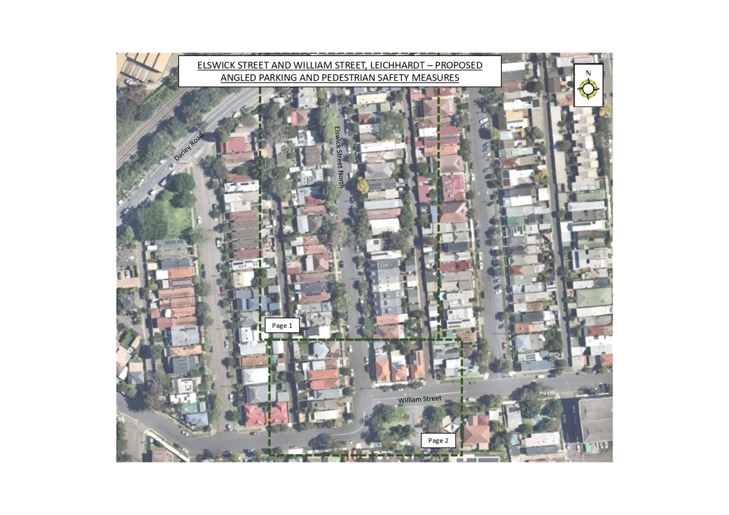
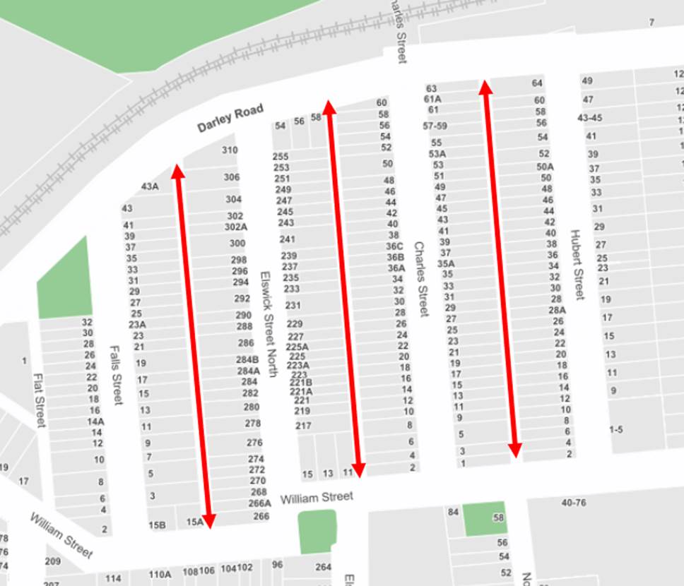
Subject: Elswick Street North, Charles Street, William Street, Leichhardt - Proposed Traffic Calming, Angled Parking and Pedestrian Facilties (GULGDAYA-LEICHHARDT WARD/BALMAIN ELECTORATE/LEICHHARDT PAC)
Prepared By: David Yu - Engineer - Traffic and Parking Services
Authorised By: George Tsaprounis - Coordinator – Traffic and Parking Services
SUMMARY
A traffic review has been undertaken in Leichhardt North including Elswick Street North, Charles Street, and William Street. The review examined requests from residents of Elswick Street North, who have safety concerns along local streets and laneways as a result of ‘rat running’ from Darley Road.
|
RECOMMENDATION
THAT:
1. A 45-degree angle parking in Elswick Street North, with concrete median island and linemarking between Darley Road and William Street be supported in principle and a detailed design be prepared, and affected residents be consulted;
2. A proposed kerb extension on both sides of William Street east of Elswick Street and a continuous footpath on the unnamed lane (between Charles St and Elswick Street North) be supported in principle and a detailed design be prepared, and affected residents be consulted;
3. A further report, including the detailed design be brought back to the Traffic Committee for consideration.
|
BACKGROUND
Concerns have been received by residents regarding limited parking spaces and pedestrian safety concerns in William Street and Elswick Street North.
The Leichhardt North Precinct Parking Study was reported at the 21 March 2022 Local Traffic Committee. The committee made the following recommendation:
THAT: 90 degree angled parking rear to kerb’ in Elswick Street North between William Street and Darley Road be approved subject to a final signposting plan being supported by Traffic Committee.
Traffic conditions in Elswick Street North and adjacent laneways were previously reviewed in the past and traffic speeds and volume did not warrant any intervention.
FINANCIAL IMPLICATIONS
Nil.
OTHER STAFF COMMENTS
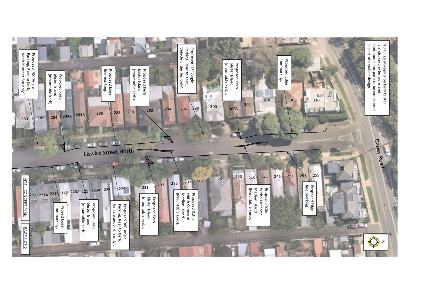
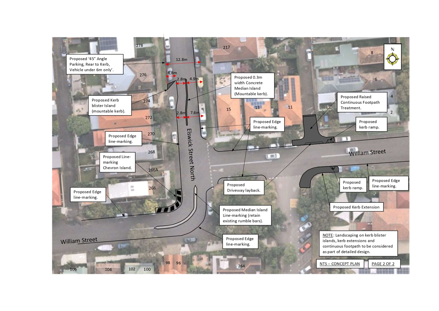
In response to resident concerns and based on previous investigations, Council is proposing the following:
· 45-degree angle parking in Elswick Street North, with concrete median island and linemarking between Darley Road and William Street
· Linemarking, Kerb extensions and continuous footpath treatment in William Street near intersection of Elswick Street.
The proposed ‘45⁰ Angle Parking, Rear to Kerb, Vehicles Under 6m Only’ restrictions be signposted on staggered arrangement on both sides of Elswick Street North to increase parking supply and also provide traffic calming measures by narrowing the road carriageway and providing slow points.
The proposed kerb extension on both sides of William Street east of Elswick Street should improve pedestrian safety by reducing the crossing distance at this location. A continuous footpath is also proposed on the unnamed lane (between Charles St and Elswick Street North).
A concept plan has been attached to this report.
Traffic Volumes
A series of traffic count surveys were undertaken during a school week in February 2022. Where available these datasets were compared to historical traffic data undertaken in 2006, 2016 and 2018 for comparison:
|
Streets |
Former Counts |
February 2022 counts |
||
|
7 Day Avg Volume |
85th Percentile Speed (km/h) |
Volumes (7 Day Avg) |
7 Day Avg Volume |
|
|
Falls Street (between Darley Road and William Street) |
151 (2006 counts) |
NB: 43.6 SB: 47.9 (2006 counts) |
136 |
NB: 34.6 SB: 40.4 |
|
Elswick Street North (between Darley Road and William Street) |
245 (2018 counts) |
NB: 50.6 SB: 48.0 (2018 counts) |
227 |
NB: 47.4 SB: 46.6 |
|
Charles Street (between Darley Road and William Street) |
429 (2018 counts) |
NB: 50.1 SB: 49.1 (2018 counts) |
959 |
NB: 49.8 SB: 49.4 |
|
Hubert Street (between Darley Road and William Street) |
517 (2016 counts) |
NB: 48.3 SB: 49.2 (2016 counts) |
405 |
NB: 44.8 SB: 45.7 |
|
Francis Street (between Darley Road and William Street) |
327 (2006 counts) |
NB: 52.9 SB: 55.8 (2006 counts) |
369 |
NB: 45.9 SB: 45.1 |
|
William Street (between Charles Steet and Hubert Street) |
2,198 (2018 counts) |
EB: 49.1 WB: 53.1 (2018 counts) |
2,329 |
EB: 49.1 WB: 49.8 |
|
William Street (between Falls Street and Elswick Street North) |
1,140 (2018 counts) |
EB: 47.3 WB: 47.6 (2018 counts) |
1,140 |
EB: 40.4 WB: 40.3 |
Traffic data collected in February 2022 indicates that there were slightly different traffic and parking conditions induced by the easing Covid-19 restrictions, food and goods delivery, and employees encouraged to work from home. The above comparison indicate that traffic volumes were generally 10-20% lower than the earlier counts which was taken into consideration during the traffic assessment. The exception to this would be Charles Street, where a roundabout was constructed in 2016 at Darley Road. There were no significant changes in traffic speeds between the recent and former counts and these were considered suitable for use in the assessment.
Peak hour traffic count in Laneways
Traffic counts were undertaken on Tuesday 10 May 2022 during the AM peak hour (7am-10am) to identify any potential ‘rat-running’ through the service lanes between Darley Road and William Street. Residents reported that ‘rat running’ was apparent where vehicles queuing was excessive leading to City West Link Road during the AM peak hour. The following information indicates the number of vehicles travelling in the three laneways:
· Unnamed Lane (between Falls Street and Elswick Street North)
· Unnamed Lane (between Elswick Street North and Charles Street)
· Unnamed Lane (between Chares Street and Hubert Street)
|
Street |
Bidirectional Traffic Volume (7am-10am)
|
|
Unnamed Lane (between Falls Street and Elswick Street North) |
9 |
|
Unnamed Lane (between Elswick Street North and Charles Street) |
5 |
|
Unnamed Lane (between Chares Street and Hubert Street) |
0 |
Laneways provide connections to adjoining streets; access to properties; vehicular access to offstreet parking; pedestrian and cycle routes; on-street parking opportunities; access by service vehicles, waste collection and emergency services.
The above traffic volumes indicate that the level of ‘rat-running’ through the laneways was not significant and did not warrant any intervention at this time. Although a continuous footpath treatment is proposed for the southern end of the Unnamed Lane between Elswick Street North and Charles Street, this was proposed to facilitate a crossing location for pedestrians as there are currently no crossing facility across William Street.
Pedestrian Assessment
Pedestrian counts were undertaken in February 2022 in William Street (between Charles Street and Elswick Street). The survey results are shown in the table below:
|
William Street |
Pedestrian Volume |
|
AM Peak (8:00am to 9:00am) |
38 |
|
AM Peak (9:00am to 10:00am) |
17 |
|
PM Peak (2:00pm to 3:00pm) |
2 |
|
PM Peak (3:00pm to 4:00pm) |
11 |
Based on the pedestrian and vehicle volumes of William Street, the TfNSW warrant for a pedestrian crossing is not met. Therefore, at the time of this report, a kerb extension and a continuous footpath is proposed at this location to reduce the crossing distance and improve safety. The proposed infrastructure is expected to accommodate a pedestrian crossing if the site meets the numerical requirements for a pedestrian crossing in the future.
Future Bike Plan
A future bike plan for the LGA is currently being prepared and William Street is a bike routes from Darley Road to Norton Street and Balmain Road. The road currently is marked with bicycle logos and directional signs. It is expected that a route for William Street may be enhanced by providing an on-road or an off-road bicycle facility. An upgraded bicycle facility could be provided in William Street and as also provide traffic calming benefits.
Future plans by TfNSW
A number of changes to the road network in North Leichhardt was proposed by Transport for NSW (TfNSW) in 2020, including a combined signalised intersection for City West Link Road at Norton Street and James Street, one-way sections, new traffic signals, and removal of on-street parking. The Haberfield, Ashfield and Leichhardt Road Network Improvements proposed significant changes to local streets in this area. Due to high level of feedback and concerns from the community, TfNSW is currently deferring the proposal and is expected to review traffic conditions following the opening of the WestConnex Rozelle Interchange in late 2023.
PUBLIC CONSULTATION
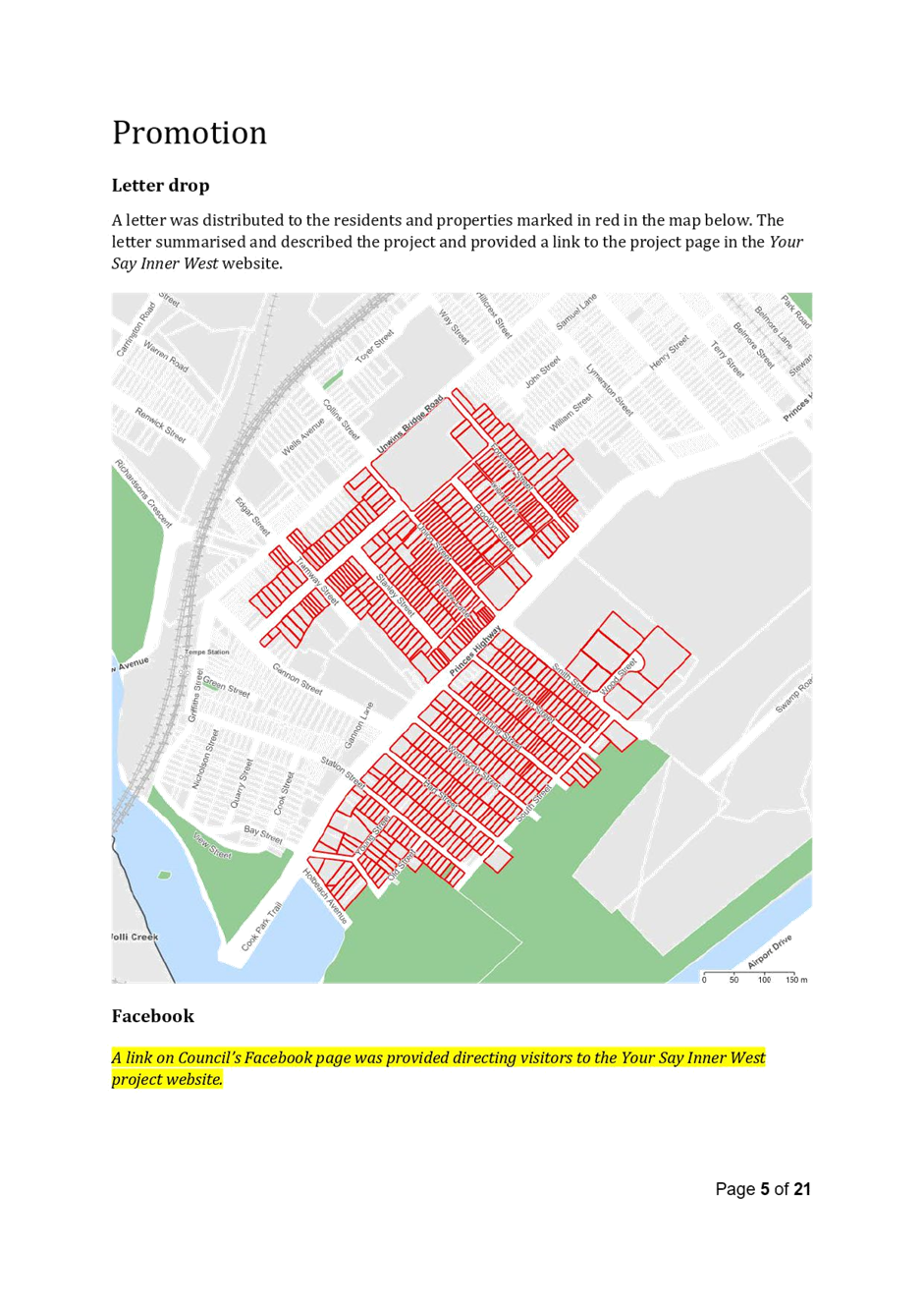
A letter outlining the above proposal was mailed out to the directly affected properties in Elswick Street North, Elswick Street, William Street, and Charles Street and adjacent properties.
Consultation survey results up to the date of 8 June 2022 are summarised as follows:
Total Number of properties consulted - 126
Elswick Street North Proposal (angled Parking)
Number of properties responded - 21 out of 59 properties
Number of properties supported - 14 (24% Elswick Street North)
Number of properties objected - 6 (10% Elswick Street North)
William Street Proposal (kerb extension and continuous footpath)
Number of properties responded - 21
Number of properties supported - 18 (86% of responses)
Number of properties objected - 3 (14% of responses)
It should be noted that consultation ends 14 June 2022 and any further responses will be reported at the traffic committee meeting.
The main objections raised during the consultation are summarised below:
· The requirement for traffic calming on Elswick Street is completely unnecessary; It is unclear why a quiet street is being targeted as a street which requires traffic calming.
· Staggering the 45 degree parking on each side makes the street confusing. An alternative would be to have 45 degree angle parking along one side of the street.
· The proposal for William Street is supported excluding the Chevron Island on the corner of William and Elswick; this seems unnecessary.
· For the areas between two blister islands, is this for parallel parking, or would this be a kerb extension and no parking.
· Elswick street north is not wide enough to support pedestrians, two way traffic and angled parking.
· Angled parking on Charles Street in unmarked, some people have difficulty judging 45 degree. Also, request slow points in Charles Street.
· All Service Lanes, between James & Elswick North, should also be designated "Shared Zones" to deter rat-running and increase pedestrian safety.
· Kerb blister islands should be landscaped.
· Painting the parking bays, like outside the church on Elswick St, would indicate a correct 45 degree parking angle.
·
In response to the main comments:
· The staggered arrangement of parking in Elswick Street allows for additional parking spaces while also providing traffic calming measures to reduce speeding in the street.
· The chevron island on the corner of William Street and Elswick Street will deter vehicles from parking at this location and impeding sight visibility lines.
· It is proposed that 45 degree angled parking be provided between the kerb blister islands in Elswick Street North.
· Based on measurements on site, angled parking and two-way traffic movement can be maintained in Elswick Street North with the proposal.
· Request for traffic calming measures in Charles Street is not supported at this time as the 85th percentile speeds did not indicate a speeding issue in the street. This street will be monitored as it carries higher level of traffic from the roundabout in Darley Road.
· Based on traffic count data collected in the service lanes, there are low volumes of vehicles and traffic calming measures are not warranted.
· Landscaping will be considered as part of the detailed design stage of this project.
· Currently Councils limited line marking budget has been prioritised to upgrade safety-related line marking assets (Give way, Stop lines, and pedestrian crossing markings) and where available in the future will consider line marking bays in residential streets.
|
1.⇩ |
Concept Plan - Proposed Elswick Street North Angled Parking and William Street Continous Footpath |
|
Local Traffic Committee Meeting 20 June 2022 |
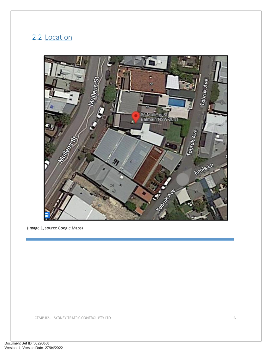
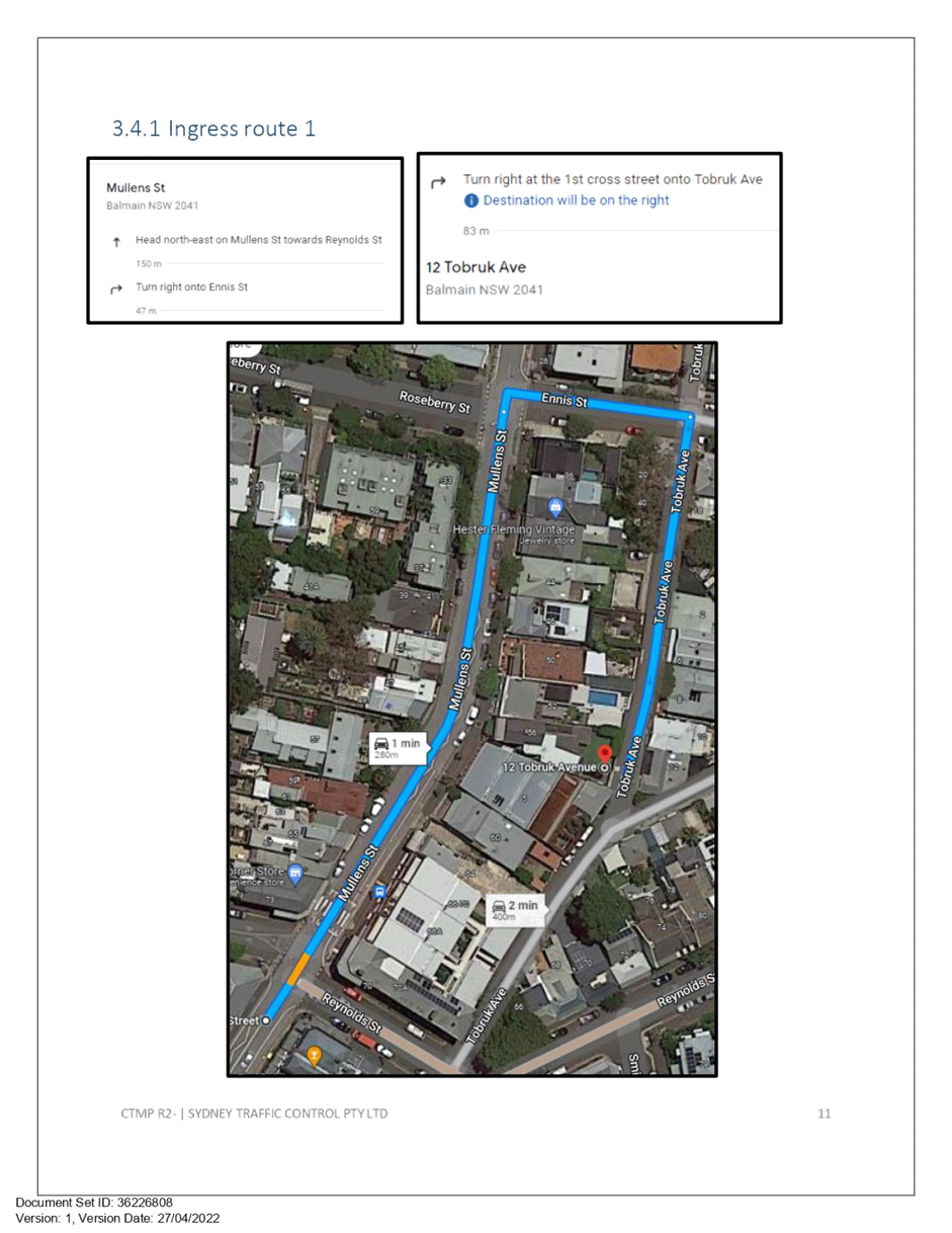
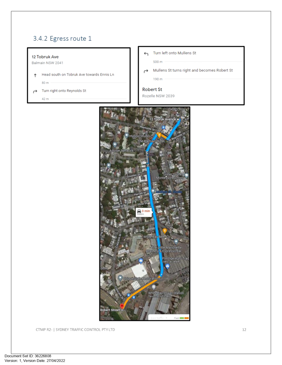
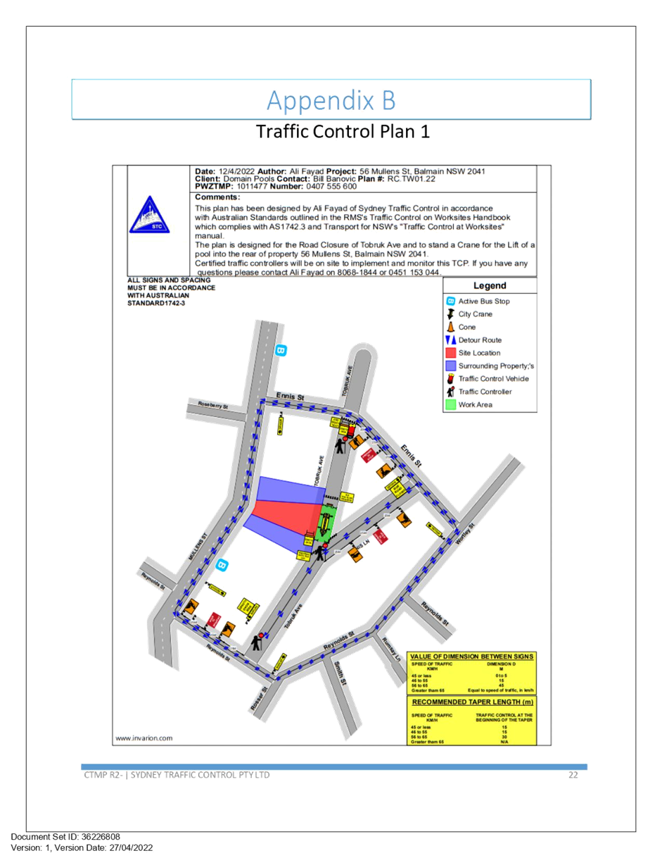
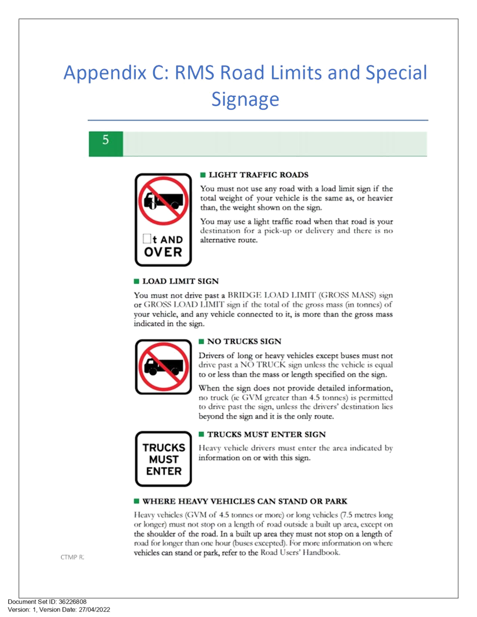
Subject: Tobruk Avenue, Balmain - Temporary Full Road Closure for Excavation works (Baludarri - Balmain/ Balmain Electorate/ Leichhardt PAC)
Prepared By: Vinoth Srinivasan - Engineer - Traffic and Parking Services
Authorised By: George Tsaprounis - Coordinator – Traffic and Parking Services
SUMMARY
Council has received an application from Domain Pools for the approval of a temporary full road closure of Tobruk Avenue, between Ennis Street and Reynolds Street, Balmain from Monday, 15 August 2022 at 8.00am to Thursday, 18 August 2022 at 11.00pm and Wednesday, 31 August 2022 from 8.00am to 11.00pm to facilitate excavation works on site at No.56 Mullens Street, Balmain
|
RECOMMENDATION
THAT the proposed temporary full road closure of Tobruk Avenue, between Ennis Street and Reynolds Street, Balmain from Monday 15 August 2022 at 8.00am to Thursday, 18 August 2022 at 11.00pm and Wednesday, 31 August 2022 from 8.00am to 11.00pm (contingency period 4 weeks) be approved for the proposed excavation works on site at No.56 Mullens Street, Balmain subject to, but not limited to the following conditions: 1. A Road Occupancy License be obtained by the applicant from the Transport Management Centre;
2. All affected residents and businesses, including NSW Police Area Command, Fire & Rescue NSW and the NSW Ambulance Services be notified in writing, by the applicant, of the proposed temporary full road closure at least 7 days in advance of the closure with the applicant making reasonable provision for stakeholders; and
3. The occupation of the road carriageway must not occur until the road has been physically closed. |
BACKGROUND & STAFF COMMENTS
Council has received an application from Domain pools for approval of a temporary full road closure of Tobruk Avenue, between Ennis Street and Reynolds Street, Balmain from Monday, 15 August 2022 at 8.00am to Thursday, 18 August 2022 at 11.00pm and Wednesday, 31 August 2022 from 8.00am to 11.00pm to facilitate excavation works on site at No.56 Mullens Street, Balmain
This road closure application is sought for the excavation and installation of a concrete swimming pool at No.56 Mullens Street, Balmain.
The Traffic Management Plan (TMP) and Traffic Control Plan (TCP) submitted with the application is attached.
FINANCIAL IMPLICATIONS
Under Council’s Fees & Charges, the applicant is to pay a fee for the temporary full road closure.
PUBLIC CONSULTATION
The applicant is to notify all affected residents and businesses in writing at least 7 days prior to the commencement of works.
The proposed road closure is currently advertised on Council’s website in accordance with the Roads Act 1993.
|
1.⇩ |
Tobruk Avenue, Balmain - Traffic Management Plan and Traffic Control Plan |
|
Local Traffic Committee Meeting 20 June 2022 |
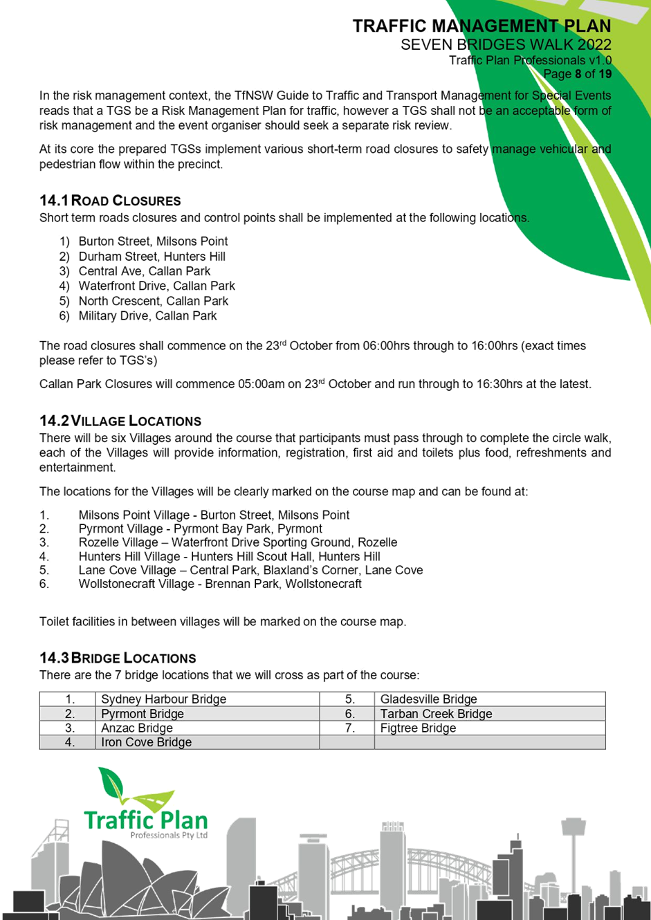
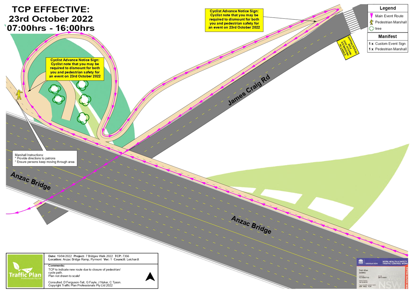
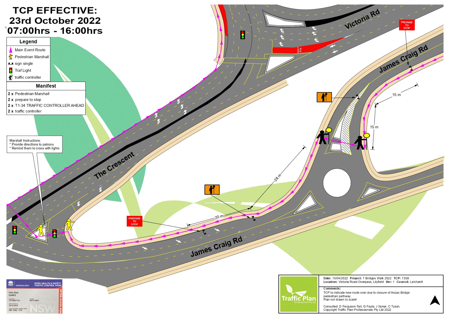
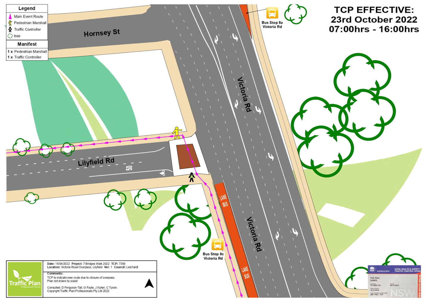
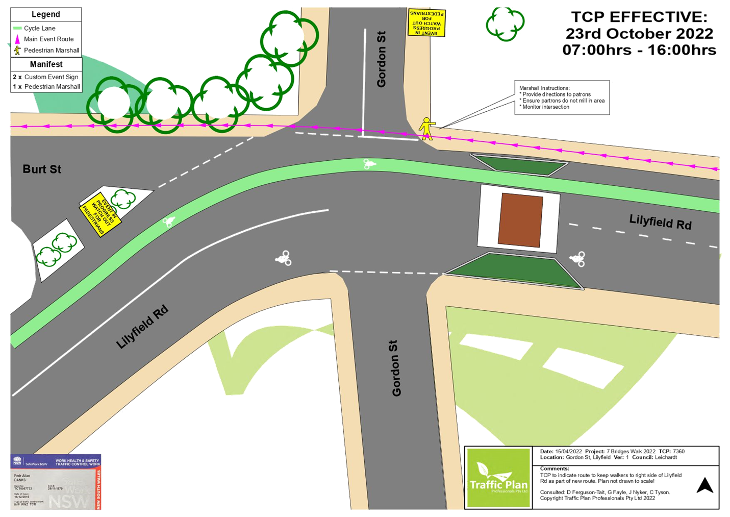
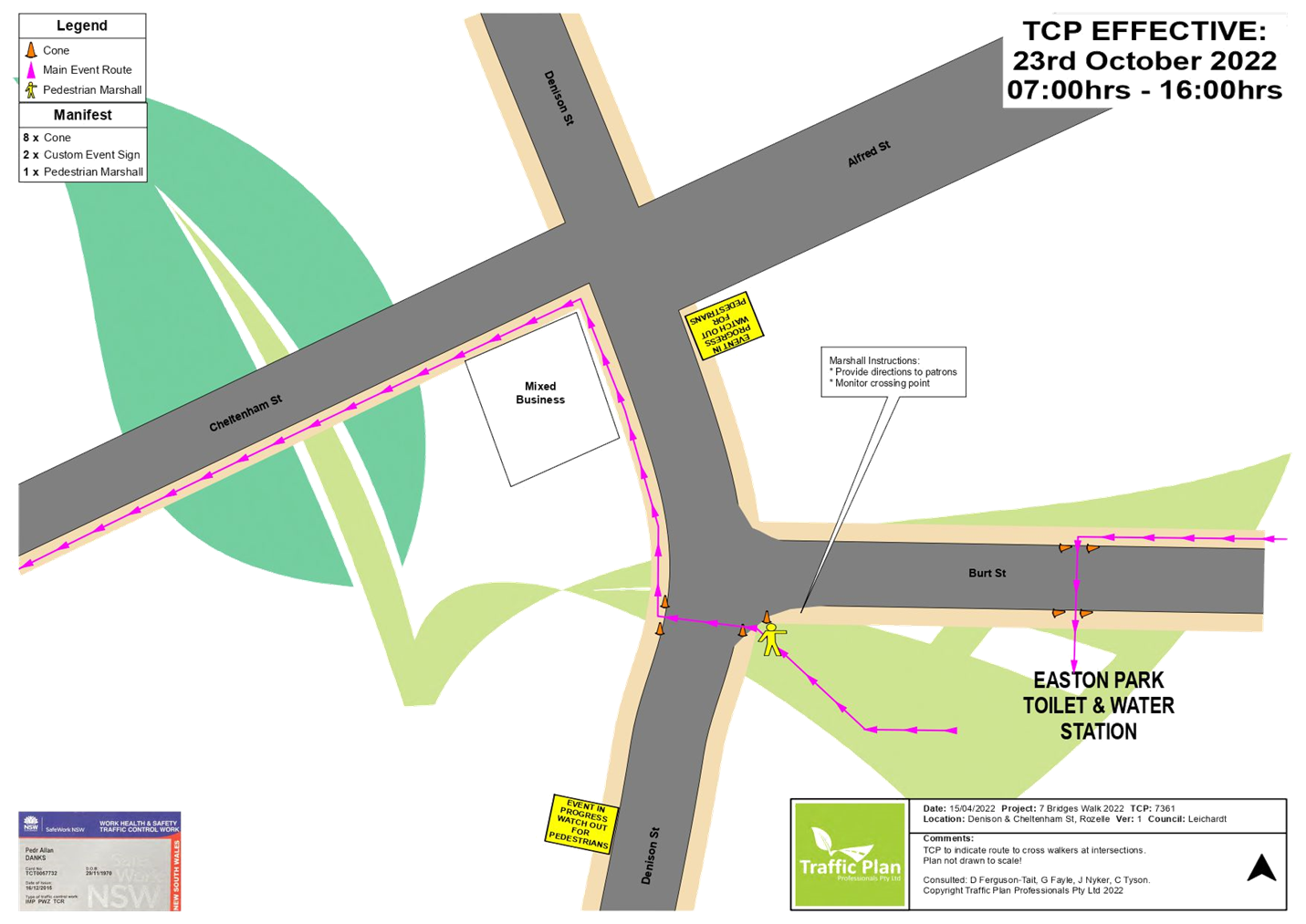
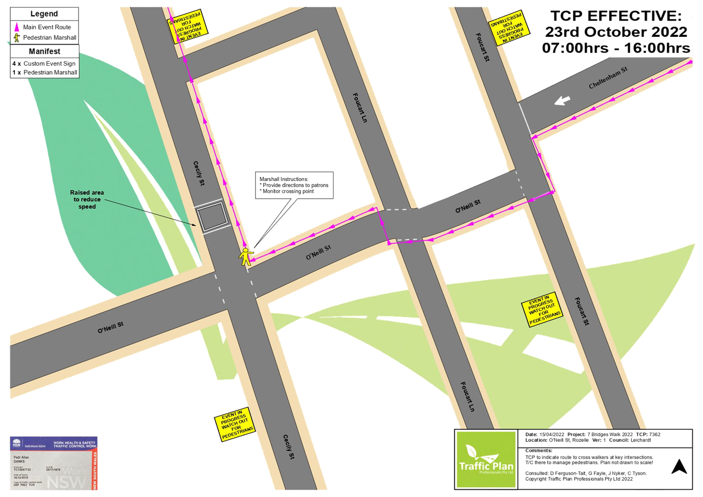
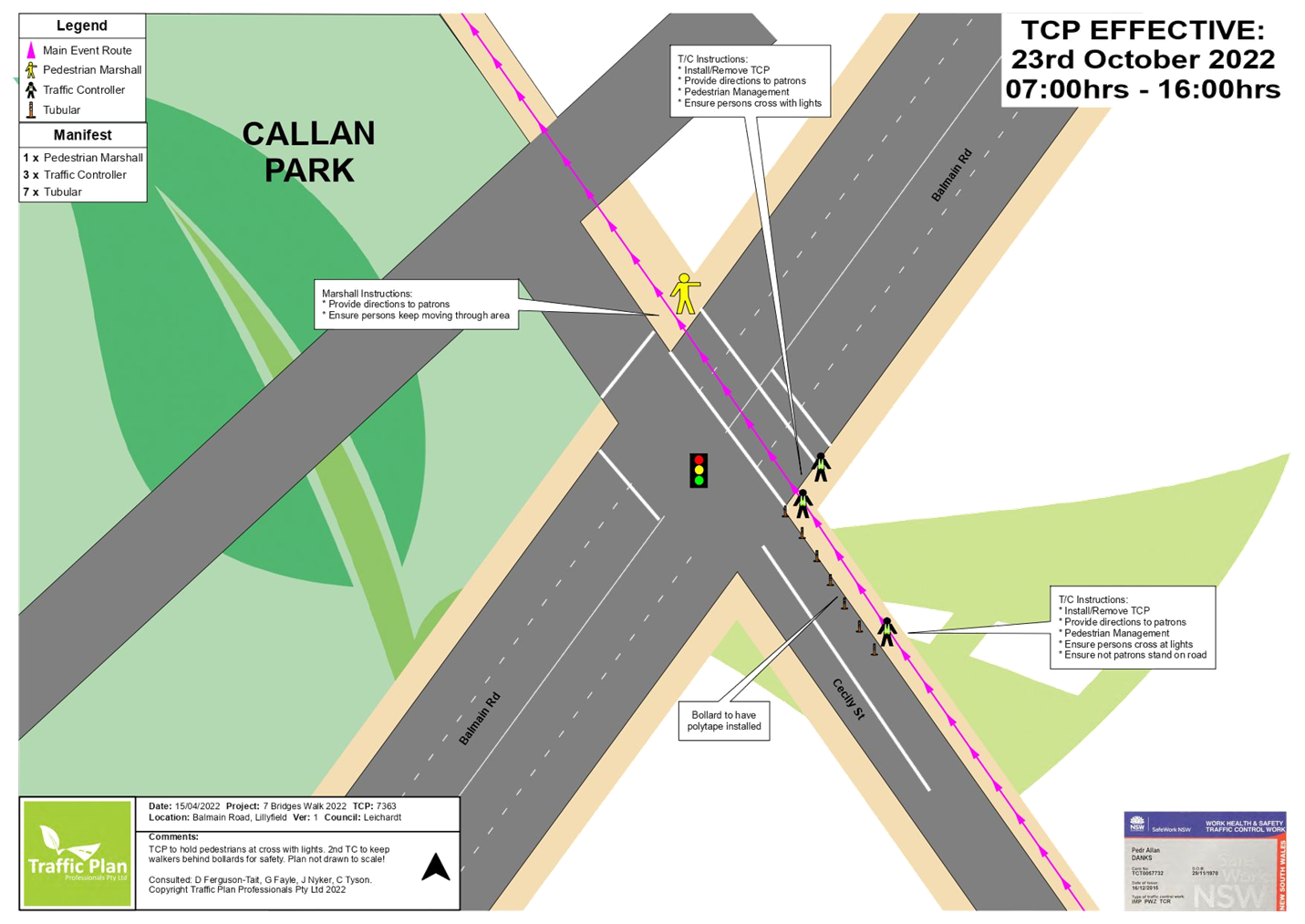
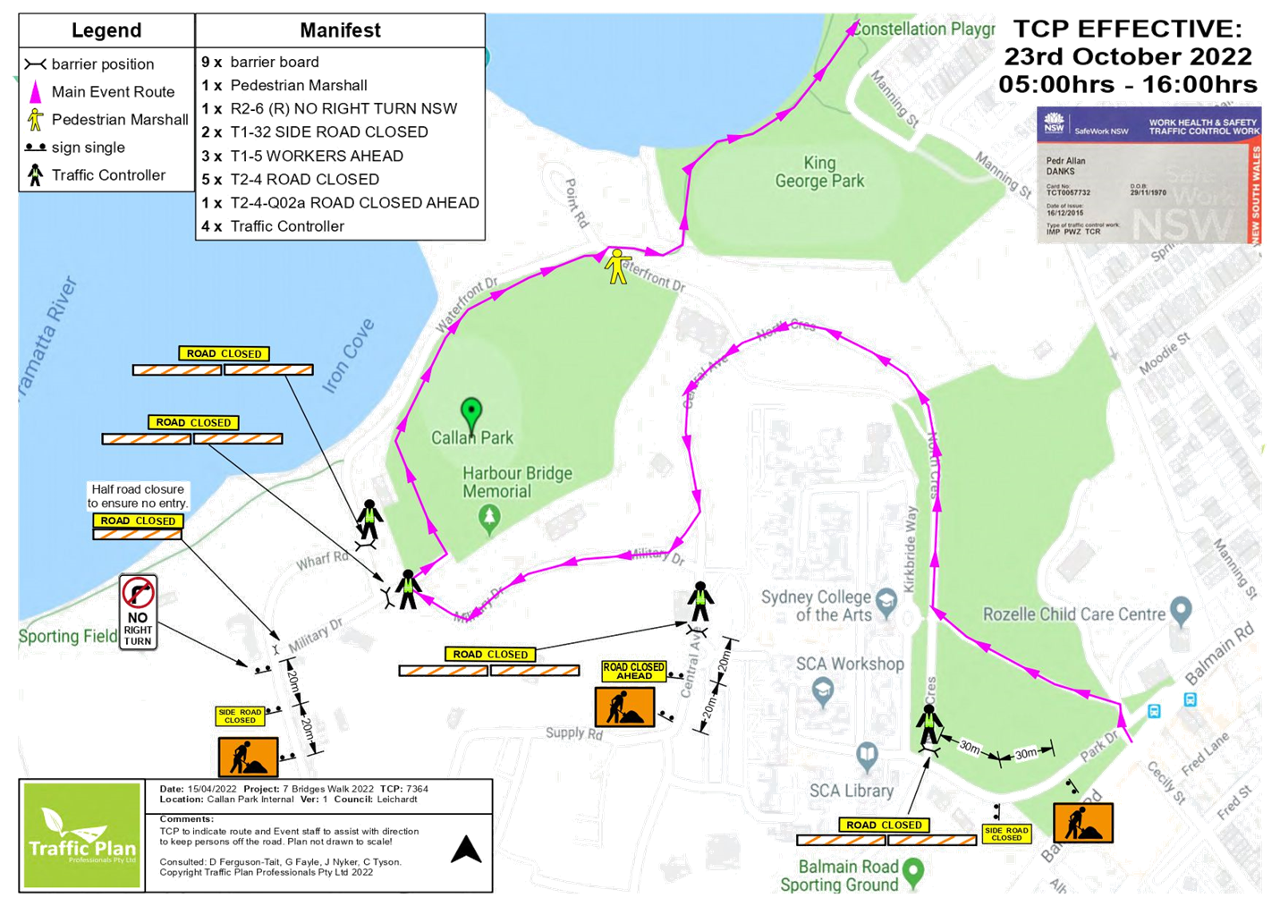
Subject: Seven Bridges Walk - Special Event (Gulgadga - Leichhardt & Baludarri - Balmain Ward/ Balmain Electorate/ Leichhard PAC)
Prepared By: Vinoth Srinivasan - Engineer - Traffic and Parking Services
Authorised By: George Tsaprounis - Coordinator – Traffic and Parking Services
SUMMARY
The Cancer Council NSW Seven Bridges Walk event will be held on Sunday, 23 October 2022 at various locations in Sydney, including areas within the Inner West Council. The Event is in its seventh year of operation and the applicant seeks approval again in 2022.
|
RECOMMENDATION
THAT the Cancer Council NSW Seven Bridges Walk to be held on Sunday, 23 October 2022 be approved, subject to a current Public Liability Insurance Policy which includes the Inner West Council being an interested party being submitted by the event organiser prior to the event. |
BACKGROUND & OTHER STAFF COMMENTS
The Cancer Council NSW Seven Bridges Walk concept was created and developed by the Pedestrian Council of Australia (PCA) who will remain the owner of the event. The PCA has engaged Mothership Events to deliver the Event Operations and manage the marketing of the Event on behalf of PCA. The Cancer Council NSW Seven Bridges Walk can be regarded as an active opportunity to further enhance the councils' and stakeholders' charter toward promoting walking as a healthy activity and as an increasingly important means of active transport. In addition, the event will provide a significant contribution to the Cancer Council NSW (CCNSW).
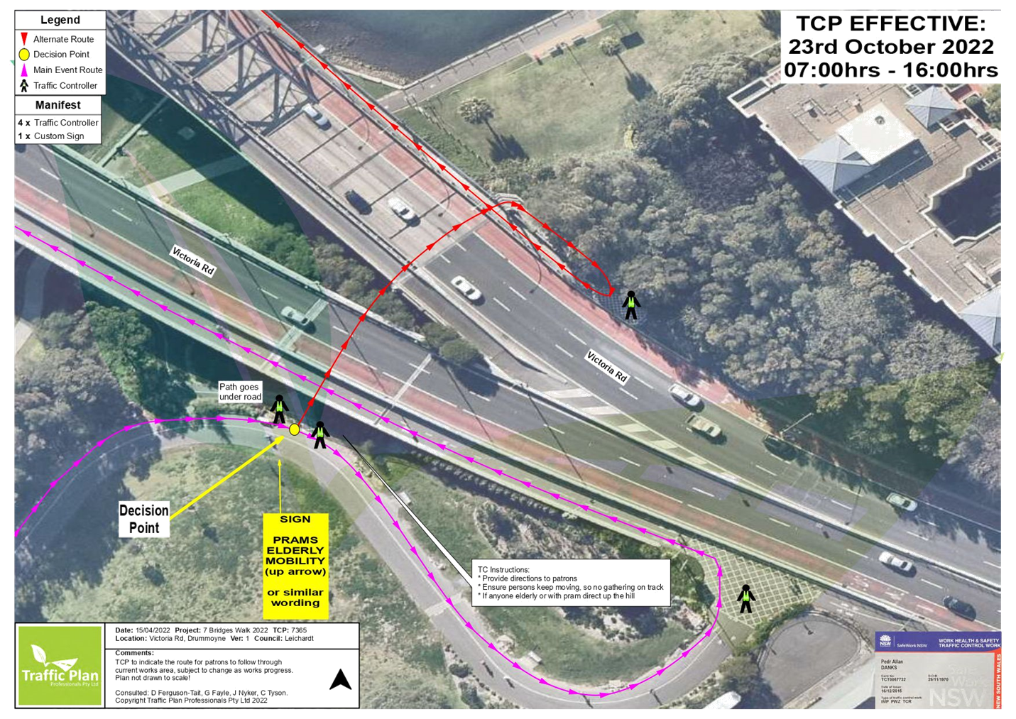
The course of CCNSW Seven Bridges Walk will open at 7:00am, and close at 4:30pm and it is estimated that it may attract up to 15,000 participants. The walking route is approximately 27km in length and is a closed loop circuit that utilises pathways around the inner metropolitan region of Sydney that skirts the Sydney Harbour and includes the crossing of seven bridges. Special event buses will operate in both directions around the course and will be provided free of charge to everyone holding an ‘event passport’.
Course Description:
The walking route is approximately 27km in length and is a closed loop circuit that utilises pathways around the inner metropolitan region of Sydney that skirts the Sydney Harbour and includes the crossing of Seven Bridges.
The Seven Bridges are:
1. Sydney Harbour Bridge
2. Pyrmont Bridge
3. ANZAC Bridge
4. Iron Cove Bridge
5. Gladesville Bridge
6. Tarban Creek Bridge
7. Fig Tree Bridge
Village Locations:
Event ‘Villages’ are located around the course and will be used as check-in locations, First Aid points, drink stations, light catering and entertainment.
The 6 villages are:
1. Milsons Point Village (Burton Street at Alfred Street, Milsons Point)
2. Pyrmont Village (at Pyrmont Bay Park, Pirrama Rd, opposite The Star Casino)
3. Rozelle Village (at Waterfront Drive Sporting Ground - Callan Park)
4. Hunters Hill Village (at Hunters Hill Scout Hall, Durham St near the Church St overpass on Burns Bay Road, Hunters Hill)
5. Lane Cove Village (Blaxlands Corner – Central Park, William Edward St and Kenneth St, Lane Cove)
6. Wollstonecraft Village (at Brennan Park, Hazelbank St at King St, Wollstonecraft)
Impact on the Inner West LGA
The route through the Inner West LGA is via:
· ANZAC Bridge to Victoria Road
· Pedestrian bridge over Victoria Road
· Lilyfield Road
· Burt Street
· Denison Street
· Cheltenham Street
· O’Neill Street
· Cecily Street
· Through Callan Park to King George Park
· Byrnes Street to Victoria Road
Traffic and Pedestrian Management Plan (TMP)
This event does not require closure of any roads in the Inner West LGA. As the participants will be using footpaths and crossing the street network with assistance of traffic controllers, the Event does not cause significant impacts on traffic and transport systems. Therefore, the Event can be considered as Class 3. Hence, Council’s approval for the Traffic & Transport Management Plan is adequate.
The attached Pedestrian and Traffic Management Plan (TMP), when approved by the relevant authorities, becomes the prime document detailing with the traffic and transport arrangements under which this event is to proceed.
In case of emergencies, or for the management of incidents, the Police are not subject to the conditions of the TMP but will make every effort to inform the other agencies of the nature of the incident and the Police response.
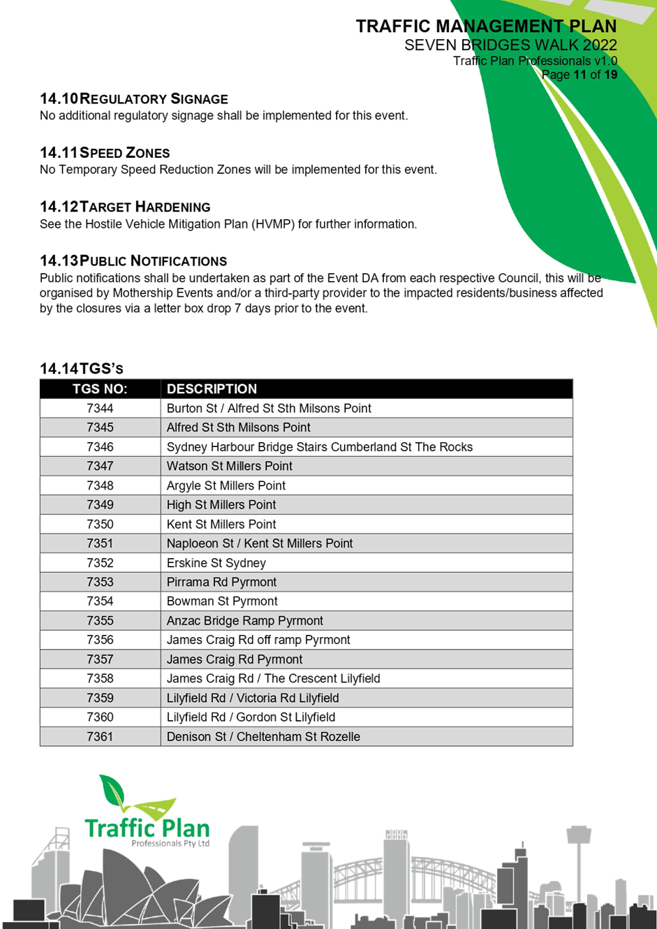
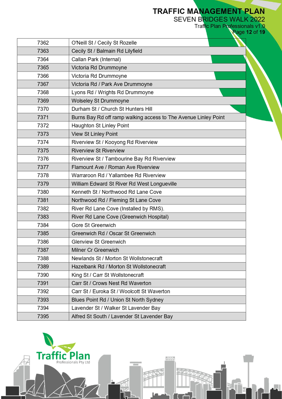
The route for the proposed Seven Bridges Walk and the Traffic Control Plans (TCP) and Traffic Management Plan for Inner West Council LGA are attached.
FINANCIAL IMPLICATIONS
All costs associated with the Seven Bridges Walk are funded by the event organisers.
|
1.⇩ |
Traffic Management Plan - Seven Bridges Walk 2022 |
|
2.⇩ |
Traffic Control Plan - Seven Bridges Walk 2022 |
|
Local Traffic Committee Meeting 20 June 2022 |
Subject: Trafalgar Street, Annandale - Proposed Raised Pedestrian Crossing (Gulgadya - Leichhardt Ward/ Balmain Electorate/ Leichhardt PAC)
Prepared By: Vinoth Srinivasan - Engineer - Traffic and Parking Services
Authorised By: George Tsaprounis - Coordinator – Traffic and Parking Services
SUMMARY
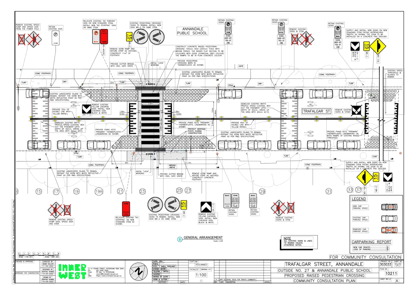
Council is planning to improve pedestrian safety in Trafalgar Street, Annandale outside No. 27 Trafalgar Street by upgrading the existing at-grade pedestrian crossing to a raised pedestrian crossing. The proposed works will improve pedestrian and motorist safety in the area. As part of the works, the two existing speed humps on either side of the existing pedestrian crossing will be removed.
|
RECOMMENDATION
THAT the attached detail design plan (Design Plan No.10211) for the proposed installation of a new raised pedestrian crossing on Trafalgar Street, Annandale be approved. |
BACKGROUND & OTHER STAFF COMMENTS
The detailed design plan shown in Attachment 1 outlines the proposed works on Trafalgar Street, Annandale and includes the following treatments:
- Installation of a new concrete raised Pedestrian Crossing in place of the existing at-grade pedestrian crossing;
- Construction ‘gutter bridges’ with heel safe grating to provide safe access over existing kerb and guttering to the new raised pedestrian crossing;
- Removal of the two existing asphalt speed humps on either side of the proposed raised pedestrian crossing;
- Reconstruction of some of damaged sections of concrete footpath with new concrete footpath on both sides of the proposed pedestrian crossing, including removal of some existing grass verge and replacing with new concrete footpath;
- Adjustment of some of the existing “No Parking” and “No Stopping” zones and signage, without impacting the existing car parking spaces; and
- Installation of associated pavement line marking and signage as required.
FINANCIAL IMPLICATIONS
Funding of $70,000 has been allocated to this project for construction in the 2021/2022 Federal Stimulus Program.
PUBLIC CONSULTATION
A letter outlining the proposal was mailed out to 67 properties in Trafalgar Street, Annandale requesting residents’ views regarding the proposal. 2 responses were received with one (1) in general support with request for changes and one (1) in objection.
The main traffic and parking related concerns raised by the residents are outlined in the below table:
|
Residents’ Comments |
Officer Comments |
|
The proposal will create safety concerns for residents exiting the driveway of No.33 Trafalgar Street. A convex mirror should be installed on the opposite side of the street. |
The installation of a convex mirrors are not warranted as they are only installed on narrow streets with low travel speeds. Additionally, mirrors are installed to benefit the general public, not to serve an individual property. |
|
Do not support the removal of the of the existing asphalt speed humps. |
The removal of the existing speed humps on either side of the pedestrian crossing is required as it would result in three speed humps in close proximity to one another. |
|
The proposal will result in drivers overtaking parked cars on the pedestrian crossing during school drop-off and pick-up times. |
Overtaking on a pedestrian crossing is against the NSW Road Rules as it is linemarked with double centre lines on both approaches. |
|
The surrounding car spaces will not be able to be utilised when the proposed works are taking place. |
There will be a temporary impact on the existing car spaces during construction only. |
|
1.⇩ |
Detailed Design Plan - Trafalgar Street, Annnandale - Proposed Raised Pedestrian Crossing |
|
|
Local Traffic Committee Meeting 20 June 2022 |
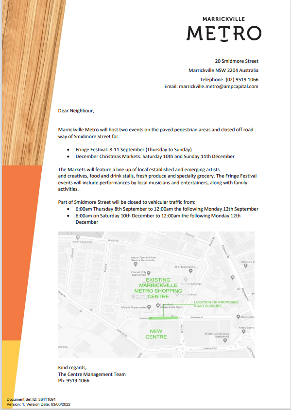
Subject: Smidmore Street, Marrickville – ENRC/2022/0022 - Temporary full road closure for two Marrickville Metro events the Fringe Festival 8-12 September 2022 and 10-12 December 2022 Markets and related temporary changes to Victoria Road kerbside parking restrictions to accommodate relocation of community bus (Midjuburi – Marrickville Ward / Heffron Electorate / Inner West PAC)
Prepared By: Jennifer Adams - Engineer – Traffic and Parking Services
Authorised By: George Tsaprounis - Coordinator – Traffic and Parking Services
SUMMARY
Council has been notified by MLA Transport Planning, on behalf of Marrickville Metro Shopping Centre, about two proposed temporary full road closures of Smidmore Street, between Murray Street and the Centre’s Smidmore Street car park access, Marrickville for the Fringe Festival 8-12 September and for the 10-12 December 2022 Marrickville Metro Market event. The closures will involve related temporary changes to Victoria Road kerbside parking restrictions to accommodate relocation of the community bus stop. It is recommended that the proposed temporary road closures be approved subject to all standard Council conditions for a temporary full road closure. The related changes to kerbside signage be approved also subject to all works and costs associated with the signage changes for the relocated 'Community Bus zone' and reinstatement of Council’s original parking restrictions is to be borne by the applicant.
|
RECOMMENDATION
1. THAT the proposed temporary full road closure of Smidmore Street, between Murray Street and the Smidmore Street car park access, Marrickville for a four day period 6am Saturday 8 September to midnight Monday 12 September 2022 and for a two day period 6am Saturday 10 December to midnight Sunday 11 December 2022 for the purpose of holding two different Marrickville Metro Shopping Centre events (the Fringe Festival and the second weekend December markets) be APPROVED, subject to the applicant complying with, but not limited to, the following conditions: a. A Road Occupancy License application be obtained by the applicant from the Transport Management Centre; b. All affected residents and businesses, including NSW Police Local Area Commander, Transit Systems, Fire and Rescue NSW and NSW Ambulance Services, shall be notified in writing by the applicant of the proposed temporary road closure at least 7 days prior to the event, with the applicant making reasonable provision for residents and businesses; c. The occupation of the road carriageway must not occur until the road has been physically closed; and d. A clear unobstructed 4-metre-wide path of travel throughout the site is recommended to be maintained at all times for emergency vehicle access, in order to provide safe egress in case of fire or other emergency.
2. THAT the proposed short-term temporary changes to parking restrictions in Victoria Road, Marrickville as per plans submitted by MLA Transport Planning (20008ppt05A-220225 Community Bus Stop Relocation Plan (002)) be approved subject to the following conditions:
a. All works and cost of the supply, installation and removal of the signage associated with the temporary community bus relocation is to be borne by the applicant; b. The temporary removal and reinstatement of any Council assets will be at the applicants cost and to Council’s Traffic Engineers satisfaction; and Notification of surrounding properties be undertaken at least 7 Days prior to installation of the temporary changes and relocated 'Bus Zone'. |
BACKGROUND
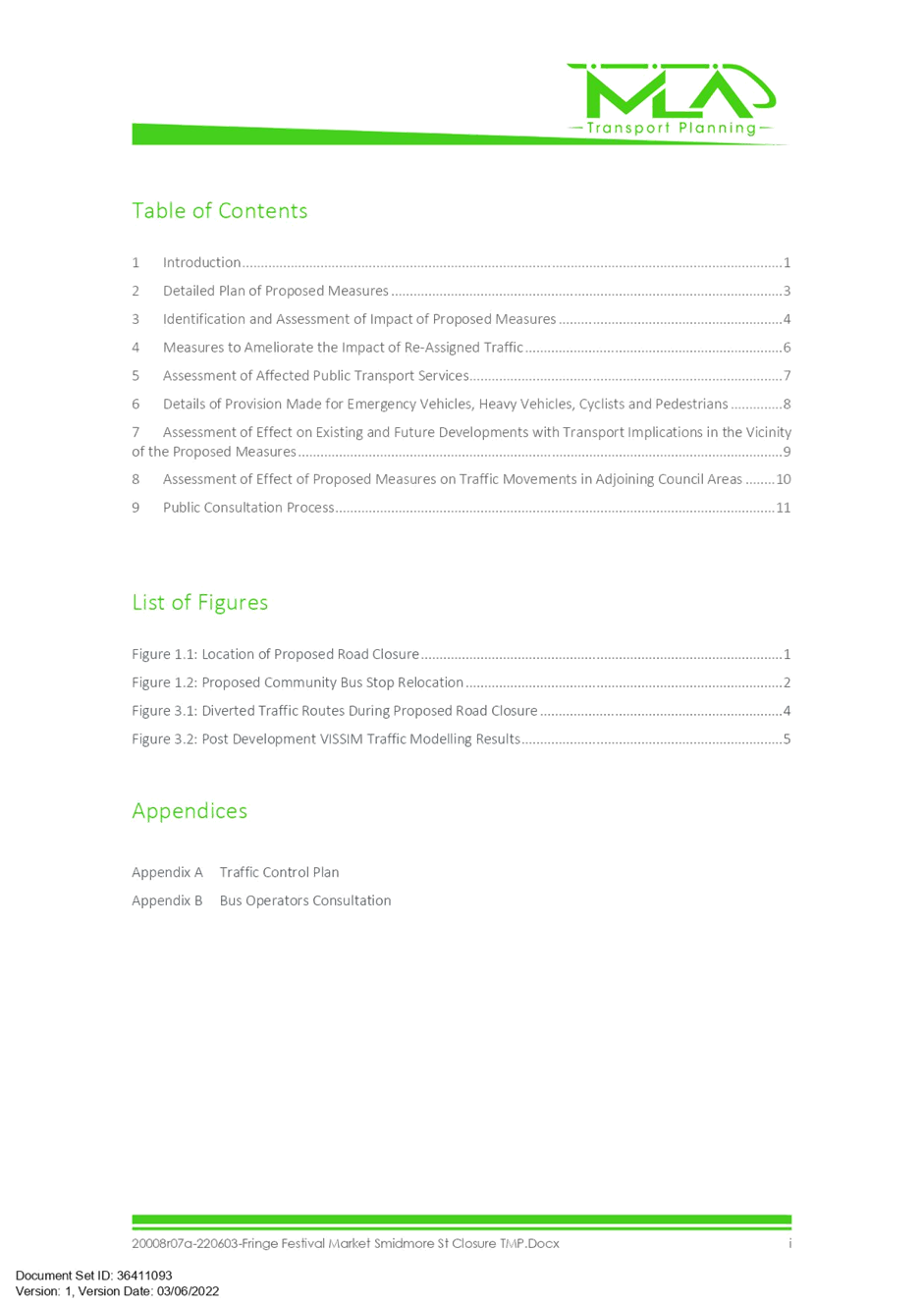
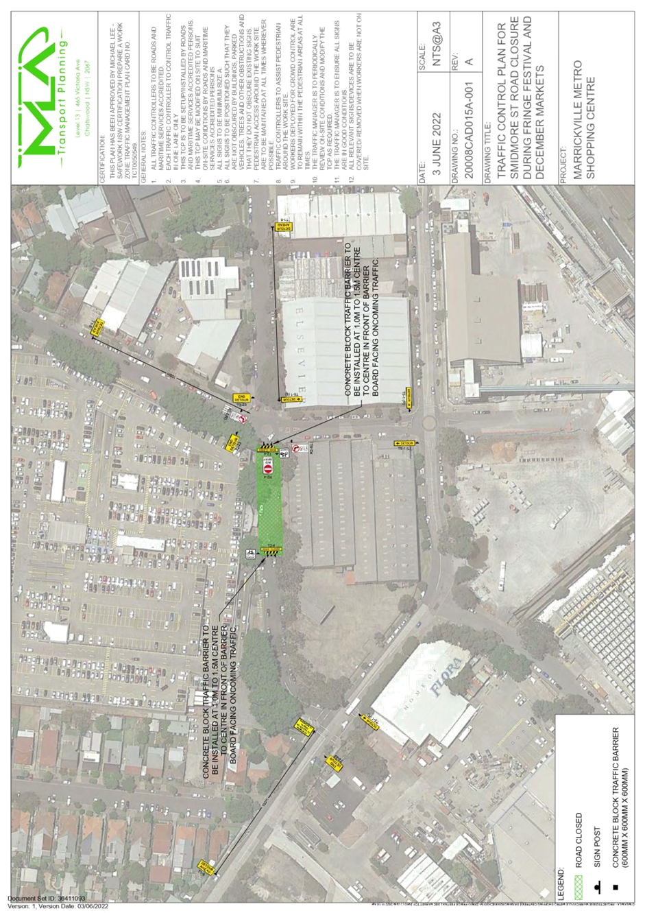
It is proposed to close Smidmore Street (between Murray Street and the car park access) to vehicular traffic from 6:00am Thursday to 12:00am the following Monday when the Fringe Festival is being held.
In addition to the above Fringe Festival event, it is also proposed to close the same section of Smidmore Street for the purpose of holding market stalls in the second weekend of December 2022 i.e., Saturday 10th December 2022 to Sunday 11th December 2022. During the market event, the road is proposed to be closed from 6:00am on Saturday and re-opens to the public again 12:00am the following Monday.
The location of the proposed road closure is shown in the diagram below.
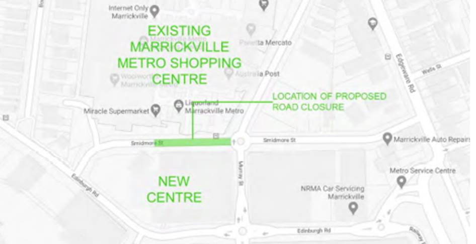
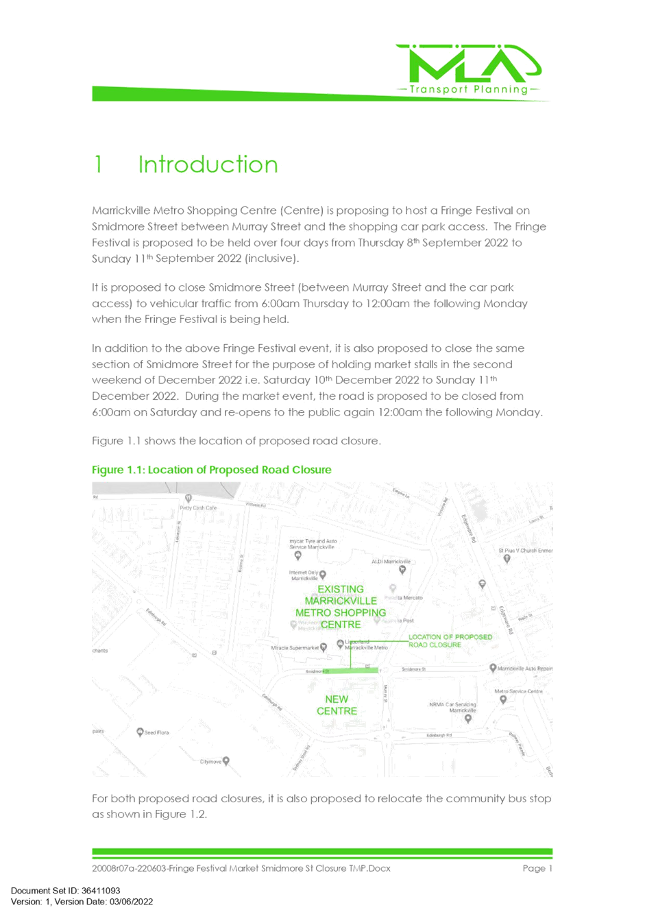
For both proposed road closures, it is also proposed to relocate the community bus stop to Victoria Road in front of the main pedestrian entrance to the existing Centre as shown below.
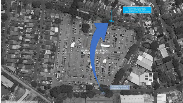
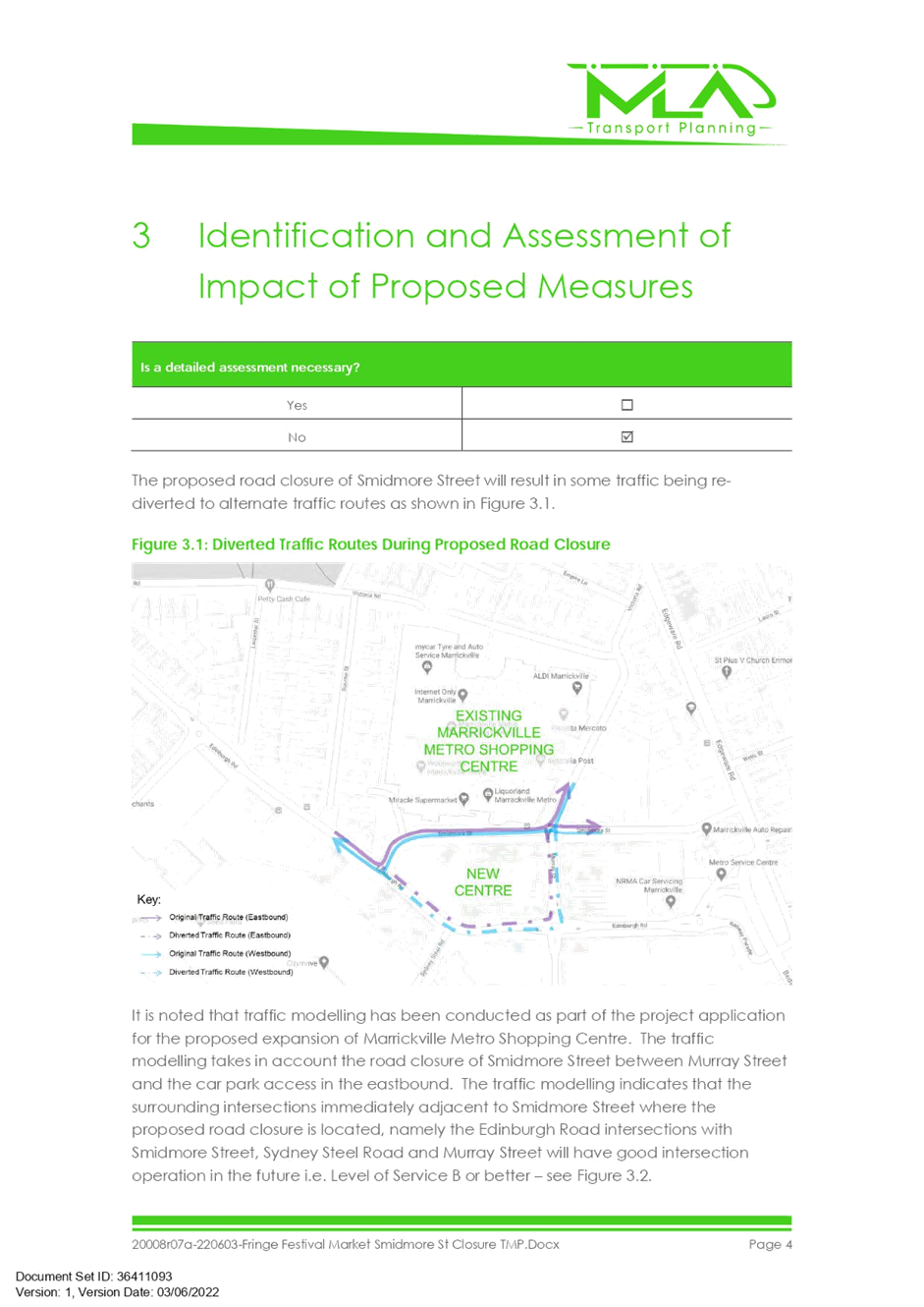
The proposed road closure of Smidmore Street will result in some traffic being rediverted to alternate traffic routes as shown below.
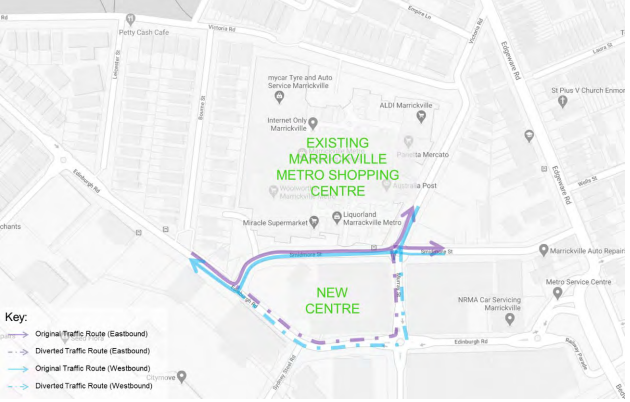
The section of Smidmore Street between Edinburgh Road and the car park access will remain open to continue to permit access to the car park and the taxi rank on the southern side of Smidmore Street. Through traffic along Smidmore Street to/from Murray Street will not be permitted except for cyclists. However, cyclists will be required to dismount from their bicycle whilst using the closed section of Smidmore Street.
The taxi rank on Smidmore Street (near Edinburgh Road) will continue to operate as per normal. Bus services in the area will not be affected by the proposed closures as buses do not require to access the section of Smidmore Street that is proposed to be closed.
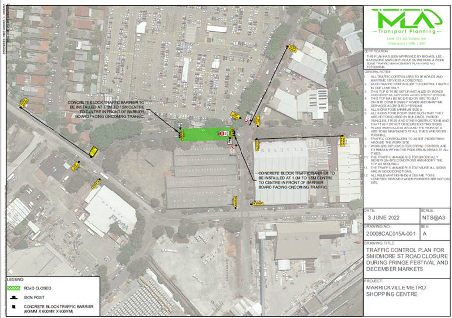
The supplied TCP is reproduced below and the TMP is attached at the end of this report.
Under Council’s Fees & Charges, the applicant is to pay a fee for the temporary full road closure along with any other required road occupancy and/or road opening permit fees.
All works and costs of implementation works associated with the recommended temporary relocation of the Community Bus Zone relocations will be borne by the applicant as will the reinstatement of any of Council approved signage at the end of the temporary relocation period.
PUBLIC CONSULTATION
The applicant is to notify all affected residents and businesses in writing at least 7 days prior to the commencement of works. A copy of the notification is attached at the end of this report.
The proposed road closure has been advertised on Council’s website in accordance with the Roads Act 1993.
In relation to the relocation of the community bus the applicant is to notify all affected residents and businesses in writing at least 7 days prior to the commencement of works
|
1.⇩ |
ECM_36411093_v1_ - - Traffic Management Plan |
|
Local Traffic Committee Meeting 20 June 2022 |
Subject: YEO PARK, SUMMER HILL-FORMALISATION OF
OFF-ROAD SHARED BICYCLE-PEDESTRIAN PATH, BETWEEN VICTORIA STREET AND PROSPECT
ROAD.
(DJARRAWUNANG-ASHFIELD WARD/SUMMER HILL ELECTORATE/ASHFIELD
PAC)
Prepared By: Boris Muha - Engineer – Traffic and Parking Services
Authorised By: George Tsaprounis - Coordinator – Traffic and Parking Services
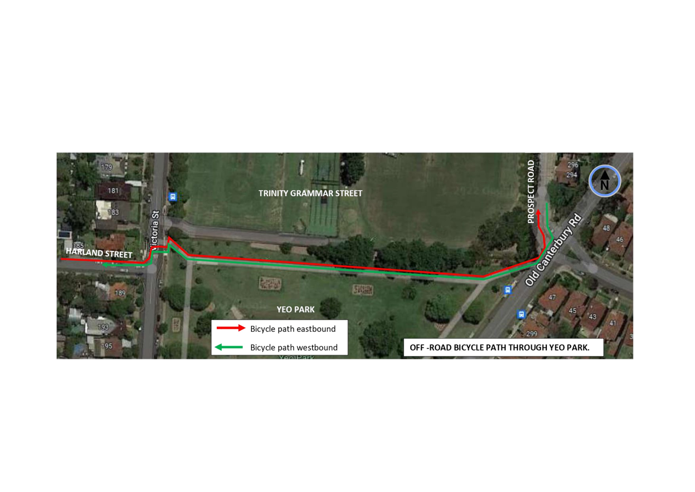
SUMMARY
Council at its meeting on the 10 May 2022 approved safer road crossing treatments for pedestrians and bicyclists at the intersections of Harland Street/Victoria Road, and Prospect Road/Old Canterbury Road, Summer Hill. Bicyclist movements are linked east to west between the two intersections via an off-road shared pedestrian-bicycle path through Yeo Park, which has not been formalised as of this moment to the required guidelines.
This report deals with the formalisation of the shared pedestrian-bicycle path through Yeo Park in treatment with signs and line marking between Harland/Victoria Street and Prospect Road.
|
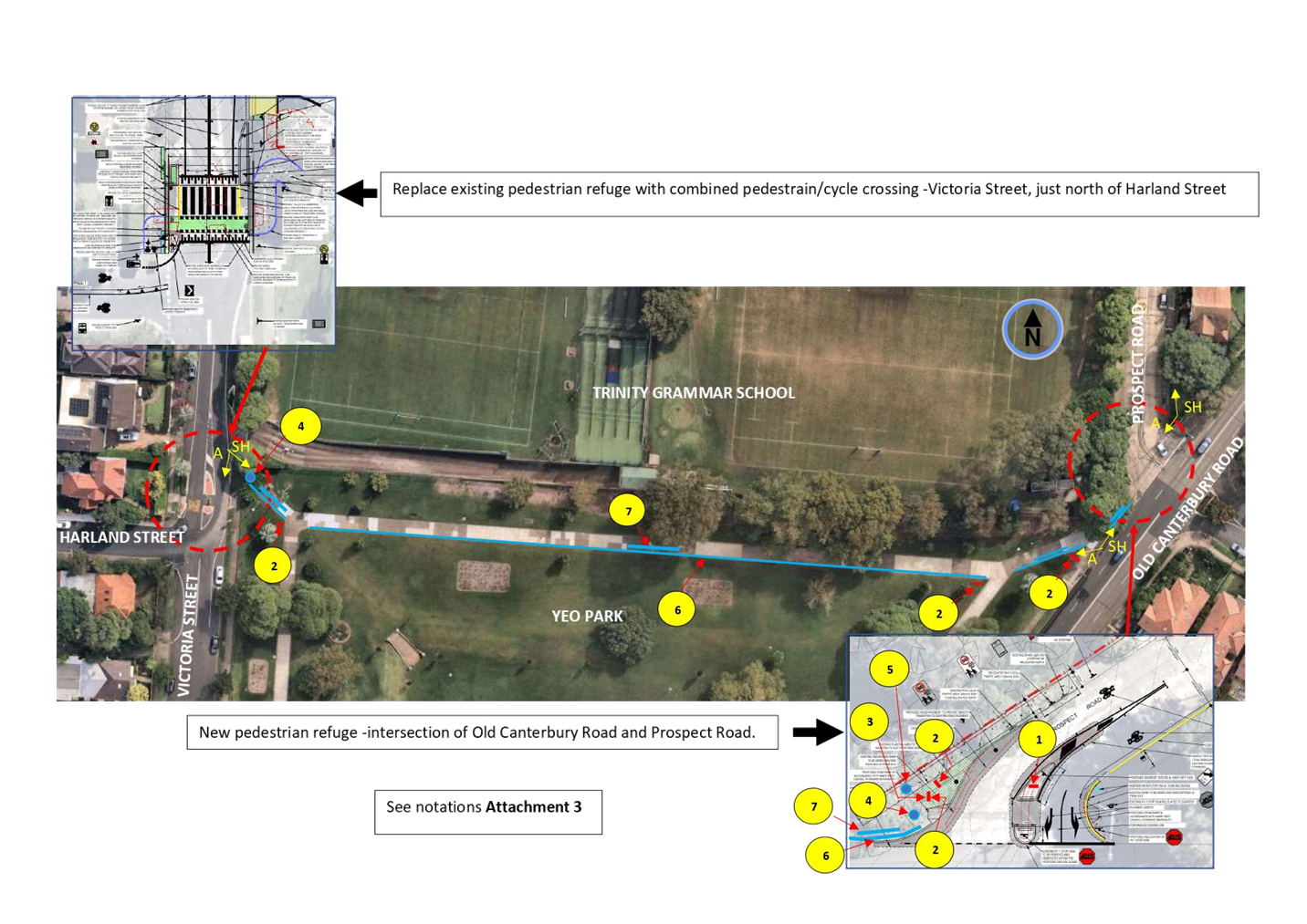
RECOMMENDATION
THAT the formalised treatment of the (off-road) shared pedestrian-bicycle path through Yeo Park, Summer Hill, with signs and line marking as shown in the plan and notations of ATTACHMENTS 2 and 3, be APPROVED.
|
BACKGROUND
The pathway across Yeo Park is designated as an off-road bicycle route under the Inner West Council Cycling Map and Guide, and the route is shown on plan ATTACHMENT 1.
The physical treatments to the intersections are part of the approved development expansion of the Trinity Grammar School for improved traffic and pedestrian safety in the area. The devices have also been designed to cater for cyclists to come off from Harland Street (on-road) across Victoria Street onto Yeo Park (off-road) and then back on road to Prospect Road and visa-versa.
-See ATTACHMENT 2.
FINANCIAL IMPLICATIONS
The proposed sign and line marking works are estimated around $8500 and will be funded under Council’s general signs and line marking budget.
OTHER STAFF COMMENTS
The following is noted with discussions made with the TfNSW representative.
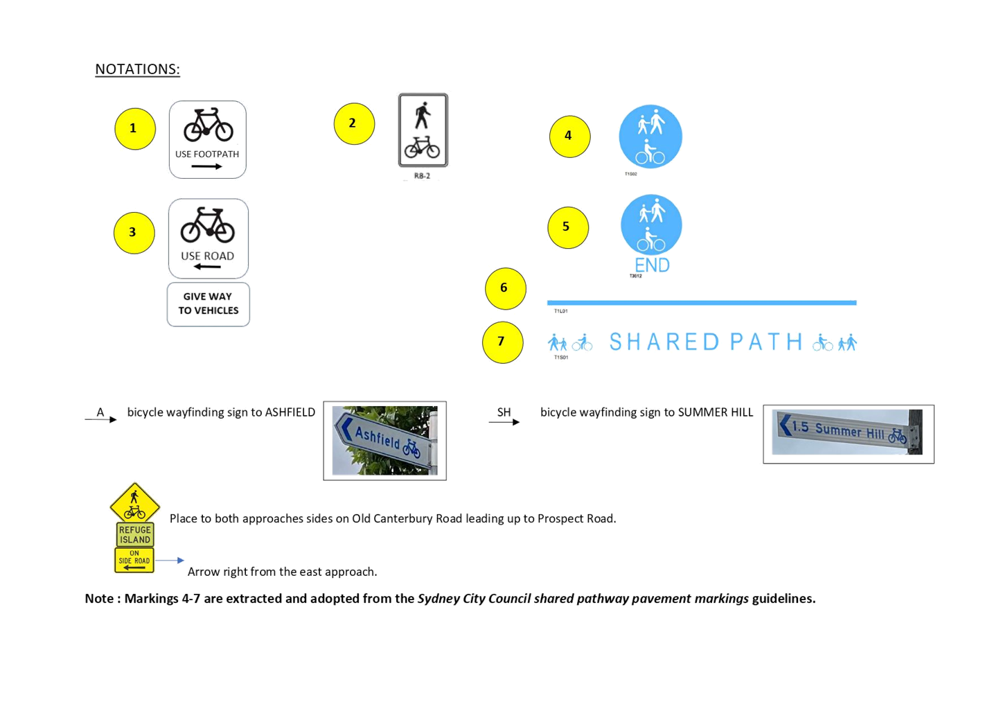
· Signs and marking are in reference to the NSW bicycle guidelines and the Sydney City Council shared pathway pavement markings guidelines-See Attachments 2 and 3.
· TfNSW accepts the use of pavement symbols and lines (identified as notations 4-7 in Attachment 3) in conjunction with other signage in formalisation of the shared path. These are extracted from Sydney City Council shared pathway pavement marking guidelines.
· The pram ramp to the western corner of Prospect Road at Old Canterbury Road is to be made at 2.1 m wide (as per Council standard) for the combined use of pedestrians, and cyclists coming off and onto Prospect Road.
· The pram ramp to the eastern corner of Prospect Road will be widened to 1.8m (instead of the standard 1.2m) for pedestrians crossing to and from the refuge in Prospect Road as requested by the TfNSW representative.
· Designed guidance/way finding signs are incorporated to direct bicyclists from on-road to off-road and visa-versa.
· Advanced warning signage is provided on both approach side of Old Canterbury Road to Prospect Road to warn motorists of pedestrian and cyclist activity in the side street (being Prospect Road).
The physical intersection (device) treatments are programmed to be constructed within the next 1-2 years by the Trinity Grammar School developer. The shared path works in Yeo Park, and in connection between the two intersection devices will be carried out by Council in conjunction with or separately following the completion of the intersection devices done by the developer.
PUBLIC CONSULTATION
Not required. No changes are made to traffic and parking.
|
1.⇩ |
Off-road bicycle route through Yeo Park |
|
2.⇩ |
Formalisation of shared path with signs and markings |
|
3.⇩ |
Notation-details for shared path signs and markings. |
|
|
Local Traffic Committee Meeting 20 June 2022 |
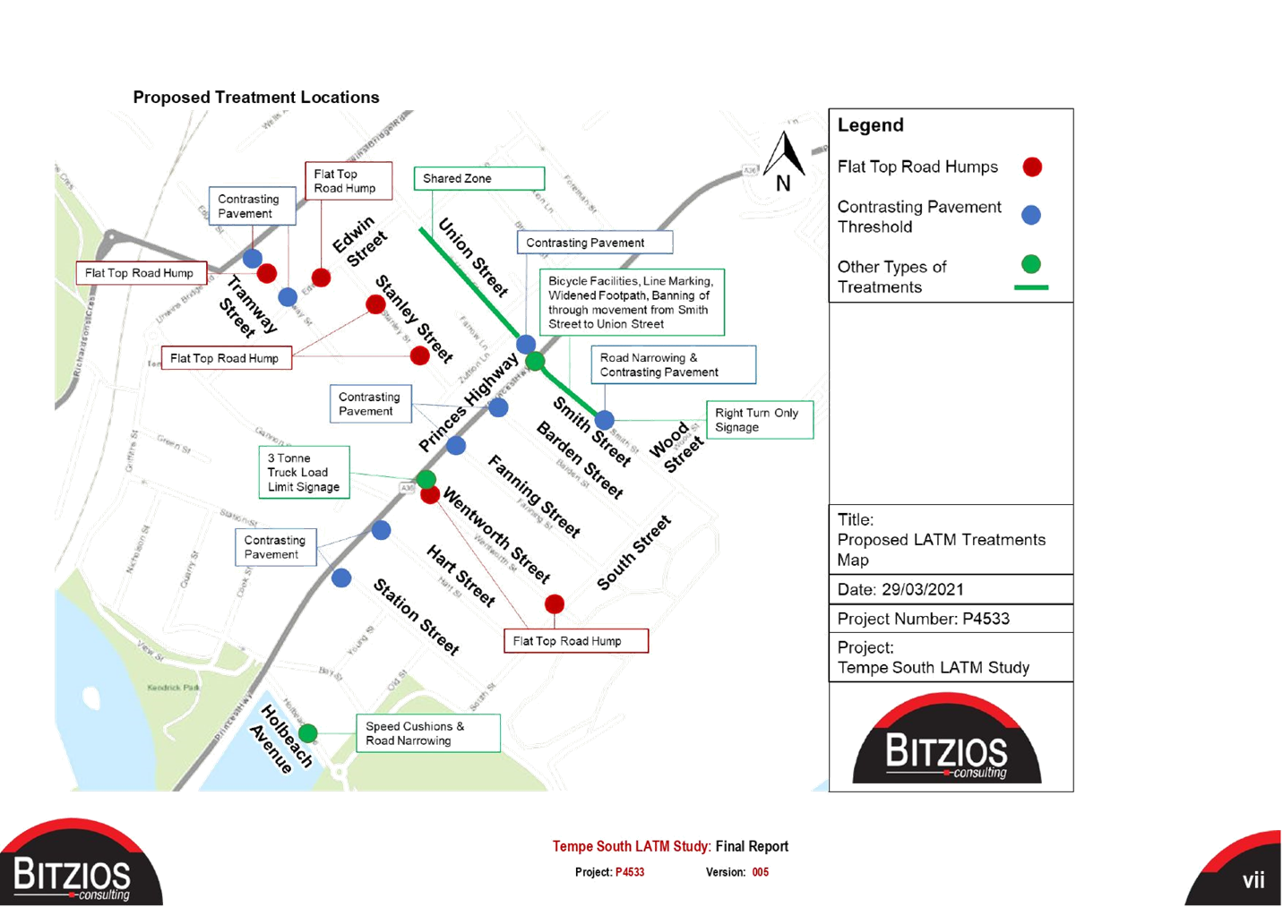
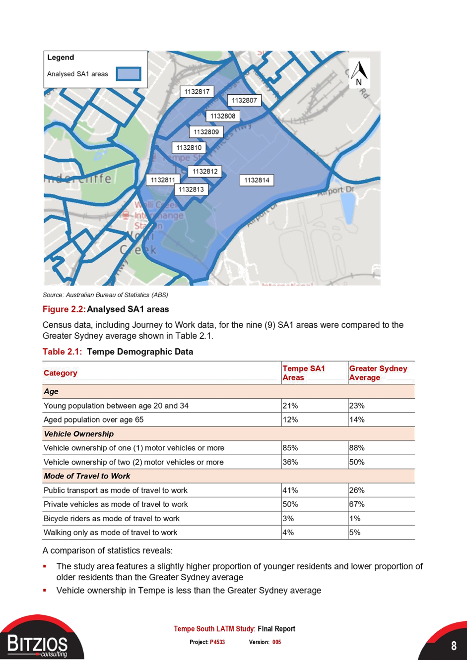
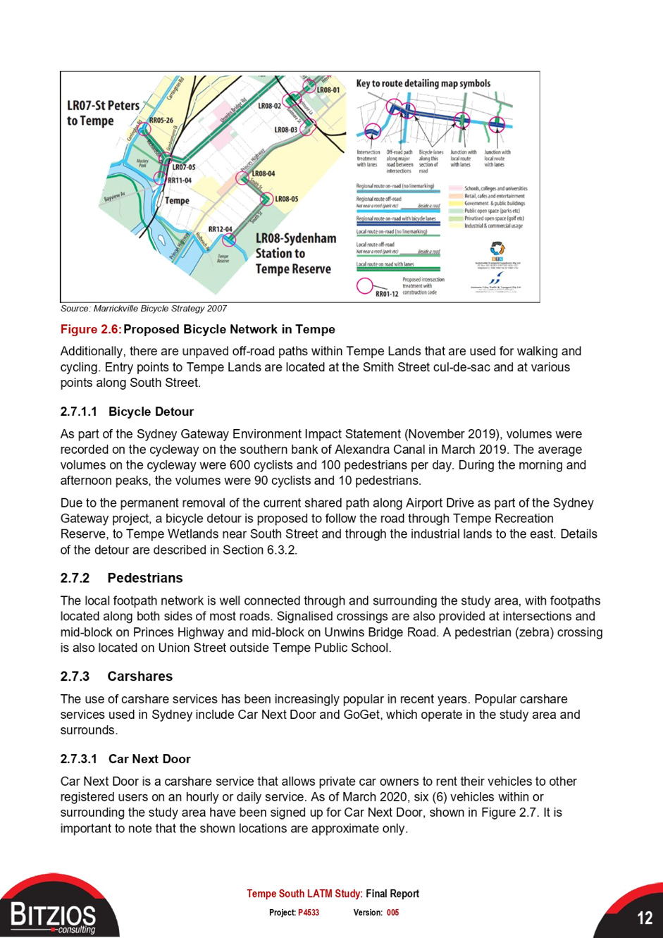
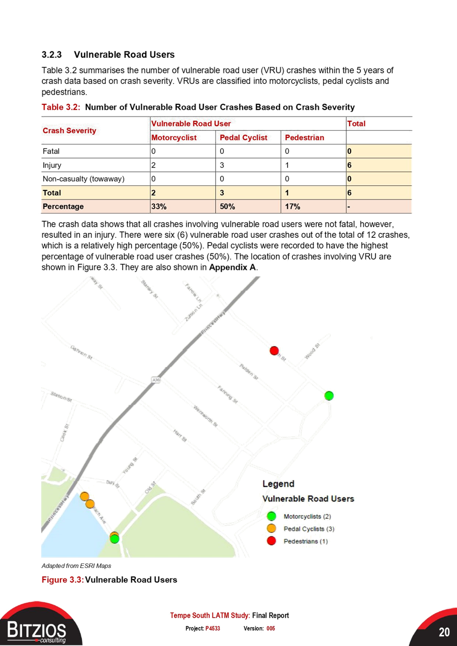
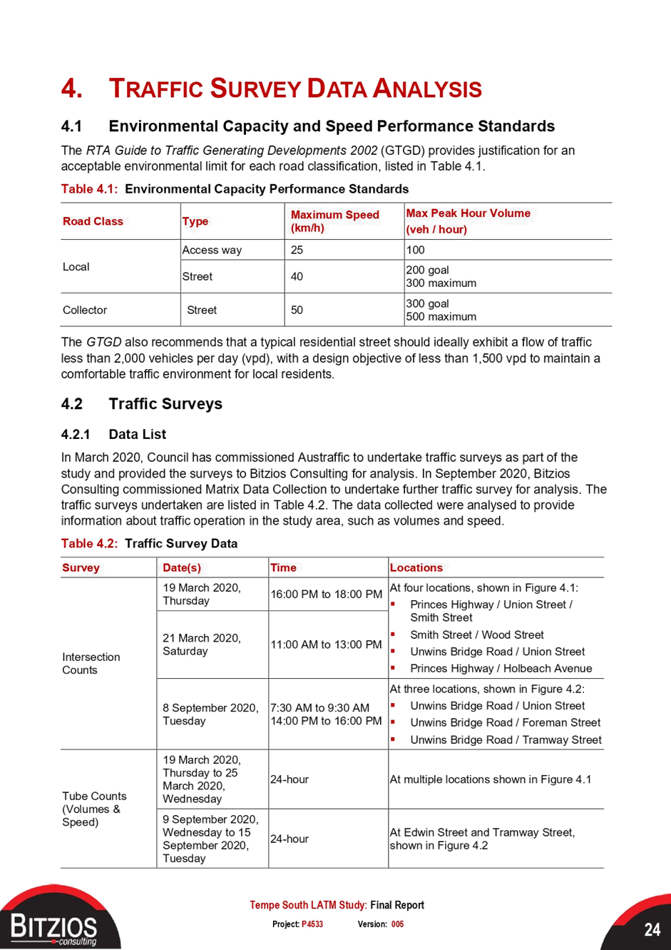
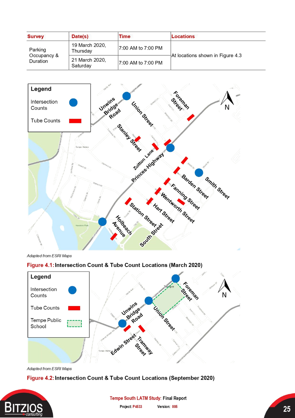
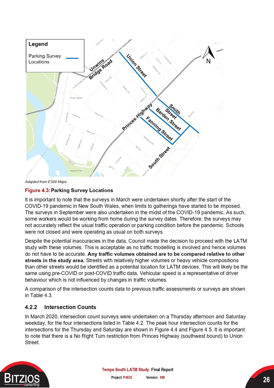
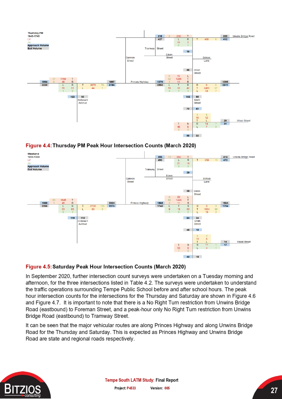
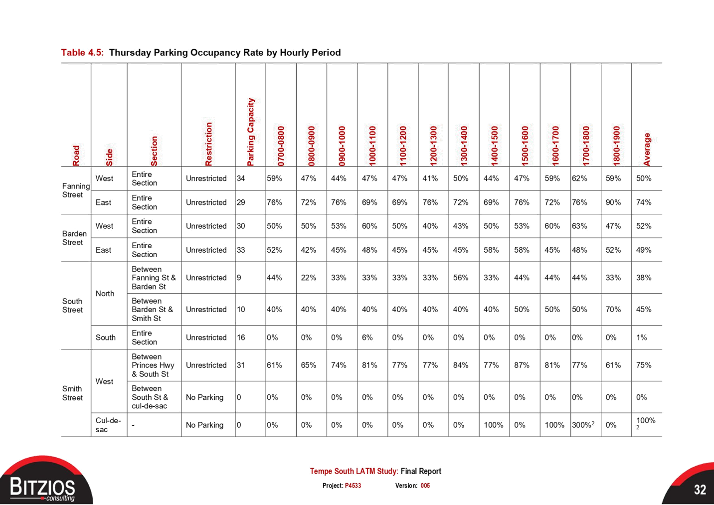
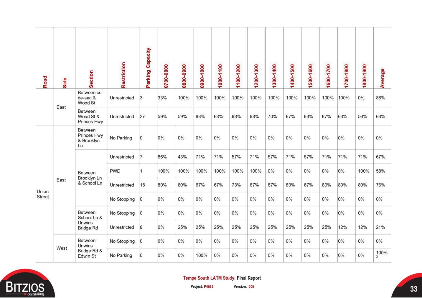
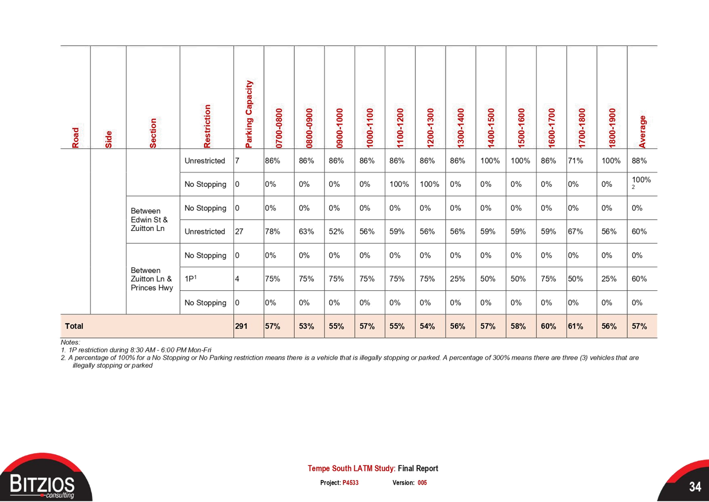
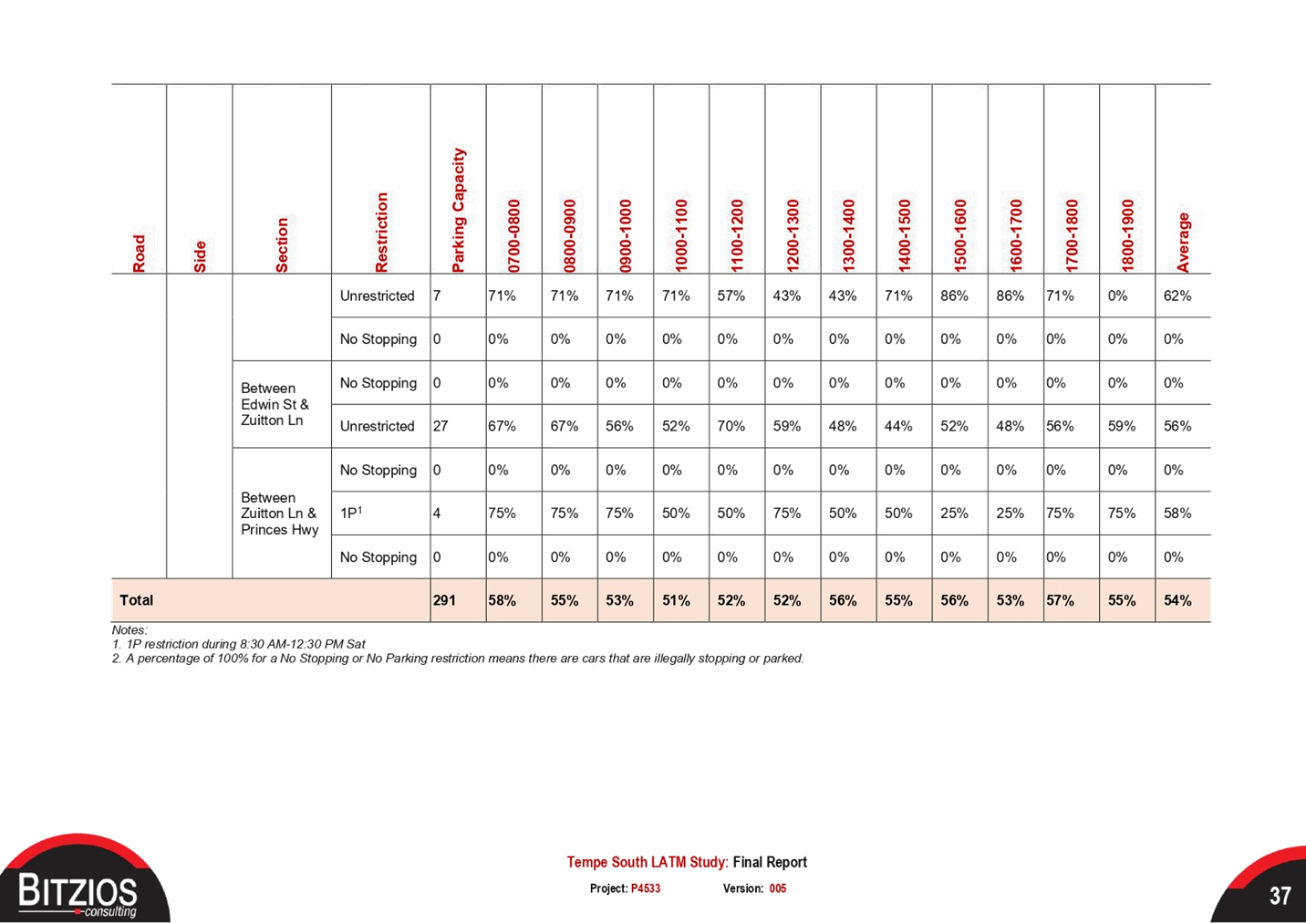
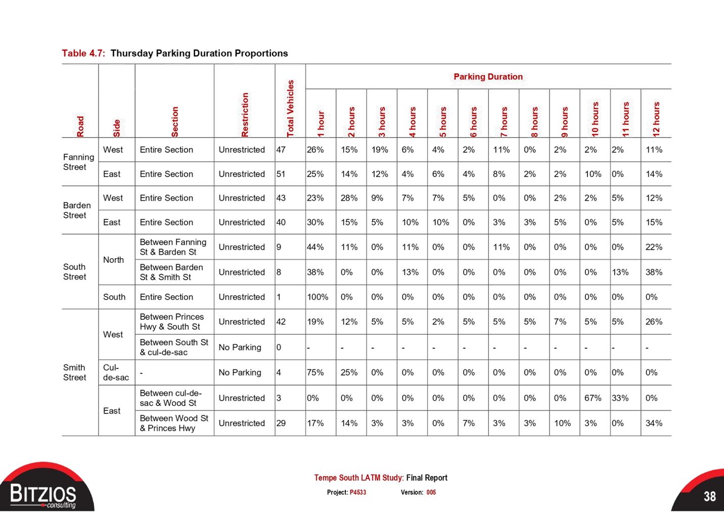
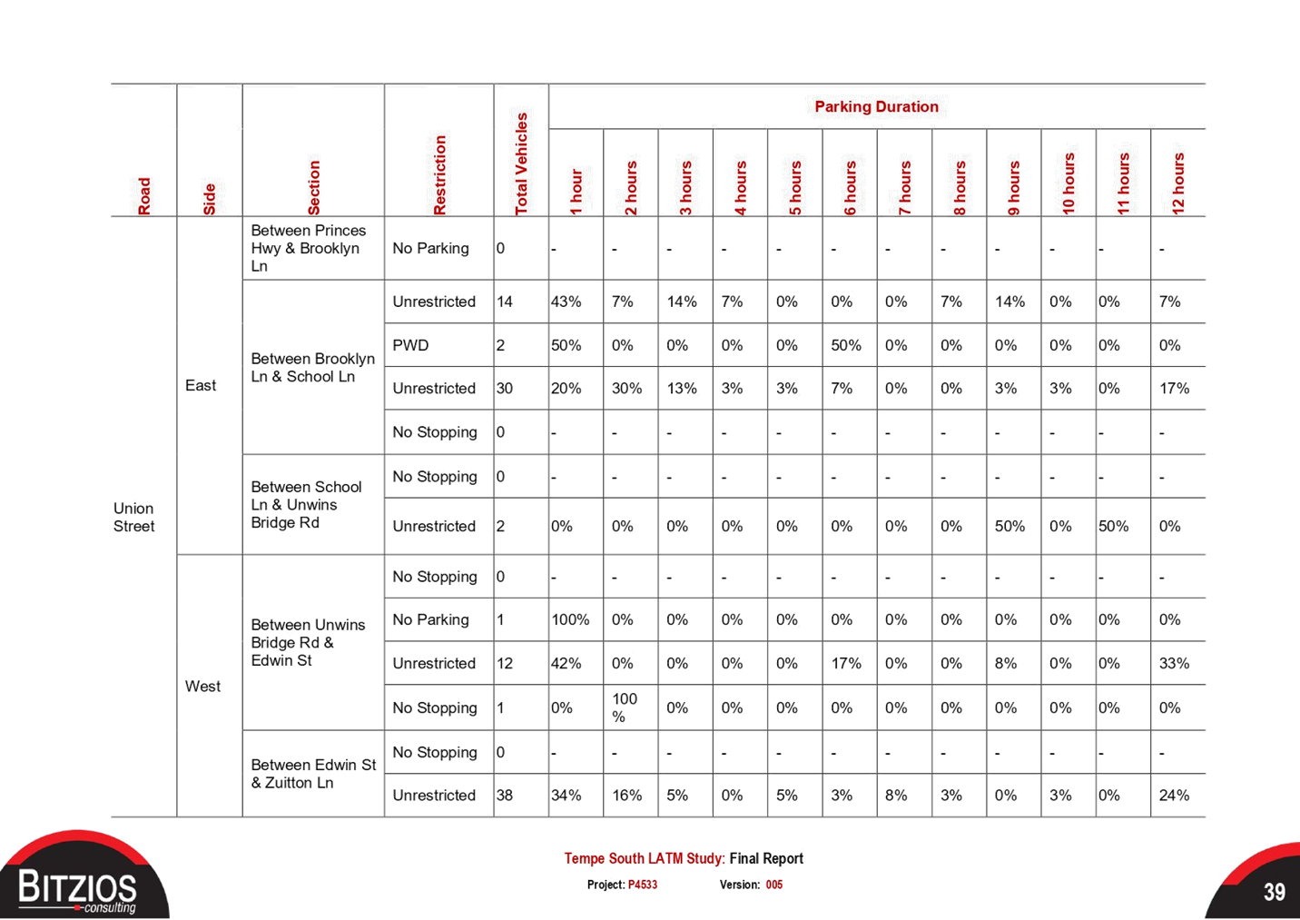
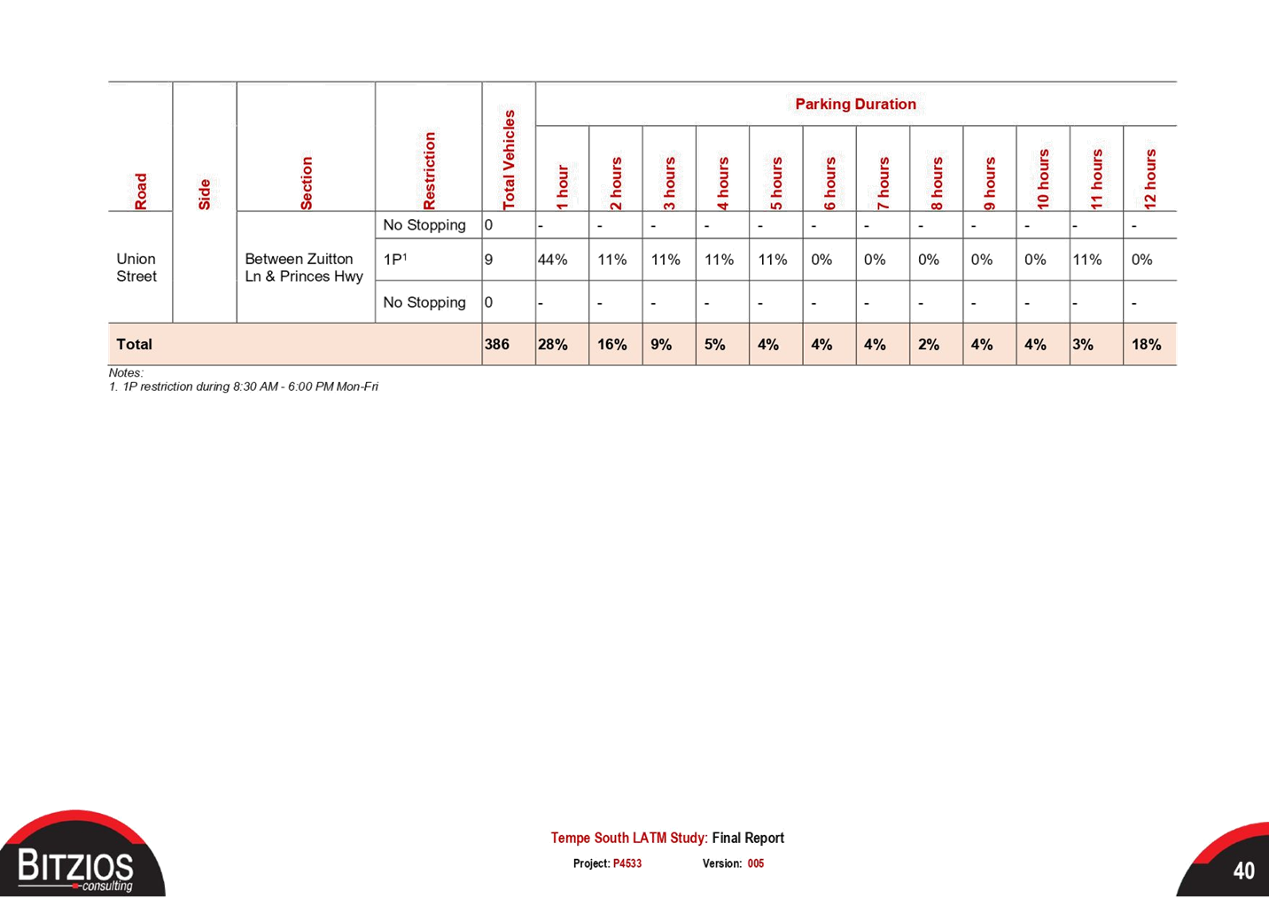
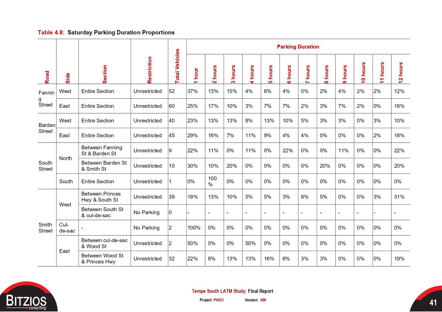
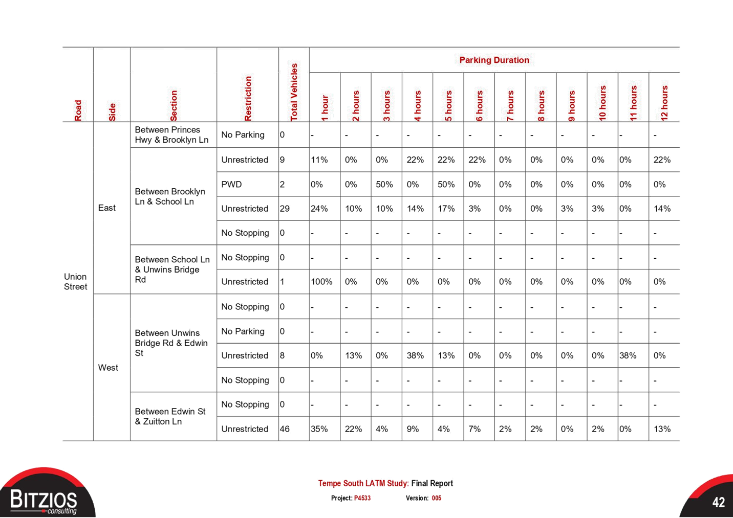
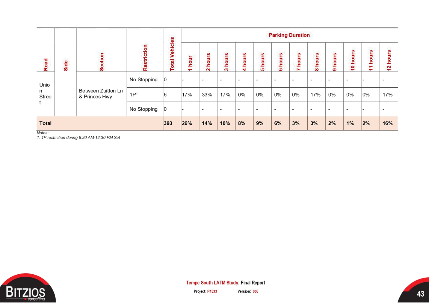
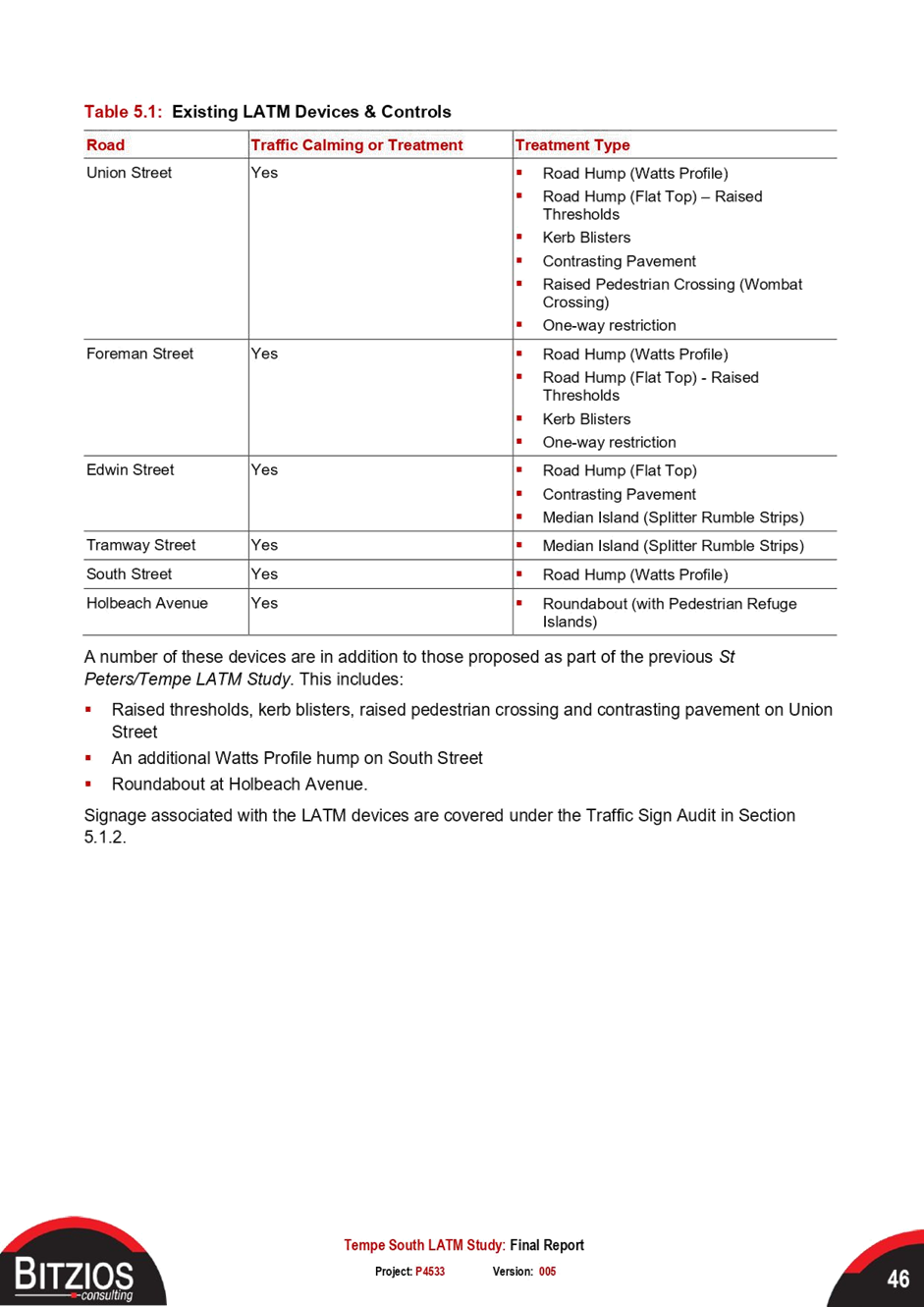
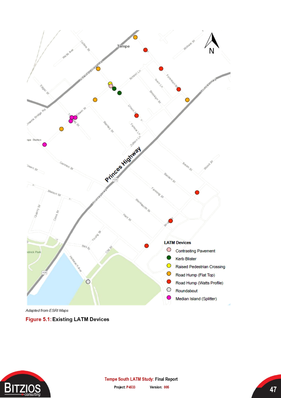
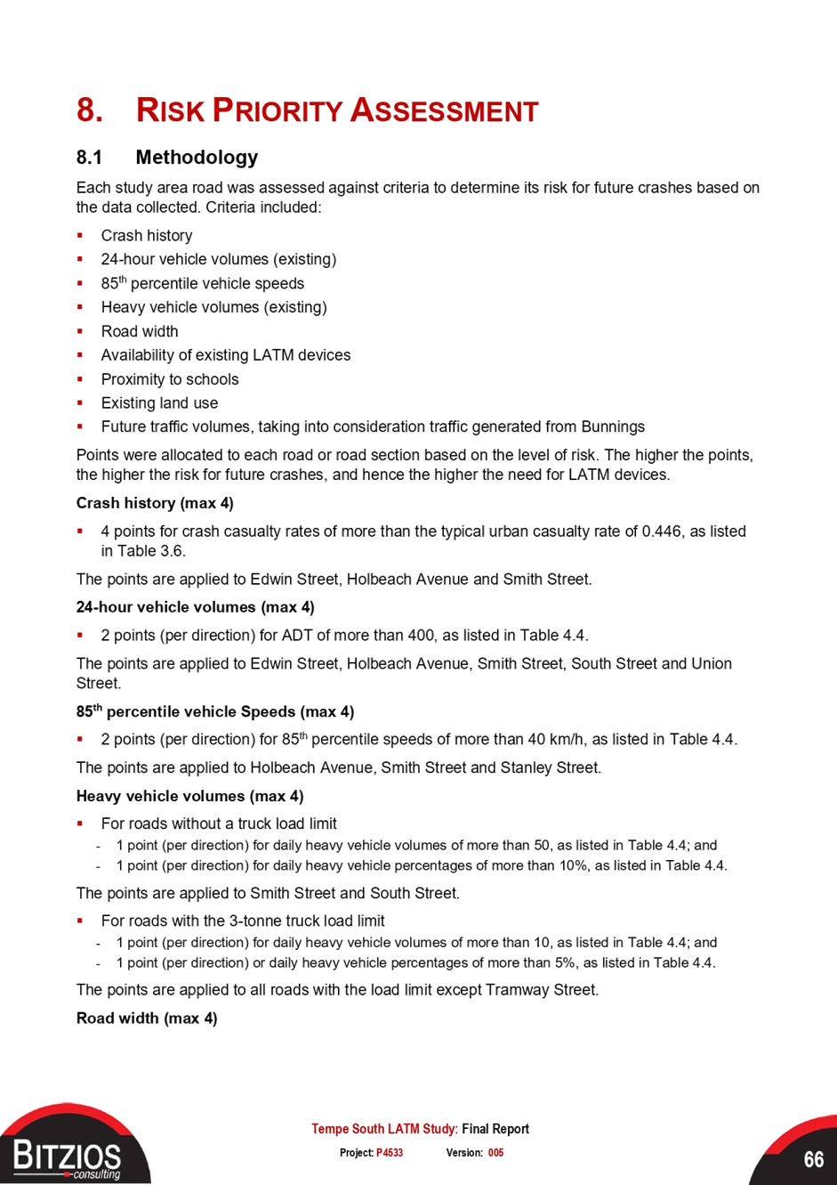
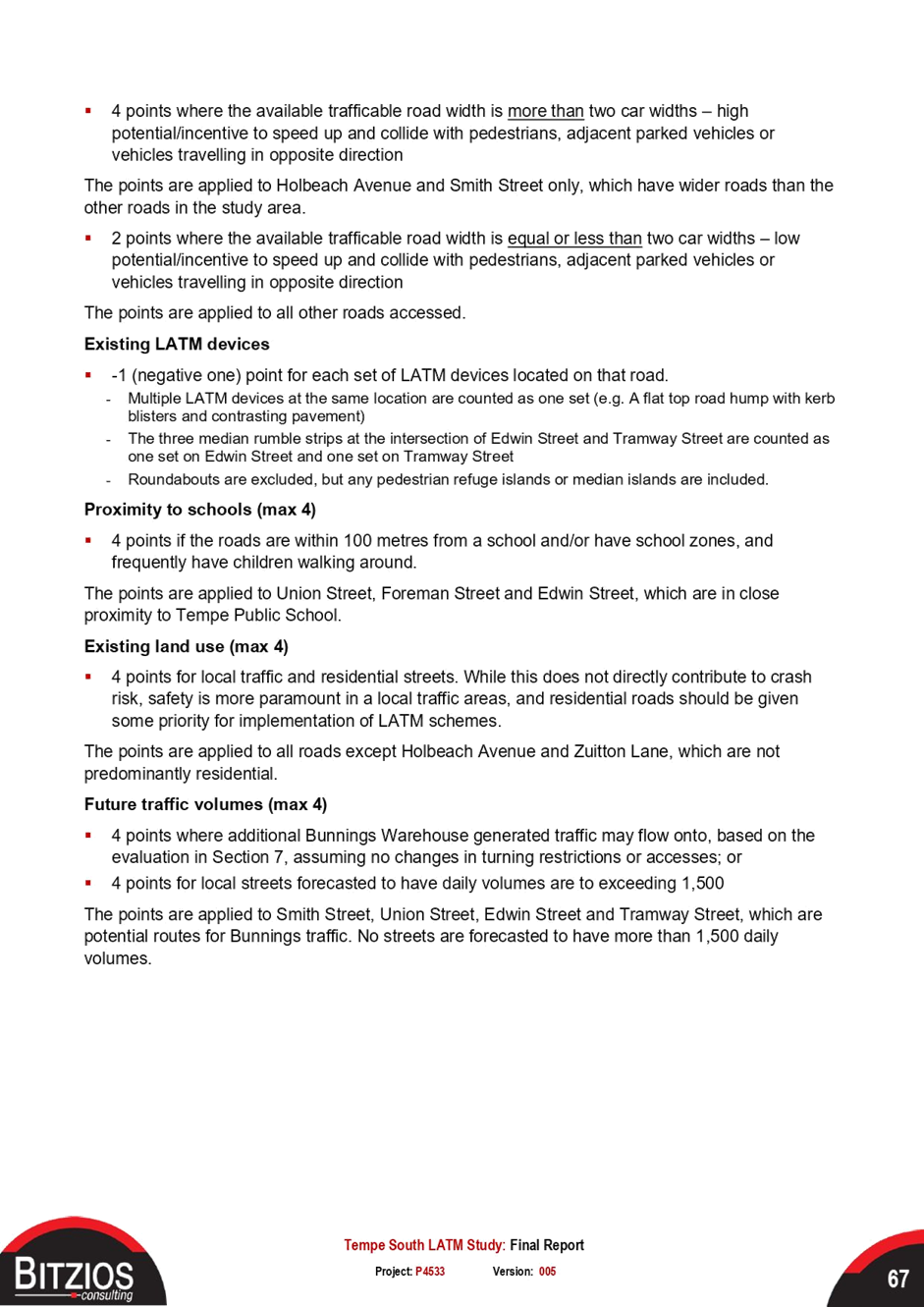
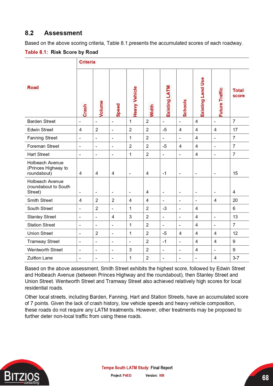
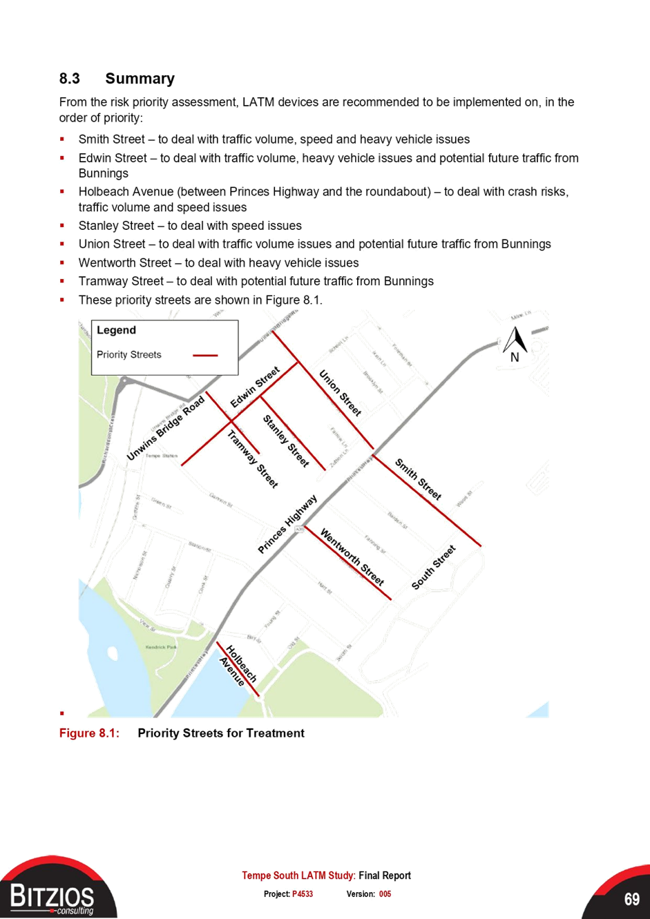
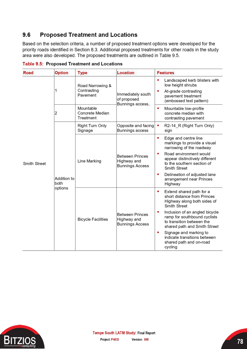
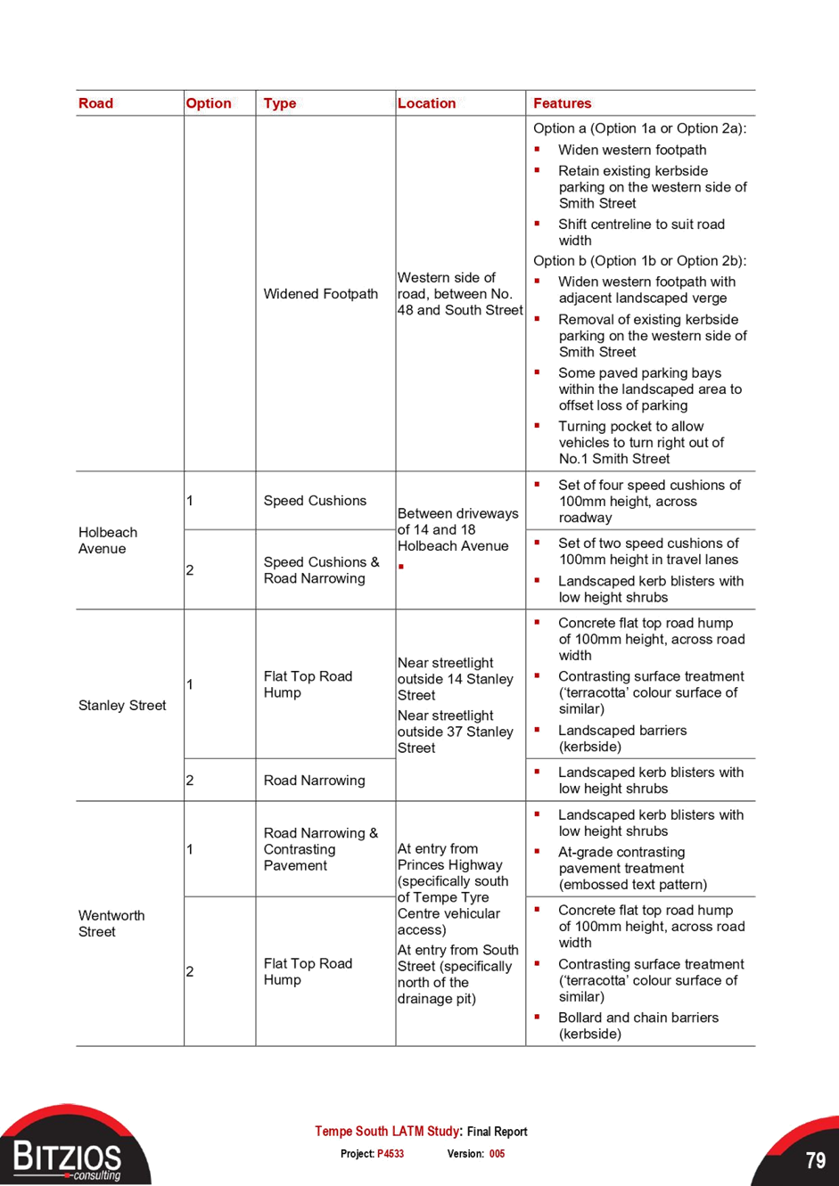
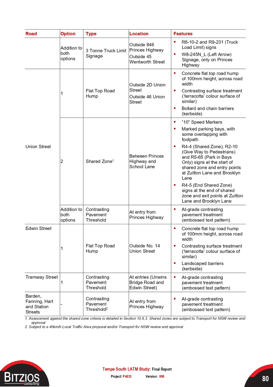
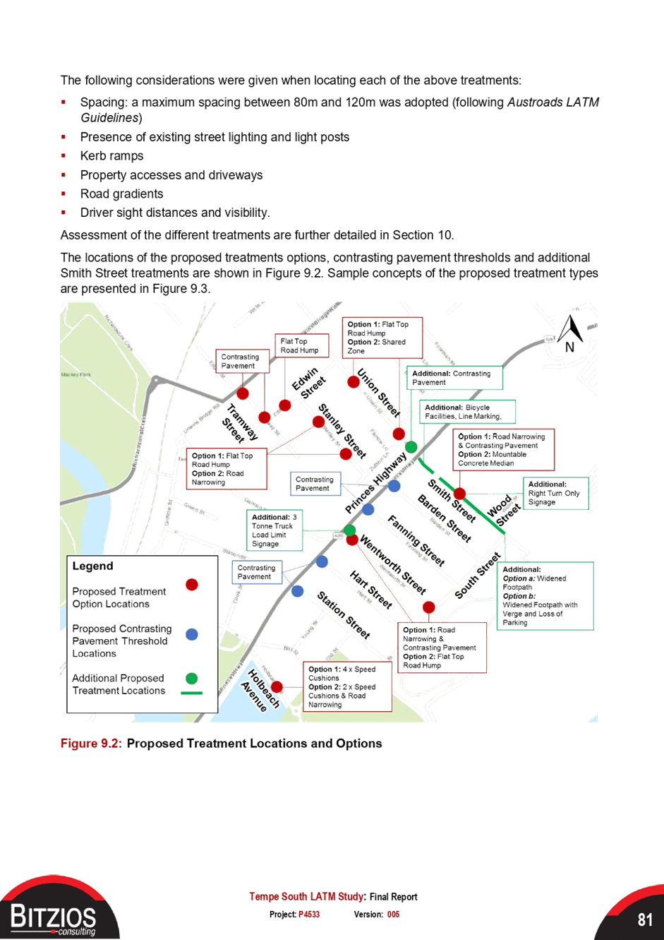
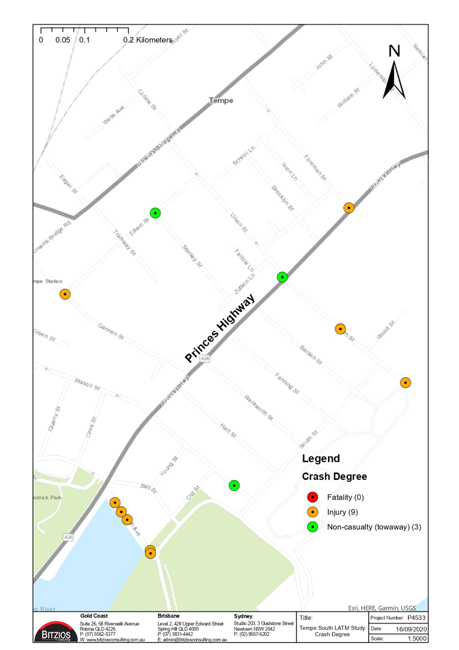
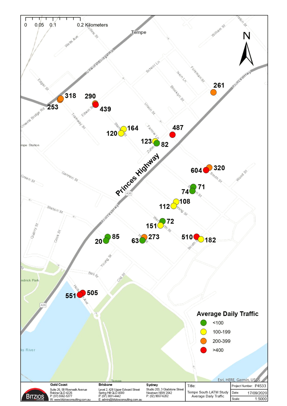
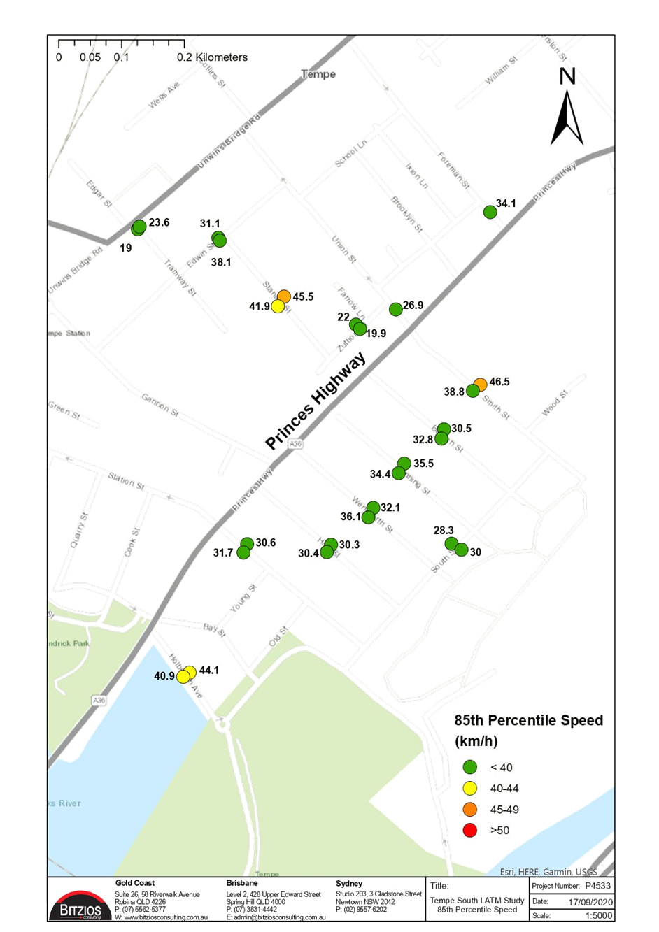
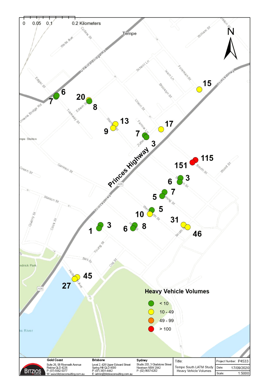
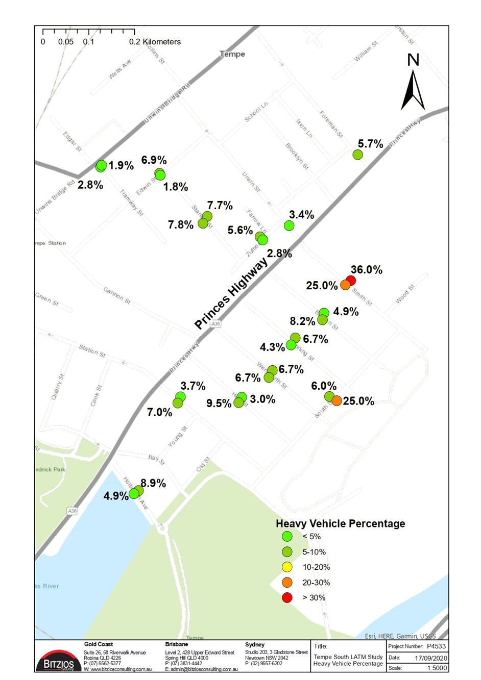
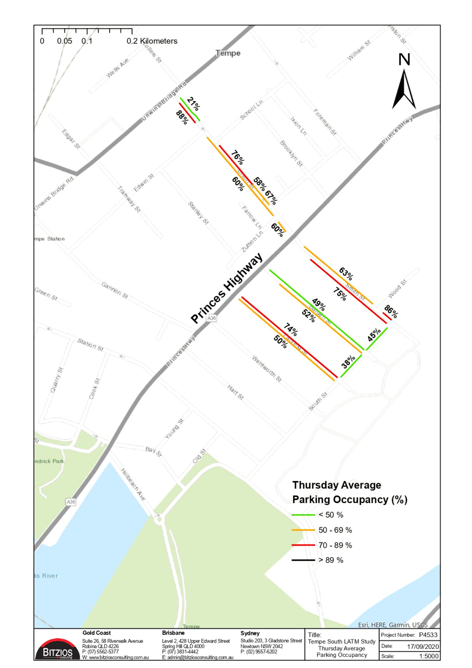
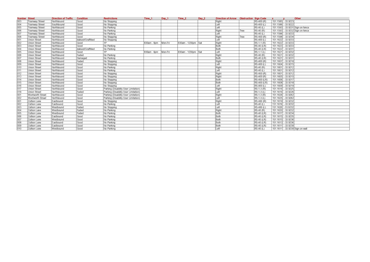
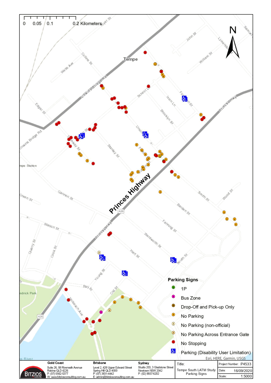
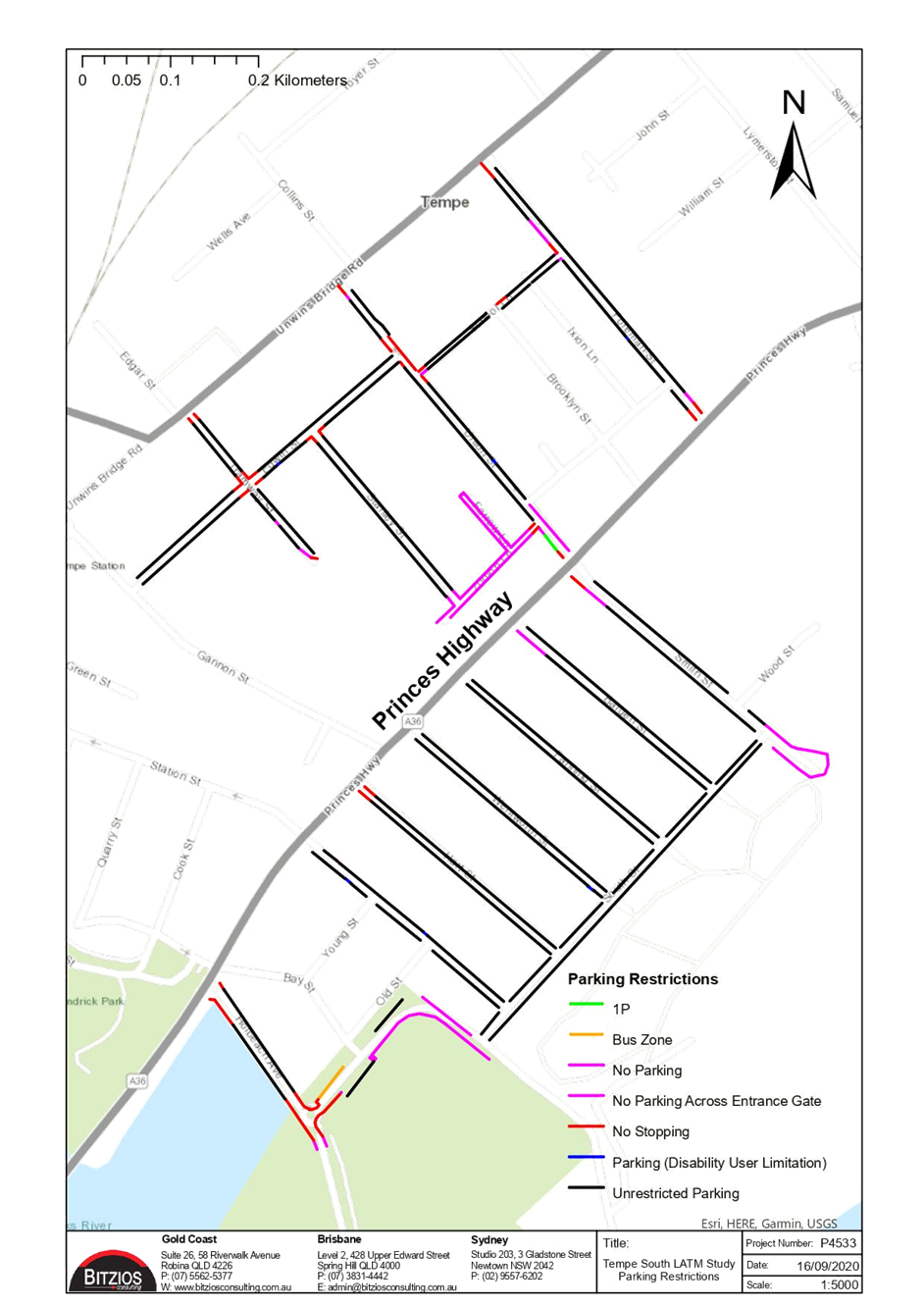
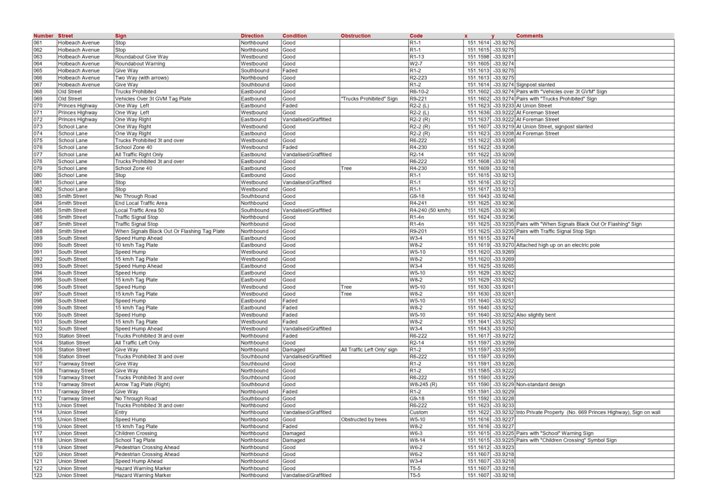
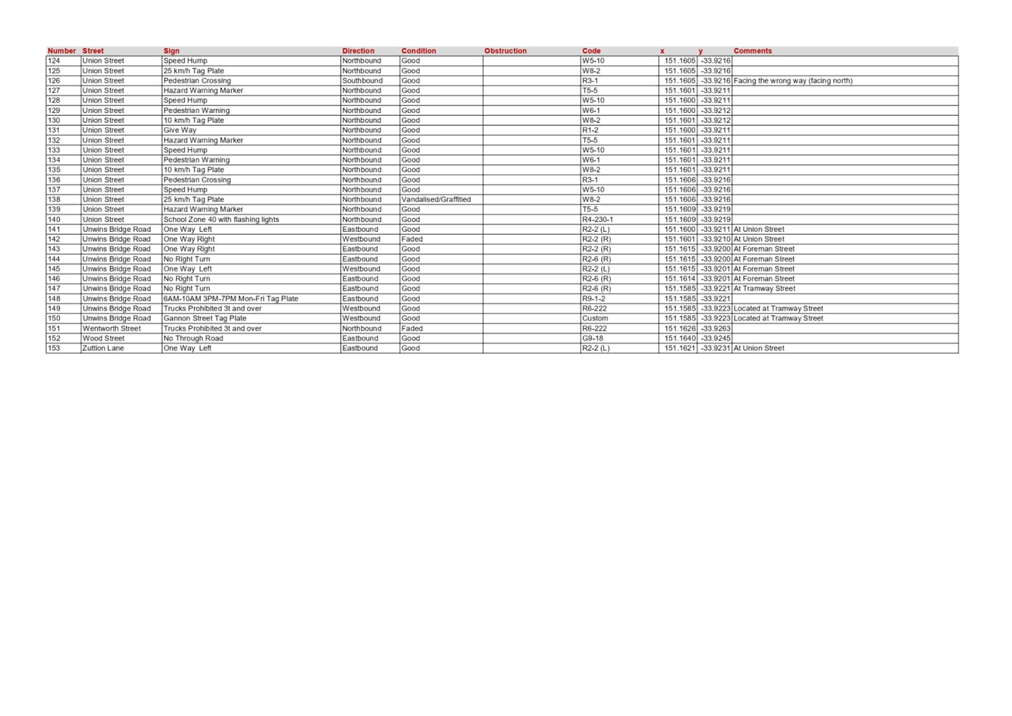
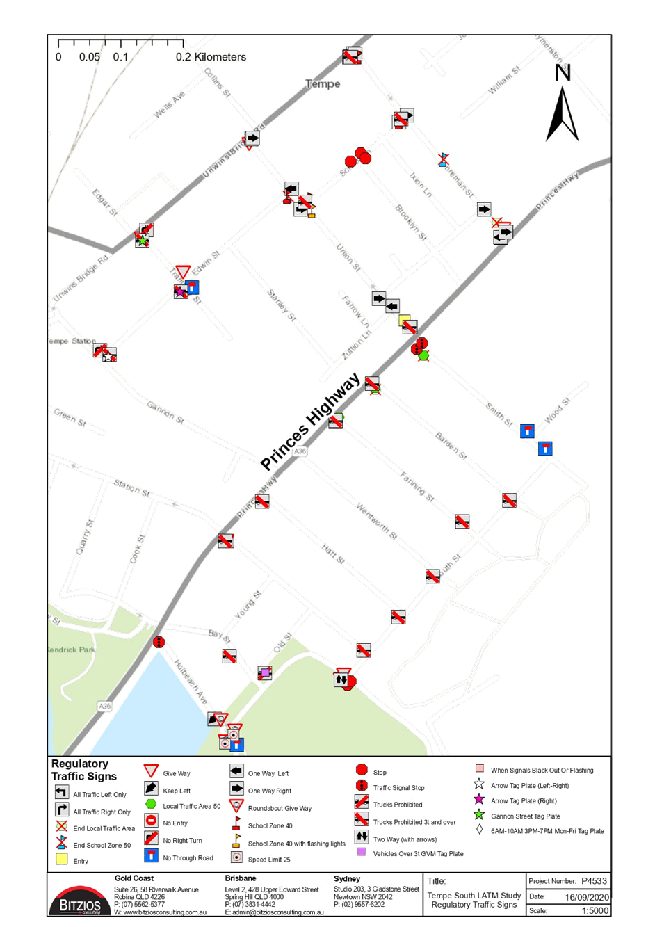
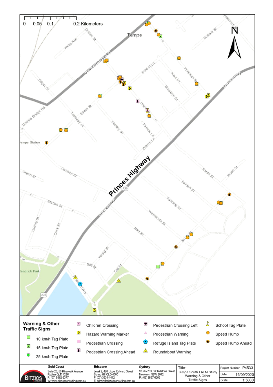
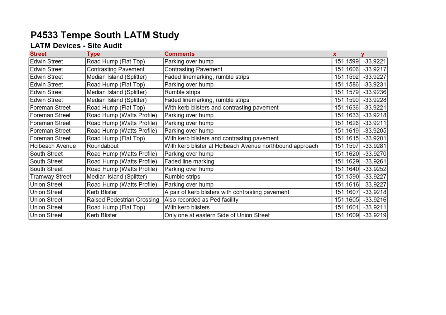
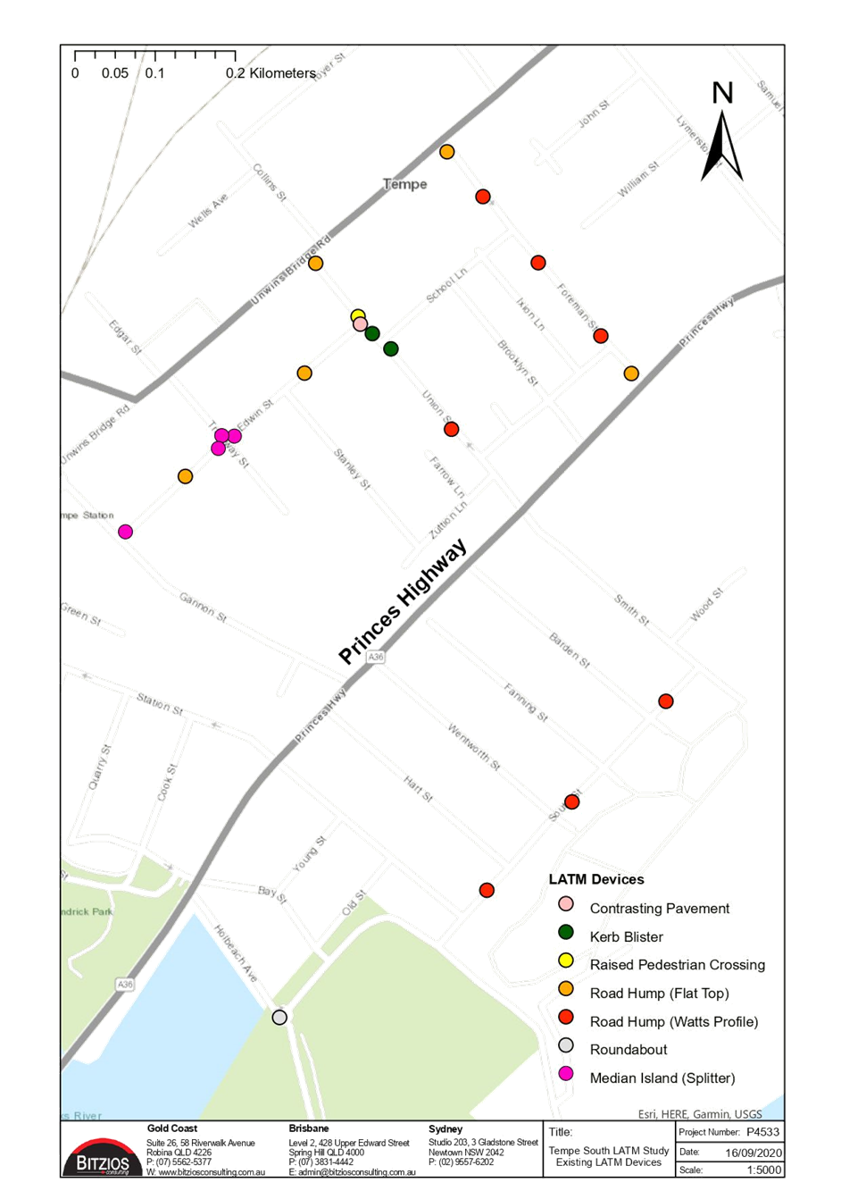
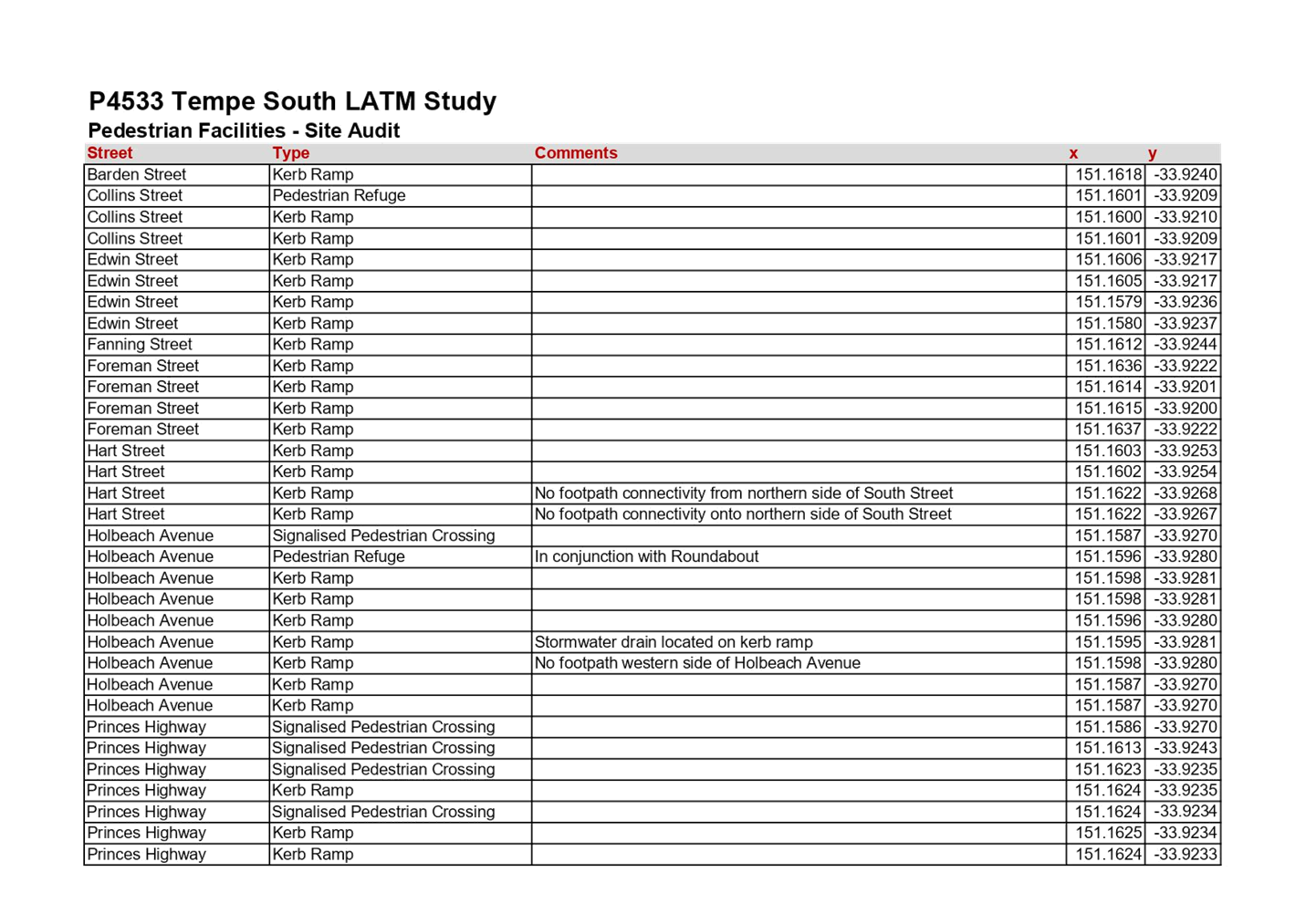
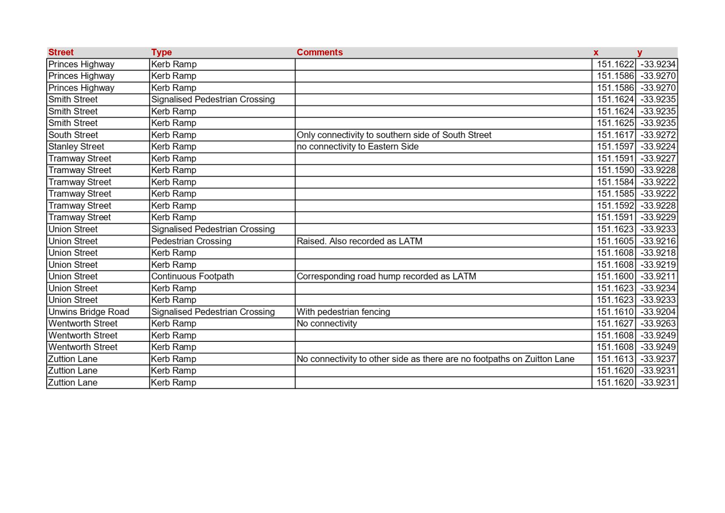
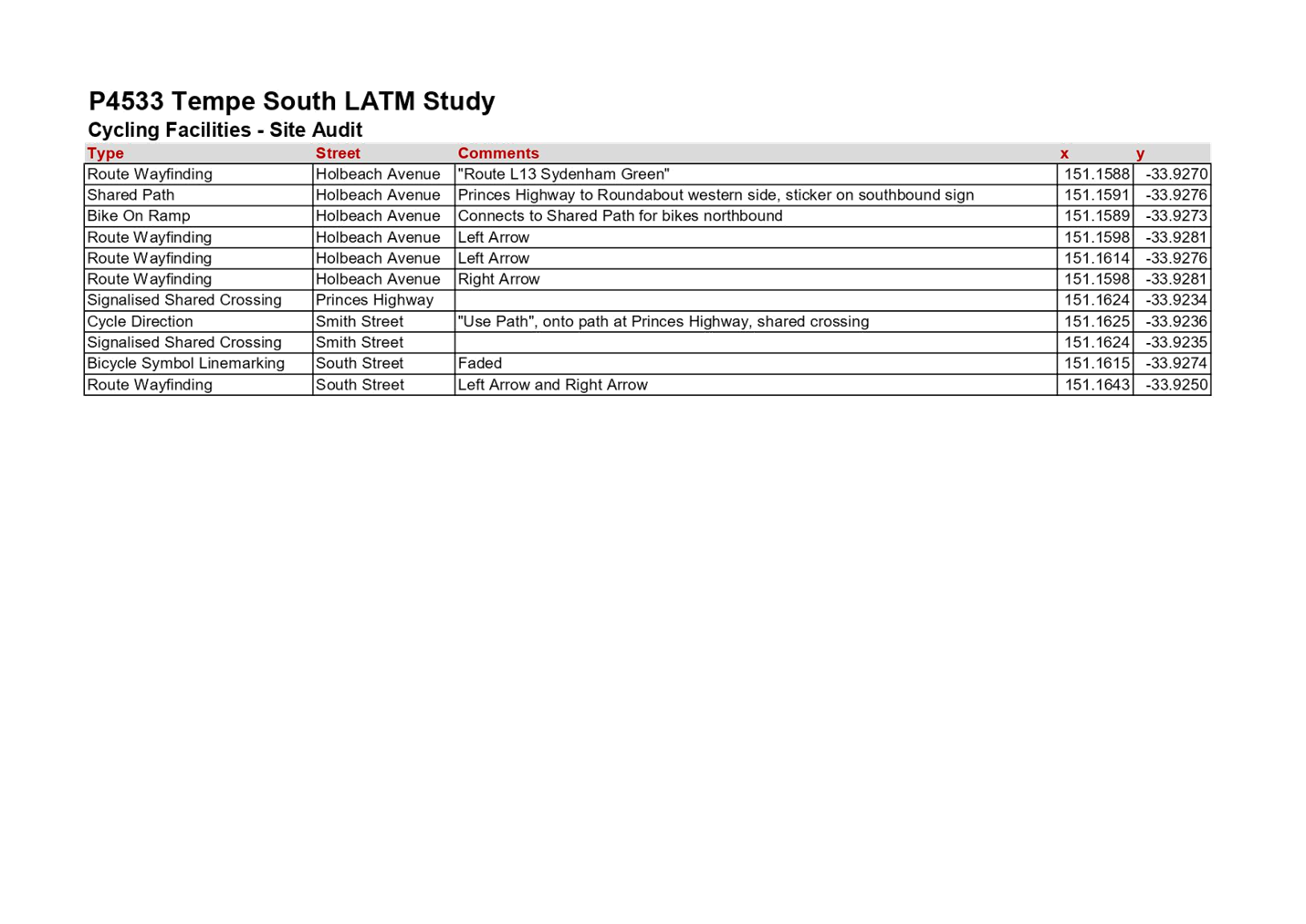
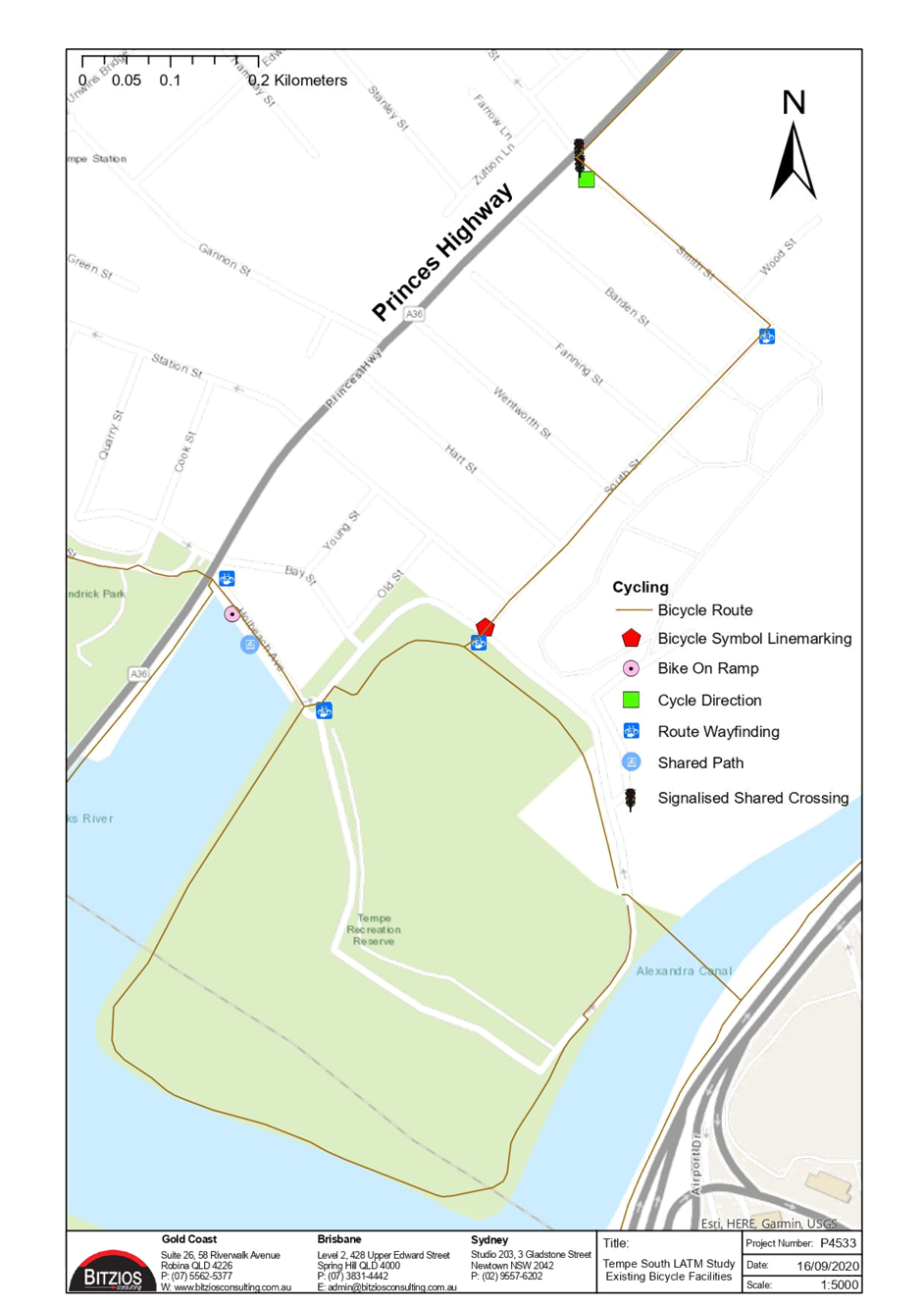
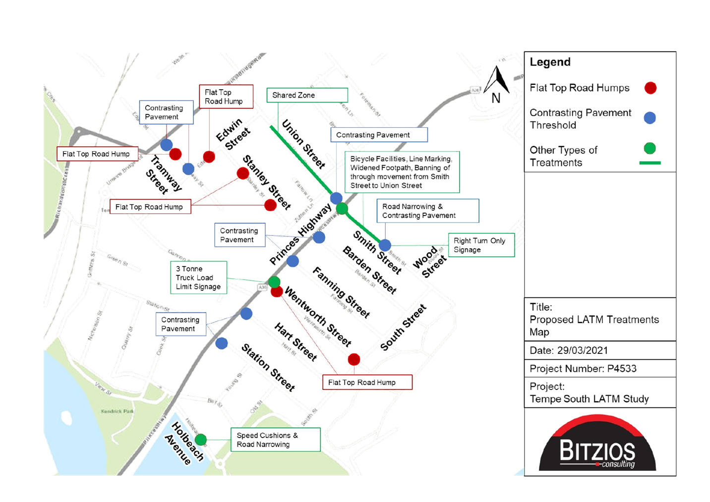
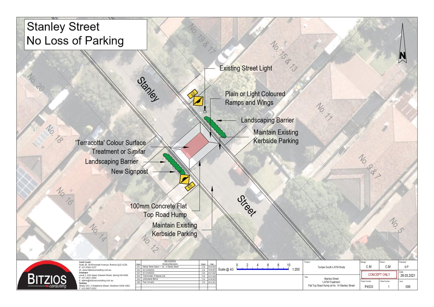
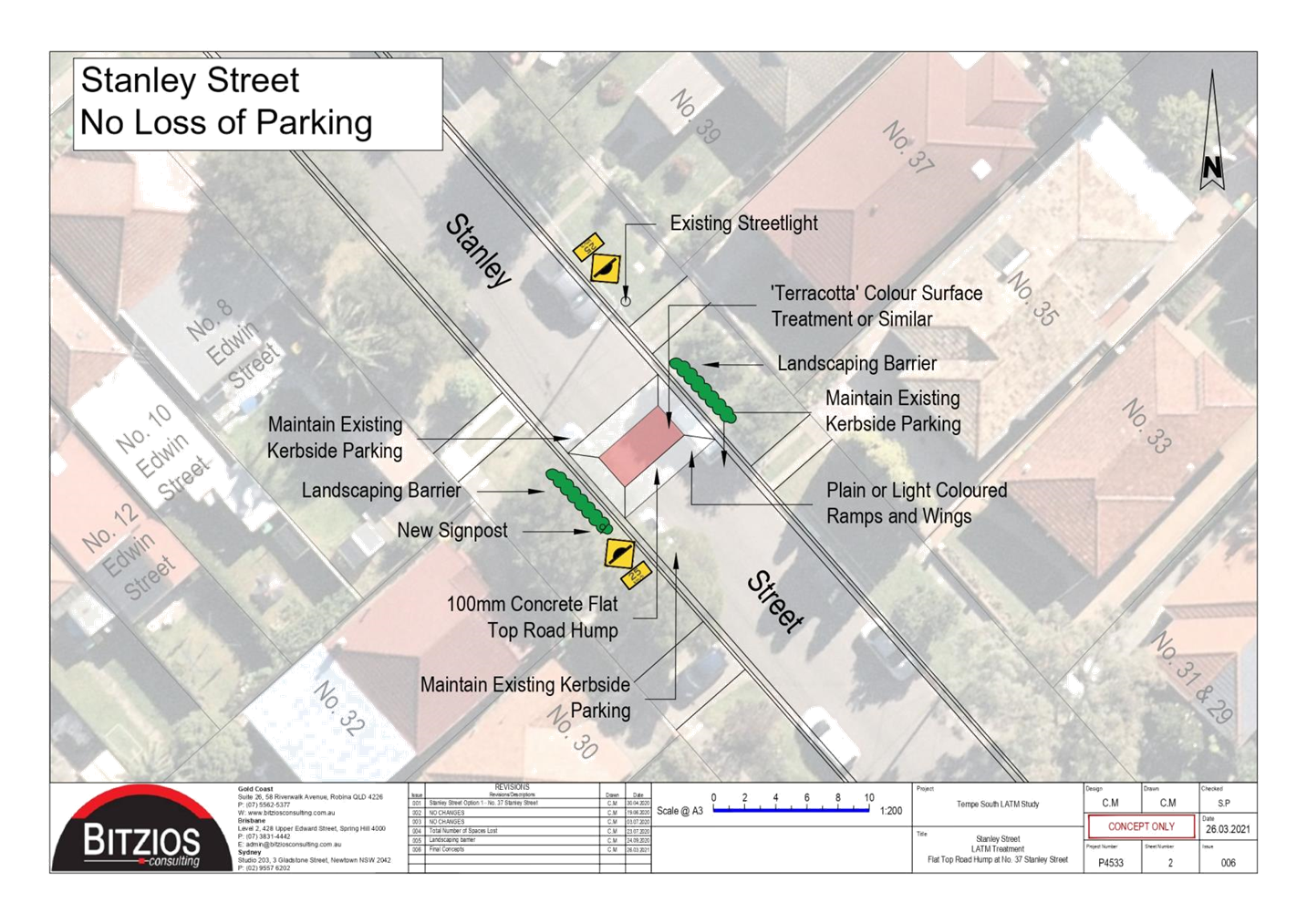
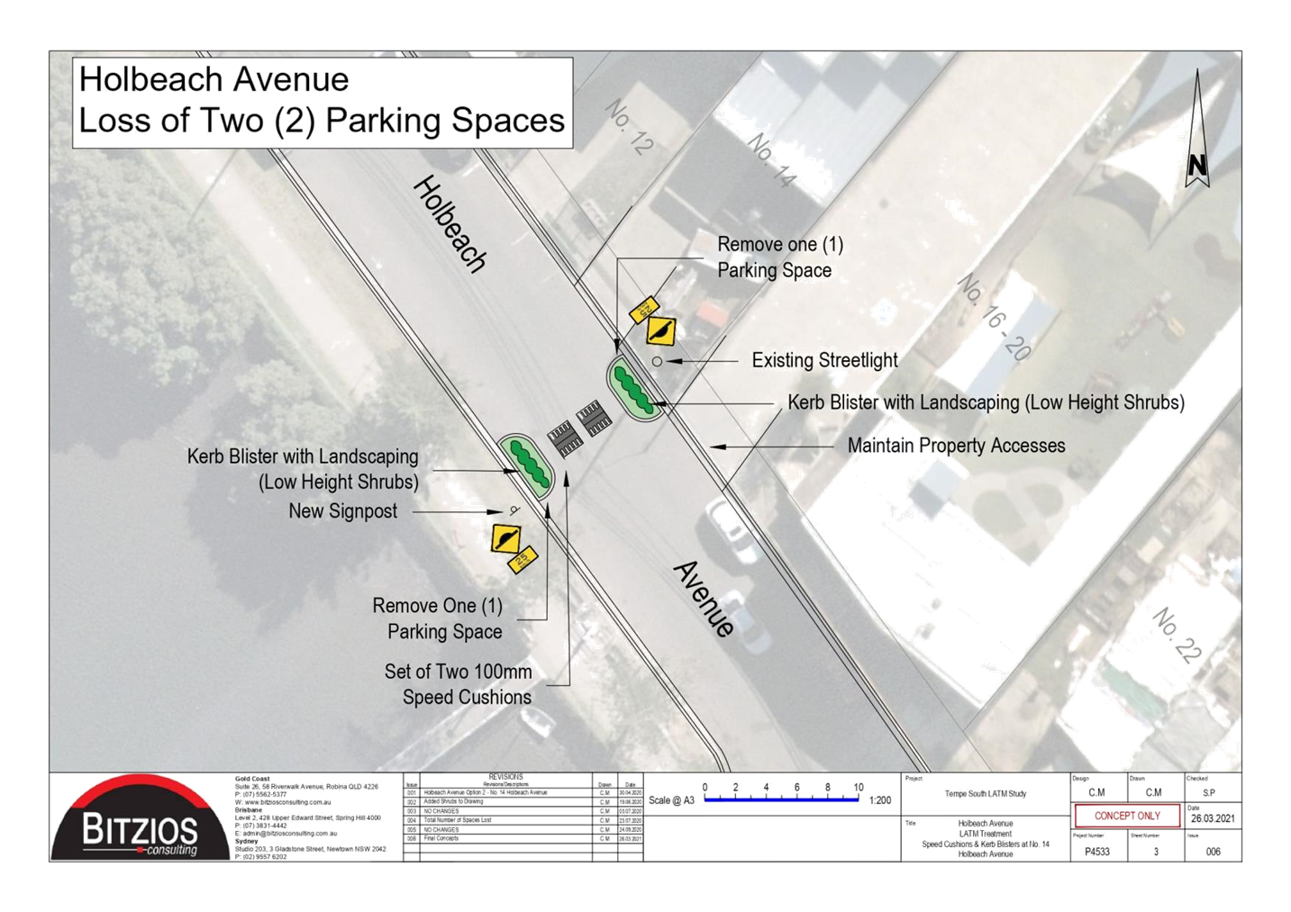
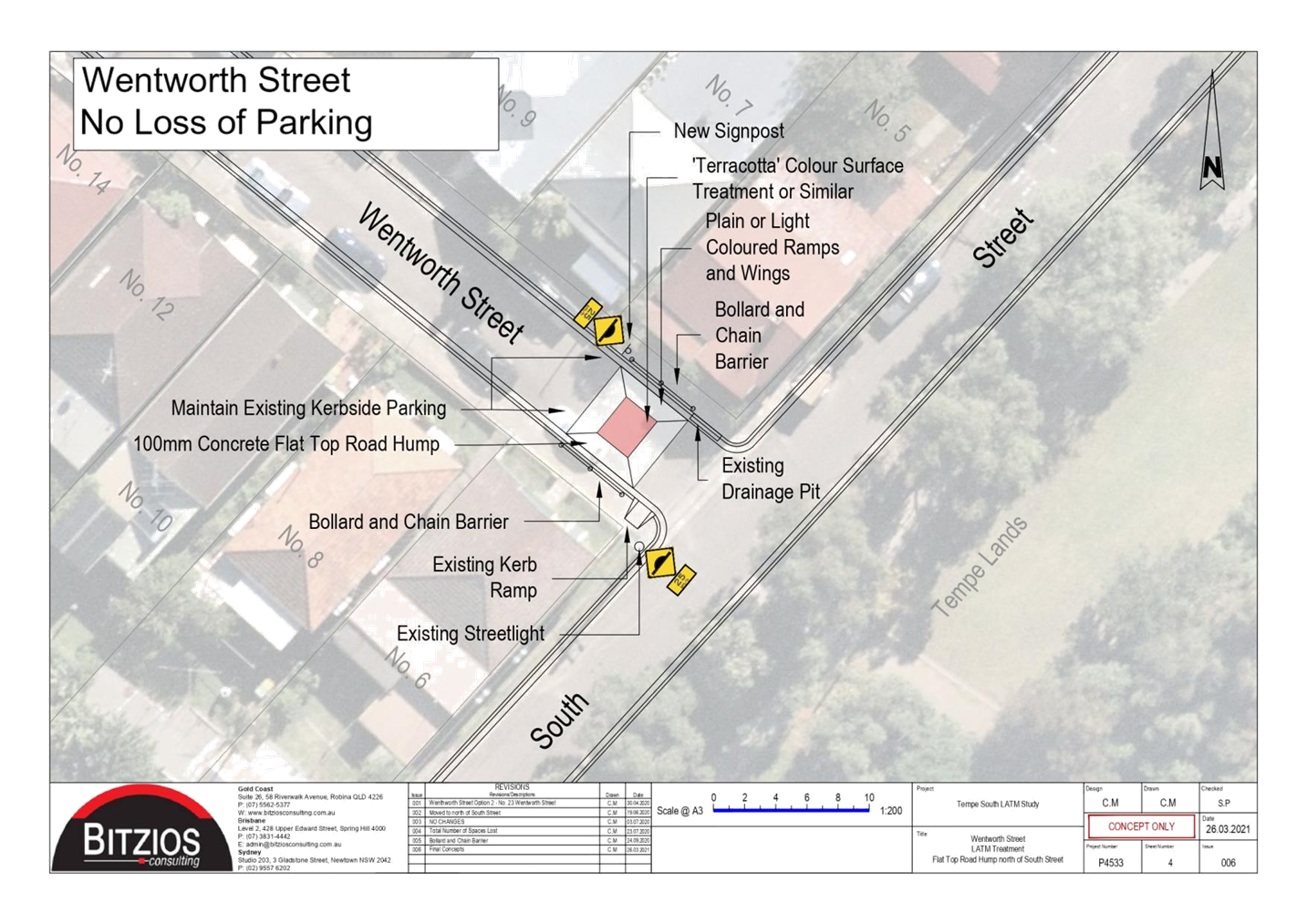
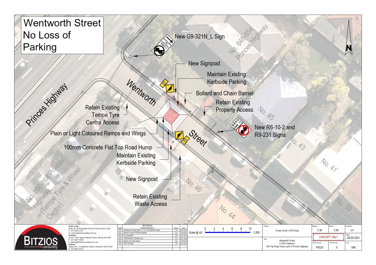
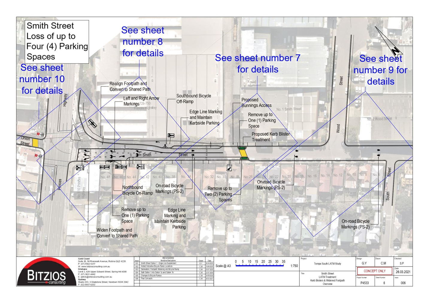
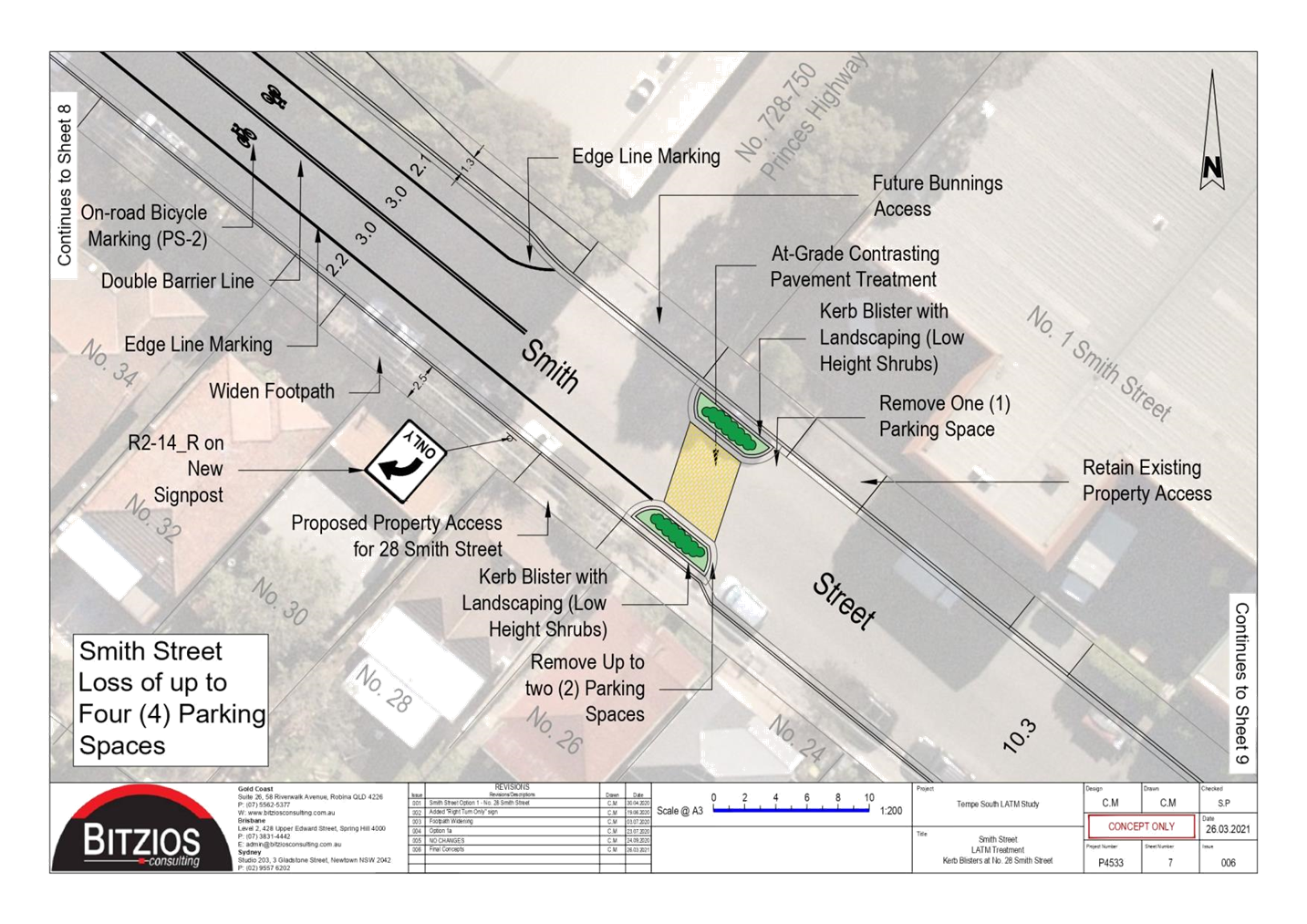
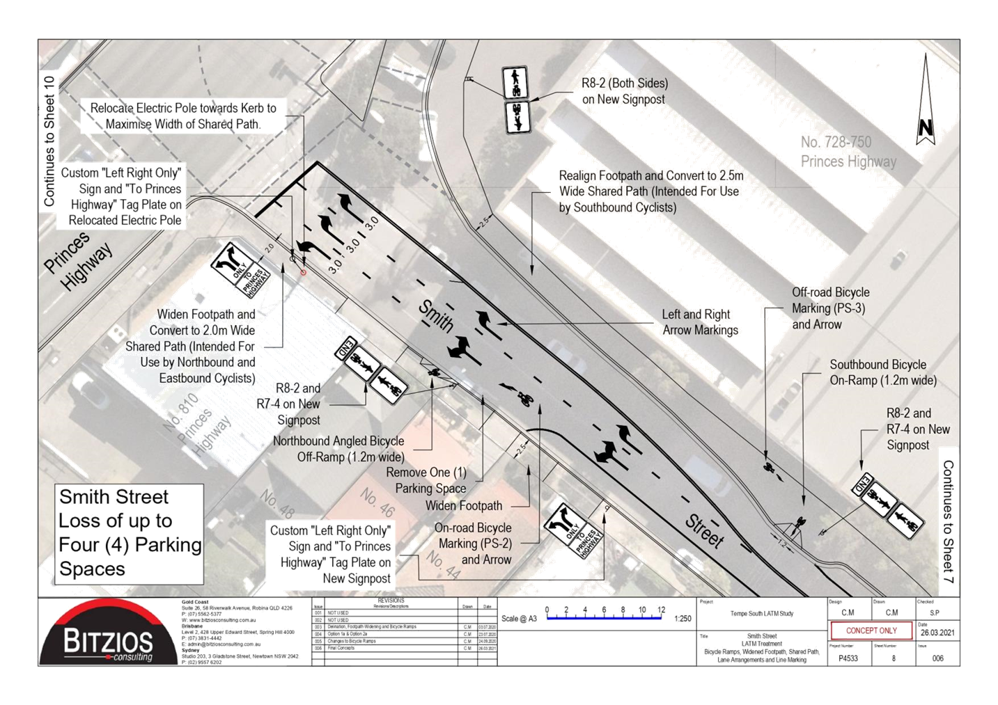
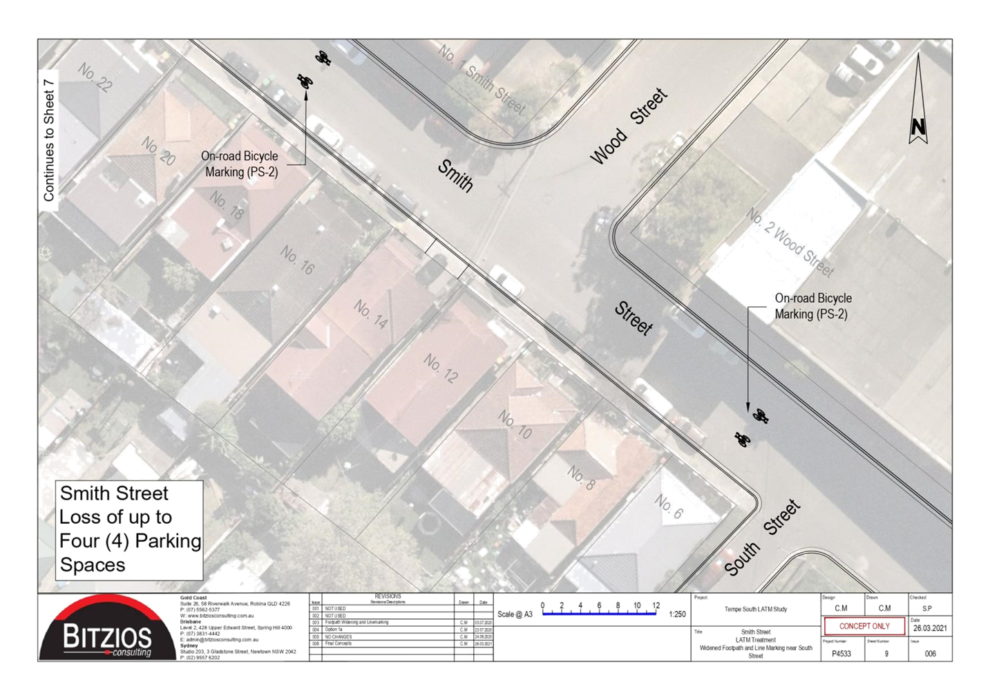
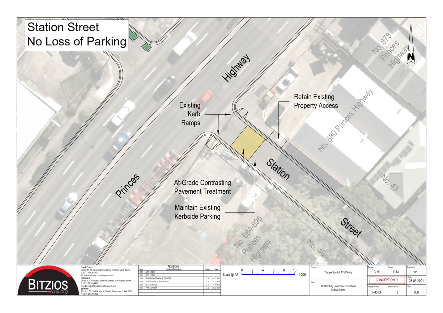
Subject: Tempe South Local Area Traffic Management Study - Revised Report (Midfuburi-Marricville Ward/Heffron Electorate/Inner West PAC)
Prepared By: Sunny Jo - Coordinator Traffic Engineering Services (North)
Authorised By: George Tsaprounis - Coordinator – Traffic and Parking Services
SUMMARY
Council is proposing to re-exhibit the Tempe South Local Area Traffic Management (LATM) study having noted the final version dated 6 July 2021. The Tempe South LATM study was deferred several times due to community concerns and impact to residential streets.
The Tempe South LATM study was last reported to the Traffic Committee on 16 August 2021 and was developed to mitigate the impacts associated with the proposed development, influencing incoming and outgoing routes. The LATM study was solely assessed based on the original approved vehicle access locations and was not intended to examine alternate access arrangements.
During the Public Exhibition of the LATM study, community action groups, businesses and individuals raised objections and concerns on the development and the study on safety and amenity grounds.
On April 2022, the Sydney Eastern City Planning Panel deferred the Modification application from the applicant to delete the condition requiring the adoption of the LATM study by Council’s Local Traffic Committee prior to the issue of any Construction Certificate.
It is noted that Council is currently organizing a comprehensive feasibility study of traffic signals at the Princes Highway driveway, and this is expected to be completed and considered by Transport for NSW for a decision on the matter.
The study will also evaluate design changes within the Bunnings site to facilitate the amended vehicular entry and exit arrangements. The results of the Traffic Signals Feasibility Study will be submitted to Transport for NSW for consideration.
|
RECOMMENDATION
THAT:
1. The Tempe South Local Area Traffic Management Study – Final Report dated 6 July 2021 be endorsed for a second public exhibition, based on the original approved vehicle access arrangements for 728-750 Princes Highway, Tempe (Determination No. 201700185). 2. The Public Exhibition be undertaken on the proposed scheme for 28 days with the outcomes being reported back to the Local Traffic Committee. 3. It be noted that a feasibility study of traffic signals at the driveway of Princes Highway is currently in progress, with input from Transport for NSW and the developer. This study will be undertaken as a separate process and when complete will be submitted to Transport for NSW for consideration.
|
BACKGROUND
The following table outlines the relevant history of the Tempe South LATM and the Tempe Bunnings development:
|
Date |
Action |
|
November 2020-January 2021 |
Public Exhibition of the draft Tempe South LATM study |
|
19 April 2021 |
The Local Traffic Committee on 19 April 2021 deferred the Tempe South LATM study and proposed treatments ‘…until a determination regarding the signalized exit from Bunnings is received from the Minister for Transport’. |
|
16 August 2021 |
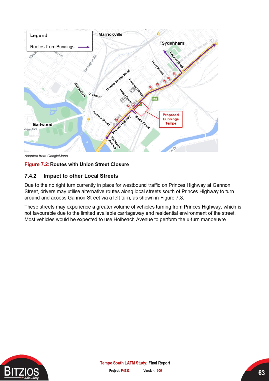
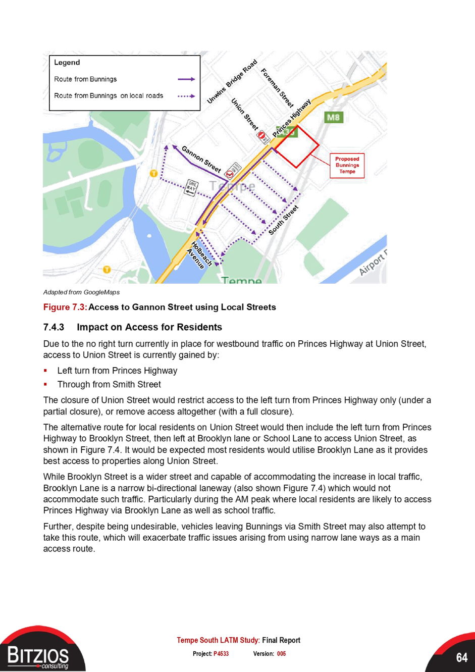
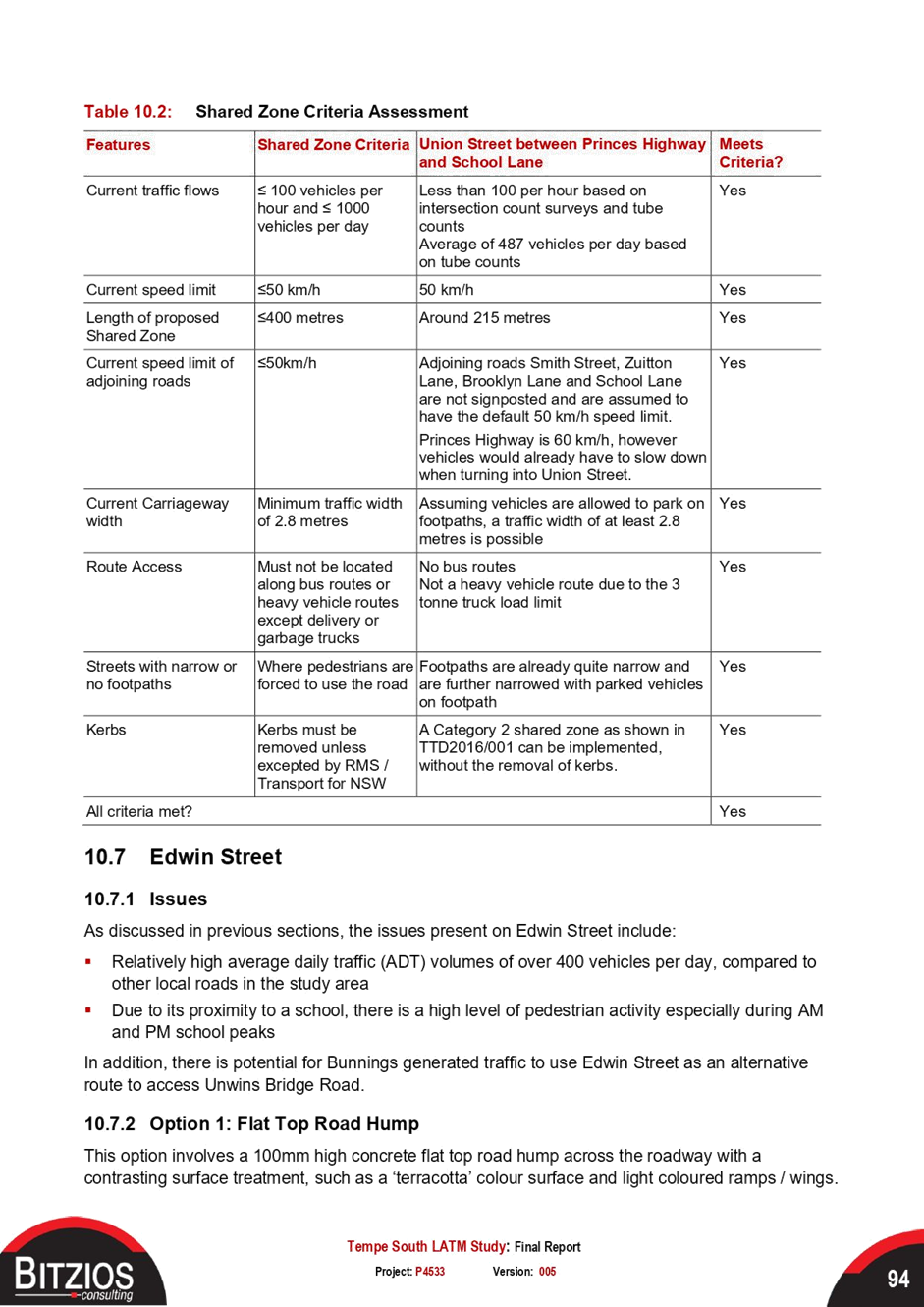
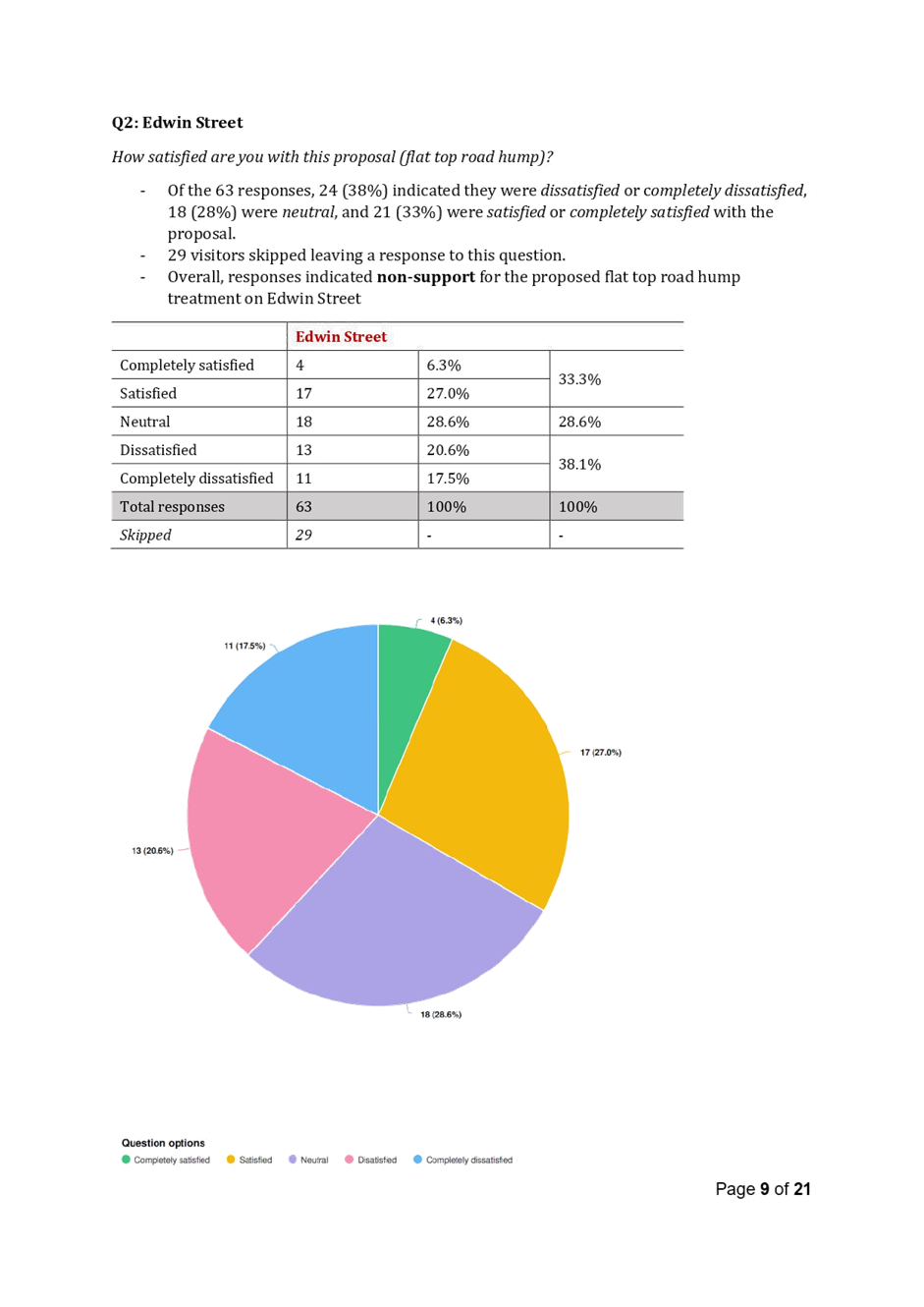
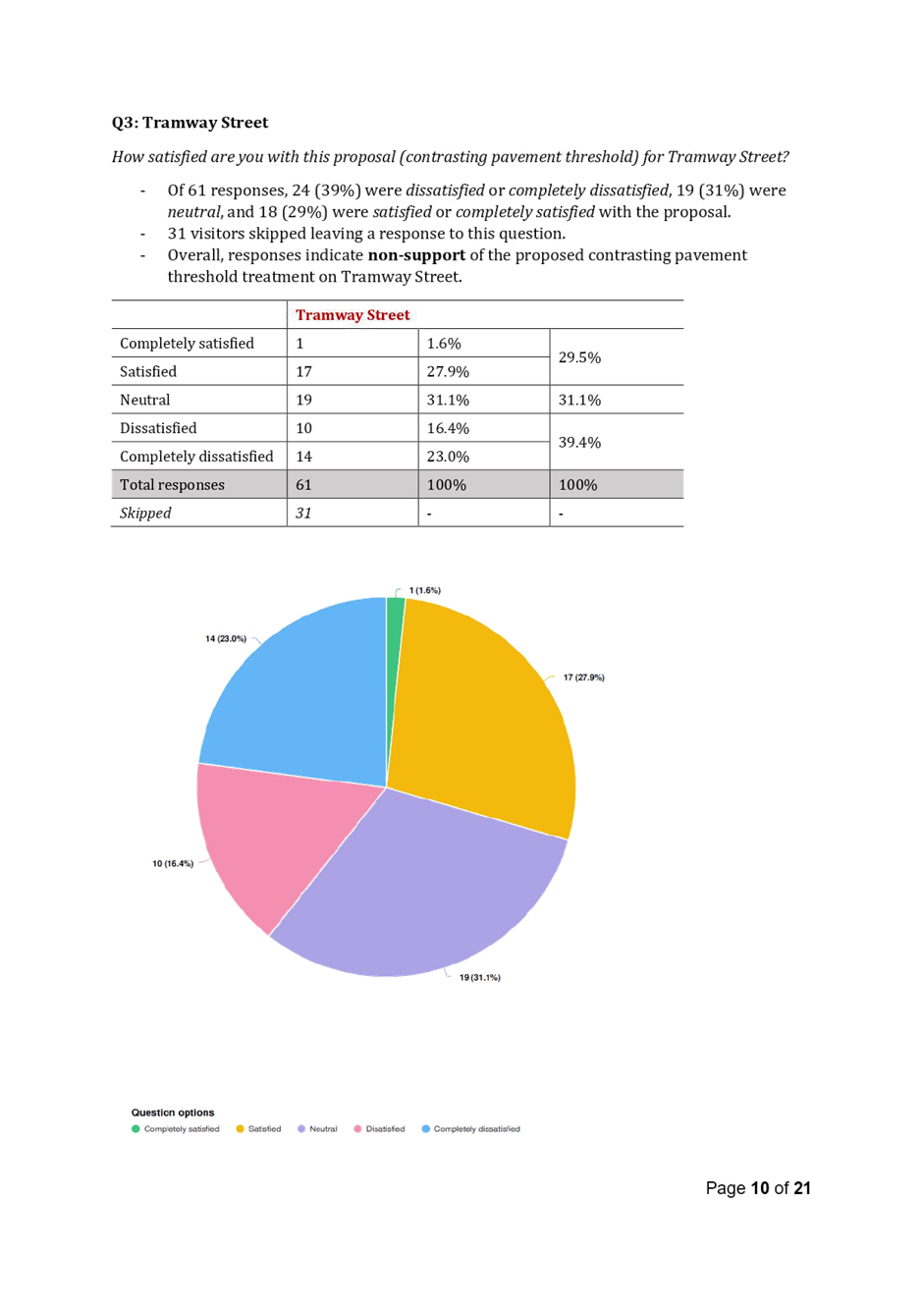
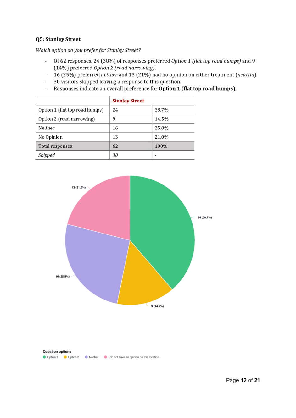
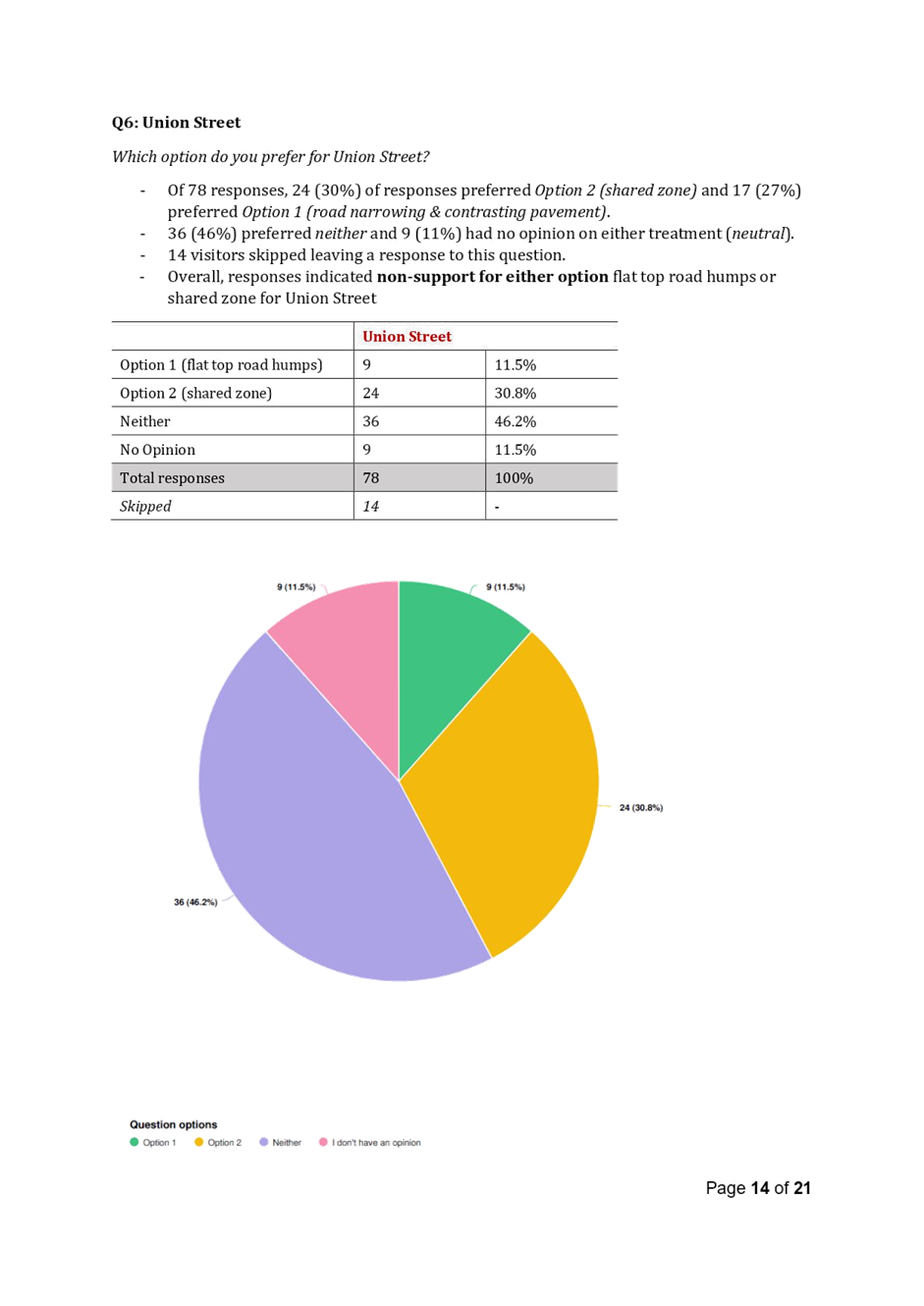
Council held meetings with Transport for NSW (TfNSW) and Bunnings regarding vehicular access arrangements for the Tempe Bunnings site, including the feasibility of traffic signals at the driveway in Princes Highway between Brooklyn Street and Foreman Street. This option was not supported by TfNSW due to safety and network efficiency reasons, with Bunnings also indicating that they do not intend to modify their development consent and the approved layout design. TfNSW also did not support the provision of banning traffic from Smith Street into Union Street by signage as there is insufficient space to install a physical island to block travel. The Tempe South LATM report dated 6 July 2021 included two additional proposals, including: · Soft closure of Union Street by signage ‘No Entry’ from Smith Street to Union Street at the existing traffic signals, including a 10km/h Shared Zone in Union Street. If TfNSW does not approve the soft closure and Shared Zone, a second option for Union Street be obtained including At-grade contrasting pavement entrance treatment, installation of mountable kerbs, marking parking bays on both sides of the road between Princes Highway and Edwin Street, a 40km/h speed limit be established in Union Street, subject to approval from TfNSW. · A partial road closure of Brooklyn Street (exit only to Princes Highway) to mitigate traffic diverted from Union Street. The Local Traffic Committee on 16 August 2021 deferred the Tempe South LATM study and the proposed treatments and recommended to refer this matter to the State Government for intervention on the grounds of safety and unnecessary impact on local residents, businesses and Tempe Primary School. |
|
10 September 2021 |
Bunnings submitted MOD/2021/0376 seeking a modification to delete condition 68A ‘…requiring the adoption of the LATM study by Council’s Local Traffic Committee’ prior to the issue of any Construction Certificate, including other changes. |
|
12 October 2021 |
Council Notice of Motion on 12 October 2021 resolved to undertake a campaign to lobby Bunnings and NSW Minor for Roads seeking approval of traffic signals installation on Princes Highway to provide controlled access to Bunnings. |
|
3 March 2022 |
Transport for NSW has provided a response to a community action group stating that they ‘…would support further risk assessment being undertaken by either Bunnings or Council of the Princes Highway access and a feasibility review of traffic lights’ |
|
12 April 2022 |
Councill Notice of Motion on 12 April 2022 resolved to ‘urgently conducts a new and independent risk assessment and feasibility review of proposed traffic lights on the Princes Hwy to determine if safety and network impacts previously raised by Transport for NSW could be effectively mitigated, funded from the next Quarterly Budget Review’ |
|
13 April 2022 |
The Sydney Eastern City Planning Panel on 13 April 2022 resolved to defer MOD/2021/0376 ‘…until all the necessary notification and assessments under the relevant parts of the Act have been completed. The Panel requested that ‘…the LTC conclude, as soon as possible, its consideration of that study in order not to circumvent the consent already grated to this development’ |
FINANCIAL IMPLICATIONS
Nil
OTHER STAFF COMMENTS
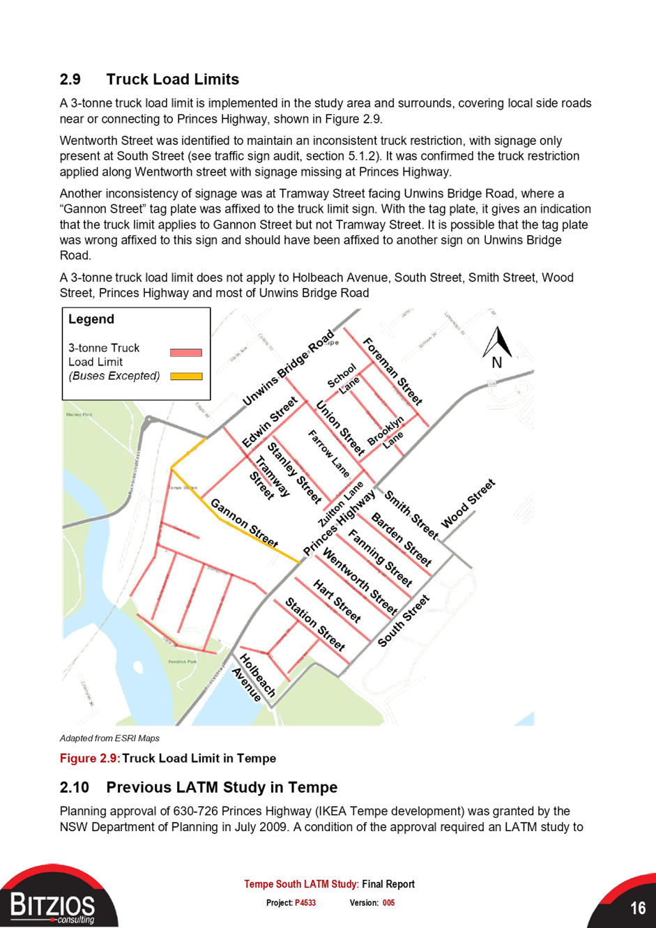
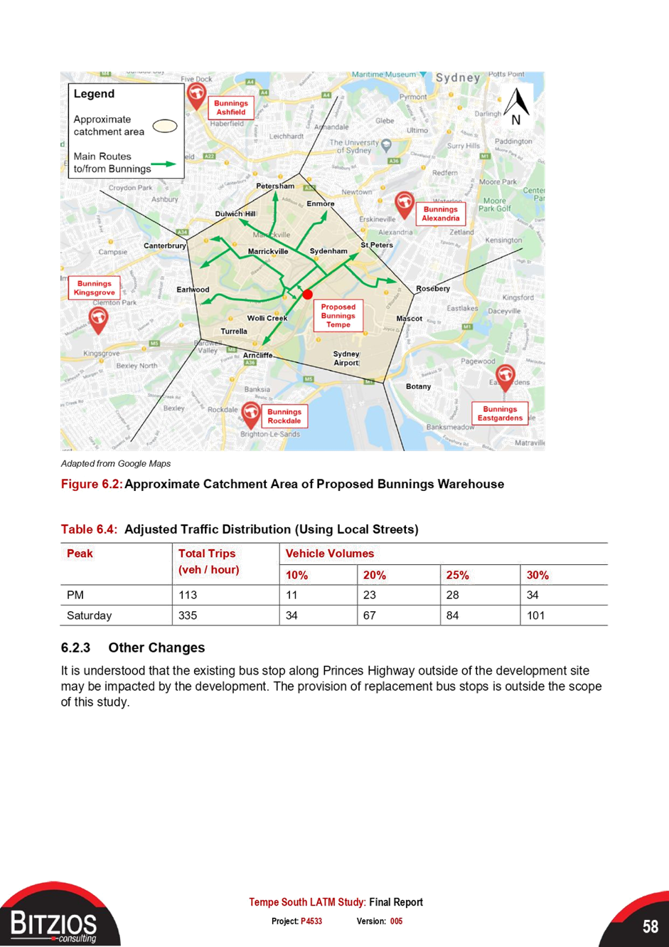
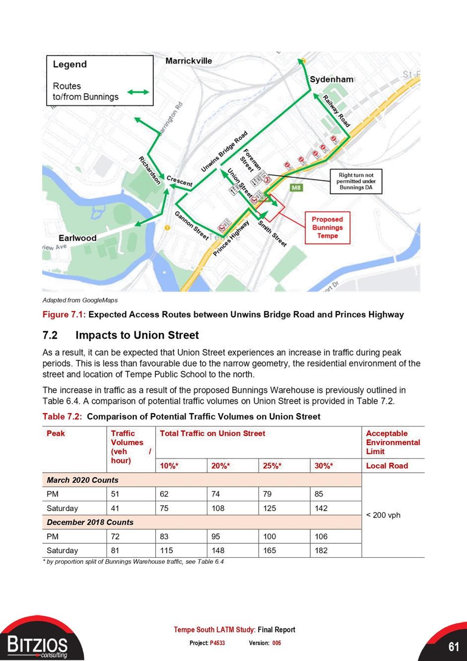
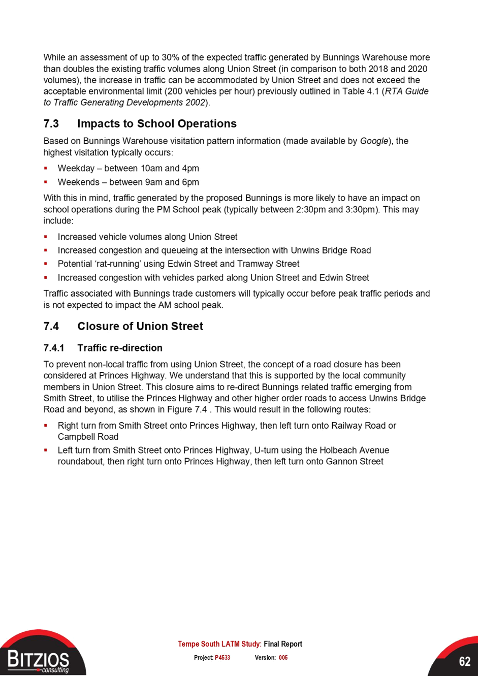
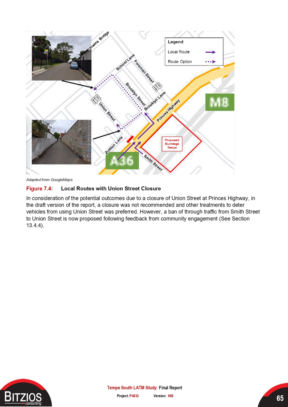
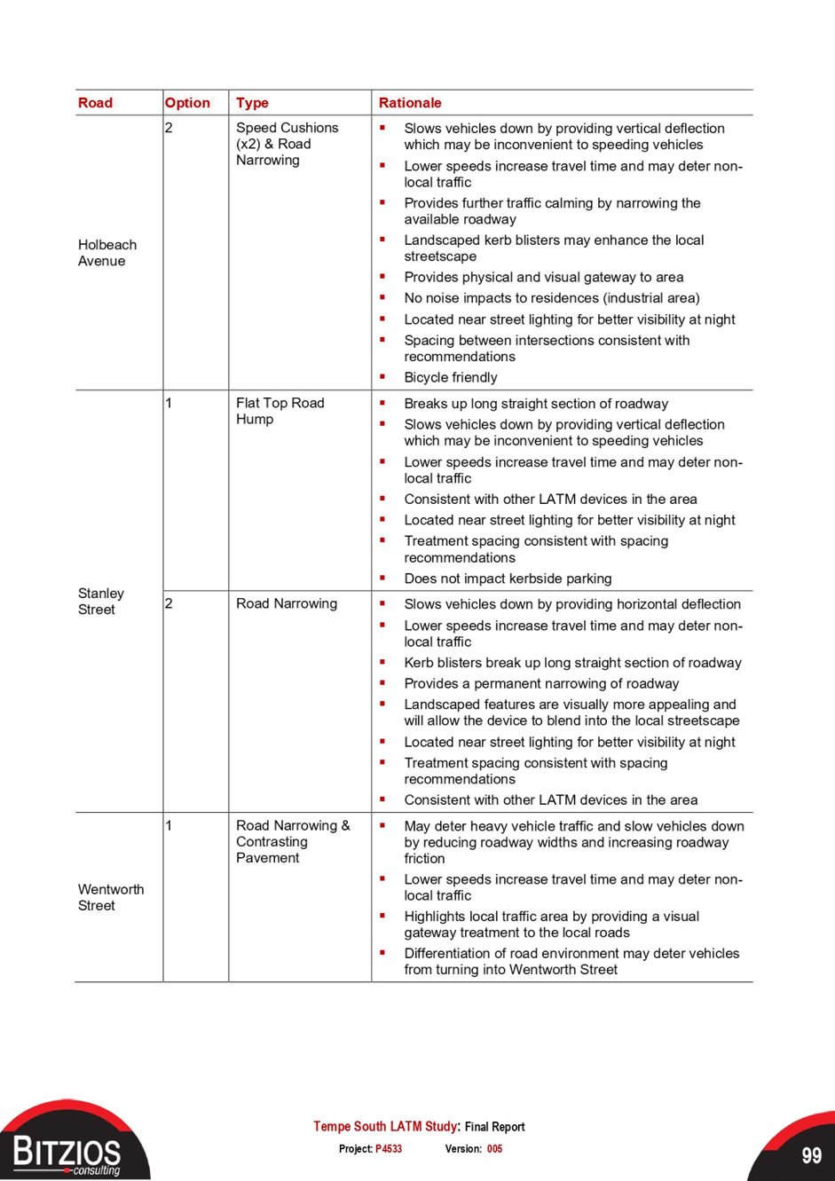
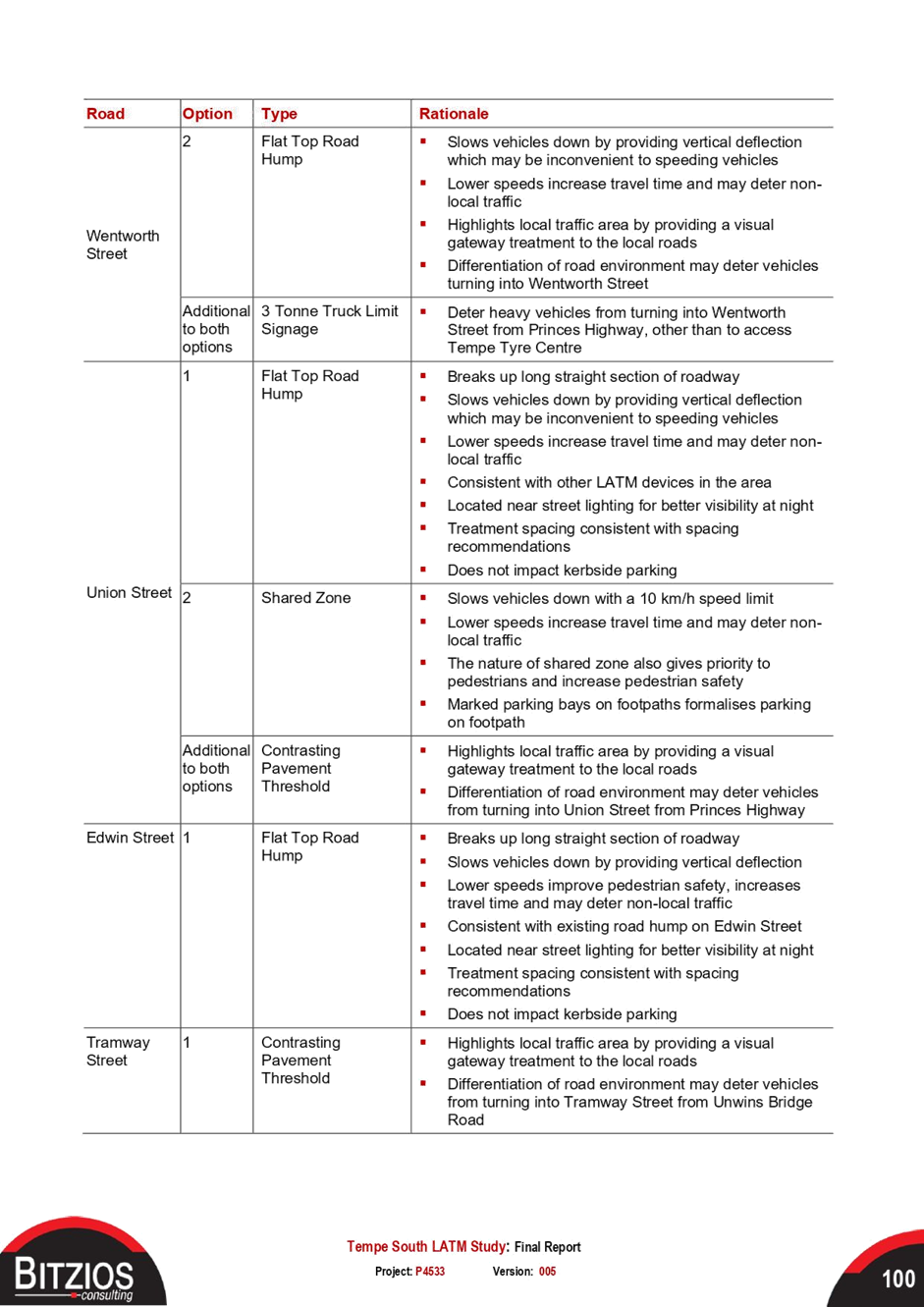
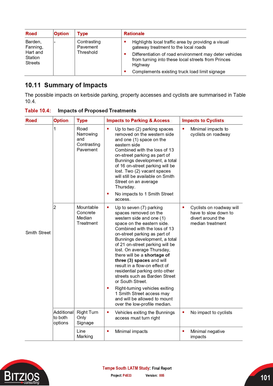
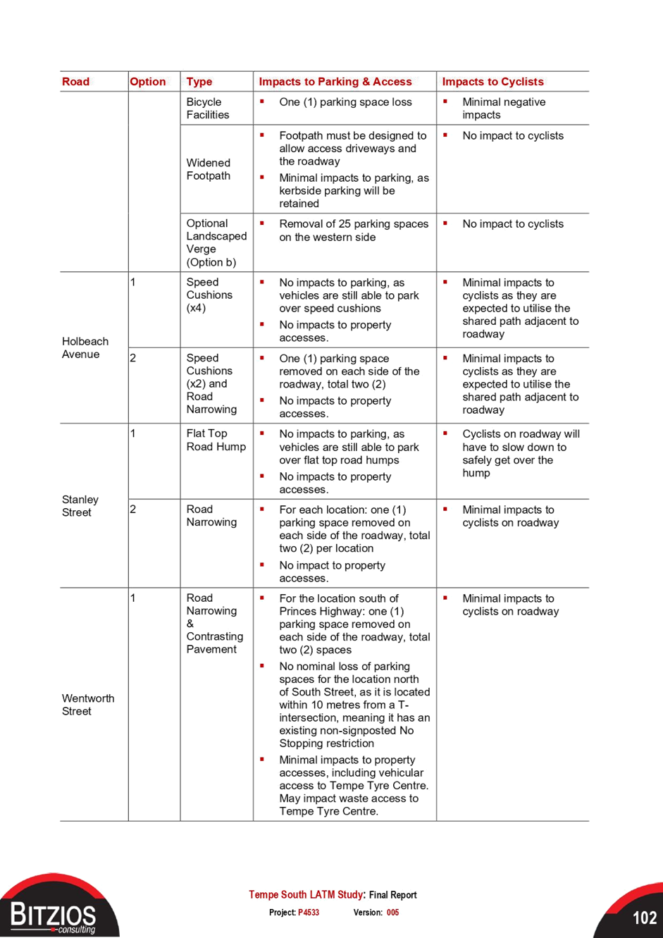
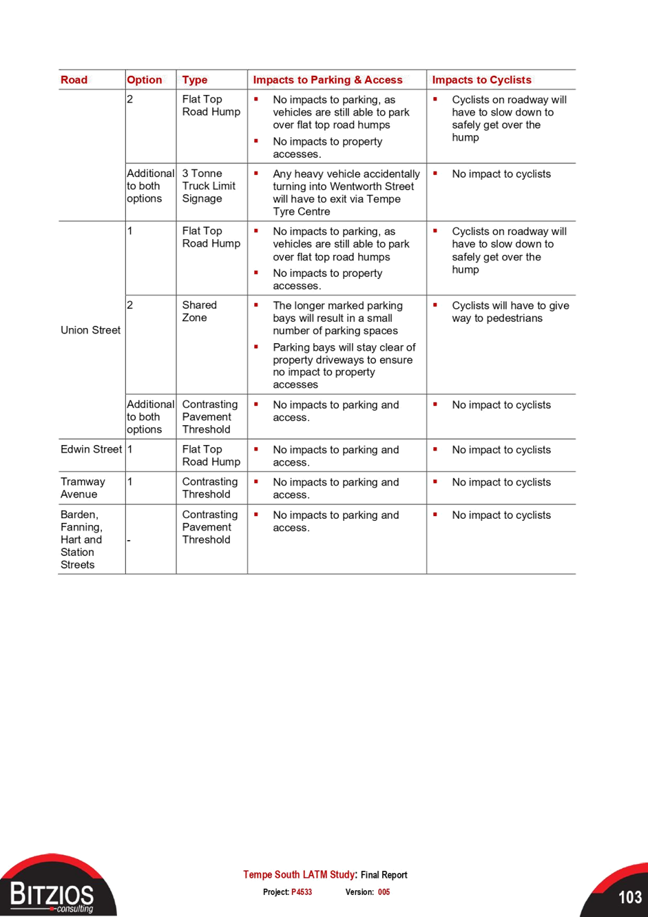
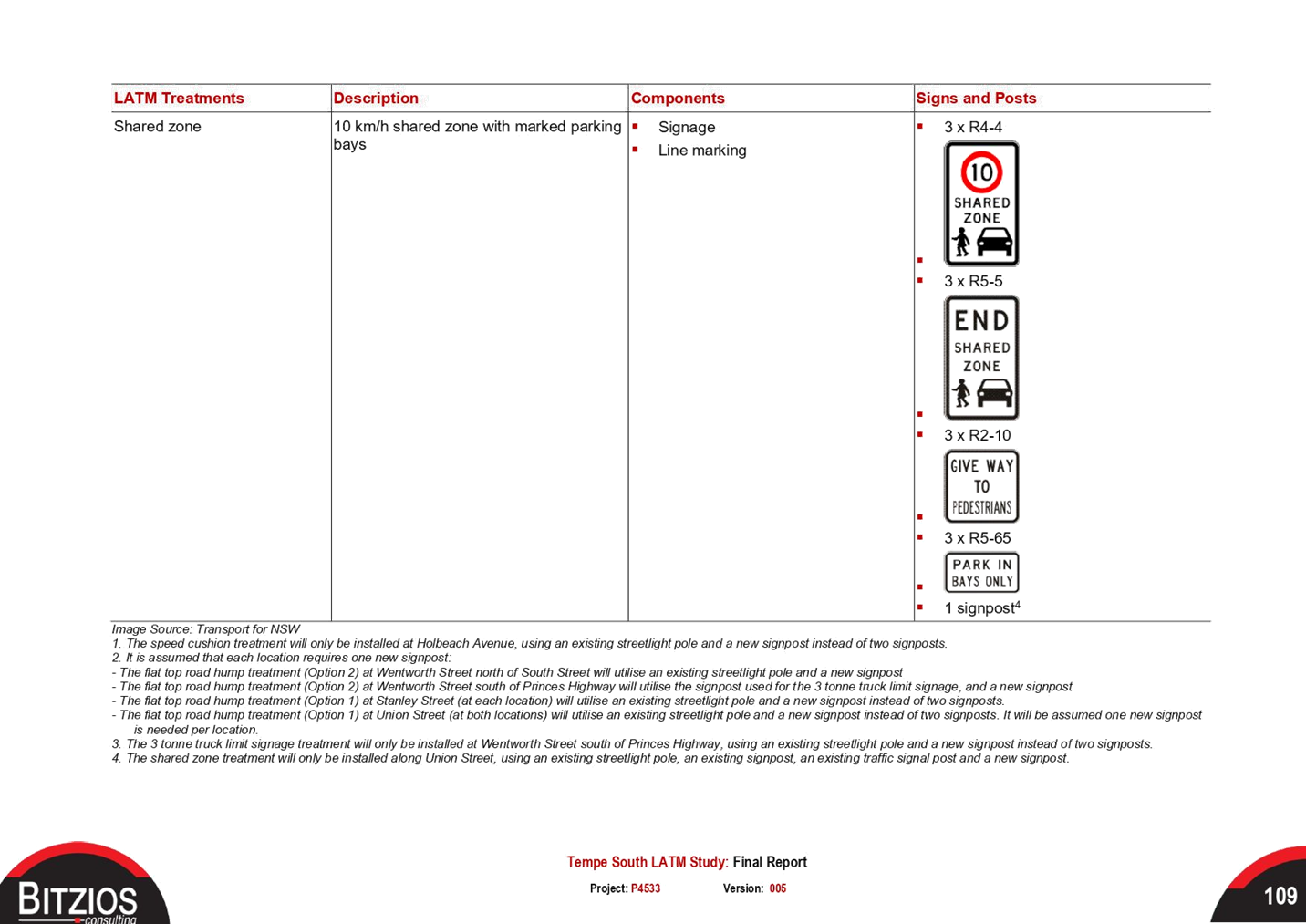
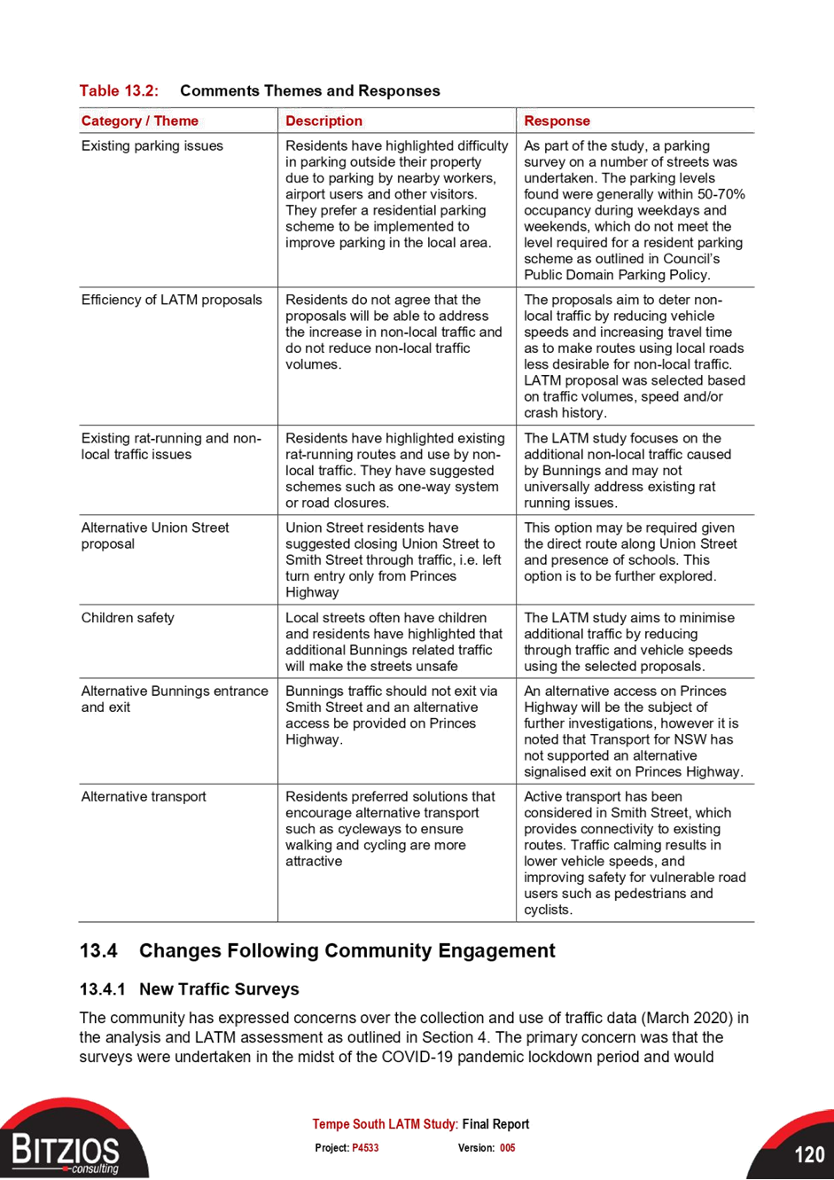
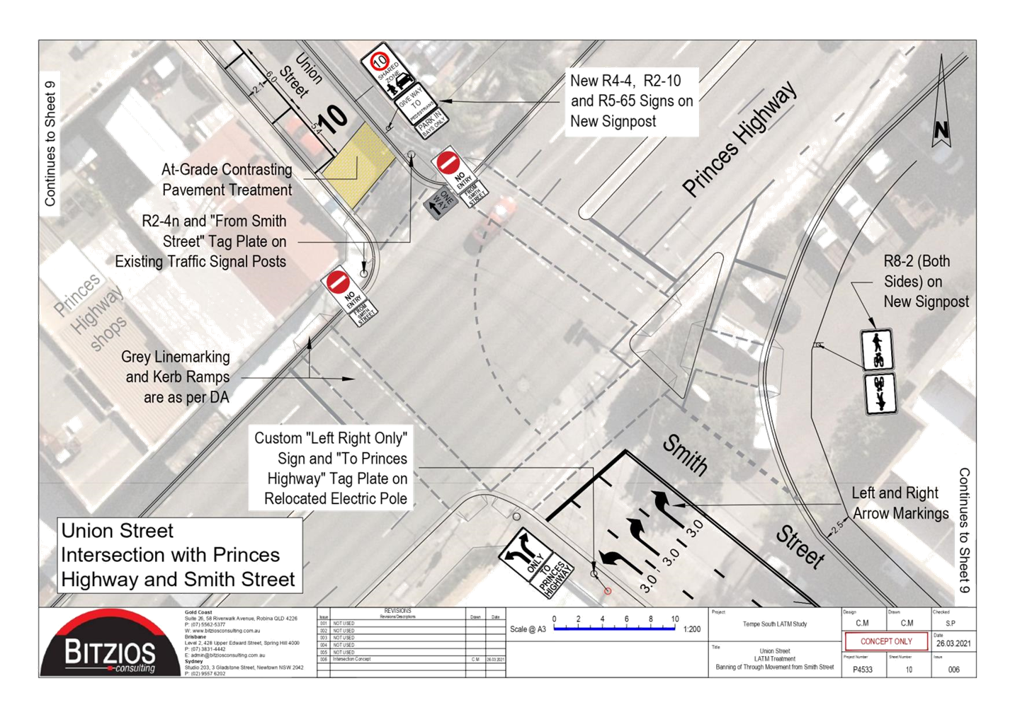
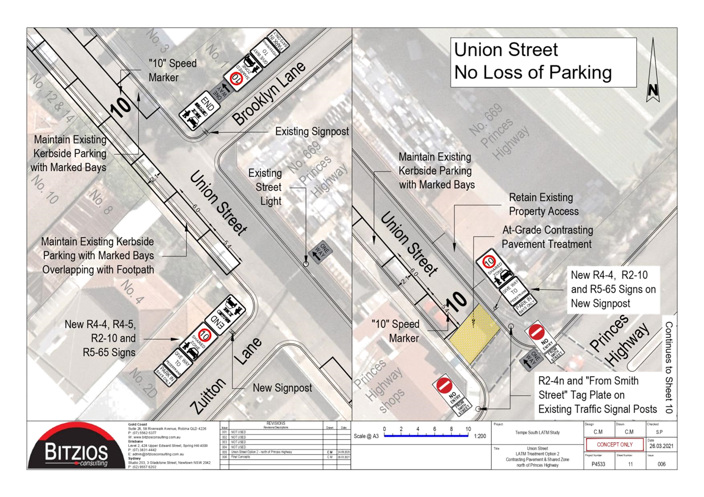
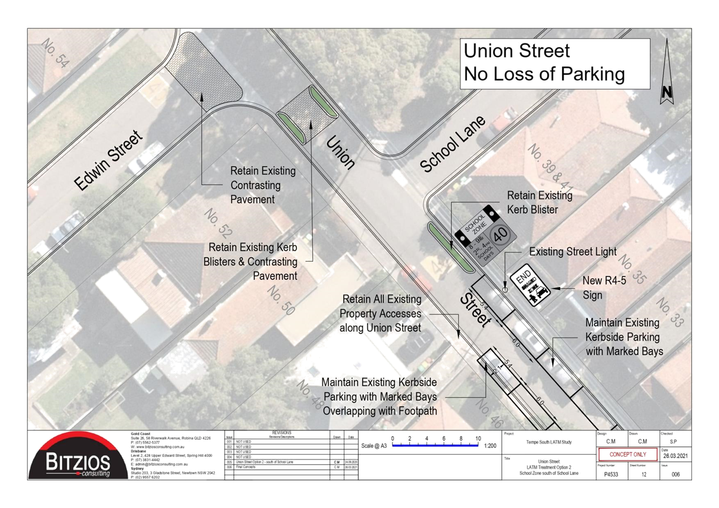
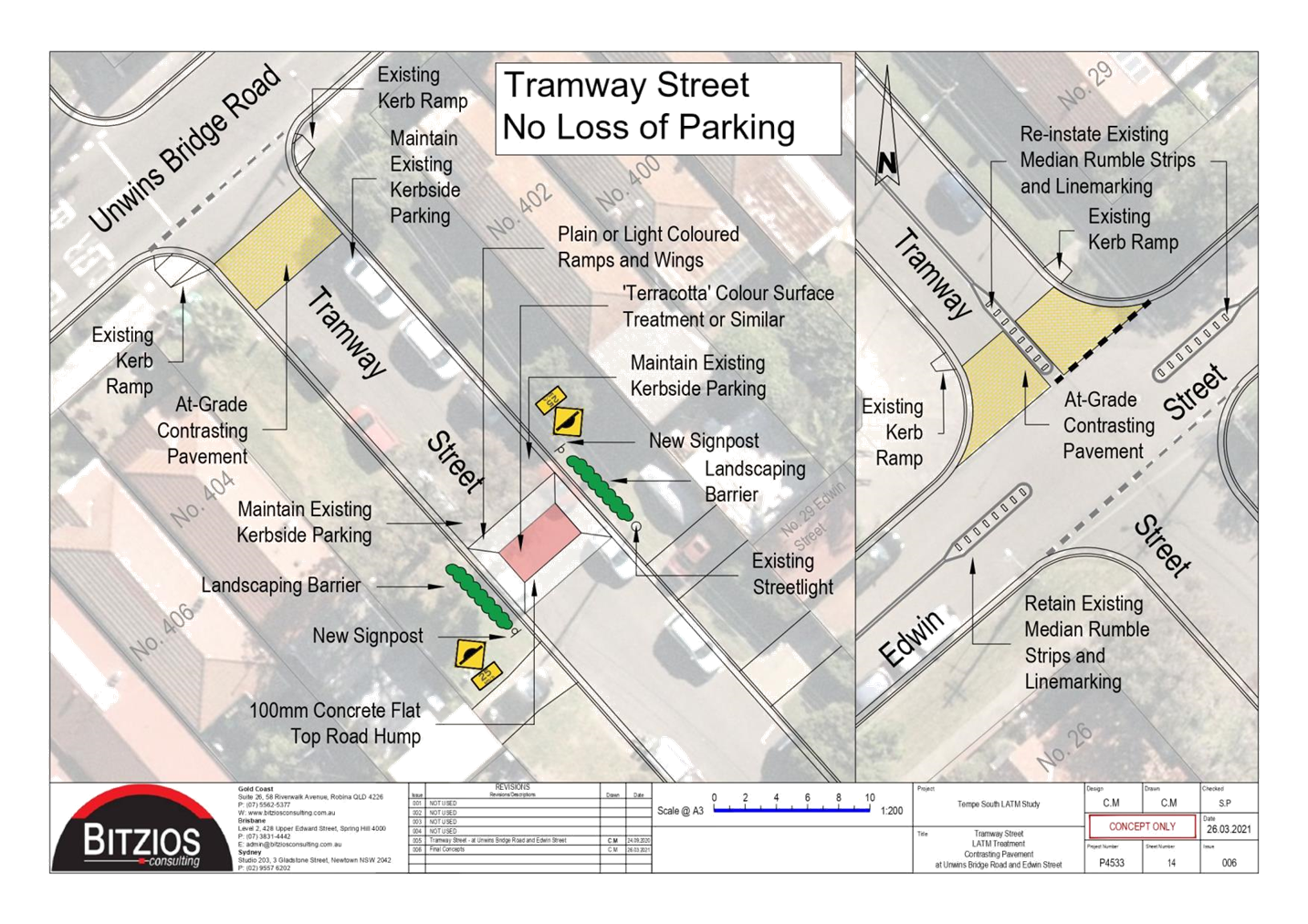
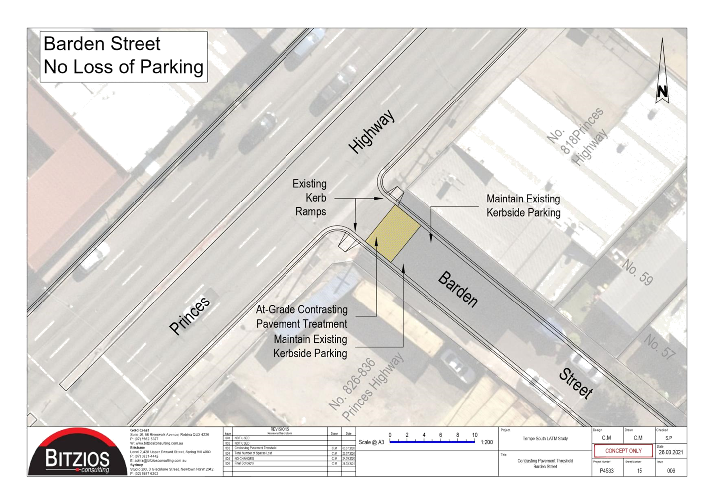
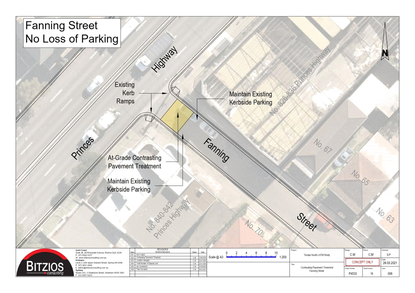
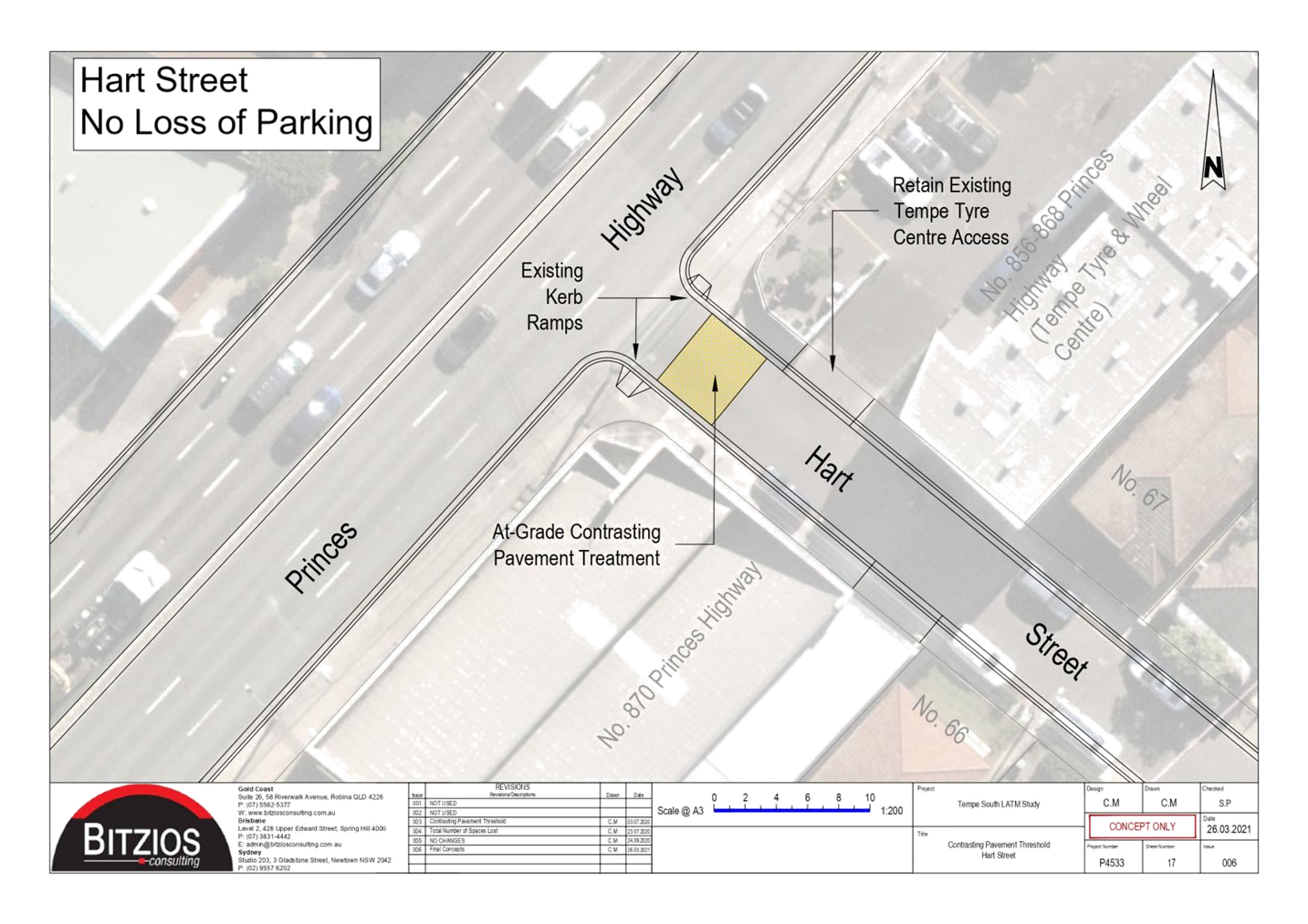
The intention of re-exhibiting the final Tempe South LATM is to finalise the treatments based on community feedback received from the initial public exhibition of the draft Tempe South LATM Study held in November 2020 to January 2021. The main changes since the last public exhibition comprised of the following proposals adopted from the community responses:
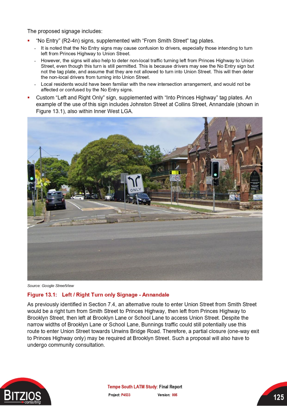
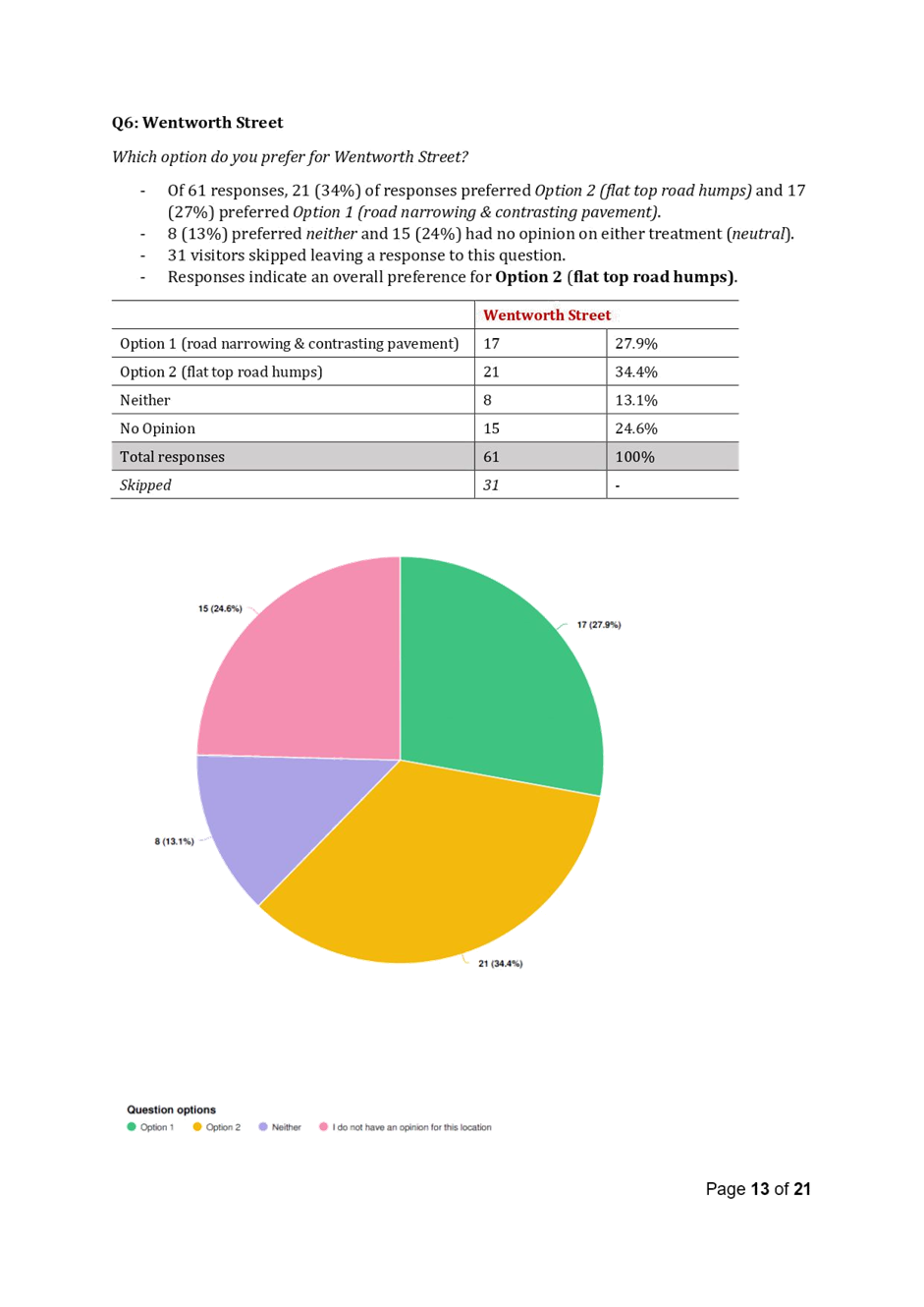
· Soft closure ‘No Entry’ and supplementary ‘From Smith Street’, custom ‘Left and Right only’ symbolic sign, supplementary ‘to Princes Highway’ sign at the signalized intersection of Smith Street and Princes Highway
· 10km/h Shared Zone in Union Street from Princes Highway to School Lane, including contrasting pavement threshold, installation of mountable kerbs
· Partial road closure of Brooklyn Street (exit only at Princes Highway), which would only be required to complement the No Entry closure at Union Street traffic signals.
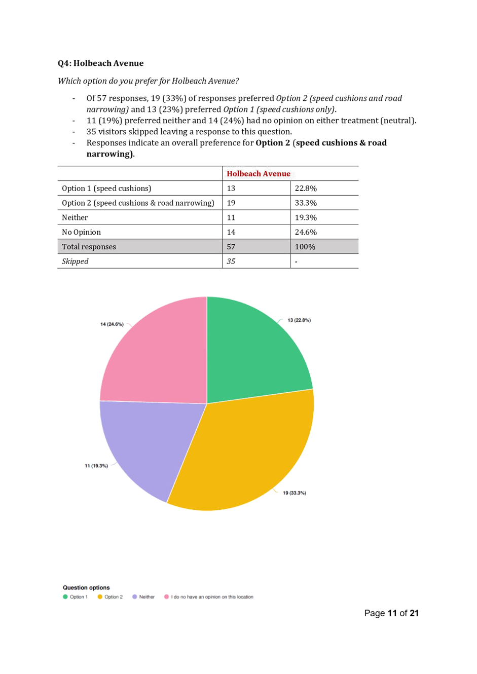
It is noted that the soft closure proposal would require some traffic diversions for residents located south of Princes Highway those seeking to access Tempe Public School or Tempe High School will need to detour to Holbeach Avenue, which will add to travel times for those impacted.
A finalised LATM scheme will be essential as there will be a fallback option for the Tempe community should the traffic signals at Princes Highway not be feasible.
As resolved by Council’s Notice of Motion on 12 April 2022, an independent study is expected to be underway examining the provision of traffic signals allowing direct connections from the Bunnings site to Princes Highway. The proposal would change the vehicle access arrangements for the site, allowing an entry only from Smith Street, whilst allowing right and left turns to and from the Princes Highway driveway positioned near the northern end of the site.
The study will also evaluate design changes within the Bunnings site to facilitate the amended vehicular entry and exit arrangements. The results of the Traffic Signals Feasibility Study will be submitted to Transport for NSW for consideration.
PUBLIC CONSULTATION
The last public exhibition held for the Tempe South LATM was in November 2020 to January 2021.
A Tempe Bunnings Community Meeting was also held on 6.00pm-7.30pm Wednesday 9 March 2022 at St Peters Library, 39 Unwins Bridge Road, Sydenham outlining the MOD/2021/0376 submitted by Bunnings, as well as the traffic matters including the Tempe South LATM study.
|
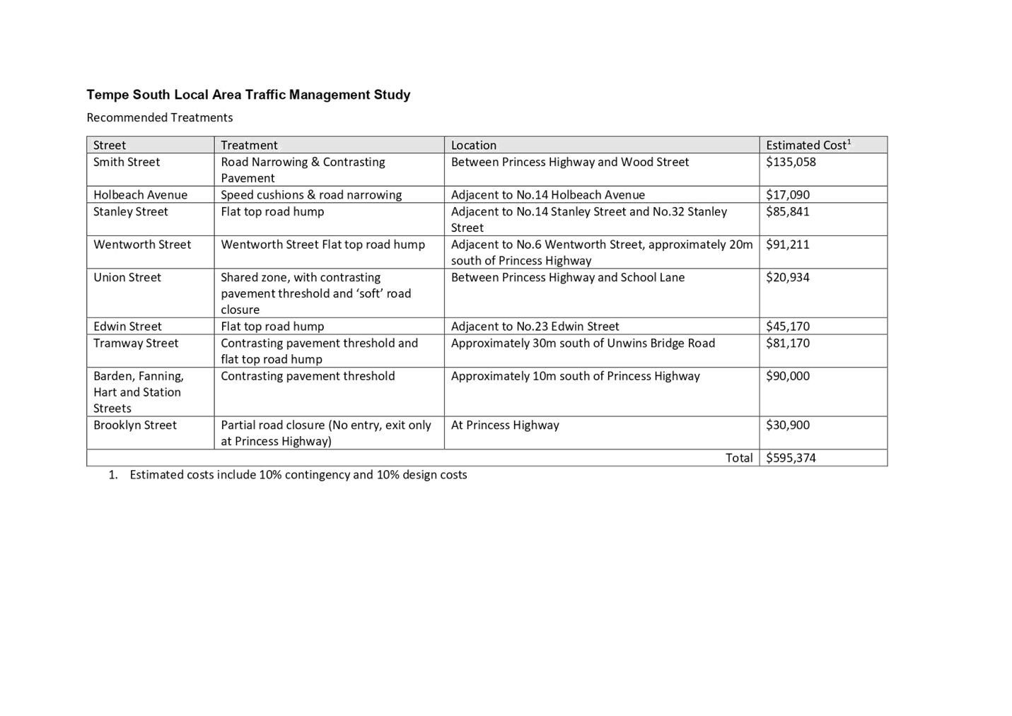
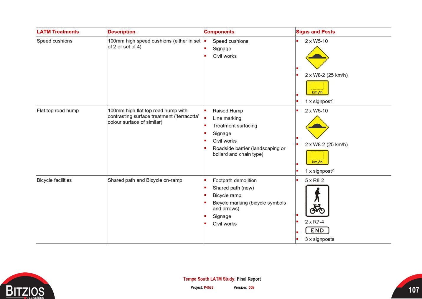
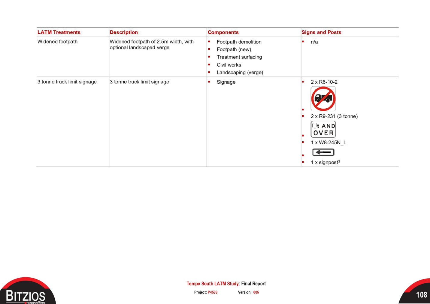
1.⇩ |
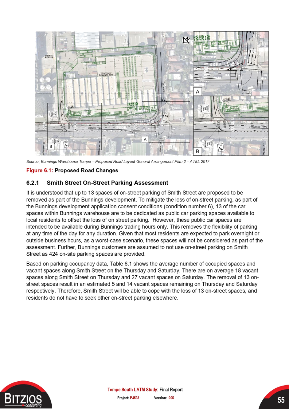
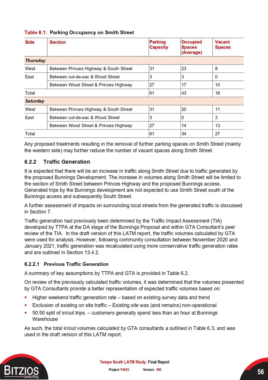
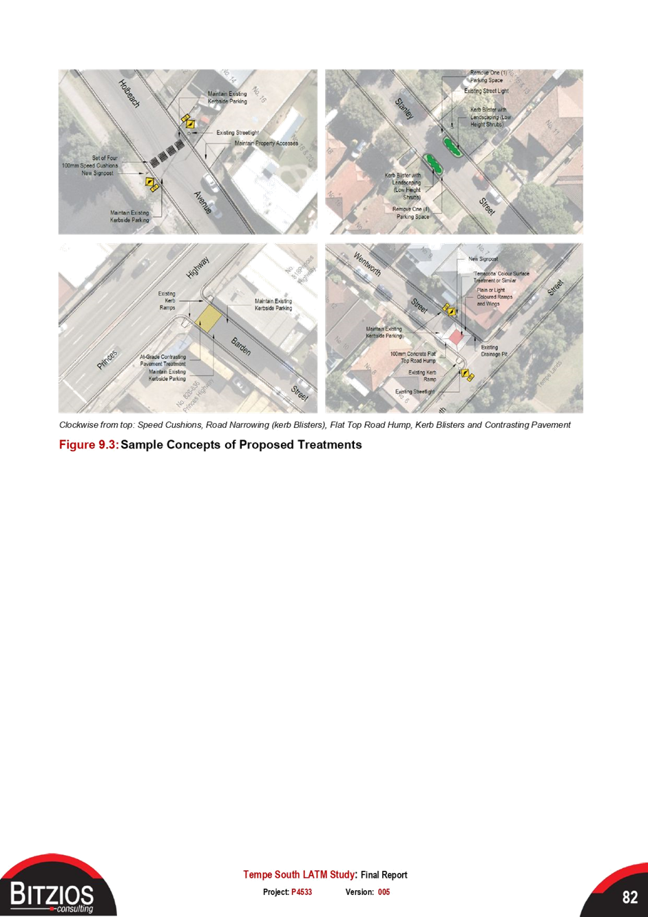
Recommended Treatments |
|
2.⇩ |
Tempe South LATM Study - Final Report |
|
3.⇩ |
Final Report Appendices A to C |
|
4.⇩ |
Final Report Appendices D to E |
|
Local Traffic Committee Meeting 20 June 2022 |
Subject: George Street, Leichhardt - Proposed 'Motor Bike Only' parking restrictions (Gulgadya - Leichhardt Ward/ Balmain Electorate/ Leichhardt PAC)
Prepared By: Vinoth Srinivasan - Engineer - Traffic and Parking Services
Authorised By: George Tsaprounis - Coordinator – Traffic and Parking Services
SUMMARY
Council has received concerns regarding obstructed resident access in George Street for No.52 George Street, Leichhardt. In order to prevent vehicles impeding resident access it is proposed to retain one (1) 5.6m parking ‘2P 8am-6pm Mon-Fri, Permit Holders Excepted’ parking space and utilise the remaining redundant kerb space to install 2m of ‘Motor Bike Only’ parking.
|
RECOMMENDATION
THAT one (1) 5.6m ‘2P 8am-6pm Mon-Fri, Permit Holders Excepted’ parking space be retained and a 2m ‘Motor Bike Only’ parking space be installed to utilise the redundant kerb space in front of No.52 George Street, Leichhardt. |
BACKGROUND & OTHER STAFF COMMENTS
Council has received concerns regarding obstructed resident access in George Street for No.52 George Street, Leichhardt.
The existing 7.6m kerb space in George Street in front of No.52 George Street is insufficient to accommodate two (2) standard vehicles without impeding resident access to No.52 George Street, Leichhardt. At times, two vehicles parked in this kerb space, along with vehicles parked across driveways on the opposite side of George Street may hinder vehicular access to the property.
In order to prevent vehicles impeding resident access it is proposed to retain one (1) 5.6m parking ‘2P 8am-6pm Mon-Fri, Permit Holders Excepted’ parking space and utilise the remaining redundant kerb space to install 2m of ‘Motor Bike Only’ parking.
![]()
FINANCIAL IMPLICATIONS
Nil.
PUBLIC CONSULTATION
A letter outlining the proposal was mailed out to 10 properties in George Street and Flood Street, Leichhardt requesting residents’ views regarding the proposal. 1 response was received in objection to the proposal.
The main traffic and parking related concerns raised by the resident are outlined in the below table:
|
Residents’ Comments |
Officer Comments |
|
The subject 7.6m kerb space is utilized by larger vehicles such as delivery trucks and vans. These oversized vehicles need extra space to park and load/unload materials without impeding accessway to driveway. Furthermore, people operating these vehicles need extra space to ensure their safety when they are loading/unloading materials from the back of vehicles. The proposal poses a safety risk for these personnel who may be struck by vehicles exiting driveways during the unload process. It is not practical to expect drivers to park |
George Street is situated in a residential area and the service vehicles attending the street will make short term, non-frequent trips. |
|
The proposal will have the unintended effect of impinging on the driveway of No.54 George Street which will be shifting the problem from one area to another. This issue can be sufficiently managed via driveway line markings. |
Driveway line markings only act as a guide and are not enforceable. It should be noted that No.52 George Street already has driveway line markings in front of the property. |
|
Installing ‘Motor Bike Only’ parking restrictions will increase noise levels in the street and there is already many spaces for motorbikes to park in the area. |
Noted. |
|
I have owned the property in close proximity to No.52 George Street for 20 years and not experienced or observed the driveway being blocked or access being restricted due to vehicles being double parked in the allocated space at the front of the property. |
Council’s enforcement team has received a number of complaints regarding illegal parking behavior in front of No.52 George Street. |
|
|
Local Traffic Committee Meeting 20 June 2022 |
Subject: Nelson Lane, Annandale - Proposed No Parking Restrictions (Baludarri-Balmain Ward/ Balmain Electorate/ Leichhardt PAC)
Prepared By: Brinthaban Baskaran - Graduate Traffic Engineer
Authorised By: George Tsaprounis - Coordinator – Traffic and Parking Services
SUMMARY
The eastern side of Nelson Lane, Annandale has existing ‘No Parking 8:00am-6:00pm Mon-Fri’ restrictions. This report recommends removing this part-time ‘No Parking’ zones and instead installing full-time ‘No Parking’ zones for the residents requiring access to their off-street parking.
|
RECOMMENDATION
THAT:
1. The ‘No Parking 8:00am – 6:00pm Mon-Fri’ restrictions be removed on the eastern side of Nelson Lane, Annandale, opposite the rear accesses of No.253-No.257, No.261-No.263 and No.269-No.331 Nelson Street. 2. Full-time ‘No Parking’ restrictions be installed on the eastern side of Nelson Lane, opposite the rear accesses of No.253-No.257, No.263, No.269, No.297, No.311, No.315 and No.331 Nelson Street.
|
BACKGROUND
The existing ‘No Parking 8:00am-6:00pm Mon-Fri’ restrictions were installed in 2015, to improve resident access as there were issues with construction workers parking due to the nearby Tramshed development. Both full-time and part-time ‘No Parking’ restrictions were considered but residents at the time preferred the part-time restrictions as the issue was only apparent during construction hours.
A survey was sent out in 2021 and majority of residents did not support a full time ‘No Parking’ restriction on the eastern side of Nelson Lane. Based on feedback received, majority of the community requested to remove the existing ‘No Parking 8:00am-6:00pm Mon-Fri’ zone, whilst some requested for a full-time ‘No Parking’ restriction to access their off-street parking.
FINANCIAL IMPLICATIONS
Nil.
OTHER STAFF COMMENTS
In order to address both requests, it is proposed to remove the existing ‘No Parking 8:00am-6:00pm Mon-Fri’ zones on eastern side of Nelson Lane, Annandale and install a 6m full time ‘No Parking’ zone opposite to the rear of No.257, No.263, No.269, No.285 and No.311 Nelson Street, Annandale.
The proposal is shown on the plan below.
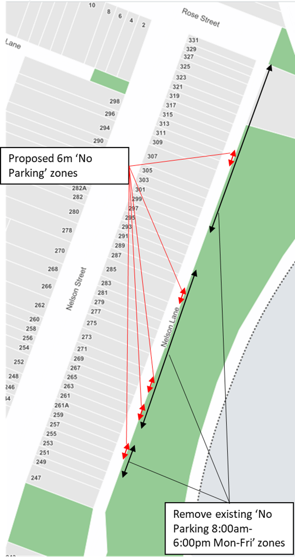
Figure 1: Proposed ‘No Parking’ restrictions – Initial Consultation Plan (2022)
After assessing feedback from the community, a revised ‘No Parking’ plan was developed as shown in Figure 2. The changes take into consideration the rate of support received during public consultation and residents who require access to their off-street parking.
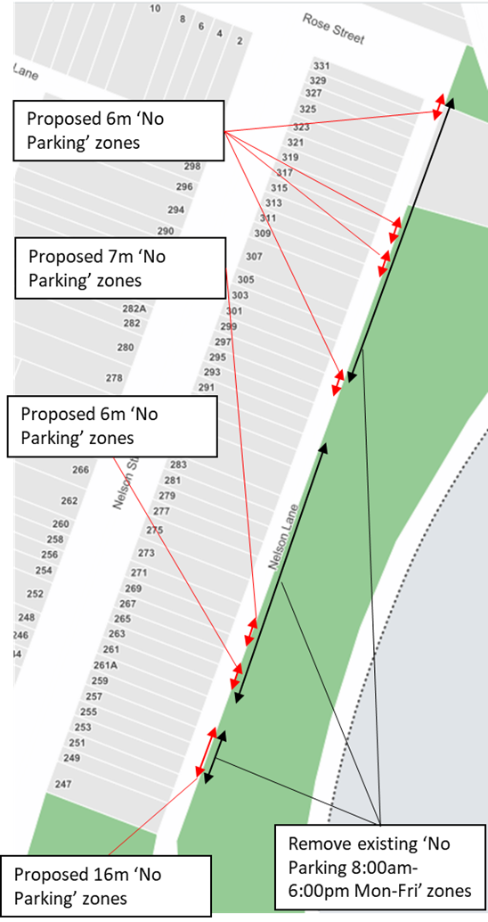
Figure 2: Revised ‘No Parking’ restrictions
The review of the consultation feedback has resulted in the following recommendation:
· Full-time ‘No Parking’ zone opposite to the rear of No.253-257, No.263, No.269, No.297, No.311, No.315 and No.331 Nelson Street, Annandale.
· Remove existing ‘No Parking 8:00am – 6:00pm’ zones opposite to the rear of No.253-No.257, No.261-No.289 and No.299-No.331
PUBLIC CONSULTATION
A letter outlining the above proposal was mailed to the affected properties (52 properties) in Nelson Street (eastern side), requesting residents’ feedback on revised proposal.
Thirteen (13) responded to the survey, Twelve (12) in support and one (1) in objection of the proposal.
|
Resident Comment |
Officer Comment |
|
6m ‘No Parking’ zone is not sufficient to access our off-street parking and it has to be extended. |
A swept path analysis was conducted, and the proposal is to extend the ‘No Parking’ zone to 7m at rear of the property. |
|
No.285 Nelson Street does not require a ‘No Parking’ zone opposite the rear of our property. |
Noted. |
CONCLUSION
The revised ‘No Parking’ restrictions recommendation to be supported.
|
|
Local Traffic Committee Meeting 20 June 2022 |
Subject: Stephen Street, Balmain (At Vincent Street) - Proposed Kerb Indentation (Baludarri - Balmain/ Balmain Electorate/ Leichhardt PAC)
Prepared By: Vinoth Srinivasan - Engineer - Traffic and Parking Services
Authorised By: George Tsaprounis - Coordinator – Traffic and Parking Services
SUMMARY
Council is planning to improve the existing parking arrangements in Stephen Street, Balmain (Vincent Street to End) by adjusting the existing kerb on the western side of the street to widen the road and forming indented parking bays. The proposed works is intended to improve pedestrian and motorist safety in the area.
|
RECOMMENDATION
THAT the attached detail design plan (Design Plan No.10203) for the proposed kerb indentation on the western side of Stephen Street, Balmain be approved. |
BACKGROUND & OTHER STAFF COMMENTS
The detailed design plan shown in Attachment 1 outlines the proposed works on Stephen Street, Balmain and includes the following treatments:
- Removal of existing kerb & gutter on the western side of the street and construction of new kerb only along new alignment to form indented parking bays (from A to B) as shown on attached plans;
- Construction of new dish drain along alignment of removed kerb & gutter (from A to B) as shown on attached plans;
- Reconstruction of existing asphalt footpath with new asphalt footpath (western side adjacent to Birrung Park);
- Reconstruction of some damaged sections of asphalt footpath with new asphalt footpath;
- Resurfacing of the road pavement in Stephen Street with new asphalt;
- Construction of 4 new kerb ramps (where shown on the plans);
- Reconstruction of some damaged sections of kerb & gutter with new concrete kerb & gutter;
- Upgrade of existing stormwater drainage pits with new grates and inlet lintels;
- Reconstruction of the entry driveway into Birrung Park;
- Installation of new No Stopping signs to ensure safe access, parking and manoeuvring into and out of Stephen Street; and
- Installation of associated pavement line marking and signage as required.
The proposal will not result in the loss of any on-street parking on Stephen Street, Balmain.
FINANCIAL IMPLICATIONS
Funding of $35,000 has been allocated to this project for construction in the 2022/2023 Traffic Facilities (LATM) Capital Works Program.
PUBLIC CONSULTATION
A letter outlining the proposal was mailed out to 6 properties in Stephen Street and Vincent, Balmain requesting residents’ views regarding the proposal. Two responses were received in general support with request for changes.
The main traffic and parking related concerns raised by the residents are outlined in the below table:
|
Residents’ Comments |
Officer Comments |
|
The proposed location of the bollard should be shifted further down the walkway by approximately one metre. This will make it easier for residents to turn around in the driveway towards the end of the street.
|
The bollard will move 0.5m toward the park - away from the driveway. This amendment will be shown on the construction plans.
|
|
Install ‘No Stopping’ signs or line marking in front of No.40 Stephen Street to prevent vehicles from parking across the driveway, restricting a vehicles ability to turn around in the cul-de-sac.
|
The installation of ‘No Stopping’ signs are not warranted at this stage. The parking on Stephen Street will be monitored after the completion of the roadworks and Council may take further action if it found that there is a high level of non-compliance. |
|
1.⇩ |
Detailed Design Plan - Stephen Street, Balmain (At Vincent Street) - Proposed Kerb Indentation |