|
AGENDA R |

Local Traffic Committee Meeting
MONDAY 18 JULY 2022
11.00AM
|
|
Local Traffic Committee Meeting 18 July 2022 |
Function of the Local Traffic Committee
Background
Roads and Maritime Services (RMS) is legislated as the Authority responsible for the control of traffic on all NSW Roads. The RMS has delegated certain aspects of the control of traffic on local roads to councils. To exercise this delegation, councils must establish a local traffic committee and obtain the advice of the RMS and Police. The Inner West Council Local Traffic Committee has been constituted by Council as a result of the delegation granted by the RMS pursuant to Section 50 of the Transport Administration Act 1988.
Role of the Committee
The Local Traffic Committee is primarily a technical review and advisory committee which considers the technical merits of proposals and ensures that current technical guidelines are considered. It provides recommendations to Council on traffic and parking control matters and on the provision of traffic control facilities and prescribed traffic control devices for which Council has delegated authority. These matters are dealt with under Part A of the agenda and require Council to consider exercising its delegation.
In addition to its formal role as the Local Traffic Committee, the Committee may also be requested to provide informal traffic engineering advice on traffic matters not requiring Council to exercise its delegated function at that point in time, for example, advice to Council’s Development Assessment Section on traffic generating developments. These matters are dealt with under Part C of the agenda and are for information or advice only and do not require Council to exercise its delegation.
Committee Delegations
The Local Traffic Committee has no decision-making powers. The Council must refer all traffic related matters to the Local Traffic Committee prior to exercising its delegated functions. Matters related to State Roads or functions that have not been delegated to Council must be referred directly to the RMS or relevant organisation.
The Committee provides recommendations to Council. Should Council wish to act contrary to the advice of the Committee or if that advice is not supported unanimously by the Committee members, then the Police or RMS have an opportunity to appeal to the Regional Traffic Committee.
Committee Membership & Voting
Formal voting membership comprises the following:
· one representative of Council as nominated by Council;
· one representative of the NSW Police from each Local Area Command (LAC) within the LGA, being Newtown, Marrickville, Leichhardt and Ashfield LAC’s.
· one representative from the RMS; and
· State Members of Parliament (MP) for the electorates of Summer Hill, Newtown, Heffron, Canterbury, Strathfield and Balmain or their nominees.
Where the Council area is represented by more than one MP or covered by more than one Police LAC, representatives are only permitted to vote on matters which effect their electorate or LAC.
Informal (non-voting) advisors from within Council or external authorities may also attend Committee meetings to provide expert advice.
Committee Chair
Council’s representative will chair the meetings.
Public Participation
Members of the public or other stakeholders may address the Committee on agenda items to be considered by the Committee. The format and number of presentations is at the discretion of the Chairperson and is generally limited to 3 minutes per speaker. Committee debate on agenda items is not open to the public.
|
|
Local Traffic Committee Meeting 18 July 2022 |
|
AGENDA |
1 Apologies
2 Disclosures of Interest
3 Confirmation of Minutes Page
Minutes of 20 June 2022 Local Traffic Committee Meeting 5
4 Matters Arising from Council’s Resolution of Minutes
5 Part A – Items Where Council May Exercise Its Delegated Functions
Traffic Matters
ITEM Page
LTC0722(1) Item 1 Dulwich Hill Station Precinct Public Domain Improvements Amendments - Location of Traffic Calming Entry Thresholds – Midjuburi – Marrickville Ward/Summer Hill Electorate/Inner West Paculwich Hill Station Precinct Public Domain Improvements - Location of Entry Thresholds 21
LTC0722(1) Item 2 Bayley Street, Marrickville, Cavendish Street, Stanmore And Fotheringham Street, Enmore - Dedicated Car Share Parking Restrictions (Summer Hill Electorate / Inner West PAC) 140
LTC0722(1) Item 3 Murrell
Street, Ashfield- Traffic and Parking changes
(Diarrawunang-Ashfield Ward/Summer Hill Electorate/Burwood PAC) 145
Parking Matters
ITEM Page
LTC0722(1) Item 4 Railway Street, Croydon-Proposed 'No Parking' opposite driveway(Gulgadya-Leichhardt Ward/Strathfiled Electorate/Ashfield PAC) 153
Late Items
Nil at time of printing.
6 Part B - Items for Information Only
Nil at the time of printing.
7 Part C - Items for General Advice
Nil at the time of printing.
8 General Business
9 Close of Meeting
|
|
Local Traffic Committee Meeting 18 July 2022 |
Minutes of Local Traffic Committee Meeting
Held on 20 June 2022 at Ashfield Service Centre
Meeting commenced at 11.01AM
ACKNOWLEDGEMENT OF COUNTRY BY CHAIRPERSON
I acknowledge the Gadigal and Wangal people of the Eora nation on whose country we are meeting today, and their elders past and present.
COMMITTEE REPRESENTATIVES PRESENT
|
Cr Justine Langford |
Councillor – Midjuburi-Marrickville Ward (Chair) |
|
Bill Holliday |
Representative for Jamie Parker MP, Member for Balmain |
|
Graeme McKay |
Representative for Jo Haylen MP, Member for Summer Hill |
|
Chris Woods |
Representative for Ron Hoenig MP, Member for Heffron |
|
Sgt Charles Buttrose |
NSW Police – Leichhardt Police Area Command |
|
Ram Sritharan |
Transport for NSW (TfNSW) |
|
|
|
|
NON VOTING MEMBERS IN ATTENDANCE |
|
|
|
|
|
Cr Kobi Shetty |
Councillor – Baludarri-Balmain Ward |
|
Colin Jones |
Inner West Bicycle Coalition (IWBC) |
|
Manod Wickramasinghe |
IWC’s Acting Director Infrastructure |
|
George Tsaprounis |
IWC’s Acting Traffic and Transport Services Manager |
|
Sunny Jo |
IWC’s Coordinator Traffic Engineering Services (North) |
|
Boris Muha |
IWC’s Engineer – Traffic and Parking Services |
|
Jason Scoufis |
IWC’s Traffic and Parking Planner |
|
Christina Ip |
IWC’s Business Administration Officer |
|
|
|
|
VISITORS |
|
|
|
|
|
Christina |
Item 3 – Resident |
|
|
|
|
APOLOGIES: |
|
|
|
|
|
Mayor Darcy Bryne |
Councillor – Baludarri-Balmain Ward |
|
SC Germaine Grant |
NSW Police – Burwood Police Area Command |
|
SC Anthony Kenny |
NSW Police – Inner West Police Area Command |
|
Colin Hesse |
Representative for Jenny Leong MP, Member for Newtown |
|
Maryanne Duggan |
Representative for Jason Yat-Sen Li, Member for Strathfield |
DISCLOSURES OF INTERESTS:
Nil.
CONFIRMATION OF MINUTES
|
The minutes of the Local Traffic Committee meeting held on 16 May 2022 were confirmed. |
MATTERS ARISING FROM COUNCIL’S RESOLUTION OF MINUTES
The Local Traffic Committee recommendations of its meeting on 16 May 2022 were adopted at Council’s meeting on 14 June 2022.
|
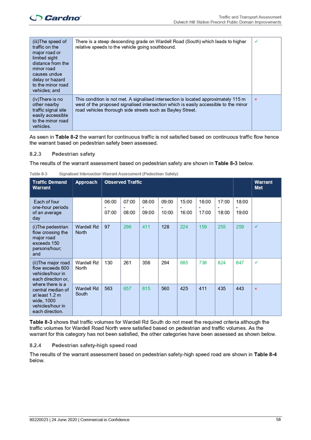
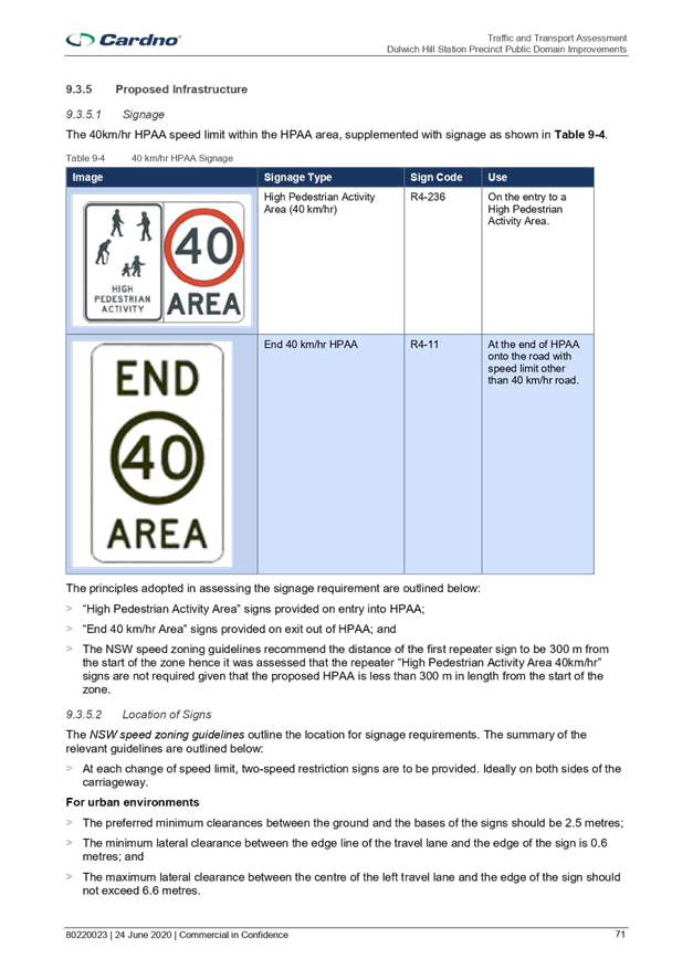
TfNSW Supplements to Australian Standards sets out the warrant for the installation of a pedestrian (zebra) crossing to be used on state roads. Council has prepared a Pedestrian Crossing Warrant Policy as per Attachment 1, to be used when assessing the suitability of locations on local and regional roads.
The Policy aligns with the Strategic Plan Objective 2: Unique, liveable, networked neighbourhoods.
Officer’s Recommendation
THAT:
1. That the Committee support the draft Pedestrian Crossing Warrant Policy in principle; and 2. The draft Pedestrian Crossing Warrant Policy be put on public exhibition for a period of 28 days for comment with the results being bought back to the Committee for consideration.
DISCUSSION
Council Officers advised of a modification to section 5.2 of the policy to state that “A pedestrian (zebra) crossing is deemed to meet the numerical warrant for a pedestrian (zebra) crossing if the crossing point is predominately used by school children…” to align with the wording used by TfNSW. The Committee members agreed to this amendment to the wording prior to the Policy being put on public exhibition.
The representative for the Member for Balmain commented that, based on Parramatta Council’s report on the Interim Guidelines for the Selection of Pedestrian Crossing Facilities within the Parramatta LGA, vehicle speed is a more important factor than vehicle volume when assessing the warrant for pedestrian crossings and suggested removing vehicle volume as a criteria. The representative also commented that, according to Austroads, a zebra crossing has no effect on pedestrian accident rates; however, a raised crossing can significantly reduce the accident rate and incorporating refuges also improves safety at the crossing.
Council Officers advised that removing the vehicle volume requirement when assessing the warrant for a pedestrian crossing could lead to zebra crossings being installed at many intersections and lead to drivers disobeying the rules around them. It was advised that many of the pedestrian crossings in local streets are installed at intersections where vehicle speeds are already low because motorists are already slowing down towards the intersection. In addition, when assessing a location for a pedestrian crossing, road geometry, sightlines, vehicles speeds and other characteristics of the location are also considered.
The TfNSW representative supported the draft policy for public exhibition and will send the Policy to their internal technical team for comment.
The Committee members agreed with the Officer’s recommendation.
COMMITTEE RECOMMENDATION
THAT:
1. That the Committee support the draft Pedestrian Crossing Warrant Policy in principle; and 2. The draft Pedestrian Crossing Warrant Policy be put on public exhibition for a period of 28 days for comment with the results being bought back to the Committee for consideration.
For motion: Unanimous |
|
LTC0622(1) Item 4 Tobruk Avenue, Balmain - Temporary full road closure for excavation works (Baludarri - Balmain/ Balmain Electorate/ Leichhardt PAC) |
|
SUMMARY
Council has received an application from Domain Pools for the approval of a temporary full road closure of Tobruk Avenue, between Ennis Street and Reynolds Street, Balmain from Monday, 15 August 2022 at 8.00am to Thursday, 18 August 2022 at 11.00pm and Wednesday, 31 August 2022 from 8.00am to 11.00pm to facilitate excavation works on site at No.56 Mullens Street, Balmain
Officer’s Recommendation
THAT the proposed temporary full road closure of Tobruk Avenue, between Ennis Street and Reynolds Street, Balmain from Monday 15 August 2022 at 8.00am to Thursday, 18 August 2022 at 11.00pm and Wednesday, 31 August 2022 from 8.00am to 11.00pm (contingency period 4 weeks) be approved for the proposed excavation works on site at No.56 Mullens Street, Balmain subject to, but not limited to the following conditions:
1. A Road Occupancy License be obtained by the applicant from the Transport Management Centre;
2. All affected residents and businesses, including NSW Police Area Command, Fire & Rescue NSW and the NSW Ambulance Services be notified in writing, by the applicant, of the proposed temporary full road closure at least 7 days in advance of the closure with the applicant making reasonable provision for stakeholders; and
3. The occupation of the road carriageway must not occur until the road has been physically closed.
DISCUSSION
The Committee members agreed with the Officer’s recommendation.
COMMITTEE RECOMMENDATION
THAT the proposed temporary full road closure of Tobruk Avenue, between Ennis Street and Reynolds Street, Balmain from Monday 15 August 2022 at 8.00am to Thursday, 18 August 2022 at 11.00pm and Wednesday, 31 August 2022 from 8.00am to 11.00pm (contingency period 4 weeks) be approved for the proposed excavation works on site at No.56 Mullens Street, Balmain subject to, but not limited to the following conditions:
1. A Road Occupancy License be obtained by the applicant from the Transport Management Centre;
2. All affected residents and businesses, including NSW Police Area Command, Fire & Rescue NSW and the NSW Ambulance Services be notified in writing, by the applicant, of the proposed temporary full road closure at least 7 days in advance of the closure with the applicant making reasonable provision for stakeholders; and
3. The occupation of the road carriageway must not occur until the road has been physically closed.
For motion: Unanimous |
|
LTC0622(1) Item 5 Seven Bridges Walk - Special Event (Gulgadga - Leichhardt & Baludarri - Balmain Ward/ Balmain Electorate/ Leichhardt PAC) |
|
SUMMARY
The Cancer Council NSW Seven Bridges Walk event will be held on Sunday, 23 October 2022 at various locations in Sydney, including areas within the Inner West Council. The Event is in its seventh year of operation and the applicant seeks approval again in 2022.
Officer’s Recommendation
THAT the Cancer Council NSW Seven Bridges Walk to be held on Sunday, 23 October 2022 be approved, subject to a current Public Liability Insurance Policy which includes the Inner West Council being an interested party being submitted by the event organiser prior to the event.
DISCUSSION
The TfNSW representative requested a separate copy of the Public Liability Insurance Policy for TfNSW review and concurrence.
The Committee members agreed with the Officer’s recommendation.
COMMITTEE RECOMMENDATION
THAT the Cancer Council NSW Seven Bridges Walk to be held on Sunday, 23 October 2022 be approved, subject to a current Public Liability Insurance Policy which includes the Inner West Council being an interested party being submitted by the event organiser prior to the event.
For motion: Unanimous |
|
LTC0622(1) Item 6 Trafalgar Street, Annandale - Proposed raised pedestrian crossing (Gulgadya - Leichhardt Ward/ Balmain Electorate/ Leichhardt PAC)
|
|
SUMMARY
Council is planning to improve pedestrian safety in Trafalgar Street, Annandale outside No. 27 Trafalgar Street by upgrading the existing at-grade pedestrian crossing to a raised pedestrian crossing. The proposed works will improve pedestrian and motorist safety in the area. As part of the works, the two existing speed humps on either side of the existing pedestrian crossing will be removed.
Officer’s Recommendation
THAT the attached detail design plan (Design Plan No.10211) for the proposed installation of a new raised pedestrian crossing on Trafalgar Street, Annandale be approved.
DISCUSSION
The TfNSW representative requested clarification whether there will be advanced crossing signs. Council Officers will check with the designers and respond to TfNSW separately.
The Committee members agreed with the Officer’s recommendation.
COMMITTEE RECOMMENDATION
THAT the attached detail design plan (Design Plan No.10211) for the proposed installation of a new raised pedestrian crossing on Trafalgar Street, Annandale be approved.
For motion: Unanimous |
|
LTC0622(1) Item 7 Smidmore Street, Marrickville – ENRC/2022/0022 - Temporary full road closure for two Marrickville Metro events The Fringe Festival 8-12 September 2022 and 10-12 December 2022 Markets and related temporary changes to Victoria Road kerbside parking restrictions to accommodate relocation of community bus (Midjuburi – Marrickville Ward / Heffron Electorate / Inner West PAC) |
|
SUMMARY
Council has been notified by MLA Transport Planning, on behalf of Marrickville Metro Shopping Centre, about two proposed temporary full road closures of Smidmore Street, between Murray Street and the Centre’s Smidmore Street car park access, Marrickville for the Fringe Festival 8-12 September and for the 10-12 December 2022 Marrickville Metro Market event. The closures will involve related temporary changes to Victoria Road kerbside parking restrictions to accommodate relocation of the community bus stop. It is recommended that the proposed temporary road closures be approved subject to all standard Council conditions for a temporary full road closure. The related changes to kerbside signage be approved also subject to all works and costs associated with the signage changes for the relocated 'Community Bus zone' and reinstatement of Council’s original parking restrictions is to be borne by the applicant.
Officer’s Recommendation
1. THAT the proposed temporary full road closure of Smidmore Street, between Murray Street and the Smidmore Street car park access, Marrickville for a four day period 6am Saturday 8 September to midnight Monday 12 September 2022 and for a two day period 6am Saturday 10 December to midnight Sunday 11 December 2022 for the purpose of holding two different Marrickville Metro Shopping Centre events (the Fringe Festival and the second weekend December markets) be APPROVED, subject to the applicant complying with, but not limited to, the following conditions: a. A Road Occupancy License application be obtained by the applicant from the Transport Management Centre; b. All affected residents and businesses, including NSW Police Local Area Commander, Transit Systems, Fire and Rescue NSW and NSW Ambulance Services, shall be notified in writing by the applicant of the proposed temporary road closure at least 7 days prior to the event, with the applicant making reasonable provision for residents and businesses; c. The occupation of the road carriageway must not occur until the road has been physically closed; and d. A clear unobstructed 4-metre-wide path of travel throughout the site is recommended to be maintained at all times for emergency vehicle access, in order to provide safe egress in case of fire or other emergency.
2. THAT the proposed short-term temporary changes to parking restrictions in Victoria Road, Marrickville as per plans submitted by MLA Transport Planning (20008ppt05A-220225 Community Bus Stop Relocation Plan (002)) be approved subject to the following conditions:
a. All works and cost of the supply, installation and removal of the signage associated with the temporary community bus relocation is to be borne by the applicant; b. The temporary removal and reinstatement of any Council assets will be at the applicants cost and to Council’s Traffic Engineers satisfaction; and Notification of surrounding properties be undertaken at least 7 Days prior to installation of the temporary changes and relocated 'Bus Zone'.
DISCUSSION
The TfNSW representative requested a separate copy of the TMP be sent to TfNSW for review.
The Committee members agreed with the Officer’s recommendation.
COMMITTEE RECOMMENDATION
1. THAT the proposed temporary full road closure of Smidmore Street, between Murray Street and the Smidmore Street car park access, Marrickville for a four day period 6am Saturday 8 September to midnight Monday 12 September 2022 and for a two day period 6am Saturday 10 December to midnight Sunday 11 December 2022 for the purpose of holding two different Marrickville Metro Shopping Centre events (the Fringe Festival and the second weekend December markets) be APPROVED, subject to the applicant complying with, but not limited to, the following conditions: a. A Road Occupancy License application be obtained by the applicant from the Transport Management Centre; b. All affected residents and businesses, including NSW Police Local Area Commander, Transit Systems, Fire and Rescue NSW and NSW Ambulance Services, shall be notified in writing by the applicant of the proposed temporary road closure at least 7 days prior to the event, with the applicant making reasonable provision for residents and businesses; c. The occupation of the road carriageway must not occur until the road has been physically closed; and d. A clear unobstructed 4-metre-wide path of travel throughout the site is recommended to be maintained at all times for emergency vehicle access, in order to provide safe egress in case of fire or other emergency.
2. THAT the proposed short-term temporary changes to parking restrictions in Victoria Road, Marrickville as per plans submitted by MLA Transport Planning (20008ppt05A-220225 Community Bus Stop Relocation Plan (002)) be approved subject to the following conditions:
a. All works and cost of the supply, installation and removal of the signage associated with the temporary community bus relocation is to be borne by the applicant; b. The temporary removal and reinstatement of any Council assets will be at the applicants cost and to Council’s Traffic Engineers satisfaction; and Notification of surrounding properties be undertaken at least 7 Days prior to installation of the temporary changes and relocated 'Bus Zone'.
For motion: Unanimous |
|
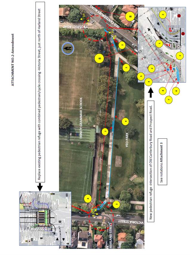
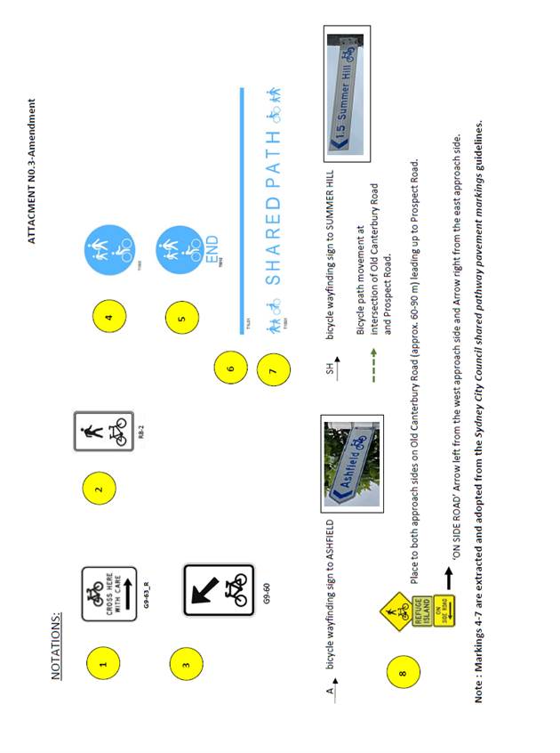
LTC0622(1) Item 8 Yeo Park, Summer Hill - Formalisation of
off-road shared bicycle- pedestrian path,
between Victoria Street and Prospect Road
|
|
SUMMARY
Council at its meeting on the 10 May 2022 approved safer road crossing treatments for pedestrians and bicyclists at the intersections of Harland Street/Victoria Road, and Prospect Road/Old Canterbury Road, Summer Hill. Bicyclist movements are linked east to west between the two intersections via an off-road shared pedestrian-bicycle path through Yeo Park, which has not been formalised as of this moment to the required guidelines. This report deals with the formalisation of the shared pedestrian-bicycle path through Yeo Park in treatment with signs and line marking between Harland/Victoria Street and Prospect Road.
Officer’s Recommendation
THAT the formalised treatment of the (off-road) shared pedestrian-bicycle path through Yeo Park, Summer Hill, with signs and line marking as shown in the plan and notations of ATTACHMENTS 2 and 3, be APPROVED.
DISCUSSION
Council Officers tabled an amended sign and line marking plan and notations that were changed to align with Australian Standards (Attachment 1). The main change is to the signage guiding cyclists from the road onto the footpath and the footpath to the roadway.
The TfNSW representative supported the concept plan and requested the detailed signage plan for review and approval. The Committee members agreed to add this request to the recommendation.
The IWBC representative requested Council consider signalising the intersection of Prospect Road and Old Canterbury Road or extending the path from Prospect Road to the pedestrian crossing at Elizabeth Street to improve safety for cyclists and pedestrians. Council Officers commented that this suggestion can be considered as part of Council’s Bicycle Plan.
COMMITTEE RECOMMENDATION
THAT:
For motion: Unanimous |
|
LTC0622(1) Item 9 Tempe South Local Area Traffic Management Study - Revised Report (Midjuburi-Marricville Ward/Heffron Electorate/Inner West PAC) |
|
SUMMARY
Council is proposing to re-exhibit the Tempe South Local Area Traffic Management (LATM) study having noted the final version dated 6 July 2021. The Tempe South LATM study was deferred several times due to community concerns and impact to residential streets. The Tempe South LATM study was last reported to the Traffic Committee on 16 August 2021 and was developed to mitigate the impacts associated with the proposed development, influencing incoming and outgoing routes. The LATM study was solely assessed based on the original approved vehicle access locations and was not intended to examine alternate access arrangements. During the Public Exhibition of the LATM study, community action groups, businesses and individuals raised objections and concerns on the development and the study on safety and amenity grounds. On April 2022, the Sydney Eastern City Planning Panel deferred the Modification application from the applicant to delete the condition requiring the adoption of the LATM study by Council’s Local Traffic Committee prior to the issue of any Construction Certificate. It is noted that Council is currently organizing a comprehensive feasibility study of traffic signals at the Princes Highway driveway, and this is expected to be completed and considered by Transport for NSW for a decision on the matter. The study will also evaluate design changes within the Bunnings site to facilitate the amended vehicular entry and exit arrangements. The results of the Traffic Signals Feasibility Study will be submitted to Transport for NSW for consideration.
Officer’s Recommendation
THAT:
1. The Tempe South Local Area Traffic Management Study – Final Report dated 6 July 2021 be endorsed for a second public exhibition, based on the original approved vehicle access arrangements for 728-750 Princes Highway, Tempe (Determination No. 201700185). 2. The Public Exhibition be undertaken on the proposed scheme for 28 days with the outcomes being reported back to the Local Traffic Committee. 3. It be noted that a feasibility study of traffic signals at the driveway of Princes Highway is currently in progress, with input from Transport for NSW and the developer. This study will be undertaken as a separate process and when complete will be submitted to Transport for NSW for consideration.
DISCUSSION
Council Officers advised that the next Council meeting will be held in August. Accordingly, public exhibition will commence after the August Council meeting.
Council Officers advised that recommended treatments in the LATM report include the same treatments proposed in the last publicly exhibited report as well as additional treatments in Smith Street, Union Street and Brooklyn Street. The Committee agreed to amend the recommendation to require in-principle support for all the proposed treatments from TfNSW before public exhibition commences.
The representative for the Member for Heffron commented that the community is having difficulty understanding how the Bunnings driveway on Princes Highway will operate based on the diagram provided in the LATM report. The representative requested that the Committee recommend that the LATM report include a clearer description and diagram of the operation of the Bunnings driveway. The Committee agreed to this additional recommendation.
COMMITTEE RECOMMENDATION
THAT:
For motion: Unanimous |
|
LTC0622(1) Item 10 George Street, Leichhardt - Proposed 'Motor Bike Only' Parking Restrictions (Gulgadya - Leichhardt Ward/ Balmain Electorate/ Leichhardt PAC) |
|
SUMMARY
Council has received concerns regarding obstructed resident access in George Street for No.52 George Street, Leichhardt. In order to prevent vehicles impeding resident access it is proposed to retain one (1) 5.6m parking ‘2P 8am-6pm Mon-Fri, Permit Holders Excepted’ parking space and utilise the remaining redundant kerb space to install 2m of ‘Motor Bike Only’ parking.
Officer’s Recommendation
THAT one (1) 5.6m ‘2P 8am-6pm Mon-Fri, Permit Holders Excepted’ parking space be retained and a 2m ‘Motor Bike Only’ parking space be installed to utilise the redundant kerb space in front of No.52 George Street, Leichhardt.
DISCUSSION
The Committee members agreed with the Officer’s recommendation.
COMMITTEE RECOMMENDATION
THAT one (1) 5.6m ‘2P 8am-6pm Mon-Fri, Permit Holders Excepted’ parking space be retained and a 2m ‘Motor Bike Only’ parking space be installed to utilise the redundant kerb space in front of No.52 George Street, Leichhardt.
For motion: Unanimous |
|
LTC0622(1) Item 11 Nelson Lane, Annandale - Proposed No Parking Restrictions (Baludarri-Balmain Ward/ Balmain Electorate/ Leichhardt PAC) |
|
SUMMARY
The eastern side of Nelson Lane, Annandale has existing ‘No Parking 8:00am-6:00pm Mon-Fri’ restrictions. This report recommends removing this part-time ‘No Parking’ zones and instead installing full-time ‘No Parking’ zones for the residents requiring access to their off-street parking.
Officer’s Recommendation
THAT:
1. The ‘No Parking 8:00am – 6:00pm Mon-Fri’ restrictions be removed on the eastern side of Nelson Lane, Annandale, opposite the rear accesses of No.253-No.257, No.261-No.263 and No.269-No.331 Nelson Street. 2. Full-time ‘No Parking’ restrictions be installed on the eastern side of Nelson Lane, opposite the rear accesses of No.253-No.257, No.263, No.269, No.297, No.311, No.315 and No.331 Nelson Street.
DISCUSSION
Council Officers tabled additional comments received from residents, including one in support of the proposal, one who did not support the proposal and one from a resident who requested the ‘No Parking’ restrictions be extended from No.263 Nelson Street to No.265 to allow trades vehicles access to parking. Council Officers will investigate this request separately.
The Committee members agreed with the Officer’s recommendation.
COMMITTEE RECOMMENDATION
THAT:
1. ‘No Parking 8:00am – 6:00pm Mon-Fri’ restrictions be removed on the eastern side of Nelson Lane, Annandale, opposite the rear accesses of No.253-No.257, No.261-No.263 and No.269-No.331 Nelson Street. 2. Full-time ‘No Parking’ restrictions be installed on the eastern side of Nelson Lane, opposite the rear accesses of No.253-No.257, No.263, No.269, No.297, No.311, No.315 and No.331 Nelson Street.
For motion: Unanimous |
|
LTC0622(1) Item 12 Stephen Street, Balmain (at Vincent Street) - Proposed kerb indentation (Baludarri - Balmain/ Balmain Electorate/ Leichhardt PAC) |
|
SUMMARY
Council is planning to improve the existing parking arrangements in Stephen Street, Balmain (Vincent Street to End) by adjusting the existing kerb on the western side of the street to widen the road and forming indented parking bays. The proposed works is intended to improve pedestrian and motorist safety in the area.
Officer’s Recommendation
THAT the attached detail design plan (Design Plan No.10203) for the proposed kerb indentation on the western side of Stephen Street, Balmain be approved.
DISCUSSION
The Committee members agreed with the Officer’s recommendation.
COMMITTEE RECOMMENDATION
THAT the attached detail design plan (Design Plan No.10203) for the proposed kerb indentation on the western side of Stephen Street, Balmain be approved.
For motion: Unanimous |
General Business
|
LTC0622(1) Item 13 Temporary parking changes from T3 Line rail shutdown – Consultation Outcomes Report |
|
Council Officers tabled the Consultation Outcomes Report from TfNSW for Item 1 of the May 2022 Local Traffic Committee. TfNSW consulted the community of Dulwich Hill, Marrickville and Sydenham that would be affected by the temporary parking changes and bus replacements during the major rail shutdown of the T3 Line for Sydney Metro upgrade works between 2-15 July 2022. TfNSW did not receive any feedback from the community. Council provided comments that can be found on page 6 of the report. |
Meeting closed at 1.05pm.
ATTACHMENT 1
|
|
Local Traffic Committee Meeting 18 July 2022 |
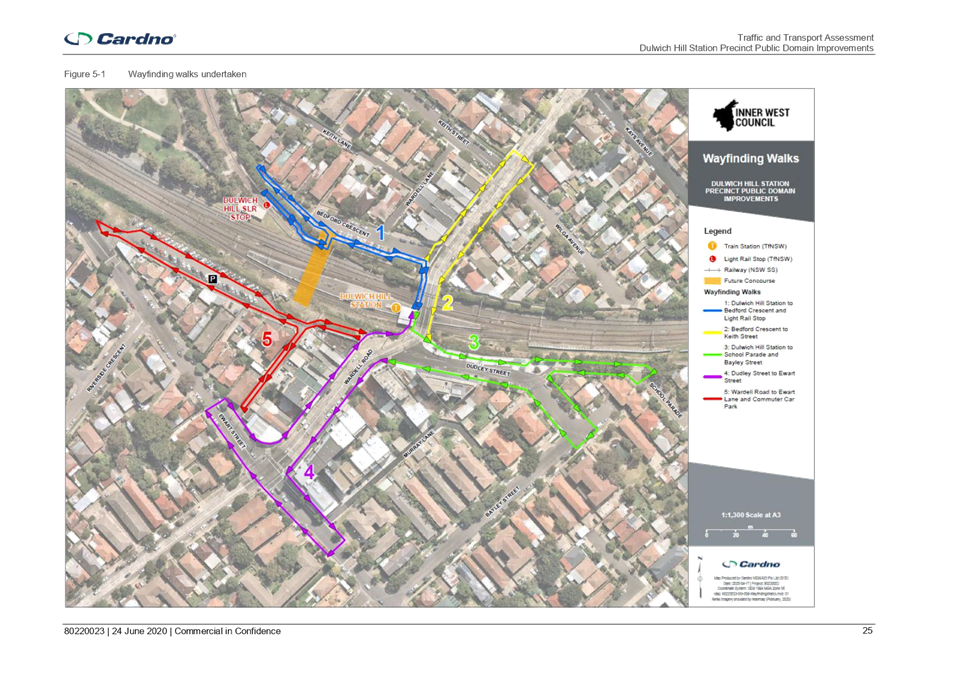
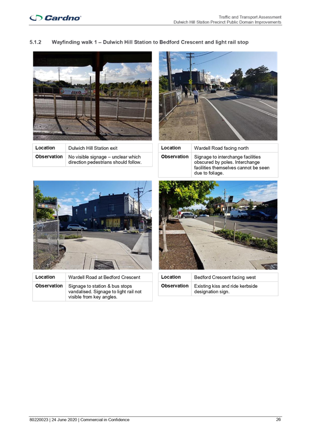
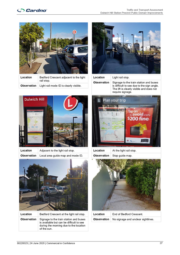
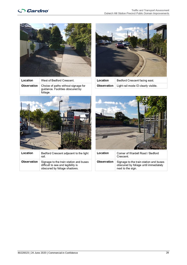
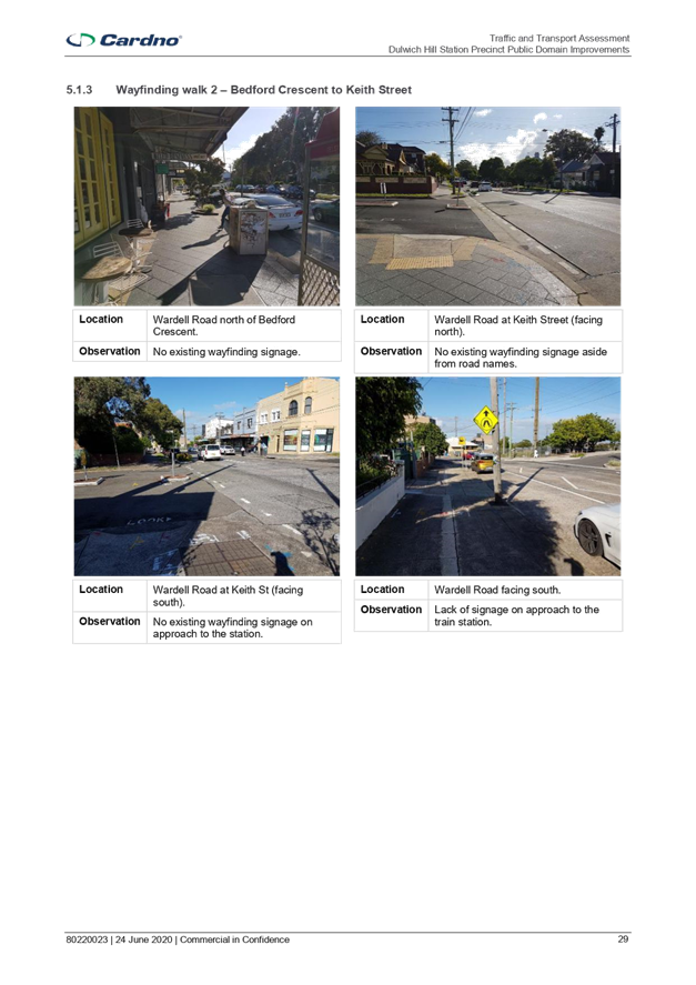
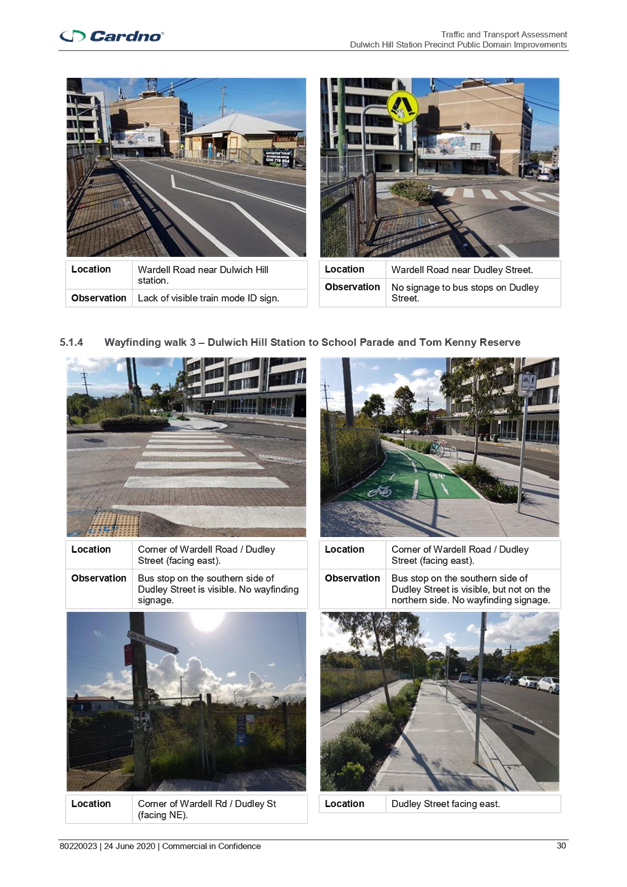
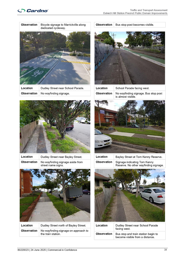
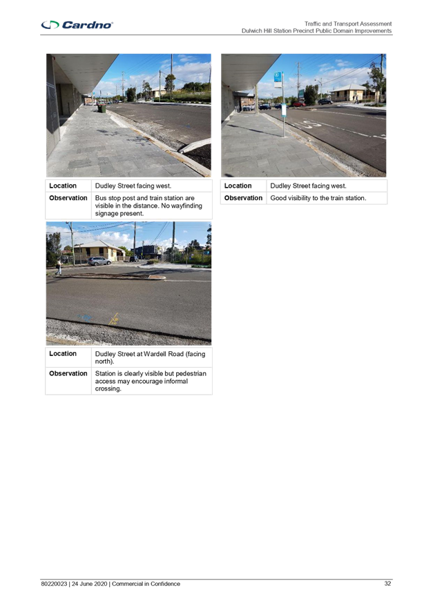
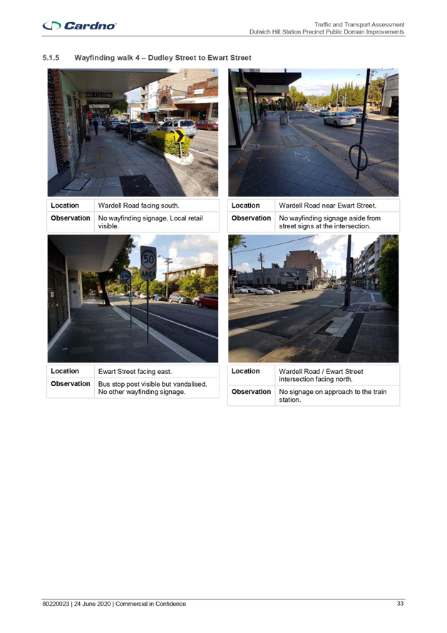
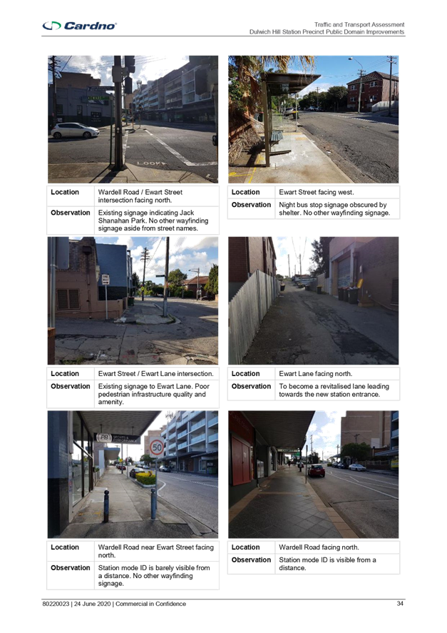
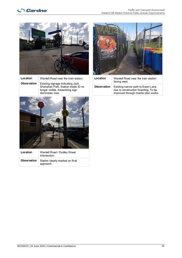
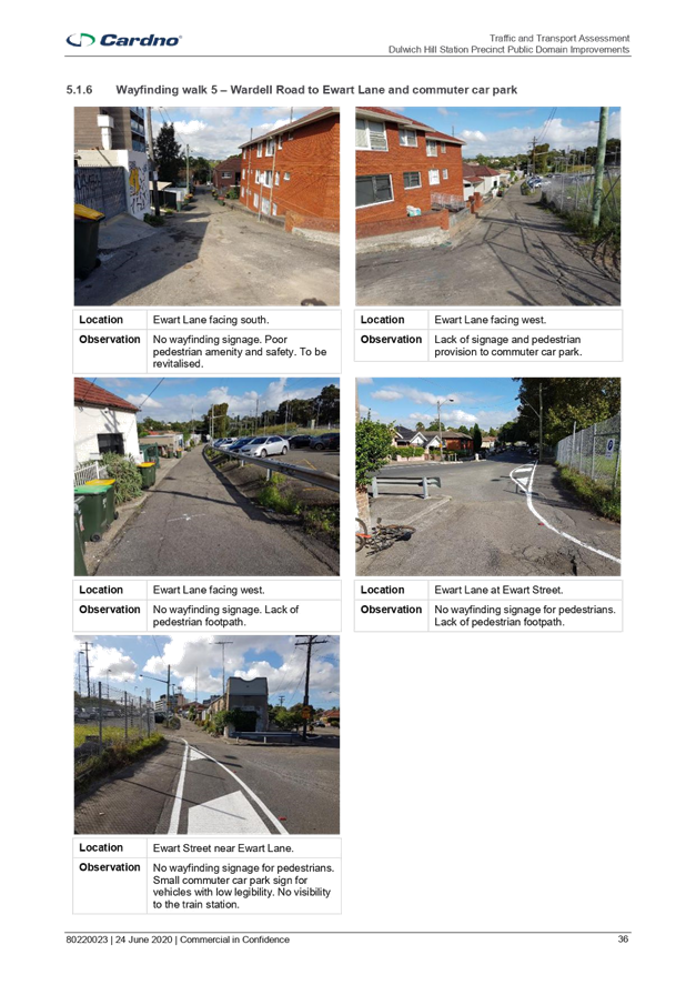
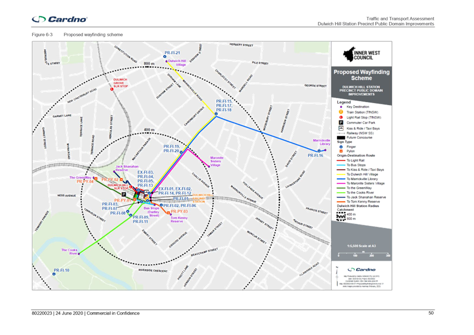
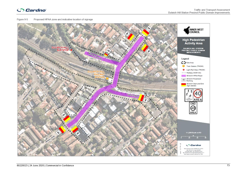
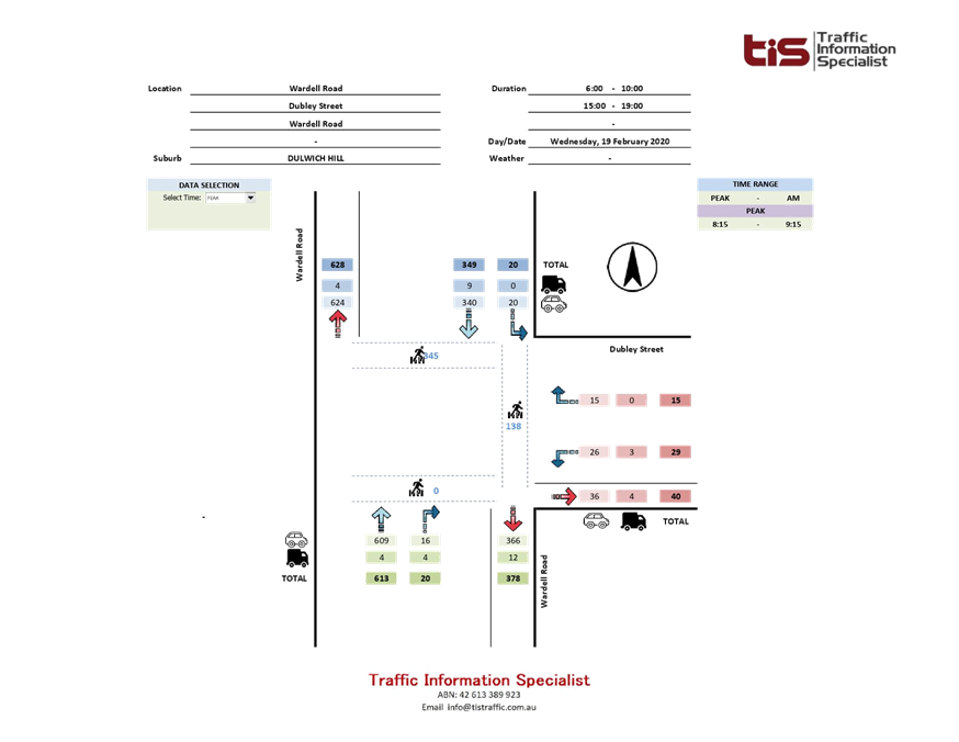
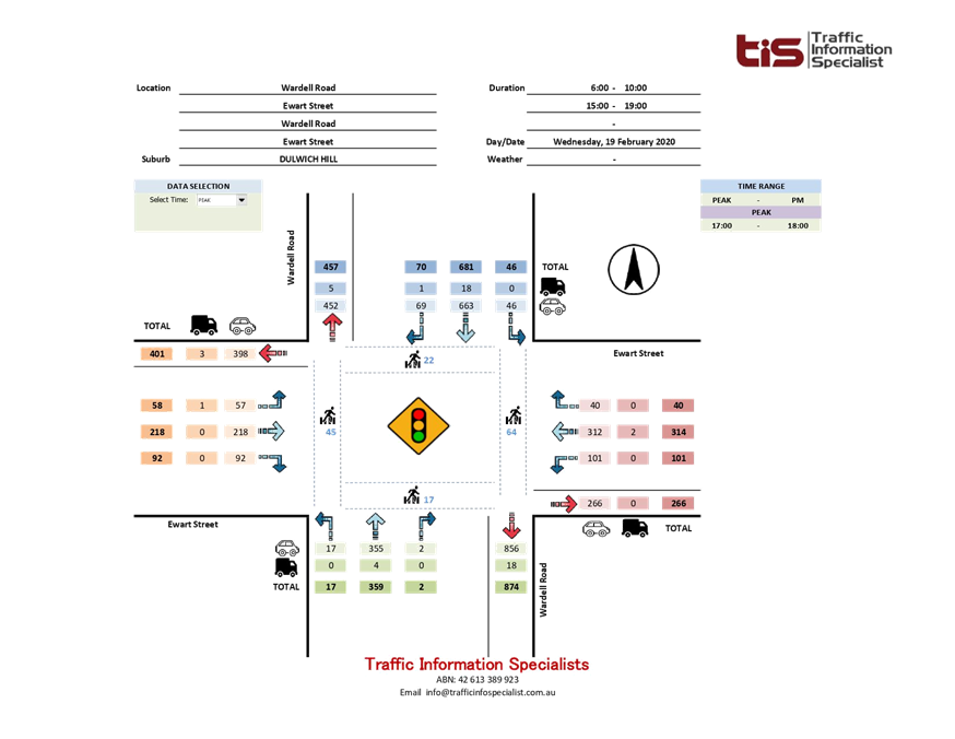
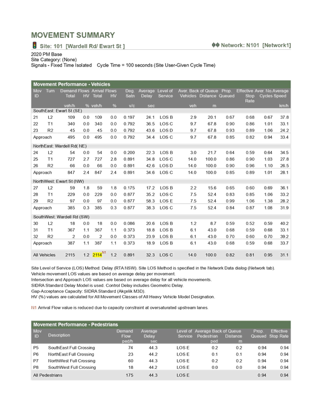
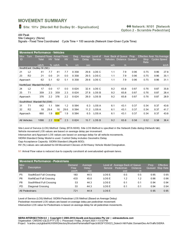
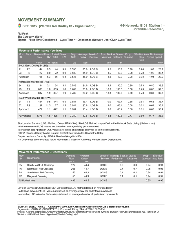
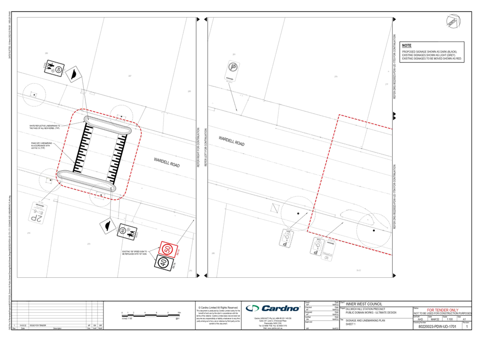
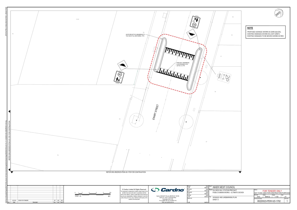
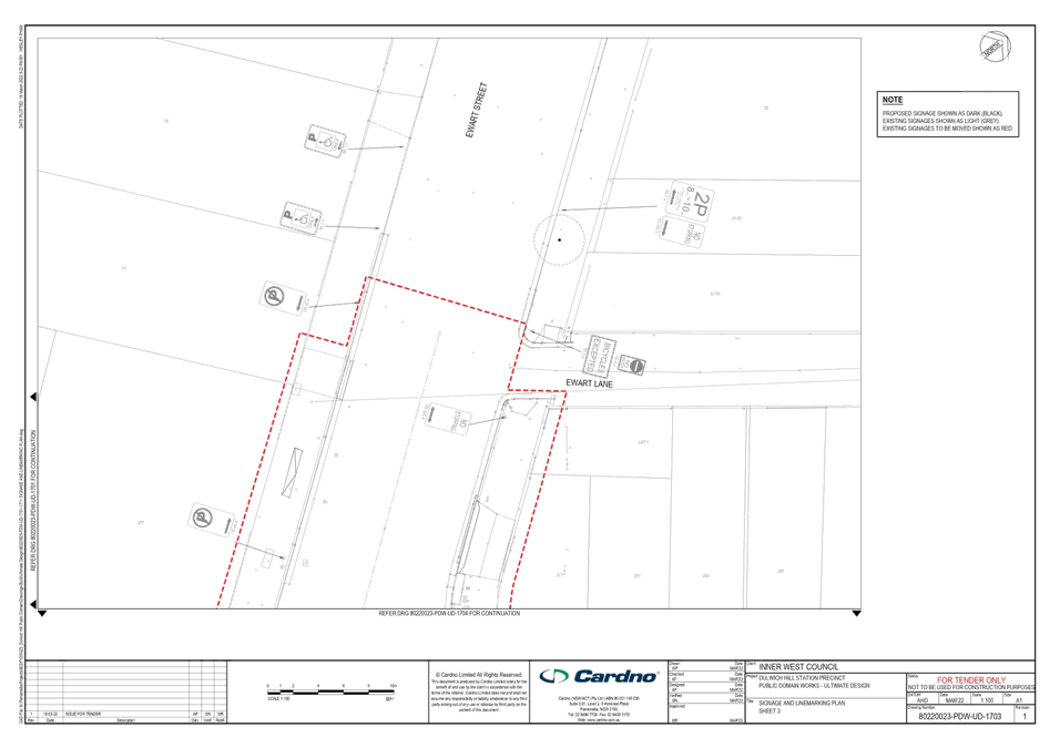
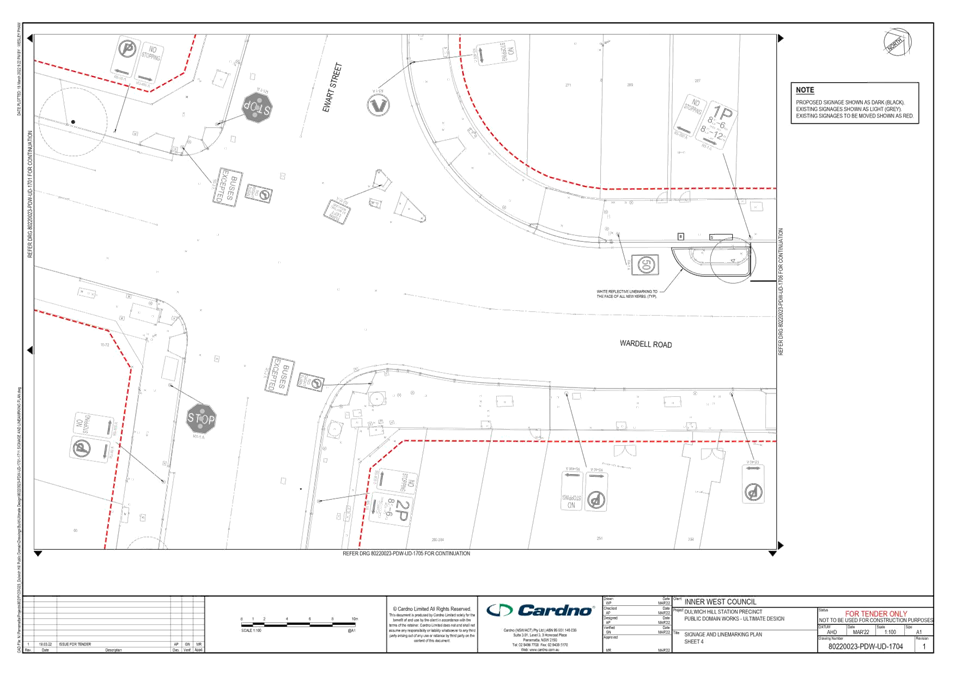
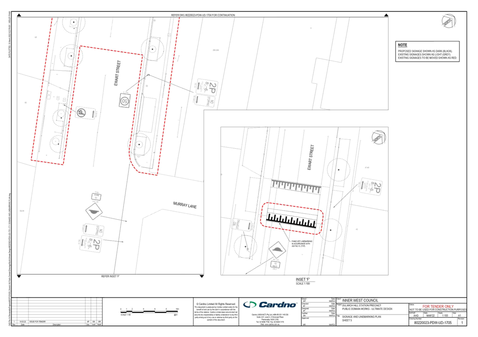
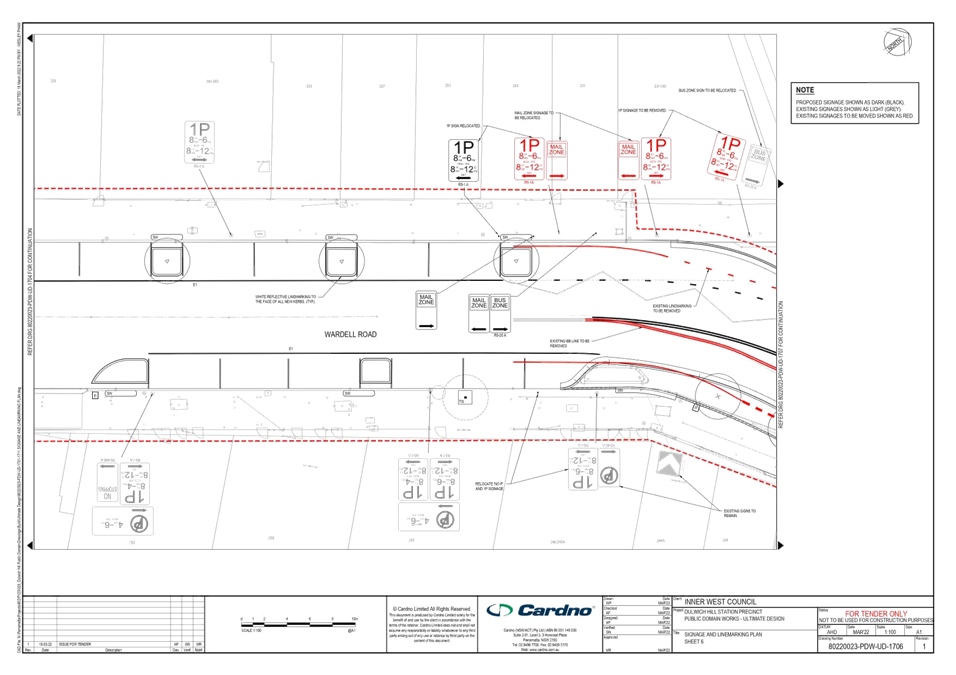
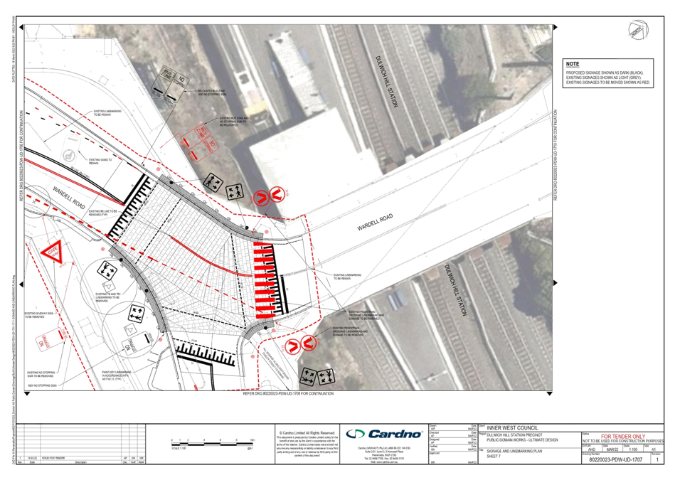
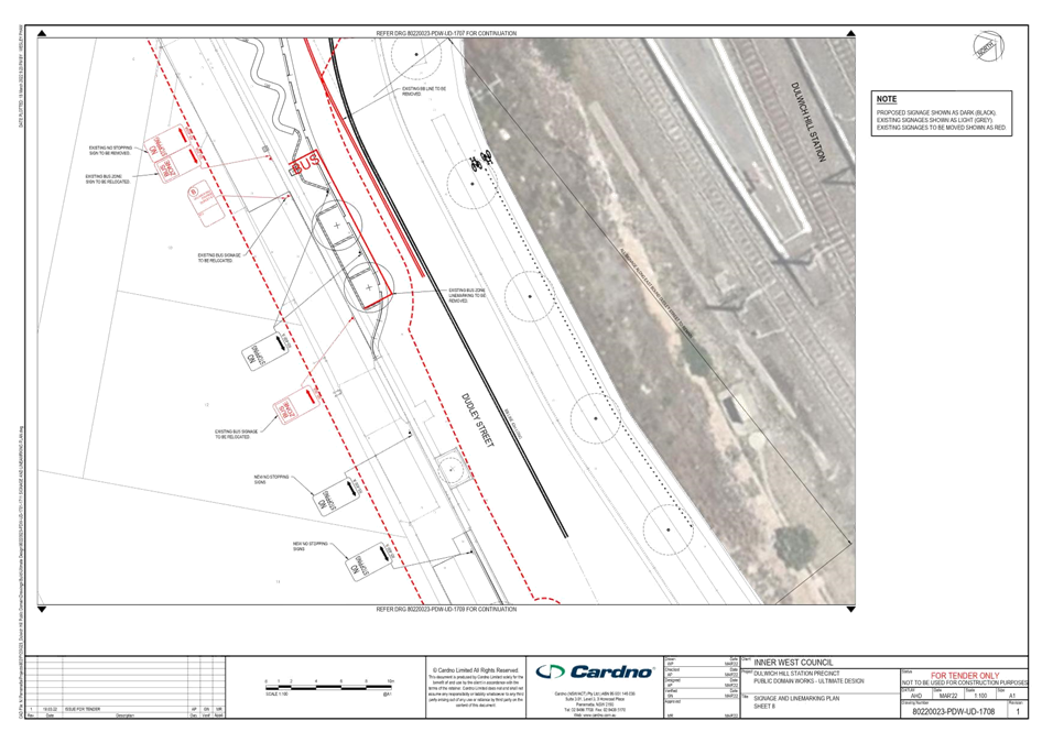
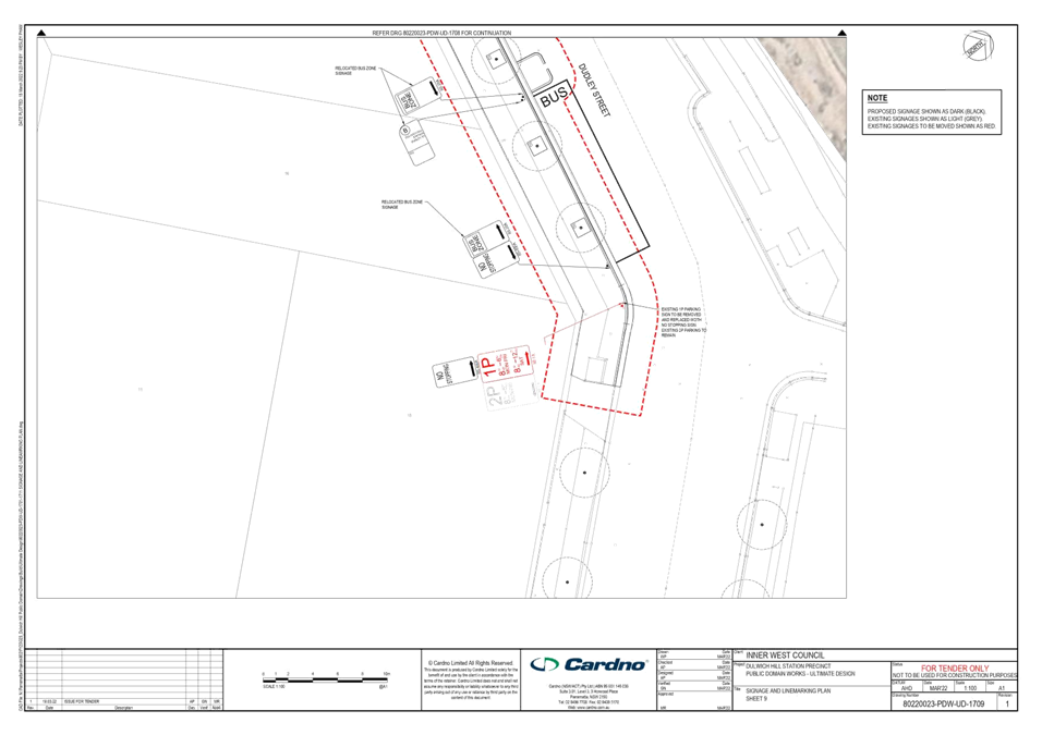
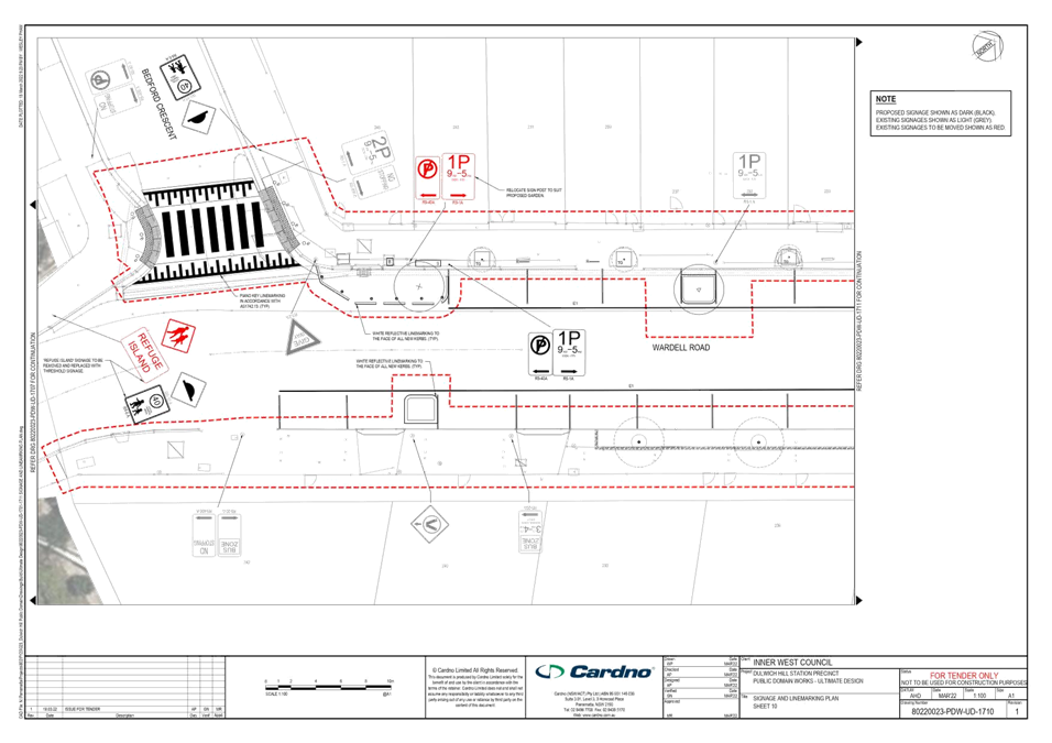
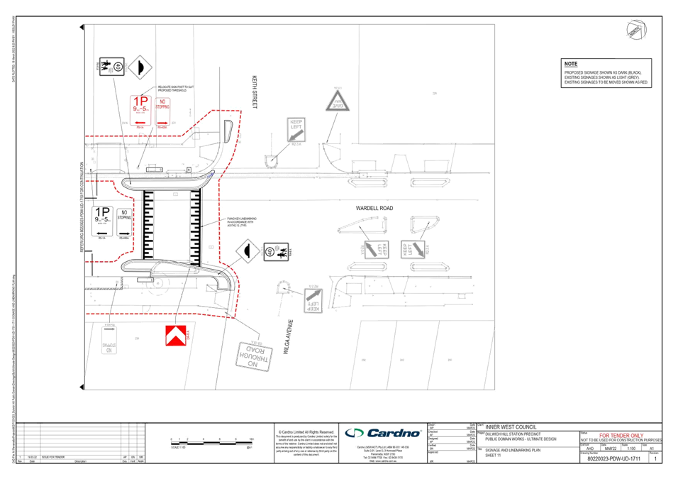
Subject: Dulwich Hill Station Precinct Public Domain Improvements Amendments - Location of Traffic Calming Entry Thresholds – Midjuburi – Marrickville Ward/Summer Hill Electorate/Inner West Paculwich Hill Station Precinct Public Domain Improvements - Location of Entry Thresholds
Prepared By: Stephen Joannidis - Urban Amenity Improvement - Delivery Manager
Authorised By: George Tsaprounis - Coordinator – Traffic and Parking Services
SUMMARY
Cardno was commissioned for the traffic and transport assessment and the detailed design of the Dulwich Hill Station Precinct Public Domain Improvements (DHSPPDI). Council adopted the Master Plan for Dulwich Hill Station Precinct at its 13 August 2019 meeting. The Dulwich Hill Station Public Domain Master Plan provides the Dulwich Hill community with a plan to transform the streets and public spaces around the station into a pedestrian oriented village.
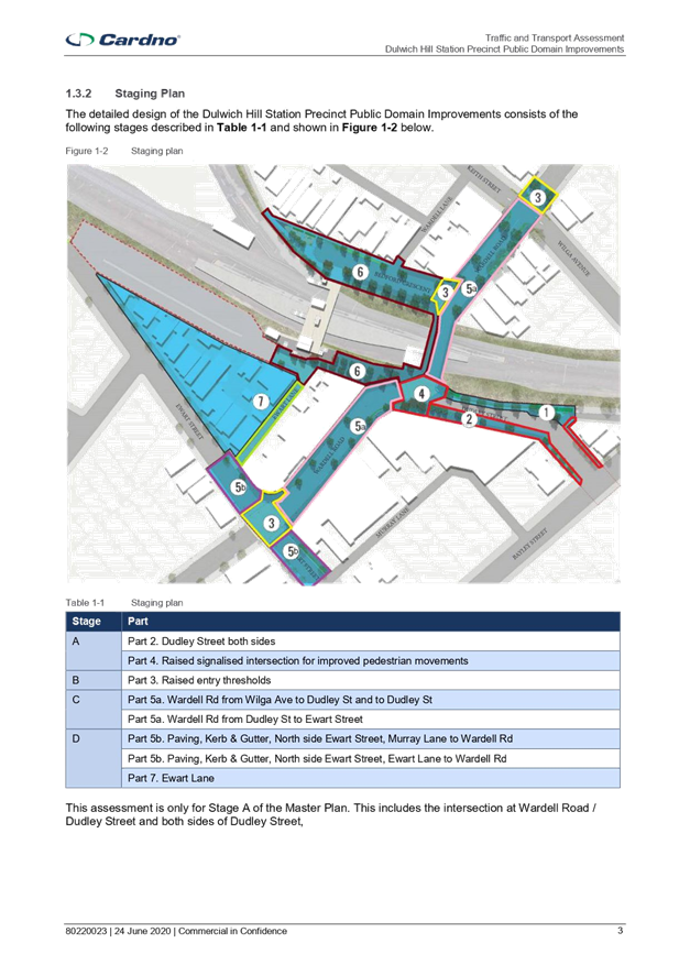
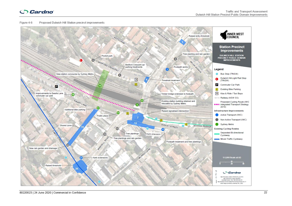
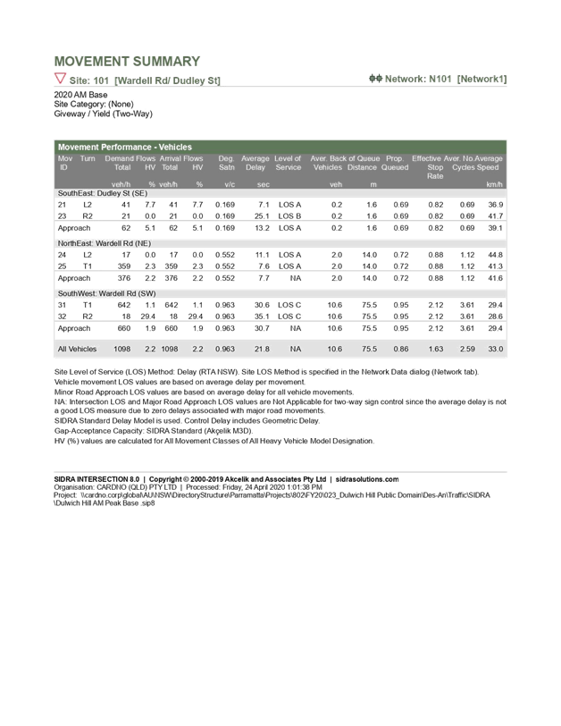
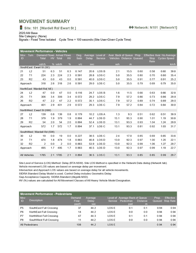
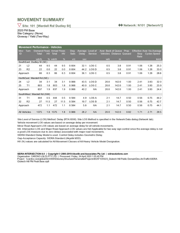
Dulwich Hill Station Precinct Public Domain Improvement works were initially planned to be delivered in two stages. Relevant documentation for Stage 1 works were submitted and approved by the Local Traffic Committee in July, 2020. Stage 1 works involved:
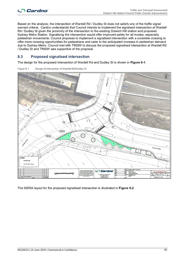
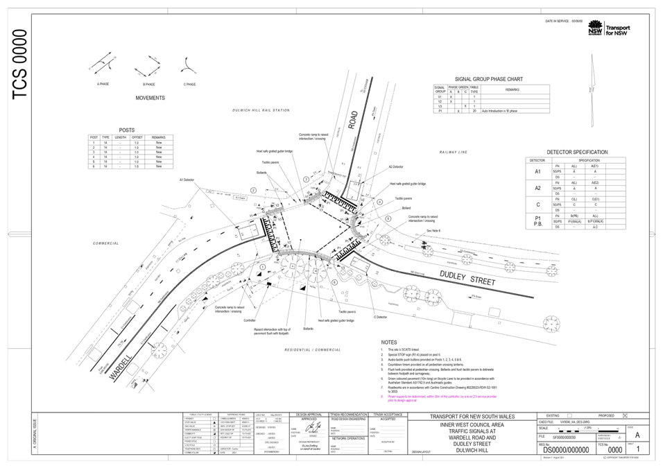
· A raised, signalised intersection at Wardell Road / Dudley Street;
· Footpath treatments and tree plantings on the southern side of Dudley Street; and
· A kerb extension on the southern side of Dudley Street at the intersection with Wardell Road.
An assessment for Stage 2 works were submitted and approved by the Local Traffic Committee in February, 2022. Stage 2 works involved:
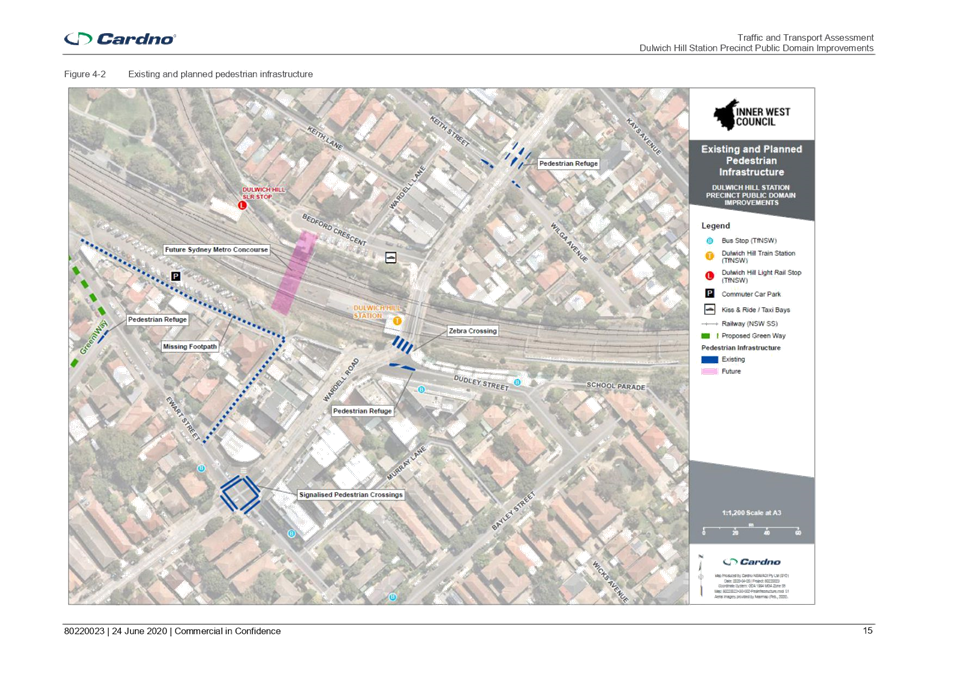
· Raised entry thresholds at the north and south of Wardell Road and south west of Ewart Street;
· Upgrading the existing threshold at Ewart St East, to IWC standards;
· Tree plantings, garden beds and a rain garden; and
· New Bluestone Pavers for footpaths.
This assessment is for an amendment to parts of the Stage 2 works. In discussion with TfNSW, the two proposed thresholds at Wardell Road South and Ewart Street West have been relocated. The raised thresholds at Ewart Street west and Wardell Road south were originally located approximately 30m west and 20m south of the Ewart Street / Wardell Road intersection respectively. Both thresholds have now been shifted to approximately 80m away from the intersection. This is likely to increase safety by providing additional length for drivers to reduce and maintain lower speed (i.e. 40km/h) while entering and exiting a signalised intersection.
|
RECOMMENDATION
THAT: the relocation of the proposed raised thresholds on Wardell Road to a position approximately 80m away from the Ewart Street/Wardell Road intersection be APPROVED as amendments to Stage 2 design of the Dulwich Hill Station Precinct Public Domain Improvement works. |
BACKGROUND
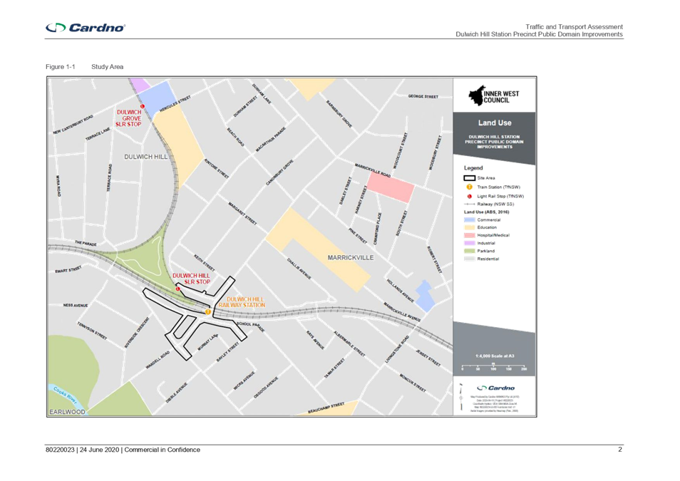
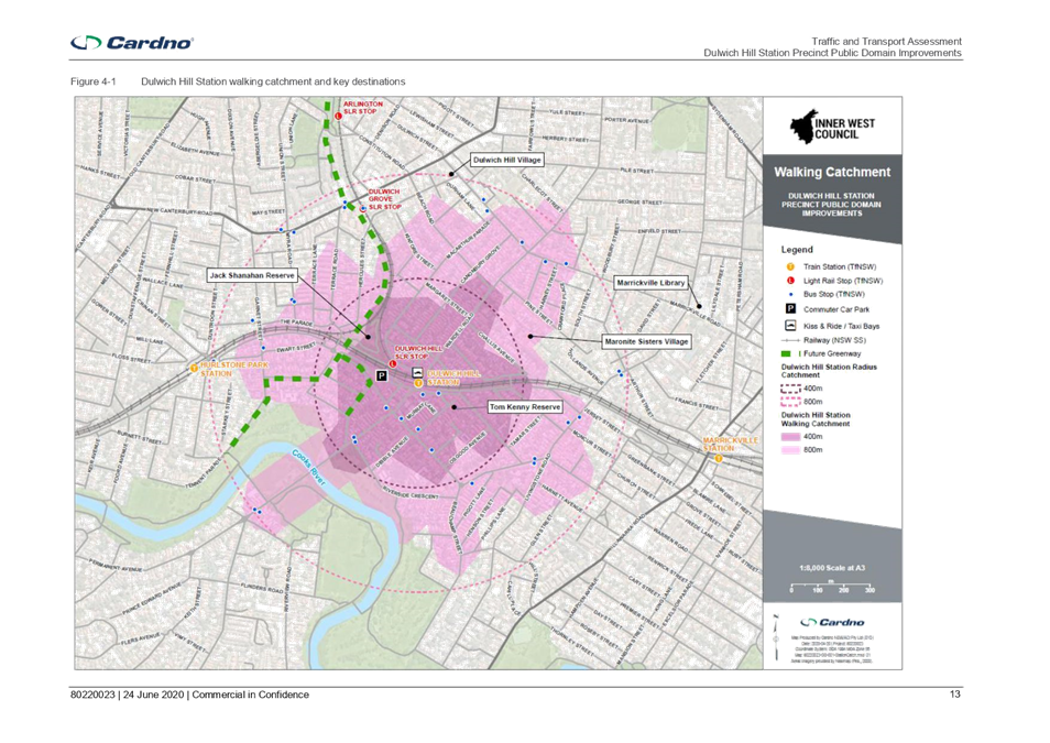
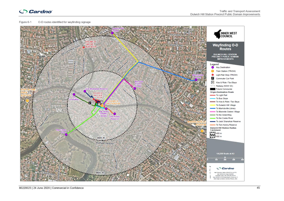
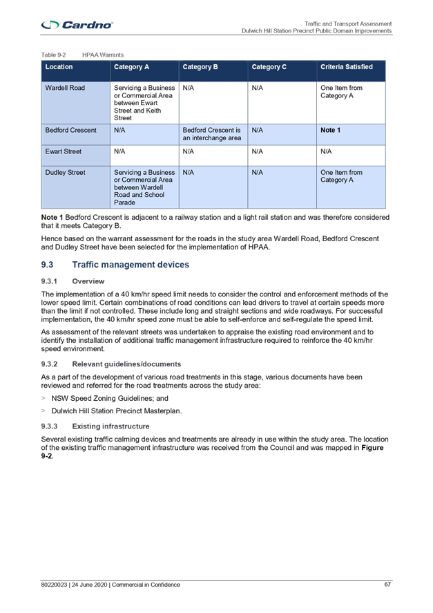
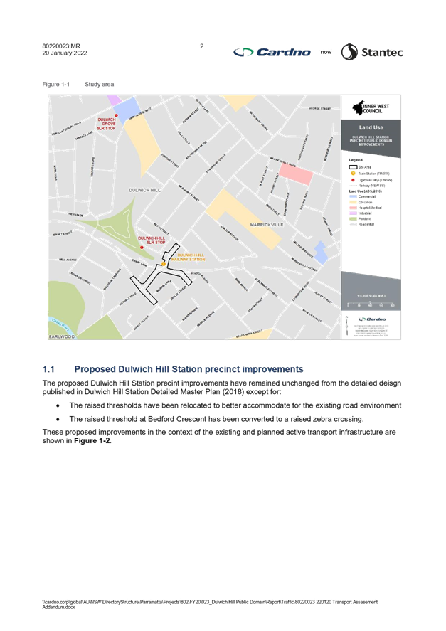
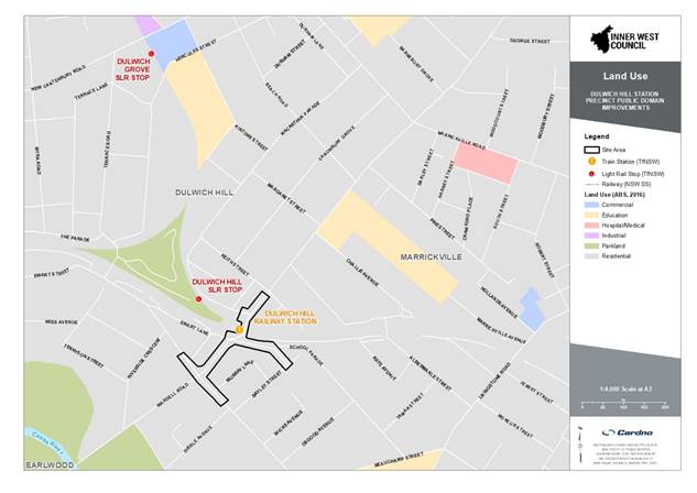
The Dulwich Hill Station Precinct (DHSP) site area includes:
· Wardell Road from Ewart Street to the north side of the Keith Street / Wilga Avenue intersection;
· Dudley Street;
· Ewart Street between Ewart Lane and Murray Lane; and
· Bedford Crescent.
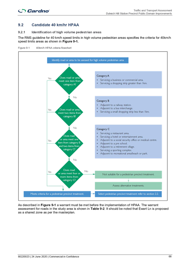
The figure below illustrates the study area relative to the surrounding road network and different land uses around the study area. The study area consists of primarily residential along with some commercial/business area along Wardell Road between Ewart Street and Keith Street.
Dulwich Hill Station is a busy railway station and along with the local commercial area generates considerable pedestrian activity. Wardell Road is a busy regional road carrying a substantial volume of traffic and in combination with the high pedestrian activity it has been a Blackspot for numerous years.
In addition, local development and the implementation of the Sydney Metro Upgrades will see higher volumes of pedestrian movements which may compound the already poor crash history of the locality.
In 2020 a Blackspot funding application was submitted, and funding of $341,250 was approved on 18 May 2021 for Dulwich Hill Station Precinct Upgrade works. Specifically, works to install entry thresholds, install slow point, raised threshold / horizontal deviation at mid-block location and conflict points (intersections and pedestrian crossings).
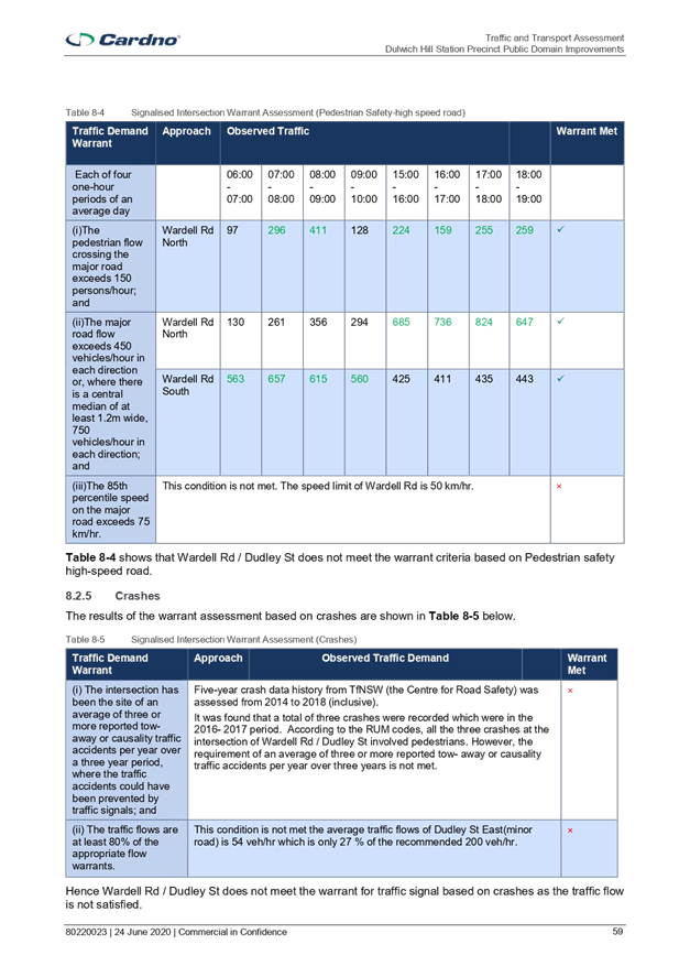
In the previous traffic committee report for Stage 1 works (6 July 2020 - LTC0720 Item 7) approval was sought for the raised, signalised intersection at Wardell Road / Dudley Street to address safety issues at the existing pedestrian crossing where crashes have been recorded, particularly as pedestrian movement increases with the implementation of the Sydney Metro upgrades. In Stage 2, thresholds are proposed to be utilised to establish a 40kmph zone at the DHSPPDI as part of works to transform this area into a pedestrian friendly zone in accordance with the masterplan by Plummer & Smith.
FINANCIAL IMPLICATIONS
The project is fully funded by the Inner West Council and DPIE. It is noted that TfNSW has also contributed $342,250 through the Blackspot Program.
The project has been listed in Councils Capital Works Program and funding has been committed for Stage 2 in the 2022/23 financial year budget.
PUBLIC CONSULTATION
Public Consultation has already been undertaken during the master plan stage. This proposal has also received community feedback. Feedback included concerns over pedestrians mistaking the raised thresholds for right of way, light pollution, desire for more greenery and concerns for reduced parking, especially mobility parking scheme parking spots. Actions undertaken as a result of public consultation include:
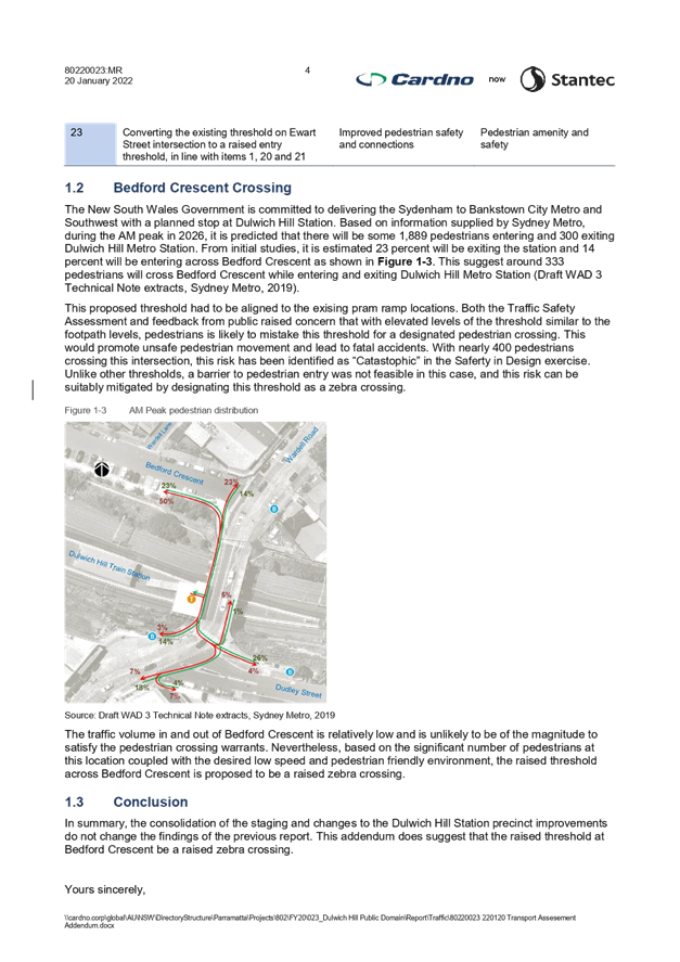
· Converting the proposed raised threshold at Bedford Crescent to a zebra crossing to address concerns over right of way at raised thresholds;
· Removing tactile indicators and extending garden beds at remaining proposed raised thresholds to address concerns over right of way at raised thresholds;
· Clarifying that Mobility Parking Scheme parking spots have been shifted, not removed;
· Reviewing lighting to satisfy community concerns over light pollution; and
· Adding more road trees to increase greenery.
Additional public consultation has been undertaken in the form of a letter sent and dropped regarding the proposed relocation of the two thresholds.
No objections were received
CONCLUSION
This proposed threshold relocation will assist vehicles towards a safer transition to the target speed of 40km/h within close proximity of a signalised intersection and hence will contribute towards improving the safety of pedestrians and cyclists throughout the precinct.
|
1.⇩ |
Traffic & Transport Assessment |
|
2.⇩ |
80220023-PDW-1701-1711 – Updated Signage and Landmarking plans, Cardno, Rev 1, dated 18/3/2022 |
|
3.⇩ |
80220023 220120 Transport Assessment Addendum 01 for incorporating a pedestrian crossing at the raised threshold at Bedford Crescent |
|
4.⇩ |
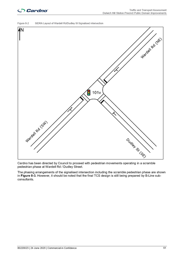
80220023 220308 Transport Assessment Addendum 02 for Removal of scramble crossing |
|
5.⇩ |
DHSPPDI - TCS for the intersection with Wardell Road and Dudley Street, dated 7/3/2022 |
|
|
Local Traffic Committee Meeting 18 July 2022 |
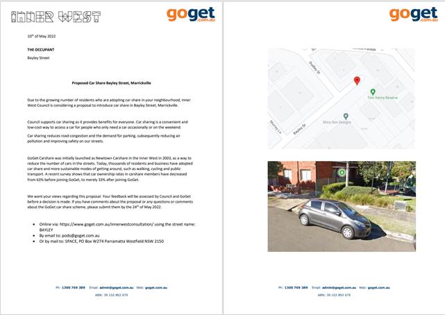
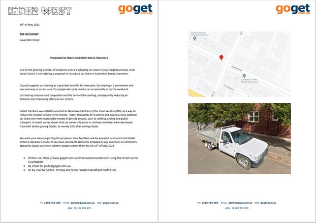
Subject: Bayley Street, Marrickville, Cavendish Street, Stanmore And Fotheringham Street, Enmore - Dedicated Car Share Parking Restrictions (Summer Hill Electorate / Inner West PAC)
Prepared By: Jennifer Adams - Engineer – Traffic and Parking Services
Authorised By: Manod Wickramasinghe - Acting Director Infrastructure
SUMMARY
A request has been received from a GoGet Car Share representative for the installation of three (3) on-street dedicated ‘Car Share’ parking spaces for existing floating car share vehicles around the Inner West. Due to community feedback and opposition to two locations only one nominated car share space is recommended for installation.
|
THAT the following ‘No Parking Authorised Car Share Vehicles Excepted’ restrictions be approved:
1. A 5.4m restriction in the first parking space on the southern side of Bayley Street, Marrickville west of the driveway at No.32 adjacent to Tom Kenny Reserve.
|
BACKGROUND
Inner West Council supports ‘Car Share’ schemes, as part of a holistic approach to encourage more sustainable travel habits for residents and businesses. Car share schemes reduce the need for members to own a private vehicle and may ease the parking stress on-street.
Research indicates that each car share space can replace up to 8 vehicles on the road. Council’s adopted Car Share Policy will potentially reduce demand for on-street parking, resulting in less cars on public roads, leading to less pollution and greenhouse emissions. The policy is part of a holistic approach to transport planning, along with improvements to public transport services and enhanced facilities for cycling and walking.
Generally, car share schemes rely on having convenient dedicated on-street parking spaces. The designated space will be in operation 24 hours a day, 7 days a week, during which only specifically marked car share vehicles will be permitted to park in the space.
In support of this scheme, Council is proposing to install one (1) dedicated parking space for authorised ‘Car Share’ vehicles in the above recommended location for resident and business use.
FINANCIAL IMPLICATIONS
Nil. The costs of the supply and installation of the signposting associated with the dedicated car share parking space is to be borne by the applicant in accordance with Council’s Fees and Charges.
OTHER STAFF COMMENTS
A request has been received from GoGet representative for the installation of on-street dedicated car share parking spaces within Inner West. The nominated locations are:
· Bayley Street, Marrickville (west of the driveway of the multi-unit development at No.32 Bayley Street) south side of Bayley Street east of Dudley Street adjacent to Tom Kenny Reserve (existing signposted restriction – ‘unrestricted’)
· Cavendish Street, Stanmore (adjacent to No.18 Holt Street) on the south side of Cavendish Street west of Holt Street (existing signposted restriction – ‘unrestricted’)
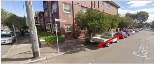
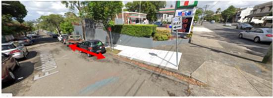
· Fotheringham Street, Enmore (adjacent to 7/11 service station) first space western side of Fotheringham Street south of Stanmore Road (existing signposted restriction – ‘unrestricted’)
PUBLIC CONSULTATION
Community consultation was led by GoGet representatives and letters were distributed to local residents surrounding each proposed space. A copy of each respective community consultation letter is presented at the end of this report.
The following summary of the consultation results as presented to Council:
Letters were delivered to residents surrounding each proposed space:
x 30 letters for Bayley Street - Bayley Street x 0 responses
x 25 letters for Cavendish Street
- Cavendish Street x 4 responses
x 15 letters for Fotheringham Street - Hobbs Street x 2 responses
For Bayley Street, Marrickville, no (0) responses were received.
For Cavendish Street, Stanmore, four (4) responses were received, two in support of the implementation of the car share restrictions and two objecting to the proposal. Residents who objected are concerned about the increase demand for on-street parking for local residents, some of whom do not have off-street parking facilities, within the already high demand area. One cited that proposed multi-apartment dwelling developments in Holt Street will further compound the parking pressures noting that any car share space should be relocated outside these developments in Holt Street near the IGA.
For Fotheringham Street, Enmore, two responses were received, one in support and the other strongly in objection. Council also had complaints from the resident who objected to the proposal. They are concerned about the increase demand for on-street parking for local residents within a very high demand area and possible driveway obstruction.
CONCLUSION
Due to community feedback and opposition to two locations only one nominated car share space is recommended for installation. The Cavendish Street, Stanmore and the Fotheringham Street, Enmore car share locations are recommended not to proceed.
Thus, it is recommended that the installation of the proposed on-street dedicated car share parking space in Bayley Street, Marrickville be approved in order to provide improved parking opportunities for local residents who participate in car share schemes.
|
|
Local Traffic Committee Meeting 18 July 2022 |
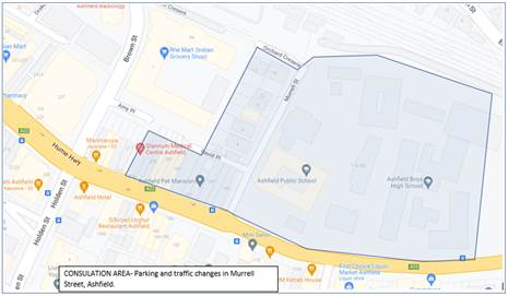
Subject: Murrell Street, Ashfield- Traffic and Parking
changes
(Diarrawunang-Ashfield Ward/Summer Hill Electorate/Burwood PAC)
Prepared By: Boris Muha - Engineer – Traffic and Parking Services
Authorised By: George Tsaprounis - Coordinator – Traffic and Parking Services
SUMMARY
Council has received numerous concerns from the Ashfield Public School community and the Good-start Early Learning Child Care Centre regarding traffic safety in Murrell Street, Ashfield.
This report deals with the main concern of congestion in the street with parked vehicles obstructing traffic flow and the build -up of traffic in Murrell Street due to vehicles waiting long periods to turn right onto Liverpool Road during school drop- off and pick up times.
The school and Child Care Centre has requested that parking to the western side of the street be either removed or wholly limited to park outside of morning and afternoon school drop-off and pick -up times.
Rather than above, it is recommended that parking be reconfigured and limited in time to certain areas on the western side of the street to improve traffic flow and minimise the impact on the loss or limitation of parking in the area for the residential and business community.
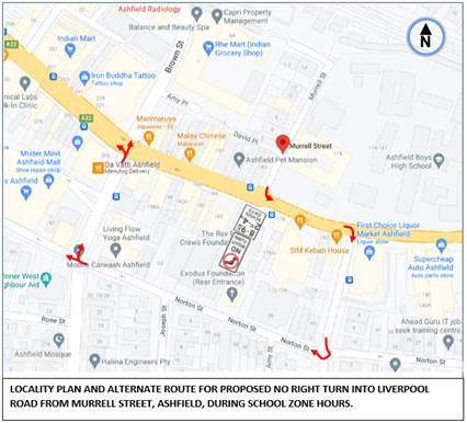
No Right Turn during school zone hours for traffic coming out of Murrell Street into Liverpool Road is proposed subject to Transport for NSW (TfNSW) approval.
|
RECOMMENDATION
THAT: 1. The following parking changes be approved:
(a) The (4) parking spaces on the western side of Murrell Street, Ashfield outside the side of 183 Liverpool Road be changed to read “No Stopping 8.30am - 9.30am, 2.30pm-3.30pm School days” and “2P 9.30am-2.30pm., 3.30pm-6.00pm Mon-Fri Permit Holders Excepted AREA 1”, (b) ‘No Stopping’ be signposted across: (i) the combined driveways of 183 Liverpool Road and David’s Lane, (ii) driveway to 2-4 Murrell Street, (iii) driveway to 10-12 Murrell Street& side service driveway to 1A Orchard Crescent, and
2. Council forwards a Traffic Management Plan to Transport for NSW to consider and approve ‘No Right Turn 8.00am-9.30am., 2.30pm-4.00pm School Days’ for traffic out of Murrell Street into Liverpool Road.
|
BACKGROUND
Murrell Street comes off Liverpool Road and leads into a short section of Orchard Crescent which leads to a dead end some 40 metres west of Murrell Street. Murrell Street measures approximately 9.0 metres from kerb to kerb with parking to both sides of the street. It only serves resident access and school drop off and pick up together with 15-minute short term parking for the Ashfield Primary Public School and an adjoining Child Care Centre on the eastern side of Murrell Street.
A mini roundabout to the end of Murrell Street allows vehicles to turn around to drop off and pick up children to the eastern side of the street. The parking to the eastern side is a mixture of ‘No Parking’ and Disabled parking during school hours, and 15- minute parking to cater for both the needs of the school and Child Care Centre over an extended time period for drop and pick up.
Currently 3 spaces for drop off and pick up are made unavailable at the northern end of Murrell Street due to the collapse of the school retaining wall from the last heavy rains resulting in the footpath being closed and temporary footway being provided onto the roadway. Works have commenced to rebuild the wall.
The western kerb side accommodates about 11 parking spaces with driveways to unit complexes in between and David’s Lane off Murrell Street serving rear shop/unit access. The parking is restricted to read “2P 8.00am-6.00pm Mon-Fri., Permit Holders Excepted Area 1”
The street is covered under a 40 km/hour school zone limit.
FINANCIAL IMPLICATIONS
The work will be funded under Council’s general signs and line marking budget.
OTHER STAFF COMMENTS
The following is provided to determining an (amended) proposal under this report.
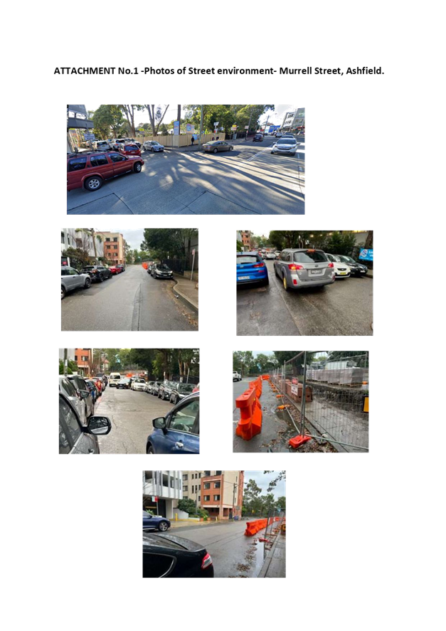
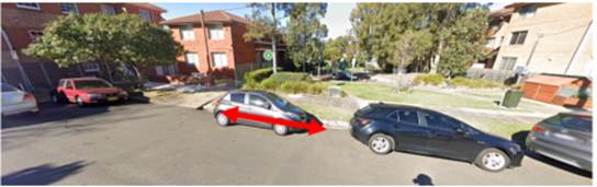
· Inspections on school hour drop off/drop off times does identify noticeable increase of traffic with the street thereafter being relatively quiet. ATTACHMENT No.1 shows the street environment during school drop off/pick up times.
· 2-way traffic is noticed to pass through rather slowly, on the basis that vehicles park close to kerb, do not double park, and that driveway clearances are made available for vehicles to veer over to allow opposing traffic to pass.
· Last traffic counts taken on the 4 April 2022 recorded average 5-day peak hour volumes around 80 -180 vehicles per hour with the latter being the morning peak. 85% speeds were recorded around 30 kph (near midblock).
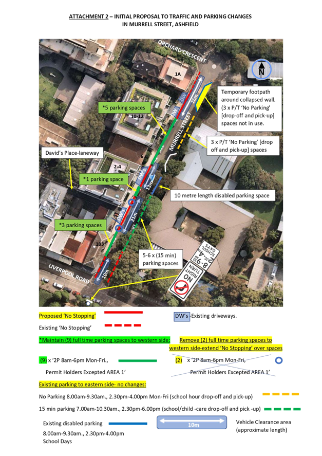
· An initial proposal was sent out under consultation to implement ‘No Stopping’ over and across the unit driveways and the merged driveways to David’s Place and 183 Liverpool Road. 1 parking space either side of the merged driveways to David’s Place and 183 Liverpool Road would be removed with ‘No Stopping’ placed right over this cleared length of kerbs pace (across the driveways and removed parking spaces). See ATTACHMENT No.2. 9 full time parking spaces are maintained under this proposal, with the loss of 2 parking spaces.
· 4 clearance zones are provided and sign posted with ‘No Stopping’ at the ends and within the street to assist in veering northbound traffic closer to kerb whilst allowing opposing traffic to pass. The ‘No Stopping’ would also prevent vehicles from parking over the driveways and dropping/picking up children from across the road.
· ‘No Stopping’ has already been placed to the bottom end of Murrell Street opposite the build out of the temporary footway where the wall has collapsed on the school side of the street.
· No Right Turn between school zone times is proposed and supported by Council for traffic coming out of Murrell Street into Liverpool Road. This will reduce queuing back from Murrell Street and prevent conflict with traffic at the intersection of Murrell Street and Liverpool Road. Alternate travel (heading west) is available by turning left into Liverpool Road, right into Queen Street and right into Norton Street.- Refer to locality map page 2.
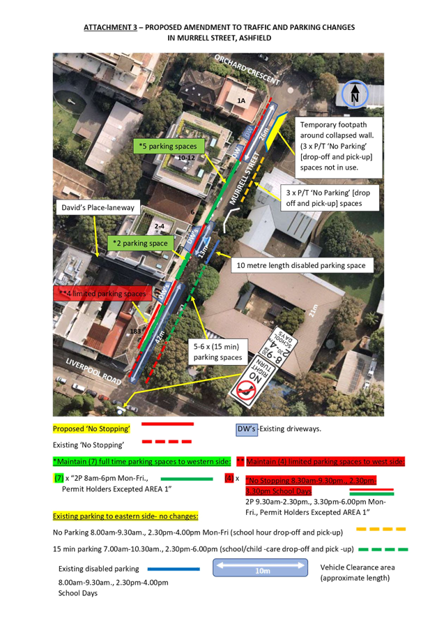
· Feedback on the initial proposal indicated that residents did not agree to the removal of parking with concerns that parking is already limited, and why should parking be removed full- time just for the short period that school traffic occurs. Further examination revealed that critical congestion occurs near to the intersection of Liverpool Road. An amended proposal is therefore considered where the 11 parking spaces can all be maintained, and that 4 spaces near to the corner of Liverpool Road and to the sides of No.183 Liverpool Road be limited only to operate outside of the school drop- off and pick up times being 8.30am – 9.30am., 2.30pm-3.30pm, for 2 hours of the day on school days. See ATTACHMENT No.3 The No Right Turn during school zone times still applies under this amended proposal.
3 clearance zones are provided with a longer zone near to the intersection of Liverpool Road.
· The 7 full time spaces further to the north, per the amended proposal are maintained and will offer ‘friction’ de-facto traffic calming for speed control near the general drop off and pick up area.
· Supplementary ‘Drop -off and Pick-up’ signage will be provided with the No Parking zone to the north to identify that the zone is required for this activity.
· The area would need to be monitored and reviewed for any further parking changes, if required.
PUBLIC CONSULTATION
Submissions for comments closed on the 24 June 2022. Six (6) responses were received in disagreement or concern to the removal and/or limitation of parking to the western side of Murrell Street under consultation with the initial proposal. This has led to recommending an amended proposal under this report as shown in ATACHMENT No.3. Three (3) of the respondents indicated agreement to the No Right turn out of Murrell Street during school zone hours.
The following comments from residents in disagreement or concern are tabled and summarised below with officer responses given.
|
Resident Comments |
Officer Response |
|
Accumulated key responses from the 6 residents: · The proposal is un-clear what spaces are taken away. [The consultation letter] only advised how many spaces are maintained and how many are lost. · How is permanent No Stopping going to help. Unfair as we already can’t park on the school side of the street. · Suggest to extend one area near one driveway for temporary no parking between 8.30am-9.30am and 2.30pm-3.30pm Mon-Fri. · Construction of a building in David’s Place and construction vehicles parking on the street would of aroused complaints regards to congestion. The building has since been complete. · There is already limited spots for residents to be able to park with the eastern side being off limits if we need to park across school hours. · The collapsed wall should be rectified as a matter of urgency to allow more room for drop off for the school. · School should implement some form of traffic control system. · Residents should not loose parking. Implementing a drop-off and pick up from the bottom of Murrell up to the exiting drop-off and pick up zone should be sufficient. · The removal of parking spots would not relieve congestion. No Parking zones be made available for parking. However, ‘No Parking’ is not suitable for sole parent to pick up children too young to leave the school premises. · Problem is mainly caused by out bound traffic turning right into Liverpool Road. Need more parking space the less. Likely also encourage more parents to stop in our driveways for school drop off which is already happening. · Keep the same number of parking spaces. Put in No Parking or pick-up zone only 8-9am and 2.30am-4pm along the entire school side of the road. |
· The initial consultation letter only advised that 9 spaces would be made. The report clarifies that 2 spaces would be lost under the initial proposal. · The No Stopping is aimed to enforce parents not to park in the driveway and/or drop off and pick up children from across the road. · Acknowledge that the removal of 2 full-time spaces under the initial proposal would not be a viable solution as the problem of congestion stems only for 2 hours in the day. Agree to limit the parking as suggested 8.30am-9.30am and 2.30pm-3.30pm Mon-Fri to the first 4 spaces to relieve critical congestion near to Liverpool Road-see amended proposal ATTACHMENT No.3. · Congestion is still evident irrespective of construction activity. · Work has commenced to repair the collapsed wall, and the 3 unused parking spaces will be reinstated soon thereafter. Supplementary ‘Drop off and pick up’ signage will be added to the No Parking signs to make school and parents aware that the zone should be used for this purpose. · The 15- minute parking zone to the eastern side is to be used for parents with younger children needing to be escorted to and from the school and child- care centre. · No Right Turn at school zone times into Liverpool Road from Murrell Street is also proposed. · The eastern side is a mixture of No Parking, disabled parking and 15- minute parking to cater for both the needs of the school and Child Care Centre. |
CONCLUSION
In view of the above, it is recommended that:
· The (4) parking spaces on the western side of Murrell Street, Ashfield outside the side of 183 Liverpool Road be changed to read “No Stopping 8.30am -9.30am., 2.30pm-3.30pm School days” “2P 9.30am-2.30pm., 3.30pm-6.00pm Mon-Fri Permit Holders Excepted AREA 1”,
· ‘No Stopping’ be signposted across:
(i) the combined driveways of 183 Liverpool Road and David’s Lane,
(ii) driveway to 2-4 Murrell Street,
(iii) driveway to 10-12 Murrell Street& side service driveway to 1A Orchard Crescent, and
· Council forwards a Traffic Management Plan to Transport for NSW to consider and approve ‘No Right Turn 8.00am-9.30am., 2.30pm-4.00pm School Days’ for traffic out of Murrell Street into Liverpool Road.
|
1.⇩ |
Photos of street environment. |
|
2.⇩ |
original proposed changes ot Murrell Street. |
|
3.⇩ |
Ammended proposal to changes in Murrell Street. |
|
|
Local Traffic Committee Meeting 18 July 2022 |
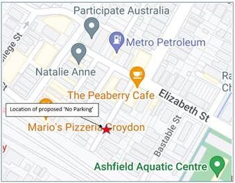
Subject: Railway Street, Croydon-Proposed 'No Parking'
opposite driveway.
(Gulgadya-Leichhardt Ward/Strathfiled Electorate/Ashfield PAC)
Prepared By: Boris Muha - Engineer – Traffic and Parking Services
Authorised By: George Tsaprounis - Coordinator – Traffic and Parking Services
SUMMARY
|
RECOMMENDATION
That a length of approximately 4.0 metres of ‘No Parking’ be assigned outside No.9 Railway Street, Croydon, supplemented with bay line and No Parking markings as shown in ATTACHMENTS 1C.
|
BACKGROUND
Railway Street is a dead -end street that runs off Elizabeth Street, Croydon. The street is narrow and measures approximately 6.1 metres in width between kerb to kerb. The footways on both sides are narrow between 0.7-0.8 metres wide. The street serves business and resident vehicle access only.
The eastern side of Railway Street is signposted with “2P 8.00am-6.00pm Mon-Fri., Permit Holders Excepted Area 7”. ‘No Parking’ exists to the western side to allow vehicle passageway. The eastern side of the street has existing corner business/shops near to Elizabeth Street followed by a childcare centre, a single dwelling house (with off-street parking) and 4 single storey terraces to the southern end of the street. All properties to the western side (including 12 Hordern Parade) rear back onto Railway Street.
The kerb space on the eastern side caters for approximately 8-10 vehicles. The child- care centre has 9 off-street recessed 90- degree angle parking spaces to carter for its needs. There is no turning area to the end of the street. Vehicles park right up to the end and reverse and turn around at the first available open driveway or child-care parking spaces (if vacant).
FINANCIAL IMPLICATIONS
The work will be funded under Council’s general signs and line marking budget.
OTHER STAFF COMMENTS
The following is provided in determining the proposal.
· The owner of 12 Hordern Parade had bought the house in the last year and has sought to arrange with the residents of the terraces to move their vehicles when requiring access. However, concern has lately been raised that more non-resident vehicles are or would be likely parking in the street and that he has been blocked out on occasions to access his driveway.
· The owner of 12 Hordern Parade only seeks a short length of ‘No Parking’ to undertake a 3–4-point turn manoeuvre in and out of his garage with the zone specifically placed to allow 3 good nominal size vehicles to park within the frontages of the terraces 8-11 Railway Street.
· The garage for No 12 Hordern Parade is 2.6metres in width and is built as a structured carport. The expense and trouble to widen the driveway-garage is not perceived an option. All other driveway garages along the western side can access via opposing driveway or are wider or set back into the properties.
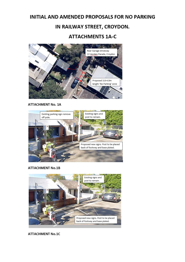
· An original proposal was only to have ‘No Parking’ signs placed outside in front of No.9 Railway Street; however, objections were raised not only to loss of parking but also the ugliness of signage to the frontage of the properties and intrusion to the front gate of No 9 Railway Street- see ATTACHMENTS 1A and 1B.
· An amended proposal was made to supplement the sign posting with road markings in this situation. Re-notification/consultation of the amended proposal was made out to the directly affected residents of 8-11 Railway Street-See ATTACHMENT 1C. Under this proposal the signage to the front can be mounted to the telegraph pole and the second vehicle would be permitted to park back up to the bay line, appropriately allowing two vehicles to park outside No 10-11. The result is considered to reduce signage intrusion and appearance to the front of No.9, reduce impact to loss of parking and clearly identify where vehicles can park up to by way of the bay lines and No Parking logo.
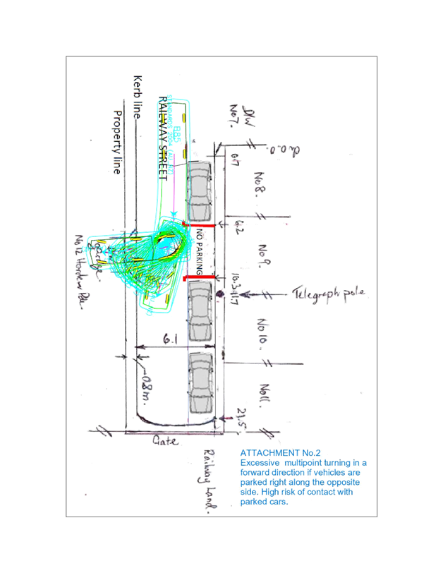
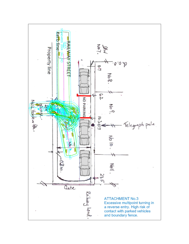
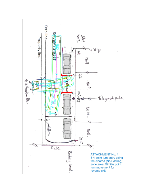
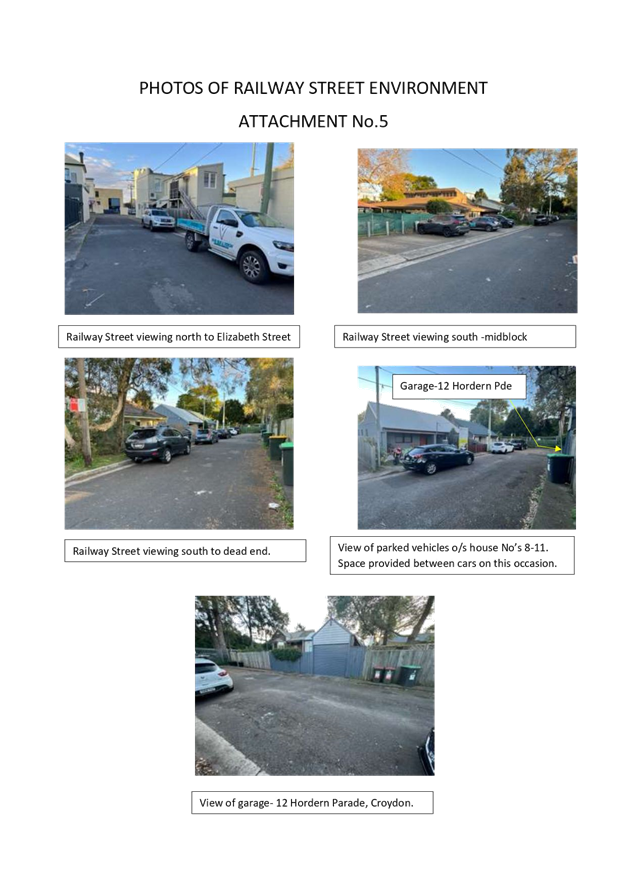
· ATTACHMENTS 2 and 3 are provided to show the difficulty (with vehicles parking right opposite-along the blue line) and ATTACHMENT 4 the improvement (with the cleared ‘No Parking’ zone) to access the garage with vehicle template movements. ATTACHMENT 5 shows photos of the existing street environment and view of the of the garage in question.
· Under the Council’s Public Domain Parking Policy, it should be noted that Council would prioritise access to off-street parking facilities over parking provision within a laneway. Railway Street (being narrow) is considered similarly to a laneway providing mainly off-street parking facilities. The residents of the 4 terraces with no off-street are entitled to resident parking permits enabling them to park longer periods of time under the Resident Parking Scheme restrictions in Railway Street.
PUBLIC CONSULTATION
A letter outlining the above proposal was distributed to (11) directly affected properties (13 letters) both in Railway Street and Hordern Parade.
Two (2) responses were received in objection to the proposal under initial consultation with (1) in support (by the owner of 12 Hordern Parade) in confirmation and agreement under re-notification/consultation of the amended proposal.
The following comments by the objectors are tabled with officer responses given.
|
Resident Comments |
Officer Response |
|
Resident 1 · Very limited parking and cannot afford to lose another space. At times cannot park in the street with nearby pool and child- care centre (pre-school) activity in the area. Neighbours have to juggle with parking.
· Signs to the frontage of the properties can create an eyesore and can devalue house prices. Foot path is narrow and would be unusable for No.9 Railway Street [with signs in footpath]. · The previous owner was able to use their garage. · Would be open to hearing a solution with no signposting and residents can park there. Further objection received-
· Was advised that the garage owner takes priority over the 4 houses who will be affected in Railway Street. · Railway Street residents have managed parking situation in the last 15 years. · There has been an increase of parking in the street with the pool (Ashfield Aquatic Centre). The 4 house- holds would need to reshuffle and park illegally down the street. · Garage was built 10-12 years ago and previous occupant managed without disrupting the whole street.
|
· It is considered there is ample parking in the street, with the 4 households able to obtain permits to assist and provide relief in parking under the current Resident Parking Scheme restrictions in the street. · The No parking zone is of short length enough to provide improved access to the garage, with minimal impact to loss of parking. The No parking is positioned in such a way to provide 3 good nominal sized vehicles to park in front of No 8-11 Railway in view to Australian standard practice. Parking of 4 vehicles may result in tight parking relying on assistance to juggle or move vehicles. It could be argued that technically there is no real loss of parking in this situation. · The amended proposal will allow the front signage to be placed on the telegraph pole and not interfere with footpath/gate access to the property No.9 Railway Street. · Residents can manage parking however the issue is how to control non-resident parking of vehicles in a public street. · Council is conscious of removal of parking but must also weigh on prioritising access to off-street parking according to the Policy. · See Attachment 3A. showing difficulty in accessing the garage with a nominal sized design vehicle and based on cars parked right along and directly opposite the garage. · Resident parking alone for exclusive use of space is not permitted on a public street. Police and Council Rangers have advised that the clearance area would need to be signposted for enforcement.
|
|
Resident 2 · Signage would cause an eyesore and ugliness to the front of the properties. · 4 residences do not have off-street parking and are dependent on the limited parking on street. · The garage owner would of noticed the driveway may not of been suited for larger vehicles when buying the property. · Neighbours have assisted the garage owner by providing a space, but the system falls down a bit when resident cars are not about and other non-resident cars park in the space. · Make the current zone outside 7-11 for resident parking only and not introduce proposed signage. · If approved, would ask that the front signs be placed on the telegraph pole. |
See all above.
See all above. |
CONCLUSION
In view of the above, it is recommended that a length of approximately 4.0 metres of ‘No Parking’ be assigned outside No.9 Railway Street, Croydon, supplemented with bay line and No Parking markings as shown in ATTACHMENTS 1C.
|
1.⇩ |
Initial proposal (signage only) and amended proposal (signage and markings) |
|
2.⇩ |
Vehicle template forward entry into garage -cars parking along and opposite driveway. |
|
3.⇩ |
Vehicle template reverse entry into garage- cars parked along and opposite driveway. |
|
4.⇩ |
Vehicle template forward entry into garage- clearance 'No Parking' zone provided. |
|
5.⇩ |
Photos of street environment |