|
AGENDA R |

Local Traffic Committee Meeting
MONDAY 15 AUGUST 2022
11.00AM
|
|
Local Traffic Committee Meeting 15 August 2022 |
Function of the Local Traffic Committee
Background
Roads and Maritime Services (RMS) is legislated as the Authority responsible for the control of traffic on all NSW Roads. The RMS has delegated certain aspects of the control of traffic on local roads to councils. To exercise this delegation, councils must establish a local traffic committee and obtain the advice of the RMS and Police. The Inner West Council Local Traffic Committee has been constituted by Council as a result of the delegation granted by the RMS pursuant to Section 50 of the Transport Administration Act 1988.
Role of the Committee
The Local Traffic Committee is primarily a technical review and advisory committee which considers the technical merits of proposals and ensures that current technical guidelines are considered. It provides recommendations to Council on traffic and parking control matters and on the provision of traffic control facilities and prescribed traffic control devices for which Council has delegated authority. These matters are dealt with under Part A of the agenda and require Council to consider exercising its delegation.
In addition to its formal role as the Local Traffic Committee, the Committee may also be requested to provide informal traffic engineering advice on traffic matters not requiring Council to exercise its delegated function at that point in time, for example, advice to Council’s Development Assessment Section on traffic generating developments. These matters are dealt with under Part C of the agenda and are for information or advice only and do not require Council to exercise its delegation.
Committee Delegations
The Local Traffic Committee has no decision-making powers. The Council must refer all traffic related matters to the Local Traffic Committee prior to exercising its delegated functions. Matters related to State Roads or functions that have not been delegated to Council must be referred directly to the RMS or relevant organisation.
The Committee provides recommendations to Council. Should Council wish to act contrary to the advice of the Committee or if that advice is not supported unanimously by the Committee members, then the Police or RMS have an opportunity to appeal to the Regional Traffic Committee.
Committee Membership & Voting
Formal voting membership comprises the following:
· one representative of Council as nominated by Council;
· one representative of the NSW Police from each Local Area Command (LAC) within the LGA, being Newtown, Marrickville, Leichhardt and Ashfield LAC’s.
· one representative from the RMS; and
· State Members of Parliament (MP) for the electorates of Summer Hill, Newtown, Heffron, Canterbury, Strathfield and Balmain or their nominees.
Where the Council area is represented by more than one MP or covered by more than one Police LAC, representatives are only permitted to vote on matters which effect their electorate or LAC.
Informal (non-voting) advisors from within Council or external authorities may also attend Committee meetings to provide expert advice.
Committee Chair
Council’s representative will chair the meetings.
Public Participation
Members of the public or other stakeholders may address the Committee on agenda items to be considered by the Committee. The format and number of presentations is at the discretion of the Chairperson and is generally limited to 3 minutes per speaker. Committee debate on agenda items is not open to the public.
|
|
Local Traffic Committee Meeting 15 August 2022 |
|
AGENDA |
1 Apologies
2 Disclosures of Interest
3 Confirmation of Minutes Page
Minutes of 18 July 2022 Local Traffic Committee Meeting 5
4 Matters Arising from Council’s Resolution of Minutes
5 Part A – Items Where Council May Exercise Its Delegated Functions
Traffic Matters
ITEM Page
LTC0822(1) Item 1 Rozelle North LATM Final Report 12
LTC0822(1) Item 2 Dudley Street, Dulwich Hill; Illawarra Road, Marrickville; Burrows Avenue, Railway Road, Gleeson Avenue and (Lower) Railway Parade, Sydenham - Temporary Parking Changes During Major Rail Shutdown of T3 Line for Sydney Metro Upgrade Works - Bus Replacements – 24 September 2022 to 9 October 2022 and 26 December 2022 to 15 January 2023 (Midjuburi - Marrickville Ward / Summer Hill Electorate / Inner West PAC) 137
Parking Matters
ITEM Page
LTC0822(1) Item 3 Beattie Street at Harris Street, Balmain - Proposed Kerb Blister Island (Baludarri - Balmain/ Balmain Electorate/ Leichhardt PAC) 146
LTC0822(1) Item 4 Cameron Street, Balmain (Between Mort Street and Clayton Street) - Propsoed Kerb Indentation (Baludarri-Balmain/ Balmain Electorate/ Leichhardt PAC) 151
Late Items
Nil at time of printing.
6 Part B - Items for Information Only
ITEM Page
LTC0822(1) Item 5 27-29 Percy Street Rozelle - Temporary Full Road Closure (Baludarri-Balmain/ Balmain Electorate/ Leichhardt PAC) 156
LTC0822(1) Item 6 Holbeach Avenue, Tempe – Temporary Full Road Closures for MS Sydney to the Gong Bike Ride on Sunday 6 November 2022 – (Midjuburi - Marrickville Ward/Heffron Electorate/Newtown LAC) 158
7 Part C - Items for General Advice
Nil at the time of printing.
8 General Business
9 Close of Meeting
|
|
Local Traffic Committee Meeting 15 August 2022 |
Minutes of Local Traffic Committee Meeting
Held on 18 July 2022 at Ashfield Service Centre
Meeting commenced at 11.00AM
ACKNOWLEDGEMENT OF COUNTRY BY CHAIRPERSON
I acknowledge the Gadigal and Wangal people of the Eora nation on whose country we are meeting today, and their elders past and present.
COMMITTEE REPRESENTATIVES PRESENT
|
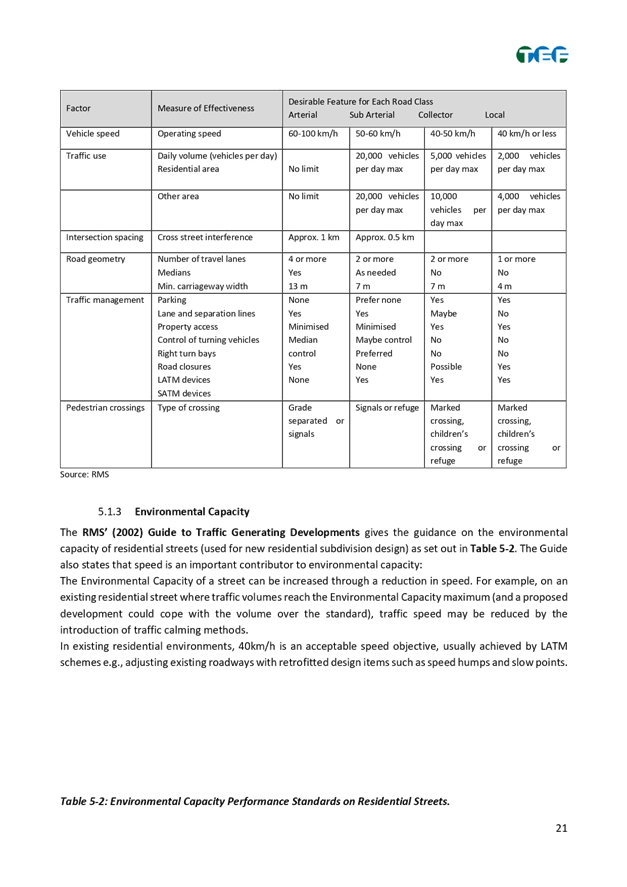
Mayor Darcy Bryne |
Councillor – Baludarri-Balmain Ward (Chair) |
|
Bill Holliday |
Representative for Jamie Parker MP, Member for Balmain |
|
Graeme McKay |
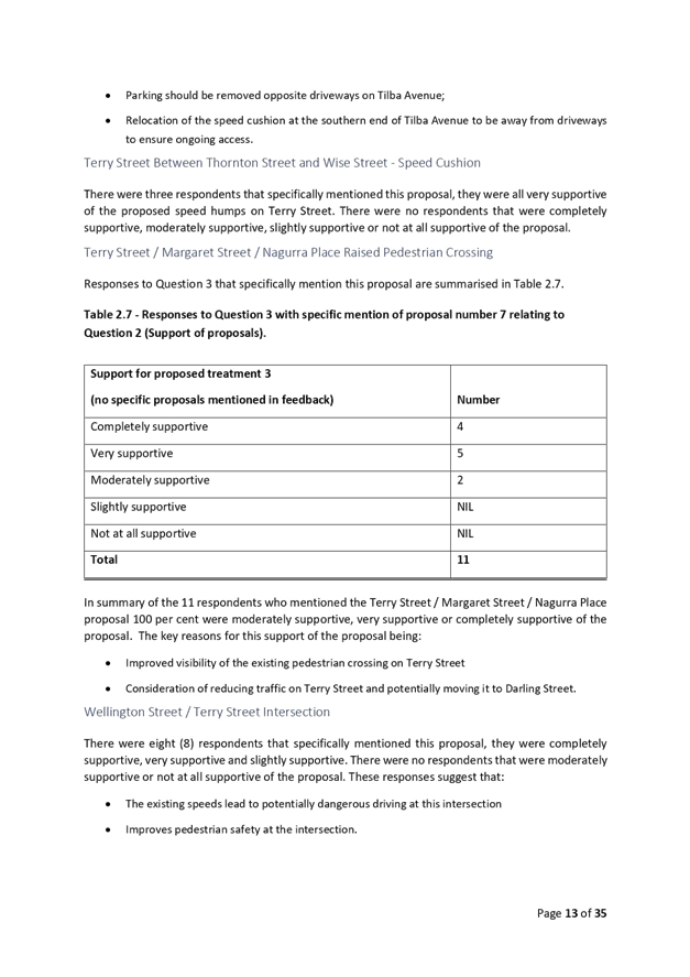
Representative for Jo Haylen MP, Member for Summer Hill |
|
Paul Kelaita |
Representative for Jason Yat-Sen Li MP, Member for Strathfield |
|
Van Le |
Transport for NSW (TfNSW) |
|
|
|
|
OFFICERS IN ATTENDANCE |
|
|
|
|
|
Cr Justine Langford |
Councillor – Midjuburi-Marrickville Ward (Alternate Chair) |
|
Colin Jones |
Inner West Bicycle Coalition (IWBC) |
|
Sunny Jo |
IWC’s Acting Traffic and Transport Services Manager |
|
George Tsaprounis |
IWC’s Coordinator Traffic Engineering Services (South) |
|
David Yu |
IWC’s Acting Coordinator Traffic Engineering Services (North) |
|
Mirushan Sivanesan |
IWC’s Student Traffic Engineer |
|
Christina Ip |
IWC’s Business Administration Officer |
|
|
|
|
VISITORS |
|
|
|
|
|
Marc Denis |
Item 4 - Resident |
|
|
|
|
APOLOGIES: |
|
|
|
|
|
Sgt Charles Buttrose |
NSW Police – Leichhardt Police Area Command |
|
SC Anthony Kenny |
NSW Police – Inner West Police Area Command |
|
Chris Woods |
Representative for Ron Hoenig MP, Member for Heffron |
|
Colin Hesse |
Representative for Jenny Leong MP, Member for Newtown |
|
Adrian Pritchard |
Transit Systems |
DISCLOSURES OF INTERESTS:
Nil.
CONFIRMATION OF MINUTES
MATTERS ARISING FROM COUNCIL’S RESOLUTION OF MINUTES
The Local Traffic Committee recommendations of its meeting on 20 June 2022 are awaiting adoption.
|
LTC0722(1) Item 1 Dulwich Hill Station Precinct Public Domain Improvements Amendments - Location of traffic calming entry thresholds (Midjuburi – Marrickville Ward/Summer Hill Electorate/Inner West PAC) |
|
Cardno was commissioned for the traffic and transport assessment and the detailed design of the Dulwich Hill Station Precinct Public Domain Improvements (DHSPPDI). Council adopted the Master Plan for Dulwich Hill Station Precinct at its 13 August 2019 meeting. The Dulwich Hill Station Public Domain Master Plan provides the Dulwich Hill community with a plan to transform the streets and public spaces around the station into a pedestrian oriented village.
Dulwich Hill Station Precinct Public Domain Improvement works were initially planned to be delivered in two stages. Relevant documentation for Stage 1 works were submitted and approved by the Local Traffic Committee in July, 2020. Stage 1 works involved: · A raised, signalised intersection at Wardell Road / Dudley Street; · Footpath treatments and tree plantings on the southern side of Dudley Street; and · A kerb extension on the southern side of Dudley Street at the intersection with Wardell Road. An assessment for Stage 2 works were submitted and approved by the Local Traffic Committee in February, 2022. Stage 2 works involved: · Raised entry thresholds at the north and south of Wardell Road and south west of Ewart Street; · Upgrading the existing threshold at Ewart St East, to IWC standards; · Tree plantings, garden beds and a rain garden; and · New Bluestone Pavers for footpaths. This assessment is for an amendment to parts of the Stage 2 works. In discussion with TfNSW, the two proposed thresholds at Wardell Road South and Ewart Street West have been relocated. The raised thresholds at Ewart Street west and Wardell Road south were originally located approximately 30m west and 20m south of the Ewart Street / Wardell Road intersection respectively. Both thresholds have now been shifted to approximately 80m away from the intersection. This is likely to increase safety by providing additional length for drivers to reduce and maintain lower speed (i.e. 40km/h) while entering and exiting a signalised intersection.
Officer’s Recommendation
THAT: the relocation of the proposed raised thresholds on Wardell Road to a position approximately 80m away from the Ewart Street/Wardell Road intersection be APPROVED as amendments to Stage 2 design of the Dulwich Hill Station Precinct Public Domain Improvement works.
DISCUSSION
The representative for the Member for Summer Hill stated that a resident was concerned that relocating the pedestrian crossing on Wardell Road would mean it would be closer to the existing crossing near Ness Street. Council Officers stated that the proposal is to relocate the raised thresholds from the previously approved design. These facilities are meant to reduce the speed of traffic on approach to the traffic signals at the intersection of Wardell Road and Ewart Street where pedestrian crossing facilities are already provided.
The Committee members agreed with the Officer’s recommendation.
COMMITTEE RECOMMENDATION
THAT: the relocation of the proposed raised thresholds on Wardell Road to a position approximately 80m away from the Ewart Street/Wardell Road intersection be APPROVED as amendments to Stage 2 design of the Dulwich Hill Station Precinct Public Domain Improvement works.
For motion: Unanimous
|
|
LTC0722(1) Item 3 Murrell
Street, Ashfield- Traffic and parking changes |
|
Council has received numerous concerns from the Ashfield Public School community and the Good-start Early Learning Child Care Centre regarding traffic safety in Murrell Street, Ashfield.
This report deals with the main concern of congestion in the street with parked vehicles obstructing traffic flow and the build -up of traffic in Murrell Street due to vehicles waiting long periods to turn right onto Liverpool Road during school drop- off and pick up times.
The school and Child Care Centre has requested that parking to the western side of the street be either removed or wholly limited to park outside of morning and afternoon school drop-off and pick -up times.
Rather than above, it is recommended that parking be reconfigured and limited in time to certain areas on the western side of the street to improve traffic flow and minimise the impact on the loss or limitation of parking in the area for the residential and business community.
No Right Turn during school zone hours for traffic coming out of Murrell Street into Liverpool Road is proposed subject to Transport for NSW (TfNSW) approval.
Officer’s Recommendation
THAT:
1. The following parking changes be approved:
(a) The (4) parking spaces on the western side of Murrell Street, Ashfield outside the side of 183 Liverpool Road be changed to read “No Stopping 8.30am - 9.30am, 2.30pm-3.30pm School days” and “2P 9.30am-2.30pm., 3.30pm-6.00pm Mon-Fri Permit Holders Excepted AREA 1”, (b) ‘No Stopping’ be signposted across: (i) the combined driveways of 183 Liverpool Road and David’s Lane, (ii) driveway to 2-4 Murrell Street, (iii) driveway to 10-12 Murrell Street& side service driveway to 1A Orchard Crescent, and
2. Council forwards a Traffic Management Plan to Transport for NSW to consider and approve ‘No Right Turn 8.00am-9.30am., 2.30pm-4.00pm School Days’ for traffic out of Murrell Street into Liverpool Road.
DISCUSSION
The representative for the Member for Summer Hill stated that Clr Mark Drury was concerned with the number of parents who use Murrell Street and make U-turns in the street when picking up and dropping off their children to school, and asked if there was an alternative option for these parents. Council Officers stated that the proposal aims to address congestion whilst maintaining as much parking as possible for parents and residents. The proposal also includes the banning of the right turn out of Murrell Street during the peak drop off and pick up times for the school to assist in the improvement of traffic flow. The proposed parking and traffic measures will be reviewed by Council 6-12 months after implementation and further changes can be made if issues persist.
The Committee members agreed with the Officer’s recommendation.
COMMITTEE RECOMMENDATION
THAT:
1. The following parking changes be approved:
(a) The (4) parking spaces on the western side of Murrell Street, Ashfield outside the side of 183 Liverpool Road be changed to read “No Stopping 8.30am - 9.30am, 2.30pm-3.30pm School days” and “2P 9.30am-2.30pm., 3.30pm-6.00pm Mon-Fri Permit Holders Excepted AREA 1”, (b) ‘No Stopping’ be signposted across: (i) the combined driveways of 183 Liverpool Road and David’s Lane, (ii) driveway to 2-4 Murrell Street, (iii) driveway to 10-12 Murrell Street& side service driveway to 1A Orchard Crescent, and
2. Council forwards a Traffic Management Plan to Transport for NSW to consider and approve ‘No Right Turn 8.00am-9.30am., 2.30pm-4.00pm School Days’ for traffic out of Murrell Street into Liverpool Road.
For motion: Unanimous
|
General Business
LTC0722 Item 5 Pedestrian crossings on Darling Street, Balmain
The representative for the Member for Balmain stated that a resident raised concerns with safety at the pedestrian crossings adjacent to Gladstone Park. The resident and her son who attends Balmain Public School have been hit by a car and a cyclist on separate occasions while at the crossings. The resident stated that the crossing had a school crossing supervisor prior to COVID lockdowns and requested a supervisor be reinstated at the crossing. TfNSW will investigate why the school crossing supervisor was withdrawn at the crossing and report back to the Committee. The TfNSW representative also advised that the school can apply for a new school crossing supervisor.
LTC0722 Item 6 Pram ramps for Orchard Crescent, Ashfield
The IWBC representative requested urgent installation of pram ramps on Orchard Crescent, Ashfield to improve access for pedestrians and cyclists. Council Officers will check whether Orchard Crescent was part of any recommendations from the Pedestrian Access and Mobility Plan study and report back to the Committee.
LTC0722 Item 7 Livingstone Road, Marrickville bike path
Cr Langford raised safety concerns with the Livingstone Road bike path that is still under construction. Cr Langford stated that it was unclear whether the new section of bike path was open as there was no signage or information provided regarding timelines. Cyclists and pedestrians have been observed using the path. Council Officers will find out when the bike path opens and report back to the Committee. Cr Langford was also advised she could contact the Acting Director Infrastructure to seek an answer prior to the next Committee meeting.
LTC0722 Item 8 Filming applications occupying footpaths and cycle paths
The IWBC representative raised concerns with film crews occupying footpaths and cycle paths and restricting acces. This has occurred in Smith Street and Lackey Street, Summer Hill and Livingstone Road, Marrickville. Council Officers advised that provisions for pedestrian access and safety should be included in an applicant’s traffic control plan and it is part of the conditions when a filming application is approved. Council Officers may need to speak to the applicant to check if the permitted occupancy was warranted. Council Officers were requested to table the relevant section of the filming application relating to pedestrian access and safety at a subsequent meeting for the Committee’s review.
Meeting closed at 11.29am.
|
|
Local Traffic Committee Meeting 15 August 2022 |
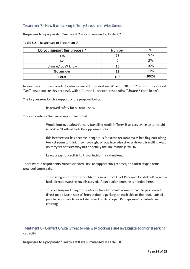
Subject: Rozelle North LATM Final Report
Prepared By: Jason Scoufis - Traffic and Parking Planner
Authorised By: Sunny Jo - Acting Traffic and Transport Manager
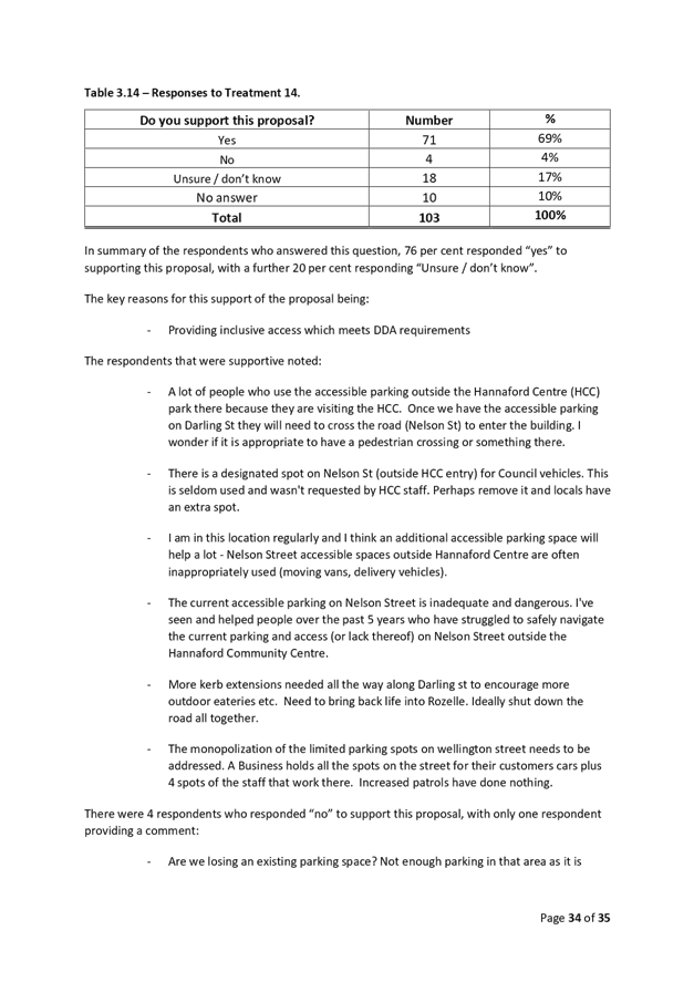
SUMMARY
This is a recommendation to endorse the findings of the Final Rozelle North LATM Study report. Council has recently undertaken Public Exhibition of the draft Rozelle North LATM Study through Yoursay Inner West.
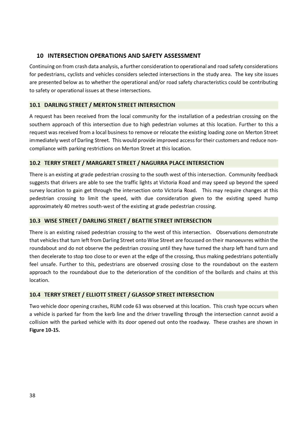
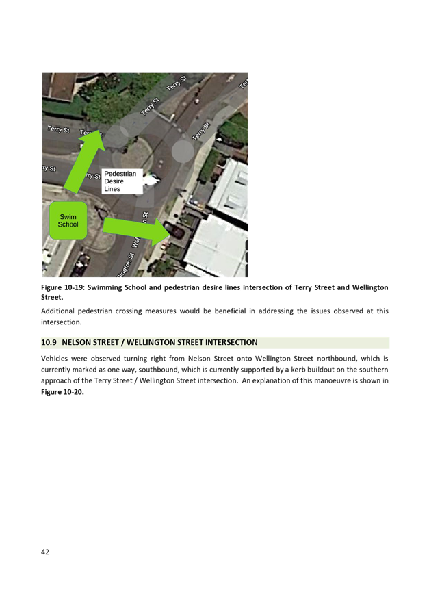
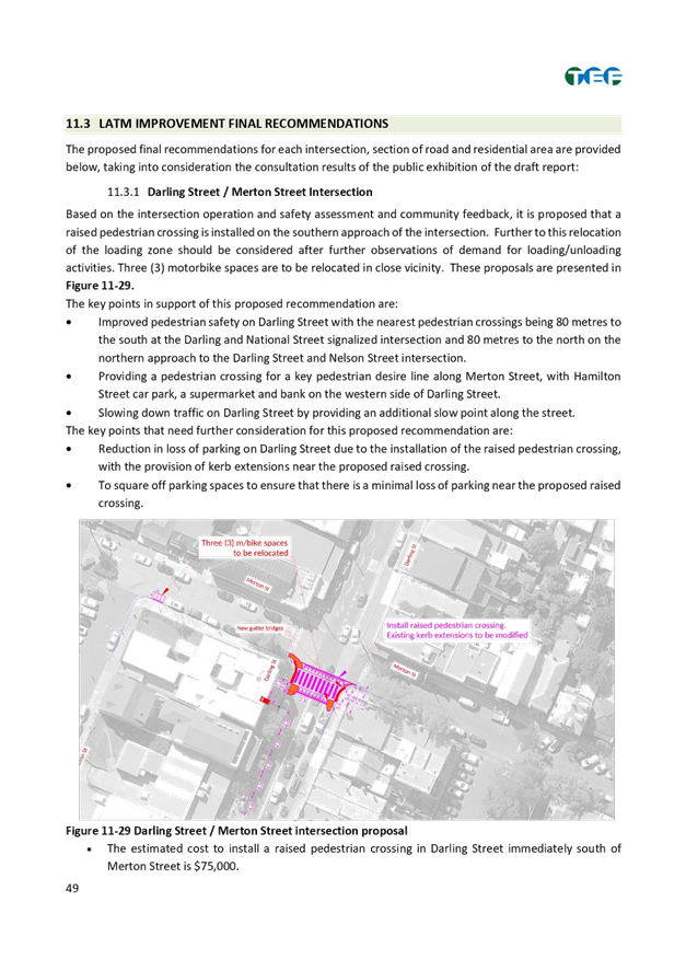
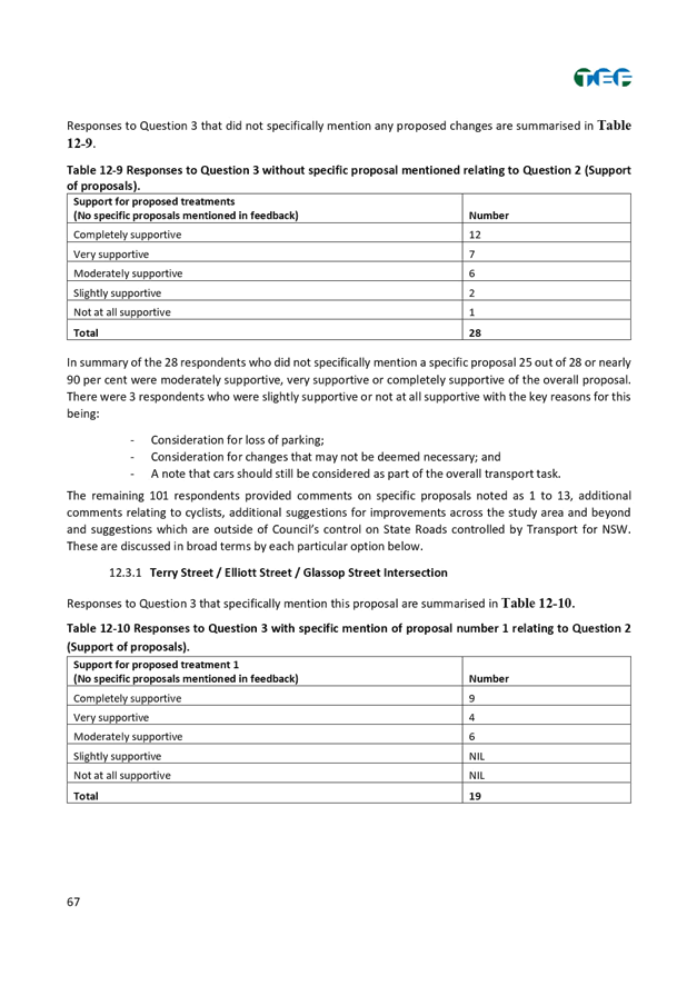
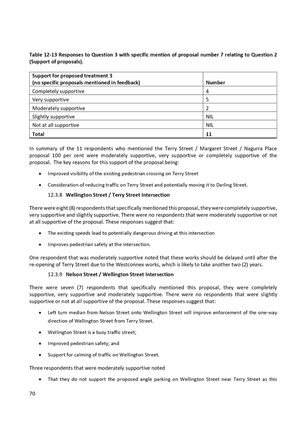
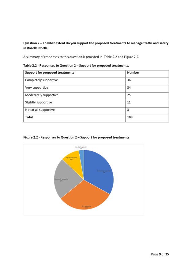
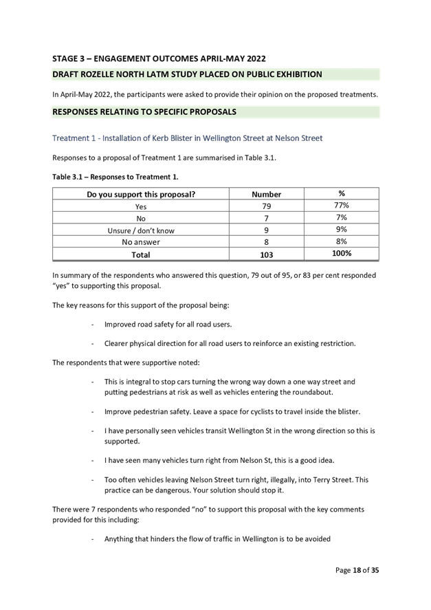
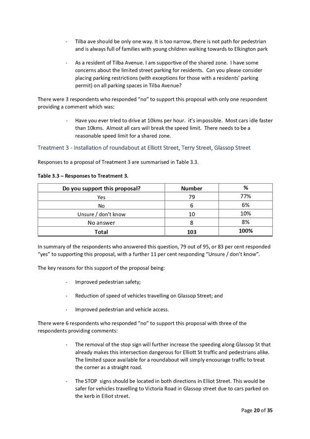
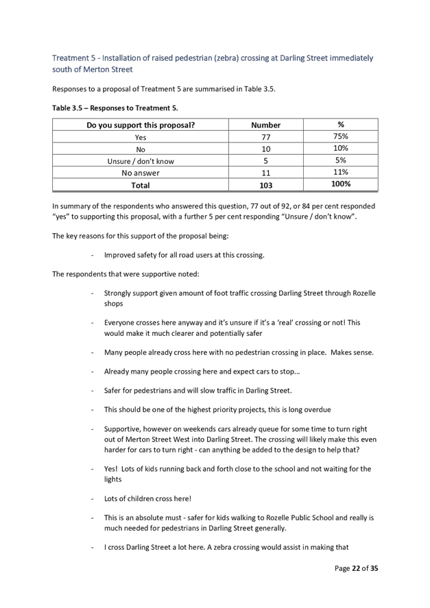
The response results indicate that the community generally supported all of the proposed changes, including support for the short-term proposal to install a roundabout at the Elliott Street/Terry Street/Glassop Street stop-controlled intersection. Similarly, support was provided for the proposal to install a raised zebra crossing in Darling Street south of Merton Street.
After considering the Public Exhibition feedback, a review on the proposed scheme was undertaken with minor adjustments made to the LATM Study recommendations and some additional recommendations added. As the changes included both short term and long-term strategies, this would require Council to implement the changes over a life cycle of the study.
|
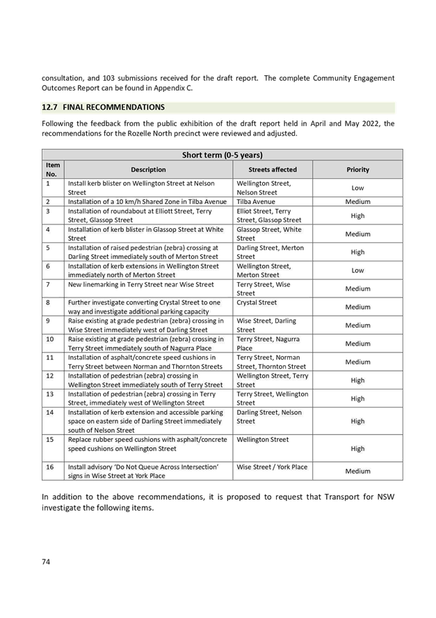
RECOMMENDATION
That:
1. The final Rozelle North LATM Study be received and noted;
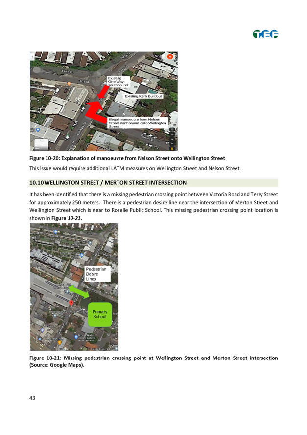
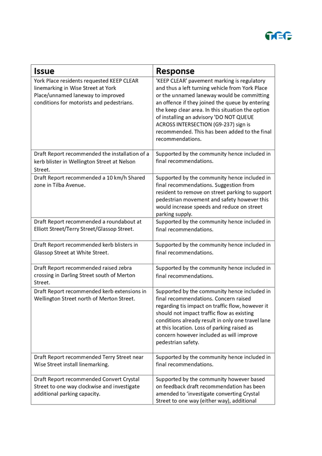
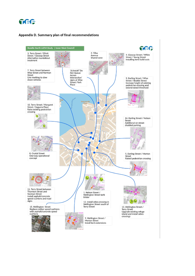
2. A kerb blister be installed in Wellington Street at Nelson Street;
3. A roundabout be installed at Elliott Street/Terry Street/Glassop Street;
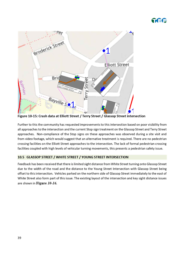
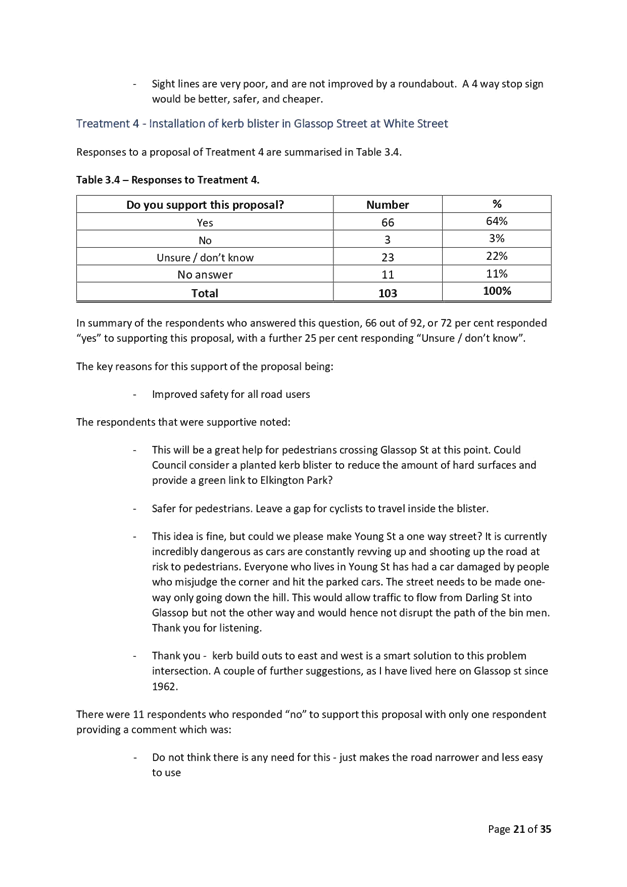
4. Kerb blisters be installed in Glassop Street at White Street;
5. A raised pedestrian (zebra) crossing in Darling Street be installed immediately south of Merton Street including relocation of existing motorbike spaces;
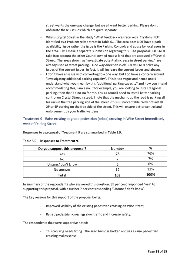
6. Raise the existing at grade pedestrian (zebra) crossing in Wise Street immediately west of Darling Street;
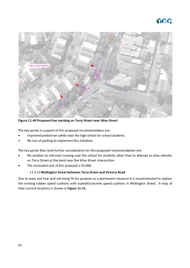
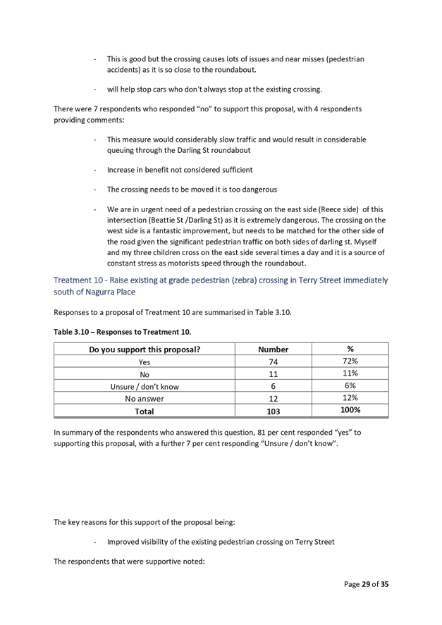
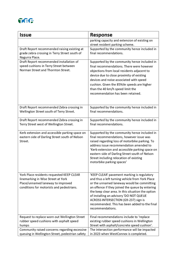
7. Raise the existing at grade pedestrian (zebra) crossing in Terry Street immediately south of Nagurra Place;
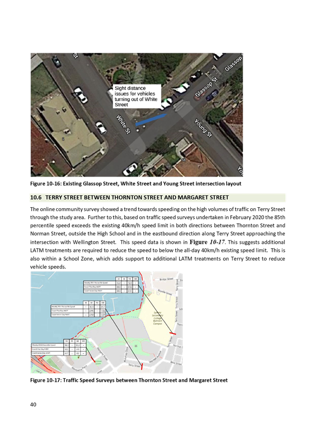
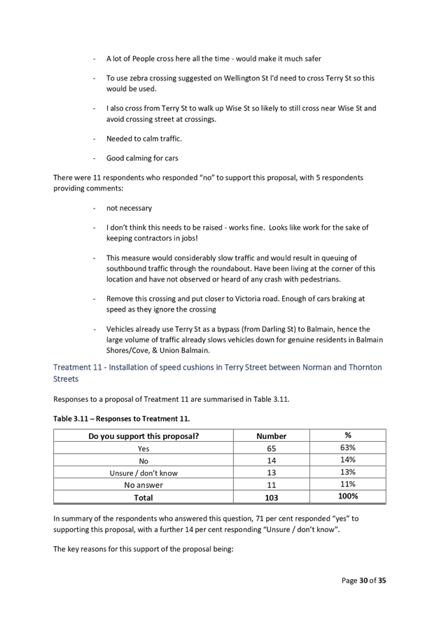
8. Install an asphalt/concrete speed cushion in Terry Street between Norman Street and Thornton Street;
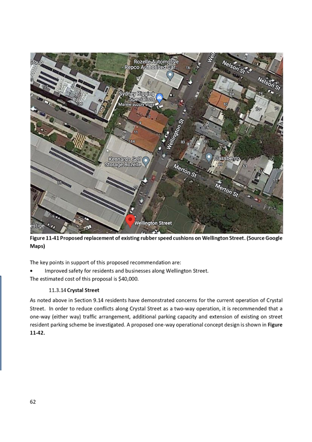
9. Replace existing rubber speed cushions with asphalt/concrete speed cushions in Wellington Street between Terry Street and Victoria Road;
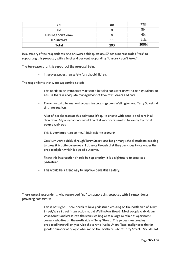
10. Install a pedestrian (zebra) crossing in Wellington Street, immediately south of Terry Street;
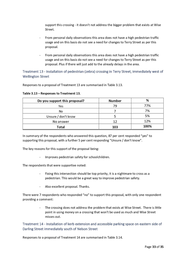
11. Install a pedestrian (zebra) crossing in Terry Street, immediately west of Wellington Street;
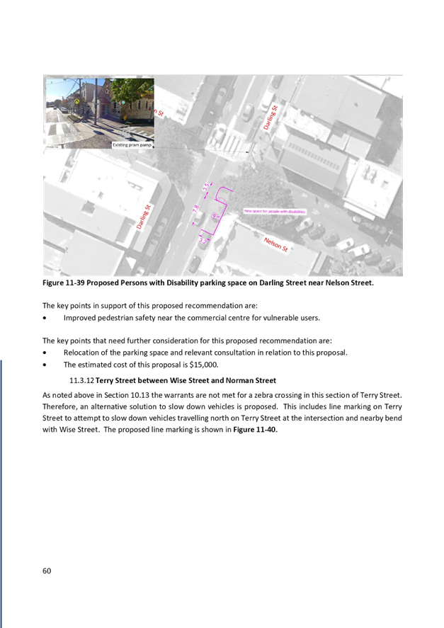
12. Install a kerb extension and accessible parking space on the eastern side of Darling Street immediately south of Nelson Street;
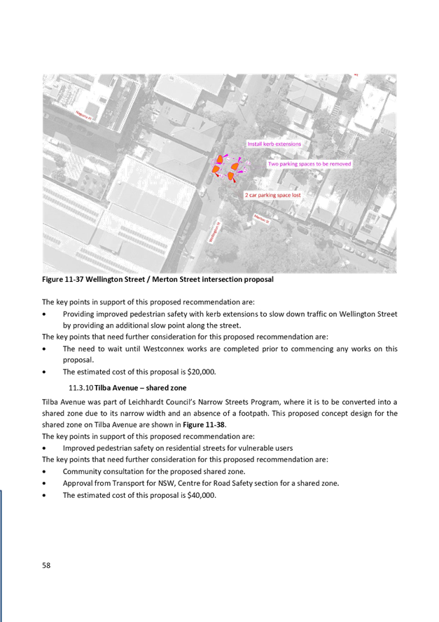
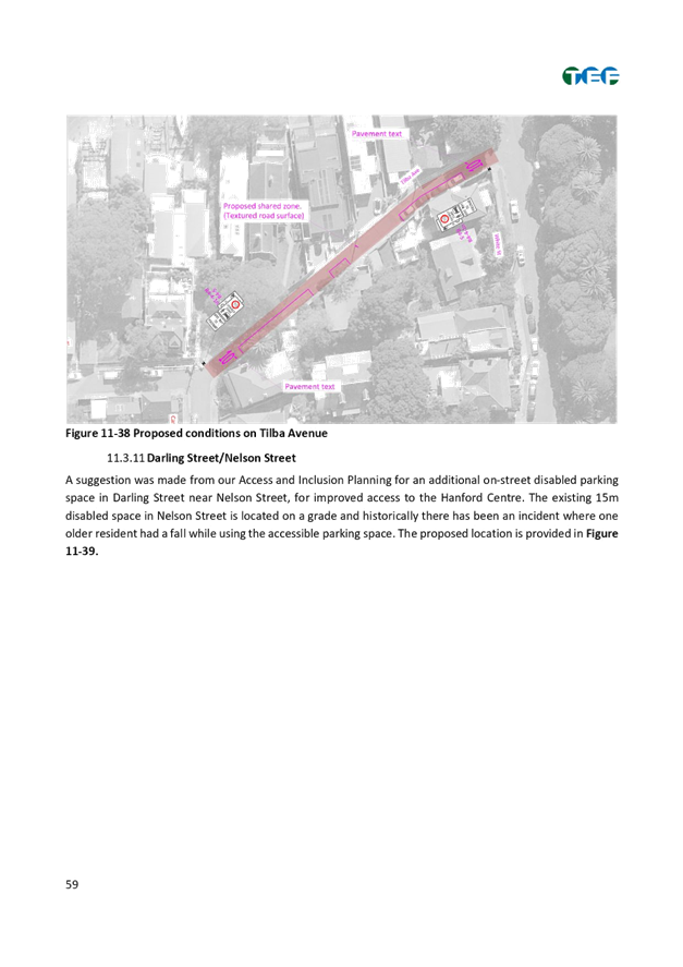
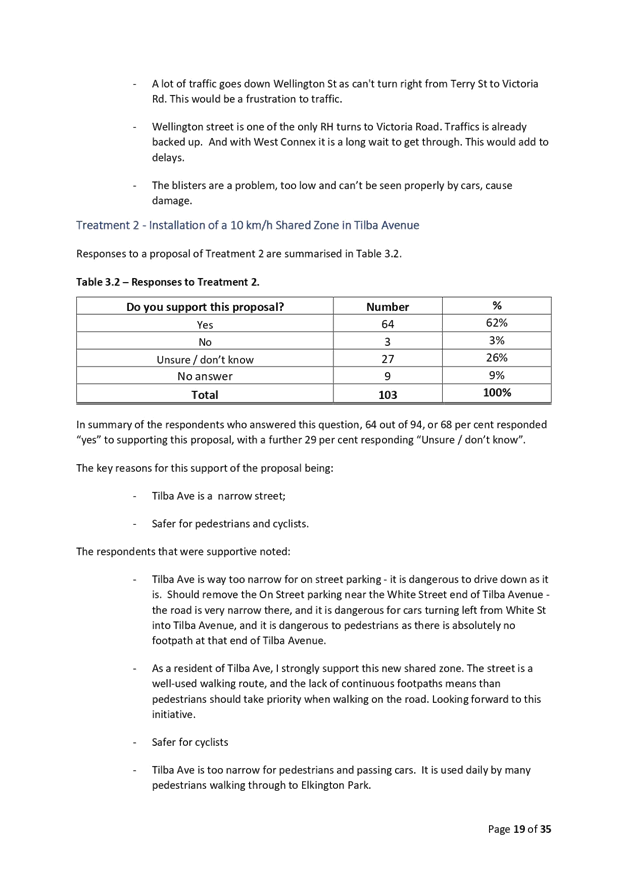
13. Install a 10 km/h Shared Zone in Tilba Avenue subject to TfNSW approval of a TMP;
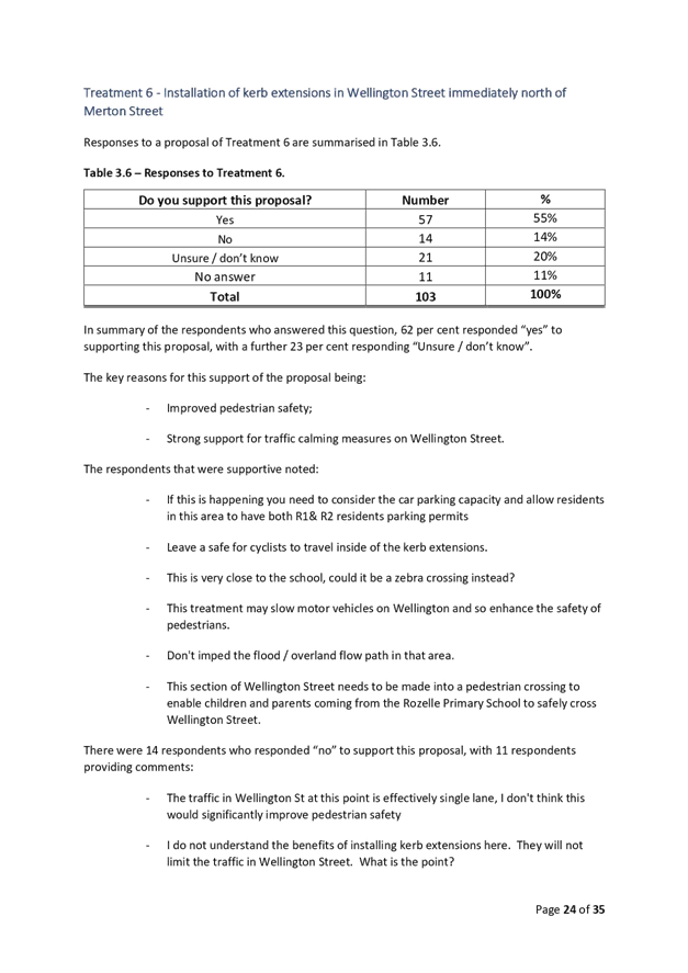
14. Install kerb extensions in Wellington Street immediately north of Merton Street;
15. Upgrade linemarking in Terry Street near Wise Street including edgeline markings and linemarking around the median island;
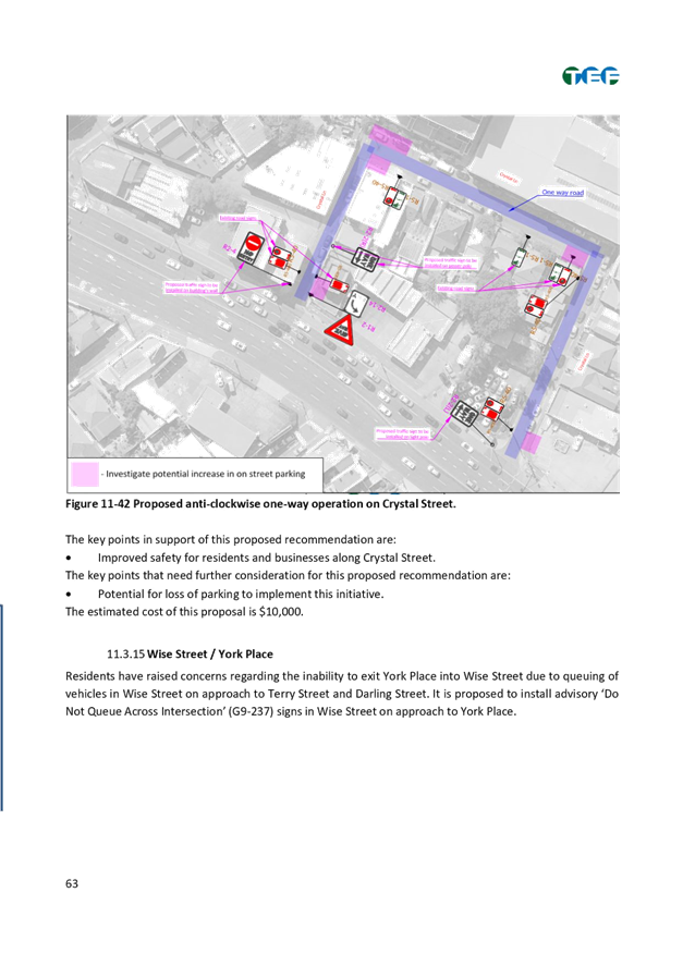
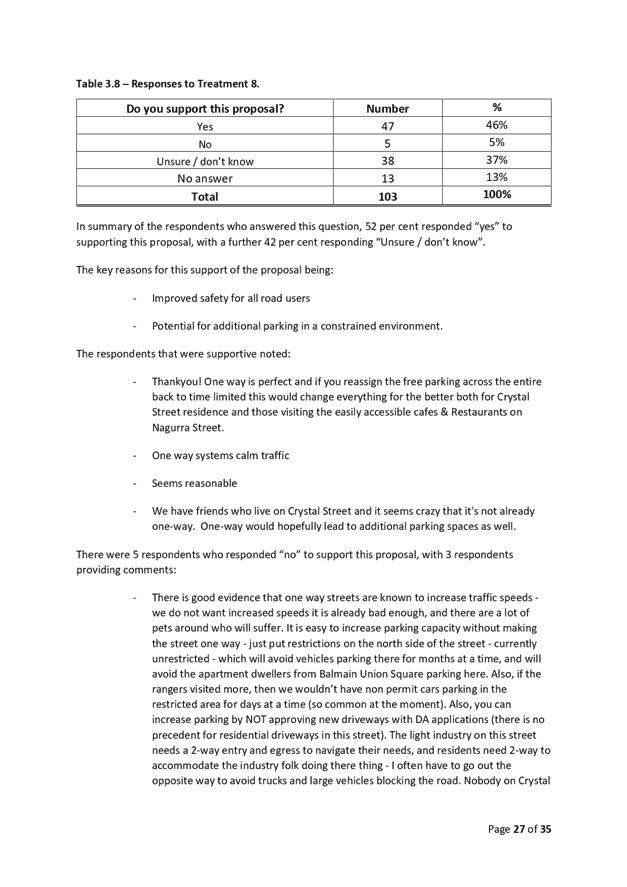
16. Undertake further investigation into converting Crystal Street to one way (either way), additional parking capacity and extension of existing on street resident parking scheme;
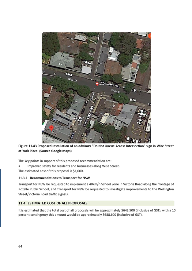
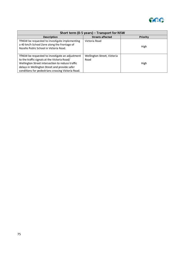
17. Install advisory 'Do Not Queue Across Intersection’ (G9-237) signs in Wise Street at York Place;
18. TfNSW be requested to investigate implementing a 40 km/h School Zone along the frontage of Rozelle Public School in Victoria Road; and
19. TfNSW be requested to investigate adjustment to the traffic signals at the Victoria Road/Wellington Street to reduce traffic delays/queuing in Wellington Street and provide safer conditions for pedestrians crossing Victoria Road.
|
BACKGROUND
As part of Council’s Local Area Traffic Management (LATM) Strategy Review Program, Council engaged TEF Consulting to prepare the Rozelle North LATM study.
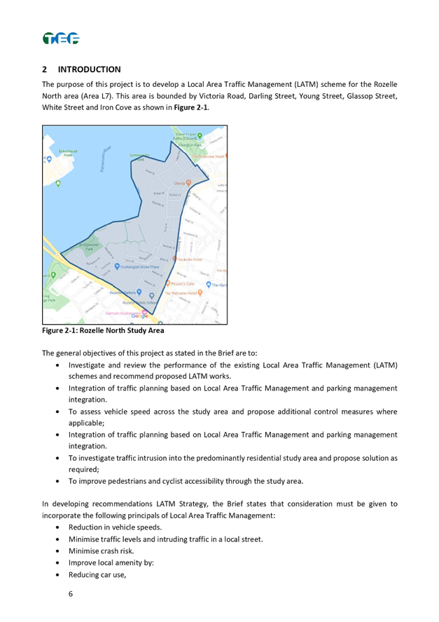
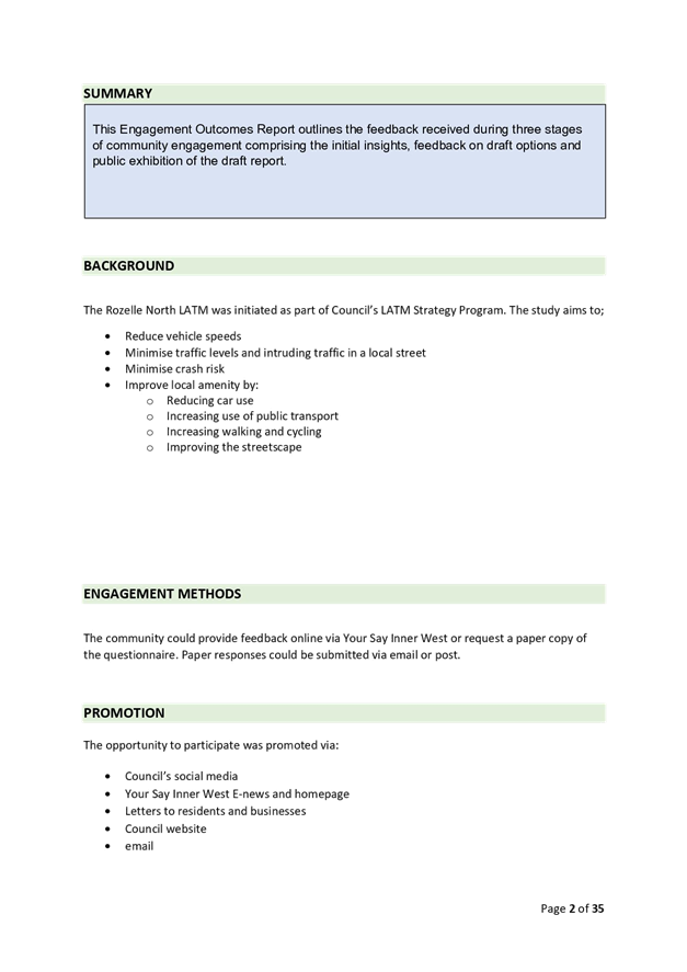
The Rozelle North (Area L7) precinct is bounded by Victoria Road, Darling Street, Young Street, Glassop Street, White Street and Iron Cove.
The
objective of the study is to reduce traffic volumes and speeds in local streets
to increase liveability and improve safety and access for pedestrians and
cyclists. It also includes a review of the original LATM Study which was
completed in the year 2000.
The map of the study area is included in a copy of the final report as provided in Attachment 1.
FINANCIAL IMPLICATIONS
The cost of proposed treatments as listed in the draft report placed on public exhibition was estimated to cost approximately $643,500 (including GST). The final report includes recommendations totalling $688,600 (including GST). This includes the additional costs associated with the additional recommendations/modifications.
This cost takes into consideration 10% contingency. Once the LATM Study is adopted, detailed design and construction would be undertaken in stages as prioritised commencing from the 2022/2023 year.
The cost to implement the Rozelle North LATM Study will be funded from Council’s traffic facilities budget, subject to Local Traffic Committee support and adoption by Council. Subsequent reports during implementation of the recommendations of the study will provide further detailed plans if required.
PUBLIC CONSULTATION
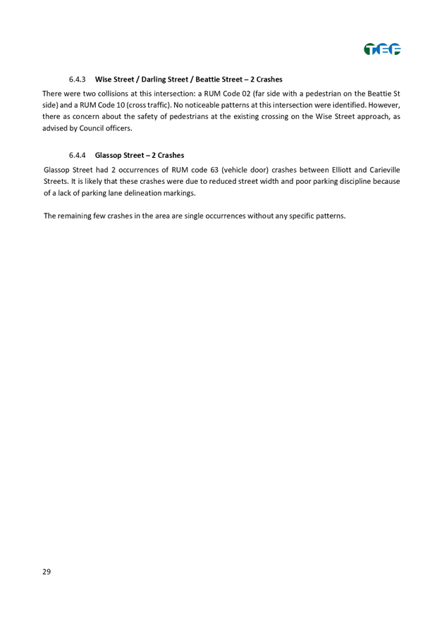
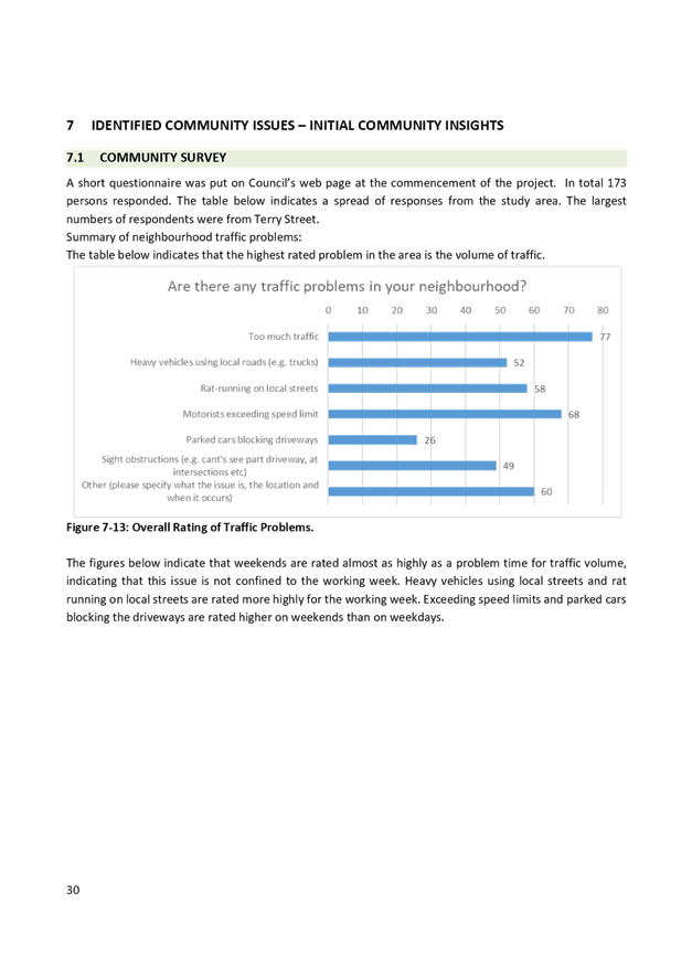
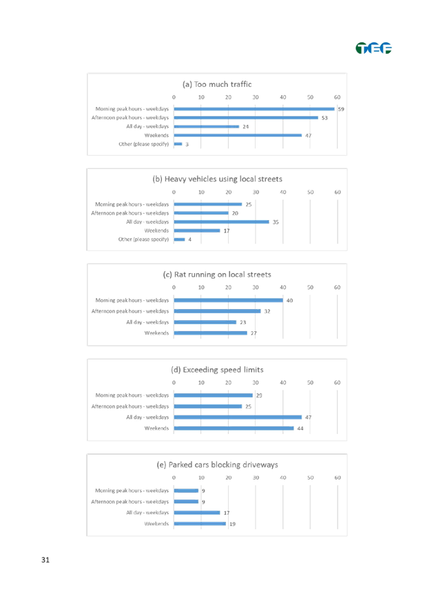
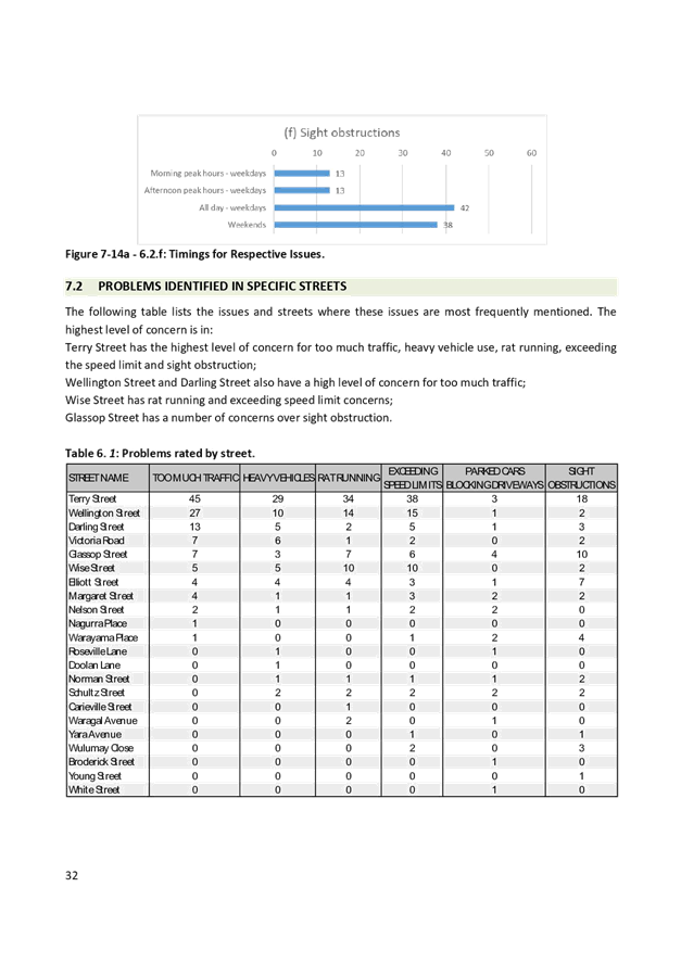
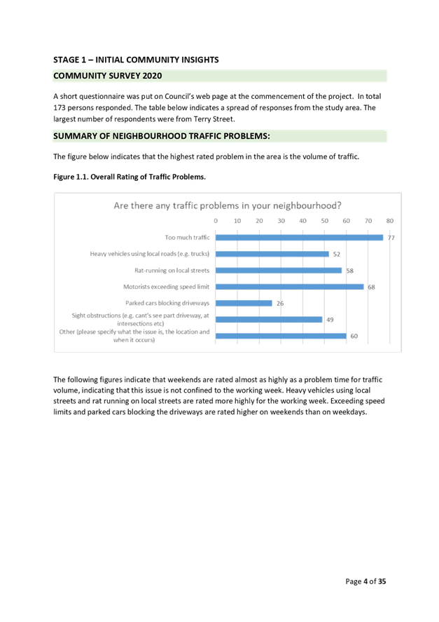
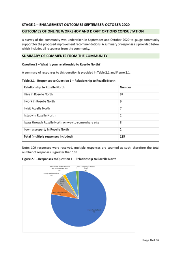
Council undertook an initial survey through Council’s Yoursay website in February/March 2020 with invitation letters mailed out to stakeholders and residents within the study area to determine existing issues and ideas in the study area. A total of 173 responses were received. An online workshop was held in September 2020 and further consultation held in October 2020 of the proposed draft options with 125 responses received.
The subsequent Public Exhibition of the draft LATM Study commenced 4th April 2022 and ended 15 May 2022. A total of 3,467 letters were mailed out, inviting to provide comments online and via separate email and paper submissions.
Councils Have Your Say in Leichhardt West website had 365 visits and 103 submissions received. A further 6 submissions were received via email, customer service enquiry, and post.
The feedback is summarised below with further details provided in the Rozelle North LATM Study Final Report which includes the Community Engagement Outcomes Report.
An additional recommendation has been included in the form of installing advisory 'Do Not Queue Across Intersection’ (G9-237) signs in Wise Street at York Place based on issues raised by residents in not being able to enter Wise Street due to queueing.
There is also an additional recommendation to replace the existing rubber speed cushions with asphalt/concrete speed cushions in Wellington Street due to their worn use.
Regarding Crystal Street, the recommendation has been adjusted to ‘investigate converting Crystal Street to one way (either way), additional parking capacity and extension of existing on street resident parking scheme which encompasses concerns regarding lack of parking turnover.
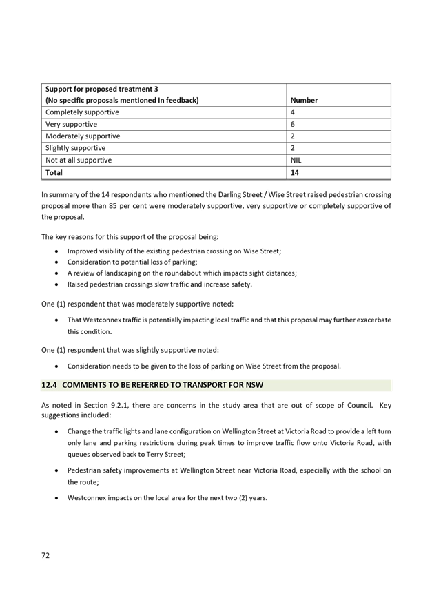
Concerning the recommendation to install a raised zebra crossing in Darling Street south of Merton Street, the community supported the proposal hence it has been included in final recommendations, however the issue was raised regarding loss of motorbike parking. To address issue the recommendation has been amended to ‘Kerb extension and accessible parking space on eastern side of Darling Street south of Nelson Street including relocation of existing motorbike parking spaces’
There are also recommendations that have been included that relate to matters under TfNSW jurisdiction on State Roads. They include a recommendation to investigate implementing a 40 km/h School Zone along the frontage of Rozelle Public School in Victoria Road and to investigate whether the traffic signals at the Victoria Road/Wellington Street can be adjusted to reduce traffic delays in Wellington Street and provide safer conditions for pedestrians crossing Victoria Road.
|
1.⇩ |
Rozelle North LATM Final report |
|
Local Traffic Committee Meeting 15 August 2022 |
Subject: Dudley Street, Dulwich Hill; Illawarra Road, Marrickville; Burrows Avenue, Railway Road, Gleeson Avenue and (Lower) Railway Parade, Sydenham - Temporary Parking Changes During Major Rail Shutdown of T3 Line for Sydney Metro Upgrade Works - Bus Replacements – 24 September 2022 to 9 October 2022 and 26 December 2022 to 15 January 2023 (Midjuburi - Marrickville Ward / Summer Hill Electorate / Inner West PAC)
Prepared By: Jennifer Adams - Engineer – Traffic and Parking Services
Authorised By: Sunny Jo - Acting Traffic and Transport Manager
SUMMARY
Council has been notified by Transport for NSW (TfNSW) that Sydney Metro works will involve a major rail shutdown of the Sydenham to Bankstown rail line (T3) over the following 2 periods:
· Saturday 24 September 2022 to Sunday 9 October 2022 (inclusive); and
· Monday 26 December 2022 to Sunday 15 January 2023 (inclusive).
During the shutdown buses will replace train services along the T3 line and to accommodate the increased bus movements and necessary holding areas some short-term parking changes are required at a number of locations.
Specifically, TfNSW is requesting approval for the temporary conversion of multiple parking spaces at the following locations: Dudley Street, Dulwich Hill; Illawarra Road, Marrickville; Burrows Avenue, Railway Road, Gleeson Avenue and (Lower) Railway Parade, Sydenham. It is recommended that no objections be raised, and Council approves the temporary short-term parking changes at the identified locations during the planned rail shutdowns, as previously approved for the prior 2-15 July 2022 shutdown.
|
RECOMMENDATION
That the Local Traffic Committee receive and note the report and the following temporary short-term parking changes over the two periods - Saturday 24 September 2022 to Sunday 9 October 2022 (inclusive) and Monday 26 December 2022 to Sunday 15 January 2023 (inclusive) be approved and implemented by TfNSW:
Dulwich Hill Station Precinct - Dudley Street (5 parking spaces)
1. The short-term conversion of 7m (1 parking space) ‘Loading Zone 8:30 am – 6 pm Mon – Fri & 8:30 am – 12:30 pm Sat’ on the northern side of Dudley Street (between Wardell Road and School Parade) to a ‘Bus Zone’ be APPROVED in order to provide an additional bus bay with adequate draw-in length;
2. The short-term conversion of 18m (3 parking spaces) ‘P30 min 8:30 am – 6 pm Mon – Fri & 8:30 am – 12:30 pm Sat’ on the northern side of Dudley Street (between Wardell Road and School Parade) to a ‘Bus Zone’ be APPROVED in order to provide an additional bus bay with adequate draw-in length;
3. The short-term conversion of 7m (1 parking space) ‘Unrestricted Parking’ on the southern side of Dudley Street (between School Parade and Wardell Road) to a ‘Bus Zone’ be APPROVED in order to provide an additional bus bay with adequate draw-in length;
Marrickville Station Precinct - Illawarra Road (1 parking space)
4. The short-term conversion of 7m (1 parking space) ‘1P 8:30 am – 6 pm’ on the western side of Illawarra Road (between Warburton Street and Greenbank Street) to a ‘Bus Zone’ be APPROVED in order to provide additional space for adequate bus draw-in/draw-out length;
Sydenham Station Precinct - Burrows Avenue (23 parking spaces)
5. The short-term conversion of 50m (14 parking spaces) rear to kerb ‘unrestricted parking’ on the northern kerb of Burrows Avenue (west of Gleeson Avenue) to a ‘Bus Zone’ be APPROVED in order to provide additional bus bays for adequate bus draw-in/draw-out length;
6. The short-term conversion of 58m (9 parking spaces) ‘unrestricted parking’ on the southern kerb of Burrows Avenue (west of Gleeson Avenue) to a ‘Bus Zone’ be APPROVED in order to provide additional bus bays for bus layover purposes;
7. The short-term conversion of 18m (3 parking spaces) ‘2P 8:30 am – 10 pm Mon - Fri’ on the eastern side kerb of Railway Road (between Burrows Avenue and Gleeson Avenue) to a ‘Bus Zone’ be APPROVED in order to provide additional bus bays for bus layover purposes;
Sydenham Station Precinct - Gleeson Avenue (2 parking spaces)
8. The short-term conversion of 12m (2 parking spaces) ‘1P 9:00 am – 3:30 pm Mon - Fri and No Parking 6 am-9 am & 3:30 pm – 6:30 pm’ on the eastern kerb of Gleeson Avenue (between Burrows Avenue and Unwins Bridge Road) to a ‘Bus Zone’ be APPROVED in order to provide a bus stop extension with adequate draw-in/draw-out length;
Sydenham Station Precinct - Lower Railway Parade (57 parking spaces)
9. The short-term conversion of 122m (46 parking spaces) 45 degree angled ‘unrestricted parking’ on the southern side kerb of Lower Railway Parade (between Sydenham Road and Marrickville Road) to a ‘Bus Zone’ be APPROVED in order to provide additional layover and standby bus bays;
10. The short-term conversion of 32m (11 parking spaces) 45 degree angled parking ‘4P 8:30 am – 6 pm Mon - Fri’ on the southwest kerb of Lower Railway Parade (between Gleeson Avenue and Marrickville Road) to a ‘Bus Zone’ be APPROVED in order to provide additional layover bus bays with adequate draw-in length; and
11. The applicant and Council Rangers be advised in terms of this report. |
BACKGROUND
Sydney Metro City & Southwest - Sydenham to Bankstown project will upgrade all 10 stations between Marrickville and Bankstown to meet metro standards before converting the T3 Bankstown Line to Metro operations.
During this possession, rail services on the T3 Bankstown Line will not operate and Temporary Transport Plan (TTP) buses will operate instead necessitating some short-term changes in parking at a number of locations. To support the closures, TTP buses and additional T8 Airport & South Line trains will operate.
All changes to street signage will be made by TfNSW contractor(s) from 10pm the night before the closures and will be reinstated at the completion of the planned shutdowns.
FINANCIAL IMPLICATIONS
There are no financial implications for Council associated with this matter. The cost of the work will be borne by Transport for NSW.
OFFICER COMMENTS
Dulwich Hill Station Precinct (5 parking spaces)
1. Section A of Dulwich Hill Station, Dudley Street, northern side (Stop ID: 20433) - Bus stop extension (1 parking space)
· Dudley Street (northern kerb between Wardell Road and School Parade)
· Currently signed ‘Loading Zone 8:30am – 6pm Mon – Fri & 8:30am – 12:30pm Sat
· Proposed Bus Zone extension is required for all days of the TTP bus operation
· Proposed temporary change will impact approximately one parking space (7m)
· This change is proposed to create the extra space required for the additional TTP buses using the stop.
2. Section B of Dulwich Hill Station, Dudley Street, northern side (Stop ID: 220433) - Bus stop extension (3 parking spaces)
· Dudley Street (northern kerb between Wardell Road and School Parade)
· Currently signed ‘P30 min 8:30am – 6pm Mon – Fri & 8:30am – 12:30pm Sat’
· Proposed Bus Zone extension is required for all days of the TTP bus operation
· Proposed temporary change will impact approximately 3 parking spaces (18m)
· This change is proposed to create the extra space required for the additional TTP buses using the stop.
3. Dudley Street opposite Dulwich Hill Station, southern side (Stop ID: 220432) - Bus stop extension (1 parking space)
· Dudley Street (southern kerb between School Parade and Wardell Road)
· Currently signed ‘Unrestricted Parking’
· Proposed Bus Zone extension is required for all days of the TTP bus operation
· This proposed change is to create the extra space required for the additional TTP buses using the stop
· Proposed temporary change will impact approximately one parking space (7m).
Marrickville Station Precinct (1 parking space)
4. Illawarra Road opposite Marrickville Station (Stop ID: 2204102) - Bus stop extension (1 parking space)
· Illawarra Road (northwest kerb between Warburton Street and Greenbank Street)
· Currently signed ‘1P 8:30 am – 6 pm’
· Proposed Bus Zone extension is required for the duration of the TTP bus operation
· Proposed temporary change will impact approximately one parking space (7 m).
· This change is proposed to create the extra space required for the additional TTP buses using the stop.
Sydenham Station Precinct (85 parking spaces)
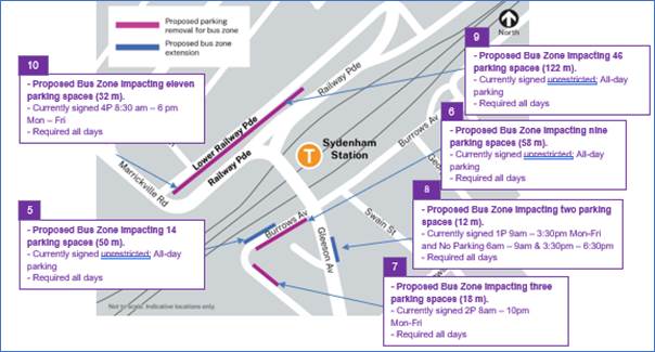
5. Burrows Avenue, Sydenham (Stop ID: 204421) Rear to kerb parking – Bus Zone Extension (14 parking spaces)
· Burrows Avenue (northern kerb west of Gleeson Avenue)
· Currently ‘Unrestricted parking’
· Proposed Bus Zone is required for all days of the TTP bus operation
· This proposed change is to create the space required for buses to layover and to provide adequate space for draw-in/draw-out purposes.
· Proposed temporary change will impact approximately 14 rear to kerb parking spaces (50 m).
6. Burrows Avenue, Sydenham – (Southern kerb) – Bus Zone (9 parking spaces)
· Burrows Avenue (southern kerb west of Gleeson Avenue)
· Currently ‘Unrestricted parking’
· Proposed Bus Zone is required for all days of the TTP bus operation
· This proposed change is to create the space required for buses to layover safely.
· Proposed temporary change will impact approximately 9 parking spaces (58 m).
7. Railway Road, Sydenham NSW 2204 – (Northeastern kerb) – Bus Zone (3 parking spaces)
· Railway Road (northeastern kerb between Gleeson Avenue and Burrows Avenue)
· Currently ‘2P 8am – 10pm Mon-Fri’
· Proposed Bus Zone is required for all days of the TTP bus operation
· This proposed change is to create the space required for buses to layover safely and to provide adequate turning circle space.
· Proposed temporary change will impact approximately 3 parking spaces (18 m).
8. Gleeson Avenue, Sydenham Bus Zone extension (2 parking spaces)
· Gleeson Avenue (eastern kerb between Burrows Avenue and Unwins Bridge Rd)
· Currently ‘1P 9:00 am – 3:30 pm Mon - Fri and No Parking 6 am-9 am & 3:30 pm – 6:30 pm’
· Proposed Bus Zone is required for all days of the TTP bus operation
· Proposed temporary change will impact approximately 2 parking spaces (12 m).
· This change is proposed to create the extra space required for the additional TTP buses using the stop.
9. Section A of Lower Railway Parade, Sydenham 90 degree angled parking – Layover Bus Zone and Standby area (46 parking spaces)
· Lower Railway Parade Parallel Parking (southern side between Sydenham Road and Marrickville Road)
· Currently’ Unrestricted parking’
· Proposed Bus Zone is required for all days of the TTP bus operation
· Proposed temporary change will impact approximately 46 angled parking spaces (122 m).
· This proposed change is to create the space required for buses to layover. This location is proposed as it is (i) reasonably close to the active bus stop; (ii) located along the route path used between the last and first stops; and (iii) as far as removed from residential dwellings.
10. Section B of Lower Railway Parade, Sydenham 90 degree angled parking - Layover Bus Zone (11 parking spaces)
· Lower Railway Parade Parallel Parking (southern side between Gleeson Avenue and Marrickville Road)
· Currently ‘4P 8:30 am – 6 pm Mon – Fri’
· Proposed Bus Zone is required for all days of the TTP bus operation
· Proposed temporary change will impact approximately eleven angled parking spaces (32 m).
· This proposed change is to create the space required for buses to layover. This location is proposed as it is (i) reasonably close to the active bus stop; and (ii) located along the route path used between the last and first stops.
PUBLIC CONSULTATION
Transport for NSW will be undertaking community consultation. Consultation with local businesses and residents will be carried out in the months prior to each the Rail Shutdown.
The consultation program will consist of the following activities:
· Two-week public consultation period to impacted areas with a printed community notification outlining the proposed kerbside changes.
· A copy of the community notifications will also be available on the ‘My Sydney’ website - https://www.mysydney.nsw.gov.au/SydenhamtoBankstown
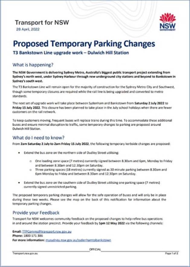
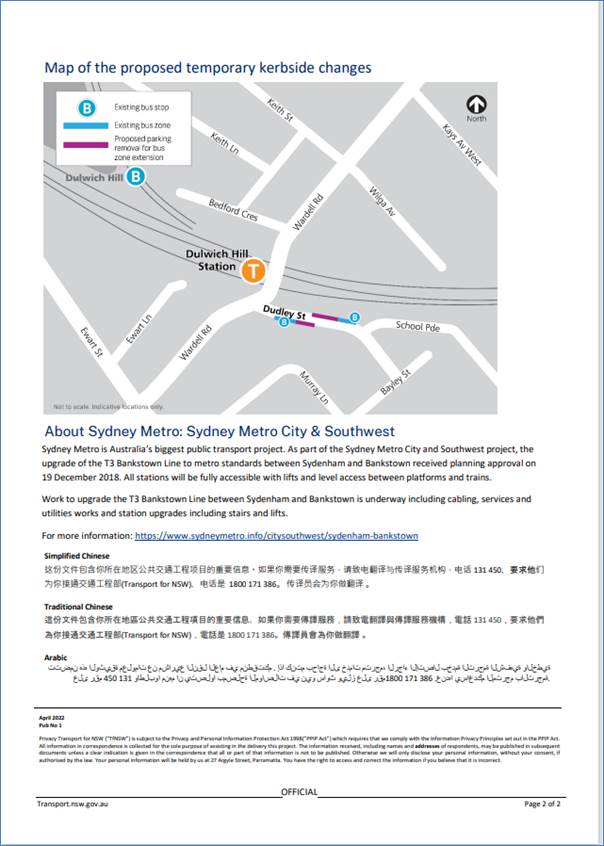
A sample copy from the previous July 2022 rail shutdown is attached at the end of this report.
A Consultation Outcomes Report will be prepared, for each period, collating feedback and TfNSW’s comment on that feedback received as part of TfNSW consultation process. The reports will be submitted to Local Traffic Committee as they come available
|
|
Local Traffic Committee Meeting 15 August 2022 |
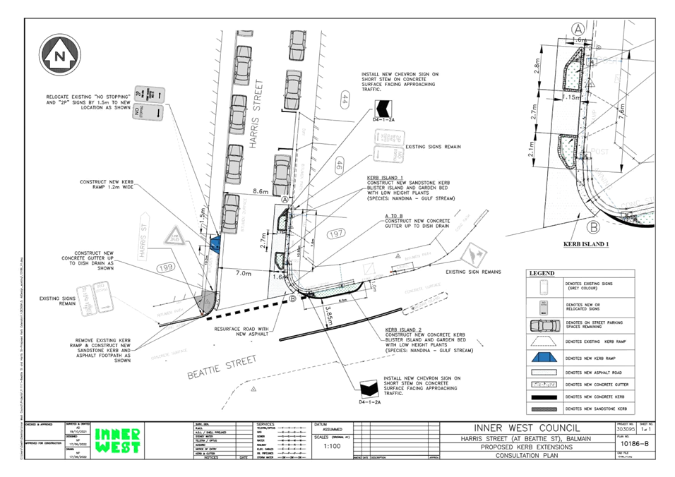
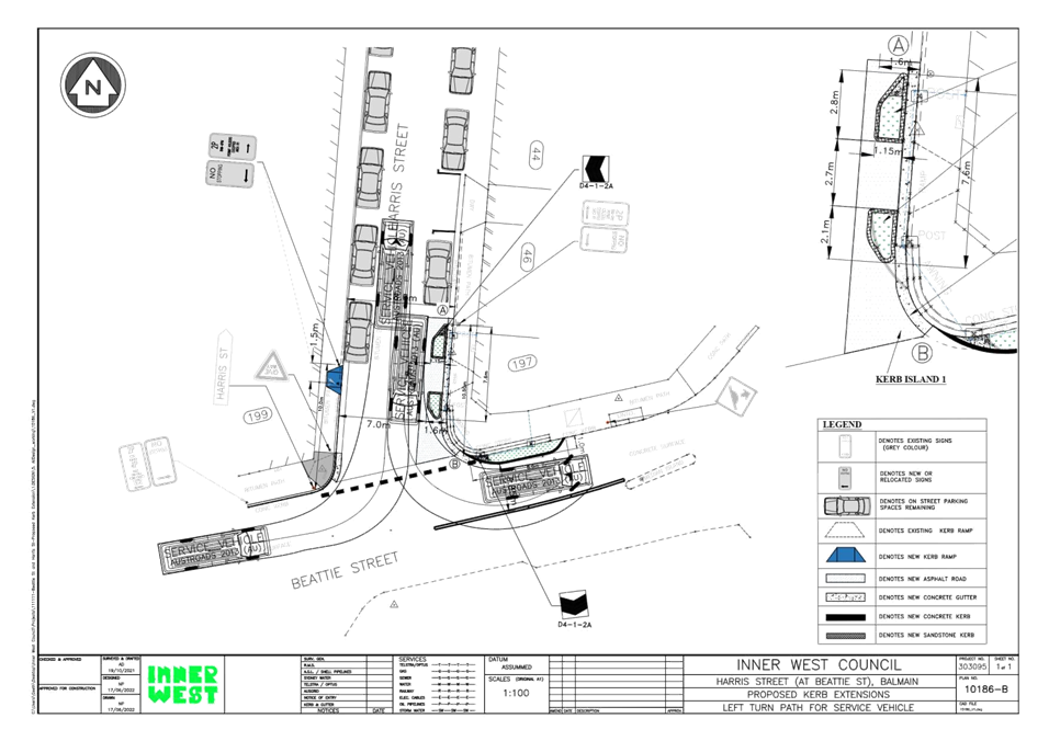
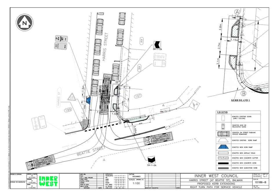
Subject: Beattie Street at Harris Street, Balmain - Proposed Kerb Blister Island (Baludarri - Balmain/ Balmain Electorate/ Leichhardt PAC)
Prepared By: Vinoth Srinivasan - Engineer - Traffic and Parking Services
Authorised By: Sunny Jo - Acting Traffic and Transport Manager
SUMMARY
Council is planning to improve safety at the intersection of Beattie and Harris Street, Balmain by constructing new kerb blister islands to facilitate better and safer pedestrian access as well as safer vehicle turning movements. The intention of the proposal is to slow traffic, protect existing adjacent property and provide a safer more accessible crossing point across Harris Street for pedestrians.
|
RECOMMENDATION
That the attached detailed design plan (Design Plan No.10186-B) for the proposed installation of the new kerb blister islands on Harris Street at Beattie Street, Balmain be approved.
|
BACKGROUND & OTHER STAFF COMMENTS
The detailed design plan shown in Attachment 1 outlines the proposed works on Harris Street at Beattie Street, Balmain and includes the following treatments:
- Construct new landscaped kerb blister islands (sandstone kerb) in Harris Street;
- Construct new integrated landscaped kerb blister island (concrete kerb) in Beattie Street;
- Remove 1 existing kerb ramp in Harris Street and replacing with asphalt footpath and sandstone kerb;
- Resurface the road pavement with new asphalt in Harris Street;
- Adjusting some existing PARKING & NO STOPPING signage on the western side of Harris Street to accommodate the new pedestrian crossing point;
- Installing associated pavement line marking and signage.
It is proposed to adjust existing Parking and No Stopping signage on the western side of Harris Street by approximately 1.5m. The proposal will not result in the loss of any on-street parking spaces.
A swept path analysis was undertaken using an 8.8m service vehicle as shown in Attachment 2 and it is deemed acceptable.
FINANCIAL IMPLICATIONS
Funding of $30,000 has been allocated to this project for construction in the 2022/2023 Capital Works Program.
PUBLIC CONSULTATION
A letter outlining the proposal was mailed out to 14 properties in Harris Street and Beattie Street, Balmain requesting residents’ views regarding the proposal. One (1) response was received in general support with request for changes. The main concern raised by the resident is outlined below in the table.
|
Officer Comments |
|
|
Reduce the length of the proposed kerb blister island in front of No.197 Harris Street to better clear the existing steps. |
The length of kerb blister island will be reduced by 400mm. This amendment is shown in the attached Design Plan No. 10186-B. |
|
1.⇩ |
Detailed Design Plan - Beattie Street at Harris Street, Balmain - Proposed Raised Kerb Blisters |
|
2.⇩ |
Swept Paths for service vehicle - Harris Street at Beattie Street, Balmain |
|
Local Traffic Committee Meeting 15 August 2022 |
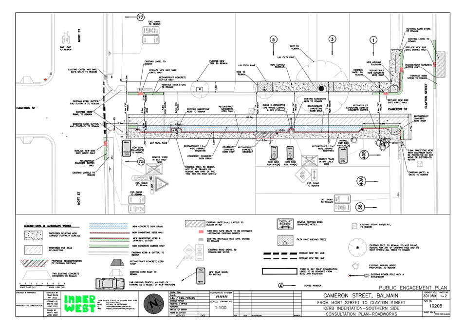
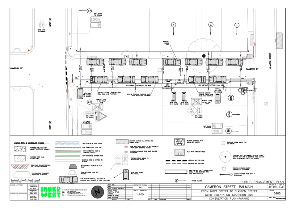
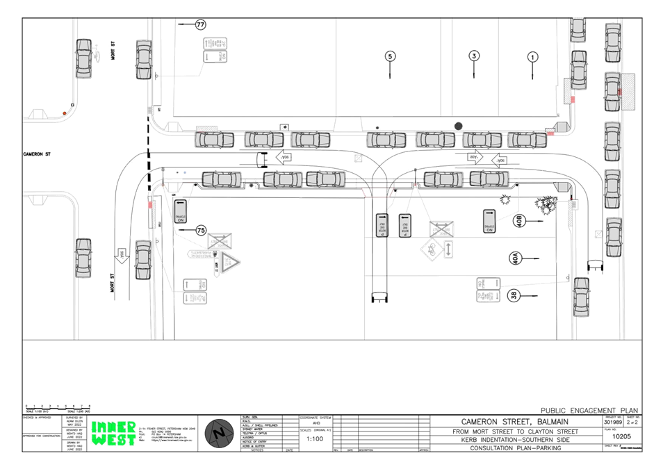
Subject: Cameron Street, Balmain (Between Mort Street and Clayton Street) - Propsoed Kerb Indentation (Baludarri-Balmain/ Balmain Electorate/ Leichhardt PAC)
Prepared By: Vinoth Srinivasan - Engineer - Traffic and Parking Services
Authorised By: Sunny Jo - Acting Traffic and Transport Manager
SUMMARY
Council is planning to improve the existing parking arrangements in Cameron Street, Balmain (Mort Street to Clayton Street) by adjusting the existing kerb on the southern side of the street to widen the road and forming indented parking bays. The proposed works is intended to improve pedestrian and motorist safety in the area.
|
RECOMMENDATION
That the attached detail design plan (Design Plan No.10205) for the proposed kerb indentation on the southern side of Cameron Street, Balmain be approved. |
BACKGROUND & OTHER STAFF COMMENTS
The detailed design plan shown in Attachment 1 outlines the proposed works on Cameron Street, Balmain and includes the following treatments:
- Removal of existing kerb & gutter on the southern side of the street and construction of new kerb along new alignment to form indented parking bays;
- Construction of new dish drain along alignment of removed kerb & gutter;
- Reconstruction of existing asphalt footpath with new asphalt footpath (southern side and a portion of the northern side of the footpath);
- Reconstruction of some damaged sections of asphalt footpath with new asphalt footpath;
- Resurfacing of half road width of road pavement in Cameron Street southern side only with new asphalt;
- Reconstruction of one driveway affected by the works;
- Reconstruction of some damaged sections of kerb & gutter with new sandstone kerb & concrete gutter;
- Removal of existing Parking Bay line markings within the street and footpath;
- Provision of new spaces for motor bike parking on the southern side.
The realignment of the kerb on the southern side of Cameron Street will widen the road pavement which will better manage parking on this side of the street and eliminate the need to park vehicles partially onto the footpath.
It is proposed to install new “No Stopping” signs near the intersections of Clayton Street & Mort Street to facilitate the new works and to better delineate areas available for parking, whilst also installing “Motor Bike Only” signs to create two (2) new Motor Bike parking spaces.
The proposal will not result in the loss of any on-street parking on Cameron Street, Balmain.
A swept path analysis was undertaken using a standard 4.9m vehicle (B85) as shown in Attachment 2 and it is deemed acceptable. Service vehicles including waste collection trucks do not enter Cameron Street as the road width is too narrow.
FINANCIAL IMPLICATIONS
Funding of $35,000 has been allocated to this project for construction in the 2022/2023 Traffic Facilities (LATM) Capital Works Program.
PUBLIC CONSULTATION
A letter outlining the proposal was mailed out to 12 properties in Mort Street, Cameron Street and Clayton Street, Balmain requesting residents’ views regarding the proposal. One (1) response was received in general support with request for changes. The main concern raised by the resident is outlined below in the table.
|
Residents’ Comments |
Officer Comments |
|
Council should also upgrade both the footpath on the northern side of Cameron Street and the driveway of No.5 Cameron Street. Upgrading only part of the street will not be visually pleasing and presents as a safety risk as only a portion of the northern footpath will have new asphalt. The current footpath has many cracks and uneven areas. |
The entire footpath on the northern side of Cameron Street will be reconstructed with new asphalt. The driveway of No.5 Cameron Street will not be upgraded as it is the responsibility of the owner to construct/reconstruct their property.
|
|
1.⇩ |
Detailed Design Plan - Cameron Street, Balmain (between Mort Street and Clayton Street) - Proposed Kerb Indentation |
|
2.⇩ |
Swept Paths for standard vehicle - Cameron Street, Balmain |
|
|
Local Traffic Committee Meeting 15 August 2022 |
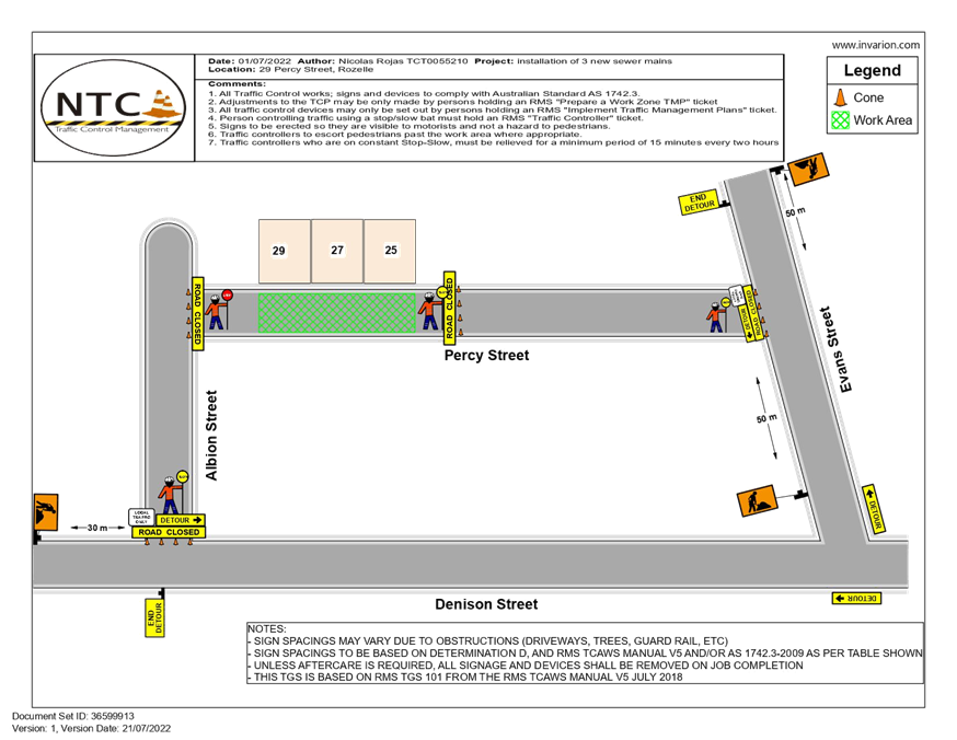
Subject: 27-29 Percy Street Rozelle - Temporary Full Road Closure (Baludarri-Balmain/ Balmain Electorate/ Leichhardt PAC)
Prepared By: David Yu - Engineer - Traffic and Parking Services
Authorised By: Sunny Jo - Acting Traffic and Transport Manager
SUMMARY
Council has received an application from dban for the approval of a temporary full road closure of Percy Street, between Albion Street and Evans Street, Rozelle from Monday 19 September 2022 to Thursday 22 September 2022 to facilitate the installation of sewer mains.
|
RECOMMENDATION
That the proposed temporary full road closure of Percy Street, between Albion Street and Evans Street, Rozelle from Monday 19 September 2022 to Thursday 22 September 2022 to facilitate the installation of sewer mains (contingency period 2 weeks) be approved subject to, but not limited to the following conditions:
1. A Road Occupancy License be obtained by the applicant from the Transport Management Centre;
2. All affected residents and businesses, including NSW Police Area Command, Fire & Rescue NSW and the NSW Ambulance Services be notified in writing, by the applicant, of the proposed temporary full road closure at least 7 days in advance of the closure with the applicant making reasonable provision for stakeholders; and
3. The occupation of the road carriageway must not occur until the road has been physically closed.
|
BACKGROUND & OTHER STAFF COMMENTS
Council has received an application from dban for approval of a temporary full road closure of Percy Street, between Albion Street and Evans Street, Rozelle from Monday 19 September 2022 to Thursday 22 September 2022.
This road closure application is sought to facilitate the installation of sewer mains in Percy Street.
The Traffic Guidance Scheme (TGS) submitted with the application is attached.
FINANCIAL IMPLICATIONS
Under Council’s Fees & Charges, the applicant is to pay a fee for the temporary full road closure.
PUBLIC CONSULTATION
The applicant is to notify all affected residents and businesses in writing at least 7 days prior to the commencement of works.
The proposed road closure is currently advertised on Council’s website in accordance with the Roads Act 1993.
|
1.⇩ |
Traffic Guidance Scheme (TGS) - Percy Street, Rozelle Temporary Road Closure |
|
|
Local Traffic Committee Meeting 15 August 2022 |
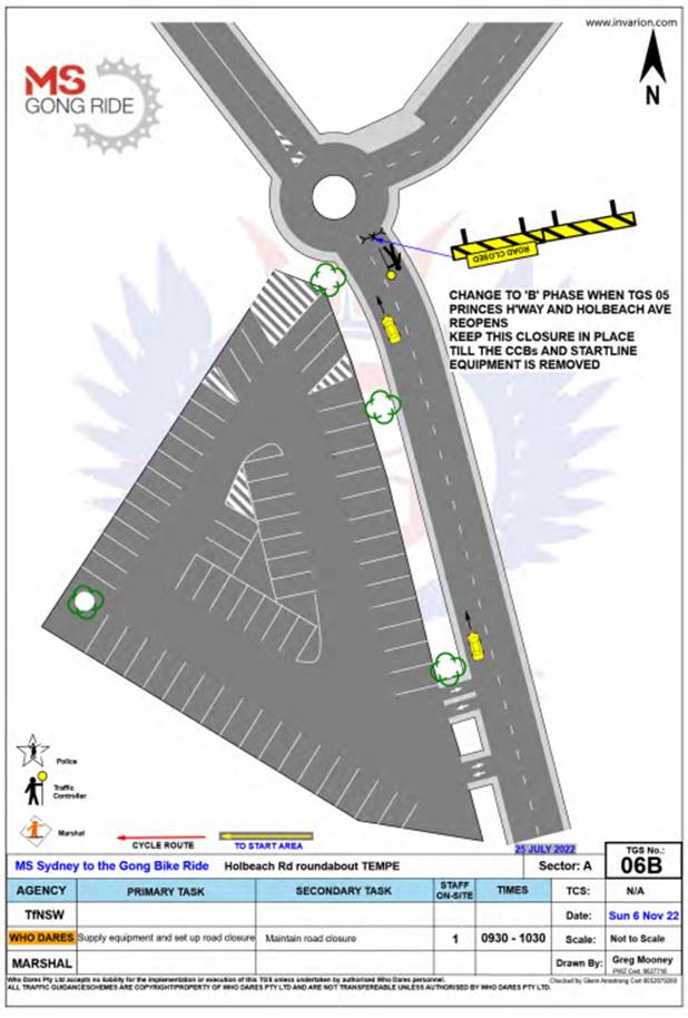
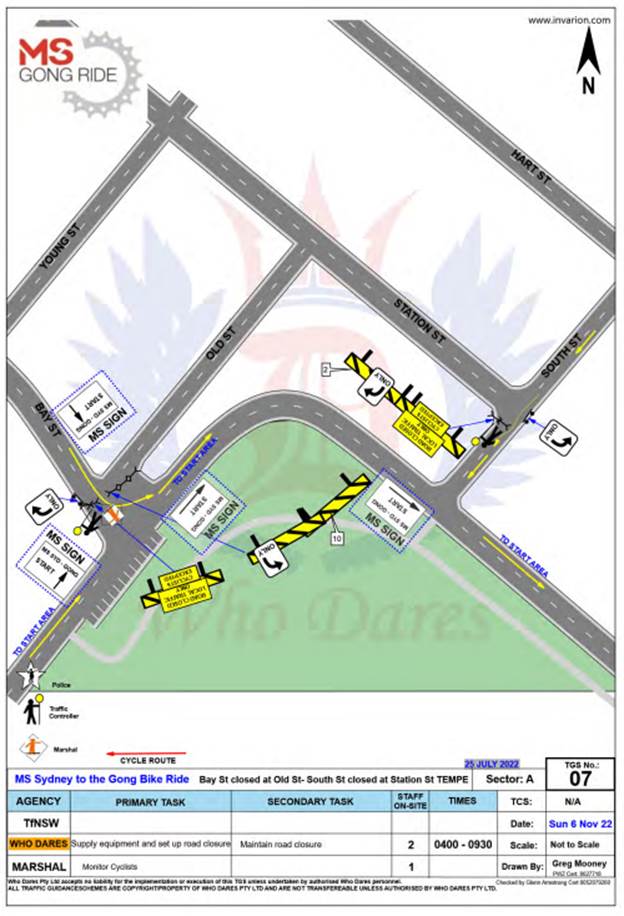
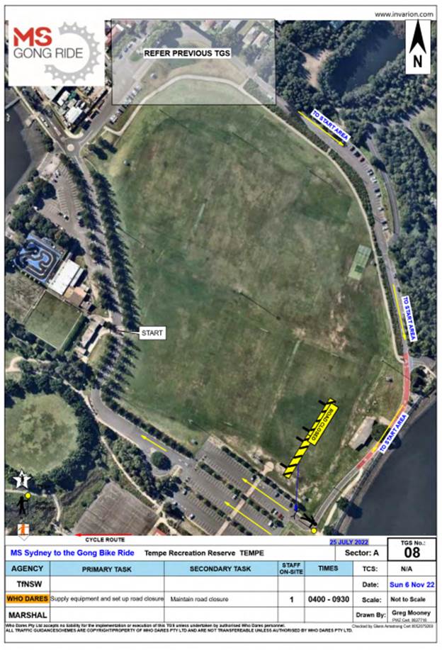
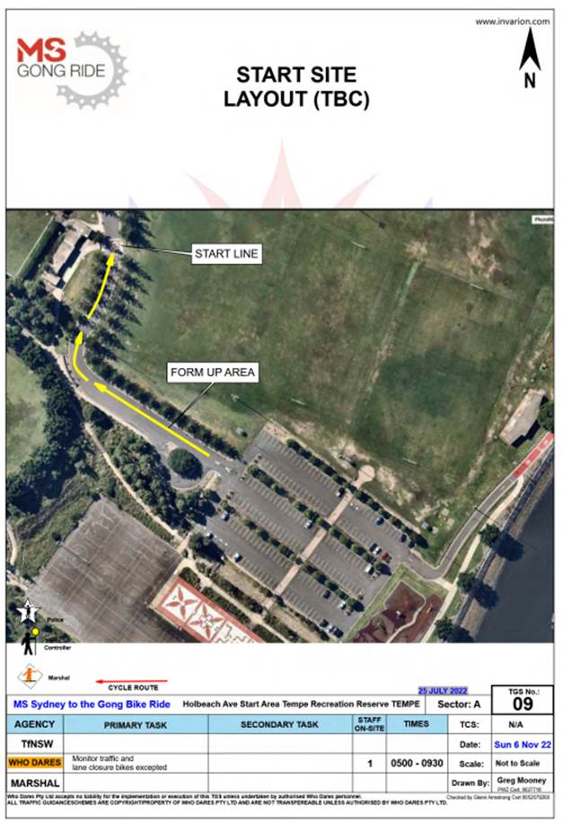
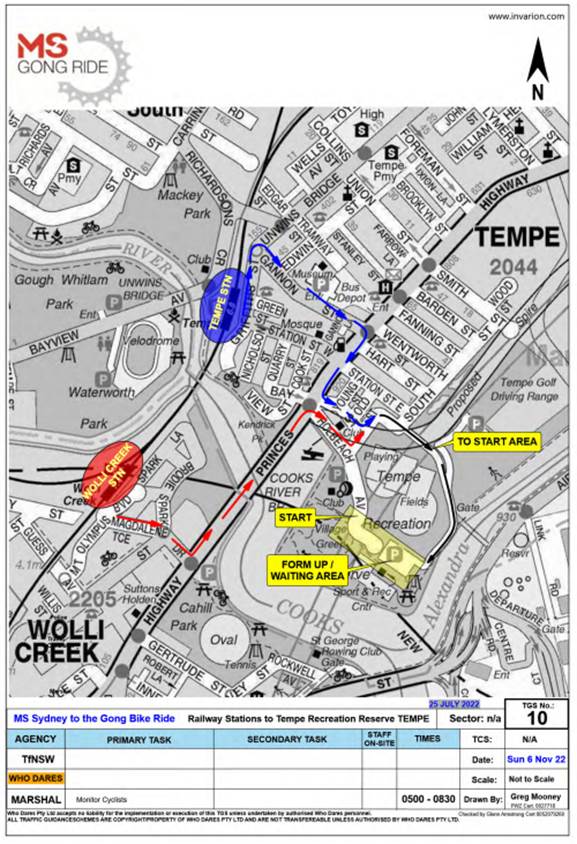
Subject: Holbeach Avenue, Tempe – Temporary Full Road Closures for MS Sydney to the Gong Bike Ride on Sunday 6 November 2022 – (Midjuburi - Marrickville Ward/Heffron Electorate/Newtown LAC)
Prepared By: Jennifer Adams - Engineer – Traffic and Parking Services
Authorised By: Sunny Jo - Acting Traffic and Transport Manager
SUMMARY
It is recommended that the comments of the Local Traffic Committee be referred to Council’s Development Assessment Section for consideration in determining the Development Application.
|
RECOMMENDATION
That the Local Traffic Committee receive and note the report. |
BACKGROUND
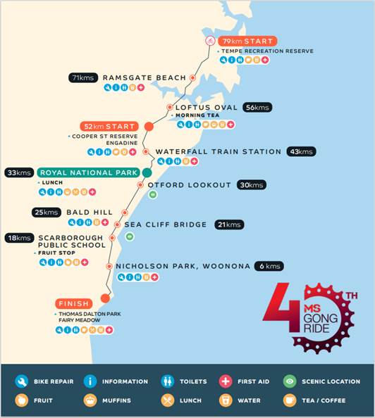
Council has received notice under an amended Section 68 application (S68201800006) of the Local Government Act 1993 to use Holbeach Avenue and Tempe Recreation Reserve to hold the annual 'MS Sydney to the Gong Bike Ride' supported by Multiple Sclerosis (MS) Australia on Sunday 6 November 2022.
The application is required to be referred to the Local Traffic Committee for consideration under State Environmental Planning Policy (Infrastructure) 2007.
The S68201900006 approval dated 27 September 2019 approves the holding of the MS Sydney to Gong bike ride event at Tempe Recreation Reserve annually on every first Sunday of November from 2019 – 2023 between 5.00am to 9.00am. Due to Covid the event was cancelled in 2020 and 2021 and this year the event was originally brought forward to May 2022 (report went to 21 March 2022 LTC meeting) however for various reasons the event now has been postponed to 6 November 2022.
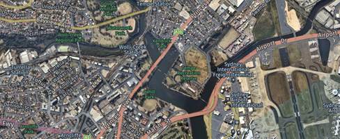
This years’ course will mostly follow that of previous years with the 82Km start location in Tempe Recreation Reserve Tempe, and the 58Km start location in Cooper Reserve Engadine. The riders then join the 82Km riders on Princes Highway following the traditional course through the Royal National Park, traveling south along the coast to Thirroul, riding over Sea Cliff Bridge then following Sandon Point Reserve, at the end of the cycle way through Woonona, East Corrimal, Towradgi, Fairy Meadow, North Wollongong to Finish in W. A. Lang Park, Wollongong.
The number of participant registrations for the 2022 Gong Bike Ride will remain capped at 10,000.
FINANCIAL IMPLICATIONS
Nil.
OFFICER COMMENTS
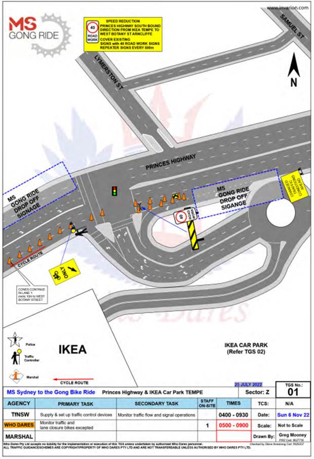
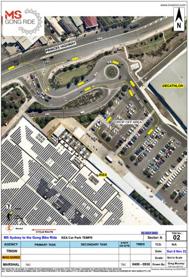
MS Australia will ultilise the IKEA car park as a drop off zone and riders will ride down Princes Highway (southbound) to the starting location at Tempe Recreation Reserve. The traffic management company will put in an access lane along Princes Highway to keep riders safe while entering the event at Tempe Recreation Reserve where this location will be the start of the cycling course.
The event will start at Tempe Recreation Reserve, Tempe. On departing, cyclists will ride west on Holbeach Avenue and then turn left onto Princes Highway. Cyclists will then ride along the southbound lanes on Princes Highway as they make their way south over the Cooks River Bridge and beyond.
The applicant advised that support of the NSW Police and RMS will be sought, and a detailed Traffic Management Plan has been forwarded to the RMS, NSW Police and relevant Councils and authorities.
NSW Police and the MS Australia Course Marshals will be at critical locations to ensure that participants and motorists follow all proposed traffic management measures. The event will be held on a Sunday morning where traffic volumes are expected to be lower than average.
It is proposed that the traffic control measures would be in place between 4:00am and no later than 10:00am as the event commences at 6.00am and is expected to be concluded by 9.00am. Affected residents and businesses will be allowed access at Police discretion.
PUBLIC CONSULTATION
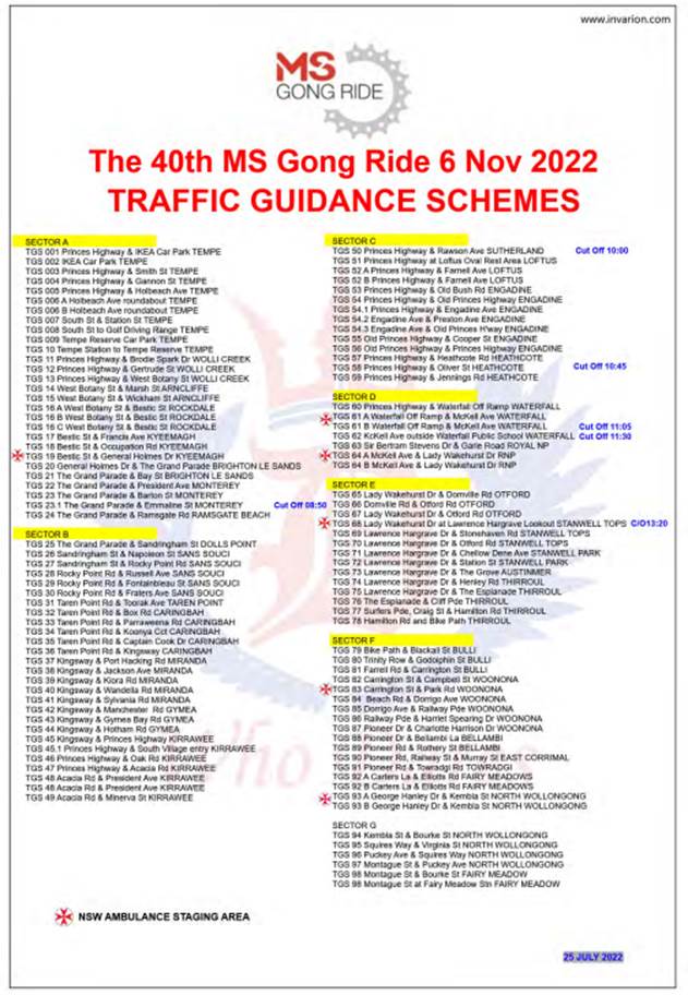
The applicant advised that the traffic control management on the day of the event will be controlled by NSW Police and MS Australia Course Marshals. The Traffic Control Plans for relevant Inner West locations are reproduced at the end of this report.
A Traffic Management Plan will be submitted to Transport for New South Wales (TfNSW) for consideration and approval as well as a Road Occupancy License application will be submitted to the Transport Management Centre.
CONCLUSION
It is proposed that the following traffic related comments be forwarded to Council’s Development Assessment section.
Based on the information presented in the applicant’s submission to Council with regards to the proposed cycling event on Sunday 6 November 2022 with the inclusion of a temporary full road closure of Holbeach Avenue, Tempe, it is acknowledged that the event will be controlled by NSW Police and the MS Australia Course Marshals. Therefore, Council supports the temporary full road closure of Holbeach Avenue, Tempe during the course of the event subject to:
· the applicant submitting a Traffic Management Plan to TfNSW for consideration and approval;
· a Road Occupancy License be obtained from the Transport Management Centre: and
· advice of the proposed event being forwarded all affected properties and to the appropriate authorities including emergency services.
Location of start and relevant Traffic Control Plans (TCPs) and sections of TMP
![]()