|
AGENDA R |

Local Traffic Committee Meeting
MONDAY 17 OCTOBER 2022
11.00AM
|
|
Local Traffic Committee Meeting 17 October 2022 |
Function of the Local Traffic Committee
Background
Roads and Maritime Services (RMS) is legislated as the Authority responsible for the control of traffic on all NSW Roads. The RMS has delegated certain aspects of the control of traffic on local roads to councils. To exercise this delegation, councils must establish a local traffic committee and obtain the advice of the RMS and Police. The Inner West Council Local Traffic Committee has been constituted by Council as a result of the delegation granted by the RMS pursuant to Section 50 of the Transport Administration Act 1988.
Role of the Committee
The Local Traffic Committee is primarily a technical review and advisory committee which considers the technical merits of proposals and ensures that current technical guidelines are considered. It provides recommendations to Council on traffic and parking control matters and on the provision of traffic control facilities and prescribed traffic control devices for which Council has delegated authority. These matters are dealt with under Part A of the agenda and require Council to consider exercising its delegation.
In addition to its formal role as the Local Traffic Committee, the Committee may also be requested to provide informal traffic engineering advice on traffic matters not requiring Council to exercise its delegated function at that point in time, for example, advice to Council’s Development Assessment Section on traffic generating developments. These matters are dealt with under Part C of the agenda and are for information or advice only and do not require Council to exercise its delegation.
Committee Delegations
The Local Traffic Committee has no decision-making powers. The Council must refer all traffic related matters to the Local Traffic Committee prior to exercising its delegated functions. Matters related to State Roads or functions that have not been delegated to Council must be referred directly to the RMS or relevant organisation.
The Committee provides recommendations to Council. Should Council wish to act contrary to the advice of the Committee or if that advice is not supported unanimously by the Committee members, then the Police or RMS have an opportunity to appeal to the Regional Traffic Committee.
Committee Membership & Voting
Formal voting membership comprises the following:
· one representative of Council as nominated by Council;
· one representative of the NSW Police from each Local Area Command (LAC) within the LGA, being Newtown, Marrickville, Leichhardt and Ashfield LAC’s.
· one representative from the RMS; and
· State Members of Parliament (MP) for the electorates of Summer Hill, Newtown, Heffron, Canterbury, Strathfield and Balmain or their nominees.
Where the Council area is represented by more than one MP or covered by more than one Police LAC, representatives are only permitted to vote on matters which effect their electorate or LAC.
Informal (non-voting) advisors from within Council or external authorities may also attend Committee meetings to provide expert advice.
Committee Chair
Council’s representative will chair the meetings.
Public Participation
Members of the public or other stakeholders may address the Committee on agenda items to be considered by the Committee. The format and number of presentations is at the discretion of the Chairperson and is generally limited to 3 minutes per speaker. Committee debate on agenda items is not open to the public.
|
|
Local Traffic Committee Meeting 17 October 2022 |
|
AGENDA |
1 Apologies
2 Disclosures of Interest
3 Confirmation of Minutes
Minutes of 19 September 2022 Local Traffic Committee Meeting 5
4 Matters Arising from Council’s Resolution of Minutes
5 Part A – Items Where Council May Exercise Its Delegated Functions
Traffic Matters
ITEM PAGE #
LTC1022(1) Item 1 27-29 Percy Street Rozelle - Temporary Full Road Closure (Baludarri-Balmain/ Balmain Electorate/ Leichhardt PAC) 37
LTC1022(1) Item 2 Audley Street, Audley Lane, Sadlier Crescent, Fisher Street, and eastbound parking lanes on New Canterbury Road Petersham – Temporary Full Road Closures For Special Event On Sunday 19 March 2023 – Petersham Festival - Bairro Portuguese – ENRC/2022/0041 (Damum - Stanmore Ward / Newtown Electorate / Inner West PAC) 40
LTC1022(1) Item 3 CHAPEL STREET, MARRICKVILLE - REQUEST FOR AN EXTENSION TO THE EXISTING DROP-OFF AND PICK-UP ZONE OUTSIDE MARRICKVILLE PUBLIC SCHOOL (Midjuburi Ward/ Summer Hill Electorate/ Inner West PAC) 65
LTC1022(1) Item 4 TRAFALGAR STREET, STANMORE – TfNSW Stanmore Station Upgrade Project – Temporary Signs and Line Markings Plan during construction (DAMUN -STANMORE WARD/ NEWTOWN ELECTORATE/ INNER WEST PAC) 68
Parking Matters
Nil at the time of printing.
Late Items
Nil at time of printing.
6 Part B - Items for Information Only
ITEM PAGE #
LTC1022(1) Item 5 King Georges Car Park, Rozelle - Signage and Line-marking Plan (Baludarri-Balmain/ Balmain Electorate/ Leichhardt PAC) 75
7 Part C - Items for General Advice
Nil at the time of printing.
8 General Business
9 Close of Meeting
|
|
Local Traffic Committee Meeting 17 October 2022 Minutes of 19 September 2022 |
Minutes of Local Traffic Committee Meeting
Held on 19 September 2022 at Ashfield Service Centre
Meeting commenced at 11.00AM
ACKNOWLEDGEMENT OF COUNTRY BY CHAIRPERSON
I acknowledge the Gadigal and Wangal people of the Eora nation on whose country we are meeting today, and their elders past and present.
COMMITTEE REPRESENTATIVES PRESENT
|
Mayor Darcy Byrne |
Councillor – Baludarri-Balmain Ward (Chair) |
|
Bill Holliday |
Representative for Jamie Parker MP, Member for Balmain |
|
Graeme McKay |
Representative for Jo Haylen MP, Member for Summer Hill |
|
Colin Hesse |
Representative for Jenny Leong MP, Member for Newtown |
|
Chris Woods |
Representative for Ron Hoenig MP, Member for Heffron |
|
Solon Ghosh |
Transport for NSW (TfNSW) |
|
|
|
|
OFFICERS IN ATTENDANCE |
|
|
|
|
|
Cr Justine Langford |
Councillor – Midjuburi-Marrickville Ward |
|
Adrian Pritchard |
Transit Systems |
|
Colin Jones |
Inner West Bicycle Coalition |
|
Sunny Jo |
IWC’s Acting Traffic and Transport Services Manager |
|
Felicia Lau |
IWC’s Acting Coordinator Traffic Engineering Services (North) |
|
Boris Muha |
IWC’s Engineer – Traffic and Parking Services |
|
Christina Ip |
IWC’s Business Administration Officer |
|
|
|
|
VISITORS |
|
|
|
|
|
Nil. |
|
|
|
|
|
APOLOGIES: |
|
|
|
|
|
Maryanne Duggan |
Representative for Jason Yat-Sen Li MP, Member for Strathfield |
|
SC Anthony Kenny |
NSW Police – Inner West Police Area Command |
|
Germaine Grant |
NSW Police – Burwood Police Area Command |
|
Sam Tohme |
NSW Police – Burwood Police Area Command |
DISCLOSURES OF INTERESTS:
Nil.
CONFIRMATION OF MINUTES
|
The minutes of the Local Traffic Committee meeting held on 15 August 2022 were confirmed.
|
MATTERS ARISING FROM COUNCIL’S RESOLUTION OF MINUTES
The Local Traffic Committee recommendations of its meeting on 15 August 2022 were adopted at Council’s meeting on 13 September 2022 with the following amendments:
1. Council Notes:
a) At the Sydney Eastern City Planning Panel (SECPP) Hearing on September 1st, the Panel determined to support the Bunnings Tempe DA modifications;
b) The approved modification for Tempe Bunnings does not include the installation of traffic lights at the Bunnings entry on Princes Highway. The community argued strongly for a signalised intersection;
c) Transport for NSW received the Traffic Light Feasibility Report that was commissioned by Council. They did not support the implementation of traffic lights at the entrance of Bunnings, only a signalised pedestrian crossing;
d) Vehicles entering Bunnings from the south bound lanes of Princes Highway will need to cross three lanes of oncoming traffic at an unsignalized intersection;
e) Tempe residents are very concerned that this will endanger the lives of pedestrians along Princes Highway, especially school children. There is also concern for cyclists. They are also concerned about the impacts of Bunnings traffic on streets on the eastern side of Princes Highway in Tempe;
f) Public consultation for the South Tempe Local Area Traffic Management (LATM) Plan closed on 8 September. A report will soon come to Council for consideration;
g) Tempe residents strongly support any measures that Council can implement to improve safety and mitigate the effects of higher levels of traffic through their local streets; and
h) Council
will continue to advocate on behalf of Tempe residents to make their streets as
safe as possible.
2. Congratulates Safe Traffic Plan for Bunnings Tempe and the Tempe community in lobbying for a safer traffic plan for Tempe;
3. Sincerely thanks Council staff for their work in keeping Councillors and the community updated about the Bunnings Tempe development proposal and for delivering the Traffic Light Feasibility Study so promptly; and
4. That Council write to the local state MPs asking them to raise issue of Frederick Street in Parliament.
|
LTC0922(1) Item 1 Seaview Street Dulwich Hill - Proposed Conversion Of Existing ‘Bus Zone 8.00-9.00am And 2.30—3.30pm School Days’ To ‘No Parking, Buses Excepted, 8am – 9.30am & 2.30pm – 4pm, Mon – Fri, School Days Only’ Restrictions Outside Dulwich Hill High School (Djarrawunang-Ashfield Ward/Summer Hill Electorate /Inner West LAC) |
|
Council initially planned to install a short drop-off zone outside Dulwich Hill High School to aid parents dropping off students at the school as several complaints had been received that there was no suitable location available to legally drop off students in Seaview Street outside the school. The community and the school were consulted on the proposal and due to feedback from the school it was decided that the existing school bus stop could be converted to ‘No Parking, Buses excepted 8am-9am 2.30pm-3.30pm Mon-Fri School Days’ which can then act as a drop-off zone when not in use by buses. These restrictions would be in place subject to school management of the use of the 'No Parking' area when required by buses.
Officer’s Recommendation
That the existing 30 metre length of the school timed Bus Zone (‘8.00-9.00am and 2.30—3.30pm School Days’) outside Dulwich Hill High School, on the southern side of Seaview Street, Dulwich Hill be approved to be converted to ‘NO PARKING, BUSES EXCEPTED, 8AM – 9.30AM & 2.30PM – 4PM, MON – FRI, SCHOOL DAYS ONLY’ in order to provide a proxy drop-off zone outside Dulwich Hill High School.
DISCUSSION
The Committee members agreed with the Officer’s recommendation.
COMMITTEE RECOMMENDATION
That the existing 30 metre length of the school timed Bus Zone (‘8.00-9.00am and 2.30—3.30pm School Days’) outside Dulwich Hill High School, on the southern side of Seaview Street, Dulwich Hill be approved to be converted to ‘NO PARKING, BUSES EXCEPTED, 8AM – 9.30AM & 2.30PM – 4PM, MON – FRI, SCHOOL DAYS ONLY’ in order to provide a proxy drop-off zone outside Dulwich Hill High School.
For motion: Unanimous
|
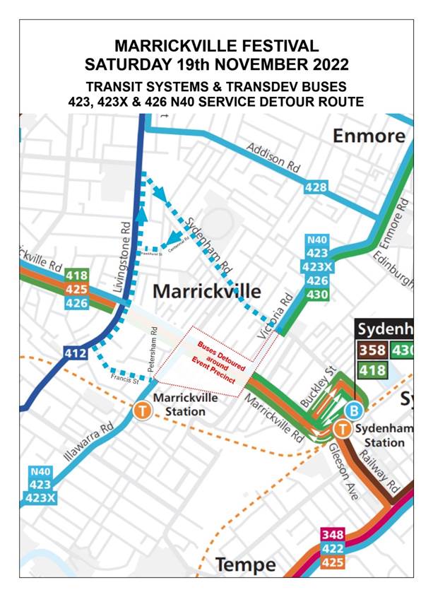
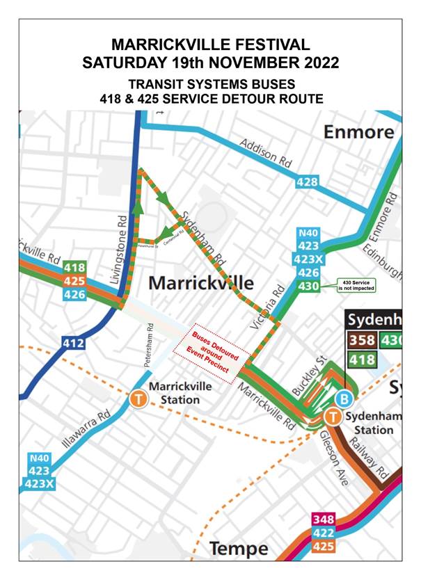
|
LTC0922(1) Item 3 Marrickville Road, Marrickville – Temporary full Road Closures for Marrickville Festival on Saturday 19 November 2022 – ENRC/2022/0037 (Midjuburi - Marrickville Ward / Summer Hill Electorate / Inner West PAC) |
|
Inner West Council is presenting Marrickville Music Festival on Saturday 19 November from 11:00am until 4:00pm. The event will feature multiple outdoor live music stages across the festival site. Including activation of Marrickville laneways through music and art. As part of the event there will be a partial road closure of Marrickville Road and Central Lane. This will require some road detours and bus diversions in surrounding streets. Event bump in will occur from 12:30am and bump out will conclude by 12:00pm midnight. It is recommended that Council approve the temporary full road closures subject to all standard Council conditions for a temporary full road closure.
Officer’s Recommendation
That:
1. The proposed temporary full road closure of Marrickville Road (between Illawarra Road and Victoria Road), Central Lane (between Victoria Road and Meeks Road), Seymour Lane (between Garners Lane and Garners Avenue and between Frampton Avenue and Garners Lane), Garners Lane (north of Seymour Lane) along with short sections of Silver Street, Garners Avenue, Gladstone Street, and Frampton Avenue where these streets intersect with Marrickville Road, Marrickville be APPROVED for the purpose of holding the ‘Marrickville Festival’ Event on Saturday 19 November 2022 between 12:30am and 12:00pm as per the submitted TMP and TGS and subject to the following conditions and all standard Council conditions for temporary full road closures;
2. A Road Occupancy License application be obtained from the Transport Management Centre;
3. Notice of the proposed event be forwarded to the NSW Police Local Area Commander, Transit Systems, the NSW Fire Brigades and the NSW Ambulance Services;
4. All residents and businesses in and around the affected area are to be notified of the temporary road closure in writing by the applicant in advance (at least 7 days prior to the event) with the applicant making reasonable provision for stakeholders;
5. A minimum four (4) metre unencumbered passage be available for emergency vehicles through the closed sections; and
6. The occupation of the road carriageway must not occur until the road has been physically closed.
DISCUSSION
The Transit Systems representative advised that the bus diversion plan will not work unless parking is removed from both sides of Illawarra Road between Marrickville Road and Sydenham Road and tree crowns are raised to 4 metres. Council Officers tabled revised diversion plans (Attachment 1) proposed by the traffic operators in response to the concerns raised by Transit Systems.
Cr Bryne asked about the cost of the road closures. Council Officers took the question on notice.
The Committee members agreed with the Officer’s recommendation.
COMMITTEE RECOMMENDATION
That:
1. The proposed temporary full road closure of Marrickville Road (between Illawarra Road and Victoria Road), Central Lane (between Victoria Road and Meeks Road), Seymour Lane (between Garners Lane and Garners Avenue and between Frampton Avenue and Garners Lane), Garners Lane (north of Seymour Lane) along with short sections of Silver Street, Garners Avenue, Gladstone Street, and Frampton Avenue where these streets intersect with Marrickville Road, Marrickville be APPROVED for the purpose of holding the ‘Marrickville Festival’ Event on Saturday 19 November 2022 between 12:30am and 12:00pm as per the submitted TMP and TGS and subject to the following conditions and all standard Council conditions for temporary full road closures;
2. A Road Occupancy License application be obtained from the Transport Management Centre;
3. Notice of the proposed event be forwarded to the NSW Police Local Area Commander, Transit Systems, the NSW Fire Brigades and the NSW Ambulance Services;
4. All residents and businesses in and around the affected area are to be notified of the temporary road closure in writing by the applicant in advance (at least 7 days prior to the event) with the applicant making reasonable provision for stakeholders;
5. A minimum four (4) metre unencumbered passage be available for emergency vehicles through the closed sections; and
6. The occupation of the road carriageway must not occur until the road has been physically closed.
For motion: Unanimous
|
|
DISCUSSION
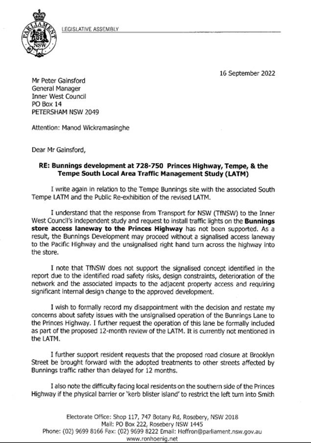
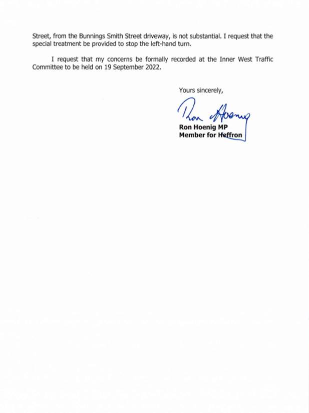
The representative for the Member for Heffron tabled a letter from Mr Ron Hoenig MP to Council (Attachment 2) expressing disappointment with TfNSW’s decision to not support the installation of traffic signals on the Bunnings stores access laneway to the Princes Highway and requested for the operation of the laneway to be formally included in the proposed 12-month review of the LATM. The representative requested that the Brooklyn Street closure be brought forward with the other adopted treatments rather than be delayed 12 months; and that the kerb blister island to restrict the left turn into Smith Street from the Bunnings Smith Street driveway be made more substantial to stop the left turn into Smith Street.
Cr Langford stated that residents requested a ‘Local Traffic Only’ sign be installed in Brooklyn Street at Brooklyn Lane during construction to deter traffic from using Brooklyn Street. Council Officers will investigate installation of the sign.
The Committee members agreed with the Officer’s recommendation and agreed to incorporate the above requests into the recommendation.
It was noted that detailed plans prepared by Bunnings are expected to be presented to the Committee in the next 12 months.
COMMITTEE RECOMMENDATION
That:
1. The adoption of the Tempe South Local Area Traffic Management (LATM) Study by Bitzios Consulting dated 6 July 2021 and proposed treatments in Attachment 1 be noted;
2. It be noted that Transport for NSW has provided support for the No Entry into Union Street from Smith Street restriction, left and right only restriction to Princes Highway at Smith Street, and this has been included in the adopted LATM;
3. 10km/h Shared Zone be supported for Union Street, between Princes Highway and School Lane subject to Transport for NSW approval, and this has been included in the adopted LATM;
4. Detailed design of the recommended treatments in Attachment 1 be reported back to the Traffic Committee prior to construction;
5. After a 12 month period following the issue of an Occupation Certificate for the Bunnings Development at 728-750 Princess Highway, a LATM review be undertaken by Council and reported back to the Traffic Committee, having noted the results of the re-exhibition;
6. Brooklyn Street closure be brought forward with the other adopted treatments rather than be delayed 12 months;
7. That the kerb blister island in Smith Street adjacent to the Bunnings driveway be made more substantial to stop the left hand turn into Smith Street; 8. That the operation of the Bunnings Lane entry to the Princes Highway be formally included in the proposed 12 month review of the LATM; and 9. Council investigate installation of “Local Traffic Only” signage on Brooklyn Street at Brooklyn Lane to deter traffic from using Brooklyn Street when construction commences. For motion: Unanimous
|
|
|
|
|
|
LTC0922(1) Item 6 England Avenue, Marrickville – Proposed new rain garden and kerb extension - Design Plan 10167 (Midjuburi-Marrickville Ward / Newtown Electorate/Inner West PAC) |
|
Council has finalised a design plan for the installation of a rain garden and kerb extensions in England Avenue, Marrickville at its intersection with Addison Road. The purpose of the proposal is to improve the quality of stormwater drainage from England Avenue as well as improve safety and accessibility for pedestrians crossing England Avenue near Addison Road. It is recommended that the proposed detailed design plan be approved.
Officer’s Recommendation
That the detailed design plan for the proposed new rain garden and kerb extensions on England Avenue at Addison Road, Marrickville and associated signs and line markings (as per Plan No.10167) be approved.
DISCUSSION
Cr Langford received the following comments and requests from a resident:
Council Officers will investigate these requests separately. The Committee members agreed with Officers’ recommendation and the inclusion of the additional requests to be investigated separately.
COMMITTEE RECOMMENDATION
That:
For motion: Unanimous |
|
LTC0922(1) Item 7 Victoria Street, Ashfield- Proposed in-lane Bus Stop platform adjacent to 20 Victoria Street (Allman Park) (Djarrawunang- Ashfield Ward/Summer Hill Electorate/Burwood PAC) |
|
Council is planning to install an in-lane bus stop platform adjacent to 20 Victoria Street, Ashfield (ALLMAN PARK). The proposal is to provide a bus stop facility to extend out and allow ease of safe travel and passenger embarkment/dis embarkment between the footpath and buses out on the travel lane. The proposal is in up-grade to the existing Bus Stop at this location where buses are prevented from properly and safely pulling up to the kerb due to (mature grown) trees located in short span distance within the Bus Stop. The proposed platform is also designed in compliance to the Disability Standards for Accessible Public Transport (DSAPT) in line with the Disability Discrimination Act (DDA).
Officer’s Recommendation
That the design plan (Design Plan No.10214) for the proposed new concrete in-lane bus stop platform (with associated tactile, seating and handrails), new concrete ramps, new landscaped verged garden, existing concrete kerb and footpath reconstruction, and associated new signs and line markings in front of 20 Victoria Street, Ashfield be APPROVED.
DISCUSSION
The Committee members agreed with the Officer’s recommendation.
COMMITTEE RECOMMENDATION
That the design plan (Design Plan No.10214) for the proposed new concrete in-lane bus stop platform (with associated tactile, seating and handrails), new concrete ramps, new landscaped verged garden, existing concrete kerb and footpath reconstruction, and associated new signs and line markings in front of 20 Victoria Street, Ashfield be APPROVED.
For motion: Unanimous
|
|
LTC0922(1) Item 8 Albert Street at James Street, Petersham – Proposed Traffic Calming (Design Plan No.10220) (Damun – Stanmore Ward / Summer Hill Electorate / Inner West PAC) |
|
A design plan has been finalised for the proposed traffic calming improvement in Albert Street, Petersham, at its intersection with James Street. The proposal includes the construction of a raised concrete threshold, a new detached concrete kerb blister with low level planting and improvements works to the existing footpath and kerb ramps. It is anticipated that this proposal will improve pedestrian and motorist safety by ultimately reducing the overall vehicular speeds within the area.
Officer’s Recommendation
That the design plan for the proposed raised concrete threshold, detached concrete kerb blister with low level planting and improvement works to the existing footpath and kerb ramps in Albert Street at James Street, Petersham (Design Plan No.10220), be APPROVED.
DISCUSSION
The Committee noted that this Item is within the Newtown Electorate, not Summer Hill.
The Committee members agreed with the Officer’s recommendation.
COMMITTEE RECOMMENDATION
That the design plan for the proposed raised concrete threshold, detached concrete kerb blister with low level planting and improvement works to the existing footpath and kerb ramps in Albert Street at James Street, Petersham (Design Plan No.10220), be APPROVED.
For motion: Unanimous
|
|
LTC0922(1) Item 9 Victoria Street, Ashfield-Proposed in-lane Bus Stop platform adjacent to 90 Victoria Street - Djarrawunang-Ashfield Ward/ Summer Hill Electorate/Burwood PAC |
|
Council is planning to install an in-lane bus stop platform adjacent to 90 Victoria Street, Ashfield. The proposal is to provide a bus stop facility to extend out and allow ease of safe travel and passenger embarkment/dis embarkment between the footpath and buses out on the travel lane. The proposal is in upgrade to the existing Bus Stop at this location where buses are prevented from properly and safely pulling up to the kerb due to (mature grown) trees located in short span distance within the Bus Stop. The proposed platform is also designed in compliance to the Disability Standards for Accessible Public Transport (DSAPT) in line with the Disability Discrimination Act (DDA).
Officer’s Recommendation
That the design plan (Design Plan No.10215-A) for the proposed new concrete in-lane bus stop platform (with associated tactile, seating and handrails), new concrete ramps, new grassed verge area, existing concrete kerb and footpath reconstruction, and associated new signs and line markings in front of 90 Victoria Street, Ashfield be APPROVED.
DISCUSSION
The Committee members agreed with the Officer’s recommendation.
COMMITTEE RECOMMENDATION
That the design plan (Design Plan No.10215-A) for the proposed new concrete in-lane bus stop platform (with associated tactile, seating and handrails), new concrete ramps, new grassed verge area, existing concrete kerb and footpath reconstruction, and associated new signs and line markings in front of 90 Victoria Street, Ashfield be APPROVED.
For motion: Unanimous
|
|
LTC0922(1) Item 10 Bright Street at Middle And North Streets, Marrickville – Proposed Traffic Calming (Design Plan No.10219) (Midjuburi – Marrickville Ward / Summer Hill Electorate / Inner West PAC) |
|
Design plans have been finalised for the proposed traffic calming improvements in Bright Street, Marrickville, at its intersections with Middle and North Streets. The proposal includes the construction of two raised concrete thresholds, new kerb extensions with low level plantings and improvements works to the existing footpath and kerb ramps. It is expected that this proposal will improve pedestrian and motorist safety by reducing the overall vehicle speeds in the area.
Officer’s Recommendation
That the design plans for the proposed raised concrete thresholds, kerb extensions with low level plantings and improvement works to the existing footpath and kerb ramps in Bright Street at Middle and North Streets, Marrickville (Design Plan No.10219), be APPROVED.
DISCUSSION
The Committee noted that this Item is within the Newtown Electorate, not Summer Hill.
The IWBC representative commented that the bike symbols proposed to be removed on Bright Street were never implemented and requested further information. Council Officers advised that the plan to mark bike symbols on Bright Street did not proceed as Bright Street was not identified as a bike route and did not connect to existing bicycle facilities in Addison Road.
The Committee members agreed with the Officer’s recommendation and with the addition of a recommendation to note the exclusion of bike symbols in Bright Street.
COMMITTEE RECOMMENDATION
That:
For motion: Unanimous
|
|
LTC0922(1) Item 11 Birchgrove Public School - Proposed 'No Stopping' and 'No Parking 8.00am-9.30am; 2.30pm-3.30pm' restrictions (Baludarri - Balmain Ward/ Balmain Electorate/ Leichhardt PAC) |
|
Council has received a request from Birchgrove Public school to extend the existing ‘No Parking 8.00am-9.30am, 2.30pm-3.30pm School Days’ restriction by one car space to accommodate additional pickup and setdown demand in Birchgrove Road, Birchgrove. Birchgrove Public school has also raised safety concerns regarding the leaning tree east of marked pedestrian crossing at the start of the pickup and setdown zone and subsequently being an obstruction to vehicles in the drop off and pickup zone.
Officer’s Recommendation
That:
1. Existing 5.3m length ‘No Stopping’ zone on the north side of Birchgrove Road, east of the pedestrian crossing be extended 9.4m;
2. Existing 17.7m ‘No Parking 8.00am-9.30am, 2.30pm-3.30pm’ zone be relocated by 4.1m to the east and lengthened to 23.7m;
3. Existing 6m ‘Mobility Parking’ zone be relocated by 10.1m to the east;
4. Kerb islands with gutter grate bridge from the driveway of No.76A Birchgrove Road, to the eastern end of the revised No Stopping zone, excluding the Pedestrian Crossing be included in Council’s future Capital Works Program with an estimated cost of $80,000; and
5. A short length kerb island and associated line marking be installed on the north side of Birchgrove Road approximately 8m east of the pedestrian crossing to protect the leaning tree.
DISCUSSION
The TfNSW representative requested details for the temporary rubber kerb island. Council Officers advised that a design plan was not ready and that it would be designed to standard kerb island specifications with a chevron sign and white painted kerbing.
The Committee members agreed with the Officer’s recommendation.
COMMITTEE RECOMMENDATION
That:
1. Existing 5.3m length ‘No Stopping’ zone on the north side of Birchgrove Road, east of the pedestrian crossing be extended 9.4m;
2. Existing 17.7m ‘No Parking 8.00am-9.30am, 2.30pm-3.30pm’ zone be relocated by 4.1m to the east and lengthened to 23.7m;
3. Existing 6m ‘Mobility Parking’ zone be relocated by 10.1m to the east;
4. Kerb islands with gutter grate bridge from the driveway of No.76A Birchgrove Road, to the eastern end of the revised No Stopping zone, excluding the Pedestrian Crossing be included in Council’s future Capital Works Program with an estimated cost of $80,000; and
5. A short length kerb island and associated line marking be installed on the north side of Birchgrove Road approximately 8m east of the pedestrian crossing to protect the leaning tree.
For motion: Unanimous
|
|
LTC0922(1) Item 12 Norton Street Italian Festa 2022- Temporary Road Closures (Gulgdaya - Leichhardt Ward/ Balmain Elecotorate/ Leichhardt PAC) |
|
The proposed event, the Norton Street Italian Festa, is a street festival held annually celebrating the traditional Italian culture that is considered an essential part of the Leichhardt community.
This report outlines the proposed closure for the Norton Street Italian Festa.
Officer’s Recommendation
That the road closure application for the ‘Norton Street Italian Festa 2022’ on Sunday, 30 October 2022 be supported subject to the following conditions:
a) The road closures be restricted to occur between 3:00am and 9:00pm on Sunday, 30 October 2022 at the following locations: · Norton Street from Marion Street to William Street. · Marlborough Street from Norton Street to Cromwell Street. · Short Street from Norton Street to Balmain Road. · Carlisle Street from Norton Street to Cromwell Street. · Allen Street from Derbyshire Road to James Street. · Arthur Street from Allen Street to Short Street. · Lou Street from Allen Street to Marion Street. · Derbyshire Road at William Street. · Macauley Street from Norton Street to Cromwell Street (eastbound lanes only). · Wetherill Street from Norton Street to Balmain Road (eastbound lanes only). b) Approval from Transport for NSW for the TMP and TCP and to install a ‘Special Event Clearway’ restriction in Norton Street be obtained prior to the event;
c) Wetherill Street (Norton Street – Balmain Road) and Macauley Street (Cromwell Street – Norton Street) function as two-way roads when Norton Street is closed to provide access for residents;
d) A three (3) metre unencumbered passage be available for emergency vehicles through the closed section of Norton Street at all times;
e) Approval to conduct a public assembly be obtained from the NSW Police prior to the event. A copy of the NSW Police approval must be forwarded to Council’s Traffic Section prior to the event;
f) The occupation of the road carriageway must not occur until the road has been formally closed;
g) All affected residents and businesses, including the NSW Police Local Area Commander, Fire & Rescue NSW, NSW Ambulance Services and the Leichhardt Bus Depot be notified in writing, by the organiser, of the proposed temporary road closure at least 2 weeks in advance of the closure with the applicant making reasonable provision for stakeholders; and
h) Install temporary ‘Bus Zones’ to accommodate two buses on both sides of William Street between Norton Street and James Street.
DISCUSSION
The Committee members agreed with the Officer’s recommendation.
COMMITTEE RECOMMENDATION
That the road closure application for the ‘Norton Street Italian Festa 2022’ on Sunday, 30 October 2022 be supported subject to the following conditions:
a) The road closures be restricted to occur between 3:00am and 9:00pm on Sunday, 30 October 2022 at the following locations: · Norton Street from Marion Street to William Street. · Marlborough Street from Norton Street to Cromwell Street. · Short Street from Norton Street to Balmain Road. · Carlisle Street from Norton Street to Cromwell Street. · Allen Street from Derbyshire Road to James Street. · Arthur Street from Allen Street to Short Street. · Lou Street from Allen Street to Marion Street. · Derbyshire Road at William Street. · Macauley Street from Norton Street to Cromwell Street (eastbound lanes only). · Wetherill Street from Norton Street to Balmain Road (eastbound lanes only). b) Approval from Transport for NSW for the TMP and TCP and to install a ‘Special Event Clearway’ restriction in Norton Street be obtained prior to the event;
c) Wetherill Street (Norton Street – Balmain Road) and Macauley Street (Cromwell Street – Norton Street) function as two-way roads when Norton Street is closed to provide access for residents;
d) A three (3) metre unencumbered passage be available for emergency vehicles through the closed section of Norton Street at all times;
e) Approval to conduct a public assembly be obtained from the NSW Police prior to the event. A copy of the NSW Police approval must be forwarded to Council’s Traffic Section prior to the event;
f) The occupation of the road carriageway must not occur until the road has been formally closed;
g) All affected residents and businesses, including the NSW Police Local Area Commander, Fire & Rescue NSW, NSW Ambulance Services and the Leichhardt Bus Depot be notified in writing, by the organiser, of the proposed temporary road closure at least 2 weeks in advance of the closure with the applicant making reasonable provision for stakeholders; and
h) Install temporary ‘Bus Zones’ to accommodate two buses on both sides of William Street between Norton Street and James Street.
For motion: Unanimous
|
General Business
LTC0922(1) Item 13 Update on improvements to the Frederick Street, Ashfield crossing
The TfNSW representative advised that the speed limit reduction from 60km/h to 50km/h on Frederick Street, Ashfield has been approved and implementation is expected to occur in the next two months. Community consultation will commence soon to gauge community feedback on two options, signalise the intersection of John Street and Frederick Street, or to install a signalised midblock pedestrian crossing on Frederick Street north of John Street. The outcomes of the consultation will be reported to the Committee.
LTC0922(1) Item 14 Pedestrian safety at the intersection of Edgeware Road, Alice Street and Llewellyn Street, Newtown
The representative for the Member for Newtown stated that residents are concerned with pedestrian safety at the intersection of Edgeware Road, Alice Street and Llewellyn Street following recent near misses at the signalised intersection. Residents have asked for more pedestrian protection and for the speed limit to be reduced to 50km/h. The TfNSW representative advised that they can review speeds at the intersection. Council Officers will check on the status of a proposal to implement red arrow pedestrian protection at the signalised intersection and report back to the representative for the Member for Newtown.
LTC0922(1) Item 15 Update on parking on Kensington Road at Liverpool Road, Summer Hill
The IWBC representative asked for an update to the issue of vehicles parking too close to the corner on Kensington Road at Liverpool Road, Summer Hill that was raised at a previous meeting. Council Officers advised that works to formalise statutory ‘No Stopping’ on Kensington Road has been listed for action.
LTC0922(1) Item 16 Safety concerns with cycleway on Livingstone Road, Marrickville
Cr Langford raised concerns with safety on the new Livingstone Road cycleway in Marrickville and asked what was the best way to discuss these concerns and make suggestions on improvements. Cr Langford was advised to contact Council Officers to arrange an on site meeting.
LTC0922(1) Item 17 T3 Bankstown Line upgrade work engagement outcomes report
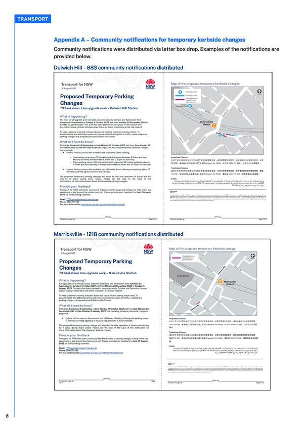
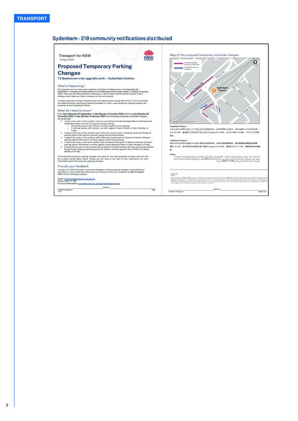
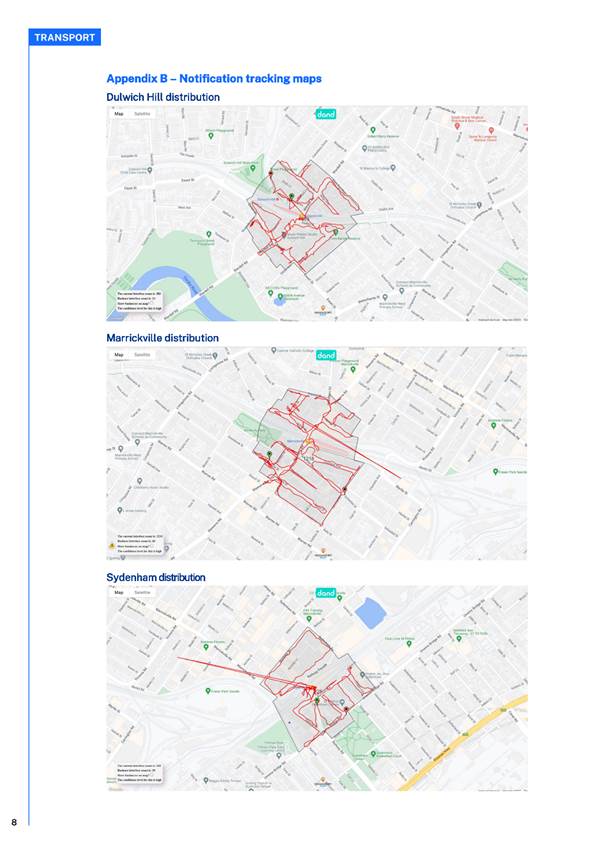
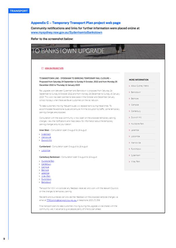
Council Officers tabled the engagement outcomes report prepared by the State Government on the T3 Bankstown Line upgrade work that will close Dulwich Hill, Marrickville and Sydenham train stations (Attachment 3). Buses will replace trains during the rail closures from 24 September 2022 to 9 October 2022 and 26 December 2022 to 12 January 2023. The report will be circulated to the Committee members.
Meeting closed at 11.37am.
Attachment 1
Attachment 2
Attachment 3


|
|
Local Traffic Committee Meeting 17 October 2022 |
Subject: 27-29 Percy Street Rozelle - Temporary Full Road Closure (Baludarri-Balmain/ Balmain Electorate/ Leichhardt PAC)
Prepared By: David Yu - Engineer - Traffic and Parking Services
Authorised By: Sunny Jo - Acting Traffic and Transport Manager
SUMMARY
Council has received an application from dban for the approval of a temporary full road closure of Percy Street, between Albion Street and Evans Street, Rozelle from Saturday, 12 November 2022 to Friday, 18 November 2022 to facilitate the installation of sewer mains.
|
RECOMMENDATION
That the proposed temporary full road closure of Percy Street, between Albion Street and Evans Street, Rozelle from Saturday 12 November 2022 to Friday 18 November 2022 to facilitate the installation of sewer mains (contingency period 2 weeks) be approved subject to, but not limited to the following conditions:
1. A Road Occupancy License be obtained by the applicant from the Transport Management Centre;
2. All affected residents and businesses, including NSW Police Area Command, Fire & Rescue NSW and the NSW Ambulance Services be notified in writing, by the applicant, of the proposed temporary full road closure at least 7 days in advance of the closure with the applicant making reasonable provision for stakeholders; and
3. The occupation of the road carriageway must not occur until the road has been physically closed.
|
BACKGROUND
Council previously received an application from dban for approval of a temporary full road closure of Percy Street, between Albion Street and Evans Street, Rozelle from Monday 19 September 2022 to Thursday 22 September 2022, which was reported and supported at the 15 August 2022 Local Traffic Committee.
However, unexpected site complications with old services in the subject location has resulted in the road closure to be rescheduled from Saturday 12 November 2022 to Friday 18 November 2022.
This road closure application is sought to facilitate the installation of sewer mains in Percy Street.
The Traffic Guidance Scheme (TGS) submitted with the application is attached.
FINANCIAL IMPLICATIONS
Under Council’s Fees & Charges, the applicant is to pay a fee for the temporary full road closure.
PUBLIC CONSULTATION
The applicant is to notify all affected residents and businesses in writing at least 7 days prior to the commencement of works.
The proposed road closure is currently advertised on Council’s website in accordance with the Roads Act 1993.
|
1.⇩ |
27-29 Percy St, Rozelle - Traffic Guidance Scheme |
|
|
Local Traffic Committee Meeting 17 October 2022 |
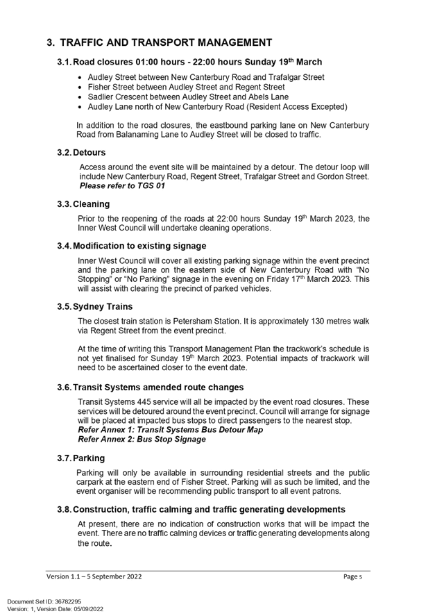
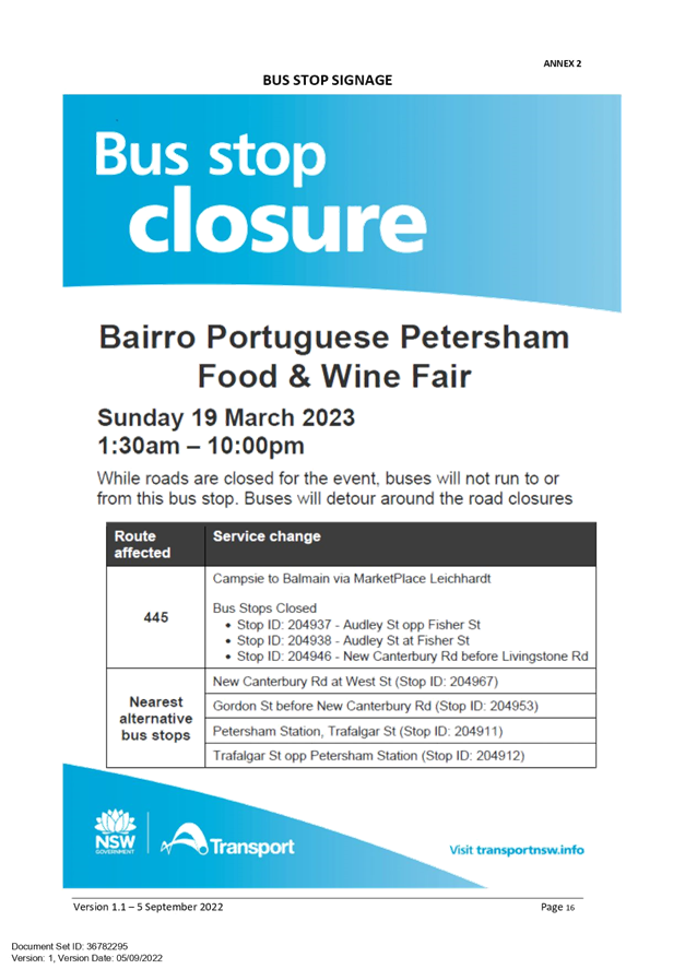
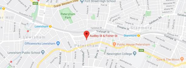
Subject: Audley Street, Audley Lane, Sadlier Crescent, Fisher Street, and eastbound parking lanes on New Canterbury Road Petersham – Temporary Full Road Closures For Special Event On Sunday 19 March 2023 – Petersham Festival - Bairro Portuguese – ENRC/2022/0041 (Damum - Stanmore Ward / Newtown Electorate / Inner West PAC)
Prepared By: Jennifer Adams - Engineer – Traffic and Parking Services
Authorised By: Manod Wickramasinghe - Acting Director Infrastructure
SUMMARY
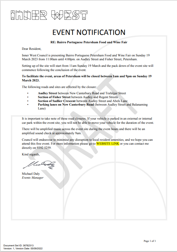
Inner West Council will be presenting Petersham Festival ‘Bairro Portuguese Petersham Food and Wine Fair’ on Sunday 19 March 2023 from 11:00am until 4:00pm on Audley Street and Fisher Street, Petersham. This event celebrates the very best of Portuguese culture with entertainment, music, dance, cultural activities, and traditional and contemporary foods. To facilitate the event, areas of Petersham will be closed and there will be road closures necessitating some road detours and bus diversions in surrounding streets.
Roads affected include Audley Street (between New Canterbury Road and Trafalgar Street), Sadlier Crescent (between Audley Street and Abels Lane) and Fisher Street (between Audley Street and Regent Street), Audley Lane north of New Canterbury Road (resident access excepted) as well as the eastbound parking lane on New Canterbury Road (between Audley Street and Balanaming Lane), Petersham from 1.00am until 9:00pm. It is recommended that Council agree to the temporary full road closures subject to all standard Council conditions for a temporary full road closure.
|
RECOMMENDATION
THAT the proposed temporary road closure of Audley Street (between New Canterbury Road and Trafalgar Street), Sadlier Crescent (between Audley Street and Abels Lane) and Fisher Street (between Audley Street and Regent Street), Audley Lane north of New Canterbury Road (resident access excepted) as well as the eastbound parking lane on New Canterbury Road (between Audley Street and Balanaming Lane), Petersham on Sunday 19 March 2023, from 1:00am until 9:00pm, for the holding of ‘Bairro Portuguese Petersham Food and Wine Fair’, be SUPPORTED subject to the applicant complying with but not limited to the following conditions:
1. A Traffic Management Plan (TMP) is submitted to and approved by Transport for NSW; and an application for a Road Occupancy Licence and a temporary Speed Zone Authorisation is forwarded to and approved by the Transport Management Centre;
2. Notice of the proposed event is forwarded to all affected residents and businesses, including the N.S.W. Police / Inner West Local Area Commander, Fire and Rescue NSW, NSW Ambulance and Transit Systems;
3. Transit Systems – Inner West Bus Services be requested to implement a revised routing for scheduled bus services in Audley Street on the day of the event and install temporary bus stops as required;
4. A minimum four (4) metre unencumbered passage be available for emergency vehicles through the closed section; and
5. The occupation of the road carriageways must not occur until the roads have been physically closed. |
BACKGROUND
Temporary road closures have been implemented in previous years to hold the once annual ‘Bairro Portuguese Food and Wine Fair’. This Fair, since its inception in 2003, aims to showcase Petersham's businesses and services, attracts people to the area and has a multicultural theme. On all previous occasions, the closures were successful and no major problems were experienced.
Funding of $85,000 has been allocated by Council for organising the ‘Bairro Portuguese Food and Wine Fair’ event under the 2022/2023 Major Community Events Program.
OFFICERS COMMENTS
Event
The event will be held on Sunday 19 March 2023 and will necessitate the temporary closure of Audley Street (between Trafalgar Street and New Canterbury Road), Sadlier Crescent (between Audley Street and Abels Lane) and Fisher Street (between Audley Street and Regent Street), Audley Lane north of New Canterbury Road (resident access excepted) as well as the eastbound parking lanes on New Canterbury Road (between Audley Street and Balanaming Lane), Petersham from 1.00am until 9:00pm. Refer to the locality map below.
This is an extension of a Class 2 Event under the TfNSW’ Special Events Guide where it impacts local traffic and transport systems but does not impact major traffic and transport systems and it disrupts the non-event community in the area around the event but not over a wide area. The event requires the involvement of Police and Local Council and a detailed Transport Management Plan (TMP).
Traffic Management Plan and Traffic Guidance Scheme
A Traffic Management Plan (TMP) has been supplied by Who Dares Pty Ltd, the scope of which includes the provision for the safe movement of vehicular traffic in and out of the event areas at the Bairro Portuguese Food and Wine Fair on Sunday 19 March 2023. The TMP and Traffic Guidance Scheme (TGS) are reproduced at the end of this report.
Access around the event site will be maintained by a detour. The detour loop will include New Canterbury Road, Regent Street, Trafalgar Street and Gordon Street. Please refer to the Traffic Guidance Scheme (TGS) prepared by Who Dares Pty Ltd – TGS 01 reproduced below.
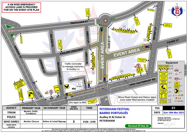
Lane closures of New Canterbury Road
As per previous events held, it is proposed to close the parking lanes on New Canterbury Road (between Balanaming Lane and Audley Street) as shown on the TGS 01 reproduced above.
In previous years the event attracted in excess of 15,000 attendees prompting the event coordinators to look at ways to ease congestion at the main site and make access easier from New Canterbury Road. The closure of the parking lanes on New Canterbury Road improves access to the area where the main event is to be conducted and improves the amenity of the footpath dining outside a number of the eateries along New Canterbury Road which are adjacent to the closure.
There is significant improvement in access for people with disabilities as congestion will be reduced and there will be no obstacles such as tables, chairs, planter boxes, light/sign poles and bins in the closed lanes. The solid barriers will separate the pedestrians from the moving traffic on the adjacent lane and will also help prevent young children who may be separated from their custodians escaping onto the main thoroughfare and possibly being hit by passing traffic.
The TGS indicates that a reduced temporary speed limit of 40km/h is required on New Canterbury Road (between Gordon Street and Audley Street) during the closure of the parking lanes for the subject event. Thus, an application for a Road Occupancy Licence will be necessary.
Road closures
The time-span for the road closure is necessary to allow stalls and stages to be set up before the event and dismantled after the event. The closure will be affected by the placement of barricades at the following locations:
· Junction of Audley Street and New Canterbury Road;
· Junction of New Canterbury Road and Gordon Street;
· Junction of Audley Street and Trafalgar Street;
· Junction of Fisher Street and Regent Street; and
· Junction of Sadlier Crescent and Abels Lane.
Special advance notice signs will be strategically installed at least two weeks prior to the event to alert motorists of the proposed closures. These signs will be installed at the following locations:-
· Junction of Railway Terrace and Gordon Street;
· Junction of New Canterbury Road and Audley Lane;
· Junction of Trafalgar Street and Audley Street;
· Junction of Regent and Fisher Streets; and
· Junction of Nelson Place and Sadlier Crescent.
In addition, 'No Parking - Special Event' signs will be affixed over all existing timed parking restrictions signs in the area to be closed on the afternoon before the day of the event. Residents in Fisher Street will be allowed access into and out of their properties.
Audley Street is used by scheduled Transit Systems bus services and they will need to implement the re-routing of services on the day as in previous years.
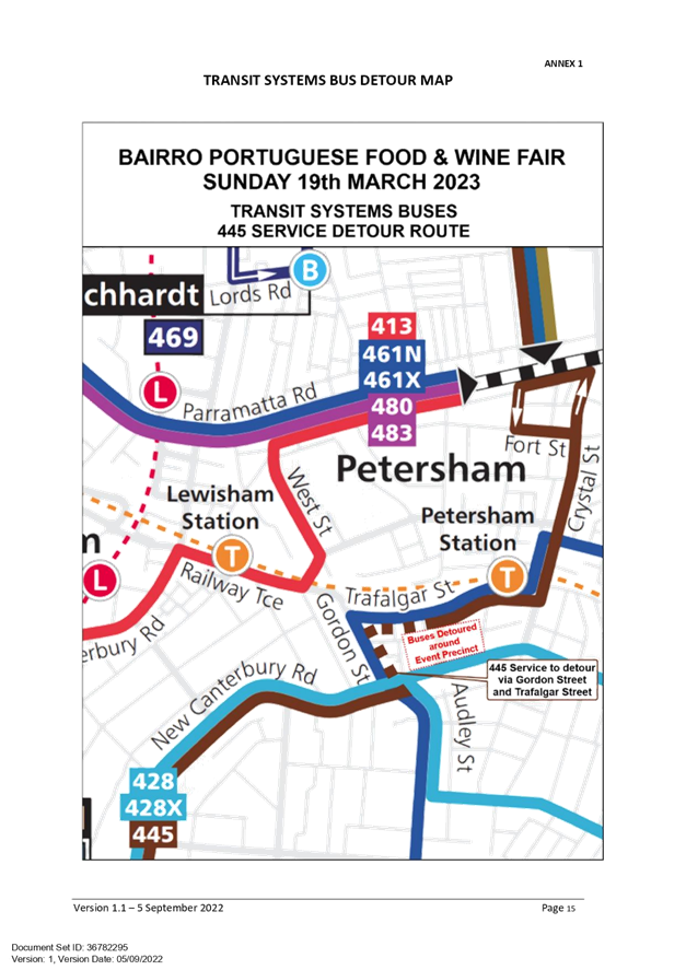
Impacts on buses
Transit Systems 445 service will all be impacted by the event road closures. These services will be detoured around the event precinct. Notices will be put up at impacted bus stops to direct passengers to the nearest stop.
· Services to Gladstone Park to run left Gordon St, right Trafalgar Street, then as normal
· Services to Campsie to run Trafalgar Street, left Gordon St, right New Canterbury Road, then as normal
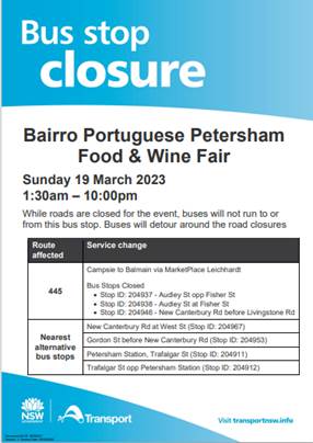
Transit Systems Detour Map – Route 445
Impacts on parking
In relation to parking it is stated in the TMP that “Parking will only be available in surrounding residential streets and the public carpark at the eastern end of Fisher Street. Parking will as such be limited, and the event organiser will be recommending public transport to all event patrons.”
Impacts on traffic
The TMP states that “heavy vehicles may experience slight delays due to increased traffic around the event precinct. Heavy vehicles should follow signposted detours”. In relation to pedestrians and cyclists it states that “There will be no major effect to pedestrians in the area. Pedestrians will be able to use the existing pedestrian paths outside of and within the event area.There are no cycleways directly impacted by this event. Cyclists entering the event site will be requested to dismount.”
There will be no special event clearways installed for this event. The TMP states that: “Inner West Council will instead install No Stopping signage throughout the event precinct prior to the event. Any remaining vehicles will be towed and parked in a nearby location on the morning of the event.”
PUBLIC CONSULTATION
The proposed temporary full road closures have been advertised in accordance with the Roads Act 1993.
Advice of the proposed event must be forwarded to all the appropriate authorities, including emergency services. A copy of the draft notification letter is attached at the end of this report. The TMP states that: “All affected residents will be notified of the event through:
• Letterbox drop will be conducted for impacted residents within and near the road closure precinct at least two weeks prior to the event.
• Date & time specific corflute “Special Event – Road Closed” signs to be placed around the event precinct 14 days prior to the event.
• “No Stopping” or “No Parking” signage installed by Council in the evening on Friday 17th March 2023.”
CONCLUSION
It is recommended that Council agree to the temporary full road closures on Sunday 19 March 2023 subject to complying with the recommendations stated in this report along with all standard conditions for temporary full road closures.
Other conditions that need to be complied with include:
· The Traffic Management Plan is to be submitted toTfNSW for consideration and approval and a Road Occupancy License application is to be submitted to the Transport Management Centre by Who Dares Pty Ltd.
· Advance notifications signs for the event are strategically installed at least two (2) weeks prior to the event;
· "No Parking - Special Event" signs are affixed over all existing timed parking restriction signs within the sections of streets to be closed on the afternoon of the day prior to the event;
· A 4-metre wide emergency vehicle access must be maintained through the closed road areas during the course of the event;
· The applicant is to consult with all affected residents and/or businesses in the area in writing and to conduct a letter box drop of surrounding properties at least two weeks prior to event; and
· Adequate vehicular traffic control shall be provided for the protection and convenience of pedestrians and motorists including appropriate signage and flagging. Workers shall be specially designated for this role (and carry appropriate certificates), as necessary to comply with this condition. This is to be carried out in accordance with the Australian Standard AS 1742.3 - Traffic Control Devices for works on roads.
|
1.⇩ |
ECM_36782246_v1_ - - TGS 01 Audley St & F |
|
2.⇩ |
ECM_36782295_v1_ Petersham Festival - 19 March 2023 |
|
Local Traffic Committee Meeting 17 October 2022 |
Subject: CHAPEL STREET, MARRICKVILLE - REQUEST FOR AN EXTENSION TO THE EXISTING DROP-OFF AND PICK-UP ZONE OUTSIDE MARRICKVILLE PUBLIC SCHOOL (Midjuburi Ward/ Summer Hill Electorate/ Inner West PAC)
Prepared By: Jennifer Adams - Engineer – Traffic and Parking Services
Authorised By: Manod Wickramasinghe - Acting Director Infrastructure
SUMMARY
Representations have been received from the Principal of Marrickville Public School, the P&C and parents of children attending the school for an extension to the existing school drop-off / pick-up zone on Chapel Street, Marrickville. There were also a number of complaints about local businesses ‘associated’ vehicles parking on Chapel Street taking up most of the available parking in the locality.
Several site inspections and a site meeting were conducted, and a proposal was developed for the installation of a further two parking spaces east of the existing four P15 spaces. This zone will be designated – ‘No P 8-9.30am 2.30-4pm School Days’ and will provide an additional two (2) space drop-off/pick-up zone which then could be used by others for up to a 5-hour period in between. It is recommended that a further two (2) parking spaces 'No Parking 8.00am-9.30am; 2.30pm-4.00pm School Days’ east of the existing four (4) ‘P15 8.30am to 3.30pm School Days’ spaces be approved to assist parents and carers with the drop-off and pick-up of children at the school.
|
RECOMMENDATION
THAT:
1. The installation of a 12 metre length (two car parking spaces) of ‘No Parking 8.00am-9.30am; 2.30pm-4.00pm School Days’ restrictions east of the existing 24 metre length of ‘15 min Parking 8.30am to 3.30pm School Days’ zone on the southern side of Chapel Street, Marrickville, outside Marrickville Public School be APPROVED, to assist parents and carers with the drop-off and pick-up of children; and 2. The Principal of Marrickville Public School and P&C be advised in terms of this report
|
BACKGROUND
In May 2014, in an effort to provide parking space for parents/carers to drop off/pick up children attending Marrickville Public School and the Goodstart Childcare Centre Council installed 24 metres (4 car parking spaces) of “P15 Min 8:30am – 3:30pm School Days only” restrictions on the southern side of Chapel Street, Marrickville, commencing from the existing 10 metre ‘No Stopping’ zone south-east of Shepherd Street. A report regarding this went to the 13 February 2014 Committee meeting.
Council is now proposing to extend the existing school drop-off zone outside Marrickville Public School to further aid parents/carers dropping off students at the school. The extension will be for a length of 12 metres (two car parking spaces) with ‘No Parking 8.00am-9.30am; 2.30pm-4.00pm School Days’ restrictions. It is noted that the spaces could then be used by others for up to a 5-hour period in between.
FINANCIAL IMPLICATIONS
The costs of the supply and installation of the signposting is to be funded from Council’s signs and line marking budget.
OTHER STAFF COMMENTS
Chapel Street, in the vicinity of Marrickville Public School, is a two-way local residential / light industrial street running east-west between Illawarra Road and Victoria Road. Unrestricted parking is available on the northern side of Chapel Street outside the school and east of the existing ‘P15 8.30am to 3.30pm School Days’ restrictions. Site observations reveal moderate to high parking ultisation, especially during business operating hours.
The existing on-street parking along the frontage of Marrickville Public School, between Sheperd Street and Chalder Lane, accommodates approximately nine legal car spaces. The existing drop-off / pick-up zone takes up four of these spaces (with a 15-minute parking restriction between 8.30am to 3.30pm school days). These spaces currently provide convenient parking for Marrickville Public School, the Aspect Centre and child care centre users when dropping off or collecting children along with the wider community benefiting from the higher turnover the short term parking provides throughout the day.
It is anticipated that the proposal to modify two adjacent car parking spaces as a time limited school drop-off/pick-up zone during school peak hours will aid parents/carers dropping off students at the school. Refer to the diagram below.
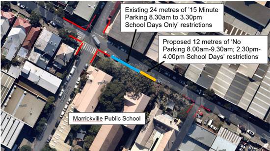
Proposed 2 car space extension of school drop-off zone outside Marrickville Public School, Chapel Street, Marrickville
It is noted that TfNSW have installed School Zones on all roads around Marrickville Public School having an active direct access point from the school, including along Chalder Street, Chalder Lane, Chapel Street, Sheperd Street, Thompson Street and Farr Street.
A traffic count in Chapel Street adjacent to the Marrickville Public School main entrance revealed an average daily traffic volume of around 1800 vehicles per day with an 85th percentile speed of 40.7km/h. It is noted that this speed drops to 38.5km/h during school drop off and pick up times. Traffic volumes are within acceptable limits for a local street and the traffic speed is well within the local urban speed limit of 50km/h and 40km/h speeds which would apply during operation of a school zone.
PUBLIC CONSULTATION
An on-site meeting was held on Wednesday 27 July 2022 with attendance from Council’s Traffic Engineering and Development Compliance teams, Marrickville Public School’s Principal, 2 representatives from the P&C, and one resident.
Council’s Development Compliance Officer gave a brief outline of what has been done to date in relation to approaching businesses that had ‘associated’ vehicles parking on Chapel Street. It was noted that there had been significantly less business associated vehicles parked in the street.
The principal’s main concern was student safety and parents being able to legally drop their children off and advised that a safe environment is needed for parents/carers when dropping off children in Chapel Street (in addition to the drop-off/pick-up in Thompson Street). It was also advised that the school may increase in numbers in the future and that an extension to the drop-off/pick-up zone would be good.
A notification letter was sent to five surrounding businesses and to Marrickville Public School and to the P&C. No formal responses were received to the consultation.
Feedback however did question why the drop-off zone could not be extended from the existing
installed 24 metres (4 car parking spaces) of “P15 Min 8:30am – 3:30pm School Days only” restrictions all the way to Chalder Lane, Marrickville. This suggestion was not considered required as several site observations, in both the morning and afternoon peak school periods, revealed relatively low numbers of school pupils entering and leaving the main gate in Chapel Street, Marrickville. Further, it is noted that in addition another drop-off/pick-up facility is provided for the school in Thompson Street and the ‘No Parking’ restrictions here provides a safe place for older children to be set down and picked up.
It is noted that during all site visits, the existing 4 spaces of 15 minute parking works very well. Generally, motorists observe the 15 minute turn around and the spaces are regularly turned over.
CONCLUSION
It is considered that the provision of two additional ‘No Parking 8-9.30am 2.30-4pm School Days’ restricted parking spaces outside Marrickville Public School, in Chapel Street, Marrickville will assist parents and carers with the drop-off and pick-up of children attending Marrickville Public School, the Aspect Centre and Goodstart childcare centre and is appropriately supported.
|
|
Local Traffic Committee Meeting 17 October 2022 |
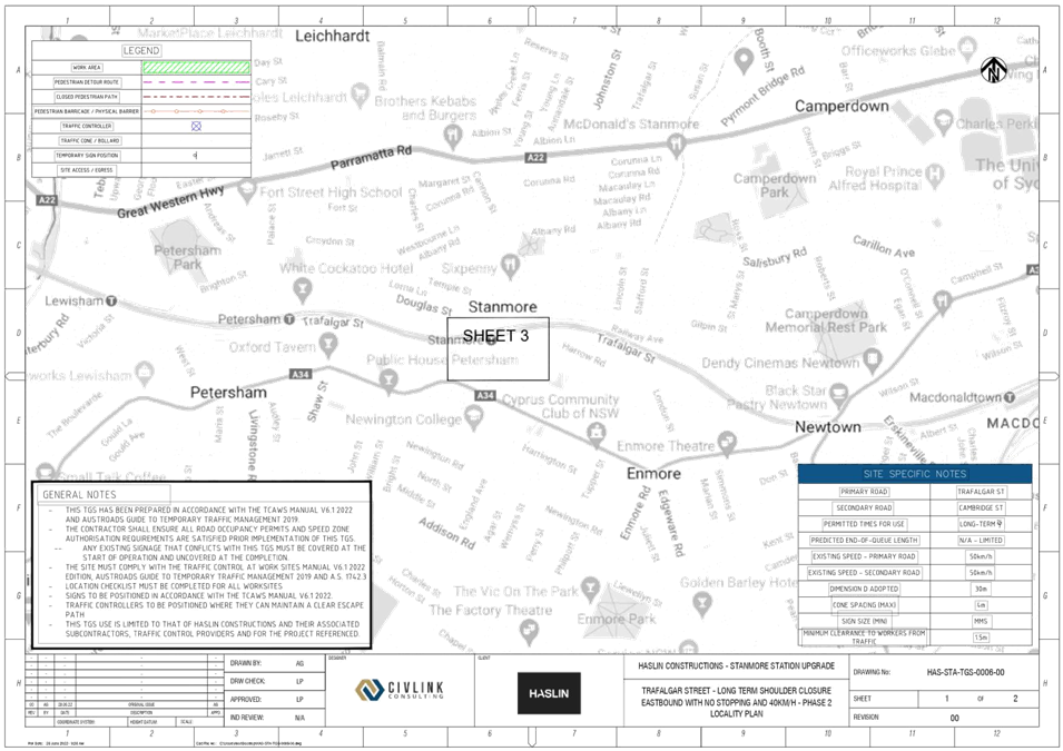
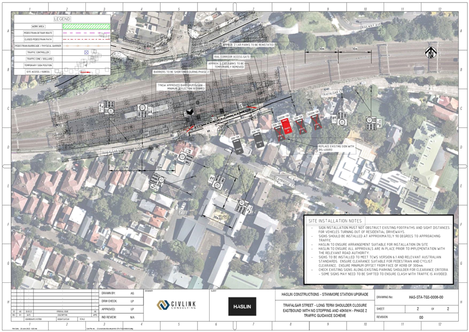
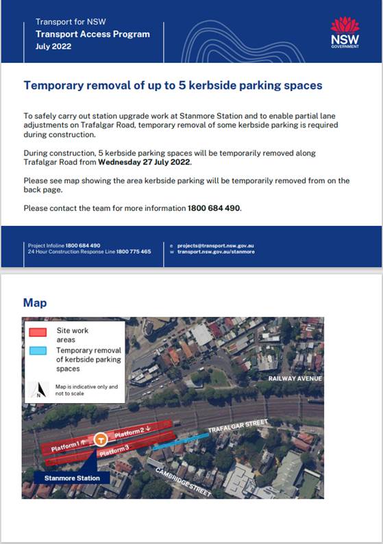
Subject: TRAFALGAR STREET, STANMORE – TfNSW Stanmore Station Upgrade Project – Temporary Signs and Line Markings Plan during construction (DAMUN -STANMORE WARD/ NEWTOWN ELECTORATE/ INNER WEST PAC)
Prepared By: Jennifer Adams - Engineer – Traffic and Parking Services
Authorised By: Manod Wickramasinghe - Acting Director Infrastructure
SUMMARY
The signs and line marking plan for the proposed temporary traffic / parking changes in Trafalgar Street, Stanmore associated with Stanmore Station Upgrade Project works has been submitted to Council (HAS-STA-TGS-0006-00) by Haslin, on behalf of TfNSW. To safely carry out station upgrade work the temporary removal of five (5) kerbside parking spaces on Trafalgar Street will be necessary. It is recommended that the temporary signs and line marking plan be approved.
|
RECOMMENDATION
That: 1. the detailed temporary signs and line marking plan for Trafalgar Street, Stanmore (as part of Stanmore Station Upgrade works) as per the attached plan (Temporary Signage and Line Marking Plan - HAS-STA-TGS-0006-00) be approved. 2. The changes to parking be in place for a period of 38-week period from the date of installation. 3. The applicant be requested to meet the costs of installing and removing the associated signage.
|
BACKGROUND
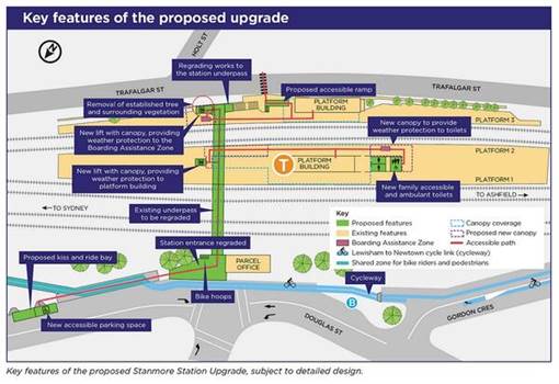
TfNSW have engaged Haslin to undertake the Stanmore Station Upgrade works to facilitate their Transport Access Program across railway stations in the Sydney Metropolitan area.
The Stanmore Station Upgrade works involves remodelling the station to include:
· two lifts providing access to all platforms
· family and easily accessible toilets on Platforms 1/2
· accessible ramp from the station to Trafalgar Street
· regrading of the station underpass
· regraded station entrance and concourse on Douglas Street
· kiss and ride bay on Douglas Street
· new accessible parking space on Douglas Street
During construction it is proposed to install the following temporary measures in Trafalgar Street, Stanmore (TGS-0006):
• Temporary re-alignment of centre line (by 1.3m-1.6m)
• Closure of shoulder lane during works
• Drive in / out works compound area
• Allows two-way traffic flow for duration of works (2.6m temporary lanes)
• Loss of 5 parking spaces
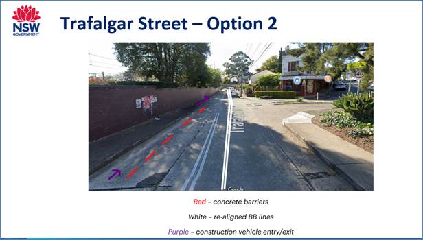
The reason that the realignment set up per TGS-0006 (Option 2) was preferred is that the other traffic options presented more onerous implications including:
o Road closures of Trafalgar Street resulting in traffic diversions for extended periods of time
o Increase in night works which would cause larger disruption to the wider community
It is anticipated that the above changes will be in place for at least a 38-week period starting early October 2022.
The plan below shows the new temporary re-alignment of centreline and associated signage. It is reproduced in the attachments.
FINANCIAL IMPLICATIONS
All works and costs of implementation of temporary works associated with the project will be borne by the applicant.
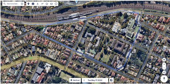
PUBLIC CONSULTATION
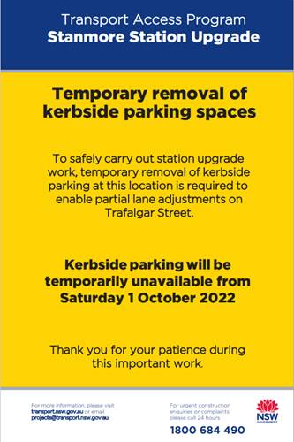
TfNSW has undertaken the community consultation for these works. The area consulted is outlined in the map below. Each property, within the survey area, was delivered a notice about the temporary removal of up to five (5) kerbside parking spaces on Trafalgar Street (a copy of the notice is reproduced at the end of this report). In addition, ‘Early Notice Signs’ were posted in the locality (a copy of the poster is reproduced at the end of this report).
TfNSW received two (2) responses. Both responses were from residents outside properties that are directly affected by the removal of the kerbside parking spaces. Neither were supportive of the removal of kerbside parking. One resident is concerned that their support workers will not be able to park near their residence. It is noted that both properties have off-street parking facilities.
Survey area.
Poster.
Notice.
|
1.⇩ |
HAS-STA-TGS-0006-00 |
|
Local Traffic Committee Meeting 17 October 2022 |
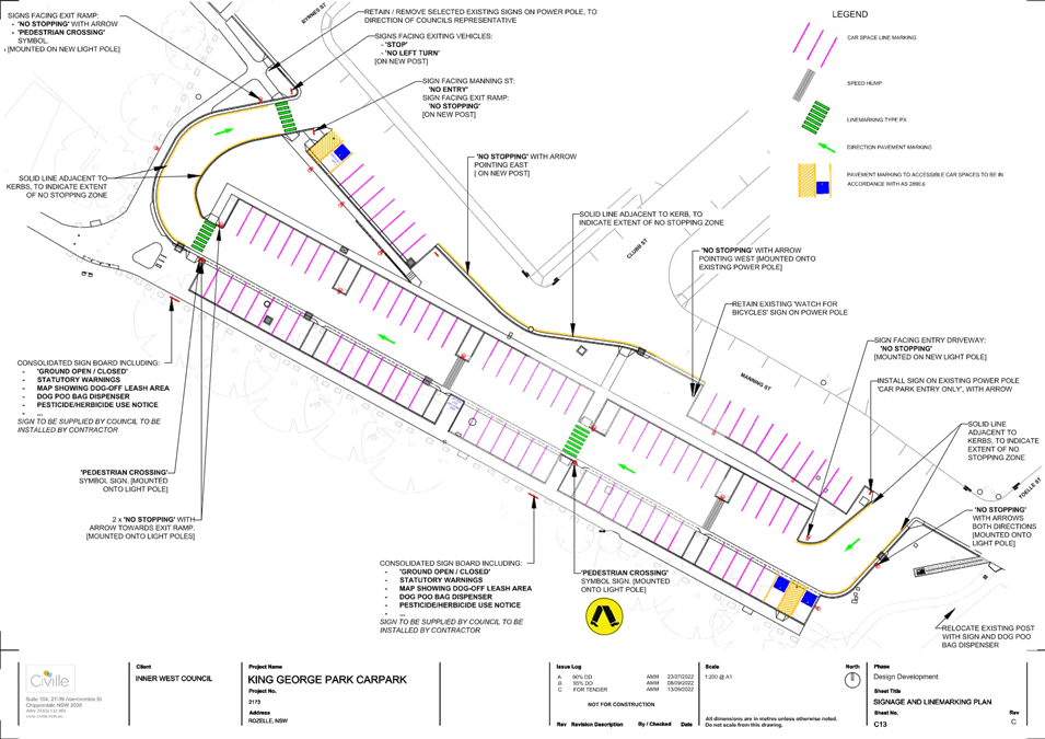
Subject: King Georges Car Park, Rozelle - Signage and Line-marking Plan (Baludarri-Balmain/ Balmain Electorate/ Leichhardt PAC)
Prepared By: David Yu - Engineer - Traffic and Parking Services
Authorised By: Sunny Jo - Acting Traffic and Transport Manager
SUMMARY
As part of the King Georges Park Draft Plan of Management (POM) and Master Plan, design plans for the King Georges Car Park in Manning Street, Rozelle has been attached for consideration.
|
RECOMMENDATION
THAT the proposed signage and line-marking plan (Attachment 1) for the upgrade of King Georges Park be approved. |
BACKGROUND & OTHER STAFF COMMENTS
As part of the King Georges Park Draft Plan of Management (POM) and Master Plan, design plans for the King Georges Car Park in Manning Street, Rozelle has been attached for consideration (Attachment 1).
King Georges Park is located in Rozelle, and the subject car park is located near Manning Street, between Byrnes Street and Clubb Street. Currently the area is unformed and there is no time limit for parking.
As part of the car park upgrade, the following works are proposed below:
· Line-marking of car parking spaces
· Installation of pedestrian crossings
· Installation of speed cushions
· Installation of mobility parking spaces
· ‘No Stopping’ zone signs and solid ‘No Stopping’ Lines
· Installation of ‘No Stopping’ signs and car park ordinance signs
· Construction of kerb and gutter, access ramps
· Lighting poles
A separate report will be prepared in the future for consideration of a time limit within the Car Park which will consider the long term parking of boat trailers in the area. Additionally, a ‘No Stopping’ zone on the southern side of Manning Street would be required to facilitate safe two way traffic movements near the Clubb Street intersection. This is expected to be reported back to the Traffic Committee once community consultation on these proposals are completed.
FINANCIAL IMPLICATIONS
A separate report to Council will be prepared for the King George Park car park upgrade tender.
PUBLIC CONSULTATION
Resident and businesses in the area have been notified of the proposed upgrade works (excluding time restrictions and other on-street parking changes in Manning Street).
|
1.⇩ |
King Georges Park - Signage and Line-marking Plan |