|
AGENDA R |

Local Traffic Committee Meeting
MONDAY 21 NOVEMBER 2022
11.00AM
|
|
Local Traffic Committee Meeting 21 November 2022 |
Function of the Local Traffic Committee
Background
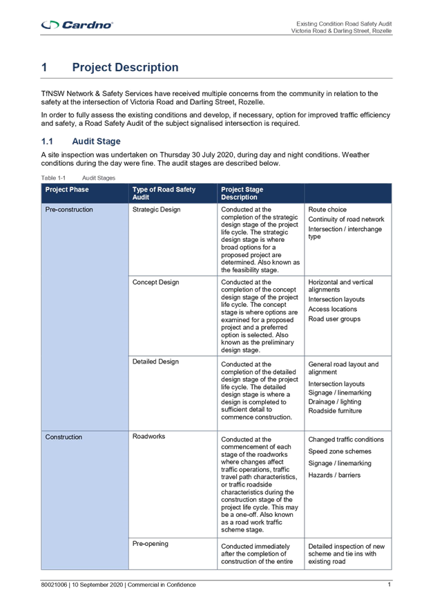
Roads and Maritime Services (RMS) is legislated as the Authority responsible for the control of traffic on all NSW Roads. The RMS has delegated certain aspects of the control of traffic on local roads to councils. To exercise this delegation, councils must establish a local traffic committee and obtain the advice of the RMS and Police. The Inner West Council Local Traffic Committee has been constituted by Council as a result of the delegation granted by the RMS pursuant to Section 50 of the Transport Administration Act 1988.
Role of the Committee
The Local Traffic Committee is primarily a technical review and advisory committee which considers the technical merits of proposals and ensures that current technical guidelines are considered. It provides recommendations to Council on traffic and parking control matters and on the provision of traffic control facilities and prescribed traffic control devices for which Council has delegated authority. These matters are dealt with under Part A of the agenda and require Council to consider exercising its delegation.
In addition to its formal role as the Local Traffic Committee, the Committee may also be requested to provide informal traffic engineering advice on traffic matters not requiring Council to exercise its delegated function at that point in time, for example, advice to Council’s Development Assessment Section on traffic generating developments. These matters are dealt with under Part C of the agenda and are for information or advice only and do not require Council to exercise its delegation.
Committee Delegations
The Local Traffic Committee has no decision-making powers. The Council must refer all traffic related matters to the Local Traffic Committee prior to exercising its delegated functions. Matters related to State Roads or functions that have not been delegated to Council must be referred directly to the RMS or relevant organisation.
The Committee provides recommendations to Council. Should Council wish to act contrary to the advice of the Committee or if that advice is not supported unanimously by the Committee members, then the Police or RMS have an opportunity to appeal to the Regional Traffic Committee.
Committee Membership & Voting
Formal voting membership comprises the following:
· one representative of Council as nominated by Council;
· one representative of the NSW Police from each Local Area Command (LAC) within the LGA, being Newtown, Marrickville, Leichhardt and Ashfield LAC’s.
· one representative from the RMS; and
· State Members of Parliament (MP) for the electorates of Summer Hill, Newtown, Heffron, Canterbury, Strathfield and Balmain or their nominees.
Where the Council area is represented by more than one MP or covered by more than one Police LAC, representatives are only permitted to vote on matters which effect their electorate or LAC.
Informal (non-voting) advisors from within Council or external authorities may also attend Committee meetings to provide expert advice.
Committee Chair
Council’s representative will chair the meetings.
Public Participation
Members of the public or other stakeholders may address the Committee on agenda items to be considered by the Committee. The format and number of presentations is at the discretion of the Chairperson and is generally limited to 3 minutes per speaker. Committee debate on agenda items is not open to the public.
|
|
Local Traffic Committee Meeting 21 November 2022 |
|
AGENDA |
1 Apologies
2 Disclosures of Interest
3 Confirmation of Minutes Page
Minutes of 17 October 2022 Local Traffic Committee Meeting 5
4 Matters Arising from Council’s Resolution of Minutes
5 Part A – Items Where Council May Exercise Its Delegated Functions
Traffic Matters
ITEM Page
LTC1122(1) Item 1 Palmer Street and Donnelly Street, Balmain - Intersection Improvements (Baludarri-Balmain Ward / Balmain Electorate / Leichhardt LAC) 13
LTC1122(1) Item 2 Smith
Street (at Lackey Street and Morris Street), Summer Hill-Proposed Streetscape
Improvement Works.
(Djarrawunang-Ashfield Ward/Summer Hill Electorate/Burwood LAC) 15
LTC1122(1) Item 3 Wardell Road/Riverside Crescent, Dulwich Hill- No Left Turn Restriction (Djarrawunang-Ashfield Ward/Summer Hill Electorate/Inner West PAC) 23
LTC1122(1) Item 4 New Canterbury Road at Balanaming Lane, Petersham - ‘No Left Turn Vehicles Over 6m Long’ restrictions (Damum - Stanmore Ward / Newtown Electorate / Inner West PAC) 38
LTC1122(1) Item 5 Dulwich Hill Station Precinct Public Domain Improvements Amendment – Amendment to Bus Zone Operational Times – (Midjuburi – Marrickville Ward / Summer Hill Electorate / Inner West PAC) 42
LTC1122(1) Item 6 Unnamed Link Road, Lilyfield (between Mary Street and Maliyawul Street) - Proposed Shared Pedestrian and Bike Path & One-way traffic (Baludarri-Balmain Ward/Balmain Electorate/Leichhardt PAC) 44
Parking Matters
ITEM Page
LTC1122(1) Item 7 Rozelle North Precinct Resident Parking Scheme Extension (Baludarri-Balmain Ward/Balmain Electorate/Leichhardt PAC) 48
LTC1122(1) Item 8 Park Lane, Sydenham - Proposed installation of 'No Parking' restrictions western side between Henry Street and Rowe Lane (Midjuburi – Marrickville Ward / Heffron Electorate / Inner West PAC) 55
Late Items
Nil at time of printing.
6 Part B - Items for Information Only
ITEM Page
LTC1122(1) Item 9 Rozelle Public School - Road Safety Improvements (Baludarri-Balmain Ward/Balmain Electorate/Leichhardt PAC 58
7 Part C - Items for General Advice
Nil at the time of printing.
8 General Business
9 Close of Meeting
|
|
Local Traffic Committee Meeting 21 November 2022 |
Minutes of Local Traffic Committee Meeting
Held on 17 October 2022 at Ashfield Service Centre
Meeting commenced at 11.00AM
ACKNOWLEDGEMENT OF COUNTRY BY CHAIRPERSON
I acknowledge the Gadigal and Wangal people of the Eora nation on whose country we are meeting today, and their elders past and present.
COMMITTEE REPRESENTATIVES PRESENT
|
Mayor Darcy Byrne |
Councillor – Baludarri-Balmain Ward (Chair) |
|
Bill Holliday |
Representative for Jamie Parker MP, Member for Balmain |
|
Graeme McKay |
Representative for Jo Haylen MP, Member for Summer Hill |
|
Solon Ghosh |
Transport for NSW (TfNSW) |
|
|
|
|
OFFICERS IN ATTENDANCE |
|
|
|
|
|
Cr Justine Langford |
Councillor – Midjuburi-Marrickville Ward |
|
Manod Wickramasinghe |
IWC’s Traffic and Transport Planning Manager |
|
Sunny Jo |
IWC’s Coordinator Traffic Engineering Services (North) |
|
George Tsaprounis |
IWC’s Coordinator Traffic Engineering Services (South) |
|
Christina Ip |
IWC’s Business Administration Officer |
|
|
|
|
VISITORS |
|
|
|
|
|
Nil. |
|
|
|
|
|
APOLOGIES: |
|
|
|
|
|
Colin Jones |
Inner West Bicycle Coalition |
|
Colin Hesse |
Representative for Jenny Leong MP, Member for Newtown |
|
Maryanne Duggan |
Representative for Jason Yat-Sen Li MP, Member for Strathfield |
|
SC Germaine Grant |
NSW Police – Burwood Police Area Command |
|
SC Anthony Kenny |
NSW Police – Inner West Police Area Command |
|
Adrian Pritchard |
Transit Systems |
|
|
|
DISCLOSURES OF INTERESTS:
Nil.
CONFIRMATION OF MINUTES
|
The minutes of the Local Traffic Committee meeting held on 19 September 2022 were confirmed. |
MATTERS ARISING FROM COUNCIL’S RESOLUTION OF MINUTES
The Local Traffic Committee recommendations of its meeting on 19 September 2022 are awaiting adoption.
|
LTC1022(1) Item 2 Audley Street, Audley Lane, Sadlier Crescent, Fisher Street, and eastbound parking lanes on New Canterbury Road Petersham – Temporary Full Road Closures for Special Event on Sunday 19 March 2023 – Petersham Festival - Bairro Portuguese – ENRC/2022/0041 (Damun - Stanmore Ward / Newtown Electorate / Inner West PAC) |
|
Inner West Council will be presenting Petersham Festival ‘Bairro Portuguese Petersham Food and Wine Fair’ on Sunday 19 March 2023 from 11:00am until 4:00pm on Audley Street and Fisher Street, Petersham. This event celebrates the very best of Portuguese culture with entertainment, music, dance, cultural activities, and traditional and contemporary foods. To facilitate the event, areas of Petersham will be closed and there will be road closures necessitating some road detours and bus diversions in surrounding streets.
Roads affected include Audley Street (between New Canterbury Road and Trafalgar Street), Sadlier Crescent (between Audley Street and Abels Lane) and Fisher Street (between Audley Street and Regent Street), Audley Lane north of New Canterbury Road (resident access excepted) as well as the eastbound parking lane on New Canterbury Road (between Audley Street and Balanaming Lane), Petersham from 1.00am until 9:00pm. It is recommended that Council agree to the temporary full road closures subject to all standard Council conditions for a temporary full road closure.
Officer’s Recommendation
THAT the proposed temporary road closure of Audley Street (between New Canterbury Road and Trafalgar Street), Sadlier Crescent (between Audley Street and Abels Lane) and Fisher Street (between Audley Street and Regent Street), Audley Lane north of New Canterbury Road (resident access excepted) as well as the eastbound parking lane on New Canterbury Road (between Audley Street and Balanaming Lane), Petersham on Sunday 19 March 2023, from 1:00am until 9:00pm, for the holding of ‘Bairro Portuguese Petersham Food and Wine Fair’, be SUPPORTED subject to the applicant complying with but not limited to the following conditions:
1. A Traffic Management Plan (TMP) is submitted to and approved by Transport for NSW; and an application for a Road Occupancy Licence and a temporary Speed Zone Authorisation is forwarded to and approved by the Transport Management Centre;
2. Notice of the proposed event is forwarded to all affected residents and businesses, including the N.S.W. Police / Inner West Local Area Commander, Fire and Rescue NSW, NSW Ambulance and Transit Systems;
3. Transit Systems – Inner West Bus Services be requested to implement a revised routing for scheduled bus services in Audley Street on the day of the event and install temporary bus stops as required;
4. A minimum four (4) metre unencumbered passage be available for emergency vehicles through the closed section; and
5. The occupation of the road carriageways must not occur until the roads have been physically closed.
DISCUSSION
The Committee members agreed with the Officer’s recommendation.
COMMITTEE RECOMMENDATION
THAT the proposed temporary road closure of Audley Street (between New Canterbury Road and Trafalgar Street), Sadlier Crescent (between Audley Street and Abels Lane) and Fisher Street (between Audley Street and Regent Street), Audley Lane north of New Canterbury Road (resident access excepted) as well as the eastbound parking lane on New Canterbury Road (between Audley Street and Balanaming Lane), Petersham on Sunday 19 March 2023, from 1:00am until 9:00pm, for the holding of ‘Bairro Portuguese Petersham Food and Wine Fair’, be SUPPORTED subject to the applicant complying with but not limited to the following conditions:
1. A Traffic Management Plan (TMP) is submitted to and approved by Transport for NSW; and an application for a Road Occupancy Licence and a temporary Speed Zone Authorisation is forwarded to and approved by the Transport Management Centre;
2. Notice of the proposed event is forwarded to all affected residents and businesses, including the N.S.W. Police / Inner West Local Area Commander, Fire and Rescue NSW, NSW Ambulance and Transit Systems;
3. Transit Systems – Inner West Bus Services be requested to implement a revised routing for scheduled bus services in Audley Street on the day of the event and install temporary bus stops as required;
4. A minimum four (4) metre unencumbered passage be available for emergency vehicles through the closed section; and
5. The occupation of the road carriageways must not occur until the roads have been physically closed.
For motion: Unanimous
|
|
LTC1022(1) Item 3 Chapel Street, Marrickville - Request for an extension to the existing drop-off and pick-up zone outside Marrickville Public School (Midjuburi Ward/ Summer Hill Electorate/ Inner West PAC) |
|
Representations have been received from the Principal of Marrickville Public School, the P&C and parents of children attending the school for an extension to the existing school drop-off / pick-up zone on Chapel Street, Marrickville. There were also a number of complaints about local businesses ‘associated’ vehicles parking on Chapel Street taking up most of the available parking in the locality.
Several site inspections and a site meeting were conducted, and a proposal was developed for the installation of a further two parking spaces east of the existing four P15 spaces. This zone will be designated – ‘No Parking 8-9.30am 2.30-4pm School Days’ and will provide an additional two (2) space drop-off/pick-up zone which then could be used by others for up to a 5-hour period in between. It is recommended that a further two (2) parking spaces 'No Parking 8.00am-9.30am; 2.30pm-4.00pm School Days’ east of the existing four (4) ‘P15 8.30am to 3.30pm School Days’ spaces be approved to assist parents and carers with the drop-off and pick-up of children at the school.
Officer’s Recommendation
THAT:
1. The installation of a 12 metre length (two car parking spaces) of ‘No Parking 8.00am-9.30am; 2.30pm-4.00pm School Days’ restrictions east of the existing 24 metre length of ‘15 min Parking 8.30am to 3.30pm School Days’ zone on the southern side of Chapel Street, Marrickville, outside Marrickville Public School be APPROVED, to assist parents and carers with the drop-off and pick-up of children; and 2. The Principal of Marrickville Public School and P&C be advised in terms of this report
DISCUSSION
Cr Langford asked whether there was potential to change the existing 15 min parking to 5 min to increase turnover. Council Officers advised that the 15 min parking zone assists parents/carers of children with autism who attend the Aspect Centre.
The representative for the Member for Summer Hill commented that some parents preferred that the proposed ‘No Parking 8.00am-9.30am; 2.30pm-4.00pm School Days’ restrictions be extended to cover the length of four car spaces. The representative suggested that the proposed ‘No Parking 8.00am-9.30am; 2.30pm-4.00pm School Days’ restrictions be implemented before the school term ends to allow time to assess its effectiveness and make any necessary adjustments before the next school term begins. Council Officers advised that the proposal needs to be adopted by Council at its next meeting on 8 November 2022 before the proposed signage can be installed. Regardless, Council Officers will arrange for the signage to be installed as soon as Council adopts the recommendation.
The Committee members agreed with the Officer’s recommendation.
COMMITTEE RECOMMENDATION
THAT:
1. The installation of a 12 metre length (two car parking spaces) of ‘No Parking 8.00am-9.30am; 2.30pm-4.00pm School Days’ restrictions east of the existing 24 metre length of ‘15 min Parking 8.30am to 3.30pm School Days’ zone on the southern side of Chapel Street, Marrickville, outside Marrickville Public School be APPROVED, to assist parents and carers with the drop-off and pick-up of children; and 2. The Principal of Marrickville Public School and P&C be advised in terms of this report
For motion: Unanimous
|
|
LTC1022(1) Item 4 Trafalgar Street, Stanmore – TfNSW Stanmore Station Upgrade Project – Temporary Signs and Line Markings Plan during construction (Damun -Stanmore Ward/ Newtown Electorate/ Inner West PAC) |
|
The signs and line marking plan for the proposed temporary traffic / parking changes in Trafalgar Street, Stanmore associated with Stanmore Station Upgrade Project works has been submitted to Council (HAS-STA-TGS-0006-00) by Haslin, on behalf of TfNSW. To safely carry out station upgrade work the temporary removal of five (5) kerbside parking spaces on Trafalgar Street will be necessary. It is recommended that the temporary signs and line marking plan be approved.
Officer’s Recommendation
That: 1. the detailed temporary signs and line marking plan for Trafalgar Street, Stanmore (as part of Stanmore Station Upgrade works) as per the attached plan (Temporary Signage and Line Marking Plan - HAS-STA-TGS-0006-00) be approved. 2. The changes to parking be in place for a period of 38-week period from the date of installation. 3. The applicant be requested to meet the costs of installing and removing the associated signage.
DISCUSSION
On behalf of Cr Liz Atkins, Cr Langford requested clarification on the options that were considered aside from the preferred Option 2. Council Officers advised that a full road closure of Trafalgar Street and night works with a one lane traffic arrangement were two other options considered. Either options would have significant impacts to residents and the local road network, and therefore Option 2 was chosen.
Cr Langford also raised concerns that there would be potential loss of parking for support workers in the area. Council Officers advised that the support worker parking permit scheme administered by City of Sydney allows support workers to park in resident parking zones across the Inner West Council area. It is up to the service provider to apply for a permit through the City of Sydney website.
Cr Byrne requested that a review of the conditions be undertaken in two months after Option 2 is implemented to identify any issues. The Committee members agreed to incorporate this request with the recommendation.
COMMITTEE RECOMMENDATION
That: 1. the detailed temporary signs and line marking plan for Trafalgar Street, Stanmore (as part of Stanmore Station Upgrade works) as per the attached plan (Temporary Signage and Line Marking Plan - HAS-STA-TGS-0006-00) be approved. 2. the changes to parking be in place for a period of 38-week period from the date of installation. 3. the applicant be requested to meet the costs of installing and removing the associated signage. 4. a review of the changes be undertaken two months after installation and be brought to Council for consideration.
For motion: Unanimous
|
General Business
Meeting closed at 11.18am.
|
|
Local Traffic Committee Meeting 21 November 2022 |
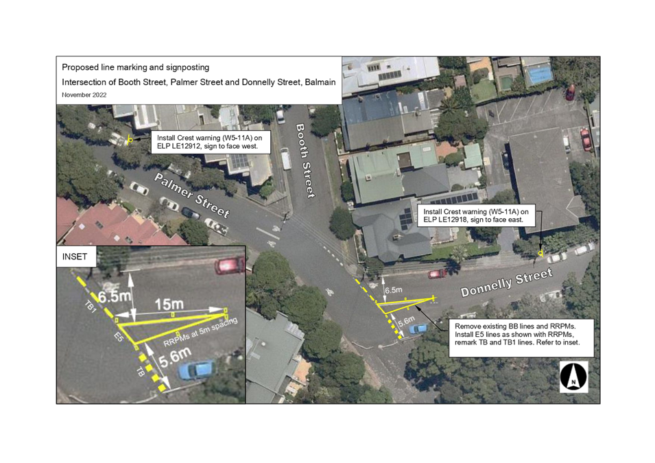
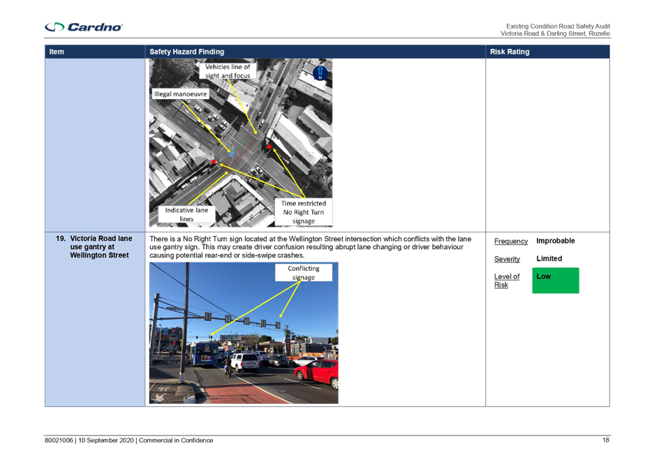
Subject: Palmer Street and Donnelly Street, Balmain - Intersection Improvements (Baludarri-Balmain Ward / Balmain Electorate / Leichhardt LAC)
Prepared By: Sunny Jo - Coordinator – Traffic and Parking Services - North
Authorised By: Manod Wickramasinghe - Traffic and Transport Planning Manager
SUMMARY
Concerns have been raised from a local resident regarding road safety at the intersection of Donnelly/Palmer/Booth Streets. A review has been undertaken and a signage and linemarking improvement is proposed.
|
RECOMMENDATION
That:
1. Linemarking at the intersection of Booth Street and Donnelly Street, Rozelle be upgraded to include a painted median island in Donnelly Street as shown in the attached plan; and
2. Two (2) W5-11A ‘Crest’ warning signs be installed on Palmer Street and Donnelly Street 40m west and 40m east of Booth Street as shown in the attached plan.
|
OTHER STAFF COMMENTS
Concerns have been raised from a local resident regarding road safety at the intersection of Donnelly/Palmer/Booth Streets.
An examination of the crash database for this location has revealed one (1) head-on (RUM code 20) tow away accident at the intersection of Booth Street and Donnelly Street for the past 5 year period ending on 2021.
Site investigations revealed an irregular four-way intersection with a crest restricting sight distances for traffic approaching from Palmer Street and Donnelly Street. To assist vehicle delineation from the east and west approaches it is proposed that a painted island be installed at the Donnelly Street approach, and two (2) W5-11A ‘Crest’ warning signs to improve safety at this location.
A signage and linemarking plan is attached.
FINANCIAL IMPLICATIONS
The cost of these works will be funded from Council’s operational budgets.
PUBLIC CONSULTATION
The proposed changes do not result in changes to the on-street parking or traffic priority at this location. Accordingly, consultation has not been undertaken for this proposal.
|
1.⇩ |
Booth Street and Donnelly Street intersection improvements |
|
|
Local Traffic Committee Meeting 21 November 2022 |
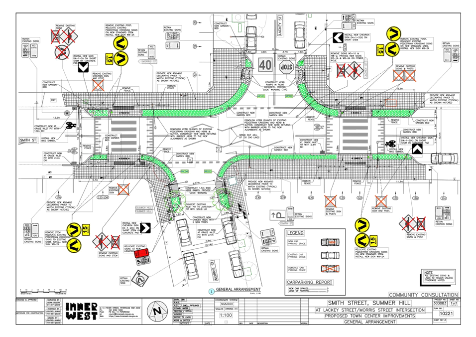
Subject: Smith Street (at Lackey Street and Morris
Street), Summer Hill-Proposed Streetscape Improvement Works.
(Djarrawunang-Ashfield Ward/Summer Hill Electorate/Burwood LAC)
Prepared By: Boris Muha - Engineer – Traffic and Parking Services
Authorised By: Manod Wickramasinghe - Traffic and Transport Planning Manager
SUMMARY
Council has finalised design plans to improve the streetscape in Lackey Street, Morris Street & Smith Street, Summer Hill by providing widened decoratively paved footpaths incorporating landscaped garden beds. The proposal aims to improve the overall aesthetic of the town centre as well as improving pedestrian and motorist safety at these intersections.
|
RECOMMENDATION
That the detailed design plan to provide widened decorative paved footpaths incorporating landscape garden beds (with associated/revised signs and markings) at the intersections of Smith Street with Lackey and Morris Street and integrating two (2) existing crossings in Smith Street, Summer Hill (as shown per plan 10221-Atachment 1) be APPROVED. |
BACKGROUND
In August 2022, Council officers presented a concept design plan of the proposal under an open Town Centre exhibition to improve the streetscape at the intersection of Lackey Street & Morris Street with Smith Street, Summer Hill. The general feedback from this exhibition was positive and supportive of the upgrades being proposed.
FINANCIAL IMPLICATIONS
The project is estimated around $200,000 and will be funded under a Town Centre Capital program.
OTHER STAFF COMMENTS
Site Location and Road Network
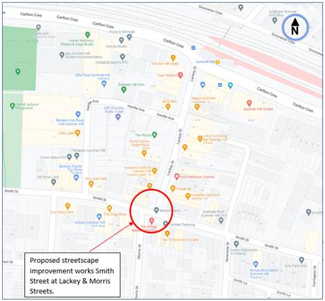
Locality Map
|
Street Name |
Lackey Street |
|
Section |
Intersection with Smith Street |
|
Carriageway Width (m) kerb to kerb |
Approx. 10.8m |
|
Carriageway Type |
Two-way, one travel lane each direction, kerbside parking both sides. |
|
Classification |
Local |
|
Speed Limit |
40 (within High Pedestrian Activity) zone |
|
85th percentile speed |
34 |
|
Vehicles per day (vpd)
|
3400 |
|
Reported Crash History (July 2016-June 2021) |
No recorded accidents |
|
Heavy Vehicle Volume (%) |
3.4 |
|
Parking Arrangements |
½ P and Loading zone (8.30am-6.00pm Mon-Fri., 8.30am-12.30pm Sat) near intersection. |
|
Street Name |
Smith Street |
|
Section |
Intersection with Lackey and Morris Streets |
|
Carriageway Width (m) kerb to kerb |
Approx. 10.1 metres. |
|
Carriageway Type |
Two-way, one travel lane each direction, kerbside parking both sides. |
|
Classification |
Local |
|
Speed Limit |
40 (within High Pedestrian Activity) zone |
|
85th percentile speed |
35 |
|
Vehicles per day (vpd)
|
4800 |
|
Reported Crash History (July 2015-June 2020) |
One (1) accident -RUM 49 (2022)- parking/U-turn- non casualty (towaway), east of Lackey Street. |
|
Heavy Vehicle Volume (%) |
2-2.5 |
|
Parking Arrangements |
1P and 1/4P (8.30am-6.00pm Mon-Fri., 8.30am-12.30pm Sat) near intersection. |
|
Street Name |
Morris Street |
|
Section |
Intersection with Smith Street. |
|
Carriageway Width (m) kerb to kerb |
Approx. 10.1 metres. |
|
Carriageway Type |
Two-way, one travel lane each direction, kerbside parking both sides. |
|
Classification |
Local |
|
Speed Limit |
40 (within High Pedestrian Activity) zone near intersection, 50 outside |
|
85th percentile speed |
44 outside |
|
Vehicles per day (vpd)
|
1100 |
|
Reported Crash History (July 2016-June 2021) |
No recorded accidents |
|
Heavy Vehicle Volume (%) |
3.0 |
|
Parking Arrangements |
1P 8.30am-6.00pm Mon-Fri., 8.30am-12.30pm Sat) and unrestricted parking near intersection. |
The following works are proposed and are illustrated on plan ATTACHMENT 1.
Smith Street / Lackey St / Morris St, Summer Hill (Plan No. 10221):
- Construct new kerbs along new alignments to form widened decorative paved footpaths incorporating landscaped garden beds.
- Relay the existing decorative paving as needed to match in with any new works and provide new decorative paving to infill the new widened footpath areas (new paving to match existing pavers already used in the town centre),
- Integrate the new works with the 2 existing raised pedestrian crossings in Smith Street
- Construct new kerb ramps to improve pedestrian accessibility across Lackey Street & Morris Street
- Resurface the road pavement with new asphalt where required (final extent yet to be determined)
- Incorporate new street trees (where feasible)
- Provide new stormwater drainage pits and pipes to better manage stormwater in the streets
- Adjusting some of the existing “No Stopping” zones and signage, without impacting the existing car parking spaces;
- Install associated pavement line marking and signage as required;
Parking Changes
It is proposed to slightly adjust existing “No Stopping” signage on the western side of Morris Street to better align the kerb returns. No other changes are proposed. However, no existing on-street car parking spaces will be lost as a result of the proposed works.
Streetlighting
The existing street lighting within the scope of works, including at the 2 existing pedestrian crossings, is deemed adequate. Therefore, no changes are proposed to the existing street lighting due to these works.
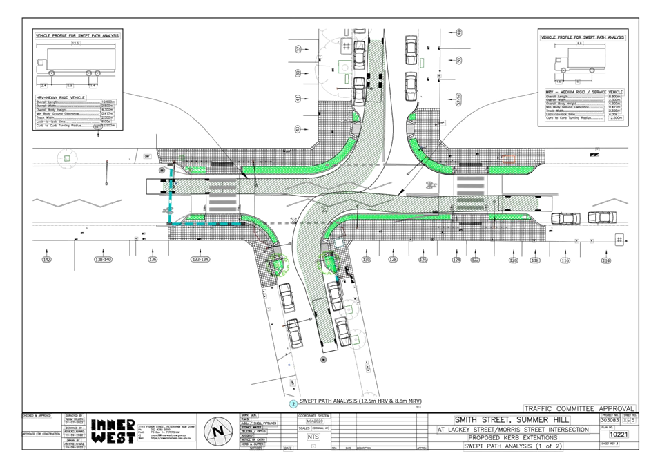
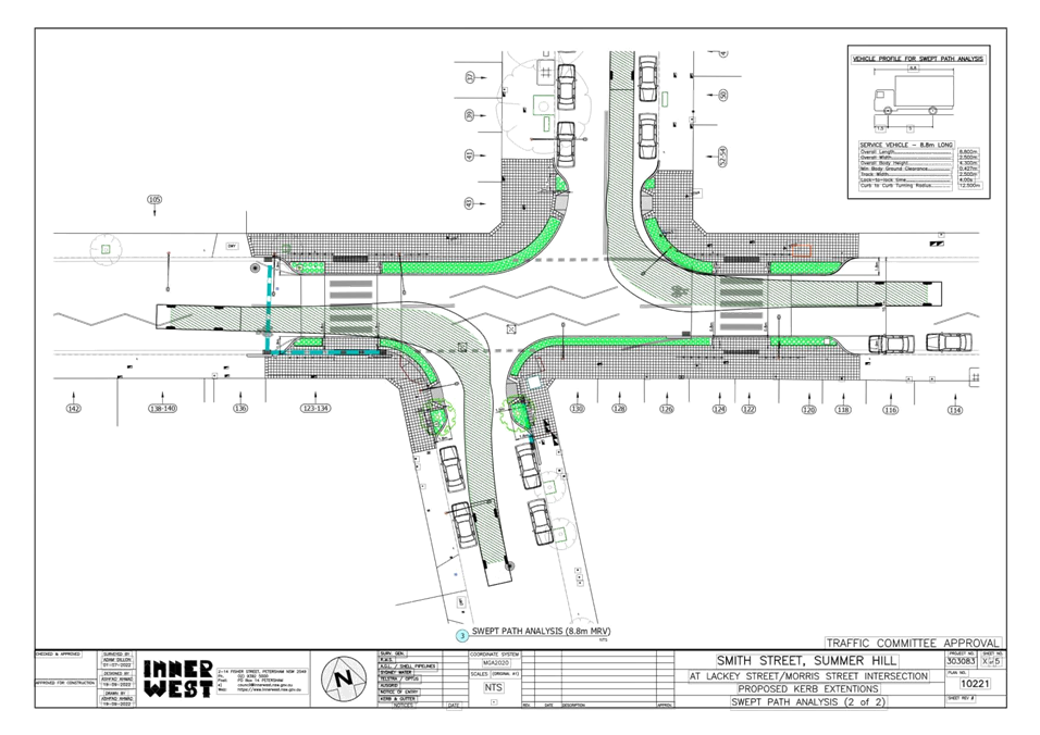
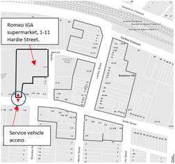
It should be further noted that the Summer Hill Town Centre is generally serviced by rigid truck vehicles ranging from 8.8m to 12.5m length trucks/buses. ATTACHMENT 2 displays turning path movements for these type vehicles at the various corners. The corner radii of the intersections are designed to adequately cater for these movements. School buses 12.5m length are known to infrequently turn left from Smith Street into Lackey Street (1-2 per morning). It is known that on occasions non-rigid small length (14m) semi-trailers may be servicing the Romero LGA supermarket (1-11 Hardie Street) with access off Smith Street. These vehicles could, with caution, adequately negotiate left turn from Smith Street into Lackey Street, if the route out is onto Carlton Crescent.
Fencing to the pedestrian crossings at will be removed, as planting areas will be made to guide pedestrians to the crossings. This will allow better aesthetics and view of pedestrians versus traffic. Planting areas at the pedestrian crossings will be low scrubs.
PUBLIC CONSULTATION
Consultation Area Plan
Consultation to the above properties is currently being undertaken (as from the 28 October) with closing date of submissions being 16 November 2022. 150 letters have been mailed out to residing occupants and non-residing owners of above properties.
No responses have been received to date in the compilation of this report. Any additional responses received prior to the LTC meeting will be tabled at the meeting.
CONCLUSION
It is recommended that the widened decorative paved footpaths incorporating landscape garden beds (with associated/revised signs and markings) at the intersections of Smith Street with Lackey and Morris Street and integrating two (2) existing crossings in Smith Street, Summer Hill be approved as shown per plan 10221-Atachment 1.
|
1.⇩ |
Proposed plan of footway widening at interesecton(s) of Smith Street with Lackey Street and Morris Street, Summer Hill. |
|
2.⇩ |
Service vehicle/bus swept paths at Smith Street intersection(s) with Lackey Street and Morris Street.- 2 plans |
|
Local Traffic Committee Meeting 21 November 2022 |
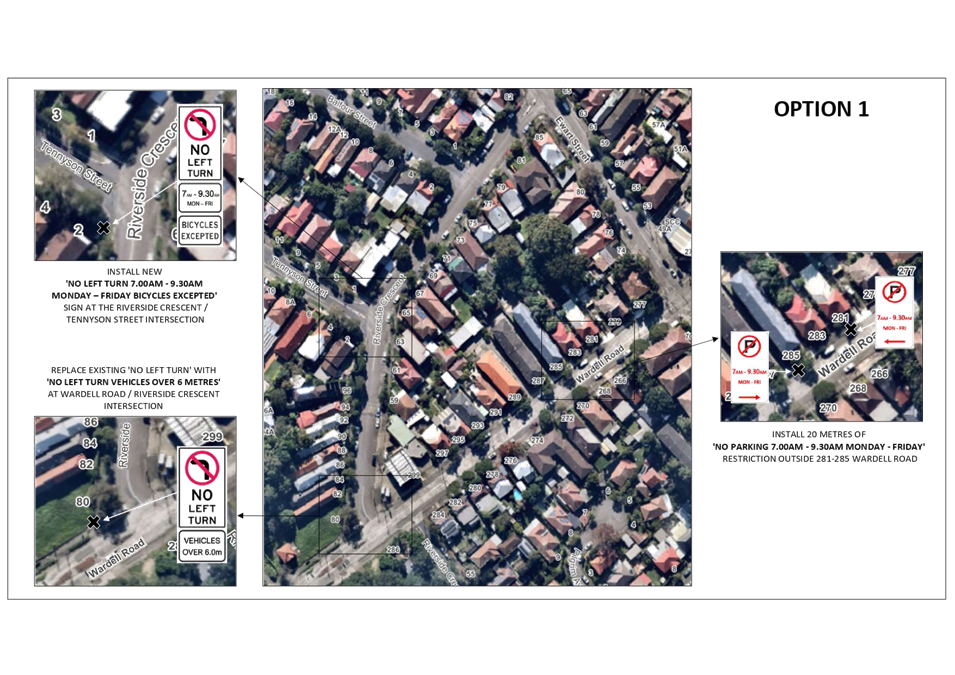
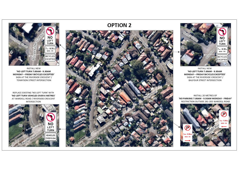
Subject: Wardell Road/Riverside Crescent, Dulwich Hill- No Left Turn Restriction (Djarrawunang-Ashfield Ward/Summer Hill Electorate/Inner West PAC)
Prepared By: Jason Scoufis - Traffic and Parking Planner
Authorised By: Manod Wickramasinghe - Traffic and Transport Planning Manager
SUMMARY
A number of recommendations are proposed in the area bounded by Wardell Road, Ewart Street and Garnet Street, Dulwich Hill. These recommendations include replacing the ‘No Left Turn’ restriction with a ‘No Left Turn Vehicles Over 6 metres’ restriction at Wardell Road/Riverside Crescent.
It also includes the introduction of a ‘No Left Turn 7:00-9:30am Mon-Fri, Bicycles Excepted’ sign in Riverside Crescent at Tennyson Street and other additional measures to reduce speeds in the local area.
|
RECOMMENDATION
That:
1. The existing ‘No Left Turn’ restriction be replaced with a ‘No Left Turn Vehicles Over 6 metres’ restriction at Wardell Road/Riverside Crescent subject to approval by TfNSW;
2. A ‘No Left Turn 7:00-9:30am Mon-Fri, Bicycles Excepted’ sign be installed in Riverside Crescent at Tennyson Street to restrict westbound movements subject to approval by TfNSW;
3. 20 metres of ‘No Parking 7:00am-9:30am Mon-Fri' be installed on the western side of Wardell Road south of Ewart Street along the frontages of 281-285 Wardell Road;
4. The statutory 10 metres of ‘No Stopping’ be installed on the southern side of Ewart Street immediately east of Riverside Crescent;
5. The BB lines in Riverside Crescent at Wardell Road be adjusted by relocating 1 metre northeast for a length of 10 metres;
6. A concept design for traffic calming in the form of kerb extensions at the Tennyson Street/Riverside Crescent and Riverside Crescent/Balfour Street intersections be prepared for consideration by Traffic Committee;
7. A concept design for an upgraded pedestrian refuge in Riverside Crescent at Ewart Street be prepared for consideration by Traffic Committee; and
8. TfNSW be requested to consider a 30 km/h speed limit trial in Ness Avenue, Balfour Street, Tennyson Street and Riverside Crescent between Wardell Road and Ewart Street.
|
BACKGROUND
At the July 2021 Traffic Committee, the following was recommended when considering a report in relation to the ‘No Left Turn sign’ in Wardell Road at Riverside Crescent which was installed in early 2021 as part of the Greenway Project.
1. The ‘No Left Turn’ sign in Wardell Road facing northeast bound motorists at Riverside Crescent be replaced with a ‘No Left Turn Vehicles over 6 metres’ sign subject to TfNSW approval of a TMP.
2. The BB lines in Riverside Crescent at Wardell Road be adjusted by relocating 1m northeast for a length of 10 metres.
3. A concept design for traffic calming in the form of kerb extensions at the Tennyson Street/Riverside Crescent be prepared for consideration by Traffic Committee.
4. A 30 km/h speed limit in Ness Avenue along the on-road Greenway route be supported for a 12-month trial period subject to approval of the trial by TfNSW.
Council subsequently endorsed the recommendation with the following amendment:
5. Notes the proposal will be consulted with the community.
The ‘No Left Turn’ sign was introduced in early 2021 to reduce traffic in local streets whilst supporting cycling for the on-road sections of the Greenway. It was installed as part of the approved on- road works for the Greenway which included community consultation.
The current proposal to modify the sign from a ‘No Left Turn’ to a ‘No Left Turn Vehicles over 6 metres’ resulted from issues shared with Council post installation of the sign regarding the traffic restriction’s impact on traffic congestion, travel times, unsafe traffic movements through the petrol station and vehicles continuing to make the left turn.
Following the July 2021 Traffic Committee and subsequent Council resolution, consultation was undertaken in August/September 2021 regarding the proposal to replace the the ‘No Left Turn’ sign in Wardell Road facing northeast bound motorists at Riverside Crescent with a ‘No Left Turn Vehicles over 6 metres’ sign.
A total of 257 letters were mailed out, inviting the community to provide comments online, by post or by phone. Council’s Have Your Say website had a total of 107 submissions with only 30% supporting the proposal. A further 20 submissions were received via email or phone with only 40% of these supporting the proposal. Additionally, a petition was received with 94 signatures opposing the proposed changes to the sign.
Given the lack of support for the proposal, no immediate action was taken to modify the sign .
During the consultation, the main objections to the proposal included the fact that the sign was installed following support during Greenway associated consultation with residents of Riverside Crescent, Tennyson Street, Balfour Street and Ness Avenue. Other concerns raised related to the negative impact on road safety and amenity the proposal would have, given it would increase traffic in the local road network and favor vehicle movements as opposed to cyclists and pedestrians.
It should be noted that TfNSW adjusted the traffic signal timings at the Wardell Road/Ewart Street signals to provide additional time for northeast bound traffic in Wardell Road on approach to Ewart Street in mid-2021. Whilst the traffic signal adjustments have improved traffic flow there are still considerable issues. These include traffic congestion and increased travel times, unsafe traffic movements through the petrol station and vehicles that continue to make the left turn in conflict with the sign.
In regard to traffic congestion and travel time delays, extensive queuing continues to occur heading northeast in the weekday AM peak in Wardell Road on approach to the Ewart Street traffic signals, with queueing often extending past the Permanent Avenue/Riverview Road/Wardell Road roundabout a length of some 700 metres.
This traffic queueing would be reduced if motorists were able to turn left into Riverside Crescent as per previous traffic conditions pre-early 2021, as less vehicles would then need to travel through the Ewart Street/Wardell Road traffic signals, thereby reducing intersection delays for all motorists approaching Dulwich Hill from the south, including bus services. Similarly, those motorists wishing to head west currently need to travel through the traffic signals at Ewart Street/Wardell Road increasing their travel time and also other motorists’ travel times as these vehicles add to traffic congestion. If they were able to turn left at Riverside Crescent, they would not need to queue to make a left turn at Ewart Street.
In regard to safety issues associated with the existing situation, a significant number of motorists continue to use the petrol station to make the left turn from Wardell Road into Riverside Crescent to avoid illegally turning left against the ‘No Left Turn’ sign. This results in dangerous conditions between motorists and pedestrians associated with the petrol station business and those vehicles travelling through to avoid illegally turning left from Wardell Road into Riverside Crescent in conflict with the sign. Similarly, safety issues occur as a result of motorists making the illegal left turn from Wardell Road into Riverside Crescent and other motorists making other turning movements and pedestrians not expecting these maneuvers.
Given the lack of community support for the previous proposal to replace the ‘No Left Turn’ sign with ‘No Left Turn Vehicles over 6 metres’ sign which would have resulted in the reintroduction of full permeability of vehicular movements back into the local road network, three alternate options were developed for further consideration and consultation.
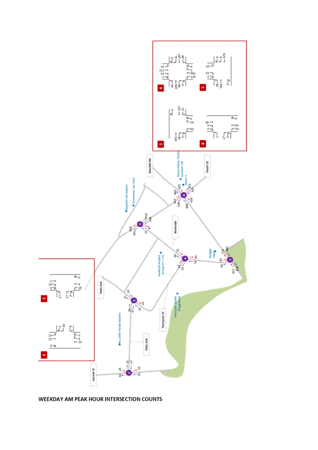
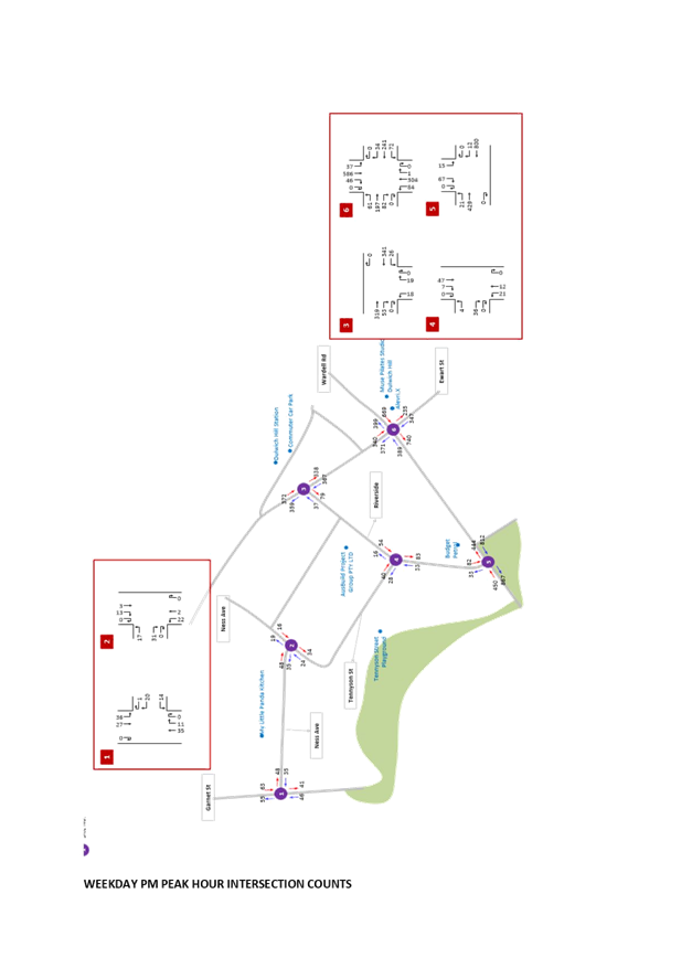
Traffic data was also collected in November 2021 and is provided in Attachment 1. The traffic data included intersection counts and speed and volume counts.
The results of the Average Daly Traffic Volume (ADT) and 85%ile speed counts are detailed below.
|
Location |
ADT |
85%ile Speed |
|
Ness Avenue between Garnet Street and Tennyson Street |
912 veh/day |
45 km/h |
|
Garnet Street between Ness Avenue and Tennent Parade |
N/A |
32 km/h
|
|
Tennyson Street between Ness Avenue and Riverside Crescent |
636 veh/day
|
49 km/h |
|
Balfour Street between Ness Avenue and Riverside Crescent |
391 veh/day |
42 km/h |
|
Riverside Crescent between Wardell Road and Tennyson Street |
1,384 veh/day
|
31 km/h |
|
Riverside Crescent between Tennyson Street and Balfour Street |
1,041 veh/day
|
37 km/h |
In regard to traffic volumes all road sections have acceptable existing traffic volumes for a local residential street. The speed results also indicate that all road sections have acceptable speeds in relation to the speed limit of 50 km/h, however it is recommended that the speed limit be reduced to further reduce the speed profile in the area, in particular Tennyson Street.
Revised Options for further consideration
Details of the three options for further assessment are detailed below and a plan of each Option detailed in Attachment 2.
Option 1 - In association with replacing the existing ‘No Left Turn’ restriction with a ‘No Left Turn Vehicles Over 6 metres’ restriction at Wardell Road/Riverside Crescent, install:
· a ‘No Left Turn 7:00-9:30am Mon-Fri, Bicycles Excepted’ sign in Riverside Crescent at Tennyson Street to restrict westbound movements.
· 20 metres of ‘No Parking 7:00am-9:30am Mon-Fri; on the western side of Wardell Road along the frontages of 281-285 Wardell Road.
Option 2 - In association with replacing the existing ‘No Left Turn’ restriction with a ‘No Left Turn Vehicles Over 6 metres’ at Wardell Road/Riverside Crescent, install:
· a ‘No Left Turn 7:00-9:30am Mon-Fri, Bicycles Excepted’ sign in Riverside Crescent at Tennyson Street to restrict westbound movements
· a ‘No Left Turn 7:00-9:30am Mon-Fri, Bicycles Excepted’ sign in Riverside Crescent at Balfour Street to restrict westbound movements
· 20 metres of ‘No Parking 7:00am-9:30am Mon-Fri' on the western side of Wardell Road along the frontages of 281-285 Wardell Road.
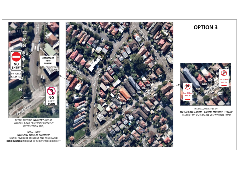
Option 3 - In association with retaining the existing ‘No Left Turn’ restriction at Wardell Road/Riverside Crescent, install:
· 20 metres of ‘No Parking 7:00am-9:30am Mon-Fri' on the western side of Wardell Road along the frontages of 281-285 Wardell Road
· ‘No Entry Bicycles Excepted’ sign facing northbound traffic in Riverside Crescent and associated kerb blisters in front of No. 92 Riverside Crescent (immediately north of the driveway to mechanics)
FINANCIAL IMPLICATIONS
The costs to implement the recommendations will be funded from Council’s operational and Traffic Facilities Budget.
PUBLIC CONSULTATION
Council undertook community consultation through Council’s Have Your Say website in July/August 2022 on the three proposed options that aim to reduce the issues associated with the restriction, whilst maintaining suitable conditions for the local roads, in particular the on-street Greenway in Ness Avenue.
A total of 380 letters were mailed out, inviting the community to provide comments online, by post or by phone. Council’s Have Your Say website had a total of 120 submissions.
|
|
Your Say Support |
Your Say Support rate |
|
Option 1 |
63 |
53% |
|
Option 2 |
35 |
29% |
|
Option 3 |
31 |
26% |
A further 7 submissions were received via email or phone with 5 of these supporting Option 1,2 supporting Option 2 and 1 supporting Option 3. Additionally, a petition was received with 84 signatures in support of Option 3. Many of those signatures on the petition also provided feedback through Your Say.
A summary of comments is detailed below.
|
Community Comment |
Officer’s Response |
|
If motorists are currently ignoring the ‘No Left Turn’ sign into Riverside Crescent it is unlikely that they will comply with ‘No Left turn’ signs into Tennyson Street and/or Balfour Street as proposed in Option 1 and Option 2. |
The travel time delay resulting from the existing ‘No Left Turn’ restriction is significant in comparison to the proposed AM peak ‘No Left Turn’ at either Tennyson Street or Balfour Street as it requires motorists to negotiate the heavily congested Ewart Street/Wardell Road signalised intersection and in many cases also a longer travel path, hence higher compliance is expected. |
|
Would like to be able to turn left unrestricted from Wardell Road into Riverside Crescent and from Riverside Crescent to Tennyson Street at all times.
It is becoming increasingly difficult to travel around the inner west due to road restrictions such as this. |
During the consultation in 2021 there was a lack of support for modifying ‘No Left Turn’ to a No Left Turn vehicles over 6 metres’ in isolation hence it is not being proposed. |
|
Remove the proposed 'No Parking' on Wardell Road as it will impact local residents' ability to park in front of their properties. |
The proposed ‘No Parking’ in AM weekday peak will allow additional storage capacity for vehicles making a left turn into Ewart street and reduce traffic delays. The minimum hours of 7:00am-9:30am are proposed to minimise inconvenience to local residents.
It will allow residents to park on-street overnight, however, they will need to leave by 7:00am on weekdays. Furthermore, business owners/shoppers will be able to park in these spaces during general business hours.
|
|
Option 1 will divert all traffic to Balfour Street. |
Whilst noting that Option 1 will result in additional traffic in Balfour Street in the weekday AM peak, it does not form part of Council’s Bike Route, thereby limiting conflict with cyclists. Furthermore, the volume of traffic in Balfour Street under Option 1 is estimated to be within the environmental capacity of a local road and motorists will also have the option of making the left turn at Ewart Street. |
|
The concrete island in Riverside Crescent results in unsafe left turns and needs to be modified as part of the proposals. |
Linemarking is to be modified as part of the recommendation to allow sufficient width for left turning vehicles. The concrete island does not need to be removed as larger vehicles will be banned from making this turn. Furthermore, the island slows vehicles down making the left turn. |
|
Concern raised regarding visibility when turning left from Riverside Crescent into Ewart Street. |
Noted and agreed. Recommendation to include 10 metres of ‘No Stopping’ on Ewart Street east of Riverside Crescent to provide adequate sight lines as inspections have revealed illegal parking within statutory ‘No Stopping’. |
|
Options 1 and Option 2 prioritise the need of motorists over cyclists, residents and pedestrians. |
The proposals aim to form a balance between all competing demands. Tennyson Avenue and Ness Avenue have already been traffic calmed to provide safe conditions for cyclists and pedestrians by reducing vehicular speeds. Further recommendations in the form of reduced speed limits and additional traffic calming will further reduce speeds. |
|
Concern raised that the installation of kerb blisters as proposed in Option 3 will reduce parking. |
Noted however the kerb blisters are required as part of this proposal to physically narrow the road carriageway to encourage one way traffic. |
|
Why are trucks banned from making the left turn from Wardell Road into Riverside Crescent? |
Trucks are banned to reduce the risk of cyclists needing to share the road space with trucks. |
|
Support or Option 3. Existing ‘No Left Turn’ is vital for buffering the Greenway from motorists attempting to cut through residential streets rather than sticking to main arteries. Option 3 makes resident streets safer for cyclists and pedestrians. |
The volume of traffic that will use local roads under Option 1 and Option 2 will generally increase however will be within the environmental capacity of a road.
Furthermore the vehicles that will be redistributed will generally be making a series of left turns thereby they will not be in conflict with opposing direction traffic flow minimising conflict with other movements. |
|
Does not support Option 1 and Option 2 as they will result in a continuation of non-compliance with vehicles continuing to turn left into Tennyson Street and Balfour Street. Traffic data unreliable due to COVID. |
Note that COVID has impacted on reliability of data, however under Option 1 vehicles will be permitted to turn left at Balfour Street or Ewart Street and under Option 2 will be able to make the left turn at Ewart Street. It is expected that this will result in higher compliance than current traffic conditions due to the difference in travel times associated with these Options as opposed to the current situation whereby vehicles heading west are delayed due to traffic signal delays. |
Assessment of Options
In order to assess the estimated impact of the 3 options on traffic volumes, the existing proportion of traffic which turns left from Riverside Crescent into the 3 traffic available routes is estimated as follows based on the traffic data.
|
Street |
AM Left Turn from Riverside Crescent |
PM Left Turn from Riverside Crescent |
|
Tennyson Street |
25% |
40% |
|
Balfour Street |
15% |
20% |
|
Ewart Street |
60% |
40% |
Based on the above information and traffic assumption that 60% to 70% of existing traffic making a left turn at the signals will redirect to Riverside Crescent to make this turn during peak weekday conditions under Option 1 and Option 2 the estimated turning traffic volumes under the 3 options in both the AM and PM weekday are detailed below.
AM weekday peak hour estimated traffic
|
|
Existing Weekday AM Peak |
Option 1 estimate |
Option 2 estimate |
Option 3 estimate |
|
Left Turn from Wardell Road into Ewart Street
|
125 |
38 |
50 |
198 |
|
Left Turn from Wardell Road into Riverside Crescent using the service station
|
15 |
0 |
0 |
0 |
|
Left Turn from Wardell Road into Riverside Crescent |
58 |
161 |
148
|
0 |
|
Left Turn from Riverside Crescent into Tennyson Street
|
24 |
0 |
0
|
5 |
|
Left Turn Riverside Crescent into Balfour Street
|
10 |
69 |
0 |
5 |
|
Left Turn from Riverside Crescent into Ewell Street
|
54 |
107 |
163 |
20 |
PM weekday peak hour estimated traffic
|
|
Existing Weekday PM Peak |
Option 1 Estimate |
Option 2 estimate |
Option 3 estimate |
|
Left Turn from Wardell Road into Ewart Street
|
84 |
33 |
33
|
111 |
|
Left Turn from Wardell Road into Riverside Crescent using the service station
|
6 |
0 |
0 |
0 |
|
Left Turn from Wardell Road into Riverside Crescent |
21 |
77 |
77
|
0 |
|
Left Turn from Riverside Crescent into Tennyson Street
|
21 |
41 |
41
|
5 |
|
Left Turn Riverside Crescent into Balfour Street
|
10 |
20 |
20
|
5 |
|
Left Turn from Riverside Crescent into Ewart Street
|
18 |
38 |
38
|
10 |
Option 1 and Option 2 will result in a redistribution of northeast bound traffic from Wardell Road into Riverside Crescent. A proportion of the traffic that currently turns left from Wardell Road into Ewart Street will now make the left turn from Wardell Road into Riverside Crescent. It is estimated that the following redistribution of traffic will occur under each of these options in comparison to the existing traffic volumes.
AM weekday peak hour estimated changes to existing traffic volumes
|
|
Option 1 estimate |
Option 2 estimate |
Option 3 estimate |
|
Left Turn from Wardell Road into Ewart Street
|
(-87) |
(-75) |
+73 |
|
Left Turn from Wardell Road into Riverside Crescent using the service station
|
(-15) |
(-15) |
(-15) |
|
Left Turn from Wardell Road into Riverside Crescent |
+103 |
+90 |
(-58) |
|
Left Turn from Riverside Crescent into Tennyson Street
|
(-24) |
(-24) |
(-19) |
|
Left Turn Riverside Crescent into Balfour Street
|
+59 |
(-10) |
(-5) |
|
Left Turn from Riverside Crescent into Ewell Street
|
+53 |
+109 |
(-34) |
PM weekday peak hour estimated changes to existing traffic volumes
|
|
Option 1 estimate |
Option 2 estimate |
Option 3 estimate |
|
Left Turn from Wardell Road into Ewart Street
|
(-51) |
(-51) |
+27 |
|
Left Turn from Wardell Road into Riverside Crescent using the service station
|
(-6) |
(-6) |
(-6) |
|
Left Turn from Wardell Road into Riverside Crescent |
+56 |
+56 |
(-21) |
|
Left Turn from Riverside Crescent into Tennyson Street
|
+20 |
+20 |
(-16) |
|
Left Turn Riverside Crescent into Balfour Street
|
+10 |
+10 |
(-5) |
|
Left Turn from Riverside Crescent into Ewell Street
|
+20 |
+20 |
(-8) |
The RMS guide To Traffic Generating development provides information in relation to the Environmental Capacity of residential streets. The midblock weekday AM and PM peak hour traffic volumes estimated for each of the options is detailed below.
Midblock Existing and Estimated Traffic Volumes
|
|
Exist.AM |
Option 1 AM |
Option 2 AM |
Option 3 AM |
Exist. PM |
Option 1 PM |
Option 2 PM |
Option 3 PM |
|
Riverside Crescent
|
142 |
245 |
232 |
84 |
116 |
172 |
172 |
95 |
|
Tennyson Street |
47 |
23 |
23 |
28 |
68 |
88 |
88 |
52 |
|
Balfour Street
|
36 |
95 |
26 |
31 |
34 |
44 |
44 |
29 |
|
Ness Avenue
|
81 |
116 |
47 |
57 |
83 |
113 |
113 |
62 |
The table indicates that all roads have peak hour volumes within the maximum environmental capacity of a local road which is 300 veh/h.
CONCLUSION
It is recommended that Option 1 whilst redistributing traffic onto the local road network be supported as it allows permeability into the local area, however it has an internal traffic ban during AM weekday peak hours to partially constrain traffic along Tennyson Street and Ness Avenue as opposed to having no internal peak hour ban which would result in full permeability on the local road network. Option 1 will also eliminate the existing safety issues that occur with illegal left turning vehicles from Wardell Road whereby other vehicles or pedestrians may not be expecting these maneuverers and similarly conflict within the service station. The additional measures recommended including kerb extensions and speed limit reduction will further reduce speeds. Option 1 also had the highest support rate through Yoursay.
Option 2 is not recommended as it does not allow traffic to either use Balfour Street and Tennyson Street to make the left turn during weekday AM peak times and would force all traffic to travel the full length of Riverside Crescent up to Ewart Street thereby requiring one intersection to cater for all left turning movements.
In regard to Option 3, whist noting that this option reduces traffic volumes in the local road network, the proposal is not supported as it will redistribute further traffic into the Wardell Road/Ewart Street intersection further increasing journey times and congestion including existing bus services. There is also likely to be a significant number of vehicles that continue to turn left at either Riverside Crescent or through the petrol station and travel through the one-way section in the opposite direction. Similarly, motorists will be doing u-turns in Riverside Crescent when confronted with a ‘No Entry’ sign. This will create conflict and unsafe traffic conditions.
|
1.⇩ |
Intersection Counts |
|
2.⇩ |
Options |
|
Local Traffic Committee Meeting 21 November 2022 |
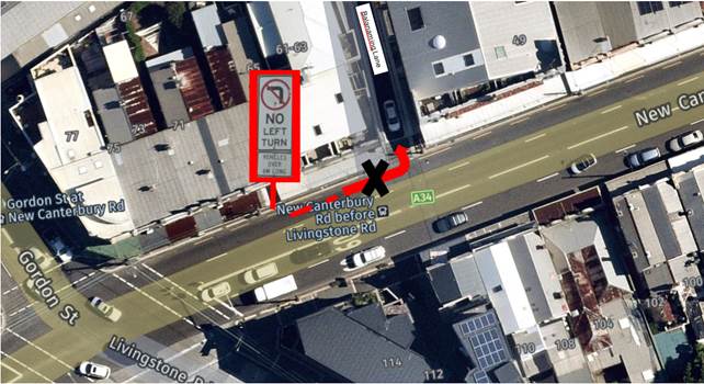
Subject: New Canterbury Road at Balanaming Lane, Petersham - ‘No Left Turn Vehicles Over 6m Long’ restrictions (Damum - Stanmore Ward / Newtown Electorate / Inner West PAC)
Prepared By: Jennifer Adams - Engineer – Traffic and Parking Services
Authorised By: Manod Wickramasinghe - Traffic and Transport Planning Manager
SUMMARY
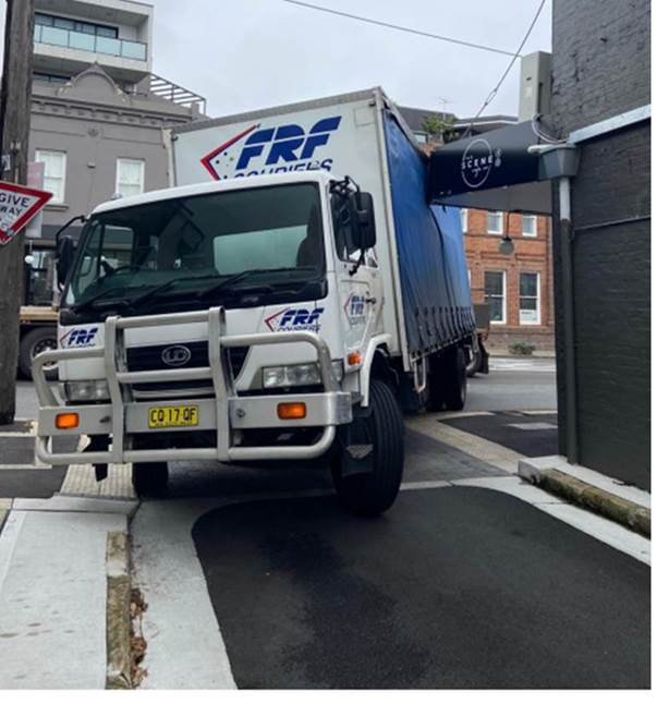
Following safety concerns raised by residents regarding trucks turning left at New Canterbury Road into Balanaming Lane, a left turn ban for vehicles greater than 6 metres is proposed. Trucks making a left turn from New Canterbury Road into Balanaming Lane are constrained by the width of the laneway and the adjacent buildings. This has resulted in damage to the awning on the southwest corner on numerous occasions
|
RECOMMENDATION
That the installation of ‘No Left Turn Vehicles Over 6m Long’ restrictions on New Canterbury Road at Balanaming Lane, Petersham be supported subject to a Traffic Management Plan (TMP) being considered and approved by TfNSW in order to deter trucks turning into the laneway and damaging the adjoining properties.
|
BACKGROUND
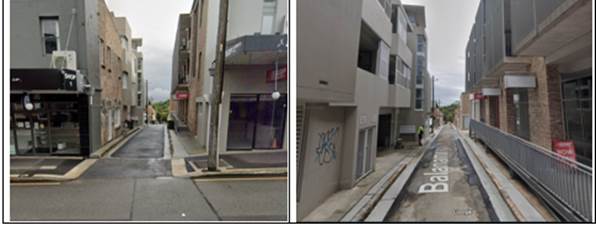
Trucks making the left-hand turn from New Canterbury Road into Balanaming Lane are constrained by the width of the laneway and the awning/building. The awning has been damaged on numerous occasions as a result of truck strikes. A Traffic Management Plan (TMP) has been prepared to detail the impact of banning left turning vehicles greater than 6 metres and will be submitted to TfNSW for their approval and implementation. Please refer to the diagram below.
FINANCIAL IMPLICATIONS
Nil.
OFFICERS COMMENTS
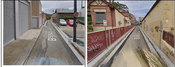
The surrounding land uses have changed in the recent past and now there are many medium residential housing units which has brought additional vehicles into the laneway. Average daily traffic volumes are around 240 vehicles per day with around 5 percent being trucks. Balanaming Lane is a local road and hence a TMP is required for the proposed vehicle movement ban.
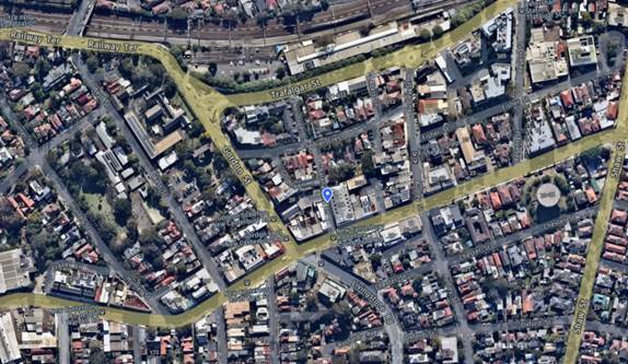
The following images are a series of photos looking north along Balanaming Lane from New Canterbury Road and looking south along Balanaming Lane from Sadlier Street, Petersham:
PUBLIC CONSULTATION
Community engagement commenced on 4 November 2022 and closed on 18 November 2022. 31 notification letters were hand delivered to the owners and occupiers within the immediate surrounding area and an email was sent to the owner of 61-63 New Canterbury Road. No responses have been received to date.
CONCLUSION
In order to deter trucks from turning into Balanaming Lane from New Canterbury Road, Petersham and causing damage to the adjoining properties, it is recommended that the installation of ‘No Left Turn Vehicles Over 6m Long’ restrictions be installed in New Canterbury Road at Balanaming Lane, Petersham be supported.
|
|
Local Traffic Committee Meeting 21 November 2022 |
Subject: Dulwich Hill Station Precinct Public Domain Improvements Amendment – Amendment to Bus Zone Operational Times – (Midjuburi – Marrickville Ward / Summer Hill Electorate / Inner West PAC)
Prepared By: Jennifer Adams - Engineer – Traffic and Parking Services
Authorised By: Manod Wickramasinghe - Traffic and Transport Planning Manager
SUMMARY
Council adopted the Master Plan for Dulwich Hill Station Precinct at its 13 August 2019 meeting. The Dulwich Hill Station Public Domain Master Plan provides the Dulwich Hill community with a plan to transform the streets and public spaces around the station into a pedestrian oriented village. An assessment for Stage 2 works were submitted and approved by the Local Traffic Committee in February 2022. Stage 2 works involved:
· Raised entry thresholds at the north and south of Wardell Road and southwest of Ewart Street;
· Upgrading the existing threshold at Ewart St East, to IWC standards;
· Tree plantings, garden beds and a rain garden; and
· New Bluestone Pavers for footpaths.
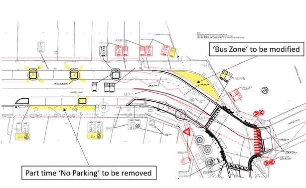
This assessment is for an amendment to parts of the Stage 2 works. The Bus Stop (for school buses) in front of the new entrance to the Metro Station on Wardell Road now will have its operational hours amended to accommodate timed parking for the general public outside bus operational times. This will provide much needed parking opportunities for the public in the locality. In addition, the now redundant ‘No Parking 4-6pm Mon-Fri’ restrictions between No.248 and No.252 Wardell Road, Dulwich Hill is proposed to be removed.
|
RECOMMENDATION
That:
1. The operation of the Bus Zone on Wardell Road outside the new Metro Station be amended as follows – ‘Bus Zone AM Peak 0.7.30 – 08.30 and PM Peak 3.00 – 4.00’. and ‘1P 8.30AM to 3PM Mon-Fri and 800AM – 12PM Sat’; and
2. The redundant ‘No Parking 4-6pm Mon-Fri’ restrictions on Wardell Road, between No.248 and No.252 Wardell Road, Dulwich Hill be removed and replaced with ‘1P 8AM – 6PM Mon-Fri and 8AM -12PM Sat’. |
BACKGROUND
Businesses within the Dulwich Hill Station Precinct have expressed concerns that the lack of on-street parking in and around the Dulwich Hill Station Precinct has become challenging. At present there is a full time Bus Zone, used for school buses, in front of the new entrance to the Metro Station on Wardell Road and Council is proposing to change the Bus Zone sign to reflect the times of day when it is used by school buses, thus freeing the space up for timed parking for the general public outside of these times.
Council Officers have consulted with a representative from Transit Systems to amend the operational times of the subject bus zone to the effective hours of bus operations. Outside these times Council Officers aim to provide on-street parking opportunities. Hours the bus stop is required are - AM Peak 0.7.30 – 08.30 and PM Peak 3.00 – 4.00.
It is noted that that the Light Rail shutdown hours and use of this bus zone during this period can be managed when required.
In addition, the new kerb blister on Wardell Road outside No.252 removes the need for the present ‘No Parking 4-6pm Mon-Fri’ restrictions between No.248 and No.252 Wardell Road, Dulwich Hill on approach to the traffic signals. It is therefore proposed to remove these restrictions and extend the existing timed 1P parking until 6pm.
FINANCIAL IMPLICATIONS
The costs of installation of the signage as recommended can be funded within Council’s signs and line marking budget.
|
|
Local Traffic Committee Meeting 21 November 2022 |
Subject: Unnamed Link Road, Lilyfield (between Mary Street and Maliyawul Street) - Proposed Shared Pedestrian and Bike Path & One-way traffic (Baludarri-Balmain Ward/Balmain Electorate/Leichhardt PAC)
Prepared By: David Yu - Engineer - Traffic and Parking Services
Authorised By: Manod Wickramasinghe - Traffic and Transport Planning Manager
SUMMARY
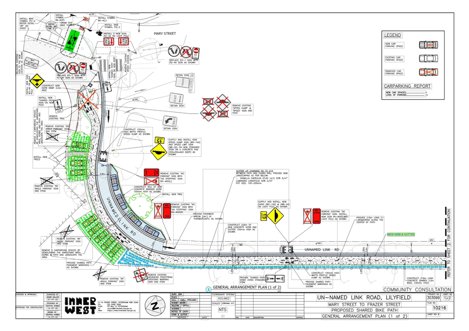
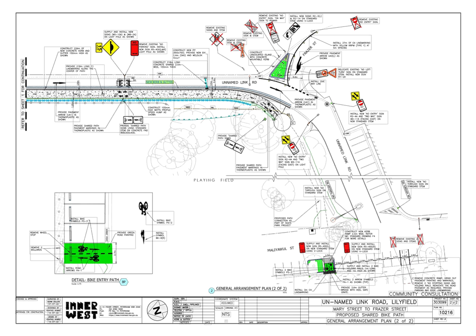
Council is planning to improve pedestrian and cyclist safety in the unnamed Link Road, Lilyfield (between Mary Street, Frazer Street and Maliyawul Street) by constructing kerb and gutter to narrow the road and widen the footpath to form a shared pedestrian and bike path.
|
RECOMMENDATION
That the attached detailed design plan (Design Plan No.10216) for the proposed shared pedestrian and bike path, road narrowing, one-way southbound conversion and associated works at Unnamed Link Road, Lilyfield (between Mary Street, Frazer Street and Maliyawul Street) be approved.
|
BACKGROUND & OTHER STAFF COMMENTS
The detailed design plan shown in Attachment 1 outlines the proposed upgrade works on Unnamed Link Road, Lilyfield and includes the following treatments:
· Construction of new kerb and gutter on the western side of the Unnamed Link Road;
· Reconstruction of existing concrete footpath;
· Construction of new landscaped area (with low height plants);
· Construction of three (3) new asphalt speed cushions;
· Constructing of new landscaped kerb blister ;
· Provide four (4) new indented parallel parking spaces;
· Road narrowing and one-way southbound conversion;
· Installing new pavement line marking; and
· Installing and relocating signage associated with the works.
It is proposed to remove 10 existing angle parking spaces and provision of four (4) new parallel parking spaces. Therefore, the proposed works will result in the net loss of six (6) regulated on-street parking spaces.
The proposed upgrade will improve safety for pedestrians and cyclists by reducing the road width and widening the shared pedestrian and bike path.
Noting that the proposed location of the Unnamed Link Road, Lilyfield is contained with crown land, a Traffic Management Plan will be submitted to Transport for NSW for approval of the one-way conversion prior to implementation.
FINANCIAL IMPLICATIONS
Funding of has been allocated to this project for construction in the 2022/23 Capital Works Program.
PUBLIC CONSULTATION
A letter outlining the proposal was mailed out to 29 properties in Frazer Street and Morton Street, Lilyfield.
The last day for comments for this proposal is Thursday, 17 November 2022 and any comments will be tabled at the November 2022 Local Traffic Committee meeting
|
1.⇩ |
Unnamed Link Road, Lilyfield - Proposed Shared Pedestrian and Bike Bath |
|
Local Traffic Committee Meeting 21 November 2022 |
Subject: Rozelle North Precinct Resident Parking Scheme Extension (Baludarri-Balmain Ward/Balmain Electorate/Leichhardt PAC)
Prepared By: Felicia Lau - Engineer - Traffic and Parking Services
Authorised By: Manod Wickramasinghe - Traffic and Transport Manager
SUMMARY
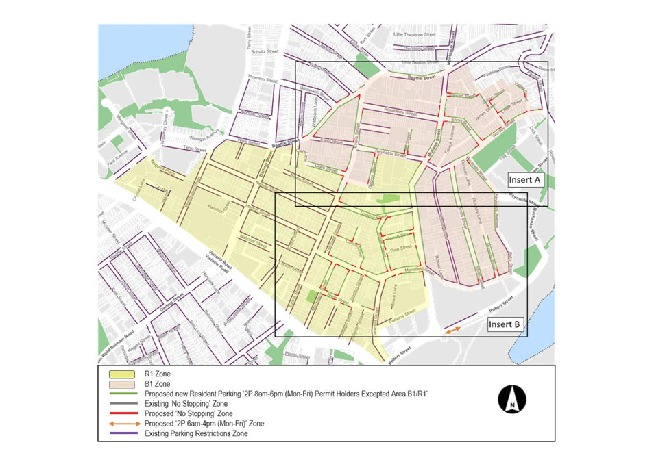
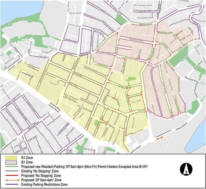
Council at its meeting on 12 April 2022 adopted the Rozelle North Precinct Parking study. As part of the study, both short and long term strategies were developed including the expansion of the existing Resident Parking Scheme (RPS) to residential streets within the Rozelle North Precinct (R1 or B1 Zone) and to introduce eight (8) time restricted parking in Robert Street to provide a higher visitor turnover to support local businesses. This report provides details of the proposed parking changes.
|
RECOMMENDATION
That:
1. The proposed ‘2P 8am-6pm Mon-Fri Permit Holders Excepted area R1’ be installed on sections of Evans Street, Clare Street, George Street, Goodsir Street, Collins Street, Moore Street, Perrett Street, Murdoch Street, Mansfield Street, Mackenzie Street, Brent Street, Hartley Street, and Mullens Street, as shown in the attached plan;
2. The proposed ‘2P 8am-6pm Mon-Fri Permit Holders Excepted area B1’ be installed on sections of Mullens Street, Stewart Street, Sutton Street, Valley Street, Davidson Street, Creek Street, Wortley Street, Reynolds Street, Reynolds Avenue, Rumsay Street, Smith Street, Beattie Street, Evans Street, Clare Street, Clay Street and George Street, as shown in the attached plan;
3. The existing time limit restrictions and hours of operation of current streets in the B1 zone that have an existing RPS will be retained, however, the restriction be converted to a B1 zone at the next permit renewal period.
4. ‘2P 6am-4pm Mon-Fri’ be installed for eight (8) parking spaces on the south side of Robert Street, east Mullens Street as outlined in the attached plan; and
5. Council’s Compliance Manager be informed of the parking changes in Balmain and Rozelle.
|
BACKGROUND
Council at its meeting on 12 April 2022 adopted the Rozelle North Precinct Parking Study which examined parking utilization in Rozelle and Balmain. The study developed short and long term strategies for managing parking in this area. The highest priority items from the Parking Study for implementation are:
· Resident Parking scheme (RPS) be expanded to include the additional streets in the R1 Zone and B1 Zone as identified in the report with ‘2P 8am-6pm (Mon-Fri) Permit Holders Excepted Area R1’ signposting in those streets not currently signposted with an RPS in the R1 Zone and ‘2P 8am-6pm (Mon-Fri) Permit Holders Excepted Area B1’ signposting in those streets not currently signposted with an RPS in the B1 Zone.
· Convert 8 unrestricted parking spaces on the southern side of Robert Street immediately east of Mullens Street to ‘2P 6am-4pm Mon-Fri’
FINANCIAL IMPLICATIONS
The cost to implement the Rozelle North Precinct Parking Strategy will be funded from Council’s operational budget.
OTHER STAFF COMMENTS
The enclosed plan presents the proposed Resident Parking Scheme (RPS) expansion for Rozelle and Balmain. During development of the RPS expansion, some street frontages were retained as unrestricted parking to offer small opportunities for those who may not be eligible for parking permits, this includes some Commercial properties and reserves. Any existing mobility parking zones, timed restriction zones, loading zones, bus zones and others will be retained.
Resident will be notified prior to the signage installation to give adequate time to understand the Scheme and apply for permits. Information on parking permit eligibility, how to apply for permits and other information will be distributed to the community. The eligibility of resident parking permits will be in accordance with Council’s Policy (former Leichhardt Resident Parking Schemes Policy) and as outlined below:
|
Number of Off-street parking spaces at Property |
Number of Eligible Permit Type |
|
|
Resident Parking Permit |
Visitor Parking Permit |
|
|
0 |
2 |
1 |
|
1 |
1 |
1 |
|
2 or more |
0 |
1 |
Note:
1. Dual occupancies, multi dwelling housing and residential flat buildings, subdivisions into two or more lots and the strata subdivision of residential flat buildings, approved after January 2001, are NOT eligible to participate in Council’s Parking Permit Scheme.
2. Multi-dwelling units with visitor parking within the premises will not be issued visitor parking permits.
Any parking permit issuance anomaly that was historical will continue with the existing arrangement for the existing owner and will revert to the above eligibility for any future changes to the property ownership or development.
For new RPS signs ‘No Stopping’ zones must also be installed at all intersections (as per NSW Road Rules) without parking signage.
It is also proposed that the first eight (8) unrestricted angle parking on the south side of Robert Street, east of Mullens Street be converted to a ‘2P 6am-4pm Mon-Fri’ which is consistent with the existing restrictions on the north side.
PUBLIC CONSULTATION
During the Public Exhibition of the Rozelle North Precinct Parking Council posted 3,886 letters to residents, businesses, organisations and institutions in November and December 2020 inviting to participate in an online questionnaire on the study. Members of the public could also request a paper-based copy of the questionnaire.
A total of 334 submissions were received, with the main findings as follows:
· Strong support that the Resident Permit Parking Scheme be extended to include the entire Rozelle North Study Area.
· Concerned with parking associated with non- residents including commuter parking, school parking and lack of enforcement of current restrictions.
· Concerned with parking too close to intersections and across driveways and inability for workers to park more than the existing 2 hour restrictions.
|
1.⇩ |
Rozelle North RPS Signage Plan |
|
Local Traffic Committee Meeting 21 November 2022 |
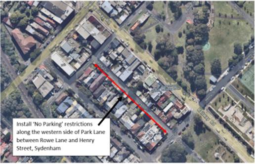
Subject: Park Lane, Sydenham - Proposed installation of 'No Parking' restrictions western side between Henry Street and Rowe Lane (MIDJUBURI – MARRICKVILLE WARD / HEFFRON ELECTORATE / INNER WEST PAC)
Prepared By: Jennifer Adams - Engineer – Traffic and Parking Services
Authorised By: Manod Wickramasinghe - Traffic and Transport Manager
SUMMARY
Requests have been received from residents of Railway Road, Sydenham for the installation of ‘No Parking’ restrictions on the western side of Park Lane, to improve vehicular access to their off-street parking space at the rear of their property. On investigation it was found that there are no parking spaces on the western side of the laneway which did not interfere with driveway/off-street access for properties on the eastern side of the laneway. Residents have been notified of the proposal to install ‘No Parking’ signs on the west side of Park Lane. It is recommended that the proposal be approved.
|
RECOMMENDATION
That the installation of a full-time ‘No Parking’ zone on the western side of Park Lane, between Henry Street and Rowe Lane, Sydenham be APPROVED to provide clear vehicular access to the residents’ off-street car parking spaces.
|
BACKGROUND
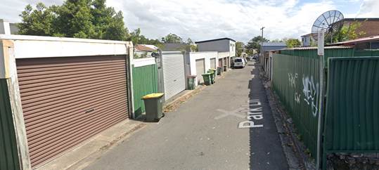
Council Officers have been advised by residents that vehicles are regularly parked opposite their off-street car parking spaces in Park Lane, which makes it difficult to enter and exit their off-street car parking space. On investigation it was found that there are no parking spaces on the western side of the laneway which did not interfere with driveway/off-street access for properties on the eastern side of the laneway. In order to alleviate this issue Council is proposing to install ‘No Parking’ restrictions along the western side of Park Lane, Sydenham between Rowe Lane and Henry Street. Please refer to the diagram below.
‘No Parking’ restrictions prohibit motorists from parking within the specified zone, however, motorists may legally stop for the purposes of loading/unloading passengers and/or goods.
DISCUSSION
Park Lane is approximately 5.3 metres in width and runs east-west between Henry Street and Rowe Lane. Park Lane provides rear access to properties fronting Park Road and Railway Road, therefore, there are driveways located on both sides of the road.
In 2015 Council installed full-time ‘No Parking’ restrictions on the eastern side of Park Lane, between Henry Street and Rowe Lane, Sydenham in order to provide clear vehicular access to the residents’ off-street car parking space,
It is noted that there are an equal amount of garages/driveways located along both sides of Park Lane. A site inspection undertaken by a Council Officer revealed that it was observed that several vehicles were parked in front of garages/off-street parking spaces in addition to any legal parking spaces in Park Lane. However, some of these parking spaces are located opposite driveways and when a vehicle is parked in these spaces it does not leave sufficient space for residents to enter/exit from their garages/off-street parking spaces due to the narrow carriageway.
Further, it should be noted that laneways were generally built to provide service access for commercial properties and access into off-street parking facilities. Prohibiting parking in the laneway will help achieve this goal.
FINANCIAL IMPLICATIONS
The costs of installation of the ‘No Parking’ restrictions as recommended can be funded within Council’s operational signs and line marking budget.
PUBLIC CONSULTATION
A notification letter was hand delivered on 29 September 2022 to owners and occupiers of Park Road and Railway Road between Henry Street and Rowe Lane, Sydenham regarding the proposal to install a full-time ‘No Parking’ zone on the west side of Park Lane. The closing date for submissions ended on 28 October 2022. 45 letters were distributed.
A total of six (6) responses were received from residents, representing a 7.5% return. Of these submissions, three (3) responses were received in opposition of the proposed 'No Parking' restrictions and three (3) responses were received in support.
|
Comments from respondent |
Council’s Officer comments |
|
|
|
|
Resident is concerned by the proposal as it will remove parking at the back of their property and effect their ability to park work related vehicles. |
Noted |
|
Resident does not support the proposal due to the fact the ‘No Parking’ will not allow them to park in front of their off-street parking space in the lane. |
It should be noted that laneways were generally built to provide service access for properties and access into off-street parking facilities |
|
The resident queried why remove all parking in Park Lane. Resident is concerned the proposal will result in loss of parking spaces for the residents of Railway Road who are not eligible for residential parking permits. Resident advised that the few limited parking spaces are getting used by commuters and residents are being penalised by loss of parking. |
It is noted that the parking of vehicles on the west side of the laneway can restrict access to off-street parking spaces, which may result in more vehicles being parked on the road, if these garages are not utilised. It should be noted that laneways were generally built to provide service access for properties and access into off-street parking facilities |
Comments from resident in support of ‘No Parking’ restrictions
|
Comments from respondent |
Council’s Officer comments |
|
Resident supports the proposal for ‘No Parking’ restrictions on both sides of Park Lane as they frequently experience vehicular access difficulties to their off-street parking space due to vehicles parking directly opposite their driveway and/or adjacent to one another on both sides of the road. |
Noted. It should be noted that laneways were generally built to provide service access for properties and access into off-street parking facilities |
|
Resident fully supports ‘No Parking’ restrictions on both sides of the laneway as they have experienced ongoing issues with parked cars blocking entry and exit to their property for numerous years day and night. |
|
|
Resident fully supports ‘No Parking’ restrictions on both sides of the laneway as they state that “their garage exit is constantly blocked due to vehicles parked where they need to swing out of their garage’. |
CONCLUSION
In order to provide clear vehicular access to all residents’ off-street car parking space(s), it is recommended that a full-time ‘No Parking’ zone be installed on the west side of Park Lane, between Henry Street and Rowe Lane, Sydenham.
|
|
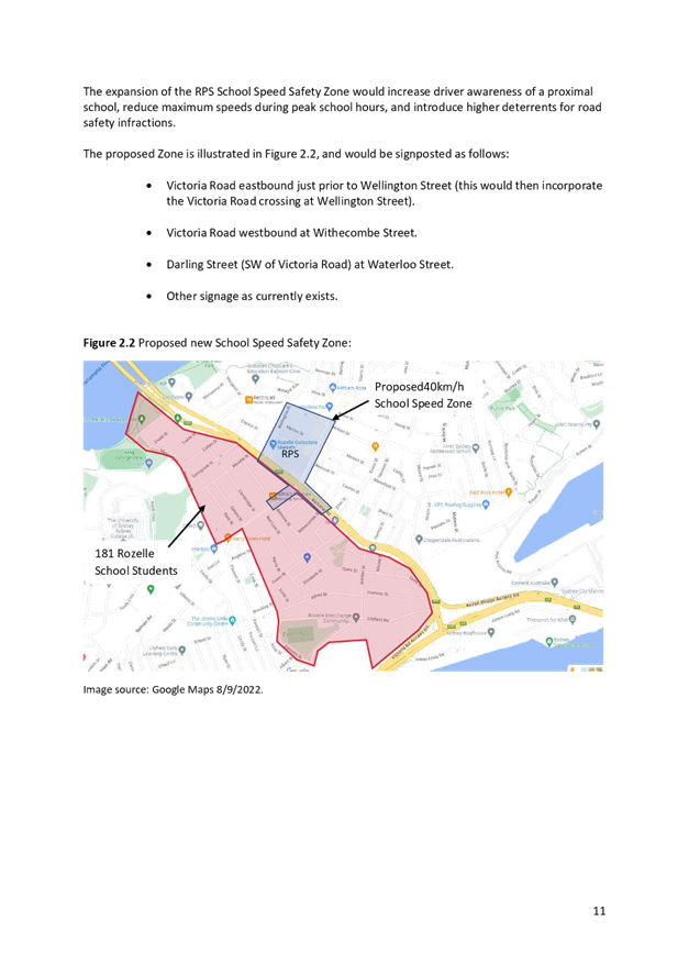
Local Traffic Committee Meeting 21 November 2022 |
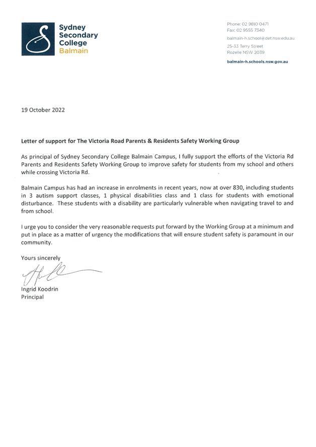
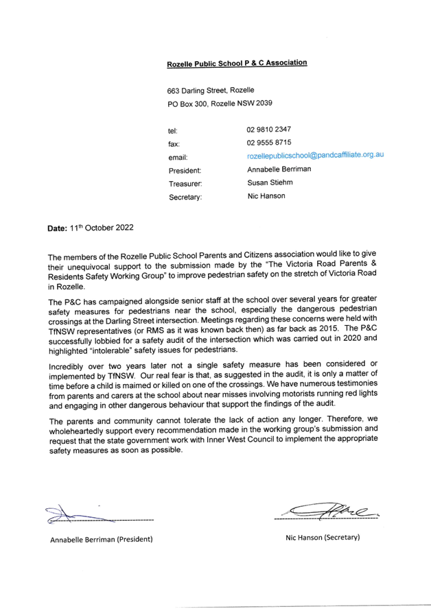
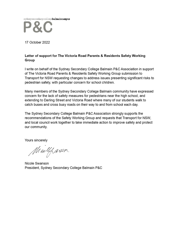
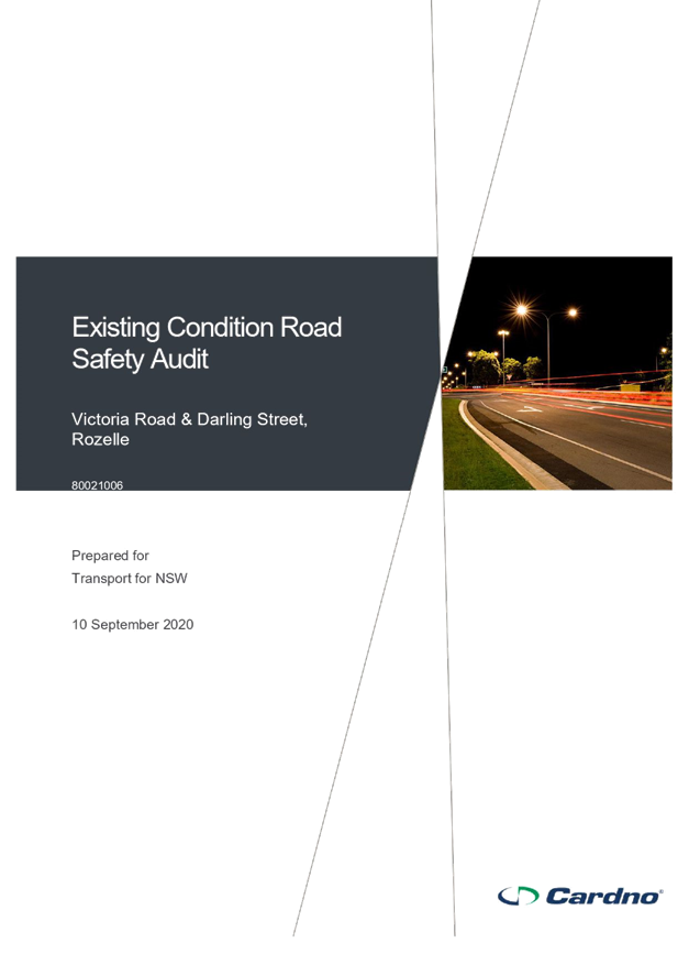
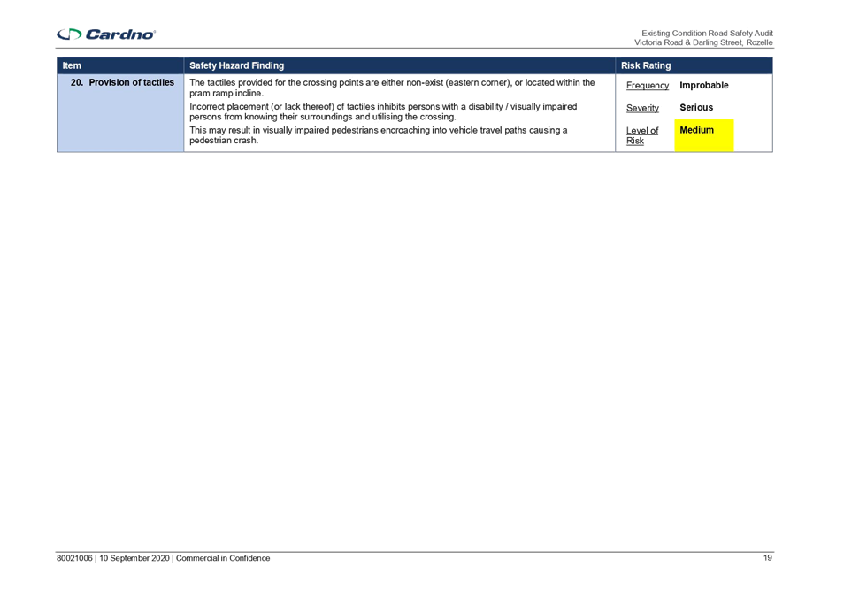
Subject: Rozelle Public School - Road Safety Improvements (Baludarri-Balmain Ward/Balmain Electorate/Leichhardt PAC
Prepared By: Jason Scoufis - Traffic and Parking Planner
Authorised By: Manod Wickramasinghe - Traffic and Transport Planning Manager
SUMMARY
Council has received representations from The Victoria Road Parents & Residents Safety Working Group who have submitted a report to TfNSW outlining a number of road safety concerns in and around Victoria Road along the frontage of Rozelle Public School. Whilst these concerns relate to issues under the care and control of TfNSW this report is provided as information only.
|
RECOMMENDATION
That the report be received and noted.
|
BACKGROUND
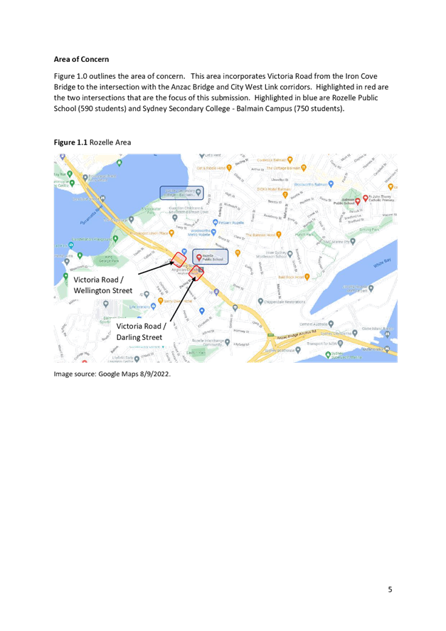
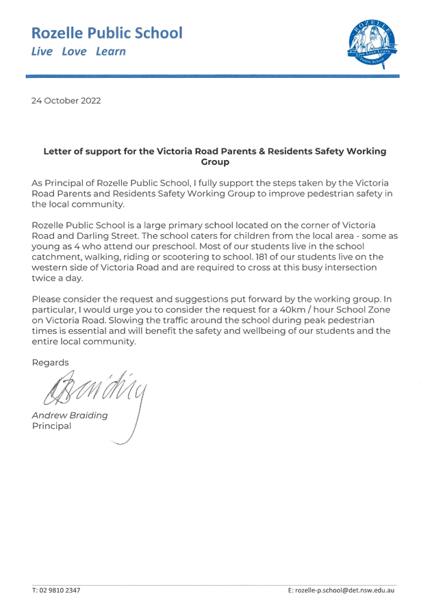
Council has received representations from The Victoria Road Parents & Residents Safety Working Group who have submitted a report to TfNSW outlining a number of road safety concerns in and around Victoria Road along the frontage of Rozelle Public School.
A copy of the report submitted to TfNSW is attached.
This submission requests TfNSW as a minimum undertake the following improvements:
· Extend the 40 km School Zone along the frontage of Rozelle Public School to include Victoria Road from the Victoria Road / Darling Street intersection to the Victoria Road /Wellington Street intersection.
· Modify the traffic signal phasing at Victoria Road/Darling Street to allow pedestrians to cross Victoria Road without needing to compete with left turning vehicle movements onto Victoria Road.
· Relocate the existing Red Light Speed Safety Camera from the intersection of Victoria Road and Evans Street to the intersection of Victoria Road and Darling Street.
· Install barriers or bollards on the kerb returns at Victoria Road/Darling Street intersection.
Some of these concerns were also highlighted in the Rozelle North LATM that the Local Traffic Committee considered at its meeting held 15th August 2022. As part of the Rozelle North LATM, the Traffic Committee recommended the following in relation to Victoria Road, which has subsequently been endorsed by Council:
· TfNSW be requested to investigate implementing a 40 km/h School Zone along the frontage of Rozelle Public School in Victoria Road.
· TfNSW be requested to investigate adjustment to the traffic signals at the Victoria Road/Wellington Street to reduce traffic delays/queuing in Wellington Street and provide safer conditions for pedestrians crossing Victoria Road.
It should also be noted that at the Council meeting held on 25 October 2022, Council considered a Notice of Motion regarding pedestrian safety on Victoria Road and Darling Street, Rozelle and resolved to write to Transport for NSW to request the following improvements:
· Reiterate the need to investigate implementing a 40km/h School Zone between Wellington Street and Withcombe Street on Victoria Road;
· Investigate changing the light filtering pattern to remove competition between pedestrians and motorists turning left onto Victoria Road;
· Install a Red Light Speed Safety Camera at the intersection of Victoria Road and Darling Street; and
· Investigates where bollards or barriers may be installed on corner kerbs of the intersection to protect pedestrians
FINANCIAL IMPLICATIONS
Nil
PUBLIC CONSULTATION
Nil
|
1.⇩ |
Victoria Road Parents & Residents Safety Working Group Submission to TfNSW |