|
AGENDA R |

Local Traffic Committee Meeting
MONDAY 15 MAY 2023
11.00am
|
|
Local Traffic Committee Meeting 15 May 2023 |
Function of the Local Traffic Committee
Background
Roads and Maritime Services (RMS) is legislated as the Authority responsible for the control of traffic on all NSW Roads. The RMS has delegated certain aspects of the control of traffic on local roads to councils. To exercise this delegation, councils must establish a local traffic committee and obtain the advice of the RMS and Police. The Inner West Council Local Traffic Committee has been constituted by Council as a result of the delegation granted by the RMS pursuant to Section 50 of the Transport Administration Act 1988.
Role of the Committee
The Local Traffic Committee is primarily a technical review and advisory committee which considers the technical merits of proposals and ensures that current technical guidelines are considered. It provides recommendations to Council on traffic and parking control matters and on the provision of traffic control facilities and prescribed traffic control devices for which Council has delegated authority. These matters are dealt with under Part A of the agenda and require Council to consider exercising its delegation.
In addition to its formal role as the Local Traffic Committee, the Committee may also be requested to provide informal traffic engineering advice on traffic matters not requiring Council to exercise its delegated function at that point in time, for example, advice to Council’s Development Assessment Section on traffic generating developments. These matters are dealt with under Part C of the agenda and are for information or advice only and do not require Council to exercise its delegation.
Committee Delegations
The Local Traffic Committee has no decision-making powers. The Council must refer all traffic related matters to the Local Traffic Committee prior to exercising its delegated functions. Matters related to State Roads or functions that have not been delegated to Council must be referred directly to the RMS or relevant organisation.
The Committee provides recommendations to Council. Should Council wish to act contrary to the advice of the Committee or if that advice is not supported unanimously by the Committee members, then the Police or RMS have an opportunity to appeal to the Regional Traffic Committee.
Committee Membership & Voting
Formal voting membership comprises the following:
· one representative of Council as nominated by Council;
· one representative of the NSW Police from each Local Area Command (LAC) within the LGA, being Newtown, Marrickville, Leichhardt and Ashfield LAC’s.
· one representative from the RMS; and
· State Members of Parliament (MP) for the electorates of Summer Hill, Newtown, Heffron, Canterbury, Strathfield and Balmain or their nominees.
Where the Council area is represented by more than one MP or covered by more than one Police LAC, representatives are only permitted to vote on matters which effect their electorate or LAC.
Informal (non-voting) advisors from within Council or external authorities may also attend Committee meetings to provide expert advice.
Committee Chair
Council’s representative will chair the meetings.
Public Participation
Members of the public or other stakeholders may address the Committee on agenda items to be considered by the Committee. The format and number of presentations is at the discretion of the Chairperson and is generally limited to 3 minutes per speaker. Committee debate on agenda items is not open to the public.
|
|
Local Traffic Committee Meeting 15 May 2023 |
|
AGENDA |
1 Apologies
2 Disclosures of Interest
3 Confirmation of Minutes
Minutes of 17 April 2023 Local Traffic Committee Meeting 5
4 Matters Arising from Council’s Resolution of Minutes
5 Part A – Items Where Council May Exercise Its Delegated Functions
Traffic Matters
ITEM Page
LTC0523(1) Item 1 Livingstone Road cycle way upgrades and safety improvements review – C1222(2) Item 26 (Midjuburi-Marrickville Ward/Summer Hill Electorate/Inner West LAC) 12
LTC0523(1) Item 2 The Esplanade, Ashfield - "STOP" sign and holding line (Djarrawunang - Ashfield Ward / Summer Hill Electorate / Burwood PAC) 20
LTC0523(1) Item 3 Withecombe Street and Ellen Street, Rozelle - Proposed 'Trucks Prohibited, Over 3t GVM' restrictions (Baludarri-Balmain Ward/ Balmain Electorate/ Leichhardt PAC) 23
LTC0523(1) Item 4 West Street, Petersham – Pedestrian Safety Improvement Works – raised pedestrian crossing - Design Plan 10240-A Project 303082 (DAMUN - STANMORE WARD/ NEWTOWN ELECTORATE/ INNER WEST PAC) 30
LTC0523(1) Item 5 West Street, Petersham at the intersection of The Boulevarde – Pedestrian Safety Improvement Works – proposed raised pedestrian crossing - Design Plan 10241 Project 303082 (DAMUN - STANMORE WARD/ NEWTOWN ELECTORATE/ INNER WEST PAC) 35
LTC0523(1) Item 6 728-750 Princes Highway, Tempe – Bunnings – ENR1/2021/0035 Special Condition 3 – Signage and Line Marking Plans – MOD20220424 (MIDJUBURI - MARRICKVILLE WARD /HEFFRON ELECTORATE /INNER WEST PAC) 39
Parking Matters
ITEM Page
LTC0523(1) Item 7 Fawcett Street, Balmain - Proposed 'No Parking' Restrictions (Baludarri - Balmain Ward/ Balmain Electorate/ Leichhardt PAC) 44
Late Items
Nil at time of printing.
6 Part B - Items for Information Only
Nil at the time of printing.
7 Part C - Items for General Advice
Nil at the time of printing.
8 General Business
9 Close of Meeting
|
|
Local Traffic Committee Meeting 15 May 2023 |
Minutes of Local Traffic Committee Meeting
Held on 17 April 2023 at Ashfield Service Centre
Meeting commenced at 11.00am
ACKNOWLEDGEMENT OF COUNTRY BY CHAIRPERSON
I acknowledge the Gadigal and Wangal people of the Eora nation on whose country we are meeting today, and their elders past and present.
COMMITTEE REPRESENTATIVES PRESENT
|
Mayor Darcy Byrne |
Councillor – Baludarri-Balmain Ward (Chair) |
|
Bill Holliday |
Representative for Kobi Shetty MP, Member for Balmain |
|
Graeme McKay |
Representative for Jo Haylen MP, Member for Summer Hill |
|
Sgt Charles Buttrose |
NSW Police – Leichhardt Police Area Command |
|
|
|
|
NON VOTING MEMBERS IN ATTENDANCE |
|
|
|
|
|
Colin Jones |
Inner West Bicycle Coalition (IWBC) |
|
Sunny Jo |
IWC’s Acting Traffic and Transport Services Manager |
|
Jason Scoufis |
IWC’s Traffic and Parking Planner |
|
Jenny Adams |
IWC’s Acting Coordinator Traffic Engineering Services (South) |
|
Felicia Lau |
IWC’s Acting Coordinator Traffic Engineering Services (North) |
|
Christina Ip |
IWC’s Business Administration Officer |
|
|
|
|
VISITORS |
|
|
|
|
|
Nil. |
|
|
|
|
|
APOLOGIES: |
|
|
|
|
|
Patricia Arcilla |
Representative for Jenny Leong MP, Member for Newtown |
|
Jason Yat-sen Li MP |
Member for Strathfield |
|
Manod Wickramasinghe |
IWC’s Acting Director Infrastructure |
|
George Tsaprounis |
IWC’s Coordinator Traffic Engineering Services (South) |
|
|
|
DISCLOSURES OF INTERESTS:
Nil.
CONFIRMATION OF MINUTES
|
The Minutes of the Local Traffic Committee meeting held on 20 March 2023 were confirmed. |
MATTERS ARISING FROM COUNCIL’S RESOLUTION OF MINUTES
The Local Traffic Committee recommendations of its meeting held on 20 March 2023 were adopted at Council’s meeting on 11 April 2023.
General Business
Meeting closed at 11.29am.
|
|
Local Traffic Committee Meeting 15 May 2023 |
Subject: Livingstone Road cycle way upgrades and safety improvements review – C1222(2) Item 26 (Midjuburi-Marrickville Ward/Summer Hill Electorate/Inner West LAC)
Prepared By: Jennifer Adams - Engineer – Traffic and Parking Services
Authorised By: Manod Wickramasinghe - Traffic and Transport Planning Manager
SUMMARY
A review of Livingstone Road cycle way (Marrickville - Local Bicycle Route 3 (LR03) Frazer Park to Marrickville Road) has been undertaken and the findings of the review are detailed in this report along with recommendations for consideration in construction of any future cycleways in the Inner West.
|
That:
1. The report be received and noted.
2. The noted enhancements to the Livingstone Road Cycleway, be considered as part of Council’s draft Cycling Action Plan (subject to detailed design and further consultation with affected residents at each location) |
BACKGROUND
That Council:
1. Undertake and table a review of the Livingstone Road Cycle Way at the Local Traffic Committee that responds to concerns that have been raised by Bike Marrickville, the Inner West Bicycle Coalition, and residents, and ensure the review details learnings from the project and lists possible areas for improvement;
2. In the meantime, undertake any minor works identified by staff to improve pedestrian and cyclist safety, including improvements to signage and line markings; and
3. Include as part of the review costs associated with any future potential improvement works, including options for funding sources.
This report details the background of the Local Route 3 (LR3) bicycle route and discusses the outcome of the initial review undertaken by Council, possible future enhancements and outlines learnings from the project.
Works orders have already been submitted for short term minor improvement works to respective signage and line markings. Costs associated with future longer term improvement works are provided for consideration.
DISCUSSION
Local Route 3 (LR3) bicycle route, identified in Council’s Bicycle Plan, is located along Livingstone Road, from Randall Street to Marrickville Park.
Lambert & Rehbein were engaged by (former) Marrickville Council to prepare a concept design of the proposed bicycle route located along Livingstone Road, Marrickville; between the Bankstown rail line and Marrickville Park; as highlighted in the Marrickville Bicycle Plan (2007).
Following approval of the concept plans, draft detailed design plans were developed for community engagement. The community was again invited to provide feedback on the plans from 6 August 2018 to 7 September 2018. The feedback received was predominantly positive and, with a few exceptions, only minor adjustments to the plans were requested. A Road Safety Audit was also completed, and the findings of the audit were incorporated in the final design.
The concept design and detail design of the project was funded (75%) by the NSW Government’s Active Transport Program (Priority Cycleways) and (25%) by Council. Council was also provided 50-50 funding from TfNSW for construction under the Active Transport Program.
The project was delivered in two sections:
· Section 1 – Livingstone Road from Marrickville Park to Marrickville Road
· Section 2 – Livingstone Road from Marrickville Road to Randall Street
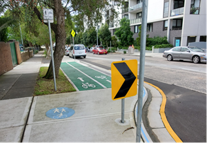
The new cycleway was fully completed in August 2022 and is located on the western side of Livingstone Road and includes a bi-directional separated cycleway and sections of shared paths where there isn’t enough space to build a separated cycleway. Shared environment intersections at some street crossings, footpath improvements and landscaping were also included to improve facilities and safety for both cyclists and pedestrians.
With the recent completion of the construction and subsequent feedback from local residents and representatives of Bike Marrickville and the Inner West Bicycle Coalition, it has been proposed to undertake a review of the performance of the design, to identify any safety or amenity issues that could not be readily identified during the design phase, and to document the learning outcomes for all future designs of cycle facilities as the cycle network develops over the Inner West road network.
Short term improvements (Line marking/signage improvements):
Initial short term improvements (mainly minor signage and line marking works) identified for remedial action are listed below. It is noted that Works Orders have already been submitted for these minor works and most are completed to date.
· Remark faded bicycle linemarking outside of Marrickville Park
· Provide cyclist-facing Give Way sign improvements at the following locations
o At Pile Street/Livingstone Road intersection - raise signs to minimum 2m from ground
o At George Street/Livingstone Road intersection - raise signs to minimum 2m from ground
o At Enfield Street - replace missing north bound Cyclist Giveaway sign and raise south bound Cyclist Giveaway sign to min 2m from ground and turn to face cyclists
· Remove existing Chevron sign and reinstall smaller Chevron sign closer to the travel lane and apply reflective tape to back of sign at No. 113/115 Livingstone Road and opposite the Marrickville Library driveway
· Replace missing give way line at Hasting Street (for vehicles)
· Repair slanted stem containing ‘bicycles/pedestrian path separated’ sign at Hastings Lane
· Apply new reflective tape (yellow) on Livingstone Road power poles (at 21 identified locations)
· Apply reflective tape on tree branch 159 Livingstone Road; and opposite Marrickville library driveway; and 161 Livingstone Road
· Remove stem with street signs on the southwest corner of the Livingstone Road/Marrickville Road intersection and move single directional sign to power pole
· Replace missing street blade at Randell Street
Long term improvements
The longer-term improvements are listed below. Indicative costs are given for the identified works. It is noted that a detailed survey, design and assessment of each of these longer term improvements needs to be undertaken, for example some of the crossings may require a bullnose to prevent vehicle scraping.
|
Concern noted |
Officer Comment |
|
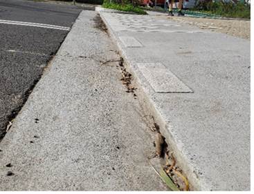
Bullnose on raised threshold ramps Lips on the edge of raised threshold ramps are too high at some locations and can damage bicycle wheels. Locations include the raised threshold on Hastings Street at Livingstone Road and on the Livingstone Road side of the ramp to Hastings Lane.
|
The ramps at Hastings Street and Hastings Lane can be modified to remove the bullnose and provide a smoother riding experience. Estimated cost: $20,000 |
|
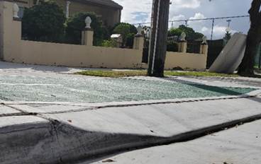
Bullnose on ramps to driveways The raised lip (bullnose) on some driveway ramps may create a hazard to cyclists entering the cycleway particular when entering at an acute angle.
|
These concerns were addressed for Stage 2 works as part of the lessons learnt during Stage 1.
The existing driveways in Stage 1 can be redesigned to remove the bullnose and improve the transition between the cycleway and driveway levels to provide a smoother riding experience.
Estimated cost: Up to $100,000 |
|
Transition between cycleway and driveways Driveway crossings are lower than the path on either side of the driveway and a rider moves up and down whilst travelling along the cycleway, thus creating a poor riding experience.
|
|
|
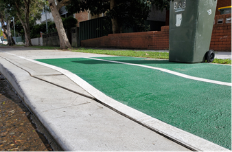
Cycleway transition points
At several points the path transitions from dedicated
cycle path to shared path and additional concrete is requested to assist with
the transition.
|
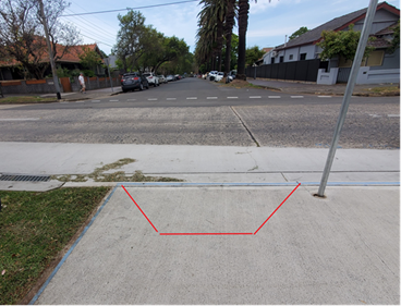
It is feasible to provide an additional concrete pad to allow transition from shared path to cycleway. Six locations were identified for these improvements.
Estimated Cost: $5,000
|
|
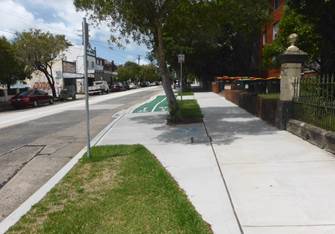
Lack of access points to the cycleway
There are limited access points to enable someone riding a bicycle to enter or leave the cycle path from side streets on the opposite side of the road. For example, Livingstone Road at Graham Avenue.
|
An access point from Graham Avenue into the cycleway can be provided through the provision of new kerb ramp.
Access from Hawkhurst Street and Stanley Street can be provided with a modification to an existing driveway lip to remove the bullnose.
Estimated cost: $7,000 Access from Francis Street is provided via the existing pedestrian crossing and a kerb ramp cannot be provided without impacting levels on the dedicated cycleway.
|
|
Signage and poles
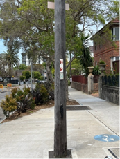
There are signage and pole obstructions along the cycleway that can create a hazard for cyclists. This includes a power pole in the middle of the path near the intersection of Hawkhurst Street and Livingstone Road.
Additionally low chevron signs and street signs are partially obstructing the cycleway.
|
Minor obstructions in the path have been cleared as part of the short term works. Relocating the additional powerpole is expected to attract significant costs ($30,000 - $70,000) and is subject to Ausgrid approval. The existing design attempts to provide sufficient space within the shared path area to allow cyclists to manouevre around both the powerpole and pedestrians. Reflective tape is being provided on this powerpole and all other identified hazards along the cycleway.
|
|
Cycle priority across side streets
Intersection priority across side streets should be reviewed with a view to provide cyclist priority at all unsignalised intersections. Intersections to review include the intersections of Livingstone Road with Pile Street, Robert Street, George Street, and Enfield Street.
Differences in priority across different intersections along the cycleway may create confusion for both drivers entering/leaving the side street and for people on the cycleway as to who has priority.
|
The design considered providing cyclist priority where feasible and allowable under the applicable TfNSW warrants for continuous footpaths. This request would require further review to determine if additional intersections could be upgraded and if approval would be provided by TfNSW. Estimated cost: Currently unknown, further review required. |
|
Pedestrian grates
Pedestrian grates should be extended to overlap the garden bed to prevent bicycle wheels falling into the crevice, e.g. at the intersection of Livingstone Road and Enfield Street.
|
This appears to occur at pedestrian grates already in place prior to the cycleway works and these can be retrofitted with new pedestrian grates to alleviate the issue. Estimated cost: $7,000 |
|
Extension of cycleway
It was requested that a temporary shared path along Livingstone Road between Randall Street and Albermarle Street be provided to connect the Livingstone Road cycleway to the Albermarle Street mixed traffic environment.
|
The Livingstone Road cycleway currently ends at Randall Street at its southern end. The cycle route will in future connect to the East West Pedestrian and Cycle Link (EWPCL) from Bankstown to Sydenham as part of the Sydney Metro works. The EWPCL will connect to Livingstone Road via Randall Street and so no additional shared path is proposed at this time. |
|
Pedestrian crossing improvements
Some pedestrian crossings along the route lack pedestrian gutter bridges. |
It is feasible to partially reconstruct pedestrian crossings on Livingstone Road outside No.240 and No.204 Livingstone Road to install pedestrian gutter bridge on the south side and extend the garden bed into the ‘No Stopping’ zone.
Estimated Cost: $60,000
|
FINANCIAL IMPLICATIONS
A base estimate of $200,000 would be required for the identified works noted above and funding for these will have to be considered in Council’s Bicycle Strategy and Action Plan so as to identify priority of future funding for the works.
LR3 cycleway – Lessons LEARNT
Through the construction of the Livingstone Road cycleway, lessons learnt during Stage 1 were incorporated into Stage 2 of works. These lessons learnt will be incorporated into future cycleway projects.
Cycleway/ Shared Path transitions – smooth and extended transitions to direct cyclists between dedicated cycle paths and shared paths should be provided where practical. It is also important to better consider side street interfaces to allow ingress and egress opportunities to the cycle path where it can be practically accommodated.
Driveway transition grades – transition grades between cycle path and driveway levels should be minimised were practical to improve amenity and comfort for cyclists using the facility.
Scoping – Initial scoping needs to ensure pedestrian and cyclist issues immediately adjacent to the substantive project are identified so that it can be better considered in design.
Driveways and continuous footpaths – Driveways and raised threshold ramps should be constructed without a lip/bullnose where possible taking into consideration drainage and vehicle scraping issues. This will improve amenity and safety for cyclists using the facility.
Signs and poles – Further consideration on the impact of physical sign and pole locations on cyclist movements need to be considered. Signage and poles must be minimised or rationalised where possible and hazards delineated with reflective tape when in proximity to the cycleway. This will improve amenity and safety for cyclists using the facility.
Nil.
|
|
Local Traffic Committee Meeting 15 May 2023 |
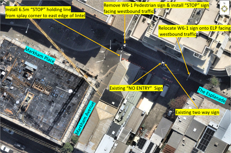
Subject: The Esplanade, Ashfield - "STOP" sign and holding line (Djarrawunang - Ashfield Ward / Summer Hill Electorate / Burwood PAC)
Prepared By: John Stephens - Engineer - Traffic and Parking Services
Authorised By: Manod Wickramasinghe - Traffic and Transport Planning Manager
SUMMARY
In response to concerns raised by local residents, Council proposes to install a ‘STOP’ sign and associated holding line in The Esplanade at the intersection of Markham Avenue and Markham Place, Ashfield.
|
RECOMMENDATION
That:
1. That the existing Pedestrian sign (W6-1) on the northern side of The Esplanade at the intersection of Markham Avenue and Markham Place, Ashfield be removed and replaced with a “STOP” sign facing westbound traffic;
2. That a 6.5m “STOP” holding line be installed from the western splay corner of 315 Liverpool Road towards the eastern edge of the drainage pit lintel located outside the boundary of Nos.17-20 The Esplanade and No.1 Markham Place; and
3. That the Pedestrian sign (W6-1) be relocated to the electric light pole (ASH-P02A) on the northern side outside Nos.17-20 The Esplanade, Ashfield. |
BACKGROUND
Council has received concerns from local residents about pedestrian safety when attempting to cross The Esplanade from Markham Avenue (a pedestrian thoroughfare from Liverpool Road) and there is no pedestrian crossing.
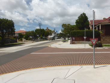
The Esplanade is zoned as a 40km/h High Pedestrian Activity Area and traffic is generally restricted to a one-way movement in a westerly direction from Fox Lane to Markham Place, except for a short section between Markham Place and the driveway to Nos.17-20 The Esplanade. This allows for eastbound traffic from Markham Place to only access the driveway of the apartments at Nos. 17-20 The Esplanade. Traffic exiting the apartments must turn right into Markham Place and travel westbound towards Cavill Avenue and Liverpool Road.
Diagram:
FINANCIAL IMPLICATIONS
The cost of installation of the signage and linemarking can be funded from Council’s operational signs and linemarking budget.
OTHER STAFF COMMENTS
A recent inspection of the site indicated that sightlines for pedestrians crossing The Esplanade from Markham Avenue to view westbound motorists were poor and vice versa due to the existing building alignments and no southern footpath to provide a safe buffer for pedestrians.
The construction of a large development involving several properties was also occurring on the southern side of Markham Place immediately west of Markham Avenue and this will increase pedestrian activity at this location in the future.
However, in the short term, to improve crossing conditions for pedestrians, it is proposed to install a ‘STOP’ sign and associated holding line in The Esplanade at the intersection of Markham Avenue and Markham Place.
PUBLIC CONSULTATION
As there is no loss of parking associated with the proposal, a notification letter will be sent to nearby properties, advising of the proposed installation of the “STOP” signage and linemarking.
CONCLUSION
In order to provide a safer crossing point for pedestrians crossing from Markham Avenue across The Esplanade, it is recommended that the proposed ‘STOP’ sign and associated holding line should be installed in The Esplanade at the intersection of Markham Avenue and Markham Place, Ashfield.
Nil.
|
|
Local Traffic Committee Meeting 15 May 2023 |
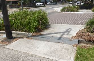
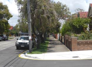
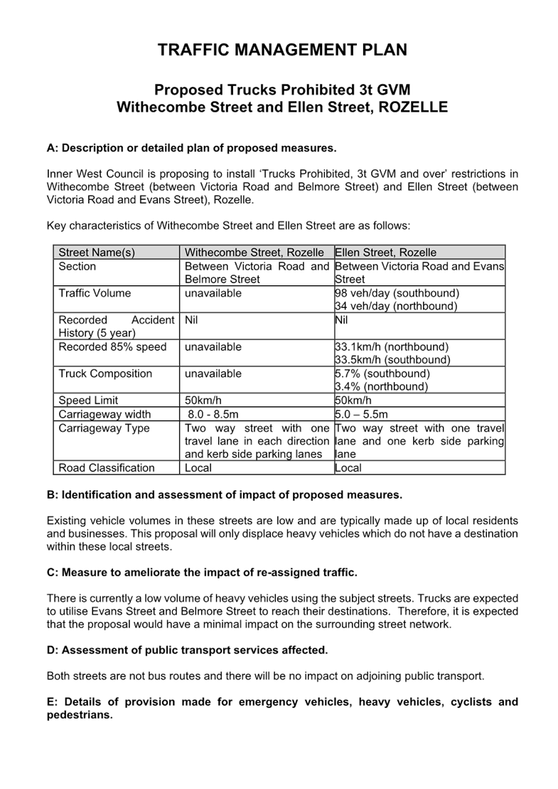
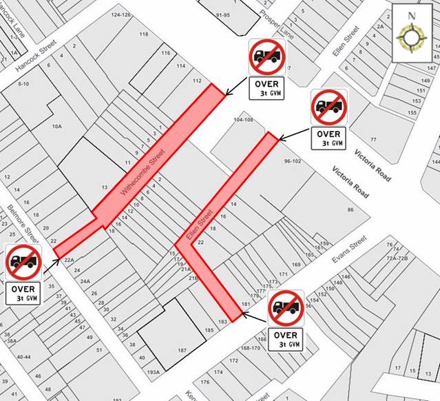
Subject: Withecombe Street and Ellen Street, Rozelle - Proposed 'Trucks Prohibited, Over 3t GVM' restrictions (Baludarri-Balmain Ward/ Balmain Electorate/ Leichhardt PAC)
Prepared By: Vinoth Srinivasan - Engineer - Traffic and Parking Services
Authorised By: Manod Wickramasinghe - Traffic and Transport Planning Manager
SUMMARY
Council has received concerns regarding trucks using Withecombe Street and Ellen Street and subsequently causing property damage in Withecombe Street and Ellen Street, Rozelle. In order to minimize damage from trucks, a ‘Trucks Prohibited Over 3t GVM’ restriction is proposed on Withecombe Street from Belmore Road to Victoria Road, and Ellen Street from Evans Street to Victoria Road.
|
RECOMMENDATION
THAT:
1. The proposed ‘Trucks Prohibited, Over 3t GVM’ zone be approved for the entire length of Withecombe Street, and Ellen Street, Rozelle between Evans Street to Victoria Road, subject to TfNSW approval of Traffic Management Plan; and
2. The ‘Trucks Prohibited, Over 3t GVM’ signs be installed at Victoria Road, Evans Street, and Belmore Street as per attached signage plan. |
BACKGROUND AND OTHER STAFF COMMENTS
Council has received concerns regarding trucks using Withecombe Street (between Victoria Road and Belmore Street) and Ellen Street (between Victoria Road and Evans Street) and subsequently causing property damage in Withecombe Street and Ellen Street, Rozelle.
Both Ellen Street and Withecombe Street provides access to commercials properties fronting Victoria Road and comprises of mainly residential properties. Both roads vary in width and have parking generally permitted on both sides of the road.
|
Street Name(s) |
Withecombe Street, Rozelle |
Ellen Street, Rozelle |
|
Section |
Between Victoria Road and Belmore Street |
Between Victoria Road and Evans Street |
|
Traffic Volume |
unavailable |
98 veh/day (southbound) 34 veh/day (northbound) |
|
Recorded Accident History (5 year) |
Nil |
Nil |
|
Recorded 85% speed |
unavailable |
33.1km/h (northbound) 33.5km/h (southbound) |
|
Truck Composition |
unavailable |
5.7% (southbound) 3.4% (northbound) |
|
Speed Limit |
50km/h |
50km/h |
|
Carriageway width |
8.0 - 8.5m |
5.0 – 5.5m |
|
Carriageway Type |
Two way street with one travel lane in each direction and kerb side parking lanes |
Two way street with one travel lane and one kerb side parking lane |
|
Road Classification |
Local |
Local |
The proposed load limit is proposed in Withecombe Street and Ellen Street, (south of Victoria Road) Rozelle is intended to protect properties from trucks the narrow intersection of Withecombe Street and Belmore Street and the narrow road bend at Ellen Street.
These restrictions indicate that a driver of a vehicle over 3 tonnes Gross Vehicle Mass (except the driver of a bus) must not drive past the ‘Trucks Prohibited’ sign. This rule does not apply if the driver has a destination which lies beyond the sign.
FINANCIAL IMPLICATIONS
Nil.
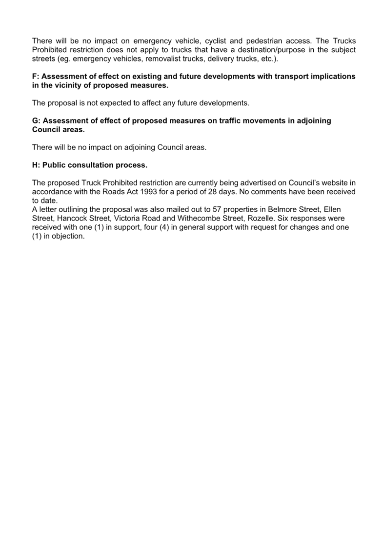
PUBLIC CONSULTATION
The proposed truck ban is currently being advertised on Council’s website in accordance with the Roads Act 1993 for a period of 28 days, via YourSay Inner West website.
A letter outlining the proposal was also mailed out to 57 properties in Belmore Street, Ellen Street, Hancock Street, Victoria Road and Withecombe Street, Rozelle. Six responses were received with one (1) in support, four (4) in general support with request for changes and one (1) in objection. The main concerns raised by the residents are outlined below in the table.
|
Residents’ Comments |
Officer Comments |
|
Council should implement a similar restriction on Hancock Street, Rozelle to prevent property damage and improvement of pedestrian safety. Hancock Street was previously signposted as ‘No Thoroughfare Large Vehicles’ and the sign was damaged and fell off after being regularly struck by large vehicles exiting Hancock Street on Victoria Street. |
The installation of ‘No Trucks, 3t GVM and over’ restrictions on Hancock Street, Rozelle will be investigated separately as part of the draft Rozelle Town Centre Mater Plan planned for public exhibition in June 2023.
|
|
Majority of properties facing Victoria Road are commercial properties that rely on larger truck access. Council should implement dedicated loading zones on Victoria Road in close proximity to these businesses to assist drivers in completing their deliveries without the need to turn into Withecombe Street. Alternatively Council can install the proposed ‘No Truck, 3t GVM and over’ restriction directly in front of No.1 Withecombe Street which will then give truck access to all the commercial properties facing Victoria Road. |
NSW Road Rules for load limit restrictions do not apply if the driver has a destination which lies beyond the ‘Trucks Prohibited’ sign and there is no other practical access to the destination.
|
|
Local businesses need to transport goods which require truck movements. There is a freight dimension to having shops, restaurants and other services close by which all add to a vibrant local economy. Council’s proposal will create an area that will be unfriendly to businesses and lead to larger vacant commercial/retail premises. |
The movement of goods and freight trucks are important and valued, however the proposed measures are intended to protect road assets and damage to private property as there are limited space at the intersection of Belmore Street and Withecombe Street. |
|
The proposed ‘No Truck, 3t GVM and over’ restriction does not pose a restriction on the length of the vehicle which is often the problem when trucks make a left-hand turn movement into Belmore Street from Withecombe Street. |
The restriction is intended to target small rigid and medium rigid trucks. Vehicles that are long and not exceeding 3t GVM are uncommon.
Belmore Street is one way northbound, hence left turn from Withecombe Street to Belmore Street is not permitted. |
|
Council should install additional signage directly in front of No.18 Withecombe Street that restricts trucks from traveling south on Withecombe Street that will prevent them from making a left-hand turn movement into Belmore Street. |
It should be noted that trucks with a legitimate destination in Withecombe Street will be exempted from the proposed truck ban. |
|
1.⇩ |
Traffic Management Plan Withecombe Street and Ellen Street Trucks Prohibited Over 3t GVM |
|
2.⇩ |
Withecombe Street and Ellen Street - Signage Plan |
|
Local Traffic Committee Meeting 15 May 2023 |
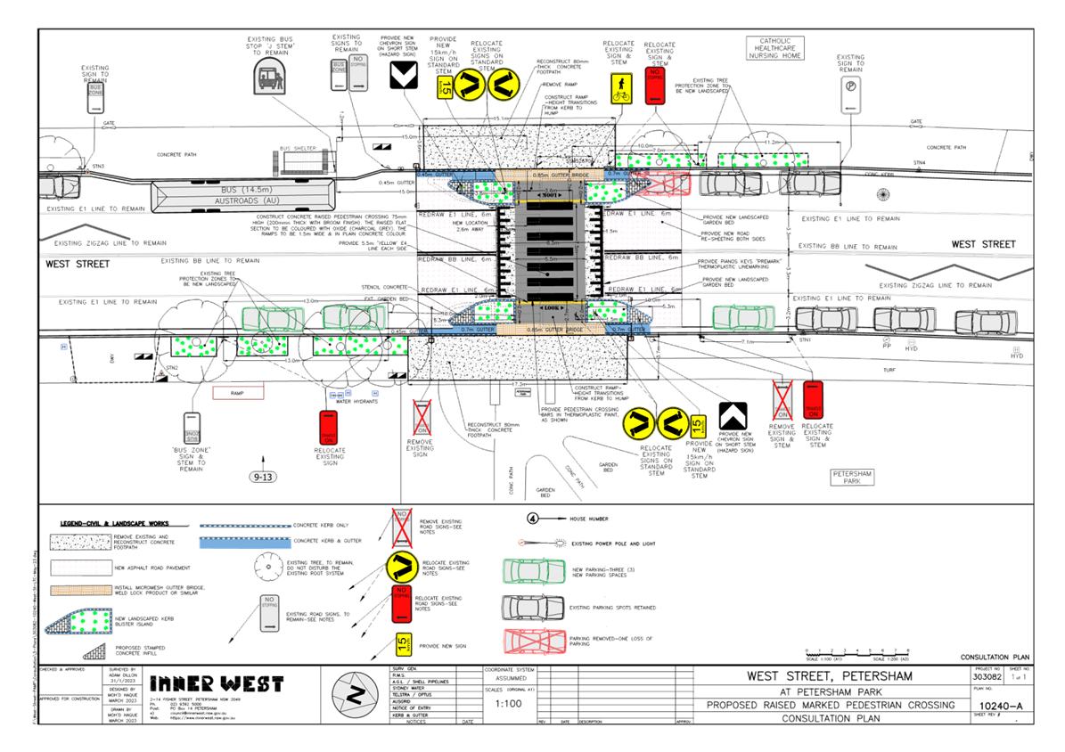
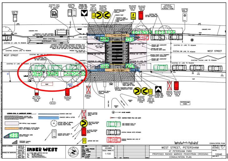
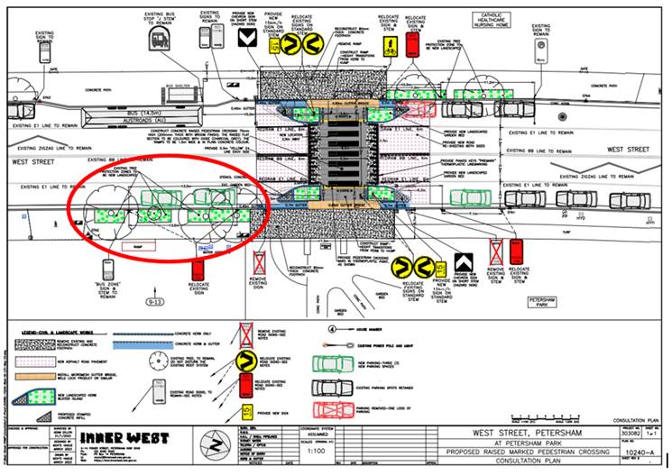
Subject: West Street, Petersham – Pedestrian Safety Improvement Works – raised pedestrian crossing - Design Plan 10240-A Project 303082 (DAMUN - STANMORE WARD/ NEWTOWN ELECTORATE/ INNER WEST PAC)
Prepared By: Jennifer Adams - Engineer – Traffic and Parking Services
Authorised By: Manod Wickramasinghe - Traffic and Transport Planning Manager
SUMMARY
Council has finalised a design plan for pedestrian safety improvement works in West Street, Petersham. The proposed works will include raising the existing pedestrian (zebra) crossing which will improve pedestrian safety at this locality.
|
RECOMMENDATION
That the detailed design plan for the raising of the existing pedestrian crossing and associated signs and line markings in West Street, Petersham (as per Plan No.10240-A) be approved. |
BACKGROUND
Council is planning to implement pedestrian safety improvement works in West Street, Petersham by raising the existing pedestrian (zebra) crossing to improve pedestrian safety.
The crossing will be slightly relocated 2.5 metres north of its present position to safely accommodate bus departure requirements and maximise parking provision. The proposal aims to improve safety for pedestrian and motorist safety and will help address concerns about pedestrian and driver behaviour at this location, particularly during busy times.
Due to concerns raised about hindered sightlines for motorists exiting from 1-15 West Street, the original consultation plan (No. 10240) was amended and one proposed additional parking space adjacent to the driveway has been removed (No. 10240-A). This report details the final amended design plan for the proposed improvement works and the related consultation results.
FINANCIAL IMPLICATIONS
The project is listed on Council’s Traffic Facilities Capital Works budget (PAMP) for 2023/2024 and funding of $110,000 has been allocated to this project.
OTHER STAFF COMMENTS
The following works are proposed and are illustrated on the Consultation Plan (Plan No. 10240) reproduced below. The proposed works will improve pedestrian safety and address concerns about pedestrian and driver behaviour in the area.
Specifically, the proposed scope of works includes the following:
· Construct a new raised concrete pedestrian crossing with new landscaped kerb blister islands to replace the existing at grade pedestrian crossing. The new pedestrian crossing will be slightly relocated by approx. 2.5m north from the existing location (as shown on the attached plans);
· Construct “gutter bridges” with heel safe grating to provide safe access over existing kerb and guttering to the new raised pedestrian crossings (where required);
· Provide additional landscaping to existing street tree pits in the vicinity of the new raised pedestrian crossing (as shown on the attached plan);
· Reconstruct some of the concrete footpath on both sides of the proposed pedestrian crossing;
· Reinstate and resurface some of the existing road with new asphalt adjacent to the new raised pedestrian crossing;
· Relocate existing ‘No Stopping’ & ‘Bus Zone’ signage to new locations (as shown on the attached plan);
· Provide new on- street parking arrangements (as shown on the attached plan); and
· Install associated pavement line marking and signage as required.
Parking Changes
The original proposal planned to relocate the existing “No Stopping” and “Bus Zone” signage to meet current standards required for pedestrian crossings and to rationalise on-street parking arrangements due to the slightly relocated raised pedestrian crossing. This resulted in the loss of one (1) on-street parking space on Nursing Home side of West Street with four (4) new on-street parking spaces created on the Petersham Park side of the West Street. However as a result of resident feedback the plan was amended, and the amended plan now shows three (3) additional on-street parking spaces east side and no relocation of the bus stop stem.
The amended plan is shown below with the changes highlighted. A full size amended plan is attached at the end of this report.
Street lighting
The existing flood lighting for the pedestrian crossing is deemed adequate for the new raised pedestrian crossing. Other than a possible slight adjustment to the orientation of the existing flood lights so they align with the new pedestrian crossing location, no other changes are proposed to the existing street lighting due to the works.
PUBLIC CONSULTATION
Consultation was conducted between 23 March 2023 and 14 April 2023. A letter along with a copy of the design plan was sent to residents / businesses in the immediate locality. A total of 69 letters were distributed and there were two (2) responses.
|
Resident’s Comments |
Officer’s response
|
|
In the interest of safety, resident is not in agreement with the introduction of three of the four proposed parking spaces on West St as this creates a blind spot while leaving the garage of 1-15 West Street. It was stated that there were instances where cars, trucks and vans park in this section currently and it makes it very difficult to safely exit the driveway into the lane. Additionally, motorbike and bike riders often ride on the inside of the lane, which would run the risk of hitting them due to the additional blind spot.
The resident supports the building of the new crossing without the addition of the three parking spots to the left of the crossing as per the map supplied in the proposal. |
Noted.
In response to the sightline issues raised the original consultation plan was amended and one (1) additional proposed on-street car space was removed to improve sightlines for motorists exiting the driveway at 1-15 West Street.
It is considered that adequate sightlines are available with the removal of the one (1) on-street parking space. |
|
West Street is a major on-road bike route linking RR7 and via Flood Street to Leichhardt. The western shared path is a bit indeterminate but should extend over the bridge to Railway Terrace - RR7 and to Parramatta Road and with provision for bike lights at Parramatta Road.
Consideration should be given to reducing the speed limit in West Street to 30 or 40 given the high number of pedestrians, disabled and cyclists in the area.
Could you investigate putting in an uphill bike lane by shifting the centre lane to the west and sharing the down hill lane. A design which achieves this could be the basis of a future bike lane on West Street. This might mean adjusting the kerb blister dimension in this project. |
It is noted that West Street is not an on-road bike route and presently marked as an off-road bike route. This raised crossing will be considered in any future bike plan, however at this time this matter is outside the scope of this project.
Noted. Council is advocating an LGA wide 40km/h zone via its Integrated Transport Strategy. The request for an area wide 40km/h zone has been raised with TfNSW as the review of any speed reduction is under the jurisdiction of TfNSW (formally RMS).
Should any on-road bike route be built there is provision to shift the centre and edge lines to accommodate an on-road bike-route. At present it is not necessary to reduce the size of the garden beds or shift existing BB and edge lines. Should an on-road bike route be established then BB and edge lines can be accommodated for an uphill dedicated bike lane with green treatment and logos.
|
|
1.⇩ |
303082-10240-A-West-Street PETERSHAM |
|
|
Local Traffic Committee Meeting 15 May 2023 |
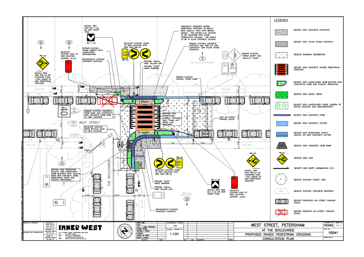
Subject: West Street, Petersham at the intersection of The Boulevarde – Pedestrian Safety Improvement Works – proposed raised pedestrian crossing - Design Plan 10241 Project 303082 (DAMUN - STANMORE WARD/ NEWTOWN ELECTORATE/ INNER WEST PAC)
Prepared By: Jennifer Adams - Engineer - Traffic and Parking Services
Authorised By: Manod Wickramasinghe - Traffic and Transport Planning Manager
SUMMARY
Council has finalised a design plan for pedestrian safety improvement works in West Street, Petersham at the intersection of The Boulevarde. The proposed works will include raising the existing pedestrian (zebra) crossing along with various associated works, including landscaped kerb blisters and road resheeting, and will improve pedestrian safety in the locality.
|
RECOMMENDATION
That the detailed design plan for the raising of the existing pedestrian crossing and new adjacent landscaped kerb blisters and ramps and associated signs and line markings in West Street, Petersham at the intersection of The Boulevarde (as per Plan No.10241) be approved. |
Council is planning to implement pedestrian safety improvement works in West Street, Petersham at the intersection of The Boulevarde by raising the existing pedestrian zebra crossing to improve pedestrian safety.
This project is included as part of the 2022/2023 Traffic Facilities Capital Works Program as ‘design only’ and originated from the Pedestrian Access and Mobility Plan (PAMP) which considered the priority of pedestrian upgrades across Inner West local area and categorised this existing at-grade crossing as high priority to upgrade due to its proximity of two schools.
This report details the design plan for those improvement works and related consultation results.
FINANCIAL IMPLICATIONS
The project is listed on Council’s Traffic Facilities Capital Works budget for 2023/2024 and is estimated to be around $110,000.
OTHER STAFF COMMENTS
The following works are proposed and are illustrated on the attached consultation plan (Plan No. 10241). The proposed works will improve pedestrian safety and addresses concerns about pedestrian and driver behaviour in the area.
Specifically, the proposed scope of works includes the following:
· Construct a new raised concrete pedestrian crossing with new landscaped kerb blister islands to replace the existing at-grade pedestrian crossing at the same location (as shown on plan);
· Construct “gutter bridges” with heel safe grating to provide safe access over new kerb and gutter to the new raised pedestrian crossing (where required);
· Provide additional landscaping to expanded street tree pit in the vicinity of the new raised pedestrian crossing (where shown on plan);
· Reconstruct some sections of concrete kerb, gutter and footpath on both sides of the proposed pedestrian crossing;
· Where large tree roots exist (particularly in front of the School), provide new porous flexible footpath in place of existing concrete footpath (subject to final detail design);
· Construct 1 new kerb ramp in The Boulevarde to facilitate a better pedestrian crossing point across the road;
· Resurface some of the existing roadway with new asphalt adjacent to the new raised pedestrian crossing;
· Adjust existing ‘No Stopping’ zones by relocating existing ‘No Stopping’ signs to new locations (where shown on plan);
· Install associated pavement line markings and signages as required;
Parking Changes
It is proposed to relocate the existing ‘No Stopping’ signs to meet current standards required for pedestrian crossings. This will result in the loss of one (1) on-street parking space on the NSW School of Language side of West Street while one (1) new on-street parking space will be created on the Petersham Public School side of West Street. Therefore, the proposal will result in no net loss of on-street parking spaces.
Streetlighting
The existing flood lighting for the pedestrian crossing is deemed adequate for the new raised pedestrian crossing so no changes are proposed to the existing street lighting due to the works.
PUBLIC CONSULTATION
Consultation was conducted between 3 April 2023 and 28 April 2023. A letter along with a copy of the design plan was sent to residents / businesses in the immediate locality. A total of 40 letters were distributed.
There was one response. Generally, the response was not supportive of the design plan to raise the existing pedestrian crossing. The resident states that the pedestrian crossing in question is on an extremely low traffic intersection and is adequate as is and that it does not need to be changed.
It is noted that Council’s PAMP study identified this crossing as requiring a safety upgrade by raising it. The project is being implemented to improve safety for pedestrians and school children who use the crossing. The cost is considered justified based on inherent safety improvements.
CONCLUSION
It is recommended that the detailed design plan of the proposed traffic treatment and associated signs and line markings be supported to improve pedestrian safety at this location.
|
1.⇩ |
302892-10241-Consultation Plan (Amended) |
|
|
Local Traffic Committee Meeting 15 May 2023 |
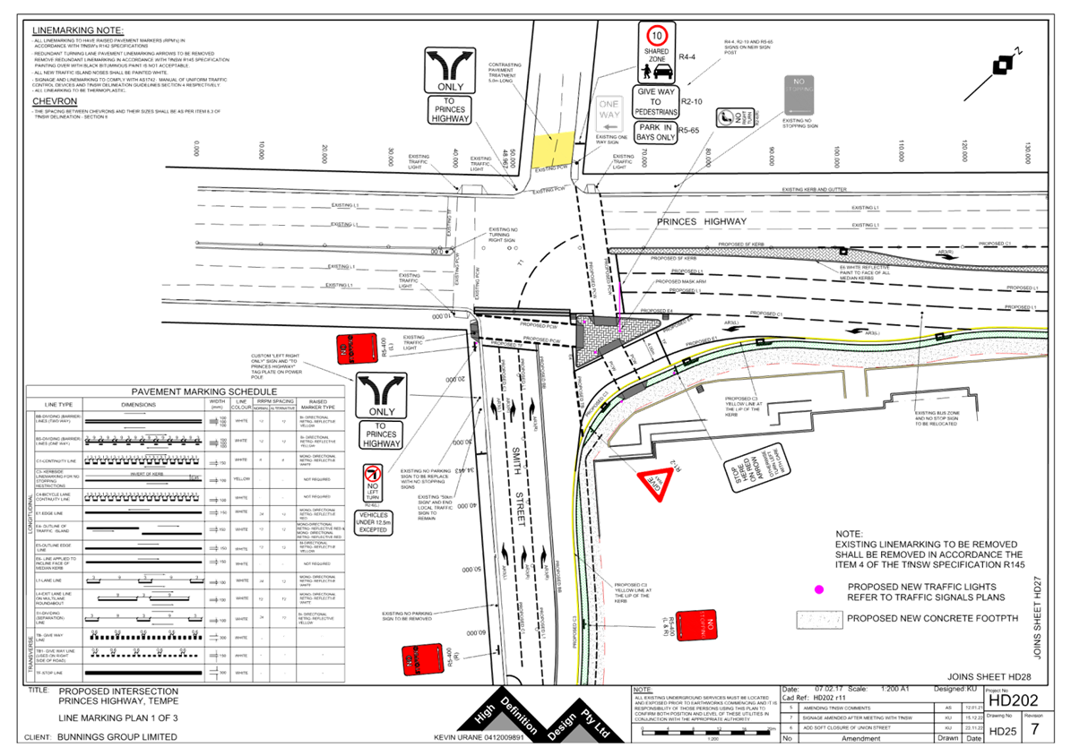
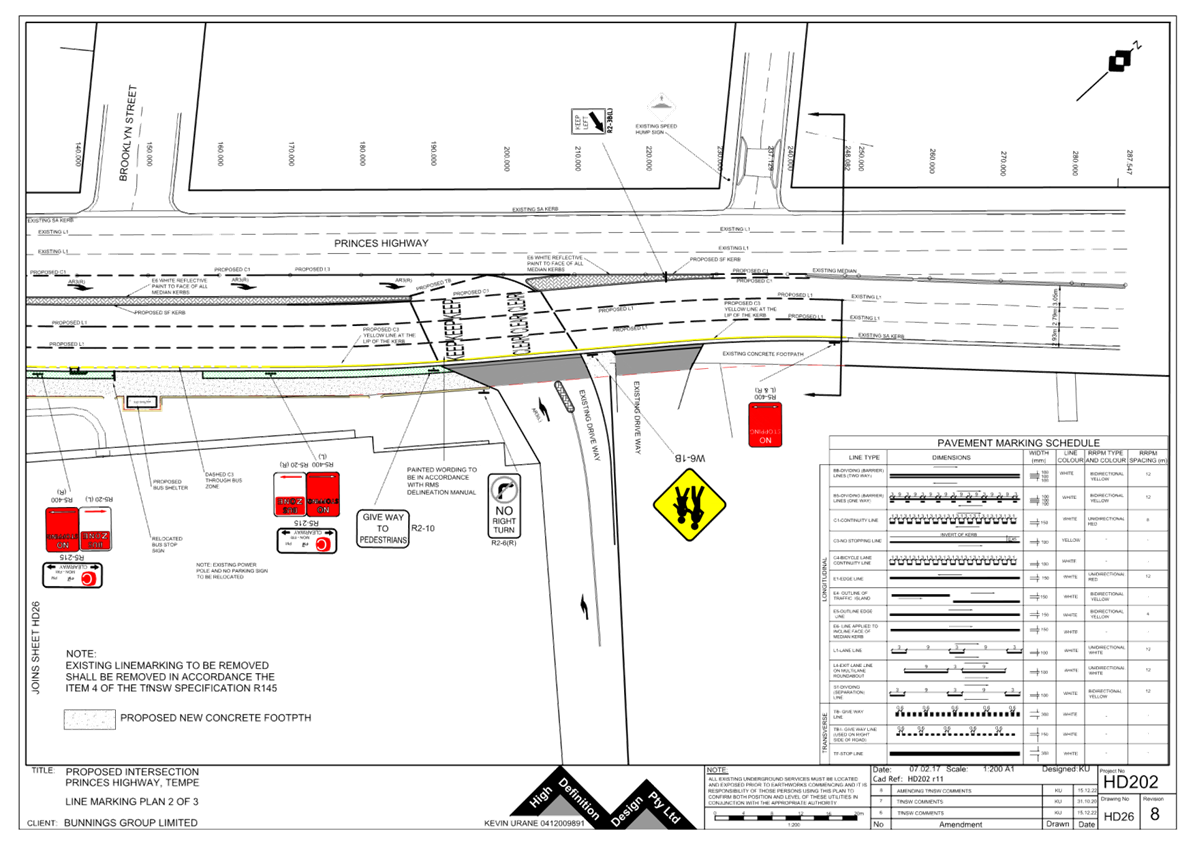
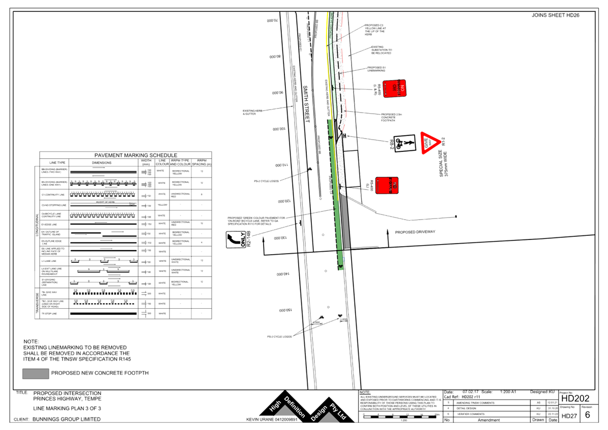
Subject: 728-750 Princes Highway, Tempe – Bunnings – ENR1/2021/0035 Special Condition 3 – Signage and Line Marking Plans – MOD20220424 (MIDJUBURI - MARRICKVILLE WARD /HEFFRON ELECTORATE /INNER WEST PAC)
Prepared By: Jennifer Adams - Engineer – Traffic and Parking Services
Authorised By: Manod Wickramasinghe - Traffic and Transport Planning Manager
SUMMARY
Detailed signage and line marking plans for 728-750 Princes Highway, Tempe have been submitted as part of ENR1/2021/0035 approval special condition 3 prior lodgement of the ‘Roadworks – Step 2 Permit to Construct’. It is recommended that the submitted plans be approved for Smith Street and no objection raised to the works along Princes Highway.
|
RECOMMENDATION
That:
1. The detailed signage and line marking plans for the proposed Bunnings development at 728-750 Princes Highway, Tempe showing the new slip lane and upgrade of Smith Street (as per the attached Plans HD202r-11-HD25, 26 and 27) be supported subject to separate TfNSW approval for the changes to the Princes Highway and TCS design; and 2. The costs of the supply and installation of the associated signage are to be borne by the applicant in accordance with Council’s Fees and Charges. |
BACKGROUND
DA201700185 dated 27 June 2019 approved an application to partially demolish the rear of the existing building, construction of a new building form and adaptively reuse the site for use as a 2 level hardware and building supplies store with undercroft car parking, erection of signage, boundary adjustments to provide a slip lane from the Princes Highway into Smith Street and the widening of Smith Street on the north-eastern side. The application was determined by the Sydney Eastern City Planning Panel and was subsequently modified on 18 September 2020 and 7 September 2022.
Council considered Application No. MOD/2022/0424 under Section 4.55 of the Environmental Planning and Assessment Act to modify Determination No. DA201700185 dated 27 June 2019. Council resolved that the application be APPROVED subject to the consent being modified.
The Public Domain Works proposed for the development at 728-750 Princes Highway, Tempe have been approved by Council. A Step 1 Permit (Design Approval) was issued 7 February 2023. Special condition no.3 of the Permit specifies requirement for submission of a signage plan:
“Amended plans relating to the signage and line marking shall be submitted for Local
Traffic Committee approval, prior to lodgement of the Roadworks Step 2 permit to
construct.’
FINANCIAL IMPLICATIONS
All works and costs of implementation works associated with the proposal will be borne by the applicant.
DISCUSSION
The proposed development at 728-750 Princes Highway is located on the north-eastern corner of Princes Highway and Smith Street, Tempe and is immediately adjacent to the existing IKEA. Surrounding land uses comprise of residential single-dwelling properties along the southern side of Smith Street, a mixture of residential single-dwelling and commercial properties (including IKEA) along both sides of Princes Highway, Tempe High School and Tempe Public School at the western ends of Union Street and Foreman Street which are all located within close proximity to the subject site.
Princes Highway is a State Road and arterial route being the principal north-south connection between Sydney and Wollongong. Annual Average Daily Traffic for Princes Highway at Cooks River is around 62,070 vpd and for Princes Highway north of Railway Road around 52,800 vpd. Princes Highway is approximately 19m in width facilitating three lanes in each direction and is sign posted 60km/h speed limit. It has a 6-10AM northbound clearway and 3-7PM southbound clearway within kerbside lanes. Generally unrestricted kerbside parking is permitted along both sides of the road outside of clearway times.
Smith Street is a local street servicing existing industrial uses and low density residential properties between Princes Highway and South Street, Tempe. Parking is unrestricted on both sides of the street. Union Street is a narrow one-way north-west local street serving mainly low density residential properties. Parking is unrestricted.
Traffic signals are present at the Princes Highway / Smith Street / Union Street intersection, with one-way north-westerly traffic flow in Union Street.
Copies of the signage and line marking plans are attached at the end of this report.
PUBLIC CONSULTATION
Consultation has been undertaken previously as part of the development application process and through the Tempe South LATM process.
|
1.⇩ |
HD202 r11-HD25 |
|
2.⇩ |
HD202 r11-HD26 |
|
3.⇩ |
HD202 r11-HD27 |
|
|
Local Traffic Committee Meeting 15 May 2023 |
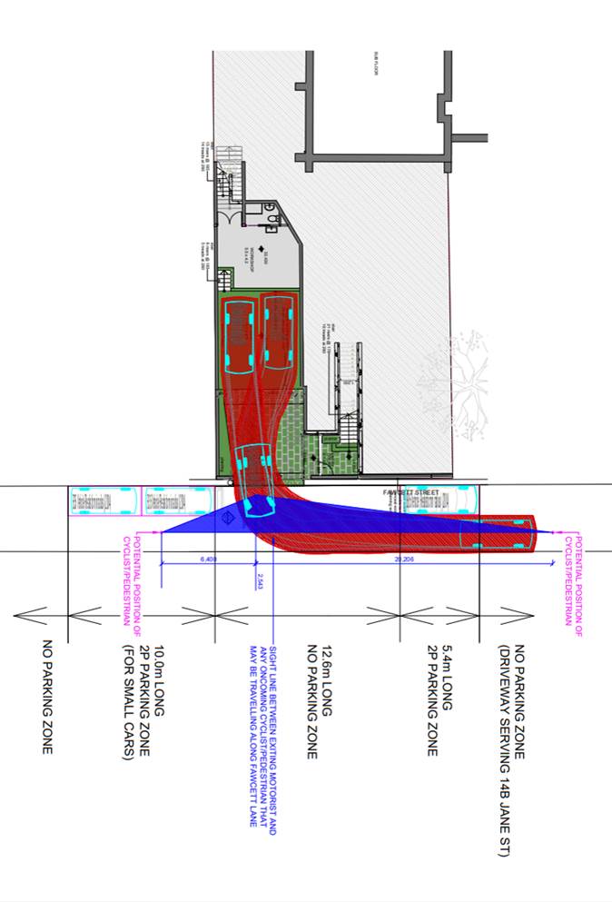
Subject: Fawcett Street, Balmain - Proposed 'No Parking' Restrictions (Baludarri - Balmain Ward/ Balmain Electorate/ Leichhardt PAC)
Prepared By: Zara Helal - Engineer - Traffic and Parking Services
Authorised By: Manod Wickramasinghe - Traffic and Transport Planning Manager
SUMMARY
Council has received a request to install a 12.6m length No Parking zone adjacent to a new driveway access at 14C Jane Street, Balmain. The proposal sees the provision of adequate sight distance when manoeuvring in and out of the driveway of the proposed development.
|
RECOMMENDATION
That:
1. The installation of ‘No Parking’ signposting in Fawcett Street, Balmain, starting 10m from the existing ‘No Parking’ zone located south of the proposed driveway and extending 12.6m north, be approved subject to consultation with residents of Fawcett Street; and
2. The ‘No Parking’ signs be installed at the applicant’s expense at no cost to Council. |
BACKGROUND AND OTHER STAFF COMMENTS
The development proposed for 14C Jane Street, Balmain under DA2022/192 involves the conversion of the site into a dual occupancy and necessitates the provision of on-site parking spaces. The development seeks approval for modifications to convert an existing dwelling into a dual occupancy, which includes the construction of a new garage that will be accessed via Fawcett Street.
The property owner has appealed to the Land and Environment Court following the Council's deemed refusal of the DA. In the appeal process, various assessments were conducted to ensure that the proposed development can provide safe vehicular access to and from the proposed new garage. These assessments included evaluating the sight distance at the proposed vehicle access, conducting an on-street parking survey, and considering small vehicle (B35 to B50 Design Vehicles) parking in Fawcett Street.
In accordance with the Austroads Stopping Sight Distance requirements, 'No Parking' restrictions are necessary for a total length of 12.6m inclusive of the driveway to ensure safe vehicle movements to and from the proposed dwelling. The parking restrictions and driveway crossover will result in the loss of two on-street parking spaces within Fawcett Street while providing two on-site parking spaces. It should be noted that the proposed development could potentially accommodate space for one additional vehicle within the 5.8m x 6.4m forecourt, increasing the on-site capacity to a maximum of three spaces. According to the report conducted by the applicant, the loss of two on-site parking spaces would have a negligible and acceptable impact on the availability of on-street car parking in the area.
Furthermore, it is important to note that the driveway of 14B Jane Street, Balmain, is located 5.4m further north of the proposed 'No Parking' zone. If the length of 'No Parking' zone from the proposed 12.6m length is reduced, this would result in a situation that may encourage two vehicles to be parked in this space potentially creating access issues to either or both properties. Additionally, significantly reducing the ‘No Parking’ zone from 12.6m to 6m would not allow for reverse movements into the proposed driveway.
The B85 Design Vehicle Exit Movement and Sight Line Assessment is illustrated below.
FINANCIAL IMPLICATIONS
Nil.
PUBLIC CONSULTATION
Not applicable at this time.