|
AGENDA R |

Local Traffic Committee Meeting
MONDAY 19 JUNE 2023
11.00am
|
|
Local Traffic Committee Meeting 19 June 2023 |
Function of the Local Traffic Committee
Background
Roads and Maritime Services (RMS) is legislated as the Authority responsible for the control of traffic on all NSW Roads. The RMS has delegated certain aspects of the control of traffic on local roads to councils. To exercise this delegation, councils must establish a local traffic committee and obtain the advice of the RMS and Police. The Inner West Council Local Traffic Committee has been constituted by Council as a result of the delegation granted by the RMS pursuant to Section 50 of the Transport Administration Act 1988.
Role of the Committee
The Local Traffic Committee is primarily a technical review and advisory committee which considers the technical merits of proposals and ensures that current technical guidelines are considered. It provides recommendations to Council on traffic and parking control matters and on the provision of traffic control facilities and prescribed traffic control devices for which Council has delegated authority. These matters are dealt with under Part A of the agenda and require Council to consider exercising its delegation.
In addition to its formal role as the Local Traffic Committee, the Committee may also be requested to provide informal traffic engineering advice on traffic matters not requiring Council to exercise its delegated function at that point in time, for example, advice to Council’s Development Assessment Section on traffic generating developments. These matters are dealt with under Part C of the agenda and are for information or advice only and do not require Council to exercise its delegation.
Committee Delegations
The Local Traffic Committee has no decision-making powers. The Council must refer all traffic related matters to the Local Traffic Committee prior to exercising its delegated functions. Matters related to State Roads or functions that have not been delegated to Council must be referred directly to the RMS or relevant organisation.
The Committee provides recommendations to Council. Should Council wish to act contrary to the advice of the Committee or if that advice is not supported unanimously by the Committee members, then the Police or RMS have an opportunity to appeal to the Regional Traffic Committee.
Committee Membership & Voting
Formal voting membership comprises the following:
· one representative of Council as nominated by Council;
· one representative of the NSW Police from each Local Area Command (LAC) within the LGA, being Newtown, Marrickville, Leichhardt and Ashfield LAC’s.
· one representative from the RMS; and
· State Members of Parliament (MP) for the electorates of Summer Hill, Newtown, Heffron, Canterbury, Strathfield and Balmain or their nominees.
Where the Council area is represented by more than one MP or covered by more than one Police LAC, representatives are only permitted to vote on matters which effect their electorate or LAC.
Informal (non-voting) advisors from within Council or external authorities may also attend Committee meetings to provide expert advice.
Committee Chair
Council’s representative will chair the meetings.
Public Participation
Members of the public or other stakeholders may address the Committee on agenda items to be considered by the Committee. The format and number of presentations is at the discretion of the Chairperson and is generally limited to 3 minutes per speaker. Committee debate on agenda items is not open to the public.
|
|
Local Traffic Committee Meeting 19 June 2023 |
|
AGENDA |
1 Apologies
2 Disclosures of Interest
3 Confirmation of Minutes
Minutes of 15 May 2023 Local Traffic Committee Meeting 5
4 Matters Arising from Council’s Resolution of Minutes
5 Part A – Items Where Council May Exercise Its Delegated Functions
Traffic Matters
ITEM Page
LTC0623(1) Item 1 Seven Bridges Walk - Special Event (Gulgadga - Leichhardt & Baludarri - Balmain Ward/ Balmain Electorate/ Leichhardt PAC) 13
LTC0623(1) Item 2 Petersham North Latm Study (Damun-Stanmore Ward/Newtown Electorate/Inner West PAC) 95
LTC0623(1) Item 3 Wardell Road, Dulwich Hill - Traffic Improvements (Djarrawunang-Ashfield Ward/Summer Hill Electorate/Inner West PAC) 153
LTC0623(1) Item 4 Ewart Street, Dulwich Hill; Burrows Avenue, Railway Road, Gleeson Avenue and (Lower) Railway Parade, Sydenham - Temporary Parking Changes During Major Rail Shutdown Of T3 Line for Sydney Metro Upgrade Works - Bus Replacements for 11 Days Between Thursday 6 July to Sunday 16 July 2023 (Midjuburi - Marrickville Ward / Summer Hill Electorate / Inner West PAC) 155
LTC0623(1) Item 5 Wardell Road, Dulwich Hill – Consent Condition For Extension To Existing School Drop Off Zone Adjacent To St Maroun's College At Nos.149-206 Wardell Road (Djarrawunang Ward/Summer Hill Electorate/Inner West PAC) 165
LTC0623(1) Item 6 Smidmore Street, Marrickville – ENRC/2023/0025 - Temporary full road closures for Marrickville Metro Markets 11 to 13 August 2023, 13 to 15 October 2023, 8 to 10 December 2023, 9 to 11 February 2024, 12 to 14 April 2024, 7 to 9 June 2024 and related temporary changes to Victoria Road kerbside parking restrictions to accommodate relocation of community bus (Midjuburi – Marrickville Ward / Heffron Electorate / Inner West PAC) 171
LTC0623(1) Item 7 Hardie
Avenue, Summer Hill - Proposed Raised Pedestrian (zebra) crossing and
associated streetscape and community facility improvements.
(Djarrawunang-Ashfield Ward/Summer Hill Electorate/Burwood PAC) 193
LTC0623(1) Item 8 Grosvenor
Crescent and Sloane Street, Summer Hill-proposed upgrade (raising) of existing
pedestrian (zebra) crossings and associated streetscape improvements.
(Djarrawunang-Ashfield Ward/Summer Hill Electorate/Burwood PAC) 198
LTC0623(1) Item 9 Proposed Roundabout & Safety Improvements - Elliott Street, Terry Street & Glassop Street, Balmain (Baludarri - Balmain Ward / Balmain Electorate / Leichhardt PAC) 206
LTC0623(1) Item 10 Kensington
Road, Summer Hill-proposed 'No Right Turn 6am-10am, 3pm-7pm Mon-Fri' from
Kensington Road into Liverpool Road.
(Djarrawunang-Ashfield Ward/Summer Hill Electorate/Burwood PAC) 211
Parking Matters
ITEM Page
LTC0623(1) Item 11 Meeks Road, Marrickville - 'No Stopping' yellow line and signage (Midjuburi – Marrickville Ward / Summer Hill Electorate / Inner West PAC) 218
LTC0623(1) Item 12 Perry Lane,
Lilyfield - Proposed 'No Parking' Restrictions
(Baludarri-Balmain Ward/Balmain Electorate/Leichhardt PAC) 221
LTC0623(1) Item 13 King George Park Carpark, Manning Street, Rozelle - Proposed '8p 8.00am-8.00pm' Restrictions (Baludarri-Balmain Ward/Balmain Electorate/Leichhardt PAC) 223
LTC0623(1) Item 14 Intersection of Joseph Street and Unnamed Laneway (Between Ryan Street & Lamb Street), Lilyfield - Proposed 'No Stopping' Restrictions (Baludarri-Balmain Ward/Balmain Electorate/Leichhardt PAC) 226
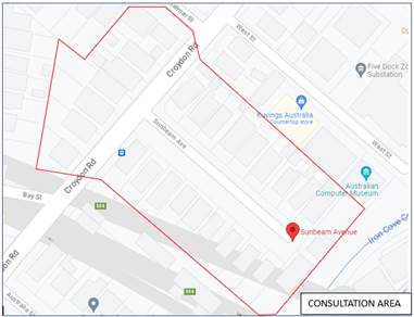
LTC0623(1) Item 15 Intersection
of Croydon Road and Sunbeam Avenue, Croydon.
-Proposed 'No Stopping' to the eastern corner of Croydon Road, north of Sunbeam
Avenue.
(Gulgadya-Leichhardt Ward/Strathfield Electorate/Burwood PAC) 228
Late Items
Nil at time of printing.
6 Part B - Items for Information Only
Nil at the time of printing.
7 Part C - Items for General Advice
Nil at the time of printing.
8 General Business
9 Close of Meeting
|
|
Local Traffic Committee Meeting 19 June 2023 |
Minutes of Local Traffic Committee Meeting
Held on 15 May 2023 at Ashfield Service Centre
Meeting commenced at 11.08am
ACKNOWLEDGEMENT OF COUNTRY BY CHAIRPERSON
I acknowledge the Gadigal and Wangal people of the Eora nation on whose country we are meeting today, and their elders past and present.
COMMITTEE REPRESENTATIVES PRESENT
|
Mayor Darcy Byrne |
Councillor – Baludarri-Balmain Ward (Chair) |
|
Bill Holliday |
Representative for Kobi Shetty MP, Member for Balmain |
|
Patricia Arcilla |
Representative for Jenny Leong MP, Member for Newtown |
|
Sgt Charles Buttrose |
NSW Police – Leichhardt Police Area Command |
|
Ben Walters |
NSW Police – Inner West Police Area Command |
|
Brad Malavey |
NSW Police – Inner West Police Area Command |
|
Nina Fard |
Transport for NSW (TfNSW) |
|
Jerimia Tukadra |
Transport for NSW (TfNSW) |
|
Mohammed Isfan |
Transport for NSW (TfNSW) |
|
|
|
|
NON VOTING MEMBERS IN ATTENDANCE |
|
|
|
|
|
Colin Jones |
Inner West Bicycle Coalition (IWBC) |
|
Manod Wickramasinghe |
IWC’s Traffic and Transport Services Manager |
|
George Tsaprounis |
IWC’s Coordinator Traffic Engineering Services (South) |
|
Jason Scoufis |
IWC’s Traffic and Parking Planner |
|
Miia Hynninen |
IWC’s Business Administration Officer |
|
|
|
|
|
|
|
VISITORS |
|
|
|
|
|
Elizabeth Dale |
Resident - Item 3 |
|
Margaret Hoban |
Resident – Item 3 |
|
Shirley Udall |
Resident – Item 7 |
|
Sharon O’Connell |
Resident – Item 7 |
|
Paul Corbett |
Traffic Engineer Representative for Applicant – Item 7 |
|
|
|
|
APOLOGIES: |
|
|
|
|
|
Graeme McKay |
Representative for Jo Haylen MP, Member for Summer Hill |
|
Sunny Jo |
IWC’s Coordinator Traffic Engineering Services (North) |
|
Ivy Tseng |
Representative for Jason Yat-sen Li MP, Member for Strathfield |
|
|
|
DISCLOSURES OF INTERESTS:
Nil.
CONFIRMATION OF MINUTES
|
That the Minutes of the Local Traffic Committee Meeting held on Monday, 17 April 2023 were confirmed. |
MATTERS ARISING FROM COUNCIL’S RESOLUTION OF MINUTES
General Business
Meeting closed at 12.14pm.
|
|
Local Traffic Committee Meeting 19 June 2023 |
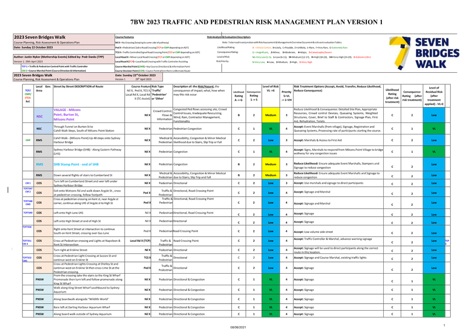
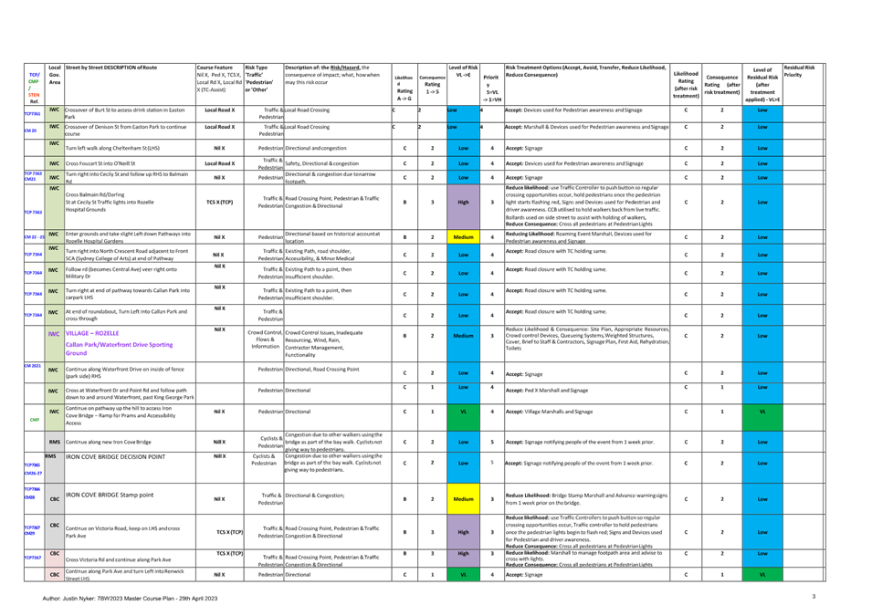
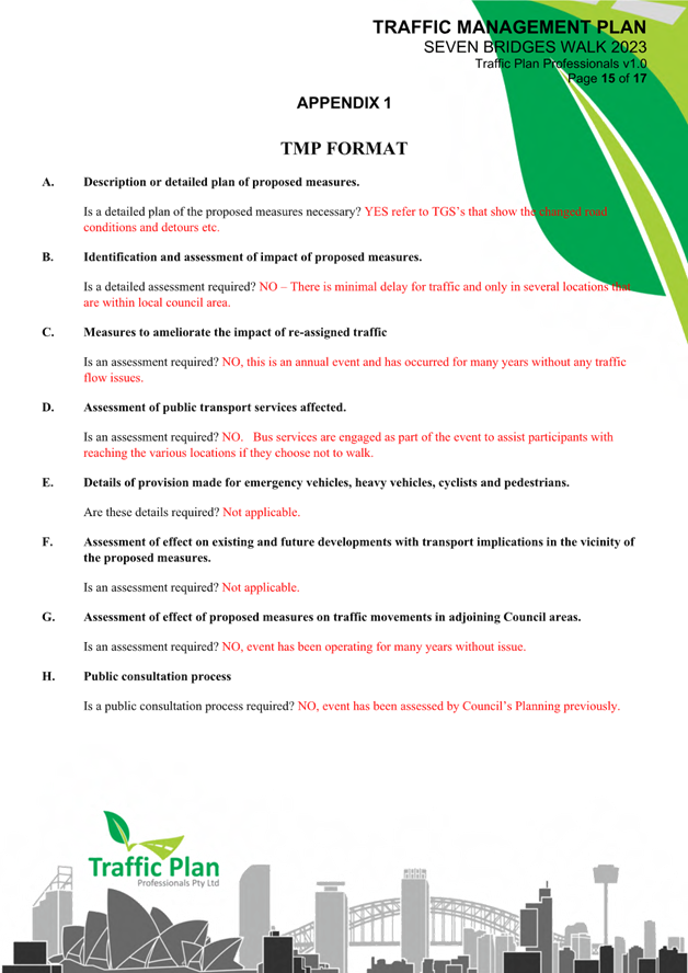
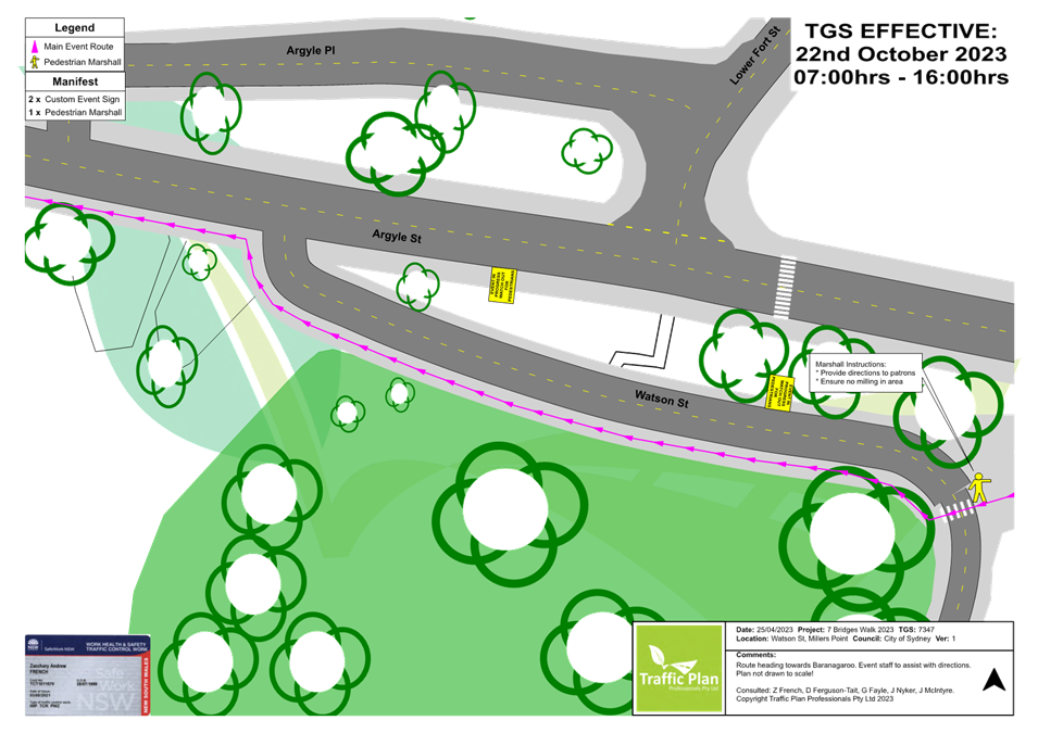
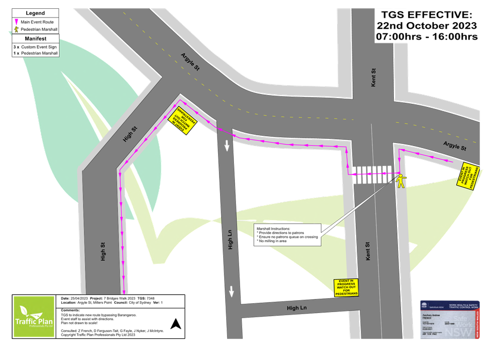
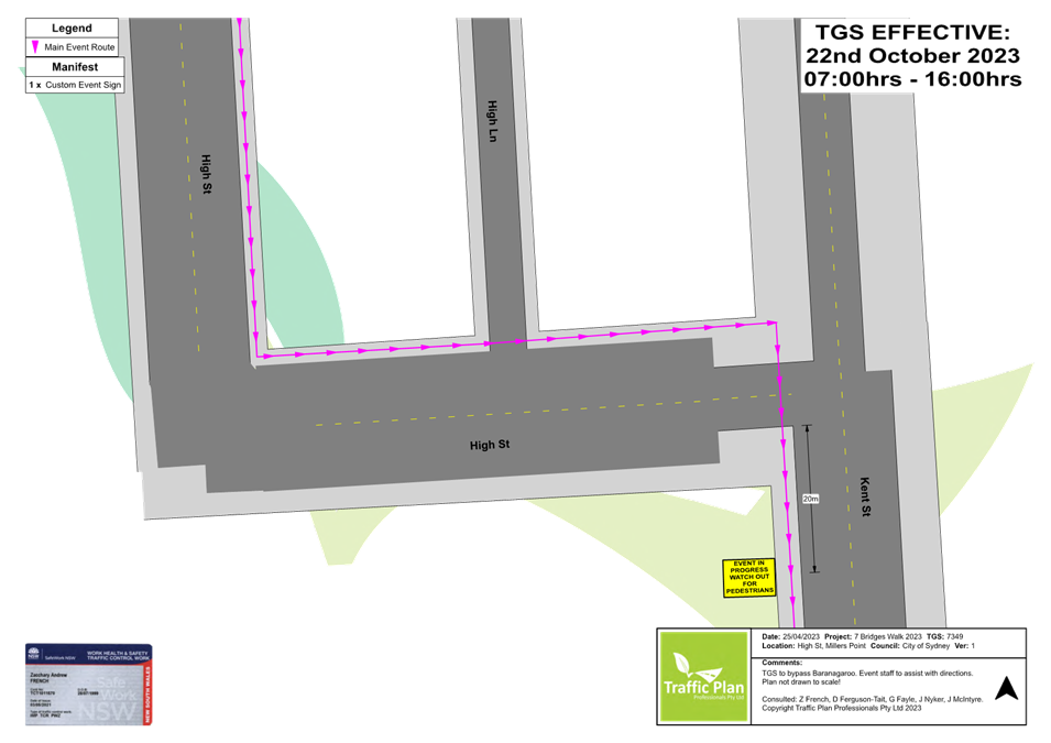
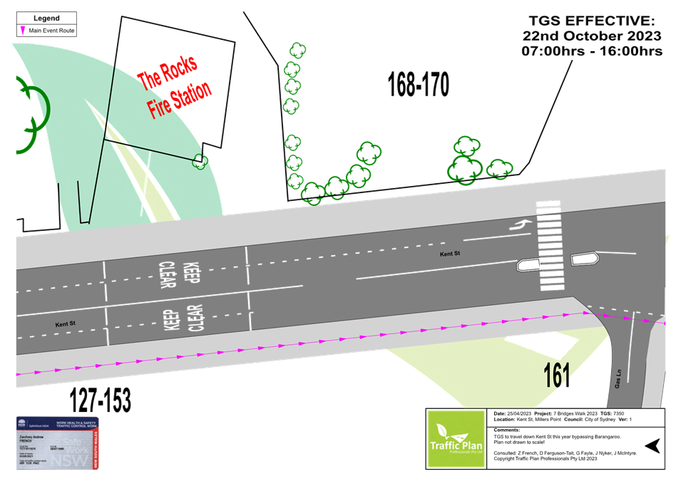
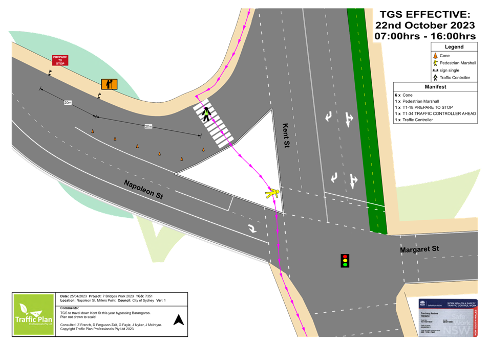
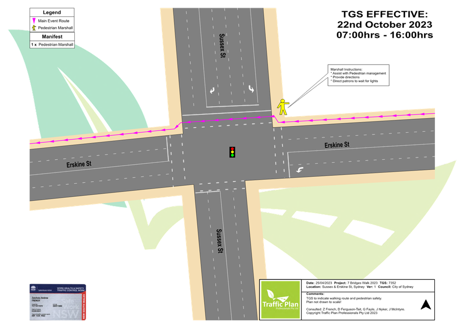
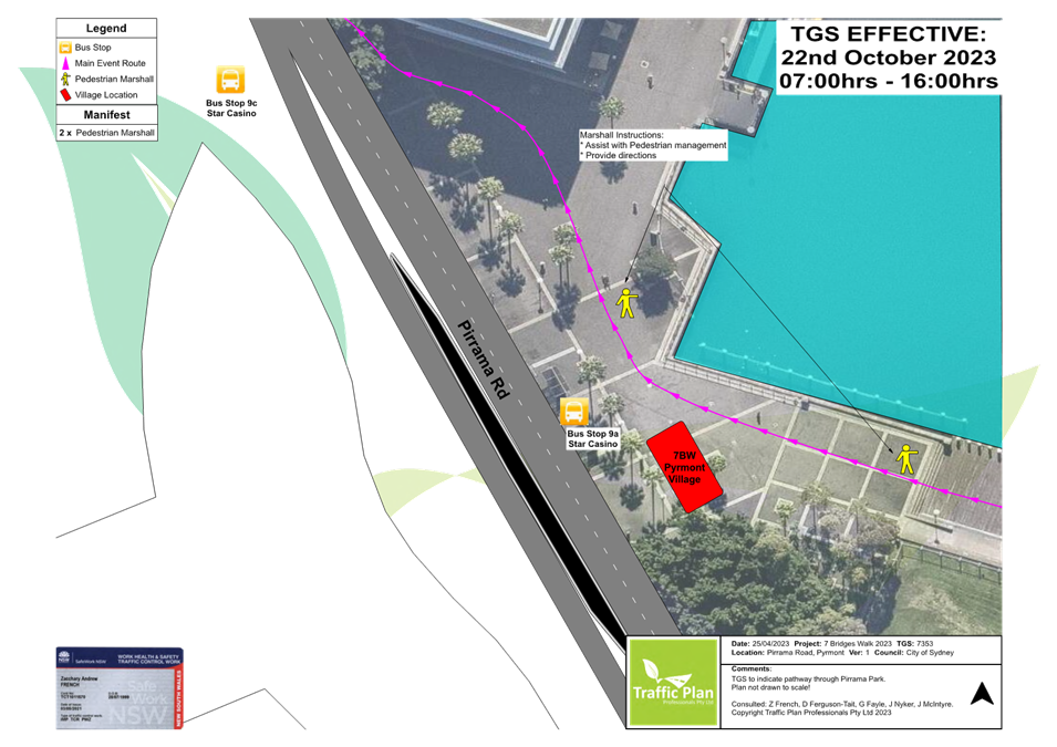
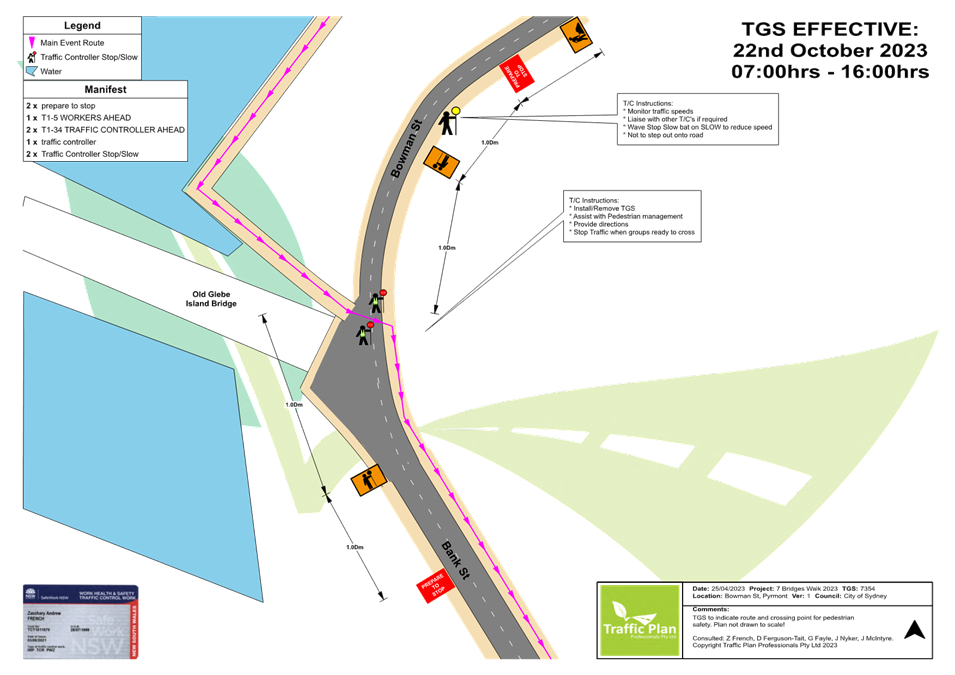
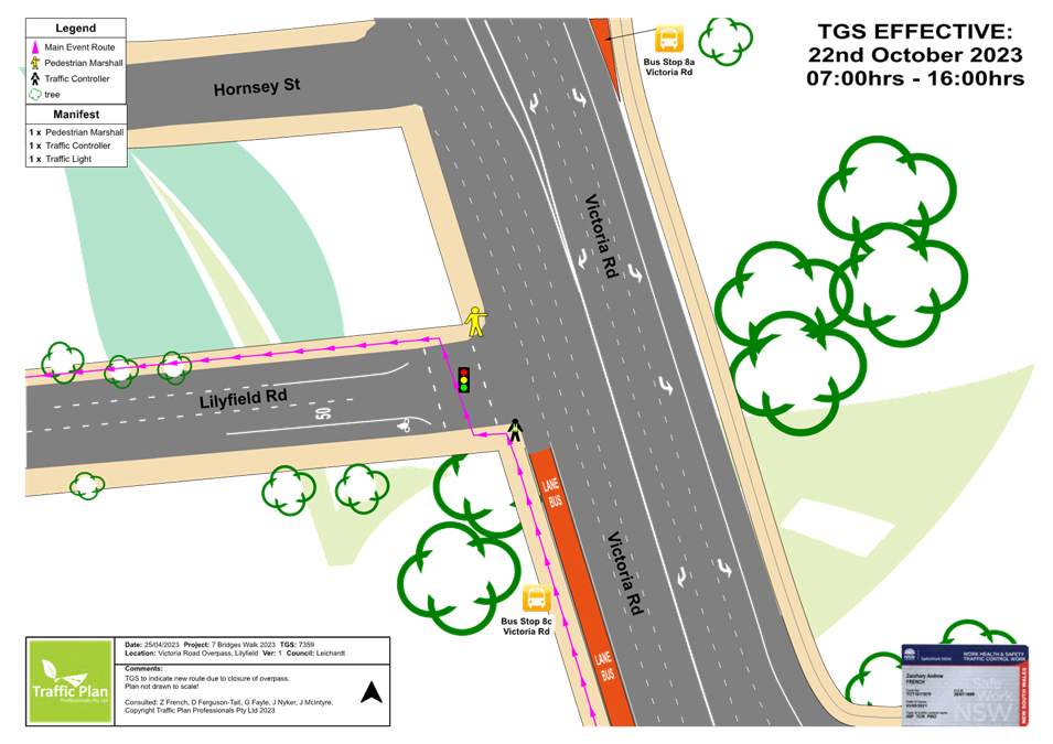
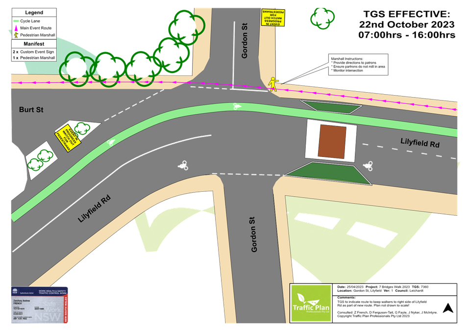
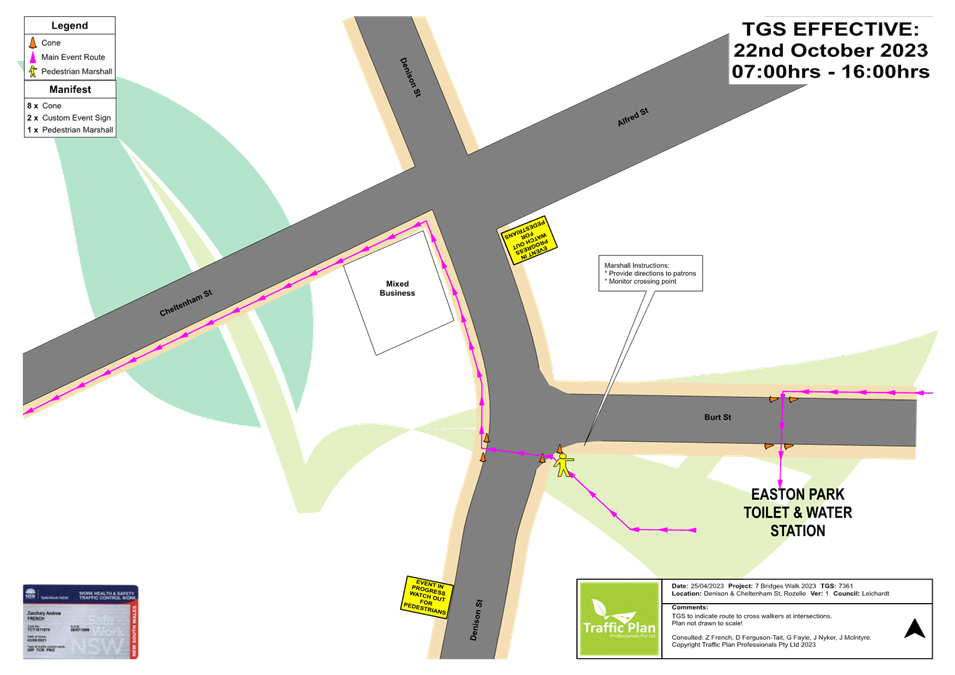
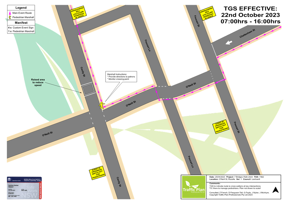
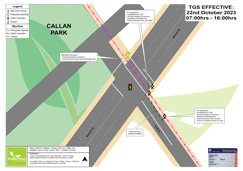
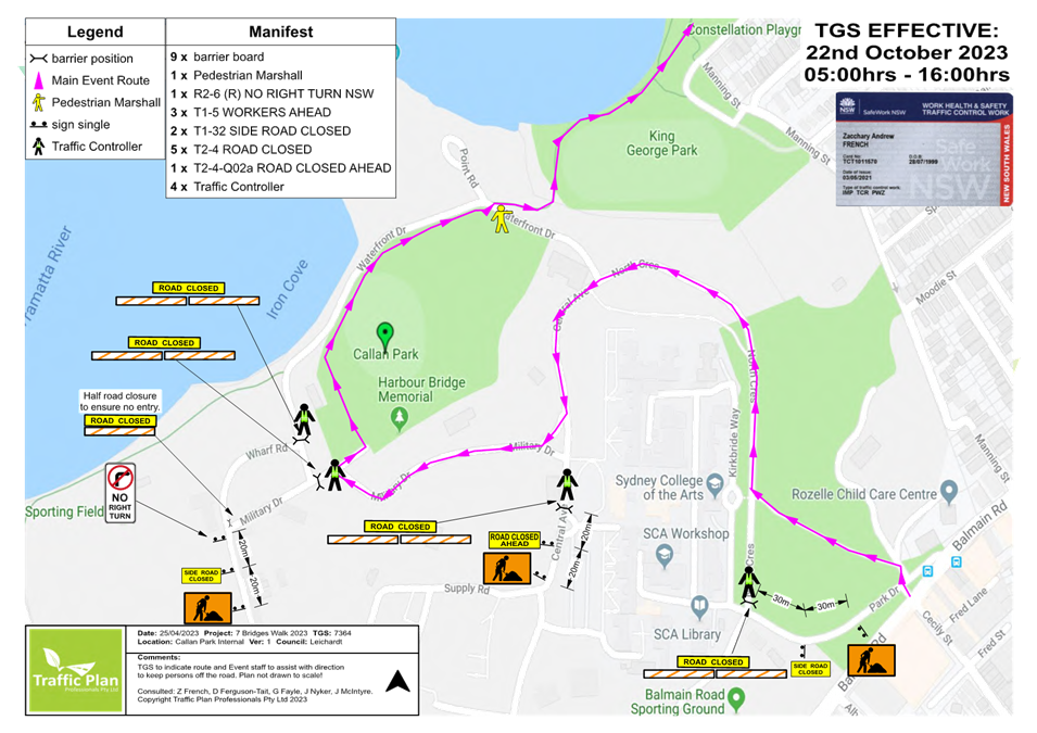
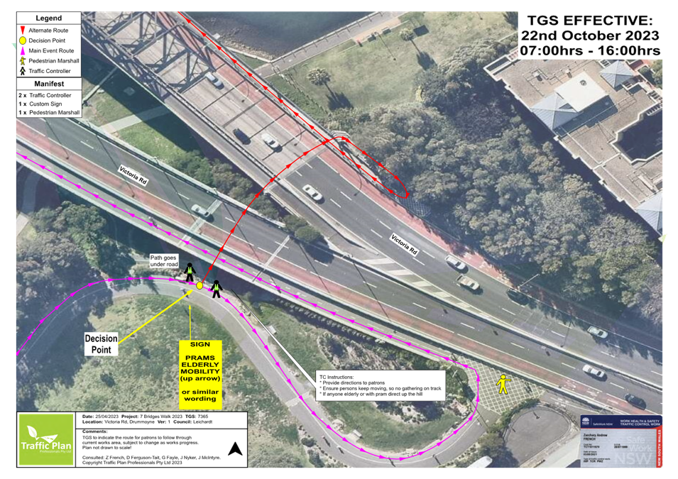
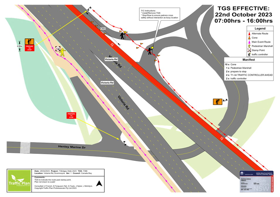
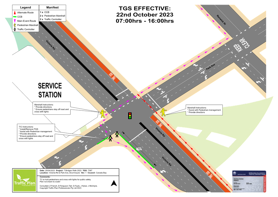
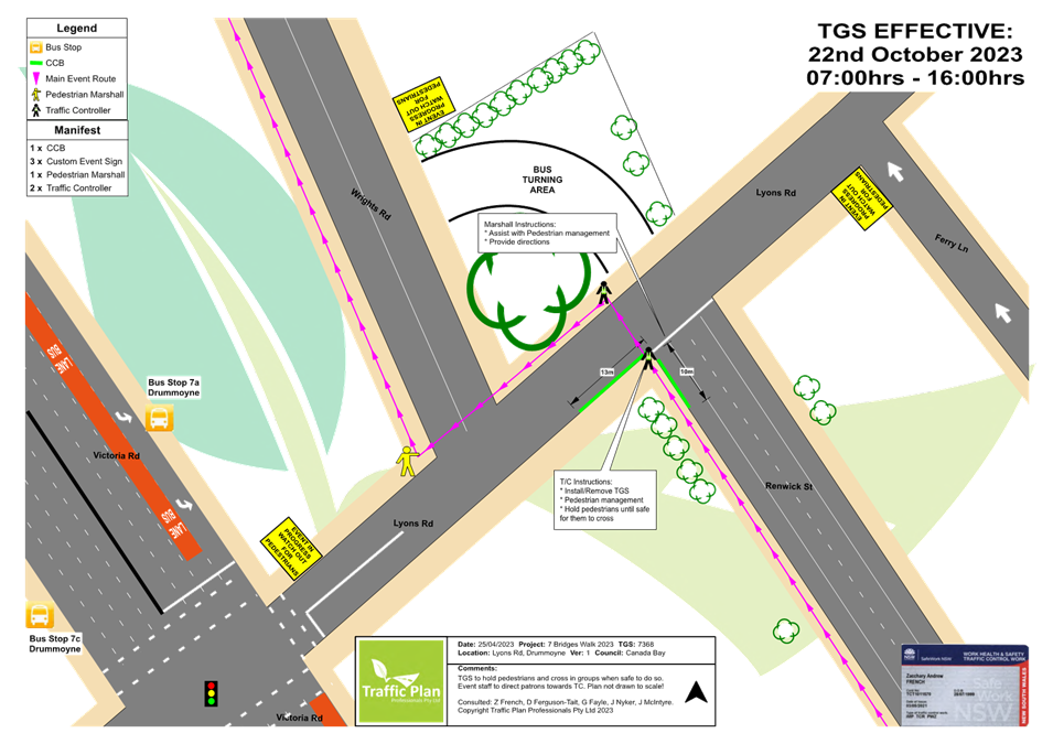
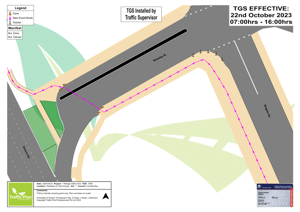
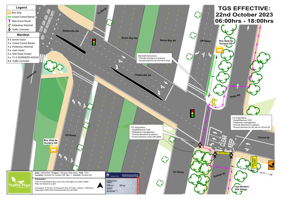
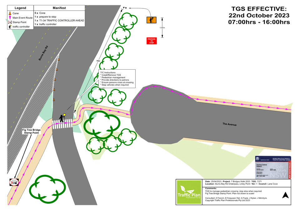
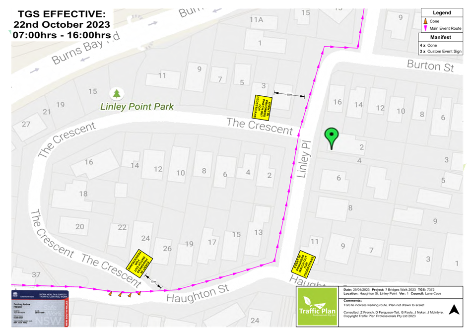
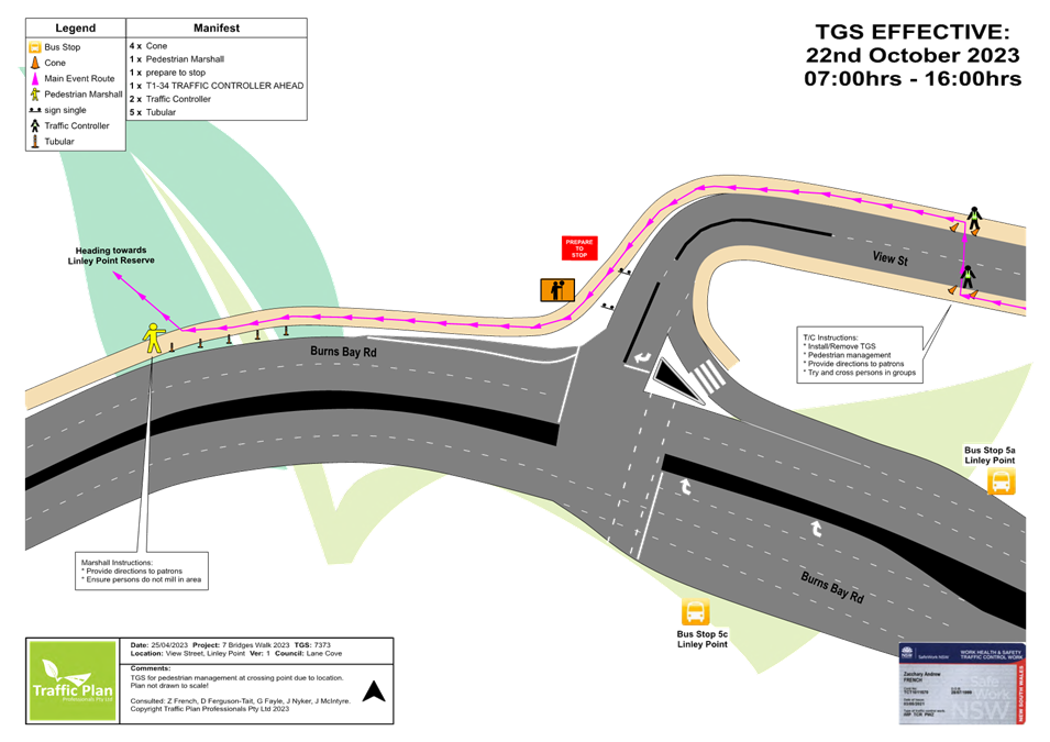
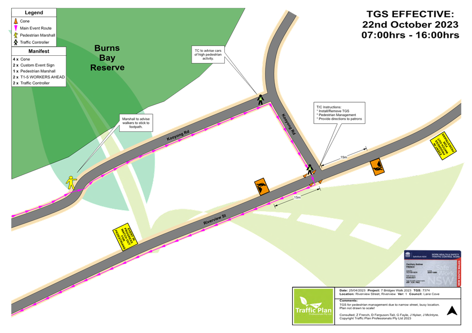
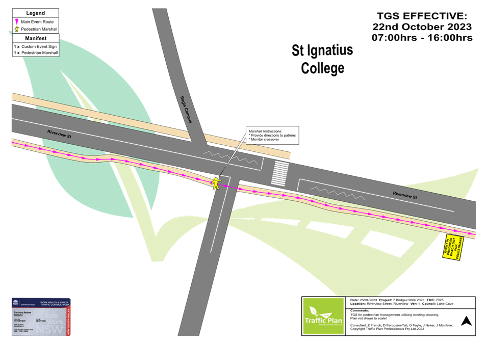
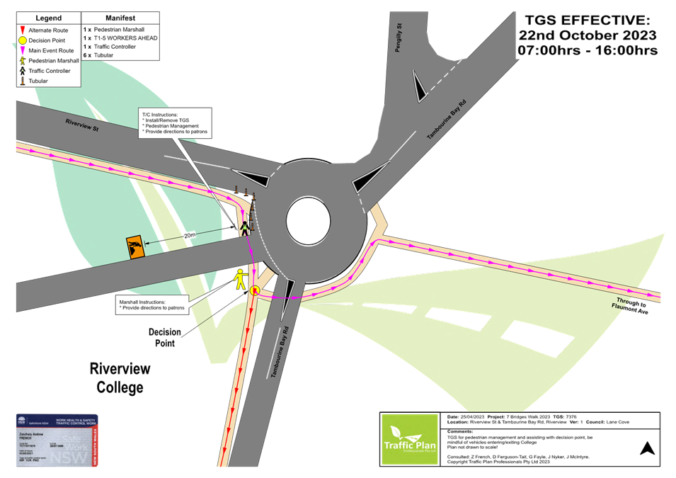
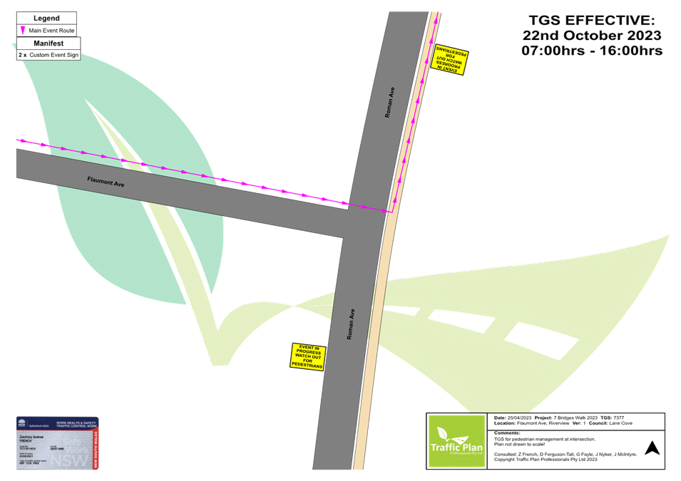
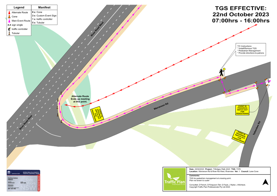
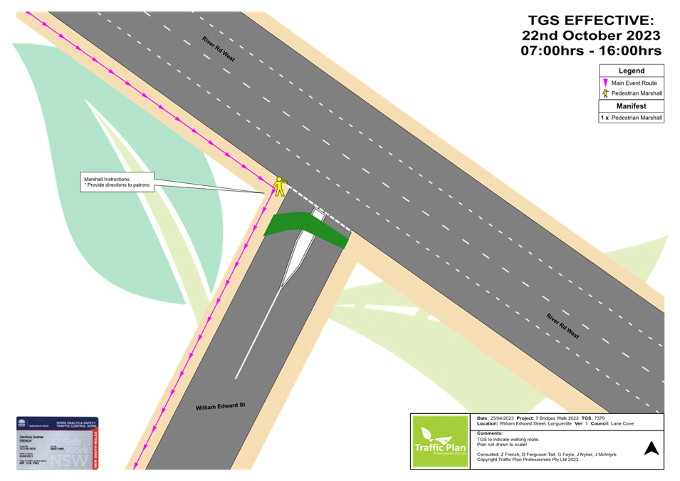
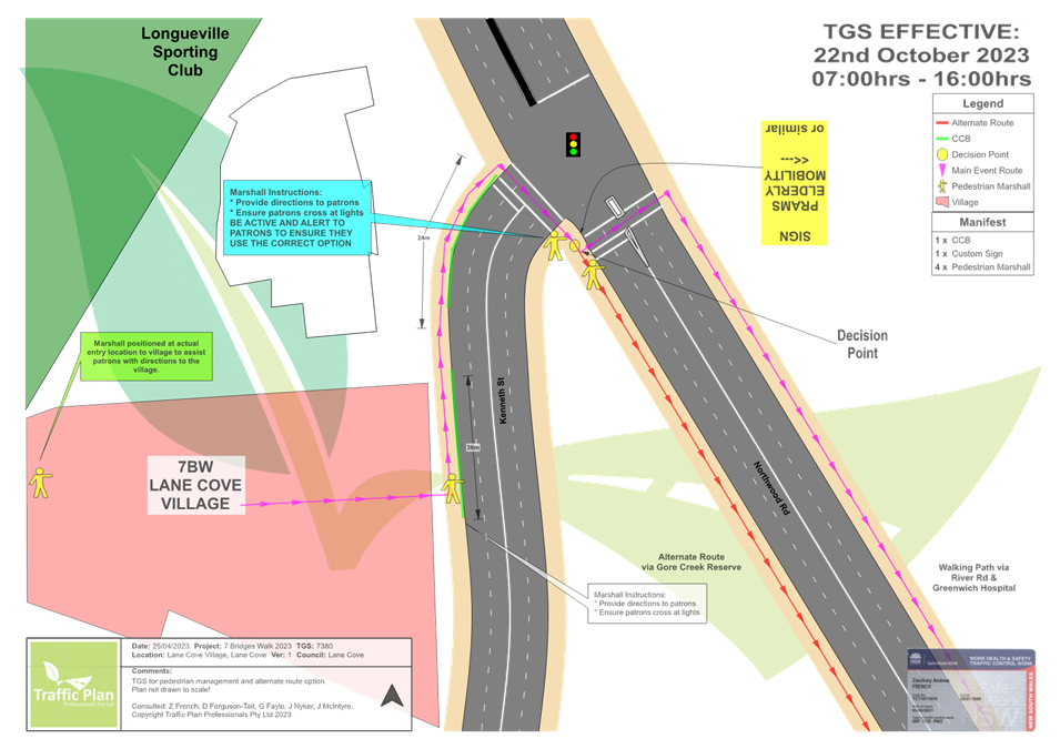
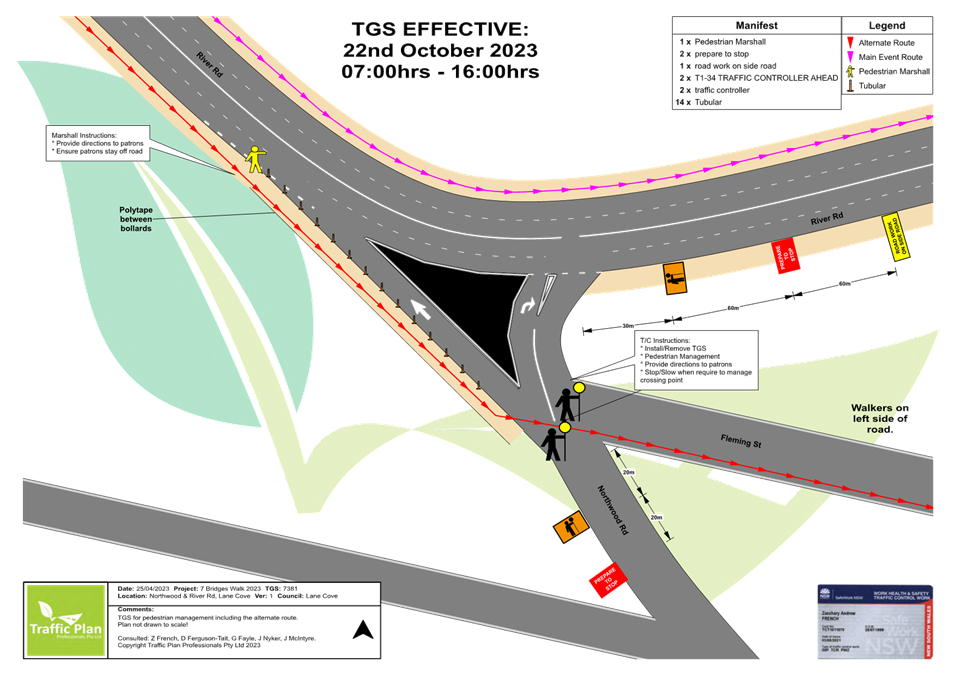
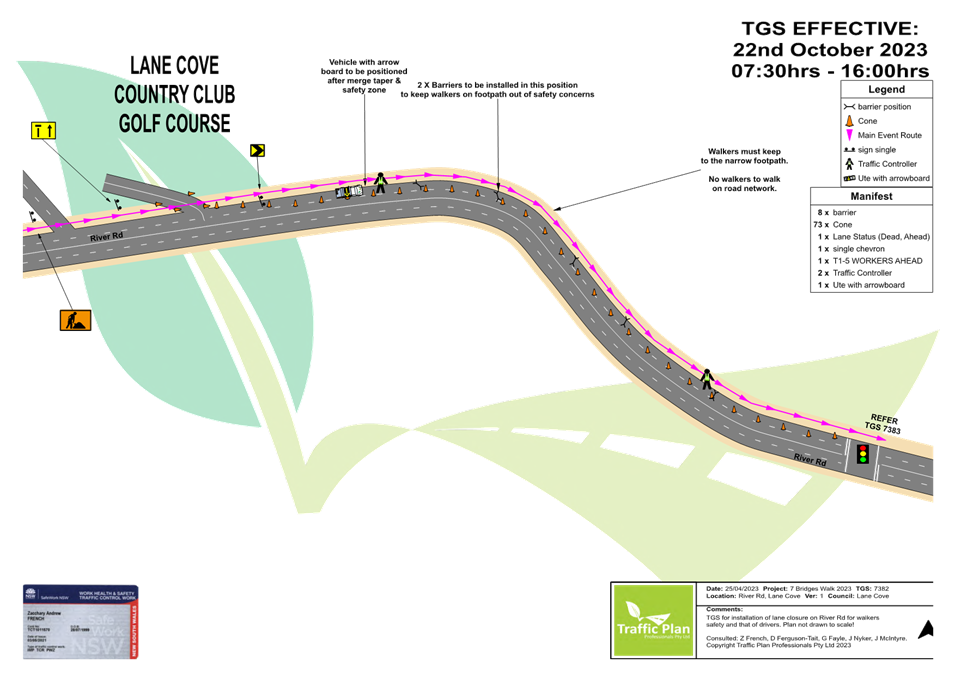
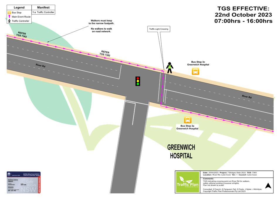
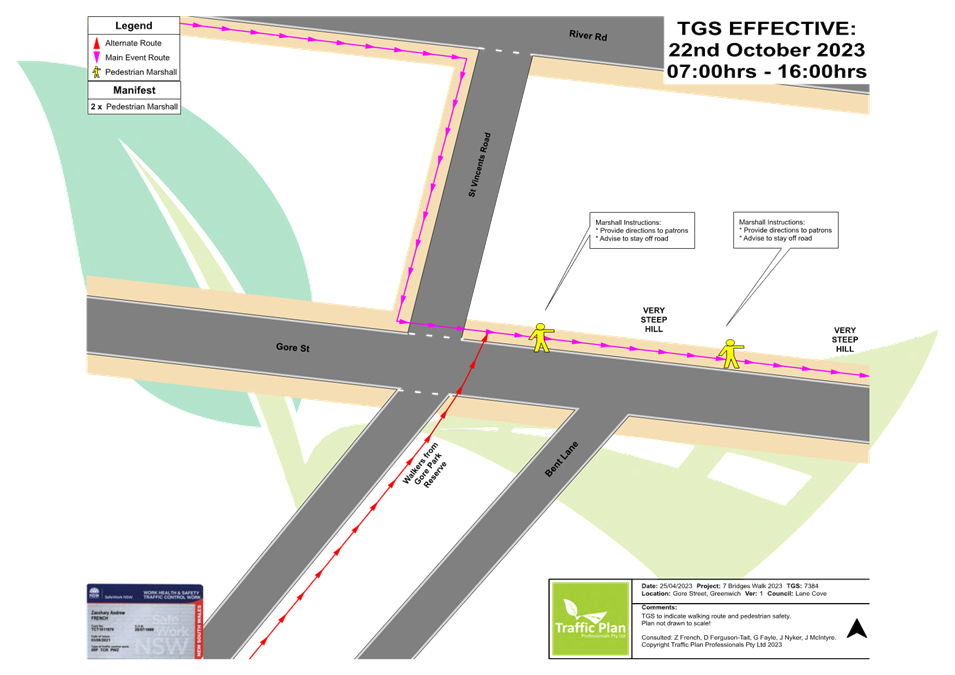
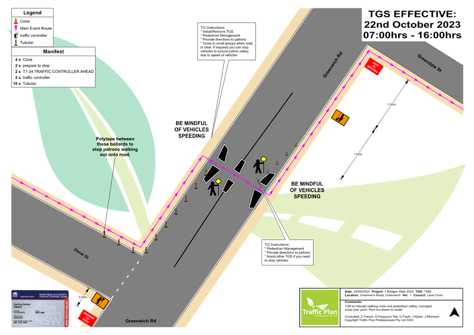
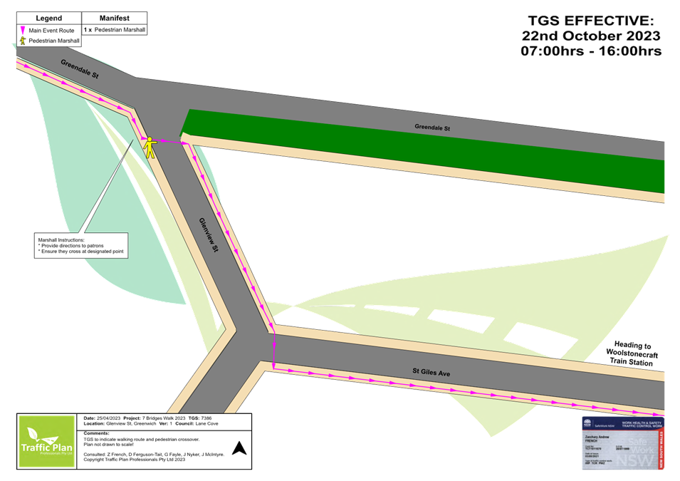
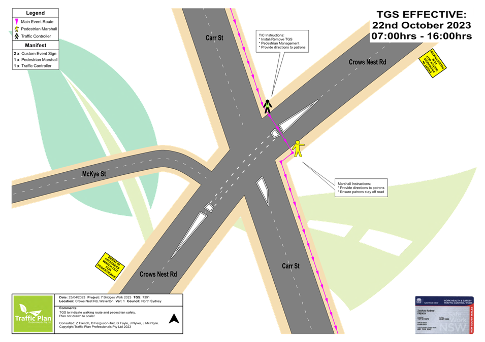
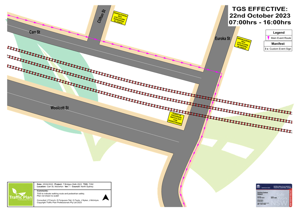
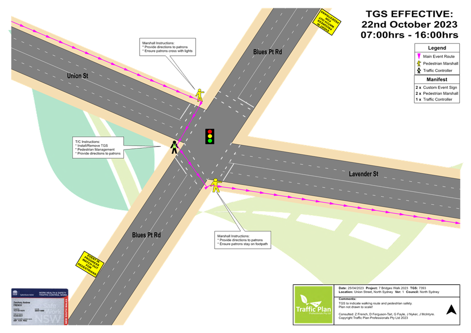
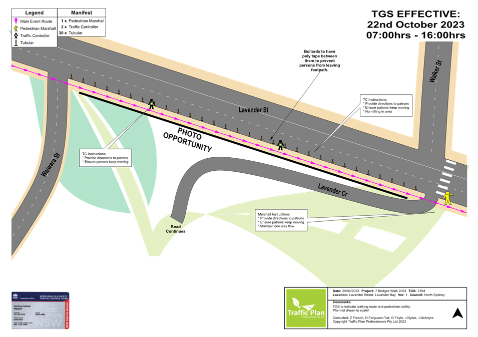
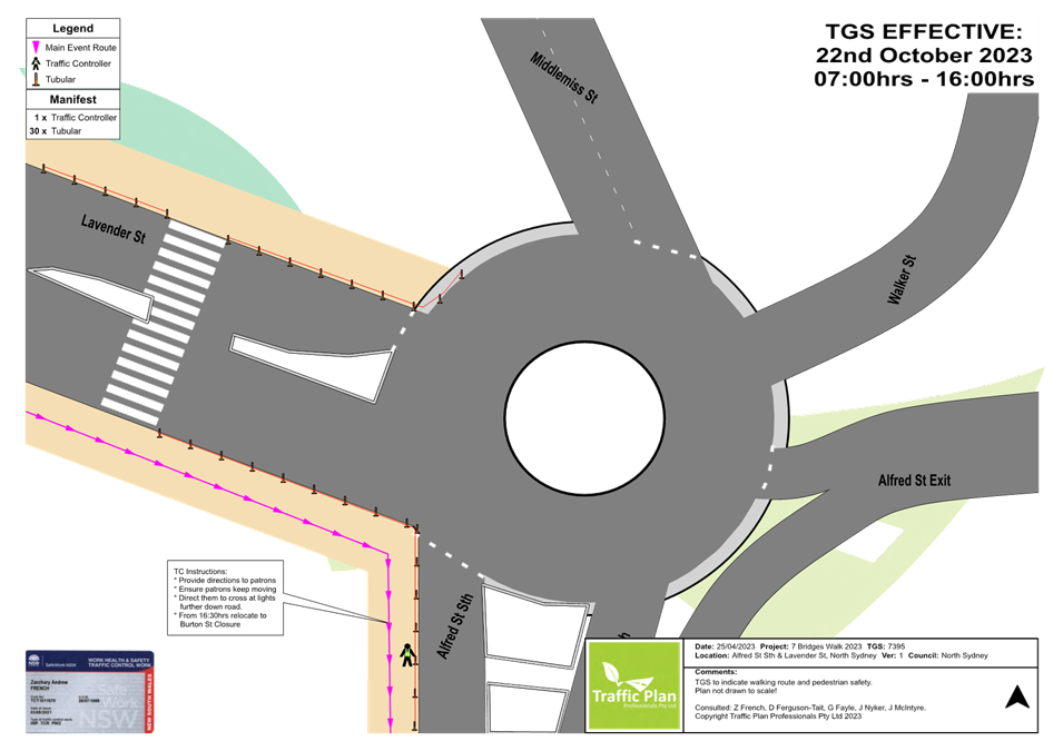
Subject: Seven Bridges Walk - Special Event (Gulgadga - Leichhardt & Baludarri - Balmain Ward/ Balmain Electorate/ Leichhardt PAC)
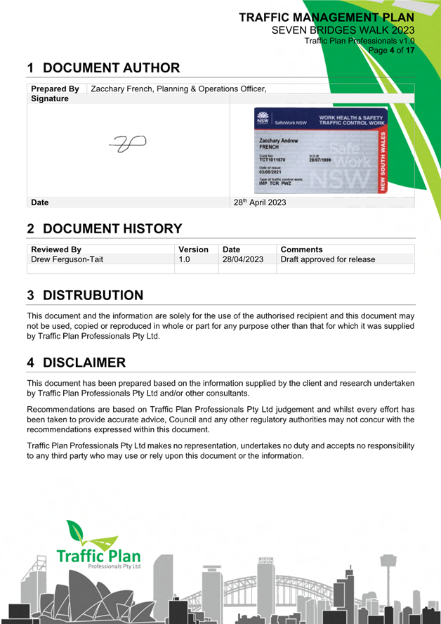
Prepared By: Zara Helal - Traffic Engineer
Authorised By: Manod Wickramasinghe - Traffic and Transport Planning Manager
SUMMARY
The Cancer Council NSW Seven Bridges Walk event will be held on Sunday, 22 October 2023 at various locations in Sydney, including areas within the Inner West Council. The Event is in its eighteenth year of operation and the applicant seeks approval again in 2023.
|
RECOMMENDATION
That the Cancer Council NSW Seven Bridges Walk to be held on Sunday, 22 October 2023 be approved, subject to a current Public Liability Insurance Policy which includes the Inner West Council being an interested party being submitted by the event organiser prior to the event. |
BACKGROUND & OTHER STAFF COMMENTS
The Cancer Council NSW Seven Bridges Walk concept was created and developed by the Pedestrian Council of Australia (PCA) who will remain the owner of the event. The PCA has engaged Mothership Events to deliver the Event Operations and manage the marketing of the Event on behalf of PCA. The Cancer Council NSW Seven Bridges Walk can be regarded as an active opportunity to further enhance the councils' and stakeholders' charter toward promoting walking as a healthy activity and as an increasingly important means of active transport. In addition, the event will provide a significant contribution to the Cancer Council NSW (CCNSW).
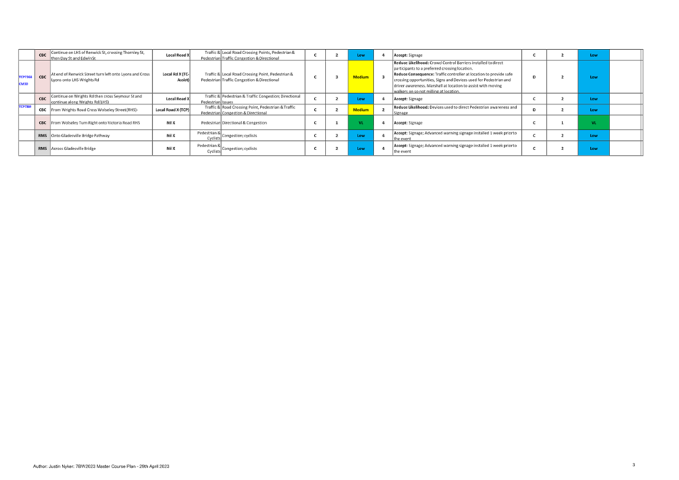
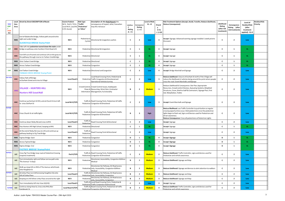
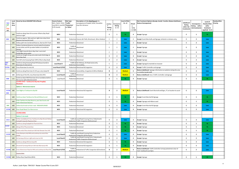
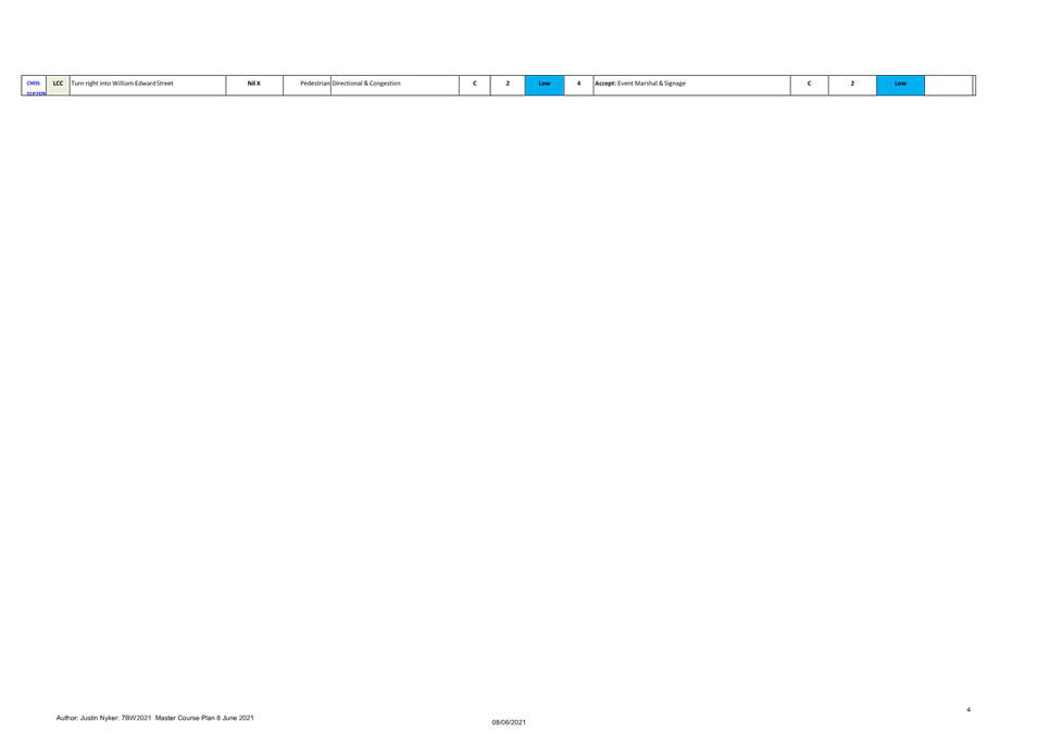
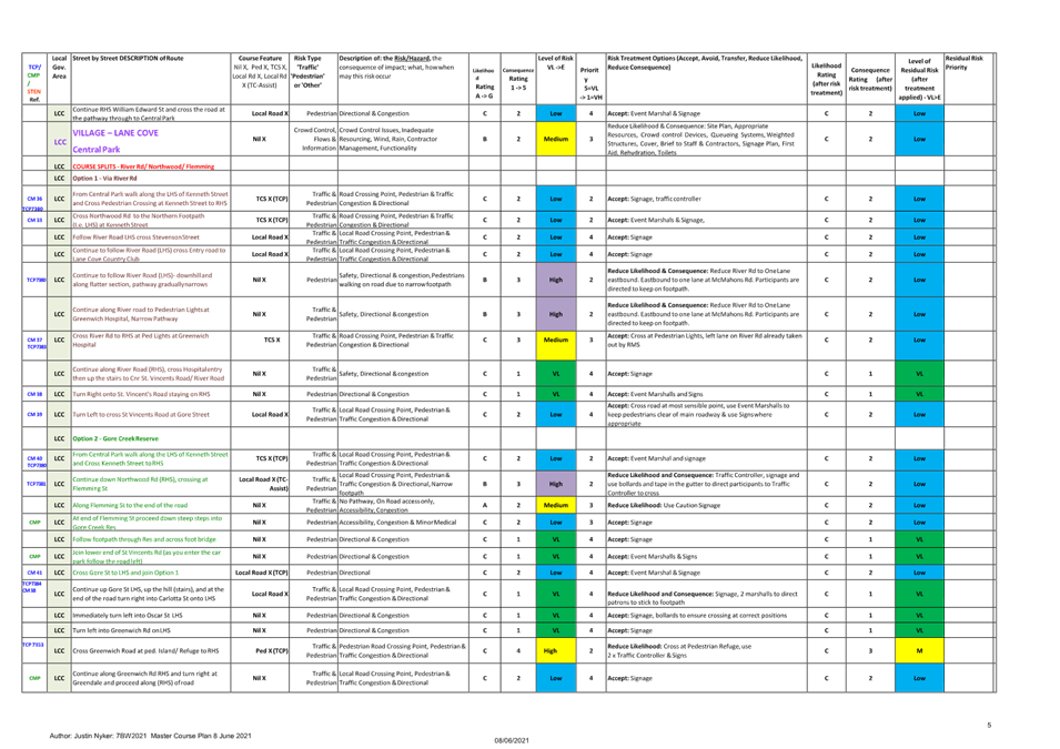
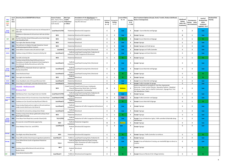
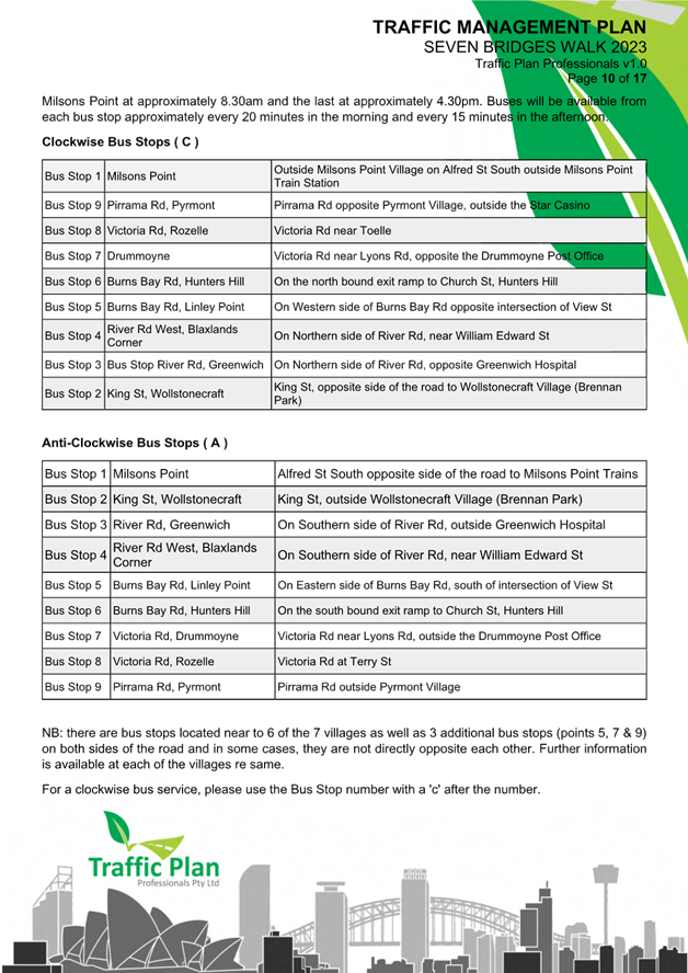
The course of CCNSW Seven Bridges Walk will open at 7:00am, and close at 4:30pm and it is estimated that it may attract up to 15,000 participants. The walking route is approximately 27km in length and is a closed loop circuit that utilises pathways around the inner metropolitan region of Sydney that skirts the Sydney Harbour and includes the crossing of seven bridges. Special event buses will operate in both directions around the course and will be provided free of charge to everyone holding an ‘event passport’.
Course Description:
The walking route is approximately 27km in length and is a closed loop circuit that utilises pathways around the inner metropolitan region of Sydney that skirts the Sydney Harbour and includes the crossing of Seven Bridges.
The Seven Bridges are:
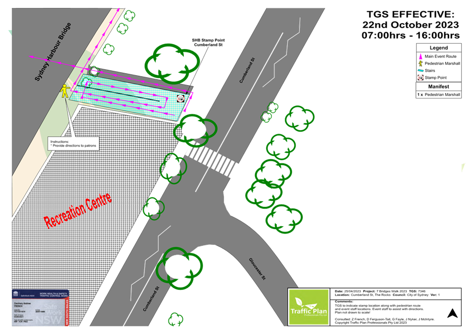
1. Sydney Harbour Bridge
2. Pyrmont Bridge
3. ANZAC Bridge
4. Iron Cove Bridge
5. Gladesville Bridge
6. Tarban Creek Bridge
7. Fig Tree Bridge
Village Locations:
Event ‘Villages’ are located around the course and will be used as check-in locations, First Aid points, drink stations, light catering and entertainment.
The 6 villages are:
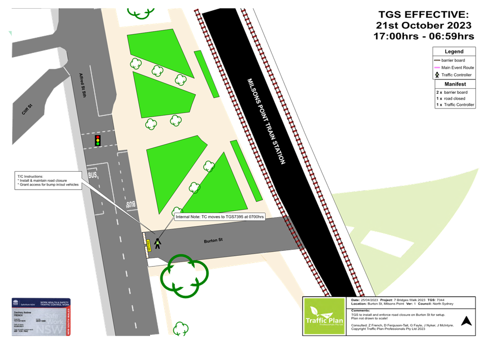
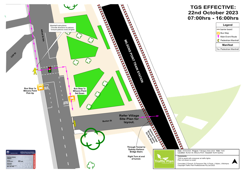
1. Milsons Point Village (Burton Street at Alfred Street, Milsons Point)
2. Pyrmont Village (at Pyrmont Bay Park, Pirrama Rd, opposite The Star Casino)
3. Rozelle Village (at Waterfront Drive Sporting Ground - Callan Park)
4. Hunters Hill Village (at Hunters Hill Scout Hall, Durham St near the Church St overpass on Burns Bay Road, Hunters Hill)
5. Lane Cove Village (Blaxlands Corner – Central Park, William Edward St and Kenneth St, Lane Cove)
6. Wollstonecraft Village (at Brennan Park, Hazelbank St at King St, Wollstonecraft)
Impact on the Inner West LGA
The route through the Inner West LGA is via:
· ANZAC Bridge to Victoria Road
· Pedestrian bridge over Victoria Road
· Lilyfield Road
· Burt Street
· Denison Street
· Cheltenham Street
· O’Neill Street
· Cecily Street
· Through Callan Park to King George Park
· Byrnes Street to Victoria Road OR
· Byrnes Street to Iron Cove Bridge via the underpass (alternative route).
Traffic and Pedestrian Management Plan (TMP)
This event does not require closure of any roads in the Inner West LGA. As the participants will be using footpaths and crossing the street network with assistance of traffic controllers, the Event does not cause significant impacts on traffic and transport systems. Therefore, the walk can be considered as a Class 3 event. Hence, Council’s approval for the Traffic & Transport Management Plan is adequate.
The attached Pedestrian and Traffic Management Plan (TMP), when approved by the relevant authorities, becomes the prime document detailing with the traffic and transport arrangements under which this event is to proceed.
In case of emergencies, or for the management of incidents, the Police are not subject to the conditions of the TMP but will make every effort to inform the other agencies of the nature of the incident and the Police response.
The route for the proposed Seven Bridges Walk and the Traffic Control Plans (TCP) and Traffic Management Plan for Inner West Council LGA are attached.
FINANCIAL IMPLICATIONS
All costs associated with the Seven Bridges Walk are funded by the event organisers.
|
1.⇩ |
Traffic Control Plan - Seven Bridges Walk 2023 |
|
2.⇩ |
Traffic Management Plan - Seven Bridges Walk 2023 |
|
|
Local Traffic Committee Meeting 19 June 2023 |
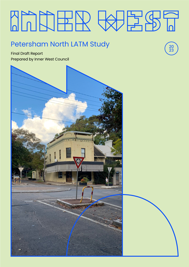
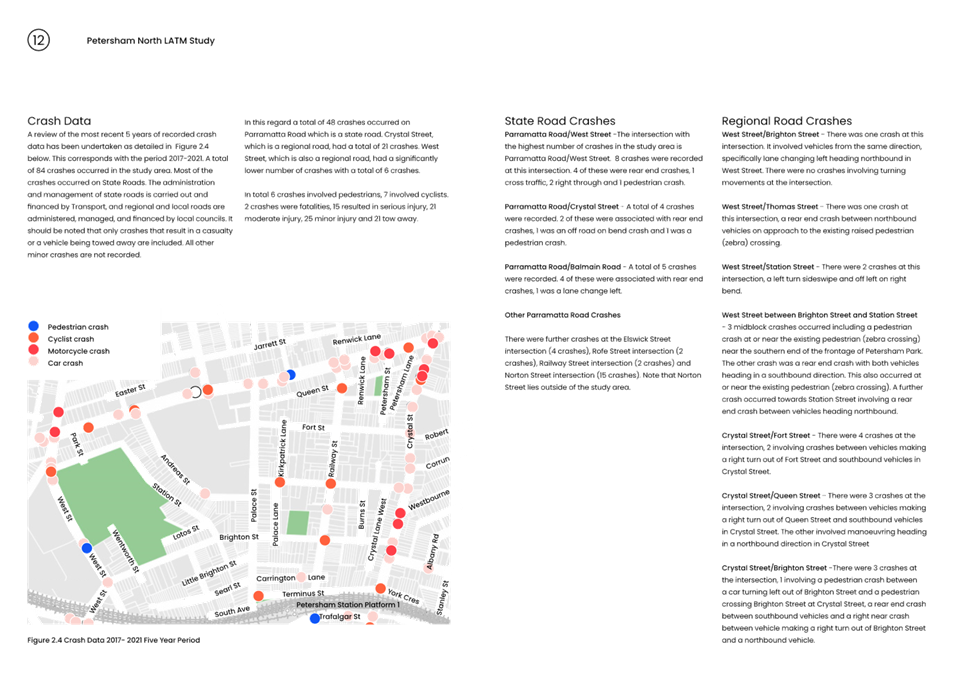
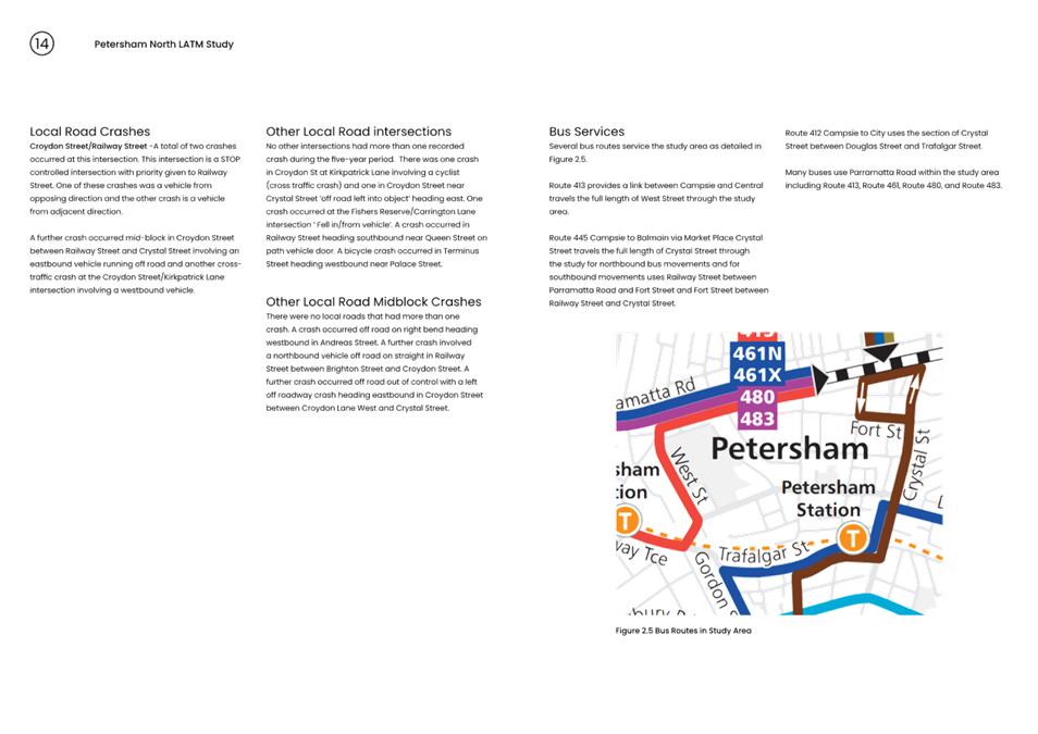
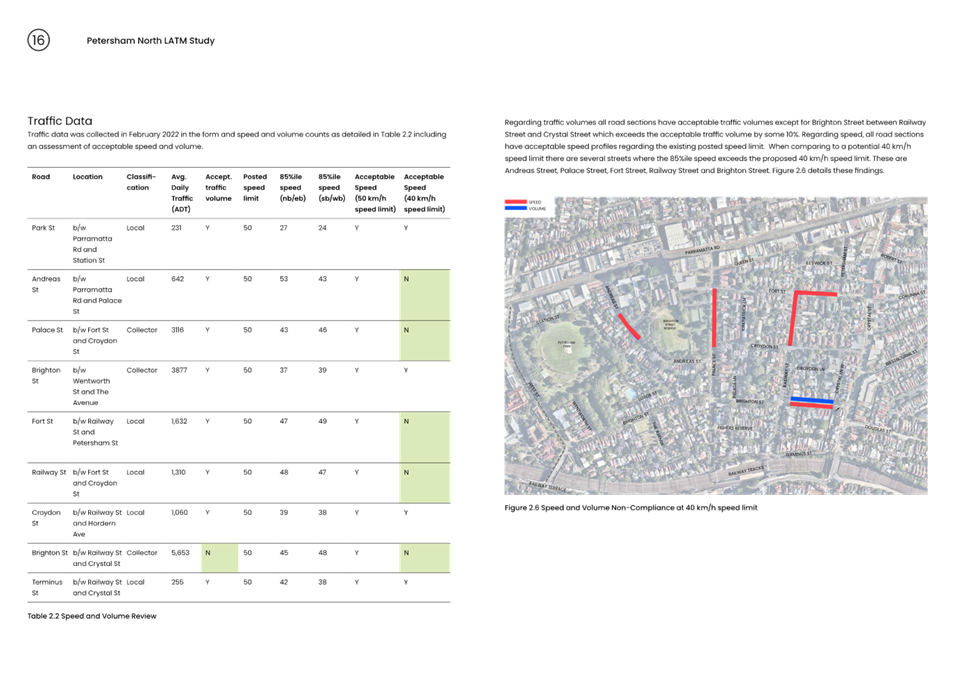
Subject: Petersham North Latm Study (Damun-Stanmore Ward/Newtown Electorate/Inner West PAC)
Prepared By: Jason Scoufis - Coordinator Traffic Studies and Road Safety
Authorised By: Manod Wickramasinghe - Traffic and Transport Planning Manager
SUMMARY
Council has prepared a draft Local Area Traffic Management (LATM) study to address key community concerns about traffic, pedestrian and cycling facilities in the Petersham North LATM precinct area.
The recommendations aim to align with Council policies and strategies, with an emphasis on
improving pedestrian and cyclist movements, whilst retaining safe and acceptable traffic
volume and speeds in local streets.
|
RECOMMENDATION
That:
1. The final draft Petersham North Local Area Traffic Management (LATM) Study be endorsed for community consultation; and
2. The report be placed on Public Exhibition, providing a minimum 28 days for community feedback and the results be reported back to the Traffic Committee.
|
BACKGROUND
As part of Council’s Local Area Traffic Management (LATM) Strategy Review Program Council has prepared the Petersham North LATM study.
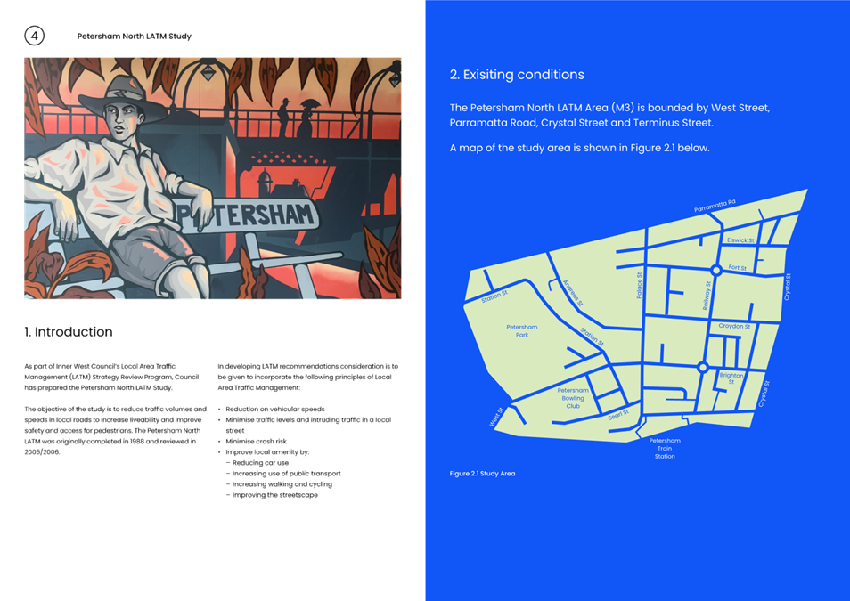
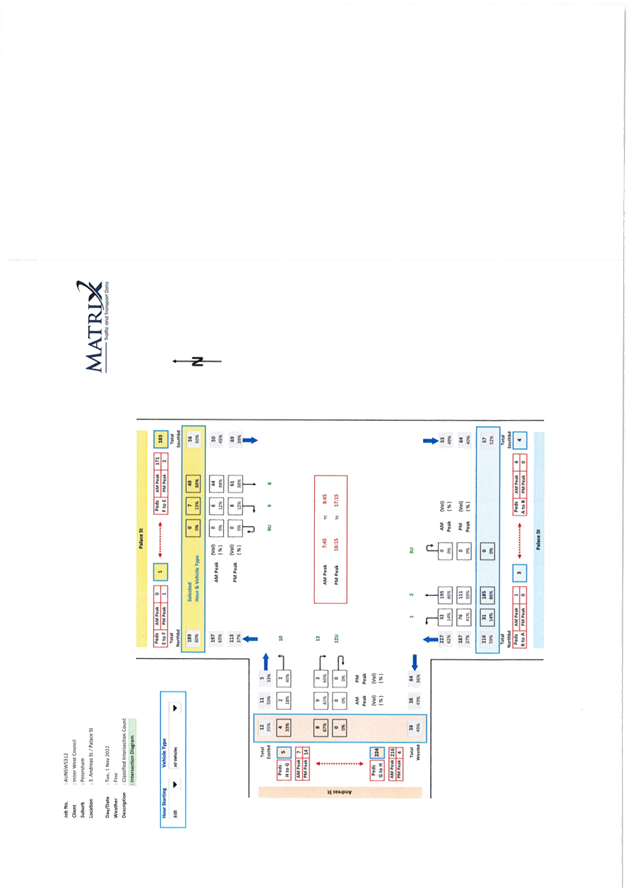
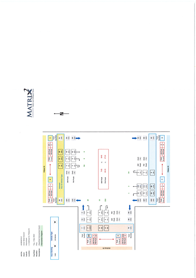
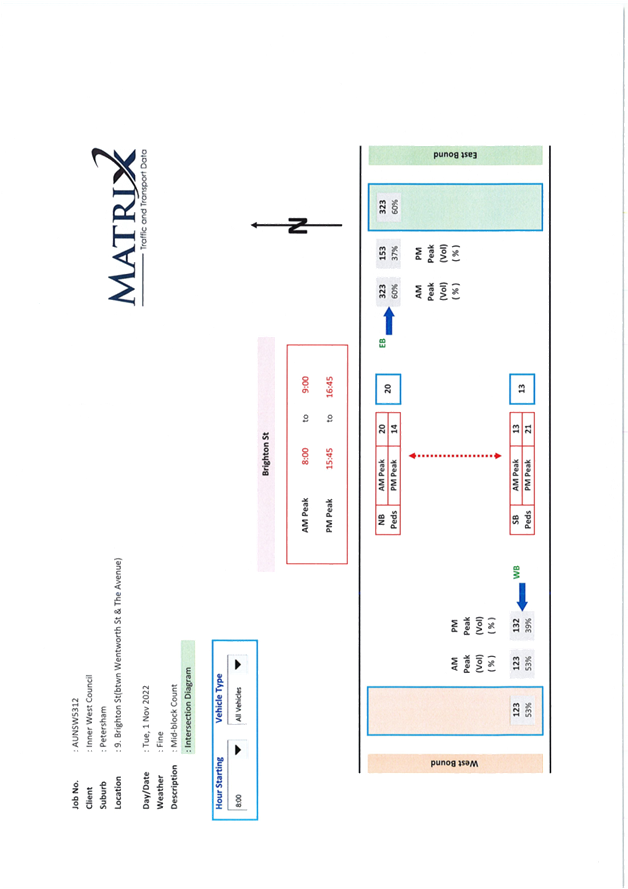
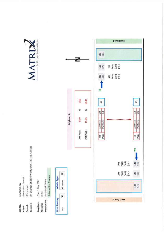
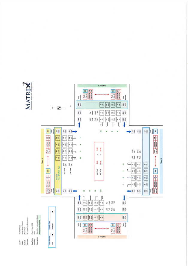
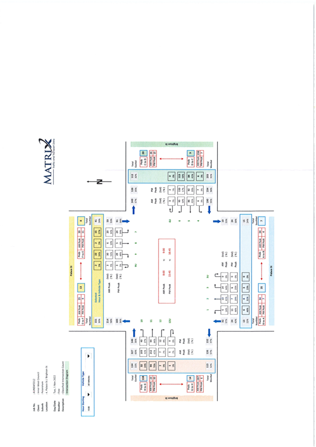
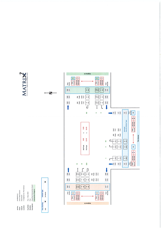
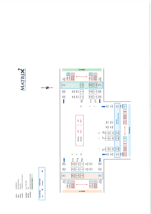
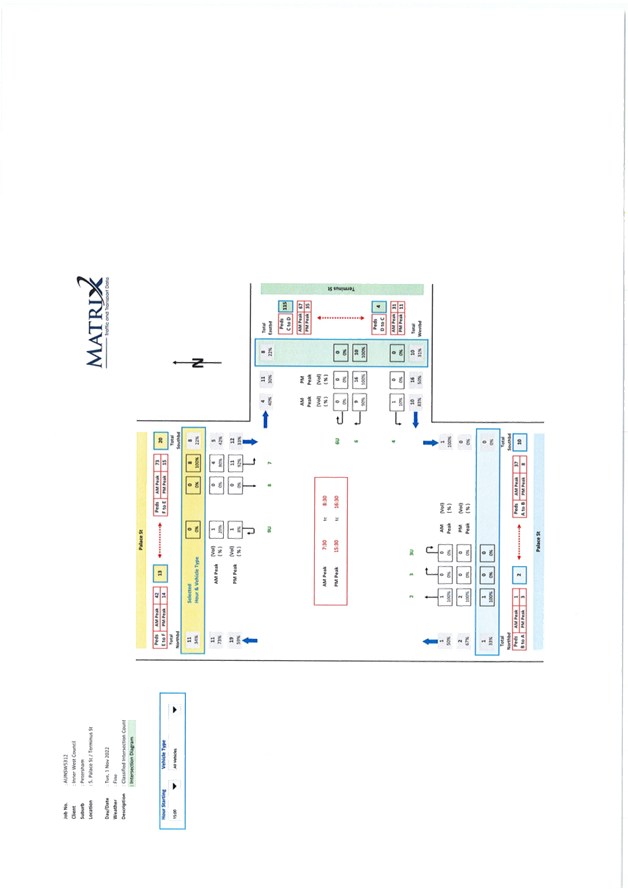
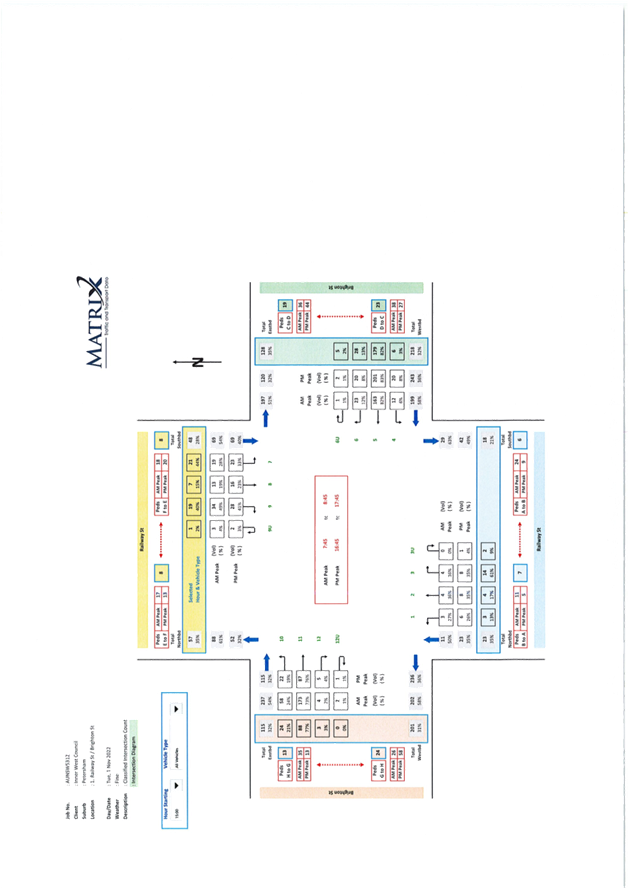
The Petersham North LATM (area M3) precinct is bounded by West Street, Parramatta Road, Crystal Street and Terminus Street. The final draft report is provided in Attachment 1 and traffic count data provided in Attachment 2.
The objective of the study is to reduce traffic volumes and speeds in local roads to increase liveability and improve safety and access for pedestrians. The Petersham North LATM was originally completed in 1988 and reviewed in 2005/2006.
In developing recommendations for the LATM Study, consideration was given to incorporate the following principals of Local Area Traffic Management:
· Reduction in vehicle speeds.
· Minimise traffic levels and intruding traffic in a local street.
· Minimise crash risk.
· Improve local amenity by:
o Reducing car use
o Increasing use of public transport
o Increasing walking and cycling
o Improving the streetscape
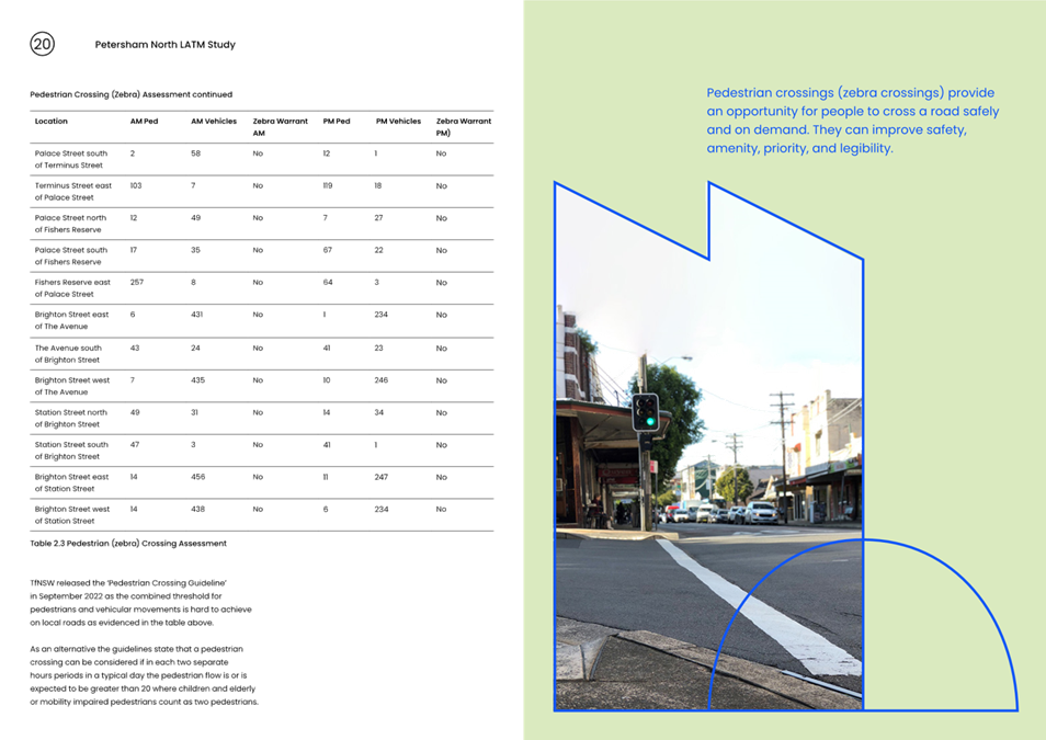
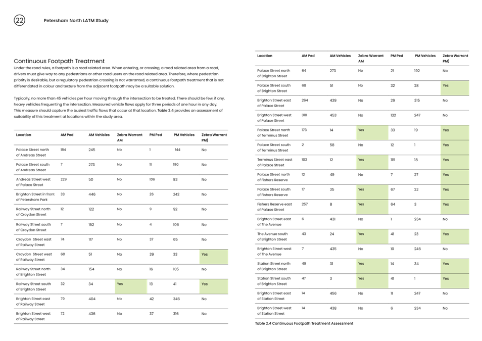
Traffic tube counts, intersection counts, and origin destination data were collected, and crash history reviewed to assist the study. Further site observations were used to determine what type of facility was warranted in specific locations.
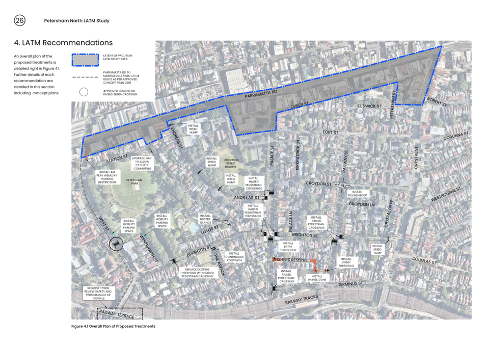
A summary of the recommendations is detailed below.
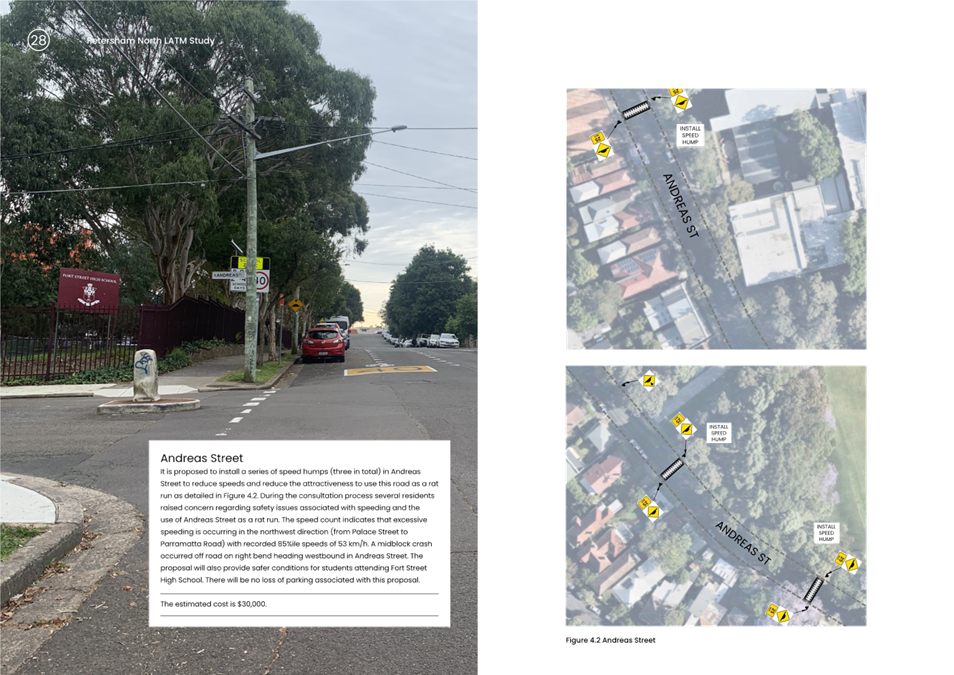
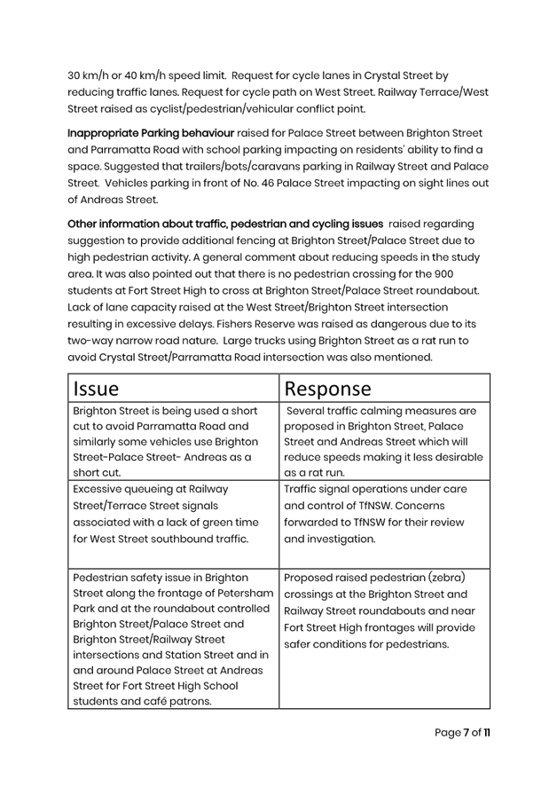
· Install 3 x speed humps in Andreas Street between Palace Street and Parramatta Road.
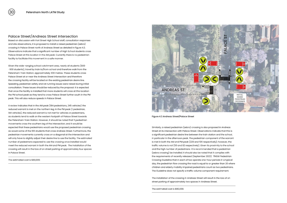
· Install a raised pedestrian (zebra) crossing in Palace Street north of Andreas Street.
· Install a raised pedestrian (zebra) crossing in Andreas Street west of Palace Street.
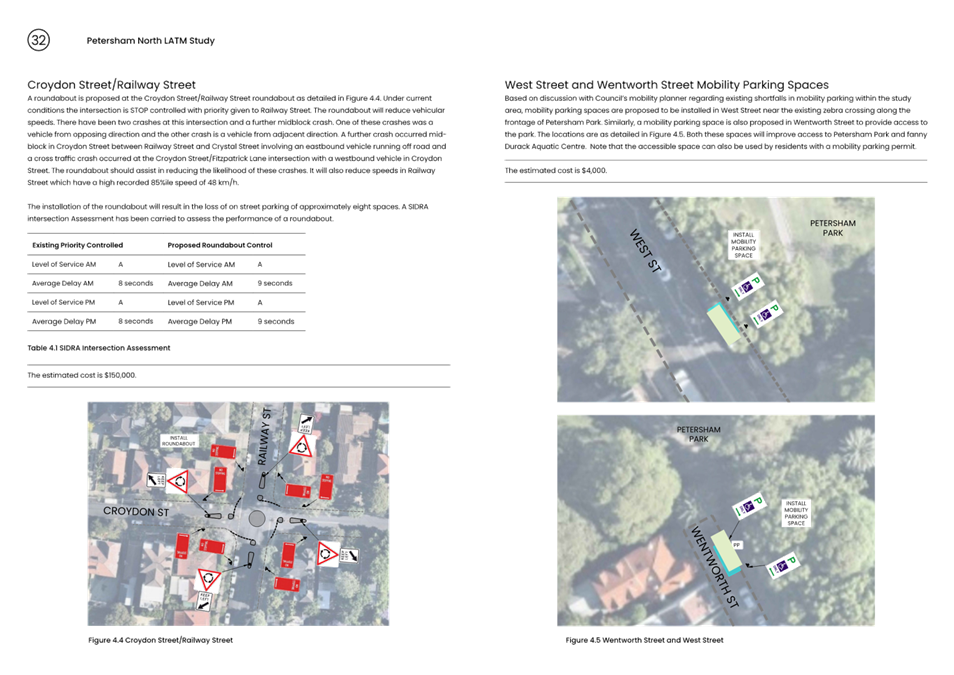
· Install a single lane roundabout at Croydon Street/Railway Street.
· Install a mobility parking space on the eastern side of West Street north of the existing at grade zebra crossing along the frontage of Petersham Park.
· Install a mobility parking space on the eastern side of Wentworth Street at the northern end along frontage of Petersham Park.
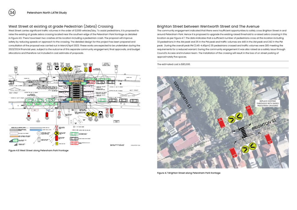
· Replace raised threshold in Brighton Street between Wentworth Street and The Avenue with a raised pedestrian (zebra) crossing.
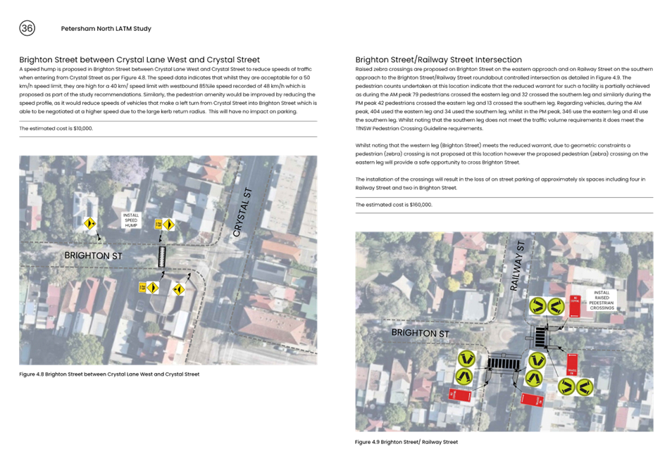
· Install a speed hump in Brighton Street between Crystal Lane West and Crystal Street.
· Install raised pedestrian (zebra) crossing on eastern leg of intersection (Brighton Street) at Brighton Street/Railway Street intersection.
· Install raised pedestrian (zebra) crossings on southern leg of intersection (Railway Street) at Brighton Street/Railway Street intersection.
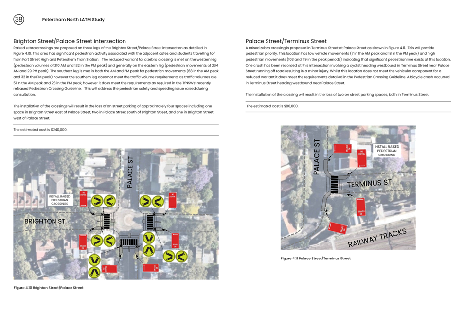
· Install raised pedestrian (zebra) crossings on eastern leg (Brighton Street) of Brighton Street/Palace Street intersection.
· Install raised pedestrian (zebra) crossings on western leg (Brighton Street) of Brighton Street/Palace Street intersection.
· Install raised pedestrian (zebra) crossings on southern leg (Palace Street) of Brighton Street/Palace Street intersection.
· Install a raised pedestrian (zebra) crossing in Terminus Street at Palace Street.
· Request TfNSW review safety and performance of the West Street/Terrace Street traffic signals.
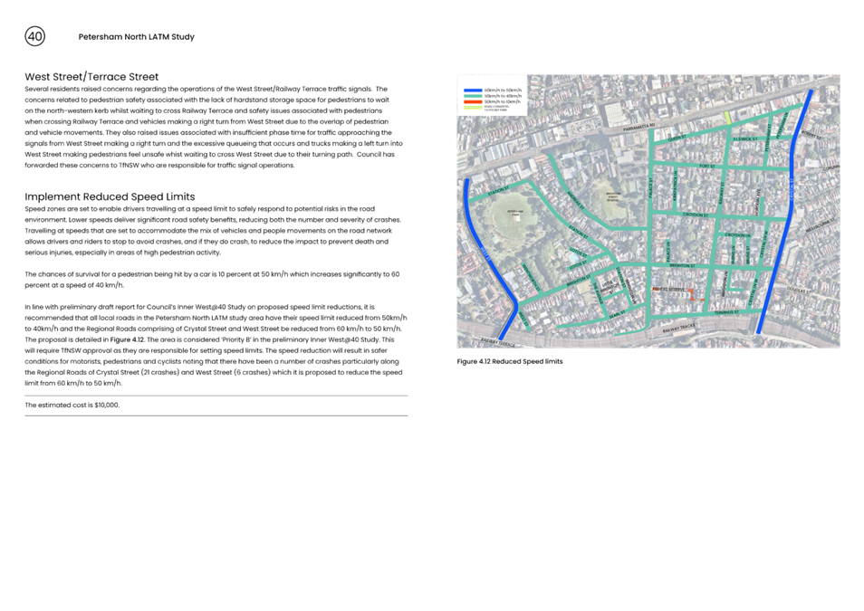
· Request TfNSW implement 40 km/h speed limit on Local Roads and 50 km/h speed limit on Regional Roads within study area.
· Replace existing four space ‘No Parking 4pm-6pm Mon-Fri' with ‘No Parking 7:00am-9:30am, 4:00pm-6:00pm Mon-Fri' on eastern side of West Street between Parramatta Road and Station Street.
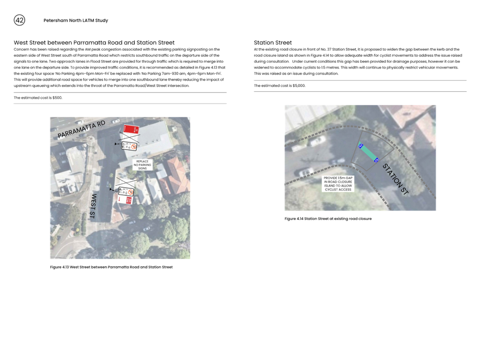
· Provide 1.5 metre gap in existing midblock road closure island in Station Street to allow access for cyclists.
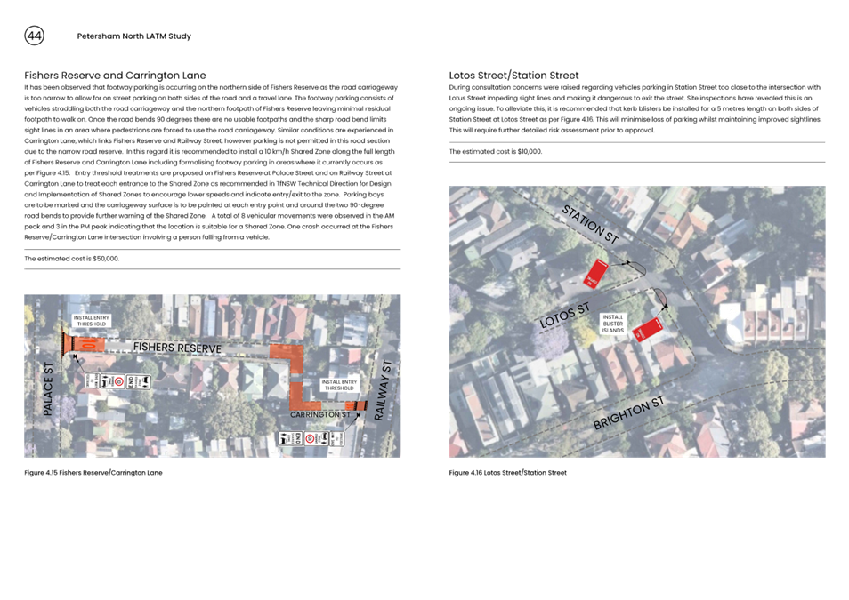
· Install a 10 km/h Shared Zone in Fishers Reserve and Carrington Lane with footway parking on northern side of Fishers Reserve.
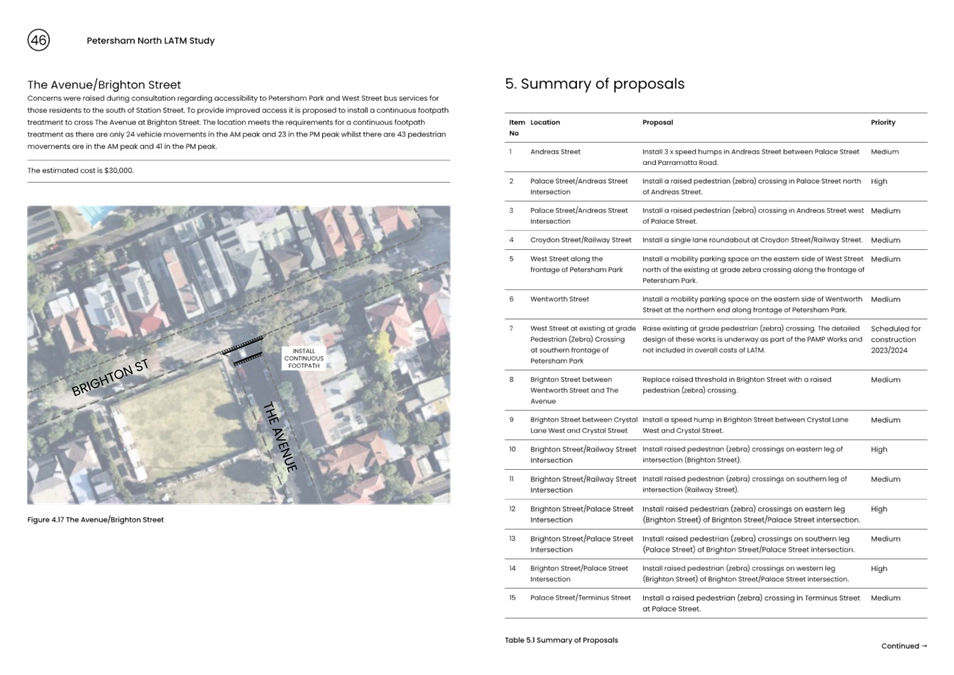
· Install kerb blisters in Station Street at Lotos Street.
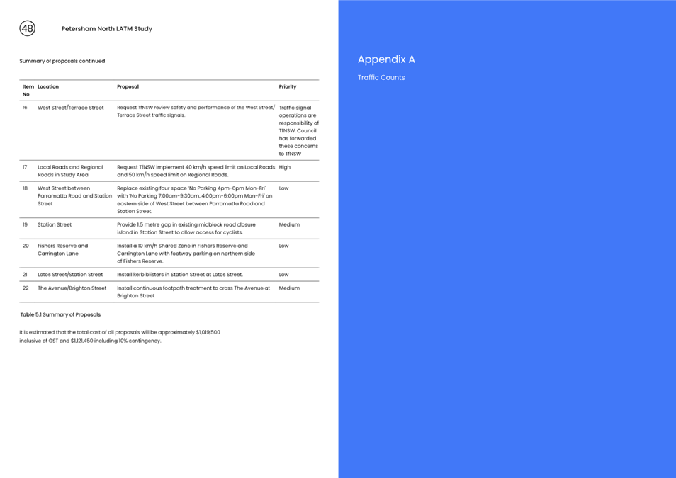
· Install continuous footpath treatment to cross The Avenue at Brighton Street.
FINANCIAL IMPLICATIONS
The cost of proposed treatments as listed in the draft proposed treatments arising from the Petersham North LATM Study is estimated to cost approximately $1,154,450 (including GST). This cost takes into consideration 10% contingency. Once the LATM Study is adopted, detailed design and construction will be scheduled.
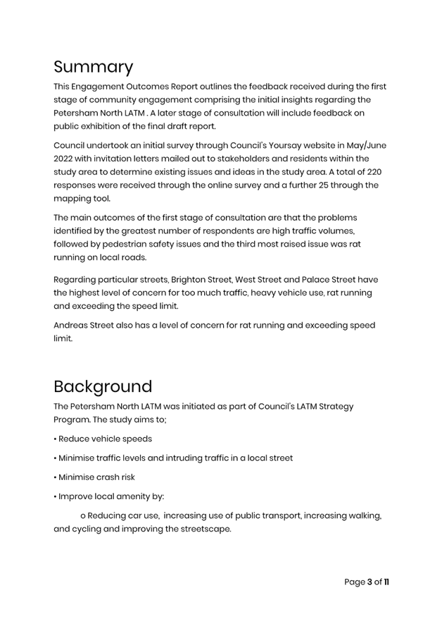
PUBLIC CONSULTATION
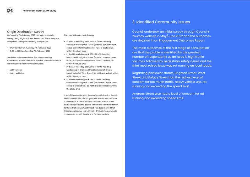
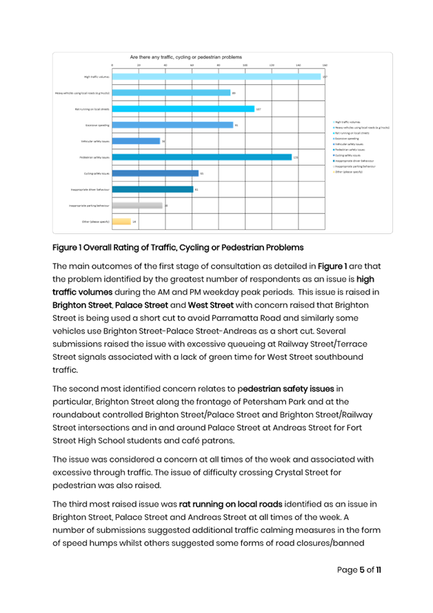
Council undertook a survey through Council’s Yoursay website with invitation letters mailed out to stakeholders and residents within the study area in May/June 2022. A total of 220 submissions were received through the online survey and a further 25 contributed through the online mapping tool. An additional 3 responses were received via email.
The main outcomes of the first stage of consultation are that the problems identified by the greatest number of respondents are high traffic volumes, followed by pedestrian safety issues and the third most raised issue was rat running on local roads.
Regarding particular streets, Brighton Street, West Street and Palace Street have the highest level of concern for too much traffic, heavy vehicle use, rat running and exceeding the speed limit. Andreas Street also has a level of concern for rat running and exceeding speed limit.
The Engagement Outcomes Report of the first stage of consultation is attached in Attachment 3.
|
1.⇩ |
Final Draft Petersham North LATM Study |
|
2.⇩ |
Traffic Counts |
|
3.⇩ |
Petersham North LATM Engagement Outcomes Report |
|
Local Traffic Committee Meeting 19 June 2023 |
Subject: Wardell Road, Dulwich Hill - Traffic Improvements (Djarrawunang-Ashfield Ward/Summer Hill Electorate/Inner West PAC)
Prepared By: Jason Scoufis - Coordinator Traffic Studies and Road Safety
Authorised By: Manod Wickramasinghe - Traffic and Transport Planning Manager
SUMMARY
Council is proposing traffic changes to improve traffic flow in Wardell Road. The proposed recommendations include the installation of a ‘DO NOT QUEUE ACROSS INTERSECTION’ sign at the Wardell Road/Riverside Crescent intersection and ‘No Parking 7:00am-9:30am Monday – Friday’ signposting along the frontage of 281-285 Wardell Road.
|
RECOMMENDATION
That:
1. A ‘DO NOT QUEUE ACROSS INTERSECTION’ (G9-237) sign be installed at the Wardell Road/Riverside Crescent intersection in Wardell Road facing northeast bound traffic.
2. ‘No Parking 7:00am-9:30am Monday – Friday’ signposting be installed along the frontage of 281-285 Wardell Road. |
BACKGROUND
Council at its meeting held in December 2022 when considering a Traffic Committee report on options to improve traffic flow in Wardell Road resolved in part as follows;
Council will retain the no-left turn restriction from Wardell Road onto Riverside Crescent, installed in early 2021 as part of the Greenway Project, and will investigate further measures that protect pedestrian and cyclist safety and alleviate traffic on Wardell Road.
In regard to further measures to alleviate traffic on Wardell Road, it is recommended that the following measures be introduced:
· A ‘DO NOT QUEUE ACROSS INTERSECTION’ (G9-237) sign be installed at the Wardell Road/Riverside Crescent intersection in Wardell Road facing northeast bound traffic.
· ‘No Parking 7:00am-9:30am Monday – Friday’ signposting be installed along the frontage of 281-285 Wardell Road.
The ‘DO NOT QUEUE ACROSS INTERSECTION’ signposting will advise motorists heading northeast in Wardell Road not to queue across the Riverside Crescent/Wardell Road intersection. This will allow improved conditions for vehicles exiting Riverside Crescent making a right turn into Wardell Road heading southwest towards Earlwood.
The proposed ‘No Parking 7:00am-9:30am Monday – Friday’ signposting in front the frontage of 281-285 Wardell Road will allow for additional storage capacity in Wardell Road on approach to the Ewart Street traffic signals during the AM peak weekday when traffic queueing is at its peak heading towards Dulwich Hill. It will result in the loss of 3 to 4 parking spaces during these hours.
It will allow residents to park on-street overnight, however, they will need to leave by 7:00am on weekdays. Furthermore, business owners/shoppers will be able to park in these spaces during general business hours.
FINANCIAL IMPLICATIONS
The costs to implement the recommendations will be funded from Council’s operational signage and linemarking budget.
PUBLIC CONSULTATION
During the July/August 2022 public exhibition, no objections were received from immediately impacted properties regarding the AM peak ‘No Parking’ restriction.
Nil.
|
|
Local Traffic Committee Meeting 19 June 2023 |
Subject: Ewart Street, Dulwich Hill; Burrows Avenue, Railway Road, Gleeson Avenue and (Lower) Railway Parade, Sydenham - Temporary Parking Changes During Major Rail Shutdown Of T3 Line for Sydney Metro Upgrade Works - Bus Replacements for 11 Days Between Thursday 6 July to Sunday 16 July 2023 (Midjuburi - Marrickville Ward / Summer Hill Electorate / Inner West PAC)
Prepared By: Jennifer Adams - Traffic Engineer
Authorised By: Manod Wickramasinghe - Traffic and Transport Planning Manager
SUMMARY
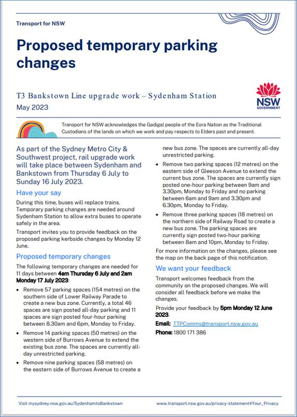
Council has been notified by Transport for NSW (TfNSW) that Sydney Metro works will involve a major rail shutdown of the Sydenham to Bankstown rail line (T3) for an 11-day period between Thursday 6 July to Sunday 16 July 2023 (inclusive). During the shutdown buses will replace train services along the T3 line and to accommodate the increased bus movements and necessary holding areas some short-term parking changes are required at a number of locations.
Specifically, TfNSW is requesting approval for the temporary conversion of multiple parking spaces at the following locations: Ewart Street, Dulwich Hill; Burrows Avenue, Railway Road, Gleeson Avenue and (Lower) Railway Parade, Sydenham. It is recommended that no objections be raised, and Council approves the temporary short-term parking changes at the identified locations during the rail shutdowns.
|
RECOMMENDATION
That this report be received and noted and the following temporary short-term parking changes for 11 days from 4am Thursday 6 July to 2am Monday 17 July 2023 (inclusive) be approved and implemented by TfNSW:
Dulwich Hill Station Precinct - Ewart Street (3 parking spaces) 1. The short-term conversion of 20m (3 parking spaces) ‘2P 8 am – 6 pm Mon – Fri’ on the northern side of Ewart Street (between Wardell Road and Bayley Street) to a ‘Bus Zone’ be APPROVED in order to provide a bus zone with adequate draw-in length; Sydenham Station Precinct - Burrows Avenue (23 parking spaces)
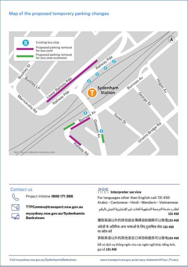
2. The short-term conversion of 50m (14 parking spaces) rear to kerb ‘unrestricted parking’ on the northern kerb of Burrows Avenue (west of Gleeson Avenue) to a ‘Bus Zone’ be APPROVED in order to provide additional bus bays for adequate bus draw-in/draw-out length;
3. The short-term conversion of 58m (9 parking spaces) ‘unrestricted parking’ on the southern kerb of Burrows Avenue (west of Gleeson Avenue) to a ‘Bus Zone’ be APPROVED in order to provide additional bus bays for bus layover purposes;
Sydenham Station Precinct – Railway Road (3 parking spaces)
4. The short-term conversion of 18m (3 parking spaces) ‘2P 8:30 am – 10 pm Mon - Fri’ on the eastern side kerb of Railway Road (between Burrows Avenue and Gleeson Avenue) to a ‘Bus Zone’ be APPROVED in order to provide additional bus bays for bus layover purposes; Sydenham Station Precinct - Gleeson Avenue (2 parking spaces)
5. The short-term conversion of 12m (2 parking spaces) ‘1P 9:00 am – 3:30 pm Mon - Fri and No Parking 6 am-9 am & 3:30 pm – 6:30 pm’ on the eastern kerb of Gleeson Avenue (between Burrows Avenue and Unwins Bridge Road) to a ‘Bus Zone’ be APPROVED in order to provide a bus stop extension with adequate draw-in/draw-out length; Sydenham
Station Precinct -
6. The short-term conversion of 122m (46 parking spaces) 45 degree angled ‘unrestricted parking’ on the southern side kerb of Lower Railway Parade (between Sydenham Road and Marrickville Road) to a ‘Bus Zone’ be APPROVED in order to provide additional layover and standby bus bays;
7. The short-term conversion of 32m (11 parking spaces) 45 degree angled parking ‘4P 8:30 am – 6 pm Mon - Fri’ on the southwest kerb of Lower Railway Parade (between Gleeson Avenue and Marrickville Road) to a ‘Bus Zone’ be APPROVED in order to provide additional layover bus bays with adequate draw-in length; and
8. The applicant and Council Rangers be advised in terms of this report.
|
BACKGROUND
Sydney Metro City & Southwest - Sydenham to Bankstown project will upgrade all 10 stations between Marrickville and Bankstown to meet metro standards before converting the T3 Bankstown Line to Metro operations.
During this possession, rail services on the T3 Bankstown Line will not operate and Temporary Transport Plan (TTP) buses will operate instead necessitating some short-term changes in parking at a number of locations. To support this closure TTP buses and additional T8 Airport & South Line trains will operate from Thursday 6 July to Sunday16 July 2023 (inclusive).
All changes to street signage will be made by TfNSW contractor(s) from 10pm the night before the closures and will be reinstated at the completion of the planned shutdowns.
It is noted that for this shutdown TfNSW has identified Ewart Street the designated Dulwich Hill Station Precinct location. Previously LTC approval has been forthcoming with the below short term conversion changes made in Dudley Street, Dulwich Hill:
· The short-term conversion of 7m (1 parking space) ‘Loading Zone 8:30 am – 6 pm Mon – Fri & 8:30 am – 12:30 pm Sat’ on the northern side of Dudley Street (between Wardell Road and School Parade) to a ‘Bus Zone’ be APPROVED in order to provide an additional bus bay with adequate draw-in length;
· The short-term conversion of 18m (3 parking spaces) ‘P30 min 8:30 am – 6 pm Mon – Fri & 8:30 am – 12:30 pm Sat’ on the northern side of Dudley Street (between Wardell Road and School Parade) to a ‘Bus Zone’ be APPROVED in order to provide an additional bus bay with adequate draw-in length;
TfNSW in their last shutdown were forced to temporarily use Ewart Street bus stops as Dudley Street was closed to buses due to Dulwich Hill Station Precinct Public Domain Improvements Project works. Two temporary bus stops, 150 metres away, were subsequently installed on Ewart Street between Wednesday 1 March to 7 April 2023.
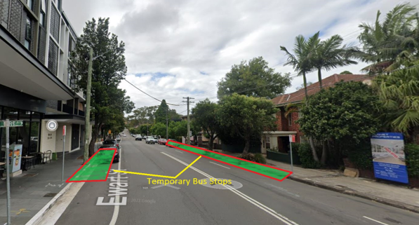
TfNSW have now advised that the relocation was successful from a bussing reliability and bus serviceability perspective. Moving forward, they would like to continue utilising the bus stops on Ewart Street, Dulwich Hill – which includes usage during their Weekend and school holiday operations moving into the future.
In a submission to Council regarding TfNSW’s utilisation of Ewart Street, Dulwich Hill at Murray Lane bus stop location (currently a Night Ride bus stop - Stop ID: 2204118) they state Ewart Street at Murray Lane bus stop advantages are:
- Enhanced travel path between Hurlstone Park to Marrickville – utilising Ewart Street only and not having to be diverted from the bus route. Noting that the travel time enhancement will have a benefit to customers, some who travel from stations further south-west of Canterbury.
- Enhanced travel times - buses will save up to 3 minutes in travel time by directly utilising Ewart Street.
- Overall better passenger experience (This service is used by up to 28,000 customers on a weekday.)
- Allows for the use of coaches who find it challenging to traverse on the older route path.
- The walking distance for passengers from Dulwich Hill station is downhill and is approximately 190 metres from the train station.
- Previously TfNSW has requested 3 x parking spaces and 1 x loading zone to be replaced by a Bus Zone on Dudley Street. TfNSW now request only 3 x parking spaces to be replaced by a Bus Zone on Ewart Street – enabling additional parking and space on Dudley Street.
Council Officers have raised concerns with TfNSW that the proposed area in Ewart Street does not have the bus infrastructure that has been provided in Dudley Street (i.e. bus shelters) and that Ewart Street is located further from the Station than Dudley Street. Furthermore, trees and planting beds located in the footpath in Ewart Street may pose a problem with regarding to passenger access onto buses.
Due to short notice, the July 2023 temporary short-term changes can be supported however it is noted that at some time in the future TfNSW may be requested by Council to return to using Dudley Street, Dulwich Hill as the preferred location for all buses as it is immediately adjacent to Dulwich Hill Station and considered more convenient for local residents.
FINANCIAL IMPLICATIONS
There are no financial implications for Council associated with this matter. The cost of the work will be borne by Transport for NSW.
OFFICER COMMENTS
Each of the locations will be detailed separately.
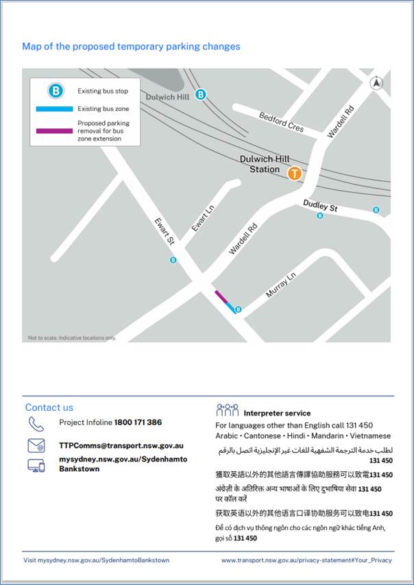
Dulwich Hill Station Precinct (3 parking spaces)
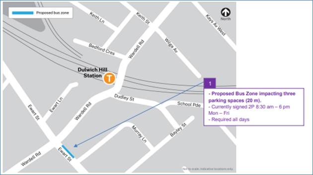
1. Ewart Street, northern side (Stop ID: 2204118) - Bus stop extension (3 parking space)
· Ewart Street (northern kerb between Wardell Road and Bayley Street)
· Currently sign posted ‘2P 8:30 am – 6 pm Mon – Fri’
· Proposed Bus Zone is required for all days of the TTP bus operation
· Proposed temporary change will impact approximately three parking spaces (20m).
· This change is proposed to create a bus stop area and to provide adequate space for draw-in/draw-out purposes.
Sydenham Station Precinct (85 parking spaces)
2. Burrows Avenue, Sydenham (Stop ID: 204421) Rear to kerb parking – Bus Zone Extension (14 parking spaces)
· Burrows Avenue (northern kerb west of Gleeson Avenue)
· Currently ‘Unrestricted parking’
· Proposed Bus Zone is required for all days of the TTP bus operation
· This proposed change is to create the space required for buses to layover and to provide adequate space for draw-in/draw-out purposes.
· Proposed temporary change will impact approximately 14 rear to kerb parking spaces (50 m).
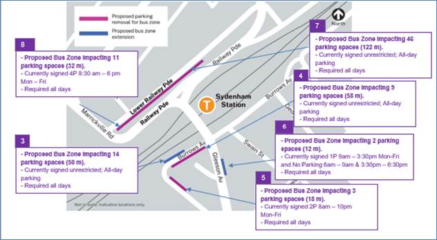
3. Burrows Avenue, Sydenham – (Southern kerb) – Bus Zone (9 parking spaces)
· Burrows Avenue (southern kerb west of Gleeson Avenue)
· Currently ‘Unrestricted parking’
· Proposed Bus Zone is required for all days of the TTP bus operation
· This proposed change is to create the space required for buses to layover safely.
· Proposed temporary change will impact approximately 9 parking spaces (58 m).
4. Railway Road, Sydenham NSW 2204 – (Northeastern kerb) – Bus Zone (3 parking spaces)
· Railway Road (northeastern kerb between Gleeson Avenue and Burrows Avenue)
· Currently ‘2P 8am – 10pm Mon-Fri’
· Proposed Bus Zone is required for all days of the TTP bus operation
· This proposed change is to create the space required for buses to layover safely and to provide adequate turning circle space.
· Proposed temporary change will impact approximately 3 parking spaces (18 m).
5. Gleeson Avenue, Sydenham (Eastern kerb) Bus Zone extension (2 parking spaces)
· Gleeson Avenue (eastern kerb between Burrows Avenue and Railway Road)
· Currently ‘1P 9:00 am – 3:30 pm Mon – Fri’
· Proposed Bus Zone extension is required for all days of the TTP bus operation
· Proposed temporary change is to create additional space required for buses to adequately draw in/out from the bus stop.
· Proposed temporary change will impact approximately 2 parking spaces (12m).
6. Section A of Lower Railway Parade, Sydenham 90-degree angled parking, Sydenham – Layover Bus Zone and Standby area (46 parking spaces)
· Lower Railway Parade Parallel Parking (southern side between Sydenham Road and Marrickville Road)
· Currently’ Unrestricted parking’
· Proposed Bus Zone is required for all days of the TTP bus operation
· Proposed temporary change will impact approximately 46 angled parking spaces (122 m).
· This proposed change is to create the space required for buses to layover. This location is proposed as it is (i) reasonably close to the active bus stop; (ii) located along the route path used between the last and first stops; and (iii) as far as removed from residential dwellings.
7. Section B of Lower Railway Parade, Sydenham 90-degree angled parking, Sydenham - Layover Bus Zone (11 parking spaces)
· Lower Railway Parade Parallel Parking (southern side between Gleeson Avenue and Marrickville Road)
· Currently ‘4P 8:30 am – 6 pm Mon – Fri’ restrictions
· Proposed Bus Zone is required for all days of the TTP bus operation
· Proposed temporary change will impact approximately eleven angled parking spaces (32 m).
· This proposed change is to create the space required for buses to layover. This location is proposed as it is (i) reasonably close to the active bus stop; and (ii) located along the route path used between the last and first stops.
PUBLIC CONSULTATION
Transport for NSW propose the temporary parking changes and they will carry out consultation with local businesses and residents during June 2023. A copy of draft notification letters are reproduced at the end of this report.
The consultation program will consist of the following activities:
• Two-week public consultation period to impacted areas with a printed community notification outlining the proposed kerbside changes. A copy of the community notifications is also available on the My Sydney website - https://www.mysydney.nsw.gov.au/SydenhamtoBankstown
A Consultation Outcomes Report will be prepared collating feedback and TfNSW’s comment on that feedback. It is proposed to table this report at the meeting.
Nil.
|
|
Local Traffic Committee Meeting 19 June 2023 |
Subject: Wardell Road, Dulwich Hill – Consent Condition For Extension To Existing School Drop Off Zone Adjacent To St Maroun's College At Nos.149-206 Wardell Road (Djarrawunang Ward/Summer Hill Electorate/Inner West PAC)
Prepared By: Jennifer Adams - Traffic Engineer
Authorised By: Manod Wickramasinghe - Traffic and Transport Planning Manager
SUMMARY
As a result of development conditions, by Sydney Eastern City Planning Panel, for St Maroun’s College an extension to the existing school drop-off / pick-up zone has been included as a consent condition. This condition requires that Council approve the extension through its Local Traffic Committee.
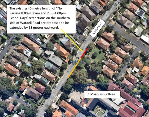
A proposal to extend the existing 40 metre length of “No Parking 8.00-9.30am and 2.30-4.00pm School Days’ restrictions in Wardell Road on the southern side by 18 meters eastward along the frontage of Gilbert Barry Reserve north of the boundary of St Maroun’s College was proposed and a consultation letter went out local residents. This report gives a summary of the results of that consultation.
|
RECOMMENDATION
That:
1. The report be noted and the Committee NOT support any further extension of the existing 40 metre length of ‘No Parking 8.00-9.30am and 2.30-4.00pm School Days’ restrictions in Wardell Road on the southern side adjacent to St Maroun’s College for the reasons as stated within this report; and
2. Council’s Planners be notified of the decision.
|
BACKGROUND
St Maroun’s College is located on the eastern side of Wardell Road, between Challis and Pine Streets, Dulwich Hill.
The current parking restrictions outside the school are as follows:
· 'No Parking 8.00am-9.30am; 2.30pm-4.30pm School Days' restrictions used by parents for the drop-off and pick-up of students (40 metres in length accommodating 7 car parking spaces).
· 'No Stopping' restrictions located directly outside the school's main entrance and extending to the south of the marked foot crossing.
· 'Bus Zone 8.45am-9.15am and 2.45pm-3.15pm School Days' restrictions south of the crossing, between the 'No Stopping' restrictions and Challis Avenue (16 metres in length).
A proposal for extending the original 30 metre length drop off/pick up zone was previously considered by the Traffic Committee in April 2019. The proposed extension was for a further 10 metre length. The recommendation of the Traffic Committee at the time was as follows;
“1. The extension of the existing 'No Parking 8.00am-9.30am; 2.30pm-4.00pm School Days’ restrictions adjacent to St Maroun’s College on Wardell Road be deferred.
2. Council's Road Safety Officer be requested to liaise with St Maroun's College regarding management of school pick-up and drop-off in the existing ‘No Parking 8.00am-9.30am; 2.30pm-4.00pm School Days’ zone.”
Although the above recommendation was adopted by Council in May 2019, it should be noted that there was considerable objection by local residents at the time. A member of the public who addressed the Local Traffic Committee stated that over time as the school has expanded parking in the street has become worse, especially for those residents with no off-street parking facilities. The RMS representative, at the time, also stated that extending the ‘No Parking’ zone was unlikely to resolve road safety issues and suggested that in the first instance, the school manage pick-up and drop-off times at the ‘No Parking’ zone.
A further proposal for extending the drop off/pick up zone was considered by the Traffic Committee on 7 September 2020. The recommendation was that:
1. The existing 'No Parking 8.00am-9.30am; 2.30pm-4.00pm School Days’ restrictions adjacent to St Maroun’s College on Wardell Road (southern side of roadway) be extended 10 metres eastward (to the school boundary line west of Gilbert Barry Reserve) to improve road safety outside St Maroun’s College; and
2. Council's Parking Officers be requested to regularly enforce the parking restrictions outside St Maroun's College in Wardell Road, Dulwich Hill during morning and afternoon school peak periods.
The above recommendation was adopted by Council at its meeting on 22 September 2020 and the drop off zone was extended shortly thereafter.
Council’s Road Safety Officer and Coordinator, Traffic and Parking Services met with the Principal of St Maroun’s College to discuss management of the school pick-up and drop-off in the existing zone as well as other options. It was acknowledged that a number of surrounding residents had voiced concerns with the loss in parking as a result of any proposed extension of the drop off/pick up zone. In this respect Council Officers investigated a number of alternate solutions to obtain additional pick up/drop off area(s) without an overall loss of unrestricted parking along Wardell Road. The options included;
· Removal of the existing School Bus Zone on the north side of Wardell Road (opposite St Maroun’s College) – This was not feasible as the Bus Zone was still in operation for school buses.
· Provision of drop off/pick up area within the School – This was not feasible due to road width constraints at the school gates would result in school children and motor vehicles mixing at the exit to the school which is a potentially hazardous environment for school children. Furthermore, other vehicles can only depart when the lead vehicle departs (due to space constraints) making the operation cumbersome.
· Provision of a drop off pick up zone in the nearby side street – This was not feasible as too many house frontages would be impact as well as the zone being located too far from the school gate and the route to leave the area would be circuitous.
Thus, the request to extend the existing school drop off zone was considered to be reasonable only if the extension was limited to being adjacent to the school property boundary only and not be extended along the frontage of the adjoining reserve.
In 2022 St Maroun’s College lodged a development application (DA20220318) proposing alterations and additions to the existing school at 194-210 Wardell Road. The application also proposed to increase the total number of students by 150, from 500 to 650, as well as to increase the total number of staff by 7, from 51 to 58. It is noted that the application originally proposed an increase to 800 students and 66 staff; however, the proposal was subsequently amended in response to a request for information from Council.
The proposal includes 11 additional car parking spaces on the site (resulting in a total of 37
spaces), 56 additional bicycle parking spaces (resulting in a total of 94 spaces), and two (2) motorcycle parking spaces. The Planners report noted that the proposal provides a sufficient number of car parking spaces for the proposed increase in staff numbers. Although the proposal does not comply with the minimum requirement for the proposed total number of staff (an additional 39 staff would require 20 spaces, effectively a shortfall of 9 spaces for staff alone), the proposal results in an improvement to the existing parking provision.
Fifty-three (53) submissions were received in response to the notification. Amongst these concerns were raised that the increased student and staff numbers, and subsequent parking requirements, could not be appropriately and safely accommodated on the site or surrounding streets, particularly given concerns around existing traffic and parking conditions.
As noted above, the application originally proposed to increase student numbers to 800 and staff to 66. The application was subsequently amended, reducing the proposed increase to 650 students and 58 staff, respectively. In this regard, the expected increase in traffic and parking has reduced. The application was further amended to delete a proposed expansion to the existing drop-off / pick-up area on Wardell Road (Council’s Assessment Report – dated 5 March 2023).
The applicants Traffic Report dated 14 December 2022 found that the existing “drop-off area was underutilised, leading to queueing along the road as drivers endeavoured to dropoff their children as close as possible to the school entrance, despite vacant spaces available further up the drop-off zone.” (observed on site visit 2 November 2021). It noted that “A drop-off / pick-up operation management plan would improve the performance of the drop-off area.” The report further notes: “No further increase to the pick-up / drop-off area is expected to be required.”
The application went to the Sydney Eastern City Planning Panel with the recommendation for approval, including a recommendation not to extend the existing school drop-off zone in Wardell Road outside St Maroun’s College. The Panel subsequently decided that an extension to the drop-off area was required and included it as a condition of consent in the determination.
FINANCIAL IMPLICATIONS
Nil.
OTHER STAFF COMMENTS
As a result of development conditions, by Sydney Eastern City Planning Panel, for St Maroun’s College an extension to the existing school drop-off / pick-up zone has been included as a consent condition. This condition requires that Council consider the extension through its Local Traffic Committee.
A consultation letter went out to the surrounding residents detailing the proposal to extend the existing 40 metre length of ‘No Parking 8.00-9.30am and 2.30-4.00pm School Days’ restrictions in Wardell Road on the southern side by 18 meters eastward along the frontage of Gilbert Barry Reserve north of the boundary of St Marouns College. (Refer to map below).
This report gives a summary of the results of that consultation.
PUBLIC CONSULTATION
A notification letter was hand delivered to 50 properties in the immediate locality along Wardell Road, Dulwich Hill on Friday 12 May 2023.
The closing date for submissions ended on Friday 26 May 2023.
Resident survey findings - A total of four (4) responses were received from residents. All opposed to the proposal.
|
Officer’s response |
|
|
Resident does not support any further extension of the drop-off zone along the front of the Gilbert Barry reserve as this would mean parking is further reduced for tenants, residents (including aging residents) and homeowners along this road.
Resident notes that the parking has already been reduced in the last couple of years to facilitate the school drop offs/pick ups and that this has not reduced the impact of school drop offs in any way so why add more spaces.
(three similar comments) |
It is noted that the expansion of the current drop off zone on Wardell Road by 20m (i.e. 3 car parking spaces) will be a further increase to a drop off zone already recently approved by Council and which now extends to the boundary of the school. This will be a further loss of all day on-street carparking for residents
|
|
Resident parking for this precinct is overdue. More teachers and more students associated with the school puts extra pressure on local parking. Give the residents a break and introduce two hour parking zones for non residents.
(two similar comments)
|
Council can consider the introduction of resident parking in this precinct should Council receive a request from 10 separate households for an investigation. |
|
The resident notes ongoing issues with double parking and obstructing driveways. They note that a select few parents park within an hour of school being let out to get a good spot which is mostly along this same road and expects that they will simply take over the extra spots provided, and stay parked until their child is let out, unless a ranger is present strictly enforcing the school zone every day.
|
Council notes that congestion occurs outside all schools especially at the afternoon pick up school period and in response Council Parking Officers regularly patrol schools in the LGA to minimise non-compliance.
Given the issues with queuing caused on Wardell Road by parent’s misuse of the drop off/pick up area it is unlikely that an additional 3 car parking spaces will make a significant difference to the problems experienced along Wardell Road. The school could explore opportunities to manage pick up/drop onsite given the relatively high traffic volumes along Wardell Road.
|
|
The new school crossing supervisor at St Maroun’s College objected to the extension of the school drop off zone.
The supervisor raised multiple concerns regarding the behaviour of both children and parent/carers attending the school and those using the pedestrian crossing.
The supervisor observed the operation of the current drop off zone for a 15-minute period one morning and noted that there is currently sufficient drop-off space for 90 “drop-offs” (at 2 minutes per drop-off). Given the above and the easy access to public transport there is no need for any extension to the drop-off areas this would represent a serious erosion of available parking for residents.
|
CONCLUSION
It is considered that any extension to the existing 40 metre length (seven car parking spaces) of 'No Parking 8.00am-9.30am; 2.30pm-4.30pm School Days' restrictions, used by parents for the drop-off and pick-up of students at St Maroun’s College, is currently not warranted and therefore it is recommended that the request not be supported for the following reasons:
It is unlikely that an additional extension of 3 car parking spaces will make any significant difference to the problems experienced along Wardell Road given the issues with queuing caused on Wardell Road by parents’ misuse of the drop off/pick up area. Any extension would unlikely resolve road safety issues and in the first instance the present ‘No Parking’ zone needs to be managed at pick-up and drop-off times. Alternately, the school should explore opportunities to manage pick up/drop onsite given the relatively high traffic volumes along Wardell Road.
It is noted that parking spaces for many of the streets surrounding the school are highly utilised and a potential overspill of parking (due to an increase in staff numbers and students) would possibly create additional problems for residents in the surrounding streets. The associated DA reports gave little to no information of how an overspill of parking may impact the surrounding area.
It is also noted that the application originally proposed an increase to 800 students and 66 staff; however, the proposal was subsequently amended in response to a request for information from Council. Subsequently, the application considered was to increase the total number of students by 150, from 500 to 650, as well as to increase the total number of staff by 7, from 51 to 58.
Nil.
|
|
Local Traffic Committee Meeting 19 June 2023 |
Subject: Smidmore Street, Marrickville – ENRC/2023/0025 - Temporary full road closures for Marrickville Metro Markets 11 to 13 August 2023, 13 to 15 October 2023, 8 to 10 December 2023, 9 to 11 February 2024, 12 to 14 April 2024, 7 to 9 June 2024 and related temporary changes to Victoria Road kerbside parking restrictions to accommodate relocation of community bus (Midjuburi – Marrickville Ward / Heffron Electorate / Inner West PAC)
Prepared By: Jennifer Adams - Traffic Engineer
Authorised By: Manod Wickramasinghe - Traffic and Transport Planning Manager
Council has been notified by MLA Transport Planning, on behalf of Marrickville Metro Shopping Centre, regarding the temporary full road closure of Smidmore Street, Marrickville between Murray Street and the Centre’s Smidmore Street car park access for Marrickville Metro Market events. Closures are proposed over six (6) separate occasions. The closures will involve related temporary changes to Victoria Road kerbside parking restrictions to accommodate relocation of the community bus stop. It is recommended that the proposed temporary road closures be approved subject to all standard Council conditions for a temporary full road closure. The related changes to kerbside signage be approved also subject to all works and costs associated with the signage changes for the relocated 'Community Bus zone' and reinstatement of Council’s original parking restrictions is to be borne by the applicant.
|
RECOMMENDATION
1. That the proposed temporary full road closures of Smidmore Street, between Murray Street and the Smidmore Street car park access, Marrickville for a series of two day periods 6am Saturday to midnight Sunday on 11 to 13 August 2023, 13 to 15 October 2023, 8 to 10 December 2023, 9 to 11 February 2024, 12 to 14 April 2024, 7 to 9 June 2024 for the purpose of holding Marrickville Metro Shopping Centre Markets be APPROVED, subject to the applicant complying with, but not limited to, the following conditions: a. A Road Occupancy License application be obtained by the applicant from the Transport Management Centre; b. All affected residents and businesses, including NSW Police Local Area Commander, Transit Systems, Fire and Rescue NSW and NSW Ambulance Services, shall be notified in writing by the applicant of the proposed temporary road closure at least 7 days prior to the event, with the applicant making reasonable provision for residents and businesses; c. The occupation of the road carriageway must not occur until the road has been physically closed; and d. A clear unobstructed 4-metre-wide path of travel throughout the site is recommended to be maintained at all times for emergency vehicle access, in order to provide safe egress in case of fire or other emergency.
2. That the proposed short-term temporary changes to parking restrictions in Victoria Road, Marrickville as per plans submitted by MLA Transport Planning (20008ppt05A-220225 Community Bus Stop Relocation Plan (002)) be APPROVED subject to the following conditions:
a. All works and cost of the supply, installation and removal of the signage associated with the temporary community bus relocation is to be borne by the applicant; b. The temporary removal and reinstatement of any Council assets will be at the applicants cost and to Council’s Traffic Engineers satisfaction; and c. Notification of surrounding properties be undertaken at least 7 Days prior to installation of the temporary changes and relocated 'Bus Zone'.
|
BACKGROUND
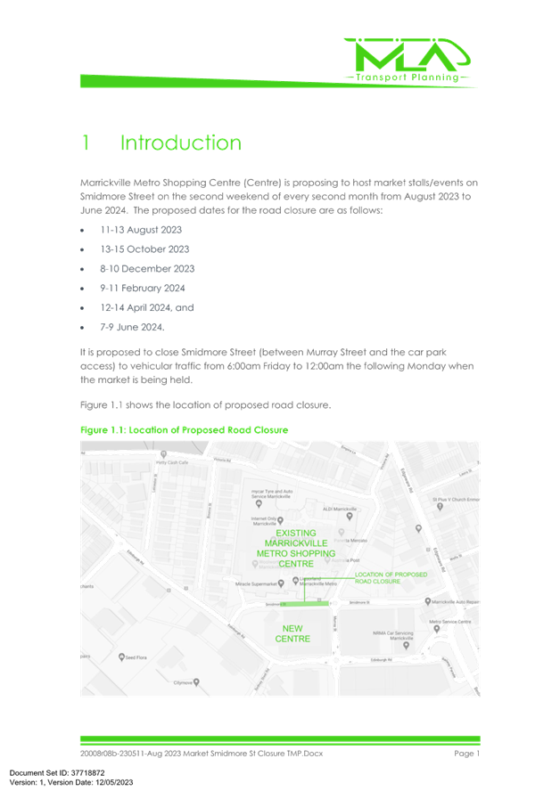
Marrickville Metro Shopping Centre is proposing to host a series of weekend markets on Smidmore Street between Murray Street and the shopping car park access. The dates the road will be closed (from 6:00am of the close date through to midnight the open date) are 11 to 13 August 2023, 13 to 15 October 2023, 8 to 10 December 2023, 9 to 11 February 2024, 12 to 14 April 2024, 7 to 9 June 2024.
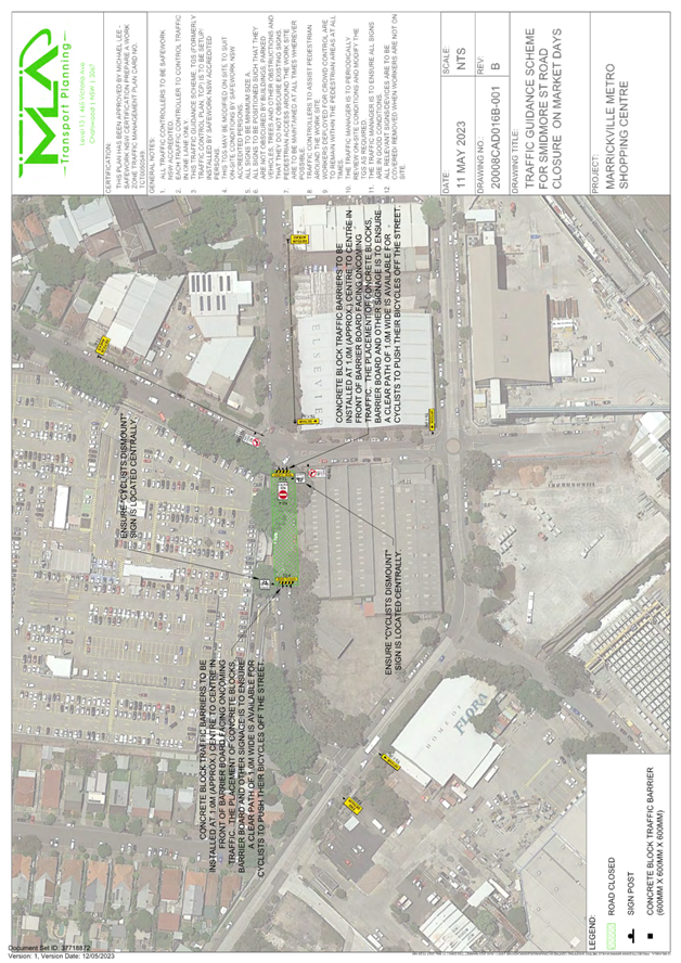
The location of the proposed road closure is shown in the diagram below.
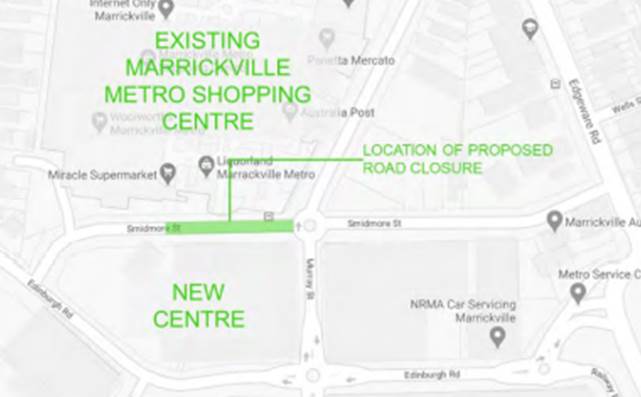
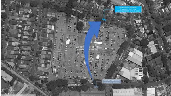
For the proposed road closures, it is also proposed to relocate the community bus stop to Victoria Road in front of the main pedestrian entrance to the existing Centre as shown below.
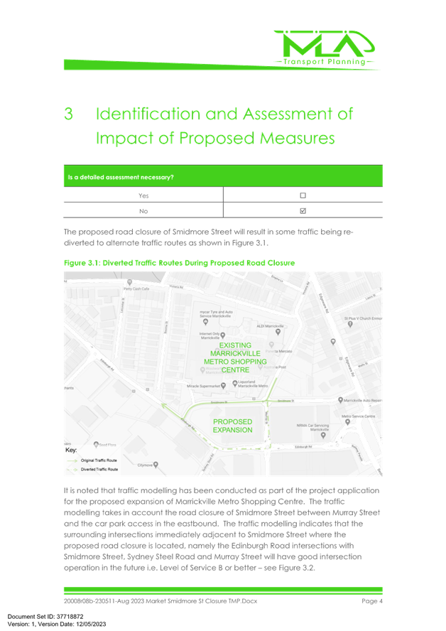
The proposed road closure of Smidmore Street will result in some traffic being rediverted to alternate traffic routes as shown below.
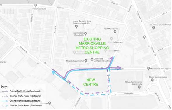
The section of Smidmore Street between Edinburgh Road and the car park access will remain open to continue to permit access to the car park and the taxi rank on the southern side of Smidmore Street. Through traffic along Smidmore Street to/from Murray Street will not be permitted except for cyclists. However, cyclists will be required to dismount from their bicycle whilst using the closed section of Smidmore Street.
The taxi rank on Smidmore Street (near Edinburgh Road) will continue to operate as per normal. Bus services in the area will not be affected by the proposed closures as buses do not require to access the section of Smidmore Street that is proposed to be closed.
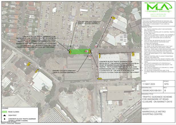
The supplied TCP is reproduced below and the TMP is attached at the end of this report.
Under Council’s Fees & Charges, the applicant is to pay a fee for the temporary full road closure along with any other required road occupancy and/or road opening permit fees.
All works and costs of implementation works associated with the recommended temporary relocation of the Community Bus Zone relocations will be borne by the applicant as will the reinstatement of any of Council approved signage at the end of the temporary relocation period.
PUBLIC CONSULTATION
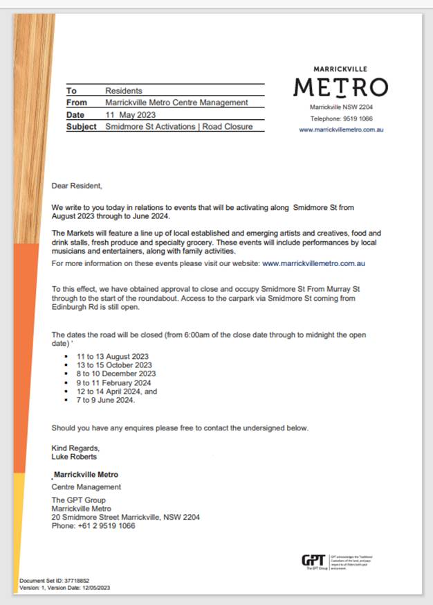
The applicant is to notify all affected residents and businesses in writing at least 7 days prior to the commencement of works. A copy of the notification is attached at the end of this report.
The proposed road closure has been advertised on Council’s website in accordance with the Roads Act 1993.
In relation to the relocation of the community bus the applicant is to notify all affected residents and businesses in writing at least 7 days prior to the commencement of works
|
1.⇩ |
Aug 2023 Market Smidmore St Closure TMP(1) |
|
Local Traffic Committee Meeting 19 June 2023 |
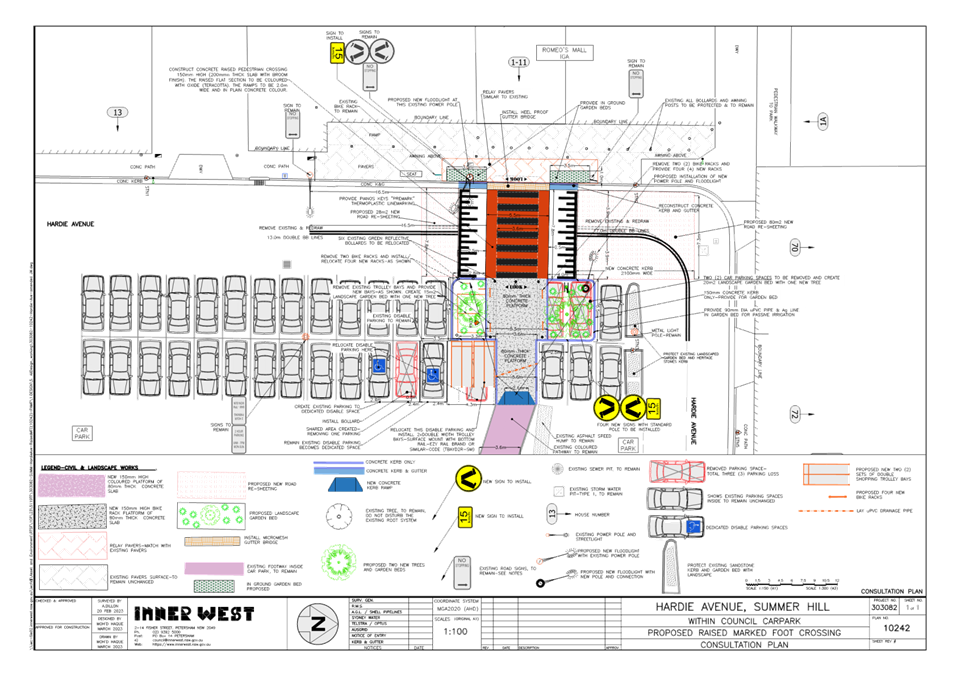
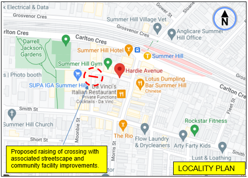
Subject: Hardie AVENUE, SUMMER Hill - Proposed raised
PEDESTRIAN (zebra) crossing and associated streetscape and community facility
improvements.
(Djarrawunang-Ashfield Ward/Summer Hill Electorate/Burwood PAC)
Prepared By: Boris Muha - Traffic Engineer
Authorised By: Manod Wickramasinghe - Traffic and Transport Planning Manager
SUMMARY
Council has finalised design plans to improve safety for pedestrians in Hardie Avenue, Summer Hill by converting the existing at-grade pedestrian (zebra) crossing (at the entry location of Romeo’s Mall/IGA) to a raised pedestrian (zebra) crossing. The proposal aims to improve safety for pedestrian and motorists and will help address concerns about pedestrian and driver behaviour at this location, particularly during busy times.
Associated streetscape and community facility improvements are also proposed in line with the raising of the crossing (i.e. landscaped garden beds, disabled parking alterations to current Australian standards and the relocation and provision of added trolley shopping bay areas in the Summer Hill carpark.)
BACKGROUND
The raising of the existing crossing is part of the identified high priority works in the Inner West Council Pedestrian Access Mobility Plan (PAMP) 2020 and has similarly been captured under the Ashfield Traffic Management Strategy 2017.The associated streetscape and community facility improvements would also complement other Town Centre streetscape improvements in the area.
FINANCIAL IMPLICATIONS
The proposed physical works to the crossing in Hardie Avenue and associated improvement works is estimated around $63,000 and will be constructed under the PAMP/Capital Works Program for the financial year 2023/2024.
OTHER STAFF COMMENTS
Site location and Road Network
|
Street Name |
Hardie Avenue
|
|
Carriageway width (m) kerb to kerb |
Approx.7.8m |
|
Carriageway type |
Two-way, one travel lane each direction, summer Hill carpark to the eastern side of Hardie Avenue. |
|
Classification |
Local |
|
Speed Limit km/h |
40 (High Pedestrian Activity) Area |
|
85th percentile speed km/h |
30 |
|
Vehicles per day (vpd) |
2700 |
|
Reported crash history July 2016-July 2021 |
NIL |
|
Parking arrangements |
East side, 2P 90-degree angle parking in carpark. Westside ‘No Stopping’ in vicinity of crossing.
|
|
Side streets |
-Smith Street and Lackey Street 100m away of crossing.
|
The Plan
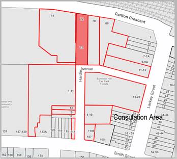
The following works are proposed and illustrated on the attached plan for Hardie Avenue, Summer Hill (Plan No. 10242- see Attachment 1)
· Construct a new raised concrete pedestrian (zebra) crossing together with new landscaped garden beds to replace the existing at-grade pedestrian crossing at the same location;
· Provide new landscaping within the new garden beds being created, new landscaping to generally be similar to the new landscaping recently provided within Lackey Street;
· Provide 2 new medium size street trees within the 2 landscaped garden beds on the carpark side of the new raised pedestrian crossing;
· Construct “gutter bridges” with heel safe grating on one side of the new raised pedestrian crossing to maintain stormwater drainage flows within the gutter & provide safe access over to the new raised pedestrian crossing (where required);
· Replace some of the existing decoratively paved footpath with new pavers – new pavers to match as best as possible to the existing pavers (subject to supply availability);
· Construct a new raised concrete footpath (surrounded by new concrete kerb) from the newly raised pedestrian crossing across 2 existing angle parking aisles together with a new wide concrete kerb ramp to transition back down to road level;
· Relocate the existing trolley bays from their existing location to the new location in place of 2 existing parking space as shown on the plan;
· Relocate the existing Disabled Parking Spaces and widen to meet current standards
· Remove the 6 existing green bollards on the carpark side of the pedestrian crossing which will be relocated if intact otherwise bollards will now be redundant as a result of the works;
· Resurface some of the existing roadway with new asphalt adjacent to the new raised pedestrian crossing;
· Install associated pavement line markings and signage associated with the new raised pedestrian crossing as required;
· Construct a new 2.1m new concrete kerb ramp.
Parking changes
It is proposed to remove four (4) existing angle parking spaces within the carpark. Two (2) of these spaces are required to accommodate the new raised pedestrian crossing and landscaped garden beds. Another two (2) spaces are required to accommodate the relocated and widened Disabled Parking Spaces & relocated trolley return bays. Please refer to the attached plans.
It is still considered that ample parking is available in the carpark despite these changes.
Streetlighting
There is no lighting currently provided for the existing pedestrian crossing. Council is investigating the provision of 2 new floodlights on either side of the new raised pedestrian crossing (together with 1 new additional timber power pole) to provide the required lighting levels as part of the works. Please refer to the attached Plans for indicative locations of the pole & flood lights.
It should be further noted the raised platform length of the crossing being 5.5m accounts for improved rideability for longer heavy vehicles servicing the area.
PUBLIC CONSULTATION
22 letters containing the proposal per plan 10242 (Attachment 1) were mailed out to properties as shown in the consultation area below to seek comments. Consultation letters were sent out on 21 April 2023 with the closure on submissions being the 12 May 2023.
No responses were received.
CONCLUSION
In view of the above, it is recommended the pedestrian crossing in Hardie Avenue, Summer Hill, outside the Romeo’s Mall/IGA) be upgraded and raised, with associated street scape and community facility improvements included as shown on plan 10242 in Attachment 1.
|
1.⇩ |
Plan of proposed raising of pedestrian crossing and associated works. |
|
|
Local Traffic Committee Meeting 19 June 2023 |
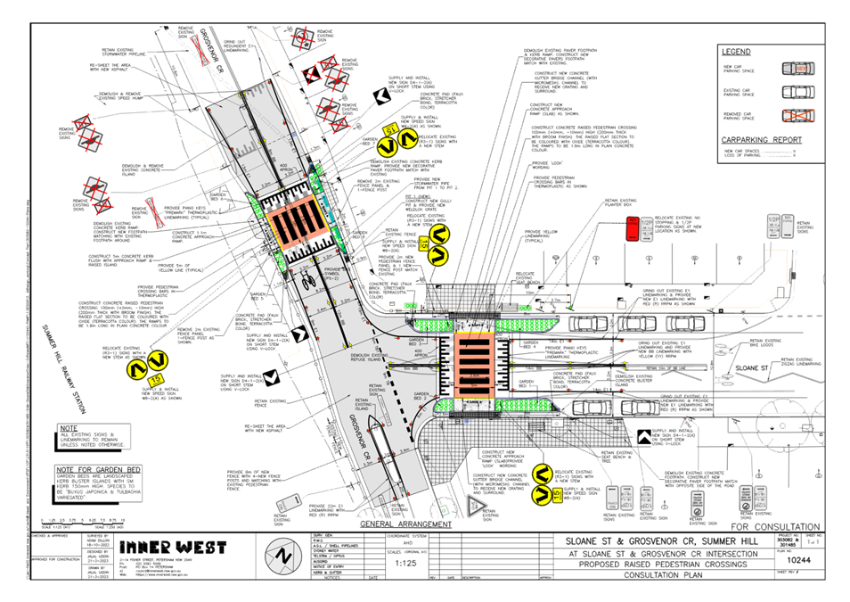
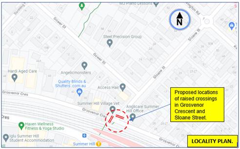
Subject: Grosvenor Crescent and Sloane Street, Summer
Hill-proposed upgrade (raising) of existing pedestrian (zebra) crossings and
associated streetscape improvements.
(Djarrawunang-Ashfield Ward/Summer Hill Electorate/Burwood PAC)
Prepared By: Boris Muha - Traffic Engineer
Authorised By: Manod Wickramasinghe - Traffic and Transport Planning Manager
SUMMARY
Council has finalised design plans to convert (2) existing at-grade pedestrian (zebra) crossings at the intersection of Sloane Steet and Grosvenor Crescent, Summer Hill, to raised pedestrian crossings with landscaped islands. The proposal aims to improve safety for pedestrians and motorists by better defining the pedestrian crossing points and reducing conflict with traffic movements in the area. This will also help address concerns with pedestrian and motorist behaviour at these locations, particularly during busy times.
Associated works would also include new drainage pits and piping, reconstruction or added new paving to footpath, and removal of a speed hump and central median island adjacent to the at-grade crossing in Grosvenor Crescent to amalgamate into a raised crossing.
|
RECOMMENDATION
|
BACKGROUND
The raising of the pedestrian (zebra) crossings is part of the Inner West Council Pedestrian Access Mobility Plan (PAMP) 2020 for improved pedestrian safety and contributes to traffic calming of the area under the Ashfield Traffic Management Strategy 2017.
FINANCIAL IMPLICATIONS
The proposed physical works to upgrading and raising the crossings in Grosvenor Avenue and Sloane Street with associated works, as a combined project, is estimated around $310,000 and will be constructed under the PAMP/Traffic Facilities Program for the financial year 2023/2024.
OTHER STAFF COMMENTS
Site location and Road Network
|
Street Name |
Grosvenor Crescent
|
Sloane Street |
|
Carriageway width (m) kerb to kerb |
Approx.10m |
Approx.12.8m |
|
Carriageway type |
Two-way, one lane in each direction, with kerbside parking both sides. |
Two-way, one lane in each direction, with kerbside parking both sides. |
|
Classification |
Local-collector (link) |
Local-collector (link) |
|
Speed Limit km/h |
40 (High pedestrian Activity) Area |
40 (High pedestrian Activity) Area |
|
85th percentile speed km/h |
< 40 in vicinity of intersection |
<40 in vicinity of intersection. |
|
Vehicles per day (vapid) |
4200 |
3000 |
|
Reported crash history July 2016-July 2021 |
(2) incidents at the intersection of Grosvenor Crescent and Sloane Street.
· (1) x 2020 -RUM 0- Pedestrian near side in Grosvenor Crescent. - minor/other injury.
|
· (1) X 2018-RUM 63-on path vehicle door (opening) in Sloane Street-serious injury.
|
|
Parking arrangements |
2P resident parking, No Stopping, unrestricted parking |
½ P parking on both sides near intersection. |
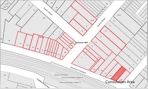
The Plan
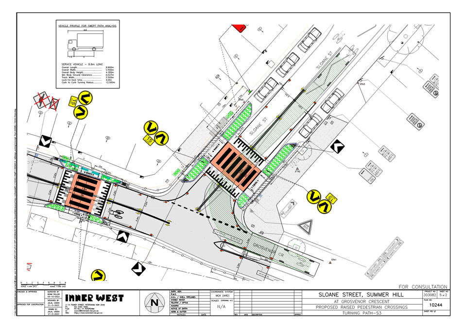
The following works are proposed and are illustrated on the attached plans: Sloane Street & Grosvenor Crescent intersection, Summer (Plan No. 10244): -see Attachment 1.
Construct 2 new raised concrete pedestrian crossings (1 in Sloane Street and 1 in Grosvenor Crescent) with new landscaped kerb blister islands to replace the 2 existing at grade pedestrian crossing. Both new pedestrian crossings will be slightly relocated by approx. 1m from the existing locations for better alignment and fit due to site constraints (as shown on the attached plans);
Provide suitable landscaping within the new kerb islands to enhance the area (final species to be finalised);
Construct “gutter bridges” with heel safe grating to provide safe access over existing kerb and guttering to the new raised pedestrian crossings (where required).
Demolish & remove the existing speed hump & central island in Grosvenor Crescent and reinstate the road pavement with asphalt; (as shown on Plans);
Provide new stormwater drainage pits & pipes in Grosvenor Crescent to improve drainage;
Reconstruct some of the decorative paved footpath on north side of Sloane Street to match new levels;
Replace the existing concrete footpath with new decorative paved footpath on the south side of Sloane Street (refer to Plans);
Adjust the pedestrian fencing in Sloane Street & Grosvenor Street to better align with the new raised pedestrian crossings;
Resurface the road in Grosvenor Street & Sloane Street with new asphalt (as shown on Plans);
Slightly adjust the existing ‘No Stopping’ signage & zones in Sloane Street to comply with minimum requirements for pedestrian crossings (as shown on plans); and
Install associated pavement line marking and signage as required.
Parking Changes
It is proposed to adjust the existing ‘No Stopping’ signage by approximately 3.7m on the north Side of Sloane Street to meet minimum requirements for pedestrian crossings. However, no existing on-street car parking spaces will be lost as a result of the proposed works.
Street lighting
The existing flood lighting at the location is deemed adequate for the new raised pedestrian crossing. Therefore, no changes are proposed to the existing street lighting due to the works.
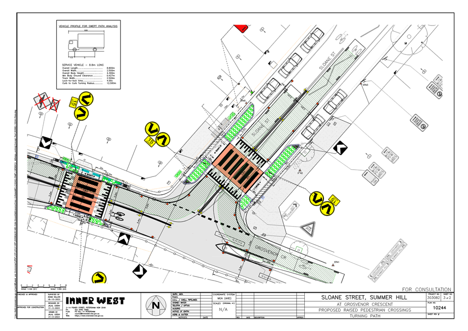
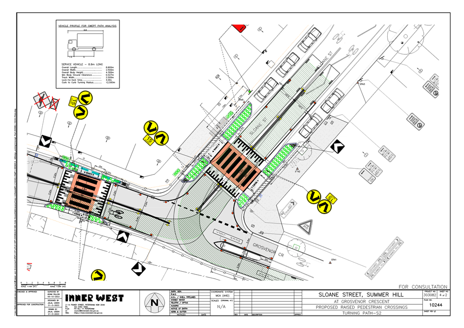
Design vehicle tracking around the intersection.
Attachment 2 identifies design garbage truck vehicle movements around the intersection under the proposed works. An existing central median island is removed under the raising of the crossing in Sloane Street. A garbage truck negotiating a left turn from Sloane Street into Grosvenor Crescent may require, under caution, to slowly come over the centreline in Sloane Street, and turn left with its wheels passing between the existing central median island and kerb line in Grosvenor Crescent, east of Sloane Street-see plan sheet 5 of 2.
It is viewed that the central median island be retained in Grosvenor Crescent, east of Sloane to control and limit the size of vehicle movements around the intersection, as it currently does so. Signage on the median could be either removed/repositioned if damaged by vehicle overhang. It is considered that line-marking and thorough painting of the island can still adequately substantiate vehicle guidance through and around the median in Grosvenor Crescent, east of Sloane Street.
PUBLIC CONSULTATION
91 letters containing the proposal per plan 10244 (Attachment 1) were mailed out to properties as shown in the consultation area below to seek comments. Consultation letters were sent out on 11 May 2023 with the closure on submissions being the 26 May 2023.
No responses were received.
CONCLUSION
In view of the above, it is recommended that the pedestrian crossings in Grosvenor Crescent and Sloane Street, Summer Hill, be upgraded and raised, with landscaped islands and associated drainage, alterations to footpath and fencing, together with signs and line marking being provided as shown in plan 10244 in Attachment 1.
|
1.⇩ |
Plan of proposed raised crossings and associated works. |
|
2.⇩ |
3x Plans of vehicle (garbage truck) tracking around the intersection under proposed raising of crossings. |
|
Local Traffic Committee Meeting 19 June 2023 |
Subject: Proposed Roundabout & Safety Improvements - Elliott Street, Terry Street & Glassop Street, Balmain (Baludarri - Balmain Ward / Balmain Electorate / Leichhardt PAC)
Prepared By: Zara Helal - Traffic Engineer
Authorised By: Manod Wickramasinghe - Traffic and Transport Planning Manager
SUMMARY
Council is proposing to improve safety at the intersection of Elliott Street, Terry Street, and Glassop Street, Balmain by constructing a roundabout and refuge splitter islands. The proposal aims to improve pedestrian and motorist safety by better defining safe pedestrian crossing points, reducing traffic speeds and conflicts at this location.
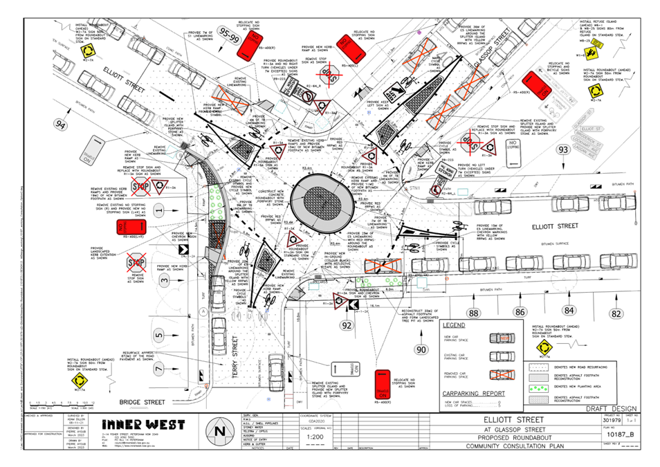
|
RECOMMENDATION
That the attached detailed design plan (Design Plan No.301979-10187_B) for the proposed installation of the new roundabout and refuge splitter islands including associated line marking at the intersection of Elliott Street/Terry Street/Glassop Street, Balmain be approved. |
BACKGROUND & OTHER STAFF COMMENTS
The proposed roundabout and safety improvements was recommended from the Rozelle North LATM study where community concerns regarding this intersection were considered.
The intersection is currently controlled by 'STOP' signs for northbound and southbound traffic on Terry Street and Glassop Street with eastbound/westbound traffic on Elliott Street having priority. Terry Street provides a critical traffic link into the Balmain Peninsular and carries approximately 5,700 vehicle movements per day.
MODIFIED PROPOSAL
Considering the submissions received during the community consultation process, changes were made to the design to improve the vehicular turning movements to the east of the roundabout and reduce parking impacts. The revised detailed design plan has been provided in Attachment 1.
The proposal sees the loss of five (5) on-street parking spaces (reduced from the previous loss of 10 parking spaces) at the following locations:
- Elliott Street: one (1) space eastbound to the west of the proposed roundabout, and one (1) space westbound to the east of the proposed roundabout.
- Glassop Street: one (1) space eastbound and two (2) spaces westbound to the north of the proposed roundabout.
The detailed design plan outlines the proposed works at the subject location and includes the following treatments:
· Construct a new concrete & decorative stone roundabout, comprising a central circulating circle, two (2) pedestrian refuge splitter islands, one (1) splitter island, and one painted splitter island.
· Provide ‘No Left Turn Vehicles Over 7m’ signage which will restrict turning of vehicles over 7m long approaching from Glassop Street onto Elliott Street.
· Provide ‘No Right Turn Vehicles Over 7m’ signage which will restrict turning of vehicles over 7m long approaching from the western end of Elliott onto Terry Street.
· Provide new kerb ramps for pedestrians to cross the roads.
· Construct a new landscaped kerb extension to better align Terry Street into Glassop Street.
· Reconstruct some of damaged sections of concrete and asphalt footpath.
· Resurface the existing damaged asphalt road with new asphalt within the area of works.
· Provide new & adjust the existing ‘No Stopping’ signage & zones to cater for the new roundabout & required traffic movements.
· Install associated pavement line marking and signage as required.
The amended design has made the following changes in response to feedback received during the consultations period:
· Reduced the proposed loss of parking from ten (10) spaces to five (5) spaces. Parking has been reinstated at the following locations:
o Terry Street: two (2) spaces northbound to the south of the proposed roundabout.
o Elliott Street: one (1) space westbound and one (1) space eastbound to the west of the proposed roundabout, and one (1) space westbound to the east of the proposed roundabout.
· Reduced the roundabout island dimensions to allow for more road space while navigating around the roundabout. This included shortening the overall length of the roundabout from 8.5m to 7.9m.
· Reduced size of splitter islands in Elliott Street and Terry Street. Subsequently, the length of the ‘No Stopping’ zones were also reduced. This change has resulted in the reinstatement of four (4) parking spaces.
· Reduced the size of the ‘No Stopping’ zone on the eastern side of Elliott Street, which has resulted in the reinstatement of one (1) parking space.
A swept path analysis was undertaken using an 8.8m service vehicle as shown in Attachment 2 and it is deemed acceptable.
FINANCIAL IMPLICATIONS
The project is listed on Council’s Traffic Facilities Capital Works budget for 2022/23 and funding of $180,000 has been allocated to this project.
PUBLIC CONSULTATION
A letter outlining the proposal was mailed out to 79 properties in Elliott Street, Terry Street and Glassop Street, Balmain requesting residents’ views regarding the proposal. Seven (7) responses were received, with four (4) in general support with request for changes, and three (3) in objection to the proposal. The main concerns raised by residents are outlined below in the table.
|
Officer Comments |
|
|
Residents are concerned regarding the loss of ten (10) parking spaces. There are concerns particularly regarding the following areas: - The loss of two (2) on-street parking spaces on the western side of Terry Street between Elliott Street and Bridge Street. Residents have raised concerns as the adjacent properties do not have off-street parking provisions. - The loss of on-street parking near properties owned by NSW Land and Housing Corporation may make it difficult for residents of such properties to park, as there are few off-street parking options. |
The
proposed roundabout improves intersection safety for vehicles and provides
improved crossing opportunities for pedestrians. The amended detailed design
has taken into consideration the loss of on-street parking and minimized the
impact of parking supply in the area. Five (5) parking spaces have been
reinstated. |
|
Residents are concerned the width of the proposed islands are too wide and roundabout dimensions are too large, which may make it difficult to drive through the intersection. |
In order to implement a roundabout and pedestrian refuge splitter islands that comply to Standards and technical directions, it is necessary to implement certain island dimensions as well as minimum ‘No Stopping’ clearances. The ‘No Stopping’ zones are essential to provide enough site lines for pedestrians who are crossing the road at these pedestrian refuge splitter island locations.
Additionally, Council has reviewed the plans and reduced the roundabout island dimensions to allow for more road space while navigating around the roundabout.
|
|
A resident has requested white road markings on either side of their driveway to ensure vehicles do not park too close to their driveway. |
Council will be able to provide white road markings on either side of the driveway as part of the works. Any future maintenance will be the responsibility of the resident. |
|
A resident has expressed concern regarding potential difficulties of turning right around the roundabout from Elliott Street onto Terry Street, as there is a steep incline. |
Council acknowledges that turning right when heading up the hill from Elliott Street onto Terry Street would be difficult, hence a ‘No Right Turn Vehicles Over 7m’ was proposed in the plans sent to residents.
The roundabout design has been amended to further improve the right turn from Elliott Street onto Terry Street for vehicles under 7m. |
|
Residents are concerned about potential increase of noise levels due to braking and accelerating. |
The proposed roundabout will not increase traffic levels and the noise from braking and accelerating is not expected to be different from previous ‘STOP’ priority at this location. |
|
Residents are concerned that vehicles travelling into Terry Street at high speeds pose safety concerns. |
The roundabout will improve pedestrian and vehicular safety by reducing vehicle speeds at the intersection. |
|
Residents are concerned that there will be light pollution impacts due to the provisions of additional street lighting. |
Council will investigate this separately when the street lighting changes are being implemented. |
|
A resident has expressed concern that the potential impacts to existing stormwater management systems including overland flow paths, impacts to existing utility services, and traffic modelling results have not been provided to support the proposed works. |
Council has received numerous concerns over the years regarding intersection safety at this location. Accordingly, this location was reviewed as part of the Rozelle North LATM study, and recommended for a roundabout treatment.
The stormwater and utility services will be reviewed in the detailed design, the proposal is not expected to negatively impact these assets. |
|
1.⇩ |
Elliott Street, Terry Street & Glassop Street, Balmain Roundabout Detailed Design Plan |
|
|
Local Traffic Committee Meeting 19 June 2023 |
Subject: Kensington Road, Summer Hill-proposed 'No
Right Turn 6am-10am, 3pm-7pm Mon-Fri' from Kensington Road into Liverpool Road.
(Djarrawunang-Ashfield Ward/Summer Hill Electorate/Burwood PAC)
Prepared By: Boris Muha - Traffic Engineer
Authorised By: Manod Wickramasinghe - Traffic and Transport Planning Manager
SUMMARY
Concerns have been raised regarding traffic safety and vehicular congestion/conflict at the intersection of Kensington Road and Liverpool Road, Summer Hill during the morning and afternoon peak periods. Council is proposing to limit traffic movement into Kensington Road by imposing a ‘No Right Turn; 6.00am-10.00am and 3.00pm-7.00pm Mon -Fri’ restriction from Kensington Road into Liverpool Road.
This will improve the safety and control of traffic at the above intersection during the above times. Vehicles will be able to detour via Sloane Street to Parramatta Road, or via Sloane Street and Gower Street to Liverpool Road towards main road intersections under signalised control.
|
RECOMMENDATION
That:
2. A Traffic Management Plan be issued to Transport for NSW seeking approval for the above part-time ‘No Right Turn’ ban.
|
BACKGROUND
The following is advised in reference to Attachment 1 being a locality plan and showing traffic count data on streets to the south of Parramatta Road and Liverpool Road, as last registered in April 2022:
Kensington Road is classed as a local road with traffic volumes ranging from 1000-1500 vehicles per day with 85% speeds at 47kph, as controlled by an array of speed humps located within the street. The adjoining streets are Sloane Street (being a local collector link road) and Gower Street (being a local Road). Sloane Street carries around 3000-4000 vpd, whilst Gower Street carries some 1300 vehicles per day with 85% speeds ranging around 37-45 kph, again with speed humps installed in these streets to control traffic speeds.
All 3 streets are posted as 50 kph speed limit, and measure approximately 12.8m kerb to kerb. Traffic is two-way with parking to both sides of the streets. The subject intersection of Liverpool Road and Kensington Road has an existing ‘No Right Turn’ ban from ‘6am-10am Mon-Fri’ to prohibit right turn vehicles from entering Kensington Road from Liverpool Road.
Available 5- year accident statistics from Transport for NSW July 2016-July 2021 indicate two (2) recorded incidences at the intersection are as follows:
· One (1) x 2019, RUM 39- Vehicles from same direction, accident degree: minor/other injury vehicle collision in Kensington Road.
· One (1) X 2021, RUM 30-Rear End, accident degree: minor/other injury- vehicle collision in Liverpool Road.
Four (4) other vehicle type crashes were recorded from 2008-2016 at the intersection having rear right, right near, rear end and cross traffic resulting with non-injury (tow-away) and serious injury severity.
FINANCIAL IMPLICATIONS
The cost of signposting will come from the signs and line marking budget.
OTHER STAFF COMMENTS
General concerns have been raised with traffic by-passing along Kensington Road from Longport Street, and traffic diverting away from Parramatta Road during peak periods in the westbound direction. Vehicles turning right at the intersection of Liverpool Road and Kensington Road are then confronted by a heavy stream of traffic in Liverpool Road during peak periods.
An intersection (camera) analysis of the intersection of Liverpool Road and Kensington Street was carried out at the same time traffic counters were laid out in April 2022 to determine the number of vehicles turning right in the morning and afternoon peak periods.
It was identified in a one hour period the maximum amount of vehicles turning right at the intersection was around 18 vehicles per hour (vph). This accounted for approximately 25% of total left and right turn vehicle movements out of Kensington Road. The right turn is considered relatively low in volume. However, with the risk of right turn vehicles having to cut across traffic in both directions of Liverpool Road to then move to the left hand side of Liverpool Road to turn left into Parramatta Road, it would be considered safe and beneficial under road safety conditions to limit right turns at this location. The accident history above may well account for incidences involved directly or indirectly with right turn movements.
A ‘No Right Turn’ ban between morning and afternoon clearway hours Mon-Fri would improve safety and minimise conflict at the intersection. The intersection analysis for 4 hours in the morning (i.e. 6am-10am) and 4 hours in the afternoon (i.e. 3pm-7pm) equated to some 100 vehicles through the day.
As these counts were undertaken in April 2022, more recent manual observations taken on the Thursday 1 June 2023 during a morning and afternoon peak hour could not establish more than 18 vph turning right at the intersection. No more than 3 vehicles were observed to bank up at this intersection, with only one right turn vehicle waiting at all times.
Total hourly traffic count observation in Kensington Street (between Sloane Street and Liverpool Road) showed no more than 94 vph (morning) and 106 vph (afternoon), as compared to April 2022 figures showing 127vph (morning) and 109 vph (afternoon)- see Attachment 1. No real increase in traffic has occurred over the last 12 months.
It is considered that the right turn traffic can be absorbed and dispersed into the surrounding street network with little or no real impact or congestion to the street environment of Sloane or Gower Street.
It is further proposed that signs reading ‘No Right Turn 6am-10am, 3pm -7pm Mon-Fri, Ahead at Liverpool Road’ be established on the northern corner side of Kensington Street, west of Sloane Street to forewarn motorist to proceed and detour via Sloane Street and/or Gower Street. Vehicles can then safely turn at the signalised intersections of Gower Street and Liverpool Road or Sloane Street and Parramatta Road. Any congestion build up to these intersections would be considered minimal with added right or left turn movements.
Alternatively, vehicle can elect to proceed, turn left, then right from Liverpool Road into Gower Street, then right into Ormand Street and left into Parramatta to head west. Any congestion build up in Liverpool Road at Gower Street would be considered minimal with added right turn movements.
As Turn bans are required to be approved by Transport for NSW, a Traffic Management Plan shall be issued to Transport for NSW seeking its formal approval.
PUBLIC CONSULTATION
1000 letters showing a plan of the proposal to add ‘No Right Turn 6-10am, 3-7pm Mon-Fri’ from Kensington Road into Liverpool Road, were mailed out to properties as shown in the consultation area below to seek comments. Consultation letters were sent out on 24 April 2023 with the closure on submissions being the 22 May 2023. The proposal was also advertised for 28 Days as required under the Road Act for proposed traffic changes.
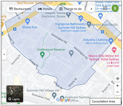
17 Responses were received with (8) in support with/without comments and (9) in non-support or objection with/without comments. Those providing comments have been tabled below with officer response made.
|
Supporting with comments |
Officers Response |
|
· Constant stream of traffic in Liverpool Road make the Right hand turn almost impossible. Traffic turning Left from Kensington Road is often queued. Right hand turns will also deter some rat-running. Prohibition should be permanent. Access to /from western end of Kensignton Road should be left in/out.
(3 similar comments) |
Noted. · The proposal only aims to limit RH turn during clearway times, more so on safety grounds and not change traffic conditions elsewhere to avoid additional traffic and congestion to other streets, and further limit local street access. · Council is separately investigating to signpost the southern corner of Kensington Road to the statutory length of 10 metres to clear the corner of parking. This may provide some opportunity for left turn vehicles to pass around right turn vehicles waiting at times outside of the proposed restrictions. |
|
· Number of near incidents of cars forcing themselves into lines of traffic. There has been one car pushed into the shops at this intersection. |
Noted. |
|
· Happy to support but think the timing is too long. |
The ban is consistent with the Liverpool Road clearway times which correspond to the times where there is a heavy stream of traffic in Liverpool Road. |
|
Support with the following additions: • increased signage showing the 50kph speed limit on both Gower Street and Kensington Road. • adjust traffic light sequencing at Gower Street and Liverpool Road at peak hours to expedite rat-run traffic out of Gower Street. • include more signage indicating Underwood Reserve, Gower Street is occupied by children and toddlers during daylight hours to accommodate increased young families in this densely populated pocket. Gower Street has frequent pedestrian traffic throughout the day and evening and speeding traffic is an ongoing issue even with the speed humps. |
· Additional 50 kph speed limit in the street is not required as local streets (in build-up areas) are at default 50 kph speed limit without the need of signposting. · Traffic signals are under the care and control of TfNSW, and light sequencing can be adjusting pending on the varying traffic conditions in the area. A request could be made to the TfNSW to examine if signal sequencing in the area is satisfactory. · Council will examine if ‘Pedestrians’ W6-1 or ‘Children’ W6-3 warning signs could be placed to forewarn motorists of pedestrian/child activity near the park. |
|
Non-Supporting with comments |
Officers Response |
|
· Concerns are not been raised by the people who use the intersection to turn right into Liverpool Rd at this intersection- the option to use Gower and Sloane streets is always available to them. Concerns must have been raised by the residents of Kensington Street who prefer to divert the traffic onto Sloane St or Gower St so that they don't have any traffic noise themselves in the morning and afternoon, however, the residents of those two streets have to deal with all the traffic and noise any time of the day. |
· Residents generally made concerns to traffic generation (rat-runinng) in the street and speeding. Council noted the problem with right turning into Liverpool Road on the basis of road safety. · Traffic diversion into side streets would be considered minimal based on traffic survey investigations. |
|
· don't believe restricting traffic flow with a 'No Right Turn' will make any difference with congestion on Liverpool Road during these peak times. · suggest a 'No Right Turn' into Tideswell Street from Liverpool Road as this blocks traffic by cars attempting to try to turn into Red Rooster. · suggest a speed camera be placed on Liverpool Road at the Gower Street intersection to reduce speeding and the many traffic incidences that have occurred at this intersection for many years. Cars come off Parramatta Road straight onto Liverpool Road at great speeds and many accidents involving both pedestrians and other vehicles have suffered in result. |
· The proposal mainly addresses a road safety issue at the intersection. · Tideswell Street is a dead- end with vehicle movements mainly into and out of Red Roaster. There is no recorded accident history at this intersection to consider ban movements, and that any ban movements may severely limit access in or out of this dead end street. · Speed cameras on the main road are the responsibility of Transport for NSW and submissions can be made to TfNSW to consider. |
|
· Gower Street and Sloane Street is already very congested at peak hour. · Turning Kensington/Liverpool Roads into 'No right turn' between 6-10am and 3-7pm, Mon-Fri only moves the problem not solve the problem. (4 similar comments)
|
The proposal mainly addresses a road safety issue at the intersection. Any congestion in other streets would be considered minimal with traffic diversion under this proposal. |
|
· Parking in Sloane St is not available to residents due to commuters using it to park cars to catch the train and traffic patrols happening very rarely. Suggest resident parking for both sides of road. Otherwise two hours. |
· Parking in the street is outside the scope of this proposal. Resident parking is contained to one side of the street only in fair balance to provide longer term parking for those residents and visitors ineligible for parking permits. |
|
· Object to the proposal. The most dangerous part about turning right onto Liverpool Road from Kensington Road are the trees planted on Liverpool Road a few years ago by Council. these obscure a drivers view of oncoming traffic. · Of a morning the roundabout at the corner of Kensington Road and Street is congested and often blocked by motorists. Forcing drivers along Kensington Street, if they are unable to turn right onto Liverpool Road, will add to this congestion. Drivers will likely turn left out of Kensington Road, block the lane by turning right at Gower Street, forcing more traffic onto Gower Street. Why create a rat-run. |
· The trees are of a species that the underside branches are cut off to avoid visual obstruction. A request will be made under maintenance program to cut any further underside growth.
· A secondary set of signs will be placed in Kensington Road, just west of the roundabout intersection with Sloane Street, advising ‘No Right Turn Ahead’ at Liverpool Road. This will alert motorist beforehand and disperse and divert traffic via Sloane Street to Parramatta Road, or Sloane/Gower Streets to Liverpool Road, or continue and turn left into Liverpool Road, and right into Gower Street. This aims to reduce the amount of right turners if forced to turn left into Liverpool Road and right into Gower Street. |
CONCLUSION
In view of the above, it is recommended based on traffic safety rather than traffic diversion that:
· A ‘No Right Turn 6am-10am., 3pm-7pm Mon-Fri’ ban be placed at the intersection of Kensington Road and Liverpool Road, Summer prohibiting right turn movements during clearway times from Kensington Road into Liverpool Road;
· An advance restriction signifying ‘No Right Turn 6am-10am., 3pm-7pm Mon-Fri Ahead at Liverpool Road’ be placed in Kensington Road west of Sloane Street; and
· As Turn bans are required to be approved by Transport for NSW, a Traffic Management Plan shall be issued to Transport for NSW seeking its formal approval.
|
1.⇩ |
Diagram showing location of proposed No Right Turn (clearway times) and traffic data (volumes and speeds) in the area. |
|
|
Local Traffic Committee Meeting 19 June 2023 |
Subject: Meeks Road, Marrickville - 'No Stopping' yellow line and signage (MIDJUBURI - MARRICKVILLE WARD / SUMMER HILL ELECTORATE / INNER WEST PAC)
Prepared By: John Stephens - Traffic Engineer
Authorised By: Manod Wickramasinghe - Traffic and Transport Planning Manager
SUMMARY
In response to concerns raised by a local resident, Council proposes to install ‘No Stopping’ linemarking and signage along the southern side of Meeks Road to improve road safety for cyclists and other road users.
|
RECOMMENDATION
That:
1. A 122m yellow ‘No Stopping’ line be installed on the southern side of Meeks Road between Braddock Playground and Victoria Road, Marrickville;
2. A ‘No Stopping’ (arrow right) signpost be installed on the eastern side of Meeks Road approximately 41m south of Maude Street;
3. A ‘No Stopping’ (arrows left & right) signpost be installed on the southern side of Meeks Road in the landscaped island prior to Victoria Road;
4. The GIVE WAY holding line in Meeks Road at Victoria Road be remarked; and
5. Traffic speed and volumes be monitored following the installation of the above works.
|
BACKGROUND
Council has received concerns from a local resident about parking that is occurring along the southern end of Meeks Street when vehicles park adjacent to the railway corridor. This section of Meeks Road is narrow (approximately 6m wide), especially with parked vehicles on both sides of the road further narrowing the carriageway and is causing a danger to cyclists and traffic.
Previously, Council had installed timber bollards along most of the southern edge of Meeks Road due to a high pressure gas line being located in the footpath area. Over the years, the shrubs and trees have grown within the unformed footpath area; however, vehicles are still being parked on the southern side which narrows the carriageway width and impacts on two-way traffic movements. Also, this section of Meeks Road forms part of Council’s on-road bicycle route and the narrowing of the carriageway affects the safety of cyclists and other road users.
Therefore, it is proposed to install a yellow ‘No Stopping’ line along the southern side of Meeks Road between Braddock Playground and Victoria Road with associated ‘No Stopping’ signage at the eastern and western ends of Meeks Road.
At the time of inspection, it was also noted that the ‘Give Way’ holding line in Meeks Road at Victoria Road was faded and should be remarked.
Diagram:
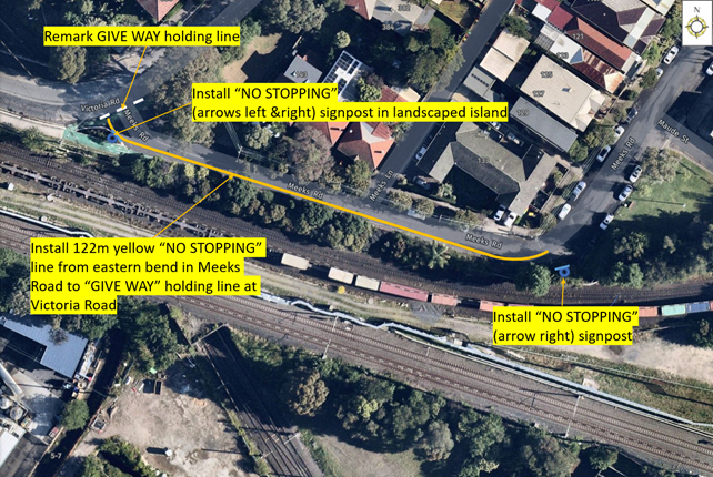
FINANCIAL IMPLICATIONS
The cost of installation of the linemarking and signposting can be funded from Council’s operational signs and linemarking budget.
PUBLIC CONSULTATION
A consultation letter was prepared indicating the proposal and mailed out to 56 properties. The consultation closed on Friday, 26 May 2023 and five responses were received, including a telephone response. Three responses were in support and two objected.
One of the supporters from Meeks Road who raised his initial concerns with Council also raised another concern about southbound traffic in Meeks Road having to move to the centre of the road to travel through the bend adjacent to the playground with vehicles parked on both sides of the road. This has led to near misses with approaching vehicles and creates a hazard to cyclists.
One of the objectors from Victoria Road was concerned that the proposal was taking away parking for residents who already pay for resident parking permits. The other objector from Meeks Road was concerned that the removal of parking would increase vehicular speeds and requested traffic calming in lieu of the proposal.
CONCLUSION
In order to provide a wider safer carriageway in Meeks Road between Braddock Playground and Victoria Road, it is recommended that the proposed ‘No Stopping’ linemarking and associated signage should be installed on the southern side of Meeks Road, Marrickville.
Nil.
|
|
Local Traffic Committee Meeting 19 June 2023 |
Subject: Perry Lane, Lilyfield - Proposed 'No Parking' Restrictions (Baludarri-Balmain Ward/Balmain Electorate/Leichhardt PAC)
Prepared By: Zara Helal - Engineer - Traffic and Parking Services
Authorised By: Manod Wickramasinghe - Traffic and Transport Planning Manager
SUMMARY
Council has received concerns from residents with rear property access on Perry Lane, Lilyfield regarding vehicles parking on the northern side of the lane and subsequently obstructing their access to their property driveways. Rear access for property No.205 Lilyfield Road is further limited by a tree located on the northern side of Perry Lane, to the west of the garage of No.1 Mary Street, Lilyfield. A ‘No Parking’ zone is proposed to enable vehicle access to these properties.
|
RECOMMENDATION
That the implementation of 6.0m ‘No Parking’ zone on the northern side of Perry Lane, Lilyfield opposite the rear garages of Nos.205 and 207 Lilyfield Road, Lilyfield, be APPROVED. |
BACKGROUND & OTHER STAFF COMMENTS
Council has received concerns from residents with rear property access on Perry Lane regarding vehicles parking on the northern side of the lane and subsequently obstructing vehicular access to their rear property driveways.
Vehicles currently park on the northern side of Perry Lane, to the west of garage of No.1 Mary Street, Lilyfield, which results in reduced manoeuvrability in and out of the subject property garage. Rear access for property No.205 Lilyfield Road is further limited by a tree located on the northern side of Perry Lane, to the west of the garage of No.1 Mary Street, Lilyfield.
Council initially proposed to implement a 3.0m ‘No Parking’ zone on the northern side of Perry Lane, opposite the rear access of No.205 Lilyfield Road, Lilyfield. During the community consultation process, a request was received to extend the 'No Parking' restriction to also improve access to the rear garage of No.207 Lilyfield Road. The proposal has been modified to accommodate this request.
The kerbspace on the northern side of Perry Lane, between the driveway of No.1 and No.2 Mary Street, being about 14m in length, currently allows for parking for two (2) vehicles. The modified proposal removes one (1) on-street parking space, opposite the rear driveway of No.207 Lilyfield Road.
FINANCIAL IMPLICATIONS
Nil.
PUBLIC CONSULTATION
A letter outlining the initial proposal was mailed out to the affected properties (19 properties) in Perry Lane, Mary Street and Steward Street, Lilyfield. Three (3) responses were received, with one (1) in support of the proposal, one (1) in general support of the proposal with changes, and one (1) in objection to the proposal. A summary of the comments and officer’s response are tabled below:
|
Residents’ Comments |
Officer Comments |
|
There is a request to extend the ‘No Parking’ restriction to ensure access from the rear garage of No.207 Lilyfield Road is also improved. |
The extension of the proposed ‘No Parking’ restrictions to improve access from the rear garage of No.207 Lilyfield Road is supported resulting in a loss of one (1) on-street parking space between the driveways of No.1 and No.2 Mary Street.
|
|
Objections to the potential loss of parking as this may negatively impact nearby businesses and their customers. |
Given the existing satisfactory on-street parking provisions available at Perry Lane, the removal of one (1) on-street parking space is not expected to have any adverse effects on the overall parking availability in the area. |
The modified proposal is shown on the plan below.
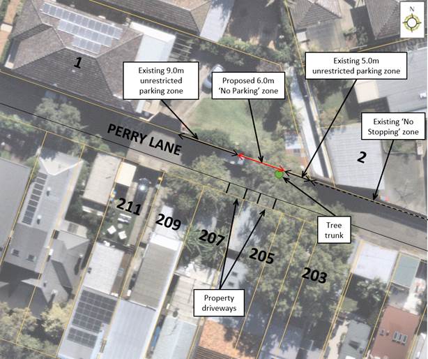
Nil.
|
|
Local Traffic Committee Meeting 19 June 2023 |
Subject: King George Park Carpark, Manning Street, Rozelle - Proposed '8p 8.00am-8.00pm' Restrictions (Baludarri-Balmain Ward/Balmain Electorate/Leichhardt PAC)
Prepared By: Zara Helal - Traffic Engineer
Authorised By: Manod Wickramasinghe - Traffic and Transport Planning Manager
SUMMARY
Council is proposing to implement ‘8P 8.00am-8.00pm’ parking restrictions in the recently constructed King George Park carpark, located in Manning Street, Rozelle. The restrictions are intended to ensure that the carpark is effectively utilised by different users of the park and deter vehicles and trailers from parking for extended periods.
Council is also proposing to implement one (1) additional accessible parking space in addition to the original arrangement. This will ensure there are adequate accessible parking provisions to accommodate visitors of the nearby Constellation Playground.
BACKGROUND & OTHER STAFF COMMENTS
The King George Park carpark, located in Manning Street, Rozelle, currently does not have any timed restrictions. This was also the case prior to the recent carpark upgrades completed in April 2023. The unrestricted parking provisions have previously enabled trailers and other motor vehicles to park in the carpark for extended periods, which could thereby reduce parking availability for visitors of King George Park and the nearby Constellation Playground (also located in Manning Street, Rozelle).
To ensure visitors of King George Park and Constellation Playground have access to suitable parking, Council is proposing to implement ‘8P 8.00am-8.00pm’ parking restrictions in the King George Park Carpark. This includes the installation of 17 signs within the carpark.
Currently, there are two (2) accessible parking spaces in the King George Park carpark. To ensure there are adequate accessible parking provisions to accommodate visitors of the Constellation Playground, one (1) additional accessible parking space in addition to the current arrangement is proposed.
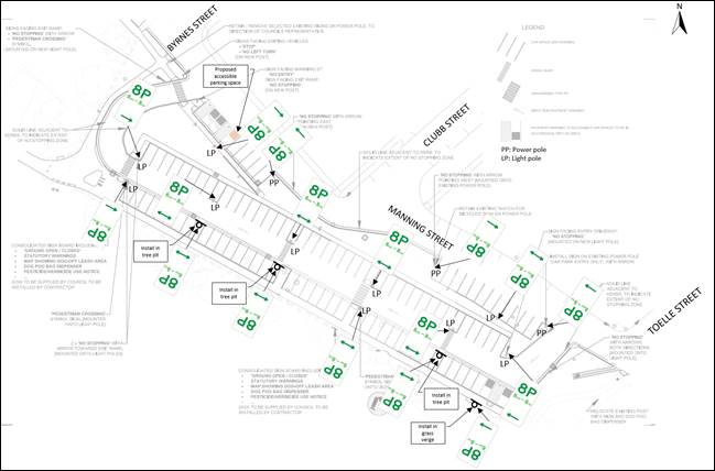
FINANCIAL IMPLICATIONS
The costs associated with installing the ‘8P 8.00am-8.00pm’ signage and pavement marking for the accessible parking space will be funded from the King George Carpark project.
PUBLIC CONSULTATION
A letter outlining the proposal was mailed out to 82 properties in Toelle Street, Clubb Street, Byrnes Street, Callan Street, and Manning Street, Rozelle. 10 responses were received, all in relation to the proposed ‘8P 8am-8pm’ restrictions only. One (1) response is in acceptance with no changes, three (3) are in acceptance with modifications to the proposal, and six (6) are in objection to the proposal.
No responses were received regarding the proposed implementation of one (1) additional accessible parking space in addition to the current arrangement.
The main traffic and parking related concerns raised by the residents are tabled below:
|
Residents’ Comments |
Officer Comments |
|
Residents request Resident Parking Scheme (RPS) to be implemented on Toelle Street, to deter trailers that would otherwise park in the carpark to park in Toelle Street. Five (5) residents have requested for this provision to be made. |
Council has undertaken investigation on a RPS in September 2019. During this time, there was insufficient level of support from residents to establish an RPS. Council will monitor Byrnes Street, Toelle Street, Clubb Street, Callan Street and Springside Street following installation of the carpark restrictions to determine if there has been any trailer displacement. |
|
Residents request RPS within King George Park carpark, allowing access to parking when on-street spaces are fully occupied. (5 comments) |
As the intended use of the carpark is for visitors of King George Park and Constellation Playground, exemptions or permits cannot be provided to residents. The carpark provides flexibility for overnight parking for residents as needed. |
|
Residents request a ‘Motor Vehicle Only’ restriction alongside the proposed ‘8P 8.00am-8.00pm’ parking restrictions, as they deem this restriction alone to be inadequate in deterring trailers in the short-term. (5 comments) |
The 8P restriction is considered adequate to deter long-term vehicle parking, including trailers. Additionally, high levels of trailers have not been observed in the adjacent streets. |
|
There is concern regarding adequate monitoring of parking restrictions by Council. (1 comment) |
Council’s parking enforcement team respond to requests made through Council’s website and phone number. |
|
Residents request that there be 1-2 dedicated carshare spaces as residents report there are currently carshare vehicles parked on Toelle Street for extended periods. (5 comments) |
As the intended use of the carpark is for visitors of King George Park and Constellation Playground, the implementation of dedicated carshare spaces within the carpark is not currently supported. |
|
One (1) resident has requested speed restrictions to be implemented within the carpark to ensure safety of pedestrians. |
Speed humps have been installed in the carpark to ensure that vehicle speeds are acceptable. |
|
Residents request unrestricted parking within King George Park carpark, so the carpark may be used as overflow parking by residents, and by commuters and workers who currently park in local streets. (2 comments) |
Refer to above response regarding other users of the carpark. The intended use of the carpark is for visitors of King George Park and Constellation Playground. Additionally, it should be noted that the proposed ‘8P 8.00am-8.00pm’ restrictions do not prevent residents or other carpark users to park overnight, given there is adequate parking availability. |
|
One (1) resident has requested that an electric vehicle charger be installed in the carpark. |
This was considered during the consultation undertaken during the King George Park masterplan and can be further considered in Council’s electric vehicle charging tender. |
|
One (1) resident has requested that school bus routes be further investigated. The resident is concerned that buses are currently facing difficulty in turning right from Callan Street into Manning Street, as cars are parked on both sides of Manning Street throughout the day. |
Bus access through this intersection may be constrained by vehicles parking too close to the intersection. Vehicles are expected to park in accordance with the NSW Road Rules. |
|
Residents have requested that additional safety measures are implemented for pedestrians at the northern ends of Toelle Street, Byrnes Street and Clubb Street, near their intersections with Victoria Road. As Victoria Road has a speed limit of 60km/h, vehicles enter these adjacent streets at high speeds. This has caused concerns regarding pedestrian safety at and near these intersections. (7 comments). |
Sections of Toelle Street, Byrnes Street and Clubb Street were reconstructed near Victoria Road as part of the Iron Cove works undertaken by WestConnex Rozelle Interchange. Council has previously raised this safety issue with them. |
Nil.
|
|
Local Traffic Committee Meeting 19 June 2023 |
Prepared By: Zara Helal - Traffic Engineer
Authorised By: Manod Wickramasinghe - Traffic and Transport Planning Manager
SUMMARY
Council has received concerns regarding vehicles obstructing sight lines and manoeuvring space by parking too close to the intersection of Joseph Street at Unnamed Laneway (between Ryan Street and Lamb Street), Lilyfield. An investigation has now been completed and is presented in this report.
|
RECOMMENDATION
That the following statutory restrictions be signposted:
1. 10m ‘No Stopping’ zone on the northern side of Joseph Street, east of Unnamed Laneway; and
2. 10m ‘No Stopping’ zone on the northern side of Joseph Street, west of Unnamed Laneway.
|
BACKGROUND & OTHER STAFF COMMENTS
Council has received concerns regarding vehicles obstructing sight lines and manoeuvring space by parking too close to the intersection of Joseph Street at Unnamed Laneway (between Ryan Street and Lamb Street), Lilyfield.
To alleviate this issue, it is proposed to signpost ‘No Stopping’ zone at the following locations:
· 10m ‘No Stopping’ zone on the northern side of Joseph Street, east of Unnamed Laneway
· 10m ‘No Stopping’ zone on the southern side of Joseph Street, west of Unnamed Laneway.
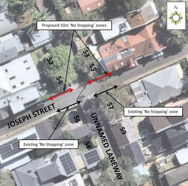
FINANCIAL IMPLICATIONS
Nil.
PUBLIC CONSULTATION
A letter outlining the initial proposal was mailed out to the affected properties (23 properties) in Ryan Street and Lamb Street, Lilyfield. Two (2) responses were received with both in general support with request for changes. The comments and Council’s responses are tabled below:
|
Residents’ Comments |
Officer Comments |
|
Implementing 10m ‘No Stopping’ restriction at the subject location will reduce parking near the intersection of Joseph Street at Unnamed Laneway (between Ryan Street and Lamb Street).
|
Under the NSW Road Rules, it is illegal to park within 10 metres of an intersection without traffic lights, unless a parking control sign applies indicating that the driver is permitted to park. As such, the signage only formalises the Road Rules. |
|
Installation of signage may be detrimental to the overall streetscape of the street.
|
The proposal sees the installation of two (2) signs which will not significantly impact the overall streetscape. The signage will not obstruct pedestrian or vehicular access in the laneway. |
Nil.
|
|
Local Traffic Committee Meeting 19 June 2023 |
Subject: Intersection of Croydon Road and Sunbeam
Avenue, Croydon.
-Proposed 'No Stopping' to the eastern corner of Croydon Road, north of
Sunbeam Avenue.
(Gulgadya-Leichhardt Ward/Strathfield Electorate/Burwood PAC)
Prepared By: Boris Muha - Traffic Engineer
Authorised By: Manod Wickramasinghe - Traffic and Transport Planning Manager
SUMMARY
Council has received concerns regarding vehicles obstructing sight lines by parking close to the eastern side of Croydon Road, north of Sunbeam Avenue, Croydon.
To alleviate this issue, it is proposed, in this case, that the corner be signposted with a 16.0 metre ‘No Stopping’ zone as measured from the side street kerb line of Sunbeam Avenue.
|
RECOMMENDATION
THAT ‘No Stopping’ of a length of 16 metres be signposted on the eastern side of Croydon Road, north of Sunbeam Avenue, Croydon. |
BACKGROUND & OTHER STAFF COMMENTS
Sunbeam Avenue is a dead- end street coming off Croydon Road. Croydon Road carries high volumes of traffic up to 800 vph in peak periods. It measures 10 metres in width kerb to kerb with two- way traffic, and parking to both sides of the street. The geometry/elevation of the intersection forces vehicles turning out to encroach well into the path of the traffic when vehicles (particularly trucks) park close to the corner of the intersection.
Under the circumstance, it is considered that a length of 16 metres of ‘No Stopping’ be signposted on the eastern corner of Croydon Road to provide safe visual sight line for vehicles exiting out of Sunbeam Avenue.
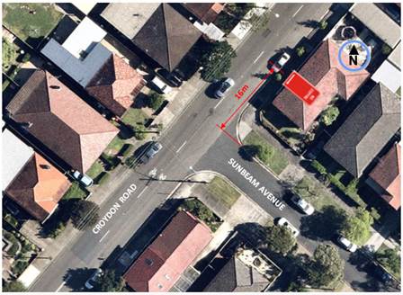
FINANCIAL IMPLICATIONS
The cost of signposting will come from the operational signs and line marking budget.
PUBLIC CONSULTATION
The plan and covering letter was sent out to 27 properties as shown in the consultation area below to seek comments. Consultation letters were sent out on 19 May 2023 with the closure on submissions being the 2 June2023.