|
AGENDA R |

Local Traffic Committee Meeting
MONDAY 21 AUGUST 2023
11.00am
|
|
Local Traffic Committee Meeting 21 August 2023 |
Function of the Local Traffic Committee
Background
Roads and Maritime Services (RMS) is legislated as the Authority responsible for the control of traffic on all NSW Roads. The RMS has delegated certain aspects of the control of traffic on local roads to councils. To exercise this delegation, councils must establish a local traffic committee and obtain the advice of the RMS and Police. The Inner West Council Local Traffic Committee has been constituted by Council as a result of the delegation granted by the RMS pursuant to Section 50 of the Transport Administration Act 1988.
Role of the Committee
The Local Traffic Committee is primarily a technical review and advisory committee which considers the technical merits of proposals and ensures that current technical guidelines are considered. It provides recommendations to Council on traffic and parking control matters and on the provision of traffic control facilities and prescribed traffic control devices for which Council has delegated authority. These matters are dealt with under Part A of the agenda and require Council to consider exercising its delegation.
In addition to its formal role as the Local Traffic Committee, the Committee may also be requested to provide informal traffic engineering advice on traffic matters not requiring Council to exercise its delegated function at that point in time, for example, advice to Council’s Development Assessment Section on traffic generating developments. These matters are dealt with under Part C of the agenda and are for information or advice only and do not require Council to exercise its delegation.
Committee Delegations
The Local Traffic Committee has no decision-making powers. The Council must refer all traffic related matters to the Local Traffic Committee prior to exercising its delegated functions. Matters related to State Roads or functions that have not been delegated to Council must be referred directly to the RMS or relevant organisation.
The Committee provides recommendations to Council. Should Council wish to act contrary to the advice of the Committee or if that advice is not supported unanimously by the Committee members, then the Police or RMS have an opportunity to appeal to the Regional Traffic Committee.
Committee Membership & Voting
Formal voting membership comprises the following:
· one representative of Council as nominated by Council;
· one representative of the NSW Police from each Local Area Command (LAC) within the LGA, being Newtown, Marrickville, Leichhardt and Ashfield LAC’s.
· one representative from the RMS; and
· State Members of Parliament (MP) for the electorates of Summer Hill, Newtown, Heffron, Canterbury, Strathfield and Balmain or their nominees.
Where the Council area is represented by more than one MP or covered by more than one Police LAC, representatives are only permitted to vote on matters which effect their electorate or LAC.
Informal (non-voting) advisors from within Council or external authorities may also attend Committee meetings to provide expert advice.
Committee Chair
Council’s representative will chair the meetings.
Public Participation
Members of the public or other stakeholders may address the Committee on agenda items to be considered by the Committee. The format and number of presentations is at the discretion of the Chairperson and is generally limited to 3 minutes per speaker. Committee debate on agenda items is not open to the public.
|
|
Local Traffic Committee Meeting 21 August 2023 |
|
AGENDA |
1 Apologies
2 Disclosures of Interest
3 Confirmation of Minutes Page
Minutes of 17 July 2023 Local Traffic Committee Meeting 5
4 Matters Arising from Council’s Resolution of Minutes
5 Part A – Items Where Council May Exercise Its Delegated Functions
Traffic Matters
ITEM Page
LTC0823(1) Item 1 Hurlstone
Avenue, Summer Hill- Proposed Kerb blister narrowing of Hurlstone Avenue at
Prospect Road and No Left Turn 7.30-9.30am.,3-5pm Mon-Fri from Prospect Road
into Hurlstone Avenue.
(Djarrawunang-Ashfield Ward/Summer Hill Electorate/Burwood PAC) 19
LTC0823(1) Item 2 Jaggers Lane, Balmain - Proposed Permanent Full Road Closure (Baludarri - Balmain Ward/ Balmain Electorate/ Leichhardt Pac) 32
LTC0823(1) Item 3 Carrington Road, Marrickville - Cycleway Upgrade 35
LTC0823(1) Item 4 Marrickville Road, Marrickville – Temporary Full Road Closures for Marrickville Music Festival - Sunday 15 October 2023 (Midjuburi - Marrickville Ward / Summer Hill Electorate / Inner West PAC) 43
LTC0823(1) Item 5 Carrington Road at Cary Street, Marrickville – Pedestrian Safety Improvement Works – Raised Pedestrian Crossing (Midjuburi - Marrickville Ward/Summer Hill Electorate/Inner West PAC) 83
LTC0823(1) Item 6 Ewart Street, Dulwich Hill; Illawarra Road, Marrickville; Burrows Avenue, Railway Road, Gleeson Avenue And (Lower) Railway Parade, Sydenham - Temporary Parking Changes During Major Rail Shutdown of T3 Line For Sydney Metro Upgrade Works - Bus Replacements Saturday 23 September To Thursday 5 October 2023 And Tuesday 26 December 2023 To Thursday 25 January 2024 (Midjuburi -Marrickville Ward / Summer Hill Electorate / Inner West Pac) 88
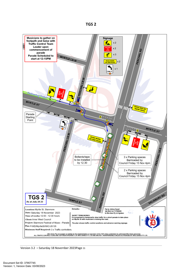
LTC0823(1) Item 7 Percival Road, Stanmore – Temporary Full Road Closures for Stanmore Music Festival – Saturday 18 November 2023 (Damum-Stanmore Ward /Newtown Electorate/ Inner West Lac) 100
LTC0823(1) Item 8 Holbeach Avenue, Tempe – Temporary Full Road Closures for Ms Sydney To The Gong Bike Ride On Sunday 5 November 2023 – (Midjuburi - Marrickville Ward/Heffron Electorate/Newtown Lac) 126
LTC0823(1) Item 9 West Street Near Brighton Street, Petersham – Proposed New Kerb Blister and Footpath Realignment (Damun-Stanmore Ward / Newtown Electorate / Inner West Pac) 141
Parking Matters
ITEM Page
LTC0823(1) Item 10 Ellen Street Carpark, Rozelle - Proposed Extension of ‘2p 8.00am-8.00pm’Timed Parking Restrictions to ‘4P 8.00am-8.00pm’ (Baludarri-Balmain Ward/Balmain Electorate
/Leichhardt Pac) 146
LTC0823(1) Item 11 Trafalgar Street, Enmore - Proposed installation of 'No Parking'
restrictions outside No.35-39A Trafalgar Street (Damun - Stanmore Ward/ Newtown Electorate/ Inner West PAC) 148
Late Items
Nil at time of printing.
6 Part B - Items for Information Only
Nil at the time of printing.
7 Part C - Items for General Advice
ITEM Page
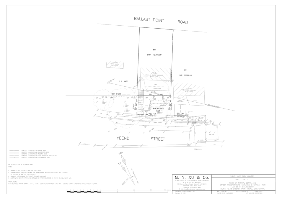
LTC0823(1) Item 12 Part Yeend Street, Birchgrove - road closure & sale (Baludarri- Balmain Ward/ Balmain Electorate/ Leichhardt PAC) 151
8 General Business
9 Close of Meeting
|
|
Local Traffic Committee Meeting 21 August 2023 |
Minutes of Meeting
Meeting commenced at 11.02am
ACKNOWLEDGEMENT OF COUNTRY BY CHAIRPERSON
I acknowledge the Gadigal and Wangal people of the Eora nation on whose country we are meeting today, and their elders past and present.
COMMITTEE REPRESENTATIVES PRESENT
|
Manod Wickramasinghe |
IWC’s Traffic and Transport Services Manager (Chair) |
|
Bill Holliday |
Representative for Kobi Shetty MP, Member for Balmain |
|
Graeme McKay |
Representative for Jo Haylen MP, Member for Summer Hill |
|
Patricia Arcilla |
Representative for Jenny Leong MP, Member for Newtown |
|
Nina Fard |
Transport for NSW (TfNSW) |
|
Van Le |
Transport for NSW (TfNSW) |
|
|
|
|
|
|
|
NON VOTING MEMBERS IN ATTENDANCE |
|
|
|
|
|
Colin Jones |
Inner West Bicycle Coalition (IWBC) |
|
George Tsaprounis |
IWC’s Coordinator Traffic Engineering Services (South) |
|
Felicia Lau |
IWC’s Acting Coordinator Traffic Engineering Services (North) |
|
Christy Li |
IWC’s Business Administration Officer |
|
|
|
|
|
|
|
VISITORS |
|
|
|
|
|
Daniel Farrugia |
Transport for NSW (TfNSW) (Senior Project Manager) (Item 2) |
|
Jeff Chen |
Transport for NSW (TfNSW) (Project Engineer) (Item 2) |
|
Netta Kovach |
Transport for NSW (TfNSW) (Communications and Stakeholder Engagement Specialist) (Item 2) |
|
Francis O’Neill |
Bicycle NSW (Head of Advocacy) (Item 2) |
|
Thomas Hyun |
Project Manager at Turner & Townsend Project Management (Item 6) |
|
Fraser Hamilton |
Commercial Manager at Gartner Rose (Item 6) |
|
Paul McCormack |
Project Manager at Gartner Rose (Item 6) |
|
|
|
|
|
|
|
APOLOGIES: |
|
|
|
|
|
Mayor Darcy Byrne |
Councillor – Baludarri-Balmain Ward |
|
Collin Hesse |
Office of Jenny Leong, Member for Newtown |
|
|
|
|
|
|
DISCLOSURES OF INTERESTS:
Nil.
CONFIRMATION OF MINUTES
|
That the Minutes of the Local Traffic Committee Meeting held on Monday, 19 June 2023 be confirmed. |
MATTERS ARISING FROM COUNCIL’S RESOLUTION OF MINUTES
Nil.
|
LTC0723(1) Item 5 Marrickville
Road, Seaview Street and Caves Lane, Marrickville – |
|
‘Dulwich Hill Village Fair' was an annual event up until 2019 and will now return this year and be held on Sunday 17 September 2023. As per previous years the event will necessitate the temporary full road closure of Marrickville Road (between New Canterbury Road and Durham Street); part of Seaview Street (between Marrickville Road and south of the entrance to the car park south of Herbert Street), Caves Lane, and the Seaview Street car park (car park adjacent to Caves Lane), Dulwich Hill.
Officer’s Recommendation
1. That the proposed temporary full road closure of Marrickville Road (between New Canterbury Road and Durham Street), part of Seaview Street (between Marrickville Road and south of the entrance to the car park south of Herbert Street), Caves Lane, and the Seaview Street car park (car park adjacent to Caves Lane), Dulwich Hill for the ‘Dulwich Hill Village Fair’ Event on Sunday 17 September 2023 between the hours of 3:00am and 8:00pm be approved as per the submitted TMP and TGSs.
2. That a Road Occupancy License application be obtained from the Transport Management Centre.
3. That notice of the proposed event be forwarded to the NSW Police Local Area Commander, Transit Systems, the NSW Fire Brigades and the NSW Ambulance Services.
4. That all residents and businesses in and around the affected area are to be notified of the temporary road closure in writing by the applicant in advance (at least 7 days prior to the event) with the applicant making reasonable provision for stakeholders.
5. That a minimum four (4) metre unencumbered passage be available for emergency vehicles through the closed section.
6. That the occupation of the road carriageway must not occur until the road has been physically closed.
DISCUSSION
The Committee members agreed with the Officer’s recommendation.
COMMITTEE RECOMMENDATION
1. That the proposed temporary full road closure of Marrickville Road (between New Canterbury Road and Durham Street), part of Seaview Street (between Marrickville Road and south of the entrance to the car park south of Herbert Street), Caves Lane, and the Seaview Street car park (car park adjacent to Caves Lane), Dulwich Hill for the ‘Dulwich Hill Village Fair’ Event on Sunday 17 September 2023 between the hours of 3:00am and 8:00pm be approved as per the submitted TMP and TGSs.
2. That a Road Occupancy License application be obtained from the Transport Management Centre.
3. That notice of the proposed event be forwarded to the NSW Police Local Area Commander, Transit Systems, the NSW Fire Brigades and the NSW Ambulance Services.
4. That all residents and businesses in and around the affected area are to be notified of the temporary road closure in writing by the applicant in advance (at least 7 days prior to the event) with the applicant making reasonable provision for stakeholders.
5. That a minimum four (4) metre unencumbered passage be available for emergency vehicles through the closed section.
6. That the occupation of the road carriageway must not occur until the road has been physically closed.
For Motion: Unanimous
|
|
LTC0723(1) Item 6 Constitution
Road, Dulwich Hill at the rail overbridge between |
|
An application has been received from Gartner Rose for the temporary full road closure of Constitution Road, Dulwich Hill at the rail overbridge between Williams Parade and Grove Street, for a 6-month period from August 2023 to January 2024 in order to facilitate piling and excavation works for the construction of the tunnel beneath Constitution Road as part of the GreenWay Project. The road will be temporarily closed to all vehicular traffic, including emergency vehicles. It is recommended that the proposed temporary full road closures be approved, subject to the conditions outlined in this report.
Officer’s Recommendation
That the proposed temporary full road closure of Constitution Road, Dulwich Hill at the rail overbridge between Williams Parade and Grove Street, for a 6-month period from August 2023 to January 2024 (with an additional 4 week contingency period) be approved, in order to facilitate piling and excavation works for the construction of the tunnel beneath Constitution Road as part of the Greenway Project subject to, but not limited to, the following conditions:
1. A Road Occupancy License be obtained by the applicant from the Transport Management Centre.
2. All affected residents and businesses, including the NSW Police Local Area Commander, Fire & Rescue NSW and the NSW Ambulance Services be notified in writing, by the applicant, of the proposed temporary road closure at least 7 days in advance of the closure with the applicant making reasonable provision for stakeholders.
3. The occupation of the road carriageway must not occur until the road has been physically closed.
4. The applicant is to set up the road closure and detours as proposed in the Traffic Guidance Schemes submitted to Council on 30 June 2023.
DISCUSSION
Public speakers, Thomas Hyun (Project Manager at Turner & Townsend Project Management), Fraser Hamilton (Commercial Manager at Gartner Rose), Paul McCormack (Project Manager at Gartner Rose) enter the meeting at 11:39AM
The Commercial Manager at Gartner Rose explained their methodology of using a Top-down tunnelling construction by pilling either side of the tunnel to excavate, installing a roof slab over the tunnel and then to re-open road the complete the rest of tunnel excavation on the other side of the slab. He stated that this is the fastest method requiring 6 months with proposed road closures from August 2023 to January 2024.
The Commercial Manager also explained they have prepared a diversion plan for cyclists, pedestrians (incl. wheelchairs, prams, the frail, aged and partially sighted) and vehicles. With regards to cyclists and pedestrians, the detour route is to take the existing ramp or stairs in Johnson Park to the Arlington Light Rail crossing which connects back onto Constitution Road. With regards to traffic diversions, a traffic control plan will be in place for traffic vehicle diversion, and a separate VMS for heavy vehicle diversion.
The Inner West Bicycle Coalition representative suggested making a partial passage along Constitution Road above the tunnel during the period of works so that pedestrians are minimally disadvantaged. However the Commercial Manager advised that this is a safety issue due to various heavy machinery being in use simultaneously.
Council officers raised the option of tunnel boring, however the Commercial Manager advised that on the south side of Constitution Road, there are steep existing embankments which will prevent them from using this construction methodology. There are also gas and water services which will need to be redirected or supported during construction and this would require a full road closure of Constitution Road in any instance.
Public speakers, Thomas Hyun (Project Manager at Turner & Townsend Project Management), Fraser Hamilton (Commercial Manager at Gartner Rose), Paul McCormack (Project Manager at Gartner Rose) left the meeting at 11:50AM.
The Committee members agreed with the Officer’s recommendation.
COMMITTEE RECOMMENDATION
That the proposed temporary full road closure of Constitution Road, Dulwich Hill at the rail overbridge between Williams Parade and Grove Street, for a 6-month period from August 2023 to January 2024 (with an additional 4 week contingency period) be approved, in order to facilitate piling and excavation works for the construction of the tunnel beneath Constitution Road as part of the Greenway Project subject to, but not limited to, the following conditions:
1. A Road Occupancy License be obtained by the applicant from the Transport Management Centre.
2. All affected residents and businesses, including the NSW Police Local Area Commander, Fire & Rescue NSW and the NSW Ambulance Services be notified in writing, by the applicant, of the proposed temporary road closure at least 7 days in advance of the closure with the applicant making reasonable provision for stakeholders.
3. The occupation of the road carriageway must not occur until the road has been physically closed.
4. The applicant is to set up the road closure and detours as proposed in the Traffic Guidance Schemes submitted to Council on 30 June 2023.
For Motion: Unanimous
|
|
LTC0723(1) Item 8 Fairfowl
Street at Pile Street, Dulwich Hill – Formalisation of road |
|
Council has prepared an amended design plan to formalise the existing road closure at the intersection of Fairfowl Street and Pile Street, Dulwich Hill. The intention of the proposal is to improve the overall amenity and streetscape of this location by providing landscaping, improving pedestrian, cyclist and vehicular access and formalising parking arrangements in the vicinity of the road closure whilst also replacing deteriorated road and footpath assets.
Officer’s Recommendation
That the amended detailed design plan for the formalisation of the road closure at the intersection of Fairfowl Street and Pile Street, Dulwich Hill and associated signs and line markings be approved (as per Plan No.10206-B).
DISCUSSION
The Committee members agreed with the Officer’s recommendation.
COMMITTEE RECOMMENDATION
That the amended detailed design plan for the formalisation of the road closure at the intersection of Fairfowl Street and Pile Street, Dulwich Hill and associated signs and line markings be approved (as per Plan No.10206-B).
For Motion: Unanimous
|
General Business
|
Item 12 Intersection at Lewisham Station
(Intersection of Railway Terrace and West
|
|
The representative for the Member for Newtown raised concerns that the green right turn arrow at the intersection of Railway Terrace and West Street only stays green for a very brief period of time which oftens means motorists are still turning on the intersection whilst the light in the opposite direction goes green. The representative for the Member for Newtown requested that a review into whether or not the green right turn light can be green for longer.
The TfNSW representative is to investigate this matter on behalf of the Member for Newtown.
|
|
Item 13 Request for Update on Traffic Light upgrade at the intersection of Alice Street, Llewellyn Street and Edgeware Road, Newtown/Marrickville/Enmore
|
|
The representative for the Member for Newtown requested for an update on the traffic light upgrade at the intersection of Alice Street, Llewellyn Street and Edgeware Road.
Council officers will raise this matter with the Project Manager or TfNSW to provide an update on changes to the traffic signals to the representative for the Member for Newtown.
|
|
Item 14 Request for Update on Traffic Signal upgrade at the intersection of Fredrick Street and John Street, Ashfield.
|
|
The representative for the Member for Summer Hill requested an update on the Traffic signals at the intersection of Fredrick Street at John Street Ashfield.
TfNSW representative advised that they were seeking funding for the design in the 23/24 financial year and construction funding for the 24/25 financial year.
|
|
Item 15 Request for Cycle maps. |
|
The IWBC representative advised it would be beneficial for Council to provide updated cycle maps which would include proposed works.
Council officers advised they will investigate this matter.
|
Meeting closed at 12:31 pm.
|
|
Local Traffic Committee Meeting 21 August 2023 |
Subject: Hurlstone Avenue, Summer Hill- Proposed Kerb
blister narrowing of Hurlstone Avenue at Prospect Road and No Left Turn
7.30-9.30am.,3-5pm Mon-Fri from Prospect Road into Hurlstone Avenue.
(Djarrawunang-Ashfield Ward/Summer Hill Electorate/Burwood PAC)
Prepared By: Boris Muha - Traffic Engineer
Authorised By: Manod Wickramasinghe - Acting Director Infrastructure
|
RECOMMENDATION
1. That the construction of kerb-blisters or kerb extensions to narrow Hurlstone Avenue at Prospect Road with associated signs and markings as shown in the concept plan Attachment 1 be approved in principle.
2. That a ‘No Left Turn; 7.30am-9.30am, 3pm-5pm Mon-Fri’ restriction be installed at the intersection of Prospect Road and Hurlstone Avenue, Summer Hill, prohibiting left turn movement during the above peak hour times from Prospect Road into Hurlstone Avenue.
3. That a Traffic Management Plan be issued to Transport for NSW seeking approval for the above part-time ‘No Left Turn’ ban.
|
STRATEGIC OBJECTIVE
|
2: Liveable, connected neighbourhoods and transport |
|
|
EXECUTIVE SUMMARY
Concerns have been raised regarding traffic and pedestrian safety issues at the intersection of Prospect Road and Hurlstone Avenue and through Hurlstone Avenue, Summer Hill.
Council is proposing to implement a safety treatment at the intersection of Hurlstone Avenue and Prospect Road by improving the sight lines of pedestrians and movement of vehicles. This will be achieved through constructing kerb blister islands or kerb extensions with pram ramps and narrow Hurlstone Avenue at the intersection of Prospect Road.
Council is also proposing to introduce time restricted ‘No Left Turn from 7.30-9.30am and 3-5pm, Monday to Friday from Prospect Road into Hurlstone Avenue. This proposal aims to relieve traffic volumes and congestion issues at this intersection and through Hurlstone Avenue during peak hours. Vehicles will be able to travel along Prospect Road and turn left or right into Old Canterbury Road from Prospect Road which is the preferred traffic route.
BACKGROUND
The proposed treatment at the intersection of Prospect Road and Hurlstone Avenue is part of the Pedestrian Access Mobility Plan (PAMP) 2020 for improved pedestrian facilities and safety and contributes to traffic calming/control of the area under the Ashfield Traffic Management Strategy 2017.
Concerns have been raised with Hurlstone Avenue as a local road, being subjected to high volumes of traffic during peak times with vehicles by-passing through the street to gain access to Old Canterbury Road and streets to the west of Old Canterbury Road. Hurlstone Avenue has similarly been subjected to pavement failure contributed by high volumes of traffic and heavy vehicle usage of the road.
The inclusion of the ‘No Left turn 7.30am-9.30am, 3-5 pm Mon-Fri’ aims to relieve the problem of high traffic volume usage of Hurlstone Avenue and for traffic to continue and primarily use Prospect Road to head towards Old Canterbury Road, during the above peak hour times. See diagram Attachment 3.
DISCUSSION
Other Staff comments:
Site location and Road Network

|
Street Name |
Hurlstone Avenue
|
|
Carriageway width (m) kerb to kerb |
12.8m |
|
Carraigeway type |
Two-way, one travel lane each direction. |
|
Classification |
Local |
|
Speed Limit km/h |
50, 40 kph school zone at western end closer to Prospect Road. |
|
85th percentile speed km/h |
46.4 |
|
Vehicles per day (vpd) |
2080 |
|
Reported crash history July 2016-July 2021 |
NIL- at the intersection with Prospect Road. |
|
Parking arrngements |
Unrestricted parking both sides |
|
Side streets |
Prospect Road to the west, and Old Canterbury Road to the east.
|
|
Street Name |
Prospect Road (at Hurlstone Avenue) |
|
Carriageway width (m) kerb to kerb |
10.2m |
|
Carraigeway type |
Two-way, one travel lane each direction. |
|
Classification |
Local-collector |
|
Speed Limit km/h |
50 and 40 kph school zone |
|
85th percentile speed km/h |
32.6 |
|
Vehicles per day (vpd) |
2143 |
|
Reported crash history July 2016-July 2021 |
(1) x 2020, north of Hurlstone Ave, RUM 63, vehicle door opening, serious injury, vehicles in southbound direction.
NIL-at the intersection with Hurlstone Avenue |
|
Parking arrngements |
Unrestricted parking to both sides, full-time and part-time school zone Bus Zones. |
|
Side streets |
Hurlstone Avenue |
Kerb blister extension and narrowing of the intersection.
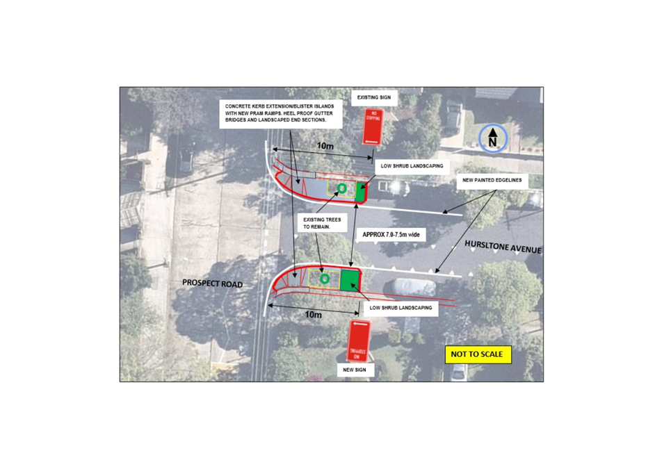
In reference to Attachment 1, the following points are made:
· The trees to the corners of Hurlstone Avenue dictates the movement of traffic around the intersection. The kerb- blisters islands are constructed to fold around the trees and extend in length to 10 metres in from the corners to emphasis and visualise the presence of the road narrowing at the intersection.
· The kerb blister- narrowing at the intersection still maintains and does not change the current practice of 2-way traffic movement around the intersection.
· Portion of the kerb blisters islands are landscaped to improve the streetscape.
· Heel proof gutter bridges are provided in line with new and extended out pram ramps.
· Edge line marking is provided to guide, delineate and further emphasis the narrowing at the intersection.
· the kerb blister islands are lengthened to the statutory ‘No Stopping’ distances on the corners of Hurlstone Avenue. There will be no loss of legal parking as result of this proposal.
· Street lighting will be examined under detail design.
Proposed ‘No Left Turn 7.30-9.30am., 3-5pm Mon-Fri’ from Prospect Road into Hurlstone Avenue.
In reference to Attachment 2 and 3, the following points are made:
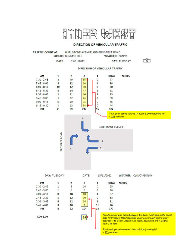
· Attachment 2 identifies visual observations on a typical Tuesday showing a higher degree of traffic turning left from Prospect Road into Hurlstone Avenue as compared to other movements around the intersection during AM and PM peak hours.
· Hurlstone Avenue is a local road and signposted under 3 tonne limit. It is a wide, straight, and short length of street connecting between Prospect Road and Old Canterbury Road. Buses servicing the Trinity Grammar School currently stop adjacent to the school on Prospect Road and then turn right into Hurlstone Avenue and exit onto Old Canterbury Road. Hurlstone Avenue is the most direct route back onto the state road network as well as being sufficiently wide to cater for bus movements in comparison to other nearby streets. Buses can be exempted through road weight limits under the Road Rules, if on route to and from a destination.
· The part-time ‘No left turn’ proposal during 2- hour peak periods in the morning and afternoon aims to relieve the traffic volume loading in Hurlstone Avenue bearing in mind that the street does cater for by-passing traffic, and the street facilitates school bus movement towards Old Canterbury Road. General vehicle movements have attributed to pavement damage in this street, more so than the other adjacent streets.
· The restriction would also be considered to minimise any concerned congestion/traffic build up issues at the intersection of Hurlstone Avenue and Old Canterbury Road during morning and afternoon peaks.
· Traffic counts conducted in Hurlstone Avenue back in 2006 registered vehicle volumes around 1120 vehicles per day (vpd) as compared to 2028vpd under recent counts done in September 2022. This identified an increase around 908 vehicles per day over time. Similar counts taken in 2006 over that of the last 2022 counts for the surrounding streets of Herbert, Seaview, and Henson Street (to the east of Prospect Road) and Prospect Road (to the south of Hurlstone Avenue) revealed traffic volume variations over similar dates from minus 150 to plus 140 vehicles per day.
· The proposed restriction is only limited to 4 hours of the day and aims to redirect some 586 vehicles per day to the adjoining streets. It is acknowledged that not all vehicles may proceed up to Prospect Road to turn at Old Canterbury Road, and that a certain degree of traffic may elect to use the narrower and less desirable (convoluted) streets of Herbert Street and Seaview Street to reach Old Canterbury Road.
It is considered that a reasonable break up of 20-60% of vehicles would be distributed to Herbert Street, Seaview Street and Prospect Road respectively. By doing so the diverted/varied traffic volumes are shown in Attachment 3. This would allow a more balanced network distribution with the east-west streets of Herbert, Seaview and Hurlstone Streets having a range approximately 560 to 1500 vehicles per day, which is considered low and well below the local road capacity. Added volumes in Henson Street and Prospect Road would be within road capacity. Prospect Road is a local-collector road which can manage additional traffic and has an array of traffic calming devices through the street and can withstand additional loading given it is a concrete road.
PUBLIC CONSULTATION
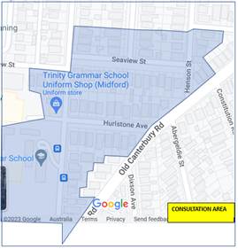
77 letters with plans of the proposed physical treatment to the intersection of Prospect Road and the proposal of placing a ‘No Left Turn 7.30am-9.30am., 3-5pm Mon-Fri’ from Prospect Road into Hurlstone Avenue, were mailed out to properties as shown in the consultation area below to seek comments.
Consultation letters were sent out on 24 April 2023 with the submissions being closed on the 22 May 2023. The proposal of the No Left Turn ban was also advertised under Public Notice on Council’s website for a minimum period of 28 Days as required under the Road Act for proposed traffic changes.
23 submissions were received from residential households on the two proposals.
18 responded in support and 5 in non-support for the kerb blister treatment to the intersection of Hurlstone Avenue and Prospect Road.
11 responded in support and 12 in non-support on the proposed ‘No Left Turn 7.30-9.30am., 3-5pm Mon-Fri’ from Prospect Road into Hurlstone Avenue.
Those providing comments have been tabled below with officer response made.
|
Officers Response |
|
|
· Support the kerb blisters -control the speed of cars turning in Hurlstone Ave which is a key issue that residents have to deal with.
· Dangerouds intersection-vehicles turning at speeds. |
· Noted |
|
· Narrowing of Hurlstone Avenue will make the left and right turns into Prospect Road more difficult. This will force vehicles onto the wrong side of Prospect Road in order to make a left turn which will lead to more congestion as well as pose a risk to pedestrians and vehicles. |
· The kerb blisters are intented only to extend out to the tracking path of the vehicle coming around the corners and passing around the trees on both sides of Hurlstone Avenue. The current pattern of traffic movement around the intersection would be maintained. |
|
· Kerb blisters are a minor safety treatment. The intersection of Hurlstone Avenue and Prospect Road will remain unsafe & would benefit from additional major safety treatments. |
· The kerb-blister widening is considerd the best option to improve safety, specifically pedestrian, and conrtol traffic movement around the intersection. The kerb blister islands may be integated into the footway under detail design and made out as kerb-footway extensions, pending on drainage considerations. |
|
· Existing trees already make the intersection narrower-blisters not reqiured.Coaches looking to turn right from Prospect Road will find it harder. No stopping signs is good, but not unless policed. |
· The main objective of the kerb blisters is to assist in bringing out the pram ramps for improved sight lines of pedestrains. The narrowing is to be designed to allow buses to turn right from Prospect Road into Hurlstone Avenue slowly and with caution going over the central area of Hurlstone Avenue, as they currently do so. |
|
· Sight view issue – No stopping sign missing at corner |
· The missing ‘No Stopping’ sign on the corner to the western side of Prospect Road, south of Hurlstone Avenue has since been replaced providing vehicles the necessary sight view when coming out of Hurlstone Avenue. |
|
· Kerb blisters are a welcome traffic measure as children cross Hurlstone Avenue to walk to Summer Hill Public School. Intersection is found dangerous with limited visibility. Dangerous driving in area, illegal parking of familes. Dropping off and picking up students, and parking close to corners -restricts pedestrian and driver views. |
· All four corners of the intersection have or will be signposted with ‘No Stopping’ to provide improved sight view and prevent vehicles from parking close to the corners. Council Rangers can be called upon to enforce illegal parking. |
|
· Pedestrian (raised) crossing should be included at the intersection. -ensure safety to pedestrians, manage Pedestrian School traffic to and from Trinity Garmmar, Yeo Park and Summer Hill Public. |
· A crossing is not suited across Hurlstone Avenue at the intersection. Trees obstruct the effectiveness of a crossing. A crossing further in from the intersection would affect parking and be located away of the intersection’s pedestrian desire path. Observation outside of school hours show low pedestrain numbers to consider consistent warrant of a crossing through out the day. Furthermore, the crossing midblock between Hurlstone Avenue and Prospect Road has been upgraded to a raised crossing, and a pedestrain refuge has been built at the intersection of Prospect Road and Old Canterbury Road to improve pedestrain safety in the area under DA conditions for Trinity Grammar. |
|
· No Left Turn (NLT) restrictions will restrict access into Hurlstone Avenue. Less safe approach to the houses during these times. |
· It is considered that alternate access in from Old Canterbury Road can be safely provided by continuing on through Prospect Road, turn left into Old Canterbury Road, and left to enter into Hurlstone Avenue. |
|
· Trinity Buses turn right in contravention of the heavy vehicle restriction in Hursltone Avenue, and cause conjestion attempting to turn out onto Old Canterbury Road and are responsible for damage to road. Police the 3 tonne limit rather than place a NLT ban.
· Buses should be made to proceed to Victoria Street.
|
· Buses can be exempted through road weight limits under the Road Rules, if on route to and from a destination.
· Buses servicing Trinity Grammar currently stop adjacent to the school on Prospect Road and then turn right into Hurlstone Avenue and exit onto Old Canterbury Road. Hurlstone Avenue is the most direct and shortest route back onto the state road network as well as being sufficiently wide to cater for bus movements in comparison to other nearby streets.
· The No Left Turn prohibits all vehicular traffic from turing left into Hurlstone Avenue from Prospect Road in the AM and PM periods as proposed.
· Other School Bus routes service the school via Victoria Street however these buses come from Ashfield. Bus opertion is well distriuted between Victoria Street and Prospect Road.
|
|
· Strongly object-Traffic will increase in Prospect Road and congestion/queuing issues will result towards Old Canterbury Road from Prospect Road during the NLT ban period- Residents on Prospect Road will be significantly affected. Difficult to turn out from Prospect Road into Old Canterbury Rd at present in peak hour.
· Risk illegally parking in No Stopping/bus zones. Traffic cannot split to turn left and right with changes made at Hurlstone Avenue and Old Canterbury Road and Propect Road and Old Canterbury Road causing present conjestion.
· Cars will be encouraged to turn around in Prospect Road turning and damaging property.
· Trinity should ease congestion with No drop-offs permitted on Prospect Road.
· This increased traffic load will pose a risk to pedestrians, particularly students, outside Trinity Grammar School.
· The changes at the intersection of Prospect Road and Old Canterbury Road [ inclusion of a pedestrian refuge as part of the Trinity Grammar development ] has lead to more traffic delays. This can cause it to be more difficult for pedestrains to safely cross Prospect Road. Congestion in Prospect Road would also be increased.
· Funeling traffic back to the school zone and crossing.
· Further congestion will impact on the path of ambulances and fire trucks.
· Increase traffic in Prospect Road will increase danger for people crossing Old Canterbury Road from Arlington Road.
· Reduce the amentity(heathiness) of our home, and increase queing of vehicles in Prospect Road will impact on ability to exit out of our propoerty.
· Hurlstone Avenue should not be treated as a local street, considering the significant demand for its use, its ample width, and direct access to Old Canterbury Road. |
· It is likely that smaller amounts of traffic (up to 40% of that to turn left into Hurlstone Street in peak hour) may be distribute between Seaview Street and Herbert Street. Prospect Road is designed and capable of handling the additional traffic.
· Observations reveal that traffic delays times are not considered very long at the intersection of Prospect Road and Old Canterbury Road, with traffic managing to turn left and right when gaps are provided in Old Canterbury Road. Any queing is considered of acceptable length. The eastern corner has just recently been cut back to design a left turn vehicle to slip around a waiting right turn vehicle.
· Formal drop-off facility is within the schools’ underground carpark off Victoria Street. Council nor Trinity Grammar cannot prohibit natural (non signposted) drop off from Prospect Road, provided it is done so legally.
· By upgrading the midblock pedestrain crossing to a raised crosing, providing a pedestrain refuge at the intersection of Prospect Rd and Old Canterbury Road and having an array of existing speed humps, aims to create a traffic calming environment to safeguard pedestrain activity with existing or added traffic in the area.
· The ban is proposed for peak hours (4 hours of the day) aimed at not diverting excessive amount of traffic in the area throughout the day or night.
· Emergency vehicles (if called to a destination) are permitted to go on the wrong side of the road or pass through ban or restricted areas.
· Pedestrians are already exposed to the higher volumes of traffic crossing Arlington Road, unless they proceed down to the midblock traffic lights further west and cross over Yeo Park.
· Hurlstone Ave is classed as a local road whereas Prospect Road is a local collector road linking between Ashfield and Old Canterbury Road. Prospect Road is structurally designed and capable of taking larger additional traffic and loading.
· Council will provide an intersection performance analysis of the intersection of Prospect Road and Old Canterbury Road in line with a traffic management plan submission for Transport for NSW to consider and formally approve any ban turn movements. . |
|
· Witnessed many vehicles accelerating to turn left into Hurlstone Ave because of being delayed while waiting for Trinity Grammer students to park on Prospect Road. I support the No Left Turn measure to keep all students safe while walking to school. |
· Noted. |
|
· Recent accident occurred with a truck speeding around the corner of Hurlstone Avenue and Old Cantebury Road. Truck colided with a tree and lost control and hit a parked car. Given the angle what can be done to prevent similar occurance (e.g. make Hurlstone Avenue one-way)
|
· This is outside of the Scope of Works, however Council officers and Police have examined the matter on site and viewed that the truck was at fault turning left at high speed from Old Canterbury Road into Hurlstone Avenue. Council has no intention in the forseeable future to do any further modifications to this intersection. There is no recorded accident history from available Transport for NSW and Police data since the intersection was modified. |
|
· Object to NLT as this will increase traffic in surruonding streets. Seaview between Prospect Road and Henson Street has already traffic generated by Trinity, parking by students, teachers, and trucks from their building site.Seaview Street is narrower than Hurlstone would not cope with the ‘rat run’that will be created under the proposed NLT.
· Trinity will continue to increase student enrolments, and the proposal is seen to be planned as part of a Trinity Masterplan.
· Concern with traffic runing down Seaview Street under the proposed NLT. Seaview Street between Prospect Road and Henson Street is narrow. It has to be parking on one side of the street only so cars can pass. Home owners park their cars on-street and not within the driveway. Need to do something about both streets being a rat run. Their has been 2 accidents in the street recently, and vehicles fly down the street with kids crossing to go to Summer Hill Public and walking to Trinity.
· Seaview street (eastern end - Prospect to Henson sts) has it's own traffic issues from the other schools queuing on Henson to enter Old Canterbury Rd as well as being only 3 cars wide requiring cars to pull over to the kerb to pass.
|
· It is likely that smaller amounts of traffic (up to 40% of that banned to turn left into Hurlstone Street) may use and distribute between Seaview Street and Herbert Street.
· The NLT proposal is made to resolve resident complaints regard to traffic using Hurlstone Avenue. Much of the traffic turing left into Hurlstone Avenuee from Prospect Road is seen to come down Prospect Road from Ashfield, and not so related to traffic from Trinity Grammar.
· Seaview Street (between Prospect Road and Henson Street) is narrow 2-way streeet with car parking to both sides providing friction and ‘defacto’ calming to control the traffic movement and speeding below the limit of 50 kph. It is considered that Seaview Street has capacity to take on additional traffic. Traffic pulls up to one side across driveways or corners to intersections and give-way to opposing vehicles. Council will examine to clear parking at the corners of Seaview Street and Henson Street, by placing’ No Stopping’ restrictions at the regulatory diatance of 10 metres from the corners, to improve sight view and traffic flow passage at this intersection.
· Removal of parking on one side of Seaview Street will impact on the residents needs to park on the street, but more so can encourage speeding by making the travel path wider.
· Council will provide an intersection performance analysis similarly at this intersection of Henson Street and Old Canterbury Road, in line with a traffic management plan submission for Transport for NSW to consider and formally approve any turn movement bans.
|
|
· No objection is raised by Transit Systems NSW for both the kerb blister narrowing proposal to the intersection of Prospect Road and Hurlstone Avenue, and the ‘No Left Turn 7.30-9.30am., 3-5pm Mon-Fri’ for Prospect Road into Hurlstone Avenue. |
· Noted. |
|
· No objection to changes to the kerb on the northern and southern corner of Prospect Road and Hurlstone Avenue raised by Trinity Grammar School. Concern raised regard to queing of traffic back into the school zone and impact on the new raised crossing and State Transit Bus Stop if NLT is proposed. |
· Noted.
· Cars should not queue over the crossing. Buses should be allowed into the main stream of traffic from a Bus Stop.
· Council will provide an intersection performance analysis at the intersection of Prospect Road and Old Canterbury Road in line with a traffic management plan submission for Transport for NSW to consider and formally approve any ban turn movements.
|
|
· Do not accept proposal of NLT as it will be ineffective as motorists will ignore it and hence result in waste of resources.
· Hurlstone Avenue must be blocked at either-or end to prohibit through traffic. Preferably the Prospect Road intersection as this would provide additional drop-off and parking for the school. |
· Council will request Police assitance to enforce the restriction.
· Inner West Council does not favour full or partial road closures. Part or full closing of Hurlstone Avenue would not likely be supported as more traffic will be diverted through alternate neighbouring streets. Vehicle access in the street would be affected. The low or nil accident history in the area may well not justify a closure. Any current Traffic Management Strategy for this area does not identify or recommend a partial or full road closure at the intersection of Hurlstone Avenue and Prospect Road.
· Formal drop off faclity is operated from the school’s underground carpark off Victoria Street. It is not intended to encourage drop off from Prospect Road.
· The NLT acts to releive traffic loading in Hurlstone Avenue with only a smaller portion of traffic in Hurlstone Avenue being redirected and distributed into other streets |
|
· Road closures/armed roads signs over the years made by council around Old Canterbury Rd, Junction Rd, Victoria St, Henson St etc. has created a ‘rat run’ through Hurlstone Ave. Plus the approval for Trinity Grammar to increase its student numbers by 40% will further increase traffic.
· Vehicles come through at a high speed. The street is wide and particularly the opening on the Old Canterbury Rd end where vehicles try to beat the oncoming traffic or take the corner sharp when turning left. - very dangerous to cross as a pedestrian, as well as pulling out of driveways or coming out of a parked car position where on many occasions there has been near misses.
· The proposal by council is only looking at one end of the street and limited times and days of the week. The issues outlined above occur at any time of day, even at night with school after hour activities and sports with traffic all hours. Council’s proposal is limited in its effectiveness and needs to be a permanent No Left Turn with no day/time restrictions. Traffic can use Prospect Rd & Old Canterbury Rd where this intersection just got improved as did the pedestrian crossing on Prospect Rd to cater for increased traffic. This makes it a safer option and one side of the Rd is just the school, so less impact to residents.
· It would be proposed to reduce traffic and increase safety, that both ends of Hurlstone Ave are narrowed to allow one car at a time (unless council can block one of either ends of the Avenue?) and also have a No Right Turn sign from Hurlstone Ave onto Prospect Rd and a warning sign at Old Canterbury Rd that there’s no Right Turn access at Prospect Rd. This means that school buses can still come through as they turn right from Prospect Rd onto Hurlstone Ave, unless a full closure is made on either end the school buses can loop around Seaview Ave as do the public buses. Traffic that comes from Old Canterbury Rd can still turn left onto Prospect Rd or if they can’t to turn right from Old Canterbury Rd, they can use Prospect Rd to turn right. Ideally council should work with State NSW Roads to put a roundabout at Old Canterbury & Prospect Rd, this would help with speed since there’s mobile speed cameras to reduce spend to 50 kms and helps with safety.
|
· Road closures are not considered an option as explained above.
· The intersection of Hurlstone Avenue and Old Canterbury Road has been treated by narrowing and realigning the intersection for improved pedestrain safety and traffic control around the intersection. The intersection was narrowed in as much as possible without severly impeding on the nature and practised flow of traffic around the intersection. A similair couse of action is proposed for Hurlstone Avenue at Prospect Road. · The 85th percentile speed through Hurlstone Avenue was recorded as 46.4kph, below the speed limit of 50, hence there is no real issue regard to speeding.
· Full time No Left turn would end up affecting resident access in quieter periods of the day and week as well as shifting additional traffic to neighbouring streets. The propsal is meant to balance traffic volumes, not shift them entirely from one street to another. The purpose of the proposed part time NLT ban is to relieve traffic loading upon Hurlstone Avenue and distribute that portion of traffic elswhere so as to balance out the overall traffic in the street network, and not to impose more traffic elsewhere for the sake of eliminating most or all of the by-passing traffic in Hurlstone Avenue.
· The narrowing of both ends of the street to one lane 2-way traffic would only add to conflict with opposing traffic if not able to be sighted around the corners.
· The banning of right turn movements from Hurlstone Avenue into Prospect Road would result in removing east bound by-passing traffic and force this traffic to adjoining streets, it would also impact local access arrangements and is not currently supported.
· To divert buses through narrower meandering streets would not be supported as Hurlstone Avenue provides a wider straight and short length road access directly onto a State Road.
· Roundabouts on State Roads are a matter for TfNSW and is not considered an appropriate solution in this instance given the substantially unbalanced traffic flows. |
|
· The NLT will create bottleneck conditions at Seaview Street and at the intersection of Prospect Road and Old Canterbury Road. It will become too difficult and slow to turn out to Old Canterbury Road from Prospect Road. Traffic will increase into Seaview Street or pressure would be made to exit Prospect Road at Old Canterbury Road creating significant safety hazard
· What are the processes required of Trinity Grammar regard to traffic and parking, to alleviate pressure in these streets and enforce that parents use the designated off-street drop -off in the designated carpark facility rather than the streets, and illegal parking by residents in the street. |
· Reference is made to the above officers responses. Council further more has installed ‘No Stopping’ restrictions on both sides of Seaview Street back in from the intersection of Prospect Road to allow safe and proper clearance for 2-way traffic flow around the intersection.
· Prospect Road at Old Cantebury Road has been reconstructed to provide a safe pedestain refuge and designed to allow for adequate left and right turn movements out of Prospect road. Waiting time is generally not considered long with vehicles finding gaps in Old Canterbury Road to exit from Prospect Road.
· The school carpark is being expanded under the school grounds off Victoria Street to cater for parking and official drop and pick up. The school, under condition of DA conscent, is reqiured to carry out an Operational Traffic Manangnemt Plan (OPTMP) and encourage parents and carers to park and drop off and pick up from the carpark off Victoria Street. There is no intention to create formal drop off and pick up in adjaent streets. The school or council cannot direct parents/carers from using adjacent ‘Public Road’ streets provided their vehicles park legally. Request will be made for Council’s Regulatory Parking Services to enforce the area.
· The NLT proposal and school carpark operation under the OTMP will aim to disperse traffic movement on a balanced approach around the school and not concentrate traffic pressure on a particulalr street. |
FINANCIAL IMPLICATIONS
The proposed physical works to the intersection of Prospect Road and Hurlstone Avenue is estimated around $30,000-40,000 and will be constructed under the PAMP/Capital Works Program for the financial year 2023/2024 subject to funding and resourcing.
The installation of the No Left Turn ban restriction will be done under the general signs and line marking budget.
There are no financial implications associated with the implementation of the proposed recommendations outlined in the report.
CONCLUSION
It is recommended that the construction of kerb-blisters or kerb extensions to narrow Hurlstone Avenue at Prospect Road with associated signs and markings as shown in the concept plan Attachment 1, be supported to proceed to final design.
It is similarly recommended that a ‘No Left Turn 7.30am-9.30am., 3-5pm Mon-Fri’ restriction be installed at the intersection of Hurlstone Avenue and Prospect Road prohibiting the left turn movements during the above peak hour times from Prospect Road into Hurlstone Avenue. It is noted that a Traffic Management Plan is needing to be issued to Transport for NSW seeking their approval for the above part-time ‘No Left Turn’ ban.
|
1.⇩ |
Concept plan-kerb blister narrowing Hurlstone Avenue at Prospect Road, Summer Hill. |
|
2.⇩ |
Traffic survey and counts. |
|
3.⇩ |
No Left Turn and traffic diversion. |
|
|
Local Traffic Committee Meeting 21 August 2023 |
Subject: Jaggers Lane, Balmain - Proposed Permanent Full Road Closure (Baludarri - Balmain Ward/ Balmain Electorate/ Leichhardt Pac)
Prepared By: Zara Helal - Traffic Engineer
Authorised By: Manod Wickramasinghe - Acting Director Infrastructure
|
RECOMMENDATION
1. That the permanent full road closure of Jaggers Lane, Balmain, between Duncan Street and Caroline Street be approved in principle, subject to the approval of the Traffic Management Plan by Transport for NSW.
2. That Council undertake a 28-day Public Exhibition, including engagement with NSW Police, emergency services, and other relevant authorities, with the results to be reported back to the Traffic Committee.
|
STRATEGIC OBJECTIVE
|
2: Liveable, connected neighbourhoods and transport |
|
|
EXECUTIVE SUMMARY
A petition has been submitted from residents for a permanent full road closure of Jaggers Lane, Balmain, to be implemented to prioritize pedestrian safety and thoroughfare in the laneway.
Jaggers Lane is a narrow laneway and does not feature footpaths on either side, it is used by many residents for access to shops and public transport located on Darling Street. Furthermore, residents of Waterview Street between Duncan Street and Caroline Street frequently use Jaggers Lane to store waste and recycling bins and for rear property access.
Though Jaggers Lane is currently providing two-way traffic functions, the permanent road closure is expected to have minimal effects on surrounding traffic movements whilst improving pedestrian safety.
BACKGROUND
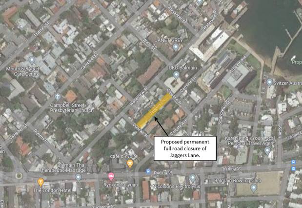
Jaggers Lane, Balmain, is a two-way lane featuring a 2.9m road carriageway. The road surface is in asphalt with sandstone kerbing on some sections of the laneway. Parking is not permitted along both sides of the laneway, and at the time of this report no property driveways have direct access to the laneway. The location of the proposed permanent full road closure is shown in the diagram:
The proposal seeks the implementation of the permanent full road closure through installation of a bollard at the centre of the road carriageway at each end of Jaggers Lane. This arrangement would retain pedestrian and bicycle access through the laneway and is expected to have minimal effects on surrounding traffic. Observations at different times of the day indicate minimal traffic conditions due to the constraints at both intersections requiring a small vehicle to successfully enter and exit with vehicles parked along Caroline and Duncan Streets.
There are no properties in the area with direct access to Jaggers Lane and emergency vehicle access to properties is expected to remain unchanged as access to properties can be undertaken via surrounding streets.
The permanent full road closure intends to improve safety of pedestrians travelling through Jaggers Lane. Currently, there is no footpath at the southern side of Waterview Street between Duncan Street and Caroline Street. The permanent full road closure will provide residents of Waterview Street between Duncan Street and Caroline Street an alternative walking path.
It should be noted that a development application (DA) consent was issued for No.4 Caroline Street, Balmain, which included the proposed provision of off-street parking with access via Jaggers Lane. The consent included a deferred commencement condition which required the applicant to demonstrate adequate vehicle turning movements through Jaggers Lane and into the driveway with a compliant vehicle. The deferred commencement condition has not yet been addressed and a subsequent Modification application has been lodged and not yet been determined.
DISCUSSION
A petition was received by Council in support of the proposed permanent road closure of Jaggers Lane, Balmain. The petition was signed by 47 residents, from 32 properties. A public 28-day notification has been undertaken and the results of any submissions will be tabled in a future report.
FINANCIAL IMPLICATIONS
There are no financial implications associated with the implementation of the proposed recommendations outlined in the report.
Nil.
|
|
Local Traffic Committee Meeting 21 August 2023 |
Subject: Carrington Road, Marrickville - Cycleway Upgrade
Prepared By: Brigid Kelly - Senior Strategic Transport Planner
Authorised By: Manod Wickramasinghe - Acting Director Infrastructure
|
RECOMMENDATION
That the proposed Carrington Road Cycleway, line marking and signage modifications plan (drawing no’s IWC2023-01 to IWC2023-05) be approved subject to the flexible bollards not extending into the kerb radius at each of the intersections along Carrington Road, Marrickville.
|
STRATEGIC OBJECTIVE
|
2: Liveable, connected neighbourhoods and transport |
|
|
EXECUTIVE SUMMARY
Council has finalised a design to provide continuous cycling access on the existing Carrington Road cycleway consistent with current NSW guidelines for cycling infrastructure. The proposal involves line marking and signage at five intersections on the cycleway to improve clarity and safety for bike riders and motorists and provide continuous cycling access for people using the cycleway.
BACKGROUND AND DISCUSSION
The Carrington Road cycleway was designed and constructed by Marrickville Council between 2009 and 2015. Marrickville Council originally proposed a design that would provide continuous cycling access along the cycleway, however, this design was not supported by a division of Transport for NSW (formally Roads and Maritime Service) at the time resulting in a cycleway with poor legibility for all road users and providing poor level of service for people using the cycleway. Since its opening Council has received ongoing complaints from cyclists about the cycleway design.
The existing design requires bike riders to give way at all side streets even though they are traveling straight along the cycleway. This requires cyclists to simultaneously monitor vehicles approaching from 3 different directions before they can proceed across the intersections. This design creates confusion for all road users as they attempt to navigate the intersections and it provides a cycling facility with poor level of service for cyclists.
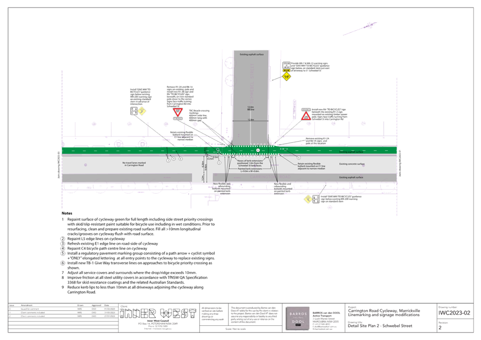
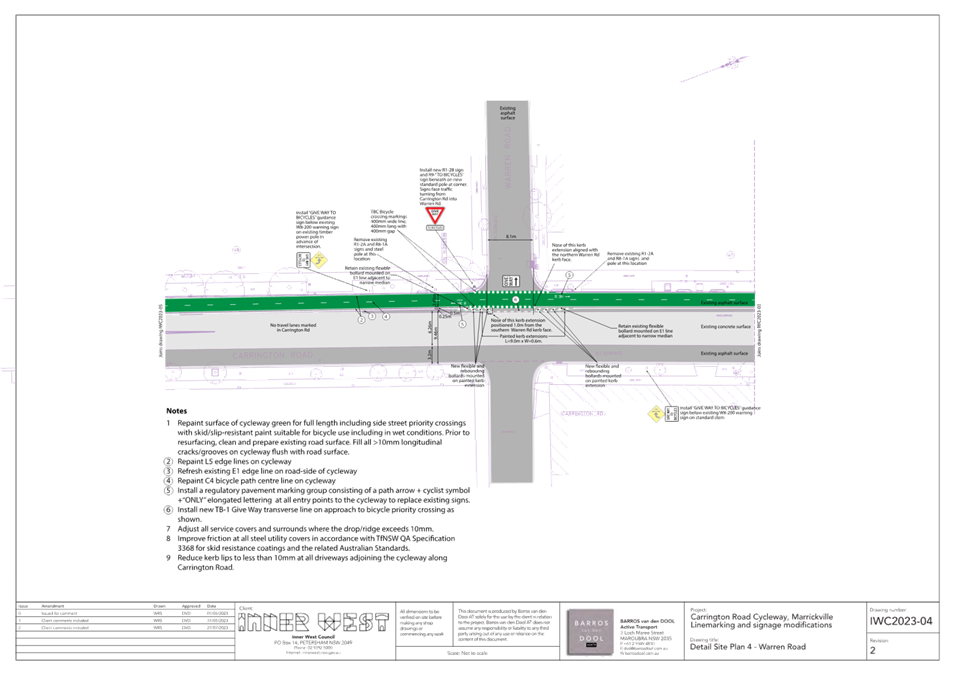
This proposal involves the following line marking and signage along the cycleway to provide direct and continuous cycling access, as outlined in Attachment 1:
· ‘Give Way’ signs addressing motorists crossing the cycleway with supplementary ‘to bicycle’ signs.
· ‘Give Way’ line marking addressing motorists crossing the cycleway.
· Supplementing the existing black and yellow warning signs addressing motorists on Carrington Road with a “Give Way To Bicycles” plate.
· Installing new black and yellow bicycle warning signs (and “Give Way To Bicycles” supplementary plate) in sides streets on approach to Carrington Road.
· Green coloured pavement on the cycleway across the intersections.
The proposed design has been assessed by a Road Safety Auditor and a number of changes were made to address risks raised in the Road Safety Audit report.
PUBLIC CONSULTATION
Consultation was conducted between 19 May and 17 June 2023. A letter outlining the proposal was letterboxed to 328 properties surrounding Carrington Road as shown on the map below. 36 people responded to a survey on Your Say Inner West, with approximately 90 percent of respondents supporting the proposal. Comments received are discussed in the table below.

|
Residents’ comments |
Officer comment |
|
A number of comments made in support of the proposal requested physical changes be made to the intersections such as with raised platforms. |
Carrington Road is an overland flow path adjacent to Cooks River which experiences significant flooding during heavy rains. Physical installations such as with raised platforms or concrete kerb build-outs would require assessment of water flow impacts requiring greater time and financial costs, while this proposal can improve immediate improvements for both cyclists and motorists. More significant street interventions can be considered in future such as with place-making and/or property development.
|
|
The cycleway should be moved to the other side of Carrington Road with parking beside the cycleway. |
Marrickville Council originally explored locating the cycleway on the eastern side of Carrington Road however, the potential impacts on car parking were considered significant at the time as well as the cyclists would need cross over Carrington Road once again at Mackey Park. Whilst its location on the western side resulted in the loss of less car parking due to the intersections with side streets, it resulted in a poor cycling facility and poor intersection legibility for both motorists and cyclists.
|
|
This is a waste of money and will have zero positives as almost no bikes use the cycleway. It will waste money and make it more difficult to use the road.
|
The installation of regulatory and advisory signage will improve the clarity of the intersections and formalise existing behaviours whereby many drivers currently give way to bike riders on the cycleway. In addition the proposal is consistent with Outcome 2.6.2 in the Community Strategic Plan (CSP) to “Manage the road network to increase safety and prioritise active and public transport over private motor vehicles.”
|
|
Cars regularly speed down the
side streets and onto Carrington Road without looking. Turning into the side
streets can be extremely stressful. During periods of high traffic on Carrington
Road, I can imagine a huge backlog of traffic would be caused by bikes having
right of way. |
The installation of regulatory signage and road markings as well as advisory signage will provide motorists with a clear requirement to give way to people using the cycleway. Whilst it’s appreciated there will some adjustment required by motorists to the new circumstances the proposed signage and line markings will be compliant with relevant specifications in terms of positioning, purpose and appearance and will provide clear communication about navigating the intersections.
In addition the proposal is consistent with Outcome 2.6.2 in the Community Strategic Plan (CSP) to “Manage the road network to increase safety and prioritise active and public transport over private motor vehicles.”
|
FINANCIAL IMPLICATIONS
Grant funding has been received from Transport for NSW under the Get NSW Active program and it is anticipated that all components of this project will be funded by the grant.
|
1.⇩ |
Proposed Cycleway Upgrade - Carrington Road Marrickville |
|
Local Traffic Committee Meeting 21 August 2023 |
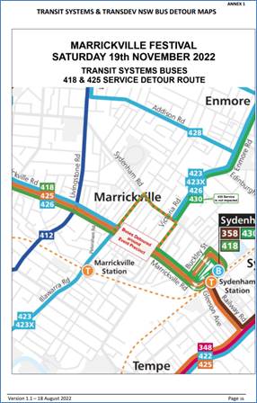
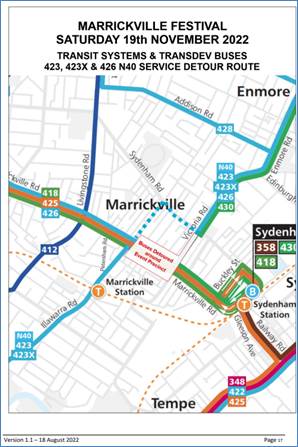
Subject: Marrickville Road, Marrickville – Temporary Full Road Closures for Marrickville Music Festival - Sunday 15 October 2023 (Midjuburi - Marrickville Ward / Summer Hill Electorate / Inner West PAC)
Prepared By: Jennifer Adams - Traffic Engineer
Authorised By: Manod Wickramasinghe - Acting Director Infrastructure
|
RECOMMENDATION
1. That the proposed temporary full road closure of Marrickville Road (between Illawarra Road and Victoria Road), Central Lane (between Victoria Road and Meeks Road), Seymour Lane (between Garners Lane and Garners Avenue and between Frampton Avenue and Garners Lane), Garners Lane (north of Seymour Lane) along with short sections of Silver Street, Garners Avenue, Gladstone Street, and Frampton Avenue where these streets intersect with Marrickville Road, Marrickville be approved for the purpose of holding the ‘Marrickville Music Festival’ Event on Sunday 15 October 2023 between 12:30am and 12:00pm as per the submitted TMP and TGSs and subject to the following conditions and all standard Council conditions for temporary full road closures.
2. That a Road Occupancy License application be obtained from the Transport Management Centre.
3. That notice of the proposed event be forwarded to the NSW Police Local Area Commander, Transit Systems, the NSW Fire Brigades and the NSW Ambulance Services.
4. That all residents and businesses in and around the affected area are to be notified of the temporary road closure in writing by the applicant in advance (at least 7 days prior to the event) with the applicant making reasonable provision for stakeholders.
5. That a minimum four (4) metre unencumbered passage be available for emergency vehicles through the closed sections.
6. That the occupation of the road carriageway must not occur until the road has been physically closed.
|
STRATEGIC OBJECTIVE
|
2: Liveable, connected neighbourhoods and transport |
|
|
EXECUTIVE SUMMARY
Inner West Council is presenting Marrickville Music Festival on Sunday 15 October from 12:00pm noon until 6:00pm. The event will feature multiple outdoor live music stages across the festival site. Including activation of Marrickville laneways through music and art. As part of the event there will be a partial road closure of Marrickville Road and Central Lane. This will require some road detours and bus diversions in surrounding streets. Event bump in will occur from 12:30am and bump out will conclude by 12:00pm midnight. It is recommended that Council agree to the temporary full road closures subject to all standard Council conditions for a temporary full road closure.
BACKGROUND
Marrickville Festival is an annual event successfully held over numerous years. This year Marrickville Music Festival will be a celebration of live music in the Inner West. The event will run on Sunday 15 October 2023 from 12pm to 6pm and will feature multiple outdoor live music stages across the festival site.
Stages will be set up across the event site including the activation of Marrickville laneways through music and art. The Marrickville Music Festival will be a showcase of music talent from the Inner West, with over 40 acts to play in the one-day event. Stages will host both established and up and coming bands from the Inner West. Music venues in Marrickville will be also encouraged to participate in the festival program to highlight the vibrant array of venues that reside in the Marrickville area.
As part of the Marrickville Music Festival site furniture will be set up within the space created by the temporary road closure, allowing patrons to purchase food from local Marrickville businesses and enjoy the atmosphere while supporting local businesses and enhancing economic activity over the day. Visitors to the festival will be encouraged to engage with local businesses within their retail spaces increasing footfall, and as such experience the true Marrickville and embrace the precinct for its vast array of unique businesses and food experiences.
The Marrickville Music Festival will also host an Inner West Brewery showcase, with local breweries setting up stalls so patrons can taste Inner West offerings. Food and art stalls will be located in pockets around the site to showcase local Inner West product and creativity. Programming for families will be available along with cultural experiences from local creatives.
As part of the event there will be a partial road closure of Marrickville Road and Central Lane. This will require some road detours and bus diversions in surrounding streets. To facilitate the event the following roads will be affected:
· Marrickville Road between Illawarra Road and Victoria Road
· Silver Street between Marrickville Road and 25 metres north of Marrickville Road
· Garners Avenue between Garners Avenue Carpark and Marrickville Road
· Seymour Lane between Garners Lane and Garners Avenue
· Frampton Avenue between Seymour Lane and Marrickville Road
· Gladstone Street between Marrickville Road and Marrickville Lane
· Silver Street between Sydenham Road and 25 metres north of Marrickville Road (Resident Access Excepted)
· Garners Avenue between Illawarra Road and Garners Avenue Carpark (Resident Access Excepted)
· Seymour Lane between Frampton Avenue and Garners Lane (Resident Access Excepted)
· Garners Lane north of Seymour Lane (Resident Access Excepted)
· Central Lane between Victoria Road and Meeks Road
· Victoria Lane between Sydenham Road and Central Lane (Resident Access Excepted)
OFFICER COMMENTS
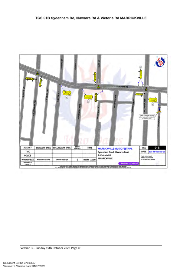
The event area will be on Marrickville Road between Illawarra Road and Victoria Road (refer to the site map below – Marrickville Music Festival Area). This year Council’s Event Coordinator has appointed ‘Who Dares Pty Ltd’ to prepare the Traffic Management Plan (TMP) and Traffic Guidance Schemes (TGS) for the event. A copy of the TMP is attached at the end of this report.
Site map
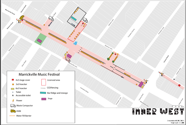
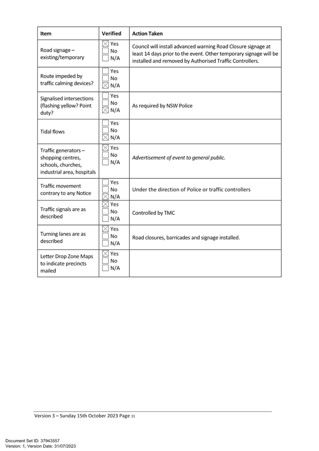
Access around the event site will be maintained by a detour. The detour loop will include Illawarra Road, Sydenham Road, Victoria Road and Calvert Street. Special Event advance notice signs will be strategically installed at least two (2) weeks prior to the event to alert motorists of the proposed closures.
This event is classified as a Class 2 event under the TfNSW’ Special Events Guide where it impacts local traffic and transport systems but does not impact major traffic and transport systems and it disrupts the non-event community in the area around the event but not over a wide area. The event requires the involvement of Police and Local Council and a detailed Transport Management Plan (TMP).
Adequate vehicular traffic control shall be provided for the protection and convenience of pedestrians and motorists including appropriate signage and flagging. Workers shall be specially designated for this role (and carry appropriate certificates), as necessary to comply with this condition. This is to be carried out in accordance with the Australian Standard AS 1742.3 - Traffic Control Devices for works on roads.
Impacts on buses
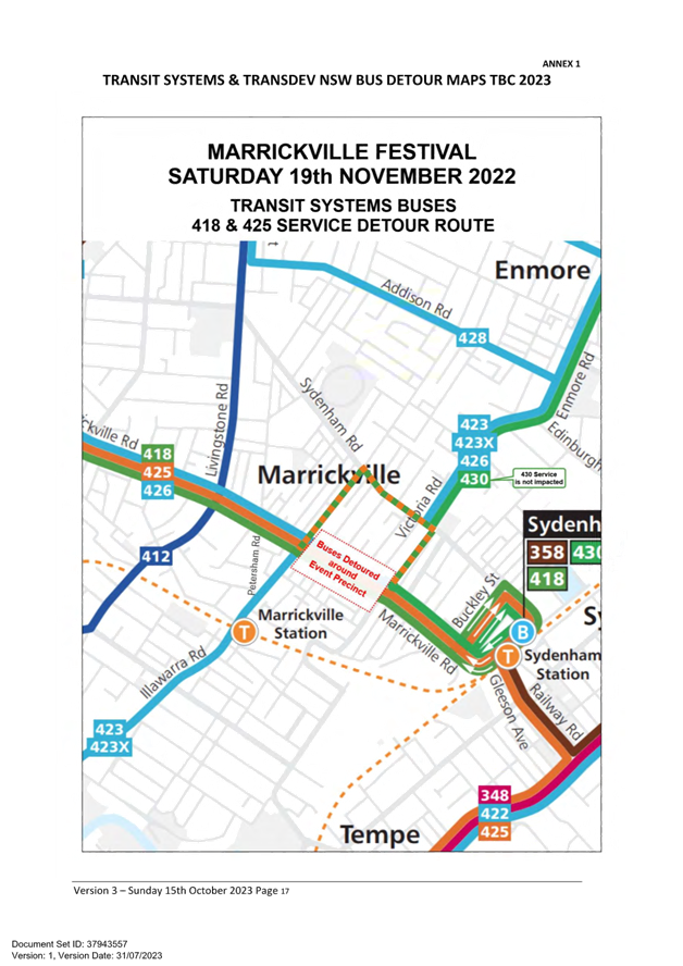
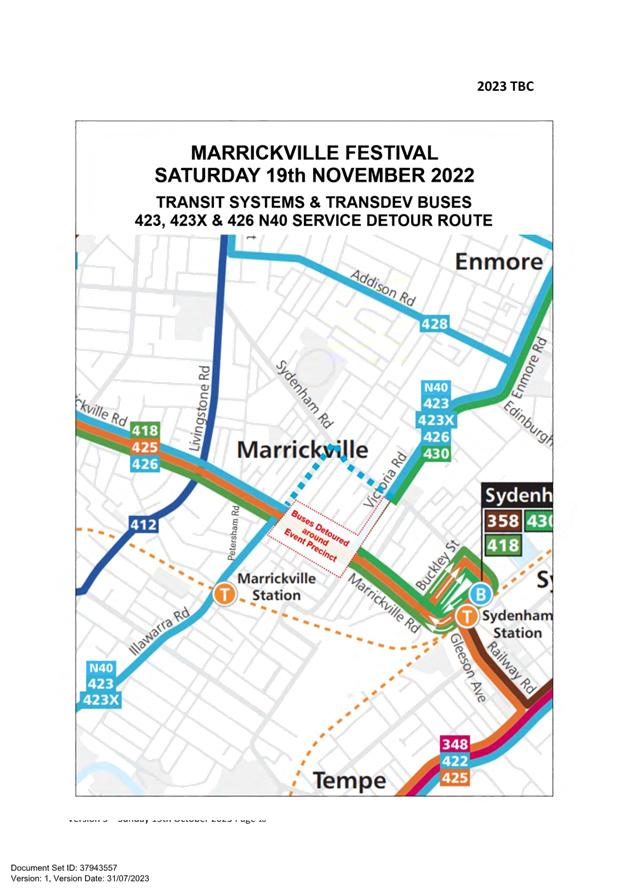
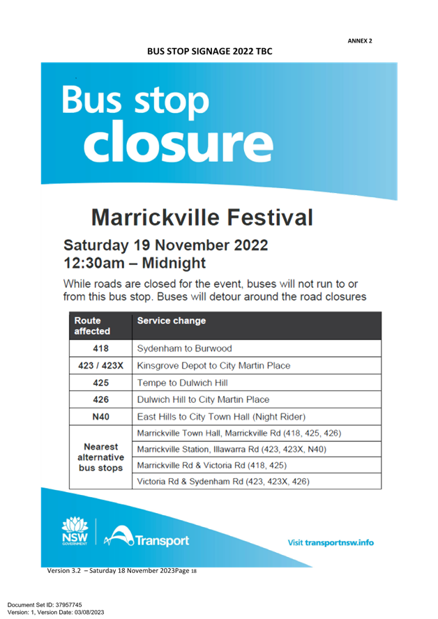
Transit Systems services 418, 423, 423X, 425 & 426 & Transdev NSW N40 service will all be impacted by the event road closures. These services will be detoured around the event precinct. Council will arrange for signage will be placed at impacted bus stops to direct passengers to the nearest stop. Refer to Annex 1 of the attached TMP for Transit Systems and Transdev Bus detour maps at a larger scale.
Impacts on pedestrians and cyclists
There will be no major effect to pedestrians in the area. Pedestrians will be able to use the existing pedestrian paths outside of and within the event area.
There are no cycleways directly impacted by this event. Cyclists entering the event site will be requested to dismount.
The closest train station is Marrickville Station. It is approximately 450 metres walk from the event precinct. Currently the Trackworks schedule for event day is as follows:
· T2 Inner West & Leppington Line - Buses replace the all-stations Inner West trains between Strathfield and Central. Trains run between Leppington and Olympic Park.
· T3 Bankstown Line - Buses replace trains between Lidcombe and Bankstown.
· T8 Airport & South Line - Revesby trains start and end at Central via the Airport. Macarthur trains start and end at Sydenham. Saturday morning, buses replace the all-stations Revesby trains between Revesby and Wolli Creek.
Impacts on Parking
Parking will only be available in surrounding residential streets and a few small public carparks around the event site. Parking will as such be limited, and the event organiser will be recommending public transport to all event patrons.
Impacts on traffic
The traffic diverted from Marrickville Road as a result of the proposed road closures, does not coincide with the peak traffic, as the festival will be held on a Sunday when lower than weekday traffic volumes are expected. Therefore, the traffic generated as a result of the proposed festival will not have a major impact on the surrounding traffic network during the event. Furthermore the arrival and departure of attendees of the festival is expected to be staggered as it is every year when this event takes place.
At present, there is no indication of construction works that will be impact the event. There are no traffic calming devices or traffic generating developments along the route.
Heavy vehicles may experience slight delays due to increased traffic around the event precinct. Heavy vehicles should follow signposted detours.
No special event clearways will be installed for this event. Inner West Council will instead install ‘No Stopping’ signage throughout the event precinct prior to the event. Any remaining vehicles will be towed and parked in a nearby location on the morning of the event.
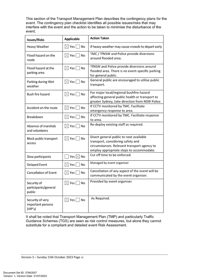
A minimum four (4) metre emergency lane will be maintained along the entire closure. Traffic controllers will be onsite to assist emergency vehicles through the closure points.
Hostile Vehicle mitigation strategies may be undertaken within the road closure in accordance with the event risk assessment and NSW Police direction.
Traffic Management Plan and Traffic Guidance Schemes
An accredited Who Dares Traffic Manager will oversee implementation of the Traffic Guidance Schemes, including road closures.
A Traffic Management Plan (TMP) has been supplied by Who Dares Pty Ltd, the scope of which includes the provision for the safe movement of vehicular traffic in and out of the event areas at the Marrickville Festival on Sunday 15 October 2023. The TMP and Traffic Guidance Schemes (TGS) are reproduced in full at the end of this report.
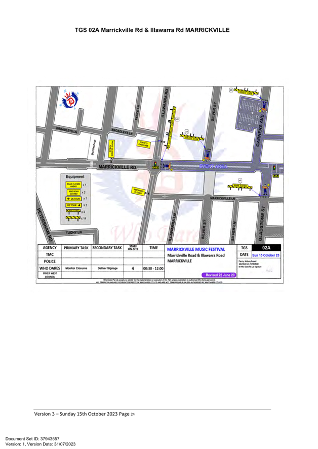
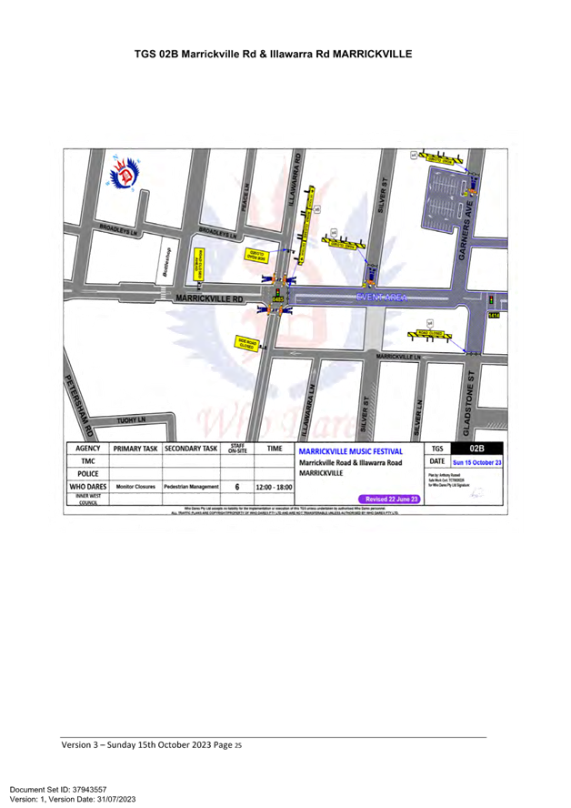
· TGS 01A Sydenham Rd, Illawarra Rd & Victoria Rd MARRICKVILLE
· TGS 01B Sydenham Rd, Illawarra Rd & Victoria Rd MARRICKVILLE
· TGS 01C Sydenham Rd, Illawarra Rd & Victoria Rd MARRICKVILLE
· TGS 02A Marrickville Rd & Illawarra Rd MARRICKVILLE
· TGS 02B Marrickville Rd & Illawarra Rd MARRICKVILLE
· TGS 02C Marrickville Rd & Illawarra Rd MARRICKVILLE
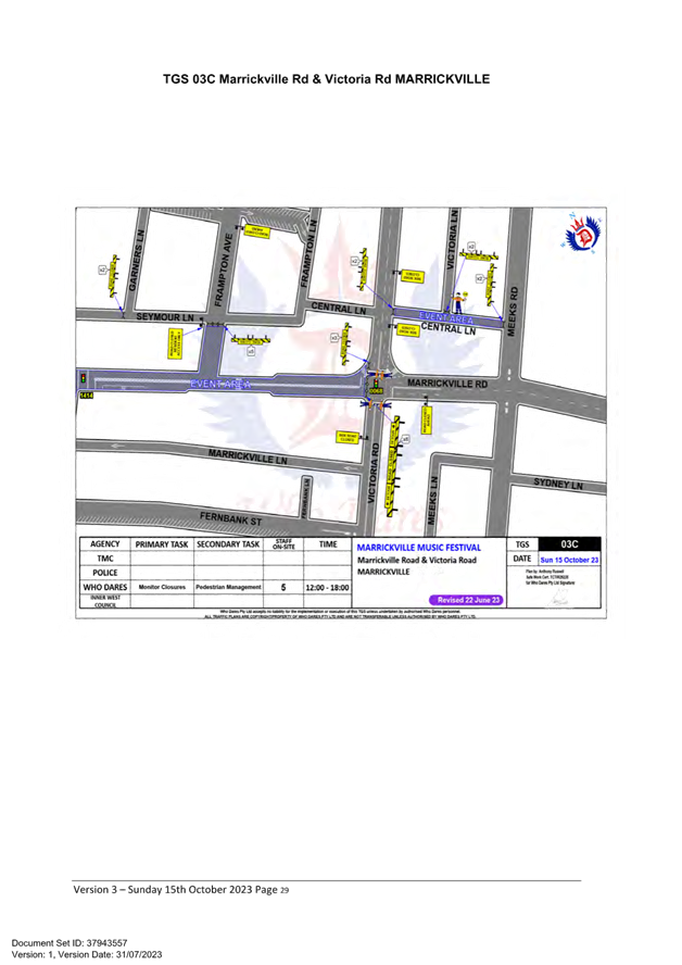
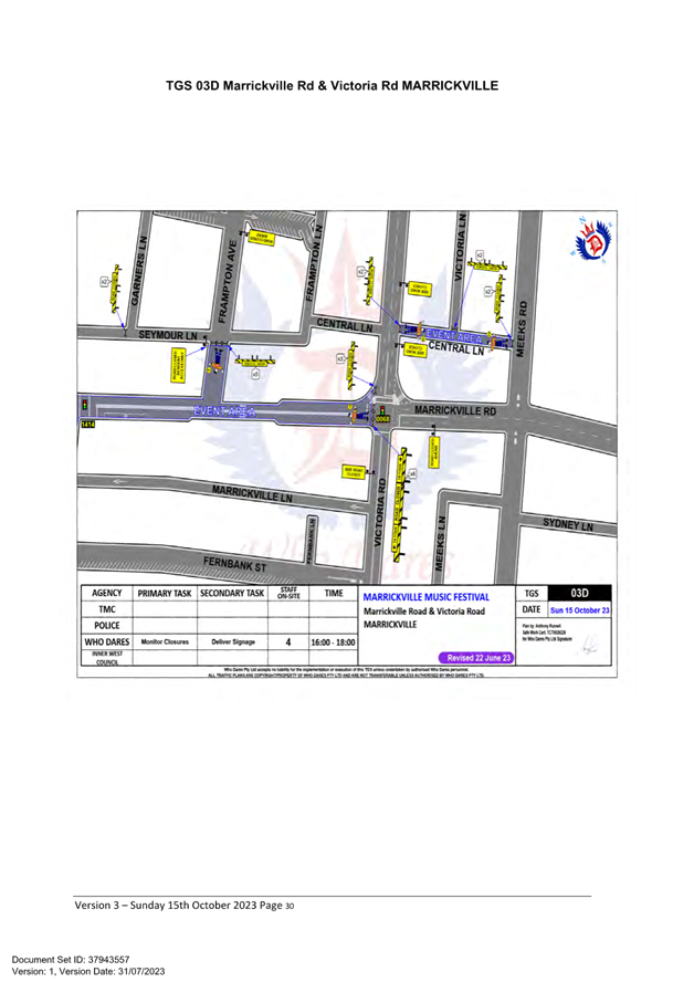
· TGS 03A Marrickville Rd & Victoria Rd MARRICKVILLE
· TGS 03B Marrickville Rd & Victoria Rd MARRICKVILLE
· TGS 03C Marrickville Rd & Victoria Rd MARRICKVILLE
· TGS 03D Marrickville Rd & Victoria Rd MARRICKVILLE
· TGS 03E Marrickville Rd & Victoria Rd MARRICKVILLE
· TGS 04 Calvert St, Illawarra Road & Victoria Road MARRICKVILLE
· TGS 05 Marrickville Rd VMS
· TGS 06 Marrickville Rd VMS
The Traffic Management Plan is to be submitted to TfNSW for consideration and approval and a Road Occupancy License application is to be submitted to the Transport Management Centre by Who Dares Pty Ltd.
PUBLIC CONSULTATION
The proposed temporary full road closures have been advertised in accordance with the Roads Act 1993.
Advice of the proposed event must be forwarded to all the appropriate authorities, including emergency services.
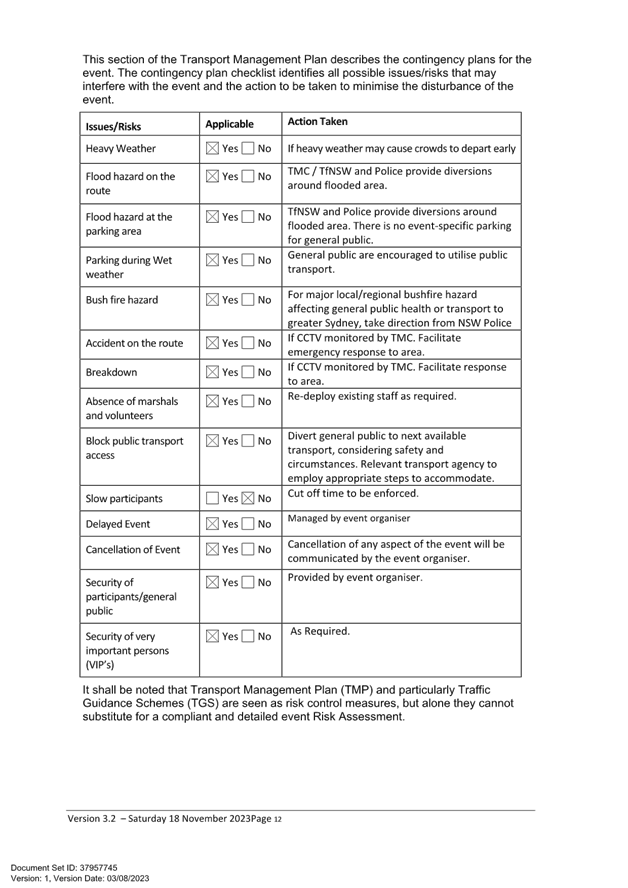
The TMP states that: “All affected residents will be notified of the event through:
· Letterbox drop will be conducted for impacted residents within and near the road closure precinct at least two weeks prior to the event.
· Date & time specific corflute “Special Event – Road Closed” signs to be placed around the event precinct 14 days prior to the event.”
Two Portable VMS Boards will be used to advertise the road closures leading up to the event day. Refer TGS 05 & 06.
Funding of $62,000 has been allocated by Council for organising the Marrickville Music Festival event under the 2023/2024 Major Community Events Program
CONCLUSION
It is recommended that Council agree to the temporary full road closures on Sunday 15 October 2023 subject to complying with the recommendations stated in this report along with all standard conditions for temporary full road closures.
|
1.⇩ |
Marrickville Music Festival 2023 - v1 |
|
Local Traffic Committee Meeting 21 August 2023 |
Subject: Carrington Road at Cary Street, Marrickville – Pedestrian Safety Improvement Works – Raised Pedestrian Crossing (Midjuburi - Marrickville Ward/Summer Hill Electorate/Inner West PAC)
Prepared By: Jennifer Adams - Traffic Engineer
Authorised By: Manod Wickramasinghe - Acting Director Infrastructure
|
RECOMMENDATION
That the detailed design plan for the raising of the existing pedestrian crossing and associated signs and line markings in Carrington Road at Cary Street, Marrickville be approved (as per Design Plan No.10248).
|
STRATEGIC OBJECTIVE
|
2: Liveable, connected neighbourhoods and transport |
|
|
EXECUTIVE SUMMARY
Council is planning to improve pedestrian safety in Carrington Road, Marrickville (at Cary Street) by converting the existing at-grade pedestrian crossing to a raised pedestrian crossing. The proposal aims to improve pedestrian safety and motorist safety and addresses concerns with pedestrian and driver behaviour in the area, particularly during busy periods.
BACKGROUND
The following works are proposed and are illustrated on the attached consultation plan (Plan No. 10248). The proposed works will improve pedestrian safety and addresses concerns about pedestrian and driver behaviour in the area.
Specifically, the proposed scope of works includes the following:
· Construct a new raised concrete pedestrian crossing to replace existing at grade (flat)
pedestrian crossing. The new pedestrian crossing will be slightly relocated from the existing location by approximately 4 metres;
· Construct “gutter bridges” with heel safe grating to provide safe access over existing kerb and guttering to the new raised pedestrian crossing (where required)
· Construct landscaped kerb blister islands in the road adjacent to the new raised pedestrian
crossing. Landscaping to be suitable species of native grasses (subject to final design);
· Reconstruct some sections of damaged concrete footpath with new concrete footpath;
· Adjusting the existing ‘No Stopping’ signage and zones and provide new ‘No Stopping’ signs which affects some of the existing on-street parking (where shown on plans); and
· Install associated pavement line marking and signage as required.
Parking Changes
It is proposed to adjust the existing parking restriction signage and zones in Carrington Road to accommodate the new raised and relocated pedestrian crossing. This will result in the loss of one (1) existing on-street parking space in Carrington Road (on southern side). Conversely, one (1) new on-street parking space will also be created in Carrington Road (on the northern side).
Therefore, the proposal will result in the overall loss of zero (0) on-street parking spaces.
Streetlighting
The existing flood lighting for the pedestrian crossings is deemed adequate for the new raised
pedestrian crossing. Other than a slight adjustment to the orientation of the existing flood lights so they align with the new pedestrian crossing locations, no other changes are proposed to the existing street lighting due to the works.
Turning path diagram

PUBLIC CONSULTATION
Consultation was conducted between 17 July 2023 and 3 August 2023. A letter along with a copy of the design plan was sent to residents / businesses in the immediate locality. A total of 2 letters were distributed. There was one (1) response with general support for the safety improvements.
FINANCIAL IMPLICATIONS
This project will be funded and delivered from the PAMP program for 2023/24.
|
1.⇩ |
Consultation Plan and Swept Path Analysis - LTC |
|
Local Traffic Committee Meeting 21 August 2023 |
Subject: Ewart Street, Dulwich Hill; Illawarra Road, Marrickville; Burrows Avenue, Railway Road, Gleeson Avenue And (Lower) Railway Parade, Sydenham - Temporary Parking Changes During Major Rail Shutdown of T3 Line For Sydney Metro Upgrade Works - Bus Replacements Saturday 23 September To Thursday 5 October 2023 And Tuesday 26 December 2023 To Thursday 25 January 2024 (Midjuburi -Marrickville Ward / Summer Hill Electorate / Inner West Pac)
Prepared By: Jennifer Adams - Traffic Engineer
Authorised By: Manod Wickramasinghe - Acting Director Infrastructure
|
RECOMMENDATION
1. That the following temporary short-term parking changes for the periods of Saturday, 23 September to Thursday, 5 October 2023 (inclusive) and Tuesday, 26 December 2023 to Thursday, 25 January 2024 (inclusive) be approved to support the works required to convert the T3 Bankstown Line to a Metro Line:
a) Dulwich Hill Station Precinct - Ewart Street (3 parking spaces): The short-term conversion of 20m (3 parking spaces) ‘2P 8 am – 6 pm Mon – Fri’ on the northern side of Ewart Street (between Wardell Road and Bayley Street) to a ‘Bus Zone’;
b) Marrickville Station Precinct - Illawarra Road (1 parking space): The short-term conversion of 7m (1 parking space) ‘1P 8:30 am – 6 pm’ on the western side of Illawarra Road (between Warburton Street and Greenbank Street) to a ‘Bus Zone’;
c) Sydenham Station Precinct - Burrows Avenue (23 parking spaces): The short-term conversion of 50m (14 parking spaces) rear to kerb ‘unrestricted parking’ on the northern kerb of Burrows Avenue (west of Gleeson Avenue) to a ‘Bus Zone’;
d) The short-term conversion of 58m (9 parking spaces) ‘unrestricted parking’ on the southern kerb of Burrows Avenue (west of Gleeson Avenue) to a ‘Bus Zone’;
e) Sydenham Station Precinct – Railway Road (3 parking spaces): The short-term conversion of 18m (3 parking spaces) ‘2P 8:30 am – 10 pm Mon - Fri’ on the eastern side kerb of Railway Road (between Burrows Avenue and Gleeson Avenue) to a ‘Bus Zone’;
f) Sydenham Station Precinct - Gleeson Avenue (2 parking spaces): The short-term conversion of 12m (2 parking spaces) ‘1P 9:00 am – 3:30 pm Mon - Fri and No Parking 6 am-9 am & 3:30 pm – 6:30 pm’ on the eastern kerb of Gleeson Avenue (between Burrows Avenue and Unwins Bridge Road) to a ‘Bus Zone’;
g) Sydenham
Station Precinct -
h) The short-term conversion of 32m (11 parking spaces) 45 degree angled parking ‘4P 8:30 am – 6 pm Mon - Fri’ on the southwest kerb of Lower Railway Parade (between Gleeson Avenue and Marrickville Road) to a ‘Bus Zone’.
2. That the applicant and Council Rangers be advised in terms of this report.
|
STRATEGIC OBJECTIVE
|
2: Liveable, connected neighbourhoods and transport |
|
|
EXECUTIVE SUMMARY
Council has been notified by Transport for NSW (TfNSW) that Sydney Metro works will involve major rail shutdown of the Sydenham to Bankstown rail line (T3) for the following periods: Saturday, 23 September to Thursday, 5 October 2023 (inclusive) and Tuesday, 26 December 2023 to Thursday, 25 January 2024 (inclusive). During the shutdowns buses will replace train services along the T3 line and to accommodate the increased bus movements and necessary holding areas some short-term parking changes are required at a number of locations.
Specifically, TfNSW is requesting approval for the temporary conversion of multiple parking spaces at the following locations: Ewart Street, Dulwich Hill; Illawarra Road, Marrickville; Burrows Avenue, Railway Road, Gleeson Avenue and (Lower) Railway Parade, Sydenham. It is recommended that no objections be raised, and Council approves the temporary short-term parking changes at the identified locations during the rail shutdowns.
All changes to street signage will be made by TfNSW contractor(s) from 10pm the night before the closures and will be reinstated at the completion of the planned shutdowns.
BACKGROUND
Sydney Metro City & Southwest - Sydenham to Bankstown project will upgrade all 10 stations between Marrickville and Bankstown to meet metro standards before converting the T3 Bankstown Line to Metro operations.
During this possession, rail services on the T3 Bankstown Line will not operate and Temporary Transport Plan (TTP) buses will operate instead necessitating some short-term changes in parking at a number of locations. To support this closure TTP buses and additional T8 Airport & South Line trains will operate.
It is noted that for the last shutdown (July 2023) TfNSW identified Ewart Street the designated Dulwich Hill Station Precinct location. Previously LTC approval has been forthcoming in Dudley Street, Dulwich Hill. It is again noted that at some time in the future TfNSW will be requested by Council to return to using Dudley Street, Dulwich Hill as the preferred location for all buses as it is immediately adjacent to Dulwich Hill Station and considered more convenient for local residents.
OFFICER COMMENTS
Each of the locations will be detailed separately.
Dulwich Hill Station Precinct (3 parking spaces)
1. Ewart Street, northern side (Stop ID: 2204118) - Bus stop extension (3 parking space)
· Ewart Street (northern kerb between Wardell Road and Bayley Street)
· Currently sign posted ‘2P 8:30 am – 6 pm Mon – Fri’
· Proposed Bus Zone is required for all days of the TTP bus operation
· Proposed temporary change will impact approximately three parking spaces (20m).
· This change is proposed to create a bus stop area and to provide adequate space for draw-in/draw-out purposes.

Marrickville Station Precinct (1 parking space)
2. Illawarra Road opposite Marrickville Station (Stop ID: 2204102) - Bus stop extension (1 parking space)
· Illawarra Road (northwest kerb between Warburton Street and Greenbank Street)
· Currently signed ‘1P 8:30 am – 6 pm’
· Proposed Bus Zone extension is required for the duration of the TTP bus operation
· Proposed temporary change will impact approximately one parking space (7 m).
· This change is proposed to create a bus stop area and to provide adequate space for draw-in/draw-out purposes.
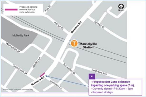
Sydenham Station Precinct (85 parking spaces)
3. Burrows Avenue, Sydenham (Stop ID: 204421) Rear to kerb parking – Bus Zone Extension (14 parking spaces)
· Burrows Avenue (northern kerb west of Gleeson Avenue)
· Currently ‘Unrestricted parking’
· Proposed Bus Zone is required for all days of the TTP bus operation
· This proposed change is to create the space required for buses to layover and to provide adequate space for draw-in/draw-out purposes.
· Proposed temporary change will impact approximately 14 rear to kerb parking spaces (50 m).
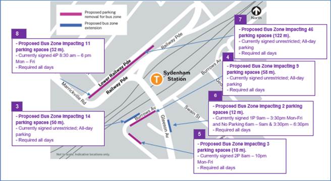
4. Burrows Avenue, Sydenham – (Southern kerb) – Bus Zone (9 parking spaces)
· Burrows Avenue (southern kerb west of Gleeson Avenue)
· Currently ‘Unrestricted parking’
· Proposed Bus Zone is required for all days of the TTP bus operation
· This proposed change is to create the space required for buses to layover safely.
· Proposed temporary change will impact approximately 9 parking spaces (58 m).
5. Railway Road, Sydenham NSW 2204 – (Northeastern kerb) – Bus Zone (3 parking spaces)
· Railway Road (northeastern kerb between Gleeson Avenue and Burrows Avenue)
· Currently ‘2P 8am – 10pm Mon-Fri’
· Proposed Bus Zone is required for all days of the TTP bus operation
· This proposed change is to create the space required for buses to layover safely and to provide adequate turning circle space.
· Proposed temporary change will impact approximately 3 parking spaces (18 m).
6. Gleeson Avenue, Sydenham (Eastern kerb) Bus Zone extension (2 parking spaces)
· Gleeson Avenue (eastern kerb between Burrows Avenue and Railway Road)
· Currently ‘1P 9:00 am – 3:30 pm Mon – Fri’
· Proposed Bus Zone extension is required for all days of the TTP bus operation
· Proposed temporary change is to create additional space required for buses to adequately draw in/out from the bus stop.
· Proposed temporary change will impact approximately 2 parking spaces (12m).
7. Section A of Lower Railway Parade, Sydenham 90-degree angled parking, Sydenham – Layover Bus Zone and Standby area (46 parking spaces)
· Lower Railway Parade Parallel Parking (southern side between Sydenham Road and Marrickville Road)
· Currently’ Unrestricted parking’
· Proposed Bus Zone is required for all days of the TTP bus operation
· Proposed temporary change will impact approximately 46 angled parking spaces (122 m).
· This proposed change is to create the space required for buses to layover. This location is proposed as it is (i) reasonably close to the active bus stop; (ii) located along the route path used between the last and first stops; and (iii) as far as removed from residential dwellings.
8. Section B of Lower Railway Parade, Sydenham 90-degree angled parking, Sydenham - Layover Bus Zone (11 parking spaces)
· Lower Railway Parade Parallel Parking (southern side between Gleeson Avenue and Marrickville Road)
· Currently ‘4P 8:30 am – 6 pm Mon – Fri’ restrictions
· Proposed Bus Zone is required for all days of the TTP bus operation
· Proposed temporary change will impact approximately eleven angled parking spaces (32 m).
· This proposed change is to create the space required for buses to layover. This location is proposed as it is (i) reasonably close to the active bus stop; and (ii) located along the route path used between the last and first stops.
PUBLIC CONSULTATION
Transport for NSW propose the temporary parking changes and they will carry out consultation with local businesses and residents during August 2023. A copy the draft notification letters are reproduced at the end of this report.
The consultation program will consist of the following activities:
· Two-week public consultation period to impacted areas with a printed community notification outlining the proposed kerbside changes.
A copy of the community notifications is also available on the My Sydney website - https://www.mysydney.nsw.gov.au/SydenhamtoBankstown
A Consultation Outcomes Report will be prepared collating feedback and TfNSW’s comment on that feedback. That report will be tabled as it becomes available.
FINANCIAL IMPLICATIONS
There are no financial implications for Council associated with this matter. The cost of the work will be borne by Transport for NSW.
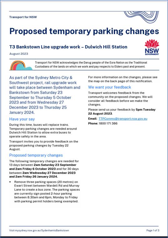
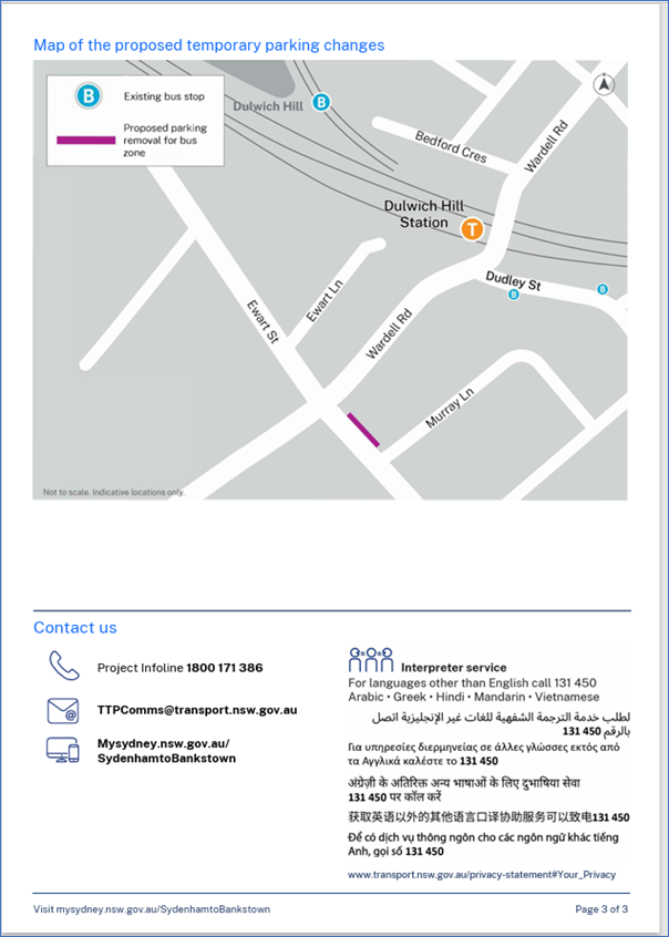

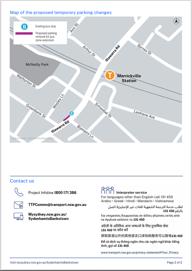

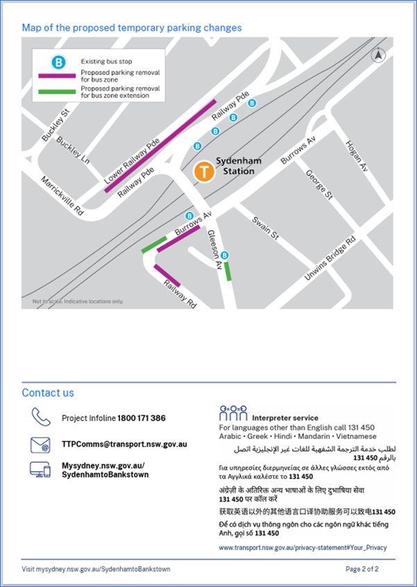
Nil.
|
|
Local Traffic Committee Meeting 21 August 2023 |
Subject: Percival Road, Stanmore – Temporary Full Road Closures for Stanmore Music Festival – Saturday 18 November 2023 (Damum-Stanmore Ward /Newtown Electorate/ Inner West Lac)
Prepared By: Jennifer Adams - Traffic Engineer
Authorised By: Manod Wickramasinghe - Acting Director Infrastructure
|
RECOMMENDATION
1. That the proposed temporary full road closure (ENRC/2023/0051) of Percival Road, from Salisbury Road to the pedestrian crossing at Myrtle Street; partial closure of Temple Street from Percival Road to Percival Lane; and partial closure of Myrtle Street, from Percival Road to Percival Laneway, Stanmore be approved for the purpose of holding the ‘Stanmore Music Festival’ Event on Saturday 18 November 2023 between 6.00am and 9.00pm as per the submitted TMP and TGSs and subject to the following conditions and all standard Council conditions for temporary full road closures.
2. That a Road Occupancy License application be obtained from the Transport Management Centre.
3. That notice of the proposed event be forwarded to the NSW Police Local Area Commander, Transit Systems, the NSW Fire Brigades and the NSW Ambulance Services.
4. That all residents and businesses in and around the affected area are to be notified of the temporary road closure in writing by the applicant in advance (at least 7 days prior to the event) with the applicant making reasonable provision for stakeholders.
5. That a minimum four (4) metre unencumbered passage be available for emergency vehicles through the closed sections.
6. That the occupation of the road carriageway must not occur until the road has been physically closed. |
STRATEGIC OBJECTIVE
|
2: Liveable, connected neighbourhoods and transport |
|
|
EXECUTIVE SUMMARY
Inner West Council is presenting Stanmore Music Festival on Saturday 18 November 2023 from 12:00pm noon until 6:00pm. This community festival has been organised by local residents who are supported by Council as part of EDGE Newtown.
To facilitate the event there will be a partial road closure of Percival Road, between Salisbury Road and Myrtle Street. This will require some road detours in surrounding streets. Road closure and event bump in will occur from 6:00am and bump out will conclude by 9:00pm.
BACKGROUND
Stanmore Music Festival is a celebration of live music in the Inner West. The event will run on Saturday 18 November 2023 from 12pm to 6pm and will feature multiple outdoor live music stages across the festival site.
The first Festival took place in November 2019 with over 60 local music acts performing on 10 stages around Stanmore with thousands attending the event to enjoy the music. COVID restrictions prevented the festival from happening in 2020 and 2021 but the second Stanmore Music Festival was held in 2022.
As part of the event there will be a partial road closure of Percival Road, from Salisbury Road to the pedestrian crossing at Myrtle Street; partial closure of Temple Street from Percival Road to Percival Lane; and partial closure of Myrtle Street, from Percival Road to Percival Laneway, Stanmore.
OFFICER COMMENTS
The event area will be on Percival Road between Salisbury Road and the pedestrian crossing at Myrtle Street, Stanmore (refer to the site map below – Stanmore Music Festival Area).
Site map
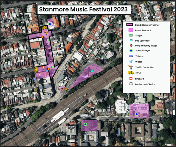
Access around the event site will be maintained by a detour. Special Event advance notice signs will be strategically installed at least two (2) weeks prior to the event to alert motorists of the proposed closures.
Adequate vehicular traffic control shall be provided for the protection and convenience of pedestrians and motorists including appropriate signage and flagging. Workers shall be specially designated for this role (and carry appropriate certificates), as necessary to comply with this condition. This is to be carried out in accordance with the Australian Standard AS 1742.3 - Traffic Control Devices for works on roads.
Traffic Management Plan and Traffic Guidance Schemes
A Traffic Management Plan has been provided and is attached at the end of this report. The two associated Traffic Guidance Schemes are reproduced below.
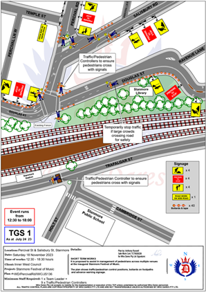
An accredited Who Dares Traffic Manager will oversee implementation of the Traffic Guidance Schemes, including road closures.
The Traffic Management Plan is to be submitted to TfNSW for consideration and approval and a Road Occupancy License application is to be submitted to the Transport Management Centre by Who Dares Pty Ltd.
Impacts on buses
Transit Systems service 412 uses Douglas Street and Salisbury Road through Stanmore and This service will not be impacted.
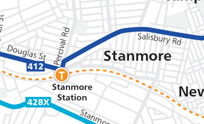
Impacts on pedestrians and cyclists
There will be no major effect to pedestrians in the area. Pedestrians will be able to use the existing pedestrian paths outside of and within the event area.
There are no cycleways directly impacted by this event. Cyclists entering the event site will be requested to dismount.
Impacts on Parking
Parking will only be available in surrounding residential streets and a few small public carparks around the event site. Parking will as such be limited, and the event organiser will be recommending public transport to all event patrons.
Impacts on traffic
The traffic generated as a result of the proposed festival should not have a major impact on the surrounding traffic network. The arrival and departure of attendees of the festival is expected to be staggered.
At present, there is no indication of construction works that will be impact the event. There are no traffic calming devices or traffic generating developments along the route.
No special event clearways will be installed for this event. Inner West Council will instead install ‘No Stopping’ signage throughout the event precinct prior to the event. Any remaining vehicles will be towed and parked in a nearby location on the morning of the event.
A minimum four (4) metre emergency lane will be maintained along the entire closure. Traffic controllers will be onsite to assist emergency vehicles through the closure points.
Hostile Vehicle mitigation strategies may be undertaken within the road closure in accordance with the event risk assessment and NSW Police direction.
PUBLIC CONSULTATION
The proposed temporary full road closures have been advertised in accordance with the Roads Act 1993.
Advice of the proposed event must be forwarded to all the appropriate authorities, including emergency services.
The TMP states that: “All affected residents will be notified of the event through:
· Letterbox drop will be conducted for impacted residents within and near the road closure precinct at least two weeks prior to the event.
· Date & time specific corflute “Special Event – Road Closed” signs to be placed around the event precinct 14 days prior to the event.”
Two Portable VMS Boards will be used to advertise the road closures leading up to the event day.
FINANCIAL IMPLICATIONS
Funding of $62,000 has been allocated by Council for organising the Stanmore Music Festival event under the 2023/2024 Major Community Events Program.
CONCLUSION
It is recommended that Council approve the temporary full road closures on Saturday 18 November 2023 subject to complying with the recommendations stated in this report along with all standard conditions for temporary full road closures.
|
1.⇩ |
Stanmore Music Festival TMP |
|
Local Traffic Committee Meeting 21 August 2023 |
Subject: Holbeach Avenue, Tempe – Temporary Full Road Closures for Ms Sydney To The Gong Bike Ride On Sunday 5 November 2023 – (Midjuburi - Marrickville Ward/Heffron Electorate/Newtown Lac)
Prepared By: Jennifer Adams - Traffic Engineer
Authorised By: Manod Wickramasinghe - Acting Director Infrastructure
|
RECOMMENDATION
That the Local Traffic Committee receive and note the report. |
STRATEGIC OBJECTIVE
|
2: Liveable, connected neighbourhoods and transport |
|
|
EXECUTIVE SUMMARY
Council has received an application under Section 68 of the Local Government Act 1993 to use Holbeach Avenue and Tempe Recreation Reserve to hold the annual 'MS Sydney to the Gong Bike Ride' supported by Multiple Sclerosis (MS) Australia on Sunday 5 November 2023. This event will necessitate the temporary full road closure of Holbeach Avenue, Tempe and southbound lane closures on Princes Highway from the car park entrance of IKEA to Cooks River along with closures (Residents Excepted) of South Street, Hart Street, Bay Street and Old Street, Tempe between the hours 0400 to 1000 hours on Sunday 5 November 2023.
The comments of the Local Traffic Committee will be referred to Council’s Development Assessment Section for consideration in determining the Development Application.
BACKGROUND
Council has received notice under an amended Section 68 application (S68201800006) of the Local Government Act 1993 to use Holbeach Avenue and Tempe Recreation Reserve to hold the annual 'MS Sydney to the Gong Bike Ride' supported by Multiple Sclerosis (MS) Australia on Sunday 5 November 2023.
The application is required to be referred to the Local Traffic Committee for consideration under State Environmental Planning Policy (Infrastructure) 2007.
The S68201900006 approval dated 27 September 2019 approves the holding of the MS Sydney to Gong bike ride event at Tempe Recreation Reserve annually on every first Sunday of November from 2019 – 2023 between 5.00am to 9.00am. Due to Covid the event was cancelled in 2020 and 2021 and ran again in 2022 on 6 November 2022.
This years’ course will mostly follow that of previous years with the 82Km start location in Tempe Recreation Reserve Tempe, and the 58Km start location in Cooper Reserve Engadine. The riders then join the 82Km riders on Princes Highway following the traditional course through the Royal National Park, traveling south along the coast to Thirroul, riding over Sea Cliff Bridge then following Sandon Point Reserve, at the end of the cycle way through Woonona, East Corrimal, Towradgi, Fairy Meadow, North Wollongong to Finish in W. A. Lang Park, Wollongong.
The number of participant registrations for the 2023 Gong Bike Ride will remain capped at 10,000.
OFFICER COMMENTS
MS Australia will ultilise the IKEA car park as a drop off zone and riders will ride down Princes Highway (southbound) to the starting location at Tempe Recreation Reserve. The traffic management company will put in an access lane along Princes Highway to keep riders safe while entering the event at Tempe Recreation Reserve where this location will be the start of the cycling course.
The event will start at Tempe Recreation Reserve, Tempe. On departing, cyclists will ride west on Holbeach Avenue and then turn left onto Princes Highway. Cyclists will then ride along the southbound lanes on Princes Highway as they make their way south over the Cooks River Bridge and beyond.
The applicant advised that support of the NSW Police and RMS will be sought, and a detailed Traffic Management Plan has been forwarded to the RMS, NSW Police and relevant Councils and authorities.
NSW Police and the MS Australia Course Marshals will be at critical locations to ensure that participants and motorists follow all proposed traffic management measures. The event will be held on a Sunday morning where traffic volumes are expected to be lower than average.
It is proposed that the traffic control measures would be in place between 4:00am and no later than 10:00am as the event commences at 6.00am and is expected to be concluded by 9.00am. Affected residents and businesses will be allowed access at Police discretion.
PUBLIC CONSULTATION
The applicant advised that the traffic control management on the day of the event will be controlled by NSW Police and MS Australia Course Marshals. The draft Traffic Control Plans for relevant Inner West locations are reproduced at the end of this report.
A Traffic Management Plan will be submitted to Transport for New South Wales (TfNSW) for consideration and approval as well as a Road Occupancy License application will be submitted to the Transport Management Centre.
CONCLUSION
The following traffic related comments be forwarded to Council’s Development Assessment section.
Based on the information presented in the applicant’s submission to Council with regards to the proposed cycling event on Sunday 5 November 2023 with the inclusion of a temporary full road closure of Holbeach Avenue, Tempe, it is acknowledged that the event will be controlled by NSW Police and the MS Australia Course Marshals. Therefore, Council supports the temporary full road closure of Holbeach Avenue, Tempe during the course of the event subject to:
· the applicant submitting a Traffic Management Plan to TfNSW for consideration and approval;
· a Road Occupancy License be obtained from the Transport Management Centre: and
· advice of the proposed event being forwarded all affected properties and to the appropriate authorities including emergency services.
FINANCIAL IMPLICATIONS
There are no financial implications associated with the implementation of the proposed recommendations outlined in the report
Location of start and relevant Traffic Control Plans (TCPs) and sections of TMP

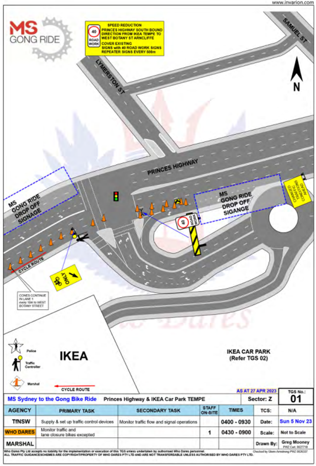
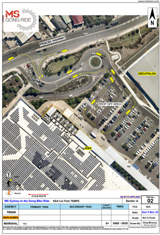
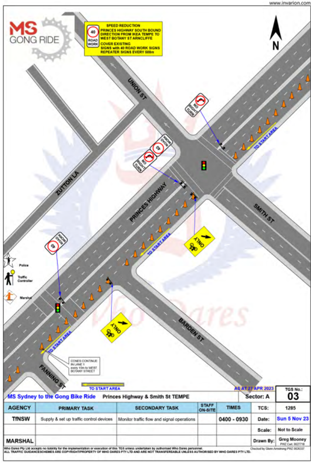

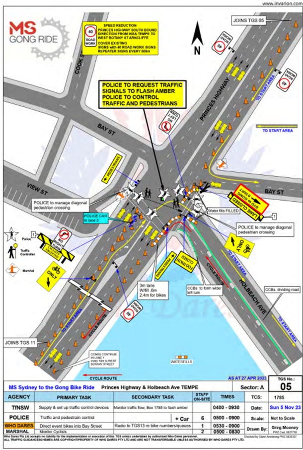

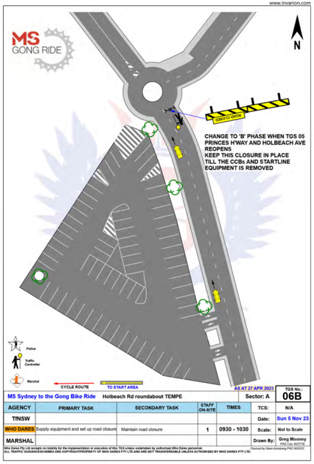
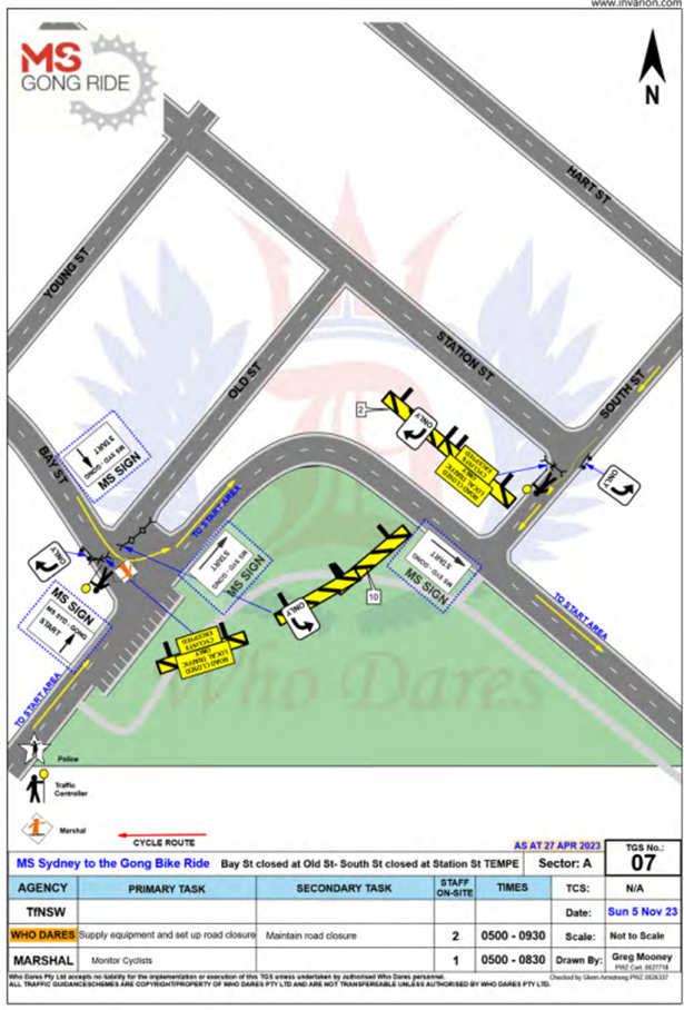
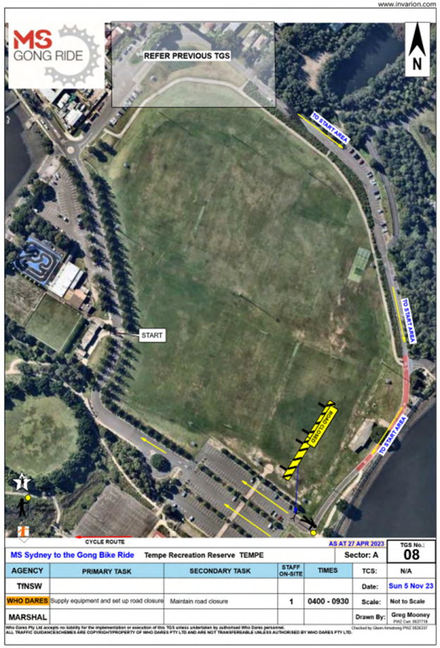


Nil.
|
|
Local Traffic Committee Meeting 21 August 2023 |
Subject: West Street Near Brighton Street, Petersham – Proposed New Kerb Blister and Footpath Realignment (Damun-Stanmore Ward / Newtown Electorate / Inner West Pac)
Prepared By: Jennifer Adams - Traffic Engineer
Authorised By: Manod Wickramasinghe - Acting Director Infrastructure
|
RECOMMENDATION
That the detailed design plan for the construction of a new landscaped kerb blister island, kerb ramps and realignment of the footpath in West Street near Brighton Street, Petersham and associated signs and line markings at the intersection be approved (as per Design Plan No.10251).
|
STRATEGIC OBJECTIVE
|
2: Liveable, connected neighbourhoods and transport |
|
|
EXECUTIVE SUMMARY
Council has finalised a design plan for pedestrian safety improvement works in West Street (near Brighton Street), Petersham. Council is planning to improve safety for pedestrians in West Street at Brighton Street intersection, Petersham by constructing landscaped kerb blister island, kerb ramps and realigning the footpath. The proposal aims to improve safety for pedestrians and motorists by better defining pedestrian crossing points and reducing conflicts with traffic movements. This will help address concerns with pedestrian and motorist behaviour at these locations, particularly during busy times.
BACKGROUND
The following works are proposed and are illustrated on the attached consultation plan (Plan No. 10251). The proposed works will improve pedestrian safety and addresses concerns about pedestrian and driver behaviour in the area.
Specifically, the proposed scope of works includes the following:
· Construct a new concrete footpath along a new alignment through the existing kerb blister island in West Street (dead end);
· Construct 4 new kerb ramps (2 in West Street and 2 in Brighton Street) for better alignment and fit to the new footpath and existing pedestrian refuge island (as shown on the attached plan). Remove redundant kerb ramps and reinstate footpath;
· Construct 1 new landscaped kerb blister on the other side of the West Street intersection with “gutter bridges” and heel safe grating to formalise existing angle parking arrangements and also provide a new footpath and safer realigned pedestrian access across West Street;
· Provide suitable low level native landscaping within the new kerb islands as determined by Council to enhance the area (final species to be finalised);
· Reconstruct an existing stormwater drainage pit to provide new grate and inlet lintel;
· Construct 1 new junction pit for better access to maintain the existing stormwater drainage pipe line;
· Remove 1 existing tree to accommodate the new realigned footpath through the existing landscaped kerb blister island;
· Install 1 new ‘No Stopping’ sign in Brighton Street to provide the required minimum safe clearance for vehicles to negotiate past the existing pedestrian refuge island;
· Relocate some existing road signs (3 x ‘Chevron’ signs, 1 x ‘Do Not Queue Across Intersection’ sign and 1 x ‘No Through Road’ sign) – refer to attached plan for locations;
· Repaint some existing line markings in West Street (ie ‘Keep Clear’ and holding lines) to better delineate areas in West Stret to be kept clear during busy times.
Parking Changes
It is proposed to provide a new ‘No Stopping’ sign approximately 10 metres away from the proposed new kerb ramp at Brighton Street to meet minimum requirements for pedestrian crossing points at pedestrian refuge islands. However, no existing legal on-street car parking spaces will be lost as a result of the proposed works.
Streetlighting
The existing street lighting at the location is deemed adequate. Therefore, no changes are proposed to the existing street lighting due to the works.
Turning path diagram
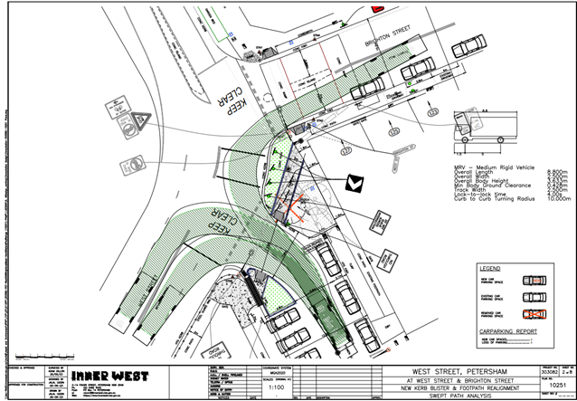
PUBLIC CONSULTATION
Consultation was conducted between 13 July 2023 and 1 August 2023. A letter along with a copy of the design plan was sent to residents / businesses in the immediate locality. A total of 49 letters were distributed. There were two (2) responses. One with general support for the safety improvements however had a number of concerns as detailed below. The other did not support possible redundant works.
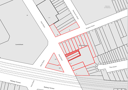
|
Resident’s Comments |
Officer’s response
|
|
1. Design of kerb ramp could include landscaping on either side of the ramp as there is a lack of landscaping in the area. .
2. Removal of tree should be a last resort option/removal of tree.
3. Faded ‘No Entry’ for truck sign needs to be replaced; refuge island needs to be repaired as falling apart
4. Right turn from Brighton Street onto West Street should be banned or make it no entry from West Street into Brighton Street. |
Landscaping as well as a footpath/kerb ramp connection has been provided within this proposed kerb blister island specifically to cater for site specific restraints (location of existing angle parking; allowing for adequate vehicle turning movements)
Council is very careful to consider any tree removals when works are proposed. Unfortunately, in this situation the proposed removal of 1 tree is unavoidable so that a new and accessible footpath connection and crossing point can be provided in West Street
Request to replace faded sign has been referred for inspection and replacement as deemed appropriate. Request to repair damaged sections of pedestrian refuge island is noted and will be included as part of the scope of works when the Design plans are finalised.
This request is outside of the scope of this project and can be considered separately as part of an overall Local Area Traffic Management (LATM) Study. |
|
5. Questioned why two Council plans dealing with the same area have been developed independently of one another. Noting that the proposed realignment plans will do nothing to alleviate the congestion, traffic chaos and loss of amenity to residents in Brighton Street, resulting from the poorly managed intersection of West and Brighton Streets from a traffic perspective.
6. Why is Council undertaking works which may become redundant once the overall Traffic Calming Plan has been finalised? |
The review of the Petersham North Local Traffic Management Area (LTMA) Scheme – Area 3, is a separate process than the Pedestrian Access and Mobility Program (PAMP), which identifies access issues and from which this particular project was identified.
This proposal aims to improve safety for pedestrians and motorists by better defining pedestrian crossing points and reducing conflicts with traffic movements. This will help address concerns with pedestrian and motorist behaviour at these locations, particularly during busy times.
|
FINANCIAL IMPLICATIONS
This project will be funded and delivered from the PAMP program for 2023/24. Project Number is 303082
|
1.⇩ |
303082-10251-Plans-Consultation |
|
|
Local Traffic Committee Meeting 21 August 2023 |
Subject: Ellen Street Carpark, Rozelle - Proposed Extension of ‘2P 8.00am-8.00pm’ Timed Parking Restrictions to ‘4P 8.00am-8.00pm’ (Baludarri-Balmain Ward/Balmain Electorate/Leichhardt Pac)
Prepared By: Zara Helal - Traffic Engineer
Authorised By: Manod Wickramasinghe - Acting Director Infrastructure
|
RECOMMENDATION
That the timed parking restrictions at Ellen Street Carpark, Rozelle, be extended from 2P 8.00AM-8.00PM’ to ‘4P 8.00AM-8.00PM’. |
STRATEGIC OBJECTIVE
|
2: Liveable, connected neighbourhoods and transport |
|
|
EXECUTIVE SUMMARY
Local businesses and residents have requested that Council extend the timed parking restrictions at Ellen Street Carpark, Rozelle. Council has undertaken a review of the existing parking occupancy levels of Ellen Street Carpark and found that the current carpark utilisation is low. Therefore, it is proposed to extend the timed parking restrictions from ‘2P 8.00am-8.00pm’ to ‘4P 8.00am-8.00pm’.
BACKGROUND
Ellen Street Carpark is located on the north side of Victoria Road at Ellen Street and features 19 standard parking spaces, one (1) accessible parking and six (6) motorbike spaces. The Ellen Street carpark was established a number of years ago to replace the on-street parking loss resulting from the implementation of the ‘Clearway 3.00pm-7.00pm Mon-Fri, 8.00am-8.00pm Sat-Sun’ restriction by TfNSW along Victoria Road between Iron Cove Bridge to The Crescent.
Feedback was received from the local community that Ellen Street Carpark is currently underutilised. Local businesses and residents have requested that Council extend the parking restrictions to ensure users are able to park for longer periods of time without having to relocate their vehicle. The recent expansion of the Resident Parking Scheme in nearby streets in Rozelle North has also constrained parking availability for those not eligible for permits.
Parking data collected from the Rozelle North Parking Study in November 2020 found the peak demand for standard parking spaces in the Ellen Street carpark was 16% and 24% for the weekday and weekend demand respectively. As the utilisation levels are low, it is expected that the extension of the timed parking restrictions from 2P to 4P between 8am and 8pm will help provide some parking supply for medium term stay (between 2 and 4 hours) during the day.
Furthermore, some streets near the carpark had high weekday parking occupancy rates. Ellen Street, Prosper Street and Prosper Lane in particular were found to have weekday peak occupancy rates of 100% or higher. Therefore, this proposal will also help relieve parking pressure in the area.
It should be noted that Council initially proposed to extend the timed parking restrictions from ‘2P 8.00am-8.00pm’ to ‘3P 8.00am-8.00pm’ during the consultation period. To better reflect the community needs as identified as part of the consultation process, the proposal has been amended and now sees the proposed implementation of ‘4P 8.00am-8.00pm’ restrictions.
DISCUSSION
A letter outlining the proposal was mailed out to the affected properties (42 properties) in Prosper Lane, Prosper Street, Ellen Street, and Evans Street requesting residents’ views regarding the proposal. Two (2) responses were received, in general support of the original proposal with request for changes.
|
Resident Comments |
Officer Comments |
|
Employees of nearby businesses utilise this carpark. It would be beneficial to increase the restriction from the proposed ‘3P 8.00am-8.00pm’ to ‘4P 8.00am-8.00pm’ to minimise disruption to business operations. |
The proposal has been amended to extend the timed parking restrictions to ‘4P 8.00am-8.00pm’. |
|
As there are high parking occupancy rates in Ellen Street, residents would like Ellen Street Carpark to be allowed to be used as an overflow parking facility. |
Ellen Street Carpark in its current state, and in the event the proposal is adopted, can be utilised by residents. It should be noted that the introduction of the proposed ‘4P 8.00am-8.00pm’ restrictions will allow vehicles to park overnight starting from 4.00pm. |
FINANCIAL IMPLICATIONS
The cost of installation of the signage and linemarking can be funded from Council’s operational signs and linemarking budget.
Nil.
|
|
Local Traffic Committee Meeting 21 August 2023 |
Subject: Trafalgar Street, Enmore - Proposed installation of 'No Parking' restrictions outside No.35-39A Trafalgar Street (DAMUN - STANMORE WARD/ NEWTOWN ELECTORATE/ INNER WEST PAC)
Prepared By: Jennifer Adams - Traffic Engineer
Authorised By: Manod Wickramasinghe - Acting Director Infrastructure
|
RECOMMENDATION
That the installation of full-time ‘No Parking’ restrictions on the southern side of Trafalgar Street, Enmore (outside property Nos.35-39A Trafalgar Street for a length of 36 metres) be approved, in order to improve vehicular access to off-street parking spaces. |
STRATEGIC OBJECTIVE
|
2: Liveable, connected neighbourhoods and transport |
|
|
EXECUTIVE SUMMARY
Council has received concerns that vehicles are parking in a manner that limits the ability of residents accessing their driveways. This is as a result of short sections of kerb between driveways when the site was redeveloped. In order to alleviate this issue, it is proposed to signpost “No Parking’ restrictions outside Nos.35-39A Trafalgar Street, Enmore. Currently the restrictions are ‘1P 6pm-10pm Permit Holders Excepted Area M3’.
BACKGROUND
A request has been received for the provision of ‘No Parking’ signs along the southern side of Trafalgar Street, Enmore outside Nos.35-39A Trafalgar Street, to improve vehicular access to their off-street parking facilities.
A consultation letter was distributed to residents in Trafalgar Street, Enmore between Gladstone Street and Liberty Street proposing to signpost ‘No Parking’ restrictions outside Nos.35-39A Trafalgar Street, Enmore and this report summaries the results of that consultation.
DISCUSSION
The subject section of Trafalgar Street is a ‘one-way’ local residential street which runs east-west between Liberty Street and Gladstone Street and has a carriageway width of 6.8 metres. At present, parking is permitted on both sides of the street, with unrestricted parking along the north side and ‘1P 6pm-10pm Permit Holders Excepted – Area M3’ restrictions along the south side. The applicant’s property is located on the south side of Trafalgar Street.
The development at 35-39A Trafalgar Street, Enmore consists of a row of 8 terrace houses which have a single driveway each servicing two terrace houses. The kerb space between each driveway is shorter than most cars and residents are constantly finding access to their off-street parking facility blocked.
It has been observed during a site inspection that vehicles park on both sides of Trafalgar Street, making it difficult for vehicles to exit from some off-street car parking areas. The north side of Trafalgar Street runs along the railway line and has a footpath, which is 1.5 metres in width and is not highly utilised by pedestrians. There is a general high demand for parking in the area.
Given the high demand for parking in this area, it is recommended that ‘No Parking’ restrictions, be approved, but only be introduced outside the properties No.35-39A Trafalgar Street, to maintain on-street parking provision in the area. (Refer to the diagram below).
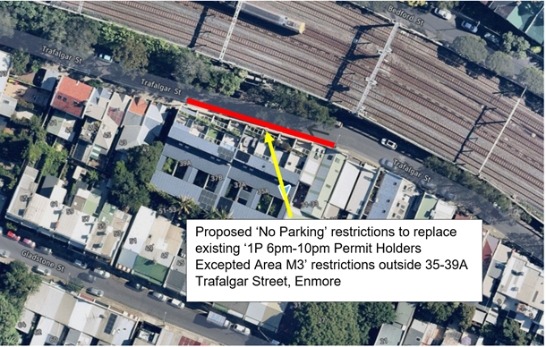
PUBLIC CONSULTATION
A notification letter was hand delivered on 21 July 2023 to owners and occupiers of Trafalgar Street, Enmore between Gladstone Street and Liberty Street regarding the proposal to install full-time ‘No Parking’ restrictions on the southern side of Trafalgar Street, Enmore (outside property No.35-39A Trafalgar Street for a length of 36 metres) to replace the existing ‘1P 6pm-10pm Permit Holders Excepted – Area M3’ restrictions. The closing date for submissions ended on 4 August 2023. 35 letters were distributed.
Resident Survey findings
A total of four (4) responses were received all in support of the proposal.
FINANCIAL IMPLICATIONS
The costs of installation of the ‘No Parking’ restrictions as recommended can be funded within Council’s signs and line marking budget.
CONCLUSION
Given the ongoing issues with vehicular access to and from residents’ off-street parking spaces, it is recommended that the installation of full-time ‘No Parking’ restrictions on the southern side of Trafalgar Street, Enmore (outside property No.35-39A Trafalgar Street for a length of 36 metres) be approved.
Directly affected residents in Trafalgar Street are to be notified of the proposed changes prior to the installation of signage.
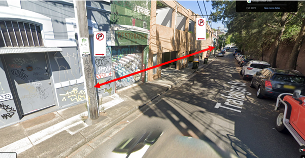
Nil.
|
|
Local Traffic Committee Meeting 21 August 2023 |
Subject: Part Yeend Street, Birchgrove - road closure & sale (Baludarri-Balmain Ward/ Balmain Electorate/ Leichhardt PAC)
Prepared By: Felicia Lau - Traffic Engineer
Authorised By: Manod Wickramasinghe - Acting Director Infrastructure
|
RECOMMENDATION
That the partial road closure of Yeend Street, Birchgrove at the rear of No. 18 Ballast Point Road (as shown in Attachment 1) and sale to the adjoining landowner be endorsed.
|
STRATEGIC OBJECTIVE
|
2: Liveable, connected neighbourhoods and transport |
|
|
EXECUTIVE SUMMARY
Council has received an application to purchase a portion of the road reserve adjacent to No.18 Ballast Point Road which fronts Yeend Street, Birchgrove. Council at the meeting on 25 October 2022 has provided ‘in principle’ support to consider the partial road closure of road reserve in Yeend Street, Birchgrove and subsequent sale to the adjoining owner. The matter has been referred to the Local Traffic Committee for endorsement.
BACKGROUND
A resident has approached Council with a request to purchase a portion of the road reserve adjacent to 18 Ballast Point Road which fronts Yeend Street, Birchgrove as shown in the Figure below. A similar application was made by the neighboring owner at No.16 Ballast Point Road for 37m2 of road area, which was approved by Council and the sale was finalised in 2017.

Following review and investigation of the application, the closure and sale proposal was submitted to Council in October 2022; Council resolved to provide ‘in principle’ support to consider the partial road closure of Yeend Street, Birchgrove and subsequent sale to the adjoining owner.
The portion of Yeend Street subject to the proposed closure and acquisition proposal adjoins the rear of No.18 Ballast Point Road. A 1.5m setback from the kerb will be required to allow space for the existing pedestrian footpath to the street. After allowing for the setback the area is approximately 58m2 as shown in the survey plan attached.
DISCUSSION
The subject road reserve area is currently used for vehicular access and a driveway layback has been in place. Although it is currently open to public, this area appears as a private parking area which currently is mainly used by the applicant. There is no loss in on-street parking associated with the proposal. Should this proposal be approved, the street curtilage for the subject site will be consistent with that of 16 Ballast Point Road.
Council’s consultant also has reported that there are no services or utilities affected by the proposal.
Following Traffic Committee endorsement, Council will proceed to public notification and advice of the proposal to neighbouring properties prior to submission to Council to close this part of Yeend Street and sell to the applicant.
FINANCIAL IMPLICATIONS
There are no financial implications associated with the implementation of the proposed recommendations outlined in the report.
|
1.⇩ |
Survey Plan |