|
AGENDA R |

Local Traffic Committee Meeting
MONDAY 18 SEPTEMBER 2023
11.00am
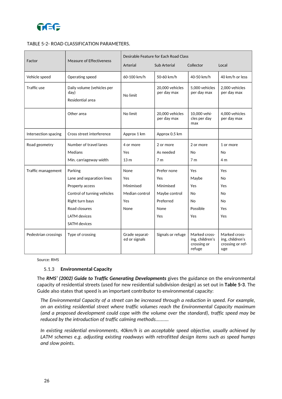
|
|
Local Traffic Committee Meeting 18 September 2023 |
Function of the Local Traffic Committee
Background
Roads and Maritime Services (RMS) is legislated as the Authority responsible for the control of traffic on all NSW Roads. The RMS has delegated certain aspects of the control of traffic on local roads to councils. To exercise this delegation, councils must establish a local traffic committee and obtain the advice of the RMS and Police. The Inner West Council Local Traffic Committee has been constituted by Council as a result of the delegation granted by the RMS pursuant to Section 50 of the Transport Administration Act 1988.
Role of the Committee
The Local Traffic Committee is primarily a technical review and advisory committee which considers the technical merits of proposals and ensures that current technical guidelines are considered. It provides recommendations to Council on traffic and parking control matters and on the provision of traffic control facilities and prescribed traffic control devices for which Council has delegated authority. These matters are dealt with under Part A of the agenda and require Council to consider exercising its delegation.
In addition to its formal role as the Local Traffic Committee, the Committee may also be requested to provide informal traffic engineering advice on traffic matters not requiring Council to exercise its delegated function at that point in time, for example, advice to Council’s Development Assessment Section on traffic generating developments. These matters are dealt with under Part C of the agenda and are for information or advice only and do not require Council to exercise its delegation.
Committee Delegations
The Local Traffic Committee has no decision-making powers. The Council must refer all traffic related matters to the Local Traffic Committee prior to exercising its delegated functions. Matters related to State Roads or functions that have not been delegated to Council must be referred directly to the RMS or relevant organisation.
The Committee provides recommendations to Council. Should Council wish to act contrary to the advice of the Committee or if that advice is not supported unanimously by the Committee members, then the Police or RMS have an opportunity to appeal to the Regional Traffic Committee.
Committee Membership & Voting
Formal voting membership comprises the following:
· one representative of Council as nominated by Council;
· one representative of the NSW Police from each Local Area Command (LAC) within the LGA, being Newtown, Marrickville, Leichhardt and Ashfield LAC’s.
· one representative from the RMS; and
· State Members of Parliament (MP) for the electorates of Summer Hill, Newtown, Heffron, Canterbury, Strathfield and Balmain or their nominees.
Where the Council area is represented by more than one MP or covered by more than one Police LAC, representatives are only permitted to vote on matters which effect their electorate or LAC.
Informal (non-voting) advisors from within Council or external authorities may also attend Committee meetings to provide expert advice.
Committee Chair
Council’s representative will chair the meetings.
Public Participation
Members of the public or other stakeholders may address the Committee on agenda items to be considered by the Committee. The format and number of presentations is at the discretion of the Chairperson and is generally limited to 3 minutes per speaker. Committee debate on agenda items is not open to the public.
|
|
Local Traffic Committee Meeting 18 September 2023 |
|
AGENDA |
1 Apologies
2 Disclosures of Interest
3 Confirmation of Minutes Page
Minutes of 21 August 2023 Local Traffic Committee 5
4 Matters Arising from Council’s Resolution of Minutes
5 Part A – Items Where Council May Exercise Its Delegated Functions
Traffic Matters
ITEM Page
LTC0923(1) Item 1 Balmain Local Area Traffic Management Plan (Baludarri- Balmain Ward/ Balmain Electorate/Leichhardt PAC) 21
LTC0923(1) Item 2 265-273 Illawarra Road, Marrickville – ENR1/2022/0150 Condition 12 – Signs and Line Markings Plan – DA201700349 (Midjuburi - Marrickville Ward / Summer Hill Electorate / Inner West PAC) 223
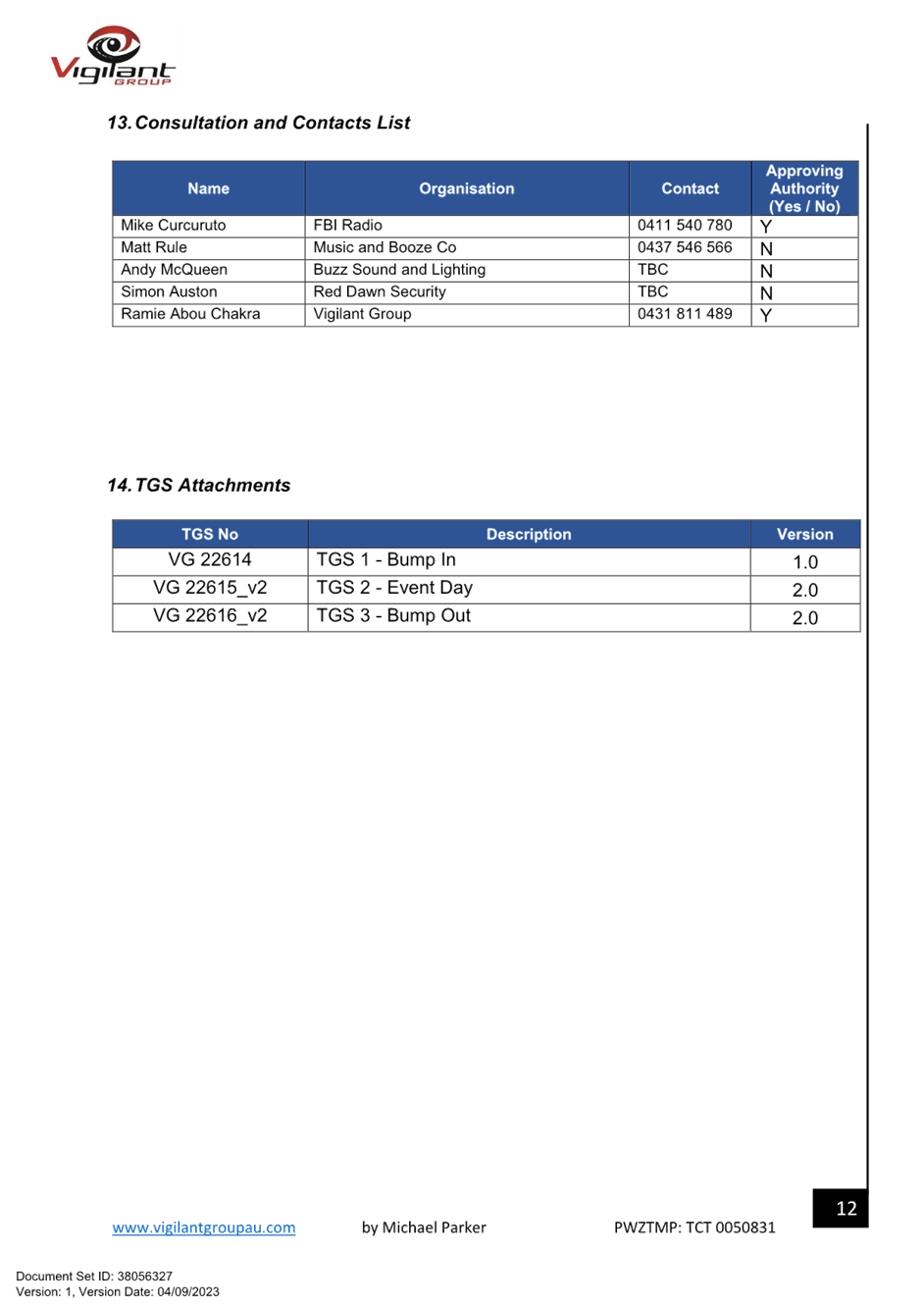
LTC0923(1) Item 3 Faversham Street, Marrickville – Temporary Full Road Closure for FBi Radio Event – Saturday 9 December 2023 (Midjuburi - Marrickville Ward / Summer Hill Electorate / Inner West PAC) 226
LTC0923(1) Item 4 Traffic
Management Plan for the 2023 New Year's Eve Event
(Baludarri-Balmain Ward/ Balmain Electorate/ Leichhardt
Pac) 249
LTC0923(1) Item 5 Norton Street & A'Beckett Avenue, Ashfield- Intersection Improvements Works (Djarrawunang-Ashfield Ward/Summer Hill Electorate/Burwood PAC) 287
LTC0923(1) Item 6 Hancock Lane, Rozelle - Permanent Road Closure (Baludarri-Balmain Ward/Balmain Electorate/Leichhardt PAC) 298
LTC0923(1) Item 7 Cumulative Impacts from Major State Infrastructure Projects & Activities in and around Rozelle & White Bay (Baludarri- Balmain Ward/ Balmain Electorate/Leichhardt PAC) 300
Parking Matters
ITEM Page
LTC0923(1) Item 8 William Street, Leichhardt - Proposed Motorbike Parking (Gulgadya - Leichhardt/Balmain Electorate/Leichhardt PAC) 302
LTC0923(1) Item 9 Isabella Street, Balmain - No Parking Restriction (Baludarri- Balmain Ward/ Balmain Electorate/Leichhardt PAC) 306
LTC0923(1) Item 10 Management of Disabled Parking in Inner West
(All wards/All Electorates/All PACs) 311
LTC0923(1) Item 11 Evans Street,
Balmain - Resident Parking Scheme
Expansion (Baludarri - Balmain ward/Balmain
Electorate/Leichhardt PAC) 313
Late Items
Nil at time of printing.
6 Part B - Items for Information Only
ITEM Page
LTC0923(1) Item 12 Pedestrian Safety Improvements to Unwin’s Bridge across
the Cooks River at Tempe (Midjuburi-Marrickville
Ward/Canterbury & Summer Hill Electorates/Inner West PAC) 315
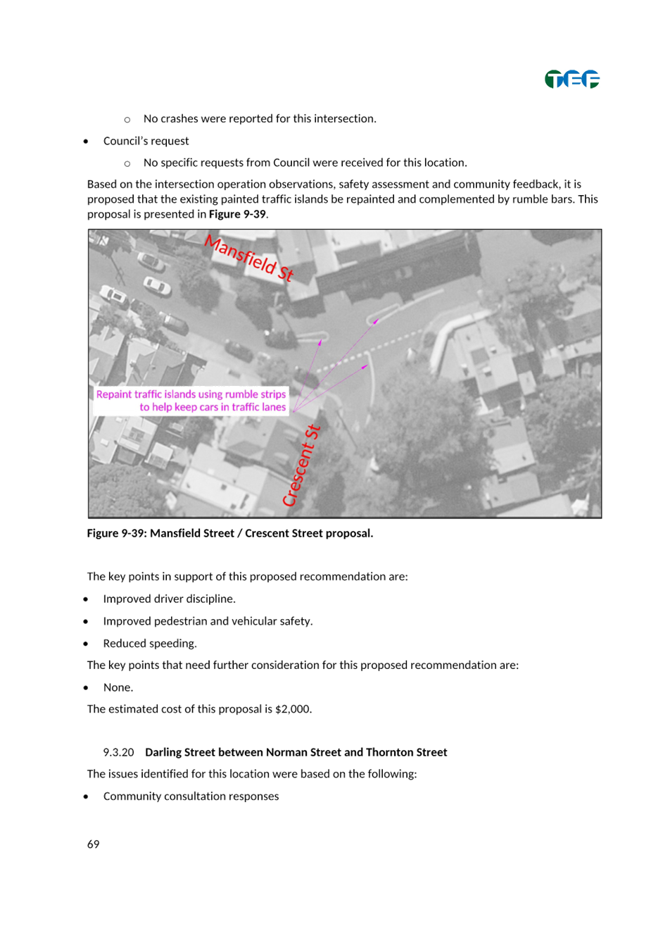
LTC0923(1) Item 13 Pedestrian Safety Improvements to bridge across the
Cooks River in Wardell Road, Marrickville (Midjuburi-Marrickville Ward/Canterbury & Summer Hill Electorates/Inner West PAC) 318
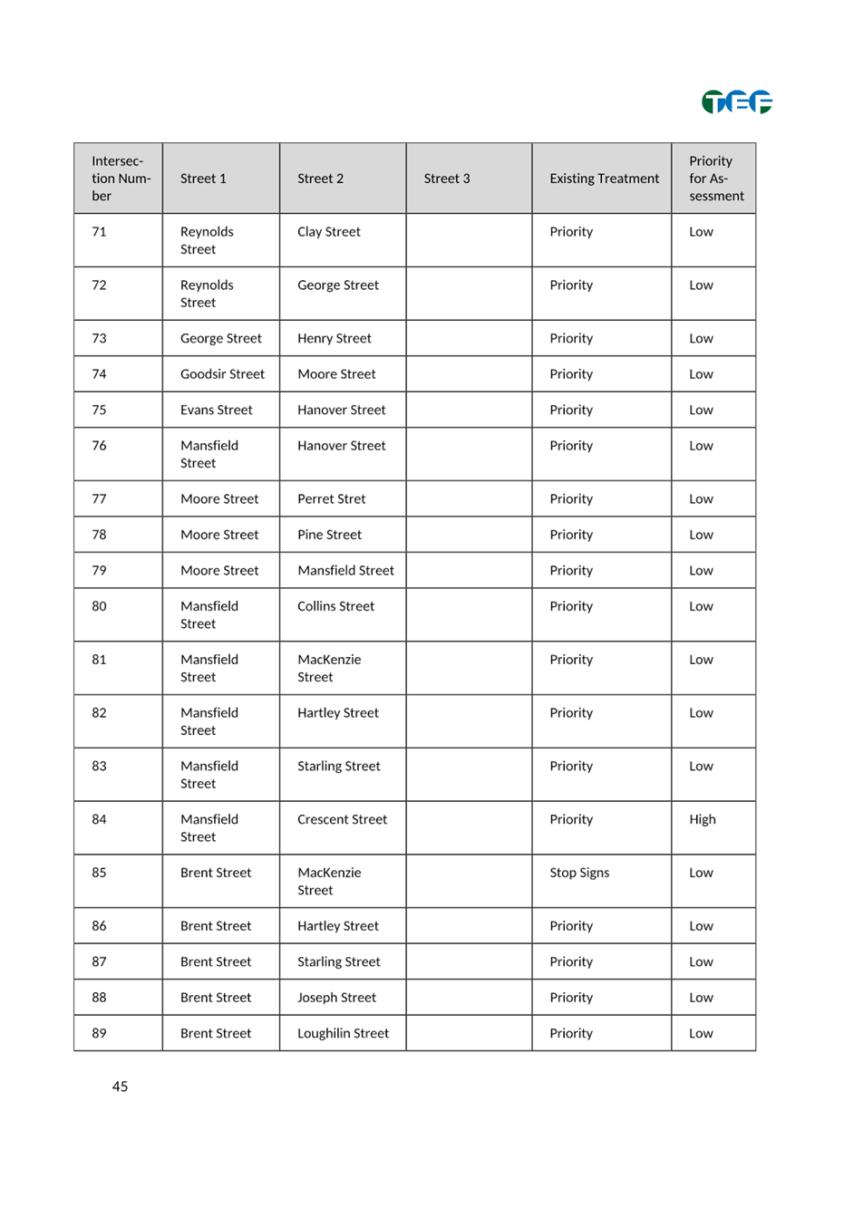
7 Part C - Items for General Advice
Nil at the time of printing.
8 General Business
9 Close of Meeting
|
|
Local Traffic Committee Meeting 18 September 2023 |
Minutes of Meeting
Meeting commenced at 11.01am
ACKNOWLEDGEMENT OF COUNTRY BY CHAIRPERSON
I acknowledge the Gadigal and Wangal people of the Eora nation on whose country we are meeting today, and their elders past and present.
COMMITTEE REPRESENTATIVES PRESENT
|
Mayor Darcy Byrne |
Councillor – Baludarri-Balmain Ward (Chair) |
|
Bill Holliday |
Representative for Kobi Shetty MP, Member for Balmain |
|
Graeme McKay |
Representative for Jo Haylen MP, Member for Summer Hill |
|
Patricia Arcilla |
Representative for Jenny Leong MP, Member for Newtown (Apology for second half of meeting) |
|
Sgt Charles Buttrose |
NSW Police – Leichhardt Police Area Command |
|
Nina Fard |
Transport for NSW (TfNSW) |
|
|
|
|
|
|
|
NON VOTING MEMBERS IN ATTENDANCE |
|
|
|
|
|
Manod Wickramasinghe |
IWC’s Acting Director Infrastructure |
|
Sunny Jo |
IWC’s Acting Traffic and Transport Services Manager |
|
George Tsaprounis |
IWC’s Coordinator Traffic Engineering Services (South) |
|
James Nguyen |
IWC’s Traffic Engineer |
|
Amir Falamarzi |
IWC’s Traffic Engineer |
|
Boris Muha |
IWC’s Traffic Engineer |
|
Colin Jones |
Inner West Bicycle Coalition (IWBC) |
|
Christy Li |
IWC’s Business Administration Officer |
|
|
|
|
|
|
|
VISITORS |
|
|
|
|
|
Annalise Ifield |
IWC’s Senior Planner |
|
Camille Guyot |
IWC’s Development Assessment Planner |
|
Julie Elstub-Ross |
Police Representative |
|
Laura McCloud |
Resident (Item 1) |
|
Michael Carvosso |
Resident (Item 1) |
|
Bob Stephenson |
Resident (Item 2) |
|
Shaun Carter |
Principle Architect at Carter Williamson Architects Representative for Resident (Item 2) |
|
Hassan Kharroubi |
Resident (Item 2) |
|
Huw Davies |
Resident (Item 2) |
|
Iona Steinle |
Resident (Item 2) |
|
Rory Steinle- Davis |
Resident (Item 2) |
|
|
|
|
|
|
|
APOLOGIES: |
|
|
|
|
|
Nil. |
|
|
|
|
DISCLOSURES OF INTERESTS:
Nil.
CONFIRMATION OF MINUTES
|
That the Minutes of the Local Traffic Committee Meeting held on Monday, 17 July 2023 be confirmed. |
MATTERS ARISING FROM COUNCIL’S RESOLUTION OF MINUTES
The Local Traffic Committee meeting recommendations of its meeting held on 15 May 2023 were adopted at Council's meeting on 8 August 2023.
The Local Traffic Committee meeting recommendations of its meeting held on 19 June 2023 were adopted at Council's meeting on 8 August 2023 subject to the follow amendment:
1. 19 June 2023 LTC0623 (1) Item 12 be deferred pending an onsite meeting to identify alternative solutions.
The Local Traffic Committee meeting recommendations of its meeting held on 17 July 2023 were adopted at Council's meeting on 8 August 2023.
|
LTC0823(1) Item 4 Marrickville Road, Marrickville – Temporary Full Road Closures for Marrickville Music Festival - Sunday 15 October 2023 (Midjuburi - Marrickville Ward / Summer Hill Electorate / Inner West PAC) |
|
Inner West Council is presenting Marrickville Music Festival on Sunday 15 October from 12:00pm noon until 6:00pm. The event will feature multiple outdoor live music stages across the festival site. Including activation of Marrickville laneways through music and art. As part of the event there will be a partial road closure of Marrickville Road and Central Lane. This will require some road detours and bus diversions in surrounding streets. Event bump in will occur from 12:30am and bump out will conclude by 12:00pm midnight. It is recommended that Council agree to the temporary full road closures subject to all standard Council conditions for a temporary full road closure.
Officer’s Recommendation:
1. That the proposed temporary full road closure of Marrickville Road (between Illawarra Road and Victoria Road), Central Lane (between Victoria Road and Meeks Road), Seymour Lane (between Garners Lane and Garners Avenue and between Frampton Avenue and Garners Lane), Garners Lane (north of Seymour Lane) along with short sections of Silver Street, Garners Avenue, Gladstone Street, and Frampton Avenue where these streets intersect with Marrickville Road, Marrickville be approved for the purpose of holding the ‘Marrickville Music Festival’ Event on Sunday 15 October 2023 between 12:30am and 12:00pm as per the submitted TMP and TGSs and subject to the following conditions and all standard Council conditions for temporary full road closures.
2. That a Road Occupancy License application be obtained from the Transport Management Centre.
3. That notice of the proposed event be forwarded to the NSW Police Local Area Commander, Transit Systems, the NSW Fire Brigades and the NSW Ambulance Services.
4. That all residents and businesses in and around the affected area are to be notified of the temporary road closure in writing by the applicant in advance (at least 7 days prior to the event) with the applicant making reasonable provision for stakeholders. 5. That a minimum four (4) metre unencumbered passage be available for emergency vehicles through the closed sections.
6. That the occupation of the road carriageway must not occur until the road has been physically closed.
DISCUSSION:
The Committee members agreed with the Officer’s recommendation.
COMMITTEE RECOMMENDATION:
1. That the proposed temporary full road closure of Marrickville Road (between Illawarra Road and Victoria Road), Central Lane (between Victoria Road and Meeks Road), Seymour Lane (between Garners Lane and Garners Avenue and between Frampton Avenue and Garners Lane), Garners Lane (north of Seymour Lane) along with short sections of Silver Street, Garners Avenue, Gladstone Street, and Frampton Avenue where these streets intersect with Marrickville Road, Marrickville be approved for the purpose of holding the ‘Marrickville Music Festival’ Event on Sunday 15 October 2023 between 12:30am and 12:00pm as per the submitted TMP and TGSs and subject to the following conditions and all standard Council conditions for temporary full road closures.
2. That a Road Occupancy License application be obtained from the Transport Management Centre.
3. That notice of the proposed event be forwarded to the NSW Police Local Area Commander, Transit Systems, the NSW Fire Brigades and the NSW Ambulance Services.
4. That all residents and businesses in and around the affected area are to be notified of the temporary road closure in writing by the applicant in advance (at least 7 days prior to the event) with the applicant making reasonable provision for stakeholders. 5. That a minimum four (4) metre unencumbered passage be available for emergency vehicles through the closed sections.
6. That the occupation of the road carriageway must not occur until the road has been physically closed.
For motion: Unanimous |
|
LTC0823(1) Item 6 Ewart Street, Dulwich Hill; Illawarra Road, Marrickville; Burrows Avenue, Railway Road, Gleeson Avenue And (Lower) Railway Parade, Sydenham - Temporary Parking Changes During Major Rail Shutdown of T3 Line For Sydney Metro Upgrade Works - Bus Replacements Saturday 23 September To Thursday 5 October 2023 And Tuesday 26 December 2023 To Thursday 25 January 2024 (Midjuburi -Marrickville Ward / Summer Hill Electorate / Inner West Pac) |
|
Council has been notified by Transport for NSW (TfNSW) that Sydney Metro works will involve major rail shutdown of the Sydenham to Bankstown rail line (T3) for the following periods: Saturday, 23 September to Thursday, 5 October 2023 (inclusive) and Tuesday, 26 December 2023 to Thursday, 25 January 2024 (inclusive). During the shutdowns buses will replace train services along the T3 line and to accommodate the increased bus movements and necessary holding areas some short-term parking changes are required at a number of locations.
Specifically, TfNSW is requesting approval for the temporary conversion of multiple parking spaces at the following locations: Ewart Street, Dulwich Hill; Illawarra Road, Marrickville; Burrows Avenue, Railway Road, Gleeson Avenue and (Lower) Railway Parade, Sydenham. It is recommended that no objections be raised, and Council approves the temporary short-term parking changes at the identified locations during the rail shutdowns.
All changes to street signage will be made by TfNSW contractor(s) from 10pm the night before the closures and will be reinstated at the completion of the planned shutdowns.
Officer’s Recommendation:
1. That the following temporary short-term parking changes for the periods of Saturday, 23 September to Thursday, 5 October 2023 (inclusive) and Tuesday, 26 December 2023 to Thursday, 25 January 2024 (inclusive) be approved to support the works required to convert the T3 Bankstown Line to a Metro Line:
a) Dulwich Hill Station Precinct - Ewart Street (3 parking spaces): The short-term conversion of 20m (3 parking spaces) ‘2P 8 am – 6 pm Mon – Fri’ on the northern side of Ewart Street (between Wardell Road and Bayley Street) to a ‘Bus Zone’; b) Marrickville Station Precinct - Illawarra Road (1 parking space): The short-term conversion of 7m (1 parking space) ‘1P 8:30 am – 6 pm’ on the western side of Illawarra Road (between Warburton Street and Greenbank Street) to a ‘Bus Zone’; c) Sydenham Station Precinct - Burrows Avenue (23 parking spaces): The short-term conversion of 50m (14 parking spaces) rear to kerb ‘unrestricted parking’ on the northern kerb of Burrows Avenue (west of Gleeson Avenue) to a ‘Bus Zone’; d) The short-term conversion of 58m (9 parking spaces) ‘unrestricted parking’ on the southern kerb of Burrows Avenue (west of Gleeson Avenue) to a ‘Bus Zone’; e) Sydenham Station Precinct – Railway Road (3 parking spaces): The short-term conversion of 18m (3 parking spaces) ‘2P 8:30 am – 10 pm Mon - Fri’ on the eastern side kerb of Railway Road (between Burrows Avenue and Gleeson Avenue) to a ‘Bus Zone’; f) Sydenham Station Precinct - Gleeson Avenue (2 parking spaces): The short-term conversion of 12m (2 parking spaces) ‘1P 9:00 am – 3:30 pm Mon - Fri and No Parking 6 am-9 am & 3:30 pm – 6:30 pm’ on the eastern kerb of Gleeson Avenue (between Burrows Avenue and Unwins Bridge Road) to a ‘Bus Zone’; g) Sydenham Station Precinct - h) The short-term conversion of 32m (11 parking spaces) 45 degree angled parking ‘4P 8:30 am – 6 pm Mon - Fri’ on the southwest kerb of Lower Railway Parade (between Gleeson Avenue and Marrickville Road) to a ‘Bus Zone’.
2. That the applicant and Council Rangers be advised in terms of this report.
DISCUSSION:
The Committee members agreed with the Officer’s recommendation.
COMMITTEE RECOMMENDATION:
1. That the following temporary short-term parking changes for the periods of Saturday, 23 September to Thursday, 5 October 2023 (inclusive) and Tuesday, 26 December 2023 to Thursday, 25 January 2024 (inclusive) be approved to support the works required to convert the T3 Bankstown Line to a Metro Line:
a) Dulwich Hill Station Precinct - Ewart Street (3 parking spaces): The short-term conversion of 20m (3 parking spaces) ‘2P 8 am – 6 pm Mon – Fri’ on the northern side of Ewart Street (between Wardell Road and Bayley Street) to a ‘Bus Zone’; b) Marrickville Station Precinct - Illawarra Road (1 parking space): The short-term conversion of 7m (1 parking space) ‘1P 8:30 am – 6 pm’ on the western side of Illawarra Road (between Warburton Street and Greenbank Street) to a ‘Bus Zone’; c) Sydenham Station Precinct - Burrows Avenue (23 parking spaces): The short-term conversion of 50m (14 parking spaces) rear to kerb ‘unrestricted parking’ on the northern kerb of Burrows Avenue (west of Gleeson Avenue) to a ‘Bus Zone’; d) The short-term conversion of 58m (9 parking spaces) ‘unrestricted parking’ on the southern kerb of Burrows Avenue (west of Gleeson Avenue) to a ‘Bus Zone’; e) Sydenham Station Precinct – Railway Road (3 parking spaces): The short-term conversion of 18m (3 parking spaces) ‘2P 8:30 am – 10 pm Mon - Fri’ on the eastern side kerb of Railway Road (between Burrows Avenue and Gleeson Avenue) to a ‘Bus Zone’; f) Sydenham Station Precinct - Gleeson Avenue (2 parking spaces): The short-term conversion of 12m (2 parking spaces) ‘1P 9:00 am – 3:30 pm Mon - Fri and No Parking 6 am-9 am & 3:30 pm – 6:30 pm’ on the eastern kerb of Gleeson Avenue (between Burrows Avenue and Unwins Bridge Road) to a ‘Bus Zone’; g) Sydenham Station Precinct - h) The short-term conversion of 32m (11 parking spaces) 45 degree angled parking ‘4P 8:30 am – 6 pm Mon - Fri’ on the southwest kerb of Lower Railway Parade (between Gleeson Avenue and Marrickville Road) to a ‘Bus Zone’.
2. That the applicant and Council Rangers be advised in terms of this report.
For motion: Unanimous |
|
LTC0823(1) Item 7 Percival Road, Stanmore – Temporary Full Road Closures for Stanmore Music Festival – Saturday 18 November 2023 (Damum-Stanmore Ward /Newtown Electorate/ Inner West Lac) |
|
Inner West Council is presenting Stanmore Music Festival on Saturday 18 November 2023 from 12:00pm noon until 6:00pm. This community festival has been organised by local residents who are supported by Council as part of EDGE Newtown.
To facilitate the event there will be a partial road closure of Percival Road, between Salisbury Road and Myrtle Street. This will require some road detours in surrounding streets. Road closure and event bump in will occur from 6:00am and bump out will conclude by 9:00pm.
Officer’s Recommendation:
1. That the proposed temporary full road closure (ENRC/2023/0051) of Percival Road, from Salisbury Road to the pedestrian crossing at Myrtle Street; partial closure of Temple Street from Percival Road to Percival Lane; and partial closure of Myrtle Street, from Percival Road to Percival Laneway, Stanmore be approved for the purpose of holding the ‘Stanmore Music Festival’ Event on Saturday 18 November 2023 between 6.00am and 9.00pm as per the submitted TMP and TGSs and subject to the following conditions and all standard Council conditions for temporary full road closures.
2. That a Road Occupancy License application be obtained from the Transport Management Centre.
3. That notice of the proposed event be forwarded to the NSW Police Local Area Commander, Transit Systems, the NSW Fire Brigades and the NSW Ambulance Services.
4. That all residents and businesses in and around the affected area are to be notified of the temporary road closure in writing by the applicant in advance (at least 7 days prior to the event) with the applicant making reasonable provision for stakeholders. 5. That a minimum four (4) metre unencumbered passage be available for emergency vehicles through the closed sections.
6. That the occupation of the road carriageway must not occur until the road has been physically closed.
DISCUSSION:
The Committee members agreed with the Officer’s recommendation.
COMMITTEE RECOMMENDATION:
1. That the proposed temporary full road closure (ENRC/2023/0051) of Percival Road, from Salisbury Road to the pedestrian crossing at Myrtle Street; partial closure of Temple Street from Percival Road to Percival Lane; and partial closure of Myrtle Street, from Percival Road to Percival Laneway, Stanmore be approved for the purpose of holding the ‘Stanmore Music Festival’ Event on Saturday 18 November 2023 between 6.00am and 9.00pm as per the submitted TMP and TGSs and subject to the following conditions and all standard Council conditions for temporary full road closures.
2. That a Road Occupancy License application be obtained from the Transport Management Centre.
3. That notice of the proposed event be forwarded to the NSW Police Local Area Commander, Transit Systems, the NSW Fire Brigades and the NSW Ambulance Services.
4. That all residents and businesses in and around the affected area are to be notified of the temporary road closure in writing by the applicant in advance (at least 7 days prior to the event) with the applicant making reasonable provision for stakeholders. 5. That a minimum four (4) metre unencumbered passage be available for emergency vehicles through the closed sections.
6. That the occupation of the road carriageway must not occur until the road has been physically closed.
For motion: Unanimous |
|
LTC0823(1) Item 11 Trafalgar Street, Enmore - Proposed installation of 'No Parking' restrictions outside No.35-39A Trafalgar Street (DAMUN - STANMORE WARD/ NEWTOWN ELECTORATE/ INNER WEST PAC) |
|
Council has received concerns that vehicles are parking in a manner that limits the ability of residents accessing their driveways. This is as a result of short sections of kerb between driveways when the site was redeveloped. In order to alleviate this issue, it is proposed to signpost “No Parking’ restrictions outside Nos.35-39A Trafalgar Street, Enmore. Currently the restrictions are ‘1P 6pm-10pm Permit Holders Excepted Area M3’.
Officer’s Recommendation:
That the installation of full-time ‘No Parking’ restrictions on the southern side of Trafalgar Street, Enmore (outside property Nos.35-39A Trafalgar Street for a length of 36 metres) be approved, in order to improve vehicular access to off-street parking spaces.
DISCUSSION:
The Committee members agreed with the Officer’s recommendation.
COMMITTEE RECOMMENDATION:
That the installation of full-time ‘No Parking’ restrictions on the southern side of Trafalgar Street, Enmore (outside property Nos.35-39A Trafalgar Street for a length of 36 metres) be approved, in order to improve vehicular access to off-street parking spaces.
For motion: Unanimous
|
General Business
|
Item 13 Pedestrian safety Robert Street, Rozelle |
|
The representative for the Member for Balmain suggested that to improve pedestrian safety at the bus stop on Robert Street, Rozelle, Council could either move the bus stop uphill, widen the footpath at the bus stop or move the bus stop around the corner to Mullens Street.
Council officers will investigate the relocation of the bus stop.
|
|
Item 14 Traffic Calming Lilyfield Road at Victoria Road |
|
The representative for the Member for Balmain suggested a pedestrian crossing on Lilyfield Road at the intersection of Victoria Road as well as reducing the speed limits on Lilyfield Road
Council officers will investigate the request for a pedestrian crossing on Lilyfield Road. |
|
Item 15 Reclassification of Victoria Road |
|
The representative for the Member for Balmain asked whether TfNSW has considered reclassifying Victoria Road between Iron Cove Bridge and City West Link as a Council managed road.
The representative for TfNSW stated that this has not been considered.
|
|
Item 16 Request for additional parking permits for the Inner Sydney Montessori School |
|
The representative for the Member for Balmain raised concerns on behalf of Inner Sydney Montessori School regarding parking around the school and would like to request additional parking permits for the teachers at the school. The representative for the Member for Balmain suggested that Council turn some of the 2 hour resident parking zones into 4 hour parking as well as implement paid parking.
The Mayor ruled the item as out of order as no written correspondence was provided. |
|
Item 17 Traffic Calming in Toelle Street, Rozelle. |
|
The representative for the Member for Balmain raised concerns on behalf of a resident that Toelle Street, Rozelle is now the major access route through to King George Park. He noted that the street has a speed limit of 50km/h and is narrow and with parked cars on both sides. He suggested that we investigate the implementation of a ‘Shared Zone.’
The Mayor ruled the item as out of order as no written correspondence was provided. |
|
Item 18 Parking availability in Wemyss Street, Marrickville |
|
The Mayor tabled correspondence concerned about the lack of parking available on Wemyss Street, Marrickville and requested further investigation. Council Officers will investigate this request and the resident will be notified of the investigation. |
|
Item 19 Speed bumps be placed in Alt Street Ashfield to address speeding concerns |
|
The Mayor tabled correspondence in regards to a request for speed bumps to be placed in Alt Street Ashfield to address speeding concerns and requested further investigation. Council Officers will investigate this request and the resident will be notified of the investigation.
|
|
Item 20 Audit of plants in Kerbside garden beds |
|
The representative for the Member for Summer Hill suggested that Council undertake an audit of planting in kerbside garden beds to ensure that they do not impede sightlines for pedestrians. Council Officers advised that species are selected and maintained to 50cm to ensure sightlines are maintained for pedestrians and motorists. Specific locations identified can be addressed. |
|
Item 21 Traffic Flow in McCleer Street, Rozelle |
|
The Mayor tabled correspondence concerned about rat running on McCleer Street, Rozelle and requested further investigation. Council Officers will investigate this request and the resident will be notified of the investigation.
|
Meeting closed at 12.28pm.
|
|
Local Traffic Committee Meeting 18 September 2023 |
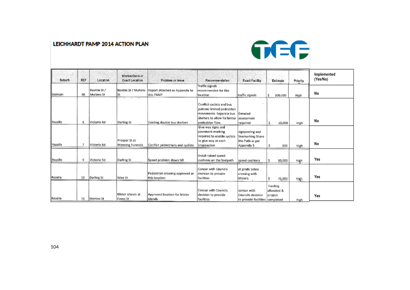
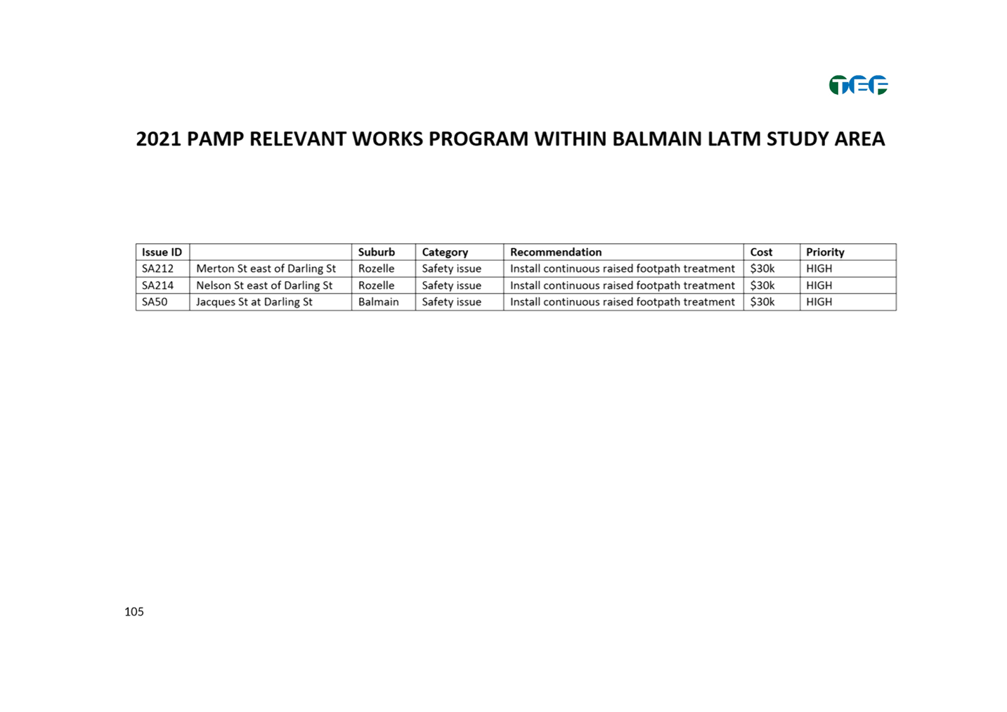
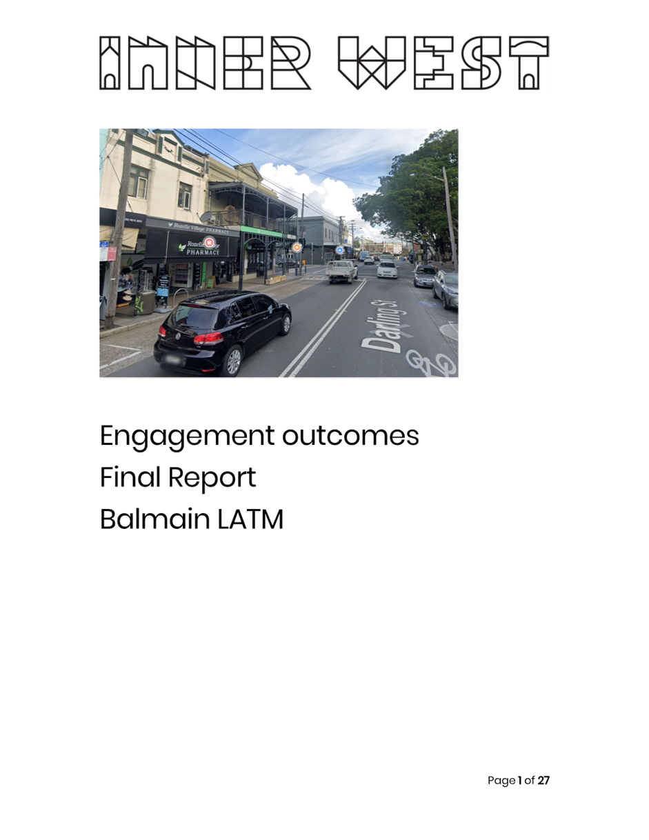
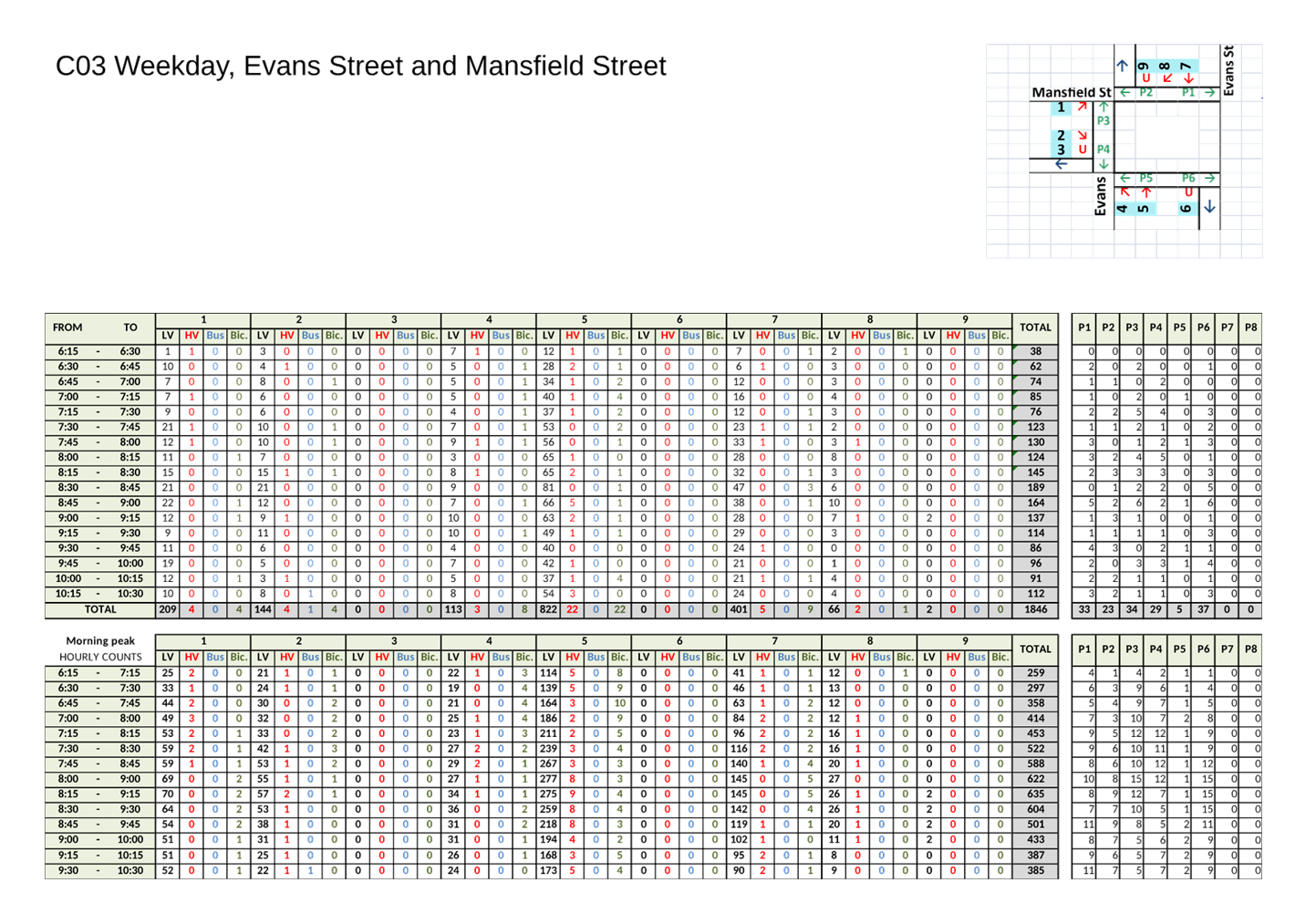
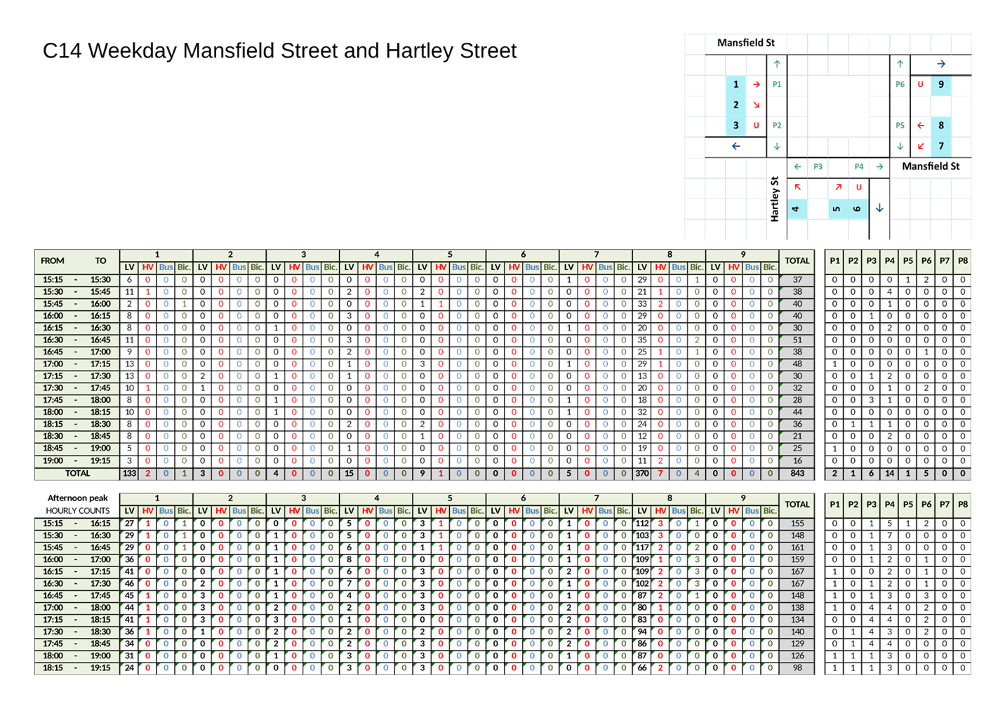
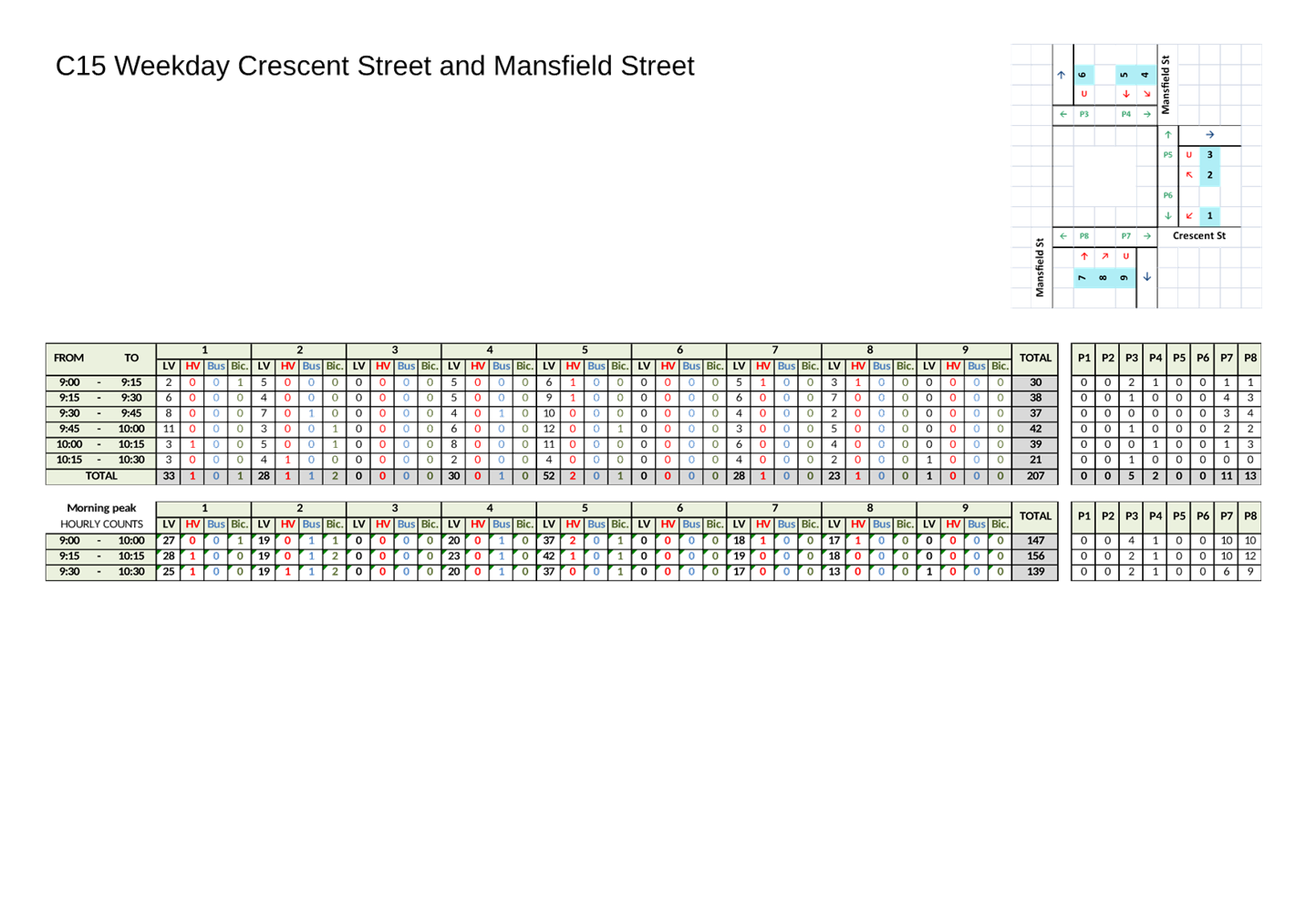
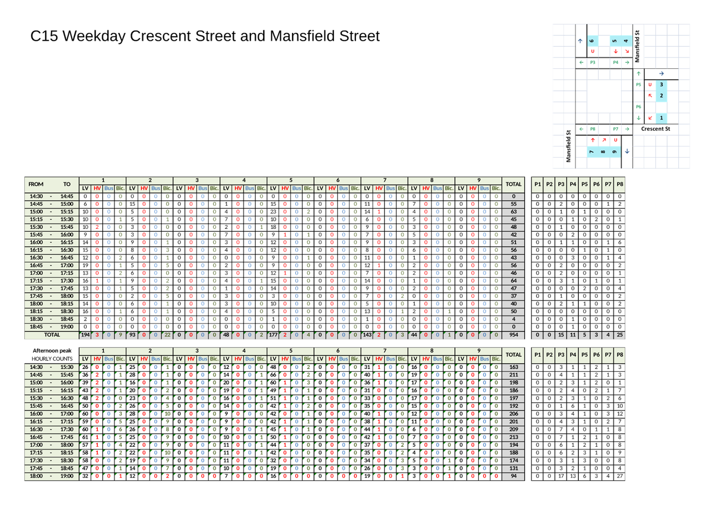
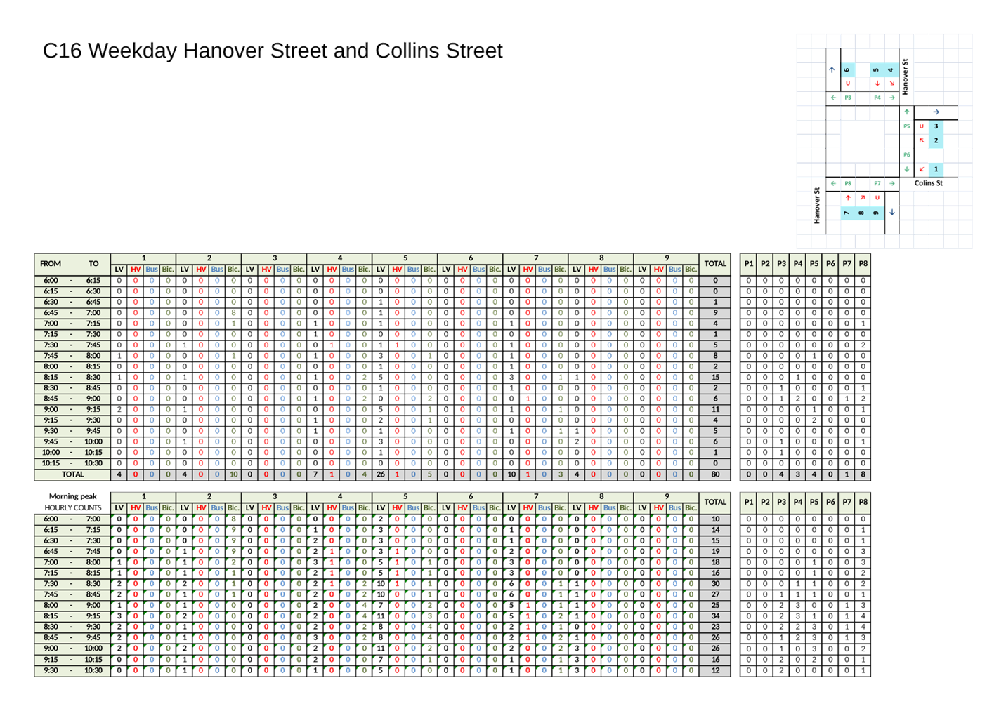
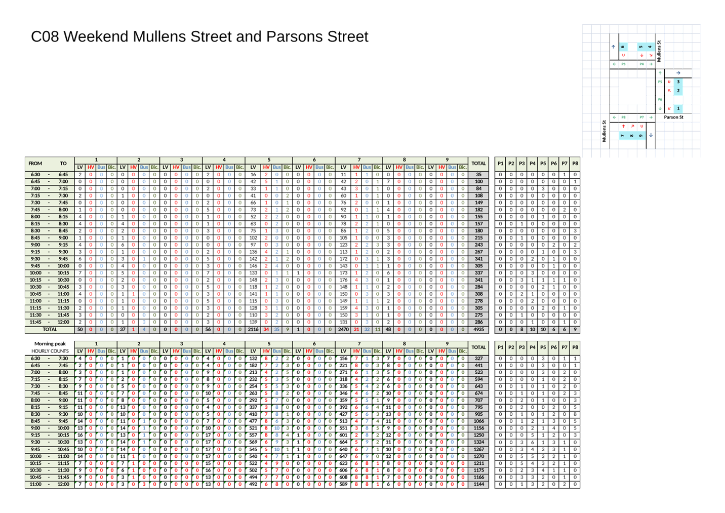
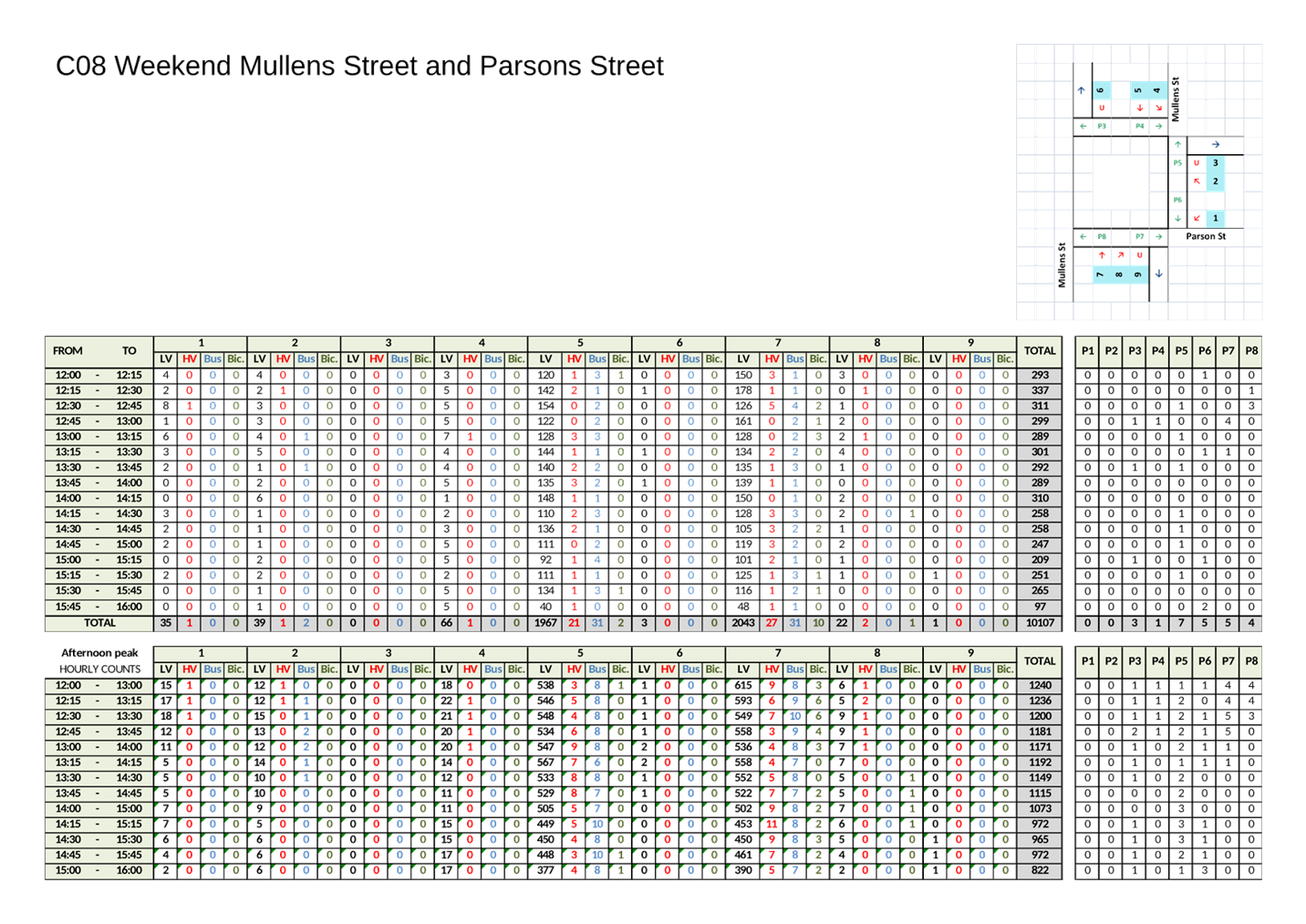
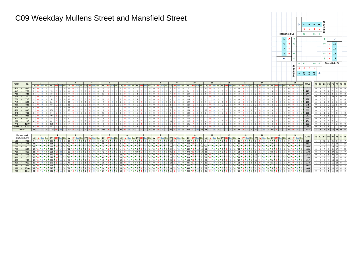
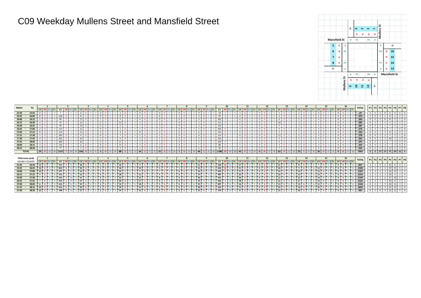
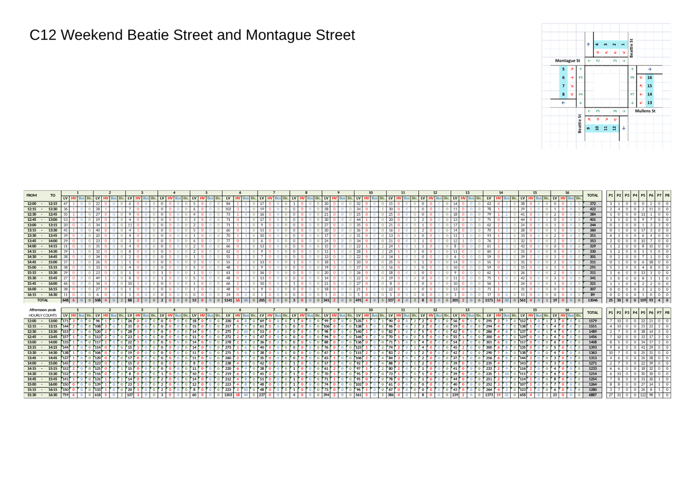
Subject: Balmain Local Area Traffic Management Plan (Baludarri- Balmain Ward/ Balmain Electorate/Leichhardt PAC)
Prepared By: Jason Scoufis - Coordinator Traffic Studies and Road Safety
Authorised By: Manod Wickramasinghe - Traffic and Transport Planning Manager
|
RECOMMENDATION
That the treatments (listed below) from the Balmain LATM be approved and be considered in Council’s Traffic Facilities program and operational linemarking/signposting program as required and prioritised as identified in the attached report.
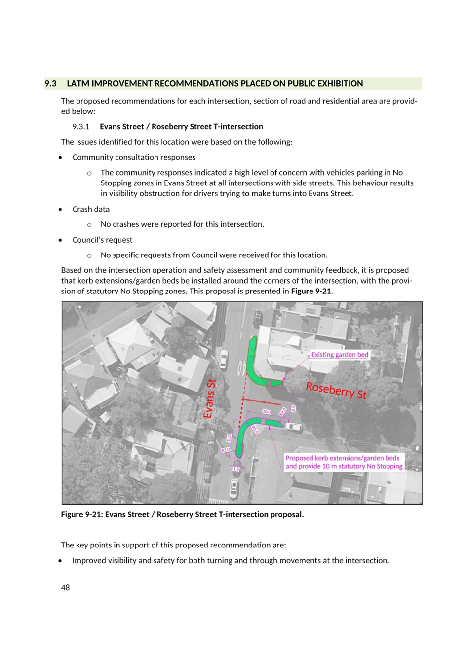
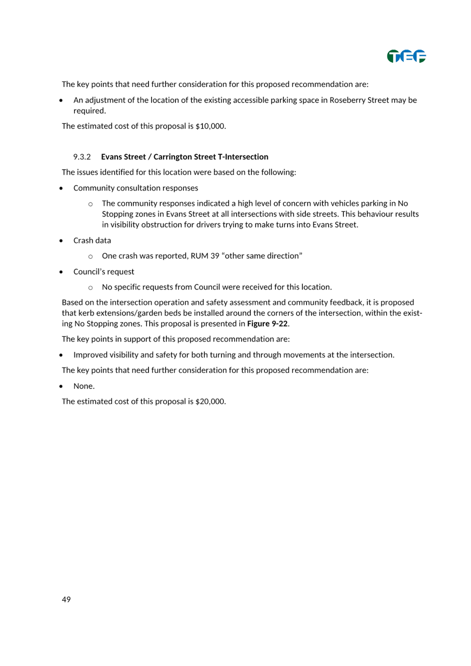
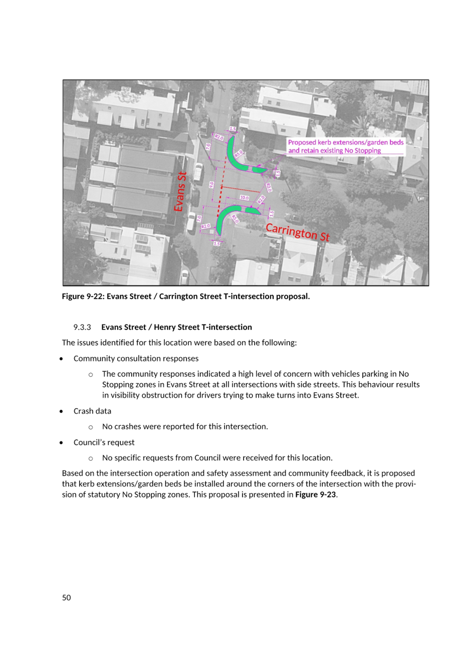
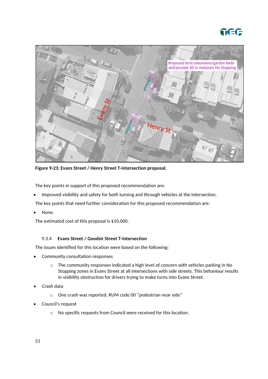
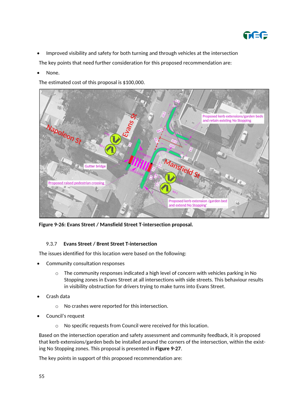
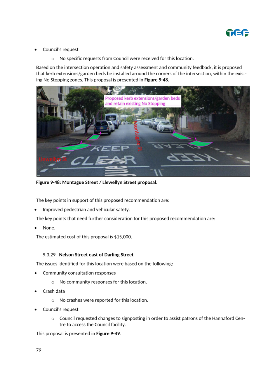
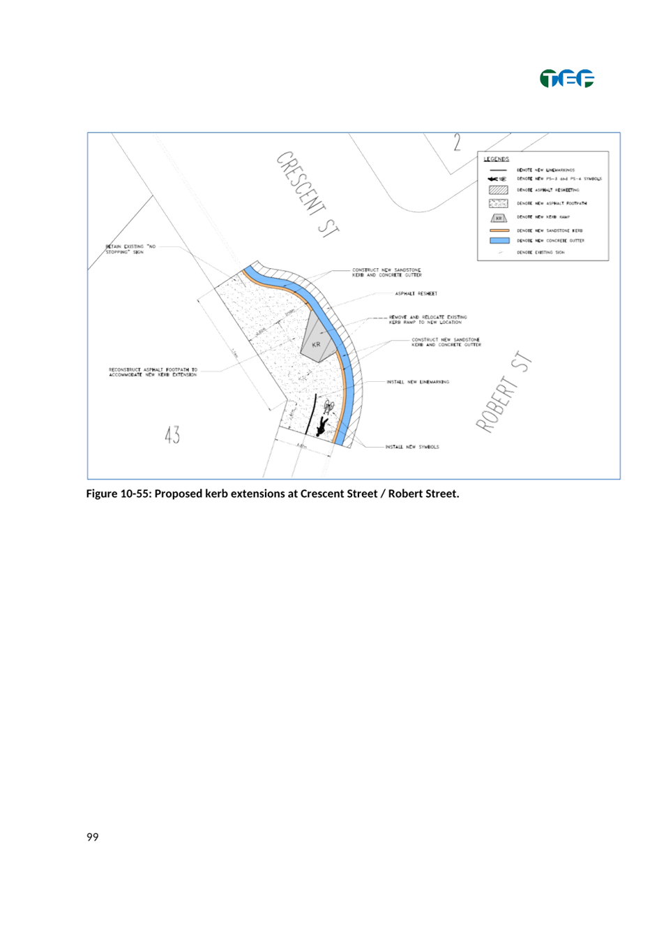
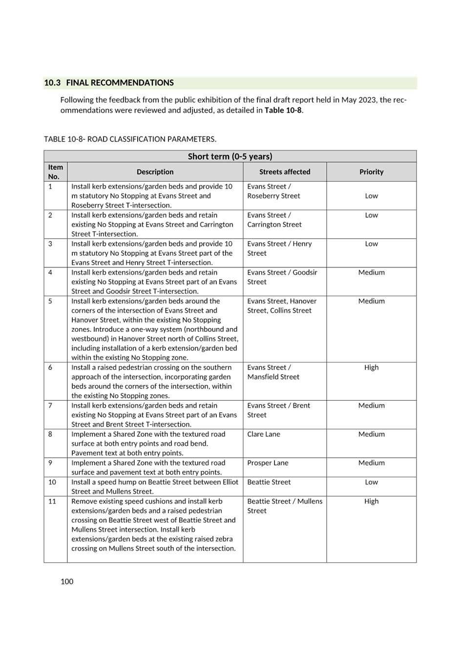
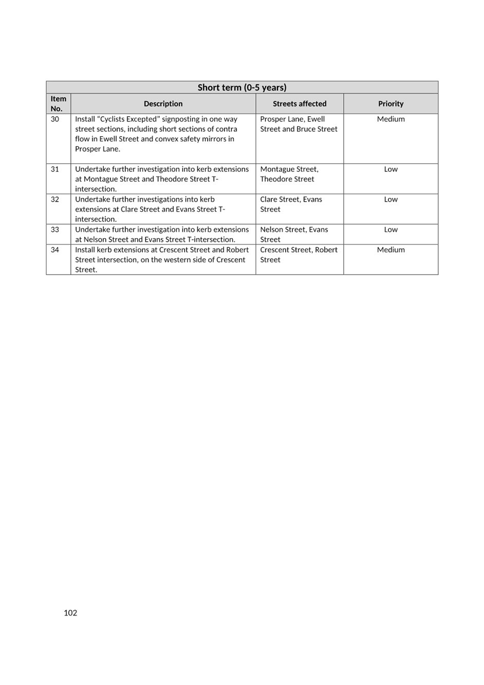
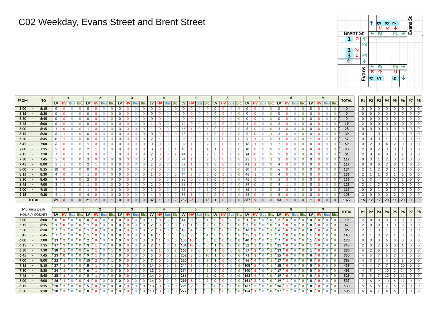
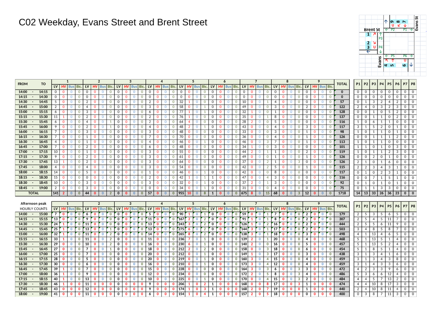
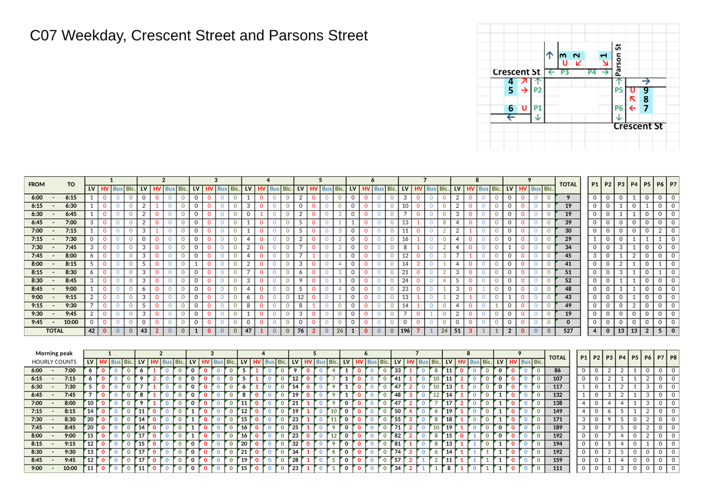
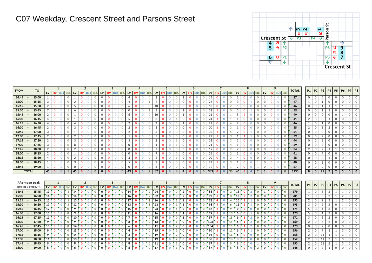
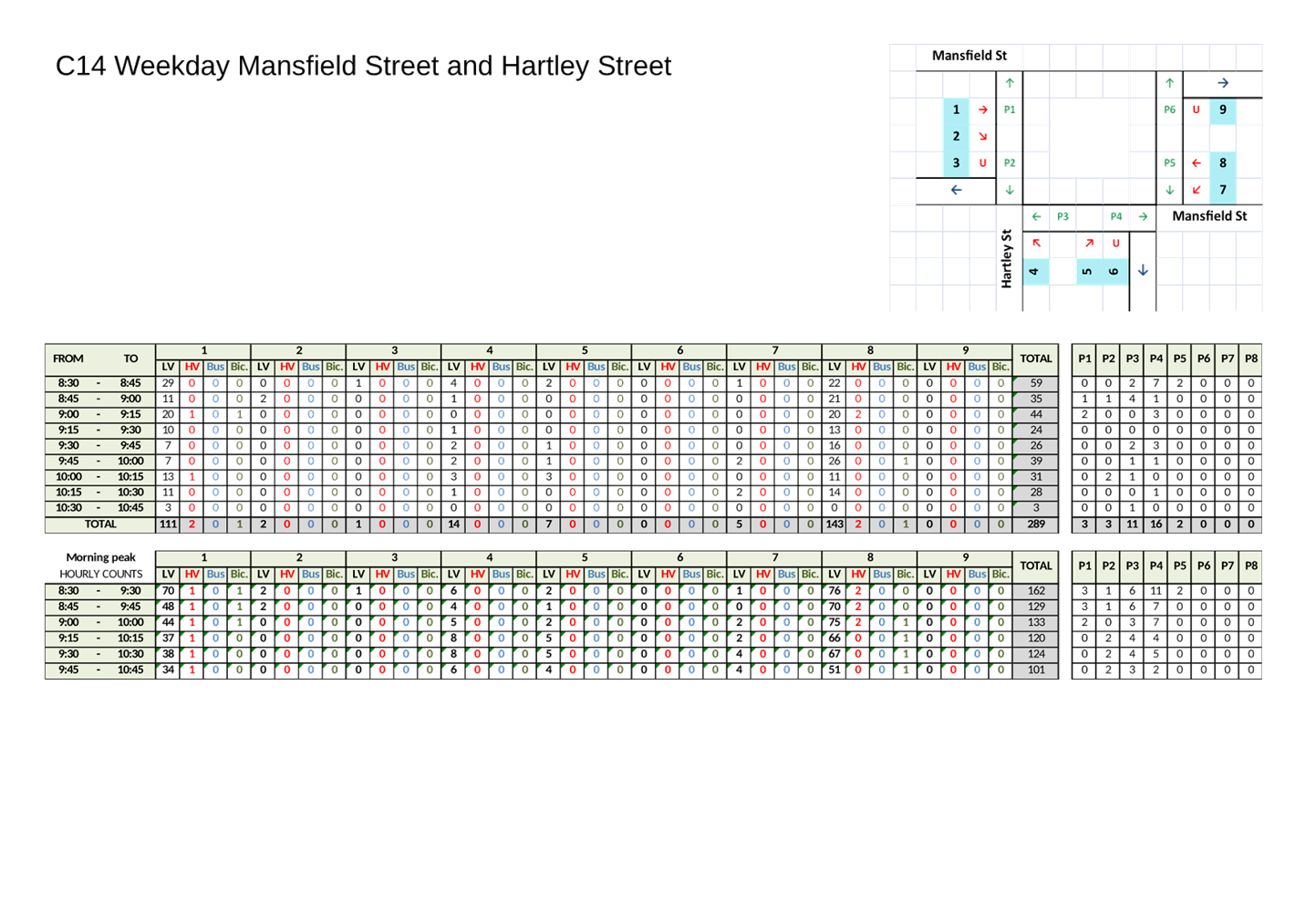
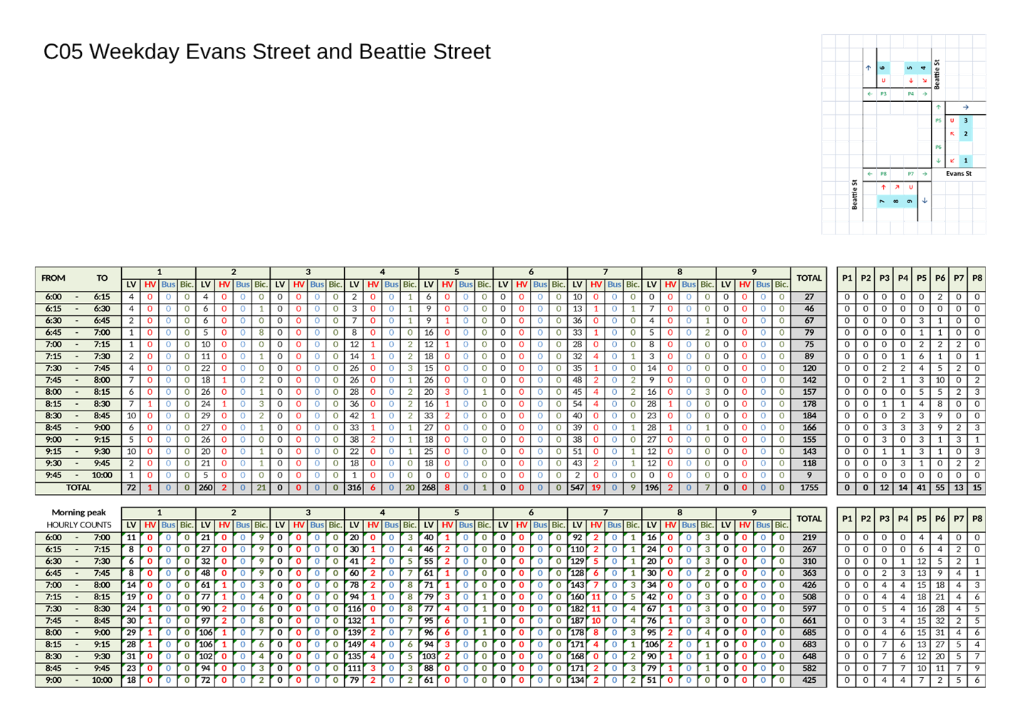
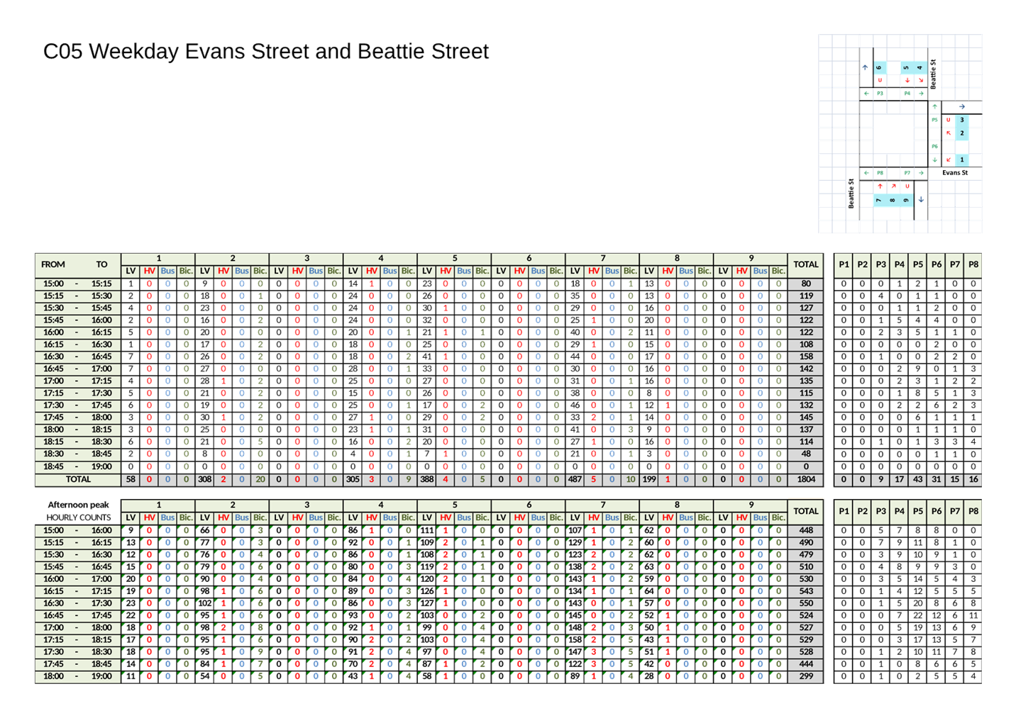
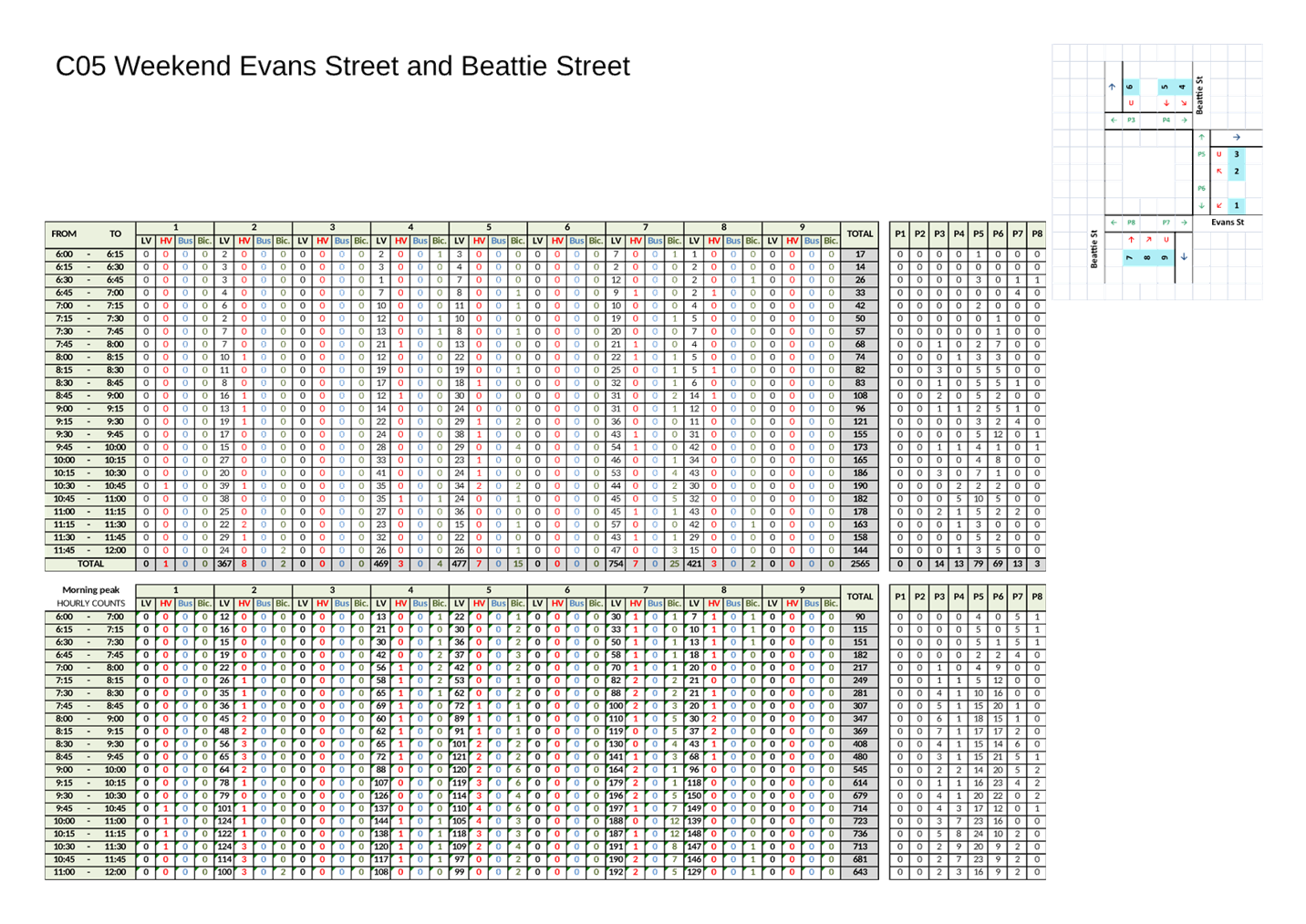
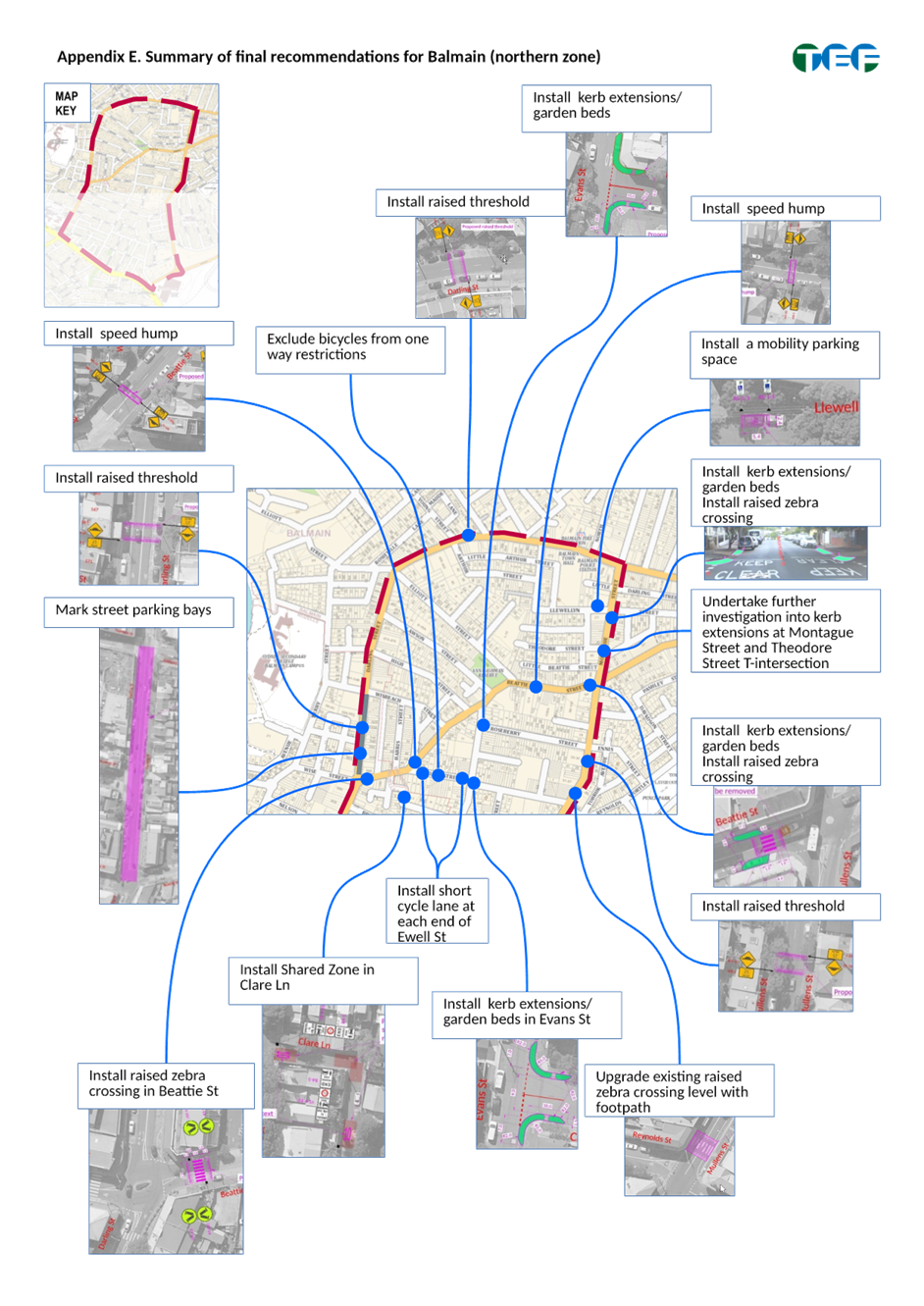
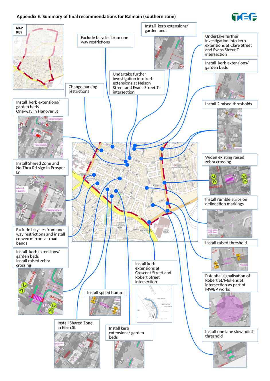
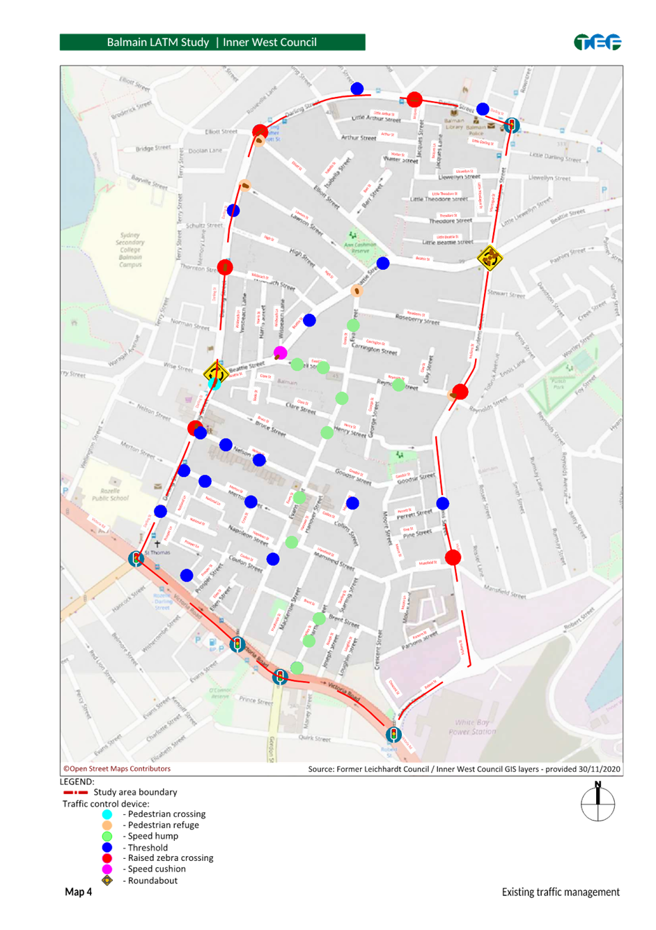
1. That kerb extensions be installed at: a) The Evans Street/Roseberry Street intersection; b) The Evans Street/Carrington Street intersection; c) The Evans Street/Henry Street intersection; d) The Evans Street/Goodsir Street intersection; e) The Evans Street/Brent Street intersection; f) The Montague Street/Llewellyn Street intersection and; g) In Crescent Street at Robert Street intersection.
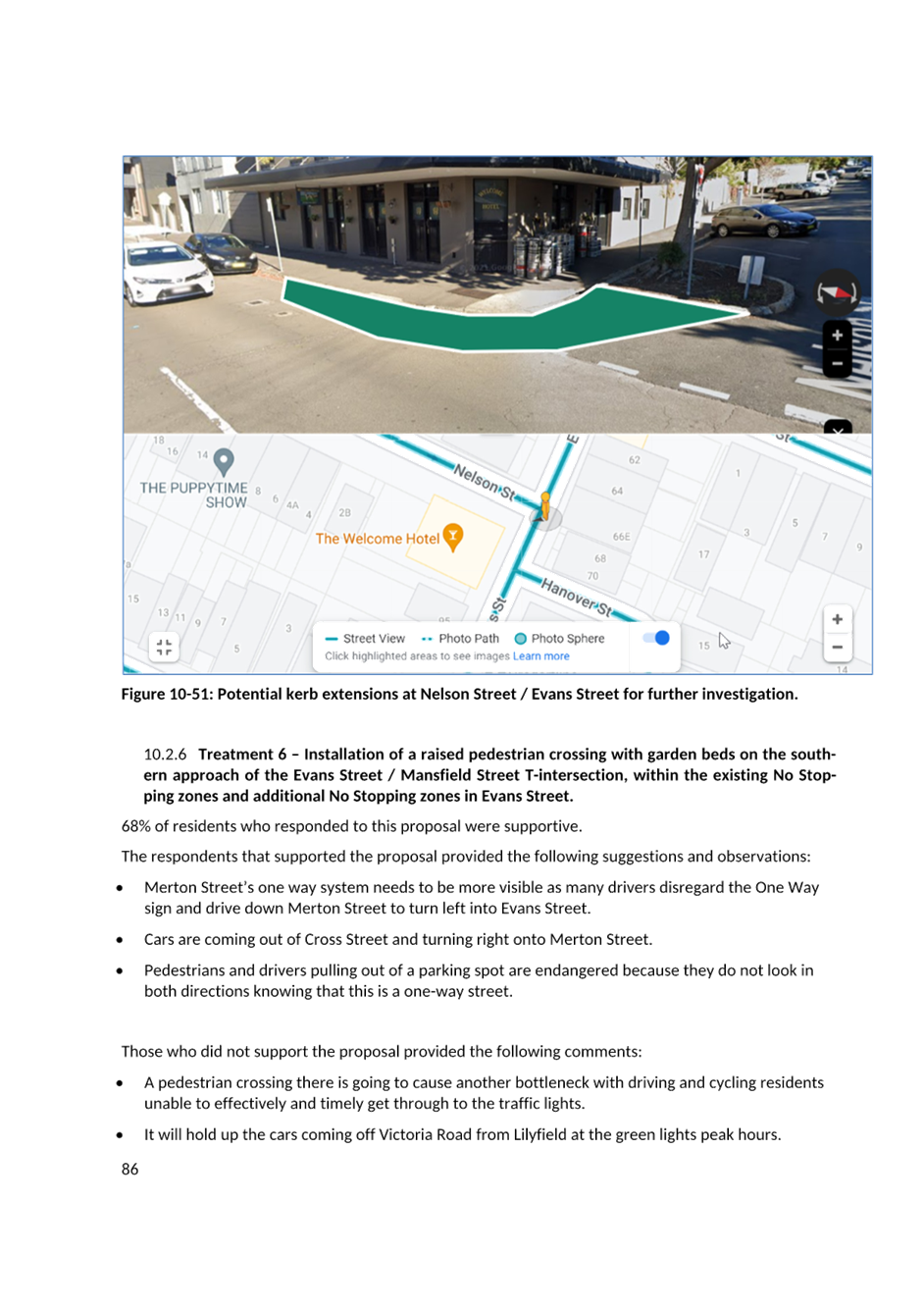
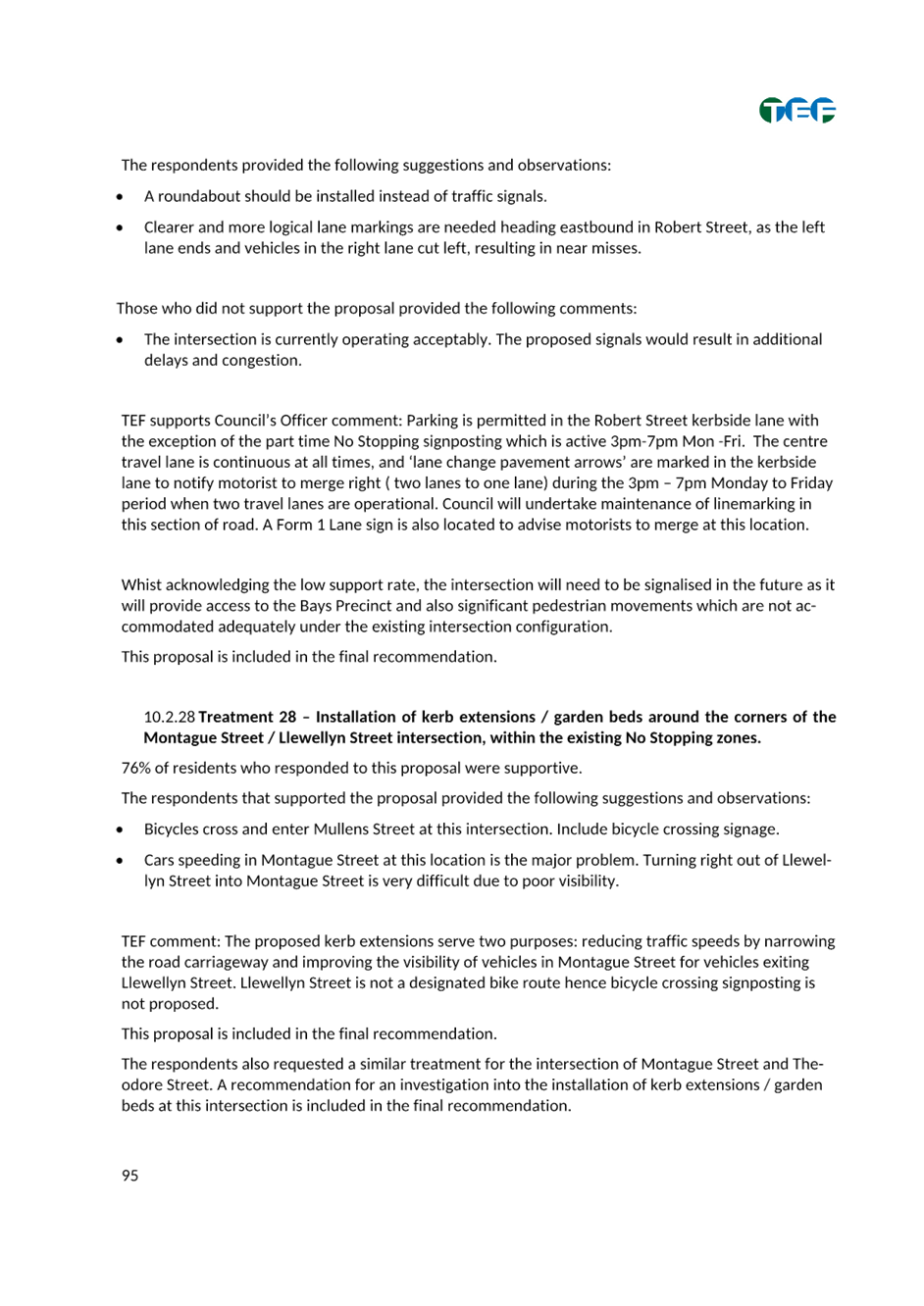
2. That Council undertake further investigation of kerb extensions at: a) Montague Street/Theodore Street; b) Clare Street/Evans Street and; c) Nelson Street/Evans Street.
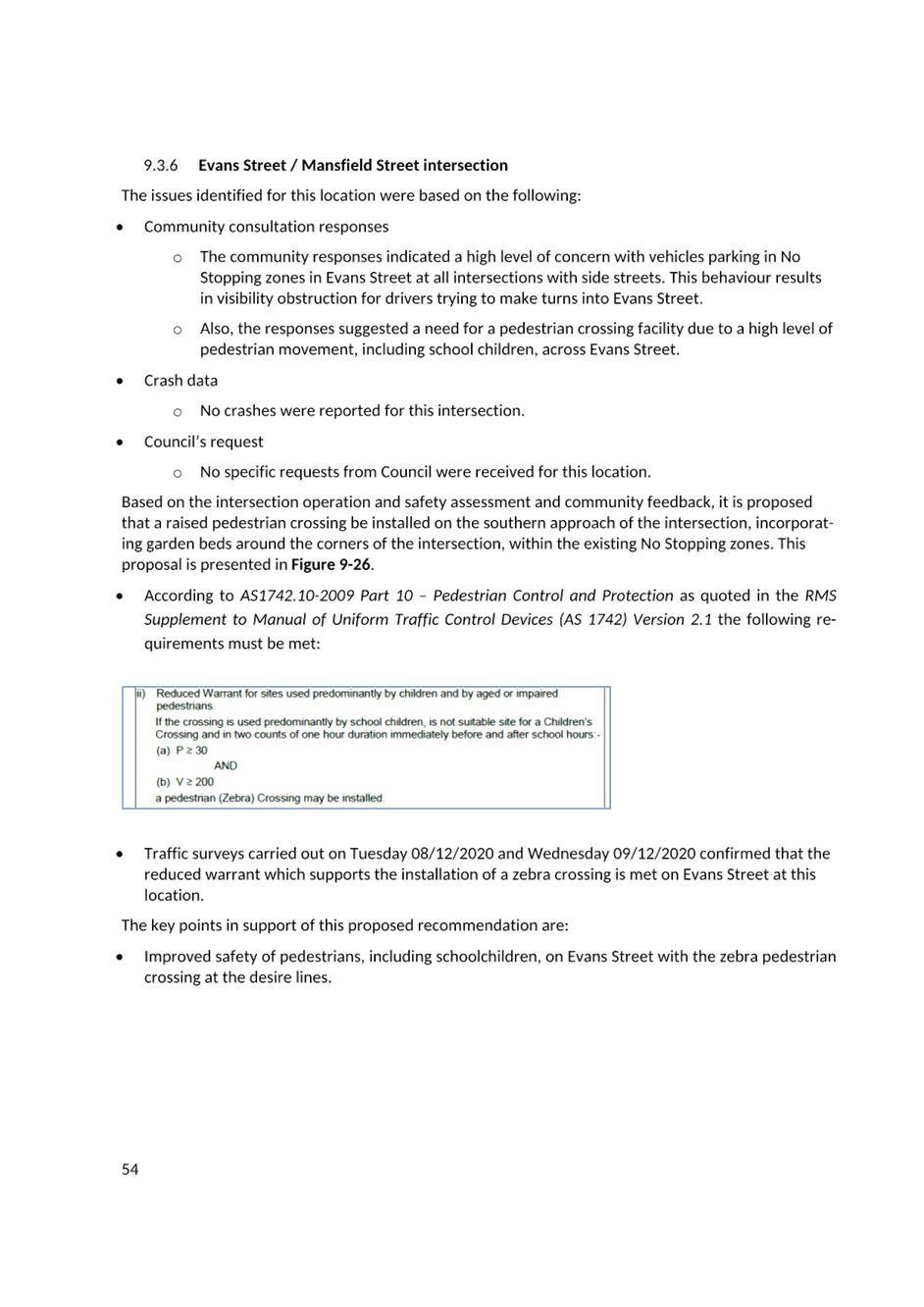
3. That a raised pedestrian (zebra) crossing be installed at Evans Street between Napoleon Street and Mansfield Street.
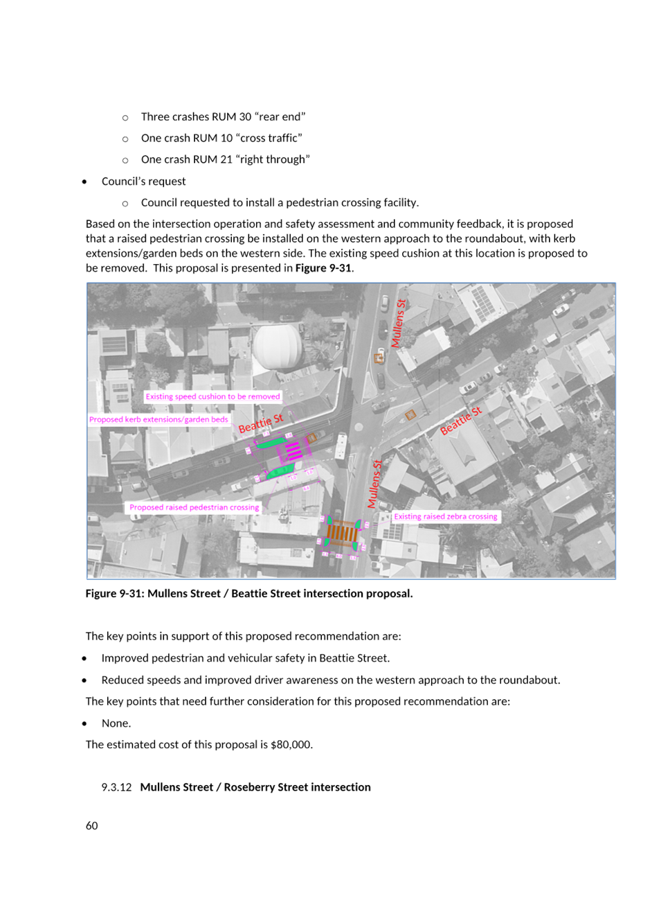
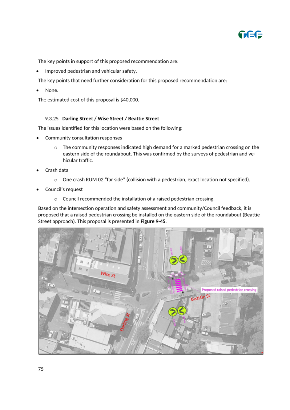
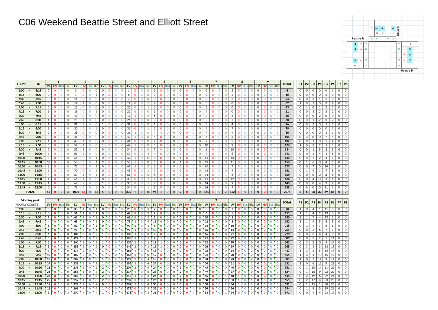
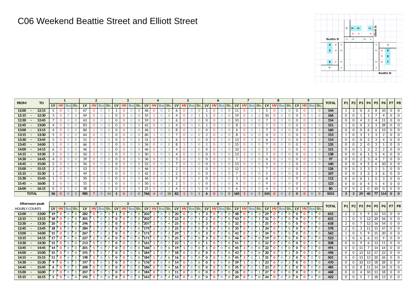
4. That a raised pedestrian (zebra) crossing be installed at Beattie Street west of Mullens Street.
5. That a raised pedestrian (zebra) crossing be installed at Beattie Street east of Darling Street.
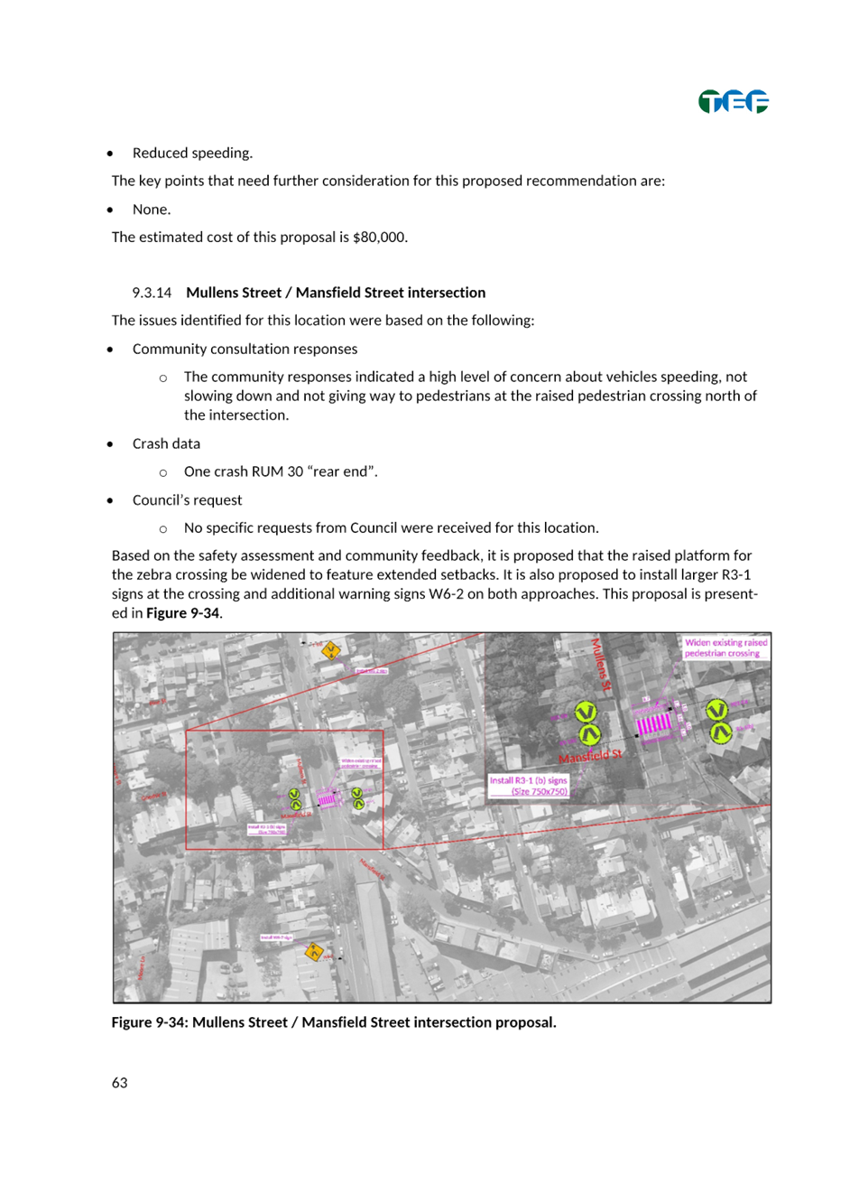
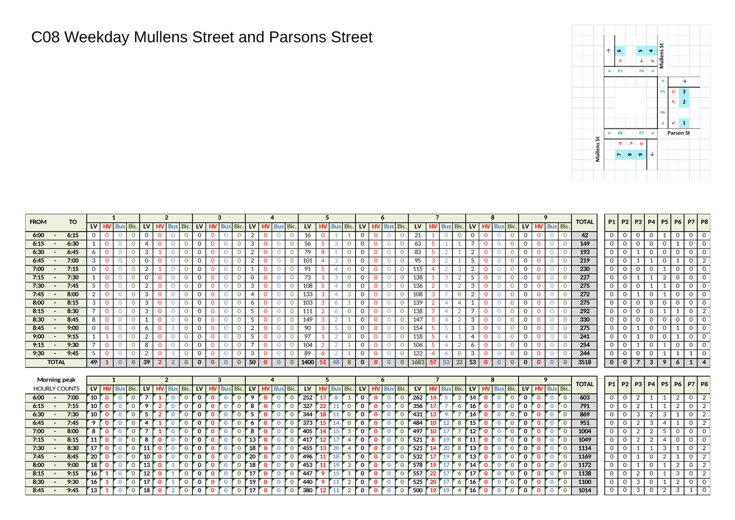
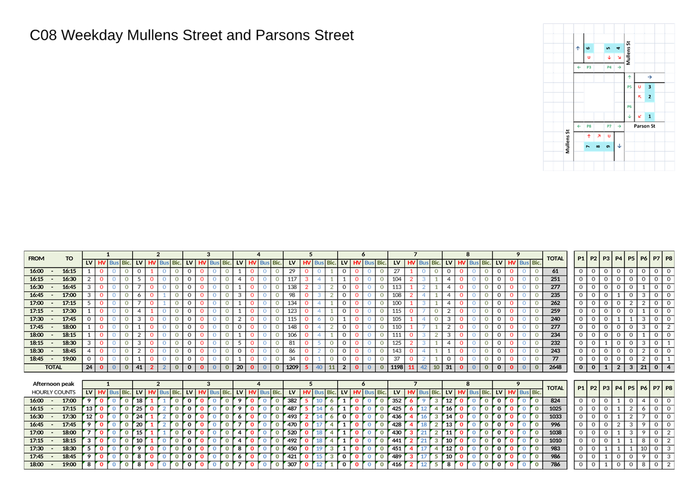
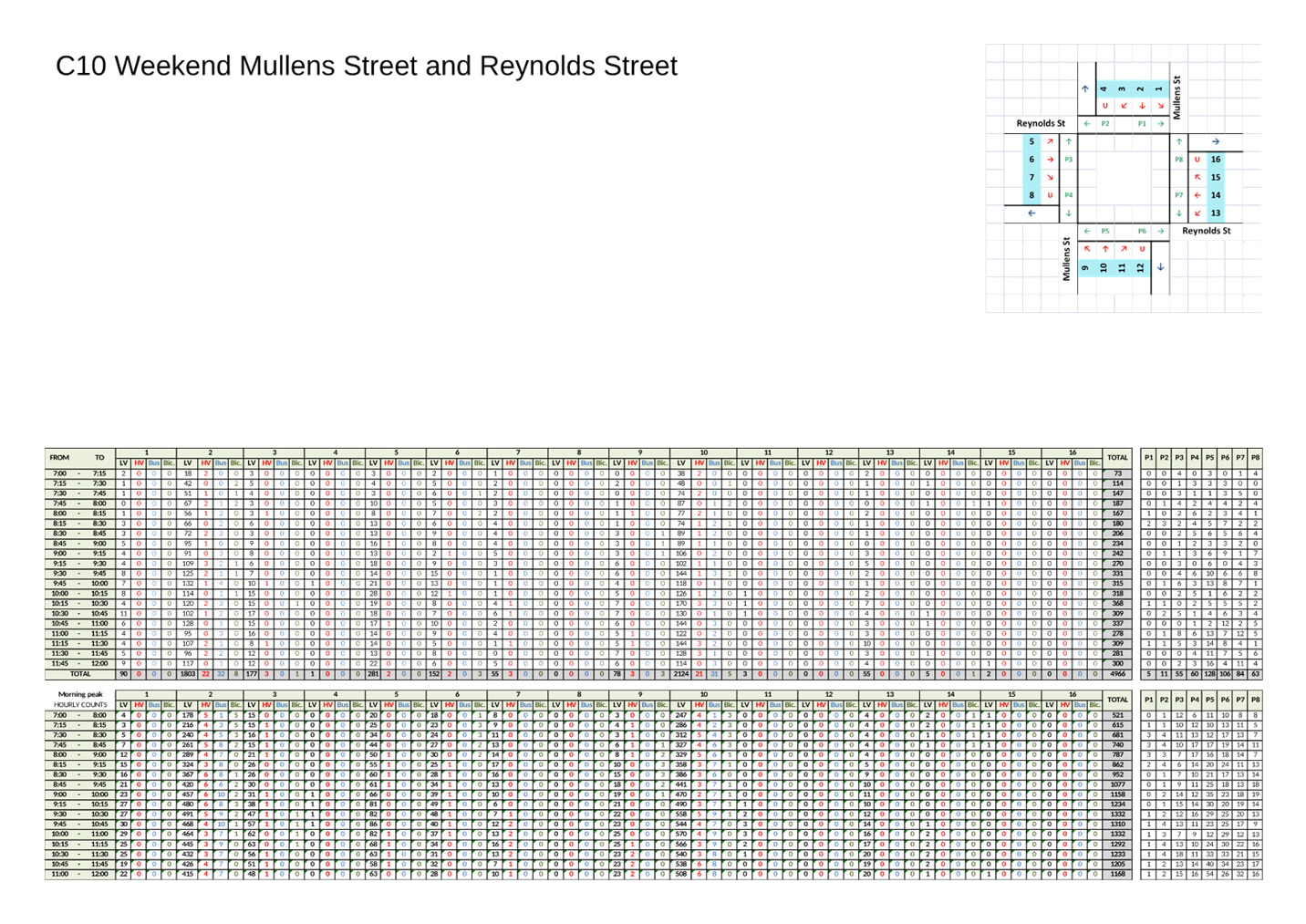
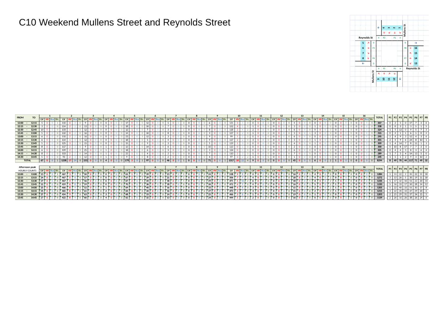
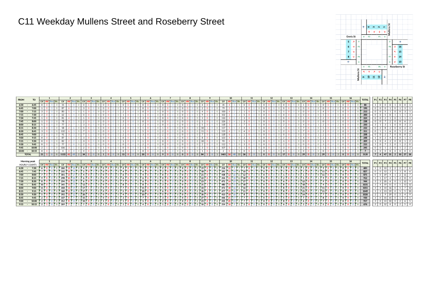
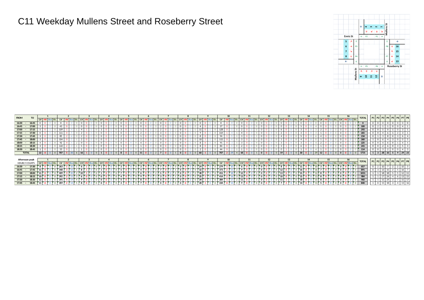
6. That the existing raised pedestrian (zebra) crossing in Mullens Street north of Mansfield Street be upgraded.
7. That the existing raised pedestrian (zebra) crossing in Mullens Street north of Reynolds Street be upgraded and investigate opportunity to incorporate cyclists’ crossing into the design.
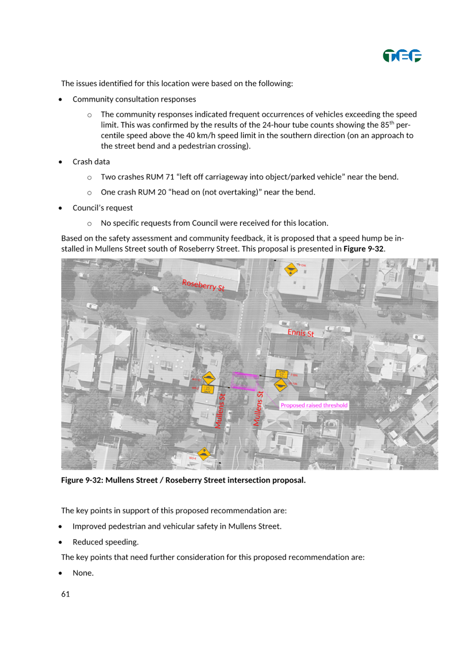
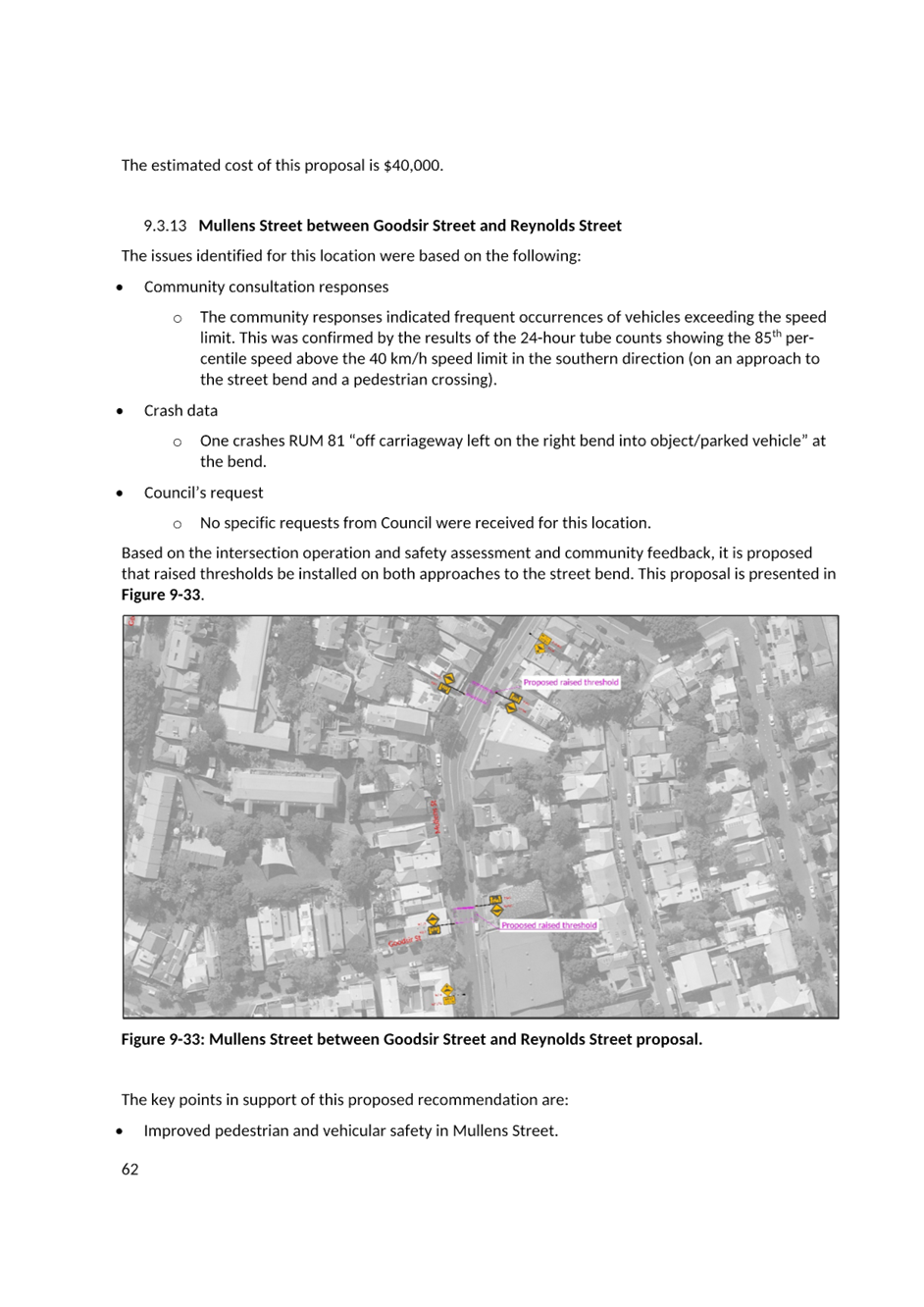
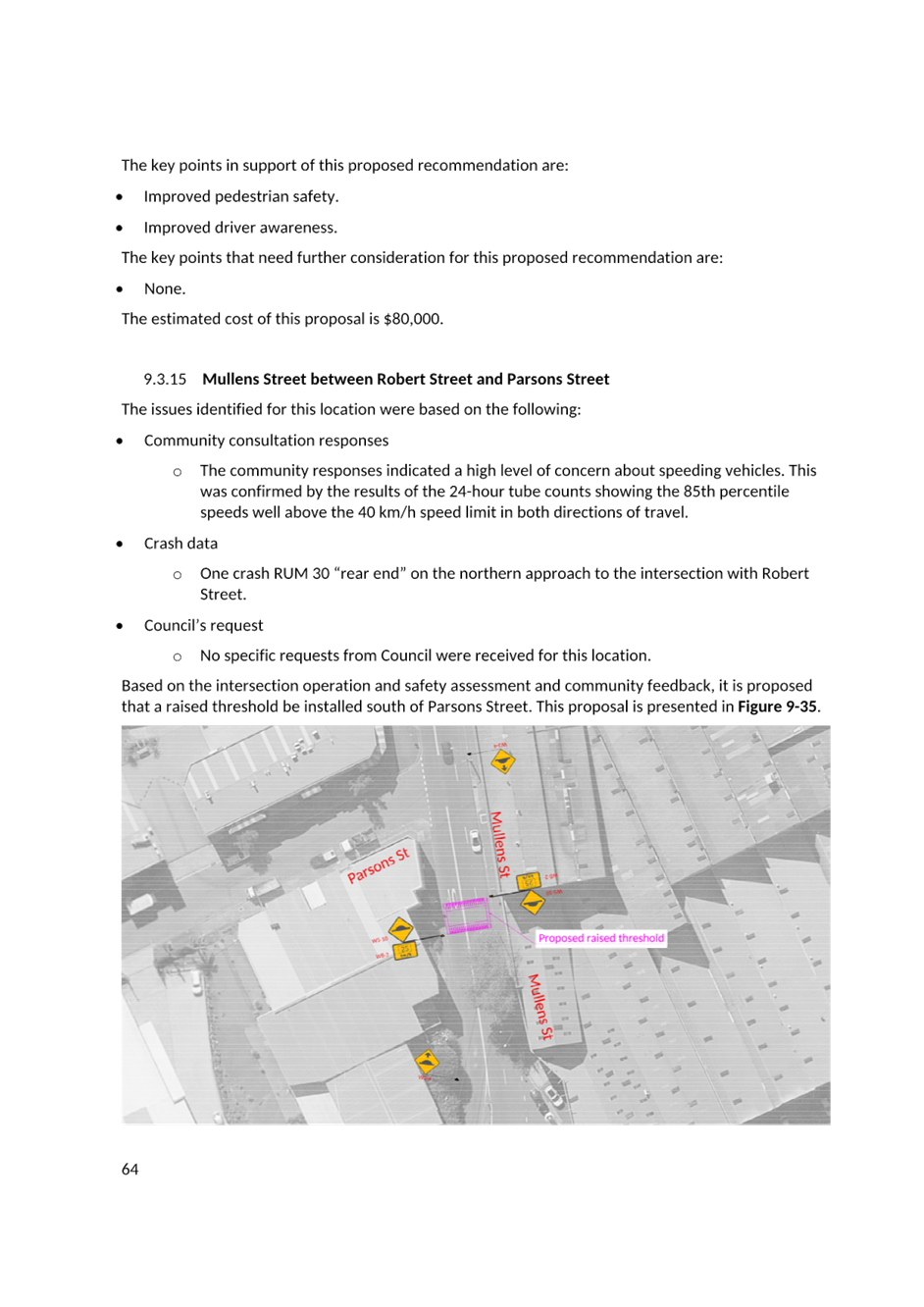
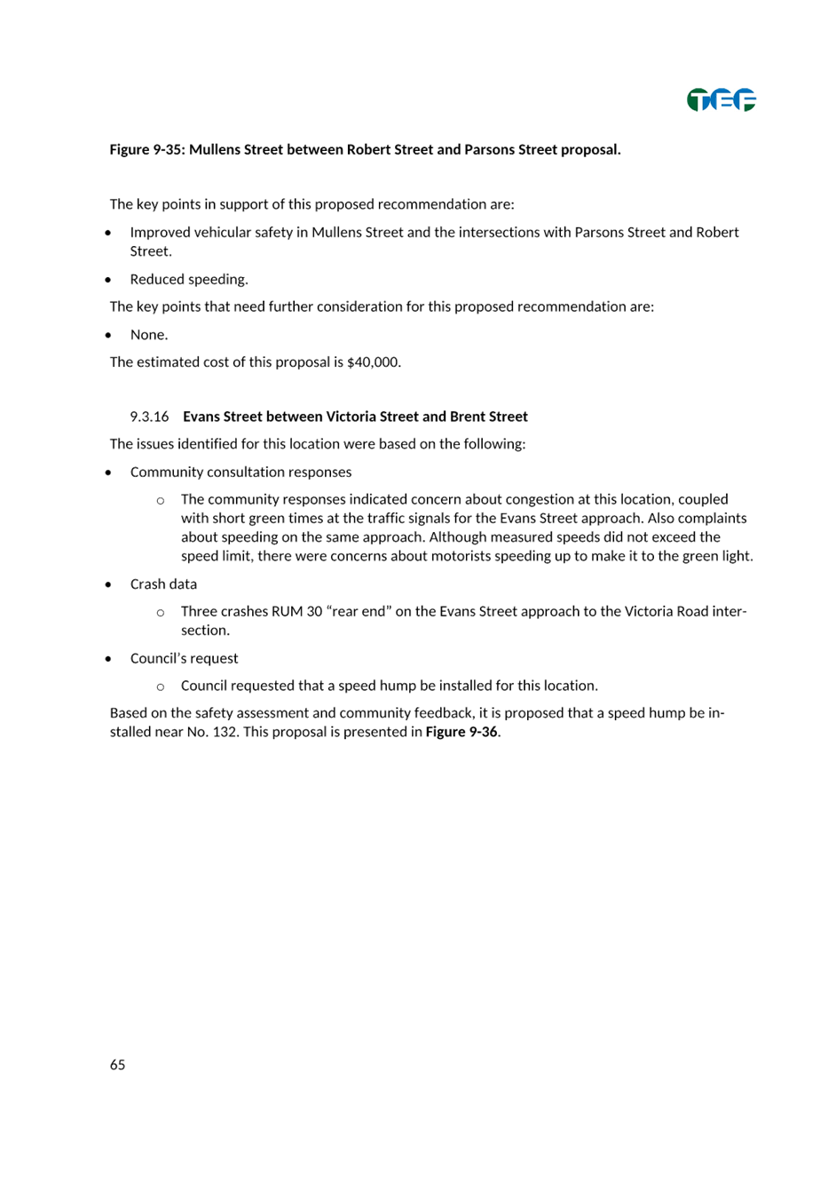
8. That a raised threshold be installed in: a) Mullens Street south of Roseberry Street; b) two raised thresholds be installed in Mullens Street between Goodsir Street and Reynolds Street; c) Mullens Street south of Parsons Street; d) Darling Street between Norman Street and Thornton Street; and e) Darling Street between Young Street and Hampton Street
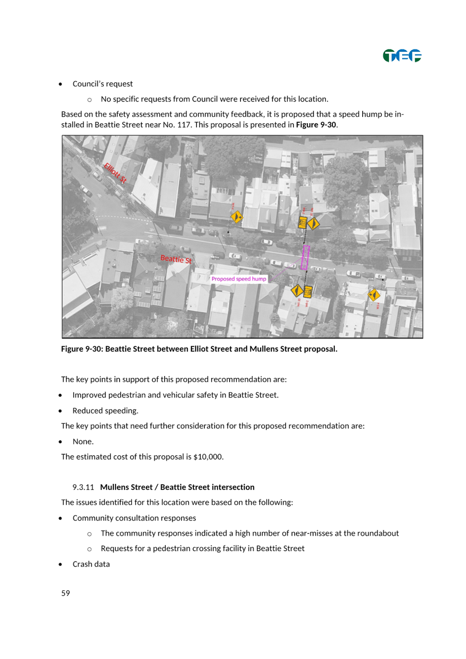
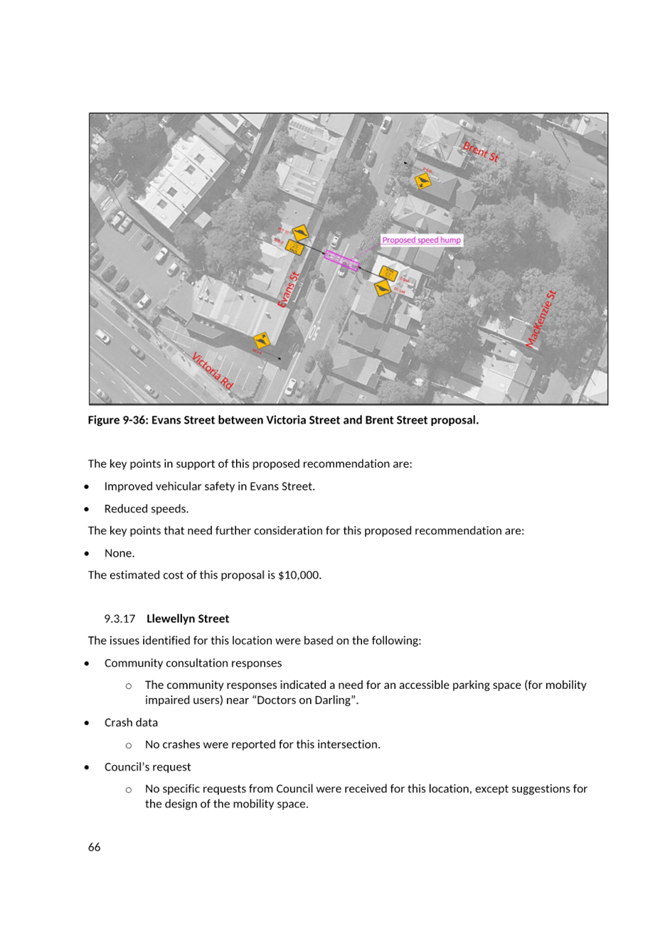
9. That a speed hump be installed in: a) Beattie Street between Elliott Street and Mullens Street; b) Evans Street between Brent Street and Victoria Road and; c) Beattie Street between Ewell Street and Wisbeach Lane.
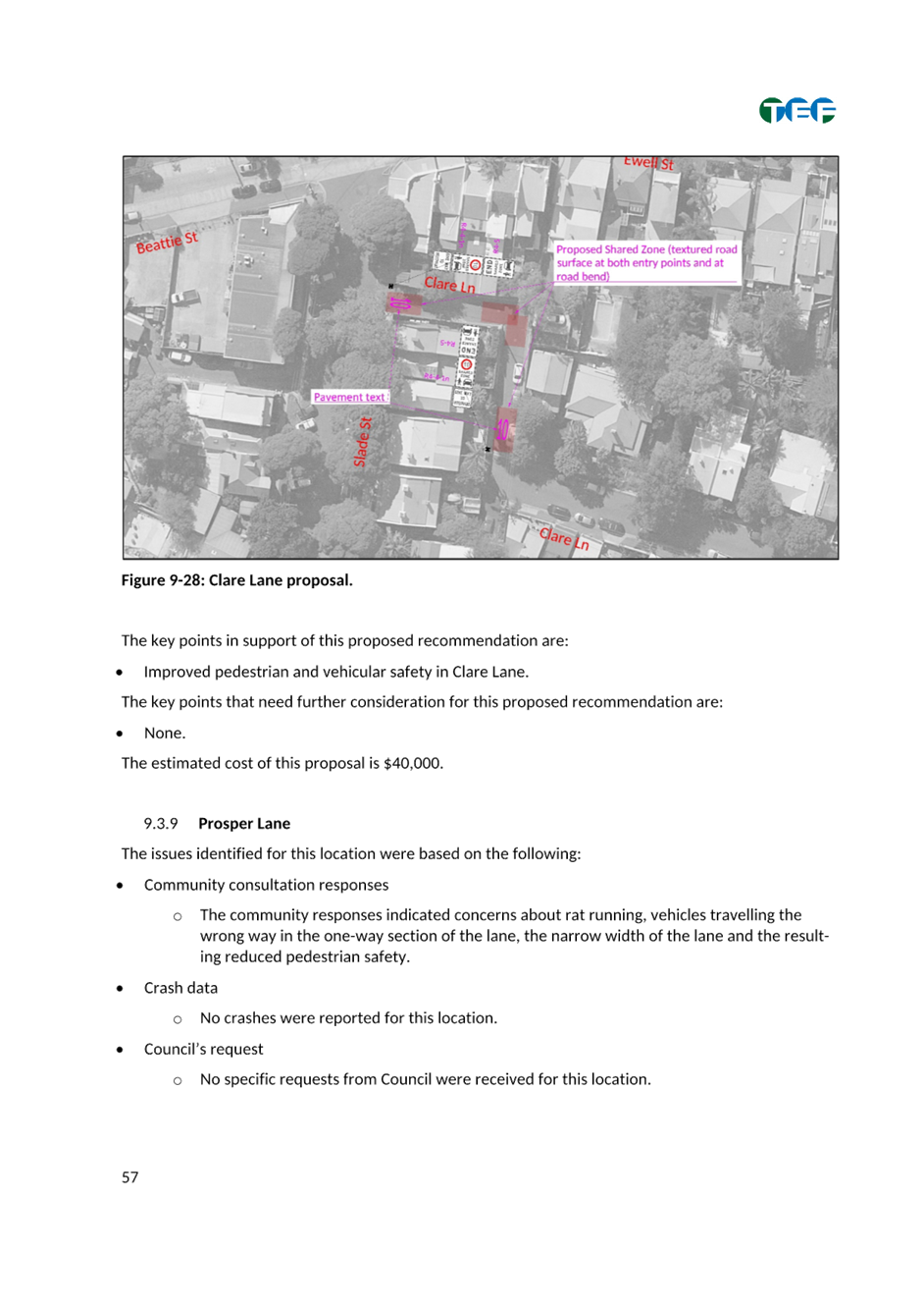
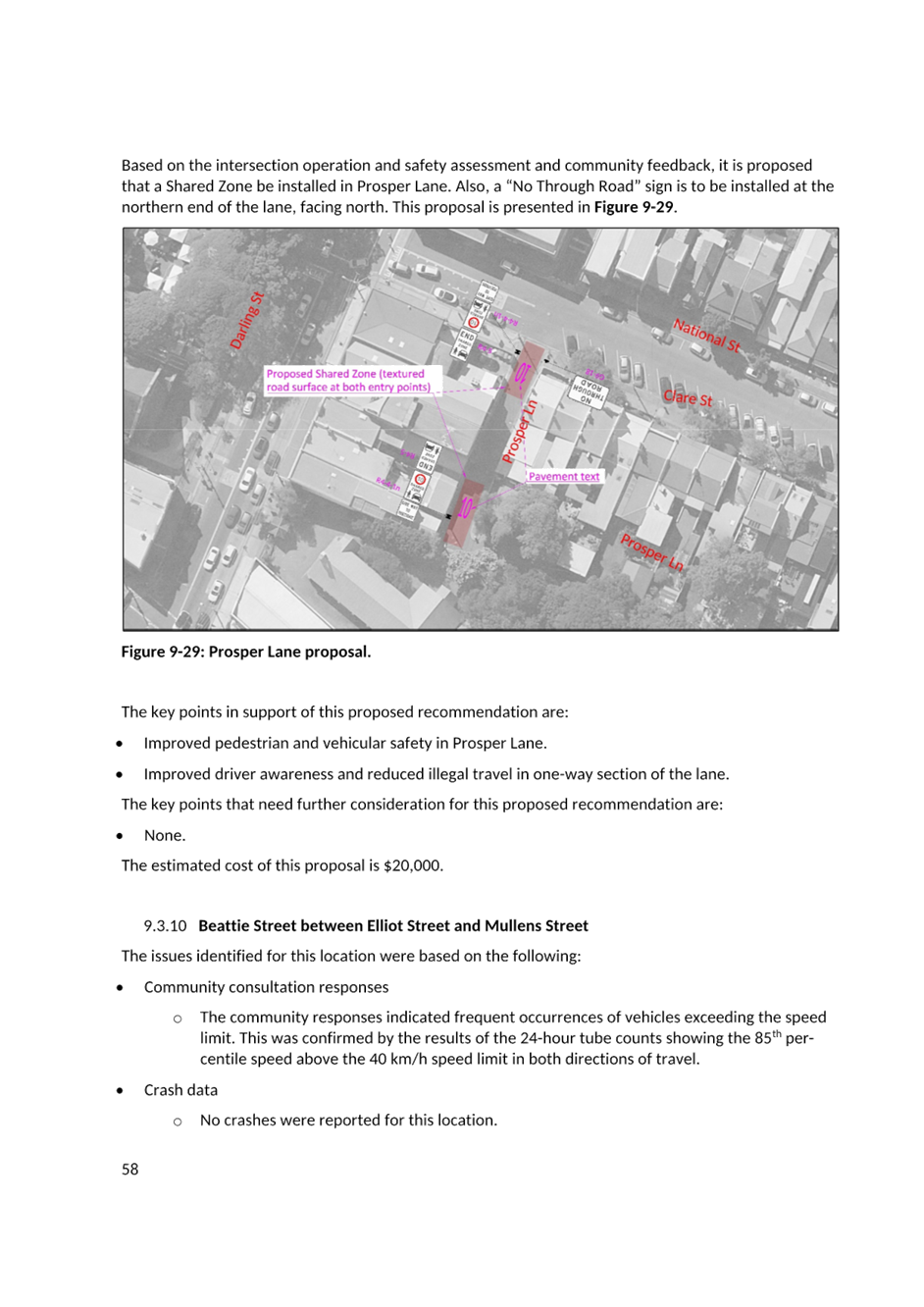
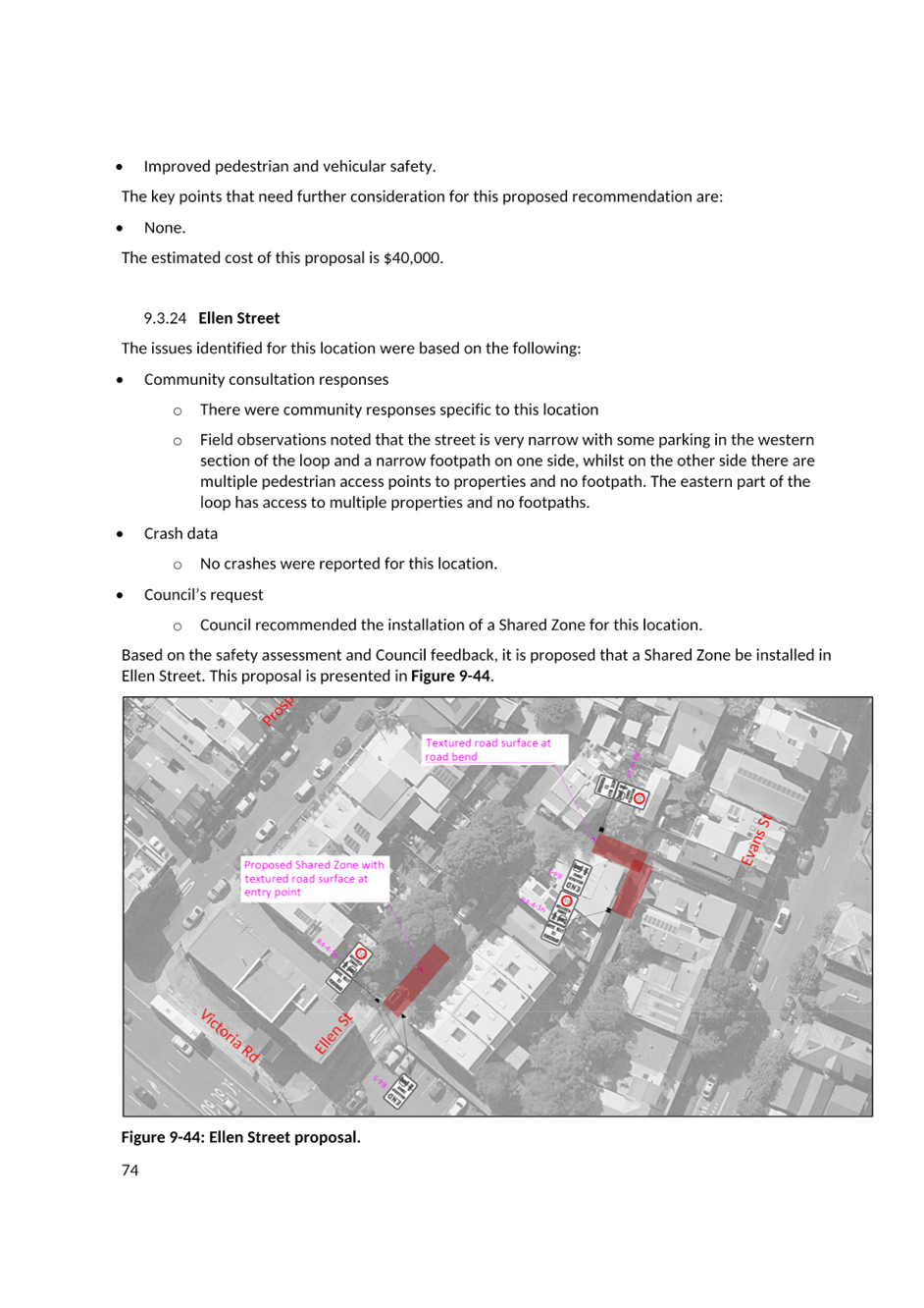
10. That subject to TfNSW approval, a 10 km/h Shared Zone be installed in: a) Clare Lane, Balmain; b) northern section of Prosper Lane, Rozelle and; c) Ellen Street, Rozelle.
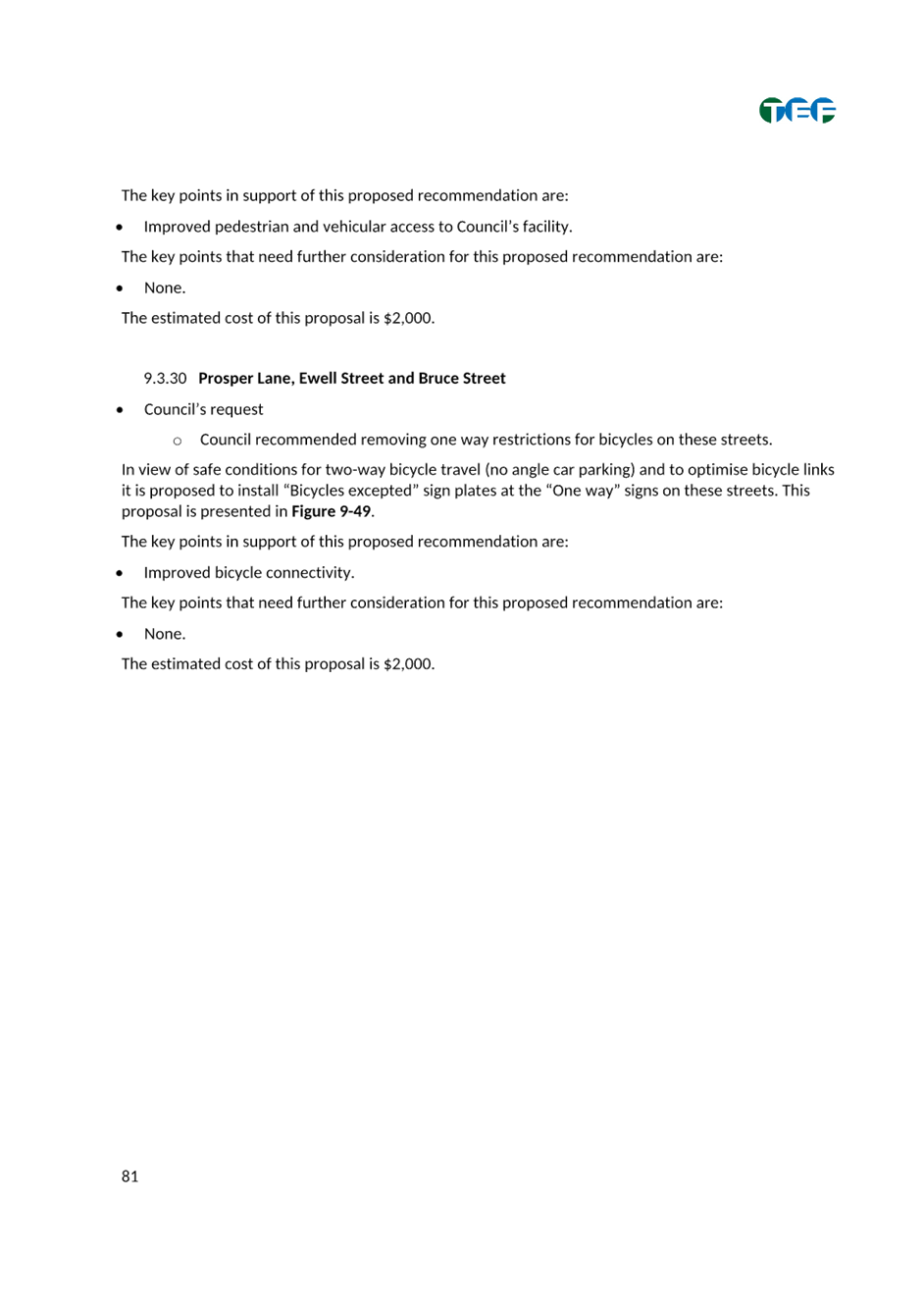
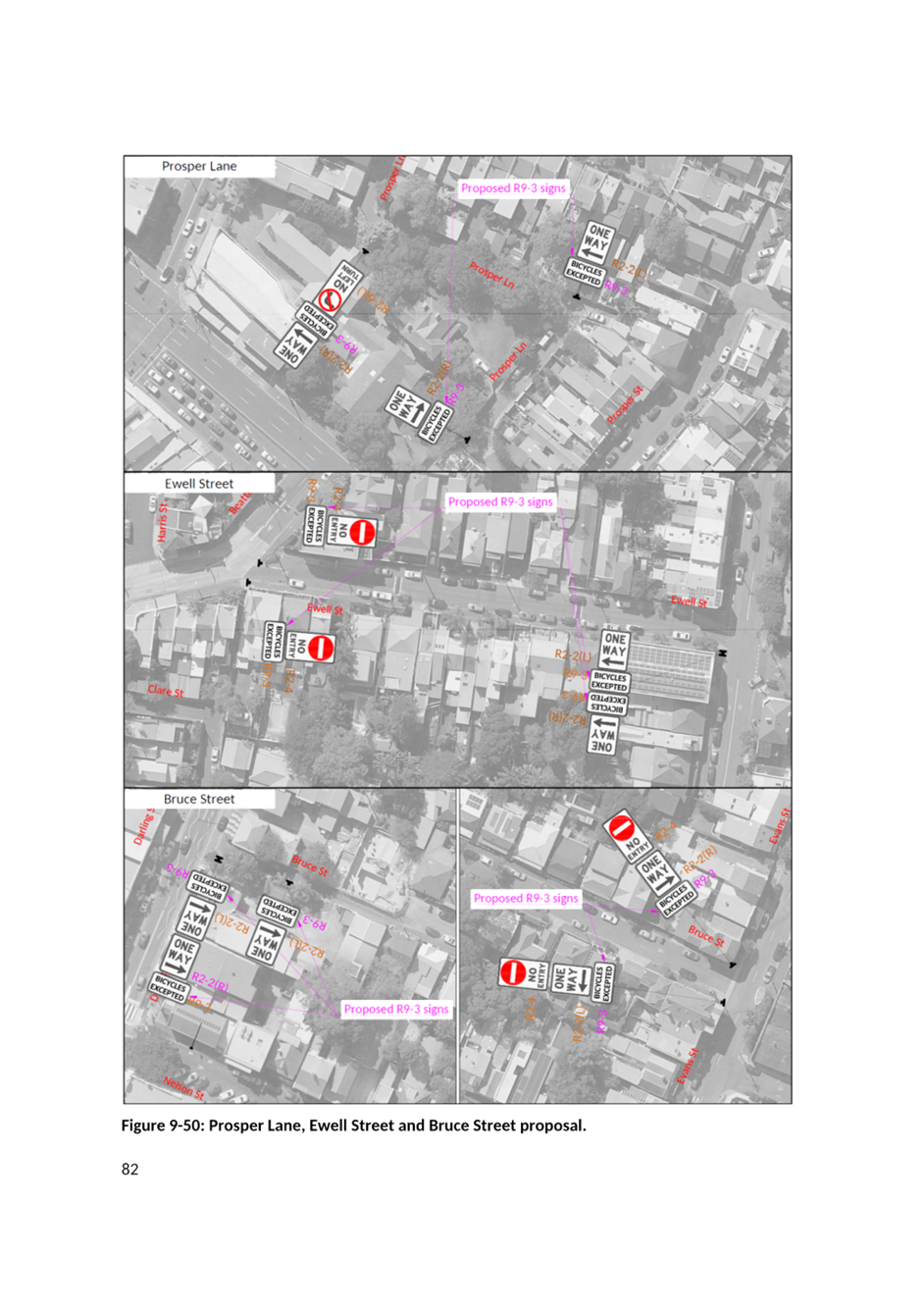
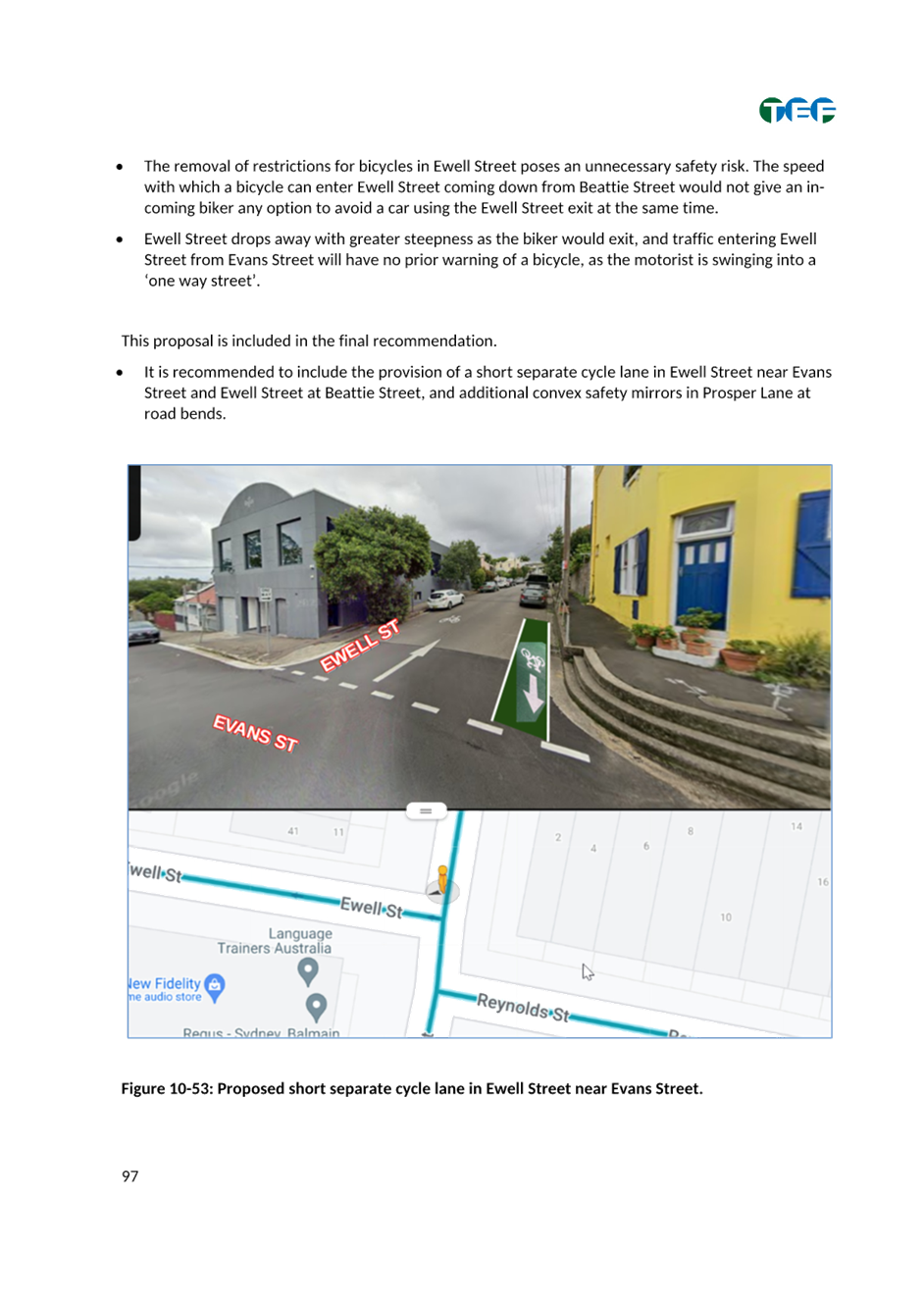
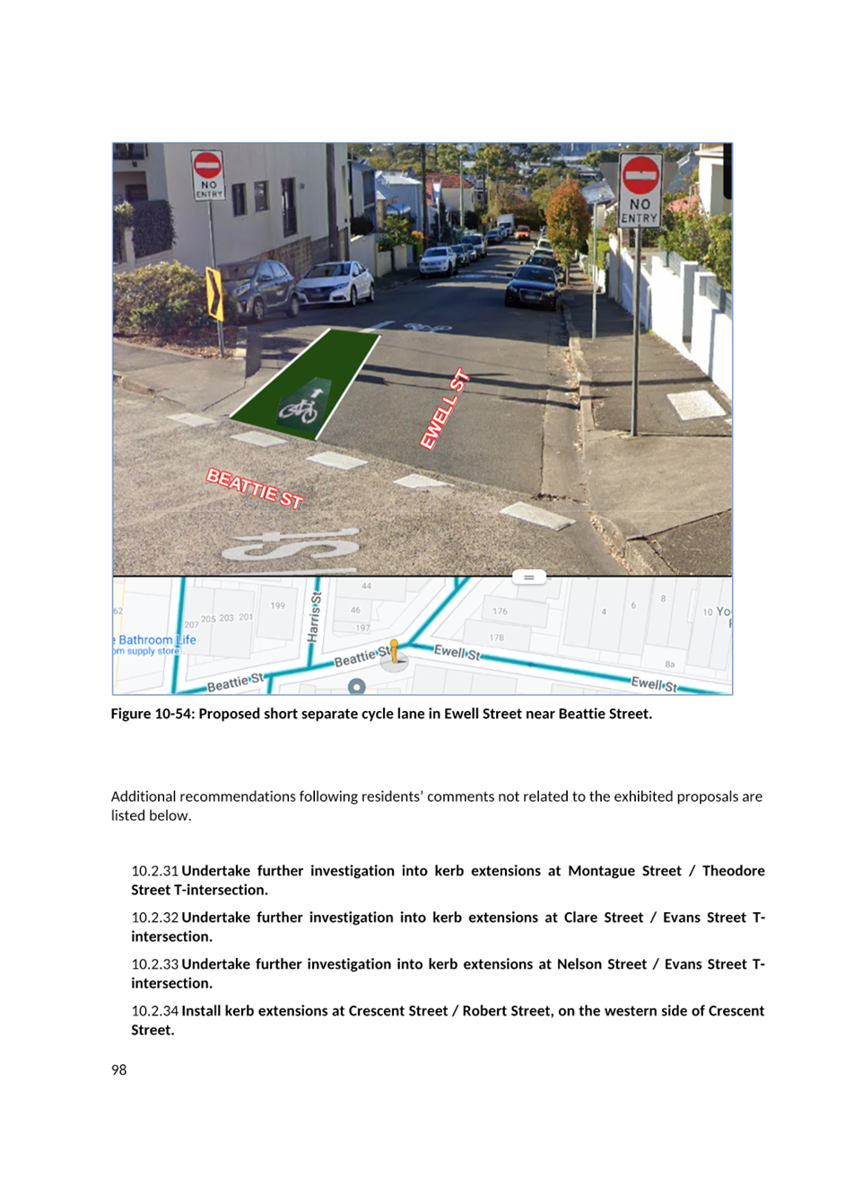
11. That Council install ‘Cyclists Excepted’ signposting in the one-way streets of Prosper Lane, Ewell Street and Bruce Street including convex safety mirrors in Prosper Lane road bends and short sections of linemarked contra flow lanes at each end of Ewell Street.
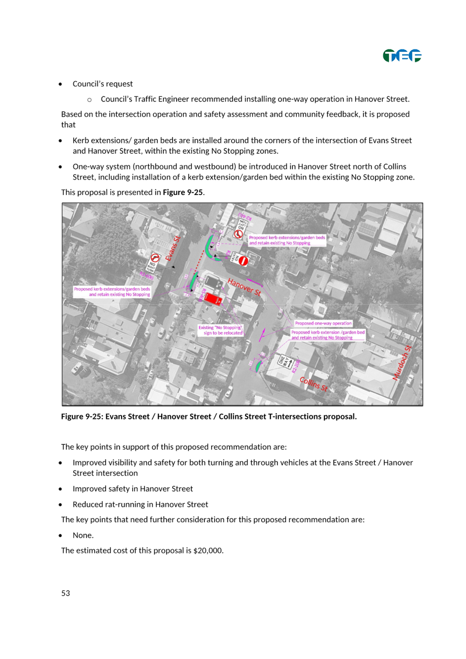
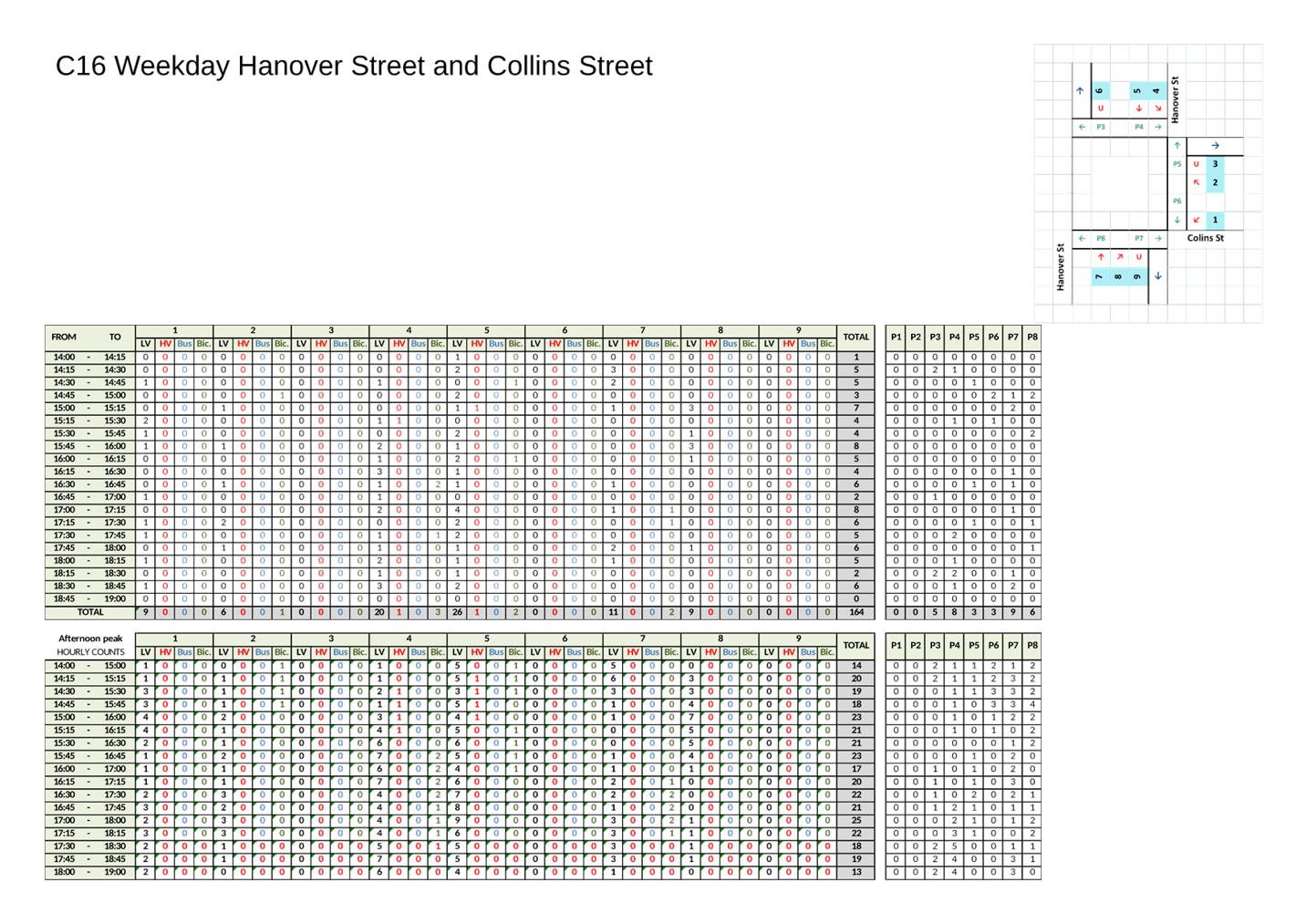
12. That subject to TfNSW approval, one way counter clockwise traffic flow be introduced in Hanover Street north of Collins Street (Collins Street to Evans Street) including kerb extensions at Evans Street/Hanover Street and Hanover Street north of Collins Street.
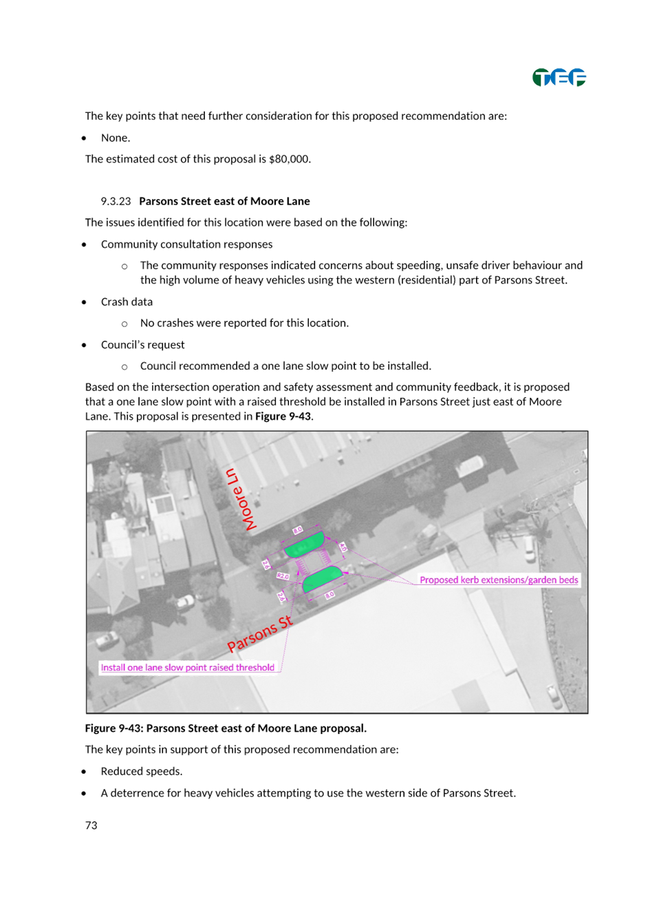
13. That Council install a one lane slow point in Parsons Street east of Moore Lane.
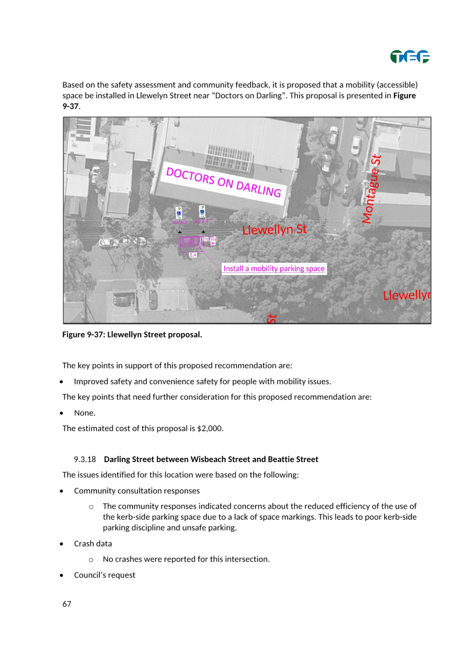
14. That Council install a mobility parking space on the northern side of Llewellyn Street west of Montague Street.
15. That Council install rumble strips at Mansfield Street/Crescent Street intersection and remark intersection linemarking.
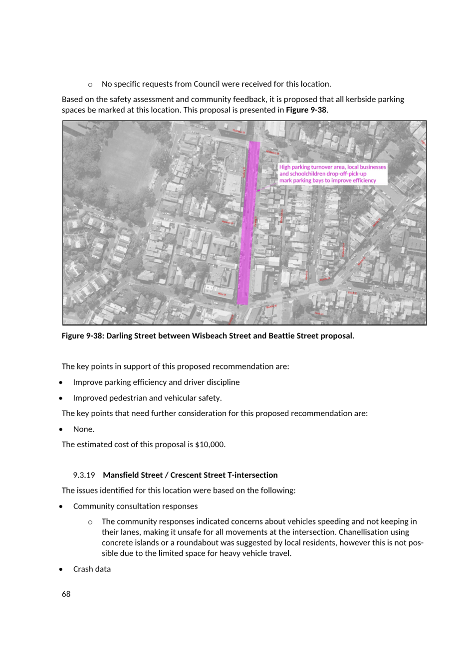
16. That Council linemark parking bays in Darling Street between Wisbeach Street and Beattie Street.
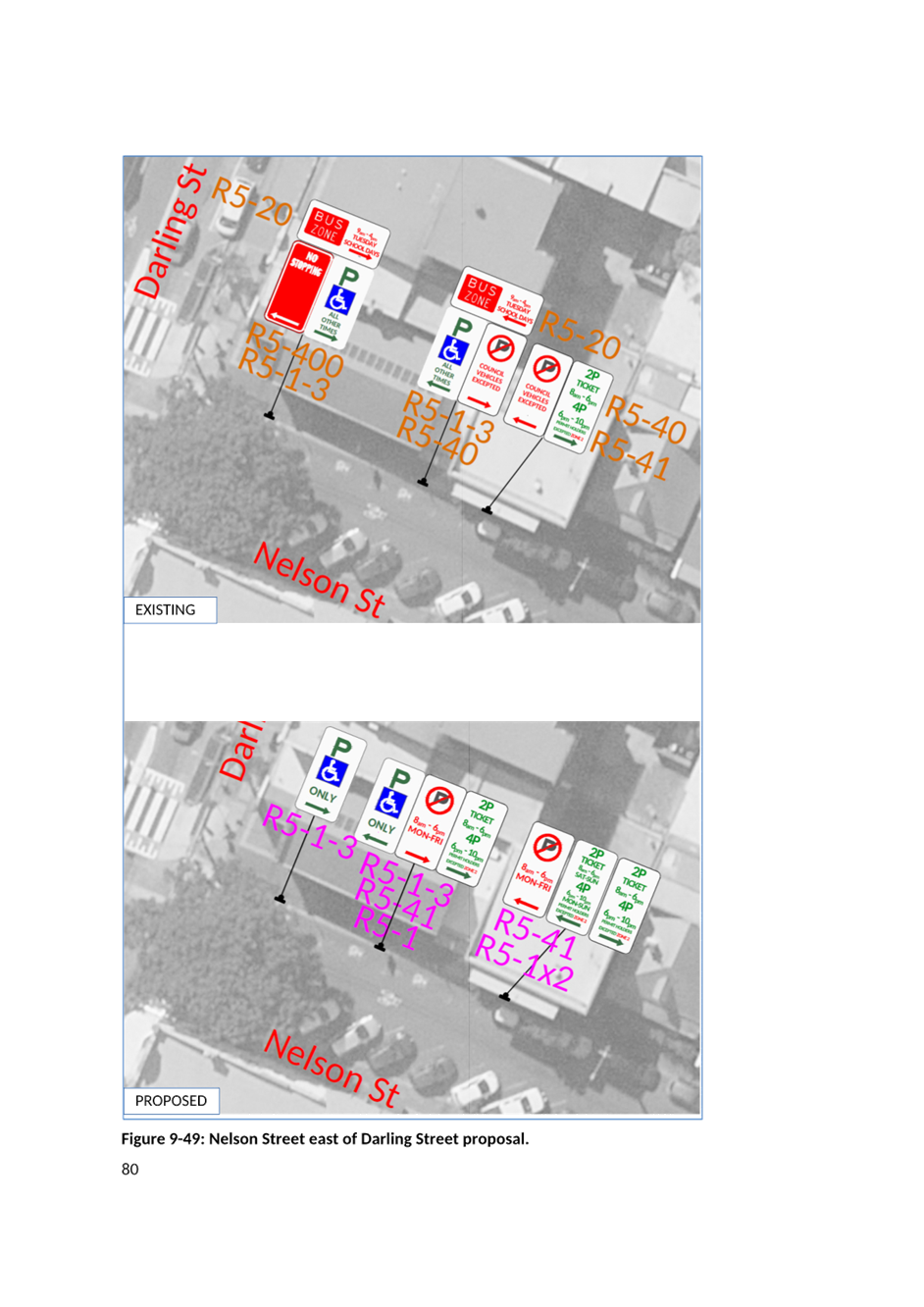
17. That Council modify on street parking along the frontage of Hannaford Centre in Nelson Street to improve access for visitors.
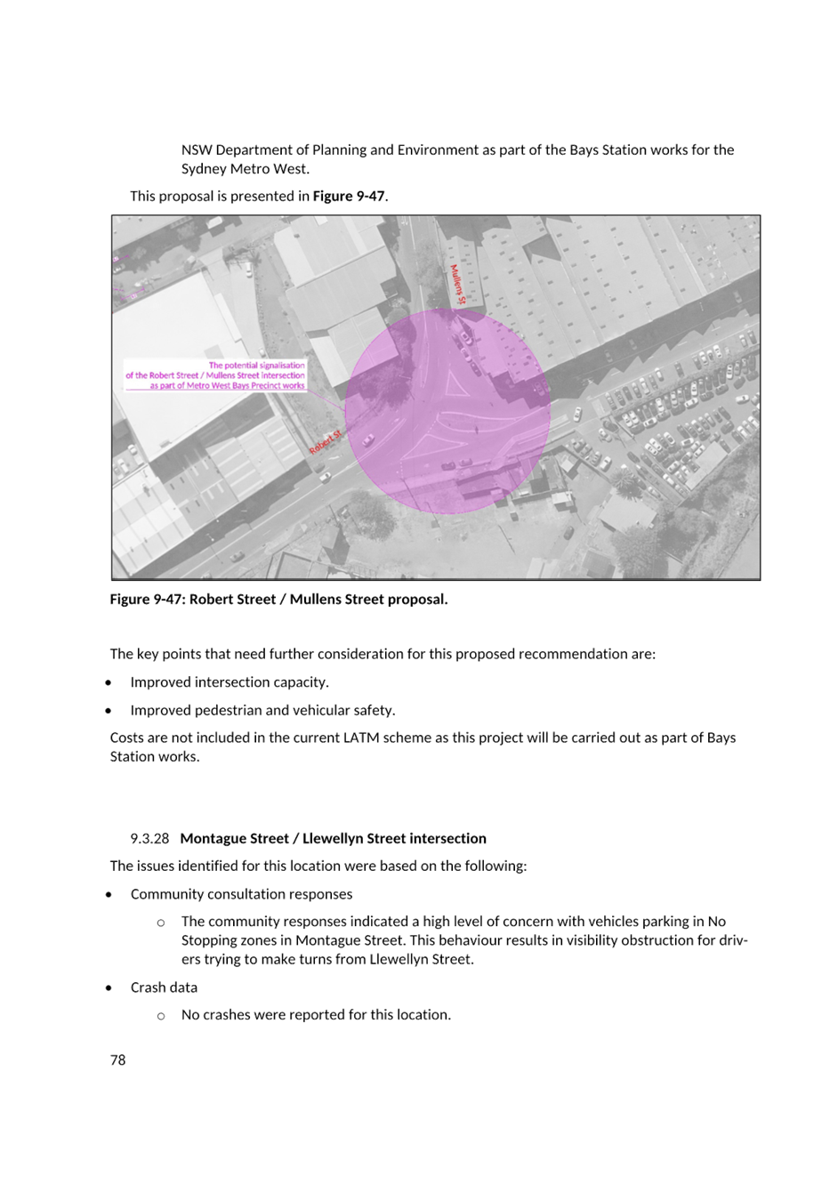
18. That Council support for further investigation of traffic signals at Robert Street/Mullens Street intersection. |
STRATEGIC OBJECTIVE
This report supports the following strategic directions contained within Council’s Community Strategic Plan:
|
2: Liveable, connected neighbourhoods and transport |
|
|
EXECUTIVE SUMMARY
This is a recommendation to endorse the findings of the Final Balmain LATM Study report. Council has recently undertaken Public Exhibition of the Final Draft Balmain LATM Study through Yoursay Inner West.
The response results indicate that the community generally supported all the proposed changes.
After considering the Public Exhibition feedback, a review on the proposed scheme was undertaken with minor adjustments made to the LATM Study recommendations and some additional recommendations added.
The recommended treatments will be included for consideration for funding in Council’s Capital Works Programs and State Government Funding Programs where possible.
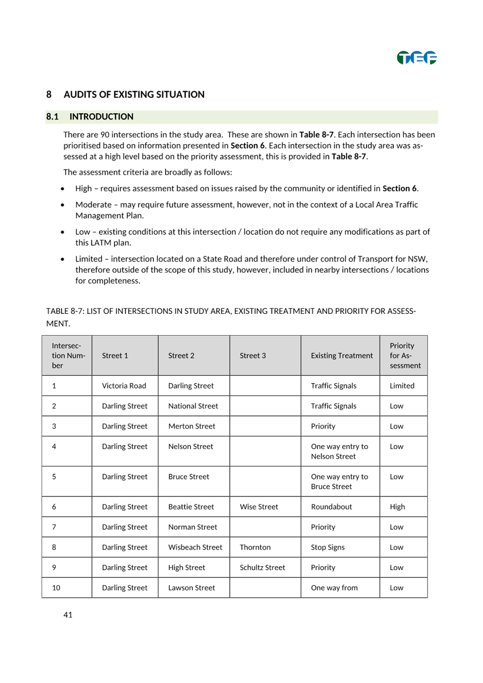
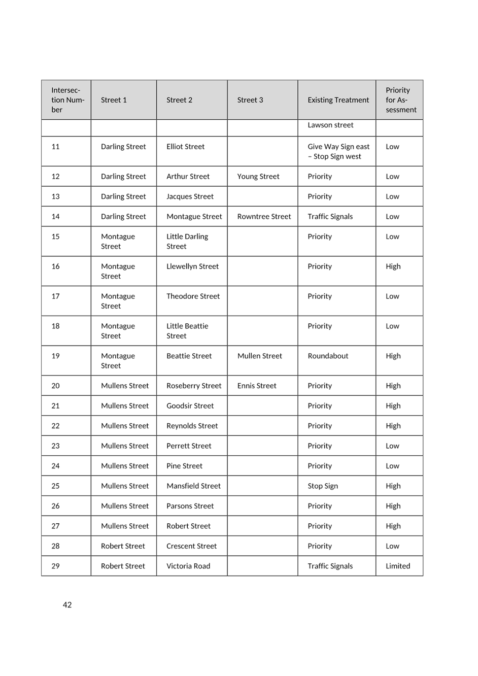
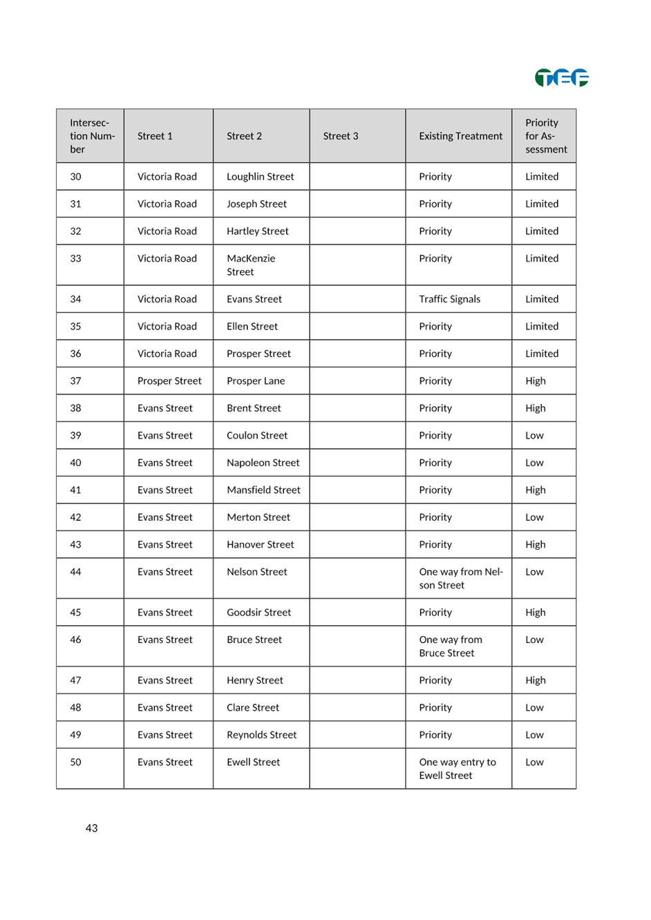
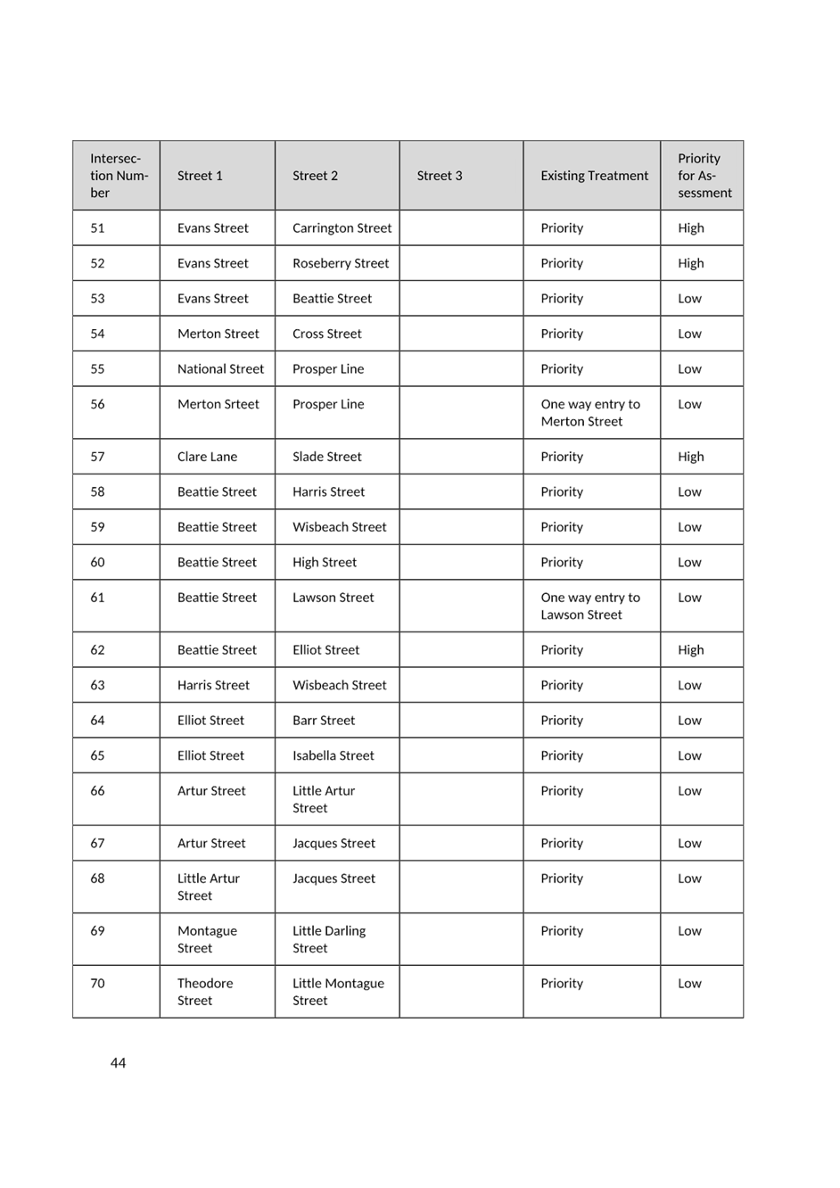
BACKGROUND
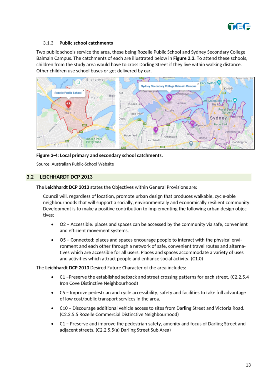
As part of Council’s Local Area Traffic Management (LATM) Strategy Review Program, Council engaged TEF Consulting to prepare the Balmain LATM study.
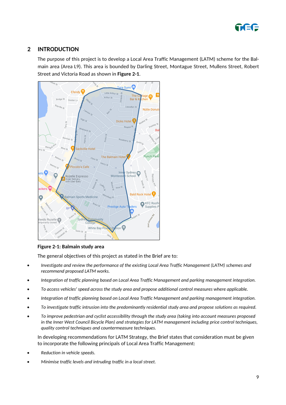
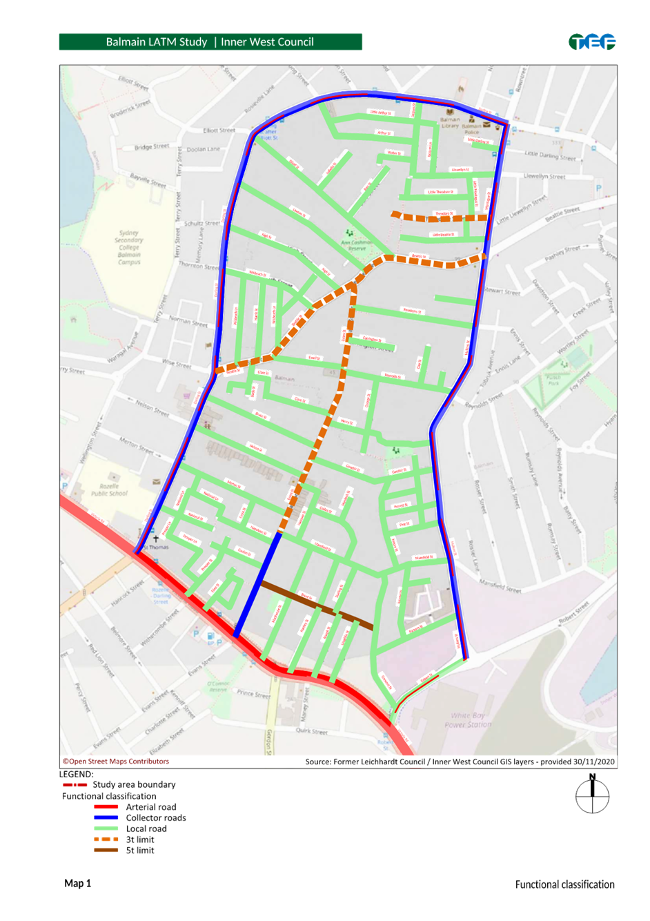
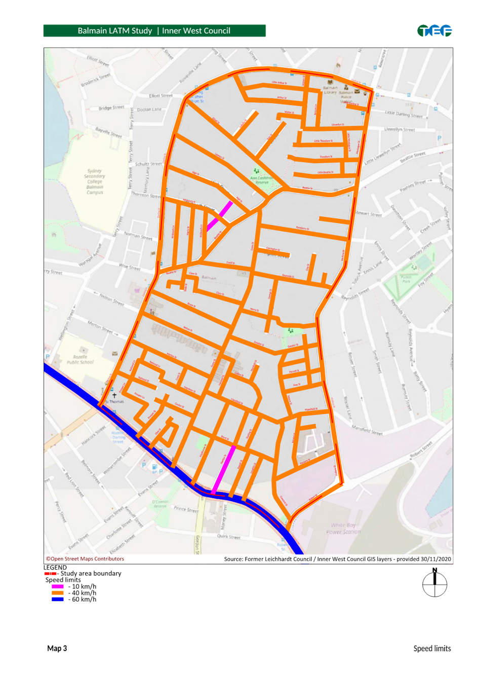
The Balmain LATM (area L9) precinct is bounded by Darling Street, Mullens Street, Montague Street, Robert Street and Victoria Road.
The
objective of the study is to reduce traffic volumes and speeds in local streets
to increase liveability and improve safety and access for pedestrians and
cyclists. It also includes a review of the original LATM Study which was
completed in the year 2000.
The map of the study area is included in a copy of the final report as provided in Attachment 1.
PUBLIC CONSULTATION
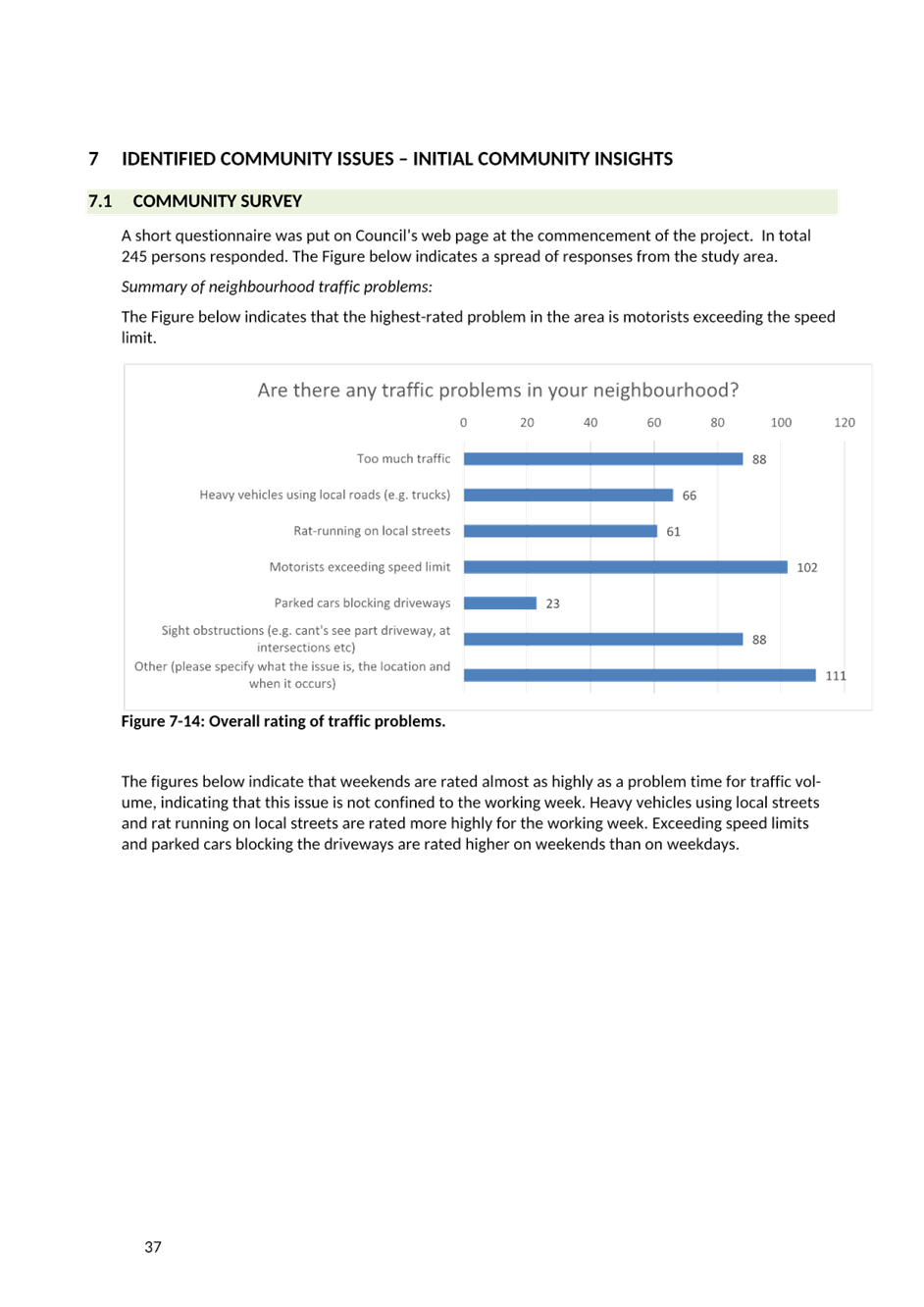
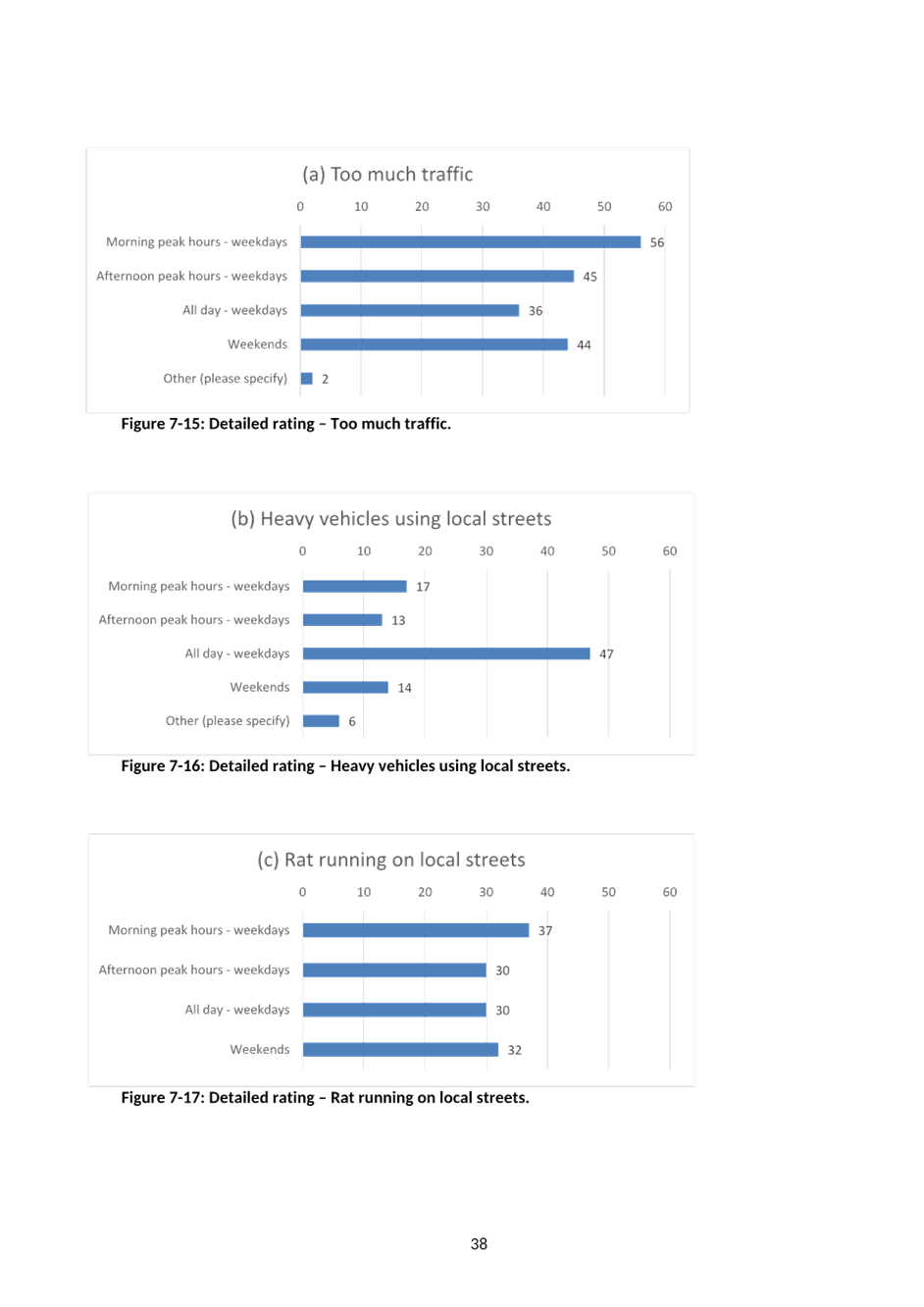
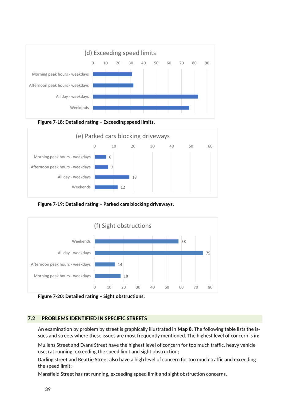
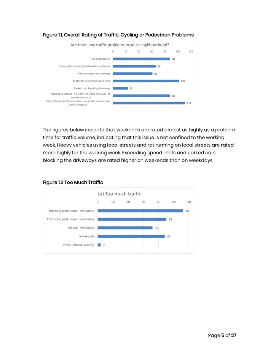
Council undertook an initial survey through Council’s Yoursay website in October/November 2020 with invitation letters mailed out to stakeholders and residents within the study area to determine existing issues and ideas in the study area. A total of 245 responses were received.
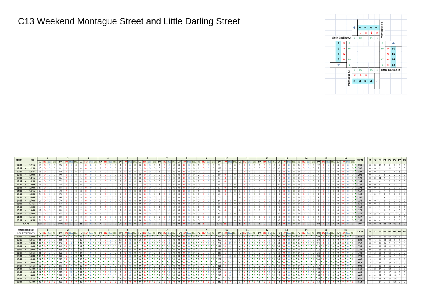
The main outcomes of the first stage of consultation are that residents were concerned with excessive speeding, followed by too much traffic and sight obstructions.
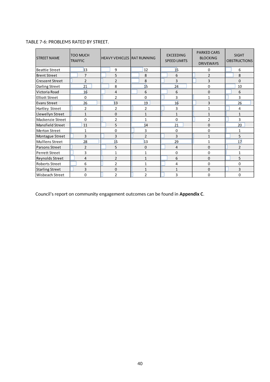
In regard to particular streets, Mullens Street and Evans Street have the highest level of concern for too much traffic, heavy vehicle use, rat running, exceeding the speed limit and sight obstruction.
Darling Street and Beattie Street also have a high level of concern for too much traffic and exceeding the speed limit whilst Mansfield Street has rat running, exceeding speed limit and sight obstruction concerns.
The final draft report was placed on public exhibition in May 2023. A total of 500 visitors accessed the Yoursay website material of which 35 contributions were made. An additional 10 emails were received regarding the final draft report during the public consultation period.
All the recommendations noted in the final draft report have been included in the final report with some adjustments. Some additional recommendations are also included.
The Engagement Outcomes Report is included in Attachment 1.
FINANCIAL IMPLICATIONS
The financial implications applicable to the implementation of the proposed recommendations.
The cost of proposed treatments as listed in the draft report placed on public exhibition was estimated to cost approximately $1,037,300 (including GST). The final report includes recommendations totalling $1,075,800 (including GST). This includes the additional costs associated with the additional recommendations/modifications.
This cost takes into consideration 10% contingency. Once the LATM Study is adopted, detailed design and construction would be undertaken in stages as prioritised commencing from the 2024/2025 year.
The cost to implement the Balmain LATM Study will be funded from Council’s traffic facilities budget, subject to Local Traffic Committee support and adoption by Council. Subsequent reports during implementation of the recommendations of the study will provide further detailed plans if required.
|
1.⇩ |
Balmain LATM Final Report |
|
Local Traffic Committee Meeting 18 September 2023 |
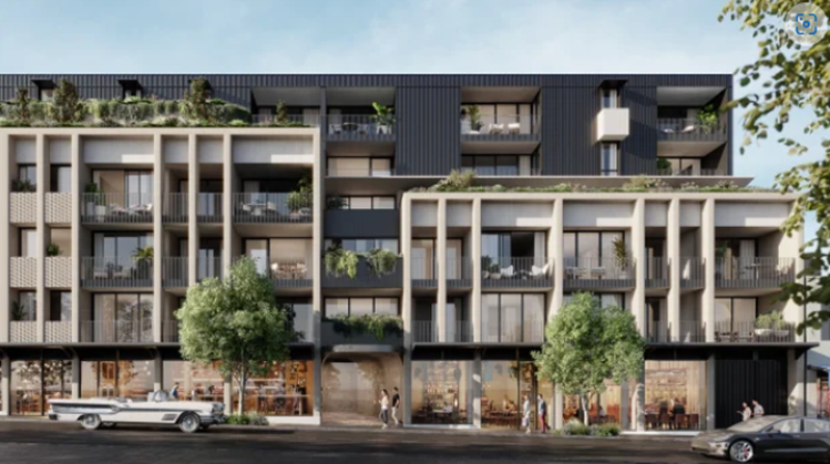
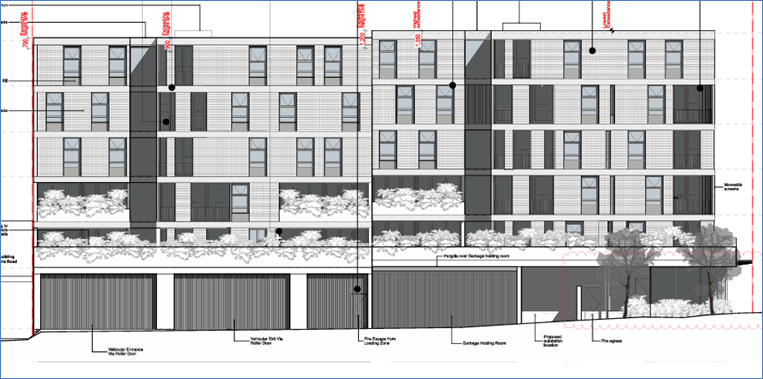
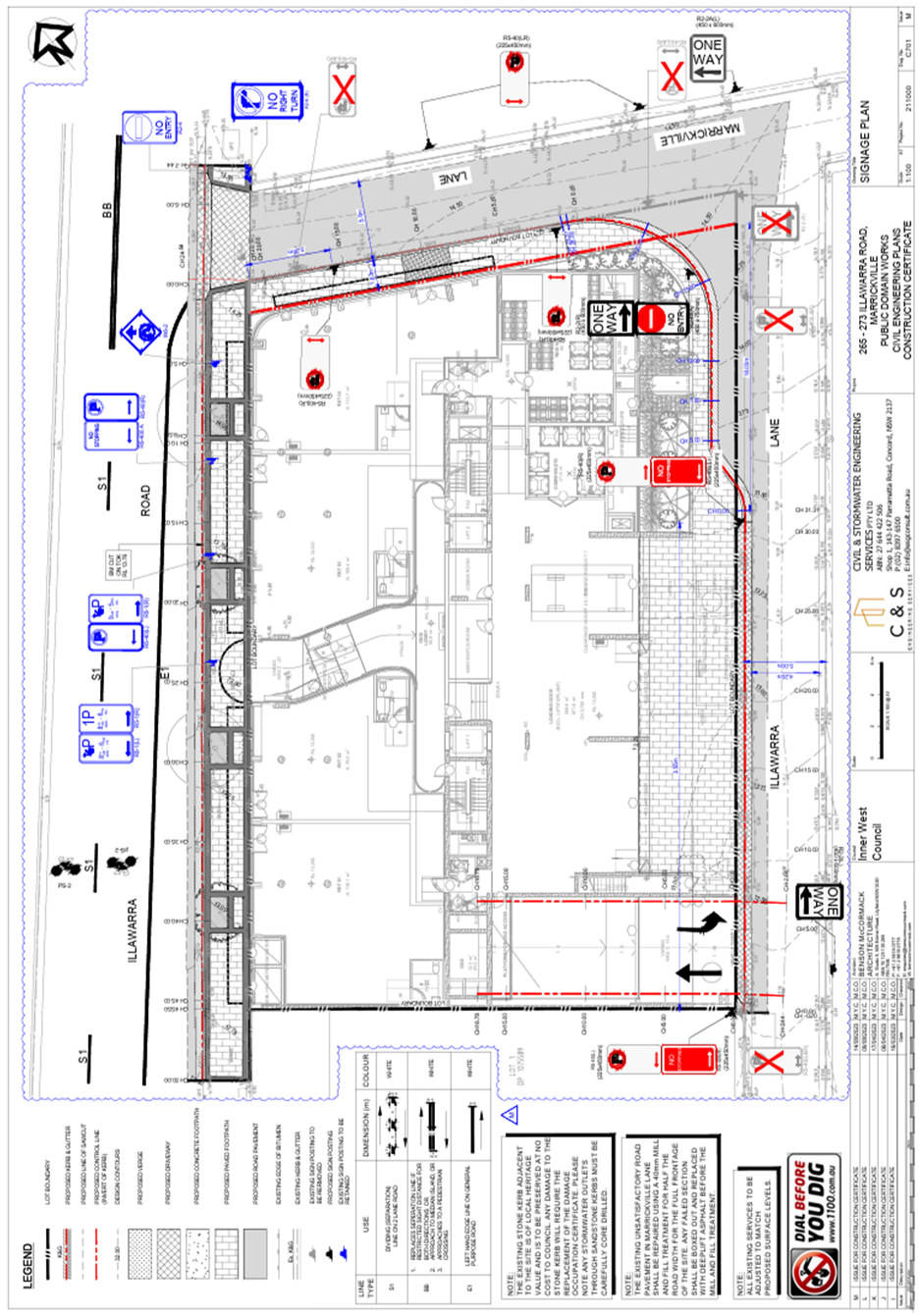
Subject: 265-273 Illawarra Road, Marrickville – ENR1/2022/0150 Condition 12 – Signs and Line Markings Plan – DA201700349 (Midjuburi - Marrickville Ward / Summer Hill Electorate / Inner West PAC)
Prepared By: Jennifer Adams - Traffic Engineer
Authorised By: Manod Wickramasinghe - Acting Director Infrastructure
|
RECOMMENDATION
1. That the detailed line marking and signage plan for the proposed 265-273 Illawarra Road development located on Illawarra Road south of Marrickville Lane and west of Illawarra Lane, Marrickville showing new ‘No Stopping’ restrictions (as per the attached Plan ESG211000.CIV.CC - 265 - 273 Illawarra Road Marrickville) be approved.
2. That the costs of the supply and installation of the associated signage are to be borne by the applicant in accordance with Council’s Fees and Charges.
|
STRATEGIC OBJECTIVE
This report supports the following strategic directions contained within Council’s Community Strategic Plan:
|
2: Liveable, connected neighbourhoods and transport |
|
|
EXECUTIVE SUMMARY
Detailed signage and line marking plans for 265-273 Illawarra Road, Marrickville have been submitted as part of the approval of special conditions prior lodgement of the ‘Roadworks – Step 2 Permit to Construct’. It is recommended that the updated plans be approved.
BACKGROUND
Development Application DA201700349 is a proposal to demolish existing improvements and construct a 6-story mixed use development containing 4 retail/commercial tenancies on the ground floor and 47 residential apartments above with associated 2 level basement car park for 38 cars. The application was determined by the Court and was granted consent subject to the conditions on 18 July 2022.
The site has a frontage to Illawarra Road, a classified road. Under Clause 101 (2) of SEPP Infrastructure 2007, the consent authority must not grant consent to development on land that has a frontage to a classified road unless it is satisfied that the efficiency and operation of the classified road will not be adversely affected by the development.
The application was referred to Roads and Maritime Services (RMS) for comment. RMS raised no objections with the application with regard to ingress and egress to the site which remains adequate to support the intended vehicle movements by road. The application is considered acceptable with regard to Clause 101 of the SEPP Infrastructure 2007.
The Public Domain Works proposed for the development at 265-273 Illawarra Road, Marrickville has been approved by Council. A Step 1 Permit (Design Approval) was issued 9 May 2023. Special condition no.12 of the Permit specifies requirement for submission of a signage plan to be approved by Council’s Local Traffic Committee.
DISCUSSION
Illawarra Road, south of Marrickville Road is a Regional Road running north-south between Marrickville Road and the Cooks River to the south. Illawarra Road carries around 14,500 vehicles per day and it is used as a bus route.
The submitted signs and line marking plan retains ‘No Parking’ restrictions along the frontage on Illawarra Lane and then introduces ‘No Stopping’ restrictions over the vehicle crossings.
PUBLIC CONSULTATION
Public Consultation is not required as changes only being proposed across vehicle crossing located in Illawarra Lane.
FINANCIAL IMPLICATIONS
All works and costs of implementation works associated with the proposal will be borne by the applicant.
ATTACHMENTS
Nil.
|
Local Traffic Committee Meeting 18 September 2023 |
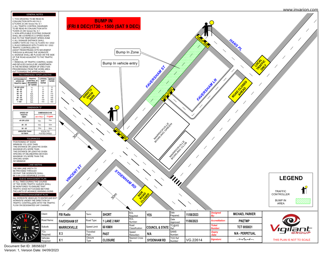
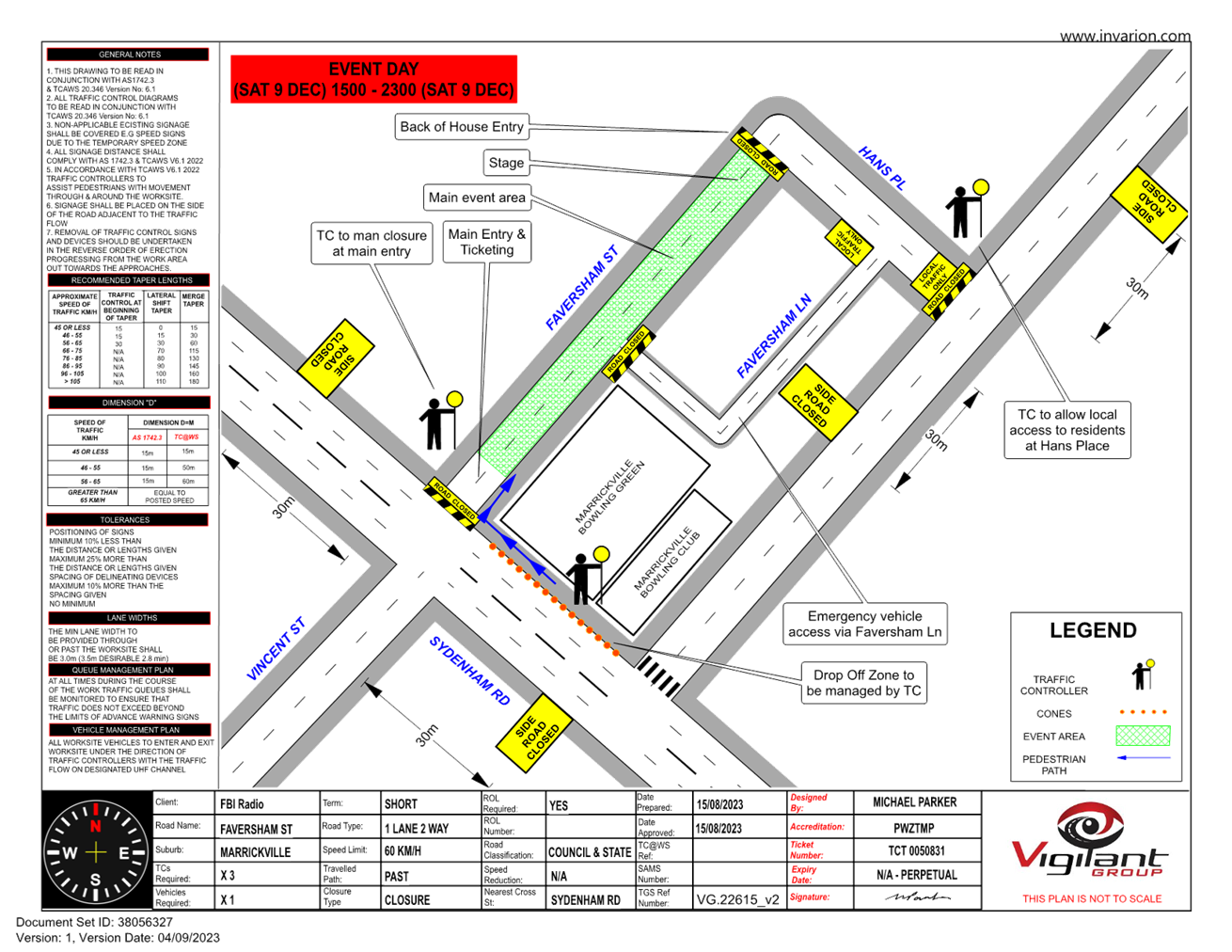
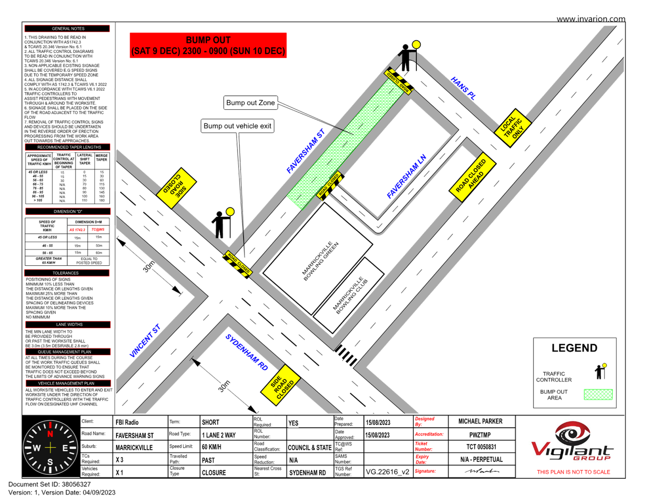
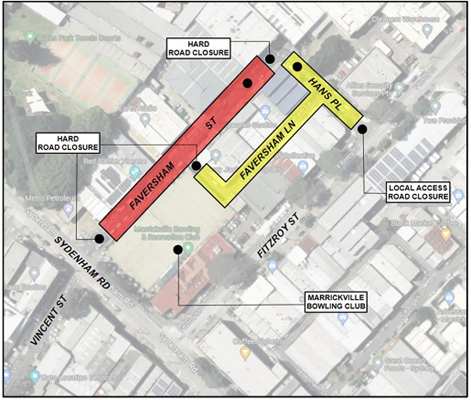
Subject: Faversham Street, Marrickville – Temporary Full Road Closure for FBi Radio Event – Saturday 9 December 2023 (MIDJUBURI - MARRICKVILLE WARD / SUMMER HILL ELECTORATE / INNER WEST PAC)
Prepared By: Jennifer Adams - Traffic Engineer
Authorised By: Manod Wickramasinghe - Traffic and Transport Planning Manager
|
RECOMMENDATION
1. That the proposed temporary full road closure (ENRC/2023/0055) of Faversham Street, between Hans Place, Faversham Lane, Sydenham Road and Fitzroy Street, Marrickville from 5.30pm Friday 8 December to 9.00am Sunday 10 December 2023 be approved for the purpose of holding the ‘FBi Turns 20’ Event as per the submitted TMP and TGSs and subject to the following conditions and all standard Council conditions for temporary full road closures.
2. That a Road Occupancy License application be obtained from the Transport Management Centre.
3. That notice of the proposed event be forwarded to the NSW Police Local Area Commander, Transit Systems, the NSW Fire Brigades and the NSW Ambulance Services.
4. That all residents and businesses in and around the affected area are to be notified of the temporary road closure in writing by the applicant in advance (at least 7 days prior to the event) with the applicant making reasonable provision for stakeholders.
5. That a minimum four (4) metre unencumbered passage be available for emergency vehicles through the closed sections.
6. That the occupation of the road carriageway must not occur until the road has been physically closed.
|
STRATEGIC OBJECTIVE
This report supports the following strategic directions contained within Council’s Community Strategic Plan:
|
2: Liveable, connected neighbourhoods and transport |
|
|
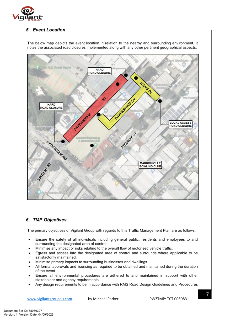
Council has received an application from FBi Radio for the proposed temporary full road closure of Faversham Street, Marrickville in order to hold their event, “FBi Turns 20’ on Saturday 9 December between 3pm and 10pm. To facilitate the event there will be a temporary full road closure of Faversham Street, between Hans Place, Faversham Lane, Sydenham Road and Fitzroy Street, Marrickville. Road closure and event bump in will occur from 5.30pm Friday 8 December and bump out will conclude by 9.00am Sunday 10 December 2023. It is recommended that Council agree to the temporary full road closure subject to all standard Council conditions for a temporary full road closure.
BACKGROUND
Community radio FBi radio will celebrate 20 years of supporting Sydney music arts and culture. Activating 3 unique spaces in the Marrickville precinct with a display of live music, culture and art celebrating both current and foundation artists, bands and DJs that have played a significant role in the last 20 years of the station. Faversham Street Marrickville will be closed to traffic thoroughfare so the event as proposed can successfully occur.
OFFICER COMMENTS
Sydenham Road is a State road. Hans Place and Faversham Street are local roads servicing the local industrial area. They are low volume roads carrying around 550 and 400 vehicles per day respectively. Both have a high truck ratio percentage of 16.5% and 10.8% respectively.
Fitzroy Street is also a local road carrying around 5,800 vehicles per day with a 85th percentile speed of 56.2km/h. The speed limit is 50km/h. Trucks make up around 12% of the total volume.
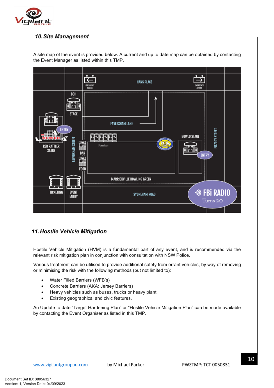
The event will be on Faversham Street, Red Rattler & Marrickville Bowling Club (refer to the site map below). The event is expected to attract 1,500 at anytime across all spaces
Site Map
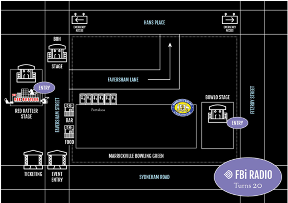
The event bump-in will take place Friday 8 December 2023 from 5:00PM until Saturday 9 December at 9:00AM to avoid disruption to local businesses during 9am-5pm hours. Bump Out at CLOSE will be 11:00pm Saturday December 10th until 9:00am Sunday 10 December 2023.
Public access to the site is permitted at all times outside of the bump in, event time and bump out confirmed periods.
All local businesses will be consulted and provided with access to the site if required during operating hours or via security and or traffic management teams.
Adequate vehicular traffic control shall be provided for the protection and convenience of pedestrians and motorists including appropriate signage and flagging. Workers shall be specially designated for this role (and carry appropriate certificates), as necessary to comply with this condition. This is to be carried out in accordance with the Australian Standard AS 1742.3 - Traffic Control Devices for works on roads.
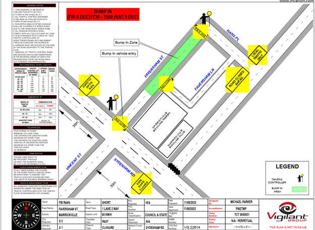
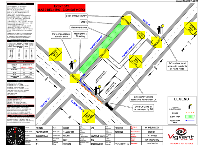
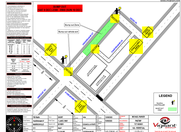
Traffic Management Plan and Traffic Guidance Schemes
A Traffic Management Plan has been provided and is attached at the end of this report. The three associated Traffic Guidance Schemes are reproduced below.
Impacts
There will be no impacts on bus services.
There will be no major effect to pedestrians in the area. Pedestrians will be able to use the existing pedestrian paths outside of and within the event area.
There are no cycleways directly impacted by this event. Cyclists entering the event site will be requested to dismount.
The closest train station is Sydenham Station. It is approximately 500 metres walk from the event precinct. Currently the Trackworks schedule for event day is as follows:

Parking will only be available in surrounding streets around the event site. Parking will as such be limited, and the event organiser will consider recommending public transport to all event patrons.
The traffic generated as a result of the proposed event should not have a major impact on the surrounding traffic network. It is noted that the event abuts Sydenham Road, a State Road under the jurisdiction of TfNSW.
Construction works at the Wicks Park development may be impacted and the applicant will need to liaise with the developer.
Heavy vehicles may experience slight delays due to increased traffic around the event precinct. No special event clearways will be installed for this event.
A minimum four (4) metre emergency lane will be maintained along the entire closure. Traffic controllers will be onsite to assist emergency vehicles through the closure points.
Hostile Vehicle mitigation strategies may be undertaken within the road closure in accordance with the event risk assessment and NSW Police direction.
PUBLIC CONSULTATION
Notice of the temporary full road closure has been advertised in accordance with the Roads Act. A notification letter outlining the proposed works will be distributed to surrounding residents/businesses by the applicant at least 7 days prior to closure. A copy of the notification letter is reproduced below.
All works and costs of implementation will be borne by the applicant.
CONCLUSION
It is recommended that Council agree to the temporary full road closures on Saturday 9 December 2023 subject to complying with the recommendations stated in this report along with all standard conditions for temporary full road closures.
|
1.⇩ |
Traffic Management Plan - V2 |
|
Local Traffic Committee Meeting 18 September 2023 |
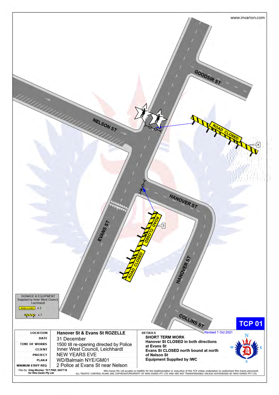
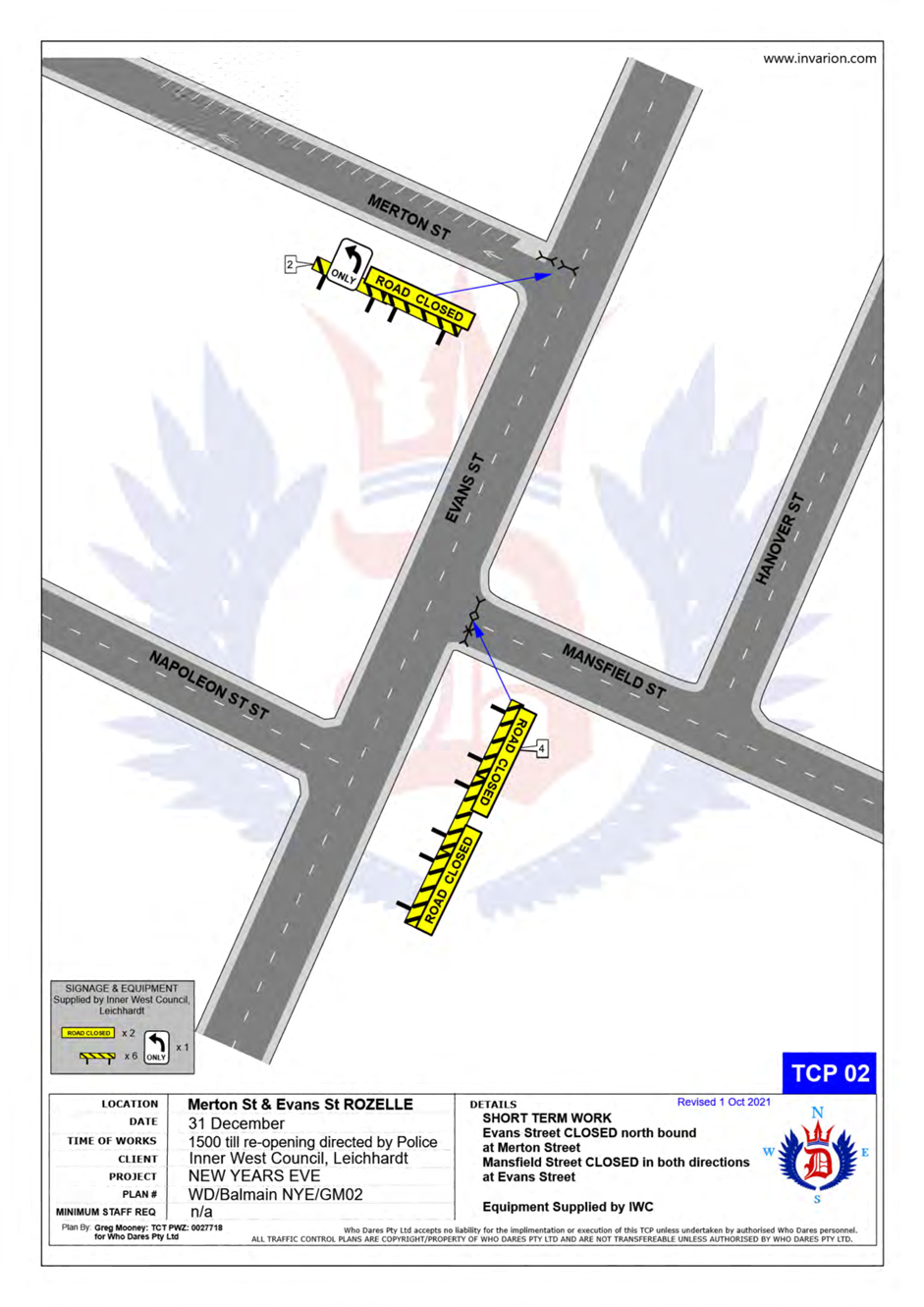
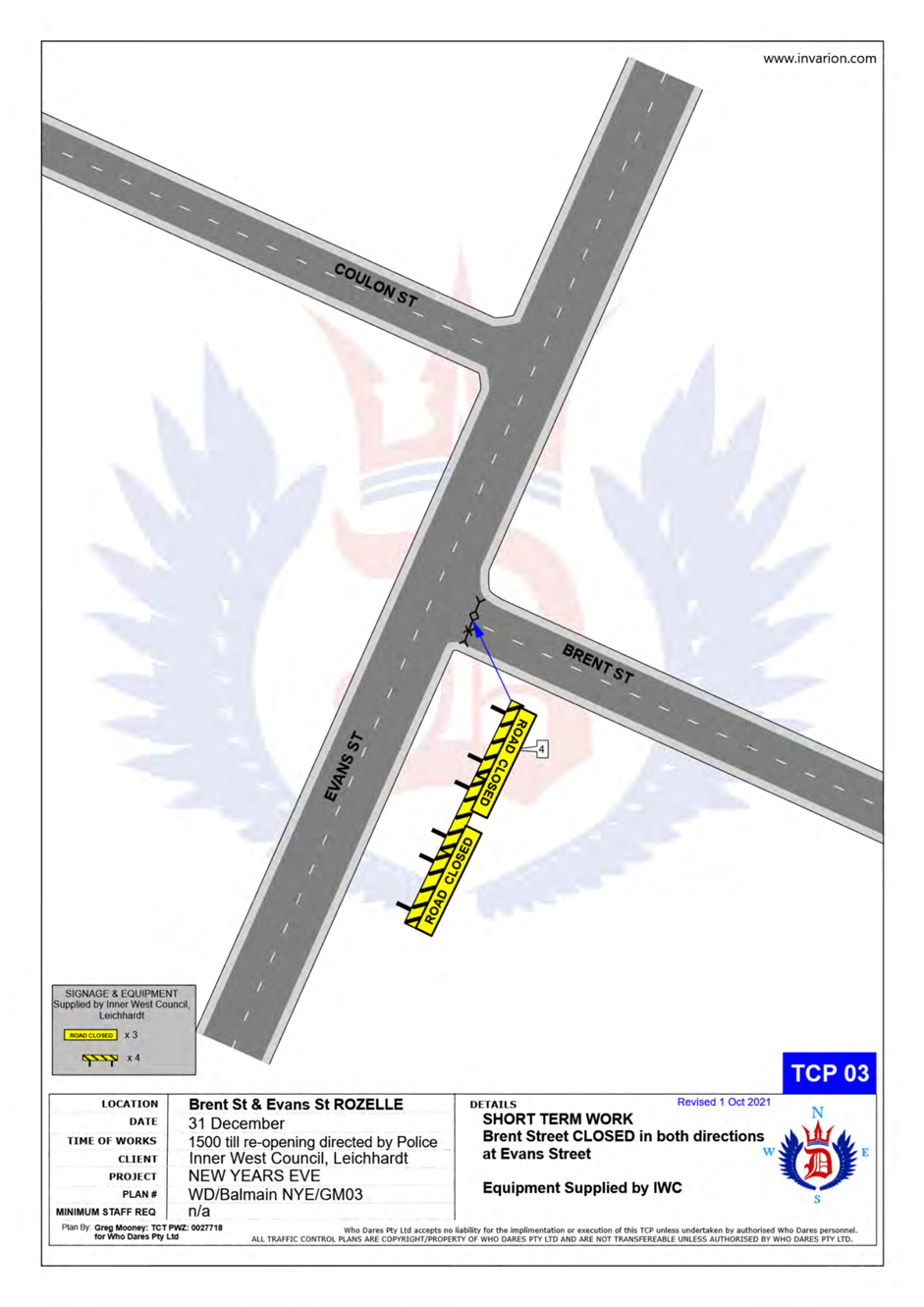
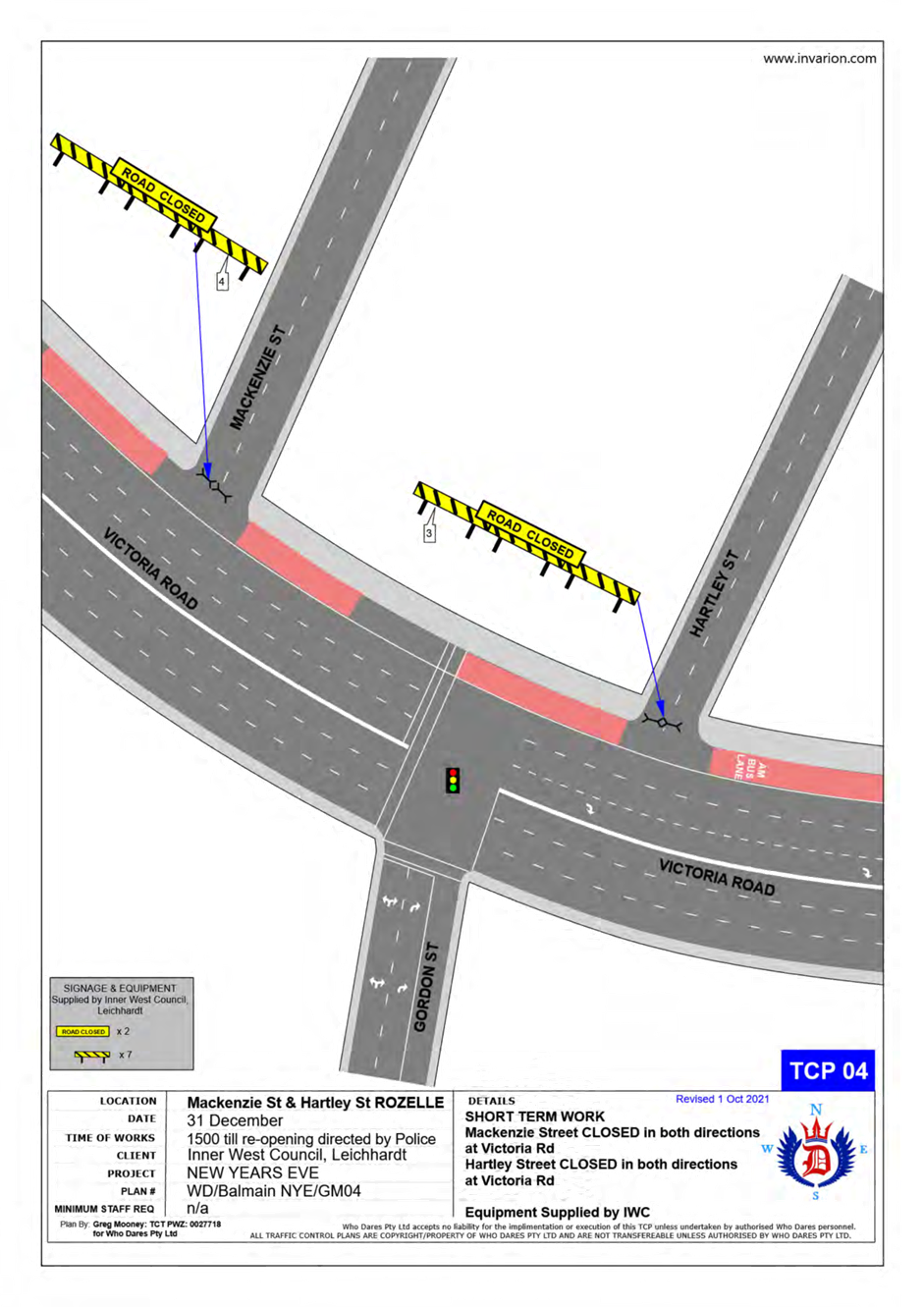
Subject: Traffic Management Plan for the 2023 New Year's Eve Event (Baludarri-Balmain Ward/ Balmain Electorate/ Leichhardt Pac)
Prepared By: Amir Falamarzi - Traffic Engineer
Authorised By: Manod Wickramasinghe - Traffic and Transport Planning Manager
|
RECOMMENDATION
1. That the Traffic Management Plan (Attachment 1) detailing the traffic arrangements for the 2023 New Year’s Eve be supported.
2. That the Traffic Management Plan (Attachment 1) be forwarded to Council’s Parks and Streetscapes Coordinator, Transport Management Centre and the Major Events & Incidents Group (NSW Police).
3. That a temporary ‘No Stopping’ zone be installed on the eastern side of Montague Street between Darling Street and Beattie Street, Balmain.
4. That the following temporary modifications to bus stops be approved:
a) On the northern side of Darling Street: i. Install temporary ‘Bus Zones’ between Mort Street and Ford Street. ii. Extend the ‘Bus Zone’ between Ford Street and McDonald Street. iii. Extend the ‘Bus Zone’ between McDonald Street and Curtis Road, outside Nos.217-223 Darling Street.
b) On the southern side of Darling Street: i. Install a temporary ‘Bus Zone’ between Booth Street and Beattie Street, outside No. 244-270 Darling Street.
c) On the eastern side of Grove Street between Wharf Road and Bay Street, Birchgrove.
5. That the Transit Systems representative be requested to place adequate notices on buses regarding the establishment of an alcohol free zone in the Balmain East area (details to be provided by Council).
6. That the taxi / hire car access to the Peninsula be restricted from 7:00pm.
7. That taxis / hire cars carrying mobility impaired or infirmed residents be permitted access at all hours into the Peninsula.
8. That the NSW Taxi Council be advised of the Committee’s recommendation.
|
STRATEGIC OBJECTIVE
This report supports the following strategic directions contained within Council’s Community Strategic Plan:
|
2: Liveable, connected neighbourhoods and transport |
|
|
EXECUTIVE SUMMARY
This report outlines the traffic management plan for the 2023 New Year’s Eve event.
BACKGROUND
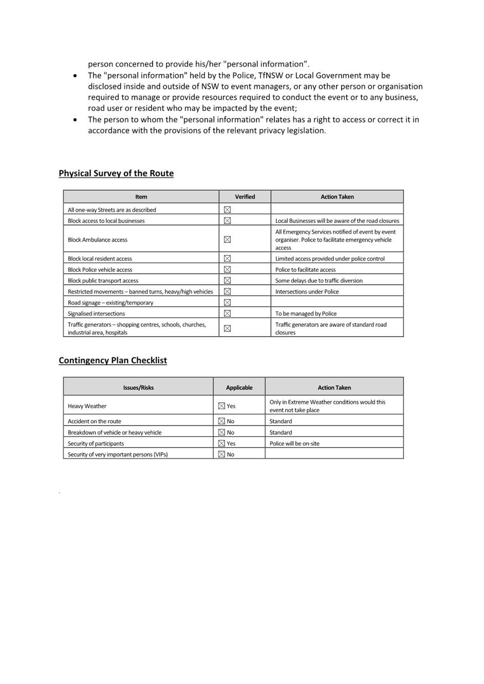
Traffic Management
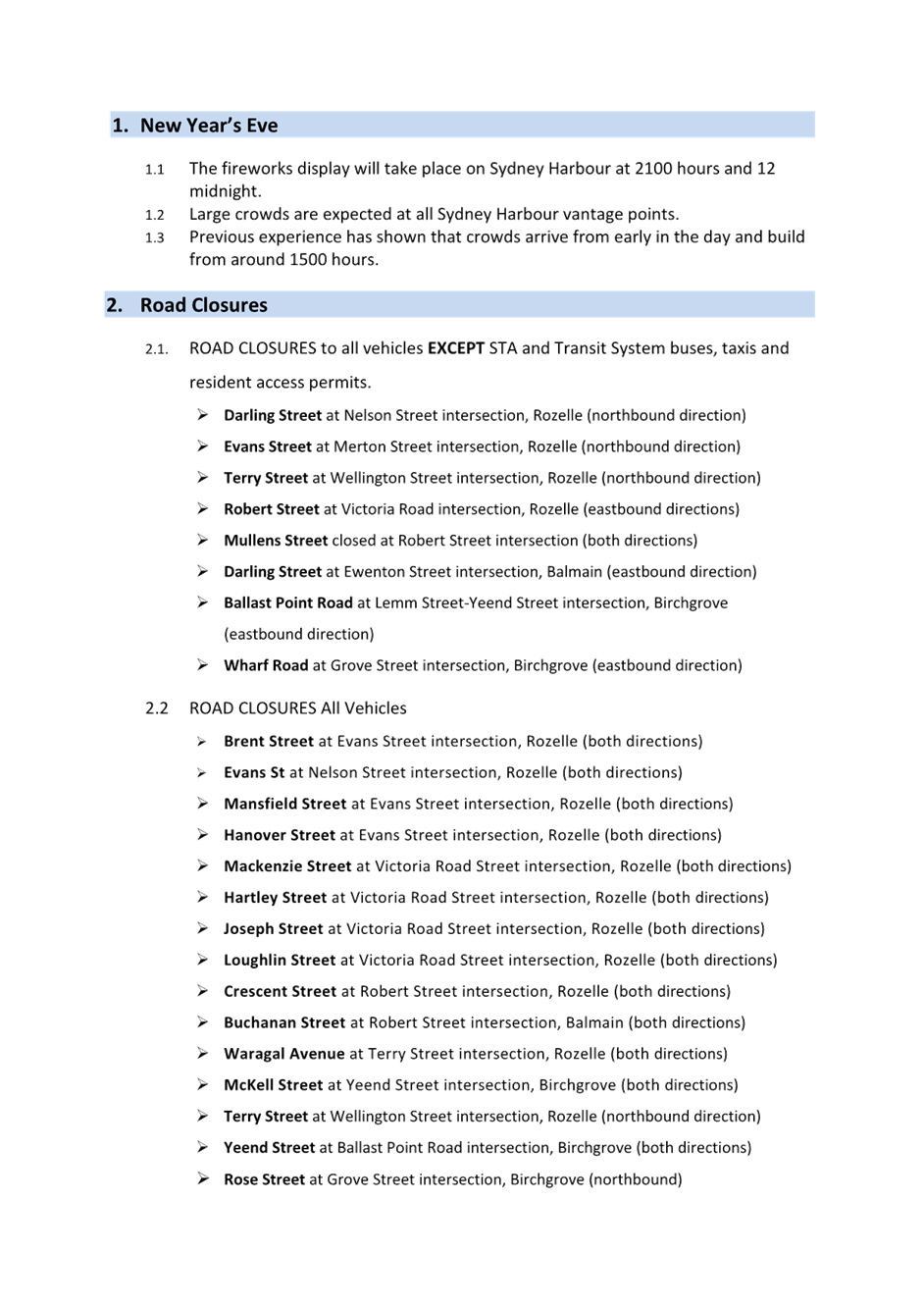
The following roads will be closed to all vehicular traffic between 3:00pm Sunday, 31 December 2023 and 12:00am on Monday, 1 January 2024 to cater for the New Year’s Eve celebrations:
· Brent Street at Evans Street intersection, Rozelle (both directions).
· Mansfield Street at Evans Street intersection, Rozelle (both directions).
· Hanover Street at Evans Street intersection, Rozelle (both directions).
· Mackenzie Street at Victoria Road intersection, Rozelle (both directions).
· Hartley Street at Victoria Road intersection, Rozelle (both directions).
· Joseph Street at Victoria Road intersection, Rozelle (both directions).
· Loughlin Street at Victoria Road intersection, Rozelle (both directions).
· Crescent Street at Robert Street intersection, Rozelle (both directions).
· Buchanan Street at Robert Street intersection, Balmain (both directions).
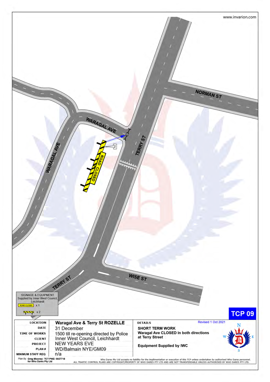
· Waragal Avenue at Terry Street intersection, Rozelle (both directions).
· McKell Street at Yeend Street intersection, Birchgrove (both directions).
In addition, the following roads will be closed to all vehicular traffic except State Transit Authority/Transit Systems buses, Taxis, Hire Cars and Balmain Access Permit holders and will be manned by NSW Police officers between 3:00pm Sunday, 31st December 2023 and 12:00am on Monday, 1st January 2024:
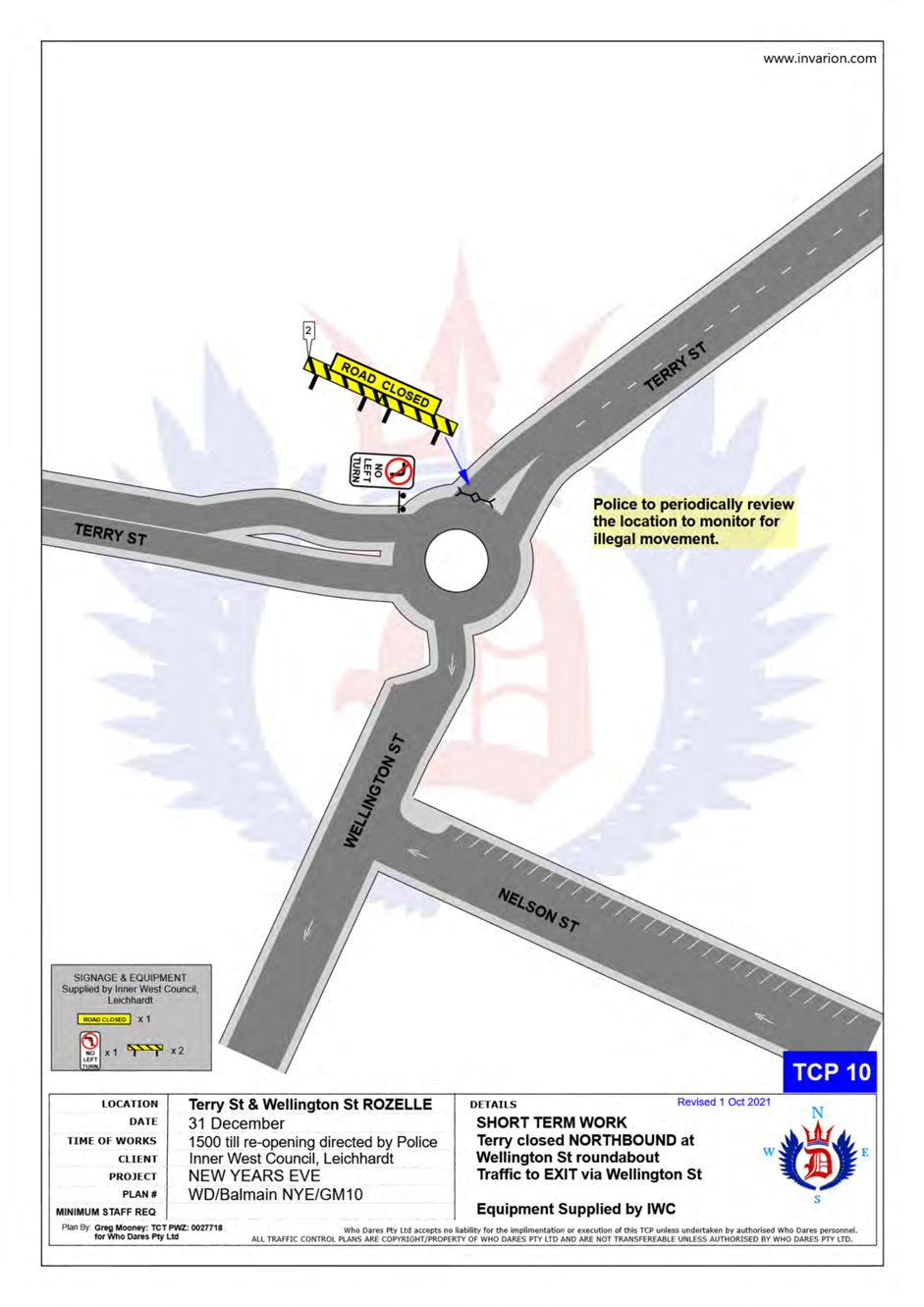
· Terry Street at Wellington Street intersection, Rozelle (northbound direction).
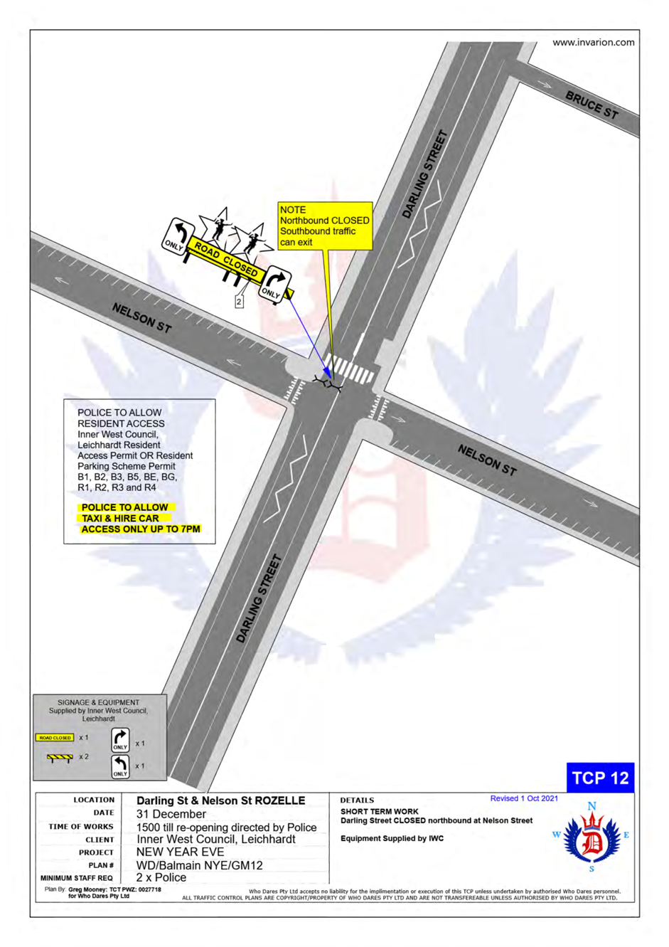
· Darling Street at Nelson Street intersection, Rozelle (northbound direction).
· Darling Street at Ewenton Street intersection, Balmain (eastbound direction).
· Evans Street at Merton Street intersection, Rozelle (northbound direction).
· Evans Street at Nelson Street, Rozelle (both directions).
· Mullens Street at Robert Street intersection, Rozelle (both directions).
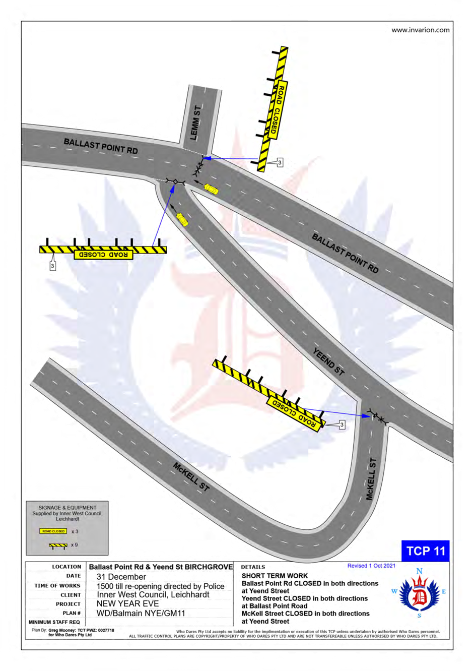
· Ballast Point Road at Lemm Street-Yeend Street intersection, Birchgrove (south and eastbound directions).
· Wharf Road at Grove Street intersection, Birchgrove (eastbound direction).
· Robert Street at Crescent Street, Rozelle (northbound direction).
· Grove Street at Rose Street, Birchgrove (eastbound direction).
The following plan indicates the road closure points:
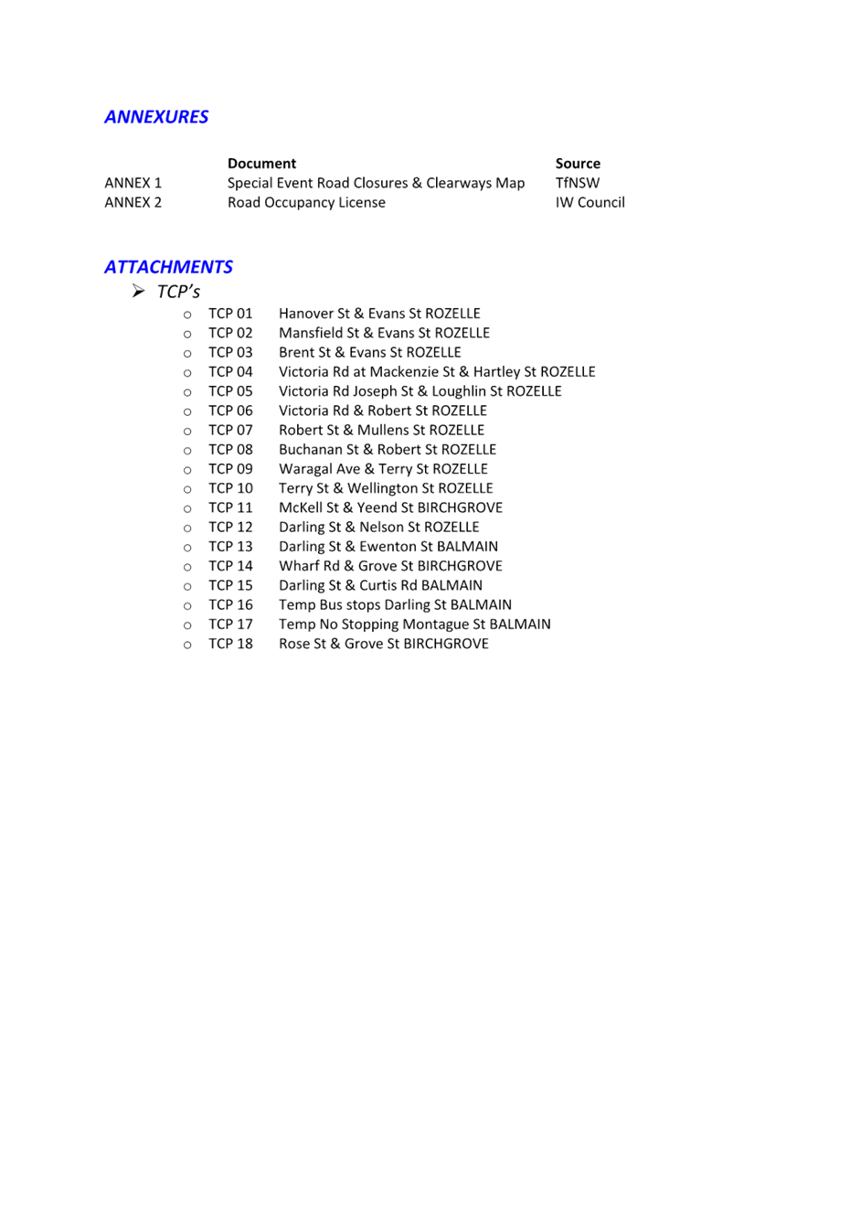
A Traffic Management Plan including Traffic Control Plans outlining the above road closures and the bus route changes is attached in Attachment 1.
Taxi Access
As previously recommended, the NSW Taxi Council will again be requested to inform their members of the proposed taxi access restriction after 7pm to minimise traffic congestion in the peninsula and improve pedestrian safety. Taxis will therefore need to use the following drop-off point locations:
· Taxis entering Terry Street - In the unrestricted parking on the eastern side of Terry Street or ‘Bus Zone’ and timed kerbside parking along Wellington Street.
· Taxis entering Darling Street - In the ticket parking areas along Darling Street and Nelson Street.
· Taxis entering Robert Street – In the restricted parking area and ‘Bus Zone’.
Public Transport Access
Transit Systems will be scheduling additional services into the Balmain peninsula to cater for the New Year’s Eve celebrations.
As such, temporary ‘Bus Zones’ will be installed at the following locations:
· Darling Street and the existing ‘Bus Zones’ on Darling Street between Mort Street and Curtis Road, Balmain.
· Eastern side of Grove Street between Wharf Road and Bay Street, Birchgrove.
The ‘Bus Zones’ on Grove Street will be used by Transit Systems and the Police to store buses on New Year's Eve. This is required for the safe bump out of the general public from Birchgrove as identified from a debrief from a previous New Year's Eve event conducted in the Balmain Peninsular.
The signs defining the temporary restrictions be in place after 12 Noon on 31 December 2023 and will be removed the following day.
Based on discussions held in previous years regarding disruptions to bus services leaving Gladstone Park/Curtis Road roundabout due to the gathering of large crowds, the Glebe Police representative introduced Police bike units to manage the crowds in the area.
In addition, to avoid delays that occurred at the Robert Street/Mullens Street intersection (which is a Police check point), buses entering Robert Street from Victoria Road are proposed to use Crescent Street and Parsons Street to access Mullens Street (see TCP 06/07 in Attachment 1).
It should be noted that Council will install variable message signs (“Balmain Peninsula is closed” and “Alcohol Free Zone”) on the main access roads into Balmain Peninsula a few days in advance of the event;
Temporary ‘No Stopping’ Restrictions
Following a previous year’s event, the Sydney Buses representative advised that several vehicles parked on Montague Street out from the kerb thus narrowing the carriageway and preventing buses from passing each other. Therefore, it is proposed to install temporary ‘No Stopping’ zone on the eastern side of Montague Street between Darling Street and Beattie Street. The residents will be advised of this arrangement in advance of the event.
Resident Access
To ensure resident access is maintained, the following permits will be accepted for access to the Balmain / Rozelle peninsula:
· Inner West Council Resident Access Permit.
· Inner West Council current Resident Parking Scheme Permit for Areas; B1, B2, B3, B5, BE, BG, R1, R2, R3 & R4.
· Australian Mobility Parking Scheme permit
Alcohol Free Zones
Council has already received approval to re-establish the Alcohol Free Areas for the New Year’s Eve celebrations in 2020, 2021, 2022 & 2023 at the following locations:
· Illoura Reserve
· 2-8 Weston Street
· Thornton Park
· Lookes Avenue Reserve
· Simmons Point Reserve
· Yurulbin Park
· Birchgrove Park
· Miklouho-Maclay Park
· Mort Bay Park
· College Street playground
· Harris Reserve
· Brownlee Reserves
· Darling Street from Duke Street to Darling Street Wharf
· Darling Street Wharf, Balmain East;
· Lookes Avenue
· Weston Street
These alcohol restrictions are proposed to be in place from 12.00pm (noon) 31 December 2023 to 3.00am 1 January 2024.
DISCUSSION
The proposed road closures are currently being advertised on Council’s website in accordance with the Roads Act 1993 for a period of 28 days from 8 September 2023 to 6 October 2023. No comments have been received to date.
In December, the details of these traffic arrangements will be re-advertised on Council’s website and via a mail out to all occupants in the Balmain peninsula.
The road closures and other event information will also be available on the Sydney New Year’s Eve Event website.
Matters arising from previous events
|
Officer Comments |
|
|
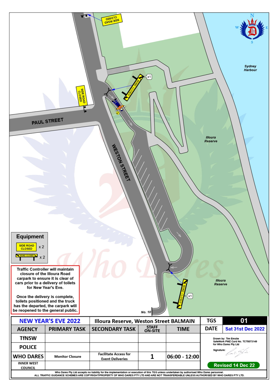
Temporary toilets at Illoura Reserve off-street car park are proposed by Council’s Events Team. |
A new TGS plan has been to block vehicle access and temporarily dedicate the space to temporary toilets at Illoura Reserve. |
|
There is a complaint from residents regarding lack of enforcement during last year’s event including illegal parking, relocating barricades and entering the road closure zone.
|
NSW Police and Council’s enforcement team have been notified of the misbehaviors that occurred at last year’s event.
|
|
There is a suggestion from a resident to notify vehicles of the road closures in advance of Mackenzie Street, Hartley Street, Joseph Street and Loughlin Street intersections at Victoria Road. |
It is proposed to install No Left Turn Sign (Side Road Closed) On Victoria Road before Mackenzie Street, Hartley Street, Joseph Street and Loughlin Street. |
|
There is a complaint from a resident regarding traffic congestion on Terry Street, Darling Street and Evans Street due to closures on those streets and lack of road closure notification. |
To address the issue, it is proposed to install Road Closure Ahead (Event Ahead) signs in advance to the subject streets to notify drivers that the road ahead is closed and provide options to turn around. |
FINANCIAL IMPLICATIONS
Funding for costs associated with New Year’s Eve including labour, notifications and permits have been budgeted for in the 2023-24 operational plan.
PUBLIC CONSULTATION
The proposed road closures are currently being advertised on Council’s website in accordance with the Roads Act 1993 for a period of 28 days from 19 August 2022 to 16 September 2022. No comments have been received to date.
In December, the details of these traffic arrangements will be re-advertised on Council’s website and via a mail out to all occupants in the Balmain peninsula.
The road closures and other event information will also be available on the Sydney New Year’s Eve Event website.
|
1.⇩ |
New Year’s Eve Fireworks - Balmain Peninsular Traffic Management 2023 |
|
Local Traffic Committee Meeting 18 September 2023 |
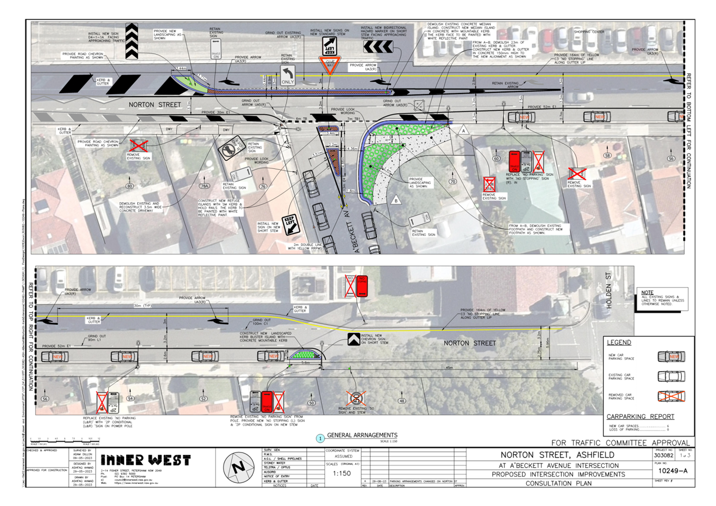
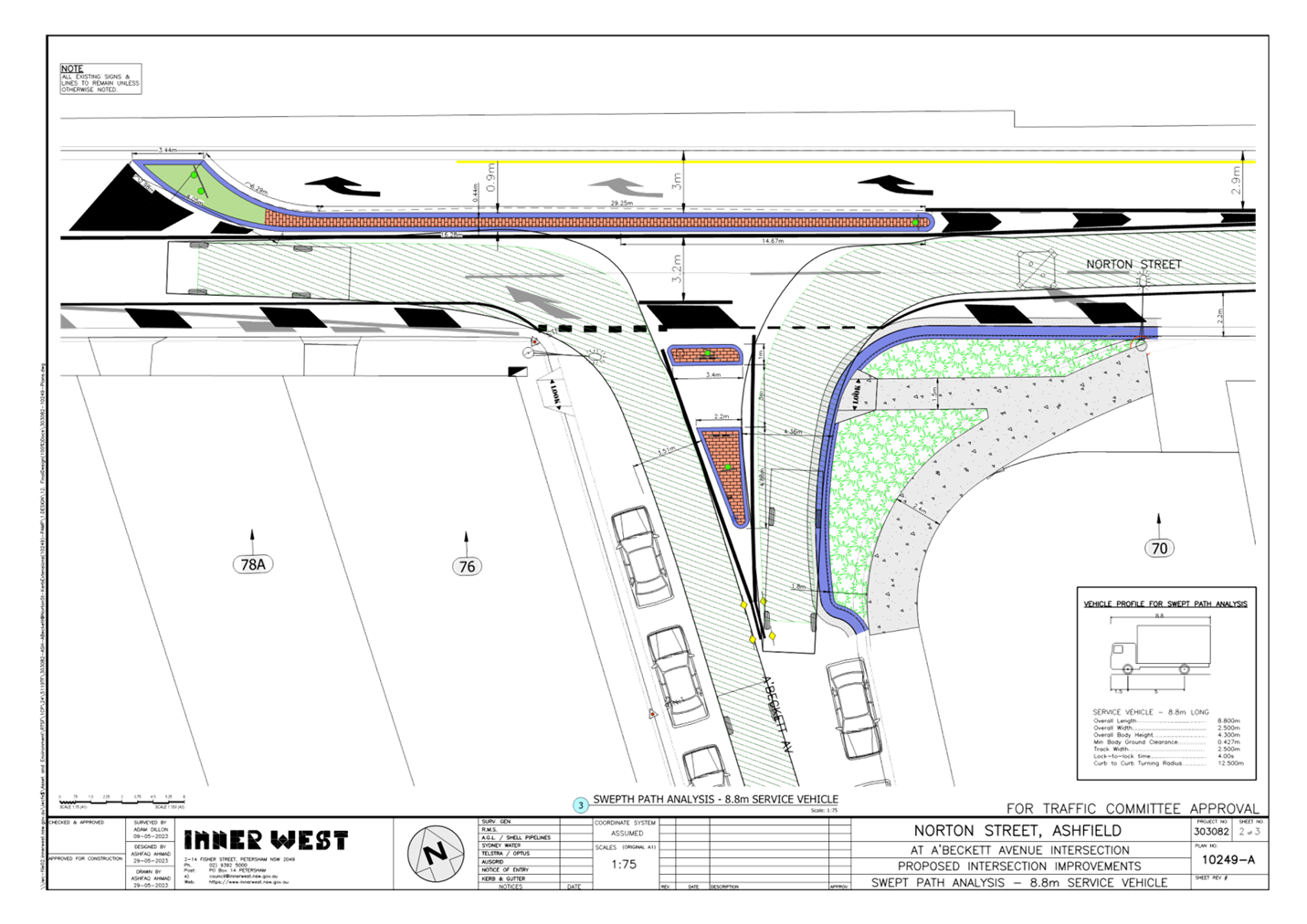
Subject: Norton Street & A'Beckett Avenue, Ashfield- Intersection Improvements Works (Djarrawunang-Ashfield Ward/Summer Hill Electorate/Burwood PAC)
Prepared By: Boris Muha - Traffic Engineer
Authorised By: Manod Wickramasinghe - Traffic and Transport Planning Manager
|
RECOMMENDATION
That the detailed design plan for the intersection improvement works of Norton Street and A’Beckett Avenue with associated signs and line marking plus the inclusion of parking on the southern side of Norton Street (between Holden Street A’Beckett Avenue) as shown on the Revised Plan 10242 A in Attachment 1 be approved.
|
STRATEGIC OBJECTIVE
This report supports the following strategic directions contained within Council’s Community Strategic Plan:
|
2: Liveable, connected neighbourhoods and transport |
|
|
EXECUTIVE SUMMARY
Council is proposing to improve pedestrian and motorist safety in Norton Street & A’Beckett Avenue, Ashfield by constructing a landscaped kerb extension together with a new pedestrian refuge ‘seagull’ island in A’Beckett Avenue. The existing dividing lane “splitter” island in Norton Street will be widened, and vehicles will be made to veer and transition earlier into the through lane of Norton Street, east of A’Beckett Avenue. Parking can be provided on the southern side of Norton Street east of A’Beckett Avenue. See Attachment 1.
The proposal aims to improve safety for pedestrians and motorists by better defining the crossing points and reduce conflict with traffic movements, plus facilitate safer parking and/or drop- off and pick -up activity in the area. This will help address concerns with pedestrian and motorist behaviour in this area, particularly during busy periods.
BACKGROUND
The pedestrian refuge splitter island treatment at the corner of A’Beckett Avenue and Norton Street is identified under the Pedestrian Access Mobility Plan 2022 to facilitate improved pedestrian activity over the wide junction of A’Beckett Avenue at Norton Street.
The widening of the dividing lane ‘splitter’ island in Norton and lane reconfiguration with added parking forms part of a current investigation for traffic calming and traffic facility improvements along Norton Street between Holden Street and Carlisle Street, Ashfield.
DISCUSSION
Other Staff comments:
Site location and Road Network.
|
Street Name |
A’Beckett Avenue
|
|
Carriageway width (m) kerb to kerb |
12.8m |
|
Carraigeway type |
Two-way, one travel lane each direction. |
|
Classification |
Local |
|
Speed Limit km/h |
50 |
|
85th percentile speed km/h |
|
|
Vehicles per day (vpd) |
Up to 2000 |
|
Reported crash history 2009- 2022 |
NIL- within A’Beckett Avenue |
|
Parking arrangements |
Unrestricted parking both sides |
|
Side streets |
Norton Street |
|
Street Name |
Norton Street (Holden Street to A’Beckett Avenue) |
|
Carriageway width (m) kerb to kerb |
6.0 to 9.0m |
|
Carraigeway type |
One-way westbound. One (1) right turn lane [3.0m wide] entry into Ashfield Mall. One (1) through lane at 3.0 metres wide. One (1) Left Lane at 3.0m wide -merge to through lane west of A’Beckett Avenue. |
|
Classification |
Regional Road. By-pass through Ashfield CBD. |
|
Speed Limit km/h |
50 |
|
85th percentile speed km/h |
48.9- Left lane 41.0- Through middle lane 42.7- Right turn lane |
|
Vehicles per day (vpd) |
1250- Left lane 6270- Through middle lane 2150- Right turn lane
|
|
Reported crash history 2009-2022 |
(1) X 2009, at intersection with A’Beckett Avenue, RUM 37, left turn side swipe, non-casualty (tow-away), vehicle turing left from through lane of Norton Street. (1) x 2010, Norton Street, west of Holden Street, RUM 30, non-casualty (towaway), rear end. (1) x 2017, A’Beckett south of Norton Street, RUM 73, non-casualty (towaway), right off carriageway into object in northbound direction. (1) x 2013, Norton Street east of A’Beckett, RUM 73, non-casualty (towaway), right off cariage way into object in west bound direction.
|
|
Parking arrangements |
Full-time ‘No Stopping’ and/or ‘No Parking’ to both sides. |
|
Side streets |
A’Beckett Avenue. |
Improvement works at the intersection of A’Beckett Avenue and Norton Street & along Norton Street, between Holden Street and A’Beckett Avenue.
A current (kerb side) left lane exits on the southern side of Norton Street between Holden Street and A’Beckett Avenue and merges right across the intersection of Norton Street and A’Beckett Avenue to form one (1) through lane west of A’Beckett Avenue. ‘No Parking’ generally exists along the southern kerb side area of Norton Street, with ‘No Stopping’ in approach to the corner of A’Beckett Avenue.
An initial plan went out to the community proposing in part to shorten down the existing left lane merge right facility just east of A’Beckett Avenue. In doing so any ‘No parking’ restrictions would be removed for full time ‘No Stopping’ right through on the southern side of Norton Street between A’Beckett Avenue and Holden Street. A petition was received from households along Norton Street between A’Beckett Avenue and Holden Street, objecting to the imposition of full time’ No Stopping’, preventing the need to drop off and pick up or park short term as permitted under the road rules for ‘No Parking’.
In view of the above, the matter was reviewed and the following works are therefore proposed and are illustrated on the attached revised plan.
Norton Street & A’Beckett Avenue, Ashfield (Plan No. 10249 A)-refer to Attachment 1:
In A’Beckett Avenue (as initially proposed):
- Construct new concrete kerb & gutter along a new alignment to form a landscaped kerb extension on south side of A’Beckett Avenue together with a new concrete footpath and kerb ramp to widen the footpath and narrow the road so pedestrians have a shorter distance to cross the road;
- Provide suitable low level native landscaping within the new kerb extension as determined by Council to enhance the area (final species to be finalised). The possibility of providing a new street tree within the landscaped area will also be investigated and may be provided if deemed appropriate (subject to detail design);
- Construct new concrete footpath to connect the existing footpath through the kerb extension and reconstruct some damaged sections of existing footpath (where shown on Plans)
- Construct a new concrete pedestrian refuge “seagull” island in A’Beckett Avenue to improve safety for pedestrians and better control traffic movements into and out of A’Beckett Avenue;
In Norton Street:
- Reconstruct and widen the existing narrow concrete lane dividing “splitter” island to better cater for traffic ‘through’ movements in Norton Street and right turn movements into the Ashfield Mall shopping Centre carpark;
- Provide some landscaping (low level native landscaping - species selection to be finalised) to a section of the proposed new lane “splitter” island;
- Provide (under revised design) a shortened left lane in Norton Street allowing vehicles to veer and transition across over into the through lane east of A’ Beckett Avenue with parking established to the southern side of Norton Street, between Holden Street and A’Beckett Avenue. Line and chevron marking will safely guide and assist traffic in one through lane past A’Beckett Avenue.
- Adjust the existing lane configuration to provide where possible ‘2P 8am-6pm Mon -Fri., Permit Holders Excepted AREA 1’ parking in lieu of “No Stopping or No Parking” on the southern side of Norton Street between Holden Street and A’Beckett Avenue.
- Install associated pavement line marking and other signage and protective kerb blister barrier to parking in Norton Street under the proposed works.
It should be further noted that:
· The existing merge right facility on the southern side of Norton Street extends through the intersection of A’Beckett Street, which can pose high risk of conflict and hazard to vehicular movement through and around the intersection.
· Norton Street is a Regional Road by-pass (one-way west) through the Ashfield CBD. It has been regulated down to a 50 kph speed limit over the years. Most traffic is observed to travel down the middle (through) lane via the north side of Norton Street east of Holden Street.
· Under the revised plan the driveway areas can allow for safe drop off and pick up between the parking spaces.
· Parking is accordingly positioned as shown on the plan aimed not to impair on sight view or access to and from the driveways.
· The provision for parking along the southern side of Norton Street, between Holden Street and A’Beckett Avenue is viewed to assist in the lined control of traffic and speeding along Norton Street.
· Shorter sample merge or transition lane lengths are identified for example in Queen Street/William Street, Five Dock and Gipps Street/Broughton Street Concord, past traffic signalised intersections.
· The existing (long) length of kerb and merge lane marking in Norton Street would have implemented prior to changes made in the regulated reduction of the speed limit down to 50 kph in Norton Street, over 20 years ago.
Parking Changes
It is proposed to introduce (7) new parking spaces within the southern kerbside area configured to a lane width of 2.5-3m. Approximately 45 metres of southern kerbside area (3.0m wide) is provided east thereof for traffic to veer and transition into the through lane under ‘No Stopping’ restrictions. Where the southern kerb side area reduces in lane width below 2.5 metres towards A’Beckett Street, the area is hatched off and is regulated under ‘No Stopping’.
Streetlighting
The existing street lighting at the location is deemed adequate. Therefore, no changes are proposed to the existing street lighting due to the works.
Ausgrid is progressively replacing all existing streetlights throughout the Local Government area with new energy efficient and environmentally friendly LED streetlights, and this will be completed independent of this project.
FINANCIAL IMPLICATIONS
The work is estimated to be approximately $100,000 and will be funded and constructed under the PAMP program, anticipated to be constructed during the 2023/2024 financial year.
PUBLIC CONSULTATION
118 letters were mailed out showing initial plans of the proposed physical treatment of providing a pedestrian refuge splitter island at the intersection of A’Beckett Avenue and Norton Street, together with the shortening of the left lane in Norton Street, just east of A’Beckett Avenue. ‘No Parking’ under the initial proposal was to be changed to ‘No Stopping’ right through on the southern side of Norton Street between Holden Street and A’Beckett Avenue. These letters were mailed out to properties as shown in the consultation area below seeking resident comments on the proposal. A letter was also issued out to the Bicyclist Group Traffic Committee representative. Consultation letters were sent out on 27 July 2023 with the closure on submissions being the 18 May 2023.
Three (3) submissions were received with two residents supporting the pedestrian safety improvements at the intersection of A’Beckett Avenue and Norton Street but expressing concern/objection to the shortening of the merge lane facility in Norton Street, and the change of the ‘No Parking’ to ‘No Stopping’ right through in Norton Street, between Holden Steet and A’Beckett Avenue.
A third resident with a petition from 6 households along Norton Street, between Holden Street and A’Beckett Avenue, questioned the need for pedestrian safety improvements in A’Beckett Avenue and Norton Street together with the shortening of the merge lane facility, but strongly objected to the changing of the ‘No Parking’ to ’No Stopping’ in Norton Street.
Resident comments under the intial proposal have been tabled below with the officer response made.
Those residents making submissions have been in turn notified of the revised proposal. Any comments received under the revised proposal will be tabled at the meeting.
|
Residents comments (on initial plan proposal) |
Officer comments |
|
· Applaud or support the pedestrain safety improvements In the area. (2 residents raised support on this measure.)
|
Noted. |
|
· The treatment in A’beckett Street will stop ‘U’ turns. Agree with the proposed changes to the parking signs (no stopping/parking), but the current signs don’t mean much as quite often vehicles stop along there with hazard lights. Reducing the merge line marking closer to Holden Street may frustrate drivers wanting to turn left into A'Beckett Street – it is assumed the proposed lane changes forces traffic to the middle lane until either turn right into one of the two Mall car park entrances. Can the left turn lane be made to ‘left turn only’ into A’beckett Avenue? Can speed cameras be put along Norton Street, between Holden Street and Knox Street. I am for improved changes that inconveniences commuters or shoppers from parking in our street. |
· The revised plan as per attachment 1 provides for safe and proper parking or standing of vehicles to the southern side of Norton Street. Although signposted with resident parking, Council canot deter the general public from parking either in Norton Street or A’Beckett Avenue, provided these vehicle abide by the periods as permitted under the restrictions. · Cutting back of the left lane east of A’Beckett Avenue either per the intial or revised plan assists to avoid potential conflict and hazard with traffic movement around the intersection. Earlier transition into the through lane can also assist vehicles to veer onto the through lane and then turn right into the Ashfield Mall entry lane, before reaching the median lane divider in Norton Street. · (**)The southern kerb lane narrows down to below the width reqiurements of a travel lane near to the approach of the interesction with A’Beckett Ave due the wideing of the median lane divider and shift of the through lane closer to the southern side of Norton Street. A ‘Left turn only’ from the southern kerbside lane can not be considered. Traffic would be best to safely turn from the through lane. · Council does not have authoirity to install speed cameras on public roads, nor would TfNSW support camera installation in this case. Traffic counter recordings identify design 85% speed to be within the 50 kph speed limit for Norton Street. |
|
· Concern or major objection is raised under the initial plan with the removal of ‘No parking’ for’ No Stopping’ right through along the kerbside area of Nortron Street, between Holden Street and A’Beckett Avenue. This would severly impact on residents along the above section of Norton Street. Couriers, removalists, residents and the general public can currently drop off and pick-up or await along the kerbside to negotiate access into the driveways. All households along this section of Norton Street, have only driveway access from Norton Street, and generally are not wide enougfh to have service vehicles park off-street.
(the above is summed up through comments by (1) resident making sole submission and another resident as head petitioner on behalf of (6) signitured residents along the above section of Norton Street.) |
· The revised plan as per attachment 1 provides for safe and proper parking or standing of vehicles to the southern side of Norton Street. · Residents/service vehicles can use the parking zone or alternately park within the side street or any rear access to propoerties (e.g No 48 has rear access from Rose Street). ‘No Stopping’ is essentail in the remaining southern kerbside lane for transition into the through lane, and near to the intersection approach to A’Beckett Avenue. |
|
· Under the initial plan, questiones are raised as to the cost benefit of this development [intersection treatment of A’Beckett Ave and Norton Street]. People are accustomed to either cross further south from the A’Beckett Street intersection, or cross further down Norton Street at the pedesterian crossing near Hugh Street. · Removing one lane of traffic would most likely create more traffic congestion backing up with long queues. Congestion already existing in the late PM peak hours. An alternative option is to consider ‘Left Lane must turn left’ · Emergency vehicles are needed to park either on the left or right side lanes. |
· The intersetion of A’Beckett Avenue and Norton Street has been identified under the Pedestrian Access Mobility Plan 2020 (PAMP) to improve pedestrain access across A’Beckett Avenue with funding provide under the PAMP program. · Most traffic proceeds down the through lane of Norton Street. Ample length of the southern kerb lane is maintained for traffic to veer into the through lane away of the signalised intersection of Norton Street and Holden Street.. · Under the revised plan, emergency vehicles attending scenes (under flashing lights) are capable of parking in the parking zone or in any form or manner on a public road as permitted under the road rules even in areas of ‘No Stopping’ · See above comment (**) regard to inablity to allow left turn only into A’Beckett Avenue.
|
CONCLUSION:
In view of the above, it is recommended that the detailed revised design plan for the intersection improvement works of Norton Street and A’Beckett Street with associated signs and line marking plus the inclusion of parking on the southern side of Norton Street (between Holden Street A’Beckett Street) as shown on the Revised Plan 10242 A in Attachment 1 be approved.
|
1.⇩ |
Consultation Plan - Proposed Intersection Improvements |
|
Local Traffic Committee Meeting 18 September 2023 |
Subject: Hancock Lane, Rozelle - Permanent Road Closure (Baludarri-Balmain Ward/Balmain Electorate/Leichhardt PAC)
Prepared By: Sunny Jo - Coordinator Traffic Engineering Services (north)
Authorised By: Manod Wickramasinghe - Traffic and Transport Planning Manager
|
RECOMMENDATION
1. That the permanent full road closure of Hancock Lane, Rozelle at Darling Street be supported in principle, subject to the approval of the Traffic Management Plan by Transport for NSW.
2. That following the 28-day Public Exhibition of the closure of Hancock Lane, including engagement with NSW Police, emergency services, and other relevant authorities, the results be reported back to the Traffic Committee for final approval.
|
STRATEGIC OBJECTIVE
This report supports the following strategic directions contained within Council’s Community Strategic Plan:
|
2: Liveable, connected neighbourhoods and transport |
|
|
EXECUTIVE SUMMARY
Council is proposing to undertake the permanent closure of Hancock Lane, Rozelle at Darling Street. The closure of Hancock Lane will provide pedestrian accessibility and safety improvements along Darling Street.
BACKGROUND
The draft Rozelle Public Domain Masterplan proposes prioritising pedestrians within the Rozelle Town Centre area by undertaking public domain upgrade works. The Masterplan proposes to permanently close Hancock Lane, Rozelle at Darling Street to improve pedestrian accessibility and safety.
DISCUSSION
The proposed closure of Hancock Lane will be a permanent project, and the indicative extent of work is highlighted in yellow in the diagram below.
Subject to refinements to the design, the key features that the project include:
· The closure of Hancock Lane from Darling Street and running approximately 15m along the lane towards Hancock Street;
· Delineation of the closed road through the construction of new kerb and gutter on Darling St and new paving in the laneway;
· Retention of property access to off-street parking in Hancock Lane, accessed via Hancock Street; and
· The closed roadway would be made available for outdoor dining activation by adjacent businesses.
The closure of Hancock Lane would result in traffic on Darling Street accessing Hancock Lane to divert via Red Lion Street, Evans Street (one way southbound), Belmore Street (one way northbound), Hancock Street prior to reaching Hancock Lane. Alternatively, motorists on Victoria Road and left turn onto Hancock Street to access Hancock Lane.
It should be noted that Hancock Lane carries low traffic volumes with previous traffic counts indicating an ADT of 106 veh/day. It is expected that this traffic can accommodated by the surrounding road network.
There are no financial implications associated with the implementation of the proposed recommendations outlined in the report.
ATTACHMENTS
Nil.
|
|
Local Traffic Committee Meeting 18 September 2023 |
Subject: Cumulative Impacts from Major State Infrastructure Projects & Activities in and around Rozelle & White Bay (Baludarri- Balmain Ward/ Balmain Electorate/Leichhardt PAC)
Prepared By: Kendall Banfield - Senior Strategic Transport Planner
Authorised By: Manod Wickramasinghe - Traffic and Transport Planning Manager
|
RECOMMENDATION
That Council writes to TfNSW, Ports Authority and DPE seeking reassurance that cumulative impact issues from major State projects and activities in the Rozelle / White Bay area continue to be monitored and resolved. |
STRATEGIC OBJECTIVE
This report supports the following strategic directions contained within Council’s Community Strategic Plan:
|
2: Liveable, connected neighbourhoods and transport |
|
|
EXECUTIVE SUMMARY
This report outlines the existing state government infrastructure projects active in the Rozelle / White Bay area.
BACKGROUND
At its November 2021 meeting Council resolved to consider undertaking a study of cumulative impacts from major State infrastructure projects in the Rozelle / White Bay area. The main projects affecting this area are:
· WestConnex Stage 3B, Rozelle Interchange & Parklands– under construction and due for completion at the end of this year
· Western Harbour Tunnel – under construction and due for completion in 2026
· Sydney Metro West – under construction and due for completion in 2030
· Glebe Island Multi-User Facility – planning underway (completion date not known)
· Glebe Island Concrete Batching Plant – under construction and due for completion in 2024
· White Bay Cruise Passenger Terminal – ongoing operations, with planning underway for ship-to-shore power installation (completion date not known)
The first three are the responsibility of Transport for NSW (TfNSW), whilst the final three are the responsibility of Ports Authority of NSW.
DISCUSSION
It is apparent the NSW Government recognises the importance of cumulative impacts from these projects. Chapter 27 of the Western Harbour Tunnel Environmental Impact Statement (EIS) assesses cumulative impacts. It explains the main response to minimising these impacts is to encourage the various project teams to build working relationships with each other. This facilitates information exchange and enables community members and other stakeholders affected by cumulative impacts to be identified and served.
It is appropriate that the NSW Government continues to be responsible for monitoring and acting on cumulative impacts. Council has always argued that the NSW Government should be responsible for resolving issues created by its own projects. As State agencies monitor and enforce compliance, they are in the best position to monitor cumulative impacts. Council has little involvement in the area of compliance beyond advocacy and provision of advice.
Further, as WestConnex Stage 3B (Rozelle Interchange) is due for completion at the end of this year, cumulative impacts are expected to substantially reduce, as this is the project that has generated most of the impacts in this area. Accordingly, monitoring of cumulative impacts beyond 2023 will likely be less pressing. Other major State projects and activities in the area will continue for some time, but it is expected that the sum of impacts from these projects will be less than those from WestConnex 3B alone.
Notwithstanding the expected reduction in impacts, it is warranted that Council writes to the NSW Government seeking reassurance that cumulative impact issues will continue to be monitored and resolved.
FINANCIAL IMPLICATIONS
There are no financial implications associated with the implementation of the proposed recommendations outlined in the report.
Nil.
|
|
Local Traffic Committee Meeting 18 September 2023 |
Subject: William Street, Leichhardt - Proposed Motorbike Parking (Gulgadya - Leichhardt/Balmain Electorate/Leichhardt PAC)
Prepared By: Charbel El Kazzi - Graduate Traffic Engineer
Authorised By: Manod Wickramasinghe - Traffic and Transport Planning Manager
|
RECOMMENDATION
That a 3m length ‘Motor Bike Parking’ zone be installed on the south side of William Street Leichhardt, east of the driveway of No.38 William Street Leichhardt. |
STRATEGIC OBJECTIVE
This report supports the following strategic directions contained within Council’s Community Strategic Plan:
|
2: Liveable, connected neighbourhoods and transport |
|
|
EXECUTIVE SUMMARY
Council has received several concerns regarding large vehicles, boats and trucks being parked close to the driveway on No.38 William Street, Leichhardt and significantly limiting visibility for exiting vehicles.
In order to improve visibility for drivers when exiting the driveway, it was proposed to install a 2.6m length motor bike only parking zone. This was then increased to 3m following feedback from residents on the matter. The kerbside length between the subject driveway and Francis Street can currently only accommodate 3.5 standard parking spaces and hence the proposal will not result in the loss of parking spaces.
BACKGROUND
Residents have raised concerns to council regarding large vehicles, boats and trailers parking adjacent to the driveway at No.38 William Street, Leichhardt for extended periods time. Please see below photos provided by residents for review.
![]()
The below plan shows the proposal to install motor bike parking on the eastern side of the driveway and improve visibility for vehicles egressing the driveway to sight westbound vehicles.
DISCUSSION
A letter outlining the above proposal was mailed out to the below affected properties (43 properties)
Three (3) submissions were received all supporting the proposal. All responses provided additional recommendations which have been summarized below.
|
Residents Comments |
Officer comments |
|
A minimum 3-metre motor bike parking bay needs to be installed. |
To further improve visibility, the proposed zone can be extended to 3 metres. It is noted that this will not have an effect on available on-street parking spaces. |
|
We have come close to having collisions with vehicles coming down William Street because the visibility is almost totally obstructed by such large vehicles. As we are located at the bottom of the hill, the speed of vehicles is always quite fast by the time they pass our building. As a result, if the visibility from the driveway is obstructed, as it frequently is, it becomes very stressful and dangerous to exit our building. We would further urge council to consider installing the ‘Motor Bike Only’ parking on BOTH sides of the driveway. (2 similar comments) |
William Street has a wide carriageway width which provides sufficient space for exiting vehicles to observe eastbound traffic. The wider carriageway also allows for eastbound vehicles and exiting vehicles reasonable space to avoid a collision. Alternatively, if the motorist is uncomfortable completing the right turn, they have the option of turning left and completing the right turn in a different location. It should also be noted that implementation of a 3m bike parking on the western side of the driveway will reduce parking supply. |
|
There is a significant development promised for 40-76 William Street with 138 units, over 300 bedrooms and 151 car spaces. There is likely to be more boats and trailers looking for on street parking including possibly more than 100 motor vehicles and in addition, to deter boats and trucks from parking behind the bike parking bay which could still obstruct the vision of vehicles departing the building, restricted parking is requested from the corner of Francis Street up to North Street (1 similar comments) |
Council will investigate the implementation of a Resident Parking Scheme separately. This investigation will include undertaking parking occupation surveys which will need to demonstrate a high parking demand during the day (above 85% parking occupancy rate) before further consideration can be provided. |
FINANCIAL IMPLICATIONS
There are no financial implications associated with the implementation of the proposed recommendations outlined in the report.
Nil.
|
|
Local Traffic Committee Meeting 18 September 2023 |
Subject: Isabella Street, Balmain - No Parking Restriction (Baludarri- Balmain Ward/ Balmain Electorate/Leichhardt PAC)
Prepared By: Charbel El Kazzi - Graduate Traffic Engineer
Authorised By: Manod Wickramasinghe - Traffic and Transport Planning Manager
|
RECOMMENDATION
1. That a section of the existing ‘No Parking’ zone on the eastern side of Isabella Street, Balmain between properties No. 25 and No. 27 be converted into a ‘2P 8am–10pm, Permit Holders Excepted Area B1’ zone as per attached plan.
2. That a ‘No Parking’ zone be installed at the northern end of Isabella Street, Balmain to prevent vehicles impeding turning movements as per attached plan.
3. That the existing median strip at the northern end of Isabella Street, Balmain be adjusted to assist vehicle turning movements.
|
STRATEGIC OBJECTIVE
This report supports the following strategic directions contained within Council’s Community Strategic Plan:
|
2: Liveable, connected neighbourhoods and transport |
|
|
EXECUTIVE SUMMARY
Council has received several concerns regarding the lack of parking spaces within Isabella Street, Balmain. Concerns have also previously been raised regarding vehicles impeding access and limiting maneuverability around the turning circle and for the driveways at the Northern end of Isabella Street, Balmain.
To improve vehicle access turning at the end of Isabella Street, it is proposed to convert a section of the existing ‘No Parking’ zone on the eastern side of Isabella Street, Balmain between properties No. 25 and No. 27 into a ‘2P 8am–10pm Permit Holders Excepted Area B1’ zone. It is also proposed to install a ‘No Parking’ restriction around the turning circle to prevent vehicles impeding turning circle access at the Northern end of Isabella Street, Balmain.
BACKGROUND
Currently an existing 11m ‘No Parking’ restriction at the eastern end of Isabella Street was installed in late 2022 on a power pole at the boundary of No.23 and 25 Isabella Street, Balmain. Following installation several residents have reached out to council expressing concern regarding the lack of available parking spaces. The current proposal will reduce the length of the ‘No Parking’ restriction to a 2m length which is being maintained to provide space necessary to assist vehicles exiting the driveway at No.27 Isabella Street.
Several residents have also reported several vehicles parked within the tight turning circle at the northern end of Isabella Street and impeding access at the end of the street. The proposed ‘No Parking’ signage will assist in maintaining turning circle access for motorists.
DISCUSSION
A letter outlining the proposal was mailed out to the below affected properties (23 properties). One (1) response was received from a resident opposing the proposal.
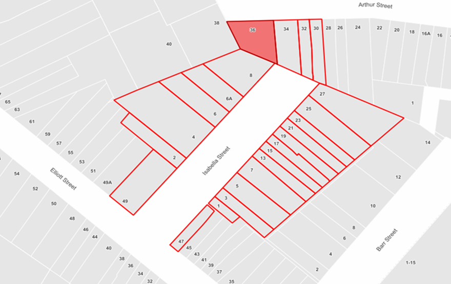
|
Residents Comments |
Officer Comments |
|
Resident requested that the corners of the street garden at the northern end be rounded to facilitate cars turning. |
Adjustments to the median strip at the turning circle could further assist vehicle turning movements and provide additional spacing between strip (see below figure). The recommendations have been amended to reflect this suggestion. |
![]()
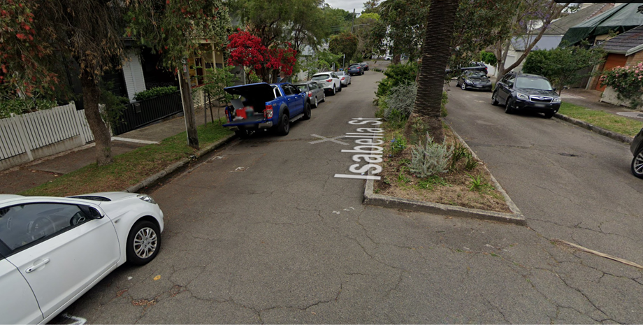
FINANCIAL IMPLICATIONS
There are no financial implications associated with the implementation of the proposed recommendations outlined in the report.
|
1.⇩ |
Proposed parking changes - Isabella Street, Balmain |
|
2.⇩ |
Signage plan - Isabella Street, Balmain |
|
Local Traffic Committee Meeting 18 September 2023 |
Subject: Management of Disabled Parking in Inner West (All wards/All Electorates/All PACs)
Prepared By: Amir Falamarzi - Traffic Engineer
Authorised By: Manod Wickramasinghe - Traffic and Transport Planning Manager
|
RECOMMENDATION
That the report be received and noted. |
STRATEGIC OBJECTIVE
This report supports the following strategic directions contained within Council’s Community Strategic Plan:
|
2: Liveable, connected neighbourhoods and transport |
|
|
EXECUTIVE SUMMARY
This report outlines the management of disabled (accessible) parking in the Inner West.
BACKGROUND
At the Council Meeting held on 2 November 2021, Council resolved the following:
THAT Council receive a report back on its management of disability parking spaces:
a) number of disability parking spaces in the Inner West, new applications and
closed permits (over time);
b) how people can apply for these spaces;
c) renewal processes for disability parking spaces;
d) what process is in place when these spaces are no longer needed;
e) whether there is a process to open up use of these spaces if the permit holder
is away for extended times; and
f) Has the disabled parking policy been harmonised
DISCUSSION
Council provides accessible public parking for people with a disability throughout the local government area and monitors its usage.
It is acknowledged that many residents in the LGA do not have access to off-street parking and so residents can also apply for an on street ‘Disabled Parking’ space outside of their residential address to provide improved opportunities to park near their property.
Note that these spaces are not reserved for private use and anyone with a Mobility Parking Scheme permit may also use these spaces.
Council has approximately 650 ‘Disabled Parking’ spaces in operation across the LGA. In the last 12 months, 41 new spaces have been approved and installed with 28 redundant spaces removed.
Application process
Council considers the installation of ‘Disabled Parking’ spaces in a residential area through resident submitted applications.
The application process is harmonised and is outlined for the applicant on Councils webpage and outlines the conditions and requirements of application.
The applicant must:
· Have a Mobility Parking Permit
· Not have access to off-street parking at the property
· Have a signed Medical Certificate
· Indicate that the parking space is to be used for parking of the permit holders vehicle or another occupants vehicle when regularly used (i.e. parked overnight)
Council officers assess the application which includes an on-site inspection to review any off-street parking and to determine feasibility of installing the ‘Disabled Parking’ Space.
Should all conditions be met, the application is submitted for approval as a delegated item to the Local Traffic Committee. If a review of a decision is requested, an additional report is submitted to the Local Traffic Committee and Council.
Review and Removal
Council reviews the need for ‘Disabled Parking’ spaces based on advice from the applicant, spouse of applicant, carer, or new owner of the property, and during periodic audits.
Audits are initiated either by Council as part of a periodic review (every 1 to 2 years) or when another resident advises that the space appears to be poorly utilised.
Council undertakes validation of the request during the audit which may include having supporting documents resubmitted.
Should it be determined that an application is no longer required, the matter is submitted for approval as a delegated item to the Local Traffic Committee. If a review of a decision is requested, an additional report is submitted to the Local Traffic Committee and Council.
Due to the time to process requests and arrange signage works, ‘Disabled Parking’ signs are not removed for temporary absences such as if the permit holder is on holidays.
FINANCIAL IMPLICATIONS
There are no financial implications associated with the implementation of the proposed recommendations outlined in the report.
Nil.
|
|
Local Traffic Committee Meeting 18 September 2023 |
Subject: Evans Street, Balmain - Resident Parking Scheme Expansion (Baludarri - Balmain ward/Balmain Electorate/Leichhardt PAC)
Prepared By: Felicia Lau - Traffic Engineer
Authorised By: Manod Wickramasinghe - Traffic and Transport Planning Manager
|
RECOMMENDATION
That ‘2P 8am-6pm (Mon-Fri) Permit Holders Excepted Area B1’ zone on the eastern side of Evans Street, Rozelle between Beattie Street and Roseberry Street, as outlined in the report be approved.
|
STRATEGIC OBJECTIVE
This report supports the following strategic directions contained within Council’s Community Strategic Plan:
|
2: Liveable, connected neighbourhoods and transport |
|
|
EXECUTIVE SUMMARY
Residents have written to Council to expand the approved Rozelle North Precinct Resident Parking Scheme (RPS) to include the frontage of their properties on the eastern side of Evans Street, Balmain between Beattie Street and Roseberry Street. This report seeks to expand the RPS to the section of Evans Street. The proposed changes impact approximately three (3) on-street spaces.
BACKGROUND
On 21 November 2022 the expansion of the RPS for the Rozelle North precinct was supported by the Local Traffic Committee. The approved signage plan proposed a ‘2P 8am-6pm Mon-Fri, Permit Holders excepted, Area R1’ on the western side of Evans Street.
Council has received correspondence from residents in Evans Street between Beattie Street and Roseberry Street requesting that the approved Resident Parking Scheme (RPS) signage installation to include the frontage of their property. The proposed changes to parking is shown in the plan below.
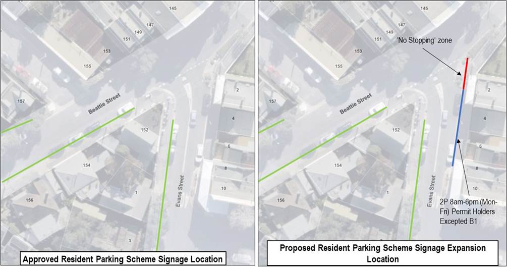
DISCUSSION
Consultation was undertaken with residents directly impacted and they have given their support for a proposed 2P RPS into the subject section of Evans Street, Balmain.
FINANCIAL IMPLICATIONS
There are no financial implications associated with the implementation of the proposed recommendations outlined in the report.
Nil.
|
|
Local Traffic Committee Meeting 18 September 2023 |
Subject: Pedestrian Safety Improvements to Unwin’s Bridge across the Cooks River at Tempe (Midjuburi-Marrickville Ward/Canterbury & Summer Hill Electorates/Inner West Pac)
Prepared By: John Stephens - Traffic Engineer
Authorised By: Manod Wickramasinghe - Traffic and Transport Planning Manager
|
RECOMMENDATION
That the report be received and noted. |
STRATEGIC OBJECTIVE
This report supports the following strategic directions contained within Council’s Community Strategic Plan:
|
2: Liveable, connected neighbourhoods and transport |
|
|
EXECUTIVE SUMMARY
Inner West Council (IWC) and Canterbury Bankstown Council (CBC) have identified the need for a new pedestrian and cycleway crossing of the Cooks River at Bayview Ave, Earlwood and Richardsons Crescent, Tempe. A brief has been prepared and tender proposals are being sought. The new crossing will need to be constructed as a separate bridge (approximately 60m long and 4m wide) and will likley be located on the southern side of the existing Unwin’s Bridge. Following engagement with the community and stakeholders to evaluate various options, a final draft plan will be prepared and brought back to the Committee for its consideration and support.
BACKGROUND
Council at its meeting held on 14 March 2023 considered a Notice of Motion requiring urgent maintenance and improvement of pedestrian safety on the Bayview Avenue Bridge at Tempe. Council noted that the existing path on the bridge was narrow and unsafe for pedestrians, cyclists, prams, wheelchairs and dog walkers.
Consequently, Council resolved “That safety issues on the Bayview Avenue bridge be referred to the Local Traffic Committee for investigation”.
Bayview Avenue in Earlwood is a Regional Classified Road within the Canterbury-Bankstown LGA and crosses the Cooks River via Unwin’s Bridge to connect with Richardsons Crescent at Tempe. Unwin’s Bridge, due to its heritage significance, is owned and maintained by Transport for NSW.
Richardsons Crescent is also a Regional Classified Road under Council’s care and control and carries over 12,000 vehicles per day. Both Bayview Avenue and Richardsons Crescent are signposted with 50km/h speed limits.
The existing pedestrian path on the southern side of Unwin’s Bridge is approximately 1.0m wide and cannot cater for both pedestrians and cyclists. The bridge provides an important link for both vehicles and pedestrian/cycle traffic and provides a connection between Earlwood and Tempe. It also links the Cooks River Regional Cycleway between Botany Bay and Homebush Bay.
The nearby landuses consist of Gough Whitlam Park, Waterworth Park and Canterbury Velodrome adjacent to Bayview Avenue in Earlwood and Tempe Railway Station, Concordia Club, River Canoe Club of NSW, Croquet NSW Headquarters within Mackey Park adjacent to Richardsons Crescent, Tempe.
Proposed bridge south of Unwin’s Bridge
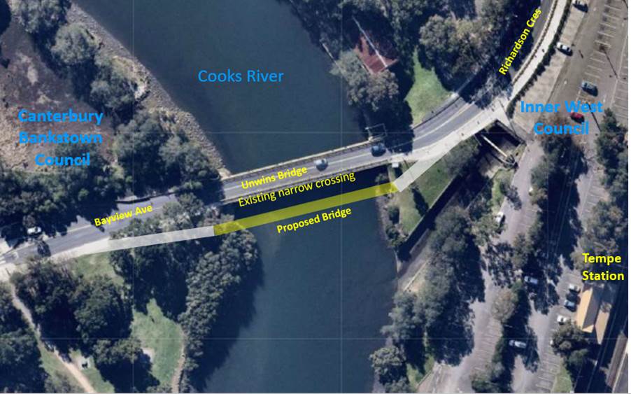
Unwin’s Bridge looking west from Tempe to Earlwood (cyclist on narrow pedestrian footpath on left)
COMMUNITY ENGAGEMENT
Once draft options for the new bridge next to Unwin’s Bridge have been prepared, engagement with the community and stakeholders will be held to evaluate those options with a final draft plan being brought back to the Committee for its consideration and support.
FINANCIAL IMPLICATIONS
Funding for the feasibility, investigation and to design a new pedestrian/cycle bridge adjacent to Unwin’s Bridge has been provided by Transport for NSW through its Get NSW Active Program for the current financial year.
Nil.
|
|
Local Traffic Committee Meeting 18 September 2023 |
Subject: Pedestrian Safety Improvements to bridge across the Cooks River in Wardell Road, Marrickville (Midjuburi-Marrickville Ward/Canterbury & Summer Hill Electorates/Inner West Pac)
Prepared By: John Stephens - Traffic Engineer
Authorised By: Manod Wickramasinghe - Traffic and Transport Planning Manager
|
RECOMMENDATION
That the report be received and noted. |
STRATEGIC OBJECTIVE
This report supports the following strategic directions contained within Council’s Community Strategic Plan:
|
2: Liveable, connected neighbourhoods and transport |
|
|
EXECUTIVE SUMMARY
An on-site inspection has been undertaken in Wardell Road between Lang Road, Earlwood and Riverside Crescent, Marrickville to investigate the existing traffic and pedestrian facilities, and road infrastructure, including the bridge which is co-owned by the City of Canterbury-Bankstown Council and Inner West Council. The report below details these findings and the required maintenance needed to make these facilities more conspicuous to motorists and to improve traffic conditions for pedestrians and other road users.
BACKGROUND
· the existing pedestrian path on either side of the bridge was narrow and unfenced and unsafe for pedestrians, cyclists, prams, dog walkers and wheelchairs.
· there was no zebra crossing on Wardell Road before the start of the bridge and this was a popular crossing point for pedestrians and golfers from Marrickville Golf Club. The crossing can be dangerous, especially in peak hour periods with high traffic movements.
· The existing damaged pedestrian refuge prior to the bridge required urgent repairs to improve pedestrian safety.
· Council should investigate traffic calming measures within the area to improve safety for pedestrians and cyclists and encourage active transport with the:
- installation of zebra crossing on Wardell Road at the start of the bridge
- a reduction of the speed limit
- provision of safety fencing on either side of the bridge
- dedicating one of the paths to pedestrians and the other to cyclists
Consequently, Council resolved “That safety issues on the Wardell Road bridge be referred to the Local Traffic Committee for investigation”.
Wardell Road is linked by the bridge between Marrickville and Earlwood and functions as an unclassified Regional Road under the care and control of both councils. It carries over 16,000 vehicles per day. The bridge provides a connection for cyclists from Marrickville / Dulwich Hill onto the Cooks River Regional Cycleway on the Earlwood side of the river.
A recent on-site inspection of Wardell Road and the bridge indicated that:
· The existing concrete pedestrian paths on the bridge are 1.83m wide on the eastern side and 1.84m wide on the western side and cannot cater for both pedestrians and cyclists. There were bicycle logos on the road pavement indicating for cyclists to share the road.
· The height of the railing on the bridge was approximately 1.18m high above the concrete footpath.
· There were notices on the approaches to the bridge indicating a 12 tonne gross load limit.
· The adjacent landuse on either side of Wardell Road approaching the bridge is Marrickville Golf Course and Beaman Park and Wills Ground on the Earlwood side of the bridge, including the Cooks River Regional Cycleway.
· There was a marked zebra pedestrian crossing with an integrated bicycle refuge in Wardell Road just north of Lang Road, Earlwood to assist pedestrians and cyclists using the Cooks River Regional Cycleway.
· The existing cyclone wire fence had several bent panels with damaged posts and there was a panel missing on the east side on the north approach to the bridge.
· The advanced warning signs for the Pedestrian Refuge and Speed Hump Ahead signs were missing on the west side of Wardell Road, north of the bridge, facing northbound traffic.
· The advanced warning sign for the Pedestrian Refuge, on the power pole, on the east side outside the boundary of Nos.274-276 Wardell Road was missing the ‘Refuge’ sign.
· There were Danger warning notices on top of the kerb in Wardell Road, south of the pedestrian refuge indicating the presence of a High Pressure Buried Oil (Fuel) Pipeline below and ‘Do Not Excavate’ message and to contact Viva Energy. The pipeline runs perpendicular to Wardell Road and through the golf course.
· Wardell Road has a signposted speed limit of 50km/h.
· One of the ‘U’ posts in the pedestrian refuge near Riverside Crescent was bent and the associated speed cushion for southbound traffic was damaged.
· The adjacent chevron sign facing southbound traffic had been vandalised with graffiti.
· The ‘No Stopping’ (arrow right) signpost was missing on the south-west approach to the pedestrian refuge.
· The linemarking on the north approach to the pedestrian refuge was faded, including the barrier lines on the south approach and on the bridge.
The following comments are made to the issues raised at the Council meeting:
· The existing pedestrian path is considered wide enough to accommodate pedestrians and wheelchair users, excluding cyclists. Maintenance of the cyclone wire fence on either side of Wardell Road adjacent to Marrickville Golf Course and up to the bridge is being arranged.
· Traffic and pedestrian counts taken on Wednesday, 12 May and Saturday, 15 May 2021 in Wardell Road at the pedestrian refuge indicated that the warrant to install a marked zebra pedestrian crossing was not met. However, maintenance instructions for signage, ‘U’ post, linemarking and the speed cushion are being arranged for the existing pedestrian refuge to make the facility more conspicuous to motorists.
· A separate report is being prepared for Council on the InnerWest@40 project proposing that Regional Roads are nominated to have a posted speed limit of 50km/h with potential further reduction to 40km/h proposed in the long term.
· The provision of safety fencing on either side of the bridge is not considered warranted at the present time based on the low crash data for this section of Wardell Road. Details of recent crash data provided below.
· The width of both paths is not wide enough to support dedicating one of the paths for pedestrians and the other for cyclists. Cyclists can use Ewart Street – Riverside Crescent – Tennyson Street – Ness Avenue – Garnet Street – Tennent Parade to access the Cooks River Cycleway. Most of these streets have already been calmed and some as part of the Greenway project. Cyclists can then either head east using the Lang Road bridge to head towards Botany Bay or turn right and head towards Homebush on the Cycleway.
A review of the current five year reported crash data (2017-2021) for Wardell Road indicated that only one collision had occurred between Riverside Crescent and the bridge. It involved a rear end crash between a car and a light truck both travelling northbound.
Diagram:
Bridge on Wardell Road looking south from Marrickville to Earlwood with footpath on both sides
Pedestrian refuge on Wardell Road looking south towards bridge
COMMUNITY ENGAGEMENT
Not required.
FINANCIAL IMPLICATIONS
The costs associated with the maintenance of the signage, linemarking, speed cushion, ‘U’ post and fencing will be funded from Council’s Operational Budget.