|
AGENDA R |

Local Traffic Committee Meeting
MONDAY 20 NOVEMBER 2023
11.00am
|
|
Local Traffic Committee Meeting 20 November 2023 |
Function of the Local Traffic Committee
Background
Roads and Maritime Services (RMS) is legislated as the Authority responsible for the control of traffic on all NSW Roads. The RMS has delegated certain aspects of the control of traffic on local roads to councils. To exercise this delegation, councils must establish a local traffic committee and obtain the advice of the RMS and Police. The Inner West Council Local Traffic Committee has been constituted by Council as a result of the delegation granted by the RMS pursuant to Section 50 of the Transport Administration Act 1988.
Role of the Committee
The Local Traffic Committee is primarily a technical review and advisory committee which considers the technical merits of proposals and ensures that current technical guidelines are considered. It provides recommendations to Council on traffic and parking control matters and on the provision of traffic control facilities and prescribed traffic control devices for which Council has delegated authority. These matters are dealt with under Part A of the agenda and require Council to consider exercising its delegation.
In addition to its formal role as the Local Traffic Committee, the Committee may also be requested to provide informal traffic engineering advice on traffic matters not requiring Council to exercise its delegated function at that point in time, for example, advice to Council’s Development Assessment Section on traffic generating developments. These matters are dealt with under Part C of the agenda and are for information or advice only and do not require Council to exercise its delegation.
Committee Delegations
The Local Traffic Committee has no decision-making powers. The Council must refer all traffic related matters to the Local Traffic Committee prior to exercising its delegated functions. Matters related to State Roads or functions that have not been delegated to Council must be referred directly to the RMS or relevant organisation.
The Committee provides recommendations to Council. Should Council wish to act contrary to the advice of the Committee or if that advice is not supported unanimously by the Committee members, then the Police or RMS have an opportunity to appeal to the Regional Traffic Committee.
Committee Membership & Voting
Formal voting membership comprises the following:
· one representative of Council as nominated by Council;
· one representative of the NSW Police from each Local Area Command (LAC) within the LGA, being Newtown, Marrickville, Leichhardt and Ashfield LAC’s.
· one representative from the RMS; and
· State Members of Parliament (MP) for the electorates of Summer Hill, Newtown, Heffron, Canterbury, Strathfield and Balmain or their nominees.
Where the Council area is represented by more than one MP or covered by more than one Police LAC, representatives are only permitted to vote on matters which effect their electorate or LAC.
Informal (non-voting) advisors from within Council or external authorities may also attend Committee meetings to provide expert advice.
Committee Chair
Council’s representative will chair the meetings.
Public Participation
Members of the public or other stakeholders may address the Committee on agenda items to be considered by the Committee. The format and number of presentations is at the discretion of the Chairperson and is generally limited to 3 minutes per speaker. Committee debate on agenda items is not open to the public.
|
|
Local Traffic Committee Meeting 20 November 2023 |
|
AGENDA |
1 Apologies
2 Disclosures of Interest
3 Confirmation of Minutes PAGE
Minutes of 16 October 2023 Local Traffic Committee 6
4 Matters Arising from Council’s Resolution of Minutes
5 Part A – Items Where Council May Exercise Its Delegated Functions
Traffic Matters
ITEM Page
LTC1123(1) Item 1 182-198 Victoria Road and 28-30 Faversham Street, Marrickville - Condition 30 & 31 – Signs and Line Markings Plans, Carshare Conditions 5 & 71, and Victoria Road proposed signage modification – MOD/2023/0049 (Midjuburi - Marrickville Ward / Summer Hill Electorate / Inner West PAC) 20
LTC1123(1) Item 2 Lord Street, Newtown - Proposed 'No Stopping' restrictions (Damun-Newtown Ward/Newtown Electorate/Inner West PAC) 39
LTC1123(1) Item 3 Brereton Avenue, Marrickville - Proposed Kerb Extensions (Midjuburi-Marrickville Ward/Summer Hill Electorate/Inner West PAC) 42
LTC1123(1) Item 4 Wells Street, Newtown - Proposed Relocation of The At-Grade Pedestrian Crossing (Damun- Newtown Ward/Newtown Electorate/Inner West PAC) 50
LTC1123(1) Item 5 Victoria Road, Marrickville - Proposed Short-Term Parking (Midjuburi- Marrickville Ward/ Summer Hill Electorate/ Inner West PAC) 55
LTC1123(1) Item 6 Wardell Road, Marrickville – Extension of the drop-off / pick-up zone for St Maroun’s College(Djarrawunang Ward/Summer Hill Electorate/Inner West PAC) 57
LTC1123(1) Item 7 Audley Street, Audley Lane, Sadlier Crescent, Fisher Street, and eastbound parking lanes on New Canterbury Road Petersham – Temporary Full Road Closures For Special Event On Saturday 23 March 2024 – Petersham Festival Bairro Portuguese (Damum - Stanmore Ward / Newtown Electorate / Inner West PAC) 60
LTC1123(1) Item 8 Murray Street, at Edinburgh Road and Smidmore Street, Marrickville – Proposed new pedestrian refuge islands post Marrickville Metro works (Midjuburi – Marrickville Ward / Newtown and Summer Hill Electorates / Inner West PAC) 86
LTC1123(1) Item 9 Lackey Street & Smith Street (between Mooonbie Street and Nowranie Street) Summer Hill- Temporary Full Road Closure- 'Summer Hill Festival' on Sunday 10 March 2024(Djarrawunang-Ashfield Ward/Summer Hill Elecorate/Burwood PAC) 98
LTC1123(1) Item 10 Charlotte Street at Bland Street, Ashfield-Intersection improvement works (Djarrawunang- Ashfield Ward/Summer Hill Electrorate/Burwood PAC) 124
LTC1123(1) Item 11 Collins Street, Tempe - Proposed 'No Parking' restrictions at dead-end (Midjuburi - Marrickville Ward/ Heffron Electorate / Inner West PAC) 129
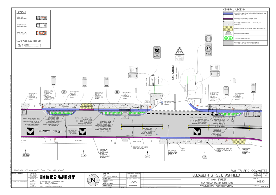
LTC1123(1) Item 12 Elizabeth Street at Oak Street, Ashfield- Intersection
improvement works (Djarrawunang- Ashfield Ward/Summer Hill Electorate/Burwood PAC) 132
ITEM Page
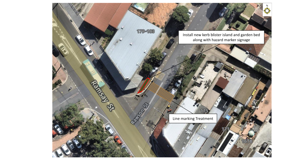
LTC1123(1) Item 13 Ramsay Street at Rawson Street, Haberfield - Proposed Kerb Blister Island (Gulgadya - Leichhardt/Balmain Electorate/Leichhardt PAC) 137
LTC1123(1) Item 14 Pritchard Street, Annandale - Proposed 'No Parking' Restriction (Baludarri-Balmain Ward/Balmain Electorate/Leichhardt PAC) 141
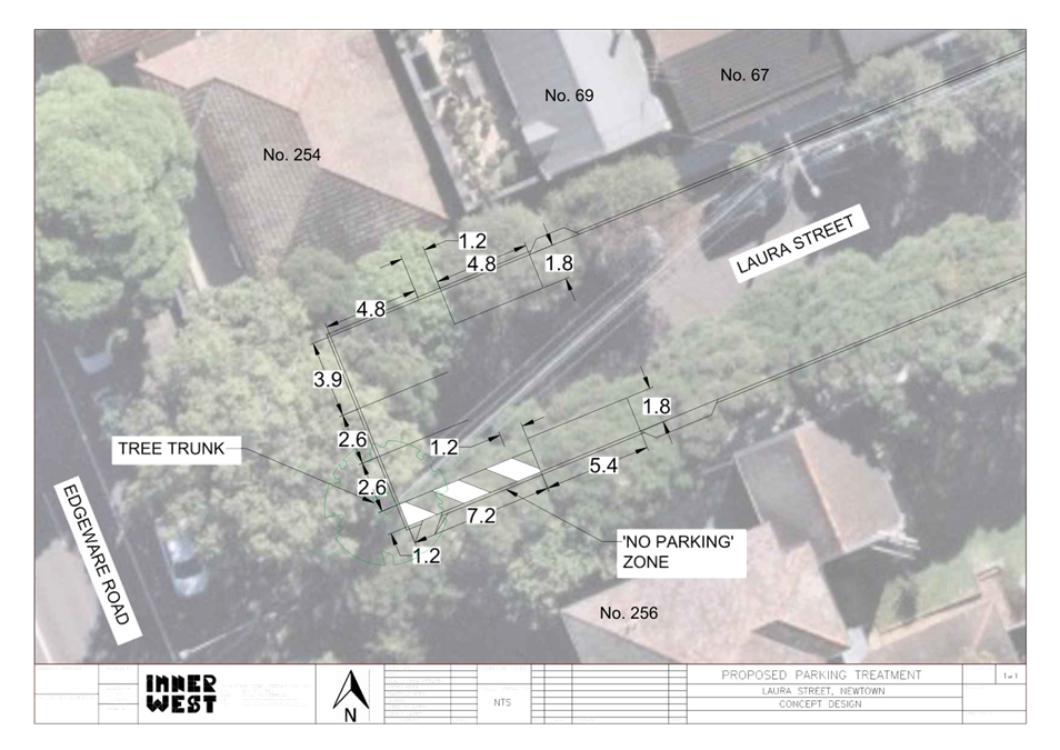
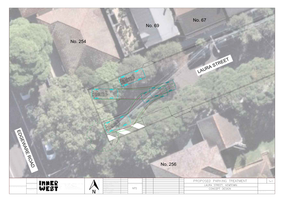
LTC1123(1) Item 15 Laura Street, Newtown - Proposed chevron line marking and parking bays (Damun-Newtown Ward/Newtown Electorate/Inner West PAC) 144
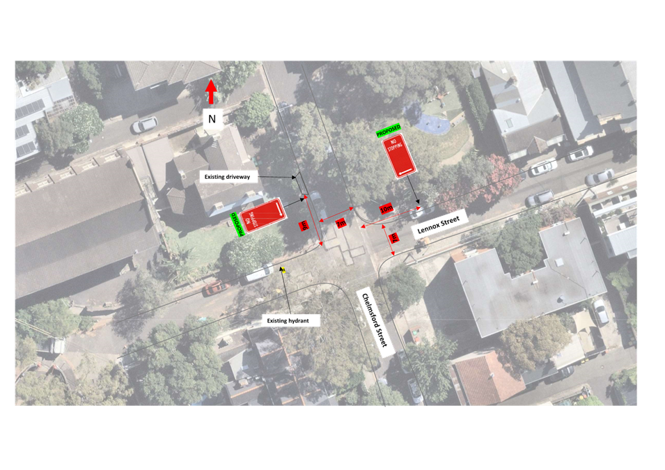
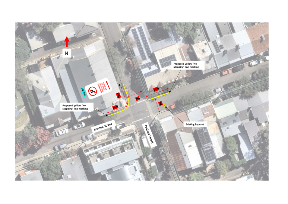
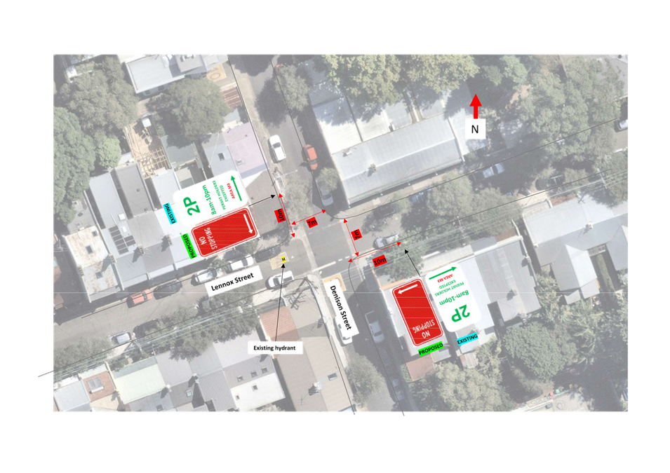
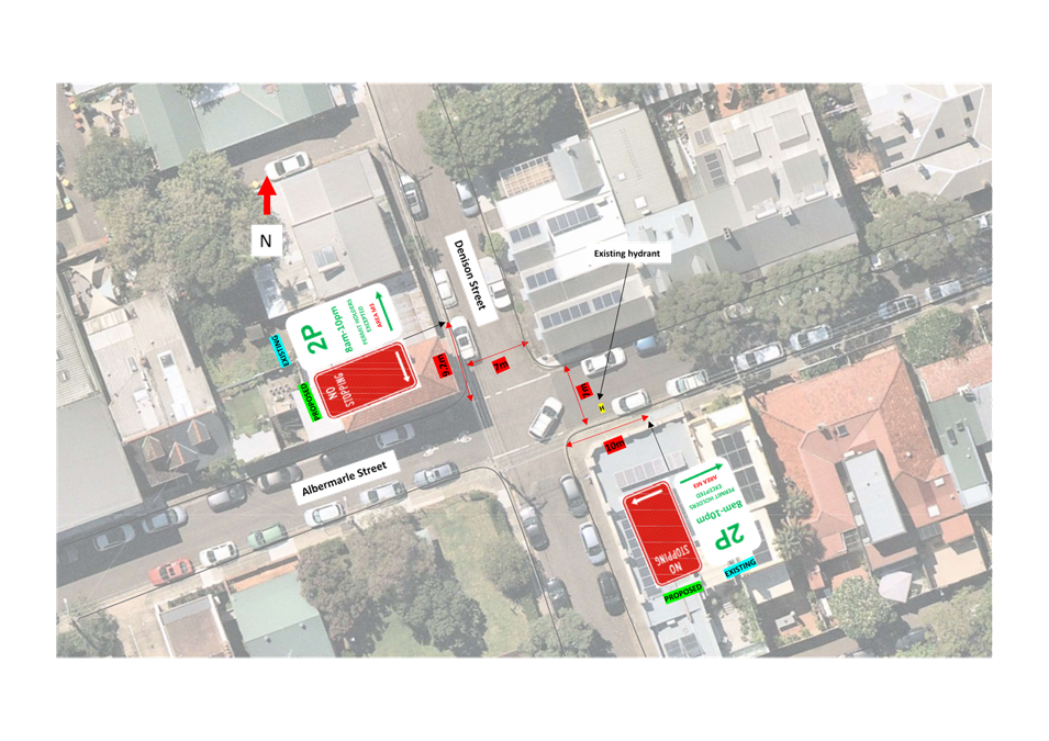
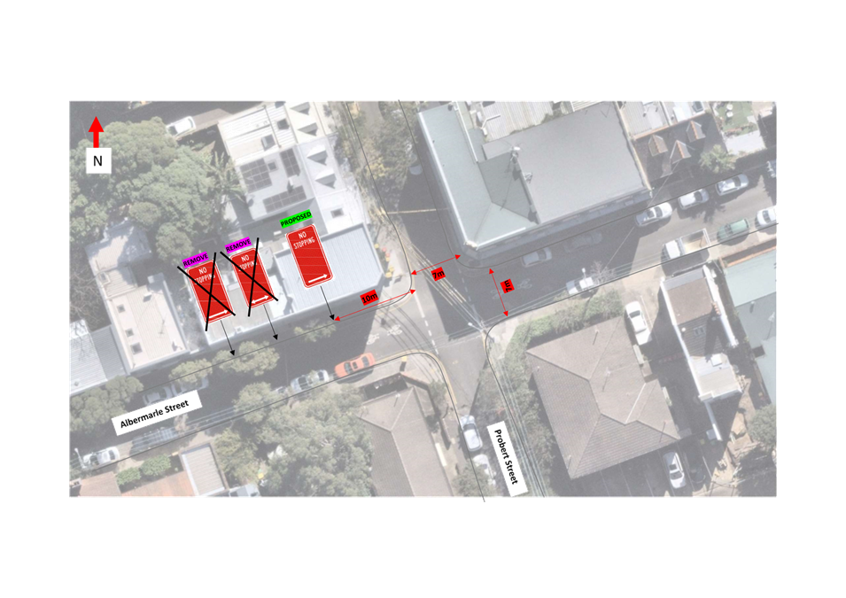
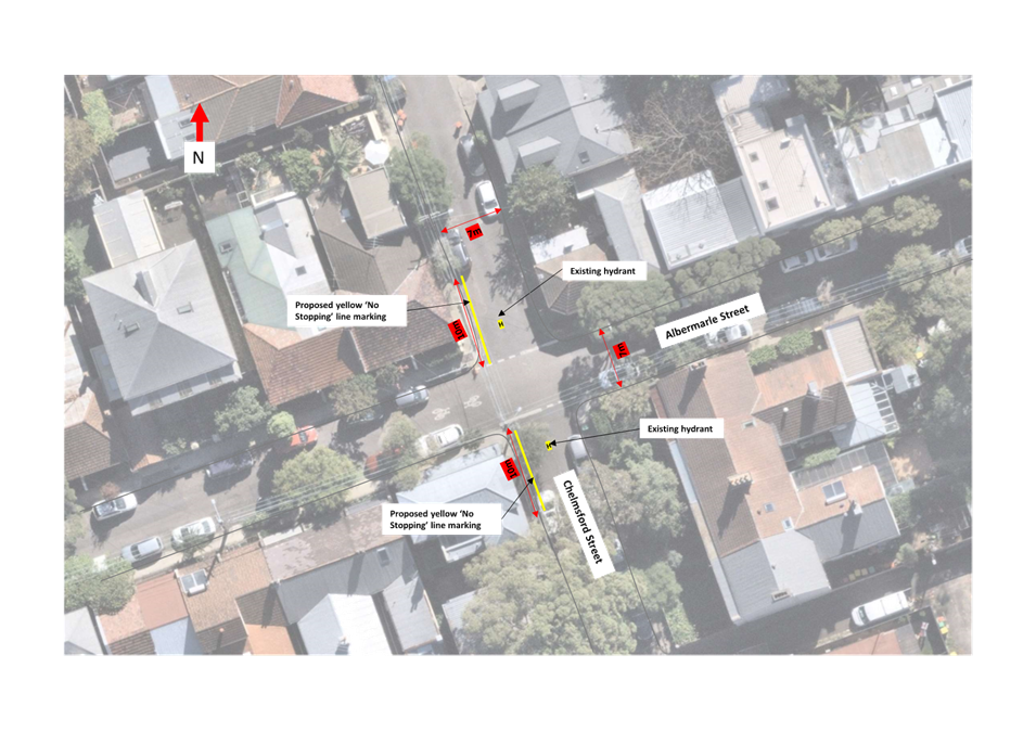
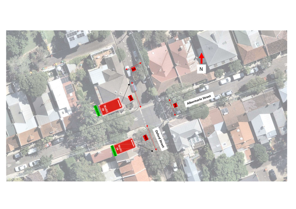
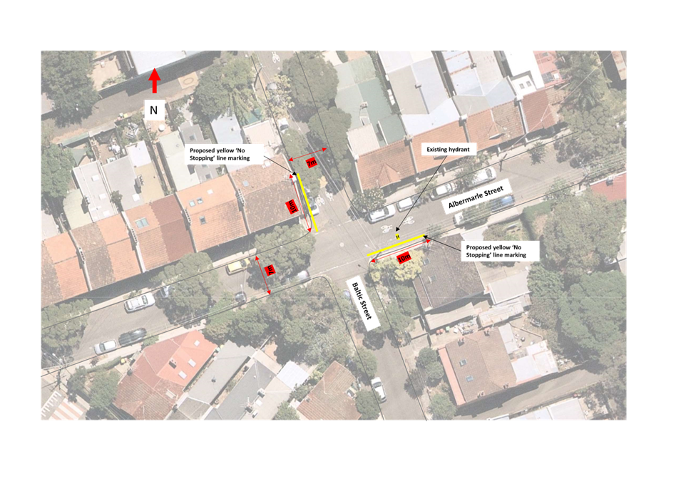
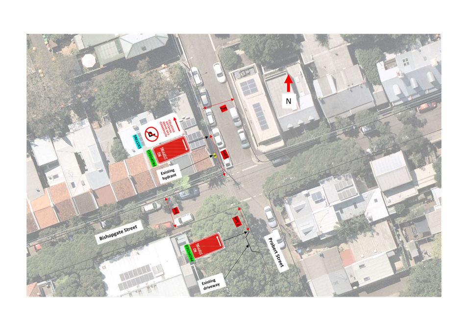
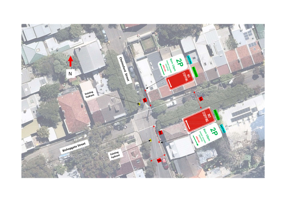
LTC1123(1) Item 16 Albermarle Street, Baltic Street, Oxford Street, Chelmsford Street, Probert Street, Denison Street, Lennox Street, Bishopgate Street, Newtown - Proposed 'No Stopping' restrictions (Damun-Newtown Ward/Newtown Electorate/Inner West PAC) 150
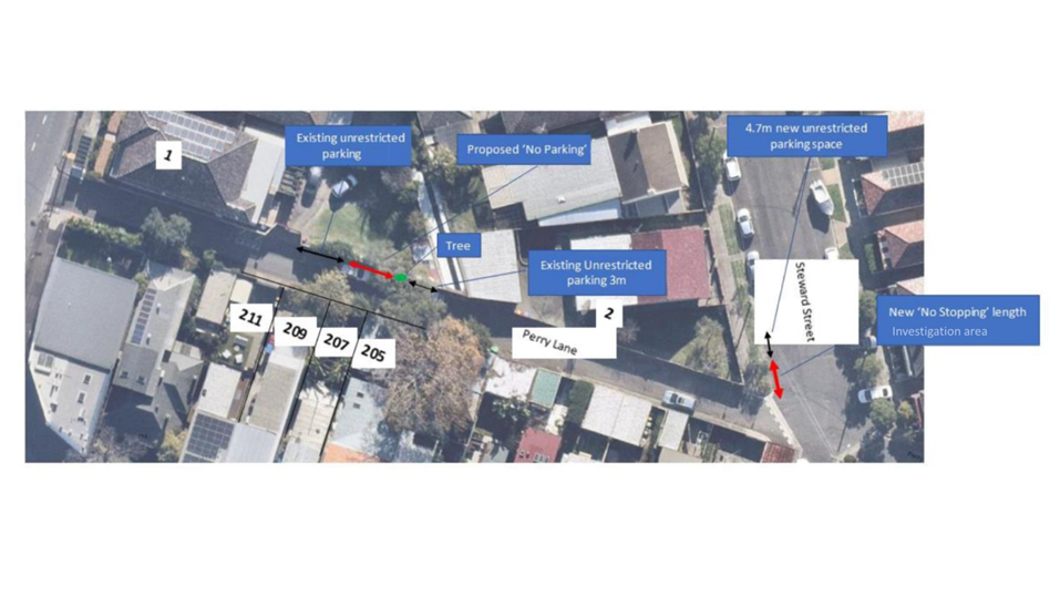
LTC1123(1) Item 17 Perry Lane, Lilyfield - Proposed 'No Parking' Restrictions (Baludarri-Balmain Ward/Balmain Electorate/Leichhardt PAC) 172
LTC1123(1) Item 18 Ryan Street At Joesph Street, Lilyfield - Proposed Kerb Blister Island (Baludarri - Balmain Ward/ Balmain Electorate/ Leichhardt PAC) 175
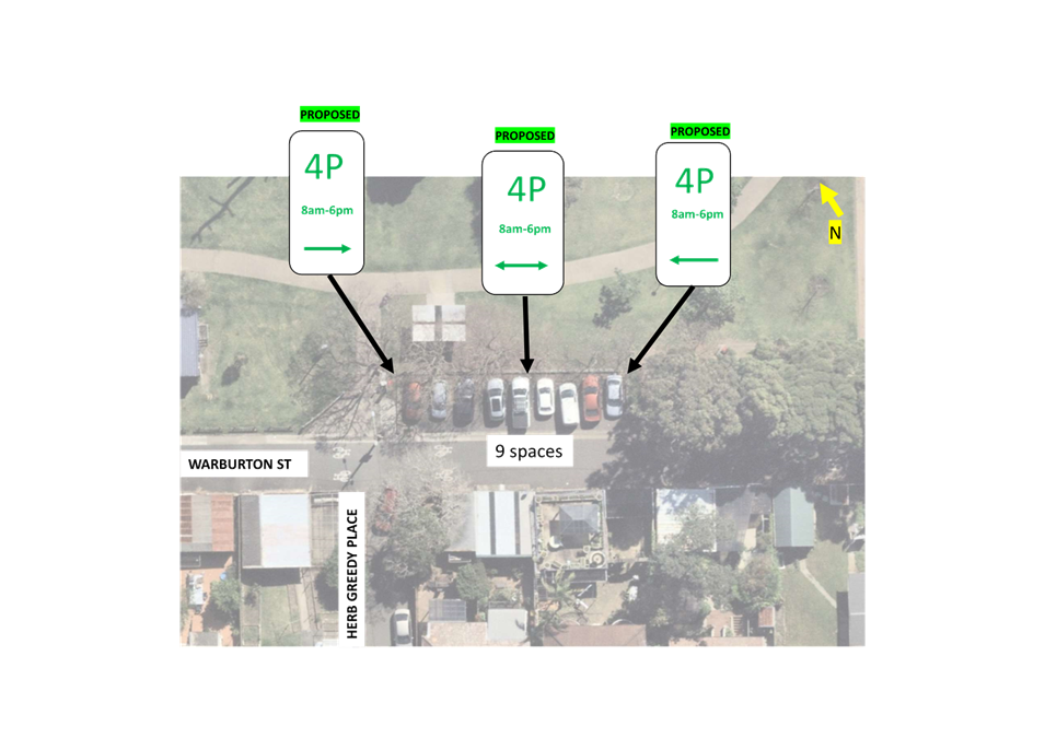
LTC1123(1) Item 19 Warburton Street, Marrickville - Proposed timed parking restrictions (Midjuburi-Marrickville Ward/Summer Hill Electorate/Inner West PAC) 178
LTC1123(1) Item 20 Birchgrove Road, Birchgrove - Proposed 'No Stopping' (Baludarri-Balmain Ward/Balmain Elecorate/Leichhardt PAC) 183
Late Items
Nil at time of printing.
6 Part B - Items for Information Only
ITEM Page
LTC1123(1) Item 21 Smith Street, Rozelle - Review of Parking (Baludarri-Balmain Ward/Balmain Electorate/Leichhardt PAC) 185
LTC1123(1) Item 22 Pedestrian and Bicycle Safety at Bus Stop - Robert Street, Rozelle (Baludarri - Balmain Ward/ Balmain Electorate/ Leichhardt PAC) 187
LTC1123(1) Item 23 Traffic Calming on Lilyfield Road, Rozelle (Baludarri - Balmain Ward/ Balmain Electorate/ Leichhardt PAC) 189
7 Part C - Items for General Advice
Nil at the time of printing.
8 General Business
9 Close of Meeting
|
|
Local Traffic Committee Meeting 20 November 2023 |
Minutes of Meeting
Meeting commenced at 11.03am
ACKNOWLEDGEMENT OF COUNTRY BY CHAIRPERSON
I acknowledge the Gadigal and Wangal people of the Eora nation on whose country we are meeting today, and their elders past and present.
COMMITTEE REPRESENTATIVES PRESENT
|
Mayor Darcy Byrne |
Councillor – Baludarri-Balmain Ward (Chair) |
|
Bill Holliday |
Representative for Kobi Shetty MP, Member for Balmain |
|
Graeme McKay |
Representative for Jo Haylen MP, Member for Summer Hill |
|
Nina Fard |
Transport for NSW (TfNSW) |
|
|
|
|
NON VOTING MEMBERS IN ATTENDANCE |
|
|
|
|
|
Colin Jones |
Inner West Bicycle Coalition (IWBC) |
|
Manod Wickramasinghe |
IWC’s Traffic and Transport Services Manager |
|
Sunny Jo |
IWC’s Coordinator Traffic Engineering Services (North) |
|
George Tsaprounis |
IWC’s Coordinator Traffic Engineering Services (South) |
|
Christy Li |
IWC’s Business Administration Officer |
|
|
|
|
VISITORS |
|
|
|
|
|
Jennifer Heywood |
Resident (Item 11) |
|
Robert Bennett |
Resident (Item 11) |
|
Paul Corbett |
Director at PDC Consultants Representative for Resident (Item 12) |
|
Catherine Davis |
Resident (Item 5) |
|
Kian Mohammadah |
Resident (Item 4) |
|
|
|
|
APOLOGIES: |
|
|
|
|
|
Senior Constable Shannon Burns |
NSW Police – Leichhardt Police Area Command |
|
Patricia Arcilla |
Representative for Jenny Leong MP, Member for Newtown |
|
Jason Yat-sen Li |
Member for Strathfield |
|
Ben Walters |
NSW Police Representative |
|
Colin Hesse |
Office of Jenny Leong, Member for Newtown |
DISCLOSURES OF INTERESTS:
Mayor Darcy Byrne declared a non-significant, non-pecuniary interest for Item 5 as he had been a renter near that location previously and will absent himself during the Committee discussion on Item 5.
CONFIRMATION OF MINUTES
|
That the Minutes of the Local Traffic Committee held on Monday, 18 September 2023 be confirmed. |
MATTERS ARISING FROM COUNCIL’S RESOLUTION OF MINUTES
The Minutes of the Local Traffic Committee meeting held on 18 September 2023 were adopted at Council’s meeting held on 10 October 2023 subject to the following amendments:
|
LTC1023(1) Item 7 Metropolitan Road, Enmore – Accessible Parking Improvements (Damun-Stanmore Ward/Newtown Electorate/Inner West PAC) |
|
Council has received a request for accessible parking improvements at a number of locations. Council staff have now investigated one location in Metropolitan Road, Enmore and in line with Council’s assessment procedures for mobility parking applications has listed improvements at that location which are recommended for installation. Currently the existing Mobility parking space is not to standard with no shared zone.
Officer’s Recommendation:
That a Shared Area be installed on the eastern side of Metropolitan Road, corner of Enmore Lane Enmore to service the existing 90-degree angle Mobility Parking Space located on the side boundary of 188A Enmore Road, Enmore. In addition, two access ramps to be installed on the eastern side and opposite footpath on the western side of Metropolitan Road, Enmore to service the Mobility Parking and Shared Area.
DISCUSSION:
The Committee members agreed with the Officer’s recommendation.
COMMITTEE RECOMMENDATION:
That a Shared Area be installed on the eastern side of Metropolitan Road, corner of Enmore Lane Enmore to service the existing 90-degree angle Mobility Parking Space located on the side boundary of 188A Enmore Road, Enmore. In addition, two access ramps to be installed on the eastern side and opposite footpath on the western side of Metropolitan Road, Enmore to service the Mobility Parking and Shared Area.
For Motion: Unanimous |
General Business:
|
Item 13 – Update on the Bus Stop on Robert Street, Rozelle. |
|
The Representative for the Member of Balmain requested an update on the Bus Stop on Robert Street, Rozelle.
Council Officer’s to prepare a report with an update to be tabled at the next Traffic Committee Meeting. |
|
Item 14 – Update on Traffic Calming Lilyfield Road at Victoria Road |
|
The Representative for the Member of Balmain requested an update on the investigation of traffic calming devices and/or treatments on Lilyfield Road at the intersection of Victoria Road.
Council Officer’s to prepare a report with an update to be tabled at the next Traffic Committee Meeting. |
|
Item 15 – Update on request for additional parking permits for the Inner Sydney Montessori School |
|
The Representative for the Member of Balmain requested an update on the request for the additional parking permits and suggestion for Council to turn some of the 2 hour resident parking zones into 4P paid parking, resident permit holders excepted.
Council Officer’s to prepare a report with an update to be tabled at the next Traffic Committee Meeting. |
|
Item 16 – Consideration for a Roundabout at the intersection of Booth Street and Annandale Street. |
|
The Representative for the Member of Balmain questioned whether there was consideration for a roundabout at the intersection of Booth Street and Annandale Street.
Council Officer’s responded that a roundabout at the intersection of Booth Street and Annandale Street has not been considered however Council is about to commence the Annandale LATM study this financial year and would encourage the Representative for the Member of Balmain to make a submission as part of that study.
|
|
Item 17 – Uneven raised speedhump on the corner of Mary Street and Perry Street, Lilyfield |
|
The Representative for the Member of Balmain raised concerns on behalf of a resident regarding the danger posed to residents with prams from on-coming traffic while crossing Mary Street using the raised speed hump on the corner with Perry Street, Lilyfield. Deep gutters at each end trap pram wheels. A proper pedestrian crossing is required here.
The Representative for the Member of Balmain is to forward resident correspondence to Council Officer’s for investigation. |
Meeting closed at 12.06pm.
CHAIRPERSON
|
|
Local Traffic Committee Meeting 20 November 2023 |
Subject: 182-198 Victoria Road and 28-30 Faversham Street, Marrickville - Condition 30 & 31 – Signs and Line Markings Plans, Carshare Conditions 5 & 71, and Victoria Road proposed signage modification – MOD/2023/0049 (Midjuburi - Marrickville Ward / Summer Hill Electorate / Inner West PAC)
Prepared By: Jennifer Adams - Traffic Engineer
Authorised By: Manod Wickramasinghe - Traffic and Transport Planning Manager
|
RECOMMENDATION
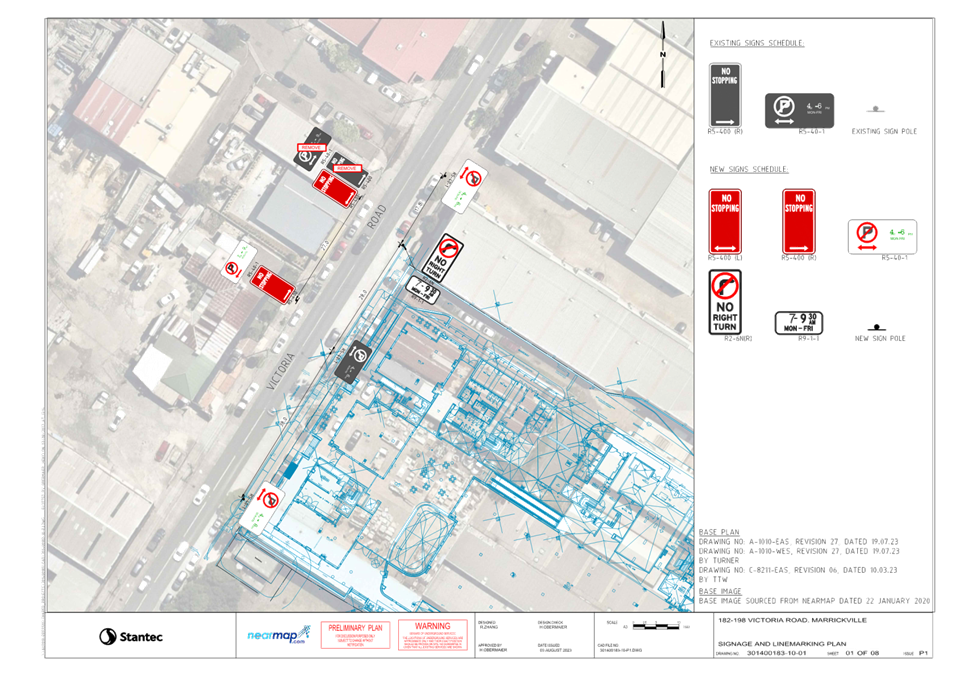
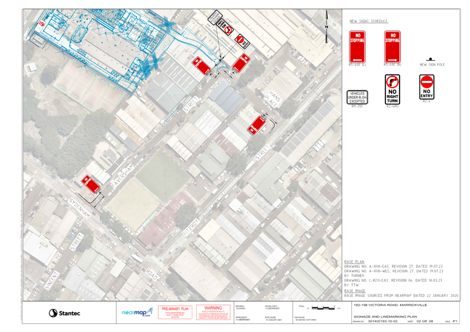
1. That the proposed amendments to ‘No Stopping’ restrictions in Faversham Street and Hans Place as shown on the updated signs and linemarking plan for the 182-198 Victoria Road and 28-30 Faversham Street, Marrickville (refer to Attachment 1, sheet 2 of 8 – 301400183-10-02 dated 3 August 2023) be approved.
2. That the updated detailed line marking and signage plans for the 182-198 Victoria Road and 28-30 Faversham Street, Marrickville development Consent Condition 30 & 31 showing amendments to ‘No Stopping’ restrictions in Faversham Street and Hans Place (as per the plans in Attachment 1) be approved.
3. That the proposed car share signage in the private shareway of the 182-198 Victoria Road and 28-30 Faversham Street, Marrickville development and new one hour parking restrictions along Victoria Road frontage, Marrickville as shown on detailed plans in Attachment 2 be approved.
4. That the costs of the supply and installation of the associated signage are to be borne by the applicant in accordance with Council’s Fees and Charges.
5. That the applicant notifies Council’s Traffic Team the date of the new line marking and signage installations. |
STRATEGIC OBJECTIVE
|
2: Liveable, connected neighbourhoods and transport |
|
|
EXECUTIVE SUMMARY
Detailed signage and line marking plans for 182-198 Victoria Road and 28-30 Faversham Street, Marrickville have been resubmitted to satisfy DA consent conditions 30 and 31 of MOD/2023/0049 as part of reviewing a Step 1 Roadworks application for Public Domain works associated with the above property (ENR1/2023/0068). Also the plan of management for the approved on-site car share spaces is presented addressing Conditions 5 and 71 of MOD/2023/0049 along with proposed modifications to signage along the Victoria Road frontage of the site. It is recommended that the updated plans be approved.
BACKGROUND
A report was orginally submitted to the Local Traffic Committee at its 3 February 2020 meeting detailing the traffic impacts of Development Application (DA/2019/00096) for a mixed residential commercial use development at 182-198 Victoria Road and 28-30 Faversham Street, Marrickville. The application was to demolish existing improvements and construct a mixed-use development ranging from 6 storeys to 12 storeys in height comprising 2,387sqm of ground floor retail floorspace, 272 residential apartments and two levels of associated basement car parking, including the provision of public domain and landscaping works.
A further report was submitted to the Local Traffic Committee at its 15 February 2021 meeting detailing initial line marking and signage plans and results of public consultation submitted by TOGA Wicks Park Development as part of development consent conditions for DA201900096. The proposal involved changes to on-street parking restrictions and the installation of new regulatory signage (‘No Right Turn’ restriction for northbound traffic into the new private road of the proposed development) and it was recommended that the submitted plans be supported in principle subject to a TMP being submitted by the applicant to TfNSW for approval.
A number of relevant modifications are applicable to the original development application/site.
MOD/2022/0241 application under Section 4.55 (1A) of the Environmental Planning and Assessment Act 1979, to modify Determination No.MOD/2021/0487, dated 7 January 2022, to modify the layout of the ground floor, including reconfiguration of retail tenancy, back of house and loading dock and other internal and external modifications. Approved 20/09/2022.
MOD/2023/0049 application under Section 4.55 (1A) of the Environmental Planning and Assessment Act 1979, to modify Determination No.MOD/2022/0241, dated 20/09/2022, to amend the approved mixed-use development including, amalgamation of units 3.11.01 and 3.11.02 into one singular unit, addition of retail storage area within Basement 1, and changes to the provision of carshare spaces & parking within the development. Specifically, the proposal involves the following:
· Relocation of the carshare allocated car parking spaces from Basement 1 to the external northern shared way at ground level;
· Modification of Condition 5(d) to increase the number of retail car parking spaces from sixty-two (62) to sixty-five (65); and
· Modification of Condition 5(e) to decrease the required number of shared car parking spaces from six (6) to four (4).
The changes to the car parking result in no overall reduction to the amount of car parking spaces provided on the site and there is no loss of parking. Now one loading space previously approved at ground level within the laneway will be located within the basement as a loading/visitor space and two car share spaces for the residential component of the development will be relocated to the basement as visitor spaces. Overall, there is a reduction in one loading space within the private road at ground level.
The site is under construction and nearing completion.
The documentation supporting Consent Condition 30 & 31 updated signs and linemarking plans for 182-198 Victoria Road and 28-30 Faversham, Marrickville along with the Car Share Plan of Management for Conditions 5 & 71 and Victoria Road Proposed Signage Modification are discussed below.
DISCUSSION
The site is located at 182-198 Victoria Road and 28-30 Faversham Street, Marrickville and is
located within the north-western portion of the Sydenham-Marrickville industrial precinct and sits within a sub-precinct known as the Victoria Road Precinct.
Victoria Road is a regional road, running north to south, connecting Enmore and Marrickville. There are two lanes in each direction with kerbside parking on both sides outside of ‘No Parking’ restrictions during peak hours:
· Northbound (western side) – ‘No Parking 7am-9am Mon-Fri’,
· Southbound (eastern side) – ‘No Parking 4pm-6pm Mon-Fri’.
Victoria Road carries approximately 17,000 vehicles per day, 5% of which are trucks and the 85th percentile speed is listed as 58.3km/h. The posted speed limit is 60km/h. Victoria Road intersects with Sydenham Road 110 metres south of the site. The intersection of Sydenham Road and Victoria Road is busy and is generally congested throughout the day. Many of the side streets abutting Victoria Road and Sydenham Road experience significant delays.
Hans Place and Faversham Street are local roads servicing the local industrial area. They are low volume roads carrying around 550 and 400 vehicles per day respectively. Both have a high truck ratio percentage of 16.5% and 10.8% respectively. The posted speed limit is 50km/h, however the 85th percentile speed for each road is around 30km/h.
Fitzroy Street is also a local road carrying around 5,800 vehicles per day with a 85th percentile speed of 56.2km/h. The speed limit is 50km/h. Trucks make up around 12% of the total volume.
Consent Condition 30 & 31
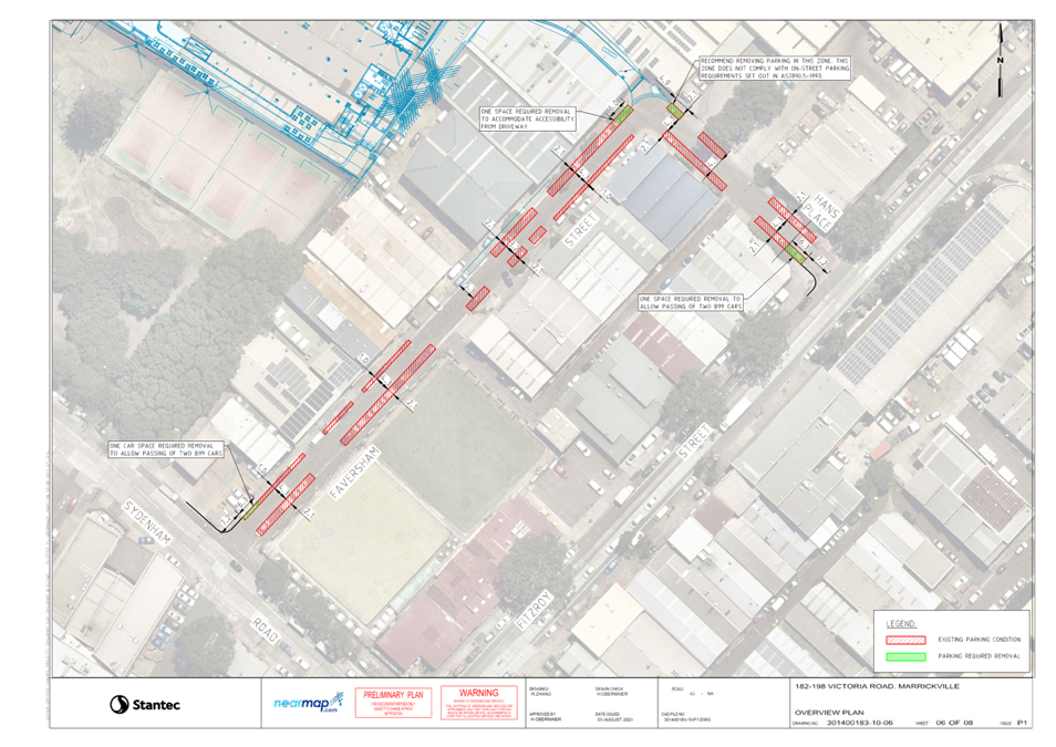
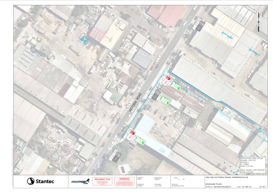
Detailed signage and line marking plans for 182-198 Victoria Road and 28-30 Faversham Street, Marrickville have been resubmitted to satisfy DA consent conditions 30 and 31 of MOD/2023/0049. The updated plans show amendments to ‘No Stopping’ restrictions in Faversham Street and Hans Place, Marrickville.
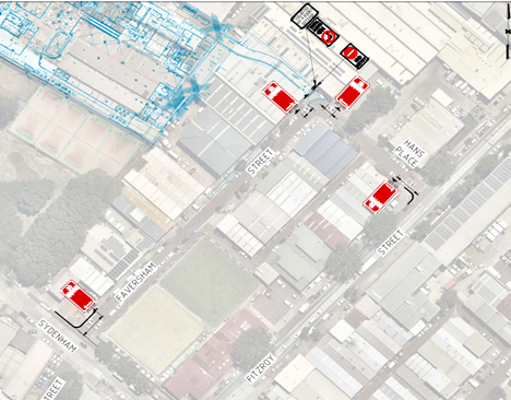
The signage plan on Sheet 2 of 8 of Attachment 1 details the updated signage changes on Faversham Street and Hans Place. The proposed signage plan result in the removal of four on-street parking spaces.
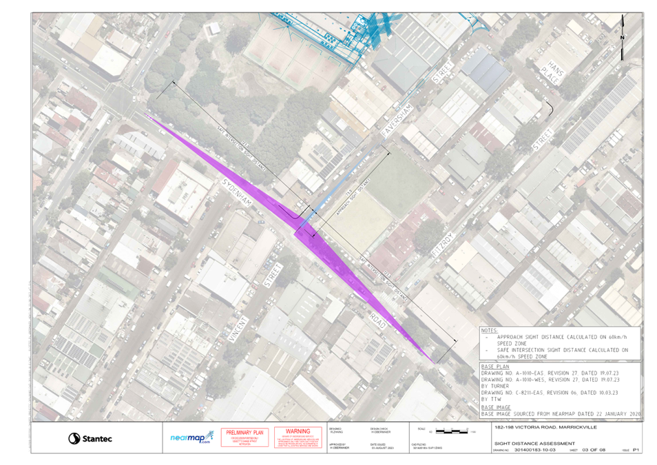
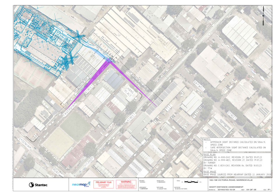
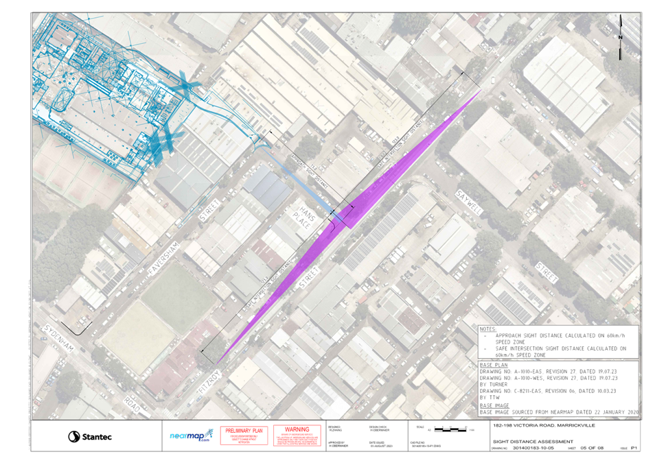
A sight line assessment has been completed and included in Attachment 1. It assesses the available Approach Sight Distance (ASD) and Safe Intersection Sight Distance (SISD) and confirms that the location of the exit driveway maximises the available sight lines to the driveway from vehicles on Faversham Street and Hans Place. The SISD to Sydenham Road/ Faversham Street and Fitzroy Street/ Hans Place is generally clear of permanent obstructions, noting these are existing intersections and the configuration achieves the maximum possible sight lines in a constrained urban environment where traffic volumes are moderate and vehicle speed low.
It is acknowledged that some trees are located along the footpaths and close to these intersections and are technically within the SISD. Given the points raised above, and in the knowledge that the trees are existing and not considered a large permanent obstruction, drivers will be able to adequately see approaching vehicles.
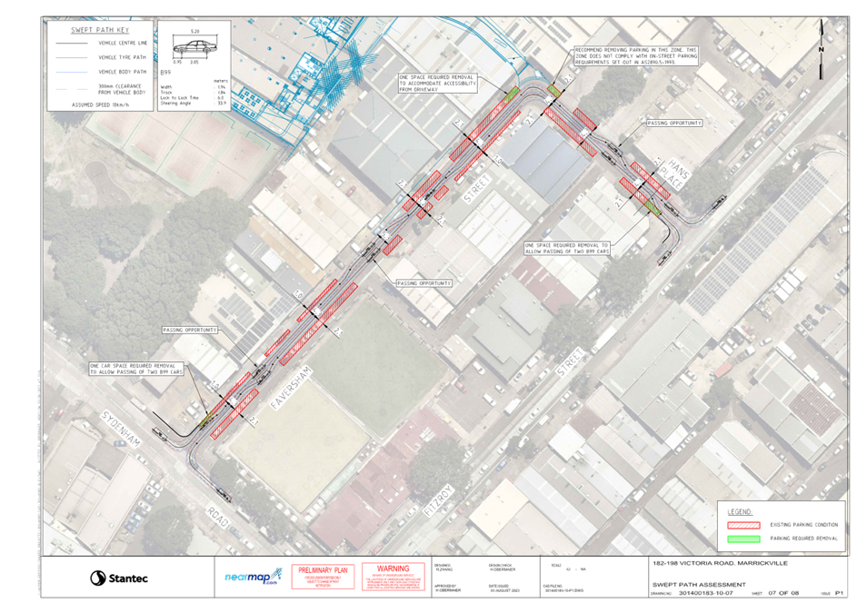
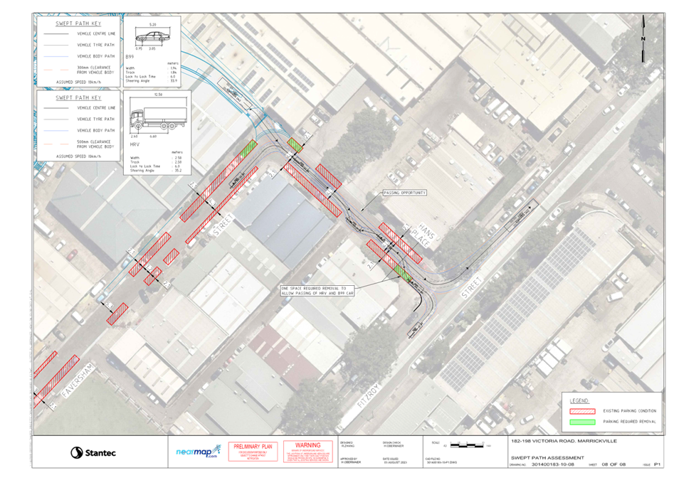
A swept path assessment has also been completed and included in Attachment 1. 99th percentile cars and 12.5 metre heavy rigid vehicles have been run and represent both the most common vehicle and largest vehicle able to access the site. The swept path assessment demonstrates there will be adequate passing opportunities along Faversham Street and Hans Place associated with gaps in on-street parking. All service vehicles related to the site will exit the site via Hans Place.
Car Share Plan of Management
The plan of management for the approved on-site car share spaces is discussed below and addresses Conditions 5 and 71 of MOD/2023/0049:
5.Car Parking
The development must provide and maintain within the site:
a) 304 car parking spaces must be paved and line marked
b) Car parking spaces, for persons with a disability must be provided and marked as disabled car parking spaces.
c) 22 visitor car parking spaces must be provided and marked as visitor car parking spaces. A sign legible from the street must be permanently displayed to indicate that visitor parking is available on site.
d) 65 retail car parking spaces must be provided and marked as visitor car parking spaces. A sign legible from the street must be permanently displayed to indicate that retail parking is available on site.
e) 4 carshare car parking spaces must be provided and marked as carshare parking spaces. In this regard, a plan of management is to be implemented for the carshare spaces to ensure they are accessed and used in a safe and efficient manner.
f) 16 off-street motorcycle parking spaces must be provided, paved, line marked and maintained at all times. g) 200 177 Bicycle storage capacity within the site.
g) 1 Carwash bay.
h) Loading dock and loading spaces.
71.Car Share – Operational
The use and operation of the car share space must be managed by the owner or contracted by the owner to a car share operator to the satisfaction of Council. The use and operation of the car share space must be accommodated in the titling and management of the development, including covenants, building or strata management statement, by laws and other instruments before the issue of an Occupation Certificate, and must provide for:
a) Free use of the car share space;
b) The person acting on this consent must demonstrate that the car share scheme is operational;
c) Public access at all times to the car share vehicle; and
d) Insurances, including public liability.
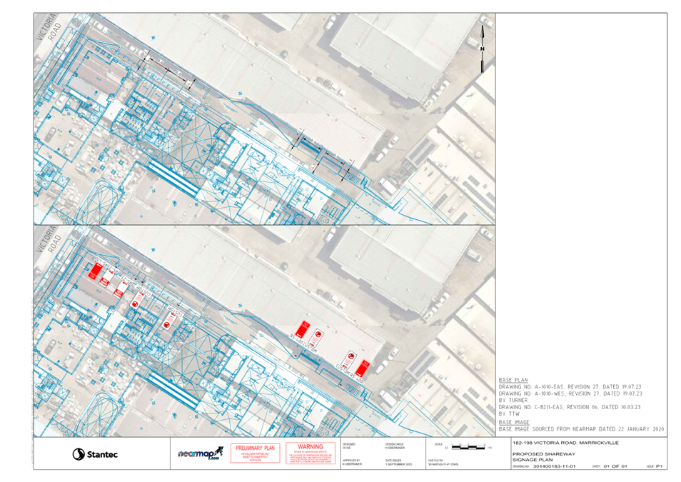
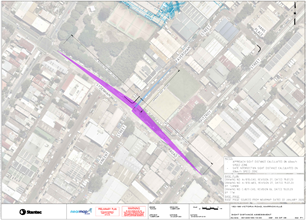
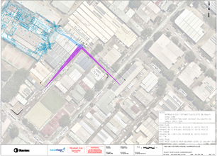
A total of four car share spaces are now approved on the site (down from the original 6) and will be located now on the private shareway along the northern site boundary (opposed to originally in the basement carpark). The car share locations are shown below.
Each of the four spaces will be linemarked with standard signage confirming authorised use of the spaces. The car share spaces will be publicly accessible 24 hours a day, seven days a week with entry to the shareway from Victoria Road and exit to Hans Place/ Faversham Street to the east.
Management of the spaces will be contracted to GoGet as per standard arrangements for publicly accessible car share spaces on private land. . Each GoGet vehicle will be parked in the dedicated spaces when not in use.
The four carshare spaces have been designed with the dimensions complying with the minimum requirements for parallel parking noting that the private shareway is one-way in the eastbound direction. These dimensions, together with the proposed signage are shown below and reproduced at a larger scale in Attachment 2.
Victoria Road Proposed Signage Modification
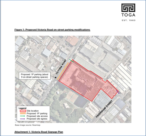
Planned changes to signage along the Victoria Road frontage of the site are proposed for the 182-198 Victoria Road and 28-30 Faversham Street, Marrickville development.
Historical land uses on the site were mostly commercial and light industrial with several driveway crossovers along the Victoria Road frontage limiting on-street parking to three or four spaces along the 70 metre wide frontage. These redundant driveways have now been removed providing additional parking spaces along the site frontage. There are clearway restrictions in place between 4:00pm and 6:00pm weekdays and it is proposed to provide short term parking along the frontage, which is currently unrestricted parking outside clearway times.
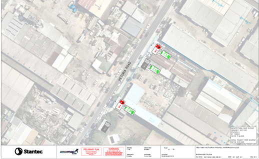
The proposed modifications are shown below with the proposed signage plan included at a larger scale in Attachment 2.
PUBLIC CONSULTATION
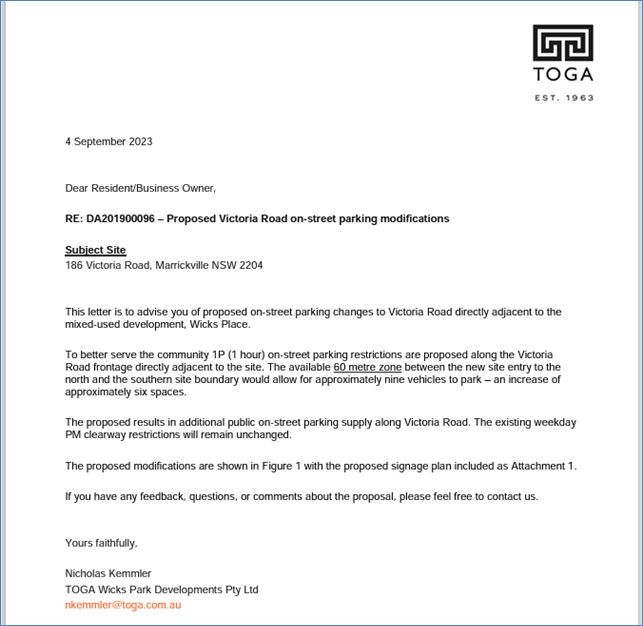
The applicant has notified adjoining and surrounding properties of the proposed changes to parking on Victoria Road adjacent to their site and a copy of their consultation letter is reproduced below.
FINANCIAL IMPLICATIONS
All works and costs of implementation works associated with the proposal will be borne by the applicant.
|
1.⇩ |
182-198 Marrickville Road Signage and Linemarking Plan |
|
2.⇩ |
182-198 Marrickville Road Signage Plan |
|
Local Traffic Committee Meeting 20 November 2023 |
Subject: Lord Street, Newtown - Proposed 'No Stopping' restrictions (Damun-Newtown Ward/Newtown Electorate/Inner West PAC)
Prepared By: James Nguyen - Traffic Engineer
Authorised By: Manod Wickramasinghe - Traffic and Transport Planning Manager
|
RECOMMENDATION
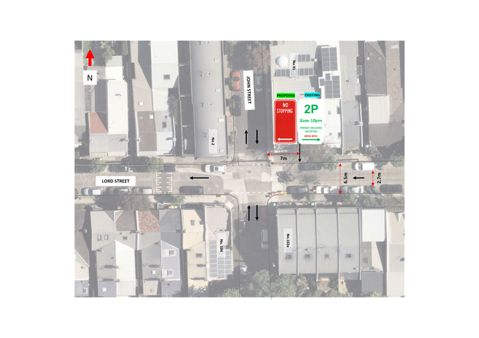
That the installation of a 7m ‘No Stopping’ sign on the northern side of Lord Street, Newtown, just east of John Street be approved. |
STRATEGIC OBJECTIVE
This report supports the following strategic directions contained within Council’s Community Strategic Plan:
|
2: Liveable, connected neighbourhoods and transport |
|
|
EXECUTIVE SUMMARY
The northern side of Lord Street, Newtown, east of John Street is currently signposted as ‘2P 8am-10pm Permit Holders Excepted Area M14’. Currently, there is no accompanying ‘No Stopping’ sign installed on the parking stem, which subsequently results in motorists parking their vehicle too close to the intersection of John Street, adjacent to the first timed parking space. The proposed ‘No Stopping’ sign seeks to improve parking compliance and reduce the instances of vehicles parking too close to the intersection.
BACKGROUND
Council has received a request from a resident requesting for the need to improve parking compliance at the intersection of Lord and John Streets, Newtown, that has historically had repeated instances of vehicles parking too close to the intersection affecting road and pedestrian safety.
DISCUSSION
Lord Street between King Street and Edgeware Road is approximately 6.5 metres wide and one-way in the westbound direction. Both sides of the street provide kerb side parking which alternates between timed parking restrictions with permit holder exemptions and unrestricted parking.
Most of the parking spaces on the northern side of Lord Street between John and King Streets are signposted as ‘2P 8am-10pm Permit Holders Excepted Area M14’.
At the intersection of John Street, there is currently no existing ‘No Stopping’ sign installed on the northern side of Lord Street, east of John Street, adjacent to the timed permit parking restrictions to clearly demarcate the kerb side where vehicles must not stop in accordance with the NSW Road Rule 167. A ‘No Stopping’ sign would advise to motorists that they cannot stop along this kerb space, reduce ambiguity and ensure compliance with this road rule.
This sign is to be installed on the existing stem that is currently 7 metres from the kerb line of John Street. Whilst this is slightly under the 10 metres required for a ‘No Stopping’ restriction at intersections, the sign is proposed adjacent to the approved 2P parking which is already in place and the change is simply formalising the existing ‘No Stopping’.
Furthermore, historical traffic counts completed on Lord Street estimate an 85th percentile speed of 30 km/h. Given the low-speed environment on Lord Street, a slight reduction to 7 metres from the standard 10 metres for ‘No Stopping’ can be considered.
By ensuring this length of kerb space always remains unimpeded, the sight lines of westbound vehicles on Lord Street would improve for vehicles on John Street as well as pedestrians seeking to cross Lord Street John Street.
PUBLIC CONSULTATION
Inner West Council consulted residents and businesses in the area. There were 32 letters sent out with one (1) response supporting and no responses opposing the proposal.
The response supporting the proposal noted the need for a ‘No Stopping’ sign at this intersection due to vehicles parking very close to the intersection of John Street creating a safety hazard.
FINANCIAL IMPLICATIONS
There are no financial implications associated with the implementation of the proposed recommendations outlined in the report.
|
1.⇩ |
Signage plan |
|
|
Local Traffic Committee Meeting 20 November 2023 |
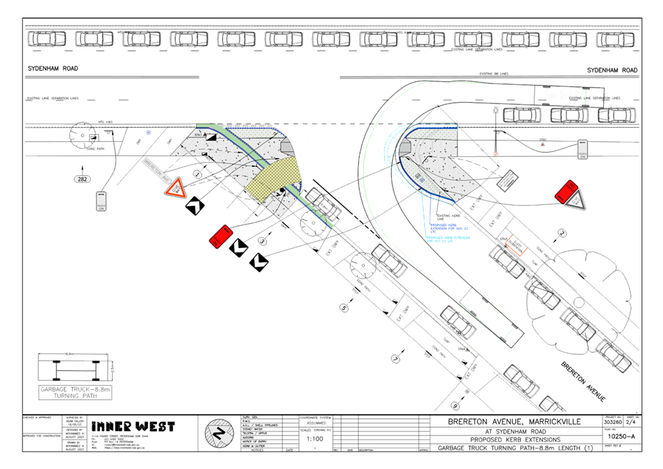
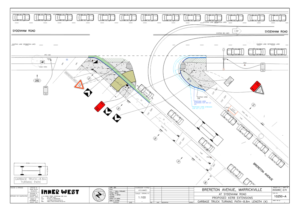
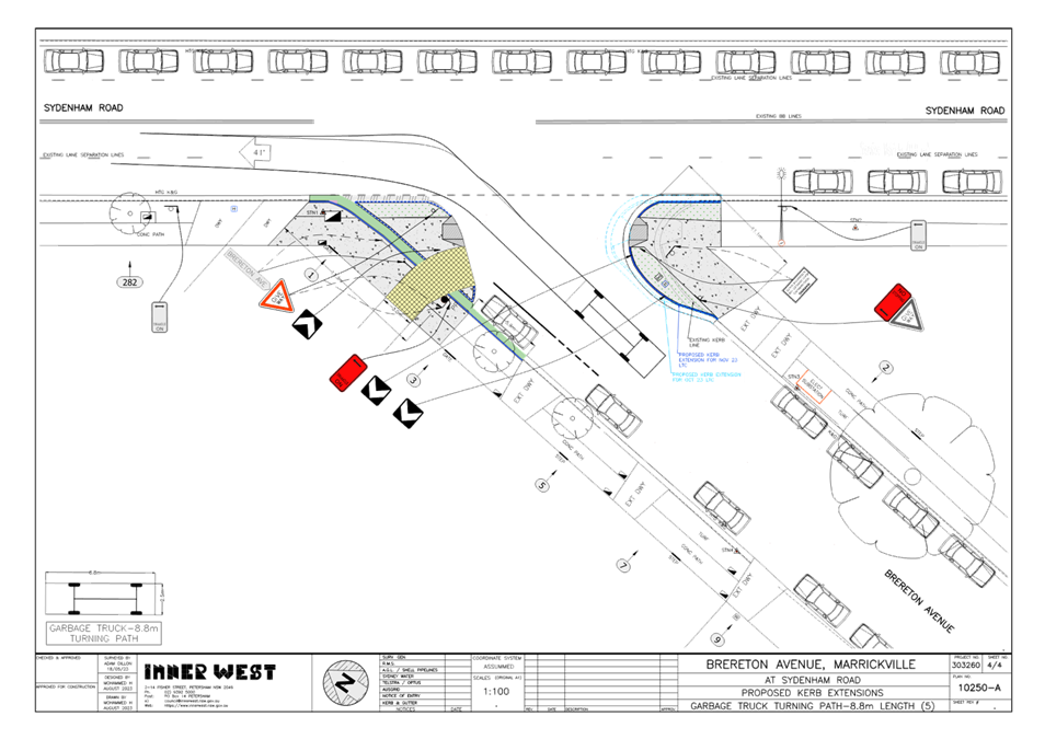
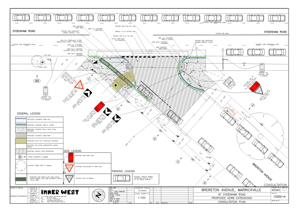
Subject: Brereton Avenue, Marrickville - Proposed Kerb Extensions (Midjuburi-Marrickville Ward/Summer Hill Electorate/Inner West PAC)
Prepared By: James Nguyen - Traffic Engineer
Authorised By: Manod Wickramasinghe - Traffic and Transport Planning Manager
|
RECOMMENDATION
That the proposed kerb extensions, signs and line marking at the intersection of Brereton Avenue and Sydenham Road, Marrickville, be approved as per Attachment 2.
|
STRATEGIC OBJECTIVE
This report supports the following strategic directions contained within Council’s Community Strategic Plan:
|
2: Liveable, connected neighbourhoods and transport |
|
|
EXECUTIVE SUMMARY
The Pedestrian Access Management
Plan (PAMP) was adopted by Council in February 2022. The proposals identified
by the PAMP seek to improve pedestrian safety, access and priority,
particularly in areas of pedestrian concentration, as well as enhancing crossing
opportunities. These proposals were priortised between ‘high’,
‘medium’ and ‘low’ and further defined by the type of
deficiency (for example: access, safety issue, connectivity).
The long crossing distance at the intersection of Brereton Avenue and Sydenham Road, Marrickville is identified as a high priority for Inner West Council to address in the PAMP. To address this long crossing distance issue, a kerb extension is proposed. This proposed kerb extension design seeks to reduce the crossing distance across Brereton Avenue to improve safety for pedestrians. It is recommended that the proposed design be approved.
BACKGROUND
This matter was previously referred to Council’s Local Traffic Committee Meeting on 16 October 2023 to seek approval for the proposed kerb extensions on Brereton Avenue, Marrickville. The proposal is identified as a high-priority intersection in Council’s Pedestrian Access Management Plan (PAMP) that was adopted by Council in February 2022, and seeks to improve pedestrian safety, access, and priority.
At the Local Traffic Committee Meeting on 16 October 2023, the representative for TfNSW objected to the recommendation and noted the need to provide swept path for the left turn from Sydenham Road to Brereton Avenue, that reflected a typical turning movement for a service vehicle (the vehicle is to occupy both the first and second travel lanes, as opposed solely to the second travel lane when making the turning maneuver). The item was subsequently deferred to allow for Council officers to investigate and resolve the issue raised.
DISCUSSION
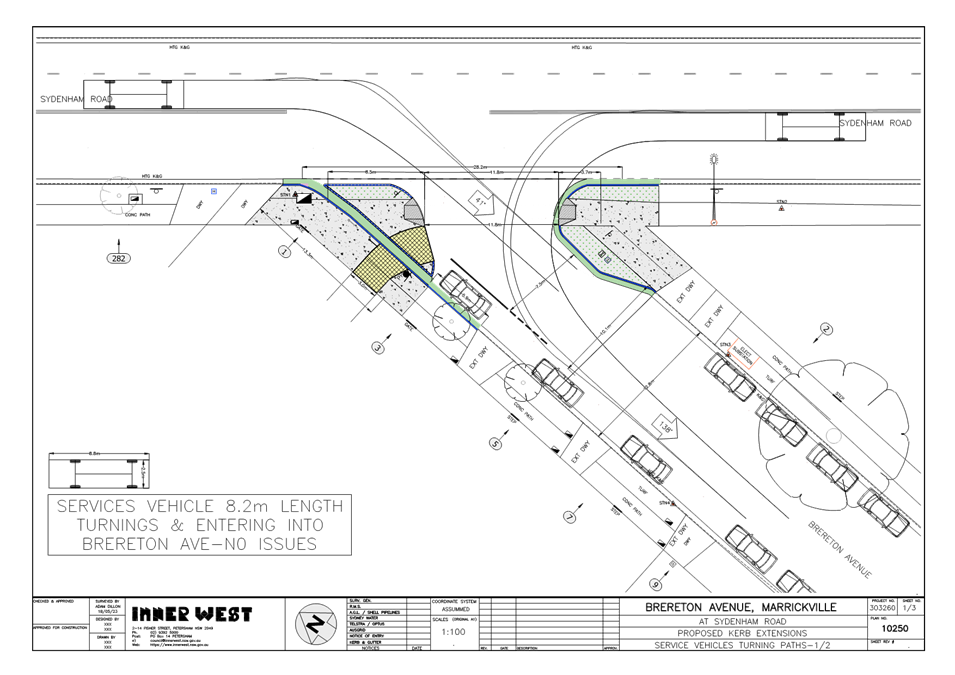
The original swept path completed for an 8.8 metre service vehicle showed the vehicle occupying solely the second northbound travel lane to make the left turn movement to Brereton Avenue.
Following a review of the travel and parking lanes along Sydenham Road and Brereton Avenue, council officers have identified that there are existing parking spaces on the western side of Sydenham Road along the first northbound travel lane on Sydenham Road.
Subsequently, an 8.8 metre service vehicle will be required to make the left-hand turn from the second northbound travel lane, similarly to the swept paths that were presented in the original traffic committee report (LTC1023(1) Item 6). However, an effort has been made to show the service vehicle to partially occupy the first travel lane in the revised swept path.
The revised swept path shows that a service vehicle will be unable to turn without obstruction with the original kerb extension alignment and requires the reduction of the radius of the kerb extension proposed on the eastern side of Brereton Avenue.
The originally proposed 4.0-metre-wide kerb extension has been reduced to 2.6 metres (a reduction of approximately 1.4 metres) to ensure that an 8.8 metre service vehicle can turn from Sydenham Road to Brereton Road without mounting the kerb extension or obstructing the parked vehicles on the western side of Brereton Avenue.
This increases the crossing distances for pedestrians from 11.8 metres to approximately 13 metres. Whilst the increase in crossing distance for a pedestrian is undesirable, the proposal is still an improvement from current conditions, where the current crossing distance for a pedestrian is reduced from 22 metres to 13 metres.
FINANCIAL IMPLICATIONS
The proposal will be delivered in Council’s 2023-24 PAMP construction program, with a delivery cost estimated at $60,000.
|
1.⇩ |
Original swept path - LTC1023(1) Item 6 |
|
2.⇩ |
Revised swept paths and kerb alignment - Brereton Avenue |
|
3.⇩ |
Revised concept plan - Brereton Avenue, Marrickville |
|
|
Local Traffic Committee Meeting 20 November 2023 |
Subject: Wells Street, Newtown - Proposed Relocation of The At-Grade Pedestrian Crossing (Damun- Newtown Ward/Newtown Electorate/Inner West PAC)
Prepared By: James Nguyen - Traffic Engineer
Authorised By: Manod Wickramasinghe - Traffic and Transport Planning Manager
|
RECOMMENDATION
That the existing pedestrian crossing outside 106-108 Wells Street, Newtown be relocated 6.5 metres east of its existing location, and the accompanying regulatory and parking signs be adjusted to suit as per Attachment 1.
|
STRATEGIC OBJECTIVE
This report supports the following strategic directions contained within Council’s Community Strategic Plan:
|
2: Liveable, connected neighbourhoods and transport |
|
|
EXECUTIVE SUMMARY
A proposal of ‘medium’ priority that was identified by the Pedestrian Access Management Plan (PAMP) is the need to improve the existing kerb ramps to the existing pedestrian crossing outside 106-108 Wells Street, Newtown outside Camdenville Public School. The existing pedestrian crossing outside Camdenville Public School is located across an existing driveway that is used as a combined pedestrian kerb ramp and vehicular crossing.
Council has subsequently completed a plan to relocate this pedestrian crossing is approximately 6.5 metres east to facilitate the construction of two new kerb ramps, separating the existing shared driveway that is being used by both vehicles and pedestrians to improve safety.
Accordingly, it is recommended that the design plan for the proposed relocation of the existing at-grade pedestrian crossing be approved.
BACKGROUND
The Pedestrian Access Management Plan (PAMP) was adopted by Council in February 2022. The proposals identified by the PAMP seek to improve pedestrian safety, access and priority, particularly in areas of pedestrian concentration, as well as enhancing crossing opportunities. These proposals were prioritised between ‘high’, ‘medium’ and ‘low’ and further defined by the type of deficiency (for example: access, safety issue, connectivity).
The proposed relocation of the existing pedestrian crossing outside 106-108 Wells Street, Newtown is included in the 2023/2024 Traffic Facilities Capital Works Program for construction. As noted earlier the PAMP considered the priority of pedestrian upgrades across the Inner West Council Local Government Area and identified the existing at-grade crossing on Wells Street, as a medium priority to upgrade, due to its proximity to Camdenville Public School and safety issues.
DISCUSSION
Wells Street, Newtown is a two-way road that is 6.7 metres wide with timed permit parking restrictions on the southern side and unrestricted parking on the northern side. Historical traffic counts recorded an average daily traffic volume of approximately 250 vehicles per day and an 85 percentile speed of 38.2 km/h. This indicates that the road is typically used for local access and due to the narrow travel lane, vehicle speeds are reduced.
The existing at-grade pedestrian crossing is located outside Camdenville Public School and pedestrians are required to use an existing driveway that functions as a dual kerb ramp, to cross the road. Historically, there have been no known recorded crashes with this current design, involving a pedestrian and a motorist entering or exiting the driveway. However, there is a need to proactively relocate this crossing to separate the movements between vehicles and pedestrians to improve safety.
Council engineers originally consulted on a proposal to relocate and convert the at-grade pedestrian crossing to a raised pedestrian crossing, as this is typically best practice to provide additional traffic calming and improve safety. However, as Wells Street has no stormwater infrastructure near the pedestrian crossing and the road is very flat in nature, therefore converting the current at-grade pedestrian crossing to a raised device would have resulted in flooding issues for the adjoining properties (without substantial stormwater drainage works in Wells Street). It should be noted that currently the road (kerb and gutter) is used to channel the overland flow west towards the nearest stormwater pit on Edgeware Road.
Subsequently, a revised design was considered to retain and relocate the at-grade pedestrian crossing, just 6.5 metres east of its original location. Given, that there are no historical crashes and historical traffic counts have recorded low traffic volumes and vehicle speeds, the retention of the at-grade pedestrian crossing is appropriate.
Two new kerb ramps are proposed as part of the relocation and an adjustment to the accompanying parking, warning and regulatory ‘No Stopping’ restrictions are also proposed. Furthermore, new pedestrian fencing is also proposed on the approach and departure sides of the relocated pedestrian crossing, adjacent to the ‘No Stopping’ restrictions. This will channel pedestrians towards the designated crossing point at the new kerb ramps.
PUBLIC CONSULTATION
Consultation was completed between Wednesday 11 October 2023 and Friday 27 October 2023. There were 84 letters sent to nearby residents and businesses of Brereton Avenue advising them of the proposal. Council officers received two (2) responses with one (1) response supporting the proposal and one (1) response opposing the proposal. These are summarised in the table below.
|
Residents response |
Officers response |
|||
|
The current street lighting was installed after an outcry from residents when the council installed new highway street pedestrian lighting over the crossing turning night into day in all the front bedrooms on the south side houses adjourning the crossing. Please consider an appropriate level of lighting for narrow streets and housing types because no one uses the crossing during the night. The purpose of the crossing is the need of safe crossing between the school and the preschool and school time hours is not night time.
|
Pedestrian crossings require PX3 level of lighting. Currently there is one floodlight for the existing pedestrian crossing. As part of the proposed relocation of the crossing 6.5m east, Council will engage an accredited lighting designer/consultant to determine required lighting level for new relocated pedestrian crossing. Therefore, Council will ensure that the required lighting level for the crossing at its proposed location will comply, without extra lighting spillage to the neighboring properties. |
|||
|
Outside No.108 Wells Street there are 2 cars and 1 motor bike parked, not one as per the plan, so the new parking space outside doesn't exist in reality. Similarly, there are two cars that currently park opposite 112 and 108 not one. Therefore, there is a gain of one car parking spot in that location not two. Therefore, in a practical sense there is a net of minus one car parking spot. However, I do realise there is a difference in the methodology of counting car parking positions - yours in more technically correct from a town planning perspective but it still grates having a promoted gain doesn't exist in reality. |
There is currently 6.4 metres of kerb space outside 108 Wells Street between the existing ‘No Stopping’ and ‘2P 8am-10pm Permit Holders Excepted Area M14’ restriction and their driveway. A kerb length of 6.4 metres allows for one (1) parking space for a vehicle and a motorcycle as per the photo below. The relocation of the pedestrian crossing 6.5 metres east on Wells Street will result in the adjustment of the current ‘No Stopping’ and ‘2P 8am-10pm Permit Holders Excepted Area M14’ parking restrictions on the southern side of Wells Street. This adjustment will provide one (1) permit parking space on the departure side of the pedestrian crossing, outside no.108 Wells Street and remove an existing permit parking space outside no.104C-104D Wells Street. Overall there is no net loss of parking.
|
|||
|
The dire shortage of parking in our local streets but point out that, despite your upgraded "loss of one (1) existing on-street parking but a gain of two new on-street parking spaces", this is still at issue. We particularly feel for our neighbours at 104D and 104C who will lose the residential only space outside their homes and be forced to battle for space on the opposite (unrestricted and heavily parked out all day) side of the street. |
There is an adjustment to the existing parking arrangement on Wells Street as part of the relocation of the existing at-grade pedestrian crossing. There is no net loss of parking as part of this proposal as the existing ‘No Stopping’ and accompanying ‘2P 8am-10pm Permit Holders Excepted Area M14’ are relocated to their new locations.
The relocation of these signs means that vehicles can park along the kerb space that was originally restricted by the ‘No Stopping’ restriction, offsetting the loss of parking from the new proposed ‘No Stopping’ restriction that is required for the new location of the pedestrian crossing.
|
FINANCIAL IMPLICATIONS
The proposal will be delivered in Council’s 2023-24 PAMP construction program, with a delivery cost estimated at $24,000.
|
1.⇩ |
Concept plan - Proposed pedestrian crossing relocation Wells Street, Newtown |
|
|
Local Traffic Committee Meeting 20 November 2023 |
Subject: Victoria Road, Marrickville - Proposed Short-Term Parking (Midjuburi- Marrickville Ward/ Summer Hill Electorate/ Inner West PAC)
Prepared By: Jennifer Adams - Traffic Engineer
Authorised By: Manod Wickramasinghe - Traffic and Transport Planning Manager
|
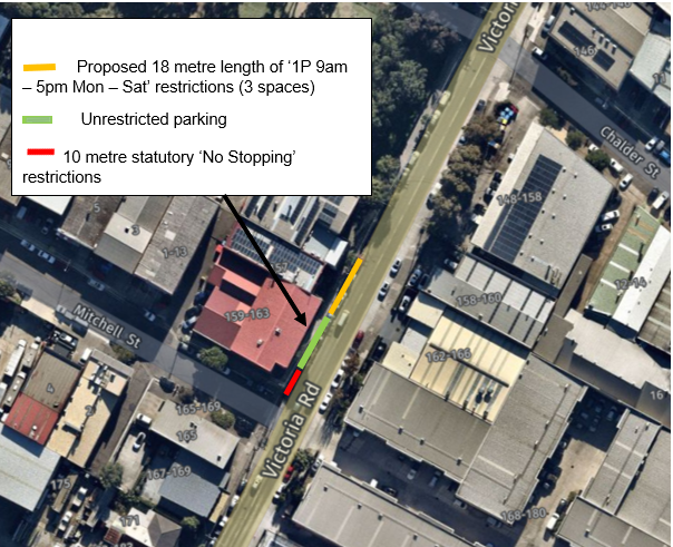
RECOMMENDATION
That an 18-metre section of ‘1P 9am – 5pm Monday to Saturday’ restrictions on the western side of Victoria Road immediately south of the driveway 153-155 Victoria Road, Marrickville be approved in order to improve parking turnover in the vicinity of the local businesses.
|
STRATEGIC OBJECTIVE
This report supports the following strategic directions contained within Council’s Community Strategic Plan:
|
2: Liveable, connected neighbourhoods and transport |
|
|
EXECUTIVE SUMMARY
Following representations from local businesses, Council is proposing to introduce a 18m section of time-restricted parking along Victoria Road, Marrickville, on the western side immediately south of the driveway 153-155 Victoria Road, in order to improve parking turnover in the vicinity of the local businesses. There will be no change to the present ‘7am – 9am’ clearway restrictions.
BACKGROUND
A request has been received for the provision of time restricted parking along the western side of Victoria Road in the vicinity of 157 Victoria Road, Marrickville to improve parking turnover for local businesses.
A consultation letter was distributed to surrounding businesses in Victoria Road, Marrickville proposing to signpost an 18-metre section of ‘1P 9am – 5pm Monday to Saturday’ restrictions outside 35-39A Trafalgar Street, Enmore and this report summaries the results of that consultation.
DISCUSSION
Victoria Road is a regional road, running north to south, connecting Enmore and Marrickville. There are two lanes in each direction with kerbside parking on both sides outside of ‘No Parking’ restrictions during peak hours:
· Northbound (western side) – ‘No Parking 7am-9am Mon-Fri’,
· Southbound (eastern side) – ‘No Parking 4pm-6pm Mon-Fri’.
Victoria Road carries approximately 17,000 vehicles per day, 5% of which are trucks and the 85 percentile speed is listed as 58.3km/h.
It is noted that due to the clearway restrictions already in place along Victoria Road, Marrickville any proposed new short term parking restrictions would be required to maintain the peak hour traffic throughfare and be outside of those hours, hence any proposed short term parking restrictions would commence from 9:00AM. Refer to the diagram below.
PUBLIC CONSULTATION
A notification letter was hand delivered on 20 September 2023 to surrounding businesses / occupants detailing the proposal to introduce a section of time-restricted parking along Victoria Road, Marrickville, on the western side immediately south of the driveway 153-155 Victoria Road in order to improve parking turnover in the vicinity of the local businesses. The closing date for submissions ended on 13 October 2023. 30 letters were distributed. A total of two (2) responses were received both in support of the proposal.
FINANCIAL IMPLICATIONS
The costs of installation of the new restrictions as recommended can be funded within Council’s signs and line marking budget.
Nil.
|
|
Local Traffic Committee Meeting 20 November 2023 |
Subject: Wardell Road, Marrickville – Extension of the drop-off / pick-up zone for St Maroun’s College(Djarrawunang Ward/Summer Hill Electorate/Inner West PAC)
Prepared By: Jennifer Adams - Traffic Engineer
Authorised By: Manod Wickramasinghe - Traffic and Transport Planning Manager
|
RECOMMENDATION
1. That the existing 'No Parking 8.00am-9.30am; 2.30pm-4.00pm School Days’ restrictions adjacent St Maroun’s College on Wardell Road (southern side of roadway) be extended 17 metres westward (towards the pedestrian crossing and replacing existing ‘No Stopping’ restrictions).
2. That Council’s Planners be notified of the decision.
|
STRATEGIC OBJECTIVE
This report supports the following strategic directions contained within Council’s Community Strategic Plan:
|
2: Liveable, connected neighbourhoods and transport |
|
|
EXECUTIVE SUMMARY
The Sydney Eastern City Planning Panel imposed a development condition on the consent for expansions works at St Maroun’s College requiring an extension to the existing school drop-off / pick-up zone.
This condition required that Council approves the extension through its Local Traffic Committee. Initially the proposal to extend the drop-off zone eastward along the frontage of Gilbert Barry Reserve north of the boundary of St Marouns College was not supported at the Committee meeting on 19 June 2023. Since, the applicant has now met with Council Officers to discuss this matter and presented new material regarding an Operational Traffic Management Plan and location for the proposed pick up/drop off zone. Council Officers have now reviewed other options including review of the current ‘No Stopping’ restrictions in place for the wombat crossing in order to resolve this matter.
BACKGROUND
A meeting was held with several Council Officers and St Maroun’s College and one of the primary discussion points was around the deferred commencement condition to provide 3 drop off-pick up spaces. Council’s Traffic Manager noted that there may be an opportunity to review the existing ‘No Stopping’ on the frontage of the school. It was noted that the existing pedestrian crossing has 2.5m wide kerb extensions which allow for the provision of a reduced ‘No Stopping’ zone and further that the driveway immediately east of the current No Parking drop off/pick up restrictions is redundant and could be used for a drop-off/pick-up zone.
This report summaries an investigation into rationalising the existing ‘No Stopping’ restrictions in place outside the school in order to extend the current drop-off/pick-up zone.
DISCUSSION
St Maroun’s College is located on the eastern side of Wardell Road, between Challis and Pine Streets, Dulwich Hill.
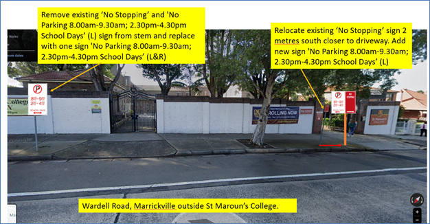
The current parking restrictions outside the school are as follows:
· 'No Parking 8.00am-9.30am; 2.30pm-4.30pm School Days' restrictions used by parents for the drop-off and pick-up of students (40 metres in length accommodating 7 car parking spaces).
· 'No Stopping' restrictions located directly outside the school's main entrance and extending to the south of marked foot crossing.
· 'Bus Zone 8.45am-9.15am and 2.45pm-3.15pm School Days' restrictions south of the crossing, between the 'No Stopping' restrictions and Challis Avenue (16 metres in length).
A review of Council records revealed that the wombat crossing was installed around 1993. The design plan for the crossing is reproduced below. The plan shows the ‘No Stopping’ restrictions to be placed 18 metres from the crossing kerb island, however it appears that the ‘No Stopping’ restrictions on the southern side of Wardell Road north of the crossing were installed at a distance of 32 metres.
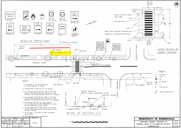
A further site inspection confirmed that the current ‘No Stopping’ restrictions can be reduced.
By reducing the current 32 metre length of ‘No Stopping’ Restrictions by 17 metres (as indicated in diagram below), an opportunity is provided to extend the existing school drop-off zone.
It is noted that outside of the school day and hour restrictions these spaces can be used by the public as additional parking in a high parking demand area. Noting the existing driveway ramp to the school gate is not used for vehicle access, the school may consider reinstating the kerb at this location so any vehicle parking over the kerb ramp does not park contrary to the Road Rules and is not penalised.
FINANCIAL IMPLICATIONS
There are no financial implications associated with the implementation of the proposed recommendations outlined in the report.
Nil.
|
|
Local Traffic Committee Meeting 20 November 2023 |
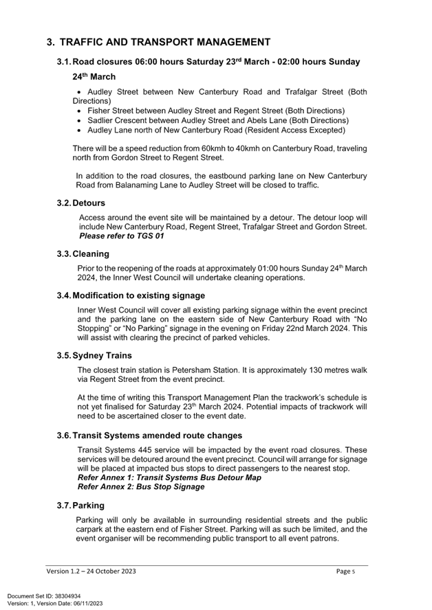
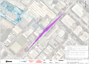
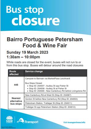
Subject: Audley Street, Audley Lane, Sadlier Crescent, Fisher Street, and eastbound parking lanes on New Canterbury Road Petersham – Temporary Full Road Closures For Special Event On Saturday 23 March 2024 – Petersham Festival Bairro Portuguese (Damum - Stanmore Ward / Newtown Electorate / Inner West PAC)
Prepared By: Jennifer Adams - Traffic Engineer
Authorised By: Manod Wickramasinghe - Traffic and Transport Planning Manager
|
1. That the proposed temporary road closure of Audley Street (between New Canterbury Road and Trafalgar Street), Sadlier Crescent (between Audley Street and Abels Lane) and Fisher Street (between Audley Street and Regent Street), Audley Lane north of New Canterbury Road (resident access excepted) as well as the eastbound parking lane on New Canterbury Road (between Audley Street and Balanaming Lane), Petersham on Saturday 23 March 2024, from 6:00am until 2.00am (Sunday), for the holding of ‘Bairro Portuguese Petersham Festival’, be approved subject to the applicant complying with but not limited to the following conditions: a) A Traffic Management Plan (TMP) is submitted to and approved by Transport for NSW; and an application for a Road Occupancy Licence and a temporary Speed Zone Authorisation is forwarded to and approved by the Transport Management Centre; b) Notice of the proposed event is forwarded to all affected residents and businesses, including the N.S.W. Police / Inner West Local Area Commander, Fire and Rescue NSW, NSW Ambulance and Transit Systems; c) Transit Systems – Inner West Bus Services be requested to implement a revised routing for scheduled bus services in Audley Street on the day of the event and install temporary bus stops as required; d) A minimum four (4) metre unencumbered passage be available for emergency vehicles through the closed section; and e) The occupation of the road carriageways must not occur until the roads have been physically closed.
|
STRATEGIC OBJECTIVE
This report supports the following strategic directions contained within Council’s Community Strategic Plan:
|
2: Liveable, connected neighbourhoods and transport |
|
|
EXECUTIVE SUMMARY
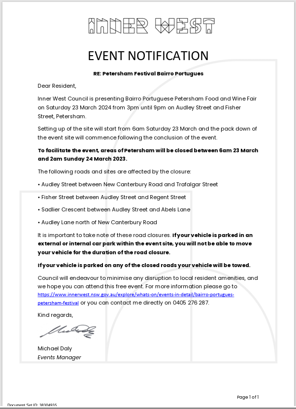
Inner West Council will be presenting Petersham Festival - Bairro Portuguese on Saturday 23 March 2024 from 3:00pm until 9:00pm on Audley Street and Fisher Street, Petersham. This event celebrates the very best of Portuguese culture with entertainment, music, dance, cultural activities, and traditional and contemporary foods. To facilitate the event, areas of Petersham will be closed and there will be road closures necessitating some road detours and bus diversions in surrounding streets (ENRC/2023/0066).
Roads affected include Audley Street (between New Canterbury Road and Trafalgar Street), Sadlier Crescent (between Audley Street and Abels Lane) and Fisher Street (between Audley Street and Regent Street), Audley Lane north of New Canterbury Road (resident access excepted) as well as the eastbound parking lane on New Canterbury Road (between Audley Street and Balanaming Lane), Petersham from 6.00am until 2.00am (Sunday). It is recommended that Council agree to the temporary full road closures subject to all standard Council conditions for a temporary full road closure. This report outlines the traffic management plan for the 2024 event.
BACKGROUND
Temporary road closures have been successfully implemented in previous years to hold the ‘Bairro Portuguese Food and Wine Fair’. This Fair, since its inception in 2003, aims to showcase Petersham's businesses and services, attracts people to the area and has a multicultural theme. On all previous occasions, the closures were effective and no major problems were experienced.
OFFICERS COMMENTS
Event
The event will be held on Saturday 23 March 2024 and will necessitate the temporary closure of Audley Street (between Trafalgar Street and New Canterbury Road), Sadlier Crescent (between Audley Street and Abels Lane) and Fisher Street (between Audley Street and Regent Street), Audley Lane north of New Canterbury Road (resident access excepted) as well as the eastbound parking lanes on New Canterbury Road (between Audley Street and Balanaming Lane), Petersham from 1.00am until 9:00pm. Refer to the map below.
This is an extension of a Class 2 Event under the TfNSW’ Special Events Guide where it impacts local traffic and transport systems but does not impact major traffic and transport systems and it disrupts the non-event community in the area around the event but not over a wide area. The event requires the involvement of Police and Local Council and a detailed Transport Management Plan (TMP).
Traffic Management Plan and Traffic Guidance Scheme
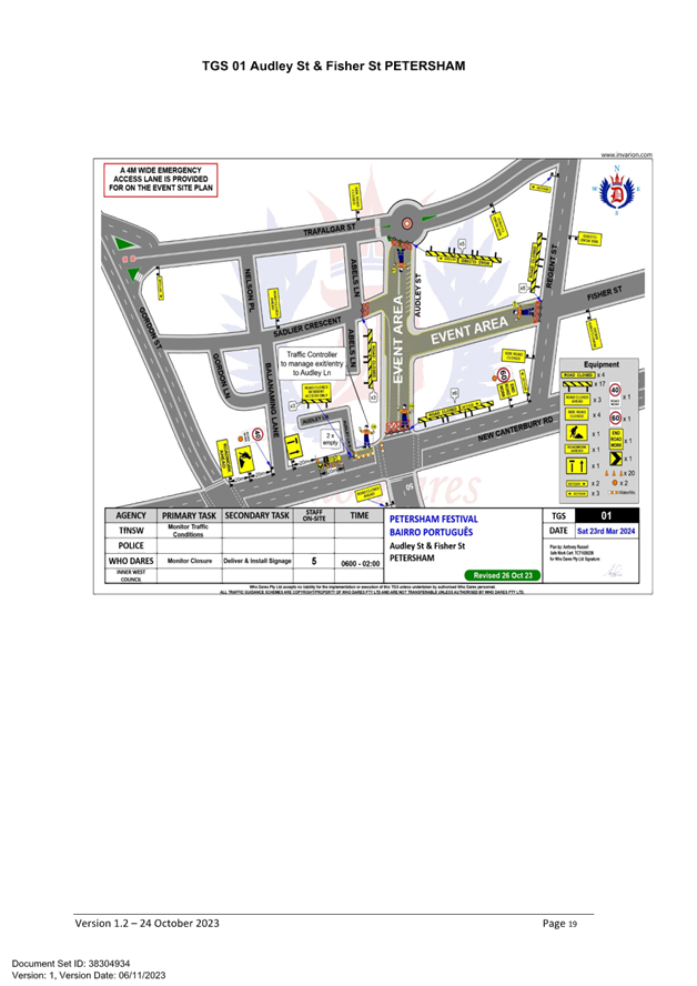
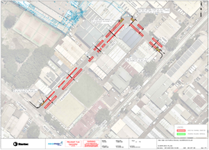
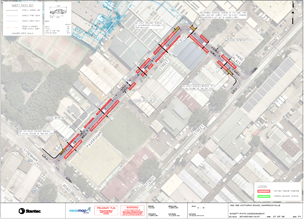
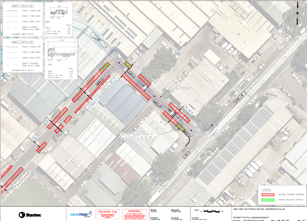
A Traffic Management Plan (TMP) has been supplied by Who Dares Pty Ltd, the scope of which includes the provision for the safe movement of vehicular traffic in and out of the event areas at the Bairro Portuguese Food and Wine Fair on Saturday 23 March 2024. The TMP and Traffic Guidance Scheme (TGS) are attached at the end of this report.
Access around the event site will be maintained by a detour. The detour loop will include New Canterbury Road, Regent Street, Trafalgar Street and Gordon Street. Please refer to the Traffic Guidance Scheme (TGS) prepared by Who Dares Pty Ltd – TGS 01 reproduced below.
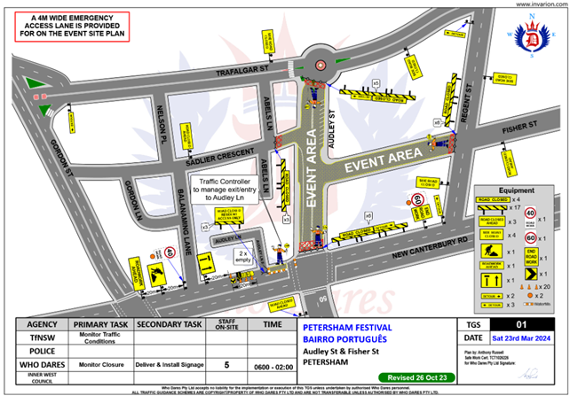
Lane closures of New Canterbury Road
As per previous events held, it is proposed to close the parking lanes on New Canterbury Road (between Balanaming Lane and Audley Street) as shown on the TGS 01 reproduced above.
In previous years the event attracted in excess of 15,000 attendees prompting the event coordinators to look at ways to ease congestion at the main site and make access easier from New Canterbury Road. The closure of the parking lanes on New Canterbury Road improves access to the area where the main event is to be conducted and improves the amenity of the footpath dining outside a number of the eateries along New Canterbury Road which are adjacent to the closure.
There is significant improvement in access for people with disabilities as congestion will be reduced and there will be no obstacles such as tables, chairs, planter boxes, light/sign poles and bins in the closed lanes. The solid barriers will separate the pedestrians from the moving traffic on the adjacent lane and will also help prevent young children who may be separated from their custodians escaping onto the main thoroughfare and possibly being hit by passing traffic.
The TGS indicates that a reduced temporary speed limit of 40km/h is required on New Canterbury Road (between Gordon Street and Audley Street) during the closure of the parking lanes for the subject event. Thus, an application for a Road Occupancy Licence will be necessary.
Road closures
The time-span for the road closure is necessary to allow stalls and stages to be set up before the event and dismantled after the event. The closure will be affected by the placement of barricades at the following locations:
· Junction of Audley Street and New Canterbury Road;
· Junction of New Canterbury Road and Gordon Street;
· Junction of Audley Street and Trafalgar Street;
· Junction of Fisher Street and Regent Street; and
· Junction of Sadlier Crescent and Abels Lane.
Special advance notice signs will be strategically installed at least two weeks prior to the event to alert motorists of the proposed closures. These signs will be installed at the following locations:
· Junction of Railway Terrace and Gordon Street;
· Junction of New Canterbury Road and Audley Lane;
· Junction of Trafalgar Street and Audley Street;
· Junction of Regent and Fisher Streets; and
· Junction of Nelson Place and Sadlier Crescent.
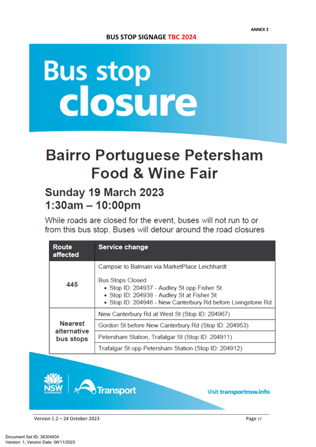
In addition, 'No Parking - Special Event' signs will be affixed over all existing timed parking restrictions signs in the area to be closed on the afternoon before the day of the event. Residents in Fisher Street will be allowed access into and out of their properties.
Audley Street is used by scheduled Transit Systems bus services and they will need to implement the re-routing of services on the day as in previous years.
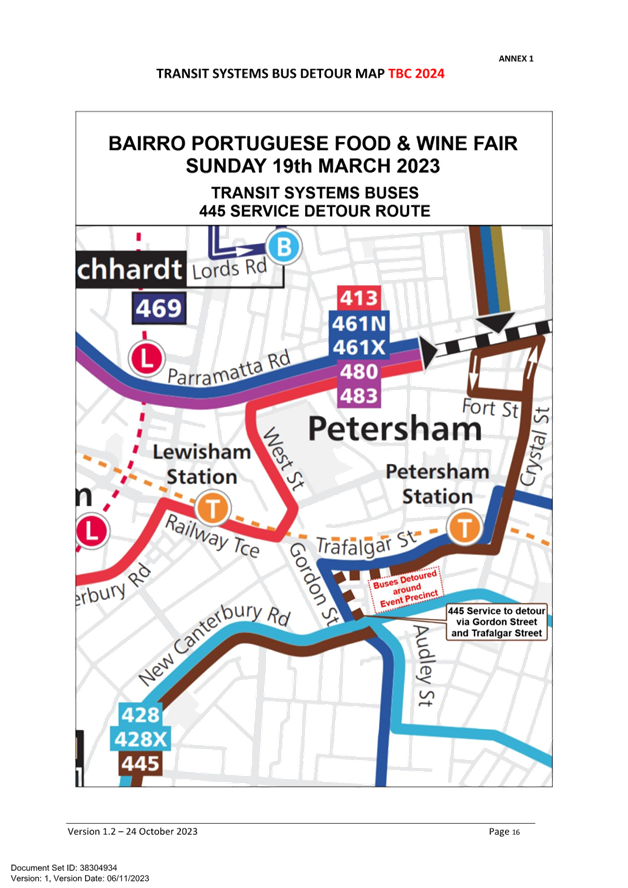
Impacts on buses
Transit Systems 445 service will all be impacted by the event road closures. These services will be detoured around the event precinct. Notices will be put up at impacted bus stops to direct passengers to the nearest stop:
· Services to Gladstone Park to run left Gordon St, right Trafalgar Street, then as normal
· Services to Campsie to run Trafalgar Street, left Gordon St, right New Canterbury Road, then as normal
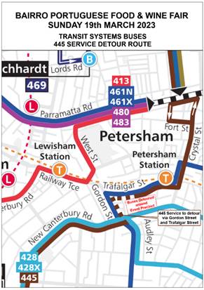
Transit Systems Detour Map – Route 445
Impacts on parking
In relation to parking it is stated in the TMP that “Parking will only be available in surrounding residential streets and the public carpark at the eastern end of Fisher Street. Parking will as such be limited, and the event organiser will be recommending public transport to all event patrons.”
Impacts on traffic
The TMP states that “heavy vehicles may experience slight delays due to increased traffic around the event precinct. Heavy vehicles should follow signposted detours”. In relation to pedestrians and cyclists it states that “There will be no major effect to pedestrians in the area. Pedestrians will be able to use the existing pedestrian paths outside of and within the event area.There are no cycleways directly impacted by this event. Cyclists entering the event site will be requested to dismount.”
There will be no special event clearways installed for this event. The TMP states that: “Inner West Council will instead install No Stopping signage throughout the event precinct prior to the event. Any remaining vehicles will be towed and parked in a nearby location on the morning of the event.”
PUBLIC CONSULTATION
The proposed temporary full road closures have been advertised in accordance with the Roads Act 1993.
Advice of the proposed event must be forwarded to all the appropriate authorities, including emergency services. A copy of the draft notification letter is attached at the end of this report.
The TMP states that: “All affected residents will be notified of the event through:
• Letterbox drop will be conducted for impacted residents within and near the road closure precinct at least two weeks prior to the event.
• Date & time specific corflute “Special Event – Road Closed” signs to be placed around the event precinct 14 days prior to the event.
• “No Stopping” or “No Parking” signage installed by Council in the evening on Friday 22 March 2024.”
Funding of $85,000 has been allocated by Council for organising the ‘Bairro Portuguese Food and Wine Fair’ event under the 2023/2024 Major Community Events Program.
CONCLUSION
It is recommended that Council approve to the temporary full road closures on Saturday 23 March 2024 subject to complying with the recommendations stated in this report along with all standard conditions for temporary full road closures.
Other conditions that need to be complied with include:
· The Traffic Management Plan is to be submitted toTfNSW for consideration and approval and a Road Occupancy License application is to be submitted to the Transport Management Centre by Who Dares Pty Ltd.
· Advance notifications signs for the event are strategically installed at least two (2) weeks prior to the event;
· "No Parking - Special Event" signs are affixed over all existing timed parking restriction signs within the sections of streets to be closed on the afternoon of the day prior to the event;
· A 4-metre wide emergency vehicle access must be maintained through the closed road areas during the course of the event;
· The applicant is to consult with all affected residents and/or businesses in the area in writing and to conduct a letter box drop of surrounding properties at least two weeks prior to event; and
· Adequate vehicular traffic control shall be provided for the protection and convenience of pedestrians and motorists including appropriate signage and flagging. Workers shall be specially designated for this role (and carry appropriate certificates), as necessary to comply with this condition. This is to be carried out in accordance with the Australian Standard AS 1742.3 - Traffic Control Devices for works on roads.
|
1.⇩ |
Petersham Festival - Bairro Portugu |
|
Local Traffic Committee Meeting 20 November 2023 |
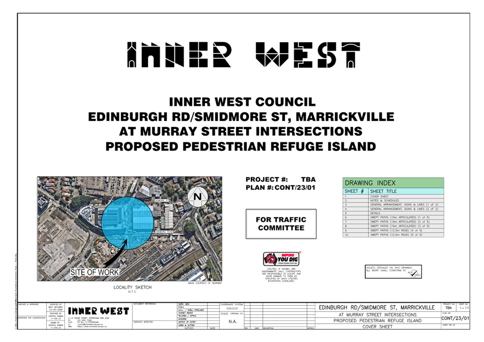
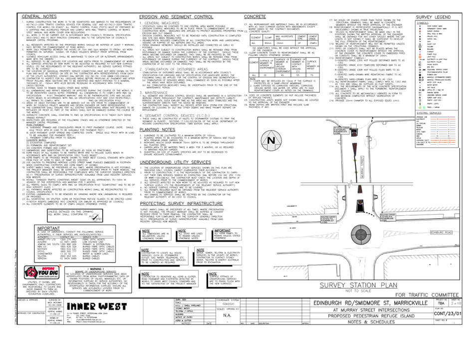
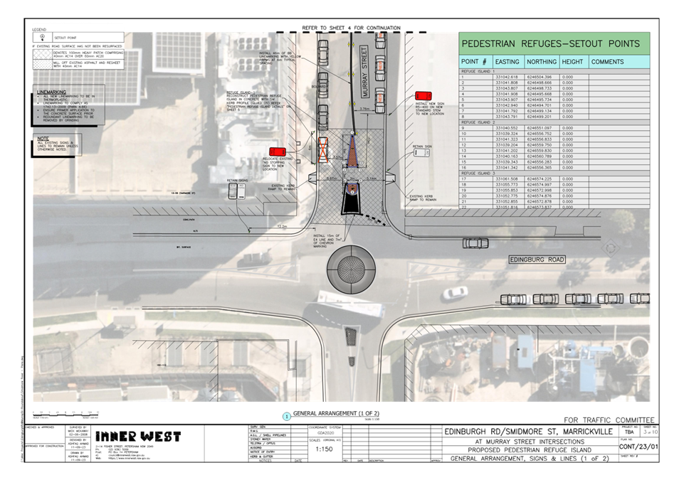
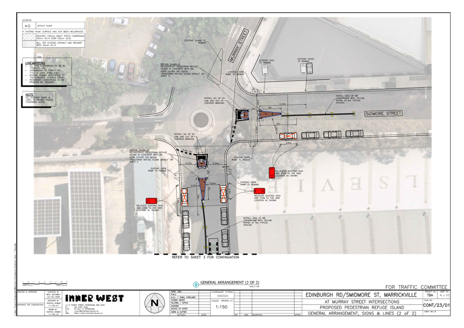
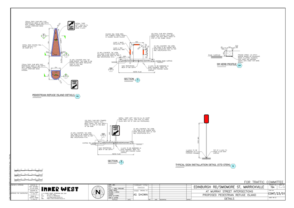
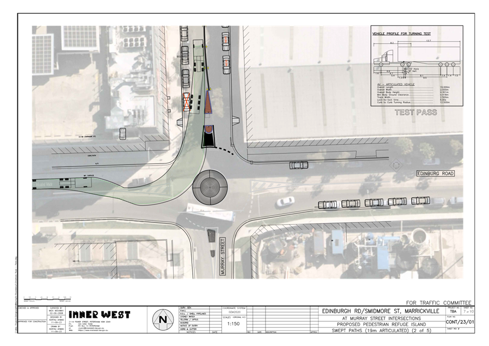
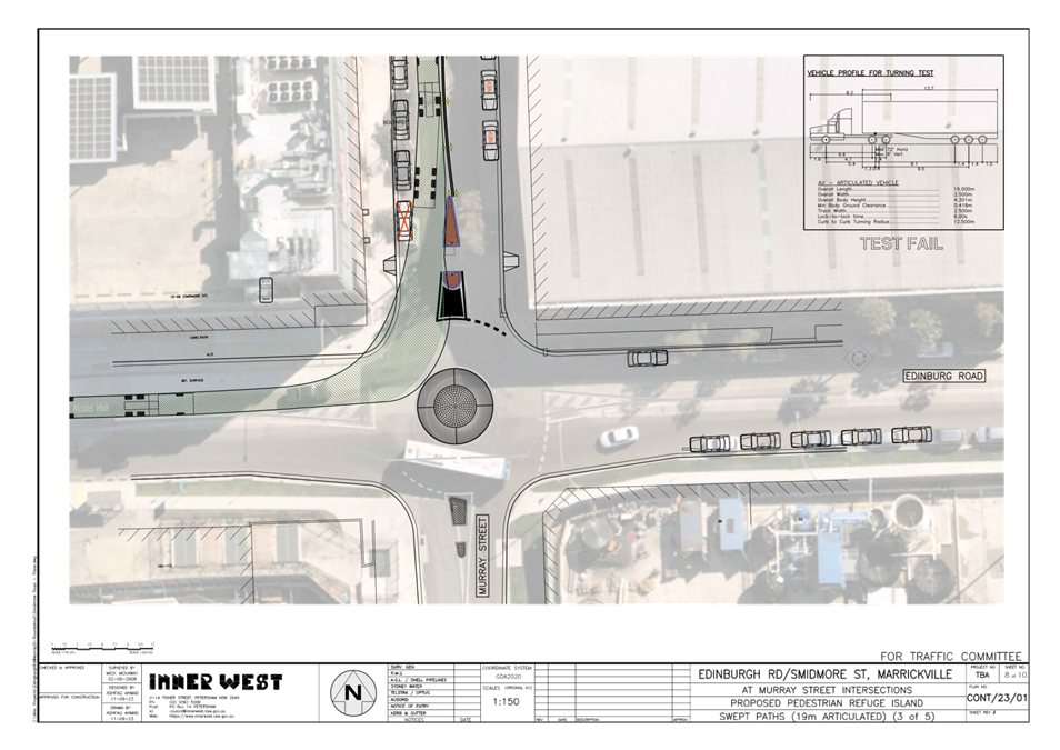
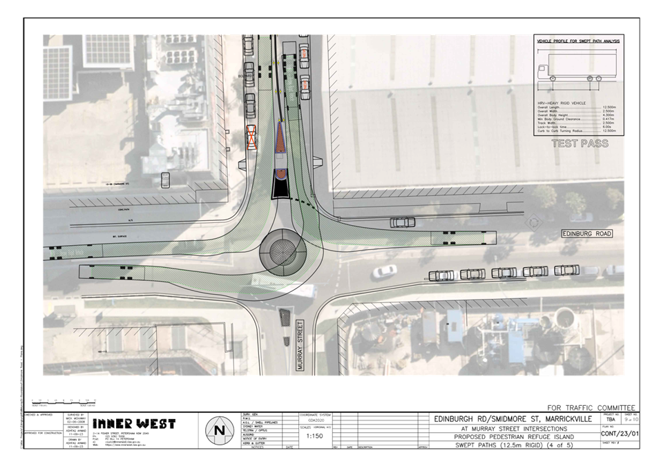
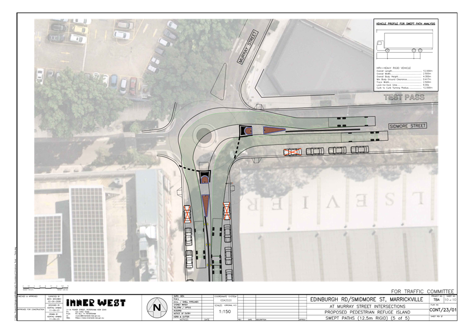
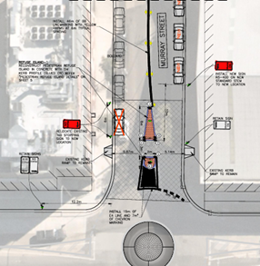
Subject: Murray Street, at Edinburgh Road and Smidmore Street, Marrickville – Proposed new pedestrian refuge islands post Marrickville Metro works (Midjuburi – Marrickville Ward / Newtown and Summer Hill Electorates / Inner West PAC)
Prepared By: Jennifer Adams - Traffic Engineer
Authorised By: Manod Wickramasinghe - Traffic and Transport Planning Manager
|
RECOMMENDATION
That the attached detailed design and construction plans (Design Plan CONT/23/01) for the proposed new pedestrian refuge islands in Murray Street, at Edinburgh Road and Smidmore Street, Marrickville be approved for construction by the applicant. |
STRATEGIC OBJECTIVE
This report supports the following strategic directions contained within Council’s Community Strategic Plan:
|
2: Liveable, connected neighbourhoods and transport |
|
|
EXECUTIVE SUMMARY
During the expansion works for Marrickville Metro Shopping Centre three existing pedestrian refuges were removed, two in Murray Street, one north of Edinburgh Road and the other south of Smidmore Street, Marrickville and one in Smidmore Street immediately east of Murray Street. These three pedestrian refuges are now going to be reinstated and new design and construction plans have been submitted. Marrickville Metro contractors will be reinstating the pedestrian refuges at their cost.
BACKGROUND
The detailed design and construction plans as shown in Attachment 1 outline the proposed works on Murray Street, at Edinburgh Road and Smidmore Street, Marrickville. Swept path diagrams are also provided as part of the attachments. The works are to be completed by contractors as part of the expansion works for Marrickville Metro Shopping Centre.
DISCUSSION
The proposed scope of work includes the following:
· Reconstruct two pedestrian refuge islands with associated signs and line markings in Murray Street, Marrickville as per design plans.
· Reconstruct one pedestrian refuge with associated signs and line markings in Smidmore Street as per design plans.
· Existing kerb ramps to remain.
· Reinstate the statutory ‘Give Way’ line markings at the intersections as per design plans.
· Relocate ‘No Stopping’ signage (as per attached drawings) to suit new pedestrian refuge crossing designs.
The proposed treatments will result in the loss of four (4) legal on-street car parking spaces.

FINANCIAL IMPLICATIONS
All works and costs of implementation works will be borne by the applicant.
CONCLUSION
It is recommended that the proposed treatments in Murray Street be supported.
|
1.⇩ |
Edinburgh Rd Smidmore St Ped Refuge Islands |
|
Local Traffic Committee Meeting 20 November 2023 |
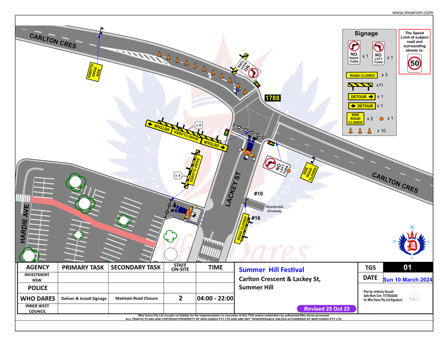
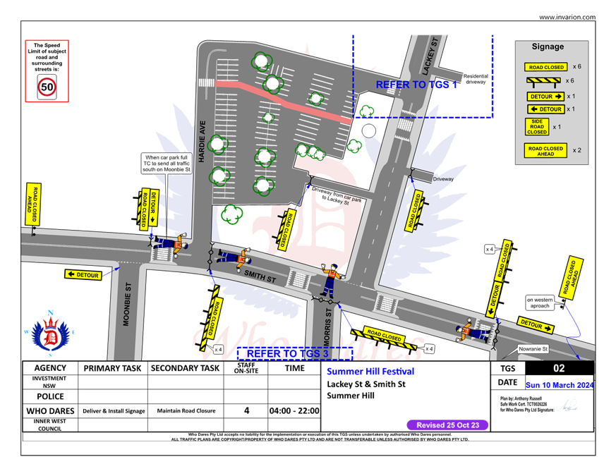
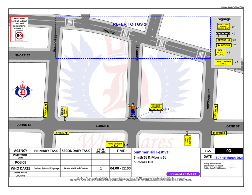
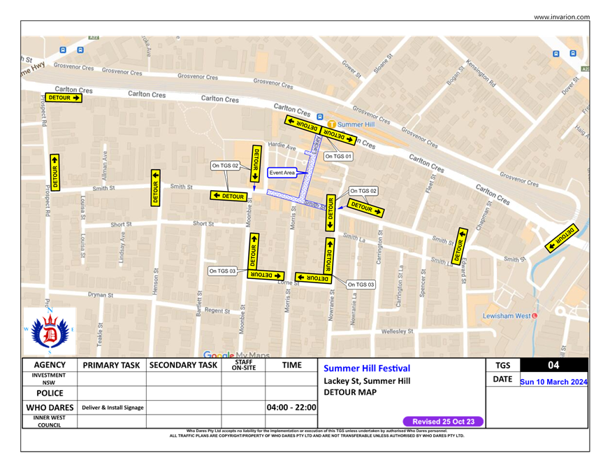
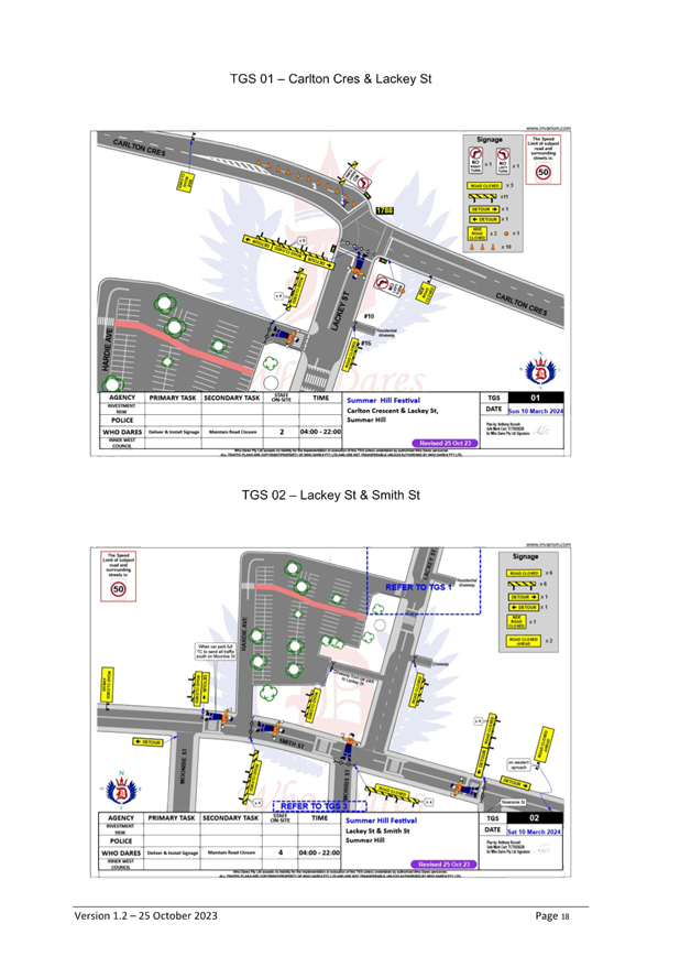
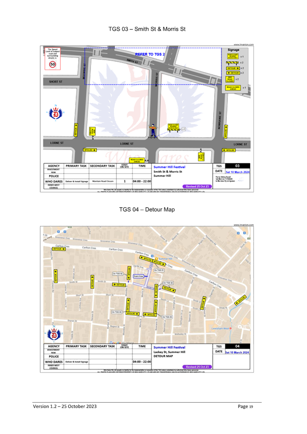
Subject: Lackey Street & Smith Street (between
Mooonbie Street and Nowranie Street) Summer Hill- Temporary Full Road Closure-
'Summer Hill Festival' on Sunday 10 March 2024.
(Djarrawunang-Ashfield Ward/Summer Hill Elecorate/Burwood PAC)
Prepared By: Boris Muha - Traffic Engineer
Authorised By: Manod Wickramasinghe - Traffic and Transport Planning Manager
|
RECOMMENDATION
1. That the proposed temporary full road closure of Lackey Street & Smith Street (between Moonbie Street and Nowranie Street) Summer Hill, be approved for the purpose of holding a ‘Summer Hill Festival’ event on Sunday 10 March 2024 between 4.00am to 10.00 pm as per the submitted TMP and TGS, and subject to the following conditions and all standard Council conditions for a temporary full road closure.
2. That a Road Occupancy License application be obtained from the Transport Management Centre.
3. That notice of the proposed event be forwarded to the NSW Police Local Area Commander, Transit Systems, the NSW Fire Brigade and the NSW Ambulance Services.
4. That all residents and businesses in and around the affected area are to be notified of the temporary road closure in writing by the applicant in advance (at least 7 days prior to the event) with the applicant making reasonable provision for stakeholders.
5. That a minimum four (4) metre unencumbered passage be available for emergency vehicles through the closed sections.
6. That the occupation of the road carriageway must not occur until the road has been physically closed.
|
STRATEGIC OBJECTIVE
This report supports the following strategic directions contained within Council’s Community Strategic Plan:
|
2: Liveable, connected neighbourhoods and transport |
|
|
EXECUTIVE SUMMARY
Inner West Council is presenting a Summer Hill Festival on Sunday, 10 March 2024 from 11am until 5pm on Lackey and Smith Street, Summer Hill.
The Summer Hill Neighbourhood Festival celebrates the area’s rich culture in a street festival boasting a wide variety of delicious food, refreshments, and artisan goods, hosting 100% local content in the heart of Summer Hill.
The setting up of the site will start from 6am Saturday, 10 March and the pack down of the event site will commence following the conclusion of the event.
To facilitate the event, areas of Summer Hill, i.e. Lackey Street and Smith Street (between Moonbie Street and Nowranie Street) will be closed between 4am and 10pm Sunday 10 March 2024. Hardie Avenue will only be open for carpark access off Smith Street.
BACKGROUND
Lackey Street and the above section of Smith Street have been closed on numerous occasions in the past for various food and musical events, The temporary full road closure of Lackey Street and Smith Street has been approved through the Traffic Committee in the past, subject to appropriate traffic control, specific conditions as recommended above and other standard conditions as set out by Council.
DISCUSSION
It is expected that up to 3,000 people may attend the event. The event would be categorised under a class 2 (if not a 3) event under the TfNSW Special Events Guide where it does not impact on the major traffic and transport systems and non-event community over a wide area. The event requires the involvement of Local Council and Police.
Adequate traffic control will be provided, with traffic made to detour through the surrounding streets. Hardie Avenue will only be opened to access the Summer Hill carpark. If the carpark is full, vehicles will be directed to park elsewhere. Service vehicle activity in the area will be encouraged to be done outside the times of the event. Refer to the Traffic Guidance System (TGS) and Detour plans as shown on Attachment 1 and Traffic Management Plan (TMP) Attachment 2 to explain any further details on the event.
The event-coordinator will apply for a Road Occupancy License (ROL). Lackey Street and Smith Streets are not Bus Routes
The proposed temporary full road closure will be advertised in accordance with the Road Act 1993.
FINANCIAL IMPLICATIONS
Funding of approximately $60,400 has been allocated by Council for the event under the Council’s Economic Development Budget.
|
1.⇩ |
Traffic Guidance System (TGS) plans and detour plan. |
|
2.⇩ |
Traffic Management Plan. |
|
Local Traffic Committee Meeting 20 November 2023 |
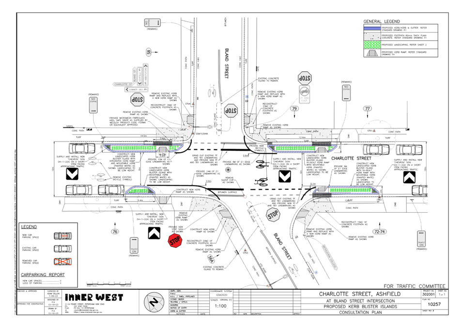
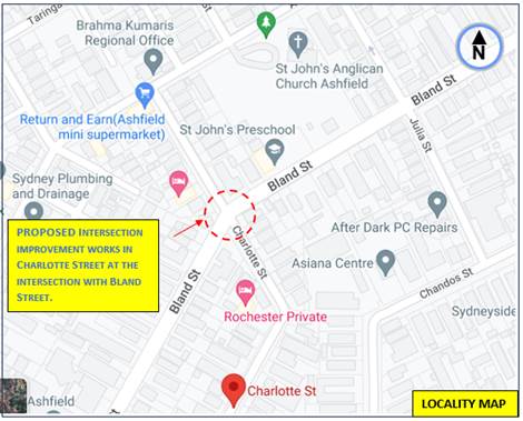
Subject: Charlotte Street at Bland Street,
Ashfield-Intersection improvement works.
(Djarrawunang- Ashfield Ward/Summer Hill Electrorate/Burwood PAC)
Prepared By: Boris Muha - Traffic Engineer
Authorised By: Manod Wickramasinghe - Traffic and Transport Planning Manager
|
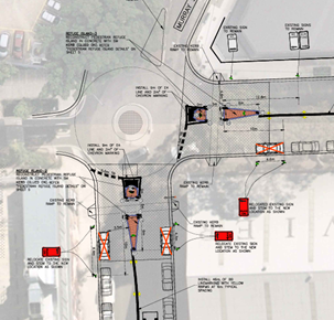
RECOMMENDATION
That the detailed design plan for the intersection improvement works of Charlotte Street at Bland Street, Ashfield, with associated signs and line marking as shown on the Plan 10257 be approved.
|
STRATEGIC OBJECTIVE
This report supports the following strategic directions contained within Council’s Community Strategic Plan:
|
2: Liveable, connected neighbourhoods and transport |
|
|
EXECUTIVE SUMMARY
Council is planning to improve road safety by constructing new landscaped kerb blister islands and kerb ramps in Charlotte Street, Ashfield (at its intersection with Bland Street). The proposal aims to improve pedestrian and motorist safety by better defining the existing traffic and parking lanes through the provision of constructed landscaped islands which also provides safer crossing location for pedestrians wishing to cross Charlotte Street.
BACKGROUND
The intersection of Charlotte Street and Bland Street has been identified under the Ashfield Traffic Management Strategy 2017 and Pedestrian Access Mobility Plan (PAMP) 2022 to examine improved traffic and pedestrian safety measures through the intersection.
DISCUSSION
Other Staff comments
Site location and Road Network.
|
Street Name |
Charlotte Street |
|
Carriageway width (m) kerb to kerb |
Approx.10m |
|
Carraigeway type |
Two-way, one travel lane each direction. |
|
Classification |
Local |
|
Speed Limit km/h |
50 |
|
85th percentile speed km/h |
41.3 (south of Bland Street) 44.6 (north of Bland Street) |
|
Vehicles per day (vpd) |
3150 (south of Bland Street) 2035 (north of Bland Street) |
|
TfNSW avaialble Reported crash history 2017- 2022 |
NIL in the last 5 years in vicinity of the intersection. |
|
Parking arrangements |
Unrestricted parking both sides |
|
Side streets |
Bland Street |
The Plan
The following works are proposed and are illustrated on the attached plans:
Charlotte Street at Bland Street, Ashfield (Plan No. 10257)-see Attachment 1 :
· Construct 4 new landscape concrete kerb blister islands, 3 with integrated kerb ramps;
· Construct 5 new kerb ramps;
· Reconstruct surrounding footpaths adjacent to the new kerb ramps;
· Adjust the existing “Stop” linemarking to improve motorist safety (as shown on the plans);
· Install any required signs associated with the works; and
· Re-mark existing pavement markings where affected by the works.
Parking Changes
This proposal will not result in the loss of any legal on-street parking spaces, as the kerb blister islands are accommodated within the existing ‘No Stopping’ zones to the corners of Charlotte Street. Please refer to the attached plan for further details.
Streetlighting
The existing lighting is deemed adequate and therefore there will be no changes to the existing street lighting due to the proposed works.
FINANCIAL IMPLICATIONS
The work is estimated to be around $30,000 and will be funded and constructed under the Capital works or PAMP program, anticipated to be done during the 2023/2024 financial year.
PUBLIC CONSULTATION
Consultation letters with the proposed plan were issued to occupant/owners of (14) properties as shown on the consultation map below. The letters were sent out around the 26 October 2023 with the closure on submissions being the 8 November 2023. No responses were received.
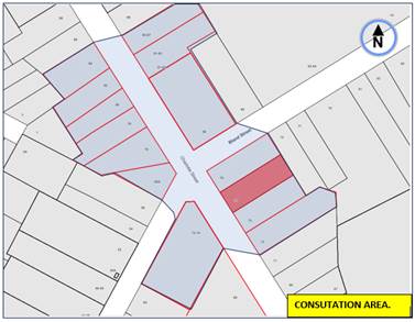
CONCLUSION
In view of the above, it is recommended that the intersection improvement works in Charlotte Street at Bland Street, Ashfield, with associated signs and line marking as shown on the Plan 10257 in Attachment 1 be approved.
|
1.⇩ |
Proposed Improvement works- Charlotte Street at Bland Street, Ashfield. |
|
|
Local Traffic Committee Meeting 20 November 2023 |
Subject: Collins Street, Tempe - Proposed 'No Parking' restrictions at dead-end (Midjuburi - Marrickville Ward/ Heffron Electorate / Inner West PAC)
Prepared By: Jennifer Adams - Traffic Engineer
Authorised By: Manod Wickramasinghe - Traffic and Transport Planning Manager
|
RECOMMENDATION
That the installation of full-time 'No Parking’ restrictions (for a distance of approximately 21 meters) at the dead-end of Collins Street, Tempe be approved in order to deter illegal parking and provide clear vehicular access to the adjacent off-street parking space. |
STRATEGIC OBJECTIVE
This report supports the following strategic directions contained within Council’s Community Strategic Plan:
|
2: Liveable, connected neighbourhoods and transport |
|
|
EXECUTIVE SUMMARY
Concerns were raised by a resident regarding restricted vehicular access to their off-street car parking space, due to vehicles being parked at the dead-end of Collins Street, Tempe.
It is recommended that the installation of ‘No Parking’ restrictions (for a distance of approximately 21 meters) at the dead-end of Collins Street, Tempe be approved, in order to provide clear vehicular access to the adjacent off-street parking space, which is often restricted by illegally parked vehicles.
BACKGROUND
The resident advised that their property has a narrow driveway located at the dead-end of Collins Street. The resident further advised that vehicles are often illegally parked at 90 degrees to the kerb at the dead-end of Collins Street, which makes it very difficult for them to access their driveway and garage.
DISCUSSION
Collins Street is a two-way local residential street which runs west -east between Unwins Bridge Road and a dead-end near Toyer Street. The carriageway in Collins Street is 11.8 metres wide and unrestricted parallel to kerb parking is permitted on both sides of the street. The dead-end services an access gate to the adjoining railway corridor.
It was observed during a number of site inspections undertaken both in the morning and afternoon periods that on-street parking spaces on Collins Street were moderately utilised and that vehicles at times were parked at 90 degrees to the kerb at the dead-end of the street. This parking makes access to the adjoining properties difficult at times. Refer to the following photos.
It is noted that parallel parking is the usual way to park unless signs indicate otherwise. Vehicles parked in this location make it difficult to access the adjacent residential properties and great care needs to be taken to avoid colliding with vehicles parked against the railway fence. Refer to photos below.
|
|
|
To alleviate this issue it is proposed to signpost ‘No Parking’ restrictions in Collins Street at the western end cul-de-sac, Tempe. Please refer to the diagram below.
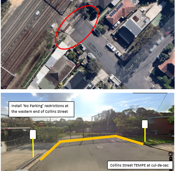
PUBLIC CONSULTATION
A notification letter was hand delivered on 22 September 2023 to owners and occupiers of Collins Street, Tempe regarding the proposal to install full-time ‘No Parking’ restrictions at the dead-end of Collins Street, Tempe. The closing date for submissions ended on 6 October 2023. 17 letters were distributed.
Resident Survey findings
One response was received in the form of a petition “NO to No Parking. Do not place no parking signs/restrictions on end of Collins Street, Tempe NSW 2044 (adjacent to railway) except on railway gate.”
The petition stated that, they as neighbours and residents of numbers 15, 17, 22 and 24 Collins Street, Tempe (all properties near the railway line), need the parking spots at the location with the proposed restrictions. Other remedial solutions were proposed however the underlying principle, in this case, is governed by the Road Rules. Regulation 208 states that the driver of a motor vehicle may park that vehicle on the roadway in the correct direction of travel and as near as practical to the far left side of the road and that the driver must position the vehicle so the vehicle does not unreasonably obstruct the path of other vehicles or pedestrians.
CONCLUSION
It is recommended that the installation of ‘No Parking’ restrictions (for a distance of approximately 21 meters) at the dead-end of Collins Street, Tempe be approved, in order to provide clear vehicular access to the adjacent off-street parking spaces, which are often restricted by illegally parked vehicles.
FINANCIAL IMPLICATIONS
The costs of installation of the ‘No Parking’ restrictions as recommended can be funded within Council’s signs and line marking budget.
Nil.
|
|
Local Traffic Committee Meeting 20 November 2023 |
Subject: Elizabeth Street at Oak Street, Ashfield- Intersection improvement works (Djarrawunang- Ashfield Ward/Summer Hill Electorate/Burwood PAC)
Prepared By: Boris Muha - Traffic Engineer
Authorised By: Manod Wickramasinghe - Traffic and Transport Planning Manager
|
RECOMMENDATION
1. That the detailed design plan for the intersection improvement works of Elizabeth Street at Oak Street, Ashfield, with associated signs and line marking as shown on the Plan 10263 be approved.
2. That the extended ‘Give-way’ line as shown on Plan 10263 be replaced with a ‘STOP line, together with the ‘Give-way signs being replaced with ‘Stop’ signs in Oak Street.
|
STRATEGIC OBJECTIVE
This report supports the following strategic directions contained within Council’s Community Strategic Plan:
|
2: Liveable, connected neighbourhoods and transport |
|
|
EXECUTIVE SUMMARY
Council is planning to improve road safety by constructing new landscaped kerb blister islands in Elizabeth Street, Ashfield (at its intersection with Oak Street). The proposal aims to improve pedestrian and motorist safety by better defining the existing traffic and parking lanes through the provision of constructed landscaped islands which also provides safer crossing point pedestrians wishing to cross Elizabeth Street.
BACKGROUND
DISCUSSION
Other Staff comments
Site location and Road Network.
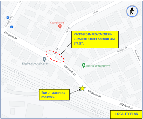
|
Elizabeth Street |
|
|
Carriageway width (m) kerb to kerb |
Approx. 8.8-8.9m |
|
Carraigeway type |
Two-way, one travel lane each direction. |
|
Classification |
Local |
|
Speed Limit km/h |
50 |
|
85th percentile speed km/h |
53 (last recorded 2008) |
|
Vehicles per day (vpd) |
Approx. 9500 |
|
TfNSW avaialble Reported crash history 2017- 2022 |
(1) X 2019, RUM 44, Manov-parking-parked vehicle, Moderatre injury, west of Oak St (o/s 18-20). (1) X 2021, RUM 21, Right through, at intersection, non-casualty (towaway) |
|
Parking arrangements |
Unrestricted parking to the northern side |
|
Side streets |
Oak Street |
The Plan
The following works are proposed and are illustrated on the attached plans:
Elizabeth Street at Oak Street, Ashfield (Plan No. 10263):
· Construct 3 new landscape concrete kerb blister islands; 1 with integrated kerb ramp
· Construct a new kerb ramp
· Reconstruct surrounding footpaths adjacent to the new works;
· Adjust the existing ‘Stop’ linemarkings to improve motorist safety (as shown on the plans);
· Install any required signs associated with the works;
· Re-sheet the road surface
· Reconstruct kerb and gutter as shown in the plans
· Re-mark existing pavement markings where affected by the works
Refer to the attached Consultation Plan (Plan No.10263) which illustrates the proposed works.
The original ‘Give-way’ line shown on plan is required to be altered to a STOP line as it is being extended out close to traffic. This shall be amended on the construction plan if approved.
It should be noted also that the southern footway ends some 80m to the east of Oak Street. The proposal provided pedestrian cross-over facility from south to north prior to the ending of the southern footway, at a location where sufficient and safe sight view is provided.
Parking Changes
This proposal will not result in the loss of any legal on-street parking spaces. The physical kerb blister islands are accommodated within the exiting ‘No Stopping’ zones and would replace the current painted kerb islands in the area.
Streetlighting
The existing lighting is deemed adequate and therefore there will be no changes to the existing street lighting due to the proposed works.
FINANCIAL IMPLICATIONS
The work is estimated to be around $35,000 and will be funded and constructed under the Capital works or PAMP program, anticipated to be done during the 2023/2024 financial year.
PUBLIC CONSULTATION
Consultation letters with the proposed plan were issued to occupant/owners of (14) properties as shown on the consultation map below. The letters were sent out around the 26 October 2023 with the closure on submissions being the 8 November 2023. No responses were received.
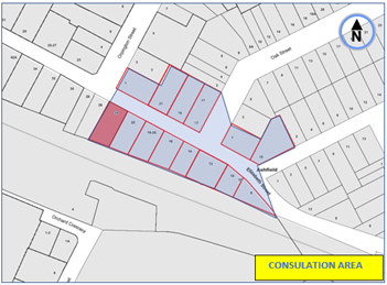
CONCLUSION:
In view of the above, it is recommended that the improvement works in Elizabeth Street around the intersection with Oak Street, Ashfield, with associated signs and line marking as shown on the Plan 10263 in Attachment 1 be approved.
|
1.⇩ |
Proposed improvement works in Elizabeth Street at Oak Street, Ashfield. |
|
|
Local Traffic Committee Meeting 20 November 2023 |
Subject: Ramsay Street at Rawson Street, Haberfield - Proposed Kerb Blister Island (Gulgadya - Leichhardt/Balmain Electorate/Leichhardt PAC)
Prepared By: Charbel El Kazzi - Traffic Engineer
Authorised By: Manod Wickramasinghe - Traffic and Transport Planning Manager
|
RECOMMENDATION
1. That the proposed installation of a landscaped island and linemarking treatment on Rawson Street at Ramsay Street, Haberfield be supported as shown in the attached concept plan.
2. That the proposed Landscaped Island and line marking treatment on Rawson Street at Ramsay Street, Haberfield be included for consideration in Council’s Capital Works Program.
|
STRATEGIC OBJECTIVE
This report supports the following strategic directions contained within Council’s Community Strategic Plan:
|
2: Liveable, connected neighbourhoods and transport |
|
|
EXECUTIVE SUMMARY
Council is planning to improve safety at the intersection of Rawson and Ramsay Street, Haberfield by constructing a new landscaped kerb blister island and installing linemarking treatment. The intention of the proposal is to maintain low vehicle speeds, protect existing property and provide a safer more accessible crossing point across Rawson Street for pedestrians.
BACKGROUND
It has been reported that trucks have previously caused damage to the awning at property No.179-183 Rawson Street, Haberfield. This has raised concerns for both the structural integrity of the awning and pedestrian safety as the awning is located over the public footpath. In response, council has installed temporary rubber kerbing (see Figure 1) to prevent parking and temporary standing of trucks in this area.
Additionally, a traffic study conducted on Ramsay and Dalhousie Streets, Haberfield in June 2021 assessed safety at the Haberfield Town Centre recommended the installation of line marking treatment in Rawson Street near the intersection with Ramsay Street, Haberfield to improve pedestrian safety and lower vehicle speeds. This has been incorporated into the proposal.
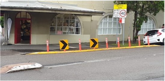
Figure 1 – Existing temporary rubber kerbing treatment
DISCUSSION
The concept plan shown in Attachment 1 outlines the proposed kerb blister island on Rawson Street at Ramsay Street, Haberfield and includes:
· Removal of existing temporary rubber kerb ramp in Rawson Street
· Construction of new landscaped island in Rawson Street along with associated hazard marker signage
· Installation of line marking treatment on Rawson Street near the intersection with Ramsay Street
The proposal is expected to provide some landscaping opportunities, self-enforce the No Stopping’ zone, and protect the awning of the adjacent property.
A consultation letter outlining the proposal was issued to the below properties and no responses were received.
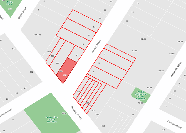
FINANCIAL IMPLICATIONS
This project is estimated to cost $28,000 and is recommended to be included in Councils Capital Works Program.
|
1.⇩ |
Rawson Street, Haberfield - Plan |
|
|
Local Traffic Committee Meeting 20 November 2023 |
Subject: Pritchard Street, Annandale - Proposed 'No Parking' Restriction (Baludarri-Balmain Ward/Balmain Electorate/Leichhardt PAC)
Prepared By: Amir Falamarzi - Traffic Engineer
Authorised By: Manod Wickramasinghe - Traffic and Transport Planning Manager
|
RECOMMENDATION
That a 147.9 m length ‘No Parking’ zone on the eastern side of Pritchard Street, Annandale opposite No.19 to No.49 be approved.
|
STRATEGIC OBJECTIVE
This report supports the following strategic directions contained within Council’s Community Strategic Plan:
|
2: Liveable, connected neighbourhoods and transport |
|
|
BACKGROUND
Council has received concerns regarding parked vehicles along a narrow section of Pritchard Street, Annandale, at times restricting vehicular access along the road and obstructing access to off-street parking between No.19 to No.47 Pritchard Street, Annandale.
It is proposed to signpost ‘No Parking’ restrictions opposite No.19 to No.49 Pritchard Street, Annandale. The proposed plan is shown in Figure 1.
It should be noted that during the initial consultation period, it was proposed to implement ‘No Parking’ restrictions opposite No.19 to No.47 Pritchard Street, Annandale. This has now been amended to reflect community feedback. The proposal does not result in the loss of any legal on-street parking.
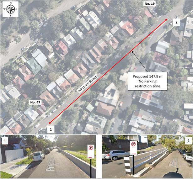
Figure 1: Proposed restrictions in Pritchard Street, Lilyfield (source: Google Maps)
DISCUSSION
A letter outlining the proposal was mailed out to 69 properties in Pritchard Street, Annandale. Three (3) responses were received, in general support of the proposal with request for changes.
The main traffic and parking related concerns raised by the residents are tabled below:
|
Residents’ Comments |
Officer Comments |
|
The ‘No Parking’ zone should be extended to encompass the area opposite No.19 to No.49 Pritchard Street, Annandale. This will allow greater vehicular maneuverability (1 comment) from the driveway of No.47. |
Noted – the amended design includes the extension of the proposed ‘No Parking’ zone as stated. |
FINANCIAL IMPLICATIONS
There are no financial implications associated with the implementation of the proposed recommendations outlined in the report.
Nil.
|
|
Local Traffic Committee Meeting 20 November 2023 |
Subject: Laura Street, Newtown - Proposed chevron line marking and parking bays (Damun-Newtown Ward/Newtown Electorate/Inner West PAC)
Prepared By: James Nguyen - Traffic Engineer
Authorised By: Manod Wickramasinghe - Traffic and Transport Planning Manager
|
RECOMMENDATION
That the proposed chevron line marking and parking bays at the dead-end of Laura Street, Newtown be approved.
|
STRATEGIC OBJECTIVE
This report supports the following strategic directions contained within Council’s Community Strategic Plan:
|
2: Liveable, connected neighbourhoods and transport |
|
|
EXECUTIVE SUMMARY
Edgeware Road and Laura Street, Newtown are both located on Council’s regional cycleway network. At the dead-end of Laura Street, a kerb ramp provides access for cyclists to enter Laura Street from the footpath on the northern side of Edgeware Road. There have been repeated instances of vehicles or trailers that park across this kerb ramp and impact access. A combination of chevron and marked parking bays is proposed at this dead-end and would help to clear the area adjacent the kerb and ensure that the kerb ramp remains unimpeded.
BACKGROUND
Council officers received feedback from the community requesting for improved delineation to the existing parking spaces adjacent to the existing kerb ramp at the dead-end of Laura Street which provides access to the roadway on Laura Street from the footpath on the northern side of Edgeware Road to ensure that the kerb ramp remains unimpeded.
In 2023 Council’s parking officers have issued five (5) infringements to motorists that park their vehicles in a way which obstructs access to this kerb ramp on Laura Street. The installation of line marking or parking signs may improve parking compliance at this location.
DISCUSSION
Laura Street, Newtown is a dead-end street that is approximately 10.3 metres wide and intersects with Edgeware Road. Currently motorists park their vehicles at this dead-end and in some circumstances, a sole vehicle may impede access to the kerb ramp on the southern side of Laura Street which provides access from the footway on Edgeware Road to Laura Street. This is likely caused by the lack of line marking and parking regulatory signs to delineate the parking space to ensure the kerb ramp remains unimpeded.
Council Traffic Engineers subsequently consulted on a proposal to install ‘No Parking’ restrictions at this dead-end. The proposed ‘No Parking’ restriction is 3.8 metres wide along the kerb at the dead-end and 6.8 metres wide along the kerb on the southern side of Laura Street (refer to the diagram below), creating a rectangular area that would allow for motorists to drop-off and pick-up and prevent long term parking. This proposal would have provided a wide unimpeded area for cyclists.
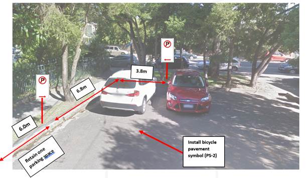
Figure 1 - Original proposal that was consulted
Following community consultation, Council’s Traffic Engineers amended to proposal to reflect the parking needs of the community whilst seeking to ensure that the kerb ramp remains unimpeded at all times.
The amended proposal is shown in Attachment 1 and consists of the following:
· A 1.2 metre wide, 7.2-metre-long chevron stencil line marking.
· A 5.4 metre long, 1.8-metre-wide line marked parking bay on the southern side of Laura Street, adjacent to the property of No.256 Edgeware Road.
· A 4.8 metre long, 1.8-metre-wide line marked parking bay on the northern side of Laura Street, adjacent to the property of no. 254 Edgeware Road.
· Three (3) parking bays at the dead-end of Laura Street that are 4.8 metres long, two (2) of which are 2.6 metres wide and a 3.9-metre-wide bay. Attachment 2 provides swept path checks to ensure vehicles can enter and exit these parking spaces.
PUBLIC CONSULTATION
A letter outlining the proposal was mailed out to 23 properties in Laura Street and Edgeware Road requesting residents’ views regarding the proposal. Two (2) responses supporting and two (2) responses opposing the proposal were received. They are summarised in the tables below:
|
Residents’ comments |
Officer comments |
|
The proposal is supported conditionally subject to the following suggested changes: · Three (3) vehicles can park at the dead-end · Parking spaces are delineated with line marking · Provide a couple of motorcycle parking spaces near the kerb ramp · Provide residents with additional permit parking due to the loss of parking · Reduce the 3.8 metre wide ‘No Parking’ area to 2.0 metre wide |
The original proposal has been amended to: · Provide three (3) parking spaces which will be line marked at the dead-end. · The adjacent parking spaces just east of the parking spaces at the dead-end will also be line marked to create parking bays · The 3.8 metre wide ‘No Parking’ zone has been reduced to a 1.2 metre wide chevron pavement hatch. The length of the pavement hatch is 7.2 metres wide. · Multiple motorcycle parking spaces cannot be provided as there is insufficient width along the southern side of Laura Street, between the chevron line marking and parking bay. The Australian Standards requires that one (1) motorcycle parking space be 2.5 metres by 1.2 metres. With the current parking provisions for vehicles a sole motorcycle parking space cannot be geometrically accommodated as this would impact access to the most southern parking space at the dead end. · There is no loss of parking with the proposal which would require the provision of additional permit parking to residents. |
|
The proposal is not supported due to the following concerns: · Improving access for cyclists to this kerb ramp will increase their travel speed and impact pedestrian safety. As the junction between the footpath on Edgeware Road and the kerb ramp on Laura Street is 90 degrees, there are visibility issues for cyclists in an area which has high pedestrian activity from the nearby school and day care centre · There is an unused driveway 10 metres east of the kerb ramp on Laura Street which cyclists can use · The loss of parking at the dead-end is not justified as there are existing ramps nearby for cyclists to use in the event that the kerb ramp is obstructed. The loss of parking will cause more stress on residents of Laura Street. |
· Council officers will investigate potential safety improvements to reduce the speed of cyclists at the 90-degree junction of the footpath on Edgeware Road and Laura Street · It is understood that there are alternative options for cyclists to use should the kerb ramp be unavailable due to an illegally parked vehicle. However, the preference is for the kerb ramp to function as per its intended purpose where possible. · The original proposal has been adjusted to ensure that there is no loss of parking whilst ensuring that there is visual communication in the form of line marking to advise motorists not to park adjacent to the kerb ramp. |
FINANCIAL IMPLICATIONS
There are no financial implications associated with the implementation of the proposed recommendations outlined in the report.
|
1.⇩ |
Laura Street, Newtown - Proposed line marking |
|
2.⇩ |
Swept path analysis |
|
|
Local Traffic Committee Meeting 20 November 2023 |
Subject: Albermarle Street, Baltic Street, Oxford Street, Chelmsford Street, Probert Street, Denison Street, Lennox Street, Bishopgate Street, Newtown - Proposed 'No Stopping' restrictions (Damun-Newtown Ward/Newtown Electorate/Inner West PAC)
Prepared By: James Nguyen - Traffic Engineer
Authorised By: Manod Wickramasinghe - Traffic and Transport Planning Manager
|
RECOMMENDATION
1. That the traffic committee approve the installation of ‘No Stopping’ yellow line on: a) The southern side of Albermarle Street for a distance of 10 metres, east of Baltic Street; b) The western side of Baltic Street for a distance of 10 metres, north of Albermarle Street; c) The western side of Oxford Street, 10 metres north of Albermarle Street; d) The western side of Oxford Street, 10 metres south of Albermarle Street; e) The western side of Chelmsford Street, 10 metres north of Albermarle Street; f) The western side of Chelmsford Street, 10 metres, south of Albermarle Street; g) The southern side of Albermarle Street, 10 metres east of Denison Street; h) The western side of Denison Street, 9.2 metres north of Albermarle Street; i) The northern side of Lennox Street for a length of 10 metres, east of Probert Street; j) The northern side of Lennox Street for a length of 10 metres, west of Probert Street; and k) The western side of Probert Street for a length of 10 metres, north of Lennox Street.
2. That the traffic committee approve the installation of a ‘No Stopping’ sign on: a) The western side of Chelmsford Street, 9 metres north of Lennox Street; b) The northern side of Lennox Street, 10 metres east of Chelmsford Street; c) The southern side of Lennox Street, 10 metres east of Denison Street; d) The western side of Denison Street, 10 metres north of Lennox Street; e) The eastern side of Chelmsford Street, 6 metres north of Bishopgate Street; f) The eastern side of Chelmsford Street, 6 metres south of Bishopgate Street; g) the western side of Probert Street, 10 metres north of Bishopgate Street; and h) the western side of Probert Street, 7.5 metres south of Bishopgate Street.
3. That the Traffic Committee approve Reducing the existing extended ‘No Stopping’ zone to 10 metres on the northern side of Albermarle Street west of Probert Street (install a ‘No Stopping’ sign on the northern side of Albermarle Street, 10 metres west of Probert Street |
STRATEGIC OBJECTIVE
This report supports the following strategic directions contained within Council’s Community Strategic Plan:
|
2: Liveable, connected neighbourhoods and transport |
|
|
EXECUTIVE SUMMARY
A review has been completed by Fire Rescue NSW (FRNSW) following a boarding house fire last year in Albermarle Street, Newtown. The review has identified road-access issues for the local brigade to the narrow streets in the Newtown area due to vehicles being parked too close to the intersections, affecting their ability to carry out first response duties nearby the location of the emergency as well as affecting first-response times.
Some of the intersections of these streets do not have existing ‘No Stopping’ restrictions to advise on rule 167 from the NSW Road Rules which prohibits a vehicle from stopping within 10 metres of an intersecting road.
The proposed installation of ‘No Stopping’ restrictions at various intersections of Albermarle, Lennox and Bishopgate Streets in Newtown will seek to improve parking compliance at the intersections, and ensure access to the street for emergency vehicles is maintained.
BACKGROUND
Council has received a request from FRNSW requesting for consideration of ‘No Stopping’ signs to be installed at various road intersections in Newtown to ensure road access for their vehicles. In August 2023, Council officers and FRNSW met on-site to assess the intersections that were identified by FRNSW to require the installation of ‘No Stopping’ signs or yellow ‘No Stopping’ line marking. The site inspection confirmed the lack of signage at various intersections where ‘No Stopping’ signs or yellow line marking would assist to advise motorists of where they can and cannot park, ensure compliance with rule 167 from the NSW Road Rules, and ensure that the intersections remain unimpeded to ensure access to first-response vehicles.
DISCUSSION
The local streets in Newtown bounded by Australia and Bedford Streets, and Kingston and Salisbury Roads are typically 7 metres wide with parking on both sides and bi-directional (two-way) with a travel lane of approximately 2.8-3.0 metres wide.
There are some intersections that have ‘No Stopping’ signs or yellow line marking installed to advise motorists where they can and cannot park. Site inspections by Council’s Engineers confirm that these intersections have adequate compliance and that vehicles can turn to access the street unimpeded. Sight lines are also appropriate to ensure visibility of pedestrians on the footpath. Figure 1 below shows an intersection with a ‘No Stopping’ sign installed.
![]()
Figure 1 - Probert Street, eastern side, south of Lennox Street
Various streets within this area are currently signposted with ‘2P 8am-10pm Permit Holders Excepted Area M3’, and signs have generally been installed to commence the timed permit parking restrictions, 10 metres from the intersecting road. As shown in Figure 2 below, a parking stem has been installed approximately 10 metres from the intersecting road, adjacent to the timed permit parking spaces. These parking stems serves to ‘guide’ vehicles where they can and cannot park as motorists should be aware of the NSW Road Rules which prohibits vehicles from stopping within 10 metres of the intersection.
Site observations revealed a varying degree of parking compliance in this scenario where at some intersections vehicles complied with the NSW Road Rules and did not park adjacent to the timed permit parking restrictions (Figure 2), and some intersections where motorists parked adjacent to the timed permit parking restrictions, and within 10 metres of the intersecting road, as shown in Figure 3.
![]()
Figure 2 - Typical parking signage at intersections
![]()
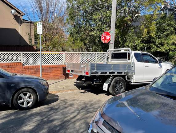
Figure 3 - Instances of illegal parking adjacent to timed permit parking restrictions
Where there were no timed permit parking restrictions with a parking stem (unrestricted parking), vehicles typically parked too close to the intersecting road, as there was no ‘No Stopping’ sign or parking stem to advise or ‘guide’ vehicles where they can and cannot park as shown in Figures 4 and 5 below.
![]()
![]()
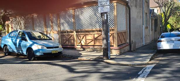
Figure 4 - Vehicles parked too close to the intersecting road
![]()
![]()
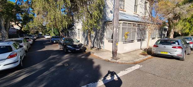
Figure 5 - Vehicles parked too close to the intersecting road
From site observations, there is a higher level of parking compliance when a ‘No Stopping’ sign is installed on parking stems to advise motorists of the NSW Road Rules. When vehicles park within the 10m ‘No Stopping’ zone, the turning movement for an emergency vehicle such as a fire rescue truck is compromised as room required to facilitate the turn is reduced by a parked vehicle as well as the sight lines of pedestrians being reduced. Furthermore, there are fire hydrants located on the roadway near these intersections that are required to remain unimpeded. Vehicles parked within 10 metres of the intersection of the road can obstruct access to these hydrants that are required in an emergency situation.
Table 1 below provides the recommendation for each intersection and the rationale for the proposal.
|
|
Local Traffic Committee Meeting 20 November 2023 |
Table 1 - Proposed parking changes
|
Street |
Side |
Intersecting Street |
Parking Stem (Y/N) |
Distance |
Recommendation |
Rationale |
|
Albermarle Street |
Southern |
East of Denison Street |
Y |
10m |
Install ‘No Stopping’ sign to existing stem |
· Existing stem already at 10 metres · Improve parking compliance and access · Australia Street Infants School nearby generating higher levels of pedestrian activity. The ‘No Stopping’ zones will improve visibility of pedestrians along the footpath |
|
Northern |
West of Probert Street |
Y |
~25m |
Reduce the existing extended ‘No Stopping’ zone to 10 metres on the northern side of Albermarle Street west of Probert Street |
· Extended ‘No Stopping’ restriction was temporarily in place following a property fire and is no longer required by FRNSW · Gain of approximately 2-3 parking spaces |
|
|
Southern |
East of Baltic Street |
N |
10m |
Install ‘No Stopping’ yellow line marking |
· Yellow line marking is recommended due to an existing tree located on the footpath · Improve parking compliance and access · Provide access to the adjacent hydrant |
|
|
Baltic Street |
Western |
North of Albermarle Street |
Y |
10m |
Install ‘No Stopping’ yellow line marking |
· Yellow line marking is recommended due to an existing tree located on the footpath · Improve parking compliance and access
|
|
Chelmsford Street |
Western |
North of Lennox Street |
N |
9m |
Install ‘No Stopping’ sign on new stem |
· A 9.0 metre ‘No Stopping’ length is recommended due to the existing adjacent driveway immediately north. |
|
Western |
North of Albermarle Street |
N |
10 |
Install ‘No Stopping’ yellow line marking |
· Yellow line marking is recommended due to an existing tree located on the footpath · Improve parking compliance and access · Provide access to the adjacent hydrant |
|
|
Western |
South of Albermarle Street |
N |
10 |
|
· Yellow line marking is recommended to ensure consistency with the yellow line marking proposed on the western side of Chelmsford Street, north of Albermarle Street · Improve parking compliance and access · Provide access to the adjacent hydrant |
|
|
Eastern |
North of Bishopgate Street |
Y |
6 |
Install ‘No Stopping’ sign to existing stem |
· A reduced 6m ‘No Stopping’ restriction is required at this location due to the existing approved permit parking restriction and location of the parking stem already installed 6 metres from the intersecting road (Bishopgate Street) · Extending the ‘No Stopping’ zone would impact an existing permit parking space. · The reduced ‘No Stopping’ zone has been supported in-principle by FRNSW · Provide access to the adjacent hydrant |
|
|
Chelmsford Street |
Eastern |
South of Bishopgate Street |
Y |
6 |
Install ‘No Stopping’ sign to existing stem |
· A reduced 6m ‘No Stopping’ restriction is required at this location due to the existing approved permit parking restriction and location of the parking stem already installed 6 metres from the intersecting road (Bishopgate Street) · Extending the ‘No Stopping’ zone would impact an existing permit parking space. · The reduced ‘No Stopping’ zone has been supported in-principle by FRNSW |
|
Denison Street |
Western |
North of Lennox Street |
Y |
10 |
Install ‘No Stopping’ sign to existing stem |
· Existing stem already at 10 metres · Improve parking compliance and access · Australia Street Infants School nearby generating higher levels of pedestrian activity. The ‘No Stopping’ zones will improve visibility of pedestrians along the footpath.
|
|
Denison Street |
Western |
North of Albermarle Street |
Y |
9.2 |
Install ‘No Stopping’ sign to existing stem |
· Existing stem already at 9.2 metres · Improve parking compliance and access · Australia Street Infants School nearby generating higher levels of pedestrian activity. The ‘No Stopping’ zones will improve visibility of pedestrians along the footpath. |
|
Lennox Street |
Southern |
East of Denison Stret |
Y |
10 |
Install ‘No Stopping’ sign to existing stem |
· Existing stem already at 10 metres · Improve parking compliance and access · Australia Street Infants School nearby generating higher levels of pedestrian activity. The ‘No Stopping’ zones will improve visibility of pedestrians along the footpath |
|
Northern |
East of Probert Street |
N |
10 |
Install ‘No Stopping’ yellow line marking |
· There is a gymnastic centre nearby which generates pedestrian activity. The ‘No Stopping’ zones will improve visibility of pedestrians along the footpath · Yellow line marking is required to ensure consistency with adjacent intersections |
|
|
Northern |
West of Probert Street |
N |
10 |
Install ‘No Stopping’ yellow line marking |
· There is a gymnastic centre nearby which generates pedestrian activity. The ‘No Stopping’ zones will improve visibility of pedestrians along the footpath · Improve parking compliance and access |
|
|
Northern |
East of Chelmsford Street |
N |
10 |
Install ‘No Stopping’ sign on new stem |
· Improve parking compliance and access
|
|
|
Probert Street |
Western |
North of Lennox Street |
N |
10 |
Install ‘No Stopping’ yellow line marking |
· There is a gymnastic centre nearby which generates pedestrian activity. The ‘No Stopping’ zones will improve visibility of pedestrians along the footpath · Improve parking compliance and access |
|
Western |
North of Bishopgate Street |
Y |
10 |
Install ‘No Stopping’ sign on existing stem |
· Improve parking compliance and access |
|
|
Western |
South of Bishopgate Street |
Y |
7.5 |
Install ‘No Stopping’ sign on new stem |
· A reduced ‘No Stopping’ zone of 7.5 metres is recommended due to the existing adjacent driveway |
|
|
Oxford Street |
Western |
North of Albermarle Street |
N |
10 |
Install ‘No Stopping’ sign on new stem |
· Improve parking compliance and access |
|
Western |
South of Albermarle Street |
N |
10 |
Install ‘No Stopping’ sign on new stem |
· Improve parking compliance and access |
|
|
Local Traffic Committee Meeting 20 November 2023 |
Council consulted with affected residents and businesses in the area. There were a total of 346 letters sent to residents and businesses. Letters were distributed to the relevant households and businesses that may be affected by the proposed parking changes at the intersections of each main street (Albermarle, Lennox and Bishopgate Streets).
The results and summary of the consultation are shown below in Tables 2, 3 and 4.
Table 2 - Consultation summary - Albermarle Street
|
Intersection |
Support |
Object |
Community responses |
Officer response |
|
Albermarle and Denison Streets |
- |
- |
- |
- |
|
Albermarle and Probert Streets |
- |
- |
- |
- |
|
Albermarle and Chelmsford Streets |
- |
- |
- |
- |
|
Albermarle and Oxford Streets |
- |
1 |
Will only support if Resident Parking Scheme/Permit is provided |
Currently the M3 permit parking area provides permit parking spaces on the eastern side of Chelmsford and Probert Streets, and the western side of Denison Street between Albermarle and St Marys Street. A review of the M3 permit parking area will need to be completed to determine if there are any required changes to the M3 permit parking area. |
|
Albermarle and Baltic Streets |
- |
- |
- |
- |
|
All Streets |
4 |
|
· One response noted support of the proposal to ensure access for emergency vehicles, however requested for consideration of adding additional permit parking spaces in the areas that are currently unrestricted as the ‘No Stopping’ restrictions will add more pressure onto the unrestricted parking spaces · Additional ‘No Stopping’ restrictions are required at the intersection of Albermarle and Australia Streets · The proposed changes remove parking in an area where parking is currently hard to find. Would Council be able to make additional parking available in the area to make up for the parking spaces that are removed |
· Currently the M3 permit parking area provides permit parking spaces on the eastern side of Chelmsford and Probert Streets, and the western side of Denison Street between Albermarle and St Marys Street. A review of the M3 permit parking area will need to be completed to determine if there are any required changes to the M3 permit parking area. · Council officers will investigate the intersection of Albermarle and Australia Streets further. · There is a gain of approximately 2-3 unrestricted parking spaces on the northern side of Albermarle Street, west of Probert Street. · It is acknowledged that the ‘No Stopping’ restrictions affects motorists who may be parking within this area, the locations are considered to be essential access routes for Fire Rescue NSW vehicles. Council in conjunction with Fire Rescue NSW has carefully considered the locations that require ‘No Stopping’ restrictions. |
|
Total |
4 |
1 |
|
|
Table 3 - Consultation summary - Lennox Street
|
Intersection |
Support |
Object |
Community responses |
Officer response |
|
Lennox and Denison Streets |
- |
- |
- |
- |
|
Lennox and Chelmsford Streets |
1 |
|
Request for additional ‘No Stopping’ restrictions on Chelmsford Street at Lennox Street |
· Council officers will investigate the intersection of Chelmsford and Lennox Street to assess if further ‘No Stopping’ restrictions are required
|
|
Lennox and Probert Streets |
- |
- |
- |
- |
|
All Streets |
1 |
|
|
|
|
Total |
2 |
0 |
|
|
Table 4 - Consultation summary - Bishopgate Street
|
Intersection |
Support |
Object |
Community responses |
Officer response |
|
Bishopgate and Probert Streets |
- |
- |
- |
- |
|
Bishopgate and Chelmsford Streets |
- |
- |
- |
- |
|
All Streets |
- |
- |
- |
- |
|
Total |
0 |
0 |
|
|
FINANCIAL IMPLICATIONS
The costs of installation of the proposal(s) is to be funded within Council’s signs and line marking budget
|
1.⇩ |
Proposed parking changes |
|
Local Traffic Committee Meeting 20 November 2023 |
Subject: Perry Lane, Lilyfield - Proposed 'No Parking' Restrictions (Baludarri-Balmain Ward/Balmain Electorate/Leichhardt PAC)
Prepared By: Charbel El Kazzi - Traffic Engineer
Authorised By: Manod Wickramasinghe - Traffic and Transport Planning Manager
|
RECOMMENDATION
1. That the implementation of a 7.0m ‘No Parking’ zone on the northern side of Perry Lane, Lilyfield opposite the rear garages of No.205 and 207 Lilyfield Road, Lilyfield, be approved.
2. That a 5.3m ‘No Stopping’ zone at the southern side of Steward Street near the intersection with Perry Lane, Lilyfield be investigated.
|
STRATEGIC OBJECTIVE
|
2: Liveable, connected neighbourhoods and transport |
|
|
EXECUTIVE SUMMARY
The proposal for the implementation of a ‘No Parking’ zone in Perry Lane at the rear access of No.205 and 207 Lilyfield Road, Lilyfield was deferred by Council on 8 August Council meeting pending an onsite meeting with the properties directly impacted. This meeting was held on 12 October 2023 in Perry Lane, with all sides reaching an agreement for a 7.0m length ‘No Parking’ zone to be implemented.
Concerns have been raised by the business owner at No.209 Lilyfield Road, Lilyfield on the reduced parking availability for customers. In response council staff will investigate a possible reduction of the ‘No Stopping’ length at the intersection of Steward Street and Perry Lane to generate an additional parking space.
BACKGROUND
Council had initially received concerns from residents with rear property access on Perry Lane, Lilyfield regarding vehicles parking on the northern side of the lane and obstructing access to their garages. Rear access for property No.205 Lilyfield Road is further limited by a tree located on the northern side of Perry Lane, to the west of the garage of No.1 Mary Street, Lilyfield.
A ‘No Parking’ zone was proposed to enable vehicle access to these properties. This proposal was supported by the Local Traffic Committee meeting however was later deferred by Council at its meeting on 8 August 2023 pending an onsite meeting to identify alternative solutions.
DISCUSSION
Subsequently, Council staff held a site meeting on 12 October 2023 with stakeholders from properties No.205, 207 and 209 Lilyfield Road, Lilyfield. Although all sides have given approval for the ‘No Parking’ zone to be implemented, some concerns remained regarding the reduced parking supply in the area. In examining possible options, Council has proposed reducing the length of the existing 10m ‘No Stopping’ on the western side of Steward Street near the intersection of Perry Lane to approximately 5m, in order to maintain the same on-street parking supply in the area and noting the very low speed and volume of traffic in this area.
FINANCIAL IMPLICATIONS
There are no financial implications associated with the implementation of the proposed recommendations outlined in the report.
|
1.⇩ |
Perry Lane, Lilyfield - Plan |
|
|
Local Traffic Committee Meeting 20 November 2023 |
Subject: Ryan Street At Joesph Street, Lilyfield - Proposed Kerb Blister Island (Baludarri - Balmain Ward/ Balmain Electorate/ Leichhardt PAC)
Prepared By: Charbel El Kazzi - Traffic Engineer
Authorised By: Manod Wickramasinghe - Traffic and Transport Planning Manager
|
RECOMMENDATION
1. That the proposed Kerb Blister Island outside No.62 Ryan Street at the intersection of Joseph Street, Lilyfield be approved.
2. That this project be listed for consideration in a forward capital works program.
|
STRATEGIC OBJECTIVE
This report supports the following strategic directions contained within Council’s Community Strategic Plan:
|
2: Liveable, connected neighbourhoods and transport |
|
|
EXECUTIVE SUMMARY
It has been reported that vehicles have caused damage to the awning at property No. 62 Ryan Street, Lilyfield whilst maneuvering near the corner of Ryan Street and Joseph Street, Lilyfield. This has raised concerns for both the structural integrity of the heritage building and pedestrian safety. Therefore, council is proposing the installation of a garden bed outside of No.62 Ryan Street, Lilyfield to facilitate safer vehicle turning movements.
BACKGROUND
Council has received concerns regarding unsafe vehicle turning movements near the corner of Ryan Street and Joseph Street, Lilyfield. At this location, the awning supports at property No.62 Ryan Street, Lilyfield are located adjacent to the road carriageway with heavy vehicles previously causing structural damage to the awning whilst parking and maneuvering through the intersection. It should also be noted that the awning is located over the public footpath and therefore also presents a pedestrian safety risk. In response to these concerns council installed a painted island and road flaps with the intention to develop this into a landscaped Kerb Blister Island.
DISCUSSION
The proposal is shown within the below plan in Figure 1. It should be noted that there will be no loss of on-street parking due position of the garden bed being installed within the existing ‘No Stopping’ zone.
![]()
A consultation letter outlining the proposal was issued to the below affected properties. One (1) response was received in support of the proposal and is summarised below.
|
Residents Comments |
Officer Comments |
|
I support the proposal but believe that a garden bed should also be installed on the opposite side in front of No.60 Ryan Street, Lilyfield |
Australia Post uses this location to collect mail from the post box located near the boundary of No.58 and 60 Ryan Street, Lilyfield. It should be noted that a previous consultation for a ‘No Stopping’ zone in this section was not supported by the properties directly impacted.
|
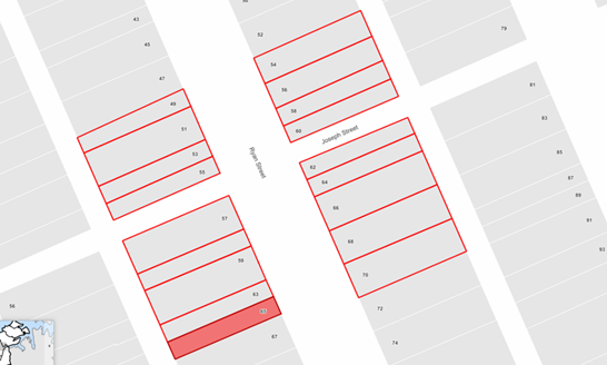
FINANCIAL IMPLICATIONS
This project is estimated to cost $12,000 and is recommended to be included in Council’s Capital Works Program.
Nil.
|
|
Local Traffic Committee Meeting 20 November 2023 |
Subject: Warburton Street, Marrickville - Proposed timed parking restrictions (Midjuburi-Marrickville Ward/Summer Hill Electorate/Inner West PAC)
Prepared By: James Nguyen - Traffic Engineer
Authorised By: Manod Wickramasinghe - Traffic and Transport Planning Manager
|
RECOMMENDATION
That the nine (9) unrestricted 90-degree angle parking be signposted as ‘4P 8am-6pm’ on the eastern side of Warburton Street, Marrickville just east of Herb Greedy Place. |
STRATEGIC OBJECTIVE
This report supports the following strategic directions contained within Council’s Community Strategic Plan:
|
2: Livable, connected neighborhoods and transport |
|
|
EXECUTIVE SUMMARY
McNeilly Park is a key open-space park within the Inner West Council, located near the Marrickville train station and town centre. Currently, there are unrestricted parking spaces adjacent to the park which allows for long-term parking such as commuter parking. As a result, motorists can park for extended periods of time which affects the equity and accessibility to the park. The proposed timed parking restriction (4P 8am-6pm) seeks to deter commuter parking, provide access to the park for those who require a vehicle, and provide the necessary turnover of parking for visitors. The proposal will also benefit the nearby town centre where the timeframe permits recreational time at the park as well as visits to the nearby town centre.
BACKGROUND
Council has received a request from a resident requesting for timed parking restrictions on Warburton Street, Marrickville, just east of Herb Greed Place. The resident has raised concerns about long term commuter parking as the parking spaces are currently unrestricted.
DISCUSSION
McNeilly Park is located adjacent to Marrickville Town Centre and approximately 300 metres from Marrickville Train Station. Currently, both sides of Warburton Street, just west of Illawarra Road is allocated as ‘2P 8.30am-6pm Mon-Fr; 8.30am-10pm Sat-Sun, Permit Holders Excepted Area M2’. This time restriction effectively limits commuter parking that may occur at this location due to the proximity to Marrickville Train Station. The time restriction also allows for turnover of parking for visitors to McNeilly Park and the nearby Marrickville Town Centre. However, further west along Warburton Street, there are currently nine (9) unrestricted 90 degree angle parking spaces adjacent to McNeilly Park and just east of Herb Greedy Place, which is inconsistent with the current time restricted parking spaces on Warburton Street.
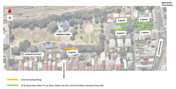
Figure 1 - Existing parking restrictions
Council officers have completed a parking survey to determine the duration of stay of vehicles at the nine (9) unrestricted parking spaces on Warburton Street. The results are presented below.
Table 1 - Duration of stay parking survey
|
Number plate survey; 12 October 2023 |
||
|
11:25am |
3:25pm |
Vehicle parked for 4-hours |
|
VEH1 |
VEH1 |
Yes |
|
VEH2 |
VEH2 |
Yes |
|
VEH3 |
VEH3 |
Yes |
|
VEH4 |
VEH10 |
No |
|
VEH5 |
VEH5 |
Yes |
|
VEH6 |
VEH6 |
Yes |
|
VEH7 |
VEH11 |
No |
|
VEH8 |
VEH8 |
Yes |
|
VEH9 |
VEH9 |
Yes |
The results from Table 1 above, indicate there were 78 per cent of vehicles (7 out of 9) that parked for a four (4) hour period, between 11.25am and 3.25pm. This suggests an extended period of parking at McNeilly Park.
Table 2 - Duration of stay parking survey
|
Number plate survey; 16 October 2023 |
||
|
8:52am |
3:50pm |
Vehicle parked for greater than 4-hours |
|
VEH1 |
VEH1 |
Yes |
|
VEH2 |
- |
No |
|
VEH3 |
VEH3 |
Yes |
|
VEH4 |
VEH4 |
Yes |
|
VEH5 |
- |
No |
|
VEH6 |
VEH6 |
Yes |
|
VEH7 |
VEH7 |
Yes |
|
VEH8 |
VEH8 |
Yes |
|
VEH9 |
VEH9 |
Yes |
Further duration of stay surveys were completed following the original survey of 12 October 2023. The survey from 16 October 2023 as shown in Table 2 above, indicate that 78 per cent of vehicles were parked from approximately 9am to 4pm (7 out of the 9 parking spaces were occupied by the same vehicle throughout the entire day).
Table 3 - Duration of stay parking survey
|
Number plate survey; 18/10/23 |
|||
|
6.30am |
9am |
3:40pm |
Likely type of parking |
|
- |
VEH5 |
VEH5 |
commuter |
|
- |
VEH6 |
VEH6 |
commuter |
|
- |
VEH7 |
VEH7 |
commuter |
|
VEH1 |
VEH1 |
VEH1 |
resident |
|
- |
VEH8 |
VEH8 |
commuter |
|
VEH2 |
VEH2 |
VEH9 |
resident |
|
VEH3 |
VEH3 |
VEH10 |
resident |
|
VEH4 |
VEH4 |
VEH11 |
resident |
|
- |
VEH12 |
VEH12 |
commuter |
A final survey was completed to determine if the vehicles that were parked in the 9 spaces were either by residents or commuters. To determine this, an early morning survey at 6.30am was completed, followed by another survey at 9am and in the afternoon at around 4pm. The results are presented in Table 3 above.
At 6.30am only 4 out of the 9 spaces were occupied, and it is likely that these vehicles are belonging to residents. By 9am, all 9 spaces were utilised, suggesting that 5 out of the 9 spaces (55 per cent) could be used by commuters. These 5 vehicles occupied the unrestricted parking spaces between 9am and 3.40pm indicating long term or commuter parking.
Based on these results, an effective parking solution is the implementation of time restricted parking. The proposed ‘4P 8am-6pm’ time restriction allows for motorists and nearby residents to park unrestricted overnight whilst ensuring turn-over of parking at McNeilly Park during the day. Table 3 suggests that 75 per cent (3 out of 4) of residents move their vehicle after 9am. With the proposed 4P commencing at 8am, residents can park in the spaces until 12noon before having to move their vehicle to allow for a park visitor to park their vehicle near McNeilly Park.
The proposal will also allow for turn-over of parking on the weekends where parking demand at McNeilly Park is likely to be higher. The proposed ‘4P 8am-6pm’ allows for a minimum of 2 turnover cycles (at 12noon, and at 4pm). As a starting point, this is an improvement over current conditions which does not allow for any turnover of parking.
PUBLIC CONSULTATION
Consultation was completed between Thursday 19 October 2023 and Friday 10 November 2023. There were 27 letters sent to nearby residents and businesses of Warburton Street advising them of the proposal. Council officers received one (1) response supporting the proposal and no responses opposing the proposal. The response supporting the proposal agreed with the time restricted parking to allow for people who use the park during the day especially parents with young children to park close to McNeilly Park.
FINANCIAL IMPLICATIONS
There are no financial implications associated with the implementation of the proposed recommendations outlined in the report.
|
1.⇩ |
Proposed time restricted parking - Warburton Street Marrickville |
|
|
Local Traffic Committee Meeting 20 November 2023 |
Subject: Birchgrove Road, Birchgrove - Proposed 'No Stopping' (Baludarri-Balmain Ward/Balmain Elecorate/Leichhardt PAC)
Prepared By: Jackie Ng - Graduate Traffic Engineer
Authorised By: Sunny Jo - Coordinator Traffic Engineering Services (north)
|
RECOMMENDATION
That a 10m length ‘No Stopping’ restriction be installed at the frontage of No.84 Birchgrove Road, Birchgrove. |
STRATEGIC OBJECTIVE
This report supports the following strategic directions contained within Council’s Community Strategic Plan:
|
2: Liveable, connected neighbourhoods and transport |
|
|
DISCUSSION
Council has received concerns regarding vehicles parked close to the intersection of Reuss Street and Birchgrove Road, Birchgrove. It is reported that vehicles parked at the frontage of No.84 Birchgrove Road limits visibility of drivers when exiting from the driveway at No.84 and also from Reuss Street, Birchgrove. It is proposed to install a 10m ‘No Stopping’ restriction along the frontage of No.84 Birchgrove Road, Birchgrove.
A consultation letter was distributed to 17 properties on 9 October 2023 to owners and occupiers near the proposed 10m ‘No Stopping’ restriction. The closing date for submissions ended on 3 November 2023.
A total of five (5) responses were received all in support of the proposal.
|
Resident Comments |
Officer Comments |
|
Resident requested ‘No Stopping’ restriction along the frontage of 82 Birchgrove Road. |
Council officers will monitor this location to determine if non-compliance is of concern and requires signposting. |
|
Resident requested ‘No Stopping’ restriction at the south eastern corner of Birchgrove Road and Cove Street. |
Council officers will monitor this location to determine if non-compliance is of concern and requires signposting. |
The plan below outlined in Figure 1 shows the proposed 10m ‘No Stopping’ restriction along the frontage of 84 Birchgrove Road, Birchgrove.
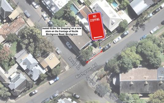
Figure 1 Proposed No Stopping zone in Birchgrove Road, Birchgrove (source NearMaps)
FINANCIAL IMPLICATIONS
There are no financial implications associated with the implementation of the proposed recommendations outlined in the report.
Nil.
|
|
Local Traffic Committee Meeting 20 November 2023 |
Subject: Smith Street, Rozelle - Review of Parking (Baludarri-Balmain Ward/Balmain Electorate/Leichhardt PAC)
Prepared By: Sunny Jo - Coordinator Traffic Engineering Services (north)
Authorised By: Manod Wickramasinghe - Traffic and Transport Planning Manager
|
RECOMMENDATION
That the report be received and noted. |
STRATEGIC OBJECTIVE
This report supports the following strategic directions contained within Council’s Community Strategic Plan:
|
2: Liveable, connected neighbourhoods and transport |
|
|
DISCUSSION
At the October 2023 Traffic Committee, the Representative for the Member of Balmain requested an update on the request for the additional parking permits and suggestion for Council to turn some of the 2 hour resident parking zones into 4P paid parking, resident permit holders excepted based on a submission was received from the Inner Sydney Montessori School (ISMS) regarding a review of the recently implemented Resident Parking Scheme (RPS) in Smith Street and surrounding streets, Rozelle.
The subject RPS in Rozelle North was expanded and implemented between May and August 2023. This was one of the recommendations from the Rozelle North Precinct Parking Study which was undertaken with consultation with the community during 2021. The work included an analysis of parking utilisation data collected outside of the Covid restrictions and developed strategies to manage the limited on-street parking.
The Parking Study identified that a very high level of permit to parking capacity ratio in Rosser Street prior to the recent parking changes. Transport for NSW guidelines require that the number of permits should not exceed the number of spaces available under the RPS. Beyond this point, the effectiveness of the scheme and chance of a permit holder finding a vacant space is greatly diminished. The intention of the permit scheme is to prioritise residents over long-term day parking.
Historically Council understood that the ISMS had a parking deficiency in contravention to Council’s planning requirements, and that this was in the order of 35-39 vehicles as noted in the School’s original DA and Mod applications.
Due to the reason outlined above, the eight (8) permits recently issued to the School cannot be increased. Further to this, the number of permits issued ISMS is considered appropriate compared to other schools and ‘community use’ organizations in Rozelle and Balmain.
It is recognised that the number permits would be a significant change for staff and this would limit long-term parking options for vehicles to other areas such as Punch Park and Robert Street. Such a change may be a catalyst to shift to other transport modes such as public, active or shared transport.
Other options including establishing a 4P paid parking scheme in Smith Street as suggested is not currently supported as parking meters are intended for town centres and shopping strips with high demand and turnover and is not recommended for implementation in residential areas. It is also noted that 4 hour parking is typically not used for Resident Parking as it reduces turnover.
The parking along the ISMS frontage in Smith Street is currently signposted as a combination of:
· ‘5 Minute Parking 8.15am-8.45am, 2.45pm-3.15pm School Days’
· ‘No Parking for 8.15am-8.45am, 2.45pm-3.15pm School Days’
· One (1) ‘Mobility Parking Space 8.15am-3.15pm School Days’
Council can review the parking along the school frontage to improve turnover for staff and visitors to the school.
FINANCIAL IMPLICATIONS
There are no financial implications associated with the implementation of the proposed recommendations outlined in the report.
Nil.
|
|
Local Traffic Committee Meeting 20 November 2023 |
Subject: Pedestrian and Bicycle Safety at Bus Stop - Robert Street, Rozelle (Baludarri - Balmain Ward/ Balmain Electorate/ Leichhardt PAC)
Prepared By: Sunny Jo - Coordinator Traffic Engineering Services (north)
Authorised By: Manod Wickramasinghe - Traffic and Transport Planning Manager
|
RECOMMENDATION
That the report be received and noted.
|
STRATEGIC OBJECTIVE
This report supports the following strategic directions contained within Council’s Community Strategic Plan:
|
2: Liveable, connected neighbourhoods and transport |
|
|
DISCUSSION
At the Traffic Committee meeting held on 16 October 2023, the Representative for the Member of Balmain requested an update on the Bus Stop on Robert Street, Rozelle.
Council has undertaken a review of the safety issues raised by a Rozelle resident at the existing Bus Stop and Shelter on the south side of Robert Street, Rozelle approximately 50m east of Victoria Road. It is reported that there are concerns for conflict between pedestrians and bicycle riders at the Bus Shelter, and several near misses have been reported. With the Shared User Path having a downhill grade from Victoria Road, bicycle riders are prone to quickly build speed on the approach to the Bus Stop.
Services 441 and 442 pass this location, connecting the City CBD to Birchgrove and Balmain East respectively, with a Bus Shelter with transparent side panels has been in place for some time. A bicycle route was adopted for Robert Street with linemarking reinforcing the Shared User Path installed circa 2016. Observations onsite confirm that a number of warning signs and linemarking installed for the downhill approach to this location as illustrated in Figure 1 below.
Figure 1 Robert Street, approx.50m east of Victoria Road (source: Google Street View)
The width of the footpath along the White Bay Power Station frontage is approximately 3.5m, which is suitable for a Pedestrian and Bicycle Shared Path however, due to the limited width a bypass for bicycle riders behind the Bus Shelter could not be provided.
It is understood that Department of Planning and Environment is currently refining the Bays West Masterplan, which is expected to include a review of the current bus routes and stops, not limited to the existing 441 and 442 services. Under the plan, it is expected that an upgrade of the Mullens Street and Robert Street intersection would be required and implemented in subsequent years from the opening The Bays Metro Station in 2030. In the interim, it is recommended to retain the existing Shared User Path and Bus Stop configuration.
FINANCIAL IMPLICATIONS
There are no financial implications associated with the implementation of the proposed recommendations outlined in the report.
Nil.
|
|
Local Traffic Committee Meeting 20 November 2023 |
Subject: Traffic Calming on Lilyfield Road, Rozelle (Baludarri - Balmain Ward/ Balmain Electorate/ Leichhardt PAC)
Prepared By: Sunny Jo - Coordinator Traffic Engineering Services (north)
Authorised By: Manod Wickramasinghe - Traffic and Transport Planning Manager
|
RECOMMENDATION
That the report be received and noted. |
STRATEGIC OBJECTIVE
This report supports the following strategic directions contained within Council’s Community Strategic Plan:
|
2: Liveable, connected neighbourhoods and transport |
|
|
DISCUSSION
At the October 2023 Traffic Committee meeting, the Representative for the Member of Balmain requested an update on the investigation of traffic calming devices and/or treatments on Lilyfield Road at the intersection of Victoria Road.
Council has now undertaken a review of the road configuration of Lilyfield Road at Victoria Road, Lilyfield. Concerns were received regarding road safety at this location as this site has changed due to the WestConnex Rozelle Interchange works. The intersection retains the left in and out movements, and now feature wider kerb ramps, and an unmarked crossing point for pedestrians and bicycle riders across Lilyfield Road. The existing raised threshold has been replaced with a Watts Profile Hump and relocated further west of its previous location.
Lilyfield Road is a cycle route and feature an on-street path which ends at Victoria Road.
Previously Council has raised the issue of relocating the existing traffic calming device further away from Victoria Road, and that the Watts Profile humps are not considered the most suitable treatment for an on-street bicycle route such as Lilyfield Road.
Aerial photos of the Lilyfield
Road and Victoria Road intersection are shown in Figure 1 below, with
recent site photos shown in Figure 2 and 3 below.
![]()
Figure 1: Intersection of Lilyfield Road and Victoria Road pre-WestConnex works (left) and post-WestConnex works
Council officers have noted the changes to this location and made comments back to Rozelle Interchange and to Transport for NSW regarding this location relating to:
· Unsuitability of the Watts Profile Hump for on-road bicycle riders as a replacement to the previous raised threshold
· Signposting and linemarking requirements
· Drainage, landscaping and footpath assets
· Pedestrian and bicycle riders safety at this location crossing Lilyfield Road
It should be noted that discussions are currently underway between Council and Transport for NSW regarding the delivery of the Lilyfield Cycleway.
Figure 2: Site photos of Lilyfield Road and Victoria Road intersection, facing east
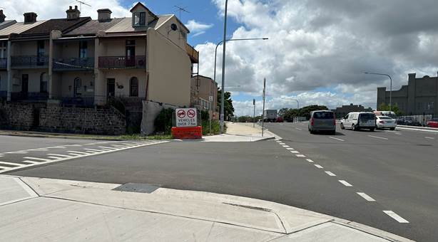
Figure 3: Site photos of Lilyfield Road and Victoria Road intersection, facing north
FINANCIAL IMPLICATIONS
There are no financial implications associated with the implementation of the proposed recommendations outlined in the report.