|
AGENDA R |

Local Traffic Committee Meeting
MONDAY 11 DECEMBER 2023
11.00am
|
|
Local Traffic Committee Meeting 11 December 2023 |
Function of the Local Traffic Committee
Background
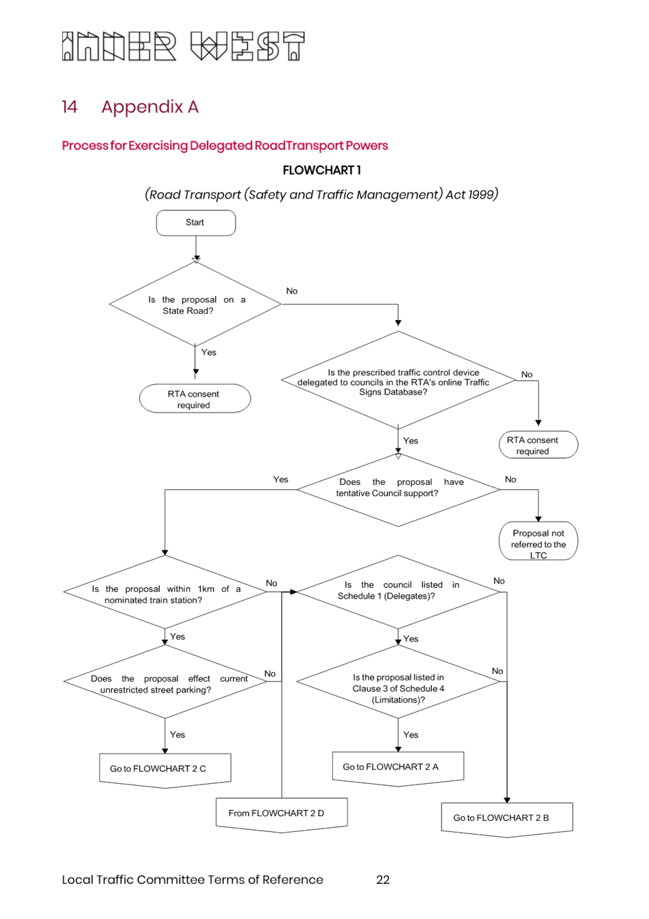
Roads and Maritime Services (RMS) is legislated as the Authority responsible for the control of traffic on all NSW Roads. The RMS has delegated certain aspects of the control of traffic on local roads to councils. To exercise this delegation, councils must establish a local traffic committee and obtain the advice of the RMS and Police. The Inner West Council Local Traffic Committee has been constituted by Council as a result of the delegation granted by the RMS pursuant to Section 50 of the Transport Administration Act 1988.
Role of the Committee
The Local Traffic Committee is primarily a technical review and advisory committee which considers the technical merits of proposals and ensures that current technical guidelines are considered. It provides recommendations to Council on traffic and parking control matters and on the provision of traffic control facilities and prescribed traffic control devices for which Council has delegated authority. These matters are dealt with under Part A of the agenda and require Council to consider exercising its delegation.
In addition to its formal role as the Local Traffic Committee, the Committee may also be requested to provide informal traffic engineering advice on traffic matters not requiring Council to exercise its delegated function at that point in time, for example, advice to Council’s Development Assessment Section on traffic generating developments. These matters are dealt with under Part C of the agenda and are for information or advice only and do not require Council to exercise its delegation.
Committee Delegations
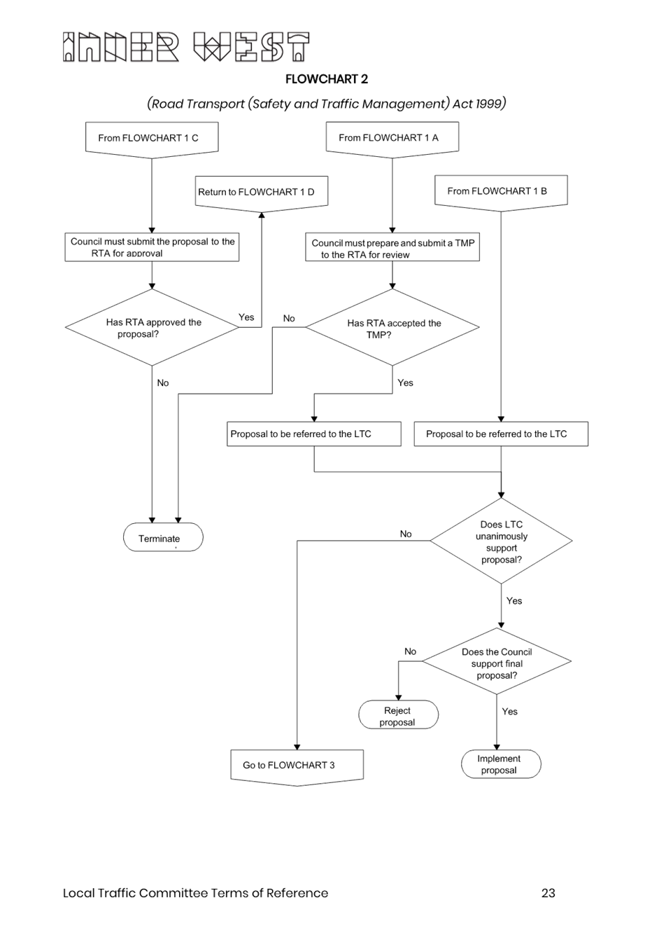
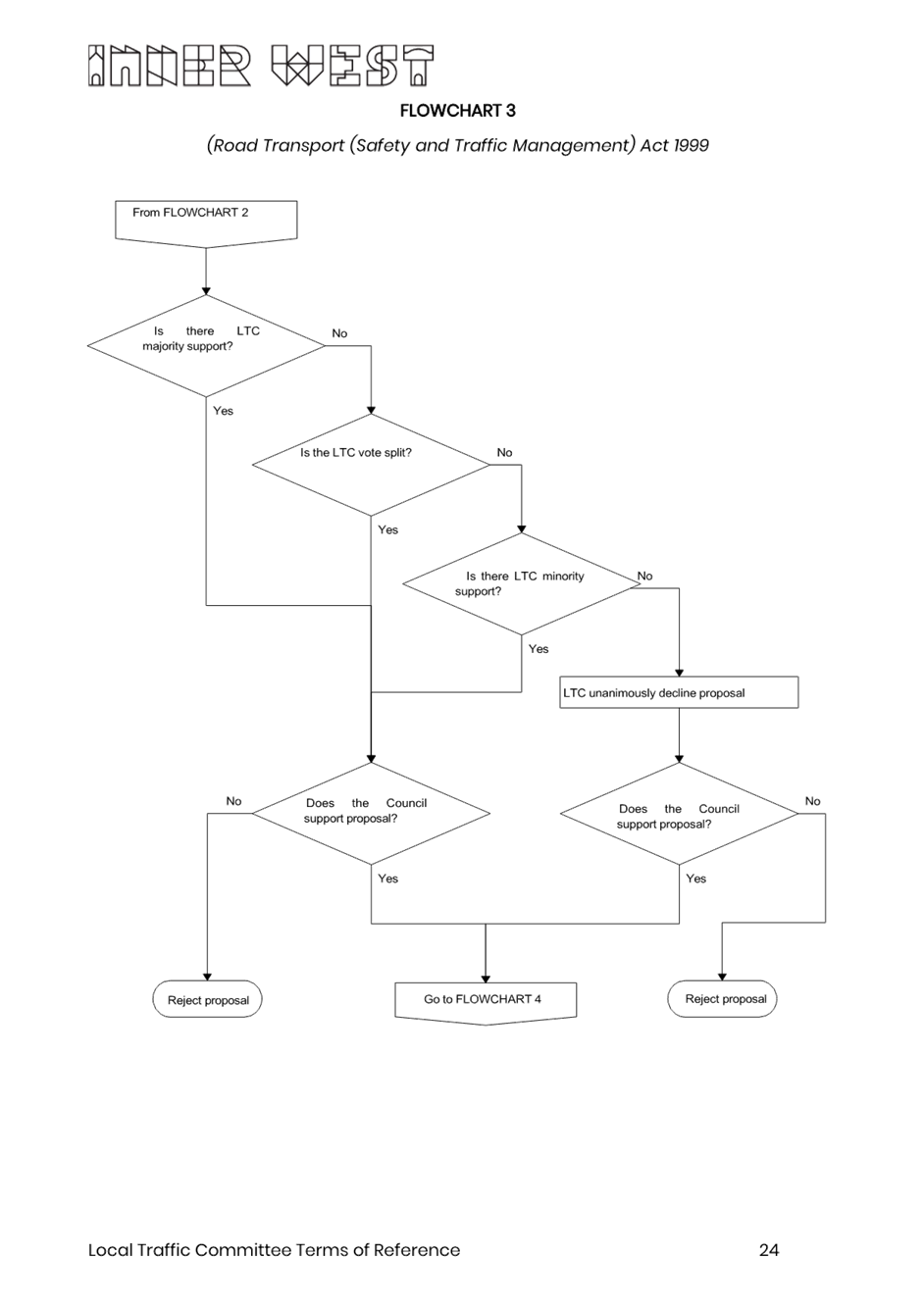
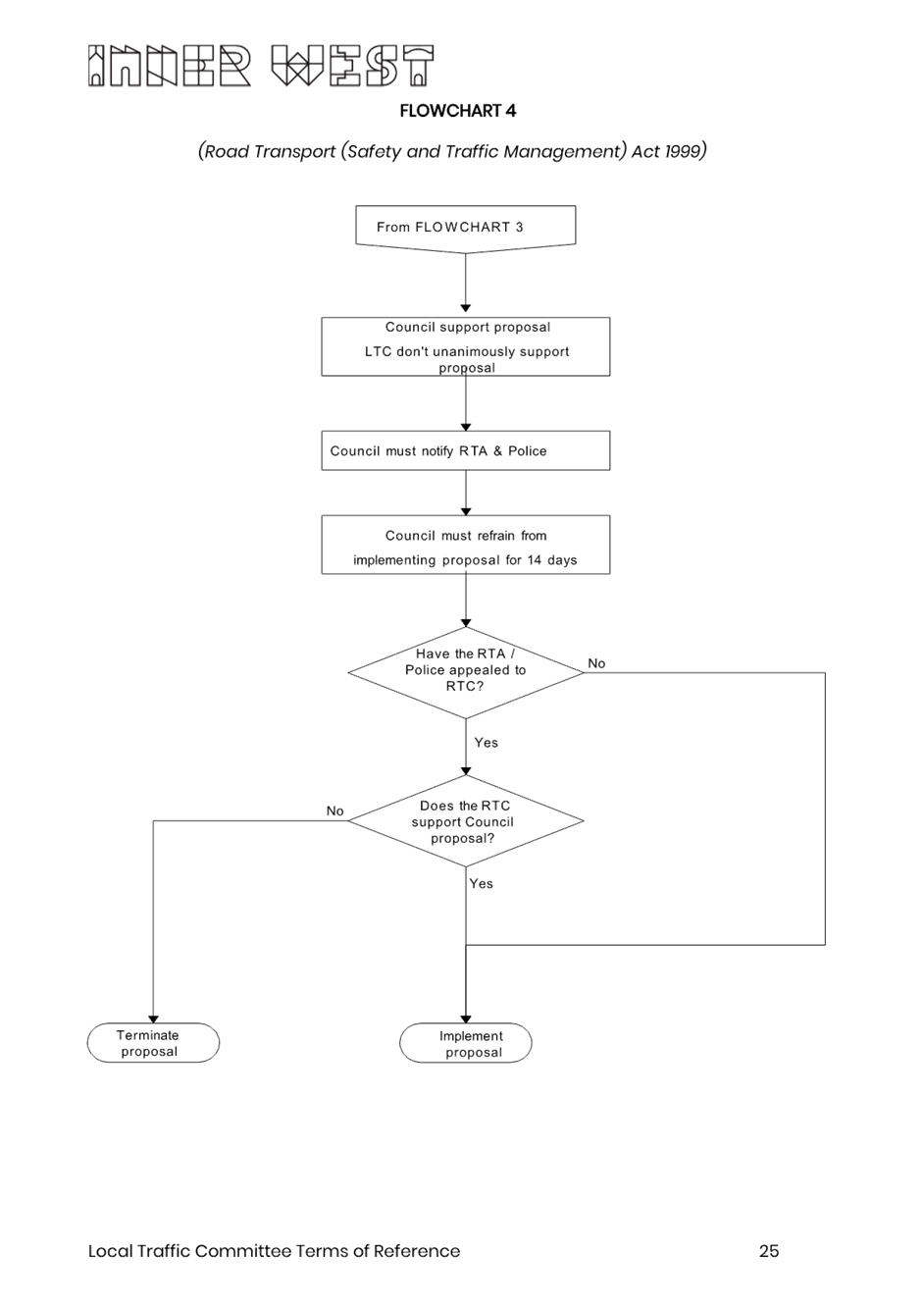
The Local Traffic Committee has no decision-making powers. The Council must refer all traffic related matters to the Local Traffic Committee prior to exercising its delegated functions. Matters related to State Roads or functions that have not been delegated to Council must be referred directly to the RMS or relevant organisation.
The Committee provides recommendations to Council. Should Council wish to act contrary to the advice of the Committee or if that advice is not supported unanimously by the Committee members, then the Police or RMS have an opportunity to appeal to the Regional Traffic Committee.
Committee Membership & Voting
Formal voting membership comprises the following:
· one representative of Council as nominated by Council;
· one representative of the NSW Police from each Local Area Command (LAC) within the LGA, being Newtown, Marrickville, Leichhardt and Ashfield LAC’s.
· one representative from the RMS; and
· State Members of Parliament (MP) for the electorates of Summer Hill, Newtown, Heffron, Canterbury, Strathfield and Balmain or their nominees.
Where the Council area is represented by more than one MP or covered by more than one Police LAC, representatives are only permitted to vote on matters which effect their electorate or LAC.
Informal (non-voting) advisors from within Council or external authorities may also attend Committee meetings to provide expert advice.
Committee Chair
Council’s representative will chair the meetings.
Public Participation
Members of the public or other stakeholders may address the Committee on agenda items to be considered by the Committee. The format and number of presentations is at the discretion of the Chairperson and is generally limited to 3 minutes per speaker. Committee debate on agenda items is not open to the public.
|
|
Local Traffic Committee Meeting 11 December 2023 |
|
AGENDA |
1 Apologies
2 Disclosures of Interest
3 Confirmation of Minutes
Minutes of 20 November 2023 Local Traffic Committee 5
4 Matters Arising from Council’s Resolution of Minutes
5 Part A – Items Where Council May Exercise Its Delegated Functions
Traffic Matters
ITEM Page
LTC1223(1) Item 1 Hancock Lane, Rozelle - Permanent Road Closure (Baludarri-Balmain Ward/Balmain Electorate/Leichhardt PAC) 27
LTC1223(1) Item 2 Biennale of Sydney 2024 Traffic Management Plan - Robert Street, Rozelle (Baludarri-Balmain Ward/Balmain Electorate/Leichhardt PAC) 43
LTC1223(1) Item 3 Pedestrian Crossing Warrant Policy 91
LTC1223(1) Item 4 Riverside Crescent, Dulwich Hill - Proposed Traffic Calming and Pedestrian Devices (Djarrawunang-Ashfield Ward/Summer Hill Electorate/ Inner West PAC) 113
LTC1223(1) Item 5 Lands Lane, Newtown - Proposed extension to road closure (Damun-Newtown Ward/Newtown Electorate/Inner West) 124
LTC1223(1) Item 6 Arthur Street, Marrickville - Proposed continuous footpath treatment (Midjubiri-Marrickville Ward/Newtown Electorate/Inner West PAC) 126
LTC1223(1) Item 7 Thornley Street carpark, Marrickville - Formalise 'P15 7.00am-9.00am and 3.00pm-6.00pm Monday to Friday' restrictions outside Yirran Gumal Early Learning Centre along with other parking restrictions within the carpark (Midjuburi - Marrickville Ward/ Summer Hill Electorate / Inner West PAC) 129
LTC1223(1) Item 8 Victoria Street, Queen Street, Clissold Street, Seaview Street and surrounding streets, Ashfield/Summer Hill - Proposed pedestrain (zebra) crossings and traffic calming around and near the Cardinal Freeman Village, Ashfield (Djarrawunang-Ashfield Ward/Summer Hill Electorate/Burwood PAC) 133
Parking Matters
ITEM Page
LTC1223(1) Item 9 Unnamed Lane, Summer Hill (adjacent Henson and Herbert Streets) - Proposed 'No Stopping' restrictions (Djarrawaunang-Summer Hill Ward/Summer Hill Electrorate/Burwood PAC) 175
Late Items
Nil at time of printing.
6 Part B - Items for Information Only
ITEM Page
LTC1223(1) Item 10 Traffic Committee Schedule 2024 181
7 Part C - Items for General Advice
ITEM Page
LTC1223(1) Item 11 Local Traffic Committee Terms of Reference 182
8 General Business
9 Close of Meeting
|
|
Local Traffic Committee Meeting 11 December 2023 |
Minutes of Meeting
Meeting commenced at 11.03am
ACKNOWLEDGEMENT OF COUNTRY BY CHAIRPERSON
I acknowledge the Gadigal and Wangal people of the Eora nation on whose country we are meeting today, and their elders past and present.
COMMITTEE REPRESENTATIVES PRESENT
|
Manod Wickramasinghe |
IWC’s Traffic and Transport Planning Manager (Chair) |
|
Sgt Shannon Burns |
NSW Police – Leichhardt Police Area Command |
|
Ben Walters |
NSW Police Representative |
|
Nina Fard |
Transport for NSW (TfNSW) |
|
|
|
|
NON VOTING MEMBERS IN ATTENDANCE |
|
|
|
|
|
Colin Jones |
Inner West Bicycle Coalition (IWBC) |
|
Sunny Jo |
IWC’s Coordinator Traffic Engineering Services (North) |
|
George Tsaprounis |
IWC’s Coordinator Traffic Engineering Services (South) |
|
Christy Li |
IWC’s Business Administration Officer |
|
|
|
|
VISITORS |
|
|
|
|
|
Denise Matovic |
Senior Architect at Leaf Architecture – Representative for St Maroun’s College (Item 6) |
|
Donald Urquhart |
Resident (Item 22) |
|
Reliza Pangan |
Resident (Item 11) |
|
John Zezovski |
Resident (Item 11) |
|
Roopa Jogunoori |
Transport for NSW Project Manager |
|
Leonardo Ferreri |
Transport for NSW |
|
|
|
|
|
|
|
APOLOGIES: |
|
|
|
|
|
Mayor Darcy Byrne |
Councillor – Baludarri-Balmain Ward |
|
Bill Holliday |
Representative for Kobi Shetty MP, Member for Balmain |
|
Graeme McKay |
Representative for Jo Haylen MP, Member for Summer Hill |
|
Patricia Arcilla |
Representative for Jenny Leong MP, Member for Newtown |
|
Germaine Grant |
NSW Police - Burwood Police Area Command |
|
|
|
|
|
|
DISCLOSURES OF INTERESTS:
Nil.
CONFIRMATION OF MINUTES
|
That the Minutes of the Local Traffic Committee held on Monday, 16 October 2023 be confirmed. |
MATTERS ARISING FROM COUNCIL’S RESOLUTION OF MINUTES
Nil.
|
LTC1123(1) Item 1 182-198 Victoria Road and 28-30 Faversham Street, Marrickville - Condition 30 & 31 – Signs and Line Markings Plans, Carshare Conditions 5 & 71, and Victoria Road proposed signage modification – MOD/2023/0049 (Midjuburi - Marrickville Ward / Summer Hill Electorate / Inner West PAC) |
|
Detailed signage and line marking plans for 182-198 Victoria Road and 28-30 Faversham Street, Marrickville have been resubmitted to satisfy DA consent conditions 30 and 31 of MOD/2023/0049 as part of reviewing a Step 1 Roadworks application for Public Domain works associated with the above property (ENR1/2023/0068). Also the plan of management for the approved on-site car share spaces is presented addressing Conditions 5 and 71 of MOD/2023/0049 along with proposed modifications to signage along the Victoria Road frontage of the site. It is recommended that the updated plans be approved.
Officer’s Recommendation:
1. That the proposed amendments to ‘No Stopping’ restrictions in Faversham Street and Hans Place as shown on the updated signs and linemarking plan for the 182-198 Victoria Road and 28-30 Faversham Street, Marrickville (refer to Attachment 1, sheet 2 of 8 – 301400183-10-02 dated 3 August 2023) be approved.
2. That the updated detailed line marking and signage plans for the 182-198 Victoria Road and 28-30 Faversham Street, Marrickville development Consent Condition 30 & 31 showing amendments to ‘No Stopping’ restrictions in Faversham Street and Hans Place (as per the plans in Attachment 1) be approved.
3. That the proposed car share signage in the private shareway of the 182-198 Victoria Road and 28-30 Faversham Street, Marrickville development and new one hour parking restrictions along Victoria Road frontage, Marrickville as shown on detailed plans in Attachment 2 be approved.
4. That the costs of the supply and installation of the associated signage are to be borne by the applicant in accordance with Council’s Fees and Charges.
5. That the applicant notifies Council’s Traffic Team the date of the new line marking and signage installations.
DISCUSSION:
The Representative for Transport for NSW (TfNSW) raised concerns regarding the ‘No Stopping’ restrictions on the opposite side of the development. The Representative for Transport for NSW also suggested a permanent ‘No Right Turn’ instead of ‘No Right Turn’ during peak hours so to better address possible congestion and loss of parking issues.
Council Officers stated that TfNSW was originally supportive of a median island across Victoria Road where it intersected with the private road however, TfNSW subsequently changed its position on the proposal and ‘No Right Turn’ restrictions during peak hour were supported instead. Council Officers stated that ‘No Right Turn’ was previously approved by Council and went through the Traffic Committee process. Councils’ Officer further stated that the ‘No Stopping’ restrictions in support of the ‘No Right Turn’ restrictions were unusual and that the proposed ‘No Stopping’ restrictions on Victoria Road, opposite the private road should not be installed.
Council Officers suggested to amend the recommendation and remove the proposed section of ‘No Stopping’ restrictions on Victoria Road, opposite the private road into the newly built development complex.
The Committee members were advised that point 2 of the recommendation would be amended to reflect the proposal for one hour parking adjacent to 182-198 Victoria Road, Marrickville as discussed within this report.
Point 2 of the recommendation was corrected to reflect the proposal for one hour parking adjacent to 182-198 Victoria Road, Marrickville as per the report and plans.
The Committee members agreed with the amended Officers recommendation.
COMMITTEE RECOMMENDATION:
1. That the proposed amendments to ‘No Stopping’ restrictions in Faversham Street and Hans Place as shown on the updated signs and linemarking plan for the 182-198 Victoria Road and 28-30 Faversham Street, Marrickville (refer to Attachment 1, sheet 2 of 8 – 301400183-10-02 dated 3 August 2023) be approved.
2. That the proposed 70m of “1P 7am–4pm Mon-Fri and 8.30am-4pm Sat” along the frontage of 182-198 Victoria Road, Marrickville as shown on signage plan 301400183-09-01 be approved.
3. That the proposed car share signage in the private shareway of the 182-198 Victoria Road and 28-30 Faversham Street, Marrickville development and new one hour parking restrictions along Victoria Road frontage, Marrickville as shown on detailed plans in Attachment 2 be approved.
4. That the costs of the supply and installation of the associated signage are to be borne by the applicant in accordance with Council’s Fees and Charges.
5. That the applicant notifies Council’s Traffic Team the date of the new line marking and signage installations.
6. The proposed No Stopping restrictions on Victoria Road (opposite the private road for 182-198 Victoria Road) not be supported for installation.
7. Council investigate a full time ‘No Right Turn’ on Victoria Road at the private driveway for 182-198 Victoria Road.
For Motion: Unanimous
|
|
LTC1123(1) Item 5 Victoria Road, Marrickville - Proposed Short-Term Parking (Midjuburi- Marrickville Ward/ Summer Hill Electorate/ Inner West PAC) |
|
Following representations from local businesses, Council is proposing to introduce a 18m section of time-restricted parking along Victoria Road, Marrickville, on the western side immediately south of the driveway 153-155 Victoria Road, in order to improve parking turnover in the vicinity of the local businesses. There will be no change to the present ‘7am – 9am’ clearway restrictions.
Officer’s Recommendation:
That an 18-metre section of ‘1P 9am – 5pm Monday to Saturday’ restrictions on the western side of Victoria Road immediately south of the driveway 153-155 Victoria Road, Marrickville be approved in order to improve parking turnover in the vicinity of the local businesses.
DISCUSSION:
The Committee members agreed with the Officers recommendation.
COMMITTEE RECOMMENDATION:
That an 18-metre section of ‘1P 9am – 5pm Monday to Saturday’ restrictions on the western side of Victoria Road immediately south of the driveway 153-155 Victoria Road, Marrickville be approved in order to improve parking turnover in the vicinity of the local businesses.
For Motion: Unanimous
|
|
LTC1123(1) Item 7 Audley Street, Audley Lane, Sadlier Crescent, Fisher Street, and eastbound parking lanes on New Canterbury Road Petersham – Temporary Full Road Closures For Special Event On Saturday 23 March 2024 – Petersham Festival Bairro Portuguese (Damum - Stanmore Ward / Newtown Electorate / Inner West PAC) |
|
Inner West Council will be presenting Petersham Festival - Bairro Portuguese on Saturday 23 March 2024 from 3:00pm until 9:00pm on Audley Street and Fisher Street, Petersham. This event celebrates the very best of Portuguese culture with entertainment, music, dance, cultural activities, and traditional and contemporary foods. To facilitate the event, areas of Petersham will be closed and there will be road closures necessitating some road detours and bus diversions in surrounding streets (ENRC/2023/0066).
Roads affected include Audley Street (between New Canterbury Road and Trafalgar Street), Sadlier Crescent (between Audley Street and Abels Lane) and Fisher Street (between Audley Street and Regent Street), Audley Lane north of New Canterbury Road (resident access excepted) as well as the eastbound parking lane on New Canterbury Road (between Audley Street and Balanaming Lane), Petersham from 6.00am until 2.00am (Sunday). It is recommended that Council agree to the temporary full road closures subject to all standard Council conditions for a temporary full road closure. This report outlines the traffic management plan for the 2024 event.
Officer’s Recommendation:
1. That the proposed temporary road closure of Audley Street (between New Canterbury Road and Trafalgar Street), Sadlier Crescent (between Audley Street and Abels Lane) and Fisher Street (between Audley Street and Regent Street), Audley Lane north of New Canterbury Road (resident access excepted) as well as the eastbound parking lane on New Canterbury Road (between Audley Street and Balanaming Lane), Petersham on Saturday 23 March 2024, from 6:00am until 2.00am (Sunday), for the holding of ‘Bairro Portuguese Petersham Festival’, be approved subject to the applicant complying with but not limited to the following conditions: a) A Traffic Management Plan (TMP) is submitted to and approved by Transport for NSW; and an application for a Road Occupancy Licence and a temporary Speed Zone Authorisation is forwarded to and approved by the Transport Management Centre; b) Notice of the proposed event is forwarded to all affected residents and businesses, including the N.S.W. Police / Inner West Local Area Commander, Fire and Rescue NSW, NSW Ambulance and Transit Systems; c) Transit Systems – Inner West Bus Services be requested to implement a revised routing for scheduled bus services in Audley Street on the day of the event and install temporary bus stops as required; d) A minimum four (4) metre unencumbered passage be available for emergency vehicles through the closed section; and e) The occupation of the road carriageways must not occur until the roads have been physically closed.
DISCUSSION:
The Committee members agreed with the Officers recommendation.
COMMITTEE RECOMMENDATION:
1. That the proposed temporary road closure of Audley Street (between New Canterbury Road and Trafalgar Street), Sadlier Crescent (between Audley Street and Abels Lane) and Fisher Street (between Audley Street and Regent Street), Audley Lane north of New Canterbury Road (resident access excepted) as well as the eastbound parking lane on New Canterbury Road (between Audley Street and Balanaming Lane), Petersham on Saturday 23 March 2024, from 6:00am until 2.00am (Sunday), for the holding of ‘Bairro Portuguese Petersham Festival’, be approved subject to the applicant complying with but not limited to the following conditions: a) A Traffic Management Plan (TMP) is submitted to and approved by Transport for NSW; and an application for a Road Occupancy Licence and a temporary Speed Zone Authorisation is forwarded to and approved by the Transport Management Centre; b) Notice of the proposed event is forwarded to all affected residents and businesses, including the N.S.W. Police / Inner West Local Area Commander, Fire and Rescue NSW, NSW Ambulance and Transit Systems; c) Transit Systems – Inner West Bus Services be requested to implement a revised routing for scheduled bus services in Audley Street on the day of the event and install temporary bus stops as required; d) A minimum four (4) metre unencumbered passage be available for emergency vehicles through the closed section; and e) The occupation of the road carriageways must not occur until the roads have been physically closed.
For Motion: Unanimous
|
|
LTC1123(1) Item 10 Charlotte Street at Bland Street, Ashfield-Intersection improvement works. (Djarrawunang- Ashfield Ward/Summer Hill Electrorate/Burwood PAC) |
|
Council is planning to improve road safety by constructing new landscaped kerb blister islands and kerb ramps in Charlotte Street, Ashfield (at its intersection with Bland Street). The proposal aims to improve pedestrian and motorist safety by better defining the existing traffic and parking lanes through the provision of constructed landscaped islands which also provides safer crossing location for pedestrians wishing to cross Charlotte Street.
Officer’s Recommendation:
That the detailed design plan for the intersection improvement works of Charlotte Street at Bland Street, Ashfield, with associated signs and line marking as shown on the Plan 10257 be approved.
DISCUSSION:
The Representative for the Inner West Bicycle Coalition requested more logos upon the entry of Bland Street near the ‘Stop’ sign as well as the western side of Charlotte Street.
Council officers agreed to incorporate more logos within the design.
The Committee members agreed with the Officers recommendation.
COMMITTEE RECOMMENDATION:
That the detailed design plan for the intersection improvement works of Charlotte Street at Bland Street, Ashfield, with associated signs and line marking as shown on the Plan 10257 be approved.
For Motion: Unanimous
|
|
LTC1123(1) Item 11 Collins Street, Tempe - Proposed 'No Parking' restrictions at dead-end (Midjuburi - Marrickville Ward/ Heffron Electorate / Inner West PAC) |
|
It is recommended that the installation of ‘No Parking’ restrictions (for a distance of approximately 21 meters) at the dead-end of Collins Street, Tempe be approved, in order to provide clear vehicular access to the adjacent off-street parking space, which is often restricted by illegally parked vehicles
Officer’s Recommendation:
That the installation of full-time 'No Parking’ restrictions (for a distance of approximately 21 meters) at the dead-end of Collins Street, Tempe be approved in order to deter illegal parking and provide clear vehicular access to the adjacent off-street parking space.
DISCUSSION:
Public Speakers Reliza Pangan and John Zezovski entered the meeting at 11.25am
Ms Pangan objected to the proposed recommendation and provided a copy of a signed petition from 18 households, with 29 signatories including one from the supervisor working at the railway. Ms Pangan stated that her mother has a disability and requires close vehicular access and that the proposed recommendation will remove parking spaces on Collins Street. Ms Pangan stated that there are no issues within the community living in Collins Street and that it was just one resident who wanted to implement the ‘No Parking’ restrictions. Ms Pangan believes that the implementation of ‘No Parking’ restrictions may cause issues within the community.
Mr Zezovski objected to the proposed recommendation as he stated that parking is quite hard to find in the area. He stated the teachers at the nearby school and patrons of ‘Col Jones Swim Tempe’ park on Collins Street during the day making hard for residents to find parking along the street. Mr Zezovski is concerned that the proposed removal of the parking spaces will cause issues as there is already limited parking.
Council Officers asked Ms Pangan if vehicles were parked 90 degrees at the dead end of the street, would it obstruct her driveway. Ms Pangan responded saying sometimes vehicles do obstruct her driveway but very rarely, as there is a railway gate in place and hence motorists tend to not park near her driveway.
Council Officers noted that if vehicles are parked too close to the driveway of No.19 Collins Street, it is very hard to access the driveway. Council Officers stated they had gone on-site and parked their car and noted it was very hard to manoeuvre out safely.
Council Officers asked Mr Zezovski and Ms Pangan if Council were to investigate the possible implementation of 90° parking on one side of the street, would this be something the community be open to. Mr Zezovski and Ms Pangan agreed that angle parking would be beneficial.
Ms Pangan also noted that since she has placed ‘Do Not Block Driveway’ signs and ‘No Parking’ signs on her property, she has had no issues with people obstructing her access to her property.
Public Speakers Reliza Pangan and John Zezovski left the meeting at 11.45am
The Representative for TfNSW noted that from a technical point of view, cars should not be parking at a dead end as that should be where the turning circle is placed.
Council Officers suggested to investigate 90° angled parking between Wells Avenue and the dead end.
The Committee members agreed with the amended Officers recommendation.
COMMITTEE RECOMMENDATION:
2. That an investigation for 90° angled parking between Wells Avenue and the dead end be undertaken.
For Motion: Unanimous |
General Business:
|
Item 24 – Briefing on Victoria Road Bus Lanes in Rozelle. |
|
Public speakers Roopa Jogunoori and Leonardo Ferreri from TfNSW joined via teams to provide an update regarding the Victoria Road Bus Lanes in Rozelle at 12.30pm.
Mr Ferreri and Ms Jogunoori advised that their teams objective was to rebalance road space, provide more frequent and reliable bus journeys, better connecting the corridor to cycling and pedestrian links, applying social outcomes lens to partnering with local government, driving high quality public amenity and safety, facilitate sustainable access to and for local business as well as encouraging mode shift from private vehicles to public and active transport on Victoria Road.
Mr Ferreri explained the works for Bus Shortening to support Rozelle Interchange Opening to ensure traffic exits safely from the Iron Cove Link tunnel westbound onto Victoria Road in Rozelle. Transport for NSW will shorten the westbound bus lane at the start of the Iron Cove Bridge. He also described plans for an offset bus lane shifting existing AM bus lane from the kerbside lane to lane two which should clear of interference caused by stopping buses and left turning traffic. The new bus lane will be operational for 24 hours.
Mr Ferreri also explained the scope of works for outbound bus lanes through the introduction of an outbound kerbside bus lane on Victoria Road between Quirk Street and Clubb Street which will be operational during the hours of 6am-10am and 3pm-7pm Monday to Friday.
Public speakers Roopa Jogunoori and Leonardo Ferreri from TfNSW left the teams meeting at 12.37pm. |
|
Item 25 – Update on Traffic Signal upgrade at the intersection of Fredrick Street and John Street, Ashfield. |
|
The Representative for TfNSW advised that TfNSW has started engaging contractors for the design work on the traffic signals at the intersection of Fredrick Street at John Street in Ashfield. TfNSW has gotten the concept design completed and are in the process of getting the detailed design out to tender. |
Meeting closed at 12:41pm.
|
|
Local Traffic Committee Meeting 11 December 2023 |
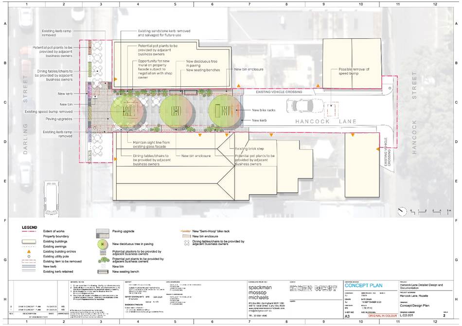
Subject: Hancock Lane, Rozelle - Permanent Road Closure (Baludarri-Balmain Ward/Balmain Electorate/Leichhardt PAC)
Prepared By: Amir Falamarzi - Traffic Engineer
Authorised By: Manod Wickramasinghe - Traffic and Transport Planning Manager
|
RECOMMENDATION
1. That the proposed permanent road closure of Hancock Lane, Rozelle at Darling Street be approved, subject to the Transport for NSW approval of the Traffic Management Plan (TMP).
2. That the two (2) existing speed cushions and associated signs in Hancock Lane be removed, and a ‘No Through Road’ sign be installed as part of the Hancock Lane closure. |
STRATEGIC OBJECTIVE
This report supports the following strategic directions contained within Council’s Community Strategic Plan:
|
2: Liveable, connected neighbourhoods and transport |
|
|
EXECUTIVE SUMMARY
Hancock Lane is one of the projects in Council’s Main Streets Program, aiming to improve the vibrancy and safety of public spaces and local streets. The proposal was previously considered by the Traffic Committee on 18 September 2023, with Council providing in-principle support of the closure, subject to community engagement.
Community engagement was undertaken between 23 October to 20 November 2023 on a concept plan closing off Hancock Lane at Darling Street, Rozelle, and rationalizing the space as a public plaza for people to visit and stay.
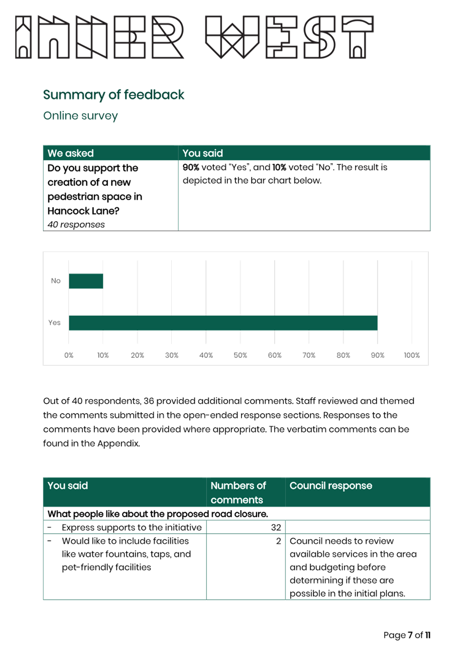
Key comments received showed support for the creation of the plaza space, acknowledging the new space as a good addition to the footpath, which will make it more friendly and safer for pedestrians and outdoor dining. About 90% of respondents expressed support for the proposal, with a range of feedback received which is outlined in this report and provided in Attachment 2.
BACKGROUND
The project is a part of Council’s Main Streets Program, aiming to improve the vibrancy and safety of public spaces and local streets. Re-imagining the use of public spaces and regenerating them can enhance the lives of the community and assist economic growth by providing settings to attract visitation and local spend and creating places to go to, not move through.
As a part of the Main Streets Program, Council has developed concept plans for improvements to Hancock Lane in Rozelle. The proposal transforms this narrow laneway
off Darling Street into a permanent street plaza, removing through vehicular traffic and creating opportunities for:
· Tree planting
· Outdoor dining and street furniture
· Streetscape improvements enabling adjoining businesses to make use of the plaza space
DISCUSSION
Hancock Lane is a two-way lane providing access for the residential houses along Hancock Lane and Hancock Street. The lane is approximately 40m long feature three existing garages having access to Hancock Lane, and due to the narrow width, no footpaths are provided. There is no designated bicycle infrastructure in the lane. To maintain low vehicle speeds, two speed cushions are located within the laneway.
On-street parking is permitted for approximately two spaces including a short kerbspace of motorbike parking. The remaining sections of the laneway are signposted as ‘No Stopping’ or ‘No Parking’.
For vehicles travelling westbound on Darling Street, the northern end of Hancock Lane is currently the shortest entry point to Hancock Street.
Recent traffic counts undertaken on 8 and 12 May 2023 for Hancock Lane and Hancock Street during the peak hours indicate low traffic volumes, with less than 10 vehicles per hour in Hancock Lane and less than 20 vehicles per hour in Hancock Street.
The proposed closure of Hancock Lane was previously considered by the Traffic Committee on 18 September 2023, with Council providing in-principle support of the closure, subject to community engagement.
The closure would require the removal of the redundant two (2) existing speed cushions and associated warning signs, including the two on-street parking spaces and motorbike parking spaces. These are proposed to be removed as part of the physical closure and improvement of Hancock Lane.
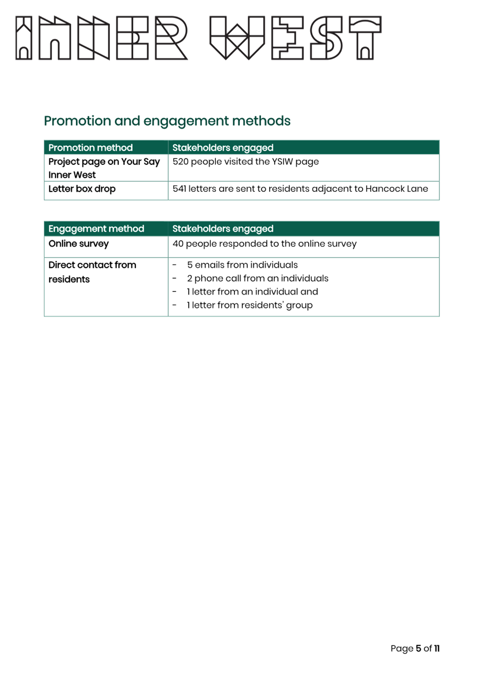
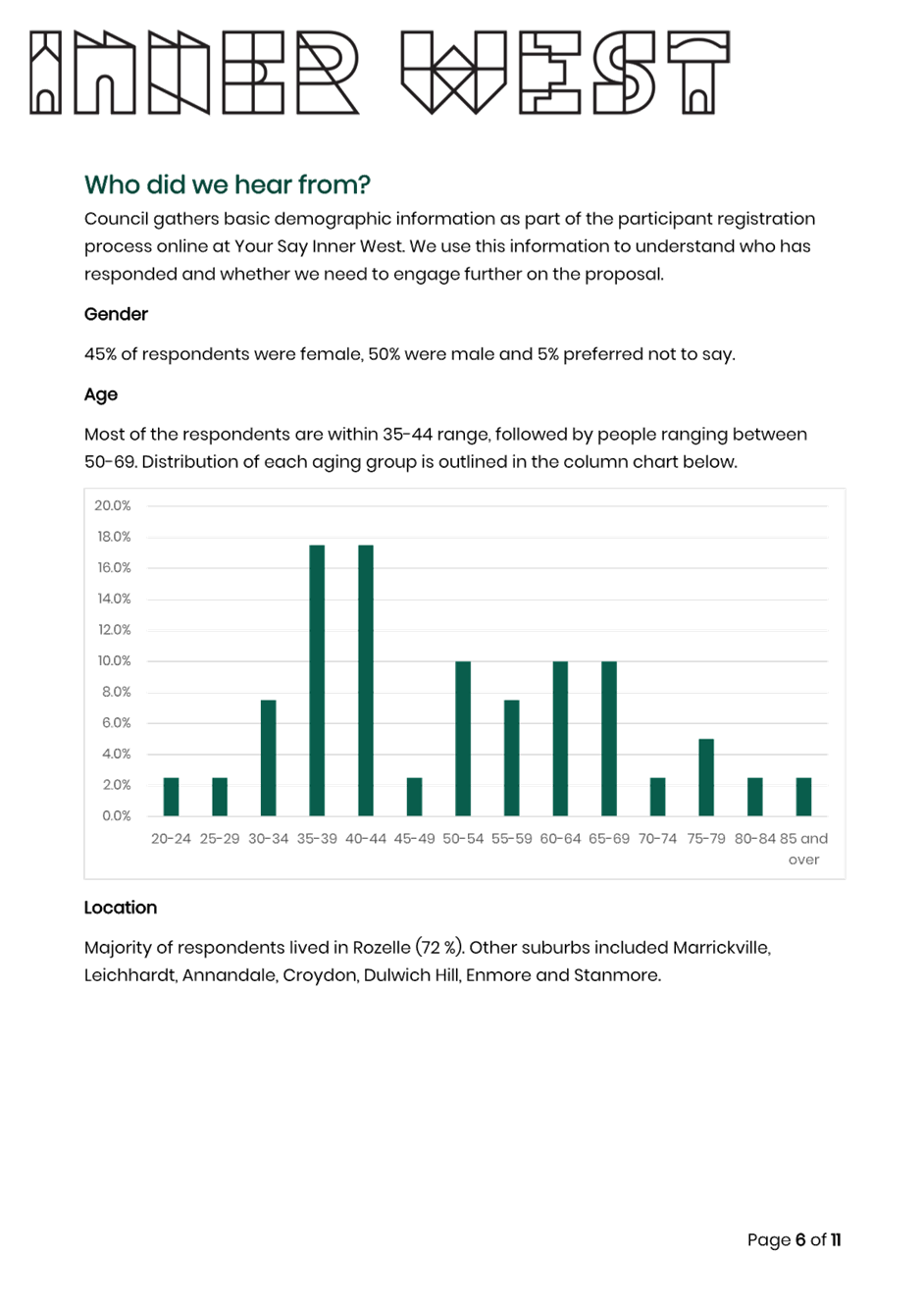
As part of the community consultation, 541 letters were sent to residents adjacent to Hancock Lane and project was advertised on Your Say Inner West. 520 People visited the Your Say Inner West page.
Most of the feedback received supports the closure of Hancock Lane and creating a permanent pedestrian plaza.
During the engagement period:
· There were 520 visits to the Your Say Inner West (YSIW) page,
· 40 people voted in the poll, 90% of respondents expressed support of the concept plan
· Five (5) emails received, 100 % of respondents expressed support of the concept plan
· Two (2) phone calls from individuals, 50% of respondents expressed support of the concept plan
· Two (2) hardcopy letters received, 50% expressed support of the concept plan
Comments from the respondents have been summarised in the table below:
|
Comments |
Council response |
|
Would like to include facilities like water fountains, taps, and pet-friendly facilities |
Council needs to review available services in the area and budgeting before determining if these are possible in the initial plans. |
|
Do more similar projects in the neighbourhood. |
The Rozelle Public Domain Master plan investigates similar opportunities in a broader area. At this stage council is prioritising Hancock Lane along with other projects across Inner West LGA. |
|
Specifically supports the idea of the murals |
Noted |
|
Specifically supports the idea of outdoor dining and people-friendly space |
Noted |
|
Specifically supports more green in the lane |
Noted |
|
Supports the proposal because it enhances pedestrian safety. |
Noted |
|
Wants council to work with broader community groups to uplift this lane |
Noted |
|
Council should take the lead on the plants and install living garden with automatic watering system. Suggest permeable surface and Crepe Myrtles as the tree species. |
Council needs to review the scope and budget to determine if these proposals are feasible. |
|
Concerns about misbehaviours in the laneway |
Noted |
|
Concerns about fixed seating adjacent to the apartments due to noise concerns. |
Council will review the plan. |
|
Concerned about loss of parking on Hancock Lane and access to Hancock Lane garages will be lost |
Vehicular access to existing properties along Hancock Lane will be maintained under the proposal. As noted in this report two on-street spaces and a small kerbspace of motorbike parking will be removed as part of this proposal and reinstated with bicycle parking spaces. |
|
The laneway closure will cause additional travel time, putting more traffic on other local roads and making it inconvenient for people living on Hancock Street |
The proposed closure will result in approximately 650m of additional travel time for a motor vehicle, which would equal to about 3 minutes of travel time. |
|
Want to see more similar projects in the area |
Noted |
|
Want to see busking opportunities with a flexible space where musicians could play |
Noted, the concept plan does not prevent such activities from happening. |
|
Want to have more street trees, and greenery in kerb blisters, street art and seating |
This is out of the scope of this project. However, the draft Rozelle Public Domain Master Plan has made similar recommendations for the broader area. |
|
Want to have more facilities for dog owners |
Noted |
|
The laneway is underutilised. Acknowledge the importance of murals on making the laneway feel welcoming and deter undesirable behaviours. |
Noted |
|
Residents from Hancock Lane support the proposal but suggest permanent seating is reconsidered due to noise concerns. |
Noted |
|
Concerned about the potential safety impact brought by the closure including additional emergency vehicle travel time, and extra 500m travelling distance for residents on Hancock Street. |
Emergency vehicles are permitted to travel against the one-way in Belmore Street to access Hancock Street if required. |
Resident concerns relating to the increased travelling distance as a result of the closing off Hancock Lane was considered. Some properties will need to be diverted to Red Lion Street, Evans Street and Belmore Street, which would increase travelling distance by approximately 650 metres. This would equal to about 3 minutes of additional travel time and mostly impact properties in Hancock Street. Whilst this would add to the motor vehicle travel distance and time, the pedestrian safety improvements across and along Hancock Lane and streetscape improvements would be a key benefit for the community.
Additionally similar concerns were made in relation to emergency vehicle travel times and distances as a result of the proposed permanent road closure. As both NSW emergency vehicles are permitted to travel against one-way roads in an emergency situation, they may choose to enter Hancock Street via Belmore Road in such cases.
Having considered the submissions received from the community and the community’s support for the proposal, it is recommended to support the permanent closure of Hancock Lane at Darling Street subject to the Traffic Management Plan (TMP) being approved by the Transport for NSW.
FINANCIAL IMPLICATIONS
There are no financial implications associated with the implementation of the proposed recommendations outlined in the report.
|
1.⇩ |
Hancock Lane - Concept Plan |
|
2.⇩ |
Engagement Outcomes Report |
|
Local Traffic Committee Meeting 11 December 2023 |
Subject: Biennale of Sydney 2024 Traffic Management Plan - Robert Street, Rozelle (Baludarri-Balmain Ward/Balmain Electorate/Leichhardt PAC)
Prepared By: Amir Falamarzi - Traffic Engineer
Authorised By: Manod Wickramasinghe - Traffic and Transport Planning Manager
|
RECOMMENDATION
That the Traffic Management Plan (TMP) for the Biennale of Sydney 2024 at the White Bay Power Station proposed during 9 March to 10 June 2024 be approved subject to the following conditions:
a) the existing ‘1P 6am-4pm Mon-Fri’ spaces and ‘Motorbike Parking’ space on the south side of Robert Street be temporarily relocated further east during the proposed event dates, and undertaken by the event organisers; b) the event organisers notify the community including residents and businesses of the proposed event, changes to traffic and parking in the area; c) the event organiser shall close the roads in accordance with the approved Traffic Management Plan (TMP) unless otherwise directed by Police/authorised Council Rangers; d) all barricades and necessary signposting shall be provided by the event organisers and maintained during the period of the event by TfNSW-accredited marshals, or Police engaged by the applicant; e) all traffic control facilities are to be installed in accordance with Australian Standard 1742.3; f) the event organiser shall indemnify Inner West Council against all claims for damage or injury that may result from the activity or occupation of part of the public way during the activity. The event organiser must provide documentary evidence of public risk insurance cover of at least $20,000,000 indemnifying Council; and g) the event organiser shall be responsible for the reimbursement for the cost of repair of any damage caused to the public way, or as a result of the activities.
|
STRATEGIC OBJECTIVE
This report supports the following strategic directions contained within Council’s Community Strategic Plan:
|
2: Liveable, connected neighbourhoods and transport |
|
|
EXECUTIVE SUMMARY
The Biennale of Sydney 2024 is being proposed to be undertaken at the NSW State Heritage-listed White Bay Power Station (WBPS) located at 28 Robert Street Rozelle. Placemaking NSW has undertaken extensive remediation and conservation work to repurpose the site as an arts, cultural and community hub. This 24th Biennale of Sydney will take place between the dates 9 March to 10 June 2024.
The Traffic Management Plan (TMP) was prepared on behalf of Placemaking NSW and aims to provide safe pedestrian access routes to the site through a proposed signalised pedestrian crossing point in Robert Street, onsite pick-up and drop-off zone for private vehicles, taxis, and shuttle bus services, including to and from bus nearby bus stops to the WBPS. A Transport Access Guide (TAG) has also been prepared for the event.
BACKGROUND
Placemaking NSW has presented a TMP application for the 2024 Biennale of Sydney at the White Bay Power Station (WBPS). The site has been zoned for a cultural and community use and the future purpose presents an extraordinary opportunity. The TMP has been prepared to provide safe and convenient connections to and from public and active transport for event patrons, participants, volunteers, and employees. The plan also manages any impacts to the local and broader transport network and community.
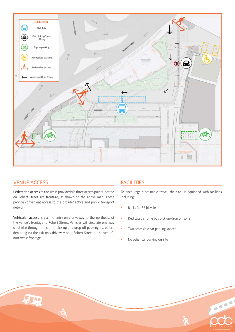
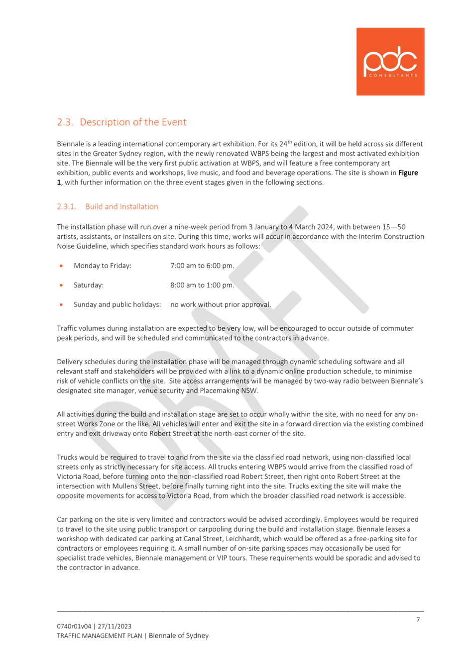
The site plan of WBPS is shown in Figure 1.
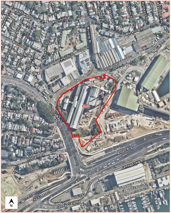
Figure 1: White Bay Power Station site plan
Based on previous events, the proposed Biennale of Sydney is expected to draw in attendees in the order of 2,000-3,000 persons during a weekday, and up to 5,000 persons (excluding staff) over a course of a day, closing every Monday.
DISCUSSION
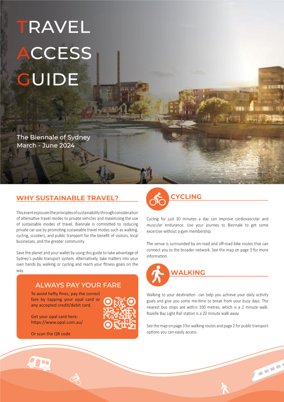
This event intends to promote the principles of sustainability through consideration of alternative travel modes to private vehicles and maximising the use of sustainable modes of travel. Biennale is committed to reducing private car use by promoting sustainable travel modes such as walking, cycling and public transport for the benefit of visitors, local businesses, and the greater community. As such the WBPS has no off-street parking facility at the event.
The event is considered as a Class 2 Event under the Guide to Traffic and Transport Management for Special Events from Transport for NSW.
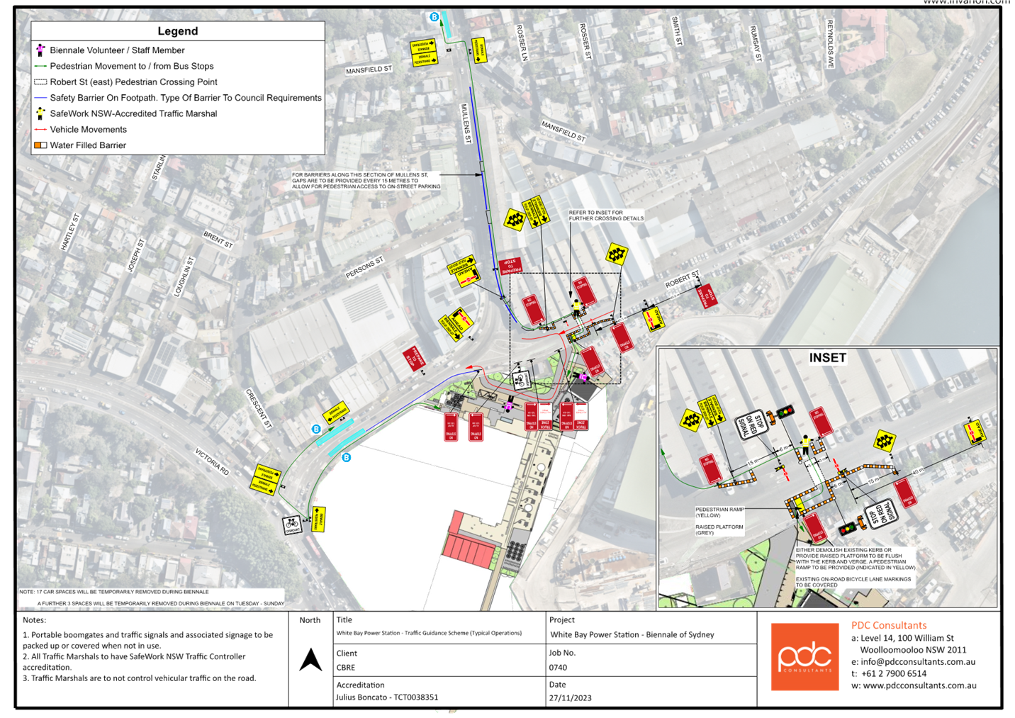
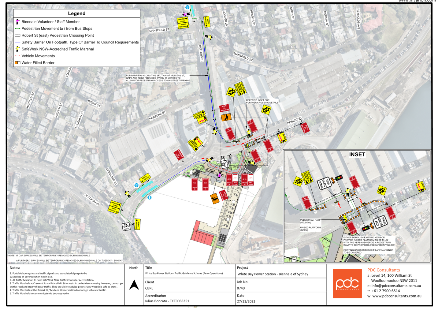
The proposed TMP includes two Traffic Guidance Schemes (TGS) with one proposed for typical operations (weekday), and another proposed for peak operations (weekend). Both TGS comprise of a pick-up and drop-off zone for private vehicles, taxis, shuttle bus service, pedestrian access from the Light Rail network, public Bus Stops, access to cycling network including bicycle parking. The peak operations TGS is identical to the typical operations TGS but includes additional traffic controllers as indicated in the plan.
Proposed Traffic Management
Two TGS plans have been prepared and included in Attachments 1 and 2, which comprise of the following features:
· A temporary portable Signalised pedestrian crossing incorporated with portable boom gates on Robert Street east of Mullens Street to cater for safe pedestrian movements across Robert Street.
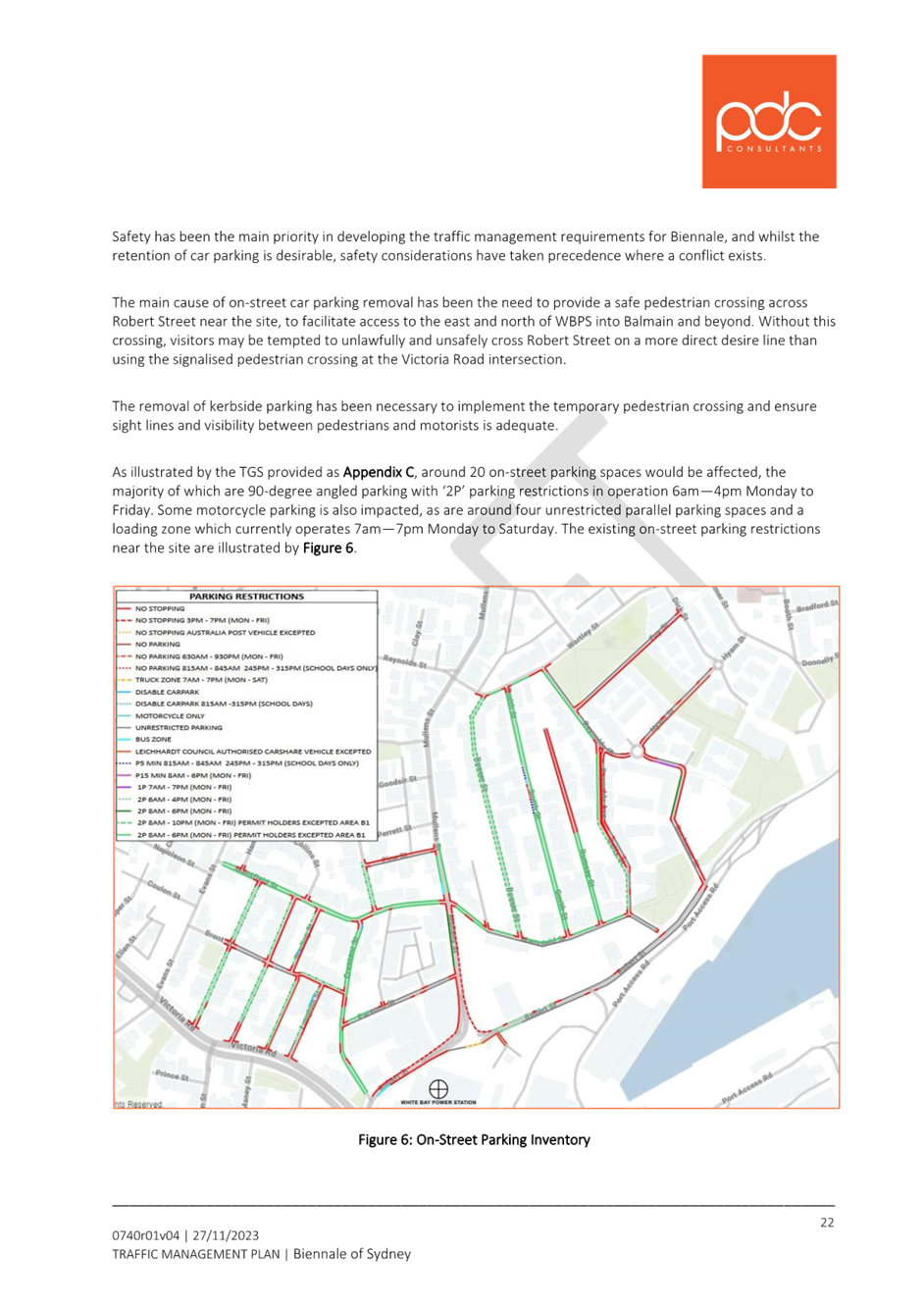
· Temporary ‘No Stopping’ zones will be established on Robert Street on both approach and departure sides to the temporary signalized pedestrian crossing.
· Water Filled Barriers will be installed on Robert Street to compliment the ‘No Stopping’ zone adjacent to the pedestrian crossing.
· An accredited Traffic Controller will be positioned at the crossing to assist pedestrians.
· Wayfinding signs will be installed on Robert Street, Mullens Street to direct pedestrians to safe crossing points and footpaths leading to the WBPS from Bus Stops in Mullens Street and Robert Street.
· Temporary ‘No Stopping’ signs will be installed on Robert Street between the entrance and exit of the pick-up/drop-off zone to improve driver visibility when exiting the WBPS on Robert Street.
· Volunteer and staff will be positioned within the pick-up and drop-off zone to encourage efficient operation.
· New driveway layback near the intersection of Robert Street and Mullens Street intersection to support one-way internal movement within the WBPS forecourt.
· ‘Bicycle Dismount’ signs will be installed on south side of Robert Street between Victoria Road and Mullens Street to minimize conflicts between pedestrians and bicycle riders in the footpath narrowed by barriers.
· In addition to the above, the peak operations TGS will feature additional traffic controllers and staff as indicated in the plan.
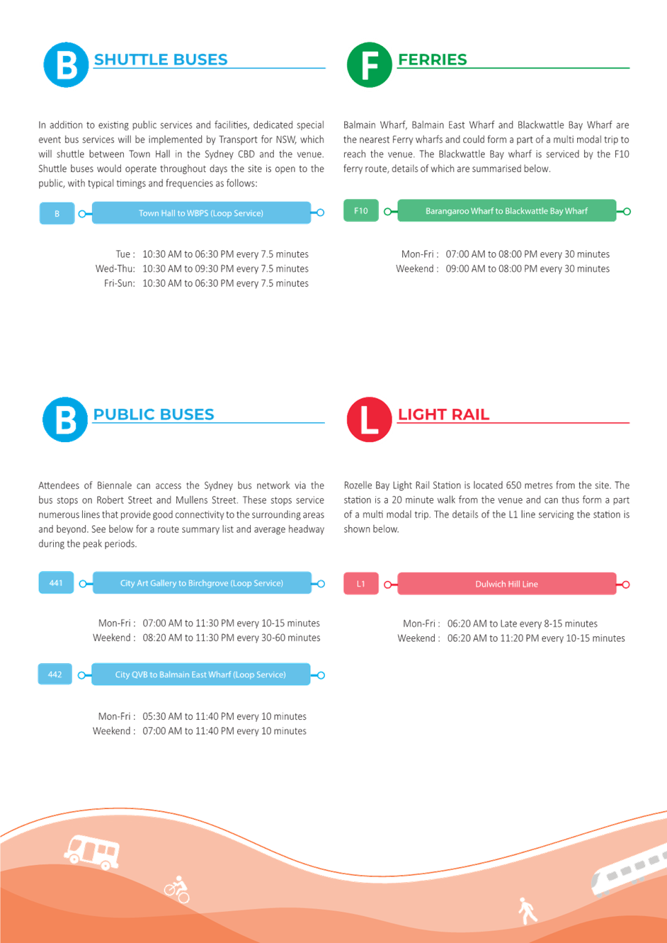
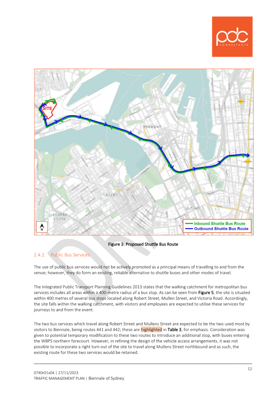
Shuttle Bus Services
A dedicated Special Event Bus Service will be implemented by Transport for NSW, which will shuttle between Town Hall Station and the WBPS site during the event. The proposed shuttle bus route is illustrated in Figure 2 and does not incorporate additional stops between the two locations.
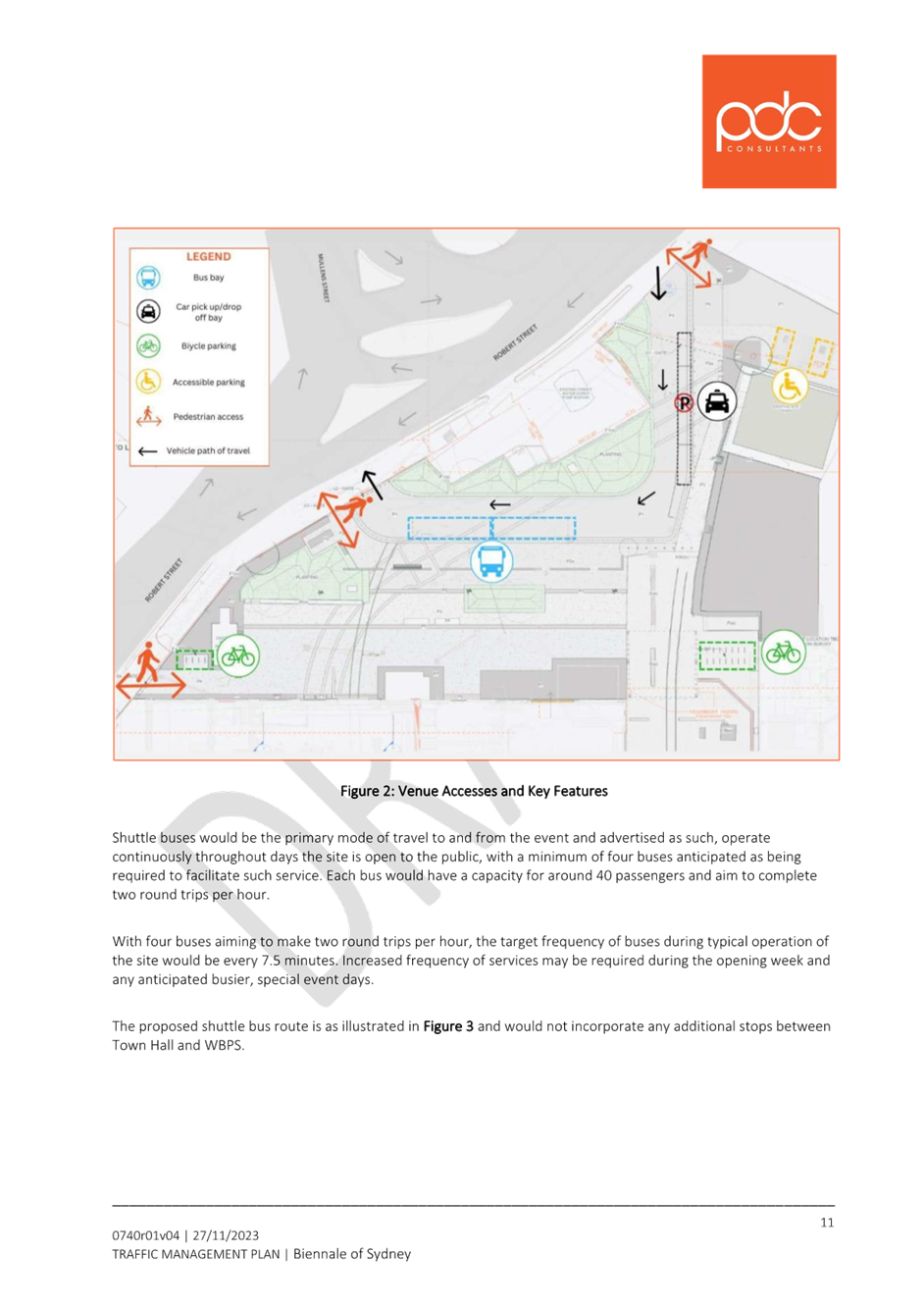
Bus pick-up and drop-offs would be facilitated by designated bus layover facilities provided in the northern forecourt of WBPS, with buses entering and exiting the site in the same manner as private vehicles. The northern forecourt access arrangements are illustrated by Figure 3.

Figure 2: Proposed shuttle bus route
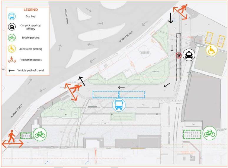
Figure 3: Venue accesses and key features
Pedestrian Access
As shown in Figure 3, three pedestrian access points are provided, with two of these will be adjacent to the two vehicular accesses, one on the east side of the entry driveway and the other on the west side of the exit driveway. The third is provided further west along Robert Street, at the site’s western extent. It is expected that the eastern access point will be the most used pedestrian accesses, with the central pedestrian access point near the vehicular entry expected to be lower.
All pedestrian access points will be open to the public during the event opening hours and work together with the combined entry and exit movements. These pedestrian access points provide direct connection to the WBPS and do not require crossing the internal vehicular circulation road at any time.
A Transport Access Guide (TAG) has been prepared for this event, outlining access points from public and active transport, including locations of bicycle and accessible parking.
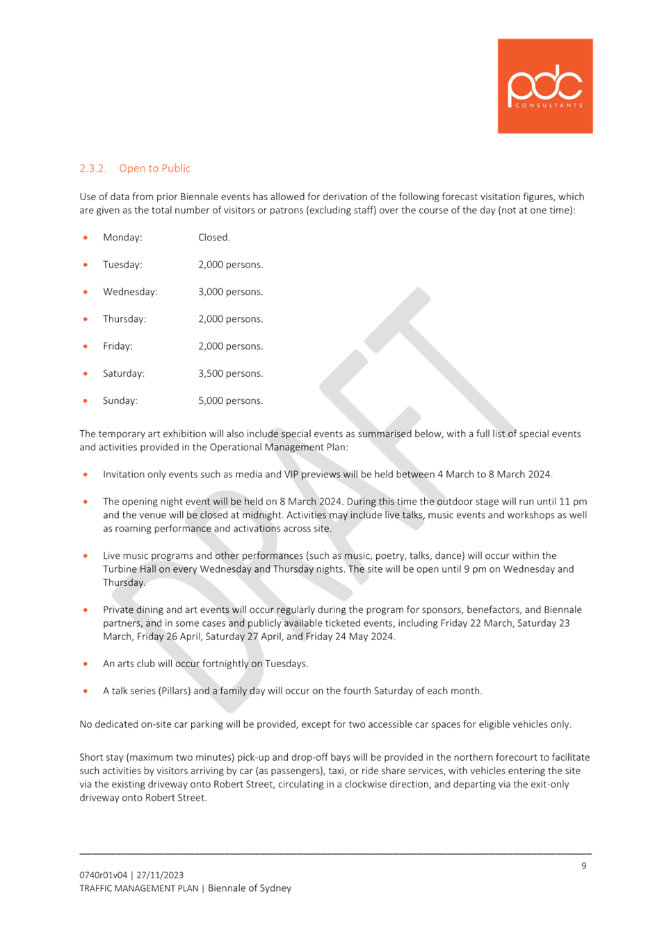
Event Parking for Private Vehicles
The event provides no onsite parking. Two (2) Mobility Parking Spaces will be provided, in addition to an off-street bicycle parking area. These are shown in Figure 2.
Public Transport Services
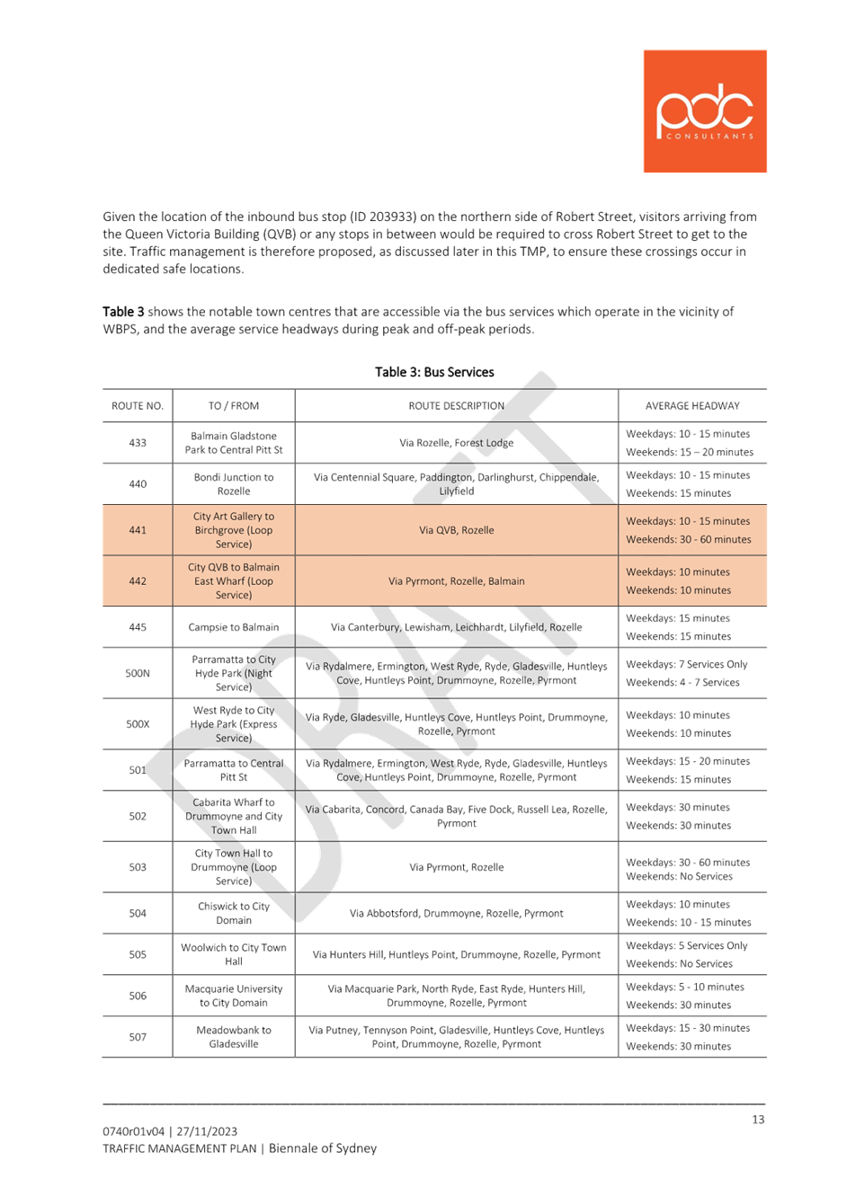
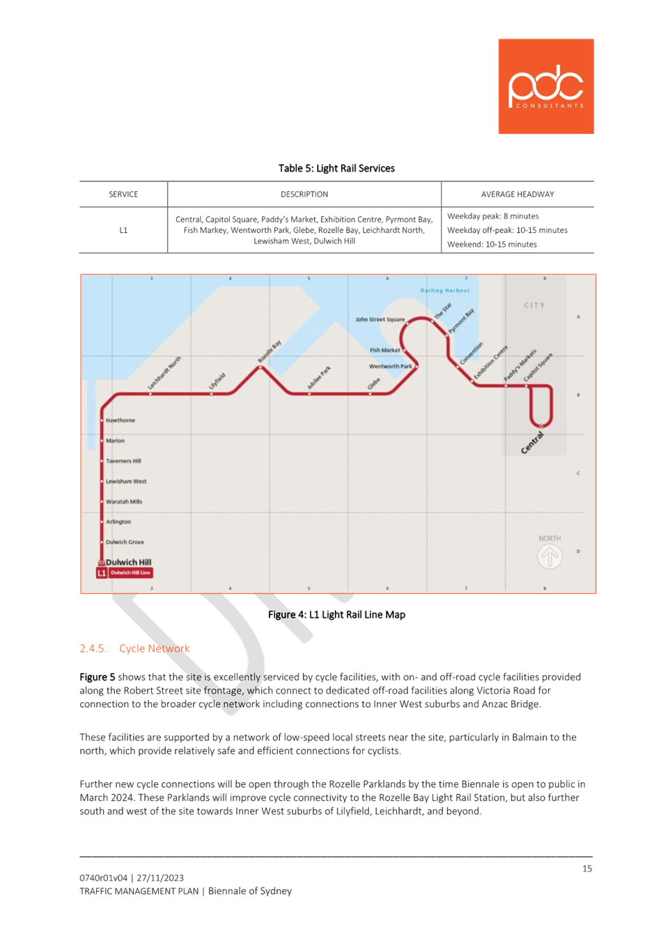
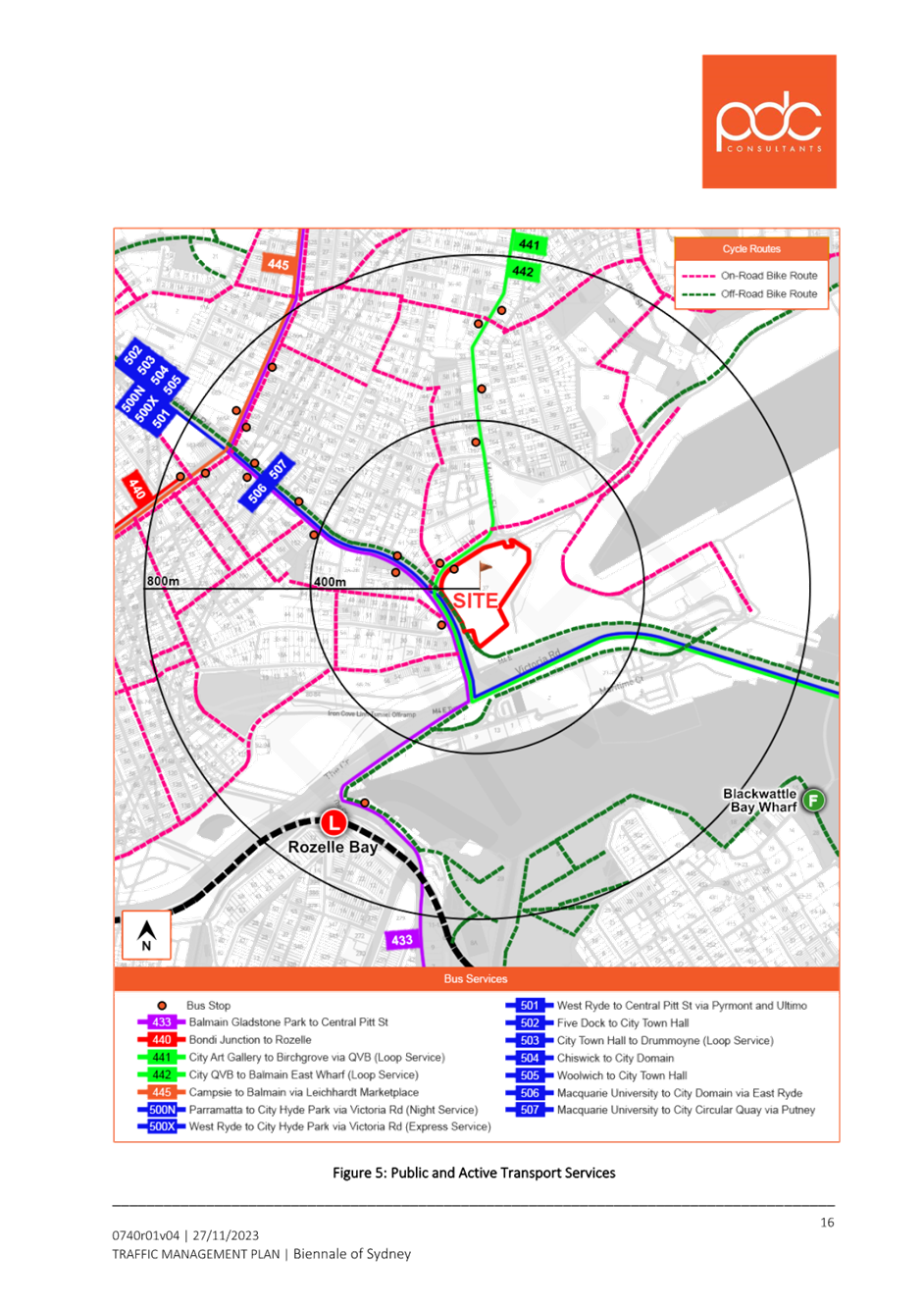
The use of Public Bus services would not be actively promoted as a principal means of travelling to and from the venue; however, they do form an existing, reliable alternative to shuttle buses and other modes of travel. The two bus services which travel along Robert Street and Mullens Street are expected to be the two used most by visitors to Biennale, being routes 441 and 442; these are highlighted in Table 1, for emphasis.
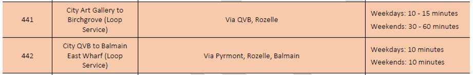
Table 1: Public bus services adjacent to the WBPS
Cycling Facilties
Figure 4 shows that the site includes on and off-road separated cycling facilities provided along the Robert Street site frontage, which connect to dedicated Shared User Path facilities along Victoria Road for connection to the broader cycle network including connections to Inner West suburbs and Anzac Bridge.
These facilities are supported by a network of low-speed on-road routes near the site, particularly in Balmain to the north, which provide relatively safe and efficient connections for cyclists. Additionally, new cycle connections will be open through the Rozelle Parklands which is expected to be open and in operation in March 2024 in time for the event. These Parklands will improve cycle connectivity to the Rozelle Bay Light Rail Station, but also further south and west of the site towards Inner West suburbs of Lilyfield, Leichhardt, and beyond.
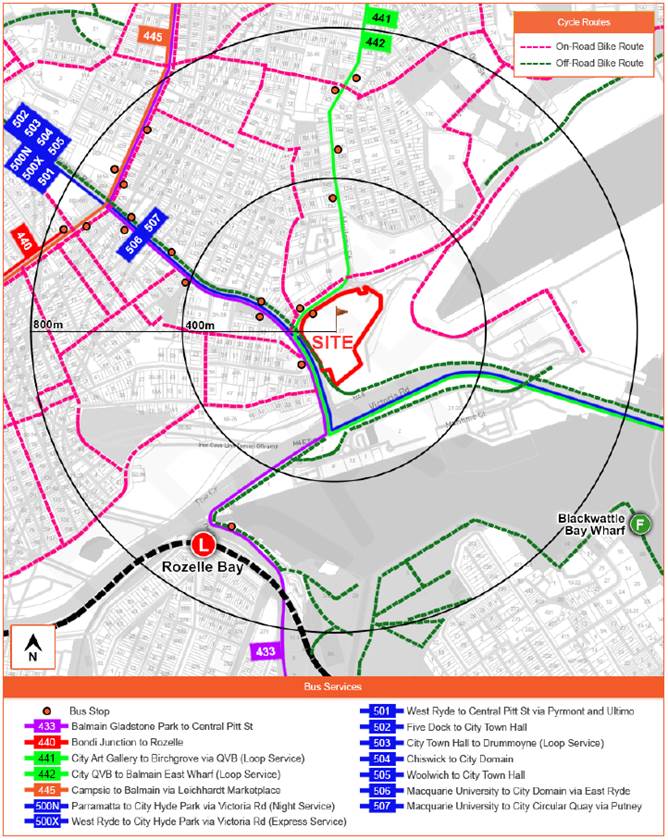
Figure 4: Public and active transport services
Bicycle Parking
As shown in Figure 3 a combined total of 36 bicycle spaces are available, including eight spaces close to the westernmost pedestrian access and 28 spaces to the southeast of the northern forecourt.
Vehicular Access
As shown in Figure 3, all vehicles, including the shuttle buses, private cars, taxis, and ride-shares, will enter the site via the upgraded access driveway onto Robert Street at the northeast of the site, before circulating through the northern forecourt of the site in a clockwise direction to depart at a separate exit-only driveway onto Robert Street at the northwest corner of the site. Private vehicles including cars, taxis, and ride shares would use one of four pick-up and drop-off bays provided along the eastern side of the internal circulation roadway through the northern forecourt of WBPS.
The TMP proposes a new driveway near the intersection of Robert Street and Mullens Street intersection, and this is currently being assessed by Council.
FINANCIAL IMPLICATIONS
There are no financial implications associated with the implementation of the proposed recommendations outlined in the report.
|
1.⇩ |
Traffic Guidance Scheme - Typical Operations |
|
2.⇩ |
Traffic Guidance Scheme - Peak Operations |
|
3.⇩ |
Transport Access Guide |
|
4.⇩ |
Traffic Management Plan |
|
Local Traffic Committee Meeting 11 December 2023 |
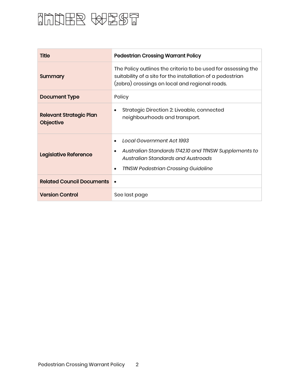
Subject: Pedestrian Crossing Warrant Policy
Prepared By: Jason Scoufis - Coordinator Traffic Studies and Road Safety
Authorised By: Manod Wickramasinghe - Traffic and Transport Planning Manager
|
RECOMMENDATION
That the Pedestrian Crossing Warrant Policy be supported and adopted. |
STRATEGIC OBJECTIVE
This report supports the following strategic directions contained within Council’s Community Strategic Plan:
|
2: Liveable, connected neighbourhoods and transport |
|
|
EXECUTIVE SUMMARY
This is a report recommending endorsement of the Pedestrian Crossing Warrant Policy.
Council has prepared a Pedestrian Crossing Warrant Policy as detailed in Attachment 1 to be used when assessing the suitability of locations on local and regional roads for pedestrian (zebra) crossings. This Policy sets out a warrant for the installation of a pedestrian (zebra) crossing on local and regional roads.
Council undertook public exhibition of the draft Pedestrian Crossing Warrant Policy. After considering the comments, a review of the draft policy was undertaken with adjustments made to finalise the Pedestrian Crossing Warrant Policy.
BACKGROUND
At the June 2022 Local Traffic Committee meeting, a report was considered regarding placing a draft Pedestrian Crossing Warrant Policy on public exhibition. The Traffic Committee provided the following recommendation which was subsequently endorsed by Council:
1. That the
Committee support the draft Pedestrian Crossing Warrant Policy in principle;
and
2. The draft Pedestrian Crossing Warrant Policy be put on public exhibition for a period of 28 days for comment with the results being bought back to the Committee for consideration.
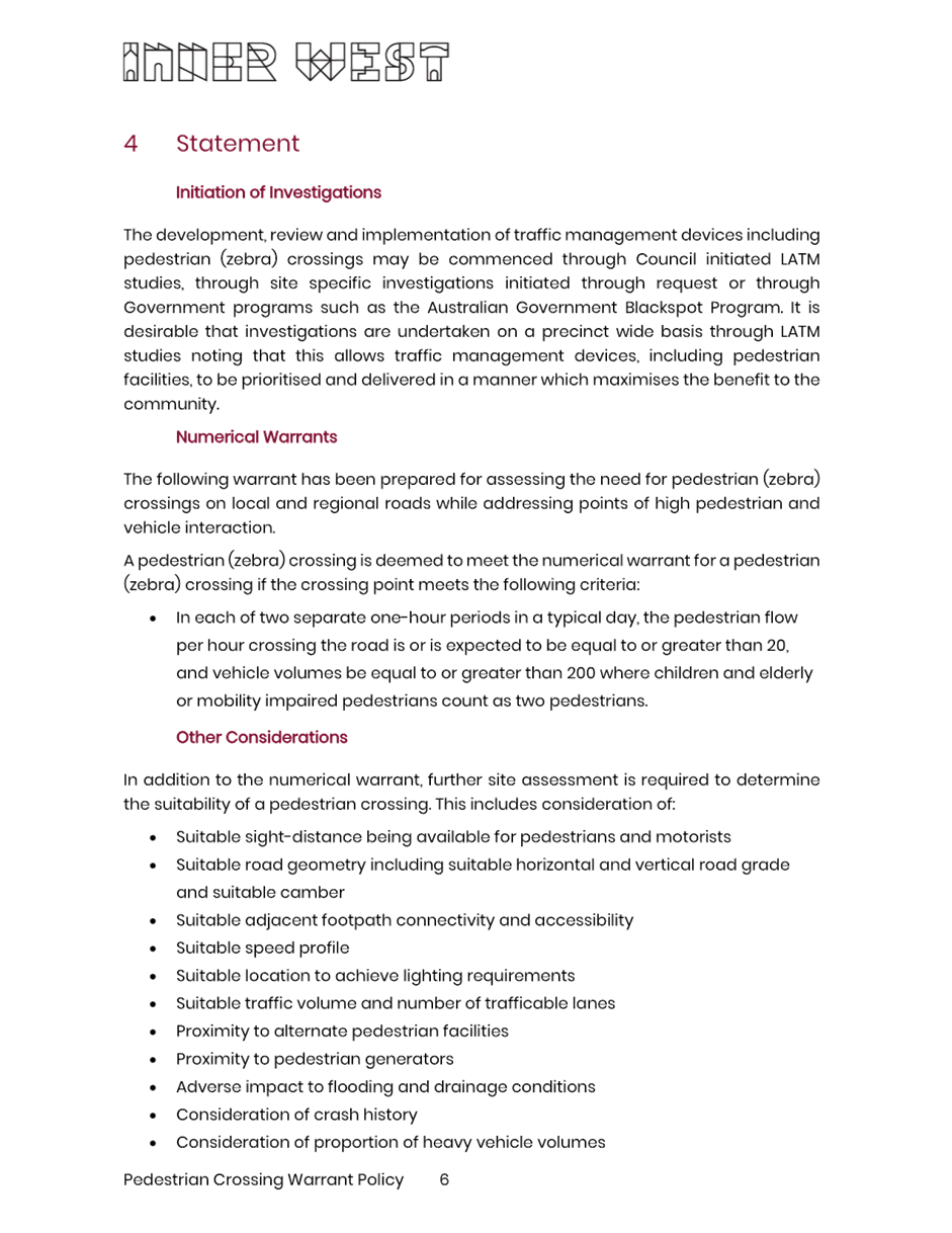
TfNSW Supplements to Australian Standards sets out the warrant for the installation of a pedestrian (zebra) crossings to be used on state roads which is not mandatory for use on local or regional roads. A warrant is the minimum criteria that must be met before such a device can be installed. The warrants for a pedestrian (zebra) crossing include the requirements for the number of pedestrians who cross the road at the crossing point and the number of vehicles that travel through the crossing point.
In the absence of a specific TfNSW warrant for roads that are not state roads (i.e., local and regional roads), the draft Policy set out a warrant for the installation of a pedestrian (zebra) crossing on local and regional roads.
The draft policy includes two types of warrants to be used in the assessment. A ‘Normal Warrant’ and a ‘Reduced Warrant’ with the ‘Reduced Warrant’ being applied at locations where the crossing point is predominantly used by children.
In addition to the numerical warrant, further site assessment is required to determine the suitability of a pedestrian (zebra) crossing include sight distance, road geometry, pedestrian connectivity, speed profile, lighting, and proximity to alternate pedestrian crossing facilities.
The draft numerical warrants that were placed on public exhibition are as follows:
· Normal Warrant
A pedestrian (zebra) crossing is deemed to meet the numerical warrant for a pedestrian (zebra) crossing if the crossing point meets the following volumes in three (3) separate one hour periods in a typical day:
a) Pedestrian volumes ≥ 30 AND
b) Vehicle volumes ≥ 200
· Reduced Warrant
A pedestrian (zebra) crossing is deemed to meet the numerical warrant for a pedestrian (zebra) crossing if the crossing point is predominately used by children and the crossing point meets the following volumes in two (2) counts of one hour duration immediately before and after school hours:
a) Pedestrian volumes ≥ 30 AND
b) Vehicle volumes ≥ 200
CONSULTATION AND UPDATED TfNSW GUIDELINES
After Council approved placing the draft Policy on public exhibition in August 2022, TfNSW released a ‘Pedestrian Crossing Guideline’ in September 2022 which was noted as an interim guide. TfNSW have recently advised that no further warrant documents are being released in the near future regarding the implementation of pedestrian crossings on non-state roads, hence Council has progressed finalising the Policy.
The 2022 Pedestrian Crossing Guideline suggests that Councils may use the following pedestrian demand calculation, noting that the combined threshold of pedestrian and vehicle volumes required to meet TfNSW warrants detailed in the Australian Standard AS1742.10-2009 may be difficult to achieve on local and regional roads:
· In each of two separate one-hour periods in a typical day, the pedestrian flow per hour (P) crossing the road is, or is expected to be, equal to or greater than 20
· Children and elderly or mobility impaired pedestrians count as two pedestrians.
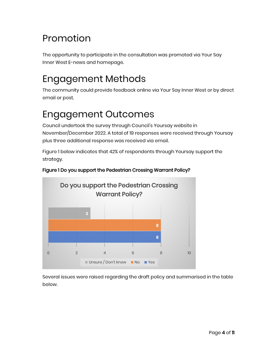
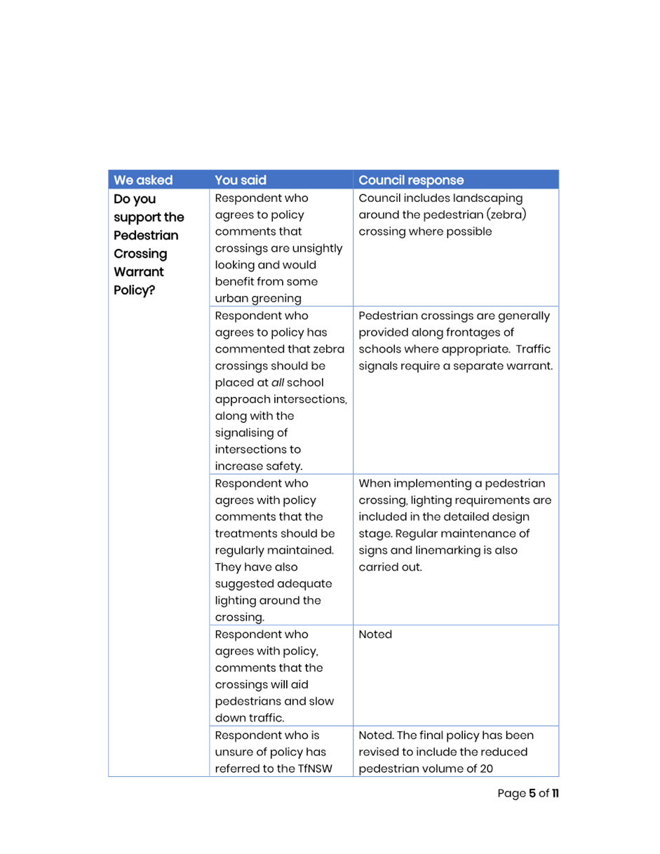
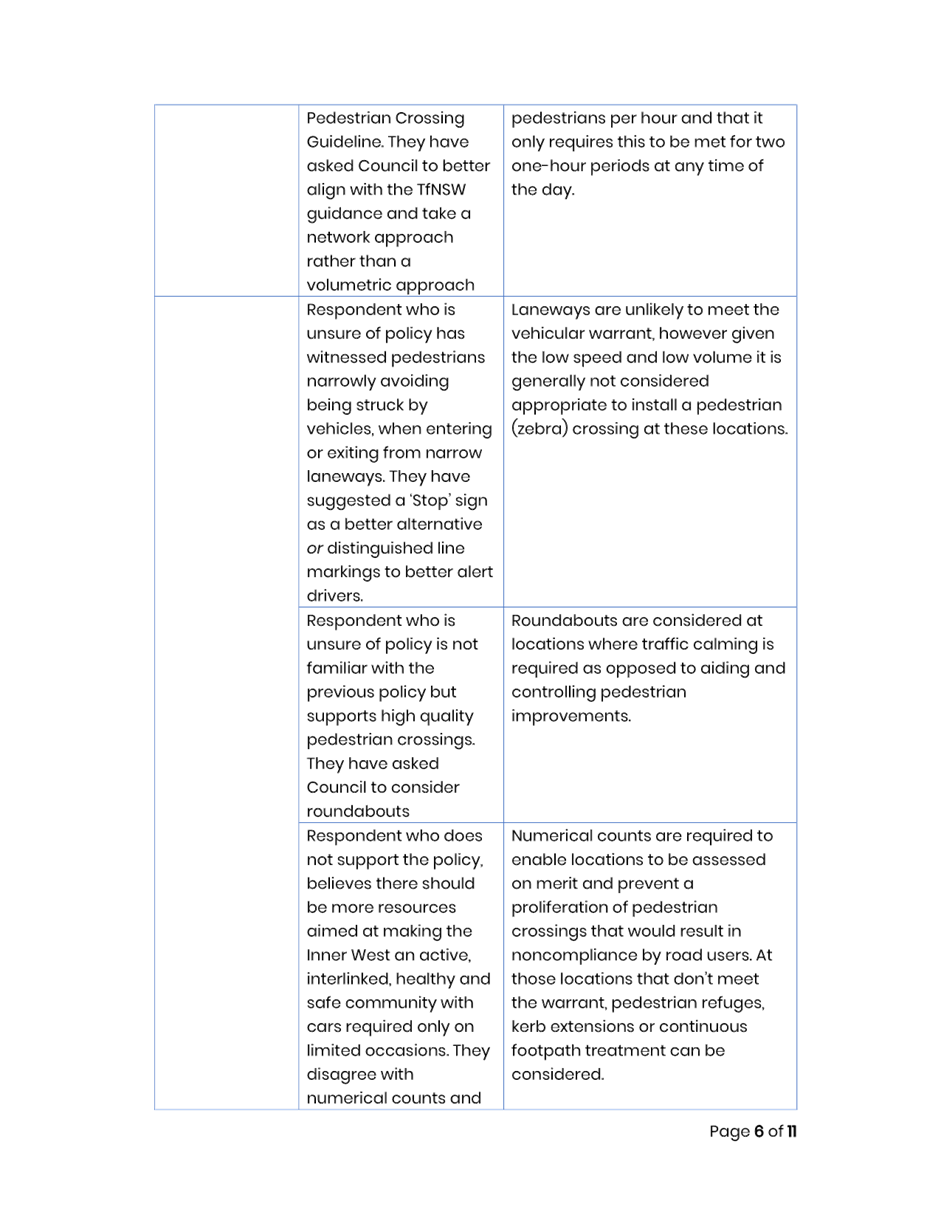
Additionally, Council undertook public exhibition of the draft policy in November/December 2022. A total of 19 responses were received through Your Say Inner West and three additional response was received via email. The following overall response was received:
· 42% support
· 42% do not support
· 16% unsure
The Community Engagement Outcomes Report is attached in Attachment 2.
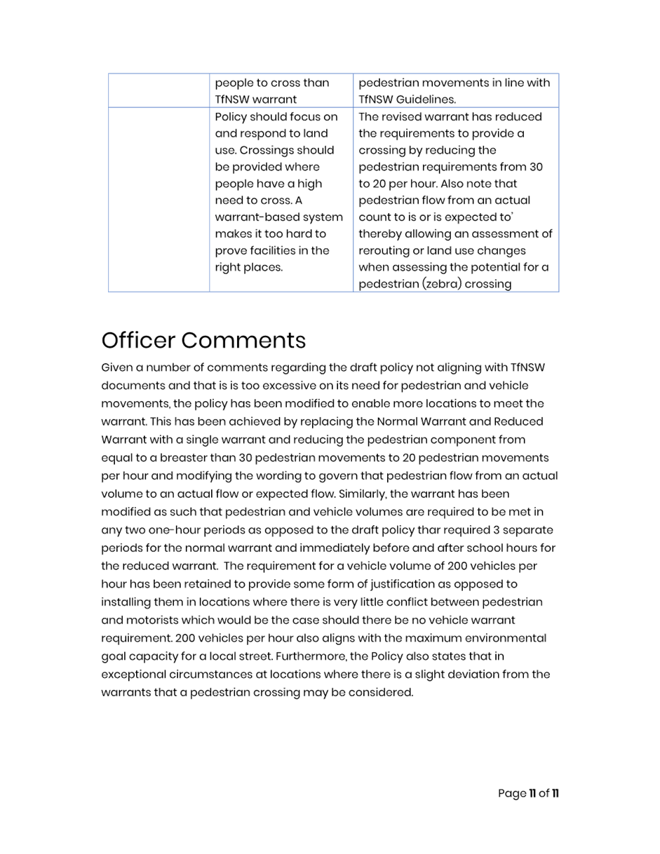
MODIFIED PROPOSAL
In response to the community consultation and release of the TfNSW guidelines it is recommended that the numerical warrant contained within the Policy be revised as follows, which is less onerous than the draft warrants:
· Revised warrant
o In each of two separate one-hour periods in a typical day, the pedestrian flow per hour crossing the road is or is expected to be equal to or greater than 20, and vehicle volumes be equal to or greater than 200 where children and elderly or mobility impaired pedestrians count as two pedestrians.
This revised warrant uses the pedestrian flow requirement as provided in the TfNSW document, however, requires a minimum vehicle volume to be met to permit the installation of a pedestrian crossing to address points of high pedestrian and vehicle interaction, thereby maximising the benefit to the community of a potential pedestrian (zebra) crossing. Implementing the requirement of 200 vehicles per hour aligns with the environmental goal capacity for a local street.
FINANCIAL IMPLICATIONS
There are no financial implications associated with the implementation of the proposed recommendations outlined in the report.
|
1.⇩ |
Attachment 1 - Pedestrian Crossing Warrant Policy |
|
2.⇩ |
Attachment 2 - Community Engagement Outcomes report |
|
Local Traffic Committee Meeting 11 December 2023 |
Subject: Riverside Crescent, Dulwich Hill - Proposed Traffic Calming and Pedestrian Devices (Djarrawunang-Ashfield Ward/Summer Hill Electorate/ Inner West PAC)
Prepared By: Zara Helal - Traffic Engineer
Authorised By: Manod Wickramasinghe - Traffic and Transport Planning Manager
|
RECOMMENDATION
That the following concept designs be approved and listed for consideration in Council’s Traffic Facilities Program:
a) Proposed traffic calming in the form of kerb extensions at the Tennyson Street/Riverside Crescent intersection as per Attachment 1. b) Proposed traffic calming in the form of kerb extensions at the Riverside Crescent/Balfour Street intersection as per Attachment 2. c) Proposed upgraded pedestrian refuge in Riverside Crescent at Ewart Street as per Attachment 3. |
STRATEGIC OBJECTIVE
This report supports the following strategic directions contained within Council’s Community Strategic Plan:
|
2: Liveable, connected neighbourhoods and transport |
|
|
EXECUTIVE SUMMARY
The concept designs as per Attachments 1, 2 and 3 have been developed as recommended in part at the Local Traffic Committee meeting held on 21 November 2022 and subsequently resolved at the Council meeting held on 6 December 2022. The proposed traffic calming and pedestrian devices aim to improve pedestrian accessibility at Riverside Crescent, Dulwich Hill, at its intersections with Tennyson Street, Balfour Street and Ewart Street, and also provide a traffic calming function.
BACKGROUND
It was recommended in part at the Local Traffic Committee meeting held on 21 November 2022 and subsequently resolved at the Council meeting held on 6 December 2022, that the following items be actioned:
- A concept design for traffic calming in the form of kerb extensions at the Tennyson Street/Riverside Crescent and Riverside Crescent/Balfour Street intersections be prepared for consideration by Traffic Committee.
- A concept design for an upgraded pedestrian refuge in Riverside Crescent at Ewart Street be prepared for consideration by Traffic Committee.
DISCUSSION
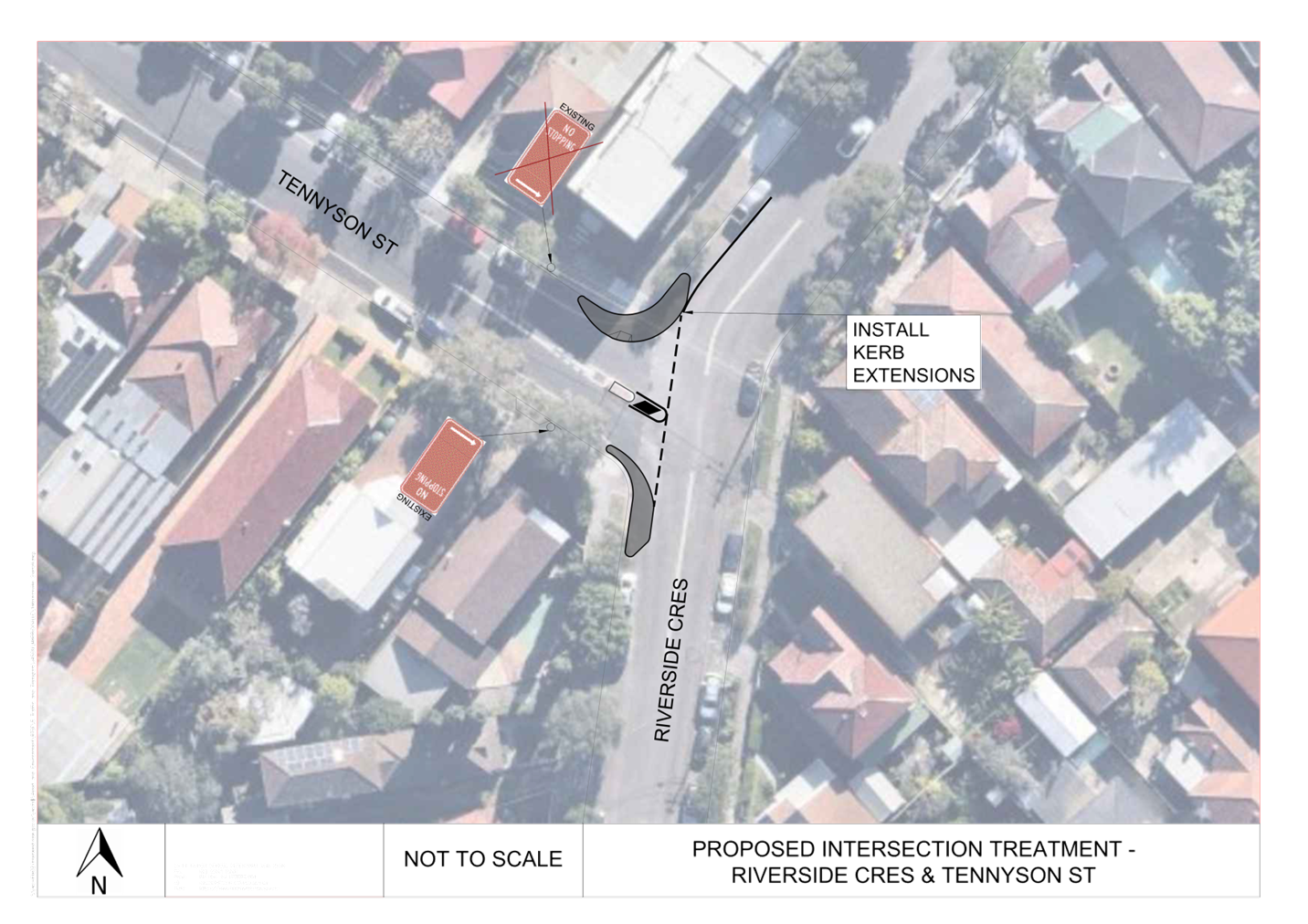
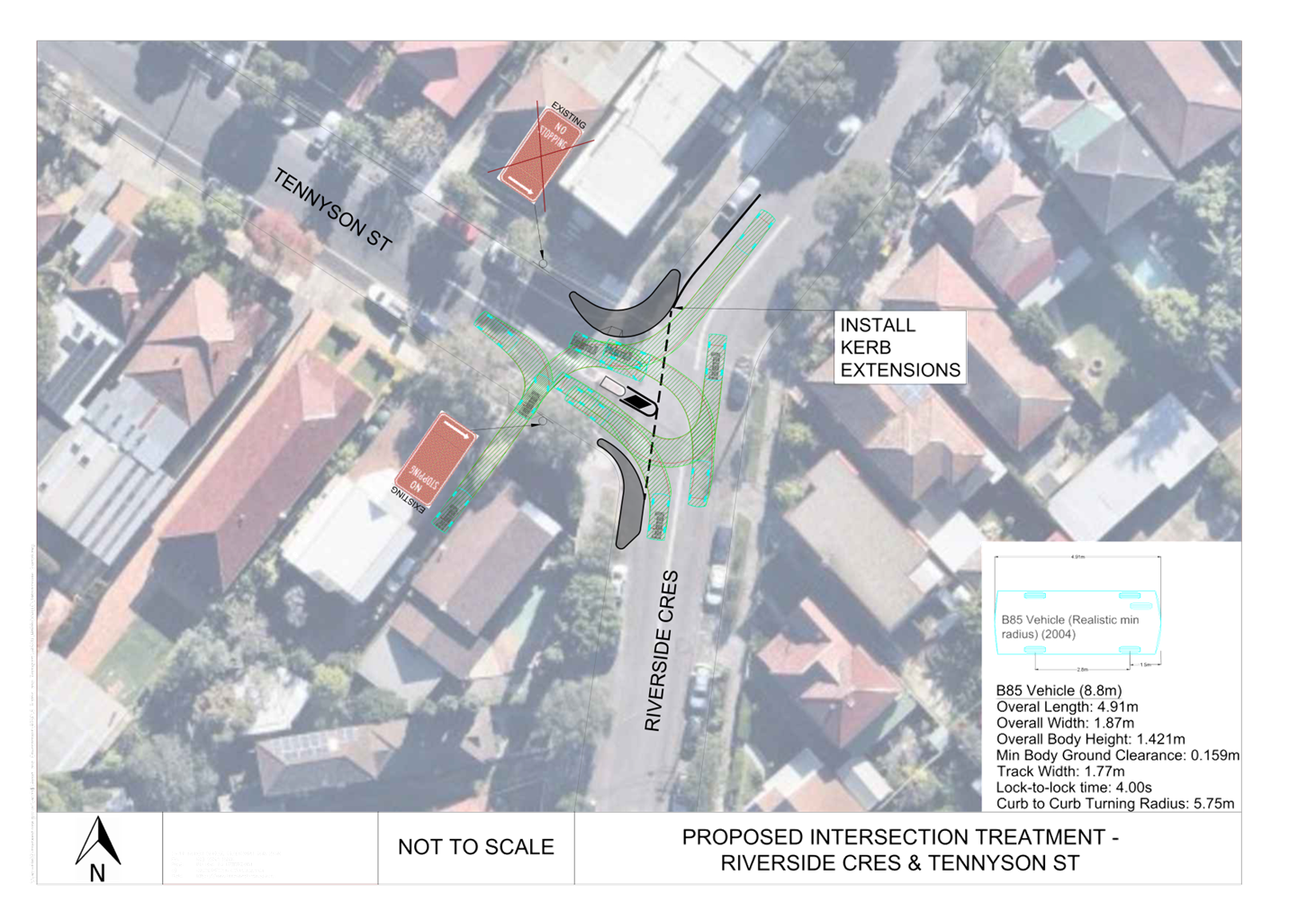
Kerb extensions are proposed at Tennyson Street/Riverside Crescent intersection as per concept design in Attachment 1. The proposal sees the gain of approximately 2m of parking on the northern side of Tennyson Street and 2.5m on the western side of Riverside Crescent, north of Tennyson Street.
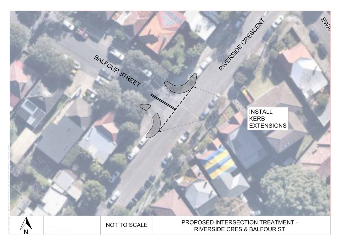
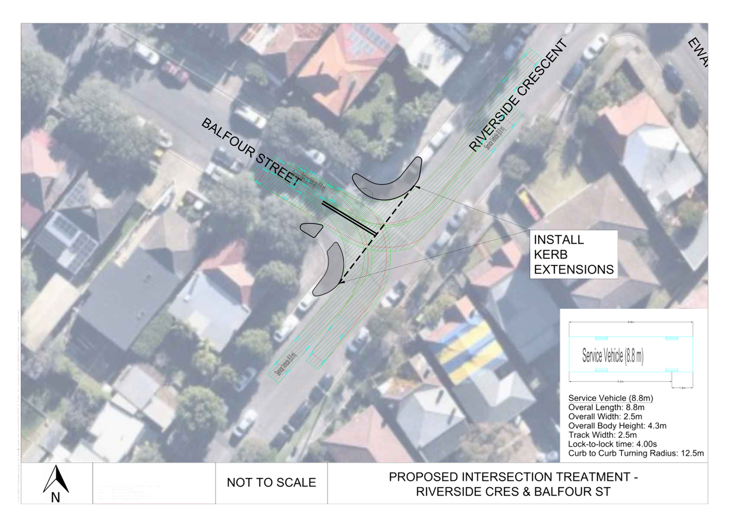
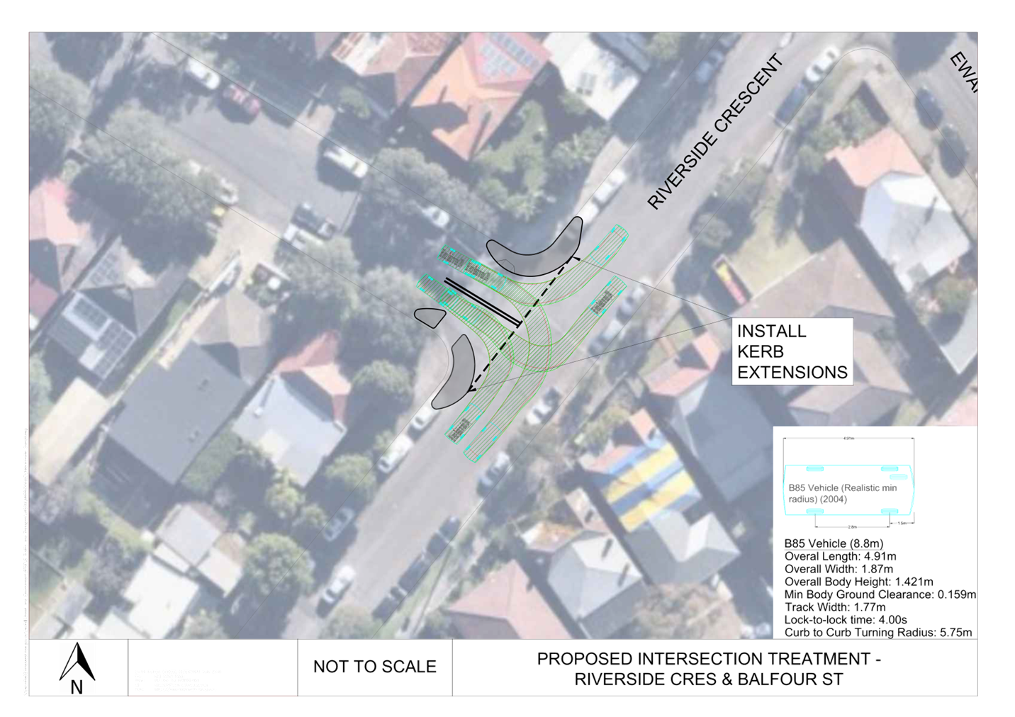
Kerb extensions are also proposed at Riverside Crescent/Balfour Street intersection as per concept design in Attachment 2. The proposal sees the gain of approximately 2.5m of parking on the northern and southern sides of Balfour Street, and on both sides of Riverside Crescent.
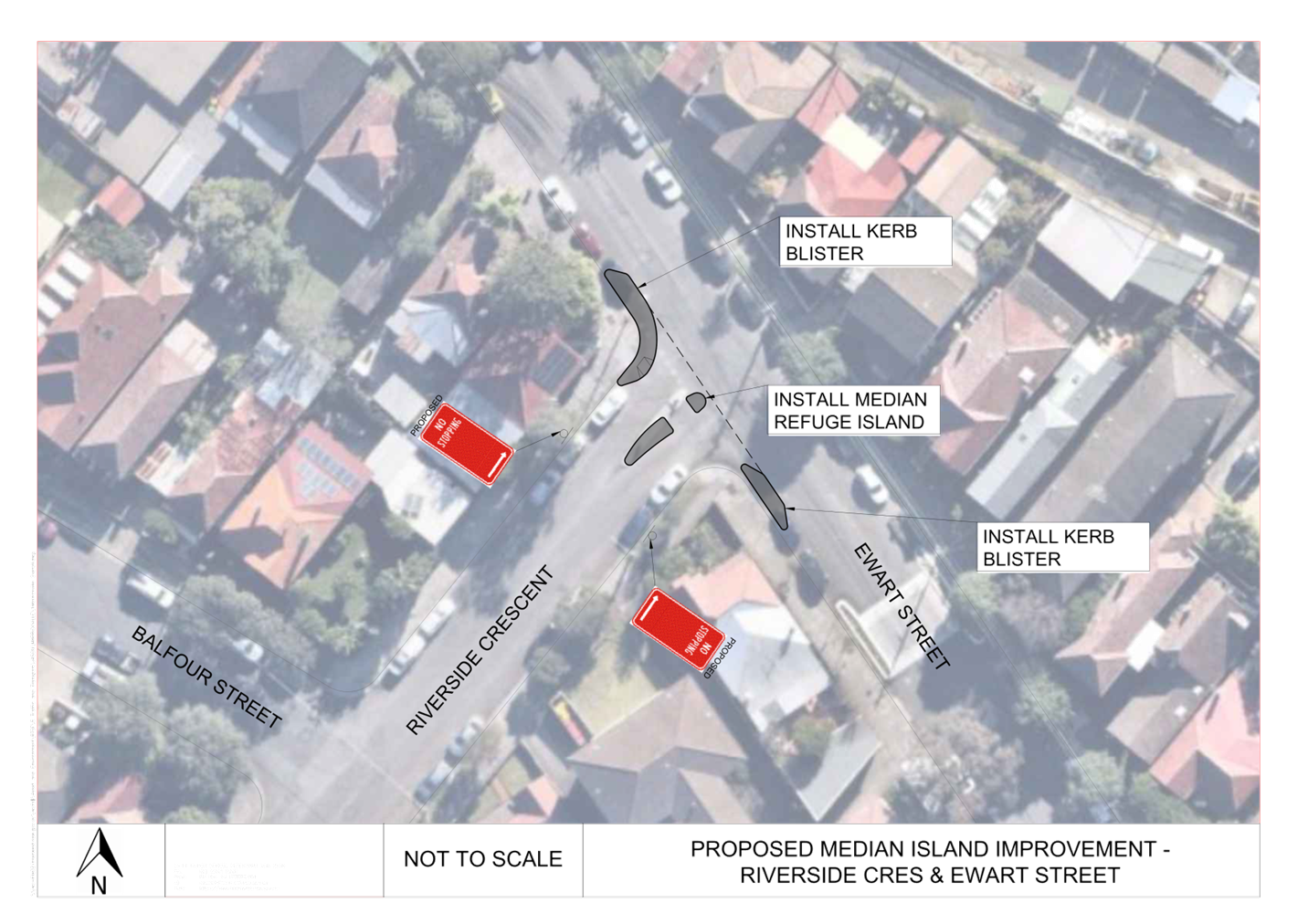
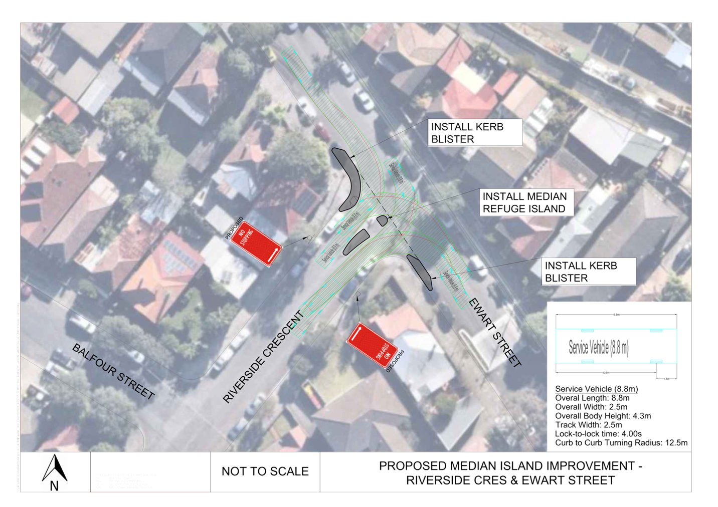
Additionally, an upgraded pedestrian refuge is proposed at Riverside Crescent at its intersection with Ewart Street as per concept design Attachment 3. The proposal sees the loss of approximately 2.5m of parking on the eastern and western sides of Riverside Crescent.
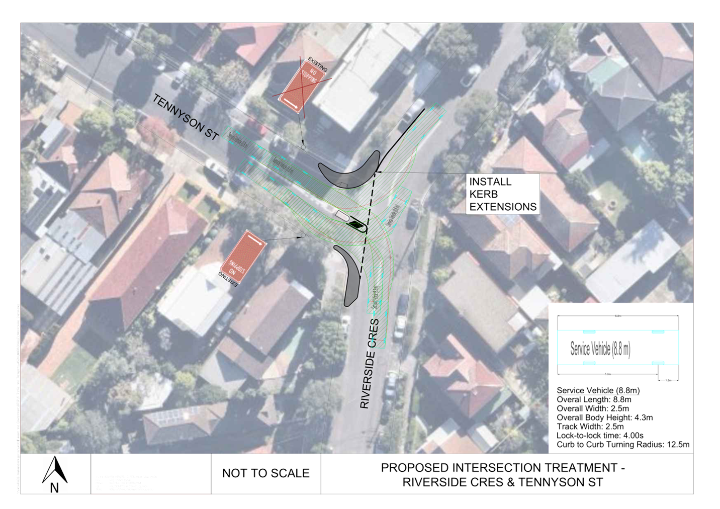
Swept path analysis has been undertaken for these concept designs as detailed in Attachment 4.
Consultation has not been undertaken at this stage given the limited impact on parking and is expected to be undertaken during the detailed design phase.
FINANCIAL IMPLICATIONS
The costs to implement the recommendations will be considered in Council’s Traffic Facilities Budget.
|
1.⇩ |
Kerb Extensions Concept Design - Riverside Crescent and Tennyson Street, Dulwich Hill |
|
2.⇩ |
Kerb Extensions Concept Design - Riverside Crescent & Balfour Street, Dulwich Hill |
|
3.⇩ |
Median Island & Kerb Extensions Concept Design - Riverside Crescent and Ewart Street, Dulwich Hill |
|
4.⇩ |
Swept Paths - Riverside Crescent, Dulwich Hill |
|
Local Traffic Committee Meeting 11 December 2023 |
Subject: Lands Lane, Newtown - Proposed extension to road closure (Damun-Newtown Ward/Newtown Electorate/Inner West)
Prepared By: James Nguyen - Traffic Engineer
Authorised By: Manod Wickramasinghe - Traffic and Transport Planning Manager
|
RECOMMENDATION
That the proposed 1.5m extension to the road closure at the dead-end of Lands Lane, Newtown be approved. |
STRATEGIC OBJECTIVE
This report supports the following strategic directions contained within Council’s Community Strategic Plan:
|
2: Liveable, connected neighbourhoods and transport |
|
|
EXECUTIVE SUMMARY
Lands Lane, Newtown is a narrow laneway that connects to Oxford Street at a dead-end. The footpaths on either side of the laneway are narrow, and subsequently, people are walking along the road to and from Oxford Street. A pram ramp is proposed at this dead-end to improve pedestrian accessibility to the footpath on Oxford Street which will require a 1.5m extension to the physical road closure.
BACKGROUND
Council Officers have identified an opportunity to improve pedestrian accessibility at the dead-end of Lands Lane, Newtown.
DISCUSSION
Lands Lane, Newtown is approximately 3 metres wide with narrow footpaths on both sides that are approximately 0.4 metres wide. Pedestrians are subsequently required to walk along the road of the laneway. Currently, there is no existing pram ramp installed at the dead-end of Lands Lane to connect pedestrians from the roadway of Lands Lane to the footpath on the eastern side of Oxford Street. A pram ramp would improve this connectivity. To facilitate a pram ramp, it is required to extend the footpath 1.5 metres to provide the appropriate pram ramp length and transition into the existing footpath.
PUBLIC CONSULTATION
Council Officers will carry out public consultation with the community about this proposal following approvals.
FINANCIAL IMPLICATIONS
The proposal is budgeted for in the 2023/23 capital works program.
|
1.⇩ |
Concept plan |
|
|
Local Traffic Committee Meeting 11 December 2023 |
Subject: Arthur Street, Marrickville - Proposed continuous footpath treatment (Midjubiri-Marrickville Ward/Newtown Electorate/Inner West PAC)
Prepared By: James Nguyen - Traffic Engineer
Authorised By: Manod Wickramasinghe - Traffic and Transport Planning Manager
|
That the following be approved in principle and subject to the detailed design:
a) installation of a raised continuous footpath treatment across Arthur Street at Illawarra Road; b) widening of the kerb extension on the southern side of Arthur Street from 2 metres to 5 metres; c) reduction of the kerb extension width on the northern side of Arthur Street from 5 metres to 2 metres; d) conversion of the 90-degree angle parking on the northern side of Arthur Street, between Illawarra Road and Ann Street to parallel parking; and e) conversion of the parallel parking on the southern side of Arthur Street, between Illawarra Road and Ann Street to 90-degree rear to kerb angle parking. |
STRATEGIC OBJECTIVE
This report supports the following strategic directions contained within Council’s Community Strategic Plan:
|
2: Liveable, connected neighbourhoods and transport |
|
|
EXECUTIVE SUMMARY
Council’s Pedestrian Access and Mobility Plan (PAMP) identified a ‘high’ priority opportunity to install a raised continuous footpath treatment across Arthur Street, Marrickville, at the intersection of Illawarra Road. The intersection of Arthur Street, at Illawarra Road is located along a key pedestrian link connecting pedestrians to the Marrickville Train Station and Marrickville Town Centre.
Council has subsequently completed a concept plan to improve pedestrian safety and connectivity. This proposal consists of installing a continuous footpath treatment, kerb extensions and adjusting the existing parking spaces on Arthur Street. Accordingly, it is recommended that the concept design plan for the proposed changes be approved in principle and that the proposal progress to a detailed design phase.
BACKGROUND
Council has received requests by the community for asking that consideration be given to improving pedestrian safety at the intersection of Arthur Street and Illawarra Road, Marrickville. Currently, there are two kerb extensions on Arthur Street, at this intersection which provides improved visibility and protection of pedestrians when crossing Arthur Street. Currently, the kerb extensions is wider on the northern side (5 metres) compared to the southern side (2 metres). This design provides more visibility for pedestrians crossing Arthur Street from the north, and safety concerns have been raised for pedestrians crossing Arthur Street from the south as visibility of pedestrians is restricted for motorists turning left from Illawarra Road due to the parapet wall of the Illawarra Road rail bridge.
The Inner West Council’s PAMP has identified this intersection to be of ‘high’ priority for pedestrian safety improvements and recommends the installation of a raised continuous footpath treatment.
Council Engineer’s have subsequently investigated this further to address the concerns raised and implement the recommendation from the PAMP.
DISCUSSION
Arthur Street is a one-way road in the westbound direction. The right turn movement from Illawarra Road into Arthur Street is permanently restricted with a ‘No Right Turn’ restriction. Subsequently, the only permissible movement is a left turn from Illawarra Road to Arthur Street.
Currently, there are two kerb extensions at the intersection of Illawarra Road to reduce the crossing distance for pedestrians, improve sight lines and provide protection. The kerb extension on the northern side is wider at 5 metres compared to the southern side which is 2 metres. This provides improved visibility for pedestrians when crossing Arthur Street from the north.
There is a high wall on the southern side of Arthur Street at Illawarra Road restricts pedestrian sight lines for motorists turning left from Illawarra Road. Given, that motorists can only turn left into Arthur Street from Illawarra Road, the sight line of pedestrians crossing from the south is more restricted compared to those crossing from the north.
Therefore, the existing kerb extensions need to be inverted, with the wider kerb extension located on the southern side of Arthur Street to address the current restricted sight lines from the high wall.
This change will also require inverting the parking layout on Arthur Street, where currently there is 90-degree angle parking on the northern side and parallel parking on the southern side.
Traffic counts completed on Arthur Street in 2013 recorded an average annual daily traffic (AADT) volume of 360 vehicles per day in the westbound direction. Assuming a compounded growth of 2 per cent per annum, it is estimated that the current AADT is 440 vehicles per day, with a peak hour volume of approximately 44 vehicles per hour. This is at/within the Transport for NSW warrants of 45 vehicles per hour for a continuous footpath treatment.
Accordingly, it is therefore proposed to install a raised continuous footpath treatment, re-design the kerb extensions, to improve pedestrian safety and reduce vehicle speeds on Arthur Street.
PUBLIC CONSULTATION
Council will carry out community engagement with residents and businesses during the detailed design stage of the process.
FINANCIAL IMPLICATIONS
The proposal will be delivered in a future PAMP construction program with a cost estimate to be prepared.
|
1.⇩ |
Concept plan |
|
|
Local Traffic Committee Meeting 11 December 2023 |
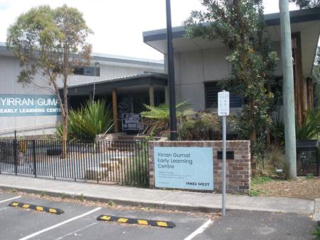
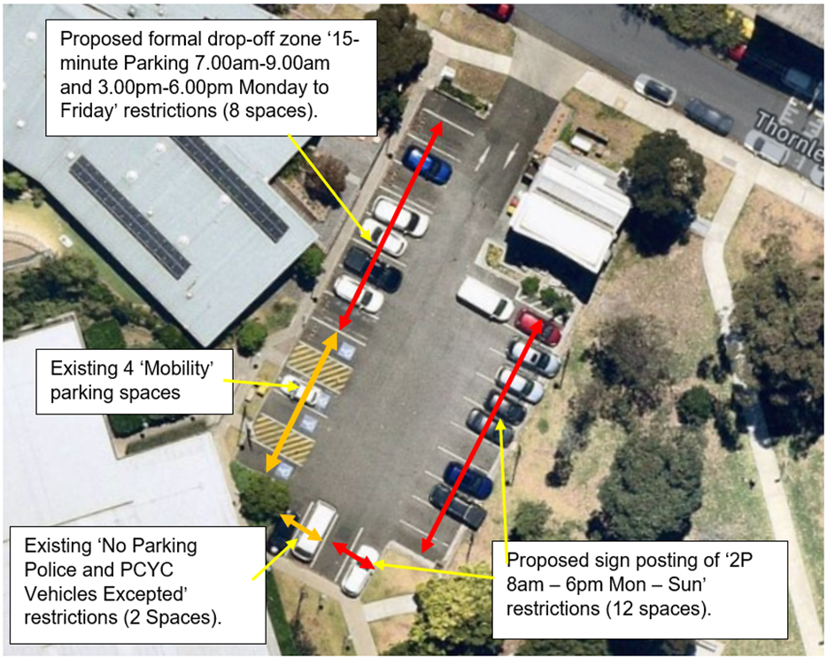
Subject: Thornley Street carpark, Marrickville - Formalise 'P15 7.00am-9.00am and 3.00pm-6.00pm Monday to Friday' restrictions outside Yirran Gumal Early Learning Centre along with other parking restrictions within the carpark (MIDJUBURI - MARRICKVILLE WARD/ SUMMER HILL ELECTORATE / INNER WEST PAC)
Prepared By: Jennifer Adams - Traffic Engineer
Authorised By: Manod Wickramasinghe - Traffic and Transport Planning Manager
|
RECOMMENDATION
1. That the existing signage ‘Drop off / Pick up Childcare Centre Parking Only 7am – 9am 3pm – 6pm Mon – Fri Except Public Holidays’ signage on the western side of Thornley Street carpark adjacent to Yirran Gumal Early Learning Centre, Marrickville be amended to ‘15-minute Parking 7.00am-9.00am and 3.00pm-6.00pm Monday to Friday’ restrictions (eight car parking spaces), to assist parents/carers with the drop-off and pick-up of children and address development conditions.
2. That the ten parking spaces on the eastern side of the car park and two spaces at the south-eastern side be sign posted with ‘2P 8am – 6pm Mon – Sun’ restrictions be approved, to provide short stay parking for the public.
3. That Council’s Parking Rangers be informed of the decision. |
STRATEGIC OBJECTIVE
This report supports the following strategic directions contained within Council’s Community Strategic Plan:
|
2: Liveable, connected neighbourhoods and transport |
|
|
EXECUTIVE SUMMARY
Parents and carers have noticed an increase in the number of people using the Council car park adjacent Yirran Gumal Early Learning Centre and are experiencing difficulties picking-up and dropping- off their children. In order to alleviate this, it is proposed to formalise the current drop-off zone in Thornley Street carpark, Marrickville.
BACKGROUND
Council has three carparks within Steel Park:
1. Debbie and Abbey Borgia Recreation Centre carpark accessed off Illawarra Road, Marrickville. It has approximately 85 spaces (4 mobility) with no parking restrictions.
2. Debbie and Abbey Borgia Recreation Centre carpark accessed off Thornley Street, Marrickville. It has 27 spaces (4 mobility) with ‘2P 8am-6pm Mon – Sun’ restrictions.
3. Steel Park carpark accessed off Illawarra Road, Marrickville. It has 25 spaces (2 Mobility) with ‘4P 6am-9pm, Free Parking Area closed 9pm-6am’ restrictions.
The current car park adjacent to Yirran Gumal Early Learning Centre has 26 parking spaces, four of which are mobility spaces and is governed overall by a ‘Parking Area 2P 8am – 6pm Mon-Sun’ restriction installed at the entrance to the carpark. Two car parking spaces, at the south-west corner are designated ‘No Parking Police and PCYC Vehicles Excepted’. Also, within the carpark there is signage that indicates some of the spaces are designated drop-off spaces for the Centre with ‘Drop off / Pick up Childcare Centre Parking Only 7am – 9am 3pm – 6pm Mon – Fri Except Public Holidays’ restrictions. This signage is not enforceable per sec, and it is proposed this signage should be amended to provide a formal drop-off zone for the Centre. Also it is recommended that the entrance ‘2P’parking sign be removed.
DISCUSSION
Determination No. 201400646, dated 28 May 2015, approved an application to construct a child care centre to accommodate 60 children, 17 staff members and 14 car spaces, operating between the hours of 7:00am and 6:30pm Mondays to Fridays with no operation on Saturdays, Sundays and Public Holidays. Condition 5 of Modified Determination No. 201400646.1 determined 1 June 2016 stated:
5. 14 off-street car parking spaces being provided for the entire development, paved, linemarked and maintained at all times in accordance with the standards contained within Part 2.10 of Marrickville Development Control Plan 2011 - Parking. Appropriate signage be erected allocating the car spaces as follows:
a) 4 staff car spaces for use in conjunction with the child care centre between the hours of 7:00am and 6:30pm Mondays to Fridays with no operation on Saturdays, Sundays and Public Holidays; and
b) 10 drop off/pick up car spaces (including 1 accessible car space) for use in conjunction with the child care centre between the hours of 7.00am to 9.00am and 3.00pm to 6.00pm Mondays to Fridays
Reason: To ensure practical off-street car parking is available for the use of the premises.
The development required a total of 14 car parking spaces (4 car parking spaces for staff and 10 drop off/pick up spaces) of which 1 is required to be an accessible car space. In addition a total of 3 bicycle parking spaces (1 for staff and 2 for customers/visitors) and 1 motorcycle parking space would be required to be provided.
It was noted that the child care centre proposed to utilise 14 car spaces (including 1 accessible car space) within the existing carpark accessed from Thornley Street. The existing parking layout was to be slightly modified so as to dedicate 11 parking spaces along the western boundary for the child care centre, with the remaining 3 parking spaces being located along the southern and south eastern boundaries of the carpark. However, there was/is no dedicated staff parking within the carpark and it appears no specific arrangement was formalised and staff might park on Thornley Street adjacent the centre, which is unrestricted.
The existing car parking area was constructed in conjunction with Determination No. 200100814 which included the provision of a child care facility for 45 children in the same location as the proposed facility which was not constructed. As such it was considered that the use of the existing car parking area would not compromise the parking areas for the other facilities within Steel Park. Furthermore, there is an additional car parking area located to the south of the Debbie and Abbey Borgia Community and Recreation Centre for the use of the other facilities within Steel Park. This area has 85 spaces and no nominated restrictions.
The applicant’s Traffic Impact report stated that ‘it is proposed to designate 14 of the existing spaces in the carpark for the Child Care Centre and these could be signposted relative to their use and time of need (eg. Child Care Centre staff 7am – 6pm Monday to Friday, Child Care Centre Set down/Pick-up 7am – 9am and 3pm – 6pm Monday to Friday). The existing accessible spaces in the carpark will be modified to accord with AS2890.6 and one of these spaces will be incorporated into the Child Care Centre allocation.’
‘The access, manoeuvring and parking arrangements will be retained generally as existing which operate in a satisfactory manner where forward ingress/egress into and out of the site is achievable. A suitably located pedestrian walking area which is provided along the western side of the car park will be physically protected from vehicles by wheel stops and bollards thus providing a safe path for parents/children between their vehicles and the entry.’
At the time the parking layout satisfied Council’s parking requirements. The parking arrangement was reviewed by Council’s Pedestrian, Cyclist and Traffic Calming Advisory Committee (PTCAC) who supported the development in terms of traffic and parking.
The PTCAC report noted that appropriate conditions were included in the recommendation requiring the spaces be signposted restricting the use of the staff spaces during the centre operating hours and restricting the use of the drop off/pick up spaces during the drop off/pick up hours for the centre. At other times the spaces were to be available for the use of the other facilities in Steel Park. The report concluded that subject to signposting of the car spaces as outlined above, the development was considered acceptable having regard to the car, bicycle and motorcycle parking spaces. No detail about sign posting was mentioned.
Over time various parking restrictions have been installed within the carpark and now it is proposed to formalise all the parking spaces with enforceable restrictions within the carpark. Refer to the diagram below.
FINANCIAL IMPLICATIONS
The costs of installation of the parking restrictions as recommended can be funded within Council’s signs and line marking budget.
Nil.
|
|
Local Traffic Committee Meeting 11 December 2023 |
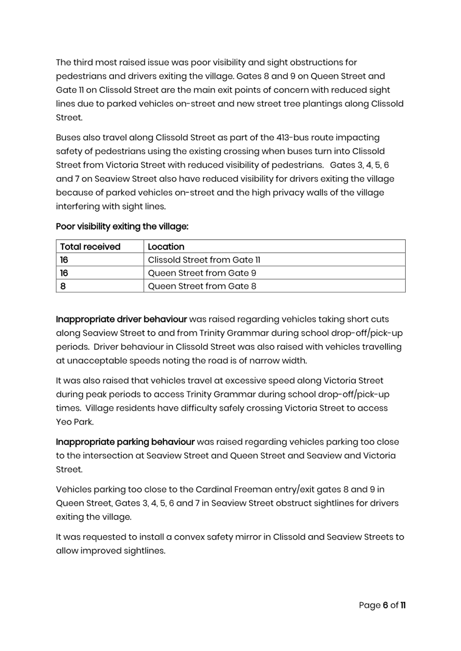
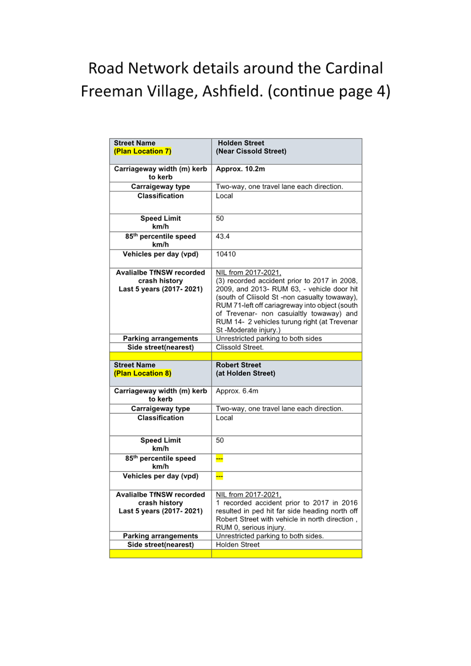
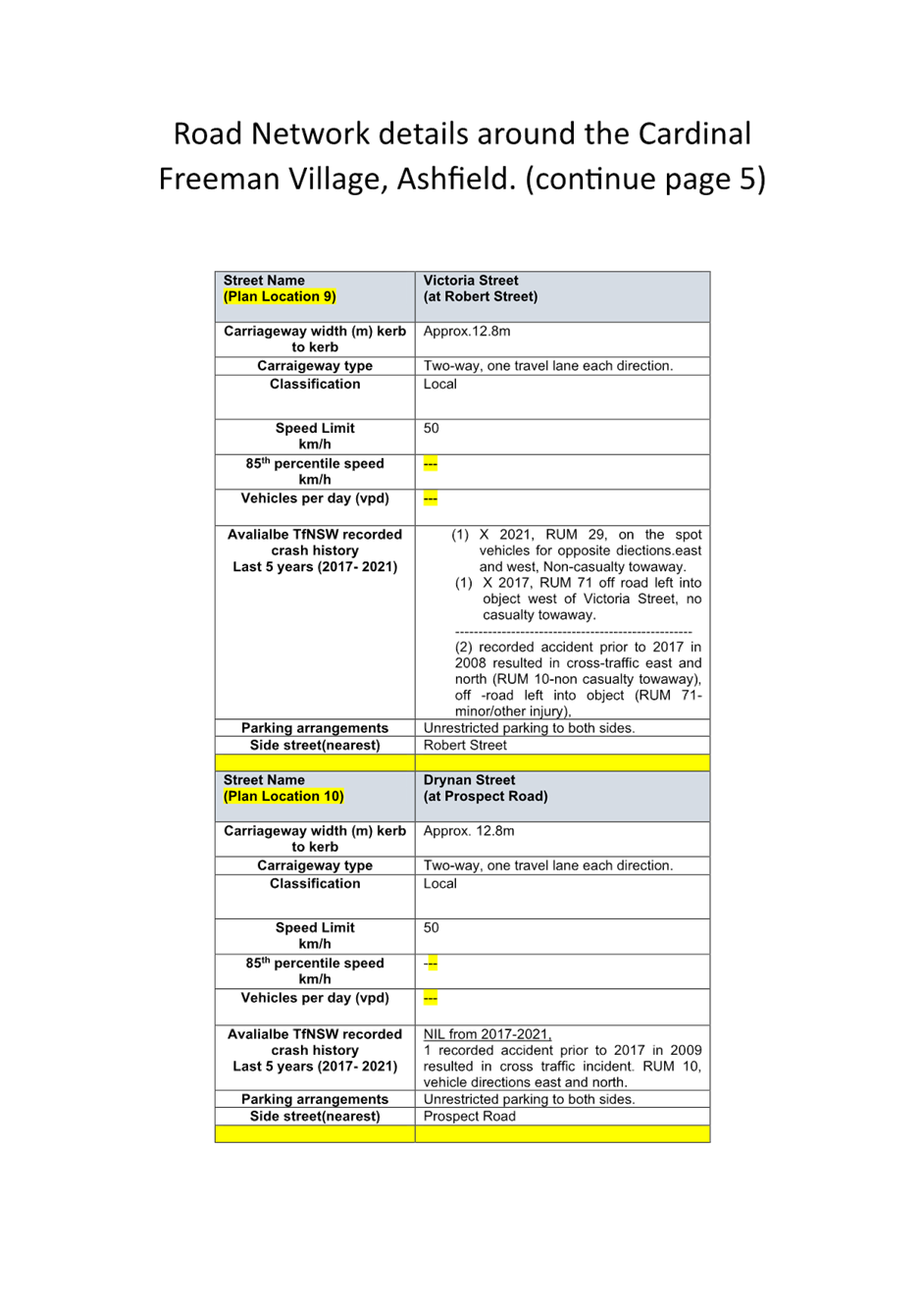
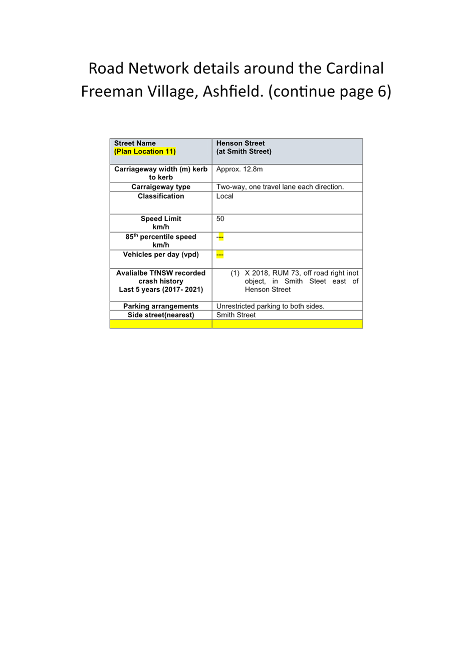
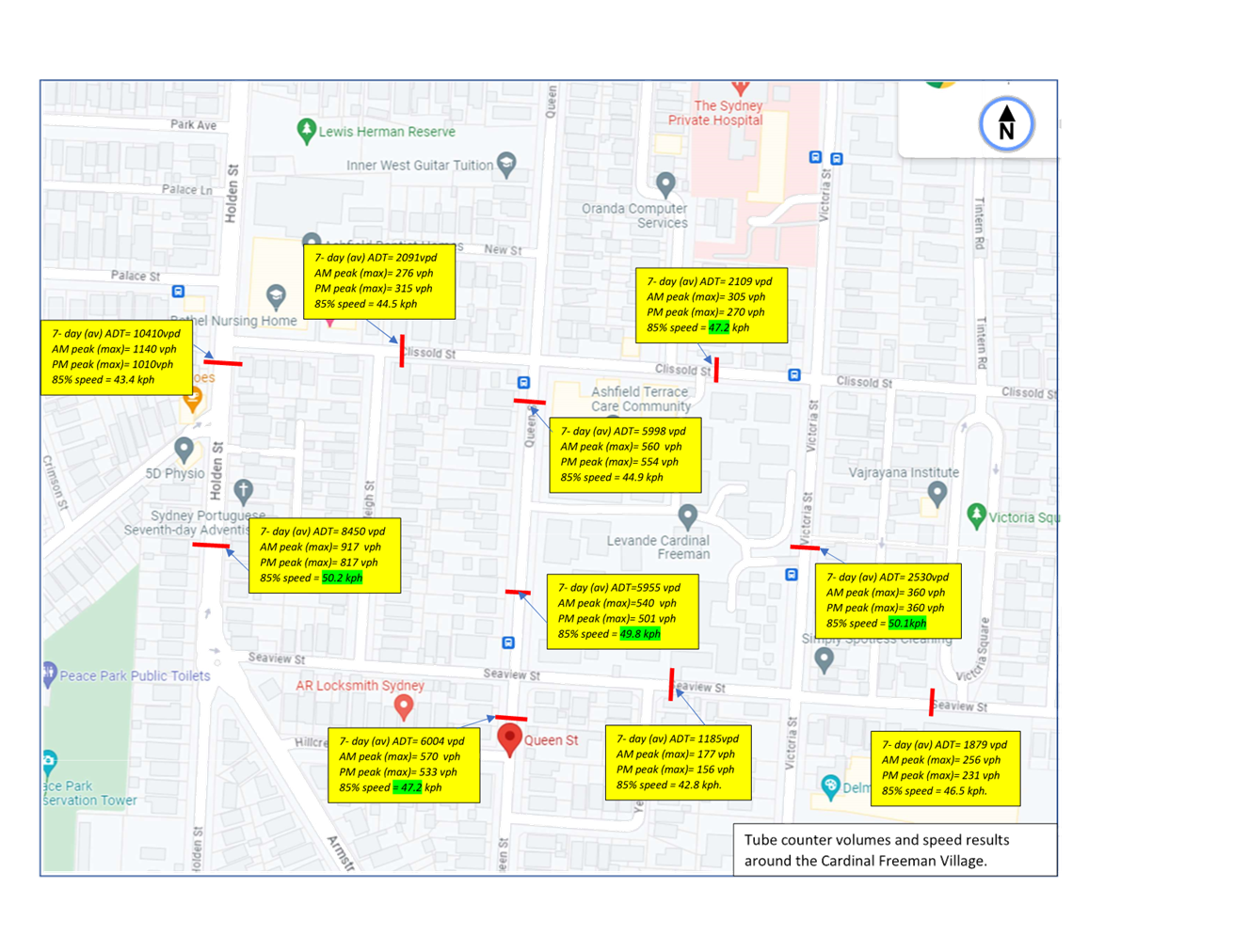
Subject: Victoria Street, Queen Street, Clissold
Street, Seaview Street and surrounding streets, Ashfield/Summer Hill - Proposed
pedestrain (zebra) crossings and traffic calming around and near the Cardinal
Freeman Village, Ashfield.
(Djarrawunang-Ashfield Ward/Summer Hill Electorate/Burwood PAC)
Prepared By: Boris Muha - Traffic Engineer
Authorised By: Manod Wickramasinghe - Traffic and Transport Planning Manager
|
RECOMMENDATION
1. That the following proposed pedestrian (zebra) crossings, kerb extensions. and traffic calming treatments around and near the Cardinal Freeman Village with associated removal or installation of parking (as shown under concept design in Attachment 2) be approved in principle, subject to final detailed design and funding:
(a) Plan 1- Victoria Street, mid-block between Clissold Street and Seaview Street. Install new raised pedestrian (zebra) crossing in line with existing kerb extensions outside premises No.126 and relocate and construct a new in lane Bus Stop platform (full-bus length) outside premises No. 128. This will result on the loss of approximately 4 parking spaces.
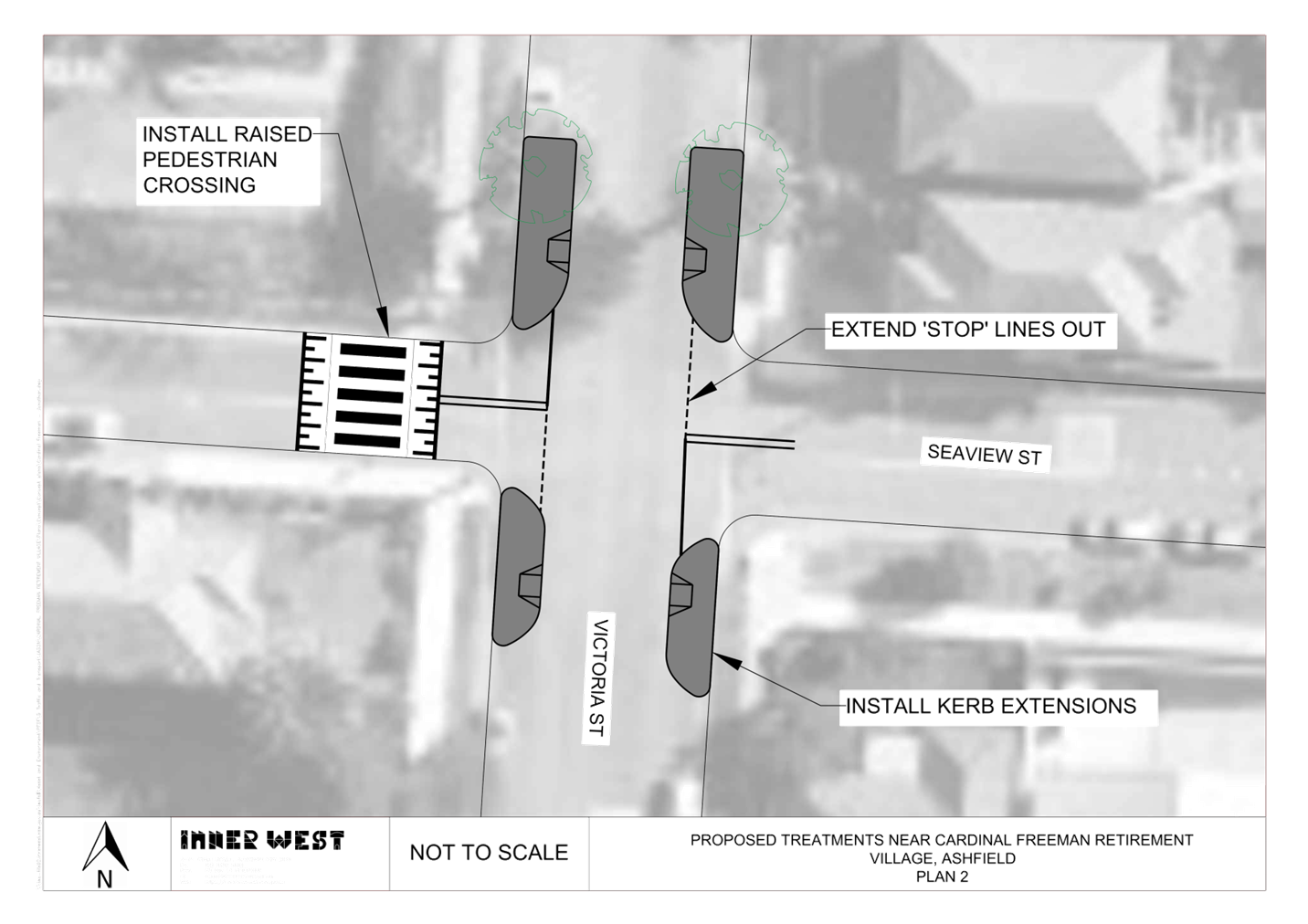
(b) Plan 2- Victoria Street and Seaview Street. Install a new raised pedestrian (zebra) crossing in Seaview Street, west of Victoria Street, provide kerb extensions to all corners of Victoria Street and bring out the ‘STOP’ lines from both ends of Seaview Street.
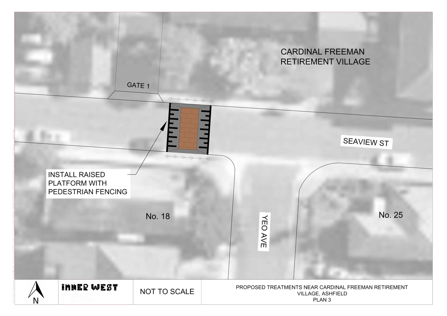
(c) Plan 3- Seaview Street at Yeo Avenue. Install new raised platform (threshold) in Seaview Street, west of Yeo Avenue with pedestrian fencing.
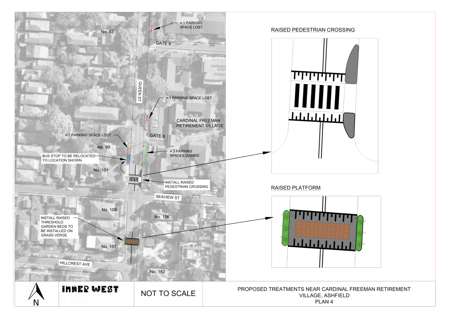
(d) Plan 4- Queen Street at Seaview Street & Hillcrest Avenue Install new raised pedestrian (zebra) crossing (in lieu of existing refuge) in Queen Street, north of Seaview Street and relocate Bus Stop forward on the western side of Queen Street. This will result in the loss of one parking space
Install new raised threshold (platform) with garden beds (back of kerb) in Queen Street, north of Hillcrest Avenue and remove parking for improved sight view of traffic out of gate 8 and 9 of the village. This will result in loss of 1 parking space to each approach sides to Gate 8 and 9 of the Cardinal Freeman Village. Gain if and where possible, approximately 3 parking spaces to the eastern side of Queen Street near Seaview Street.
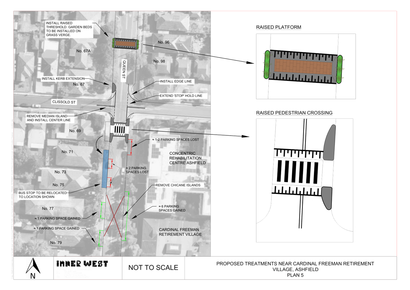
(e) Plan 5- Queen Street at Clissold Street. Install new raised threshold (platform) with garden beds (back of kerb) in Queen Street, north of Clissold Street. Install new raised pedestrian (zebra) crossing in Queen Street, south of Clissold Street and relocate Bus stop on the western side south of its original location. Remove chicane islands outside premises No.77. Remove narrow central median islands in Clissold Street and replace with BB centre line marking or painted median. This will result in the loss of approximately 3-4 parking spaces and gain of up to 8 parking spaces.
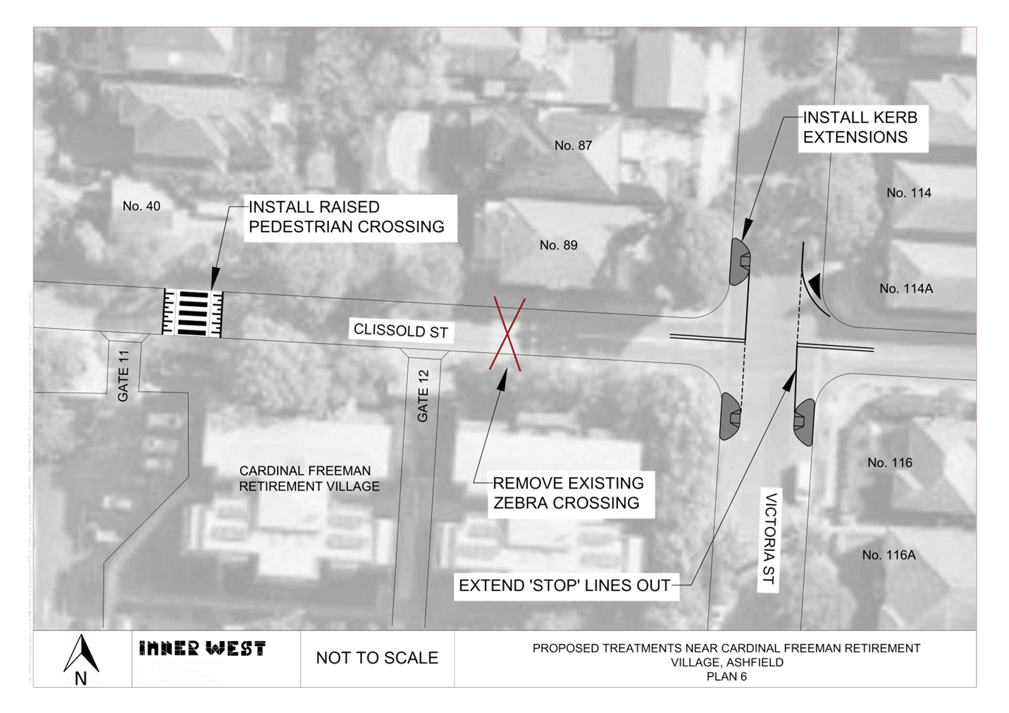
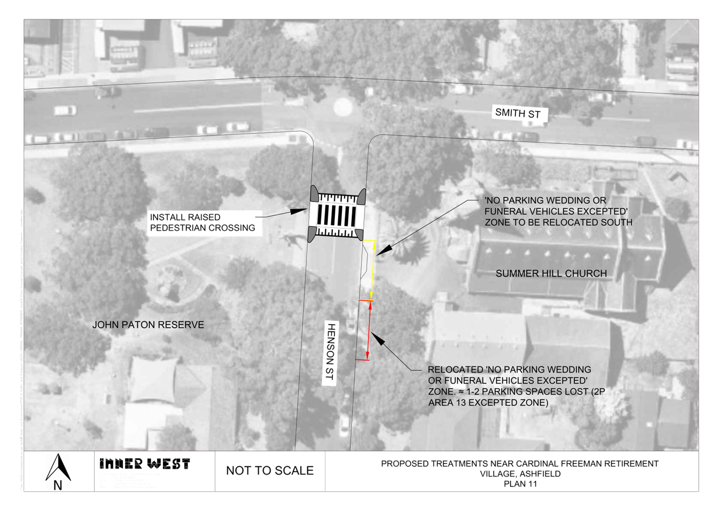
(f) Plan 6- Clissold Street and Victoria Street. Remove existing (at road level) zebra crossing in Clissold Street east of Gate 12 of the Cardinal Freeman Village and install new raised pedestrian (zebra) crossing east of Gate 11 to the Cardinal Freeman Village. Install physical and painted kerb extensions to all corners of Victoria Street and bring out the ‘STOP’ lines on both sides of Clissold Street.
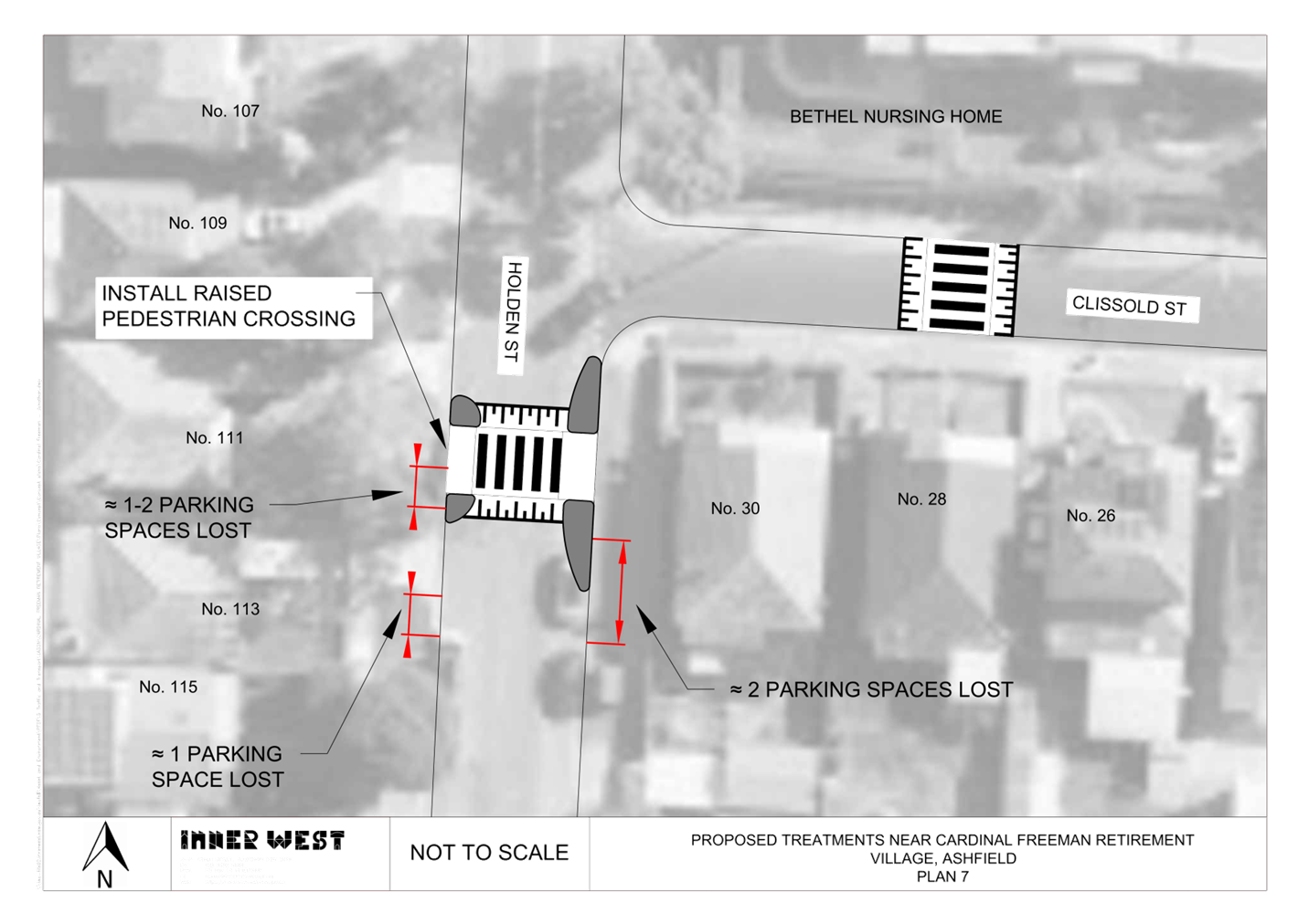
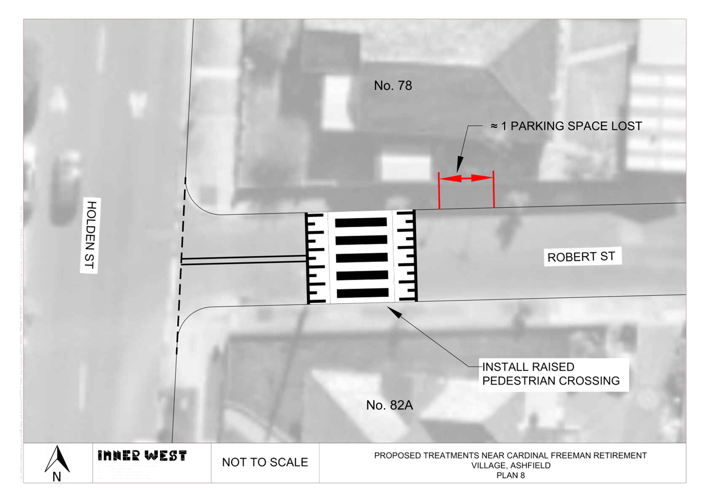
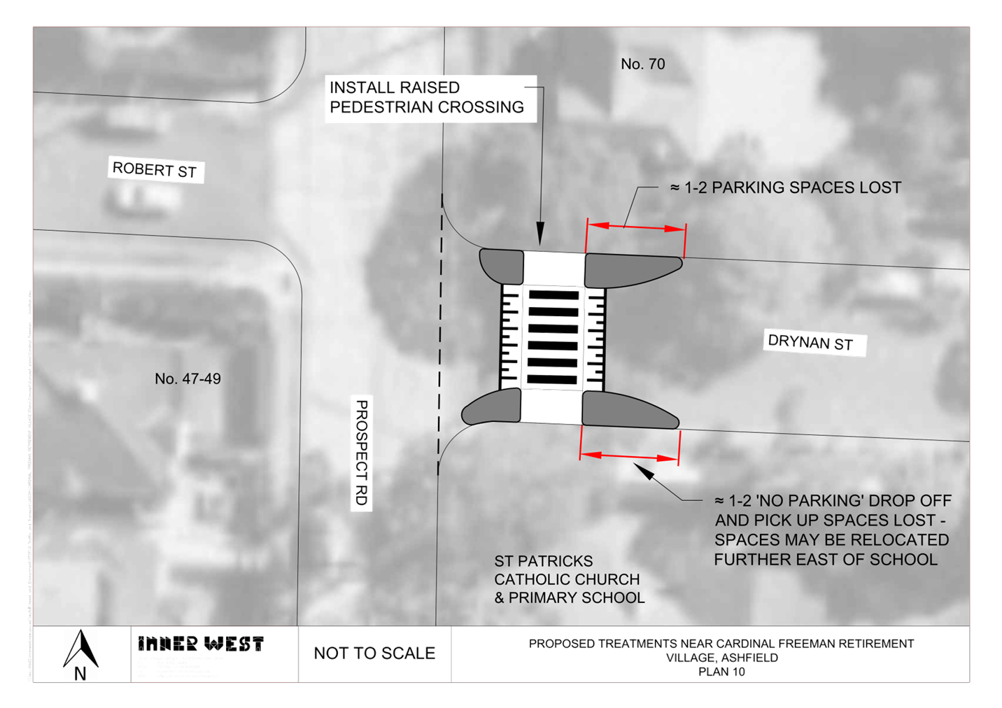
(g) Plan 7- [Clissold Street crossing]- Clissold Street at Holden Street. Install new raised pedestrian (zebra) crossing in Clissold Street, east of Holden Street (outside premises No. 28 Clissold Street).
(h) Plan 8- Robert Street at Holden Street. Install new raised pedestrian (zebra) crossing in Robert Street, east of Holden Street.
(i) Plan 9- Victoria Street at Robert Street. Install new raised pedestrian (zebra) crossing in Robert Street, south of Victoria. This will result in the loss of approximately 2 parking spaces.
(j) Plan 10- Drynan Street at Prospect Road. Install new raised
pedestrian (zebra) crossing in Drynan Street, east of
(k) Plan 11- Henson Street at Smith Street. Install new pedestrian (zebra) crossing in Henson Street, south of Smith Street. This will result in the loss of approximately 1-2 resident parking spaces for relocation of the ‘No Parking Wedding and Funeral Vehicles Excepted’ reserve further south of its original location on the eastern side of Henson Street.
2. That the new raised pedestrian (zebra) crossing in Holden Street, south of Clissold Street be approved in principle, subject to obtaining concurrence from Canterbury Bankstown Council prior to final design.
|
STRATEGIC OBJECTIVE
This report supports the following strategic directions contained within Council’s Community Strategic Plan:
|
2: Liveable, connected neighbourhoods and transport |
|
|
EXECUTIVE SUMMARY
Council at its meetings on the 14 March 2023 and 8 August 2023 raised pedestrian safety issues via a Notice of Motion and resolved that Council officers investigate improved pedestrian safety around the Cardinal Freeman (Retirement) Village, Ashfield.
The primary issues raised under Notice of Motion would be that Council engage with the residents of Cardinal Freeman Village to identify and implement pedestrian safety improvements and support a reduced warrant approach in line with Inner West Council policy for pedestrian crossings at or near Cardinal Freeman Retirement Village.
Council has since developed a scheme to address key concerns raised regarding pedestrian and road safety issues in the streets surrounding and near vicinity to the Cardinal Freeman Retirement Village.
The scheme has been developed using information from:
· initial community consultation in August 2023- Refer to report in Attachment 1
· ongoing correspondence from the community about issues in the area
· a review of traffic volumes, vehicle speeds and crash statistics in the area
The scheme proposes recommended treatments at locations shown in the attached locality map Diagram 1 on page 4, which includes raised pedestrian crossings, kerb extension pedestrian facilities and raised threshold traffic calming devices. The various proposed treatments (under concept design) are further shown in Attachment 2. The treatments are also developed for the benefit and safety of the general community.
BACKGROUND
The Cardinal Freeman Village (currently known as Levande Cardinal Freeman) is bounded by Clissold Street to the north, Victoria Street to the east, Seaview Street to the south and Queen Street to the west.
Village management advise that the complex has been functioning as a retirement village for over 55’s for well over 60 years and has now expanded to include 6 medium rise buildings totaling 320 units with another 40 units to be added by 2026. The village caters to an independent living lifestyle however as the average age is over 82 years there are a significant number of residents with mobility issues that hinder their ability to move around freely.
The facility caters for 420 residents aged from 57 to 101. 60% have hearing impairment, 10 with visual impairment, and 1 is registered as a blind resident. In terms of mobility, 20% are on walkers, 60% with reduced mobility.
Many of the elderly residents are capable, and desire to walk to and from various destinations outside of the village, and/or take other forms of public transportation (e.g. bus and train) to travel to other parts of Sydney.
This has prompted a general request from the village residents to improve pedestrian safety around the village to enable them to walk and take public transport within the area.
Other Aged care facilities such as the Ashfield Baptist Homes, Bethal Nursing Homes, Ashfield Terrace Care Community, and other community facilities are also located adjacent or near to the Cardinal Freeman Village.
DISCUSSION
The below Diagram 1 shows the location of proposed treatments to improve pedestrian safety and provide traffic calming around the Cardinal Freeman Village. Reference is also made to Attachment 2 which also explains and shows the various proposed treatments under concept design.
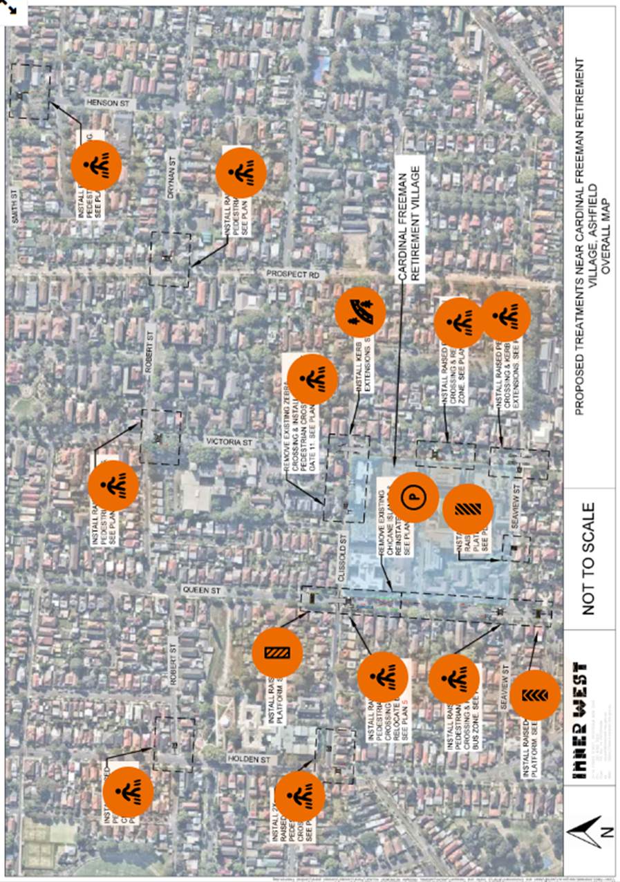
Diagram 1. Proposed pedestrian crossings and other traffic safety improvements near the Cardinal Freeman Village, Ashfield.
Existing road geometry details with accident history, available traffic volumes and speeds around the areas of the proposed treatments have been compiled and tabled as shown in Attachment 3.
Reference is also made to Attachment 4 for locations of recorded volumes and speeds last taken in August-September 2023.
The following process, information and design principles were used to derive the proposed treatments as shown in Attachment 2.
1. Council undertook an initial (Stage 1) community survey through Council’s ‘Have Your Say’ website between 18 August 2023 and 3 September 2023. Invitation letters were distributed to village residents and non-residents within the study area, to determine existing issues and ideas for improved pedestrian safety.
Pedestrian safety, speeding and high traffic volumes, poor visibility exiting out of various driveway gates and the request that Clissold Street and Seaview Street be made one-way, were primary issues raised.
Pedestrian (zebra) crossings were requested based on the vulnerability of the elderly pedestrians, and the recognition and need of crossings for those visually or mobility impaired. The report also identified requests for crossings to be established outside of the immediate surrounding streets of the village for elderly residents to walk to various other destinations. Namely Ashfield CBD and Lewis Herman Reserve to the north, Summer Hill shops to the east, Yeo Park to the south-east and café/shops the south-west.
A summary tabulation of these comments has been made on page 9-11 of the Stage 1 Community Engagement report (Attachment 1) with an officer’s response provided to address these comments.
2. Following the above, traffic surveys were organized to identify volumes, speeds, and pedestrian movements around certain locations where crossings have been requested.
The traffic survey results were then used to examine the warrant for pedestrian crossings as required under the Transport for NSW guidelines. TfNSW warrants outlined in the Supplement to Australian Standards AS 1742.10-2009 have been difficult to achieve on Council local roads. TfNSW has accepted that Council can use in this case an interim Pedestrian Crossing Guideline till such time the TfNSW warrants are revised, or Council adopts a separate Guideline or Policy for pedestrian (zebra) crossings.
The interim guidelines effective as from the 13 September 2022 state under a pedestrian demand calculation that:
· In each of two separate one-hour periods in a typical day, the pedestrian flow per hour (P) crossing the road is, or is expected to be, equal to or greater than 20.
· Children and elderly or mobility impaired pedestrians count as two pedestrians.
The TfNSW does quote under these guidelines “that overuse of pedestrian crossings may lead to diminished safety because drivers ignore or no longer see them.”
In saying this, Council officers have used a further criterion of around 200 or more vehicles per hour needing to be attained in the hourly periods when pedestrian counts are taken and that additional criteria such as safe sight view and positioning of the crossing be considered.
In addition to the above, it should be noted that a draft Council ‘Pedestrian Crossing’ policy has been developed which spells out the above need of a minimum volume level, whilst adding additional criteria to justify a crossing rather than the numerical volumes alone. The draft policy also states:
“In exceptional circumstances a pedestrian (zebra) crossing may be considered without meeting the traffic volume component, where the pedestrian crossing would be an essential link to an overall network of pedestrian facilities to a vulnerable group such as the aged or school children.”
The below table 1 compiles all relevant pedestrian and traffic volume statistics around each proposed (zebra) crossing. The table also assesses the warrant and provides the support/non-support outcome of each crossing.
An additional crossing would be recommended in Smith Street, east of Henson Street to tie in and link safe destination movements to the Summer Hill shops and the community and park land facilities to the north side of Smith Street near the shops, as requested under Stage 2 of the community feedback.
In view of the above and the information as provided in table 1, it is considered that all the crossings satisfy the TfNSW interim guidelines and/or warrants and conditions developed in a draft Council ‘Pedestrian Crossing’ Policy. The draft policy will be referred to the Local Traffic Committee separately and in line with this item for recommended approval by Council.
3. Pedestrian crossings, in this case, have been limited and generally placed to one leg of the intersection. They would be spaced reasonably apart to minimise/avoid any conflict with traffic or drivers ignoring the overuse or close distancing of crossings.
4. Raised platforms are designed to reduce speeding along the road or in approach to an intersection but are not used to cross over. Vehicles are permitted to park over platforms if not supplemented with kerb extensions or governed under restrictions. If not supplemented with kerb extensions, fencing or garden planter beds are placed to the back of kerb and used to deter pedestrians from crossing over the platforms.
5. Kerb extensions to corners offer alternate means to cross-over at a shorter distance. They can be made to accommodate compliant and aligned pram ramps and assist in bringing out ‘STOP’ lines for improved sight view of traffic. They are also considered to control traffic movement through and around the intersection.
6. An Engagement Outcomes Report [Stage 2] was formulated outlining the feedback received during the second stage of community engagement, comprising responses made by Cardinal Freeman Village and non-village residents on the concept design treatments to each plan sites. Resident concerns have been tabulated. A copy of the final report will be tabled at the Local Traffic Committee meeting with members receiving a copy of this report prior to the meeting. It is also proposed to post this report to Your Say webpage with all respondents being advised of this report.
7. Holden Street, south of Clissold Street is the border line between Inner West Council and Canterbury Bankstown Council (CBC). Concurrence would need to be sought from Canterbury Bankstown Council for a new raised pedestrian crossing in Holden Street, south of Clissold Street. This may need to be timed and treated separately from the rest of the project pending on the decision of CBC.
8. Another request although not outlined in the engagement report was to erect ‘No Stopping’ restrictions right through on the northern side of Seaview Street between Queen Street and Victoria Street. Seaview Street is two-way measuring approx. 6.6m wide kerb to kerb. Parking is permitted along the whole southern side of the street. Vehicles do not typically park on the northern side. ‘No Stopping’ to the northern side of the street would reinforce the clearance of parking to that side of the street. This matter will be investigated separately.
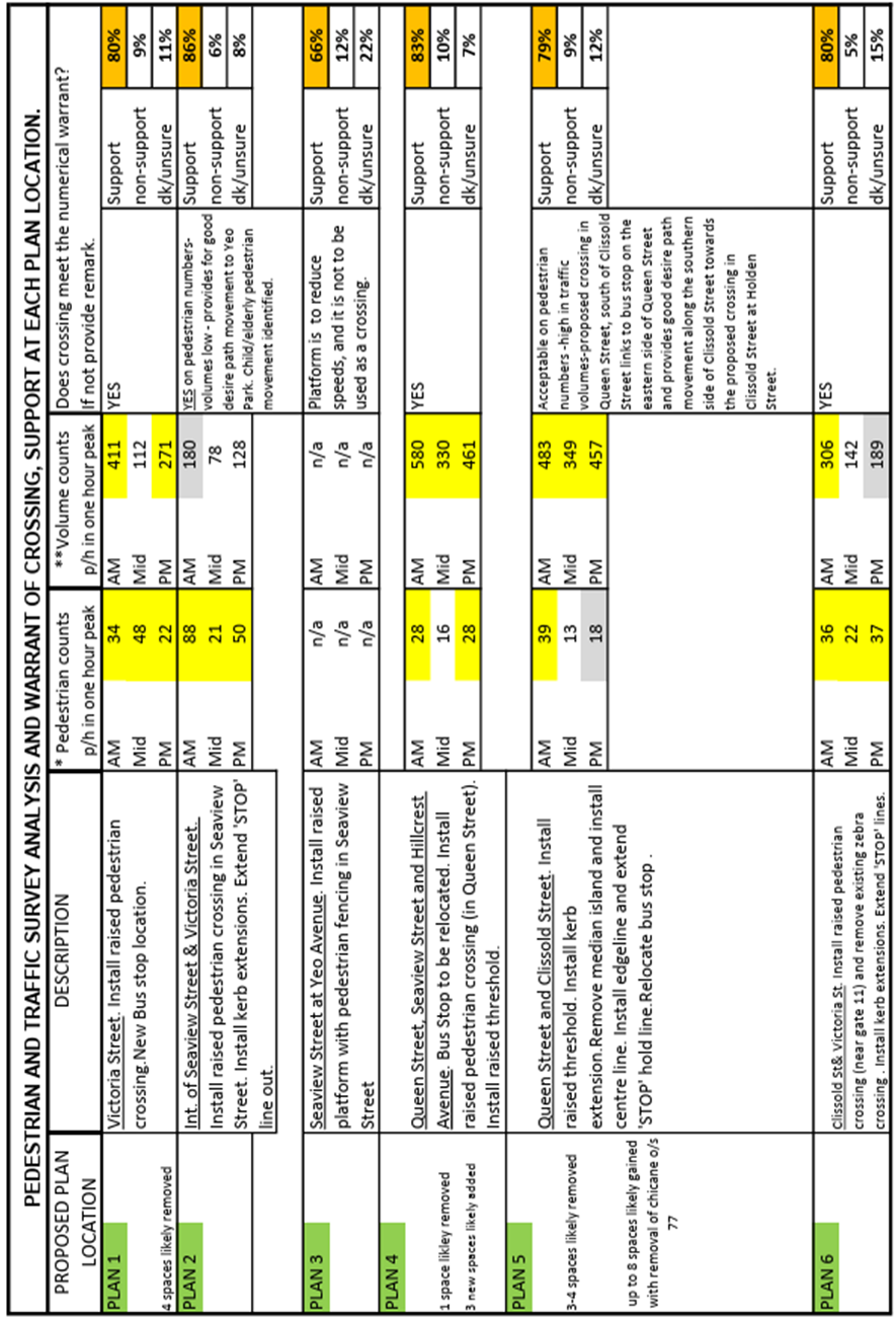
Table 1 - Tabulation of pedestrian numbers, traffic volumes, warrant assessment and support/non-support to each pedestrian (zebra) crossings plan site -Page 1
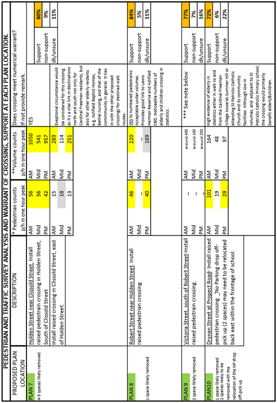
Table 1 - Tabulation of pedestrian numbers, traffic volumes, warrant assessment and support/non-support to each pedestrian (zebra) crossings plan site -Page 2
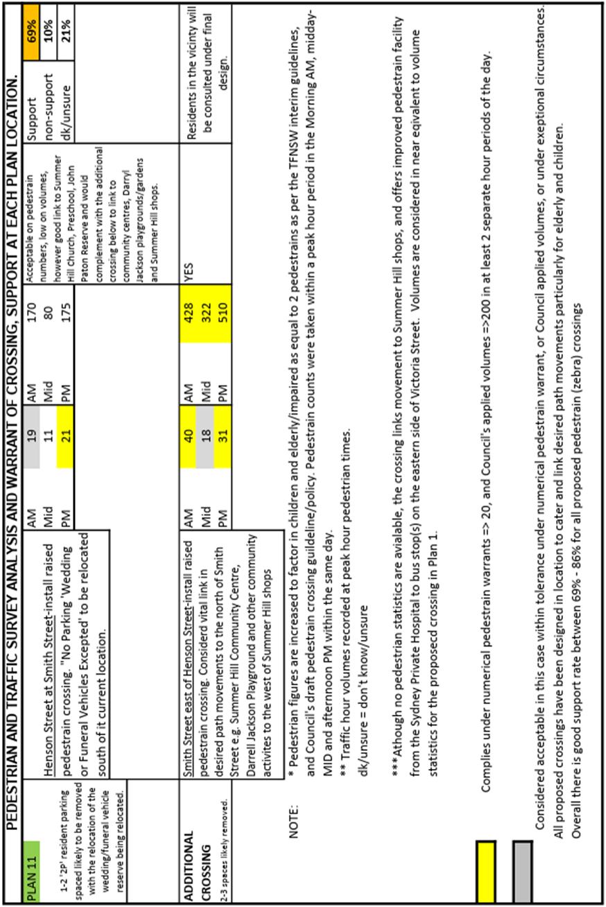
Table 1 - Tabulation of pedestrian numbers, traffic volumes, warrant assessment and support/non-support to each pedestrian (zebra) crossings plan site -Page 3
FINANCIAL IMPLICATIONS
The overall project has a preliminary estimate of $1,000,000 and funding will be sought under the Transport for NSW ‘NSW Get Active’ program. Design will be programmed in the 2023/2024 financial year, with anticipated construction in the 2025/2026 financial year, subject to provision of funding.
The Victoria Street pedestrian (zebra) crossing, mid-block between Clissold Street and Seaview Street is included in the existing 2023/24 financial year Traffic Facilities Program.
CONSULTATION
Council carried a consultation survey on the concept design plans through Council’s ’Have Your Say’ website between 25 October 2023 and 15 November 2023. Invitation letters were also distributed to village residents and non-village residents within the study area, to determine existing issues and ideas from the following feedback received:
· 609 visits to Your Say Inner West
· 31 contributors to the online survey
· 46 contributors to the paper survey
· 8 contributors via email
252 letters were issued to the outside non-village resident properties shown on the consultation map Diagram 2 below, whilst paper surveys were administered to 420 residents of the village.
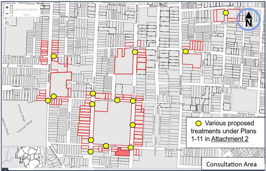
Diagram 3. Consultation Area and locations for the various treatments.
An Engagement Outcomes Report [Stage 2] was prepared once all comments from residents were received on the proposals. This report will in turn be posted on Councils Your Say website and tabled at the Local Traffic Committee meeting. All respondents will be advised of this report and the Engagement Outcomes Report.
The Stage 2 engagement report contains a summary of all the responses received and corresponding comments by Councils Officer added to the report. In relation to the responses, 65% of respondents are residents of Cardinal Freeman Village and 35% are non-village residents of Ashfield.
The key issues raised from the respondents who did not agree with the proposals are summarised below.
|
Summary of main issues |
Council response |
|
Loss of car parking.
|
In general, Council attempted reduce the loss of parking when considering the installation of traffic facilities. It accepts that sometimes parking will be lost and balances this loss against the gains in safety and amenity as a result of installing the device. |
|
Infrequent use of Bus Stops |
Council supports the use of public transport as it provides a community service regardless of its frequency of use. Council’s strategies are aimed to see mode shift toward active and public transport and the provision of adequate bus stops is a key part of this. |
|
The raised platform could be mistaken for a crossing.
|
Raised pedestrian crossings and raised platform devices will be marked and signposted differently to distinguish between the two treatments. Other physical features will also be added so that motorists can distinguish between the two different types of treatments. |
|
Location of proposed devices |
The location of the proposed devices was carefully considered and as a outcome of initial community input and traffic data collection. They also considered other design factors. |
|
Raised platform/crossing not warranted. |
Traffic data has been collected for each of the sites. Warrants have been met for the proposed pedestrian crossings and speed reductions can be achieved by installing the raised platform devices. |
CONCLUSION
It is recommended that the various treatments (under concept design) incorporating raised pedestrian (zebra) crossings, kerb extensions, raised platforms and removal of an existing chicane, with loss or gain of parking, as shown in plans 1-6,8-11 of Attachment 2, be approved in principle for Council to then proceed to final design.
For plan 7 with a proposed installation of a raised (zebra) crossing in Holden Street, south of Clissold Street, that approval be granted in principle subject to concurrence being obtained from Canterbury Bankstown Council prior to final design.
It is viewed that these treatments would facilitate in providing improved pedestrian safety to those more vulnerable (being children and persons of elderly and impaired nature), desiring to walk to various destinations near and around the Cardinal Freeman Village
ATTACHMENTS
|
1.⇩ |
Stage 1 Community Engagement Report |
|
2.⇩ |
Cardinal Freeman Village Concept Plan designs. |
|
3.⇩ |
Road Network Details around Cardinal Freeman Village. |
|
4.⇩ |
Map locality -traffic volumes and speed counts around the Village |
|
|
Local Traffic Committee Meeting 11 December 2023 |
Subject: Unnamed Lane, Summer Hill (adjacent Henson and Herbert Streets) - Proposed 'No Stopping' restrictions (Djarrawaunang-Summer Hill Ward/Summer Hill Electrorate/Burwood PAC)
Prepared By: James Nguyen - Traffic Engineer
Authorised By: Manod Wickramasinghe - Traffic and Transport Planning Manager
|
RECOMMENDATION
1. That the installation of ‘No Stopping’ on the north side of Unnamed lane, Summer Hill extending 10m from its intersections of Herbert Street be approved.
2. That the installation of ‘No Stopping’ on the west side of Unnamed lane, Summer Hill extending 6m from its intersections of Henson Street be approved. |
STRATEGIC OBJECTIVE
This report supports the following strategic directions contained within Council’s Community Strategic Plan:
|
2: Liveable, connected neighbourhoods and transport |
|
|
EXECUTIVE SUMMARY
The unnamed laneway running perpendicular to Henson and Herbert Streets, Summer Hill is utilised by Council’s waste vehicles to collect household waste of the properties on Henson Street. Currently, there are no existing ‘No Stopping’ restrictions at the entrance to the laneway at the intersections of Herbert and Henson Streets, and parked vehicles are subsequently, restricting access for Council’s waste vehicles, impacting weekly household waste collection. ‘No Stopping’ restrictions are proposed at the entrance to this laneway to ensure compliance with the NSW Road Rules and ensure vehicles do not park too close to the intersection. This will improve the turning movements into and out of the laneway for Council’s waste vehicles as well as any emergency vehicles that require access. In addition, it will also improve sight lines for pedestrians crossing the laneway, particularly school children from the nearby Summer Hill Public School.
BACKGROUND
Council has received a request from a resident requesting for consideration of ‘No Stopping’ signs at both ends of the laneway adjacent to Herbert and Henson Streets, Summer Hill due to repeated missed waste collections by Councils waste service vehicles.
DISCUSSION
The rear laneway in Summer Hill, at the rear of Henson and Herbert Streets is two-way and approximately 5.2 metres wide. Council’s waste vehicles collect household waste via this laneway (household bins are placed in this laneway for collection). Currently, there are no existing ‘No Stopping’ restrictions at both ends of this laneway. Subsequently motorists tend to park their vehicles within 10 metres of Henson and Herbert Streets. This narrows the laneway and compromises access for Councils waste collection vehicles that require the kerb space at the intersection to remain unimpeded to ensure access to the laneway. The proposed ‘No Stopping’ zone would seek to ensure that the kerb space remains unobstructed and compliance with rule 167 from the NSW Road Rules.
Council’s Waste Services team have advised that the provision of ‘No Stopping’ signs at the locations proposed would improve accessibility to the laneway and reduce instances of missed bin collections for households due to obstructed access.
Following a review of the responses received from community consultation, Council’s Engineers completed further swept path checks to determine if a reduced ‘No Stopping’ zone on the southern side of the laneway adjacent to Henson Street is possible. The swept paths indicate that a left turn in from Henson Street to the laneway cannot be made by a service vehicle with a reduced 6-metre ‘No Stopping zone. However, all other turning movements can be successfully completed with a reduced 6 metre ‘No Stopping’ zone. Accordingly, given only the left turn in from Henson Street is impacted, a reduced ‘No Stopping’ zone of 6-metres can be considered. The swept paths are attached to this report.
Council’s Waste Services team advised that their vehicles enter the laneway via Herbert Street and exit via Henson Street. Subsequently, a reduced 6-metre ‘No Stopping’ zone does not impact the exit turning movement from the laneway to Henson Street.
It is therefore proposed to amend the proposal to have a 10-metre ‘No Stopping’ zone on the western side of the laneway, north of Herbert Street and a reduced 6-metre ‘No Stopping’ zone on the southern side of the laneway, east of Henson Street. The amended proposal seeks to maximise the available kerb space for parking of residents, whilst still providing access for a service or emergency vehicle (right turn in).
PUBLIC CONSULTATION
Consultation was completed between Monday 9 October 2023 and Friday 27 October 2023. There were 29 letters sent to nearby residents and businesses of Henson Street advising them of the proposal. Council officers received five (5) responses with three (3) responses supporting the proposal and two (2) responses opposing the proposal. These are summarised in the table below.
The responses supporting the proposal noted the need for ‘No Stopping’ restrictions due to repeated instances of missed waste collection and the need to ensure compliance with the NSW Road Rules.
The responses opposing the proposal and officers responses are outlined in the table below.
Table 1 - Consultation summary
|
Residents response |
Officers response |
|
The ‘No Stopping’ zone proposed on the southern side of the laneway, just east of Henson Street will impact their ability to charge their electric vehicle. Currently, the resident parks their vehicle within the 10 metre ‘No Stopping’ zone to access the EV charger of their property due to a neighbours trailor that is repeatedly left unattended in the first legal parking space in the laneway. The resident is requesting for a designated “EV charging only” space in the first parking space adjacent to their property to ensure that they can charge their electric vehicle, or a reduction in the ‘No Stopping’ zone to 5 metres. |
· Council officers will further assess the issues pertaining to the unattended trailer that is affecting the ability for parking in the legal parking spaces for all motorists in this laneway.
· The laneway is a public road and a dedicated ‘EV charging only’ space for sole private household use is not supported. ‘EV charging only’ spaces are for public chargers that are to be of shared use.
· Council officers will assess whether a reduced 6-metre ‘No Stopping’ zone is possible. |
|
Residents typically have 3-4 cars each and reducing parking would impact households that have children and elderly
|
· Council officers will assess whether a reduced 6-metre ‘No Stopping’ zone is possible to maximise parking, |
|
Parking is already busy during the school drop off and pick up time, removing further parking would not help the situation |
· Council officers will assess whether a reduced 6-metre ‘No Stopping’ zone is possible to maximise parking, |
|
There have not been dangerous incidences or access issues in the past around the proposed no stopping area |
· Council officers have received feedback from the community about missed household waste collections. Access issues have been confirmed by Council’s Waste Services team. |
FINANCIAL IMPLICATIONS
There are no financial implications associated with the implementation of the proposed recommendations outlined in the report.
|
1.⇩ |
Swept paths |
|
2.⇩ |
Signage plan |
|
|
Local Traffic Committee Meeting 11 December 2023 |
Subject: Traffic Committee Schedule 2024
Prepared By: Charbel El Kazzi - Traffic Engineer
Authorised By: Manod Wickramasinghe - Traffic and Transport Planning Manager
|
RECOMMENDATION
That the proposed schedule of meetings of the Local Traffic Committee for the 2024 calendar year be received and noted. |
STRATEGIC OBJECTIVE
This report supports the following strategic directions contained within Council’s Community Strategic Plan:
|
2: Liveable, connected neighbourhoods and transport |
|
|
BACKGROUND
To assist Committee members with forward planning, the schedule of meetings of the Local Traffic Committee for 2024 is detailed below.
DISCUSSION
All meetings will be held on the 3rd Monday of each month, excluding January during which no
meeting is held and December which has been brought 1 week forward to avoid the Christmas
holiday period. The meetings will commence at 11.00am. The proposed meeting dates for
2024 are as follows:
|
Monday, 19 February 2024 |
11.00am |
|
Monday, 18 March 2024 |
11.00am |
|
Monday, 15 April 2024 |
11.00am |
|
Monday, 20 May 2024 |
11.00am |
|
Monday, 17 June 2024 |
11.00am |
|
Monday, 15 July 2024 |
11.00am |
|
Monday, 19 August 2024 |
11.00am |
|
Monday, 16 September 2024 |
11.00am |
|
Monday, 21 October 2024 |
11.00am |
|
Monday, 18 November 2024 |
11.00am |
|
Monday, 9 December 2024 |
11.00am |
Nil.
|
|
Local Traffic Committee Meeting 11 December 2023 |
Subject: Local Traffic Committee Terms of Reference
Prepared By: George Georgakis - Governance Manager
Authorised By: Beau-Jane De Costa - Senior Manager Governance and Risk
|
RECOMMENDATION
That the Local Traffic Committee Terms of Reference attached to the report be endorsed for Council to adopt. |
STRATEGIC OBJECTIVE
This report supports the following strategic directions contained within Council’s Community Strategic Plan:
|
5: Progressive, responsive and effective civic leadership |
|
|
EXECUTIVE SUMMARY
The Local Traffic Committee is run in accordance with “A Guide to the Delegation to Councils for the Regulation of Traffic (including the operation of Traffic Committees)” which was produced by the then Roads and Traffic Authority in 2009.
Governance and Risk is redeveloping Council’s Terms of Reference for Local Democracy Groups which includes advisory committees and working groups, to encompass additional governance mechanisms.
The Terms of Reference includes clauses on Conflicts of Interest and Model Code of Conduct requirements. Also included are acts of disorder and mutual respect clauses to align with Council’s Code of Meeting Practice and Council’s values and stance on mutual respect.
A review of the “Guide to the Delegation to Councils for the Regulation of Traffic (including the operation of Traffic Committees)” has been undertaken and it is recommended that it encompasses specific clauses on the above areas to ensure appropriate governance is upheld in the Local Traffic Committee.
It is recommended that the Local Traffic Committee Terms of Reference attached to the report be endorsed for Council to adopt.
DISCUSSION
Governance has completed a review of the “Guide to the Delegation to Councils for the Regulation of Traffic (including the operation of Traffic Committees)” and amended the document to encompasses provisions from Council’s Model Terms of Reference as outlined below:
Additionally, the information from the Guide has been copied into Council’s Model Terms of Reference template and the following specific clauses relating to the following areas for better governance of the Committee and meetings have been included:
- Part 9: Model Code of Conduct
- Part 10: Meeting Principles
- Part 11: Breaches of this Guideline
- Part 12: Administrative Changes
- Part 13: Version Control – Terms of Reference History
Part 9 (Model Code of Conduct) provisions relate to Committee members complying with the standards of conduct prescribed under Council’s Model Code of Conduct.
Part 10 (Meeting Principles) provisions relate to meeting conduct, acts of disorder (and how acts of disorder can be dealt with) and conflicts of interest. A Disclosure of Interest form for Committee members to complete is also included as part of Appendix A.
Part 11 (Breaches of this Guideline) relates to how breaches will be dealt with.
Part 12 (Administrative Changes) relates to how minor administrative changes can be made to the document.
Part 13 (Version Control – Terms of Reference History) is for the Governance department to manage the version history and adoption of the document.
Transport for NSW were consulted about the proposed inclusions and have not provided any feedback to the contrary regarding the new inclusions.
FINANCIAL IMPLICATIONS
There are no financial implications associated with the implementation of the proposed recommendations outlined in the report.
|
1.⇩ |
Local Traffic Committee Terms of Reference |
|
2.⇩ |
A Guide to the delegation to councils for the regulation of traffic (including the operation of Traffic Committees) |