|
AGENDA R |

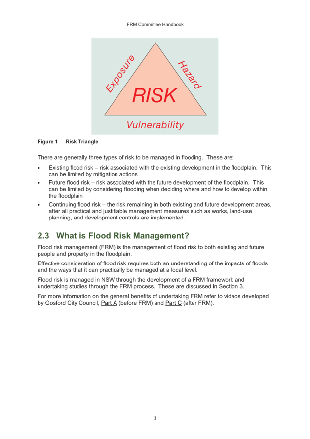
Flood Management Advisory Committee Meeting
THURSDAY 29 FEBRUARY 2024
2:00 PM
|
|
Flood Management Advisory Committee Meeting 29 February 2024 |
|
AGENDA |
1 Apologies
2 Disclosures of Interest
3 Confirmation of Minutes
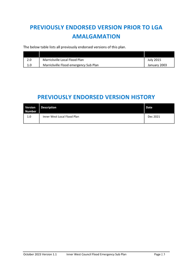
Minutes of 27 July 2023 Flood Management Advisory Committee 3
5 Staff Reports
ITEM Page
FMACC0224(1) Item 1
Review of Flood Management Advisory Committee Terms of Reference 11
FMACC0224(1) Item 2
Future Flood Education 79
FMACC0224(1) Item 3
Inner West Local Flood Plan 88
6 Reports with Confidential Information
Reports appearing in this section of the Business Paper are confidential in their entirety or contain confidential information in attachments.
The confidential information has been circulated separately.
ITEM
FMACC0224(1) Item 4
Presentation of Alexandra Canal Flood Risk Management Study & Plan and Johnstons Creek / Whites Creek Flood Risk Management Study& Plan
7 General Business
Update on Council Resolutions
Update on Flood Mitigation Programming
8 Close of Meeting
Minutes of the Flood Risk Management Advisory Committee Meeting
27 July 2023
Meeting Commenced at 1:03pm
COMMITTEE REPRESENTATIVES PRESENT
|
Clr Mat Howard |
Councillor – Midjuburi-Marrickville Ward (Chair) |
|
Clr Marghanita Da Cruz |
Councillor – Gulgadya-Leichhardt Ward |
|
Lois Gray |
Community Representative |
|
Shad Wall |
Community Representative |
|
Alexander Bailey |
Ashfield-Leichhardt SES |
|
Robert Baker |
Marrickville SES |
NON VOTING MEMBERS IN ATTENDANCE
|
David Paton |
IWC Engineering Services Manager |
|
James Ogg |
IWC Coordinator Stormwater & Asset Planning |
|
Rafaah Georges |
IWC Stormwater & Asset Planning Engineer |
|
Sadeq Zaman |
NSW Department of Planning and Environment (DPE) |
|
Martin Griffin |
Representative from Stantec – IWC’s Flood Modelling Consultant |
Observers
|
Klaus Neuscheler |
SES |
|
Liam Hogan |
SES |
|
Michael Carney |
SES |
|
Deborah Kearns |
SES |
|
Cian Currie |
SES |
|
Helen Slater |
SES |
|
Stuart McTaggart |
City of Sydney |
|
Neville Naicker |
Bayside Council |
Apologies
|
Tim Harnett |
Community Representative |
|
Ryann Midei |
IWC Director Infrastructure |
|
Douglas Wylie |
SES |
|
Shelly Stingmore |
SES |
|
Peter Kaye |
SES |
|
1. Acknowledgement Of Country – Clr Howard |
I acknowledge that we are meeting on the land of the Gadigal and Wangal people of the Eora Nation and pay my respects to the elders past and present and I extend that respect and acknowledgement to any Aboriginal people who are here with us today.
|
2. Disclosures of Interest |
Councillor Howard declared a possible conflict of interest as a local resident of Marrickville. This was considered a non-significant, non-pecuniary interest as the items of the agenda do not address areas of Marrickville.
|
3. Confirmation of Minutes |
That the Minutes of the Flood Management Advisory Committee Meeting held on Thursday, 22 August 2022 be confirmed.
|
Point of Order |
Councillor Da Cruz queried as to why the agenda and previous minutes were not published on the Council website. As it was believed to be a Council requirement to publish the agendas unless matters were considered confidential, and that this committee is under this jurisdiction.
James Ogg replied that it was an oversight of the publishing process and would review the Terms of Reference for the Advisory Committee moving forward. Previous practice has been to publish the minutes once they have been adopted by Council. Council staff have resolved to ensure future meeting agendas are publicly published and would review the minutes process with Council’s Governance Team.
Councillor Mat Howard noted it would be better to have the information publicly and in advance of the meetings for the purpose of declaring conflicts.
It was resolved that the meeting could proceed, noting the actions for future meetings.
|
4. Items for the Committee - FMAC0727(1) – Item 1 Dobroyd Canal and Hawthorne Canal Flood Risk Management Study & Plan – Proposed Endorsement |
SUMMARY
A short slideshow presentation for the committee outlining actions to date as it had been a few years since the report was last presented to the committee.
• 2015 – Dobroyd Canal Flood Risk Management Study commenced by Ashfield Council
• 2016 – Hawthorne Canal Flood Risk Management Study commenced by Marrickville Council with Ashfield Council as significant stakeholder
• 2017 – Following Council amalgamations in 2016, these studies were combined into a single project
• 2018 – Initial community consultation conducted to develop proposed options
– Modelling of options undertaken by consultant WMA Water
• 2019 – Multi-criteria analysis of options, considering complexity of construction, impact to public, and cost-benefit ratio
– Draft report presented to Flood Risk Advisory Committee in 2019 prior to public exhibition
– Public Exhibition undertaken in mid 2019, with Your Say Inner West portal, in person information sessions, and phone calls to Council engineers
– Report amended to address community questions about Hawthorne Parade levy & expansion of Dobroyd Canal
– Committee endorses the Flood Risk Management Study & Plan, subject to
- Responses issued to all written submissions
- Review of wording and grammatical errors and Figure inconsistencies
- Additional comments about vulnerability education in an urban catchment
Following these amendments the Flood Risk Management Plan identified 5 flood mitigation options, 3 response modification options, and 2 property modification options.
- FM0403A / FM403B – Grosvenor Street pipe upgrade and Darrell Jackson Gardens detention basin
- FM0404C – Nowranie Street pipeline upgrade
- FM0501G – Petersham Park detention basin
- FM0605C – Sloane Street pipeline upgrade
- FM0702 – Pratten Park detention basin
- RM01 – Investigate Flash Flooding Warning System for Heighway Avenue
- RM02 – Update SES and Council flood model data for future flood response
- RM03 – Community Education Program
- PM01 – Development Controls associated with Flood Planning Levels
- RM02 – Residential Flood Proofing
Items that had best value under multi-criteria analysis were community education options and localised damage minimisation through development controls. Floods upgrade options had a lower score, due to greater constraints and difficulties, but would continue to investigate the viability of these options.
OFFICERS RECOMMENDATION
That the Flood Management Advisory Committee endorse the Final Draft Dobroyd Canal and Hawthorne Canal Flood Risk Management Study and Plan to Council for adoption.
DISCUSSION
Councillor Howard asked what the key concerns were that had been raised in the previous submissions.
Council officers advised that the key concerns were uncertainty about why properties were considered flood affected as flooding had not been seen in the area. Residents were satisfied once the criteria for mapping and the size and nature of flooding in the area were explained during the information sessions.
Councillor Howard asked how previous written submissions were addresses as resolved by the previous committee, and whether people at that time were satisfied with the outcome.
Council officers advised that a written response was provided by Council’s consultants to any written submission during the exhibition process. No further feedback from those written responses were received. As noted residents that attended drop-in sessions during the exhibition were satisfied with the explanations provided at the time.
Councillor Howard sought clarification for the delay in adoption, noting that the report was complete in 2019, and the impact of new residents moving into the area on proposed outcomes.
Council officers noted that prioritisation of resourcing in a time of high demand on the Asset Planning team resulted in delays in taking the report to Council, however this was no being rectified. There are no changes proposed to flood mapping, risk modelling, property zoning, or development controls to flood affected properties. These details have already been adopted by Council as part of the Hawthorne Canal Flood Study and Dobroyd Canal Flood Study.
The representative from the Department of Planning noted that while the plan was not progressed to Council adoption in 2020 due to difficulty in resourcing, the study was very comprehensive and acknowledged Council officer comments that this is a highly built-up catchment and the impact to the study due to land use change and increase in impervious areas, which are among the main drivers of increasing flood risk, would not be significant.
The representative from the Department of Planning noted that the study was completed based on the ARR 1987 dataset, which has since been superseded by the ARR 2019 dataset published through The Bureau of Meteorology, hence there may be an opportunity to check in on the outcome by using the latest rainfall data.
Council officers noted that a comparison check was undertaken for another study currently underway in Johnstons Creek on the impact of using ARR 2019 compared to ARR 1987. The results of the comparison noted that the changes caused by the updated rainfall patterns were not significant to undertake a new rainfall model. Given the minor nature of the changes and the design to maintain consistency in the assessment of flood mitigation impact assessment, Council has maintained the 1987 rainfall data in this study.
Councillor Howard noted that the report investigates a levy on Hawthorn Parade and the potential expansion of Dobroyd Parade and if this was still the proposed plan
Councillor Da Cruz wanted clarification that the levy was a physical levy and not a monetary levy.
Council officers confirmed that the levy was a physical levy rather than monetary contribution. The report reviews these two options due to resident considerations, however as both options result in a net worsening of flood impacts these were not recommended for further investigation.
Lois Gray noted that it would seem that the flood situation for most of affected properties does not change.
Council officers confirmed that since flooding in these two catchments is largely across minor tributaries rather than overflow of the creeks themselves, there weren't any substantive options to eliminate or reduce flooding across large sections of the catchment. As such the key options was about community awareness in conjunction with SES and property modification through DCP controls. This was supported by the representatives from Leichhardt-Ashfield SES and Marrickville SES.
Councillor Da Cruz asked if Council could comment on climate change and sea level rise.
Council officers advised that climate change was factored into both the Flood Study and the Flood Risk Management Study and Plan under guidelines issued by the Department of Planning. The guidelines recommend modelling 10%, 20% and 30% increases to the intensity of rainfall and modelling sea level rise as a water level condition on Council’s outlets to the canal. These changes to the model parameters do not see significant variation to the flood depths modelled within the catchments.
Councillor Howard foreshadowed an amended recommendation which he wanted to raise for discussion. Conscious of population change, opportunity should be given to get renewed feedback from the current community about the policies that impact them and educate new residents about the potential impacts to their property.
DISCUSSION OF AMENDED RECOMMENDATION
Lois Gray suggested that the community consultation should not be to seek new resident views, but rather further inform residents about what it means to have an existing flood affected property, noting that the study recommendations of the study were unlikely to change and the DCP controls only relate to new builds or significant redevelopment.
James Ogg commented that education was one of the recommendations of the report itself, as a method of risk reduction through knowledge rather than constructed methods to reduce flood levels and that ongoing engagement with the community would continue to occur outside of the process developing and adopting the Flood Risk Management Study
Lois Gray asked if advice is given to people with the section 10.7 certificates for flood affected lots and controls that may be applicable and if this would assist new residents who may have just moved into the area.
James Ogg confirmed that the 10.7 planning certificates outlines planning and zoning controls, but does include a section stating whether the property is subject to development controls due to flooding. If the lot is identified as a Flood Affected Property under Council’s Development Control Plan, this section advises potential residents to contact Council’s Stormwater & Asset Planning team for further specific information. Consequently, any new property owners would have been notified through this process.
Councillor Da Cruz sought clarification of the impact of undertaking a new FRMS&P or if the committee should consult on the current document.
Council officers noted that though the Flood Management Process is an iterative process, the relative lack of change in the urban character and residential zoning of the affected areas means that any revised modelling would show limited impacts to flood hazard, flood depths, or damage estimates. Similarly a new study would not be expected see substantial changes to the value of the options assessed and recommended.
The adoption of the report provides legislative support for further investigation and design of identified options, inclusion within future works programs, inclusion within development control plans, financial support from the NSW Government, and guide ongoing community engagement and education. Further detailed design and assessment is required for each design option and further community would occur with each of those options during detailed design.
Alexander Bailey commented that the Ashfield and Leichardt SES would continue to work with Council to engage residents in the area around matters of flood hazard and flood safety.
Councillor Da Cruz wanted to clarify if ongoing SES education was dependent on the adoption of this plan and Council doing some of the work.
James Ogg responded that this plan did inform some of the measures taken by SES, such as route planning and hazard mapping, as well as any high-risk communities.
Councillor Howard advised that he understood the benefits of ongoing education related to the adoption of the report, and valued the work that the SES and Council were doing, however still had concern that the potential for significant population change within the catchment, with information not available online for the public to review.
It was further noted that the committee makes a recommendation to the Council and the elected Council make the final resolution in this respect.
Councillor Da Cruz proposed that the committee could consider the endorsement of the report and recommend a further report committing Council to develop an education strategy for presentation to the next committee meeting. This would also provide opportunity for ongoing feedback to the committee and Council once the document was adopted.
Councillor Howard moved to amend the recommendation to endorse the Study and plan, subject to a further report to Council about options for further community engagement prior to or following the adoption of the study.
COMMITTEE RECOMMENDATION
1. That the Flood Management Advisory Committee endorse the Final Draft Dobroyd Canal and Hawthorne Canal Flood Risk Management Study and Plan to Council for adoption.
2. That Council receive a report on options of further community engagement or notification on the study and plan, noting that new residents may wish to be informed of the recommendations of the study and plan.
For Motion: Unanimous
|
4. Items for the Committee - FMAC0727(1) – Item 2 Alexandra Canal Flood Risk Management Study & Plan and Johnsons Creek and Whites Creek Flood Risk Management Study & Plan – Review of initial mitigation proposals |
James Ogg and representatives from Council’s flood modelling consultant Stantec provided an update on progress of the Alexandra Canal Flood Risk Management Study and Plan and Johnsons Creek & Whites Creek Flood Risk Management Study and Plan.
Throughout the project there has been a technical working group involving representatives from Council, Stantec and DPE meeting fortnightly to keep the project progressing and maintaining ongoing feedback.
Both studies are partial catchment studies – the Alexandra Canal study area focuses only on areas north of the canal, and west of Barwon Park Road and the Johnstons Creek & Whites Creek study area focuses only on areas south of Parramatta Road. Leichhardt Flood Risk Management Study and Plan. The remaining areas are already covered by studies undertaken the City of Sydney and Inner West Council.
The Alexandra Canal catchment is generally industrial and commercial land with some residential areas in Tempe and near Sydney Park. Changes to the catchment since the Alexandra Canal Flood Study include the St Peters Interchange component of WestConnex and the Sydney Gateway project. The change to drainage patterns as a result of these projects does not significantly affect the flood risk for the wider area as both these projects are located in the lower region of the catchment and have had to demonstrate as part of their approval that there would be no worsening of flooding to the surrounding catchment.
The second study area is Johnsons Creek and Whites Creek, limited to the area south of Parramatta Road and west of King Street and Church Street Newtown. These catchments are largely residential, with limited areas of commercial and industrial buildings along major roads.
An assessment of model updates, including new building footprints and rainfall data sets was undertaken when the project commenced. The results showed minor water level reductions associated with the new rainfall data. However, in order maintain continuity between the previous Flood Study and the current Flood Risk Management Study the previous model was maintained, noting that this would also be a more conservative approach. The project is otherwise operating consistent with the revised guidelines of the NSW Government 2022 Flood Prone Land Package guidance.
Community consultation was undertaken from March to April of this year. Over 2700 letters were mailed to owners and occupiers in the one in one hundred year affected properties, with three in person information sessions, and an online survey/submission portal through the Your Say Inner West portal. The community engagement had five survey responses, five in person visitors across the three sessions and two interactive map responses. The have your say page had a bit better engagement with 650 views 501 and one of those that were unique, 7 hours of viewing and 49 flood study report downloads.
Stantec provided a brief outline of the flood planning controls review, hazard mapping and damages assessment taken to date, noting that these would be fully documented in the Draft Flood Risk Management Study to be presented to the committee later in the year. It was noted that the 20%AEP event (previously referred to as the 1‑in‑5-year event) contributes almost 50% of average annualised damage assessment. Consequently, Council and Stantec would be focusing on options that provided the greatest benefit in these smaller more frequent events.
A preliminary list of options has been prepared by Stantec, guided by site visits, flood model results, and workshops with internal Council teams as well as local stakeholder organisations including SES and City of Sydney.
Stantec presented to the committee fourteen mitigation options that it is believed would reduce or improve flood levels and flood impacts across these catchments, seeking comment from the committee, before undertaking further detailed modelling
Alexandra Canal
- Station Street - drainage upgrade to Tempe Reserve
- Bay Street - drainage upgrade
- Princess Highway drainage upgrade between Campbell Street and Barwon Park Road
- Talbot Street drainage upgrade to maintain regional evacuation route on Princes Highway
Johnstons Creek
- Bridge Road – pipe capacity upgrade and detention storage
- Camperdown Park – on-site stormwater detention storage
- Salisbury Road – review blockage capacity in inlet maintenance schedules
- Clarendon Street / Clarendon Lane – pipe capacity upgrade
- Trafalgar Street – pipe upgrade within rail corridor west of Stanmore Station
- Cardigan Street and Kingston Street – pipe upgrade and inlet capacity improvements
- Probert Street – improved inlet capacity into existing network
- Railway Avenue – pipe capacity upgrade
- Lennox Street – new stormwater pipeline along Lennox St connecting in further downstream
Whites Creek
- Drainage upgrade between Westbourne Street and Parramatta Road
The Flood Risk Management Study will also evaluate the suitability and capacity of six typical Emergency Management options
- Flood Prediction and Warning (noted that there were complexities with such systems in a flash flooding catchment)
- Review of Flood Planning & Information Availability
- Community Flood Awareness
- Education Programs
- Flood Signage & Markers
- Post Flood Data Gathering
Once detailed options are investigated a draft report and public exhibition will be undertaken followed by finalisation and completion of the study. The draft report will be presented to our technical working group and the committee and then the draft final report post comment will go on public exhibition. At the next Flood Advisory Committee meeting it is planned to have the draft report finished and the detailed options summary to present to the committee.
DISCUSSION
Councillor Da Cruz noted the response to the community consultation process and suggested that the method of community engagement, notification and communication was important and requested feedback as to how this could be improved moving forward.
Council officers noted that this was an ongoing point of discussion and will provide further feedback / plans at next Flood Advisory Committee prior to exhibition of the final Flood Risk Management Study and Plan
Clr Marghanita Da Cruz asked for clarification whether Weekly Park in Johnstons Creek was assessed for flood mitigation.
Representatives from Stantec and Council officers noted that the modelling did not show a significant depth of flooding affecting many properties, and options in this context are not typically included in a Flood Risk Management Study due to comparatively minor benefit.
Council officers noted investigations had been undertaken to this area in previous years to reduce frequency of flooding. However Council would commit to including a pipe upgrade option in this area as one of the options to undergo further benefit testing.
Councillor Howard sought clarification as to what was required of the committee regarding the Alexandra Canal and Whites Creek and Johnsons Creek mitigation proposed options presented.
Council officers confirmed that Council was seeking comments on the options identified, and any specific areas of concern that members of the Flood Advisory Committee wanted to raise as part of these studies.
COMMITTEE RECOMMENDATION
That the information slides be provided to the members of Flood Advisory Committee with any comments to be returned by 11 August 2023.
|
4. Items for the Committee - FMAC0727(1) – Item 3 Review of Committee Terms of Reference |
Review deferred to next meeting.
Council officers to provide draft updates prior to next meeting.
|
5. General Business |
Shad Wall had photos of historic flooding in Leichhardt to share with Council officers.
|
6. Meeting Closed 3:10pm – Clr Howard |
|
|
Flood Management Advisory Committee Meeting 29 February 2024 |
Subject: Review of Flood Management Advisory Committee Terms of Reference
Prepared By: James Ogg - Stormwater and Asset Planning Coordinator
Authorised By: Ryann Midei - Director Infrastructure
|
RECOMMENDATION
1. That the Flood Management Advisory Committee endorse the updated Terms of Reference (including new schedule) |
STRATEGIC OBJECTIVE
This report supports the following strategic directions contained within Council’s Community Strategic Plan:
|
5: Progressive, responsive and effective civic leadership |
|
|
EXECUTIVE SUMMARY
This report reviews the purpose of the Flood Management Advisory Committee within NSW Legislation and Guidance Manuals. It reviews current membership, consistency with other Flood Management Committees, and consistency with similar committees of Inner West Council.
Following this review, an amended Terms of Reference has been developed using this new template and including amendments to membership, meeting schedule and code of conduct as detailed in the report.
BACKGROUND
At the meeting of Council held on 19 September 2023, Council resolved the following in part:
6. That a review be undertaken of the Flood Management Advisory Committee, including consideration of meeting schedule, terms of reference and other governance measures and that this report be received by Council in or before December 2023.
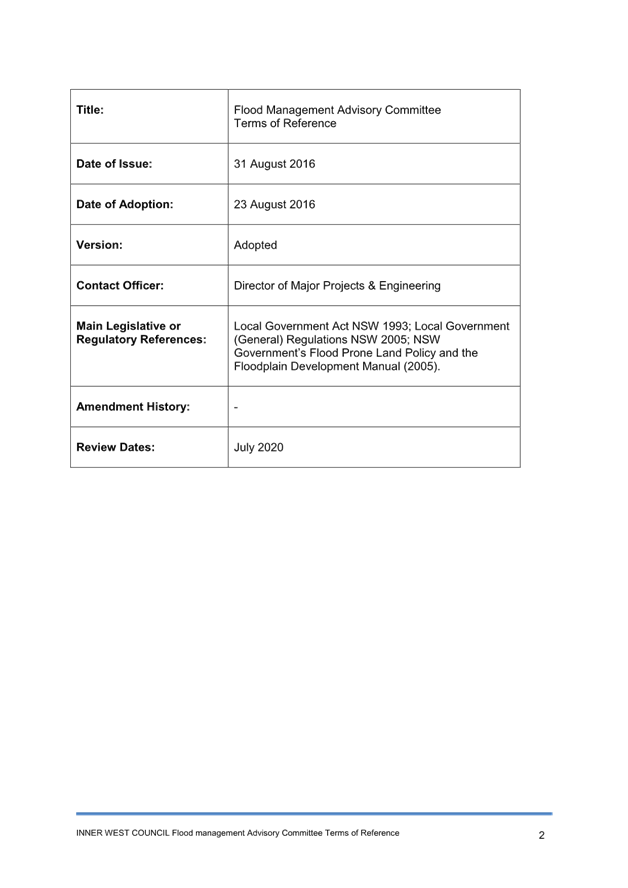
The Terms of Reference for the Inner West Council Flood Management Advisory Committee (FMAC) was adopted in August 2016 and was scheduled for review in July 2020. The FMAC did not meet between 2020 and 2022 due to the impacts of COVID-19, after which a review of the Committee Terms of Reference has been a standing item on the agendas. A copy of the current Terms of Reference dated August 2016 is provided in Attachment 1.
DISCUSSION
Review of the Flood Management Advisory Committee
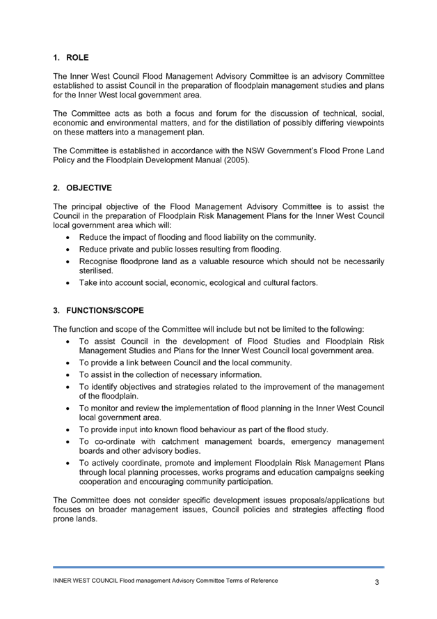
Legislation & Governance
Flooding and the management of flood liable land within NSW is governed under the NSW Flood Prone Land Policy (the Policy). The primary objective of the Policy is to reduce the impact of flooding and flood liability on communities and individual owners and occupiers of flood prone property, and to reduce private and public losses resulting from floods.
The NSW Flood Risk Management Manual (the Manual) has been prepared by the NSW Department of Planning in accordance with the Policy to support its implementation.
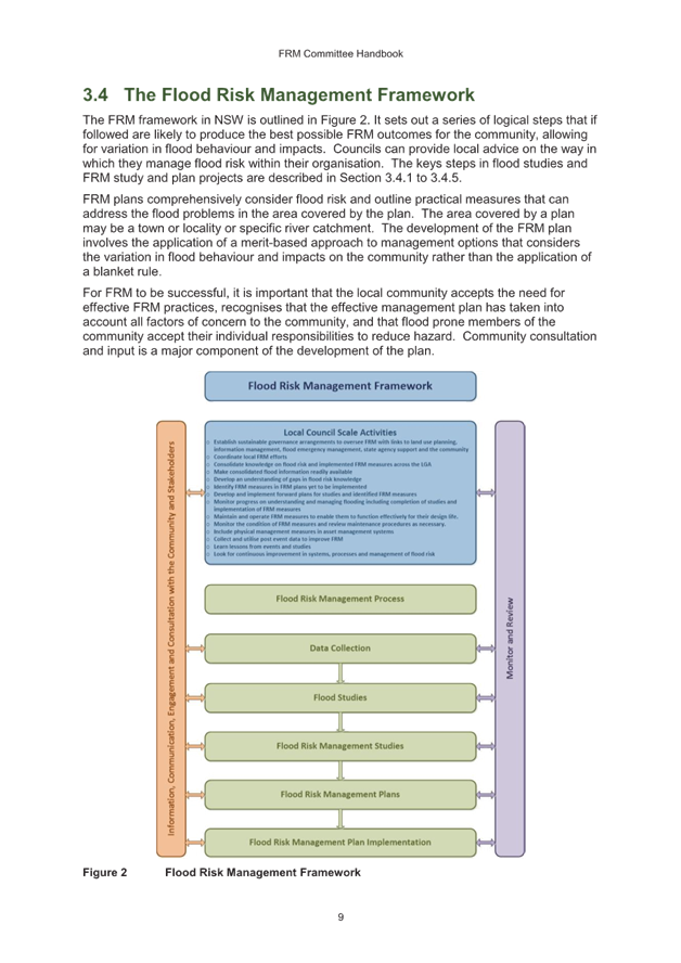
Under the Policy and Manual the management of flood prone land is the responsibility of local councils, including the establishment of flood risk management (FRM) governance and consultation with the community through the establishment and management of committees.
A key part of strategic flood risk management is to have arrangements in place to oversee and enable contribution by agencies, key stakeholders and the community to studies and the development of FRM plans under the FRM process.
Councils may choose to assign this role to an existing committee of council, or a separate management committee may be formed. Typically, metro Councils have assigned this responsibility to a unique committee.
These committees are generally advisory in nature and do not have or exercise any formal powers of Council, but report through an established process to the Council or to an appropriate standing committee, which has the final decision-making authority.
While in many ways these committees share similarities with Council’s Local Democracy Groups, the operation of the committee forms part of Council’s legislated responsibilities under Section 733 the Local Government Act 1993.
While the Inner West Council Flood Management Advisory Committee is not directly legislated under the Local Government Act, Section 733 of Act outlines that a council that acts in accordance with the Manual relating to the management of flood liable land is taken to have acted in good faith in relation to advice given, or things done or not done, relating to the likelihood of flooding or the extent of flooding.
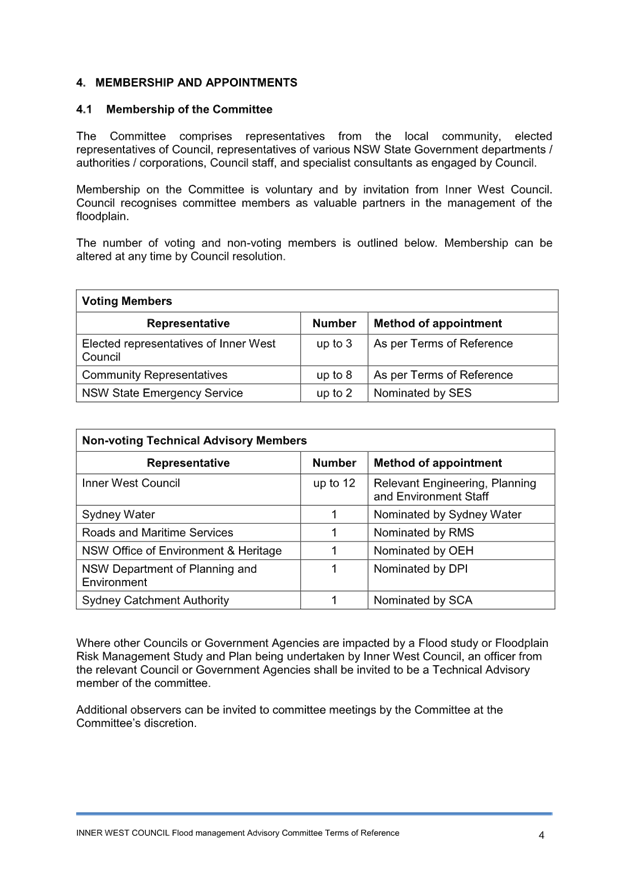
Membership
As outlined in the Manual, membership of the FMAC should include a balanced representation of stakeholders such as agencies, groups and individuals impacted by flood management within the affected area. Typically, membership is:
• elected members of council
• an appropriate number of representatives of the local community including local flood affected landholders, relevant industry bodies, and environmental groups)
• Representative(s) from the State Emergency Service (SES)
• Council staff from engineering, planning and environmental disciplines
• Officers from the Department of Planning and Environment
• Other key stakeholders, such as owners or managers of infrastructure or land that may influence or be impacted by flood behaviour such as Sydney Water and Transport for NSW
Committee members may be required to vote to determine the majority opinion on different issues. Because the FRM plan should be a local based process, Department of Planning officers, infrastructure owners and Council officers abstain from voting.
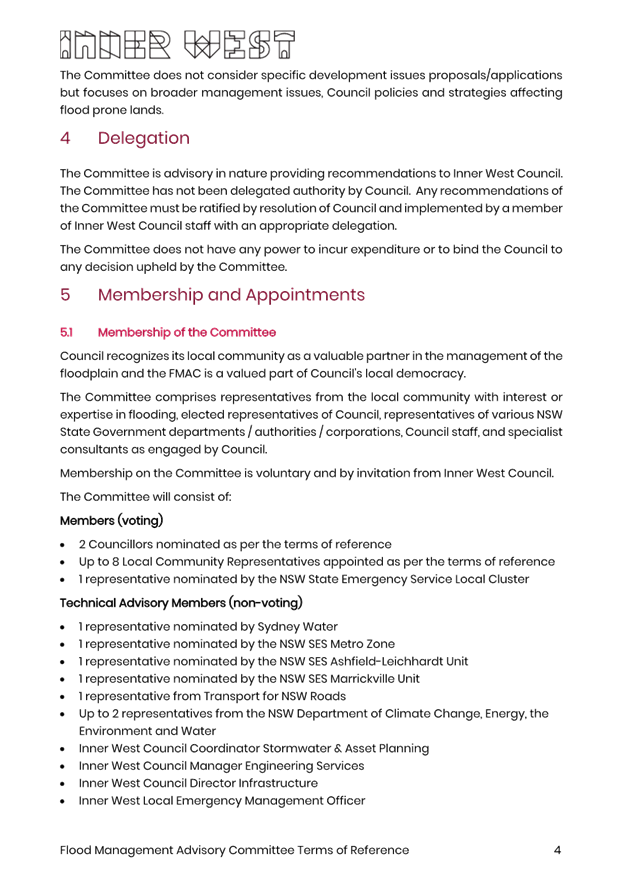
Under the current Terms of Reference, membership of the FMAC is made up of:
Voting Members:
• Up to three elected representatives of Inner West Council
• Up to eight community representatives – up to one from each catchment within Council
• Up to two NSW SES representatives
Non-Voting Advisory Members:
• Up to twelve members of Inner West Council staff from Engineering, Planning and Environment teams as required
• One representative from Sydney Water
• One representative from Roads and Maritime Services
• One representative from NSW Office of Environment & Heritage
• One representative from NSW Department of Planning and Environment
• One representative from Sydney Catchment Authority
• A representative from other Councils or Government Agencies impacted by a Flood study or Floodplain Risk Management Study and Plan being undertaken
Following recent changes within NSW agencies, including SES structures, the number of elected representatives appointed from Council, and overall benchmarking with neighbouring Councils, the following changes are recommended to the Terms of Reference:
Voting Members:
• Two elected representatives of Inner West Council
• Up to eight community representatives who reside or operate on flood prone land, have expertise in local flood management, represent local environmental groups, sporting groups, social groups, or chamber of commerce impacted by flooding
• One representative from the NSW SES Inner West Cluster
Non-Voting Advisory Members:
• Inner West Council Director Infrastructure
• Inner West Council Manager Engineering Services
• Inner West Council Coordinator Stormwater & Asset Planning
• Inner West Local Emergency Management Officer
• 1 representative nominated by Sydney Water
• 1 representative nominated by the NSW SES Metro Zone
• 1 representative from Transport for NSW Roads
• Up to 2 representatives from the NSW Department of Climate Change, Energy, the Environment and Water
Further invitees and observers can be invited to the committee meetings at the discretion of the Committee Facilitator, including
• Relevant officers from Inner West Council within Civil Works, Operations, Planning and Environment
• Representatives from the NSW SES Ashfield-Leichhardt Unit & NSW SES Marrickville Unit
• Representatives from other Councils or Government Agencies where they impacted by a Flood Study or Floodplain Risk Management Study and Plan being undertaken by Inner West Council
Following recent resignations of community members there are several vacancies that have not yet been filled. As these vacancies are currently within six months of the end of term of the current Council, it is recommended that these vacancies are filled following an expression of interest in the first term of the new Council.
Matters for Consideration
The NSW Flood Risk Management Manual (the Manual) outlines the roles and responsibilities of the FMAC. The FMAC assists Council in developing and implementing Flood Risk Management Plans by contributing ideas, professional expertise, experience, and local knowledge.
As outlined in the Manual, the principal objective of the FMAC is to oversee and assist Council in the development of Flood Studies and Flood Risk Management Plans, providing advice on priorities for implementation and facilitating important links to state agencies, key stakeholders and the community. Members of the committee contribute their knowledge of historical information, local problems, and possible solutions.
Once the committee has completed the prime task of developing an FRM plan and implementation strategy, and the council has adopted these, implementation falls back to Council as part of activities under the Flood Risk Management framework outlined in the Manual.
Noting the review of the Flood Risk Management Manual above, it is recommended
that the following changes are made:
|
Item |
Current function |
Proposed Amendment |
|
7 |
To co-ordinate with catchment management boards, emergency management boards and other advisory bodies. |
To facilitate coordination of flood management between local and state government agencies. |
|
8 |
To actively coordinate, promote and implement Floodplain Risk Management Plans through local planning processes, works programs and education campaigns seeking cooperation and encouraging community participation. |
To support and review the implementation of Floodplain Risk Management Plans within local planning processes, works programs and education campaigns and encouraging community participation. |
Meeting Schedule
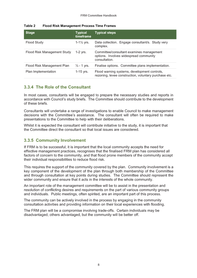
A recommended schedule of meetings is not provided within the NSW Flood Risk Management Manual (the Manual). Meetings are typically held at critical points in the project stages during the development of Flood Studies and Flood Risk Management Plans.
To provide greater ongoing support and guidance to the development of Floodplain Risk Management Plans and the implementation of works programs and education campaigns resulting from the adopted studies, as well as provide ongoing community feedback from rain and flood events, it is recommended that a quarterly schedule be adopted.
The work plan of Flood Studies and Flood Risk Management Studies would be amended to have milestones line up with an adopted meeting schedule, however occasional extraordinary meetings may need to be called where an urgent response or a project critical milestone does not fall within the regular meeting schedule.
Terms of Reference Updates
The Inner West Council Governance team has been adopting new standard Terms of References for Councils committees, such as the Local Traffic Committee Terms of Reference adopted by Council on 13 February 2024.
An amended Terms of Reference has been developed using this new template and includes the above reviews into membership, meeting schedule and matters for consideration. The amended Terms of Reference document is provided in Attachment 2.
FINANCIAL IMPLICATIONS
There are no financial implications associated with the implementation of the proposed recommendations outlined in the report.
|
1.⇩ |
Current Terms of Reference |
|
2.⇩ |
Proposed Terms of Reference |
|
3.⇩ |
Floodplain Risk Management Advisory Committee Handbook |
|
Flood Management Advisory Committee Meeting 29 February 2024 |
Subject: Future Flood Education
Prepared By: James Ogg - Stormwater and Asset Planning Coordinator
Authorised By: Ryann Midei - Director Infrastructure
|
RECOMMENDATION
1. That the Flood Management Advisory Committee support the schedule of actions to be taken to facilitate flood education within Inner West Council. |
STRATEGIC OBJECTIVE
This report supports the following strategic directions contained within Council’s Community Strategic Plan:
|
1: An ecologically sustainable Inner West 5: Progressive, responsive and effective civic leadership |
|
|
EXECUTIVE SUMMARY
Community engagement is identified in the NSW Flood Risk Management Manual as an integral part of the flood risk management process.as it raises awareness and can provide base information for further community flood awareness activities.
The NSW State Emergency Service (SES) acts as the lead agency under the Emergency Management framework for flooding and flood management, including ongoing community awareness and education, informing the community on how to prepare for and act in response to a flood threat, and assisting with the issuance of flood warnings.
Under this framework, Council partners with NSW SES to support and facilitate such activities.
Council officers have reviewed the type of information currently available to residents and have investigated potential opportunities to improve awareness in the community via two main objectives – improving accessibility to information and increasing public engagement.
From this review, a proposed shortlist of actions and activities has been prepared, with short (within 1 year), medium (1-3 years) and long (3 years +) term timeframes as outlined below.
|
Action |
Timeframe |
Comments |
|
Planning Certificate Clarity |
Short |
Actions already undertaken in December 2023 |
|
Community Information Sessions |
Short |
Information Sessions to be undertaken in mid-2024 with exhibition of Alexandra Canal FRMSP & Johnstons Creek and Whites Creek FRMSP |
|
Information Hub |
Short–Medium |
Overall website review being undertaken in 2024 |
|
Signage |
Medium |
|
|
Online Mapping |
Medium-Long |
|
|
Community Events |
Medium |
To be undertaken as required in support of other actions |
BACKGROUND
At the Council Meeting held on 12 September 2023, Council resolved the following:
3. That a future flood education strategy for the wider local government area be developed and presented to the Flood Management Advisory Committee.
This followed the adoption of the Hawthorne Canal & Dobroyd Canal Flood Risk Management Study & Plan, which included a Community Education Program as a High Priority measure for flood management in that catchment.
In this regard, the 2022 NSW Flood Inquiry notes the importance of community engagement and public education in the creation of more resilient communities and improved flood risk management at all levels of the community.
Specifically, Inner West Council is bounded by three primary water bodies – Parramatta River to the north, Cooks River to the South and Sydney Harbour to the east – and contains five tributary creek systems – Dobroyd Canal, Hawthorne Canal, Whites Creek, Johnstons Creek and Alexandra Canal – with further localised catchment flow paths draining to these areas.
Consequently, flooding within Inner West Council is generally considered flash flooding – which is sudden and unexpected and the result of sudden local or nearby heavy rainfall. Within Inner West Council a flood event will typically occur within 1 to 2 hours of the onset of rain. These timeframes reinforce the importance of community awareness and readiness in responding to such rapid onset of flooding.
DISCUSSION
As outlined in the NSW Flood Risk Management Manual, community engagement to promote flood awareness is an integral part of the flood risk management process. This process raises awareness and can provide base information for further community flood awareness activities.
The NSW SES under the Emergency Management framework acts as the lead agency for flooding and flood management, including ongoing community awareness and education, informing the community on how to prepare for and act in response a flood threat, and assisting with the provision of flood warnings.
Under this framework, Council partners with NSW SES to support and facilitate such activities.
The Community Engagement for Disaster Resilience Handbook (AIDR 2020), published by the Australian Government Department of Home Affairs and the Australian Institute for Disaster Resilience outlines a number of methods of engaging with the local community to provide information, options, solutions or services for a given situation. This includes meetings, presentations, information sessions, fact sheets/brochures/newsletters, and online videos or information portals.
Current Information
NSW SES operates two units within Inner West Council located in Marrickville and Haberfield/Leichhardt, supported by further operational services within the Metro Zone. These branches inform residents of general flood risk, flood safety, and provide information to support residents in developing home emergency plans through their website - https://www.ses.nsw.gov.au/flood-awareness-nsw/ - and Unit Open Days.
Within Council operations, information about flooding is currently available to the public via Council’s website - https://www.innerwest.nsw.gov.au/live/environment-and-sustainability/in-your-neighbourhood/rivers-and-waterways/flooding.
This page provides a background on the nature of flooding within Inner West Council and provides links to completed flood studies, including maps of flood impact, for residents to download.
Further information about emergency preparedness & support is also available under the Community Well Being section of Council’s website - https://www.innerwest.nsw.gov.au/live/community-well-being/safety-and-well-being/emergency-management-be-prepared.
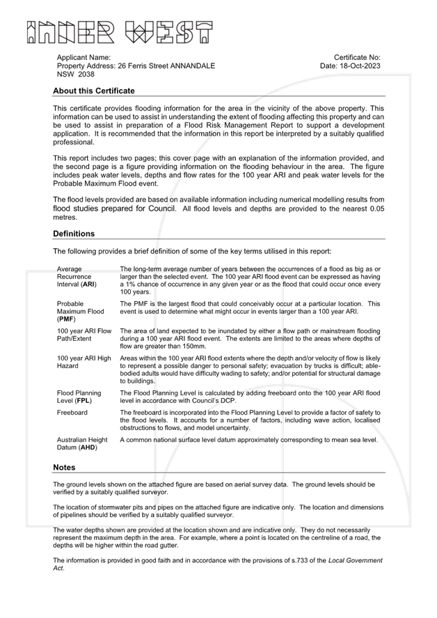
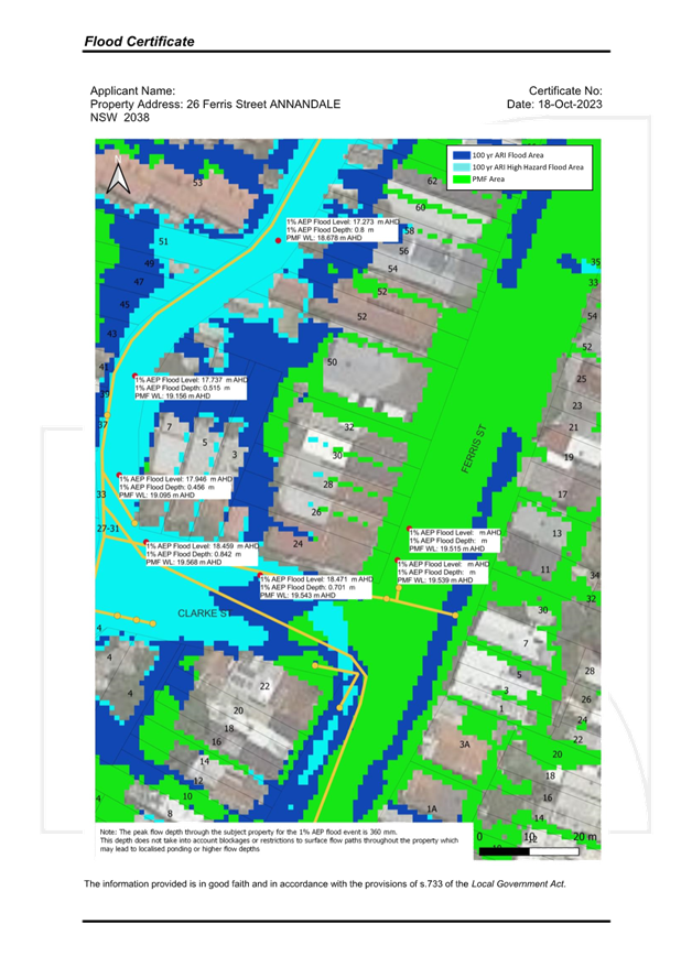
For individual property owners, information about specific flood levels in relation to a property can be obtained through a Flood Certificate, issued by Council on application, which provides a localised map of flooding patterns and spot levels in the vicinity of a specific property. A sample certificate is provided in Attachment 1.
Potential future property owners are informed of the potential for flood impact to a property through Section 9 of a Planning Certificate that can be obtained from Council.
Future Actions
The NSW Government published its response to the 2022 Flood Enquiry in August 2022. It supports the delivery of evidence based; targeted education campaigns aimed at building disaster resilience and will consider opportunities to improve access to information on individual and community risk exposure, noting that further work was required on the implementation of a schools-based education program and central data hub.
As noted above, the NSW SES has been tasked with delivering a central data-hub and partnering with NSW Department of Education to deliver the schools-based education program.
Council provides a largely support and facilitation role in providing information and education to the wider community. In this regard, officers have reviewed potential opportunities in the community, addressed below via two main objectives – improving accessibility of information and increasing public engagement.
These opportunities would be further developed following engagement with Council’s internal stakeholders including Customer Service, Community Engagement, Strategic Planning, IT and Events.
Improving Access to Information
· Greater Clarity on Planning Certificates
The Planning Certificates currently issued under Section 10.7 Environmental Planning and Assessment Act 1979 include a section related to the impact of Flood Related Development Controls.
This certificate is a legislative requirement and is primarily focused on the impact of development controls on property; however, changes were made in December 2023 to the certificate text so that they now outline the reason for the development controls, and where they may obtain further information.
For properties located within the Flood Planning Area, the following text is provided:
· The property is located within the Flood Planning Area, as determined through Inner West Council’s adopted Flood Studies, and is identified as a Flood Affected Property under Council’s Development Control Plan.
· Clause 5.21 – Flood Planning of the Inner West Local Environment Plan 2022 applies to all development.
· Further information on flooding, including copies of Council’s adopted Flood Studies, can be found on Council’s Flooding webpage at https://www.innerwest.nsw.gov.au/live/environment-and-sustainability/in-your-neighbourhood/rivers-and-waterways/flooding.
· If you wish to obtain specific information about flood levels in the vicinity of the property you may choose to apply for a Flood Certificate. Please see https://www.innerwest.nsw.gov.au/live/environment-and-sustainability/in-your-neighbourhood/flood-certificate for further information.
· For further information, please contact Council’s Stormwater and Asset Planning Team.
· Online Digital Mapping
Digital Mapping tools are being increasingly used by Councils to provide maps that are more easily navigated and read and can be extended to provide information specific to a property. Three examples are provided in the table below.
|
Northern Beaches Council |
https://nb-icongis.azurewebsites.net/ |
|
City of Parramatta |
https://www.cityofparramatta.nsw.gov.au/environment/ |
|
Brisbane City Council |
https://fam.brisbane.qld.gov.au/
|
The flood studies completed by Inner West Council to date provide sufficient data files to support a similar mapping tool, however Council does not currently have an online mapping suite. Engineers will work with Council’s IT and GIS departments in 2024 to review opportunities for enhanced online mapping.
· Develop a Flood Information Hub
The Flooding page on the Inner West Council website is currently focused on outlining the type of flooding, completed studies, and providing links to existing documents. Links to preparedness documents and other support agencies are currently located in a separate section of the Inner West Council website.
Minor changes were made in January to provide a greater link between these two pages, however further comprehensive updates could be made to provide a central information hub including links to other services like NSW SES and the Bureau of Meteorology, to help prepare for emergencies and manage risks at home.
· Public Signage
Flood warning signage can be an effective tool to remind or inform residents of the potential exposure of an area to floodwater and the associated risks of entering these areas during a flood.
These signs may vary between general depth gauges at areas of deep water or high traffic routes to confirm the flooding depth and minimise the number of people choosing to drive through flood waters, and general information signage explain that can outline flood history in a particular precinct.
Depth gauges could be installed in the short to medium term in areas of high interest under the direction and supervision of the Local Emergency Management Committee.
Precinct based signage would require a longer timeline, including consultation with stakeholders from Council’s Public Domain, Economic Development, and Placemaking teams.
Increasing Public Engagement
· Public Community Information Sessions
Drop-in information sessions provide an opportunity for residents to obtain general flood information for the local area. Residents have attended drop-in information sessions during the community engagement and exhibition phases of Flood Risk Management Plan projects, sometimes only to obtain further information about flood levels near their property.
The Alexandra Canal Flood Risk Management Plan and Johnstons Creek and Whites Creek Flood Risk Management Plan are expected to be exhibited mid-2024 and will include drop-in information sessions.
While these sessions will be primarily focused on the catchment areas, Council officers will also be available to discuss general flood enquiries to residents in other areas.
A review of attendance at these sessions will help determine whether there is value in extending these targeted sessions to general information sessions for other catchments.
Timeline of Activities
From the above discussion, a proposed shortlist and timeline of actions and activities has been prepared, with short (within 1 year), medium (1-3 years) and long (3 years +) term timeframes as outlined below.
|
Action |
Timeframe |
Comments |
|
Clarity on Planning Certificates |
Short |
Actions already undertaken in December 2023 |
|
Community Information Sessions |
Short |
Information Sessions to be undertaken in mid-2024 with exhibition of Alexandra Canal FRMSP & Johnstons Creek and Whites Creek FRMSP |
|
Information Hub |
Short – Medium |
Overall website review being undertaken in 2024 |
|
Signage |
Medium |
|
|
Online Mapping |
Medium - Long |
|
FINANCIAL IMPLICATIONS
There are no direct financial implications associated with the implementation of the proposed recommendations outlined in the report.
|
1.⇩ |
Sample Flood Certificate |
|
Flood Management Advisory Committee Meeting 29 February 2024 |
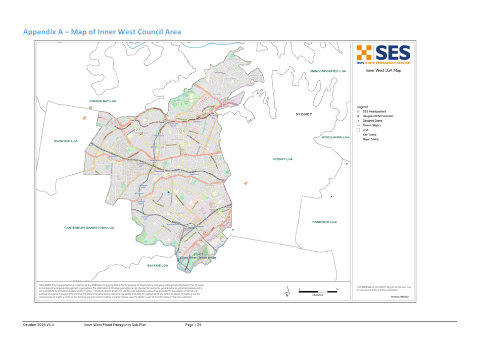
Subject: Inner West Local Flood Plan
Prepared By: James Ogg - Stormwater and Asset Planning Coordinator
Authorised By: Ryann Midei - Director Infrastructure
|
RECOMMENDATION
1. That the Flood Management Advisory Committee endorse the amended Inner West Council Flood Emergency Sub Plan |
STRATEGIC OBJECTIVE
This report supports the following strategic directions contained within Council’s Community Strategic Plan:
|
2: Liveable, connected neighbourhoods and transport |
|
|
BACKGROUND
The Inner West Council Flood Emergency Sub Plan is a sub plan of the Inner West Council Local Emergency Management Plan (EMPLAN). It has been prepared in accordance with the provisions of the State Emergency Service Act 1989 (NSW) and is endorsed by the Local Emergency Management Committee in accordance with the provisions of the State Emergency and Rescue Management Act 1989 (NSW).
The Flood Emergency Sub Plan has been prepared by NSW State Emergency Service (SES) as the lead combat agency for flooding under the Inner West Council Local Emergency Management Plan (EMPLAN) and sets out the multi-agency arrangements for the emergency management of flooding in the Inner West Council Local Government Area (LGA).
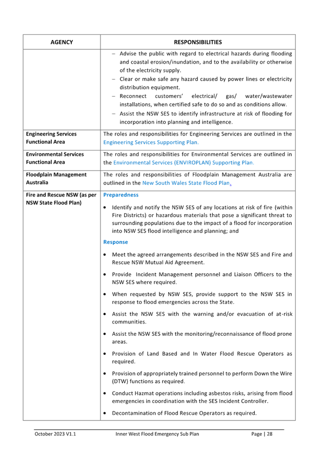
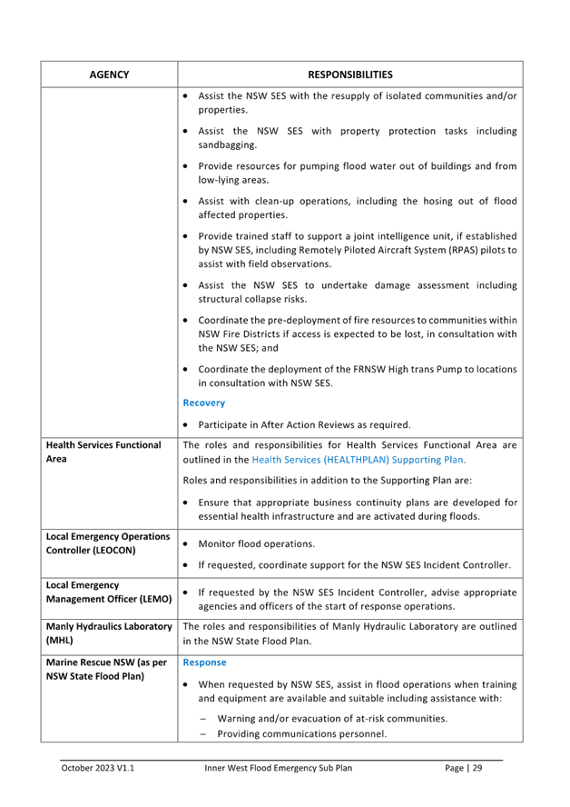
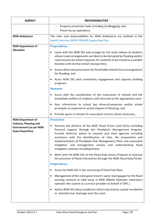
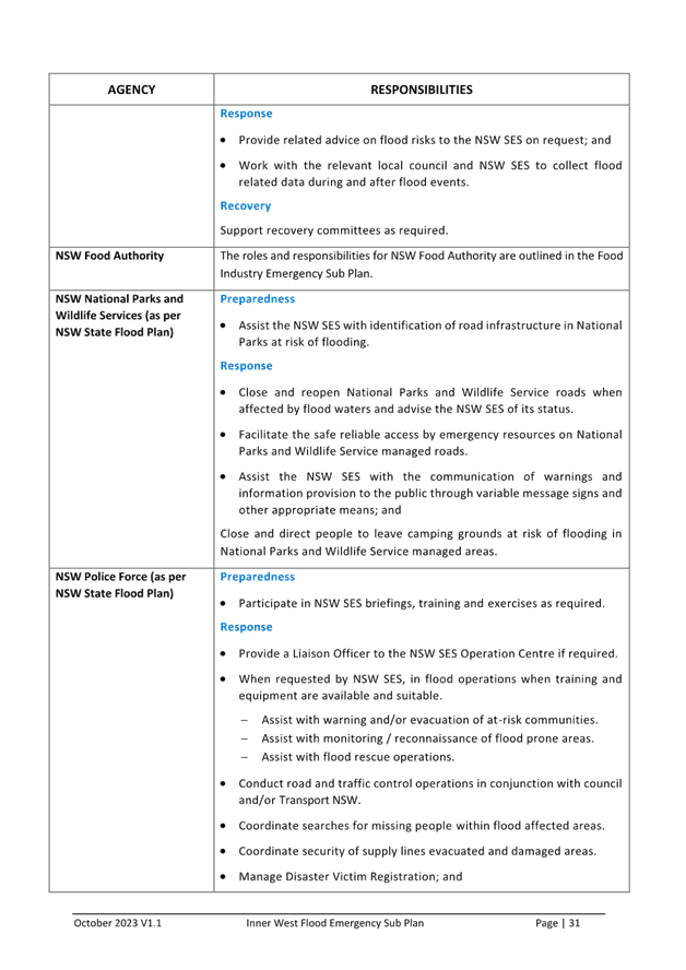
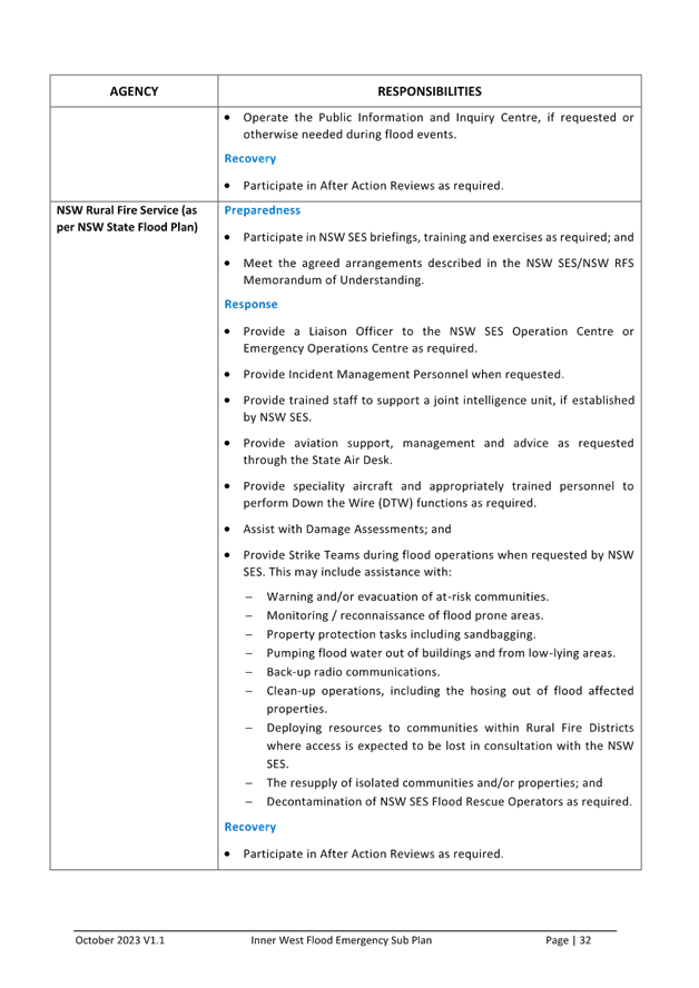
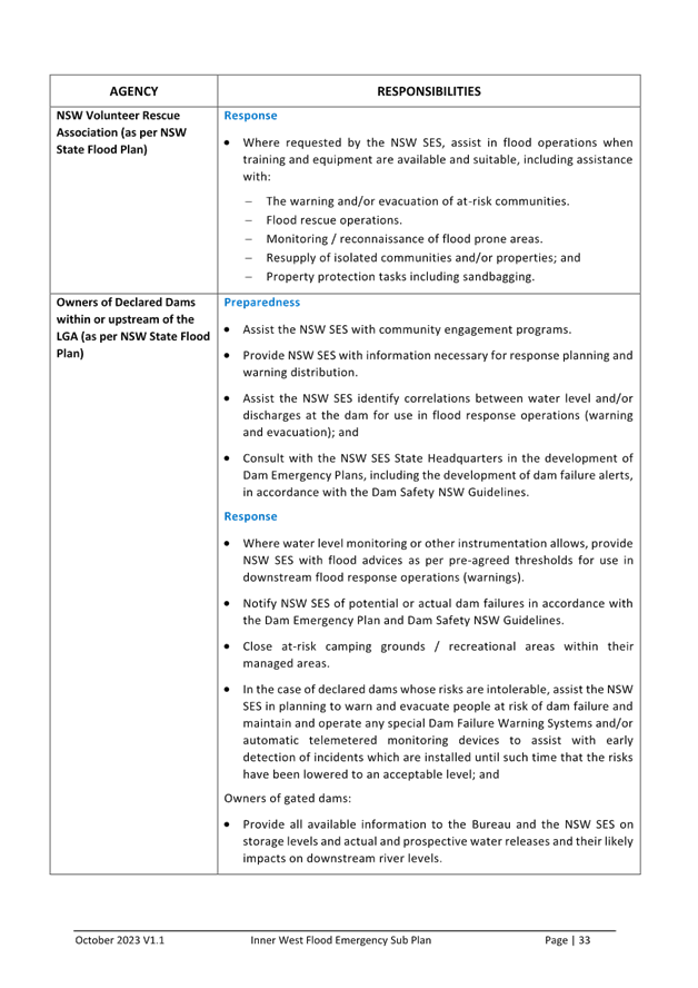
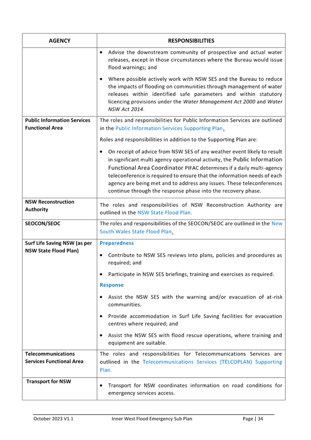
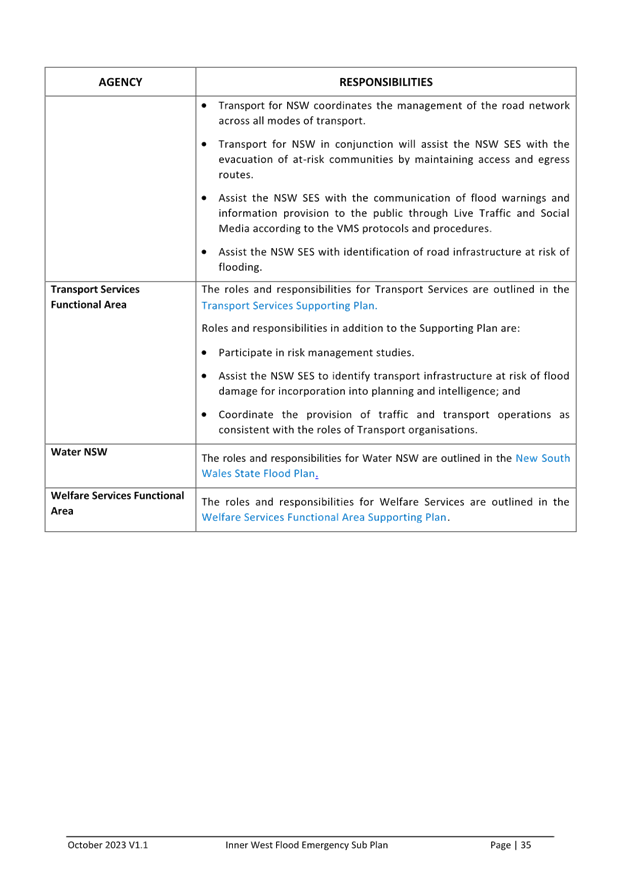
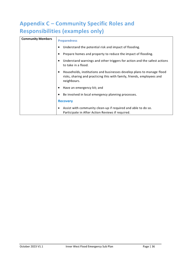
It outlines measures and strategies to prepare and respond to flooding. Under the Sub Plan NSW SES is responsible for
- Development of Flood Intelligence Systems & Warning Systems
- Maintaining a flexible volunteer workforce to support community resilience
- Working with individuals, communities, businesses and government agencies to build flood resilience
- Flood response operations
- Incident Control Centres
- Logistics Control
- Issuing of information and warnings during a flood event
These actions are supported by the officers and resources of Inner West Council.
The current Sub Plan has been adopted by Inner West Council and the Local Emergency Management Committee since December 2021.
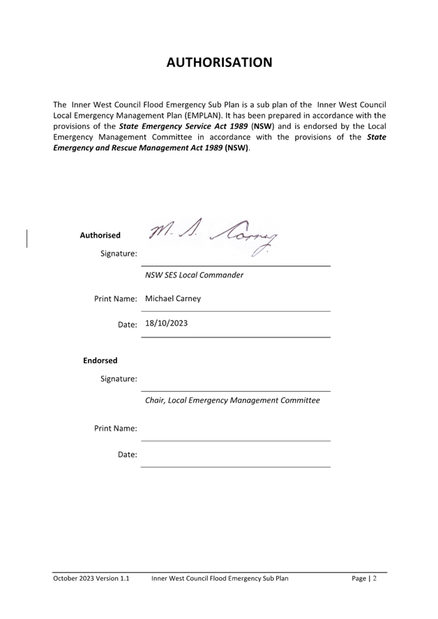
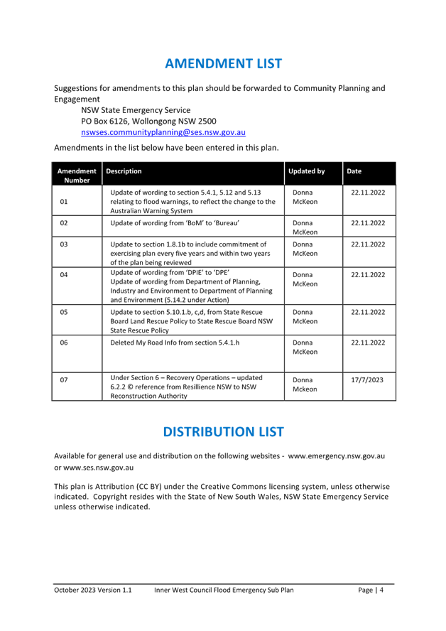
The current changes proposed in the most recent version of are administrative changes relating to changes to Flood Warnings in accordance with the Australian Warning System (AWS) to provide a nationally consistent approach to warnings, and administrative changes regarding the renaming of State Government departments.
The amended Sub Plan has been reviewed and endorsed by the Local Emergency Management Committee at its meeting on 9 November 2023 and is now being presented to the Flood Management Advisory Committee for endorsement.
FINANCIAL IMPLICATIONS
There are no financial implications associated with the implementation of the proposed recommendations outlined in the report.
|
1.⇩ |
Inner West Flood Emergency Sub Plan |