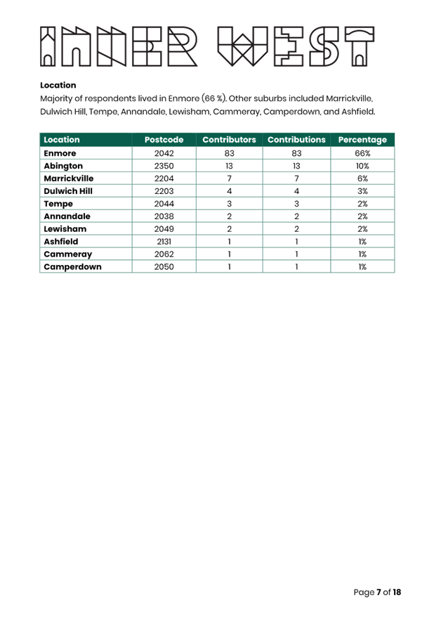
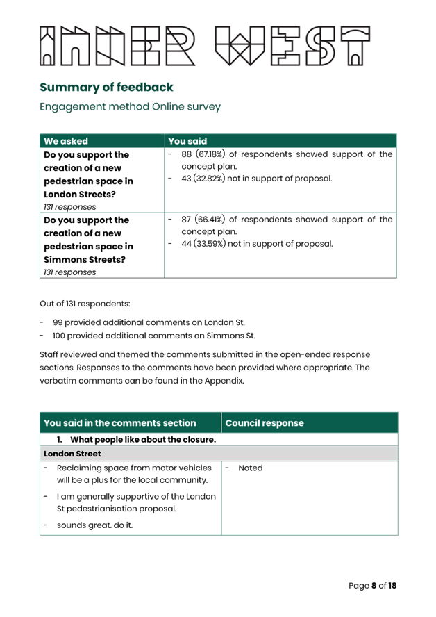
|
AGENDA R |

Local Traffic Committee Meeting
MONDAY 18 MARCH 2024
11:00 AM
|
|
Local Traffic Committee Meeting 18 March 2024 |
Function of the Local Traffic Committee
Background
Roads and Maritime Services (RMS) is legislated as the Authority responsible for the control of traffic on all NSW Roads. The RMS has delegated certain aspects of the control of traffic on local roads to councils. To exercise this delegation, councils must establish a local traffic committee and obtain the advice of the RMS and Police. The Inner West Council Local Traffic Committee has been constituted by Council as a result of the delegation granted by the RMS pursuant to Section 50 of the Transport Administration Act 1988.
Role of the Committee
The Local Traffic Committee is primarily a technical review and advisory committee which considers the technical merits of proposals and ensures that current technical guidelines are considered. It provides recommendations to Council on traffic and parking control matters and on the provision of traffic control facilities and prescribed traffic control devices for which Council has delegated authority. These matters are dealt with under Part A of the agenda and require Council to consider exercising its delegation.
In addition to its formal role as the Local Traffic Committee, the Committee may also be requested to provide informal traffic engineering advice on traffic matters not requiring Council to exercise its delegated function at that point in time, for example, advice to Council’s Development Assessment Section on traffic generating developments. These matters are dealt with under Part C of the agenda and are for information or advice only and do not require Council to exercise its delegation.
Committee Delegations
The Local Traffic Committee has no decision-making powers. The Council must refer all traffic related matters to the Local Traffic Committee prior to exercising its delegated functions. Matters related to State Roads or functions that have not been delegated to Council must be referred directly to the RMS or relevant organisation.
The Committee provides recommendations to Council. Should Council wish to act contrary to the advice of the Committee or if that advice is not supported unanimously by the Committee members, then the Police or RMS have an opportunity to appeal to the Regional Traffic Committee.
Committee Membership & Voting
Formal voting membership comprises the following:
· one representative of Council as nominated by Council;
· one representative of the NSW Police from each Local Area Command (LAC) within the LGA, being Newtown, Marrickville, Leichhardt and Ashfield LAC’s.
· one representative from the RMS; and
· State Members of Parliament (MP) for the electorates of Summer Hill, Newtown, Heffron, Canterbury, Strathfield and Balmain or their nominees.
Where the Council area is represented by more than one MP or covered by more than one Police LAC, representatives are only permitted to vote on matters which effect their electorate or LAC.
Informal (non-voting) advisors from within Council or external authorities may also attend Committee meetings to provide expert advice.
Committee Chair
Council’s representative will chair the meetings.
Public Participation
Members of the public or other stakeholders may address the Committee on agenda items to be considered by the Committee. The format and number of presentations is at the discretion of the Chairperson and is generally limited to 3 minutes per speaker. Committee debate on agenda items is not open to the public.
|
|
Local Traffic Committee Meeting 18 March 2024 |
|
AGENDA |
1 Apologies
2 Disclosures of Interest
3 Confirmation of Minutes
Minutes of 19 February 2024 Local Traffic Committee 5
4 Matters Arising from Council’s Resolution of Minutes
5 Part A – Items Where Council May Exercise Its Delegated Functions
Traffic Matters
ITEM Page
LTC0324(1) Item 1 Newtown South LATM Study (Damun-Stanmore Ward/Newtown Electorate/Inner West PAC) 20
LTC0324(1) Item 2 Jaggers Lane, Balmain - Permanent Road Closure Proposal (Baludarri - Balmain Ward Balmain Electorate Leichhardt PAC) 116
LTC0324(1) Item 3 Vincent Street, Balmain - Proposed Stormwater Improvements (Baludarri - Balmain Ward/Balmain Electorate/Leichhardt PAC) 133
LTC0324(1) Item 4 Deakin Avenue, Haberfield Edge - proposed line marking installation (Baludarri - Balmain Ward Balmain Electorate Leichhardt PAC) 139
LTC0324(1) Item 5 Bay Street and Hammond Avenue, Croydon - Proposed 'No Stopping' restrictions (Gulgadya-Croydon Ward/Strathfield Electorate/Inner West PAC) 149
LTC0324(1) Item 6 Dalmar and Byron Streets, Croydon - Proposed 'No Stopping' restrictions (Gulgadya-Croydon Ward/Strathfield Electorate/Inner West PAC) 152
LTC0324(1) Item 7 Gould Avenue, Lewisham - Proposed 'No Stopping' restrictions (Damun-Lewisham Ward/Newtown Electorate/Inner West PAC) 158
LTC0324(1) Item 8 Belmore Street, Tempe - Proposed 'No Parking' restrictions (Midjuburi-Tempe Ward/Heffron Electorate/Inner West PAC) 165
LTC0324(1) Item 9 Denison Street, Camperdown, south of Kilner Lane - Proposed kerb extension and ramp (Damun-Camperdown/Newtown Electorate/Inner West PAC) 168
LTC0324(1) Item 10 Meeks Road at Victoria Road, Marrickville – Proposed intersection Improvements - Design Plan 10268 (Midjuburi-Marrickville Ward / Summer Hill Electorate / Inner West PAC) 171
LTC0324(1) Item 11 Ewart Street, Dulwich Hill And (Lower) Railway Parade, Sydenham - Temporary Parking Changes On 4 Weekends During Weekend Rail Replacement Operations - Bus Replacements (Midjuburi -Marrickville Ward / Summer Hill Electorate / Inner West PAC) 175
LTC0324(1) Item 12 Ewart Street, Dulwich Hill; Illawarra Road, Marrickville; Burrows Avenue, Railway Road, Gleeson Avenue And (Lower) Railway Parade, Sydenham - Temporary Parking Changes During Major Rail Shutdown Of T3 Line For Sydney Metro Upgrade Works - Bus Replacements Saturday 13 April 2024 To Wednesday 24 April 2024 (Midjuburi -Marrickville Ward / Summer Hill Electorate / Inner West PAC) 180
LTC0324(1) Item 13 Grosvenor
Crescent (Sloane Street to Liverpool Road),
Summer Hill-Proposed Raised Thresholds (Speed Humps) (Djarrawunang-Ashfield
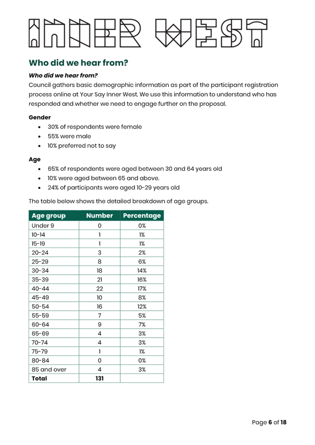
Ward/Summer Hill Electorate/
Burwood PAC) 192
LTC0324(1) Item 14 Tideswell
Street, Ashfield (off Liverpool Road)-Proposed
Kerb Extensions and kerb ramps (Djarrawunang-Ashfield Ward/Summer Hill
Electorate/Burwood PAC) 199
LTC0324(1) Item 15 London Street and Simmons Street, Enmore – Proposed Temporary Road Closure and Part Road Closure (Damun-Newtown Ward/Newtown Electorate/Inner West PAC) 206
Parking Matters
ITEM Page
LTC0324(1) Item 16 Amendment to
signposted Car Share Vehicles spaces in the
Inner West (All Wards, All Electorates, All PACs) 250
Late Items
Nil at time of printing.
6 Part B - Items for Information Only
Nil at the time of printing.
7 Part C - Items for General Advice
Nil at the time of printing.
8 General Business
9 Close of Meeting
|
|
Local Traffic Committee Meeting 18 March 2024 |
Minutes of Meeting
Meeting commenced at 11:06 AM
ACKNOWLEDGEMENT OF COUNTRY BY CHAIRPERSON
I acknowledge the Gadigal and Wangal people of the Eora nation on whose country we are meeting today, and their elders past and present.
COMMITTEE REPRESENTATIVES PRESENT
|
Manod Wickramasinghe |
IWC’s Traffic and Transport Planning Manager (Chair) |
|
Bill Holliday |
Representative for Kobi Shetty MP, Member for Balmain |
|
Graeme McKay |
Representative for Jo Haylen MP, Member for Summer Hill |
|
Kate Wheatley |
Representative for Jenny Leong MP, Member for Newtown |
|
Sgt Shannon Burns |
NSW Police – Leichhardt Police Area Command |
|
Nina Fard |
Transport for NSW (TfNSW) |
|
|
|
|
|
|
|
NON VOTING MEMBERS IN ATTENDANCE |
|
|
|
|
|
Colin Jones |
Inner West Bicycle Coalition (IWBC) |
|
Michael Takla |
Representative for Transit Systems |
|
Roderick Primerano |
Representative for U-Go Mobility |
|
Sunny Jo |
IWC’s Coordinator Traffic Engineering Services (North) |
|
George Tsaprounis |
IWC’s Coordinator Traffic Engineering Services (South) |
|
Christy Li |
IWC’s Business Administration Officer |
|
|
|
|
|
|
|
VISITORS |
|
|
Rachael Casella |
Resident (Item 11) |
|
|
|
|
|
|
|
APOLOGIES: |
|
|
Mayor Darcy Byrne |
Councillor – Baludarri-Balmain Ward |
|
Therese O’Reilly |
Representative for the Member for Summer Hill |
|
|
|
|
|
|
DISCLOSURES OF INTERESTS:
Nil.
CONFIRMATION OF MINUTES
|
That the Minutes of the Local Traffic Committee held on Monday, 11 December 2023 be confirmed. |
MATTERS ARISING FROM COUNCIL’S RESOLUTION OF MINUTES
Nil.
|
LTC0224(1) Item 1 John Street at Croydon Road, Croydon - Implementation Of 'No Left Turn, Vehicle Over 6m' Restriction (Gulgadya-Leichhardt Ward/Strathfield Electorate/Burwood PAC) |
|
On 22 December 2023, a large vehicle attempted to turn left from John Street into Croydon Road, Croydon and as a result damaged the awning of café ‘Double Dose Croydon’, located at No.125-131 Croydon Road, and displaced a bollard located on the footpath. In response to this, Council on the same day installed a ‘No Left Turn, Vehicles Over 6m’ restriction from John Street into Croydon Road as an interim safety measure.
Swept path assessment has demonstrated that a Service Vehicles (8.8m) is unable to negotiate the turn left from John Street into Croydon Road as a result of the pedestrian refuge island located in Croydon Road immediately south of John Street. As such, it is recommended that the ‘No Left Turn, Vehicles Over 6m’ restriction be approved to be implemented permanently.
Officers Recommendation
1. That a ‘No Left Turn, Vehicles over 6m’ restriction be permanently installed at the intersection of John Street and Croydon Road, Croydon, prohibiting vehicles over 6 m (in length) from turning left into Croydon Road from John Street.
2. That a Traffic Management Plan be issued to Transport for NSW seeking approval for the above ‘No Left Turn’ ban.
DISCUSSION:
The Representative for the Inner West Bicycle Coalition questioned if this proposal was due to John Street, between Fredrick Street and Croydon road becoming a rat run. Council Officer’s responded that the recommendation was in relation to large vehicles turning left and damaging the awning of the adjacent local business.
The Committee members agreed with the Officer’s recommendation.
COMMITTEE RECOMMENDATION:
1. That a ‘No Left Turn, Vehicles over 6m’ restriction be installed at the intersection of John Street and Croydon Road, Croydon, prohibiting vehicles over 6 m (in length) from turning left into Croydon Road from John Street.
2. That a Traffic Management Plan be issued to Transport for NSW seeking approval for the above ‘No Left Turn’ ban.
For Motion: Unanimous |
|
LTC0224(1) Item 2 Davis Street, Dulwich Hill at the rail overbridge between Windsor Road and Victoria Street – Temporary full road closure ((Djarrawunang - Ashfield Ward/ Summer Hill Electorate/ Inner West PAC) |
|
An application has been received from Gartner Rose for the temporary full road closure of Davis Street, Dulwich Hill at the rail overbridge between Windsor Road and Victoria Street, for a 6-month period beginning from March 2024 to the end of August 2024 in order to facilitate the tunnelling works under Davis Street associated with the GreenWay Project. The road will be temporarily closed to all vehicular traffic, including emergency vehicles. It is noted that works will commence prior to the Council meeting in March, 2024, therefore, it is recommended that the temporary full road closures be endorsed in this case, subject to the conditions outlined in this report.
Officers Recommendation
That the temporary full road closure (ENRC/2024/0004) of Davis Street, Dulwich Hill at the rail overbridge between Windsor Road and Victoria Street, for a 6-month period beginning from March 2024 to the end of August 2024 be endorsed, in order to facilitate the tunnelling works under Davis Street associated with the GreenWay Project subject to, but not limited to, the following conditions:
1. A Road Occupancy License be obtained by the applicant from the Transport Management Centre;
2. All affected residents and businesses, including the NSW Police Local Area Commander, Fire & Rescue NSW and the NSW Ambulance Services be notified in writing, by the applicant, of the proposed temporary road closure at least 7 days in advance of the closure with the applicant making reasonable provision for stakeholders;
3. The occupation of the road carriageway must not occur until the road has been physically closed; and
4. The applicant is to set up the road closure and detours as proposed in the Traffic Guidance Schemes submitted to Council on 23 January 2024.
DISCUSSION:
The Representative for the Member for Summer Hill questioned if Constitution Road will be re-opened prior to the temporary full road closure of Davis Street, Dulwich Hill at the rail overbridge between Windsor Road and Victoria Street.
Council Officer’s advised that the plan is to have Constitution Road re-opened before the works begin at Davis Street, Dulwich Hill. Council Officer’s advised they will follow up with Gartner Rose regarding the re-opening of Constitution Road prior to the beginning of works on Davis Street.
The Committee members agreed with the Officer’s recommendation.
COMMITTEE RECOMMENDATION:
That the temporary full road closure (ENRC/2024/0004) of Davis Street, Dulwich Hill at the rail overbridge between Windsor Road and Victoria Street, for a 6-month period beginning from March 2024 to the end of August 2024 be endorsed, in order to facilitate the tunnelling works under Davis Street associated with the GreenWay Project subject to, but not limited to, the following conditions:
1. A Road Occupancy License be obtained by the applicant from the Transport Management Centre;
2. All affected residents and businesses, including the NSW Police Local Area Commander, Fire & Rescue NSW and the NSW Ambulance Services be notified in writing, by the applicant, of the proposed temporary road closure at least 7 days in advance of the closure with the applicant making reasonable provision for stakeholders;
3. The occupation of the road carriageway must not occur until the road has been physically closed; and
4. The applicant is to set up the road closure and detours as proposed in the Traffic Guidance Schemes submitted to Council on 23 January 2024.
For Motion: Unanimous |
General Business:
|
Item 14 – Rozelle Parkland internal pathways closed due to asbestos in mulch |
|
The Representative for the Member for Balmain raised concerns of closures of internal pathways within the Rozelle Parklands causing access issues for pedestrians and cyclists going to and from Rozelle, Lilyfield and the City. The Representative for the Member of Balmain questioned if it would be possible to fence off the areas affect by the asbestos and allow the pathways to be reopened for pedestrian access. The Representative for Transport for NSW stated that due to the EPA requirements, the entire site had to be closed. It was advised that the mulch removal was progressing with 30% removed to date. The Transport for NSW representative advised that further detail will be released with the minutes. The Representative for the member for Balmain asked if the paths could be opened progressively to restore access more quickly.
|
|
Item 15 – Parked vehicles overhanging footpath in Robert Street, Balmain |
|
The Representative for the Member for Balmain raised concerns regarding vehicles obstructing the northern footpath of Robert Street, Rozelle east of Mullens Street. The Representative for the Member for Balmain advised that long vehicles overhang the footpath, obstructing access and requiring pedestrians to walk on the road. Council Officers will investigate this concern. |
|
Item 16 – Frederick Street and John Street, Ashfield traffic signal update |
|
The Representative for the Member for Summer Hill requested an updated on the traffic signals at the intersection of Fredrick Street and John Street, Ashfield. The Representative for Transport for NSW advised there is no further update at the moment however the procurement for the design is in progress and that the traffic signals at the intersection of Fredrick Street and John Street, Ashfield has been added to the Transport for NSW’s project list and system. The Representative for Transport for NSW also noted that once the consultants have been engaged, we will receive regular reporting back. |
|
Item 17 – Rozelle Parklands Bicycle Facilities |
|
The Representative for Inner West Bicycle Coalition raised concerns regarding the interface between the bicycle paths in the Rozelle Parklands and Lilyfield Road, specifically the height of the lip on the access ramps. Council Officers advised that they were aware of this issue and had raised it with the Transport for NSW project team and will again follow up.
|
|
Item 18 – Edgeware Road, Alice Street and Llewellyn Street, Newtown intersection signal upgrade |
|
The Representative for the Member for Newtown requested an update on the Edgeware Road, Alice Street and Llewellyn Street intersection signal upgrade. Council Officers advised that they were commencing a procurement process to engage a contractor to undertake works and expect construction to commence in March 2024 with completion by 30 June 2024.
|
|
Item 19 – Camdenville Public School crossing guard |
|
The Representative for the Member for Newtown requested an update on the crossing guard recruitment update for Camdenville Public School. The Representative for Transport for NSW advised that they would follow up on the issue.
|
|
Item 20 – Transport for NSW Delegation Changes |
|
The Representative for the Inner West Bicycle Coalition questioned whether Council will be adopting Transport for NSW’s new temporary delegations to Council for traffic facilities which would mean that some traffic facilities could be approved without referral to the Traffic Committee. Council Officers advised that it was their understanding that this was a voluntary and temporary delegation and Inner West Council was still referring items to the Traffic Committee as this was a more transparent process and ensured that consultation with NSW Police, Transport for NSW and other stakeholders was captured.
|
Meeting closed at 11:58pm.
CHAIRPERSON
|
|
Local Traffic Committee Meeting 18 March 2024 |
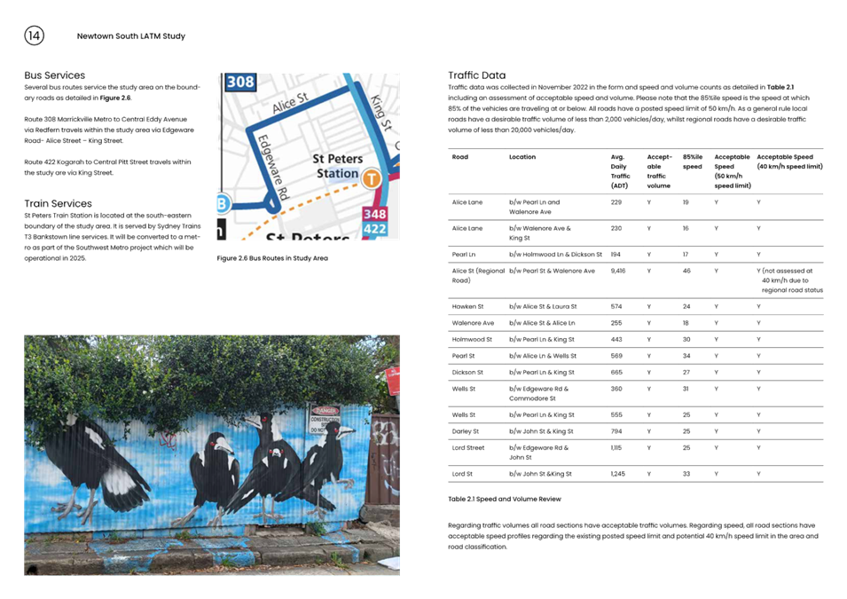
Subject: Newtown South LATM Study (Damun-Stanmore Ward/Newtown Electorate/Inner West PAC)
Prepared By: Jason Scoufis - Coordinator Traffic Studies and Road Safety
Authorised By: Manod Wickramasinghe - Traffic and Transport Planning Manager
|
RECOMMENDATION
1. That the final draft Newtown South Local Area Traffic Management (LATM) Study be endorsed for community consultation.
2. The report be placed on Public Exhibition, providing a minimum 28 days for community feedback and the results be reported back to the Traffic Committee.
|
STRATEGIC OBJECTIVE
This report supports the following strategic directions contained within Council’s Community Strategic Plan:
|
2: Liveable, connected neighbourhoods and transport |
|
|
EXECUTIVE SUMMARY
Council has prepared a draft Local Area Traffic Management (LATM) study to address key community concerns about traffic, pedestrian and cycling facilities in the Newtown South LATM precinct area.
The recommendations aim to align with Council policies and strategies, with an emphasis on improving pedestrian and cyclist movements, whilst retaining safe and acceptable traffic volume and speeds in local streets.
BACKGROUND
As part of Council’s Local Area Traffic Management (LATM) Strategy Review Program Council has prepared the Newtown South LATM study.
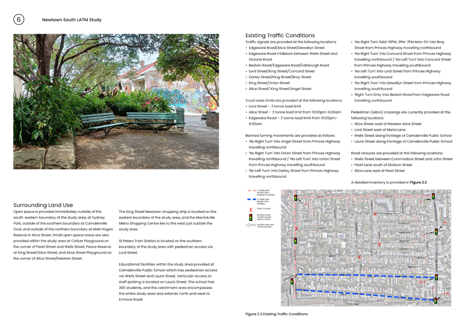
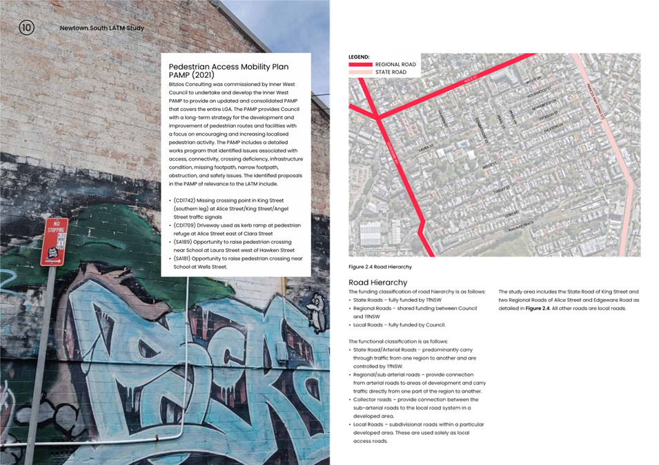
The Newtown South LATM precinct is bounded by The Newtown South LATM Area (M7) is bounded by Edgeware Road, King Street (Princes Highway), Alice Street, and Lord Street.
The final draft report is provided in Attachment 1 and the Engagement Outcomes Report provided in Attachment 2.
The Newtown South LATM was initially completed in 2007 and approved by Council in 2008.
In developing recommendations for the LATM Study, consideration was given to incorporate the following principals of Local Area Traffic Management:
· Reduction in vehicle speeds.
· Minimise traffic levels and intruding traffic in a local street.
· Minimise crash risk.
· Improve local amenity by:
o Reducing car use
o Increasing use of public transport
o Increasing walking and cycling
o Improving the streetscape
Traffic tube counts and intersection counts were collected, and crash history reviewed to assist the study. Further site observations and review of community engagement outcomes also assisted to determine what type of facility was warranted in specific locations.
It should be noted that Council is also currently developing the Newtown Enmore Public Domain Masterplan which is considering improvements to King Street which lies on the eastern boundary of the LATM Study area.
A summary of the recommendations is detailed below.
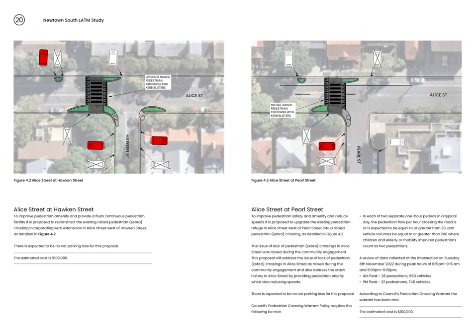
· Reconstruct the existing raised pedestrian (zebra) crossing incorporating kerb extensions in Alice Street west of Hawken Street.
· Upgrade the existing pedestrian refuge in Alice Street west of Pearl Street into a raised pedestrian (zebra) crossing.
· Upgrade the existing pedestrian refuge in Alice Street west of Walenore Avenue into a raised pedestrian (zebra) crossing.
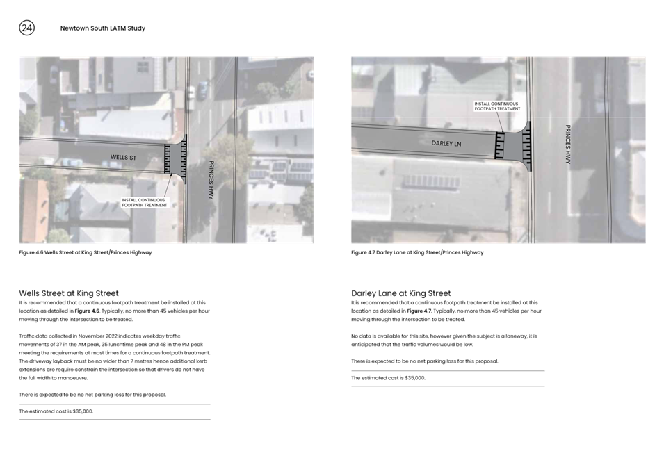
· Install continuous footpath treatment in Dickson Street at King Street.
· Install continuous footpath treatment in Wells Street at King Street.
· Install continuous footpath treatment in Darley Lane at King Street.
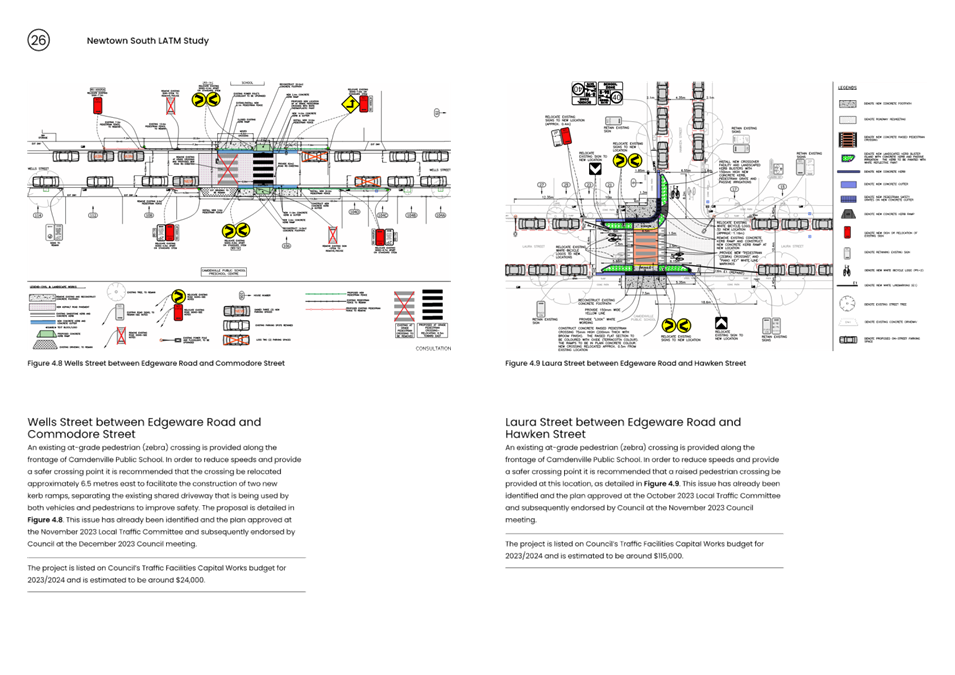
· Relocate pedestrian crossing approximately 6.5 metres east to facilitate the construction of two new kerb ramps, separating the existing shared driveway at frontage of Camdenville Public School.
· Upgrade existing at grade pedestrian (zebra) crossing to a raised pedestrian crossing in Laura Street along frontage of Camdenville Public School.
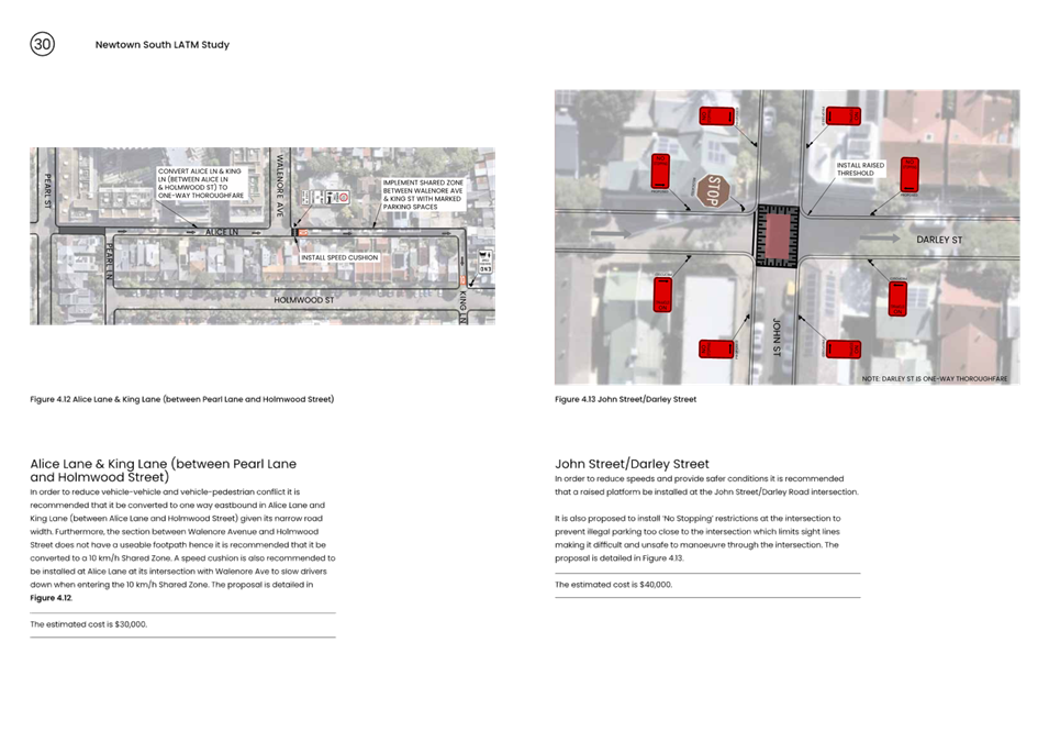
· Convert full length from Pearl Street to Holmwood Street to one way eastbound and convert section between Walenore Avenue and Holmwood Street to a 10 km/h Shared Zone.
· A raised platform be installed at the John Street/Darley Street intersection.
· A raised platform be installed at the John Street/Lord Street intersection.
· Widen the Lord Street southern footpath between King Street and the access to the railway station, a length of some 50 metres.
· Install statutory 10 metres of ‘No Stopping’ at the Pearl Street/Wells Street intersection.
· Install statutory 10 metres of ‘No Stopping’ on both the southern and northern side of the Wells Street/Edgeware Road intersection.
· Install ‘No Stopping’ at the Laura Street/Commodore Street intersection – reduced ‘No Stopping’ restriction may be implemented subject to TfNSW approval.
· Amend the existing timed parking restrictions from ‘No Parking 8:30am-6:00pm Mon-Fri’ to ‘No Parking 8:30am-6:00pm Mon-Sat’ in Edgeware Road between Llewellyn Street and Victoria Road.
· Install raised pedestrian/cyclist crossing in Edgeware Road south of Bedwin Road with kerb extensions and median splitter island.
· Road bends in Wells Street at Commodore Street and Wells Street at John Street to be painted red with piano key landmarking at the approach and departure points, and footpath connection to be rebuilt with smooth connection between the two existing kerb ramps.
· Install Pedestrian Warning (left arrow) sign and supplementary ‘Disabled’ sign at Edgeware Road/Llewellyn Street/Alice Street intersection and request TfNSW upgrade the traffic signals to provide a safer crossing point for pedestrians crossing the Llewellyn Street leg of the intersection.
· Modify existing gate in Pearl Lane at Dickson Street to allow for bicycle access.
· Request TfNSW implement 40 km/h speed limit on Local Roads and 50 km/h speed limit on subject Regional Roads as per innerwest@40 study.
PUBLIC CONSULTATION
Council undertook a survey through Council’s Yoursay website with invitation letters mailed out to stakeholders and residents within the study area in May 2022. A total of 191 submissions were received through the online survey and a further 20 contributed through the online mapping tool. An additional 4 responses were received via email.
The main outcomes of the first stage of consultation are that the problems identified by the greatest number of respondents are high traffic volumes, followed by pedestrian safety and the third most raised issue was heavy vehicles using local roads.
Regarding specific streets, Edgeware Road, Alice Street and King Street have the highest level of concern for too much traffic, pedestrian safety, heavy vehicle uses and excessive speed.
Lord Street also has a level of concern for rat running and exceeding the speed limit. The results of the consultation are included in the Engagement Outcome Report as provided in Appendix A of the Final Draft LATM Report.
FINANCIAL IMPLICATIONS
The cost of proposed treatments as listed in the draft proposed treatments arising from the Newtown South LATM Study is estimated to cost approximately $933,350 (including GST). This cost takes into consideration 10% contingency. Once the LATM Study is adopted, detailed design and construction will be scheduled.
|
1.⇩ |
Attachment 1 Newtown South LATM Final Draft Report |
|
2.⇩ |
Attachment 2 - Newtown South LATM Engagement Outcomes Report Stage 1 |
|
Local Traffic Committee Meeting 18 March 2024 |
Subject: Jaggers Lane, Balmain - Permanent Road Closure Proposal (Baludarri - Balmain Wardbalmain Electorate Leichhardt PAC)
Prepared By: Amir Falamarzi - Traffic Engineer
Authorised By: Manod Wickramasinghe - Traffic and Transport Planning Manager
|
RECOMMENDATION
1. That the permanent road closure of Jaggers Lane, Balmain between Duncan Street and Caroline Street be approved subject to the approval of the Traffic Management Plan (TMP) by Transport for NSW.
2. That the closure of Jaggers Lane, Balmain be implemented as per the bollards and signposting plan provided in Attachment 2.
|
STRATEGIC OBJECTIVE
This report supports the following strategic directions contained within Council’s Community Strategic Plan:
|
2: Liveable, connected neighbourhoods and transport |
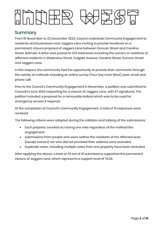
EXECUTIVE SUMMARY
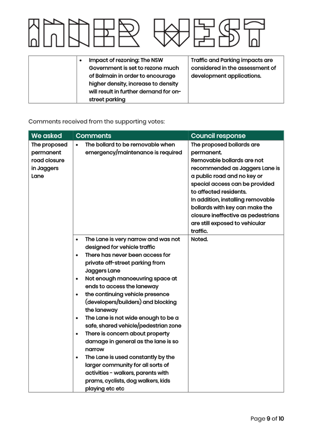
Following a petition that was submitted from residents for the permanent road closure of Jaggers Lane in June 2023, Council proposed to closure the lane to improve pedestrian safety and amenity. Public consultation was undertaken in late 2023 to invite residents with access in Jaggers Lane and surrounding streets to provide their feedback on the proposed lane closure. Out of the 31 submissions received, 23 supported (74.2 % of submissions), and 8 (25.8% of submissions) have opposed the proposal.
The public consultation also sought feedback from utility companies and organisations regarding a permanent closure of the laneway. It was generally found that proposed bollard locations for a closure would need to be adjusted on both ends of the laneway.
A traffic counter was deployed, and collected traffic data for 7 days, and found very low levels of traffic. It was also found that the vehicle speeds were not significant.
BACKGROUND
In June 2023, Council received a petition from residents requesting the closure of Jaggers Lane, between Duncan Street and Caroline Street, Balmain. The petition was submitted with 47 names and signatures and proposed a closure for motor vehicles in the laneway by installing removable bollards at each end of the laneway which may be removed for emergency access.
Jaggers Lane is a laneway comprising of a narrow width (approx. 3m) and the rationale for the road closure is due to the insufficient road width for pedestrians and vehicles to safety pass each other. The proposed closure is expected to improve pedestrian safety and amenity.
DISCUSSION
The petition prompted an investigation to examine the viability of a permanent closure of Jaggers Lane. As part of this investigation, public consultation has been undertaken to gauge the level of support for the closure, internal and external stakeholders have been liaised with to determine if the closure adversely impacts on their operations. Additionally, traffic data along Jaggers Lane has been collected to analysis movements and a vehicle swept path assessment has been undertaken at each end of Jaggers Lane to Duncan Street and Caroline Street.
Community Engagement Process
From 15 November to 22 December 2023, Council undertook Community Engagement to residents and businesses near Jaggers Lane inviting to provide feedback on a permanent closure proposal of Jaggers Lane between Duncan Street and Caroline Street, Balmain. A letter was posted to 323 addresses including the owners or residents of affected residents in Waterview Street, Colgate Avenue, Caroline Street, Duncan Street and Jaggers Lane.
In this respect, the community had the opportunity to provide their comments through the variety of methods including an online survey (Your Say Inner West), post, email and phone call. Council also organised a notice published in The Sydney Morning Herald newspaper on 23 November 2023 to invite residents to provide their feedback on the proposed road closure over a 28 day period.
At the completion of Council’s Community Engagement, a total of 31 submissions from different properties were received, with 23 in support (74.2%) and 8 (25.8%) opposed the proposal. A copy of the engagement outcomes report is included in Attachment 1 which provides a breakdown of comments and concerns received from the community.
Traffic Redistribution
A traffic count has been undertaken on Jaggers Lane between 6 February 2024 and 12 February 2024, with the volume and traffic speed data summarised in Table 1 and Table 2 below.
Table 1: Traffic volume along Jaggers Lane
|
Traffic Volume (vehicles) Jaggers Lane, Balmain |
||||||||
|
24 hours |
Mon |
Tue |
Wed |
Thu |
Fri |
Sat |
Sun |
7-day average (veh/day) |
|
2 |
0 |
3 |
1 |
5 |
2 |
3 |
2.3 |
|
Table 2: Traffic speed along Jaggers Lane
|
Traffic Speed (km/h) Jaggers Lane, Balmain |
||
|
24 hours |
85% Speed (km/h) |
Average Speed (km/h) |
|
15.7 |
12.5 km/h |
|
Based on the traffic flows, the proposed closure will result in a negligible redistribution of traffic and therefore the closure is considered to have an acceptable impact on the local road network.
Impact on Utility Provider and Emergency Services
Consultation on the proposed permanent road closure was extended to utility service providers and emergency services to collect their feedback. Table 3 provides information received from various organisations as the time of this report:
|
Entity/organization |
Response received |
Feedback on proposed closure |
|
Ambulance NSW |
No |
No response has been provided. It is expected that as all of the affected properties along Jaggers Lane have access from surrounding streets, the road closure would not negatively impact on access to these properties. It is further noted that Ambulance vehicles are larger than an 85th percentile vehicle and access into Jaggers Lane from Caroline Street and Duncan Street could not be demonstrated for an 85th percentile vehicle. |
|
Fire & Rescue NSW |
No |
No response has been provided. Likewise, it is expected that as all the affected properties along Jaggers Lane have access from surrounding streets and the road closure would not negatively impact on access to these properties. It is further noted that Fire & Rescue vehicles are larger than an 85th percentile vehicle and access into Jaggers Lane from Caroline Street and Duncan Street could not be demonstrated for an 85th percentile vehicle. |
|
NBN |
No |
No response received regarding the proposal. A service check indicates no NBN services in the lane. |
|
Jemena |
No |
No response received regarding the proposal. A service check indicates no Jemena services in the lane. |
|
NSW State Emergency Service (SES) |
No |
no response received regarding the proposal. |
|
Council’s Waste Collection |
Yes |
No concern has been raised regarding the proposal. |
|
Telstra |
Yes |
Raised no objections to the proposal. |
|
Ausgrid |
Yes |
Ausgrid raised an access issue the existing streetlight in Jaggers Lane when maintenance work is required. To address this concern, it is proposed that the design of the bollards will be such that they could be removed if planned maintenance works require vehicular access to Jaggers Lane. |
|
Sydney Water |
Yes |
Sydney Water raised an access issue to their sewer mains on Jaggers Lane when maintenance works are required and vehicular access is essential. To address the concern the proposed bollard locations have been adjusted. The southern bollard has been relocated to the back of the sewer mains outside #31 Waterview Street to provide machinery and vehicular access. |
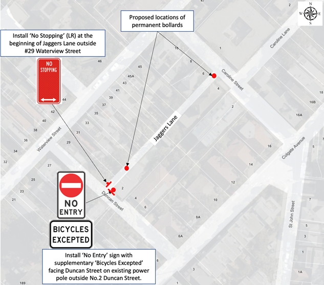
From the above feedback, the locations of the proposed bollards have been adjusted to provide suitable sewer access. These are outlined in Figure 1 below, with Figure 2 showing indicative locations of the bollards at each end of the laneway.
As the revised position of the proposed bollards at each end of the laneway may prompt residents or visitors to park at this location, it is proposed that these areas be appropriately signposted as ‘No Stopping’ to prevent the laneway from being obstructed.
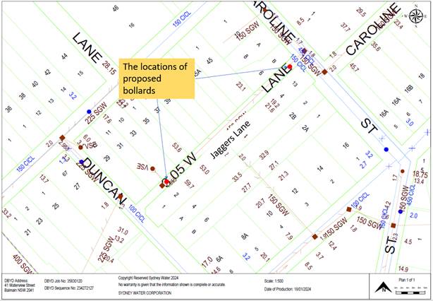
Figure 1: Plan view of proposed bollards
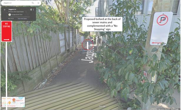
Figure 2: Location of the southern bollard (source Google Maps)
Swept Path Analysis
A swept path analysis for the 85th percentile vehicle exiting and entering Jaggers Lane from Caroline Street and Duncan Street has been undertaken.
The analysis found that the existing property boundaries, parking lanes, bollards, telegraph poles and fencing prevented a single movement for the 85th percentile vehicle from Caroline Street and Duncan Street into Jaggers Lane.
Through this analysis, vehicular access would require a multi-point turn to enter Jaggers Lane, which is not considered acceptable on a public road.
It should be noted that previous development applications for off-street parking in Jaggers Lane have not been supported as applicants have been unable to demonstrate that standard vehicles can access the lane and traverse through safely with consideration of current street furniture and parking.
Pedestrian-vehicle conflict
The proposed closure of Jaggers Lane would improve road safety by eliminating pedestrian and bicycle rider conflict with motor vehicles.
It is noted that the level of pedestrian and bicycle movements were found to be low.
Pedestrian movements in the lane are local in nature and provide access to nearby properties, predominately residents accessing Waterview Street properties and properties in Caroline Lane. It is noted that properties on the south side of Waterview Street have pedestrian gates that open onto the travel lane (see Figure 3 below) and access in the low volume Jaggers Lane may be a preferred option for pedestrian ingress and egress to these properties.
An examination of the crash database provided by Transport for NSW for the most recent 5 years revealed no reported crashes in Jaggers Lane.
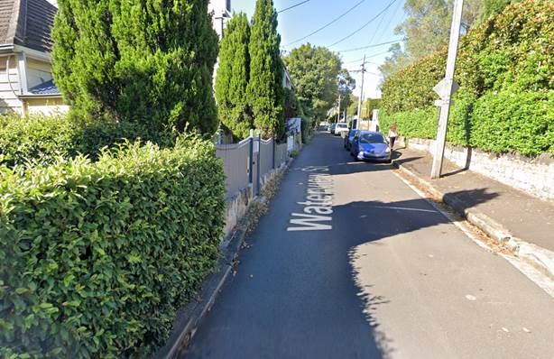
Figure 3: Waterview Street, facing south (source Google Maps)
Conclusion
Having considered the above and the majority resident support from Council’s Community Engagement, it is recommended to proceed with the proposed closure of Jaggers Lane on traffic and safety grounds.
To maintain suitable access for Sydney Water, it is recommended that the proposed bollard locations be adjusted as shown in Figure 1 and 2 in Jaggers Lane. Additionally, a ‘No Stopping’ zone is proposed for the southern end of Jaggers Lane at Duncan Street to prevent obstruction of the laneway by parked vehicles.
FINANCIAL IMPLICATIONS
The funding for the proposed bollards and signs is available within Council’s signs and linemarking budget.
|
1.⇩ |
Jaggers Lane, Balmain - Engagement Outcomes Report |
|
2.⇩ |
Jaggers Lane, Balmain - Signage Plan |
|
Local Traffic Committee Meeting 18 March 2024 |
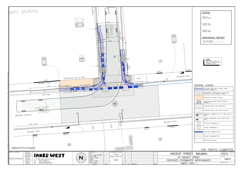
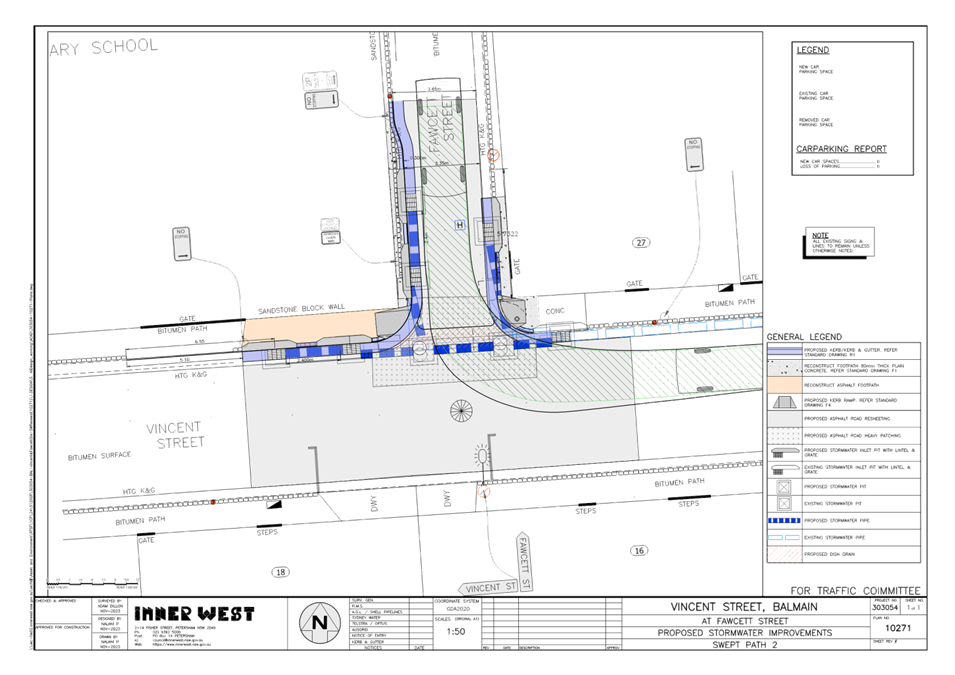
Subject: Vincent Street, Balmain - Proposed Stormwater Improvements (Baludarri - Balmain Ward/Balmain Electorate/Leichhardt PAC)
Prepared By: Charbel El Kazzi - Traffic Engineer
Authorised By: Manod Wickramasinghe - Traffic and Transport Planning Manager
|
RECOMMENDATION
That the attached detailed design plan (Design Plan No.10271) for the proposed stormwater improvements at Vincent and Fawcett Street, Balmain be approved. |
STRATEGIC OBJECTIVE
This report supports the following strategic directions contained within Council’s Community Strategic Plan:
|
2: Liveable, connected neighbourhoods and transport |
|
|
EXECUTIVE SUMMARY
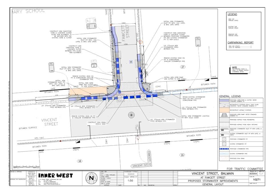
Council is planning drainage improvement works in Vincent Street & Fawcett Street, Balmain to better manage stormwater in this area by replacing and upgrading ageing stormwater infrastructure and reconstructing kerb returns, kerb ramps and road pavement.
The works will require the kerb-alignment within the existing ‘No Stopping’ zone to accommodate the inlet pits with lintels. The proposal will not change the existing parking arrangement in the streets and will result in no loss of parking spaces.
BACKGROUND
The detailed design plan shown in Attachment 1 outlines the proposed works on Vincent and Fawcett Street, Balmain and includes the following treatments:
• Construction of five (5) new stormwater drainage inlet pits with lintels & grates to replace the three (3) existing “head on” inlet pits at the intersection.
• Construct two (2) new junction pits to allow connections of new stormwater pipes to the main stormwater pipe in Vincent Street.
• Remove existing shallow and undersized stormwater pipes and lay new 375dia stormwater pipes to and connect to all the new stormwater inlet pits.
• Construct concrete kerb and gutter returns, new concrete dish drain, two (2) new kerb ramps and some concrete footpath at the intersection.
• Resurface the road pavement with new asphalt at the intersection to match with new works and levels.
A turning path assessment using an 8.8m service vehicle was also undertaken as per Attachment 2 and demonstrated the new kerb alignment is acceptable.
DISCUSSION
A letter outlining the proposal was issued to 31 properties shown in the distribution map below. No comments were received in response to this proposal.
FINANCIAL IMPLICATIONS
The works are expected to cost approximately $120,000 and are to be constructed under the 2024/25 Capital Works Stormwater Renewal Program.
|
1.⇩ |
Design Plan No.10271 |
|
2.⇩ |
Turning Path Assessment |
|
Local Traffic Committee Meeting 18 March 2024 |
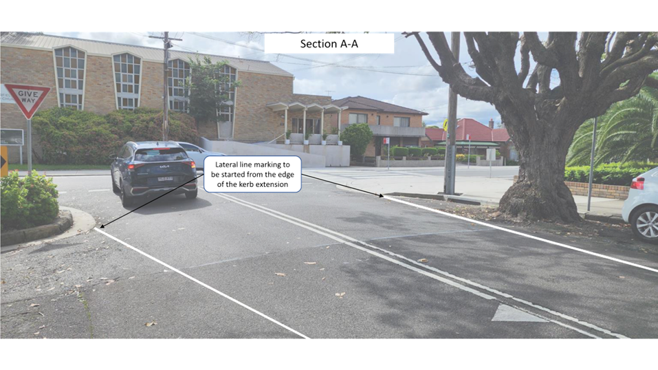
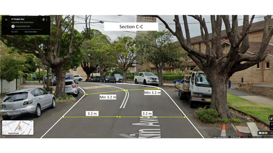
Subject: Deakin Avenue, Haberfield Edge - proposed line marking installation (Baludarri - Balmain Ward Balmain Electorate Leichhardt PAC)
Prepared By: Amir Falamarzi - Traffic Engineer
Authorised By: Manod Wickramasinghe - Traffic and Transport Planning Manager
|
RECOMMENDATION
That the installation of edge line marking on Deakin Avenue, Haberfield between Dalhousie Street and O’Connor Street be approved. |
STRATEGIC OBJECTIVE
This report supports the following strategic directions contained within Council’s Community Strategic Plan:
|
2: Liveable, connected neighbourhoods and transport |
|
|
EXECUTIVE SUMMARY
A request received from a resident regarding the speeding issue along Deakin Avenue, Haberfield and concerns of reckless driving from Deakin Avenue to Kingston Street. In order to alleviate this, it is proposed to install edge line marking along Deakin Avenue between Dalhousie Street and O’Connor Street.
BACKGROUND
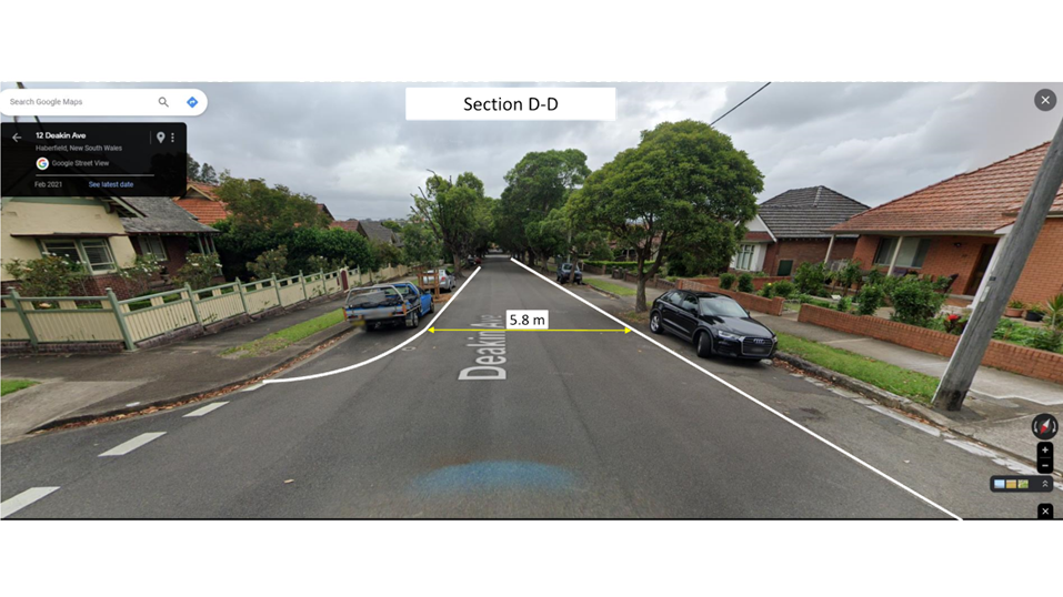
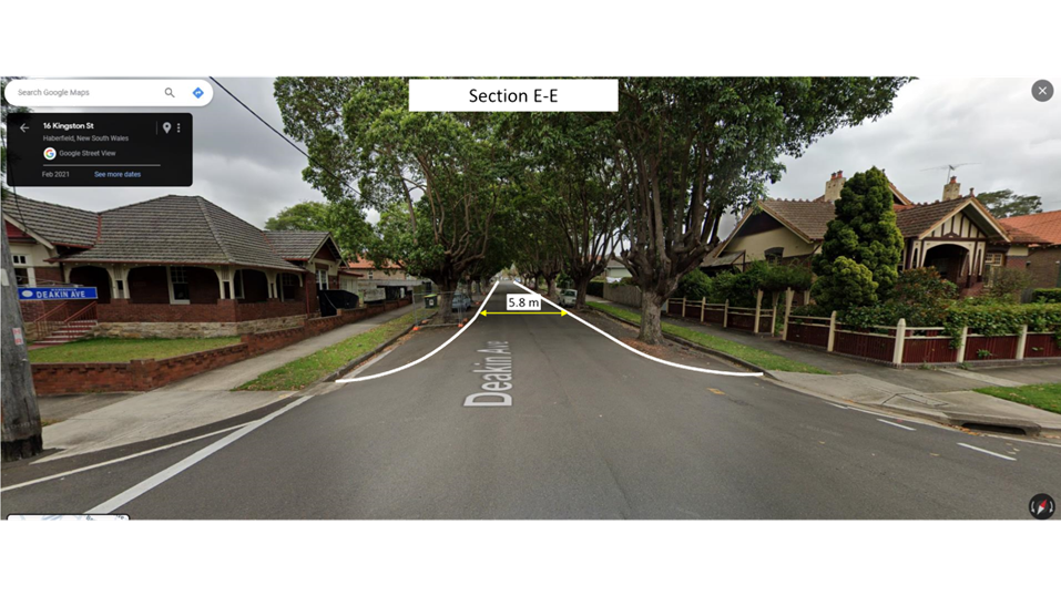
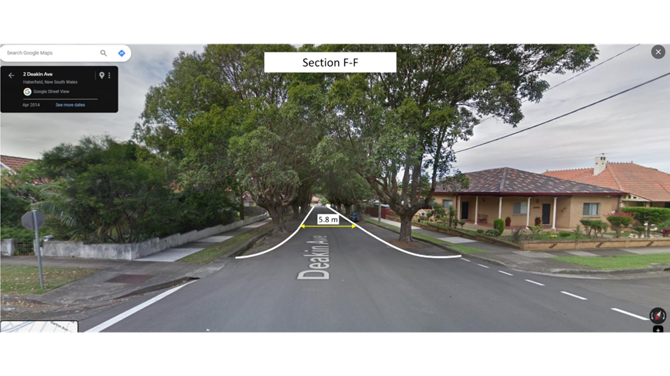
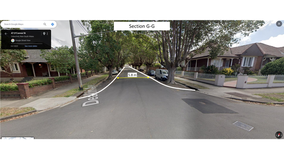
Deakin Avenue is a two-way local street stretched between Dalhousie Street and O’Connor Street. The signposted speed limit on Deakin Avenue is 50 km/h, consistent with other residential streets of Haberfield. The road width of Deakin Avenue is 12.8 m between kerbs however due to existence of street trees on its parking lanes, the width of the carriageway is reduced to approximately 7.0m.
TfNSW crash statistics portal indicates that no reported crashes have been reported in last five years along the street.
The recent traffic count collected on Deakin Avenue in mid-November 2023 demonstrates that average speed along this street is 40.5 km/h and 85 percentile is 48 km/h and weekday average traffic volume is 930 vehicles.
Traffic islands have been installed on Kingston Street at the intersection with Deakin Avenue with linemarking at this location, to help control intersection speeds. Adequate Stop Signs along with No Stopping Signs are installed on Kingston Street at the intersection to address visibility, manoeuvrability and traffic flow.
DISCUSSION
Following the request from the customer traffic safety along Deakin Avenue has been examined. The assessment process was undertaken and aligned with Council’s traffic management policy to determine if Deakin Avenue is warranted for the installation of traffic calming measures.
As the road environment did not have meet the requirements as set by the policy, which includes TfNSW crash statistics, traffic volume and speed, a physical traffic calming treatment was not considered warranted at this time.
Notwithstanding, due to wide travelling carriageway and current 85% percentile speed being close to speed limit, edge line marking can be installed as an alternative treatment to delineate the road. It has been proven in other sites throughout urban areas of NSW that edge line marking has significant visual impact on drivers and will encourage them to lower their speed as there is a direct correlation between road width and traffic safety issues including traffic speed and crash statistics.
The edge line marking plan along Deakin Avenue is attached in Attachment 1.
FINANCIAL IMPLICATIONS
There are no financial implications associated with the implementation of the proposed recommendations outlined in the report.
|
1.⇩ |
Proposed line marking along Deakin Avenue |
|
Local Traffic Committee Meeting 18 March 2024 |
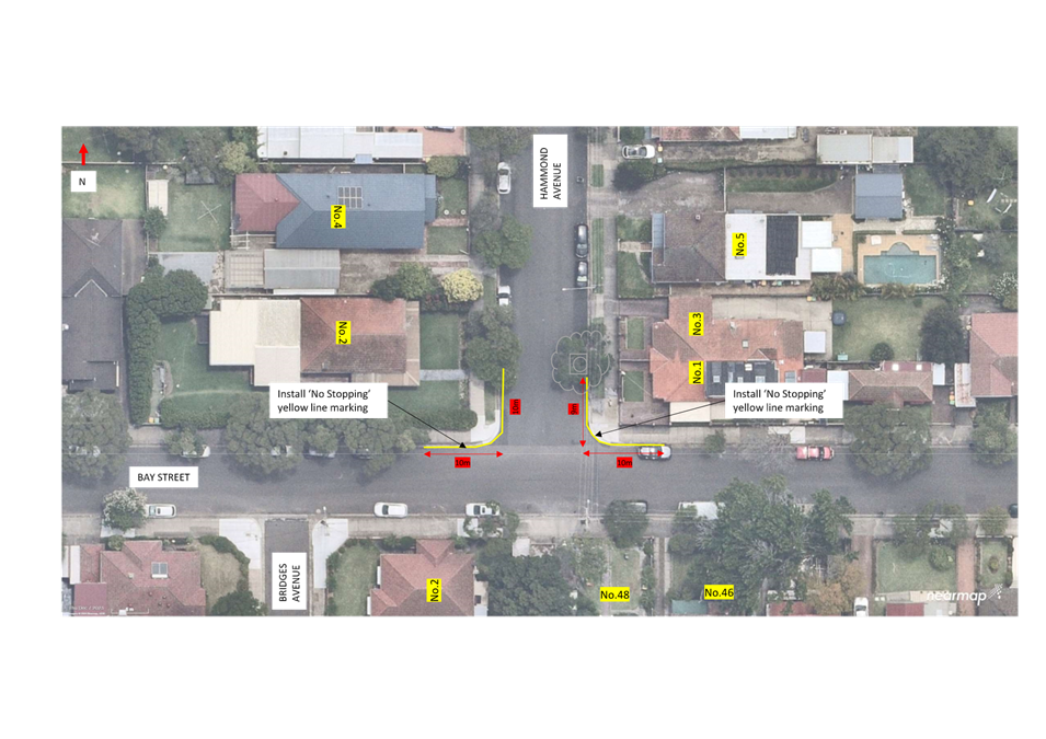
Subject: Bay Street and Hammond Avenue, Croydon - Proposed 'No Stopping' restrictions (Gulgadya-Croydon Ward/Strathfield Electorate/Inner West PAC)
Prepared By: James Nguyen - Traffic Engineer
Authorised By: Manod Wickramasinghe - Traffic and Transport Planning Manager
|
RECOMMENDATION
That 10m ‘No Stopping’ yellow line marking be provided on: a) the northern side of Bay Street, east of Hammond Avenue, Croydon b) the northern side of Bay Street, west of Hammond Avenue, Croydon c) the western side of Hammond Avenue, north of Bay Street, Croydon d) the eastern side of Hammond Avenue, north of Bay Street, Croydon |
STRATEGIC OBJECTIVE
This report supports the following strategic directions contained within Council’s Community Strategic Plan:
|
2: Liveable, connected neighbourhoods and transport |
|
|
EXECUTIVE SUMMARY
This report outlines the current traffic and parking issues at the intersection of Bay Street and Hammond Avenue, Croydon, and proposes ‘No Stopping’ restrictions to address the issues raised.
BACKGROUND
Council has received a request to investigate the installation of ‘No Stopping’ signs at the intersection of Bay Street and Hammond Avenue, Croydon in order to advise motorists of the NSW Road Rules which prohibits vehicles from parking within 10 metres an intersection, to ensure that sight lines for motorists and pedestrians are maintained at this intersection.
DISCUSSION
A request was made at Council’s Local Matters Forum from community members regarding the poor visibility for motorists when turning at the intersection of Bay Street and Hammond Avenue, Croydon. The request noted that car-ownership has increased over the years and parking demand from teachers and students of Rosebank College has subsequently increased demand for on-street parking, leading to instances of illegal parking (vehicles parking within 10 metres of the intersection) on Bay Street and Hammond Avenue.
Currently, there are no existing ‘No Stopping’ restrictions installed on Bay Street and Hammond Avenue, which may lead to instances of vehicles parking within 10 metres at this intersection. The NSW Road Rules prohibits vehicles from parking within 10 metres of an intersecting road.
Bay Street is an east-west collector road between Acton Street and Croydon Road and experiences higher traffic volumes compared to side roads such as Hammond Avenue. ‘No Stopping’ restrictions on Bay Street, would ensure that vehicles on local roads such as Hammond Avenue have adequate sight lines of approaching vehicles on roads that have higher traffic volumes such as Bay Street.
Motorists that park too close to the intersection on Hammond Avenue, would compromise sight lines, particularly for motorists of pedestrians on the footpath of the northern side of Bay Street when crossing Hammond Avenue. ‘No Stopping’ restrictions would improve pedestrian safety and make walking a more attractive option.
PUBLIC CONSULTATION
Council consulted with the affected residents on the proposed ‘No Stopping restrictions. There were 11 letters sent with one (1) response supporting and three (3) responses opposing to the proposal.
The response supporting the proposal noted that ‘No Stopping’ signs are needed as residents do not park their cars in their driveways and resort to parking within 10 metres of the intersection of the road.
Two (2) proposals objecting to the proposal raised concerns that the ‘No Stopping’ signs would affect the public amenity of the neighbourhood. These proposals noted in-principal support to improve safety at the intersections, however, were not in favour of the impact that ‘No Stopping’ signs would have to the public amenity and requested consideration of yellow ‘No Stopping’ line marking.
One (1) of the responses objecting to the proposal noted that the proposal would make the current parking situation worse as households own multiple vehicles and require on-street parking.
FINANCIAL IMPLICATIONS
Funding for the proposed yellow linemarking is available within the signs and line marking budget.
|
1.⇩ |
Concept Plan |
|
|
Local Traffic Committee Meeting 18 March 2024 |
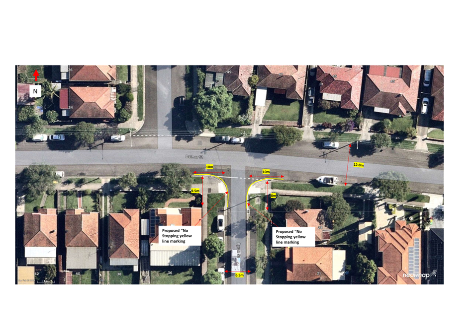
Subject: Dalmar and Byron Streets, Croydon - Proposed 'No Stopping' restrictions (Gulgadya-Croydon Ward/Strathfield Electorate/Inner West PAC)
Prepared By: James Nguyen - Traffic Engineer
Authorised By: Manod Wickramasinghe - Traffic and Transport Planning Manager
|
RECOMMENDATION
That the Committee approve the proposed ‘No Stopping’ yellow line marking on the:
· Southern side of Dalmar Street, 10 metres east and west of Byron Street; · Eastern side of Byron Street, 8 metres south of Dalmar Street; and · Eastern side of Byron Street, 9.5 metres south of Dalmar Street. |
STRATEGIC OBJECTIVE
This report supports the following strategic directions contained within Council’s Community Strategic Plan:
|
2: Liveable, connected neighbourhoods and transport |
|
|
EXECUTIVE SUMMARY
This report outlines the current traffic and parking issues at the intersection of Dalmar and Byron Streets, Croydon and proposes ‘No Stopping’ restrictions to address the issues raised.
BACKGROUND
Council has received a request to consider the installation of ‘No Stopping’ signs at the intersection of Dalmar and Byron Streets, Croydon to inform motorists of the NSW Road Rules which prohibits vehicles from parking within 10 meters of the intersection, and ensure adequate sight lines for motorists and pedestrians are maintained at this intersection.
DISCUSSION
A request was made at Council’s Local Matters Forum from community members about poor visibility for motorists when turning at the intersection of Dalmar and Byron Streets, Croydon.
The request noted that car-ownership has increased over the years and parking demand from teachers and students of Rosebank College has subsequently increased demand for on-street parking, leading to instances of illegal parking (vehicles parking within 10 meters of the intersection) on Dalmar and Byron Streets.
Currently, there are no existing ‘No Stopping’ restrictions installed at the intersection of Dalmar and Byron Streets, which may lead to instances of vehicles parking within 10 meters at this intersection, particularly on Dalmar Street. The NSW Road Rules prohibits vehicles from parking within 10 meters of an intersecting road.
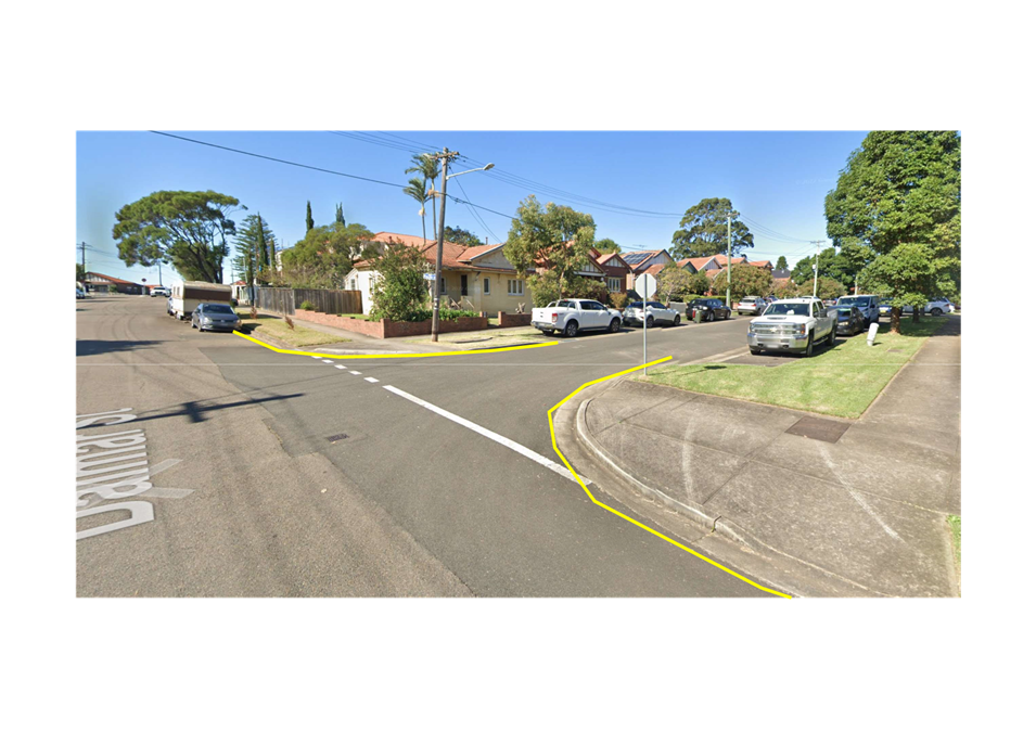
Dalmar Street, east of Byron Street, intersects Byron Street at less than 90 degrees which reduces the sight distance of westbound vehicles on Dalmar Street; vehicles that are parked within 10 meters of the intersection on the southern side of Dalmar Street, east of Byron Street would further compromise this sight line, and a ‘No Stopping’ restriction would reinforce the existing NSW Road Rules, and improve safety.
There are indented parking bays on Byron Street, south of Dalmar Street with the first parking bays located approximately 10 meters away from the intersection of Dalmar Street. ‘No Stopping’ restrictions on Byron Street are less critical, as it is highly unlikely a vehicle will park within 10 meters of the intersection on Byron Street, as they would subsequently block the road access to Byron Street. However, a ‘No Stopping’ restriction could reiterate to vehicles that they cannot park in this section of Byron Street as they would be blocking road access. It would also allow for consistency with the ‘No Stopping’ restriction on Dalmar Street.
A reduction of the ‘No Stopping’ restriction from 10 metres to 9.5 metres on the western side and 8 metres on the eastern side of Byron Street is required to ensure parking can commence at the start of the parking bay. Given Byron Street is approximately 6.5 metres wide and provides local traffic access, vehicle speeds and volumes are expected to be low. A reduced ‘No Stopping’ restriction in this instance has merit.
PUBLIC CONSULTATION
Council consulted with the affected residents on the proposed ‘No Stopping’ restrictions. There were 17 letters sent with one (1) response supporting and two (2) responses opposing to the proposal.
The response supporting the proposal noted the need for ‘No Stopping’ signs as there are vehicles regularly parking within 10 meters of the intersection. The response also requested for consideration of ‘No Stopping’ restrictions on the opposing side of where the restrictions are currently proposed. Council officers will investigate further ‘No Stopping’ restrictions on the northern side of Dalmar Street, east and west of Byron Street and the eastern side of Byron Street, north of Dalmar Street.
The responses opposing the proposal are noted in Table 1 below:
|
Resident response to proposal |
Council Officer Response |
|
The proposal will make it difficult to find a parking space outside residents’ homes on Byron Street, south of Dalmar Street. |
The proposed ‘No Stopping’ restrictions terminate at the start of the first parking bay and there are no impacts to the existing parking bay spaces. No legal parking spaces will be affected and it will improve safety at this location. |
|
The proposal will result in the loss of parking on Byron Street, south of Dalmar Street, outside properties no.21 and 23 Dalmar Street. |
The proposed ‘No Stopping’ restrictions terminate at the start of the first parking bay and there are no impacts to the existing parking bay spaces. No legal parking spaces will be affected and it will improve safety at this location. |
|
Motorists are leaving vehicles unattended between 4 days to 1 month and that the process and timeframe involved with the unattended property act is unacceptable. |
Byron Street is unrestricted for parking, and it is noted that vehicles can currently park for an indefinite period. The Public Spaces (Unattended Property) Act 2021 No 38 is currently the most appropriate legislation that gives Council powers to manage unattended property such as vehicles and boats on the public road. |
|
Burwood Council has made the streets surrounding Rosebank College 2-hour parking which has forced school children and teachers to park in Byron and Dalmar Streets. |
Council officers will investigate further the parking issues that have been raised and determine if any appropriate parking changes are necessary. |
|
School students are parking adjacent to resident driveways and obstructing access. There have been instances of anti-social and hostile behaviour by students towards residents when they are advised not to obstruct driveways. |
Residents are advised to report instances of obstructed driveway access to Councils Parking Services Unit, who can enforce upon the illegal parking. |
|
The proposal will result in the loss of one (1) parking space on the southern side Dalmar Street, east of Byron Street, that is currently being utilised by nearby households and high school students of Rosebank College. |
The proposed ‘No Stopping’ restrictions are proposed 10 metres from the kerb line of Byron Street and seeks to prevent parking within 10 metres of this intersection. Most nearby households have off-street parking spaces and consideration must be given to road safety, particularly at this location, given the compromised sight line by the existing road geometry. No legal parking spaces will be affected and it will improve safety at this location. |
|
The proposed ‘No Stopping signs would impact the impact on public amenity. |
The proposal for ‘No Stopping’ signs has been revised to ‘No Stopping’ yellow line marking to minimise clutter of signs and maintain public amenity. |
|
The safety issues that have been raised by the proponent are embellished and overstated as there has never been any incident outside no.23 Byron Street. |
The installation of ‘No Stopping’ restrictions is aimed to improve parking compliance and improve upon the existing parking condition. This should be given consideration to improve compliance. |
|
The off-street parking bays that Council has installed considered the surrounding streetscape and created a pleasant street. The proposed ‘No Stopping’ sign will be jarring – why aren’t you proposing to change the streetscape to accommodate your new requirements? |
The proposal for ‘No Stopping’ signs has been revised to ‘No Stopping’ yellow line marking to minimise clutter of signs and maintain public amenity. |
FINANCIAL IMPLICATIONS
Funding for the linemarking is available within the signs and linemarking budget.
|
1.⇩ |
Concept sketch |
|
Local Traffic Committee Meeting 18 March 2024 |
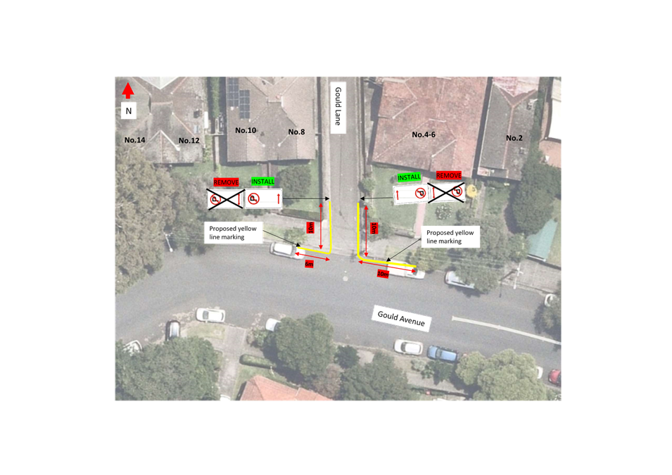
Subject: Gould Avenue, Lewisham - Proposed 'No Stopping' restrictions (Damun-Lewisham Ward/Newtown Electorate/Inner West PAC)
Prepared By: James Nguyen - Traffic Engineer
Authorised By: Manod Wickramasinghe - Traffic and Transport Planning Manager
|
RECOMMENDATION
That the installation of a ‘No Stopping’ yellow line marking at the following locations be approved:
· Northern side of Gould Avenue, 10 metres in length, east of Gould Lane; · Northern side of Gould Avenue, 6 metres in length, west of Gould Lane; · Eastern side of Gould Lane, 10 metres in length, north of Gould Avenue; and · Western side of Gould Lane, 10 metres in length, north of Gould Avenue. |
STRATEGIC OBJECTIVE
This report supports the following strategic directions contained within Council’s Community Strategic Plan:
|
2: Liveable, connected neighbourhoods and transport |
|
|
EXECUTIVE SUMMARY
This report outlines the parking and road safety issues at the intersection of Gould Avenue and Gould Lane, Lewisham, and proposes a solution to address the issues raised. The report also includes feedback from the community about the current parking issues within the Inner West Local Government Area.
BACKGROUND
Council has received a request from a resident requesting for consideration of ‘No Stopping’ restrictions at the intersection of Gould Avenue and Gould Lane, Lewisham, due to vehicles parking within 10 metres of the intersection.
DISCUSSION
Council has received a request from a resident requesting for consideration of ‘No Stopping’ restrictions at the intersection of Gould Avenue and Gould Lane, Lewisham, due to vehicles parking within 10 metres of the intersection. The resident has provided photographic evidence of repeated instances where vehicles are illegally parked within 10 metres of this intersection.
Gould Lane provides resident access to their rear-garage and properties, and intersects Gould Avenue which provides connectivity to the wider road network such as Wardell Road and New Canterbury Road.
Aerial photos suggest repeated instances where motorists are parking within 10 metres of the intersection on the northern side of Gould Avenue, east and west of Gould Lane, which would restrict sight lines.
![]()
![]() Figure 1 below shows the existing sight distances permissible for
motorists on Gould Lane, with motorists parking within 10 metres of the
intersection on Gould Avenue.
Figure 1 below shows the existing sight distances permissible for
motorists on Gould Lane, with motorists parking within 10 metres of the
intersection on Gould Avenue.
Figure 2 below shows the improved sight distances with the provision of a 6 metre ‘No Stopping’ zone on the northern side of Gould Avenue, west of Gould Lane, and a 10 metre ‘No Stopping’ zone, east of Gould Lane. There is approximately a 150 per cent increase in sight distance with the proposed ‘No Stopping’ restrictions.
Due to the larger angle (greater than 90 degrees) which the western leg of Gould Avenue intersects Gould Lane, a reduced ‘No Stopping’ length of 6 metres can be considered to minimise the loss of kerb space and maximise parking. A reduced ‘No Stopping’ length on the northern side of Gould Avenue, east of Gould Lane is not recommended.
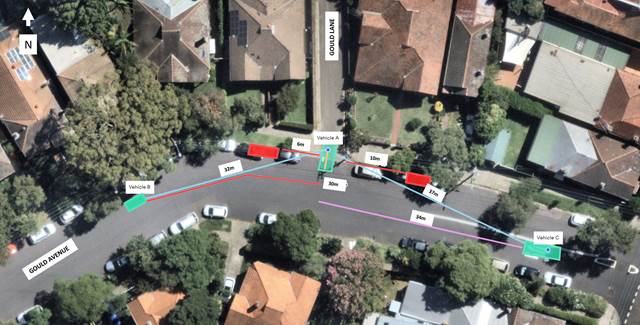
Figure 2 - Sight distances with proposed ‘No Stopping’ restrictions
In addition, the current ‘No Parking’ restrictions on Gould Lane allows for vehicles to stop within 10 metres of the intersection. It is proposed to reallocate this ‘No Parking’ restriction with a ‘No Stopping’ restriction for the first 10 metres of Gould Lane on both sides to ensure compliance with the NSW Road Rules.
PUBLIC CONSULTATION
Council consulted on the proposed ‘No Stopping’ restrictions with affected residents. There were 20 letters sent with two (2) responses supporting and one (1) response opposing the proposal.
The responses supporting the proposal supported the proposed yellow line marking to make the road safer. However, expressed concerns about the current parking conditions due to commuters and visitors parking on Gould Avenue to access the nearby train, and light rail stations and businesses. Council Engineers have advised residents that further parking investigations can commence upon receipt of a minimum of 10 requests from households in Gould Avenue or 50 per cent of the households affected, or whichever is less.
The one (1) response opposing the proposal and Council Engineer’s responses are noted in Table 1 below:
Table 1
|
Resident response |
Council Engineer’s response |
|
Overall, I do not support the reduction in parking spaces in Gould Avenue or Gould Lane Lewisham. If you were to visit the two locations at any time you will see that due to the profilication of units on Canterbury Road without adequate onsite parking, and Councils failure to actively manage illegally parked cars that overstay the legal permissible timeframe of 28 days outlined in the Public Spaces Act (the most recent example is a vehicle which has only been moved today after being parked in the same location in Gould Avenue since October 2023 after Councils rangers failed to act on the numerous complaints from residents in the street). |
The proposal does not reduce the number of legal parking spaces. The proposal seeks to reduce instances of vehicles parking in non-legal spaces that impact sight lines and affect road safety. A reduced ‘No Stopping’ restriction of 6 metres on the north-western side of Gould Avenue is a reduction from the standard 10 metres to maximise kerb space for parking.
Council Engineers will provide this feedback to the Parking Services Unit to improve response times to enforce the Public Spaces Act. |
|
I can outline a number of other locations throughout the LGA with poor line of sight due to either Councils failure to install appropriate signage and line marking, or failure to enforce appropriate and legal parking. I cannot see why this particular location is any different. Balmain for example is an example of poor line of sight and frequent illegal parking without control by council. |
Council Engineers investigates each request raised by the community accordingly. Council Engineers seeks to install ‘No Stopping’ restrictions only where parking enforcement becomes an ineffective deterrent to illegal parking, or when there is a safety or access issue that needs to be resolved.
It is acknowledged that not all intersections are currently signposted or line marked, however if safety or parking issues are raised by the community, Council Engineers will investigate these concerns and deem whether any further action is required. |
FINANCIAL IMPLICATIONS
Funding for the line marking is available with the signs and line marking budget.
|
1.⇩ |
Concept plan |
|
Local Traffic Committee Meeting 18 March 2024 |
Subject: Belmore Street, Tempe - Proposed 'No Parking' restrictions (Midjuburi-Tempe Ward/Heffron Electorate/Inner West PAC)
Prepared By: James Nguyen - Traffic Engineer
Authorised By: Manod Wickramasinghe - Traffic and Transport Planning Manager
|
RECOMMENDATION
That the proposed ‘No Parking’ restrictions extending 9m south (western side) and 15m south (eastern side) from the dead-end of Belmore Street, Tempe, as per Figure 2 in this report be approved.
|
STRATEGIC OBJECTIVE
This report supports the following strategic directions contained within Council’s Community Strategic Plan:
|
2: Liveable, connected neighbourhoods and transport |
|
|
EXECUTIVE SUMMARY
This report outlines road access issues at the dead-end of Belmore Street, Tempe. It outlines the investigation and proposes a ‘No Parking’ restriction to resolve the access issues. Community feedback on the proposal is also included and informs the final ‘No Parking’ restriction proposal.
BACKGROUND
Council has received a request for consideration of parking restrictions at the dead-end in Belmore Street, Tempe, due to parked vehicles obstructing access.
DISCUSSION
Council’s Parking Officers have requested parking restrictions at the dead-end in Belmore Street, Tempe, due to parked vehicles obstructing driveway access.
Currently, the dead-end in Belmore Street has no existing restrictions. The unrestricted parking spaces on both sides of this dead-end are highly utilised due its proximity to Sydenham Station, and given the lack of signage, parking boundaries are undefined. Accordingly, an investigation has been completed to determine the acceptable location of parking spaces which do not obstruct the turning circle of vehicles at the dead-end in Belmore Street, or impede access to adjacent driveways. A ‘No Parking’ restriction is proposed to ensure driveway access and provide a turning area at the dead-end.
PUBLIC CONSULTATION
Council consulted with affected residents on a proposed ‘No Parking’ restrictions. This original proposal is shown in Figure 1 below. There were 12 letters sent with two (2) responses supporting and no responses opposing the proposal. The responses supporting the proposal provided photos of vehicles parking at this dead-end, which subsequently obstructed driveway access and restricted turn around movements. Further comments were also provided suggesting that a larger clearance zone was required.
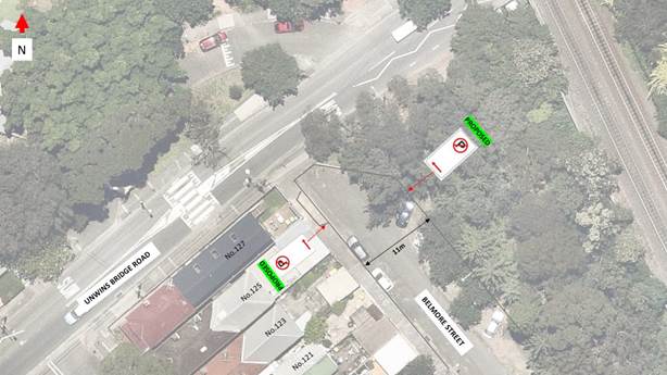
Figure 1 - Original proposal during consultation
Further swept path analysis for passenger vehicles were subsequently completed to determine the extent of the proposed ‘No Parking’ restrictions and the length of the clearance zone required. Accordingly, a 6-metre clear area is required on the eastern side of Belmore Street from the dead-end to ensure access to adjacent driveways and provide a turn-around area for passenger vehicles. The adjacent unrestricted angle parking spaces on the eastern side of Belmore Street, will commence south of this ‘No Parking’ restriction. The final proposed signage plan is shown below in Figure 2.

Figure 2 - Final proposal after consultation
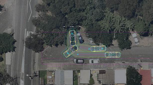
Figure 3 - Swept path 1 - Turn around movement at dead-end
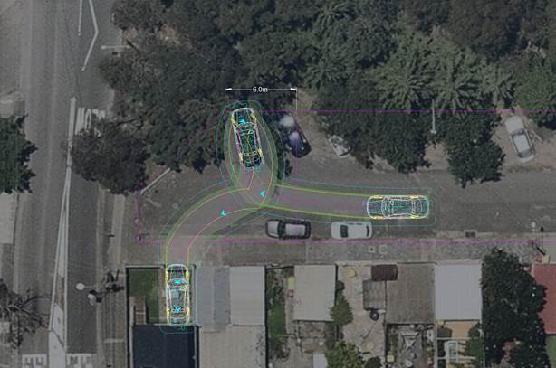
Figure 4 - Swept path - Driveway/Road access to and from Belmore Street
FINANCIAL IMPLICATIONS
Funding for the No Parking signage is available within signs and linemarking budget.
Nil.
|
|
Local Traffic Committee Meeting 18 March 2024 |
Subject: Denison Street, Camperdown, south of Kilner Lane - Proposed kerb extension and ramp (Damun-Camperdown/Newtown Electorate/Inner West PAC)
Prepared By: James Nguyen - Traffic Engineer
Authorised By: Manod Wickramasinghe - Traffic and Transport Planning Manager
|
RECOMMENDATION
That the detail design plan (plan no. 10273) for new kerb ramps which incorporate a kerb blister (southern side) on Denison Street, Camperdown, south of Kilner Lane be approved.
|
STRATEGIC OBJECTIVE
This report supports the following strategic directions contained within Council’s Community Strategic Plan:
|
2: Liveable, connected neighborhoods and transport |
|
|
EXECUTIVE SUMMARY
This report outlines proposed pedestrian facility devices to improve connectivity, access and safety at the intersection of Denison Street and Kilner Lane, Camperdown.
BACKGROUND
A kerb extension/blister and ramp is proposed for construction on Denison Street, Camperdown, south of Kilner Lane in Councils 2024/25 Traffic Facilities Capital Works Program.
DISCUSSION
Denison Street, Camperdown between Kilner Lane and Hordern Place is a 7-metre wide two-way street. A short section of Denison Street, just west of Kilner Lane (between Parramatta Road and Kilner Lane) is one-way eastbound for road users to travel further east on Denison Street, with a ‘No Entry Bicycles Excepted’ restriction, to restrict westbound movements on to Parramatta Road via Denison Street. A bicycle contraflow lane is provided to facilitate westbound movements for cyclists.
Currently, there are no facilities to support pedestrian movements in the east-west direction across Denison Street from Kilner Lane and Gantry Lane. With the surrounding land-use consisting of medium-density apartments, pedestrian movements at this location are likely to be high.
Accordingly, it is proposed to install a 1.8-metre-wide kerb extension on the western side of Denison Street, south of Kilner Lane, and a kerb ramp on the eastern side of Denison Street to improve pedestrian connectivity. The proposed kerb extension and ramp will provide a crossing point for pedestrians, particularly those with mobility devices and prams. The kerb extension will improve sight lines of pedestrians crossing Denison Street from Kilner Lane.
A swept path analysis has been completed to assess the left-turn movement of a 12.5-metre-long truck, from Denison Street into Kilner Lane. This swept path has determined the maximum acceptable width of the kerb extension (1.8 meters). An edge (E1) line of 21 meters in length is proposed along the eastern side of Denison Street to improve vehicle delineation when making the left turn. It also provides a buffer for pedestrians at the kerb extension.
A unidirectional hazard marker (D4-1-2A) sign is proposed to be installed on the kerb extension to face northbound vehicles on Denison Street to warn motorists of the kerb extension. To minimise sight obstruction of pedestrians on the kerb extension, the smallest available sign (450mm high and 450mm wide) is proposed and will be installed at the lowest height acceptable to maximise the visibility of pedestrians.
PUBLIC CONSULTATION
Council consulted with the community on the proposal. There were 210 letters sent with no responses received supporting or opposing the proposal.
FINANCIAL IMPLICATIONS
The proposed works are funded under the 2023/2024 Traffic Works Program.
|
1.⇩ |
Concept plan |
|
|
Local Traffic Committee Meeting 18 March 2024 |
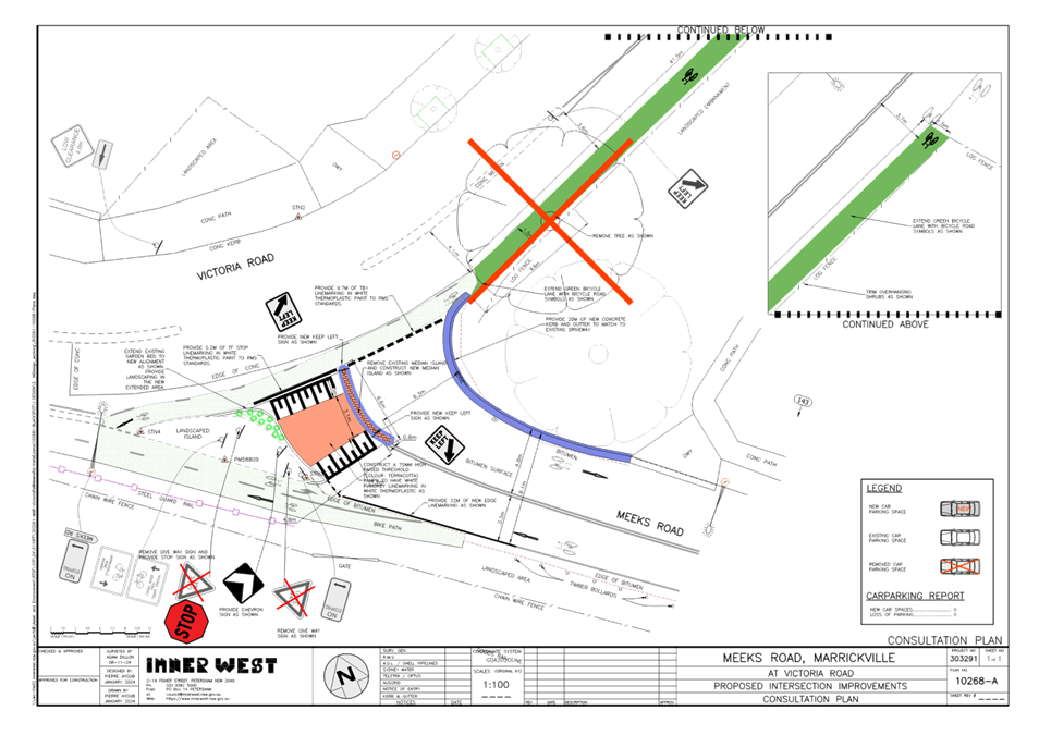
Subject: Meeks Road at Victoria Road, Marrickville – Proposed intersection Improvements - Design Plan 10268 (MIDJUBURI-MARRICKVILLE WARD / SUMMER HILL ELECTORATE / INNER WEST PAC)
Prepared By: Jennifer Adams - Traffic Engineer
Authorised By: Manod Wickramasinghe - Traffic and Transport Planning Manager
|
RECOMMENDATION
That the detailed design plan for the proposed intersection improvements at the intersection of Meeks Road and Victoria Road, Marrickville and associated signs and line markings (as per Design Plan No.10268-A) be approved. |
STRATEGIC OBJECTIVE
This report supports the following strategic directions contained within Council’s Community Strategic Plan:
|
2: Liveable, connected neighbourhoods and transport |
|
|
EXECUTIVE SUMMARY
Council has finalised a design plan for proposed intersection improvements at the intersection of Meeks Road and Victoria Road, Marrickville. The proposed works aim to improve cyclist and motorist safety by better defining the intersection as well as improving the entry threshold at the intersection. It is noted that Council has received Blackspot funding to upgrade the intersection.
BACKGROUND
Council is planning to improve safety for pedestrians and other road users in Meeks Road, Marrickville at its intersection with Victoria Road. The works aim to improve cyclist and motorist safety by better defining the intersection.
A Blackspot funding application was submitted in 2022 to, amongst other works, remove sight distance restrictions at the intersection, upgrade the intersection from a “GIVE WAY’ to ‘STOP’ control and to move the control lines forward using kerb extensions. The cycleway is part of Council's Regional Route No.5 between Enmore and Cooks River.
This report details the design plan for those improvement works and its related consultation results.
FINANCIAL IMPLICATIONS
The project is listed on Council’s Traffic Facilities Capital Works budget for 2023/2024 and Blackspot funding of $160,000 has been received for this project. Project number is 303291.
OTHER STAFF COMMENTS
The following works are proposed and are illustrated on the attached Consultation Plan (Plan No. 10268). The proposed works aim to improve cyclist and motorist safety by better defining the intersection.
Specifically, the proposed scope of works includes the following:
· Extend existing landscaped kerb blister island in Meeks Road at its intersection with Victoria Road.
· Construct new kerb and gutter along existing landscaped shoulder to better define the intersection for road users
· Construct new raised threshold at the intersection
· Construct central median island
· Extending the green cycle lane across the Meeks Road Intersection into Victoria Road
· Removal of the juvenile self-sown tree in the road shoulder
· Install associated signs and line markings.
Parking changes
This proposal does not change any of the existing parking arrangements in Meeks Road and Victoria Road. Therefore, there will be no loss of parking spaces resulting from the proposed works.
Streetlighting
The existing street lighting at the location is deemed adequate. Therefore, no changes are proposed to the existing street lighting due to the works.
It should however be noted that Ausgrid is progressively replacing all existing streetlights throughout the Local Government area with new energy efficient and environmentally friendly LED streetlights, and this will be completed independent of this project.
PUBLIC CONSULTATION
Consultation was conducted between 21 February 2024 and 6 March 2024. A letter along with a copy of the design plan was sent to residents / businesses in the immediate locality. A total of 25 letters were distributed. There were no responses.
Following consultation, the green bicycle lane was further extended and plans clarified to show the existing green bicycle lane across Meeks Road is to be retained. This does not impact parking.

CONCLUSION
It is recommended that the detailed design plan of the proposed intersection improvements and associated signs and line markings be supported to improve road safety at this location.
|
1.⇩ |
303291-10268-A ConsultationPlan |
|
|
Local Traffic Committee Meeting 18 March 2024 |
Subject: Ewart Street, Dulwich Hill And (Lower) Railway Parade, Sydenham - Temporary Parking Changes On 4 Weekends During Weekend Rail Replacement Operations - Bus Replacements (Midjuburi -Marrickville Ward / Summer Hill Electorate / Inner West PAC)
Prepared By: Jennifer Adams - Traffic Engineer
Authorised By: Manod Wickramasinghe - Traffic and Transport Planning Manager
|
RECOMMENDATION
1. That the following temporary short-term parking changes for the following period 10:00pm Friday 22 to 02:00am Monday 25 March 2024 (inclusive) be approved to support the works required to convert the T3 Bankstown Line to a Metro Line:
a) Dulwich Hill Station Precinct - Ewart Street (3 parking spaces): The short-term conversion of 20m (3 parking spaces) ‘2P 8 am – 6 pm Mon – Fri’ on the northern side of Ewart Street (between Wardell Road and Bayley Street) to a ‘Bus Zone’;
b) The short-term conversion of 25m ‘No Parking’ restrictions on the southern side of Ewart Street (between Wardell Road and Riverside Crescent) to a ‘Bus Zone’;
c) Sydenham Station Precinct - Lower Railway Parade (57 parking spaces): The short-term conversion of 122m (46 parking spaces) 45 degree angled ‘unrestricted parking’ on the southern side kerb of Lower Railway Parade (between Sydenham Road and Marrickville Road) to a ‘Bus Zone’; and
d) The short-term conversion of 32m (11 parking spaces) 45-degree angled parking ‘4P 8:30 am – 6 pm Mon - Fri’ on the southwest kerb of Lower Railway Parade (between Gleeson Avenue and Marrickville Road) to a ‘Bus Zone’.
2. That the following temporary short-term parking changes for the following periods · 04:00am Saturday 22 to 02:00am Monday 24 June 2024 (inclusive) · 04:00am Saturday 29 to 02:00am Monday 1 July 2024 (inclusive) · 04:00am Saturday 6 to 02:00am Monday 8 July 2024 (inclusive) be approved to support the works required to convert the T3 Bankstown Line to a Metro Line:
a) Sydenham Station Precinct - Lower Railway Parade (57 parking spaces): The short-term conversion of 122m (46 parking spaces) 45 degree angled ‘unrestricted parking’ on the southern side kerb of Lower Railway Parade (between Sydenham Road and Marrickville Road) to a ‘Bus Zone’; and
b) The short-term conversion of 32m (11 parking spaces) 45-degree angled parking ‘4P 8:30 am – 6 pm Mon - Fri’ on the southwest kerb of Lower Railway Parade (between Gleeson Avenue and Marrickville Road) to a ‘Bus Zone’.
3. That the cost of all works of the statement and/or reinstatement of any/all signage will be borne by TfNSW.
4. That the applicant and Council Rangers be advised in terms of this report. |
STRATEGIC OBJECTIVE
This report supports the following strategic directions contained within Council’s Community Strategic Plan:
|
2: Liveable, connected neighbourhoods and transport |
|
|
EXECUTIVE SUMMARY
Council has been notified by Transport for NSW (TfNSW) that in a joint submission with Sydney Trains there will be major rail shutdown of the Sydenham to Bankstown rail line (T3) for the following periods:
· 10:00pm Friday 22 to 02:00am Monday 25 March 2024 (inclusive).
· 04:00am Saturday 22 to 02:00am Monday 24 June 2024 (inclusive).
· 04:00am Saturday 29 to 02:00am Monday 1 July 2024 (inclusive).
· 04:00am Saturday 6 to 02:00am Monday 8 July 2024 (inclusive).
During the shutdown buses will replace train services along the T3 line and to accommodate the increased bus movements and necessary holding areas some short-term parking changes are required at a number of locations. It is noted that the Dulwich Hill changes are only required between 10:00pm Friday 22 to 02:00am Monday 25 March 2024 (inclusive).
Specifically, TfNSW is requesting approval for the temporary conversion of multiple parking spaces at Ewart Street, Dulwich Hill and (Lower) Railway Parade, Sydenham. It is recommended that no objections be raised, and Council approves the temporary short-term parking changes at the identified locations during the four (4) weekend rail shutdowns.
All changes to existing parking arrangements and signage will be reinstated at the completion of the bussing operation by TfNSW.
OFFICER COMMENTS
Each of the locations will be detailed separately.
Dulwich Hill Station Precinct (3 parking spaces)
1. Ewart Street, northern side (Stop ID: 2204118) - Bus stop extension (3 parking space)
· Ewart Street (northern kerb between Wardell Road and Bayley Street)
· Currently sign posted ‘2P 8:30 am – 6 pm Mon – Fri’
· Proposed Bus Zone is required for all days of the TTP bus operation
· Proposed temporary change will impact approximately three parking spaces (20m).
· This change is proposed to create a bus stop area and to provide adequate space for draw-in/draw-out purposes.
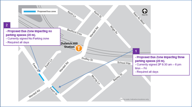
2. Ewart Street, southern side (Stop ID: 220488) – Bus stop
· Ewart Street (southern kerb between Wardell Road and Riverside Crescent)
· Currently signed No Parking Zone
· Proposed Bus Zone is required for all days of the TTP bus operation
· Proposed temporary change will impact approximately no parking spaces.
· This change is proposed to create a bus stop area and to provide adequate space for draw-in/draw-out purposes.
Sydenham Station Precinct (55 parking spaces)
8. Section A of Lower Railway Parade, Sydenham 90-degree angled parking, Sydenham – Layover Bus Zone and Standby area (46 parking spaces)
· Lower Railway Parade Parallel Parking (southern side between Sydenham Road and Marrickville Road)
· Currently’ Unrestricted parking’
· Proposed Bus Zone is required for all days of the TTP bus operation
· Proposed temporary change will impact approximately 46 angled parking spaces (122 m).
· This proposed change is to create the space required for buses to layover. This location is proposed as it is (i) reasonably close to the active bus stop; (ii) located along the route path used between the last and first stops; and (iii) as far as removed from residential dwellings.
9. Section B of Lower Railway Parade, Sydenham 90-degree angled parking, Sydenham - Layover Bus Zone (11 parking spaces)
· Lower Railway Parade Parallel Parking (southern side between Gleeson Avenue and Marrickville Road)
· Currently ‘4P 8:30 am – 6 pm Mon – Fri’ restrictions
· Proposed Bus Zone is required for all days of the TTP bus operation
· Proposed temporary change will impact approximately eleven angled parking spaces (32 m).
· This proposed change is to create the space required for buses to layover. This location is proposed as it is (i) reasonably close to the active bus stop; and (ii) located along the route path used between the last and first stops.
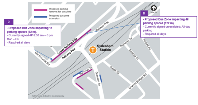
PUBLIC CONSULTATION
TfNSW propose the temporary parking changes and they will carry out consultation with their wider team who will be installing notifications at each impacted parking location 2-weeks prior to the start of the weekend possession on March 23. Draft example of one of the notifications is reproduced at the end of this report.
FINANCIAL IMPLICATIONS
There are no financial implications for Council associated with this matter. The cost of the work will be borne by Transport for NSW.
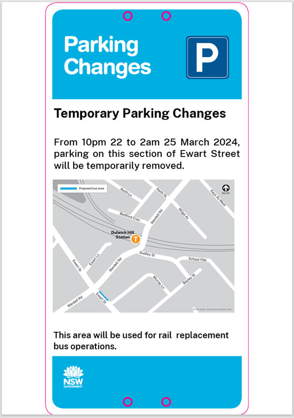
Nil.
|
|
Local Traffic Committee Meeting 18 March 2024 |
Subject: Ewart Street, Dulwich Hill; Illawarra Road, Marrickville; Burrows Avenue, Railway Road, Gleeson Avenue And (Lower) Railway Parade, Sydenham - Temporary Parking Changes During Major Rail Shutdown Of T3 Line For Sydney Metro Upgrade Works - Bus Replacements Saturday 13 April 2024 To Wednesday 24 April 2024 (Midjuburi -Marrickville Ward / Summer Hill Electorate / Inner West PAC)
Prepared By: Jennifer Adams - Traffic Engineer
Authorised By: Manod Wickramasinghe - Traffic and Transport Planning Manager
|
RECOMMENDATION
1. That the following temporary short-term parking changes for the period of 2am Saturday 13 April 2024 to 10pm Wednesday 24 April 2024 (inclusive) be approved to support the works required to convert the T3 Bankstown Line to a Metro Line:
a) Dulwich Hill Station Precinct - Ewart Street (3 parking spaces): The short-term conversion of 20m (3 parking spaces) ‘2P 8 am – 6 pm Mon – Fri’ on the northern side of Ewart Street (between Wardell Road and Bayley Street) to a ‘Bus Zone’;
b) The short-term conversion of 25m ‘No Parking’ restrictions on the southern side of Ewart Street (between Wardell Road and Riverside Crescent) to a ‘Bus Zone’;
c) Marrickville Station Precinct - Illawarra Road (1 parking space): The short-term conversion of 7m (1 parking space) ‘1P 8:30 am – 6 pm’ on the western side of Illawarra Road (between Warburton Street and Greenbank Street) to a ‘Bus Zone’;
d) Sydenham Station Precinct - Burrows Avenue (23 parking spaces): The short-term conversion of 50m (14 parking spaces) rear to kerb ‘unrestricted parking’ on the northern kerb of Burrows Avenue (west of Gleeson Avenue) to a ‘Bus Zone’;
e) The short-term conversion of 58m (9 parking spaces) ‘unrestricted parking’ on the southern kerb of Burrows Avenue (west of Gleeson Avenue) to a ‘Bus Zone’;
f) Sydenham Station Precinct – Railway Road (3 parking spaces): The short-term conversion of 18m (3 parking spaces) ‘2P 8:30 am – 10 pm Mon - Fri’ on the eastern side kerb of Railway Road (between Burrows Avenue and Gleeson Avenue) to a ‘Bus Zone’;
g) Sydenham Station Precinct - Gleeson Avenue (2 parking spaces): The short-term conversion of 12m (2 parking spaces) ‘1P 9:00 am – 3:30 pm Mon - Fri and No Parking 6 am-9 am & 3:30 pm – 6:30 pm’ on the eastern kerb of Gleeson Avenue (between Burrows Avenue and Unwins Bridge Road) to a ‘Bus Zone’;
h) Sydenham Station Precinct - Lower Railway Parade (57 parking spaces): The short-term conversion of 122m (46 parking spaces) 45 degree angled ‘unrestricted parking’ on the southern side kerb of Lower Railway Parade (between Sydenham Road and Marrickville Road) to a ‘Bus Zone’; and
i) The short-term conversion of 32m (11 parking spaces) 45-degree angled parking ‘4P 8:30 am – 6 pm Mon - Fri’ on the southwest kerb of Lower Railway Parade (between Gleeson Avenue and Marrickville Road) to a ‘Bus Zone’.
2. That the cost of all works of the statement and/or reinstatement of any/all signage will be borne by TfNSW.
3. That the applicant and Council Rangers be advised in terms of this report.
|
STRATEGIC OBJECTIVE
This report supports the following strategic directions contained within Council’s Community Strategic Plan:
|
2: Liveable, connected neighbourhoods and transport |
|
|
EXECUTIVE SUMMARY
Council has been notified by Transport for NSW (TfNSW) that Sydney Metro works will involve major rail shutdown of the Sydenham to Bankstown rail line (T3) for the following periods: Saturday 13 April 2024 to Wednesday 24 April 2024 (inclusive). During the shutdown buses will replace train services along the T3 line and to accommodate the increased bus movements and necessary holding areas some short-term parking changes are required at a number of locations.
Specifically, TfNSW is requesting approval for the temporary conversion of multiple parking spaces at the following locations: Ewart Street, Dulwich Hill; Illawarra Road, Marrickville; Burrows Avenue, Railway Road, Gleeson Avenue and (Lower) Railway Parade, Sydenham. It is recommended that no objections be raised, and Council approves the temporary short-term parking changes at the identified locations during the rail shutdowns.
All changes to street signage will be made by TfNSW contractor(s) from 10pm the night before the closures and will be reinstated at the completion of the planned shutdowns.
BACKGROUND
Sydney Metro City & Southwest - Sydenham to Bankstown project will upgrade all 10 stations between Marrickville and Bankstown to meet metro standards before converting the T3 Bankstown Line to Metro operations.
During this possession, rail services on the T3 Bankstown Line will not operate and Temporary Transport Plan (TTP) buses will operate instead necessitating some short-term changes in parking at a number of locations. To support this closure TTP buses and additional T8 Airport & South Line trains will operate.
It is noted that for the shutdown in July 2023 TfNSW identified Ewart Street the designated Dulwich Hill Station Precinct location. Previously LTC approval had been forthcoming in Dudley Street, Dulwich Hill. It is again noted that at some time in the future TfNSW will be requested by Council to return to using Dudley Street, Dulwich Hill as the preferred location for all buses as it is immediately adjacent to Dulwich Hill Station and considered more convenient for local residents.
OFFICER COMMENTS
Each of the locations will be detailed separately.
Dulwich Hill Station Precinct (3 parking spaces)
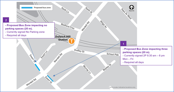
1. Ewart Street, northern side (Stop ID: 2204118) - Bus stop extension (3 parking space)
· Ewart Street (northern kerb between Wardell Road and Bayley Street)
· Currently sign posted ‘2P 8:30 am – 6 pm Mon – Fri’
· Proposed Bus Zone is required for all days of the TTP bus operation
· Proposed temporary change will impact approximately three parking spaces (20m).
· This change is proposed to create a bus stop area and to provide adequate space for draw-in/draw-out purposes.
2. Ewart Street, southern side (Stop ID: 220488) – Bus stop
· Ewart Street (southern kerb between Wardell Road and Riverside Crescent)
· Currently signed No Parking Zone
· Proposed Bus Zone is required for all days of the TTP bus operation
· Proposed temporary change will impact approximately no parking spaces.
· This change is proposed to create a bus stop area and to provide adequate space for draw-in/draw-out purposes.
Marrickville Station Precinct (1 parking space)
3. Illawarra Road opposite Marrickville Station (Stop ID: 2204102) - Bus stop extension (1 parking space)
· Illawarra Road (northwest kerb between Warburton Street and Greenbank Street)
· Currently signed ‘1P 8:30 am – 6 pm’
· Proposed Bus Zone extension is required for the duration of the TTP bus operation
· Proposed temporary change will impact approximately one parking space (7 m).
· This change is proposed to create a bus stop area and to provide adequate space for draw-in/draw-out purposes.
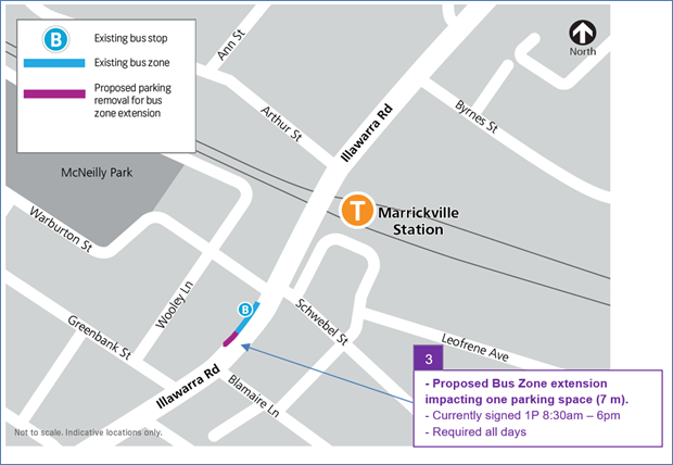
Sydenham Station Precinct (85 parking spaces)
4. Burrows Avenue, Sydenham (Stop ID: 204421) Rear to kerb parking – Bus Zone Extension (14 parking spaces)
· Burrows Avenue (northern kerb west of Gleeson Avenue)
· Currently ‘Unrestricted parking’
· Proposed Bus Zone is required for all days of the TTP bus operation
· This proposed change is to create the space required for buses to layover and to provide adequate space for draw-in/draw-out purposes.
· Proposed temporary change will impact approximately 14 rear to kerb parking spaces (50 m).
5. Burrows Avenue, Sydenham – (Southern kerb) – Bus Zone (9 parking spaces)
· Burrows Avenue (southern kerb west of Gleeson Avenue)
· Currently ‘Unrestricted parking’
· Proposed Bus Zone is required for all days of the TTP bus operation
· This proposed change is to create the space required for buses to layover safely.
· Proposed temporary change will impact approximately 9 parking spaces (58 m).
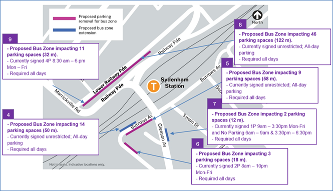
6 Railway Road, Sydenham – (Northeastern kerb) – Bus Zone (3 parking spaces)
· Railway Road (northeastern kerb between Gleeson Avenue and Burrows Avenue)
· Currently ‘2P 8am – 10pm Mon-Fri’
· Proposed Bus Zone is required for all days of the TTP bus operation
· This proposed change is to create the space required for buses to layover safely and to provide adequate turning circle space.
· Proposed temporary change will impact approximately 3 parking spaces (18 m).
7. Gleeson Avenue, Sydenham (Eastern kerb) Bus Zone extension (2 parking spaces)
· Gleeson Avenue (eastern kerb between Burrows Avenue and Railway Road)
· Currently ‘1P 9:00 am – 3:30 pm Mon – Fri’
· Proposed Bus Zone extension is required for all days of the TTP bus operation
· Proposed temporary change is to create additional space required for buses to adequately draw in/out from the bus stop.
· Proposed temporary change will impact approximately 2 parking spaces (12m).
8. Section A of Lower Railway Parade, Sydenham 90-degree angled parking, Sydenham – Layover Bus Zone and Standby area (46 parking spaces)
· Lower Railway Parade Parallel Parking (southern side between Sydenham Road and Marrickville Road)
· Currently’ Unrestricted parking’
· Proposed Bus Zone is required for all days of the TTP bus operation
· Proposed temporary change will impact approximately 46 angled parking spaces (122 m).
· This proposed change is to create the space required for buses to layover. This location is proposed as it is (i) reasonably close to the active bus stop; (ii) located along the route path used between the last and first stops; and (iii) as far as removed from residential dwellings.
9. Section B of Lower Railway Parade, Sydenham 90-degree angled parking, Sydenham - Layover Bus Zone (11 parking spaces)
· Lower Railway Parade Parallel Parking (southern side between Gleeson Avenue and Marrickville Road)
· Currently ‘4P 8:30 am – 6 pm Mon – Fri’ restrictions
· Proposed Bus Zone is required for all days of the TTP bus operation
· Proposed temporary change will impact approximately eleven angled parking spaces (32 m).
· This proposed change is to create the space required for buses to layover. This location is proposed as it is (i) reasonably close to the active bus stop; and (ii) located along the route path used between the last and first stops.
PUBLIC CONSULTATION
Transport for NSW propose the temporary parking changes and they will carry out consultation with local businesses and residents between 5 and 19 March 2024. Copies of the draft consultation letters are reproduced below.
The consultation program will consist of the following activities:
· Two-week public consultation period to impacted areas with a printed community notification outlining the proposed kerbside changes.
A copy of the community notifications is also available on the My Sydney website - https://www.mysydney.nsw.gov.au/SydenhamtoBankstown
A Consultation Outcomes Report will be prepared collating feedback and TfNSW’s comment on that feedback. That report will be tabled as it becomes available.
FINANCIAL IMPLICATIONS
There are no financial implications for Council associated with this matter. The cost of the work will be borne by Transport for NSW.
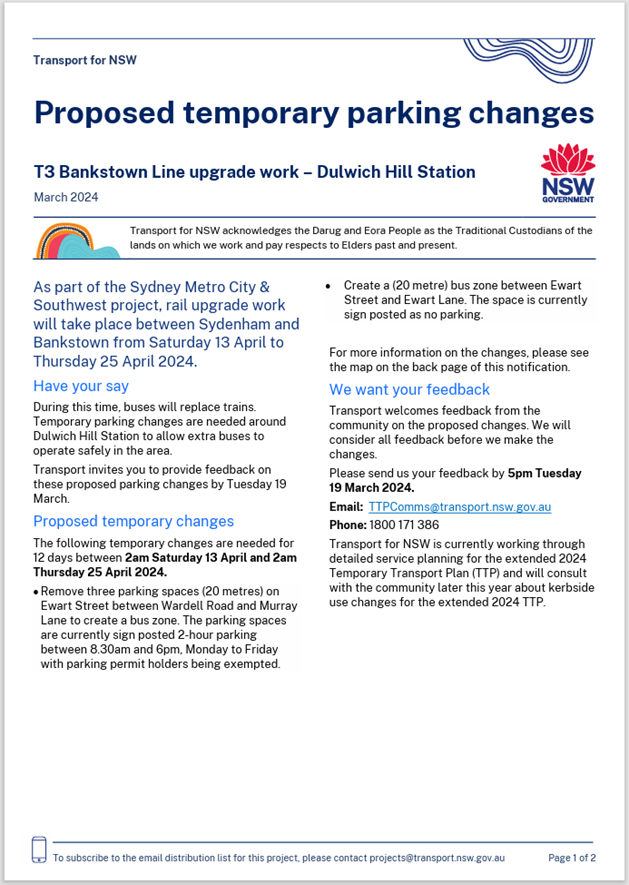

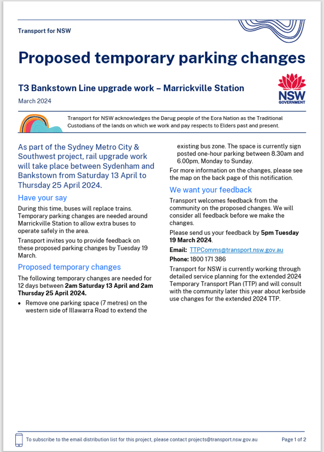

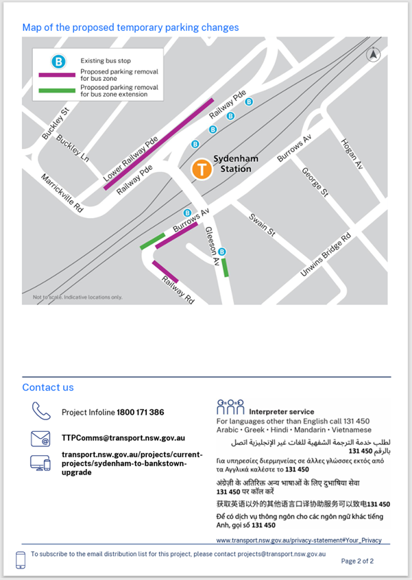
Nil.
|
|
Local Traffic Committee Meeting 18 March 2024 |
Subject: Grosvenor Crescent (Sloane Street to Liverpool
Road), Summer Hill-Proposed Raised Thresholds (Speed Humps)
(Djarrawunang-Ashfield Ward/Summer Hill Electorate/Burwood PAC)
Prepared By: Boris Muha - Traffic Engineer
Authorised By: Manod Wickramasinghe - Traffic and Transport Planning Manager
|
RECOMMENDATION
THAT the proposed installation of 3x Raised threshold (Speed Humps) along Grosvenor Crescent, between Sloane St and Liverpool Rd, Summer Hill with associated landscaping and signs and line marking as shown in Plan No. 10267, sheet 1 to sheet 3 (Attachment 1) be approved.
|
STRATEGIC OBJECTIVE
|
2: Liveable, connected neighbourhoods and transport |
|
|
EXECUTIVE SUMMARY
Council is planning to improve road infrastructure by constructing three (3) raised thresholds (Speed Humps) in Grosvenor Crescent, Summer Hill (Sloane St to Liverpool Rd). The proposal aims to improve the overall road safety along the street and enhance visual amenity by providing additional landscaping opportunities.
BACKGROUND
The proposed installation of these devices’ addresses required traffic calming treatment along Grosvenor Crescent as captured under the ‘Ashfield Traffic Management Strategy 2017 to resolve crashes mainly relating to loss of control on the straight sections of the roadway and resident complaints about speeding vehicles.
DISCUSSION
|
Street Name |
Grosvenor Crescent (between Liverpool Road and Sloane Street.)
|
|
Carriageway width (m) kerb to kerb |
Approx.10m in width. |
|
Carriageway type |
Two-way, one travel lane each direction, kerb side parking both sides. |
|
Classification |
Local |
|
Speed Limit km/h |
50 |
|
85th percentile speed km/h |
52 |
|
Vehicles per day (vpd) |
4000 |
|
Reported crash history July 2017-Dec 2022 |
2 accidents had occurred in the last 5 years.
1x 2019, RUM 30, Rear end, moderate injury. 1x 2019, RUM 71, Off road left => object, serious injury.
Further 7 accidents were accounted between 2010-2017.
5 x off road left=> object or off road left bend=> object, RUM 71, 87. -non casualty (towaways), 1X ped emerging, serious injury 1x head on, moderate injury. |
|
Parking arrangements |
Unrestricted parking to both sides of Grosvenor Crescent.
|
|
Side Street/Road |
Liverpool Road to the western end Sloane Street to the eastern end. |
The Plan
The following works are proposed and are illustrated on the attached plans:
Grosvenor Crescent (Sloane St to Liverpool Rd), Summer Hill (Plan No. 10267)-see Attachment 1 containing 3 plans:
- Construct three (3) new concrete Raised Thresholds (Speed Humps) to improve traffic safety by controlling traffic speed in the street.
- Provide new landscaping in the footpath on either side of the speed humps to protect accidental pedestrian movement across the speed humps.
- Installation of associated line marking.
Parking Changes
No changes are proposed to the existing street & parking signage. Therefore, the proposal will not change existing on-street parking arrangements.
Streetlighting
The existing lighting is deemed adequate and therefore there will be no changes to the existing street lighting due to the proposed works.
FINANCIAL IMPLICATIONS
The proposed works are funded under the 2023/2024 Traffic Works Program with a budget estimate of $155,000.
PUBLIC CONSULTATION
Consultation letters were sent out on the 22/01/2024 and closed on 16/02/2024. A total of 360 letters were distributed to the community at properties as shown in the consultation map area below.
One (1) objection was received. The issues have been addressed in the tabled comments below.

|
Residents Comments |
Officers Response |
|
· Opposed to the new speed humps. People already slow down for the train station. The sound of vehicles breaking is stressful and keeps the whole family awake. I have not encountered any issues on this stretch. They are not necessary and make driving in the area so unpleasant. Please do not go ahead with this project. |
· The proposed installation of these devices’ addresses required traffic calming treatment along Grosvenor Crescent as captured under the ‘Ashfield Traffic Management Strategy 2017 to resolve crashes mainly relating to loss of control on straights and resident complaints about speeding vehicles.
• Traffic calming devices such as speed humps are important road safety devices that assist and control motorist speeds in local and regional streets. It is acknowledged that speed humps generate a noise impact, and this impact is considered against the associated road safety benefits prior to installation of the devices, by both the Local Traffic Committee and Council.
• The proposed devices are evenly placed along the street, and mainly termed as raised thresholds designed in height and ramp in effort to reduce noise and provide a reduced/controlled speed profile along the street leading up to the station. They have been proposed at locations under/near lighting and where properties are well set back from the roadway. |
CONCLUSION
It is recommended that the proposed installation of 3x Raised threshold (Speed Humps) along Grosvenor Crescent, between Sloane St and Liverpool Rd, Summer Hill with associated landscaping and signs and line marking as shown under Plan No. 10267 sheets 1 to 3 in Attachment 1 be approved.
|
1.⇩ |
Proposed 3x Raised thresholds in Grosvenor Crescent, Liverpool Rd to Sloane Street- 3 Plans |
|
Local Traffic Committee Meeting 18 March 2024 |
Subject: Tideswell Street, Ashfield (off Liverpool Road)-Proposed Kerb Extensions and kerb ramps (Djarrawunang-Ashfield Ward/Summer Hill Electorate/Burwood PAC)
Prepared By: Boris Muha - Traffic Engineer
Authorised By: Manod Wickramasinghe - Traffic and Transport Planning Manager
|
RECOMMENDATION
That the amended design plan (No.10254-A) for the proposed new landscaped kerb blister islands, and associated infrastructure works and new signs and line markings at the intersection of Tideswell Street and Liverpool Road, Ashfield, as shown in Attachment 2 be approved. |
STRATEGIC OBJECTIVE
This report supports the following strategic directions contained within Council’s Community Strategic Plan:
|
2: Liveable, connected neighbourhoods and transport |
|
|
EXECUTIVE SUMMARY
Council is planning to improve safety for pedestrians and other road users in Tideswell Street, Ashfield at its intersection with Liverpool Road by constructing a new crossover facility. The works aim to improve pedestrian safety by better defining pedestrian crossing points and reducing the crossing width.
BACKGROUND
The design (only) of this traffic facility is included as part of the 2023/2024 Traffic Facilities Capital Works Program. The project was initiated as part of the Pedestrian Access and Mobility Plan (PAMP) to provide a significant safety improvement and reduce the risk of incidents occurring.
DISCUSSION
Site location and road network.

|
Street Name |
Tideswell Street ( ‘No through Road’ off Liverpool Road)
|
|
Carriageway width (m) kerb to kerb |
Approx.12.7-12.8m in width. |
|
Carriageway type |
Two-way, one travel lane each direction, kerb side parking both sides. |
|
Classification |
Local |
|
Speed Limit km/h |
50 |
|
85th percentile speed km/h |
|
|
Vehicles per day (vpd) |
<300 |
|
Reported crash history July 2017-Dec 2022 |
NIL |
|
Parking arrangements |
Unrestricted parking to both sides of Tideswell Street.
|
|
Side Street/Road |
Liverpool Road |
The Plan
The following works are proposed in amendment (following consultation) and illustrated on the attached plan under Attachment 2.
Tideswell Street, Ashfield (Plan No. 10254 A):
• Construct landscaped kerb extensions with integrated kerb ramps in Tideswell Street at its intersection with Liverpool Road,
• Remove existing kerb ramps and re-construct footpath,
• Provide metal heel safe grated gutter bridges for cross-over between footpath and new pram ramps,
• Relocate existing ‘NO THROUGH ROAD’ AND ‘GIVEWAY’ SIGNS to the appropriate locations,
• Remove existing and provide ‘GIVEWAY’ line markings to the new alignment and provide a new offset ‘BB’ line markings. The ‘BB’ line allows to control entry and exit of vehicles through the intersection, and that the southern carriageway is made 4.8m in width to allow two vehicles to exit side by side turning left and right out of the intersection.
• Install a regulatory ‘No U turn sign’ to alleviate alleged U turning at the intersection.
• All works are contained within the local street area.
The initial plan that went out to consultation is shown under Attachment 1.
Tideswell Street is a short length ‘No Through Road’ off Liverpool Road. Apart from residential properties, Tideswell Street serves rear access to Milano Furniture (130-140 Liverpool Road) and general access for Red Rooster Summer Hill (25 Liverpool Road)
Parking changes
This proposal requires the adjustment to the existing parking arrangements in Tideswell Street, as the works are contained to be generally within the statutory 10m ‘No Stopping’ areas from the intersection. Therefore, there will be a loss of one parking space resulting from the proposed works.
Given the appropriate locations for the new kerb ramps, Council has minimised the loss of parking as much as possible to achieve the benefits of both pedestrian safety and traffic calming.
Streetlighting
The existing street lighting at the location is deemed adequate. Therefore, no changes are proposed to the existing street lighting due to the works.
PUBLIC CONSULTATION
A letter outlining the above proposal was distributed to 13 directly affected properties (25 letters) in Tideswell Street and Liverpool Road, as shown on the consultation map area below.
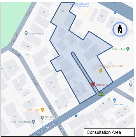
Two (2) submissions were received in comment of the initial design plan as shown in Attachment 1. One (1) resident was in objection and one (1) raised concerns/suggestions to the initial design plans. Council officer responses addressing the issues are tabled below, with the design plan amended accordingly as shown in Attachment 2.
|
Residents Comments |
Officers Response |
|
Resident has objection to the proposal · Concern is raised regarding the loss of a parking space due to Liverpool Road as a clearway most of the weekdays and much of the houses (at Liverpool Road) don't have off-street parking.
· Adding crossover facilities and narrowing the road will result in unnecessary delays to traffic in Tideswell Street.
· Additional traffic signs as part of this work are unnecessary and will cause visual pollution |
· The Southbound carriageway for Tideswell Street is widened from 4.4m to 4.8m by relocating the proposed new centre line marking as illustrated in Consultation Plan 10254-A. This will allow two standard vehicles to depart from Tideswell Street into Liverpool Road side by side.
· The proposed new traffic signs are required as part of the proposal to comply with TfNSW’s specifications and the Australian Standards. However, it should be noted that two proposed ‘No-Stopping’ signs have now been excluded from the proposal.
|
|
Resident is in support for the proposal with comments requiring expansion of scope of works to include: · inclusion of centre island at the crossover facility to stop vehicles from u-turning at the intersection. · ‘No Right Turn’ sign on the centre island as close to the intersection as possible to dissuade vehicles from u-turning at the intersection. · ‘Keep Clear’ line marking symbols across Liverpool Road in front of Tideswell Street to dissuade vehicles from u-turning at the intersection. · ‘Left Only’ sign on the centre island in front of the driveway leaving Red Rooster to discourage patrons from turning right when leaving Red Rooster. He believes this will discourage patrons from using Tideswell Street as additional parking spots
|
· A new central median island would need to be 2m wide to satisfy the standards required for such devices. Council does not support the inclusion of such a device as it will constrain truck movements into the street.
· The installation of a ‘Left Only’ sign is not supported as it is not a priority traffic issue and would be difficult to enforce. There is no recorded accident history within the street to justify such a restriction on traffic grounds. |
CONCLUSION
It is recommended that the amended design plan (No.10254-A) for the proposed new landscaped kerb blister islands, and associated infrastructure works and new signs and line markings at the intersection of Tideswell Street and Liverpool Road, Ashfield, as shown in Attachment 2 be approved.
FINANCIAL IMPLICATIONS
Funding will be allocated from the PAMP programs in the estimate amount of $67,000 with construction plan design in 2023/2024 and programmed construction in 2024/2025.
|
1.⇩ |
Original design plan No. 10254 |
|
2.⇩ |
Amended design plan No. 10254 A |
|
|
Local Traffic Committee Meeting 18 March 2024 |
Subject: London Street and Simmons Street, Enmore – Proposed Temporary Road Closure and Part Road Closure (Damun-Newtown Ward/Newtown Electorate/Inner West PAC)
Prepared By: George Tsaprounis - Coordinator Traffic Engineering Services (south)
Authorised By: Manod Wickramasinghe - Traffic and Transport Planning Manager
|
RECOMMENDATION
1. That the temporary full closure of London Street, Enmore between Enmore Road and Belmore Lane be approved for a trial period of 6 months.
2. That the temporary part closure of Simmons Street, Enmore with a one way northbound between Enmore Lane and Enmore Road be approved for a trial period of 6 months.
3. That a report be bought back to the Committee following the 6-month trial period and be used to inform Council of possible locations for future implementation of traffic management measures as well as success or otherwise of the temporary road/part road closures.
4. That Traffic Management Plans for the proposed changes to London Street and Simmons Street be submitted to TfNSW for their consideration and approval.
5. That Council undertake vehicle movement surveys at least 2 months after implementation of the temporary closures at the midblock locations to determine changes to the traffic volumes and establish whether further changes required to manage speed and/or rat running.
6. That the signs and linemarking plan for London Street (Parking changes plan) as per figure 4 be approved.
7. That the signs and linemarking plan for Simmons Street (Parking changes plan) as per figure 5 be approved.
|
STRATEGIC OBJECTIVE
This report supports the following strategic directions contained within Council’s Community Strategic Plan:
|
2: Liveable, connected neighbourhoods and transport |
|
|
EXECUTIVE SUMMARY
Council is proposing to close London Street at Enmore Road and Simmons Street (part closure) and one way northbound between Enmore Road and Enmore Lane in order for these selected streets to become more welcoming and enhance their use and activity for pedestrians and people visiting Enmore. This project comes from Council’s Main Streets Program and aims to improve the vibrancy and safety of public spaces to pedestrians and people visiting this busy and active strip, by improving their character and making them more inviting for people to spend more time in.
Both traffic and parking impacts have been reviewed as part of the proposal and it was found that both London Street and Simmons Street would benefit from the proposed changes, other adjacent streets would actually experience an increase in traffic and this varied from a minor increase to a few examples where a more significant increase may occur. Community feedback from the engagement exercise found overall approximately 70% of respondents supported the proposals however a number of local residents raised concerns with the redistribution of traffic into adjacent streets. Council has made changes to the original proposals that include reducing the trial period down to 6 months and changing the full closure of Simmons Street to a part closure with a one way northbound traffic flow.
Proposed changes to parking are not considered significant, as there will be no loss in parking for London Street and only a minor loss for Simmons Street. There will however be the loss of a ‘No Parking’ area on the eastern side of Simmons Street that is currently used by delivery vehicles at times.
In conclusion, it is proposed that the temporary full closure of London Street between Enmore Road and Belmore Lane and the part closure of Simmons Street between Enmore Road and Enmore Lane with one way northbound traffic be supported as a 6 month trial to improving the vibrancy and safety of these public spaces and local streets. It is also recommended that the plans within the report showing the signage and line marking changes be approved in order to better delineate parking and non carparking spaces, turning restrictions as well as other features such as the cycle lanes.
BACKGROUND
Council’s Main Streets Program aims to improve the vibrancy and safety of public spaces and local streets by improving their character and making them more inviting.
Re-imagining the use of public spaces and regenerating them can enhance the lives of the community and assist economic growth by providing settings to attract visitation and local spend and creating places to go to, not move through.
As a part of the Main Streets Program, Council has developed concept plans for improvements to two (2) local streets in Enmore, an area recently classified as a Special Entertainment Precinct where Council is encouraging night time activities:
· London Street (closure)
· Simmons Street (part closure)
Council has reviewed local traffic movements and notes that the proposal will impact a number of local vehicular movements, however the redistribution of traffic can be accommodated by the adjacent streets.
Although Council proposed that the two streets were to be temporarily pedestrianised for a period of 18 months from early 2024, this has been amended to a 6-month trial period and Simmons Street was changed from a full road closure to a partial road closure with a one way northbound following community engagement.
DISCUSSION
In order for Council to make selected streets more welcoming and enhance their use and activity, council officers have worked with adjacent shop owners and are now proposing the following place making and pedestrian improvements to London Street and Simmons Street:
· Create a space where people can meet and socialise or have a quiet time.
· Install seating and large pots with trees. Provide paving decoration.
· Create an opportunity for patrons of the adjacent or nearby businesses to enjoy an outdoor space off Enmore Road.
The above aspects of the London Street and Simmons Street proposals are represented in Figures 1&2 below and attachments.
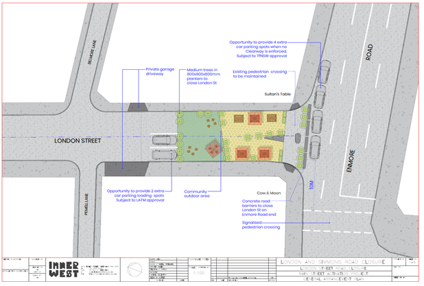
Figure 1 – London Street closure proposal
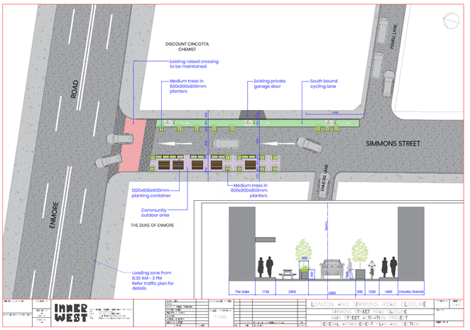
Figure 2 – Simmons Street part closure and one way proposal
The projects are both located adjacent to Enmore Road, Simmons Street approximately 450 metres west of Newtown Station and London Street approximately 600 metres west of Newtown station.
· London Street is a side street off Enmore Road, with the proposed works located between Enmore Road and Cambridge Lane. The site is also located between the Cow & The Moon Gelato shop and Sultan’s Kebab’s, both of which have outdoor dining tables on the footpath.
· Simmons Street is a side street extending off Enmore Road, with the proposed works occurring between Enmore Road and Enmore Lane. The site is between The Duke Hotel to the west and an apartment building with a ground floor shop to the east.
Traffic Impacts
London Street is a local road with a 9.7 m wide roadway and 2.9m and 1.7m footpaths on either side of the roadway. It carries around 3650 vehicles per day in the section between Liberty Street and Augustus Street. Many of the trips along London Street are rat runners as London Street provides convenient access between Liberty Street and Enmore Road.
Simmons Street is a local road with a 8.8m wide road and 1.7m and 1.6m wide footpaths on either side of the road, between Enmore Road and Pemmell Lane. It carries around 1230 vehicles per day in the section between Enmore Road and Enmore Lane. The bulk of trips moving via Simmons Street are localised internal trips.
Mid block traffic counts were collected for 7 days from 4th June 2023 and intersection counts undertaken on 7th December 2023 in the Enmore Road local area. They have revealed that a high proportion of through traffic uses the London Street/Enmore Road intersection during peak times (refer to Figure 3 below and Attachment 1)
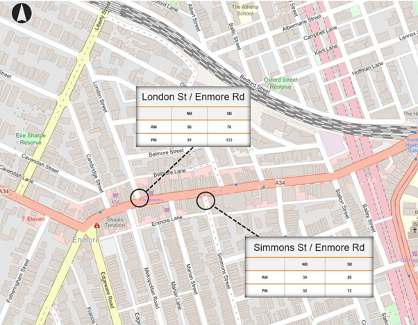
Figure 3: Intersection traffic count survey data for London St and Simmons St
A study was commissioned by Council Officers in order to determine the impact of the proposals on adjacent local Street network. The following assumptions were made in relation to the distribution of the traffic (refer to Attachment 1 - London Street and Simmons Street (Southbound) Temporary Road Closures)
London Street – Northbound
For traffic travelling northbound on London Street, 10% are internal trips and 90% are external trips (i.e., rat runners). To determine this, count data from various locations was analysed and compared. Of the 90% of external through trips travelling north on London Street, it was assumed that following the closure of London Street at Enmore Road:
· 80% of vehicles would travel via Liberty St; and,
· 20% of vehicles would travel via Philip St.
London Street – Southbound
For traffic travelling southbound on London Street, 10% are internal trips and 90% are external trips (i.e., rat runners). To determine this, count data from various locations was analysed and compared. After considering the tube data collected, of the 90% of external through trips travelling south on London Street, it was assumed that following the closure of London Street at Enmore Road:
· 40% of vehicles would travel via Gladstone Street and Philip Street;
· 30% of vehicles would travel via Belmore Street and Philip Street; and,
· 30% of vehicles would travel via Belmore Lane and Philip Street.
Simmons Street – Northbound
Simmons Street will allow a one-way northbound exit onto Enmore Road, with both left and right turning movements permitted. It is assumed that all the vehicles currently travelling northbound on Simmons Street to get to Enmore Rd will continue to do so in the future, even after the implementation of the Simmons Street (Southbound) street closure.
Simmons Street – Southbound
For traffic travelling southbound on Simmons Street, we assume that all trips would divert to either Marian Street, Reiby Street or Station Street. It assumed that the bulk of trips moving via Simmons Street are localised internal trips. For this reason, the traffic travelling southbound on Simmons Street was re-distributed to the above-mentioned streets as follows:
· 70% of vehicles would travel via Marian Street;
· 20% of vehicles would travel via Reiby Street; and,
· 10% of vehicles would travel via Station Street.
A summary of the streets where traffic volume is projected to increase due to the proposed road closures include;
· Gladstone Street: AM peak East bound, existing 175 vehicles, increase to 204 vehicles (+29 vehicles or 17% increase);
PM peak East bound, existing 137 vehicles, increase to 180 vehicles (+43 vehicles or 31% increase).
· Phillip Street: AM peak South bound, existing 92 vehicles, increase to 155 vehicles (+63 vehicles)
PM peak South bound, existing 90 vehicles, increase to 186 (+96 vehicles)
· Belmore Street: AM peak West bound existing 51 vehicles, increase to 58 vehicles (+7 vehicles or 14% increase)
PM peak East bound existing 73 vehicles, increase to 79 vehicles (+6 vehicles or 8% increase).
· Belmore Lane: AM peak West bound existing 104 vehicles, increase to 111 vehicles (+7 vehicles or 7% increase)
PM peak West bound existing 109 vehicles, increase to 115 vehicles (+6 vehicles or 6% increase)
· Marian Street: AM peak South bound existing 10 vehicles, increase to 30 vehicles (+20 vehicles)
PM peak South bound existing 18 vehicles, increase to 64 vehicles (+46 vehicles)
Phillip Street, Gladstone and Marian Streets will experience the most significant increases in traffic as compared to their current levels.
The following improvements in vehicular movements are projected on London Street and Simmons Street due to the proposed road closures:
· London Street: AM peak North bound existing 147 vehicles, reduced to 97 vehicles (-51 vehicles or 34% fewer vehicles);
Southbound existing 111 vehicles, reduced to 84 vehicles (-26 vehicles or 23% fewer vehicles).
PM peak North bound existing 130 vehicles, reduced to 85 vehicles (-45 vehicles or 35% fewer vehicles);
South bound existing 158, reduced to 117 vehicles (-41 vehicles or 26% fewer vehicles)
· Simmons Street: AM peak southbound existing 28 vehicles, reduced to 0 vehicles (-28 vehicles or 100% fewer vehicles)
PM peak southbound existing 66 vehicles, reduced to 0 vehicles (-66 vehicles or 100% fewer vehicles)
Six month trial
It is proposed that both temporary road closures will be trialled for a 6-month period from approximately July 2024 to January 2025. At least two months after the commencement of the trial, Council will undertake a new count of vehicle movements on local streets in the area to get accurate data on the extent of changes to local streets. Council will review this new data when preparing a new Local Area Traffic Management study for the area to identify opportunities to prevent rat running through the area and also to inform a decision at the end of the six month trial period to either extend or conclude the London and Simmons Street road closure trials. Council Officers will submit as the next step in the process, a Traffic Management Plan to Transport for New South Wales (TfNSW) for consideration and approval.
Impacts to Parking
Each of the proposals will result in the changes to the parking in the affected section of London Street and Simmons Street. In London Street there is no net loss in carparking as a result of the closure (i.e., although six one hour parking spaces will be lost as a result of the proposed closure, a further 6 spaces will be gained by extending parking through the intersection and providing a further 2 angled spaces in London Street itself). Signs and linemarking will be amended in this area to suite the proposed arrangements. (Refer to figure 4 below). Note that changes to parking arrangements on Enmore Road will require TfNSW approval.
In Simmons Street, there is a large area of ‘No Parking’ on the eastern side of the roadway, and this appears to be used as a loading area by the adjacent business owners. On the western side of the roadway, currently a portion of the roadway is taken up by a temporary outdoor dining area and the remainder is motorcycle parking (1 car parking space in length). Prior to Council approving the dining area, this area was unrestricted parking for two vehicles. The proposal will only affect the motorcycle parking for the duration of the trial. The loss of the ‘No Parking’ on the eastern side may be expected to have an impact on deliveries to local businesses. Signs and linemarking will be amended in this area to suite the proposed arrangements. (Refer to figure 5 below).
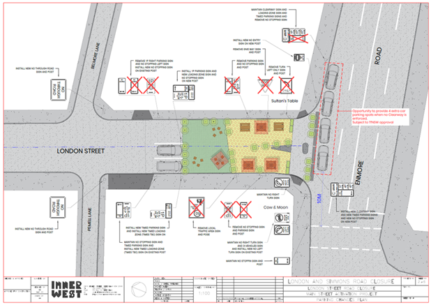
Figure 4 – London Street signage and linemarking plan.

Figure 5 – Simmons Street signage and linemarking plan.
Prior to the final layout of Simmons Street being developed, the critical left movement from Enmore lane into Simmons Street was analysed so that parking spaces and lane widths could be better determined. This turn was tested on the left turn movement of an 8.8m service truck. The analysis is shown in figure 6 below.
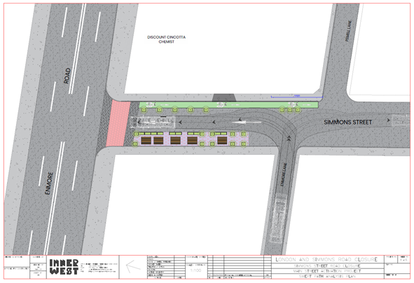
Figure 6 – Swept path analysis of a left and right turning 8.8m service truck from Enmore Lane
Public Consultation
From 23 October to 20 November 2023, the community was invited to provide feedback on concept plans that propose temporarily closing off London and Simmons Streets, at Enmore Road and make a short section of each street a public plaza for people to visit and stay. (Refer to Attachment 7 – Engagement Report)
During the engagement period:
· There were 131 visits to the Your Say Inner West (YSIW) page
· 100 community members participated in the Face-to-face pop-up session
· 26 emails received
· 2 x Hardcopy letters received
Key comments received included:
o A clear majority of respondents supported the creation of temporary plaza spaces at both London and Simmons Streets.
o Written email and letter submissions with detailed commentary, mostly objecting to traffic management concerns with the proposals.
o A strong turnout of local residents at the community pop-up event who indicated both support and objection to the proposals, supporting increased pedestrian space whilst raising concerns with traffic impacts on local streets.
|
Promotion and engagement methods Promotion method |
Stakeholders engaged |
|
Project page on Your Say Inner West |
773 people visited the YSIW page.
|
|
Letterbox drop |
492 letters were sent to residents adjacent to London Street 566 letters were sent to residents adjacent to Simmons Streets
|
|
Online Survey |
131 people responded to the online survey.
|
|
Direct contact from residents |
28 emails from individuals 100 community members participated in the Face-to-face pop-up session. 2 letters from individuals
|
Summary of feedback
A summary of the online responses is provided below.
|
Question |
Response |
|
Do you support the creation of a new pedestrian space in London Streets? 131 responses |
88 (67.18%) of respondents showed support of the concept plan. 43 (32.82%) not in support of proposal.
|
|
Do you support the creation of a new pedestrian space in Simmons Streets? 131 responses |
87 (66.41%) of respondents showed support of the concept plan. 44 (33.59%) not in support of proposal.
|
As a result of the community engagement, Council Officers made several changes to the proposal including reducing the trial period from 18 months to 6 months and amending Simmons Street from a full closure to a partial closure. Concerns with the impact of the redistribution of traffic was the main concerns for the residents objecting. Council Officers in the trial period are proposing to undertake counts to gauge the actual effect of the closures and will subsequently come back to Council with a further report following the end of the trial period.
In conclusion, it is proposed that the temporary full closure of London Street between Enmore Road and Belmore Lane and the part closure of Simmons Street between Enmore Road and Enmore Lane with one way northbound traffic be supported as a 6 month trial, to improve the vibrancy and safety of public spaces and local streets. It is recognised that although there are benefits to the proposed closures there will be impacts on adjacent streets as a consequence of changes to the number of vehicles traveling along these local streets. To address this issue, a trial of 6 months and additional counts will be undertaken during this period, to determine the overall impact to the adjacent streets. Community feedback will also be at the end of the trial period.
The plans within the report showing the signage and line marking changes are also supported, in order to better delineate parking and non carparking spaces, turning restrictions as well as other features such as the cycle lanes.
FINANCIAL IMPLICATIONS
The proposals within this report are funded through Council's Mainstreet Local Place Making budget.
|
1.⇩ |
London Street and part Simmons Street temporary closures report |
|
2.⇩ |
Figure 1 - London Street closure proposal |
|
3.⇩ |
Figure 2 - Simmons Street closure proposal |
|
4.⇩ |
Figure 4 – London Street signage and linemarking plan. |
|
5.⇩ |
Figure 5 – Simmons Street signage and linemarking plan. |
|
6.⇩ |
Figure 6 – Swept path analysis of a left and right turning 8.8m service truck from Enmore Lane |
|
7.⇩ |
Engagement Report |
|
|
Local Traffic Committee Meeting 18 March 2024 |
Subject: Amendment to signposted Car Share Vehicles spaces in the Inner West (All Wards, All Electorates, All PACs)
Prepared By: Sarah Guan - Graduate Strategic Transport Planner
Authorised By: Manod Wickramasinghe - Traffic and Transport Planning Manager
|
RECOMMENDATION
1. That the existing car share spaces signposted as 'No Parking, Council Authorised Car Share Vehicles Excepted’ (or similar) in the locations scheduled in Attachment 2 be amended to ‘No Parking Authorised Car Share Vehicle Excepted Area GG’.
2. That the following signposting convention be endorsed for the current Council car share providers: a) Car share spaces operated by Goget be signposted with the Area GG exemption b) Car share spaces operated by Flexicar be signposted with Area FC exemption c) Car share spaces operated by Popcar be signposted with Area PC exemption |
STRATEGIC OBJECTIVE
This report supports the following strategic directions contained within Council’s Community Strategic Plan:
|
2: Liveable, connected neighbourhoods and transport |
|
|
EXECUTIVE SUMMARY
Currently Council has signposted 116 fixed on-street car share spaces in the LGA which are operated by GoGet.
Following the adoption of the Inner West Car Share Policy (Attachment 1), additional car share operators have been selected to operate in the Inner West which requires amendment to existing signage to accommodate multiple companies.
It is recommended that Council adopts changes to signage for on-street fixed space car share parking.
BACKGROUND
Car share parking is an efficient use of parking spaces because one shared vehicle can replace several private vehicles that would otherwise compete for local parking. Car share also reduces overheads for residents who don't need to own a car.
Council supports car sharing as a part of its drive to:
· reduce greenhouse gas emissions;
· reduce on-street parking demand;
· reduce congestion and the competition for parking spaces; and
· encourage active lifestyles by reducing dependency on private cars.
Users of car share schemes in the Inner West report reduced car ownership and greater use of other transport options including public transport, walking and cycling.
GoGet was the car share operator for the former Marrickville Council and Leichhardt Council and continue to operate in Inner West Council.
Currently car share parking spaces are signposted differently depending on the location and include variations of:
· ’No Parking Council authorised car share vehicles excepted’
· ‘No Parking Leichhardt Council authorised car share vehicles excepted’
· ‘No Parking Car share vehicles authorised by Marrickville Council excepted’
The map shows the geographic distribution of fixed GoGet car share vehicles in the Inner West. Note that the map does not show the number of car share parking spots at each location and does not include car share vehicles on private land. For a complete list of GoGet’s existing dedicated on-street car share parking spaces, please refer to Attachment 2.
Figure 1: GoGet car share distribution in Inner West
On 3 August 2021, Council resolved to adopt the Inner West Council Car Share Policy and following this, in October 2023, an RfQ for car share operators in Inner West LGA was released.
This was in response to overwhelming interest from other car share operators and to provide variety of options to our Community.
The benefits of multiple car share operators include:
· Providing our community with a variety of choices;
· Creating a competitive market to benefit our community; and
· Increase resilience within the car share industry in Inner West to reduce impacts of shocks from the market.
There are 3 car share operators appointed from the RfQ: GoGet, Hertz/Flexicar and PopCar. Changes to existing car share signage are required to allow for proper allocation and enforcement of car share spaces between the multiple car share operators.
DISCUSSION
Changes to the signage will follow TfNSW’s Guidelines for on-street fixed car share parking as shown below.

Figure 2: Example signage from TfNSW's Guidelines for on-street fixed space car share parking
Council proposes using the following area codes for Authorised Car Share Operators:
|
Authorised Car Share Operator |
Area Code |
|
GoGet |
GG |
|
Flexicar |
FC |
|
PopCar |
PC |
Table 1: Proposed area codes for Authorised Car Share Operators
The area codes will allow the community and Council’s Parking and Ranger services staff to identify which car share operator is assigned to a fixed car share space.
FINANCIAL IMPLICATIONS
Authorised car share operators are required to pay for application fees, supply and installation of signposting fees in addition to an annual fee for each signposted parking space.
These fees cover the maintenance and updating of signage.
Fees associated with car share parking for FY23/24 is outlined below:
|
Fee Type |
FY23/24 Fee |
|
Car Share space application – per application |
$179.80 |
|
Install/replace car share signposting supply and install signs (includes first years fee) – per sign |
$422.40 |
|
Car share Annual Fee – per year or part there of |
$192.60 |
Table 2: Fees and charges for car share parking space (Source: Inner West Fees & Charges 2023/24)
|
1.⇩ |
Inner West Council's Car Share Policy |
|
2.⇩ |
List of GoGet's existing dedicated car share parking spaces |