|
AGENDA R |

Local Traffic Committee Meeting
MONDAY 15 APRIL 2024
11:00 AM
|
|
Local Traffic Committee Meeting 15 April 2024 |
Function of the Local Traffic Committee
Background
Roads and Maritime Services (RMS) is legislated as the Authority responsible for the control of traffic on all NSW Roads. The RMS has delegated certain aspects of the control of traffic on local roads to councils. To exercise this delegation, councils must establish a local traffic committee and obtain the advice of the RMS and Police. The Inner West Council Local Traffic Committee has been constituted by Council as a result of the delegation granted by the RMS pursuant to Section 50 of the Transport Administration Act 1988.
Role of the Committee
The Local Traffic Committee is primarily a technical review and advisory committee which considers the technical merits of proposals and ensures that current technical guidelines are considered. It provides recommendations to Council on traffic and parking control matters and on the provision of traffic control facilities and prescribed traffic control devices for which Council has delegated authority. These matters are dealt with under Part A of the agenda and require Council to consider exercising its delegation.
In addition to its formal role as the Local Traffic Committee, the Committee may also be requested to provide informal traffic engineering advice on traffic matters not requiring Council to exercise its delegated function at that point in time, for example, advice to Council’s Development Assessment Section on traffic generating developments. These matters are dealt with under Part C of the agenda and are for information or advice only and do not require Council to exercise its delegation.
Committee Delegations
The Local Traffic Committee has no decision-making powers. The Council must refer all traffic related matters to the Local Traffic Committee prior to exercising its delegated functions. Matters related to State Roads or functions that have not been delegated to Council must be referred directly to the RMS or relevant organisation.
The Committee provides recommendations to Council. Should Council wish to act contrary to the advice of the Committee or if that advice is not supported unanimously by the Committee members, then the Police or RMS have an opportunity to appeal to the Regional Traffic Committee.
Committee Membership & Voting
Formal voting membership comprises the following:
· one representative of Council as nominated by Council;
· one representative of the NSW Police from each Local Area Command (LAC) within the LGA, being Newtown, Marrickville, Leichhardt and Ashfield LAC’s.
· one representative from the RMS; and
· State Members of Parliament (MP) for the electorates of Summer Hill, Newtown, Heffron, Canterbury, Strathfield and Balmain or their nominees.
Where the Council area is represented by more than one MP or covered by more than one Police LAC, representatives are only permitted to vote on matters which effect their electorate or LAC.
Informal (non-voting) advisors from within Council or external authorities may also attend Committee meetings to provide expert advice.
Committee Chair
Council’s representative will chair the meetings.
Public Participation
Members of the public or other stakeholders may address the Committee on agenda items to be considered by the Committee. The format and number of presentations is at the discretion of the Chairperson and is generally limited to 3 minutes per speaker. Committee debate on agenda items is not open to the public.
|
|
Local Traffic Committee Meeting 15 April 2024 |
|
AGENDA |
1 Apologies
2 Disclosures of Interest
3 Confirmation of Minutes Page
Minutes of 18 March 2024 Local Traffic Committee 5
4 Matters Arising from Council’s Resolution of Minutes
5 Part A – Items Where Council May Exercise Its Delegated Functions
Traffic Matters
ITEM Page
LTC0424(1) Item 1 Jane Street, Balmain - Proposed Adjustment to No Stopping Restriction (Baludarri-Balmain Ward/Balmain Electorate/Leichhardt PAC) 27
LTC0424(1) Item 2 Alberto Street, Lilyfield - Proposed Kerb Extension (Baludarri-Balmain Ward/Balmain Electorate/Leichhardt PAC) 30
LTC0424(1) Item 3 Boomerang Street, Haberfield - Pedestrian Crossing Line Markings (Gulgadya-Leichhardt Ward/Summer Hill Electorate/Burwood PAC) 35
LTC0424(1) Item 4 Lewisham Street, Dulwich Hill - Proposed one-way (westbound) restriction (Djarrawunang-Dulwich Hill Ward/Summer Hill Electorate/Inner West PAC) 37
LTC0424(1) Item 5 Hercules Street, Fox's Lane & Drakes Lane, Ashfield-Temporary Full Road closures (ENRC/2024/0016) 'Culture X Ashfield Music Festival' - Sunday 8 September 2024 (Djarrawunang-Ashfield Ward/Summer Hill Electorate/Burwood PAC) 47
LTC0424(1) Item 6 Illawarra Road, Marrickville Near Thornley Street - Proposed Upgrade Of Existing Pedestrian Crossing (Midjuburi-Marrickville Ward / Summer Hill Electorate / Inner West PAC) 76
Parking Matters
ITEM Page
LTC0424(1) Item 7 Wells Avenue, Tempe - Proposed Relocation Of Existing Marked Parking Bay (Midjuburi - Marrickville Ward/ Heffron Electorate / Inner West PAC) 79
Late Items
Nil at time of printing.
6 Part B - Items for Information Only
Nil at the time of printing.
7 Part C - Items for General Advice
Nil at the time of printing.
8 General Business
9 Close of Meeting
|
|
Local Traffic Committee Meeting 15 April 2024 |
Minutes of Meeting held on 18 March 2024
Meeting commenced at 11:04 AM
ACKNOWLEDGEMENT OF COUNTRY BY CHAIRPERSON
I acknowledge the Gadigal and Wangal people of the Eora nation on whose country we are meeting today, and their elders past and present.
COMMITTEE REPRESENTATIVES PRESENT
|
Mayor Darcy Byrne |
Councillor – Baludarri-Balmain Ward (Chair – Items 1 to 2) |
|
Manod Wickramasinghe |
IWC’s Traffic and Transport Planning Manager (Chair – Items 3 to 20) |
|
Bill Holliday |
Representative for Kobi Shetty MP, Member for Balmain |
|
Graeme McKay |
Representative for Jo Haylen MP, Member for Summer Hill |
|
Nina Fard |
Transport for NSW (TfNSW) |
|
|
|
|
NON VOTING MEMBERS IN ATTENDANCE |
|
|
|
|
|
Colin Jones |
Inner West Bicycle Coalition (IWBC) |
|
Michael Takla |
Representative for Transit Systems |
|
Roderick Primerano |
Representative for U-Go Mobility |
|
Sunny Jo |
IWC’s Coordinator Traffic Engineering Services (North) |
|
Jason Scoufis |
IWC’s Coordinator Traffic Studies & Road Safety |
|
Kurt Henkel |
IWC’s Principal Designer Public Domain |
|
Amir Falamarzi |
IWC’s Traffic Engineer |
|
Sarah Guan |
IWC’s Graduate Strategic Transport Planner |
|
Christy Li |
IWC’s Business Administration Officer |
|
|
|
|
VISITORS |
|
|
|
|
|
Edward Walsh |
Resident (Item 2) |
|
Bob Stephenson |
Resident (Item 2) |
|
Susan Moxham |
Resident (Item 2) |
|
Huw Davies |
Resident (Item 2) |
|
Despina Langella |
Resident (Item 15) |
|
Felicity Muller |
Resident (Item 15) |
|
Michael Frydman |
Resident (Item 15) |
|
Doug Rosser |
Resident (Item 15) |
|
Nick Rippon |
Resident (Item 15) |
|
|
|
|
APOLOGIES: |
|
|
|
|
|
Ben Walters |
NSW Police – Inner West Police Area Command |
|
|
|
DISCLOSURES OF INTERESTS:
Nil.
CONFIRMATION OF MINUTES
|
That the Minutes of the Local Traffic Committee held on Monday, 19 February 2024 be confirmed. |
MATTERS ARISING FROM COUNCIL’S RESOLUTION OF MINUTES
The Minutes of the Local Traffic Committee meeting held on 11 December 2023 were adopted at Council’s meeting held on 05 March 2024 subject to the following adjustments:
1. Council committing to the expedited delivery of LTC1233 (1) Item 8 traffic calming measures around Cardinal Freemen Village:
a) that Council Commits to the planned works being delivered in both the 2024/25 and 2025/26 financial years and that Council will seek opportunities to fund and deliver the works sooner;
b) that Plan 1 (a) Victoria St, mid-block between Clissold Street and Seaview Street be delivered as the first project, as a matter of urgency; and
c) that Item 8 program of works be referred to the Major Projects Committee for oversight.
2. The following being referred to the Local Traffic Committee for investigation, in relation to LTC1223(1) Item 8:
a) that Council investigate traffic calming measures on intersections of Norton Street and Carlisle Street, and Norton and Lapish Avenue; and
b) that Council continue consultations with Guide Dogs NSW/ACT and other stakeholders with the aim of developing safe and inclusive pedestrian crossings in our community.
3. The following amendments to LTC1223(1) Item 7 to include urgent action being taken to improve visibility of the pedestrian crossing at Illawarra Road at Yirran Gumal Early Learning Centre, including:
a) a report including designs to improve visibility at the crossing be brought to the next possible Local Traffic Committee Meeting, considering options to raise the crossing, implement flashing lights, or any other measure to improve safety; and
b) that upon approval by the Local Traffic Committee and Council, these works be immediately prioritised and undertaken, funded through the quarterly budget update.
4. The following amendments to LTC1223(1) Item 3:
a) that the clause on
page 7 of the policy that allows for crossings to be provided at less than the
numerical warrant be amended to read as follows:
‘A pedestrian (zebra) crossing may also be considered
at locations where there is a deviation from meeting the
warrant, such as where the pedestrian crossing would serve as an
essential link to an overall network of pedestrian facilities, or for a vulnerable group such as children, the elderly or
mobility impaired’; and
b) that a report be provided to Council 12 months after the adoption of the policy about any new pedestrian crossings that have been approved or refused under the new policy, with reasons for the approvals and refusals to be included in the report.
The Minutes of the Local Traffic Committee meeting held on 19 February 2024 were adopted at Council’s meeting held on 05 March 2024.
|
LTC0324(1) Item 12 Ewart Street, Dulwich Hill; Illawarra Road, Marrickville; Burrows Avenue, Railway Road, Gleeson Avenue And (Lower) Railway Parade, Sydenham - Temporary Parking Changes During Major Rail Shutdown Of T3 Line For Sydney Metro Upgrade Works - Bus Replacements Saturday 13 April 2024 To Wednesday 24 April 2024 (Midjuburi -Marrickville Ward / Summer Hill Electorate / Inner West PAC) |
|
Council has been notified by Transport for NSW (TfNSW) that Sydney Metro works will involve major rail shutdown of the Sydenham to Bankstown rail line (T3) for the following periods: Saturday 13 April 2024 to Wednesday 24 April 2024 (inclusive). During the shutdown buses will replace train services along the T3 line and to accommodate the increased bus movements and necessary holding areas some short-term parking changes are required at a number of locations.
Specifically, TfNSW is requesting approval for the temporary conversion of multiple parking spaces at the following locations: Ewart Street, Dulwich Hill; Illawarra Road, Marrickville; Burrows Avenue, Railway Road, Gleeson Avenue and (Lower) Railway Parade, Sydenham. It is recommended that no objections be raised, and Council approves the temporary short-term parking changes at the identified locations during the rail shutdowns.
All changes to street signage will be made by TfNSW contractor(s) from 10pm the night before the closures and will be reinstated at the completion of the planned shutdowns.
Officers Recommendation:
1. That the following temporary short-term parking changes for the period of 2am Saturday 13 April 2024 to 10pm Wednesday 24 April 2024 (inclusive) be approved to support the works required to convert the T3 Bankstown Line to a Metro Line:
a) Dulwich Hill Station Precinct - Ewart Street (3 parking spaces): The short-term conversion of 20m (3 parking spaces) ‘2P 8 am – 6 pm Mon – Fri’ on the northern side of Ewart Street (between Wardell Road and Bayley Street) to a ‘Bus Zone’;
b) The short-term conversion of 25m ‘No Parking’ restrictions on the southern side of Ewart Street (between Wardell Road and Riverside Crescent) to a ‘Bus Zone’;
c) Marrickville Station Precinct - Illawarra Road (1 parking space): The short-term conversion of 7m (1 parking space) ‘1P 8:30 am – 6 pm’ on the western side of Illawarra Road (between Warburton Street and Greenbank Street) to a ‘Bus Zone’;
d) Sydenham Station Precinct - Burrows Avenue (23 parking spaces): The short-term conversion of 50m (14 parking spaces) rear to kerb ‘unrestricted parking’ on the northern kerb of Burrows Avenue (west of Gleeson Avenue) to a ‘Bus Zone’;
e) The short-term conversion of 58m (9 parking spaces) ‘unrestricted parking’ on the southern kerb of Burrows Avenue (west of Gleeson Avenue) to a ‘Bus Zone’;
f) Sydenham Station Precinct – Railway Road (3 parking spaces): The short-term conversion of 18m (3 parking spaces) ‘2P 8:30 am – 10 pm Mon - Fri’ on the eastern side kerb of Railway Road (between Burrows Avenue and Gleeson Avenue) to a ‘Bus Zone’;
g) Sydenham Station Precinct - Gleeson Avenue (2 parking spaces): The short-term conversion of 12m (2 parking spaces) ‘1P 9:00 am – 3:30 pm Mon - Fri and No Parking 6 am-9 am & 3:30 pm – 6:30 pm’ on the eastern kerb of Gleeson Avenue (between Burrows Avenue and Unwins Bridge Road) to a ‘Bus Zone’;
h) Sydenham Station Precinct - Lower Railway Parade (57 parking spaces): The short-term conversion of 122m (46 parking spaces) 45 degree angled ‘unrestricted parking’ on the southern side kerb of Lower Railway Parade (between Sydenham Road and Marrickville Road) to a ‘Bus Zone’; and
i) The short-term conversion of 32m (11 parking spaces) 45 degree angled parking ‘4P 8:30 am – 6 pm Mon - Fri’ on the southwest kerb of Lower Railway Parade (between Gleeson Avenue and Marrickville Road) to a ‘Bus Zone’.
2. That the cost of all works of the statement and/or reinstatement of any/all signage will be borne by TfNSW.
3. That the applicant and Council Rangers be advised in terms of this report.
DISCUSSION:
The Committee members agreed with the Officer’s recommendation.
COMMITTEE RECOMMENDATION:
1. That the following temporary short-term parking changes for the period of 2am Saturday 13 April 2024 to 10pm Wednesday 24 April 2024 (inclusive) be approved to support the works required to convert the T3 Bankstown Line to a Metro Line:
a) Dulwich Hill Station Precinct - Ewart Street (3 parking spaces): The short-term conversion of 20m (3 parking spaces) ‘2P 8 am – 6 pm Mon – Fri’ on the northern side of Ewart Street (between Wardell Road and Bayley Street) to a ‘Bus Zone’;
b) The short-term conversion of 25m ‘No Parking’ restrictions on the southern side of Ewart Street (between Wardell Road and Riverside Crescent) to a ‘Bus Zone’;
c) Marrickville Station Precinct - Illawarra Road (1 parking space): The short-term conversion of 7m (1 parking space) ‘1P 8:30 am – 6 pm’ on the western side of Illawarra Road (between Warburton Street and Greenbank Street) to a ‘Bus Zone’;
d) Sydenham Station Precinct - Burrows Avenue (23 parking spaces): The short-term conversion of 50m (14 parking spaces) rear to kerb ‘unrestricted parking’ on the northern kerb of Burrows Avenue (west of Gleeson Avenue) to a ‘Bus Zone’;
e) The short-term conversion of 58m (9 parking spaces) ‘unrestricted parking’ on the southern kerb of Burrows Avenue (west of Gleeson Avenue) to a ‘Bus Zone’;
f) Sydenham Station Precinct – Railway Road (3 parking spaces): The short-term conversion of 18m (3 parking spaces) ‘2P 8:30 am – 10 pm Mon - Fri’ on the eastern side kerb of Railway Road (between Burrows Avenue and Gleeson Avenue) to a ‘Bus Zone’;
g) Sydenham Station Precinct - Gleeson Avenue (2 parking spaces): The short-term conversion of 12m (2 parking spaces) ‘1P 9:00 am – 3:30 pm Mon - Fri and No Parking 6 am-9 am & 3:30 pm – 6:30 pm’ on the eastern kerb of Gleeson Avenue (between Burrows Avenue and Unwins Bridge Road) to a ‘Bus Zone’;
h) Sydenham Station Precinct - Lower Railway Parade (57 parking spaces): The short-term conversion of 122m (46 parking spaces) 45 degree angled ‘unrestricted parking’ on the southern side kerb of Lower Railway Parade (between Sydenham Road and Marrickville Road) to a ‘Bus Zone’; and
i) The short-term conversion of 32m (11 parking spaces) 45 degree angled parking ‘4P 8:30 am – 6 pm Mon - Fri’ on the southwest kerb of Lower Railway Parade (between Gleeson Avenue and Marrickville Road) to a ‘Bus Zone’.
2. That the cost of all works of the statement and/or reinstatement of any/all signage will be borne by TfNSW.
3. That the applicant and Council Rangers be advised in terms of this report.
For Motion: Unanimous |
General Business:
|
Item 17 – Request for stop lines to be marked near raised crossings near schools |
|
The Representative for the Member for Summer Hill noted that he lives near a school and that when the raised crossing was upgraded, the stop lines on either side of the crossing were removed. The Representative for the Member for Summer Hill proposed that the stop lines near the crossing be reinstalled so that vehicles have a guide as to where to stop and to minimise safety risks associated with stopping too close to the pedestrian crossing.
Council Officers advised they will discuss with Transport for NSW regarding the standards but noted that stop lines are a feature of Childrens Crossings rather than Pedestrian (zebra) Crossings. |
|
Item 18 – Request to extend the Haberfield Public School ‘School Zone’ in Denman Avenue up to Chandos Street, Haberfield |
|
The Representative for the Member for Summer Hill suggested the that the ‘School Zone’ be extended in Denman Avenue up to Chandos Street and from Denman Avenue to Giles Avenue. The Representative for the Member for Summer Hill noted that there was a 200 meter gap in the ‘School zone’ and suggested that the ‘School Zone’ be extended so that there are no gaps in the zone.
The Representative for Transport for NSW advised that she could pass on the information to the relevant team within Transport for NSW.
|
|
Item 19 – Update on Robert Street, Balmain – Cars overhanging footpath |
|
The Representative for the Inner West Bicycle Coalition asked if there was an update regarding the issue of car overhanging the footpath on Robert Street, Balmain.
Council Officers advised that Council is currently investigating the issue and will provide a response to the Committee once the outcome is finalised. |
|
Item 20 – Late notice of Traffic Guidance System in Grove Street, Birchgrove. |
|
The Representative for Transit Systems noted that there were 2 occasions where the pre-arranged road works did not follow the Traffic Guidance System (TGS) in place which resulted in buses needing to be rerouted.
The Representative for Transit Systems advised that they would like proper consultation and communication in the future to avoid issues in the future. |
Council Officers advised they are following up with the relevant teams
Meeting closed at 12.34pm.
CHAIRPERSON
|
|
Local Traffic Committee Meeting 15 April 2024 |
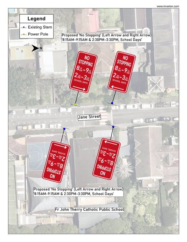
Subject: Jane Street, Balmain - Proposed Adjustment to No Stopping Restriction (Baludarri-Balmain Ward/Balmain Electorate/Leichhardt PAC)
Prepared By: Jackie Ng - Graduate Traffic Engineer
Authorised By: Manod Wickramasinghe - Traffic and Transport Planning Manager
|
RECOMMENDATION
That the existing ‘No Stopping 8:30AM – 9:30AM & 3:00PM – 3:30PM School Days’ restriction at the children crossing outside Fr John Therry’s Catholic Primary School on Jane Street, Balmain be amended to ‘No Stopping 8:15AM – 9:15AM & 2:30PM – 3:30PM School Days’ as per the plan in Attachment 1.
|
STRATEGIC OBJECTIVE
This report supports the following strategic directions contained within Council’s Community Strategic Plan:
|
2: Liveable, connected neighbourhoods and transport |
|
|
EXECUTIVE SUMMARY
This report outlines the current traffic and parking issues at the ‘Children Crossing’ outside Father John Therry’s Catholic Primary School on Jane Street, Balmain during school peak hours. Council proposes to extend the ‘No Stopping’ hours to address the issues raised.
BACKGROUND AND DISCUSSION
Council has received a request from the School Crossing Supervisor of Fr John Therry’s Catholic Primary School regarding cars being parked adjacent to the ‘Children Crossing’ causing visibility and safety concerns.
These cars are parked legally as they are parked outside of the current operational hours of the part-time 'No Stopping’ restrictions associated with the Childrens Crossing, but there is still a high demand for children utilising the crossing point at this time.
It is therefore proposed to adjust the current part-time ‘No Stopping’ restrictions from ‘No Stopping 8:30AM – 9:30AM & 3:00PM – 3:30PM, School Days’ to ‘No Stopping 8:15AM – 9:15AM & 2:30PM – 3:30PM, School Days’ to better match the periods of high pedestrian activity generated by the school.
A consultation letter was distributed to 11 properties near the Children’s Crossing s on 13 February 2024. The closing date for submissions ended on 1 March 2024.
A total of one (1) response was received objecting the time extension in the afternoon period as the initial consultation proposed ‘No Stopping’ from 8:00AM – 9:30AM & 2:30PM – 4:00PM.
The resident believed that the afternoon period was 30 minutes too long, stating that by 3:30PM there are no more cars on the road. Feedback from the Principal of Fr John Therry’s Catholic Primary School as well as the Parent’s and Friends Association confirmed that the ‘No Stopping’ times could be changed to ‘8:15AM – 9:15AM & 2:30PM – 3:30PM’.
After further discussion, Council officers amended the proposal in response to feedback to adopt these times for the changes to the ‘No Stopping’ restriction on Jane Street, Balmain.
FINANCIAL IMPLICATIONS
There are no financial implications associated with the implementation of the proposed recommendations outlined in the report.
|
1.⇩ |
Jane Street, Balmain - Proposed Adjustment to No Stopping Restrictions - Plan |
|
|
Local Traffic Committee Meeting 15 April 2024 |
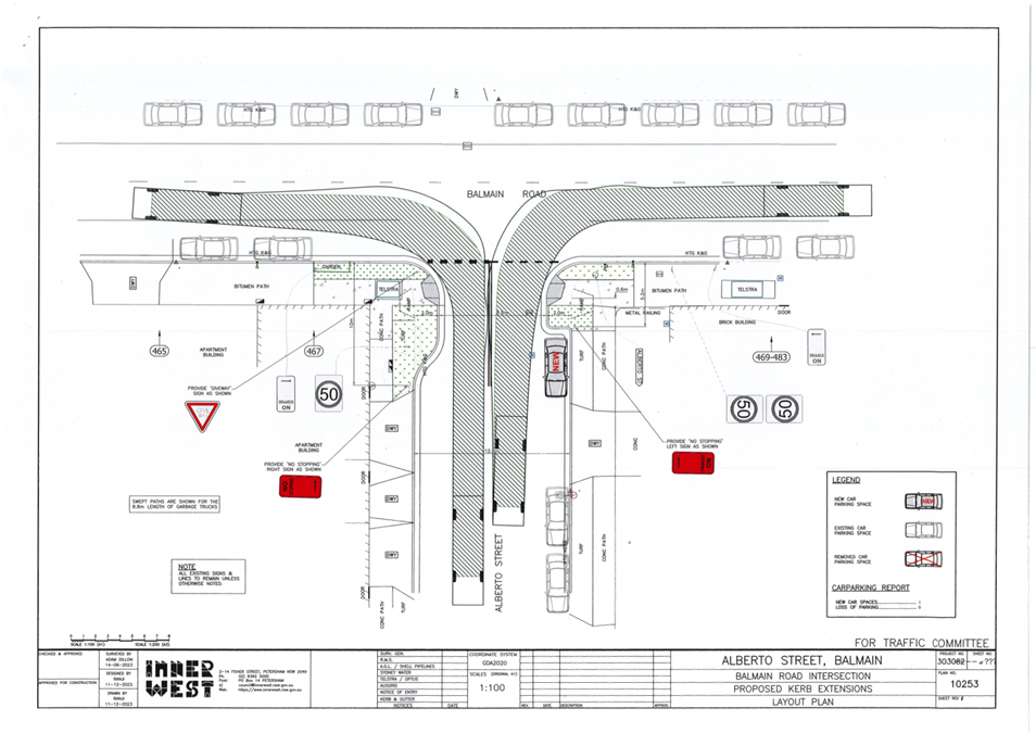
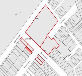
Subject: Alberto Street, Lilyfield - Proposed Kerb Extension (Baludarri-Balmain Ward/Balmain Electorate/Leichhardt PAC)
Prepared By: Charbel El Kazzi - Traffic Engineer
Authorised By: Manod Wickramasinghe - Traffic and Transport Planning Manager
|
RECOMMENDATION
That the attached detailed design plan (Design Plan No.10253) for the proposed kerb extensions on Alberto Street at the intersection with Balmain Road, Lilyfield be approved.
|
STRATEGIC OBJECTIVE
This report supports the following strategic directions contained within Council’s Community Strategic Plan:
|
2: Liveable, connected neighbourhoods and transport |
EXECUTIVE SUMMARY
Council is planning to improve safety for pedestrians and other road users in Alberto Street, Lilyfield at its intersection with Balmain Road by constructing two kerb blister islands and two kerb ramps. The works aim to improve pedestrian safety by better defining pedestrian crossing points and reducing the road crossing width in Alberto Street.
The proposed ‘No Stopping’ distance on the eastern side of Alberto Street is proposed to be reduced from the statutory 10m (from the intersection) to 5.2m which will create a new parking space. A risk assessment for the reduced ‘No Stopping’ has been submitted to Transport for NSW and has been approved.
BACKGROUND
The detailed design plan shown in Attachment 1 outlines the proposed works on Alberto Street, Lilyfield and includes the following treatments:
· Construct two landscaped kerb blister islands with integrated kerb ramps, footpaths and heel safe ‘cross-over’ gratings in Alberto Street at its intersection with Balmain Road
· Reconstruct areas of concrete footpaths
· Provide new grass verges
· Provide new signage associated with the works (refer to the Plan)
· Provide new ‘Give Way’ & road centreline ‘BB’ line markings at the intersection (refer to Plan)
· Provide two new ‘No Stopping’ signs in Alberto Street and provide two ‘Unidirectional Signs’
A turning path assessment using an 8.8m service vehicle was also undertaken as per
Attachment 2.
DISCUSSION
A letter outlining the proposal was issued to the properties shown in the distribution map below. Three (3) submissions were received in response to this proposal and are summarised within the below table.
|
Resident Comments |
Officer Comments |
|
The pedestrian access kerb ramps on both the eastern and western sides of Alberto Street were redesigned and installed only a few months ago. Has there been any material change to pedestrian safety to warrant the new and more substantial change. (3 similar comments) |
Note that the recent installation of pedestrian access kerb ramps were only temporary changes. This proposal provides a more permanent solution which improves pedestrian safety. |
|
It is disingenuous to claim that the proposal will result in one new parking space on Alberto Street. A parking space where the kerb blister on the western side of Alberto Street immediately outside 1/467 Balmain Road will disappear. Why can’t council install the same application on both sides so that parking can be kept. (3 similar comments) |
Please note that this parking space is within 10m of the intersection with Balmain Road and therefore under the NSW road rules is an illegal parking space. Council is not proposing to reduce the statutory distance of the ‘No Stopping’ on the western side of Alberto Street (approach side to the crossing point) as the existing high wall of the neighbouring property along with a vehicle parked in this location will impede sight lines and reduce pedestrian safety. |
|
Can consideration be given to a pedestrian crossing. |
Alberto Street doesn’t experience sufficiently high vehicle traffic to justify a pedestrian crossing. |
|
There are no pedestrian lights, only traffic lights, at the entrance/exit to Callan Park or Cecily Street and I have witnessed children not looking to see if cars are coming from Cecily Street on a green light as the children have no indication if they can or can't cross. It is extremely dangerous and needs to be addressed by Council before work in Alberto Street |
Note that traffic signals are under the jurisdiction of Transport for NSW. Council has previously made representations for improvements to the traffic signals at Cecily Street. |
|
It appears that the proposed blister may impede left turning traffic until any right-turning traffic has cleared the intersection. This junction is already quite busy and subject to long delays at peak times. If traffic is so impeded, delays will become even more significant. |
Improvements to pedestrian safety will outweigh any negative impact on traffic delays noting that traffic volumes in Alberto Street are relatively low. |
|
Not sure if a give way sign is necessary as this is a T-intersection. |
The sign is needed to reinforce the give way restriction and is required when putting in line marking. It will also assist in slowing vehicle speeds on approach to the crossing point. |
FINANCIAL IMPLICATIONS
The works are expected to cost approximately $54,000 and is funded under Council’s Pedestrian Access and Mobility Plan (PAMP) program.
|
1.⇩ |
Detailed Design Plan 10253 - Alberto Street, Lilyfield |
|
2.⇩ |
Turning Path - Alberto Street, Lilyfield |
|
|
Local Traffic Committee Meeting 15 April 2024 |
Subject: Boomerang Street, Haberfield - Pedestrian Crossing Line Markings (Gulgadya-Leichhardt Ward/Summer Hill Electorate/Burwood PAC)
Prepared By: Charbel El Kazzi - Traffic Engineer
Authorised By: Manod Wickramasinghe - Traffic and Transport Planning Manager
|
RECOMMENDATION
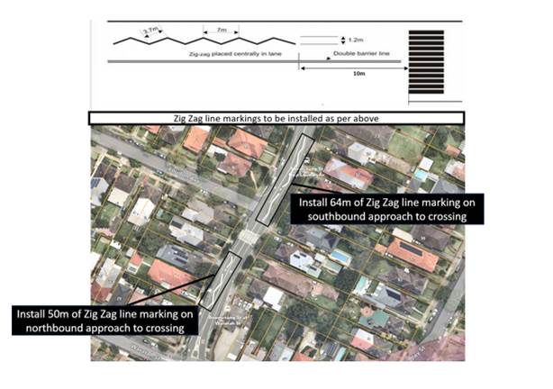
That the installation of Zig Zag line markings on both approaches to the pedestrian crossing on Boomerang Street near the intersection with Loudon Avenue, Haberfield be approved.
|
STRATEGIC OBJECTIVE
This report supports the following strategic directions contained within Council’s Community Strategic Plan:
|
2: Liveable, connected neighbourhoods and transport |
|
|
EXECUTIVE SUMMARY
Council has received several concerns from residents regarding vehicles not slowing down as they approach the pedestrian crossing at Boomerang Street near the intersection with Loudon Avenue, Haberfield.
In response, council is proposing to install Zig Zag line markings on both approaches to the crossing to indicate to motorists that a pedestrian crossing is ahead.
BACKGROUND AND DISCUSSION
Council has received several concerns from residents regarding vehicles not slowing down as they approach the pedestrian crossing in Boomerang Street, Haberfield near Loudon Avenue.
A review of the site indicates that there are horizontal curves (reverse curves) on Boomerang Street on approach to the pedestrian crossing. These horizontal curves, in conjunction with vehicles traveling in the opposing direction, can lead to obstruction of sight lines to the crossing signs or pedestrians themselves. This raises additional safety concerns due to crossing being used by students at the nearby Dobroyd Point Public School in Waratah Street, Haberfield.
Providing zig zag line marking will warn motorists in advance that a pedestrian crossing is ahead and improve pedestrian safety. Additionally, council will be increasing the size of the pedestrian crossing signage to improve visibility for motorists and will also be installing <LOOK> stencils on each side of the crossing.
Council is proposing to install zig zag linemarkings as per the following plan.
FINANCIAL IMPLICATIONS
Installation of the linemarking and signage will be funded through Council’s operational linemarking and signposting budgets.
Nil.
|
|
Local Traffic Committee Meeting 15 April 2024 |
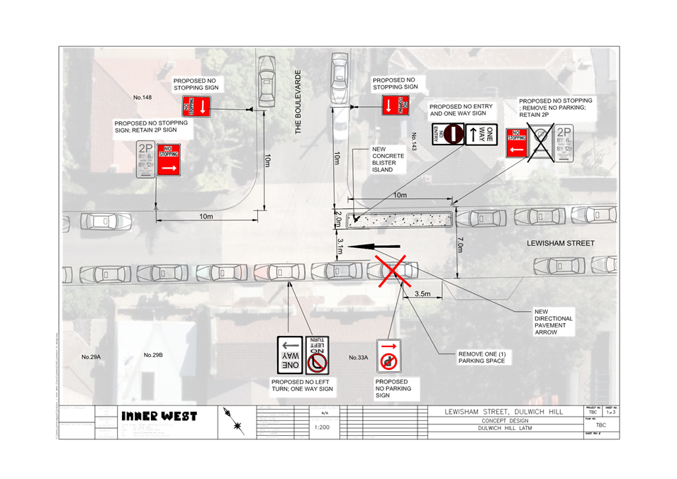
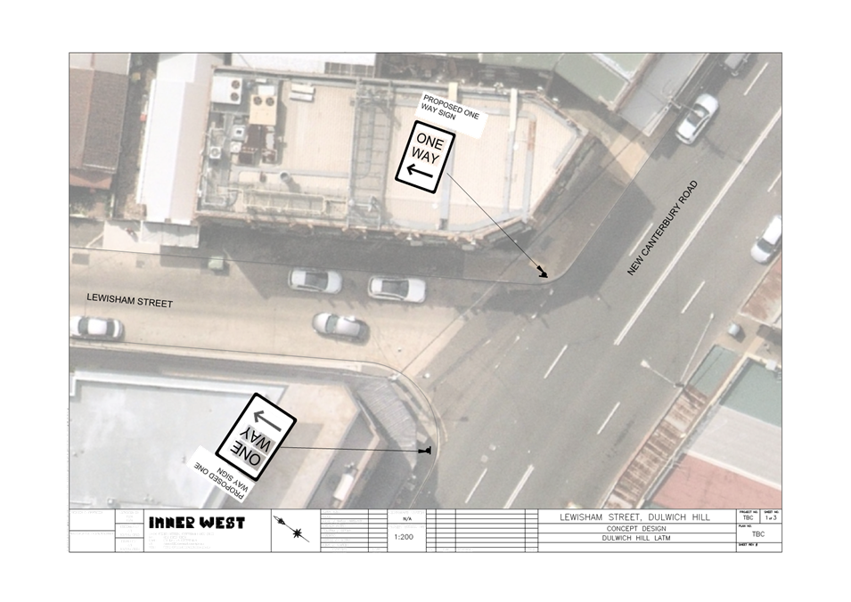
Subject: Lewisham Street, Dulwich Hill - Proposed one-way (westbound) restriction (Djarrawunang-Dulwich Hill Ward/Summer Hill Electorate/Inner West PAC)
Prepared By: James Nguyen - Traffic Engineer
Authorised By: Manod Wickramasinghe - Traffic and Transport Planning Manager
|
RECOMMENDATION
That the proposed one-way (westbound) restriction on Lewisham Street, between The Boulevarde and New Canterbury Road, Dulwich HIll be reassessed upon the completion of the Hoskins Park Precinct (Arlington Grove), to determine if the traffic conditions on Lewisham Street reflect the forecasted traffic volumes from the Dulwich Hill LATM 2016 Plan, and determine if the proposed one-way (westbound) restriction is warranted.
|
STRATEGIC OBJECTIVE
This report supports the following strategic directions contained within Council’s Community Strategic Plan:
|
2: Livable, connected neighbourhoods and transport |
|
|
EXECUTIVE SUMMARY
This report discusses further investigations into the one-way (westbound) proposal on Lewisham Street, between The Boulevarde and New Canterbury Road, Dulwich Hill which was identified in the Dulwich Hill North Local Traffic Management Plan (LATM) 2016. It provides context on the origin of the proposal, and further assessment on the proposal with respect to current traffic conditions. An extensive consultation summary is provided with a final revised proposal.
BACKGROUND
A one-way (westbound) proposal on Lewisham Street, between The Boulevarde and New Canterbury Road was proposed in the Dulwich Hill North Local Traffic Management Plan (LATM) in 2016. This one-way proposal was identified as a long-term priority for delivery in the LATM plan, and required to mitigate the assumed traffic generation on Lewisham Street by the development site at Arlington Grove.
The final Dulwich Hill North LATM and following LATM treatment plan which includes the conversion of Lewisham Street to one-way between New Canterbury Road and The Boulevarde, was endorsed Council’s Local Traffic Committee meeting of 7 September 2017.
Accordingly, Council officers have since developed further a concept design and re-consulted with the community on the one-way (westbound) proposal of Lewisham Street between The Boulevarde and New Canterbury Road. In addition, further traffic counts have been completed to assess current traffic conditions.
DISCUSSION
Dulwich Hill North LATM Plan – Origin of the one-way proposal
The Dulwich Hill North LATM Plan was completed in 2016 to investigate and review the performance of the existing LATM schemes and recommend proposed LATM works in the Dulwich Hill North area. The LATM plan collected traffic data, assessed existing traffic conditions, estimated future traffic conditions based on anticipated land use growth areas and identified appropriate treatments to reduce volumes and speeds, improve pedestrian and cyclist needs and develop concept LATM treatment proposals.
The one-way (westbound) proposal on Lewisham Street between The Boulevarde and New Canterbury Road was a long-term proposal to mitigate the estimated traffic growth on Lewisham Street by the Arlington Grove development sites on Hill Street.
Traffic volumes on Lewisham Street were forecasted to increase by 131% between The Boulevarde and New Canterbury Road and 147% between Denison Road and The Boulevarde, and is shown in Table 1 below:
Table 1 - Forecasted traffic volumes
|
Road section |
Existing (vpd) |
Additional (vpd) |
Future (vpd) |
Traffic Growth (%) |
|
Lewisham Street between Denison Road and The Boulevarde |
490 |
230 |
720 |
147% |
|
Lewisham Street between The Boulevarde and New Canterbury Road |
740 |
230 |
970 |
131% |
The forecasted traffic growth on Lewisham Street was made based on Figure 1 below:
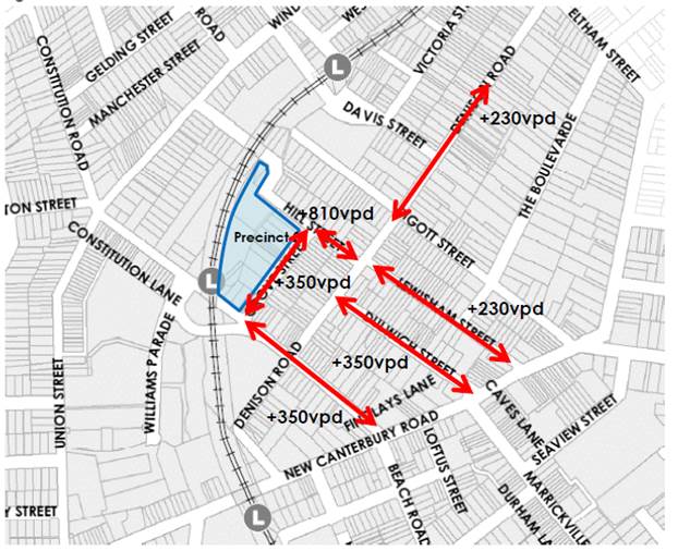
Figure 1 - Additional Traffic Volumes from Precinct 2 (source: Dulwich Hill North LATM Plan 2016)
According to Figure 1, the LATM plan estimated that Precinct 2 (Arlington Grove) would generate approximately an additional 230 vehicles per day on Lewisham Street.
Given that Lewisham Street is approximately 7.1 metres wide, the LATM plan noted that the carriageway may not be sufficient for the additional traffic generated by the future development in the long-term, and that a one-way proposal would seek to mitigate this issue. The LATM plan also noted that this proposal would shift one direction of traffic to adjacent streets such as Pigott or Dulwich Streets. The LATM plan identified this proposal was a long-term priority compared to other treatments.
Design development
Council officers have since developed a concept design in 2023 for the proposal. The concept plan that was exhibited for public consultation is shown in Figure 2 and Figure 3.
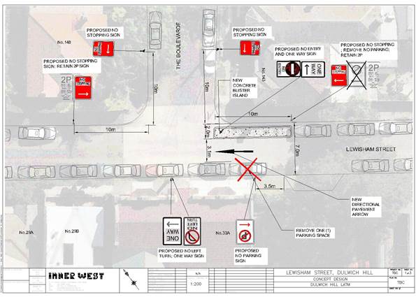
Figure 2 – Consultation plan
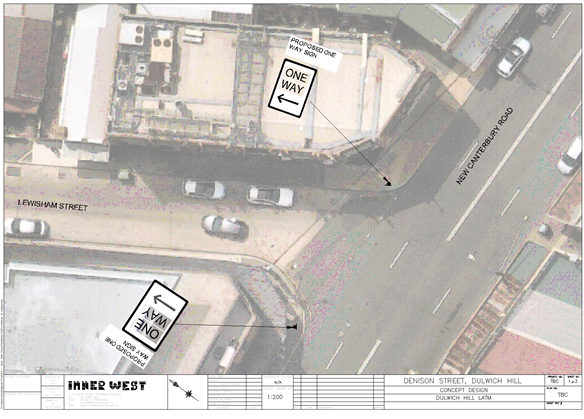
Figure 3 – Consultation plan
The one-way (westbound) proposal on Lewisham Street between New Canterbury Road and The Boulevarde consists of the following:
· A new concrete kerb blister island on the northern side of Lewisham Street, east of The Boulevarde;
· A ‘No Entry’ and ‘One Way’ sign installed on the kerb blister island to advise motorists of the one-way westbound restriction;
· A ‘No Left Turn’ sign and ‘One Way’ sign on the southern side of Lewisham Street, facing north towards The Boulevarde.
· A ‘No Parking’ restriction for a length of 3.5 metres from the existing driveway of No.39 Lewisham Street to ensure a service vehicle can exit from the driveway to Lewisham Street;
· Replace the existing ‘No Parking’ (left) sign on the northern side of Lewisham Street, east of The Boulevarde with a ‘No Stopping’ (left) sign;
· Install ‘No Stopping’ signs on both sides of The Boulevarde, north of Lewisham Street to ensure compliance with the NSW Road Rules;
· Install a ‘No Stopping’ (right) sign on the northern side of Lewisham Street, west of The Boulevarde
· Install ‘One Way’ signs on New Canterbury Road to commence the one-way control on Lewisham Street.
Public Consultation on the Dulwich Hill North LATM plan
The original Dulwich Hill North LATM plan was consulted with the community between 7 May 2017 and 14 June 2017. Council received a total of 108 submissions from individual households with 70 responses in support and 38 response against the LATM plan. Of the 70 responses that supported the strategy 49 responses requested changes. There were no objections or concerns raised by the community about the proposed one-way conversion of Lewisham Street between The Boulevarde and New Canterbury Road, at the time.
Public Consultation on the one-way (westbound) conversion of Lewisham Street between The Boulevarde and New Canterbury Road
Council re-consulted with residents and businesses on the one-way proposal between 8 February 2024 and 6 March 2024. There were 536 letters sent to affected residents. In addition, the proposal was public exhibited on Inner West Council’s ‘Your Say’ website. Council received a total of 17 submissions on the proposal. There were six (6) responses supporting, nine (9) responses opposing and two (2) responses unsure about the proposal.
The responses supporting the proposal noted that a one-way proposal is required due to the narrow road width of Lewisham Stret and that the street experiences a lot of through traffic to New Canterbury Road movement due to the residential apartments at Arlington Grove.
The responses opposing to the proposal are noted below:
· Extend the one-way proposal for the entire length of Lewisham Street as the short section would cause confusion on Lewisham Street and The Boulevarde.
· The one-way proposal will cause confusion and limit access to the customers of the Salvation Army that utilise the carpark within the proposed one-way section. An extended one-way restriction to Denison Road will reduce confusion and provide greater access.
· The proposal does not consider parking impacts, remove parking spaces and make the parking situation worse, especially for residents without permit parking.
· The proposal does not consider the increase in traffic to New Canterbury Road via Dulwich, Lewisham and Piggott Streets, from the apartments being constructed near Arlington Light Rail
· The proposal will not reduce rat-running of traffic to New Canterbury Road once Constitution Bridge re-opens
· Traffic counters were installed on Lewisham Street during the temporary closure of Constitution Road (at the bridge), and did not provide an accurate measure of the traffic volumes on Lewisham Street
· The one-way proposal will result in cars turning right to New Canterbury Road via Pigott Street instead of Lewisham Street due to the bend in New Canterbury Road
· The proposal would have serious impact on traffic and safety on Dulwich Street. Traffic that would normally go up Lewisham Street will now have to access New Canterbury Road via Dulwich Street.
· There would be added traffic congestion in front of the driveways of Sydney Tools and the GPO apartment making exiting and entering the driveways unsafe.
· The traffic report was conducted prior to the Sydney Tools and GPO apartment building, and a new study needs to be completed to understand traffic implications to the block.
· The one-way conversion should be made eastbound between Denison Road and New Canterbury Road to ensure there are two eastbound roads (Lewisham and Dulwich Street) to evenly distribute traffic to New Canterbury Road
· There is no indication of additional traffic coming from New Canterbury Road into Lewisham Street
· There is a ‘No Parking 8.30am-6pm Mon-Fri’ restriction on the southern side of Lewisham Street, just west of New Canterbury Road that allows for two vehicles to pass.
· The proposed ‘No Stopping’ restrictions on The Boulevarde and Lewisham Street will further remove parking and affect residents with limited off-street parking and affect a heritage area
· The concept plan shows a parking space across an existing driveway to the Scouts Hall
· The proposal will increase traffic along The Boulevarde
Further suggestions were made and are noted below:
· Create a roundabout at the intersection of Lewisham Street and Denison Street to facilitate a right-hand turn into Denison Street
· Request to remove the ‘No Right Turn 3pm-7pm’ restriction from New Canterbury Road to Piggott Street and reallocate it to New Canterbury Road at Lewisham Street
· Install additional signage at the intersection of Lewisham Street and Denison Road to advise motorists that there will be no access to New Canterbury Road from Lewisham Street
· Consider a ‘No Right Turn’ ban from Pigott Street to New Canterbury Road during the peak hour
· A ’Keep Clear’ should be considered at the existing driveways of the GPO apartment and Sydney Tools on Dulwich Street
· Remove parking on one side of Lewisham Street to create two-way traffic flow
· Install traffic calming devices on Lewisham Street between The Boulevarde and Denison Road
· Consider a ‘No Right Turn’ ban from New Canterbury Road to Lewisham Street
Further traffic assessment of one-way proposal
Council engineers completed seven-day tube counts between Friday 27 October 2023 and Friday 3 November 2023 to determine the number of vehicles that would be redistributed by the proposed one-way (westbound) conversion of Lewisham Street, between The Boulevarde and New Canterbury Road. The results are shown in Table 2 and 3 below.
Table 2 - Traffic counts - Lewisham Street (between New Canterbury Road and The Boulevarde)
|
Time |
Westbound |
Eastbound |
Both directions |
|
8am-9am (AM Peak) (vph) |
24 |
27 |
51 |
|
5pm-6pm (PM Peak) (vph) |
47 |
26 |
72 |
|
7-day average (vpd) |
402 |
310 |
712 |
Table 3 - Traffic counts - Lewisham Street (between The Boulevarde and Denison Road)
|
Time |
Westbound |
Eastbound |
Both directions |
|
8am-9am (AM Peak) (vph) |
16 |
21 |
37 |
|
5pm (PM Peak) (vph) |
34 |
18 |
51 |
|
7-day average (vpd) |
283 |
221 |
504 |
Table 4 below presents a comparison of the traffic volumes from the LATM plan with the recent traffic counts completed in 2023 and shows that the traffic growth on Lewisham Street is less than projected in the LATM plan.
Table 4 - Comparison of traffic counts
|
Road section |
Volume (vpd) (LATM plan 2016) |
Future volume (vpd) (LATM plan 2016) |
Volume (vpd) (Oct-Nov 2023 counts) |
Forecasted change (vpd) (LATM plan 2016) |
Actual change (vpd) |
|
Lewisham Street, between The Boulevarde and Denison Rd |
485 |
720
|
504 |
+235 (147%) |
+19 (4%) |
|
Lewisham Street between The Boulevarde and New Canterbury Road |
735 |
970 |
712 |
+ 235 (131%) |
-23 / remain unchanged (-3%) |
CONCLUSION
The one-way (westbound) conversion of Lewisham Street between New Canterbury Road and The Boulevarde was proposed due to the road carriageway width (7.1 metres) of Lewisham Street being insufficient for the projected volume of additional traffic generated by Precinct 2. The recent traffic counts completed in 2023 are much less than the projected volumes in the LATM, and have remained fairly consistent with the traffic volumes in 2016, and indicates that a one-way (westbound) conversion may not be required at this stage.
FINANCIAL IMPLICATIONS
There are no financial implications associated with the implementation of the proposed recommendations outlined in the report.
|
1.⇩ |
Consultation plan - page 1 |
|
2.⇩ |
Consultation plan - page 2 |
|
|
Local Traffic Committee Meeting 15 April 2024 |
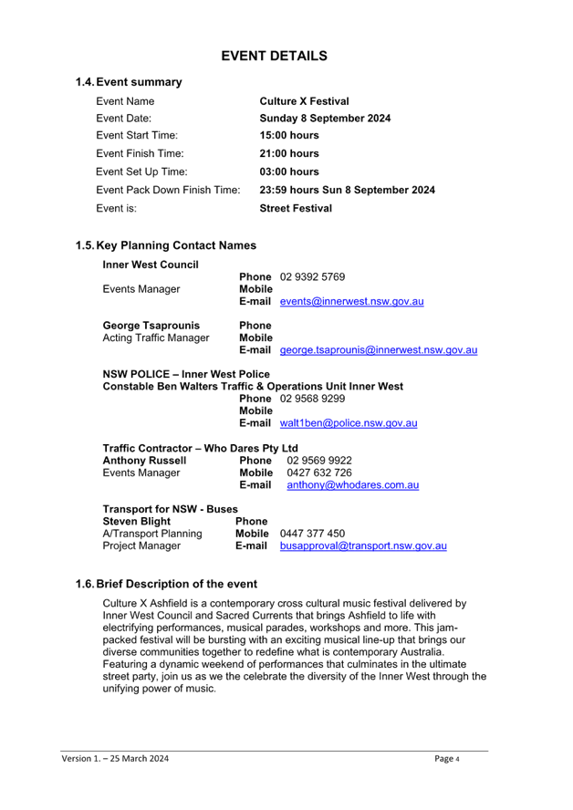
Subject: Hercules Street, Fox's Lane & Drakes Lane, Ashfield-Temporary Full Road closures (ENRC/2024/0016) 'Culture X Ashfield Music Festival' - Sunday 8 September 2024 (Djarrawunang-Ashfield Ward/Summer Hill Electorate/Burwood PAC)
Prepared By: Boris Muha - Traffic Engineer
Authorised By: Manod Wickramasinghe - Traffic and Transport Planning Manager
|
RECOMMENDATION
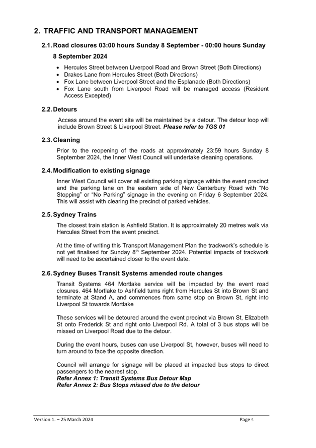
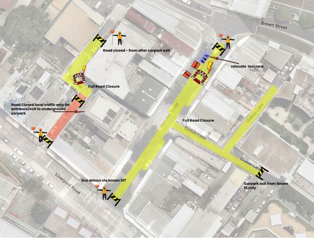
1. That the proposed temporary full road closures of Hercules Street, (between Liverpool Road and Brown Street), Fox’s Lane (between Liverpool Road and Brown Street) and Drakes Lane (off Hercules Street), Ashfield, be APPROVED for the purpose of holding a ‘Culture X Ashfield’ music Festival on Sunday 8 September 2024 between 3.00am to 11.59pm. The closures as per the submitted TGS and TMP are subject to the following specific conditions and all other standard Council conditions for the temporary full road closures.
2. That a Road Occupancy License application be obtained from the Transport Management Centre.
3. That notice of the proposed event be forwarded to the NSW Police Local Area Commander, Transit Systems, the NSW Fire Brigade and the NSW Ambulance Services.
4. That all residents and businesses in and around the affected area are to be notified of the temporary road closure in writing by the applicant in advance (at least 7 days prior to the event) with the applicant making reasonable provision for stakeholders.
5. That a minimum four (4) metre unencumbered passage be available, where required, for emergency vehicles through the closed sections.
6. That the occupation of the road carriageway must not occur until the road has been physically closed.
|
STRATEGIC OBJECTIVE
This report supports the following strategic directions contained within Council’s Community Strategic Plan:
|
2: Liveable, connected neighbourhoods and transport |
|
|
EXECUTIVE SUMMARY
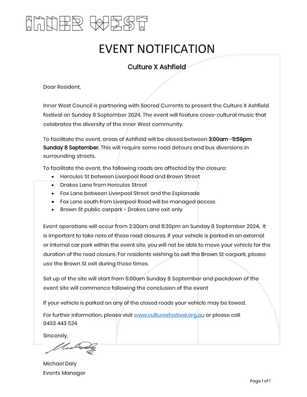
Inner West Council is partnering with Sacred Currents to present the Culture X Ashfield festival on Sunday 8 September 2024. The event will feature cross-cultural music that celebrates the diversity of the Inner West community.
BACKGROUND
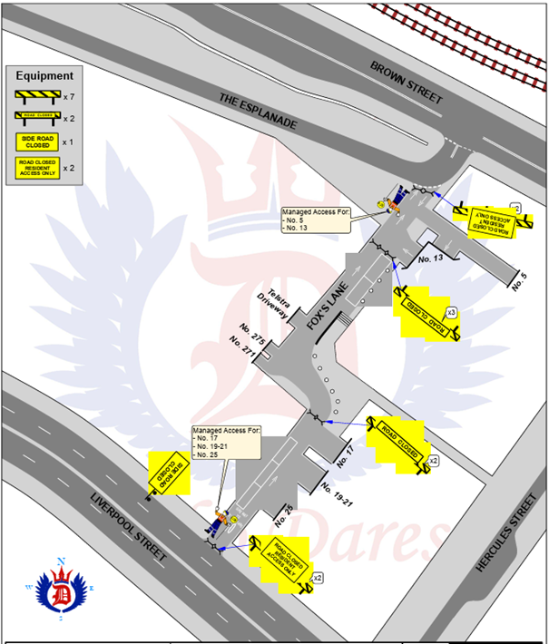
Hercules Street (with Drakes Lane off Hercules Street) and Fox’s Lane has been closed in the past for various food and musical events, The temporary full road closures of Hercules Street, Drakes Lane and Fox’s Lane have been approved through the Traffic Committee in the past, subject to adequate traffic control, and specific conditions as recommended above and other standard conditions as set out by Council.
DISCUSSION
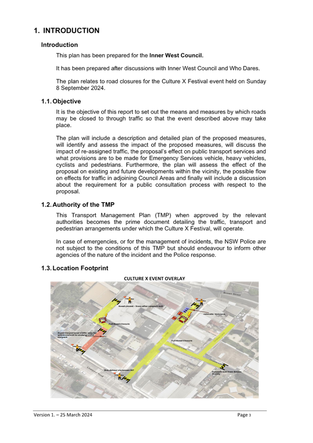
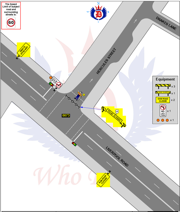
Hercules Street is main town Centre local street, whilst Fox’s Lane and Drakes Lane are mainly property access laneways. Hercules Street and Fox’s Lane are one-way north, whilst Drakes Lane is a two-way dead- end street. The event is likely to attract some 3000 guests. The event would need to be categorised under a class 2 (if not a 3) event under the TfNSW Special Events Guide where it does not impact on the major traffic and transport systems and non-event community over a wide area. The event requires the involvement of Local Council and Police.
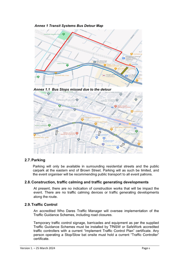
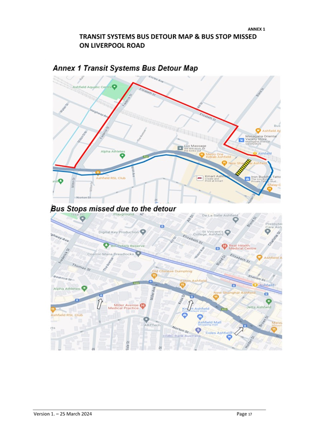
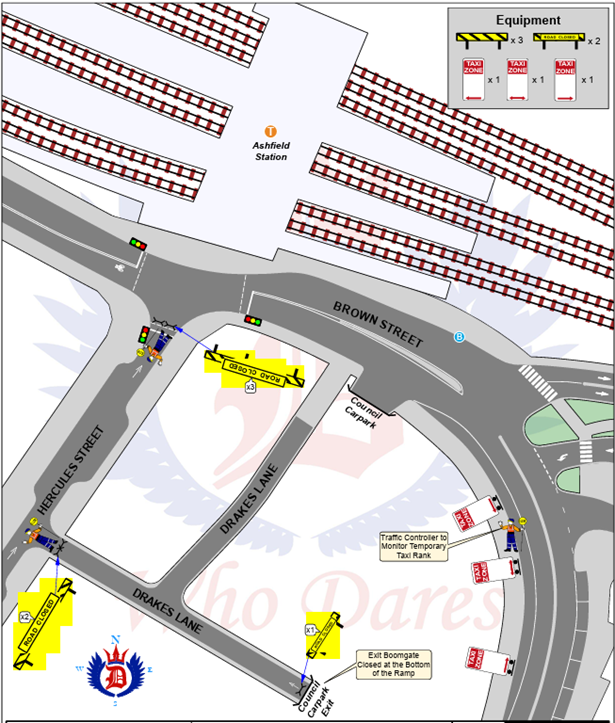
Adequate traffic control will be provided, with traffic detouring via Brown Street to reach Ashfield Station and continue onto Bland and Elizabeth Streets to reach Ashfield, north of the railway line. Access to The Esplanade (to the south of Fox’s Lane) will be via Brown Street.
Hercules Street is a bus route. Buses turning left into Hercules Street from Liverpool shall be diverted further east along Liverpool Road and then turn left into Brown Street. They shall depart out heading west via Bland, Elizabeth, and Frederick Streets. Patrons (at missed bus stops) will be directed to alternate bus stop locations.
An existing taxi rank in Hercules Steet shall be temporarily relocated to the western side of Brown Street in the location where period parking currently exists.
Service vehicle activity in the area will be encouraged to be done outside of the event times. Refer to the Traffic Guidance System TGS plan below, and Traffic Management Plan (TMP) as shown on Attachment 1 to explain any further detail and detouring. Attachment 2 provides a site map detail, and Attachment 3 is a draft sample of the notification letter to affected residents and businesses.
The event-coordinator will apply for a Road Occupancy License (ROL).
The proposed temporary full road closure will be advertised in accordance with the Road Act 1993.
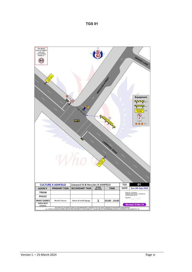
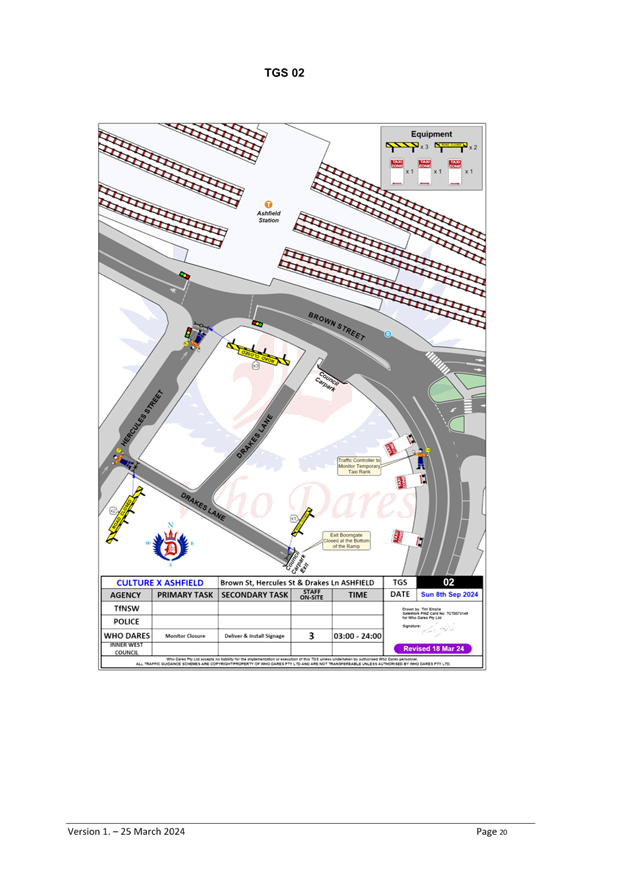
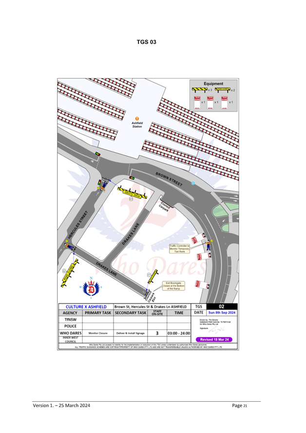
TGS-Temporary full road closure of Fox’s Lane, Ashfield.
TGS- Temporary full road closure of Hercules Street, Ashfield Plan 1 of 2.
TGS- Temporary full road closure of Hercules Street, Ashfield Plan 2 of 2.
Note: Under-ground council carpark levels exist within Premises 1A Brown Street. The car park secondary exit onto Drakes Lane will be closed. Vehicles will be directed to use the primary exit onto Brown Street. Detour signs will be placed at the intersection of Brown Street and Liverpool Road to direct traffic via Brown Street.
FINANCIAL IMPLICATIONS
The event is co-funded by Inner West Council, Multicultural NSW under the Stronger Together Major Festivals fund and Create NSW. Council’s Events team operational budget contribution to the event is approximately $40,000.
ATTACHMENTS
|
1.⇩ |
Traffic Management Plan (TMP) |
|
2.⇩ |
Site map detail |
|
3.⇩ |
Draft sample notification letter |
|
|
Local Traffic Committee Meeting 15 April 2024 |
Subject: Illawarra Road, Marrickville Near Thornley Street - Proposed Upgrade Of Existing Pedestrian Crossing (Midjuburi-Marrickville Ward / Summer Hill Electorate / Inner West PAC)
Prepared By: George Tsaprounis - Coordinator Traffic Engineering Services (south)
Authorised By: Manod Wickramasinghe - Traffic and Transport Planning Manager
|
RECOMMENDATION
That the upgrade of the existing pedestrian (zebra) crossing on Illawarra Road near Thornley Street to a raised crossing facility be approved in principle and that the detail design be bought back to the Traffic Committee for consideration.
|
STRATEGIC OBJECTIVE
This report supports the following strategic directions contained within Council’s Community Strategic Plan:
|
2: Liveable, connected neighbourhoods and transport |
|
|
EXECUTIVE SUMMARY
Council at its meeting held in March 2024, resolved to investigate safety of the pedestrian crossing on Illawarra Road at Yirran Gumal Early Learning Centre.
Previously minor pedestrian improvements have been made to this crossing, however on this occasion Council Officers have examined the possibility of raising this crossing. An initial investigation revealed that raising this crossing is feasible, subject to detailed design and community engagement.
Therefore, it is recommended that a proposed raised pedestrian crossing be supported in principle and that a detailed design of the proposal be bought back to the Committee for consideration.
BACKGROUND
Council has in the past received concerns as to the safety of the pedestrian crossing on Illawarra Road near Thornley Street, Marrickville.
The Minutes of the Local Traffic Committee meeting held on 11 December 2023 were adopted at Council’s meeting held on 05 March 2024 subject to the following amendments:
3. The following amendments to LTC1223(1) Item 7 to include urgent action being taken to improve visibility of the pedestrian crossing at Illawarra Road at Yirran Gumal Early Learning Centre (refer to figure 1), including:
a) a report including designs to improve visibility at the crossing be brought to the next possible Local Traffic Committee Meeting, considering options to raise the crossing, implement flashing lights, or any other measure to improve safety; and
b) that upon approval by the Local Traffic Committee and Council, these works be immediately prioritised and undertaken, funded through the quarterly budget update.
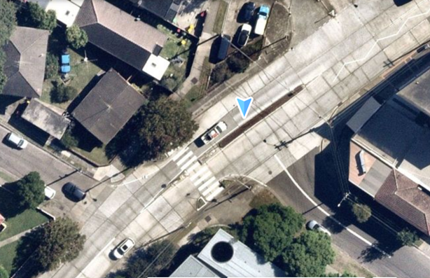
Figure 1 – Location of existing crossing.
DISCUSSION
The pedestrian crossing located on Illawarra Road, immediately west of Thornley Street (and adjacent to the Yirran Gumal Early Learning Centre and Debbie and Abbey Borgia Community Recreation Centre on Illawarra Road) is an at grade crossing facility with kerb blisters and a centre refuge island. The facility is well used by the adjacent facilities and by bus patrons as bus stops are present (nearby) on either side of this existing crossing facility.
This section of Illawarra Road is classified as regional road and has the following traffic related characteristics.
· Traffic volume – 14,500 vehicles per day
· Traffic Speed – 52.2 km/h
· Heavy vehicle volume – 3.1%
· Carriageway width – 13.1m
In order to improve safety of pedestrians at this crossing and to address community concerns which have been raised, it is proposed to undertake the following works’
· Relocate the existing crossing slightly west of Thornley Street to be cater for a raised crossing facility,
· Raise the existing pedestrian crossing facility,
· Remove the central blister island feature from the proposed raised pedestrian crossing,
· Remove the adjacent tree and replace at a more suitable location,
· Remarking and replacing existing signs and linemarking which require adjustment,
· Reconstruct the kerb ramps and adjacent footpaths, and
· Widen the existing kerb blister island on either side of the proposed crossing.
Currently, there are ‘No Stopping’ restrictions in place on either side of the existing pedestrian crossing and these will not be affected by the proposed changes. As a result, parking in the vicinity of this crossing will therefore not be affected.
It should be noted that raised pedestrian crossing can lead to potential noise concerns on heavily trafficked roads. Measures to cater for the expected bus and truck traffic will need to designed to assist in alleviating any potential noise issues which may arise.
Community engagement will be undertaken as part of the detailed design process and the results of this consultation will be included in a report back to the Committee.
FINANCIAL IMPLICATIONS
It is estimated that the cost to upgrade this pedestrian crossing is $80,000 and this project is to be prioritized and funded through the quarterly budget update as per the Council resolution.
Nil
|
|
Local Traffic Committee Meeting 15 April 2024 |
Subject: Wells Avenue, Tempe - Proposed Relocation Of Existing Marked Parking Bay (Midjuburi - Marrickville Ward/ Heffron Electorate / Inner West PAC)
Prepared By: Jennifer Adams - Traffic Engineer
Authorised By: Manod Wickramasinghe - Traffic and Transport Planning Manager
|
RECOMMENDATION
That the existing linemarked parking bay at the dead-end in Wells Avenue, Tempe outside No.13 be relocated as per the attached sign and linemarking plan. |
STRATEGIC OBJECTIVE
This report supports the following strategic directions contained within Council’s Community Strategic Plan:
|
2: Liveable, connected neighbourhoods and transport |
|
|
EXECUTIVE SUMMARY
Council has received a request from a resident to further review the current parking arrangements outside No.13 Wells Avenue, Tempe. It is recommended that the existing marked parking bay be relocated as outlined in this report.
BACKGROUND
The Committee in January 2021 considered a report about concerns received from the resident of No.15 Wells Avenue regarding restricted access to his property’s driveway. The Committee noted that the access was constrained by an adjacent rock wall as well as the carriageway being narrow at this location. Consequently, the Committee supported the installation of a 6m ‘No Parking’ restriction from the western edge of the driveway of No.15 Wells Avenue.
In July 2023 the Committee considered a further report after the resident at No.15 Wells Avenue requested a review of the then current ‘No Parking’ signpost outside No.13 Wells Avenue. The resident requested the removal of the parking space outside No.13 Wells Avenue to improve access to his property as his and his visitors’ vehicles have been damaged when scraping against the adjacent rock wall. He was also concerned that a vehicle may hit the pipeline against the rock wall and near his driveway.
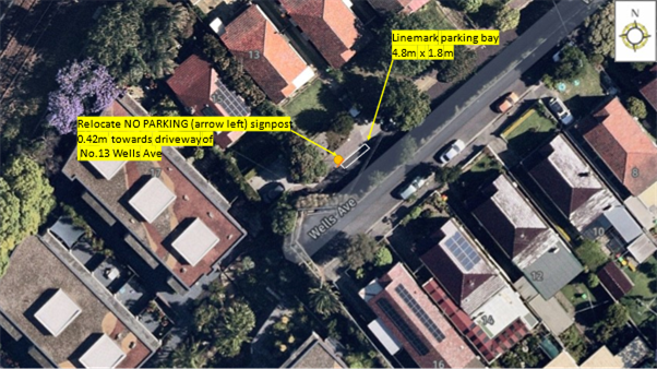
An inspection of the kerb line between the driveways of No.15 and No.13 Wells Avenue indicated that there was sufficient kerb length to maintain a 4.8m car space with an increase of the ‘No Parking’ restriction by 0.42m, thus providing a 5.3m carriageway width.
Furthermore, it was noted that the installation of a 1.8m wide linemarked parking bay at this location would assist in requiring vehicles being parked parallel and close to the kerb line, providing a wider 3.5m travel lane for vehicles accessing the driveway of No.15 Wells Avenue.
At the time, it was considered that the proposed changes to parking outside No.13 Wells Avenue should assist with the access to the driveway of No.15 Wells Avenue, whilst maintaining the on-street parking space for local residents and other road users. The Committee subsequently supported the following recommendation:
1. That the existing ‘No Parking’ (arrow left) signpost outside No.13 Wells Avenue be relocated 0.42m towards the driveway of No.13 Wells Avenue, Tempe.
2. That a parking bay (4.8m x 1.8m) be linemarked between the above relocated ‘No Parking’ signpost and western edge of the driveway of No.13 Wells Avenue, Tempe.
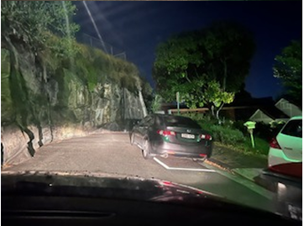
In October 2023 the resident at No.15 Wells Street, Tempe raised concerns that vehicles were parking outside the bay and again hindering access to his property. The resident provided a number of photos to demonstrate the issue.
DISCUSSION
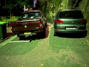
Council Officers made a further site visit and concluded that parking was constrained and in order to retain the parking space the parking bay could be amended to allow vehicles to straddle the footpath (refer to figure 1 and 2).
This proposal would still allow for a usable but reduced footpath and is considered acceptable given the low pedestrian volumes using the dead-end of Wells Avenue.
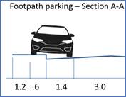
Figure 1 – Footpath parking dimensions
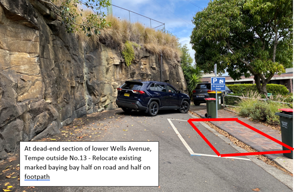
Figure 2 – Site location and indicative location of marked bay
PUBLIC CONSULTATION
Consultation was carried out in December 2023 notifying both affected residences of the proposed parking changes. Two responses from property No. 15 Wells Avenue were received saying that the changes will make no difference and that they would prefer ‘No Parking’ restrictions. Notwithstanding, as the proposal will incur no loss of parking with the proposed changes it is recommended at this time to relocate the existing marked parking bay as proposed.
CONCLUSION
Council is proposing to relocate the existing marked parking bay to straddle the footpath at this location in order to allow parking at this location whilst retaining adequate travel lane width for vehicles and adequate footpath width for pedestrians.
FINANCIAL IMPLICATIONS
The costs of relocation of the parking bay as recommended can be funded within Council’s signs and line marking budget.