|
AGENDA R |

Local Traffic Committee Meeting
MONDAY 20 MAY 2024
11:00 AM
|
|
Local Traffic Committee Meeting 20 May 2024 |
Function of the Local Traffic Committee
Background
Roads and Maritime Services (RMS) is legislated as the Authority responsible for the control of traffic on all NSW Roads. The RMS has delegated certain aspects of the control of traffic on local roads to councils. To exercise this delegation, councils must establish a local traffic committee and obtain the advice of the RMS and Police. The Inner West Council Local Traffic Committee has been constituted by Council as a result of the delegation granted by the RMS pursuant to Section 50 of the Transport Administration Act 1988.
Role of the Committee
The Local Traffic Committee is primarily a technical review and advisory committee which considers the technical merits of proposals and ensures that current technical guidelines are considered. It provides recommendations to Council on traffic and parking control matters and on the provision of traffic control facilities and prescribed traffic control devices for which Council has delegated authority. These matters are dealt with under Part A of the agenda and require Council to consider exercising its delegation.
In addition to its formal role as the Local Traffic Committee, the Committee may also be requested to provide informal traffic engineering advice on traffic matters not requiring Council to exercise its delegated function at that point in time, for example, advice to Council’s Development Assessment Section on traffic generating developments. These matters are dealt with under Part C of the agenda and are for information or advice only and do not require Council to exercise its delegation.
Committee Delegations
The Local Traffic Committee has no decision-making powers. The Council must refer all traffic related matters to the Local Traffic Committee prior to exercising its delegated functions. Matters related to State Roads or functions that have not been delegated to Council must be referred directly to the RMS or relevant organisation.
The Committee provides recommendations to Council. Should Council wish to act contrary to the advice of the Committee or if that advice is not supported unanimously by the Committee members, then the Police or RMS have an opportunity to appeal to the Regional Traffic Committee.
Committee Membership & Voting
Formal voting membership comprises the following:
· one representative of Council as nominated by Council;
· one representative of the NSW Police from each Local Area Command (LAC) within the LGA, being Newtown, Marrickville, Leichhardt and Ashfield LAC’s.
· one representative from the RMS; and
· State Members of Parliament (MP) for the electorates of Summer Hill, Newtown, Heffron, Canterbury, Strathfield and Balmain or their nominees.
Where the Council area is represented by more than one MP or covered by more than one Police LAC, representatives are only permitted to vote on matters which effect their electorate or LAC.
Informal (non-voting) advisors from within Council or external authorities may also attend Committee meetings to provide expert advice.
Committee Chair
Council’s representative will chair the meetings.
Public Participation
Members of the public or other stakeholders may address the Committee on agenda items to be considered by the Committee. The format and number of presentations is at the discretion of the Chairperson and is generally limited to 3 minutes per speaker. Committee debate on agenda items is not open to the public.
|
|
Local Traffic Committee Meeting 20 May 2024 |
|
AGENDA |
1 Apologies
2 Disclosures of Interest
3 Confirmation of Minutes
Minutes of 15 April 2024 Local Traffic Committee 5
4 Matters Arising from Council’s Resolution of Minutes
5 Part A – Items Where Council May Exercise Its Delegated Functions
Traffic Matters
ITEM Page
LTC0524(1) Item 1 Denison Road at New Canterbury Road, Dulwich Hill - Proposed 'No Left Turn 6.30am-9am Mon-Fri' restrictions ((Djarrawunang-Dulwich Hill Ward/Summer Hill Electorate/Inner West PAC) 13
LTC0524(1) Item 2 Bedford Crescent, Dulwich Hill - Proposed changes to raised pedestrian crossing and parking (Djarrawunang-Dulwich Hill Ward/Summer Hill Electorate/Inner West PAC) 19
LTC0524(1) Item 3 Centennial Street, Marrickville – Temporary Road Closure for Special Event at Henson Park (2024 Beer, Footy and Food Festival) on Saturday 27 July 2024 - (Midjuburi-Marrickville Ward /Summer Hill Electorate /Inner West LAC) 24
LTC0524(1) Item 4 Ewart Street, Dulwich Hill and (Lower) Railway Parade, Sydenham - Temporary Parking Changes on 3 Weekends During Weekend Rail Replacement Operations - Bus Replacements During June and July 2024 (Midjuburi -Marrickville Ward / Summer Hill Electorate / Inner West PAC) 47
LTC0524(1) Item 5 Installation of a parking restriction in front of Emmerick Street Community Preschool on Emmerick Street, Lilyfield (Baludarri-Balmain Ward/Balmain Electorate/Leichhardt PAC) 51
LTC0524(1) Item 6 Redmond Street, Leichhardt - Proposed No Stopping Extension (Baludarri-Balmain Ward/Balmain Electorate/Leichhardt PAC) 55
LTC0524(1) Item 7 Terrace Lane, Dulwich Hill - Proposed installation of a 14m length of 'No Parking' restrictions western side opposite the fence and gate to 40 Terrace Road (Djarrawunang – Ashfield Ward / Summer Hill Electorate / Inner West PAC) 59
LTC0524(1) Item 8 Proposed
Pedestrian (zebra) crossing and relocation of Bus Stop in Victoria Street,
mid-block between Clissold Street and Seaview Street, Ashfield.
(Djarrawunang-Ashfield Ward/Summer Hill Electorate/Burwood PAC) 62
LTC0524(1) Item 9 Proposed
Pedestrian (zebra) crossings in Seaview Street and new kerb extension facilities
at the intersection of Victoria Street and Seaview Street, Ashfield.
(Djarrawunang-Ashfield Ward/Summer Hill Electorate/Burwood PAC) 71
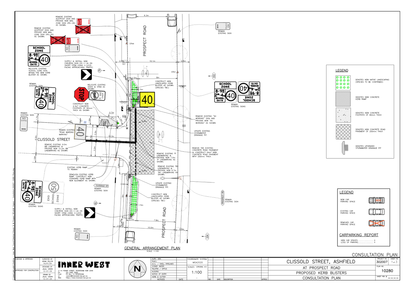
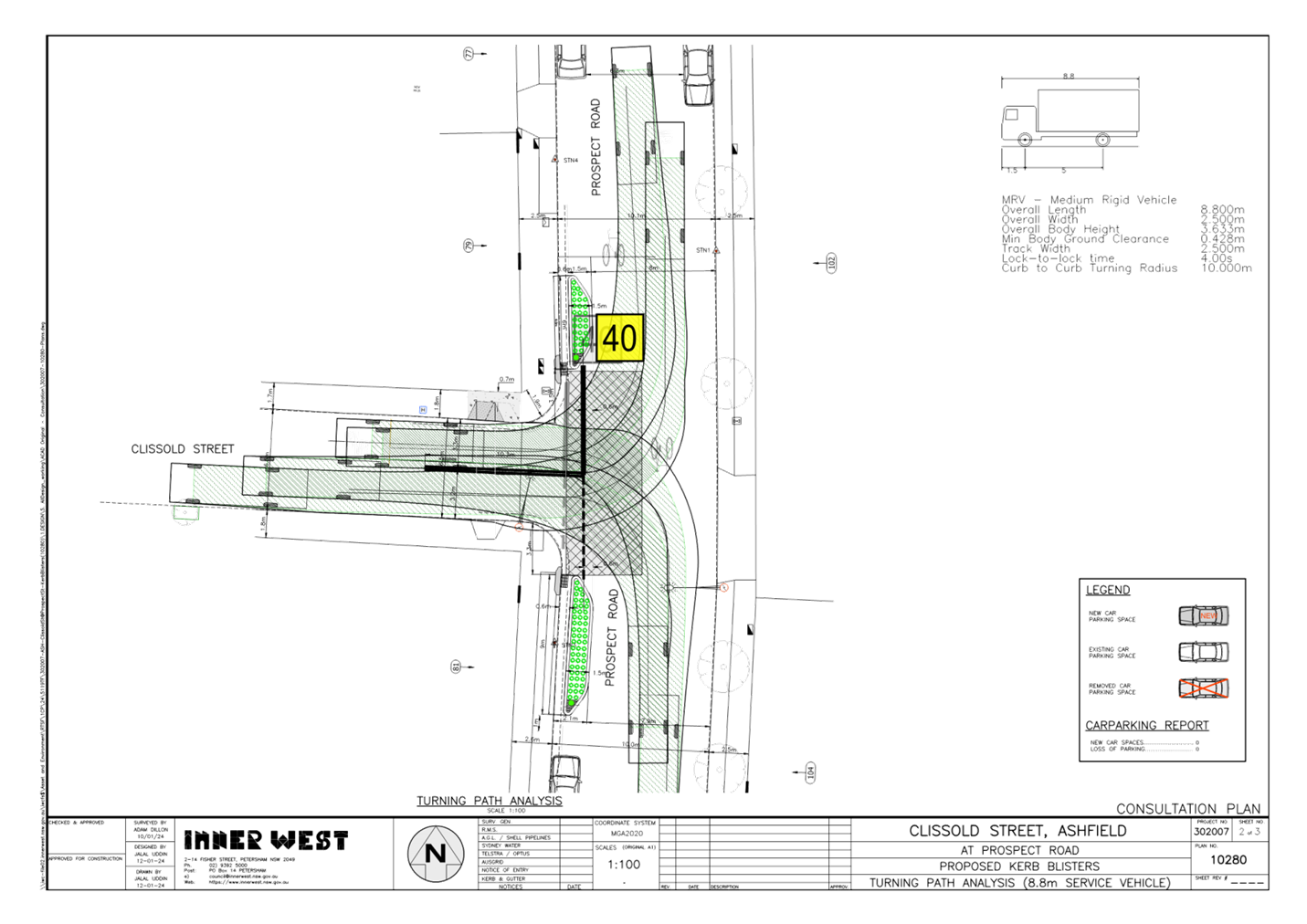
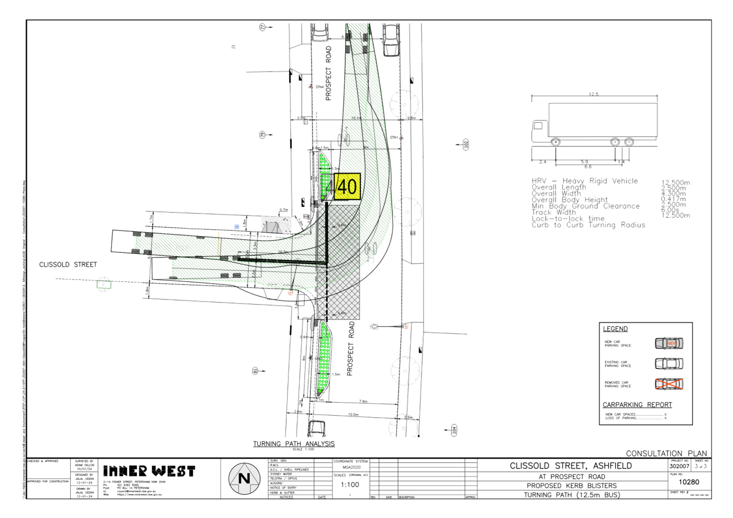
LTC0524(1) Item 10 Proposed new kerb extension facilities at intersection of Prospect Road and Clissold Street, Ashfield (Djarrawunang-Ashfield Ward/Summer Hill Electorate/ Burwood PAC) 84
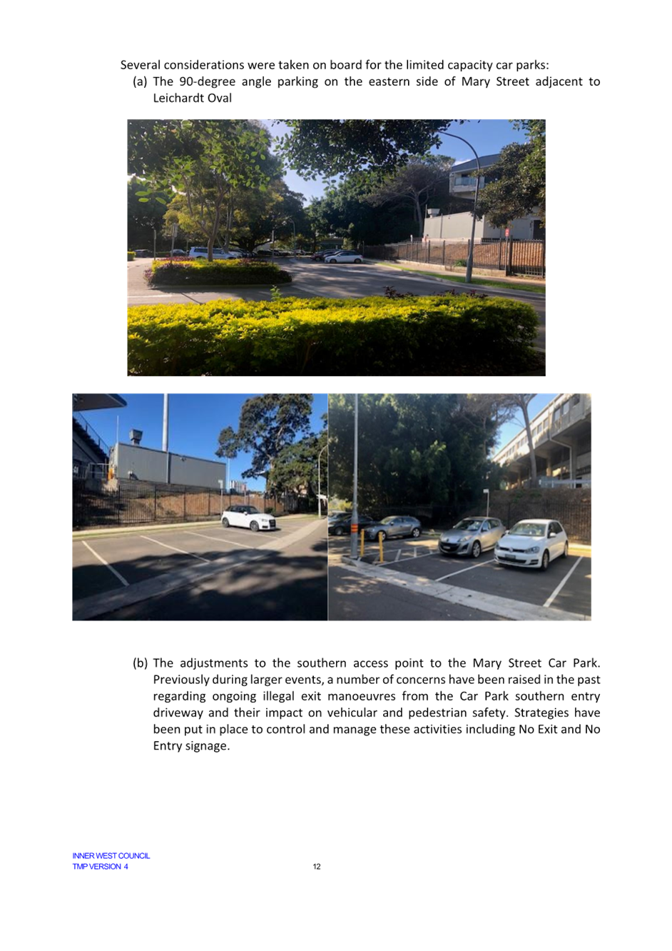
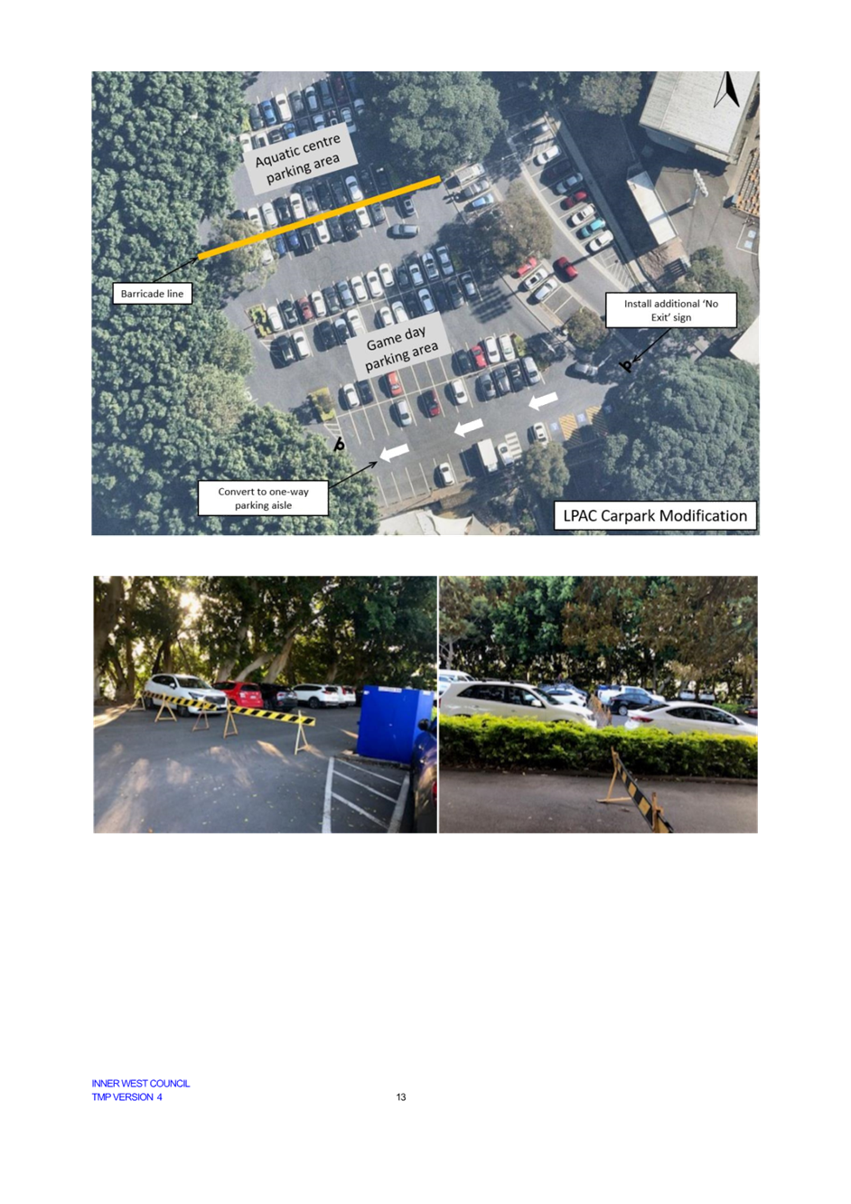
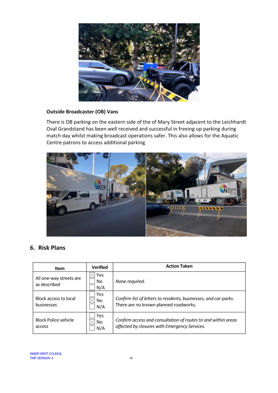
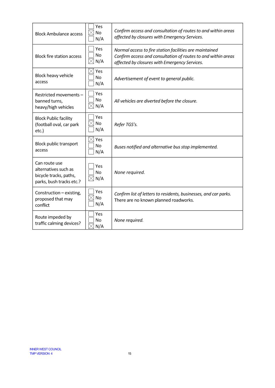
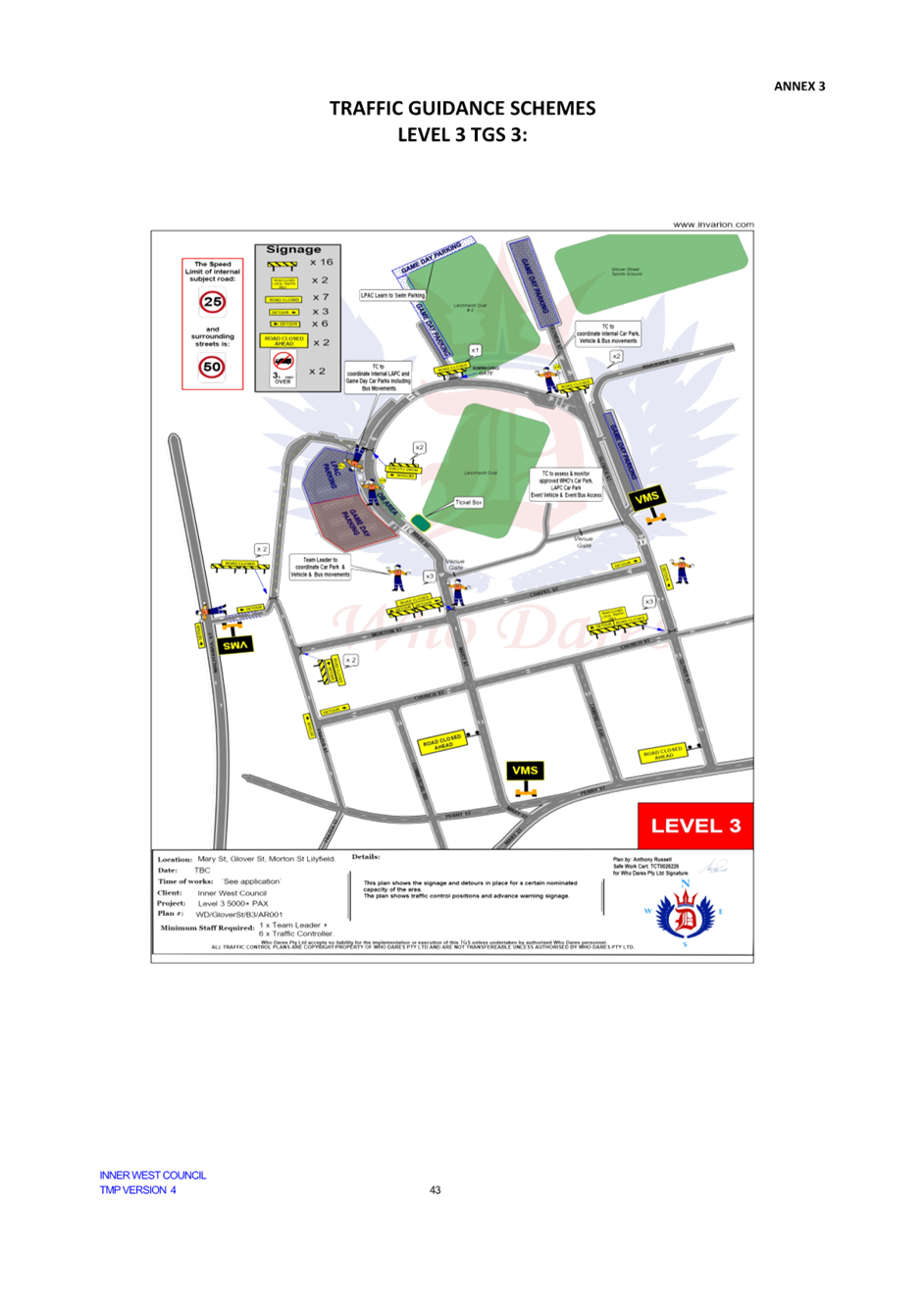
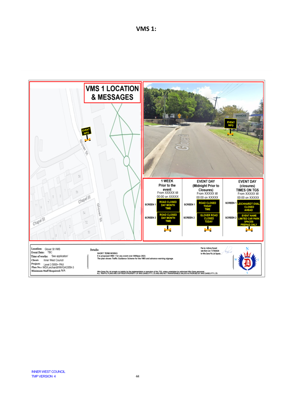
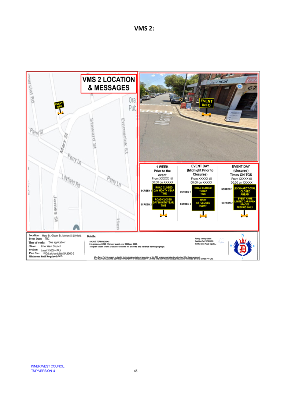
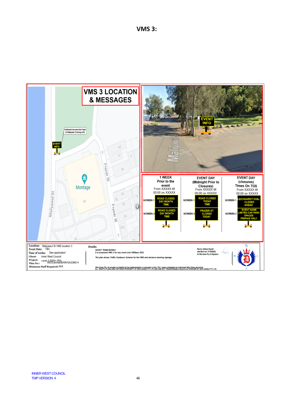
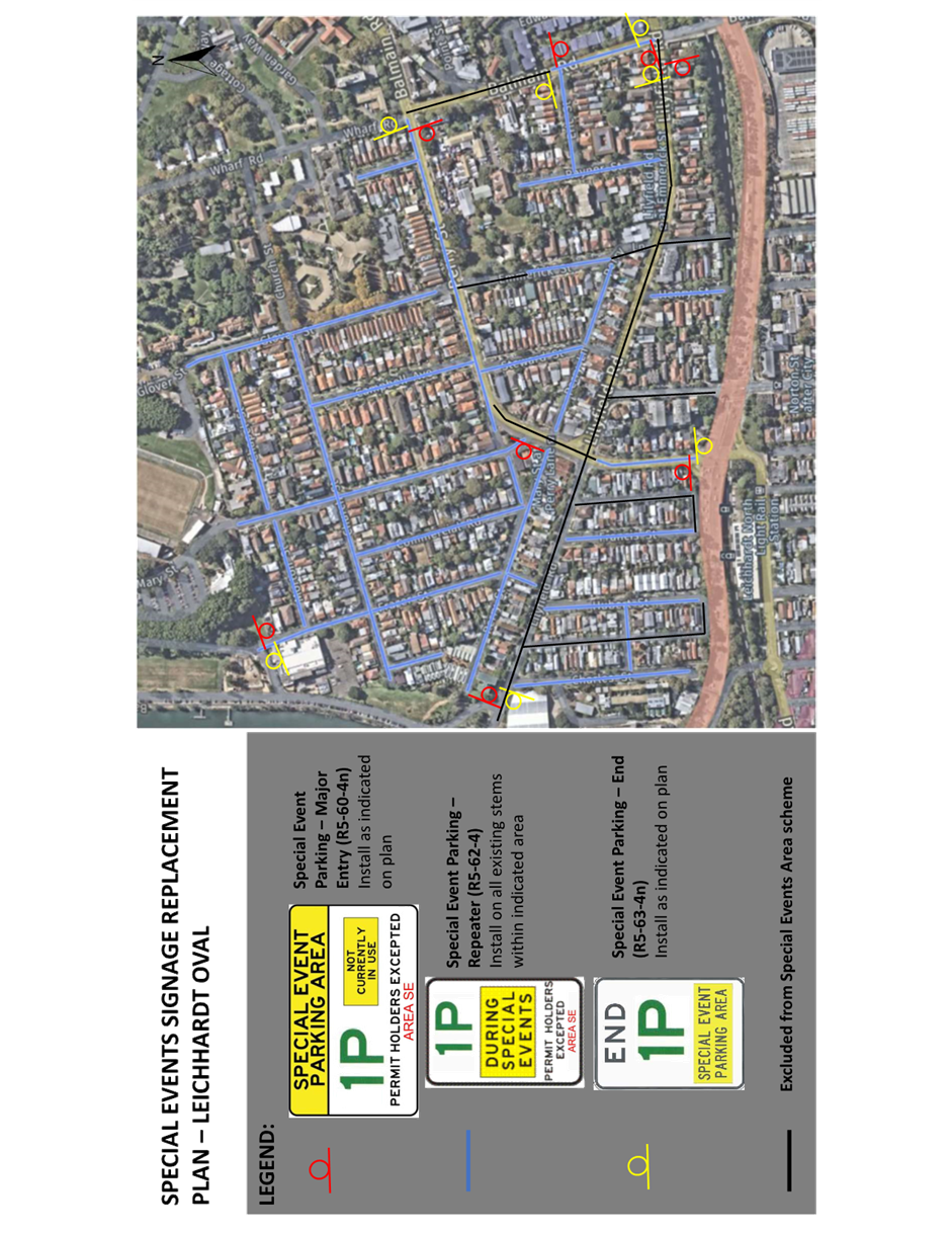
LTC0524(1) Item 11 Leichhardt Oval TMP and Special Event Parking Zone 91
Parking Matters
ITEM Page
LTC0524(1) Item 12
Amendment to signposted car share vehicle spaces in the
Inner West (All wards, all
electorates, all PACs) 140
Late Items
Nil at time of printing.
6 Part B - Items for Information Only
Nil at the time of printing.
7 Part C - Items for General Advice
Nil at the time of printing.
8 General Business
9 Close of Meeting
|
|
Local Traffic Committee Meeting 20 May 2024 |
Minutes of Local Traffic Committee Meeting held on 15 April 2024
Meeting commenced at 11:03 AM
ACKNOWLEDGEMENT OF COUNTRY BY CHAIRPERSON
I acknowledge the Gadigal and Wangal people of the Eora nation on whose country we are meeting today, and their elders past and present.
COMMITTEE REPRESENTATIVES PRESENT
|
Manod Wickramasinghe |
IWC’s Traffic and Transport Planning Manager (Chair) |
|
Bill Holliday |
Representative for Jamie Parker MP, Member for Balmain |
|
Graeme McKay |
Representative for Jo Haylen MP, Member for Summer Hill |
|
Nina Fard |
Transport for NSW (TfNSW) |
|
|
|
|
NON VOTING MEMBERS IN ATTENDANCE |
|
|
|
|
|
Roderick Primerano |
Representative for U-Go Mobility |
|
Michael Takla |
Representative for Transit Systems |
|
Felicia Lau |
IWC’s Acting Coordinator Traffic Engineering Services (North) |
|
George Tsaprounis |
IWC’s Coordinator Traffic Engineering Services (South) |
|
Christy Li |
IWC’s Business Administration Officer |
|
|
|
|
VISITORS |
|
|
|
|
|
Nathan English |
Resident (Item 1) |
|
|
|
|
APOLOGIES: |
|
|
|
|
|
Mayor Darcy Byrne |
Councillor – Baludarri-Balmain Ward |
|
Eleanor Nurse |
Representative for Jenny Leong MP, Member for Newtown |
DISCLOSURES OF INTERESTS: Nil.
CONFIRMATION OF MINUTES
|
That the Minutes of the Local Traffic Committee held on Monday, 18 March 2024 be confirmed. |
MATTERS ARISING FROM COUNCIL’S RESOLUTION OF MINUTES
The Minutes of the Local Traffic Committee meeting held on 18 March 2024 were adopted at Council’s meeting held on 05 March 2024 subject to the following adjustments:
1. London Street and Simmons Street, Enmore – Proposed Temporary Road Closure and Partial Road Closure to be deferred until the approval of a Traffic Management Plan by TfNSW, that this Plan address the potential increase to traffic in neighbouring residential streets and associated safety concerns, and that communication regarding the trial period and a contact for residents to provide feedback directly to council be letterboxed and displayed on the council website;
2. Amendment to signposted Car Share Vehicles spaces in the Inner West to be deferred pending further review of the signage especially the use of abbreviations; and
3. That Council defer the item 2 on Jaggers Lane, pending the outcome of the Land and Environment Court matter.
|
LTC0424(1) Item 3 Boomerang
Street, Haberfield - Pedestrian Crossing Line |
|
Council has received several concerns from residents regarding vehicles not slowing down as they approach the pedestrian crossing at Boomerang Street near the intersection with Loudon Avenue, Haberfield.
In response, council is proposing to install Zig Zag line markings on both approaches to the crossing to indicate to motorists that a pedestrian crossing is ahead.
Officers Recommendation:
That the installation of Zig Zag line markings on both approaches to the pedestrian crossing on Boomerang Street near the intersection with Loudon Avenue, Haberfield be approved.
DISCUSSION:
The Representative for the Member of Summer Hill questioned if the Zig Zag line markings make a difference in reducing vehicular speed.
The Representative for Transport for NSW advised these line markings are usually installed where sightlines are impaired to indicate that there is a pedestrian crossing ahead. It was also noted that the purpose of these line markings is to provide advanced warning to motorists to slow down in preparation of the upcoming pedestrian crossing.
The Committee members agreed with the Officer’s recommendation.
COMMITTEE RECOMMENDATION:
That the installation of Zig Zag line markings on both approaches to the pedestrian crossing on Boomerang Street near the intersection with Loudon Avenue, Haberfield be approved.
For Motion: Unanimous
|
|
LTC0424(1) Item 6 Illawarra Road, Marrickville Near Thornley Street - Proposed Upgrade Of Existing Pedestrian Crossing (Midjuburi-Marrickville Ward / Summer Hill Electorate / Inner West PAC) |
|
Council at its meeting held in March 2024, resolved to investigate safety of the pedestrian crossing on Illawarra Road at Yirran Gumal Early Learning Centre.
Previously minor pedestrian improvements have been made to this crossing, however on this occasion Council Officers have examined the possibility of raising this crossing. An initial investigation revealed that raising this crossing is feasible, subject to detailed design and community engagement.
Therefore, it is recommended that a proposed raised pedestrian crossing be supported in principle and that a detailed design of the proposal be bought back to the Committee for consideration.
Officers Recommendation:
That the upgrade of the existing pedestrian (zebra) crossing on Illawarra Road near Thornley Street to a raised crossing facility be approved in principle and that the detail design be bought back to the Traffic Committee for consideration.
DISCUSSION:
The Committee members agreed with the Officer’s recommendation.
COMMITTEE RECOMMENDATION:
That the upgrade of the existing pedestrian (zebra) crossing on Illawarra Road near Thornley Street to a raised crossing facility be approved in principle and that the detail design be bought back to the Traffic Committee for consideration.
For Motion: Unanimous |
General Business:
|
Item 8: Request for ‘One Way’ streets in the Balmain ward to allow bidirectional movements from bicycles. |
|
The Representative for the Member of Balmain suggested that Council consider the possibility of permitting ‘One Way’ streets in the Balmain ward to allow bidirectional movements from bicycles through the implementation of signage.
Council Officers advised that Council is currently looking into a LATM Study for the Balmain East and Birchgrove area and requested that the Representative for the Member of Balmain send through a list of streets he would like reviewed so that Council Officers can investigate. |
Meeting closed at 11.44am.
CHAIRPERSON
Manod Wickramasinghe
|
|
Local Traffic Committee Meeting 20 May 2024 |
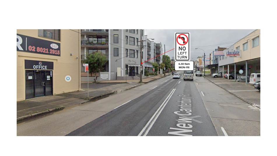
Subject: Denison Road at New Canterbury Road, Dulwich Hill - Proposed 'No Left Turn 6.30am-9am Mon-Fri' restrictions ((Djarrawunang-Dulwich Hill Ward/Summer Hill Electorate/Inner West PAC)
Prepared By: James Nguyen - Traffic Engineer
Authorised By: Manod Wickramasinghe - Traffic and Transport Planning Manager
|
RECOMMENDATION
That the proposed ‘No Left Turn 6.30am-9am Mon-Fri’ restriction from New Canterbury Road into Denison Road not be approved due to traffic impacts to Constitution Road. |
STRATEGIC OBJECTIVE
This report supports the following strategic directions contained within Council’s Community Strategic Plan:
|
2: Liveable, connected neighbourhoods and transport |
|
|
EXECUTIVE SUMMARY
This report discusses further investigations for the proposed left turn ban from New Canterbury Road into Denison Road, Dulwich Hill during the weekday morning peak period that was identified in the Dulwich Hill North Local Traffic Management Plan (LATM) 2016. It provides context on the origin of the proposal, and further assessment on the proposal with respect to current traffic conditions. An extensive consultation summary is provided with a final revised proposal.
BACKGROUND
A ‘No Left Turn’ ban from New Canterbury Road into Denison Road, Dulwich Hill during the weekday morning peak period to reduce through traffic was identified in the Dulwich Hill North LATM 2016 plan. The proposal sought to reduce through traffic volumes, improve the environment for pedestrians and cyclists, and is a low-cost intervention.
The final Dulwich Hill North LATM plan which included restricting the left turn movement for motorists from New Canterbury Road into Denison Road in the AM peak (subject to a further traffic survey) was endorsed by Local Traffic Committee meeting of 7 September 2017.
Council officers have since completed further traffic surveys to assess the traffic impact on Constitution Road and re-consulted with the community on the proposal.
DISCUSSION
Traffic assessment
Denison Road is a north-south collector road within the Dulwich Hill North Precinct. The road runs parallel to Old Canterbury Road and New Canterbury Road. The Dulwich Hill North LATM 2016 plan assessed the traffic conditions on Denison Road. The study determined that there are high through traffic volumes experienced on Denison Road, during the morning peak hour between 8:00am to 9:00am and subsequently recommended a peak hour ‘No Left Turn’ ban from New Canterbury Road into Denison Road during the weekday morning peak period.
The LATM plan notes that this treatment would shift traffic to adjacent streets, potentially impact local resident access and be difficult to enforce. In addition, the recommendation made by the Local Traffic Committee conditioned the implementation of the AM peak ‘No Left Turn’ subject to further traffic surveys at New Canterbury Road.
Accordingly, Council Engineers have completed further analysis on this proposal to assess the impacts, particularly the traffic distribution onto Constitution Road and whether this treatment will be effective in deterring through traffic during the morning peak period.
The daily recorded traffic volumes on Denison Road and Constitution Road from the LATM plan is shown below in Table 1:
Table 1 - Daily Traffic Volumes (Source: Dulwich Hill North Local Traffic Management Plan, 2016, p21)
|
Street Name |
Section |
Surveyed |
Functional classification |
Compliance |
||||
|
Volume (ADT) |
Speed 85th % km/h) |
Heavy Vehicle (%) |
Volume (ADT) |
Speed (85th % km/h) |
Heavy Vehicle (%) |
|||
|
Denison Road |
Eltham Street and Davis Street |
2,512 |
46.4 |
3.00 |
Collector |
Yes |
Yes |
Yes |
|
New Canterbury Road and Constitution Road |
483 |
36.7 |
3.10 |
Collector
|
Yes |
Yes |
Yes |
|
|
Constitution Road |
Williams Parade and Grove Street |
4308 |
46.1 |
5.80 |
Collector |
No |
Yes |
No |
Table 2 - Environmental Capacity and Speed Performance Standards (Source: Guide to Traffic Generating Developments (RMS, 2002))
|
Road Class |
Road Type |
Maximum Speed (km/h) |
Max Peak hour volume (veh/hr) |
Daily volume (veh/day) |
|
Local |
Access way |
25 |
100 |
1,000 |
|
Street |
40 |
200 (desirable) and 300 (maximum) |
2,000 (desirable) and 3,000 (maximum) |
|
|
Collector |
Street |
50 |
300 (desirable) and 500 (maximum) |
3,000 (desirable) and 5000 (maximum) |
At the time of completion of the LATM plan, the average daily traffic volume on Constitution Road exceeded the desirable environmental capacity limits (3,000 veh/day) and heavy vehicle limits (although not maximum limits), whilst the volumes on both sections (Eltham Street and Davis Street, and New Canterbury Road and Constitution Road) of Denison Road were within acceptable limits. In addition, the 85th percentile speeds Denison Road and Constitution Road were below the 50 km/h speed limit.
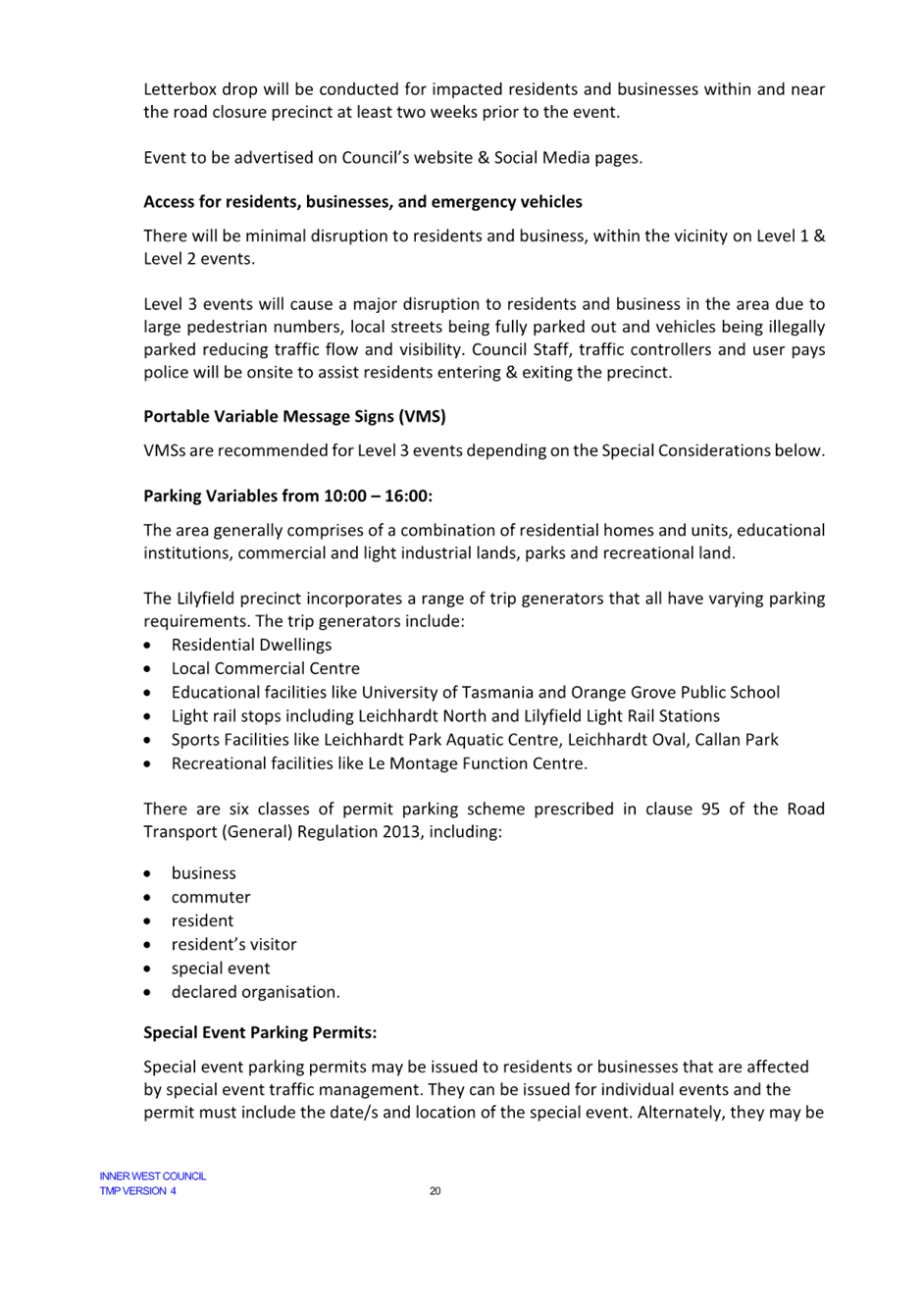
Council engineer’s completed traffic intersection counts on Wednesday 1 May 2024 to determine the impact of the proposed no left turn ban from New Canterbury Road into Denison Road on Constitution Road. Accordingly, traffic intersection counts were completed at both the intersections of Denison Road and Constitution Road at New Canterbury Road. Figure 2 below compares the left turn volumes of vehicles recorded from New Canterbury Road into Denison Road and Constitution Road.
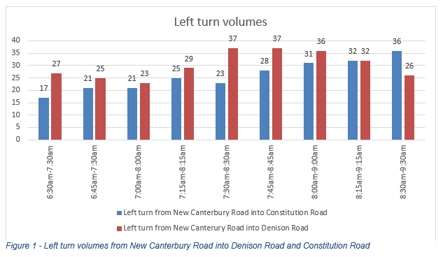
On average, 54 per cent of the total left turn movements from New Canterbury Road are made at Denison Road, compared to 46 per cent which is made at Constitution Road between 6:30am and 9:30am.
Table 3 below provides an assessment of the redistributed left turning movements from Denison Road to Constitution Road. The existing peak hour volumes between 7:15am and 9:30am on Constitution Road already exceeds the desirable environmental limit (300 veh/hour). A peak hour ‘No Left Turn’ ban from New Canterbury Road to Denison Road would increase the peak hour volume by an average of 10 per cent.
Table 3 - Traffic redistribution to Constitution Road
|
Time |
Existing bi-directional AM peak volume on Constitution Road (veh/hour) |
Redistributed left turn movements from Denison Road (veh/hour) |
Projected total hourly volumes on Constitution Road (veh/hour) |
Compliance with Max Peak hour volume |
|
6:30am-7.30am |
161 |
+27 |
188 |
Yes |
|
6:45am-7:30am |
193 |
+25 |
218 |
Yes |
|
7:00am-8:00am |
269 |
+23 |
292 |
Yes |
|
7:15am-8:15am |
348 |
+29 |
377 |
No |
|
7:30am-8:30am |
400 |
+37 |
437 |
No |
|
7:45am-8:45am |
446 |
+37 |
483 |
No |
|
8:00am-9:00am |
429 |
+36 |
465 |
No |
|
8:15am-9:15am |
401 |
+32 |
433 |
No |
|
8:30am-9:30am |
349 |
+26 |
375 |
No |
PUBLIC CONSULTATION
Public Consultation - Dulwich Hill North LATM plan
The original Dulwich Hill North LATM plan was consulted with the community between 7 May 2017 and 14 June 2017. Council received a total of 108 submissions from individual households with 70 responses in support and 38 responses against the LATM plan. Of the 70 responses that supported the strategy 49 responses requested changes. There were no objections or concerns raised by the community about the proposed one-way conversion of Lewisham Street between The Boulevarde and New Canterbury Road, at the time.
Public Consultation - ‘No Left Turn 6.30am-9.30am Mon-Fri’
Council re-consulted with residents and businesses on a proposed ‘No Left Turn 6.30am-9.30am Mon-Fri’ restriction from New Canterbury Road into Denison Road between Wednesday 21 February 2024 and Thursday 7 March 2024. There were 422 letters sent. In addition, the proposal was publicly exhibited on Inner West Council’s ‘Your Say’ website. Council received a total of 19 submissions on the proposal. There were five (5) responses supporting, 12 responses opposing and two (2) responses unsure about the proposal.
The responses supporting the proposal noted unconditional support to the proposal.
The responses opposing the proposal noted the following concerns and comments:
· Traffic would be redirected to Constitution Road and increase congestion.
· Access to Christian Brothers Lewisham via Denison Road.
· ‘Rat-running’ does not occur on Denison Road via New Canterbury Road. The main issue is located at the intersection of New Canterbury Road and Constitution Road.
· A ‘No Left Turn’ restriction will increase traffic queuing on New Canterbury Road at the intersection of Constitution Road during the morning peak, and motorists will turn left an earlier location to avoid the queue.
· Access to homes will be restricted.
· Alternative traffic calming measures on Denison Road should be considered.
· Access to the existing disability parking space on the southern side of Denison Road, west of New Canterbury Road between 6.30am-9am will be restricted.
· The proposed ‘No Left Turn 6.30am-9am’ was investigated and proposed in 2017 and does not consider changes to travel behaviour. More people are working from home.
CONCLUSION
The traffic surveys completed indicate the traffic volumes on Constitution Road already exceed the desirable environmental limits between 7:15am and 9:30am. An AM peak ‘No Left Turn’ restriction from New Canterbury Road into Denison Road would increase the AM peak hour traffic volumes on Constitution Road. Furthermore, the section of Denison Street which this ban would benefit already experiences low daily traffic volumes in comparison to the remaining section of Denison Street and Constitution Road. Accordingly, the proposed ‘No Left Turn 6.30am-9am Mon-Fri’ restriction from New Canterbury Road into Denison Road is not recommended.
FINANCIAL IMPLICATIONS
There are no financial implications associated with the implementation of the proposed recommendations outlined in the report.
|
1.⇩ |
Concept plan |
|
Local Traffic Committee Meeting 20 May 2024 |
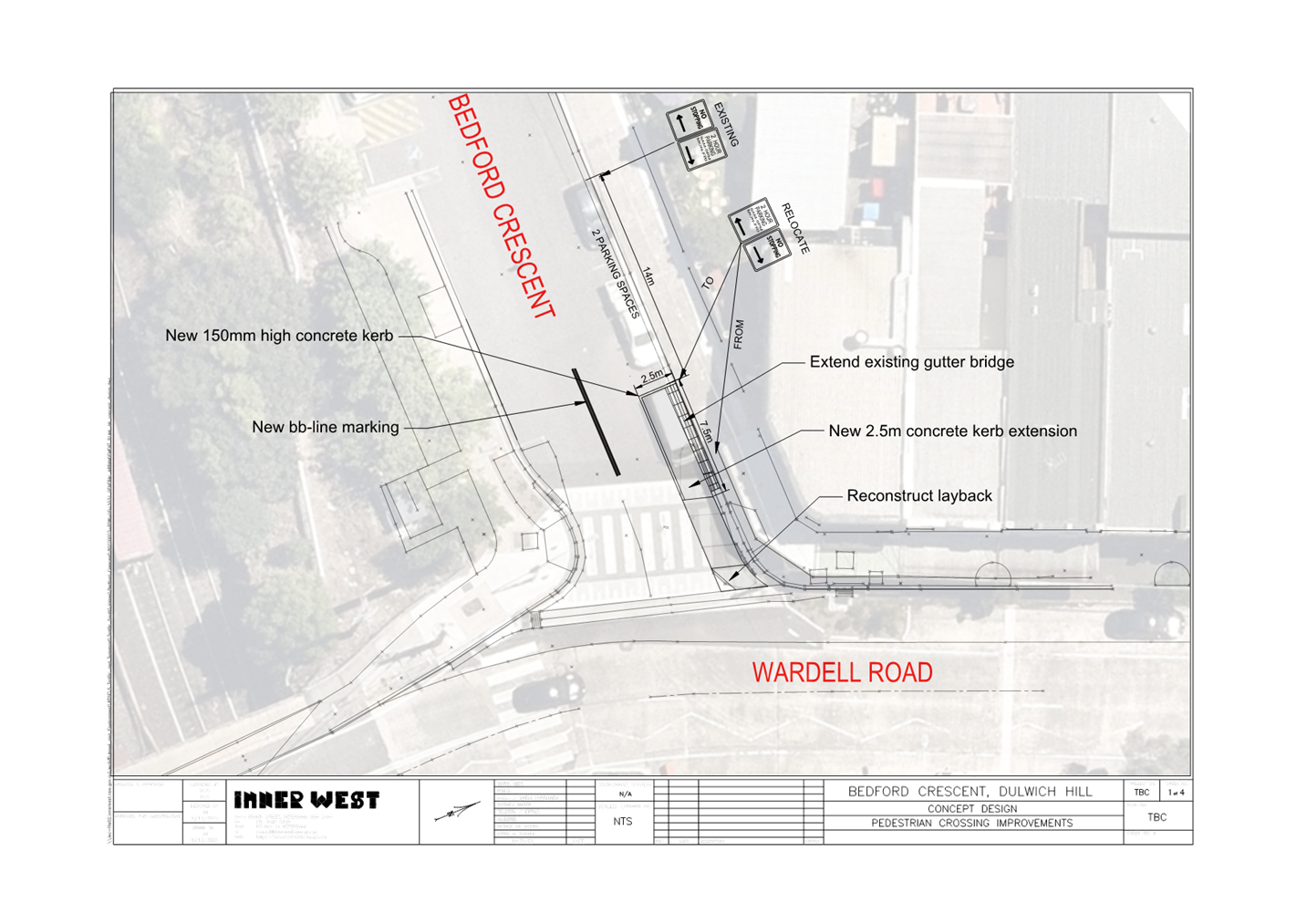
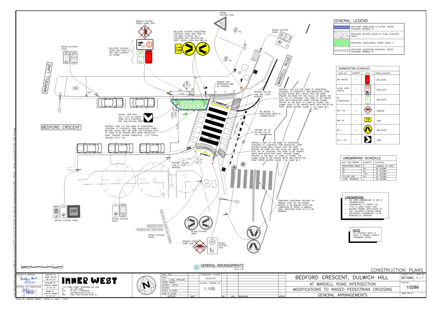
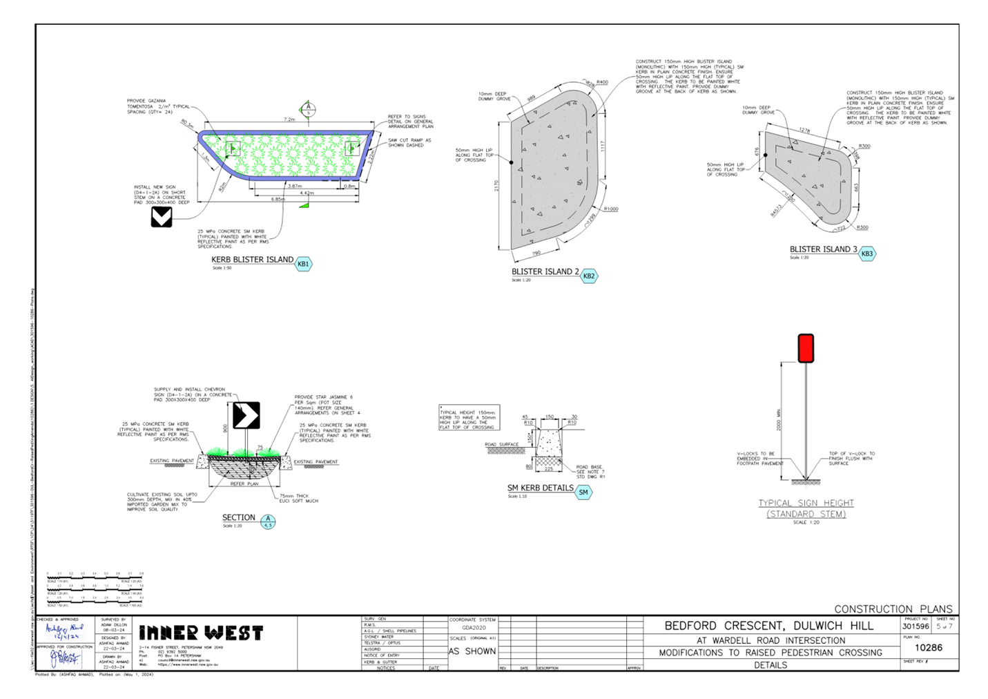
Subject: Bedford Crescent, Dulwich Hill - Proposed changes to raised pedestrian crossing and parking (Djarrawunang-Dulwich Hill Ward/Summer Hill Electorate/Inner West PAC)
Prepared By: James Nguyen - Traffic Engineer
Authorised By: Manod Wickramasinghe - Traffic and Transport Planning Manager
|
RECOMMENDATION
That the proposed changes to the raised pedestrian crossing on Bedford Street, Dulwich Hill, as shown on the attached revised concept plan be endorsed. |
STRATEGIC OBJECTIVE
This report supports the following strategic directions contained within Council’s Community Strategic Plan:
|
2: Liveable, connected neighbourhoods and transport |
|
|
EXECUTIVE SUMMARY
This report outlines the design development of the proposed changes to the existing raised pedestrian crossing on Bedford Street, Dulwich Hill to improve pedestrian safety.
BACKGROUND
A proposal to adjust the existing raised pedestrian crossing on Bedford Street, Dulwich Hill was referred to and approved at the Local Traffic Committee meeting on Monday 19 February 2024.
The proposed changes consist of:
· Constructing a new kerb extension;
· Relocating an existing ‘No Stopping’ restriction to improve sight lines, which will require the removal of one (1) parking space;
· Installing a new flood light and pole at the pedestrian crossing; and
· ‘BB’ line marking on the approach to the pedestrian crossing on Bedford Crescent.
DISCUSSION
The concept design has been refined and developed further with the following changes proposed from the previous revision:
· Removal of the ‘BB’ line marking on the approach to the pedestrian crossing
· Landscaping the existing kerb extension to reduce hard surface run-off
· Installation of ‘give way’ and edge (E1) line markings
· Two kerb blister islands on the eastern side of the pedestrian crossing to increase pedestrian protection from turning vehicles on Wardell Road
· Installation of ‘LOOK’ and yellow line marking to increase pedestrian awareness at the pedestrian crossing
· Remove the existing speed hump sign (W5-10A) and install pedestrian crossing, speed advisory, and chevron alignment marking signs (R3-1, W8-2A, D4-1-2A).
A lighting design is currently being prepared in parallel with the civil design.
PUBLIC CONSULTATION
The original proposal has already been consulted with the adjacent businesses on Wardell Road and referred to the Local Traffic Committee meeting on Monday 19 February 2024.Given the further changes to the proposal are minor, further consultation was not required.
FINANCIAL IMPLICATIONS
The revised design is estimated to cost approximately $100,000 (inclusive of lighting) and will be funded from the Capital Works Program.
|
1.⇩ |
Approved concept plan - Bedford Crescent, Dulwich Hill |
|
2.⇩ |
Revised concept plan - Bedford Crescent, Dulwich Hill |
|
Local Traffic Committee Meeting 20 May 2024 |
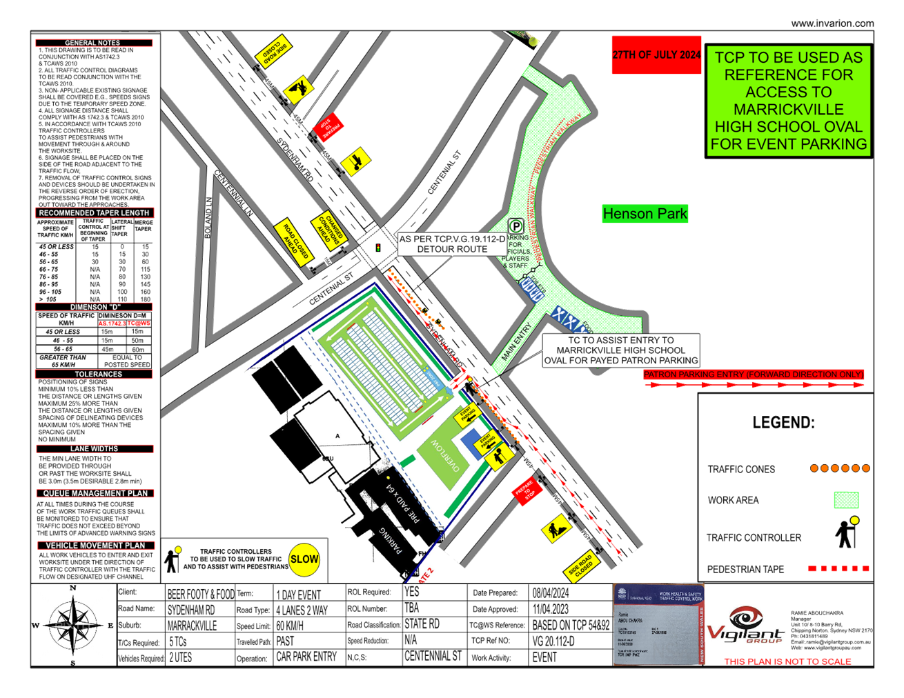
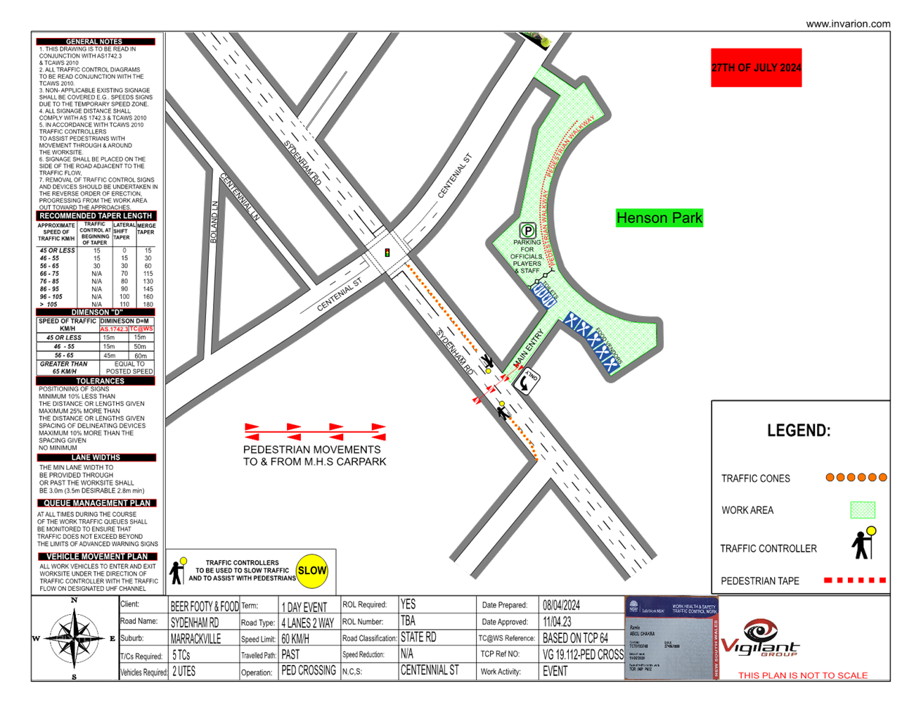
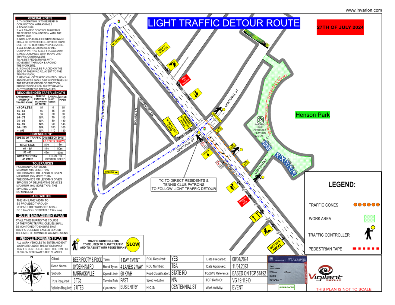
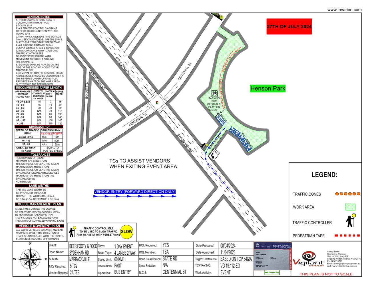
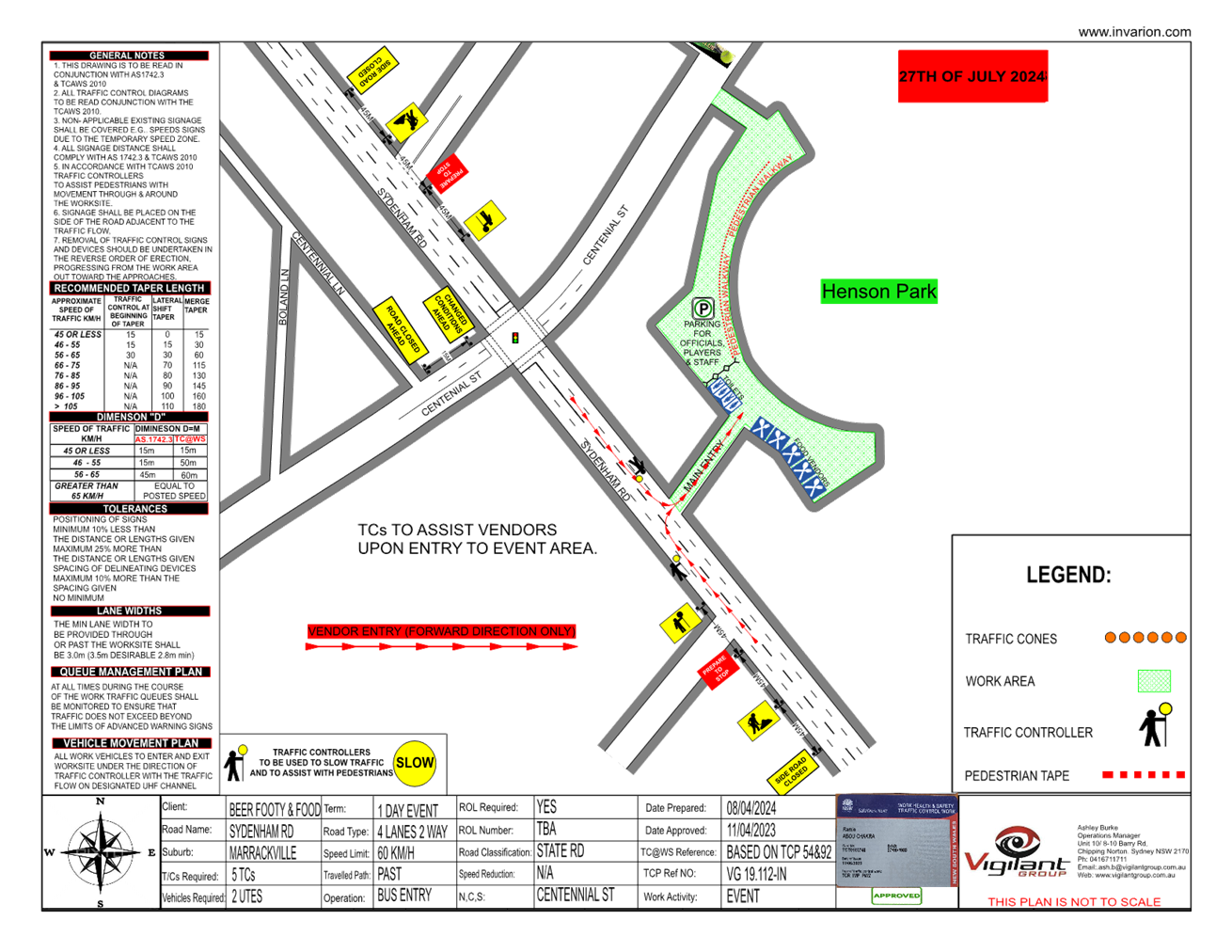
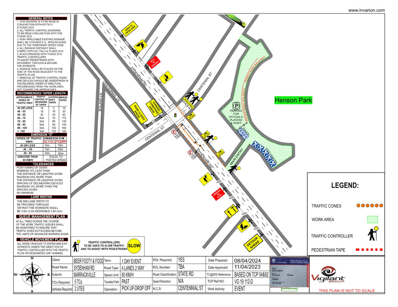
Subject: Centennial Street, Marrickville – Temporary Road Closure for Special Event at Henson Park (2024 Beer, Footy and Food Festival) on Saturday 27 July 2024 - (Midjuburi-Marrickville Ward /Summer Hill Electorate /Inner West LAC)
Prepared By: Jennifer Adams - Traffic Engineer
Authorised By: Manod Wickramasinghe - Traffic and Transport Planning Manager
|
RECOMMENDATION
That the proposed temporary full road closure (ENRC/2024/0022) of Centennial Street, Marrickville between Sydenham Road and the entrance to Henson Park and Marrickville & District Hardcourt Tennis Club car park, between 10.00am and 8.00pm on Saturday 27 July 2024 (contingency period of two months) for the purpose of holding the ‘Beer, Footy and Food Festival 2024’ event be approved, subject to the approval of the S68 Application and the applicant complying with, but not limited to, the following conditions:
a) A Road Occupancy License application be obtained by the applicant from the Transport Management Centre; b) All affected residents and businesses, including NSW Police Local Area Commander, Transit Systems, Fire and Rescue NSW and NSW Ambulance Services, shall be notified in writing by the applicant of the proposed temporary road closure at least 7 days prior to the event, with the applicant making reasonable provision for residents and businesses; c) A VMS be placed displaying that there is ‘No Public Parking’ in Centennial Street; d) The occupation of the road carriageway must not occur until the road has been physically closed; and e) Subject to written concurrence from Transport for New South Wales.
|
STRATEGIC OBJECTIVE
This report supports the following strategic directions contained within Council’s Community Strategic Plan:
|
2: Liveable, connected neighbourhoods and transport |
|
|
EXECUTIVE SUMMARY
An application has been received from the Music & Booze Company together with the Newtown Rugby League Football Club to hold the 2024 Beer, Footy and Food Festival between 10.00am and 8.00pm on Saturday 27 July 2024 at Henson Park Oval. The event requires the temporary full road closure of Centennial Street, Marrickville between Sydenham Road and the entrance gate to Henson Park Oval. It is recommended that Council agree to the temporary full road closure subject to the applicant complying with the above conditions and obtaining concurrence from Transport for NSW as the closure entails lane closures on Sydenham Road, Marrickville.
BACKGROUND AND STAFF COMMENTS
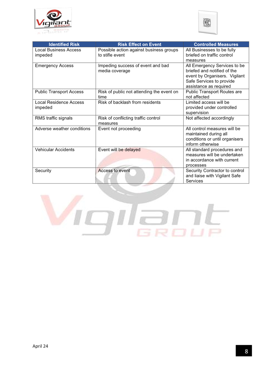
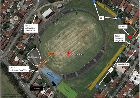
Centennial Street, east of Sydenham Road, will be closed to traffic thoroughfare so the event as proposed can successfully occur. The road will be accessible to all residents, emergency services, Event staff, Coaches and players and allowance will also be made for disability parking to come through the road closure.
Centennial Street is a dead-end local two-way street with one travel lane in each direction, in addition to kerbside parking lanes. It carries around 400 vehicles per day. Parking is unrestricted along both sides of the road. It is a residential local road and an entry point to Henson Park.
The following traffic control measures are diagrammatically shown and detailed in the attached TMP and Traffic Guidance Schemes (TGSs):
VG. 19.112-1, Pick up and Drop off
VG. 19.112-B. E, Bus entry assisted
VG. 19.112-D, Detour route/ Light Traffic entry to Centennial Street
VG. 19.112-IN, Ingress for Vendors and Staff
VG. 19.112-EG, Egress for Vendors and Staff
· Road Closure, on Centennial Street, however allowing access to Residents, Players, Coaches, event staff & Patrons of the Tennis Club.
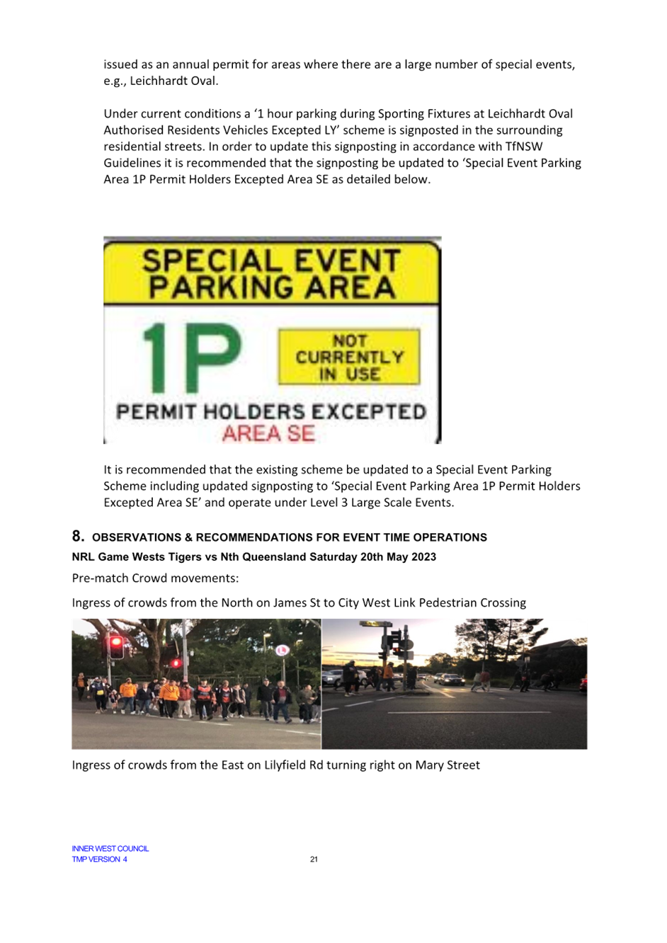
· Light traffic entry to Centennial Street - light traffic will be detoured along Sydenham Road to turn left into Petersham Road and turn left onto Centennial Street, before continuing straight through the lights on to the closed section of Centennial Street this control measure is to alleviate traffic congestion attempting to turn right from Sydenham Road on to Centennial Street.
· All Residents & business effected by this closure will be notified 1 month and 1 week prior to the Event.
· 1 Traffic Controller will be in place on the southwest corner of the Centennial Street and Sydenham Road intersection, they will assist anyone attempting to enter the Road Closure at Centennial Street by directing them towards the light traffic detour.
· Special Event Clearways
Sydenham Road, between Centennial Street and Holmesdale Street to allow room for the drop off area, just outside the gates to Henson Park.
· Bus Entry
Bus entry will be conducted under guidance by RMS accredited Traffic Controllers. Upon approach all traffic will be stopped in both directions & the road closure opened, the bus driver will be instructed to drive into Centennial Street (south) & then reverse into Centennial Street (north) where they will be assisted by a spotter to a safe parking spot.
· Pedestrian Crossing
Traffic Controllers (TCs) will assist all pedestrians across the road safely, from the main entry/exit to the Marrickville High School parking lot. This is a preventative measure to ensure all patrons leave the Event safely and in an orderly fashion. TCs will hold pedestrians from crossing the road until such time as the supervisor deems it safe, has stopped traffic and cleared an area to cross. This will avoid people rushing onto the road in between slow traffic and causing more congestion as well as keeping the public safe.
· Lane closures on Sydenham Road
Sydenham Road, northbound right turning lane at Centennial Street intersection - Traffic cones will merge traffic into the left lane 30 meters prior to the intersection.
Sydenham Road, northbound left lane parking Clearway. Traffic management personnel will be directing motorists parking for the event into Marrickville High School grounds via Sydenham Road gate entrance.
Sydenham Road, southbound left lane parking Clearway. Traffic management personnel will direct motorists into this lane as a “drop-off” zone for the event.
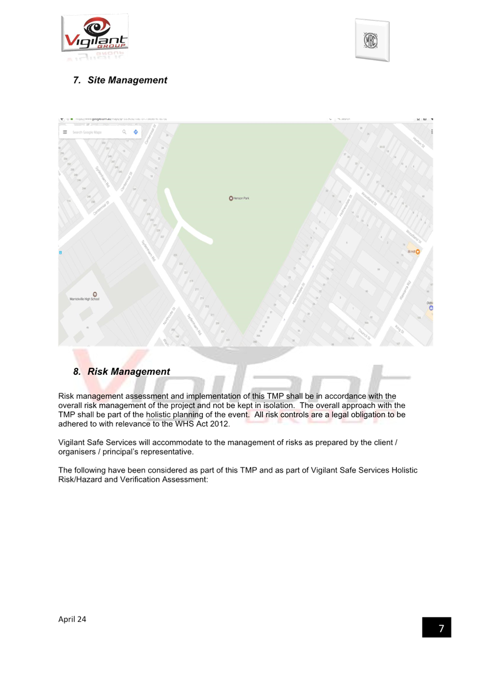
· Site map
FINANCIAL IMPLICATIONS
All works and costs of implementation will be borne by the applicant
PUBLIC CONSULTATION
The applicant is to notify all affected residents and businesses in writing at least 7 days prior to the commencement of works. The proposed road closure has been advertised on Council’s website in accordance with the Roads Act 1993.
|
1.⇩ |
BEER FOOD FOOTY TMP1 COMPLETE |
|
Local Traffic Committee Meeting 20 May 2024 |
Subject: Ewart Street, Dulwich Hill and (Lower) Railway Parade, Sydenham - Temporary Parking Changes on 3 Weekends During Weekend Rail Replacement Operations - Bus Replacements During June and July 2024 (Midjuburi -Marrickville Ward / Summer Hill Electorate / Inner West PAC)
Prepared By: Jennifer Adams - Traffic Engineer
Authorised By: Manod Wickramasinghe - Traffic and Transport Planning Manager
|
RECOMMENDATION
1. That the following temporary short-term parking changes for the following periods · 2am Saturday 1 June to 2am Monday 3 June 2024 (inclusive) · 2am Saturday 15 June to 2am Monday 17 June 2024 (inclusive) · 2am Saturday 13 July to 2am Monday 15 July 2024 (inclusive) be approved to support the works required to convert the T3 Bankstown Line to a Metro Line: a) Dulwich Hill Station Precinct - Ewart Street (3 parking spaces): The short-term conversion of 20m (3 parking spaces) ‘2P 8 am – 6 pm Mon – Fri’ on the northern side of Ewart Street (between Wardell Road and Bayley Street) to a ‘Bus Zone’;
b) The short-term conversion of 25m ‘No Parking’ restrictions on the southern side of Ewart Street (between Wardell Road and Riverside Crescent) to a ‘Bus Zone’;
c) Sydenham Station Precinct - Lower Railway Parade (80 parking spaces): The short-term conversion of 122m (46 parking spaces) 45 degree angled ‘unrestricted parking’ on the southern side kerb of Lower Railway Parade (between Sydenham Road and Marrickville Road) to a ‘Bus Zone’;
d) The short-term conversion of 32m (11 parking spaces) 45-degree angled parking ‘4P 8:30 am – 6 pm Mon - Fri’ on the southwest kerb of Lower Railway Parade (between Gleeson Avenue and Marrickville Road) to a ‘Bus Zone’;
e) The short-term conversion of 50m (14 parking spaces) rear to kerb ‘unrestricted parking’ on the northern kerb of Burrows Avenue (west of Gleeson Avenue) to a ‘Bus Zone’ and
f) The short-term of 58m (9 parking spaces) ‘unrestricted parking’ on the southern kerb of Burrows Ave (west of Gleeson Ave) to a ‘Bus Zone’.
2. That the cost of all works of the statement and/or reinstatement of any/all signage will be borne by TfNSW.
3. That the applicant and Council Rangers be advised in terms of this report. |
STRATEGIC OBJECTIVE
This report supports the following strategic directions contained within Council’s Community Strategic Plan:
|
2: Liveable, connected neighbourhoods and transport |
|
|
EXECUTIVE SUMMARY
Council has been notified by Transport for NSW (TfNSW) that in a joint submission with Sydney Trains there will be major rail shutdown of the Sydenham to Bankstown rail line (T3) for the following periods:
· 2am Saturday 1 June to 2am Monday 3 June 2024 (inclusive).
· 2am Saturday 15 June to 2am Monday 17 June 2024 (inclusive).
· 2am Saturday 13 July to 2am Monday 15 July 2024 (inclusive).
During the shutdown buses will replace train services along the T3 line and to accommodate the increased bus movements and necessary holding areas some short-term parking changes are required at a number of locations.
Specifically, TfNSW is requesting approval for the temporary conversion of multiple parking spaces at Ewart Street, Dulwich Hill and (Lower) Railway Parade, Sydenham. It is recommended that no objections be raised, and Council approves the temporary short-term parking changes at the identified locations during the three (3) weekend rail shutdowns.
All changes to existing parking arrangements and signage will be reinstated at the completion of the bussing operation by TfNSW.
OFFICER COMMENTS
Each of the locations are detailed separately.
Dulwich Hill Station Precinct (3 parking spaces)
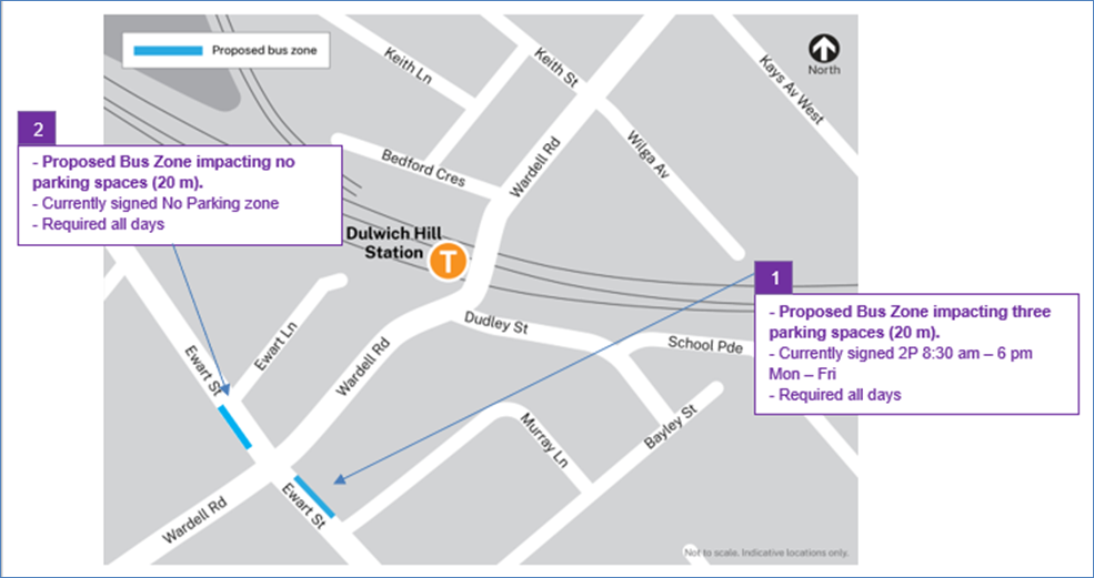
1. Ewart Street, northern side (Stop ID: 2204118) - Bus stop extension (3 parking space)
· Ewart Street (northern kerb between Wardell Road and Bayley Street)
· Currently sign posted ‘2P 8:30 am – 6 pm Mon – Fri’
· Proposed Bus Zone is required for all days of the TTP bus operation
· Proposed temporary change will impact approximately three parking spaces (20m).
· This change is proposed to create a bus stop area and to provide adequate space for draw-in/draw-out purposes.
2. Ewart Street, southern side (Stop ID: 220488) – Bus stop
· Ewart Street (southern kerb between Wardell Road and Riverside Crescent)
· Currently signed No Parking Zone
· Proposed Bus Zone is required for all days of the TTP bus operation
· Proposed temporary change will impact approximately no parking spaces.
· This change is proposed to create a bus stop area and to provide adequate space for draw-in/draw-out purposes.
Sydenham Station Precinct (55 parking spaces)
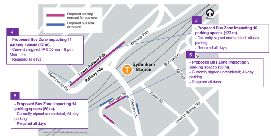
3. Section A of Lower Railway Parade, Sydenham 90-degree angled parking, Sydenham – Layover Bus Zone and Standby area (46 parking spaces)
· Lower Railway Parade Parallel Parking (southern side between Sydenham Road and Marrickville Road)
· Currently’ Unrestricted parking’
· Proposed Bus Zone is required for all days of the TTP bus operation
· Proposed temporary change will impact approximately 46 angled parking spaces (122 m).
· This proposed change is to create the space required for buses to layover. This location is proposed as it is (i) reasonably close to the active bus stop; (ii) located along the route path used between the last and first stops; and (iii) as far as removed from residential dwellings.
4. Section B of Lower Railway Parade, Sydenham 90-degree angled parking, Sydenham - Layover Bus Zone (11 parking spaces)
· Lower Railway Parade Parallel Parking (southern side between Gleeson Avenue and Marrickville Road)
· Currently ‘4P 8:30 am – 6 pm Mon – Fri’ restrictions
· Proposed Bus Zone is required for all days of the TTP bus operation
· Proposed temporary change will impact approximately eleven angled parking spaces (32 m).
· This proposed change is to create the space required for buses to layover. This location is proposed as it is (i) reasonably close to the active bus stop; and (ii) located along the route path used between the last and first stops.
5. Burrows Avenue, Sydenham (Stop ID: 204421) rear to kerb parking – Bus Zone extension (14 parking spaces)
· Burrows Avenue (northern kerb west of Gleeson Avenue)
· Currently Unrestricted parking
· Proposed Bus Zone is required for all days of the TTP bus operation
· This proposed change is to create the space required for buses to layover and to provide adequate space for draw-in/draw-out purposes.
· Proposed temporary change will impact approximately 14 rear to kerb parking spaces (50 m).
6. Burrows Avenue, Sydenham – (Southern kerb) – Bus Zone (9 parking spaces)
· Burrows Avenue (southern kerb west of Gleeson Avenue)
· Currently Unrestricted parking
· Proposed Bus Zone is required for all days of the TTP bus operation
· This proposed change is to create the space required for buses to layover safely
· Proposed temporary change will impact approximately 9 parking spaces (58 m ).
PUBLIC CONSULTATION
TfNSW propose the temporary parking changes and they will carry out consultation with their wider team who will be installing notifications at each impacted parking location 2-weeks prior to the start of the weekend possession(s).
FINANCIAL IMPLICATIONS
There are no financial implications for Council associated with this matter. The cost of the work will be borne by Transport for NSW.
Nil.
|
|
Local Traffic Committee Meeting 20 May 2024 |
Subject: Installation of a parking restrcition in front of Emmerick Street Community Preschool on Emmerick Street, Lilyfield (Baludarri-Balmain Ward/Balmain Electorate/Leichhardt PAC)
Prepared By: Amir Falamarzi - Traffic Engineer
Authorised By: Manod Wickramasinghe - Traffic and Transport Planning Manager
|
RECOMMENDATION
That a 14m length ‘P10minute 9am-9.30am, 2.30pm-3pm School Days’ be approved outside of Emmerick Street Community Preschool at No.15 Emmerick Street, Lilyfield as shown on the signage plan.
|
STRATEGIC OBJECTIVE
This report supports the following strategic directions contained within Council’s Community Strategic Plan:
|
2: Liveable, connected neighbourhoods and transport |
|
|
EXECUTIVE SUMMARY
Multiple requests have been received from the Emmerick Street Community Preschool regarding the lack of available on-street parking spaces outside the preschool during the pickup and drop off times. Site inspections indicate that there is a lack of short-term parking during peak times and it is recommended to install a 10-minute parking restriction on the east side of Emmerick Street outside preschool.
BACKGROUND
Council has received multiple concerns from the Emmerick Street Community Preschool regarding the lack of available on-street parking spaces outside the preschool during the pickup and drop off times.
The available parking in front of the Emmerick Street Community Preschool is shown in Figure 1, and is approximately 14.0m in length, which positioned between the driveway of No.15 Emmerick Street and the driveway of No.11A Emmerick Street. This length could accommodate two standard cars spaces or three small cars.
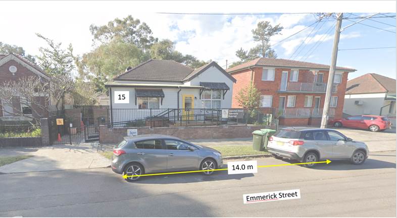
Figure 1: 15 Emmerick Street, Lilyfield
Site observations indicate that there is a lack of short-term parking during the preschool pick up drop off times which may result in illegal parking including parking on driveways or double parking.
DISCUSSION
To improve vehicle turnover and parking availability, it is proposed to install 14m length ‘P10minute 9am-9.30am, 2.30pm-3pm School Days’ adjacent to the Emmerick Street Community Preschool.
The proposal is shown in Figure 2:
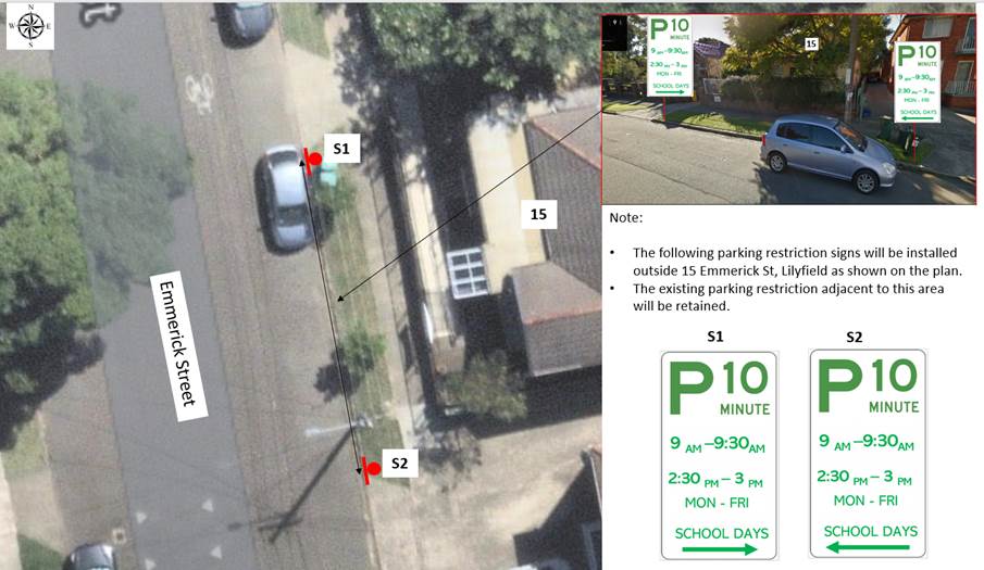
Figure 2: Parking restriction proposal outside 15 Emmerick Street, Lilyfield
PUBLIC CONSULTATION
Community consultation has been undertaken with all affected residents on Emmerick Street, Lilyfield regarding the proposed parking changes.
Three comments have been received, with three (3) expressing objections to the proposal and one (1) supporting the proposal. These comments, including officer’s comments are summarised in Table 2 below.
Table 2: Comments raised by the residents and the responses
|
Residents’ comments |
Officer comments |
|
The new proposal will not be effective as currently due to lack of parking enforcement, some parents park illegally such as parking across the driveway, parking on other’s off-street parking spaces and double parking. |
Council undertake proactive and reactive parking enforcement in many areas. If members of the public witness unsafe parking, please report the matter through Council’s Customer Service. |
|
Due to lack of allocated off-street parking space, the proposal will limit our access to available on-street parking spaces on Emmerick Street |
Noted. The proposal impacts two (2) spaces in Emmerick Street and operates as unrestricted parking outside of the signposted hours. |
|
It’s not reasonable to have obscure time restrictions on those spots all of a sudden, given the preschool is an organisation that has existed without restrictions until now. |
Noted. See above response. |
|
If their parents need to drive there is a large number of spots available on Emmerick St, adjacent to the school. |
On-street parking demand on Emmerick Street is high during the preschool pick up drop off times. The proposal can improve parking turnover outside the preschool and will reduce the likelihood of illegal parking including parking on others’ driveways or double parking during the preschool pick up drop off times. |
|
A condition of the original DA proposal for the preschool stated that they would have 2 off-street parking spots for drop-off/pick-up. |
An examination of the DA consent indicates no conditions relating to an off-street drop off pick up space. |
|
One of the preschool teachers parks across their driveway on an almost daily basis. If she didn't do this, it would free up another drop-off/pick-up spot. |
Parking across driveway is illegal and can be enforced under the Road Rules. |
|
It should be incumbent upon the preschool to educate the parents about the road/parking rules & make an effort to encourage the parents to do the right thing |
Noted. |
|
I’m not able to access my driveway due to illegal parking and have to parking in front of the preschool between 2:30 and 3pm. This will take more than 15 minutes and I’ll be fined if the proposal is approved. My child and myself have disabilities and need to park on my own property. |
Noted. See above response. |
FINANCIAL IMPLICATIONS
The costs of installation of the new restrictions as recommended can be funded within Council’s signs and line marking budget.
Nil.
|
|
Local Traffic Committee Meeting 20 May 2024 |
Subject: Redmond Street, Leichhardt - Proposed No Stopping Extension (Baludarri-Balmain Ward/Balmain Electorate/Leichhardt PAC)
Prepared By: Jackie Ng - Graduate Traffic Engineer
Authorised By: Manod Wickramasinghe - Traffic and Transport Planning Manager
|
RECOMMENDATION
That the existing ‘No
Stopping’ zone commencing from the southern property alignment of No.4
Redman Street, Leichhardt be extended from 6m to 10m as shown in |
STRATEGIC OBJECTIVE
This report supports the following strategic directions contained within Council’s Community Strategic Plan:
|
2: Liveable, connected neighbourhoods and transport |
|
|
EXECUTIVE SUMMARY
This report outlines the existing access issues in Redmond Street, Leichhardt adjacent to properties No.4 and No.5 Redmond Street with vehicles legally parked on both sides of the street. It is proposed to extend the ‘No Stopping’ restriction at the frontage of No.4 Redmond Street, Leichhardt from 6m to 10m to address this issue.
BACKGROUND AND DISCUSSION
Council has reviewed the on-street parking in Redmond Street, Leichhardt and surrounding streets. During the consultation undertaken as part of the review, concerns were received from residents of Redmond Street regarding the lack of vehicular passing width near No.4 and No.5 Redmond Street when vehicles are parked legally on both sides of the street.
The current signage configuration allows vehicles to legally park on the western side fronting No.6-8 Redmond Street and the eastern side fronting No.5 Redmond Street, creating inadequate road width for passing.
In February 2024, letters were distributed to residents and businesses proposing the extension of the existing Resident Parking Scheme in Redmond Street and Catherine Street. In conjunction, the letter also proposed the extension of the ‘No Stopping’ restriction near properties No.4 and No.5 Redmond Street.
A total of three (3) submissions were received in response to the ‘No Stopping’ extension proposal with (2) supporting the proposal and one (1) objecting the proposal.
The comments are summarized in the below table.
|
Resident Comments |
Officer Comments |
|
Parking in that location has always worked and through traffic needs to drive at a low speed. It does become difficult when a large van or truck parks there. Emergency vehicles and garbage trucks have always been able to navigate this small space and it does not make sense to remove these two parking spots. |
The extension of the ‘No Stopping’ from 6m to 10m will only remove one parking space at the frontage of No.6-8 Redmond Street, Leichhardt. As per Attachment 2, a vehicle swept path assessment has been completed showing the inability of an 8.8m service vehicle being able to navigate the choke point when cars are parked on both sides of the street. |
|
I believe the existing ‘Resident Parking Scheme’ at the frontage of 1-5 Redmond Street should be changed to a ‘No Stopping’ and have the ‘No Stopping’ in front of No.4 Redmond Street be converted to ‘Resident Parking Scheme’ as it provides a safer clearance. |
Removing the current two (2) spaces in front of No.1-5 Redmond Street would result in the loss of two spaces as opposed to one space lost under the proposed changes. |
|
This will not help with the bottle neck issue as the cars will still be able to be parked on both sides of the road. The parking sign outside of No.5 Redmond Street currently allows cars to park up and down the street. |
The ’2P’ restriction outside 5 Redmond Street has historically been a single arrow pointing to the right and had mistakenly been replaced with a new double arrow sign. A work order has been issued to resolve this issue. |
FINANCIAL IMPLICATIONS
The costs of installation of the new restrictions as recommended can be funded within Council’s signs and line marking budget.
|
1.⇩ |
Redmond Street, Leichhardt - Proposed No Stopping Extension - Plan |
|
2.⇩ |
Redmond Street, Leichhardt - Swept Path Analysis |
|
|
Local Traffic Committee Meeting 20 May 2024 |
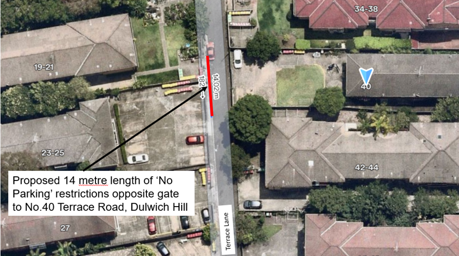
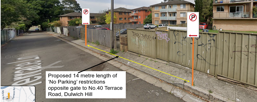
Subject: Terrace Lane, Dulwich Hill - Proposed installation of a 14m length of 'No Parking' restrictions western side opposite the fence and gate to 40 Terrace Road (Djarrawunang – Ashfield Ward / Summer Hill Electorate / Inner West PAC)
Prepared By: Jennifer Adams - Traffic Engineer
Authorised By: Manod Wickramasinghe - Traffic and Transport Planning Manager
|
RECOMMENDATION
That the installation of a 14-metre length of ‘No Parking’ restrictions on the western side of Terrace Lane, Dulwich Hill between Garnet Lane and Myra Lane opposite the fence and gate to 40 Terrace Road, be APPROVED to provide clear vehicular access to the residents’ off-street car parking spaces.
|
STRATEGIC OBJECTIVE
This report supports the following strategic directions contained within Council’s Community Strategic Plan:
|
2: Liveable, connected neighbourhoods and transport |
|
|
EXECUTIVE SUMMARY
A request has been received from residents in Terrace Road, Dulwich Hill for the installation of ‘No Parking’ restrictions on the western side of Terrace Lane opposite their access gate to improve vehicular access to their off-street parking spaces at the rear of their property. Surrounding residents have been notified of the proposal to install a 14-metre length of ‘No Parking’ restrictions on the western side of Terrace Lane, Dulwich Hill between Garnet Lane and Myra Lane opposite the fence and access gate to No.40 Terrace Road. This report details the results of that consultation. It is recommended that the proposal be approved.
BACKGROUND
Council Officers have been advised that vehicles are regularly parked opposite the access gate to No.40 Terrace Road in Terrace Lane, which makes it difficult to enter and exit their off-street car parking spaces. In order to alleviate this issue Council is proposing to install ‘No Parking’ restrictions opposite their access gate for a 14m length along the western side of Terrace Lane. Please refer to the diagram below.
‘No Parking’ restrictions prohibit motorists from parking within the specified zone, however, motorists may legally stop for the purposes of loading/unloading passengers and/or goods.
DISCUSSION
Terrace Lane is a narrow and relatively long laneway that carries a low vehicle volume and is predominantly used by local residents to access properties that back onto the laneway. Currently the laneway between Garnet Lane and Myra Lane, Dulwich Hill is unrestricted parking on both sides.
Site observations were undertaken, and observations confirmed that at times vehicles were parked within the laneway minimising the passing space for all other vehicles. Resident feedback also highlighted issues with Council’s Waste Service trucks having difficulty due to parked cars in the laneway.
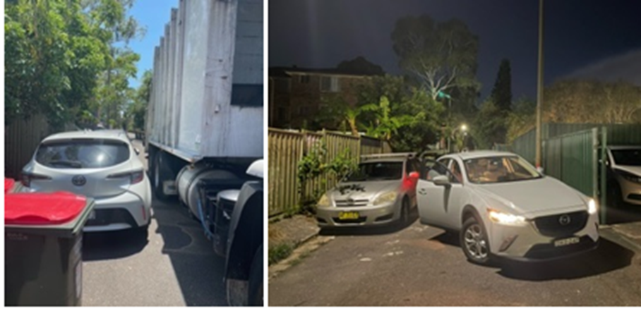
Further, it should be noted that laneways were generally built to provide service access for commercial properties and access into off-street parking facilities. Prohibiting parking in the section of laneway will help achieve this goal.
FINANCIAL IMPLICATIONS
The costs of installation of the ‘No Parking’ restrictions as recommended can be funded within Council’s signs and line marking budget.
PUBLIC CONSULTATION
Council Rangers were contacted in relation to the issue of vehicles parking opposite the access gate of No.40 Terrace Road in Terrace Lane and their response was that for Parking Services to be able to patrol this location they would need signage as there is no offence to book for.
A notification letter was hand delivered on 14 March 2024 to owners and occupiers of the surrounding residential complexes in Terrace Road and Myra Road, Dulwich Hill regarding the proposal to install a 14-metre length of ‘No Parking’ restrictions on the western side of Terrace Lane, Dulwich Hill between Garnet Lane and Myra Lane opposite the fence and access gate to No.40 Terrace Road. The closing date for submissions ended on 5 April 2024. 73 letters were distributed.
Resident Survey findings
A total of six (6) responses were received from residents. All were in support of the proposal.
Other concerns were raised in relation to dumped rubbish and access for Council’s Waste Services vehicles. Two of the residents advocated for ‘No Parking’ restrictions along the entire western side of Terrace Lane.
CONCLUSION
In order to provide clear vehicular access to residents off-street car parking spaces, it is recommended that the full-time ‘No Parking’ zone as proposed be installed on the western side of Terrace Lane opposite the fence and access gate to 40 Terrace Road. Refer to diagram below.
Nil.
|
|
Local Traffic Committee Meeting 20 May 2024 |
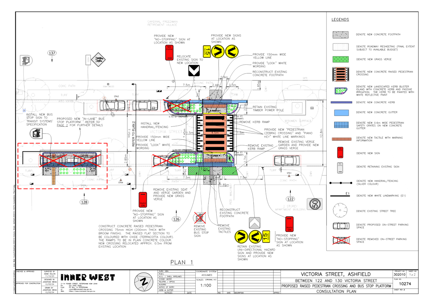
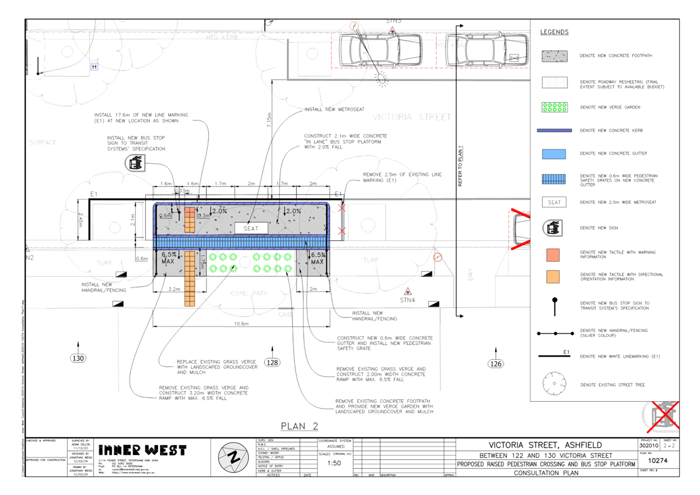
Subject: Proposed Pedestrian (zebra) crossing and
relocation of Bus Stop in Victoria Street, mid-block between Clissold Street
and Seaview Street, Ashfield.
(Djarrawunang-Ashfield Ward/Summer Hill Electorate/Burwood PAC)
Prepared By: Boris Muha - Traffic Engineer
Authorised By: Manod Wickramasinghe - Traffic and Transport Planning Manager
|
RECOMMENDATION
1. That the detailed design plan (10274 sheets 1 and 2 of 2) for the proposed new raised pedestrian (zebra) crossing with re-built kerb extensions and associated signs and line marking outside premises No.126 Victoria Street, and the relocation and construction of a new in lane Bus Stop platform (full-bus length) outside premises No. 128 as shown in Attachment 1 be approved,
2. That 10-12 metres of BB centreline marking be placed on the approaches to the pedestrian (zebra) crossing, and
3. That ‘AGED’ signage be placed under the crossing leg signs of the proposed pedestrian (zebra) crossing.
|
STRATEGIC OBJECTIVE
This report supports the following strategic directions contained within Council’s Community Strategic Plan:
|
2: Liveable, connected neighbourhoods and transport |
|
|
EXECUTIVE SUMMARY
Council at its meetings on the 18 March 2024 approved in principle, subject to detailed design, a series of proposed pedestrian (zebra) crossings and kerb extension treatments (under concept) for improved pedestrian and road safety around and near to the Cardinal Freeman (Retirement) Village, Ashfield.
This report focuses on the prepared detailed design plan of one of the proposed treatments, i.e. install a new raised pedestrian (zebra) crossing with re-built kerb extensions and associated signs and line marking outside premises No.126 Victoria Street, and relocate and construct a new in lane Bus Stop platform (full-bus length) outside premises No. 128 Victoria Street. This treatment will be programmed and prioritised to be constructed following approval.
BACKGROUND
The Cardinal Freeman Village (currently known as Levande Cardinal Freeman) is bounded by Clissold Street to the north, Victoria Street to the east, Seaview Street to the south and Queen Street to the west.
The village caters to an independent living lifestyle however as the average age is over 82 years there are a significant number of residents with mobility issues that hinder their ability to move around freely.
Many of the elderly residents are capable, and desire to walk to and from various destinations outside of the village, and/or take other forms of public transportation (e.g. bus and train) to travel to other parts of Sydney.
This has prompted a general request from the residents to improve pedestrian safety around the village to enable them to walk various desired destinations and take public transport within the area.
Other Aged care facilities such as the Ashfield Baptist Homes, Bethal Nursing Homes, Ashfield Terrace Care Community, and other community facilities are also located adjacent or near to the Cardinal Freeman Village.
The proposed treatment in this report received a major (80% rate) support under a general community engagement consultation conducted in October 2023. The facility is viewed in benefit and supported by the community at large, and not only for the elderly of the Cardinal Freeman Village.
DISCUSSION
The following information is provided in discussion.
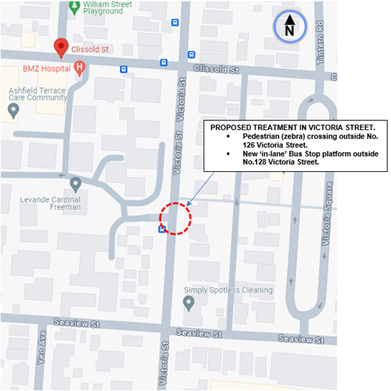
Figure 1. Locality Plan
|
Street Name (Plan Location 1) |
Victoria Street (midblock between Clissold Street and Seaview Street) |
|
Carriageway width (m) kerb to kerb |
Approx 12.8m |
|
Carriageway type |
Two-way, one travel lane each direction. |
|
Classification |
Local |
|
Speed Limit km/h |
50 |
|
85th percentile speed km/h |
50.1 |
|
Vehicles per day (vpd) |
2530 |
|
Available TfNSW recorded crash history Last 5 years (2018- 2023) |
1x 2019, RUM 93, o/s No. 118 Victoria Street, parked vehicle (north) runaway into object, non-casualty (towaway) 1 x 2023, RUM 31, o/s No. 137 Victoria Street driveway entrance, Left rear, both vehicles travelled in north direction, moderate injury |
|
Parking arrangements |
Unrestricted parking both sides |
|
Side streets |
Clissold Street & Seaview Street |
Table 1. Road Network detail.
The Plan
The following works are proposed and are illustrated on the attached plan.
In front of 126 Victoria Street, Ashfield (Plan No. 10274 sheet 1):
· Construct a new raised concrete pedestrian crossing with new landscaped kerb blister islands to replace the existing “in-lane” bus stop platform at the same location (where shown on plan);
· Construct gutter bridges with heel safe grating to provide safe access over new kerb and gutter to the new raised pedestrian crossing (where required);
· Reconstruct concrete kerb, gutter and footpath on both sides of the proposed pedestrian crossing;
· Reinstate and resurface some of the existing roadway with new asphalt adjacent to the new raised pedestrian crossing (subject to final funding allocations);
· Provide 3 new ‘No Stopping’ signages to new locations (where shown on plan);
· Install associated pavement line markings and signages as required;
In front of 128 Victoria Street, Ashfield (Plan No. 10274 sheet 2):
· Construct a new concrete “in-lane” bus stop platform with associated tactile, seating and handrails (where shown on plan);
· Construct gutter bridges with heel safe grating to provide safe access over new kerb and gutter to the new “in-lane” bus stop platform (where required);
· Remove existing grass verge and construct new concrete ramps for safe access to the new concrete “in-lane” bus stop platform (where shown on plan);
· Reinstate and resurface some of the existing roadway with new asphalt adjacent to the new “in-lane” bus stop platform (subject to final funding allocations);
· Install associated pavement line markings and signages as required;
Parking Changes
This proposal will result in the loss of 4 on-street parking space. Some street parking will also be affected temporarily to facilitate the construction activities during construction.
Streetlighting
The existing street lighting at the location for the proposed new raised pedestrian crossing is deemed inadequate. Therefore, 2 new floodlights are proposed to be included as part of the works.
The new pedestrian (zebra) crossing with re-built landscaped blister islands (or kerb extension-built outs) is proposed at the location where the current ‘in-lane’ Bus Stop platform exits. Kerb extensions are also currently incorporated in this area for pedestrians to cross-over Victoria Street at a shorter distance.
The Bus stop must be relocated because of the new pedestrian (zebra) crossing with re-built kerb extension going in at this location. The Bus Stop, under platformed construction is moved further south.
2 parking spaces are required to be removed to comply with Transport for NSW directorate/guidelines for sight view clearance in approach and departure of the crossing.
2 parking spaces are further required to be removed to accommodate the new outreached ‘in-lane’ Bus Stop platform. The short span distance between the palm trees prohibits buses from pulling up safely close to the kerb. The platform also allows for the safe boarding and dis-embarkment of passengers particularly those of mobility impairment. Bus safety conditions for new platforms require passengers to dis-embarkment from both doorways of the bus in the case of emergency.
It is also recommended that short length 10-12 metre BB centre lines be placed on the approaches to the pedestrian (zebra) crossing to control traffic movement on the correct side of road through the crossing.
Furthermore, supplementary ‘AGED’ signage could be placed under the crossing leg signage at the crossing to advise motorists of elderly pedestrians utilising the crossing. This request was made under resident consultation.
FINANCIAL IMPLICATIONS
CONSULTATION
A letter outlining the proposal was mailed out to 14 properties (49 letters) in Victoria Street, Ashfield, between Clissold Street and Seaview Street requesting residents’ views regarding the proposal. (see also map of consultation area Figure 3).
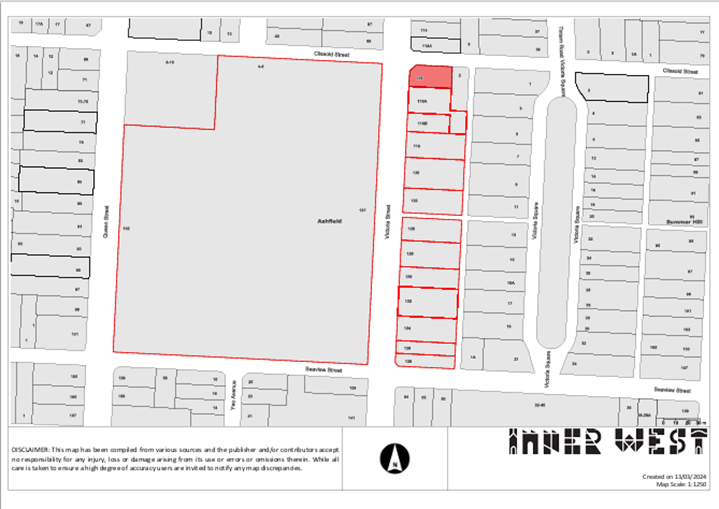
Figure 3. Map on Consultation Area
Council officers also convened a presentation session on the 2 May 2024 at the Cardinal Freeman Village outlining the proposal to the residents of the Village.
One (1) response was received from a street resident (on behalf of Victoria Street residents) in objection to the Bus Stop. Three (3) residents of the village responded under submission in support of the proposal with one making concern as to why the crossing needs to be raised.
12 elderly residents of the village who attended the presentation session and who provided comments on the proposal on the day were wholly in support with or without certain concerns.
One (1) response was submitted under email by a visually impaired resident of the village raising various concerns mainly in the ability to cross over at the new pedestrian (zebra) crossing as proposed.
The main concerns raised by the residents are outlined below in the table.
|
Residents Comments |
Officers Response |
|
Submission by resident (on behalf of Victoria Street residents) do not want the Bus Stop. · Resident believes existing bus stop is inefficient, waste of time, resources and ratepayer funds and he raises concerns of Council's priorities and abilities regarding the proposal of the new proposed bus stop.
· Resident asks for reason on why the existing bus stop is being relocated.
· Resident notes that the current bus stop has minimal patronage of only school age children and senior citizens do not frequent the public bus service as they have Cardinal Freeman Village private bus service. · Resident raises concern regarding floodlighting for the proposed raised pedestrian crossing and he believes lighting from nearby village is sufficient.
· Elderly residents from properties in front of the new bus stop will have no close/easy access from their car (or ambulance) to their gate and the loss of parking is a major concern.
|
· Concern for reason for changes and Cost. The current treatment has been in place since 2019 and was designed to amalgamate a bus stop over the kerb blister islands built for pedestrians to cross over at a short distance. The new proposal involves a raised pedestrian (zebra) crossing with re-built kerb blisters under a scheme to improving pedestrian and road safety around the Cardinal Freeman Village. Bus stops cannot be placed over a pedestrian crossing. The bus stop will be moved forward in nearest vicinity to the crossing (not impeding to any driveways) and a platform built out to provide an ‘in-lane’ bus stop. The bus stop platform extends in length (under current Transit System’s requirements for platforms) to cover both doors for emergency dis-embarkment. · Concern of patronage for the new proposal The bus service route 406 is a major part time service. The proposed bus stop platform, including the existing one on the western side are required and appropriately cater for the needs of the residents of the Cardinal Freeman Village and the community at large. Council supports the use of public transport as it provides a community service regardless of its frequency. · Concern of lighting for the new proposal The proposed new raised pedestrian crossing requires to be illuminated with the standard level of lighting in compliance with Australian Standards. Existing lighting from the multi-level buildings is not sufficient to meet this condition so two additional luminaires will need to be provided as part of the new crossing. · Concern of parking for the new proposal It is acknowledged that any new pedestrian crossing or traffic calming device will result in a loss of parking. Crossings require clearance for sight view of pedestrians and traffic in accordance with TfNSW guidelines or technical directions. Placing the crossing at the current location of existing crossover facility minimises the loss of parking spots to 2 instead of 4 due to the locations of existing driveways on the north side. The proposed new location for the bus stop platform also requires the occupation of 2 parking spaces. Council at its meeting on 18 March 2024 (through recommendation of its Local Traffic Committee on 11 December 2023) approved in principle the proposal (under concept subject to detailed design) and general majority support was provided through community engagement. The detailed design is devised around the concept plan, displaying the location of the raised pedestrian crossing with relocated bus stop platform, and identifying 4 parking spaces to be removed. |
|
Village residents generally believe this proposal will greatly improve safety and amenity for residents of the area and bus users.
|
Noted |
|
Main concerns/comments as raised by Village residents. · Residents generally feels safer with new treatment proposal. · STOP sign is requested near Harland Street (instead of ‘Give Way’) due to dangerous driving. · Ground Tactile Surface Indicators alone, do not assist the vision impaired; A change in grade is required so that Guide Dogs can identify ped crossing on approach. · Residents are concerned for visually impaired resident and hope that changes to grade can be made to assist her. · Tactiles are slippery and a trip hazard (as the tactiles age). · Residents view this treatment as urgent and believe it should be prioritised. · The vast cost of the proposal was acknowledged several times and appreciation was offered to Council and its staff. · Pavement needs repair/ upgrade (on Victoria St)
|
· Noted
· The request for a STOP control in lieu of exiting Give-way at the intersection of Harland Street and Victoria Street will be examined and considered separately, as this does not form part of the Scope of Works to this project. · The pedestrian (zebra) crossing will have some slope deviation leading from the footpath, over the kerb blister path onto the raised crossing. However, owing to further concerns to this, Council will organise a workshop with relevant visually and mobility impaired organisations to consider on appropriate construction detail for crossings. This report only entails to approve the type and location of the devices. · External funding is being sought with aim to get this facility constructed under priority by early 2024/2025. · A request will be made to investigate non-slip type tactiles. Upon age and wear, residents can request investigation of the condition of the tactiles over time, and if required, the tactlies could be replaced under maintenance. · General pavement conditions along Victoria will be referred to Council’s Assets Group to investigate.
|
|
Concerns raised by visually impaired resident. · Most guide dogs can only identify a pedestrian crossing by graded slope from footpath to road surface. · Kerb ramps remain the most familiar physical feature for blind/low vision pedestrians to detect the edge of the roadway. · It is important that kerb ramps/slopes or similar aids on opposite sides of the street line -up in the direction of travel. · Flush crossings deprive blind/low vision pedestrian of vital road safety and orientation, navigation and wayfinding clues, resulting in potentially getting disorientated and lost, which is also a safety concern. · Suggests prioritization of this crossing to improve pedestrian safety. · Request for graded slope from footpath to road surface or alternatively, a curvature integrated as a foothold either side of a flush surface design. · Tactile ground surface indicators (TGSI’s) should not be used in isolation but in association with kerb ramps or graded slope to assist recognition of a pedestrian crossing. · Well-designed and located compliant kerb ramps or slopes or a side-by-side curvature should be able to meet the road crossing needs of all pedestrian groups. · Aged sign should be installed both sides of the pedestrian crossing advising drivers approaching from either direction. · Lower speed limit to 40 km /h. |
Noted.
· Most of the concerns raised are construction detail related. Council will organise a workshop with relevant visually and mobility impaired organisations to consider appropriate path measures over pedestrian (zebra) crossings. Changes in grade are generally dictated by the geometry of the street environment.
· Flush crossings unfortunately are provided where road and drainage constraints, footpath width, and the inability to provide kerb extensions prevents any opportunity to apply slope deviation over the crossing. Alternate treatment is provided in this case with tactiles placed 600mm deep to alert in the presence of a crossing.
· ‘PEDESTRIAN’ and ‘AGED’ warning signs will be considered to be placed on entry areas to the Village along Victoria Street, i.e. south of Seaview Steet and north of Clissold Street. It will be further recommended under this report to install ‘AGED’ signs under the ‘crossing leg’ signs at the proposed (zebra) crossing.
· Council is seeking Transport for NSW approval to lower the speed limit on its local roads from 50 to 40km/h. |
CONCLUSION
It is recommended that the detailed design plan (10274 sheets 1 and 2 of 2) for the proposed new raised pedestrian (zebra) crossing with re-built kerb extensions and associated signs and line marking outside premises No.126 Victoria Street, and the relocation and construction of a new in lane Bus Stop platform (full-bus length) outside premises No. 128 as shown in Attachment 1 be approved.
In addition, and in amendment of the plan that 10-12 metres of BB centre line marking be placed on the approaches to the pedestrian (zebra) crossing, and ‘AGED’ signs be placed under the crossing leg signs of the proposed pedestrian (zebra) crossing.
|
1.⇩ |
Detail design plan- Proposed pedestrian (zebra) crossing and relocation of Bus Stop in Victoria Street, Ashfield. |
|
Local Traffic Committee Meeting 20 May 2024 |
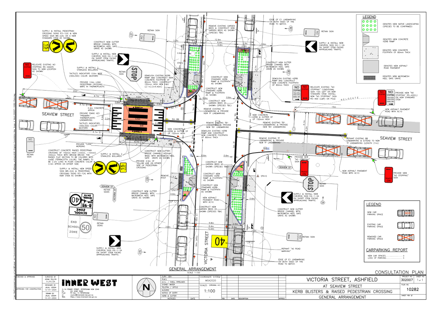
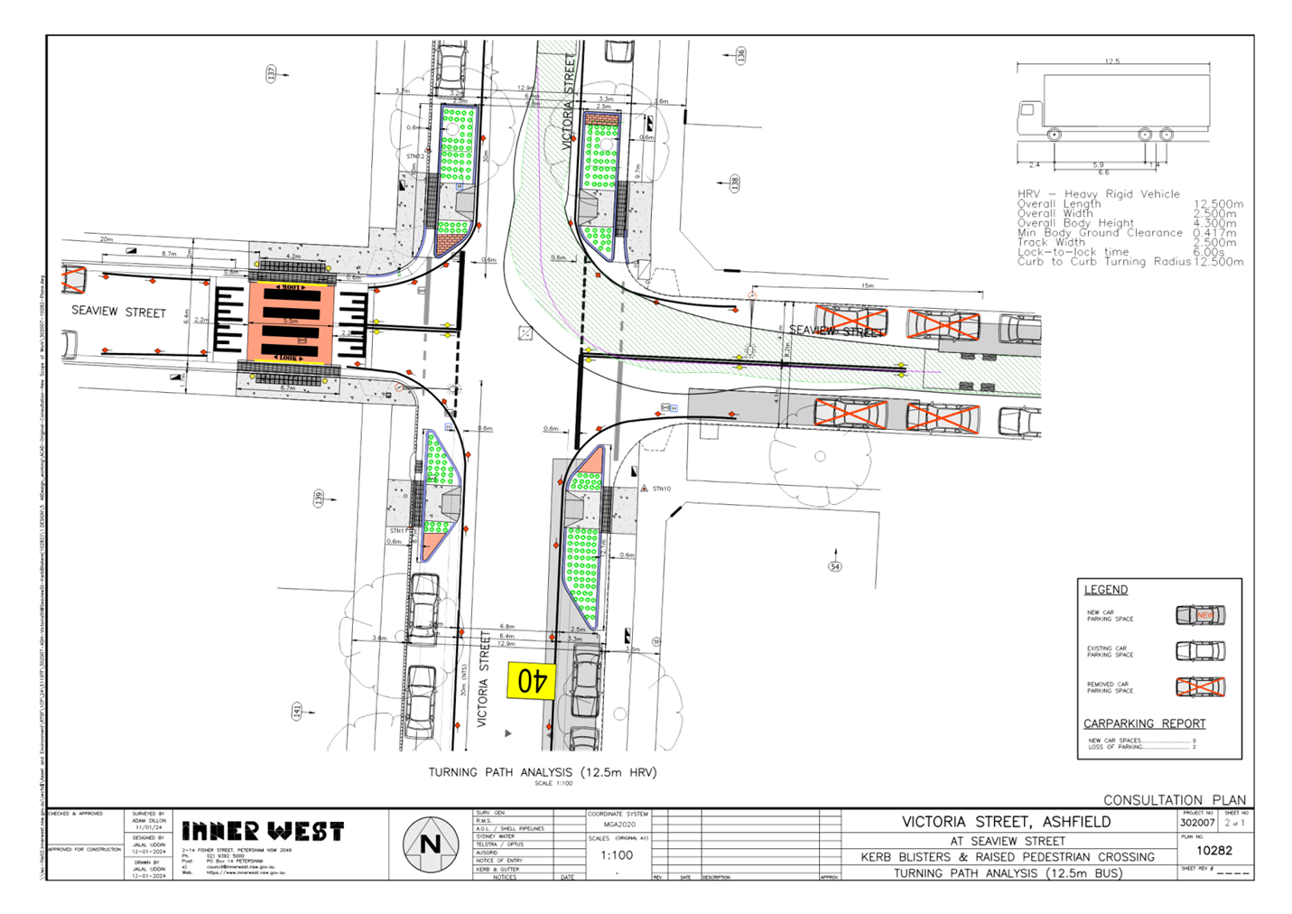
Subject: Proposed Pedestrian (zebra) crossings in
Seaview Street and new kerb extension facilites at the intersection of Victoria
Street and Seaview Street, Ashfield.
(Djarrawunang-Ashfield Ward/Summer Hill Electorate/Burwood PAC)
Prepared By: Boris Muha - Traffic Engineer
Authorised By: Manod Wickramasinghe - Traffic and Transport Planning Manager
|
RECOMMENDATION
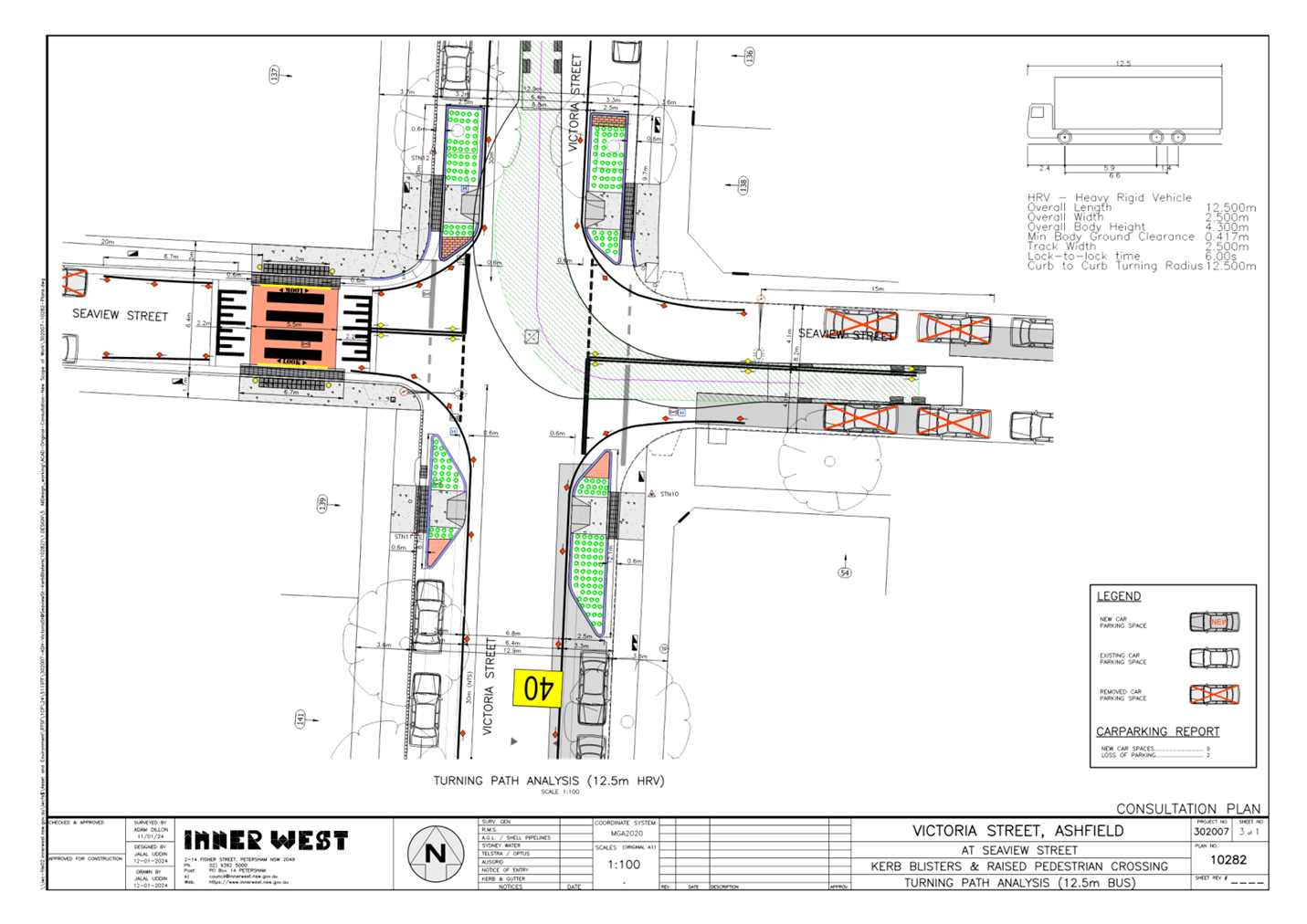
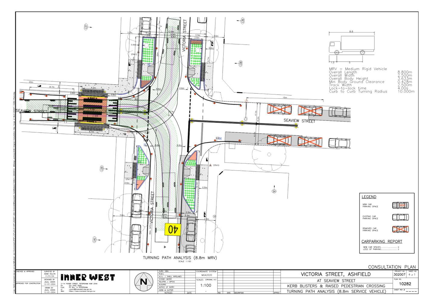
That the detailed design plan (10282) to install a new raised pedestrian (zebra) crossing in Seaview Street, west of Victoria Street, and provide landscaped blister islands (kerb extension build-outs) to all corners of Victoria Street and bring out the ‘STOP’ lines from both ends of Seaview Street, together with associated signs and line marking as shown in Attachment 1, be approved.
|
STRATEGIC OBJECTIVE
This report supports the following strategic directions contained within Council’s Community Strategic Plan:
|
2: Liveable, connected neighbourhoods and transport |
|
|
EXECUTIVE SUMMARY
Council at its meetings on the 18 March 2024 approved in principle, subject to detailed design, a series of proposed pedestrian (zebra) crossings and kerb extension treatments (under concept) for improved pedestrian and road safety around and near to the Cardinal Freeman (Retirement) Village, Ashfield.
This report focuses on the prepared design plan of one of the proposed treatments, i.e. install a new raised pedestrian (zebra) crossing in Seaview Street, west of Victoria Street, and provide landscaped blister islands (kerb extension build-outs) to all corners of Victoria Street and bring out the ‘STOP’ lines from both ends of Seaview Street. This work is programmed and envisaged to be constructed in the 2024/2025 financial year, subject to funding.
BACKGROUND
The Cardinal Freeman Village (currently known as Levande Cardinal Freeman) is bounded by Clissold Street to the north, Victoria Street to the east, Seaview Street to the south and Queen Street to the west.
The village caters to an independent living lifestyle however as the average age is over 82 years there are a significant number of residents with mobility issues that hinder their ability to move around freely.
Many of the elderly residents are capable, and desire to walk to and from various destinations outside of the village, and/or take other forms of public transportation (e.g. bus and train) to travel to other parts of Sydney.
This has prompted a general request from the elderly residents to improve pedestrian safety around the village to enable them to walk to various desired destinations and take public transport within the area.
Other Aged care facilities such as the Ashfield Baptist Homes, Bethal Nursing Homes, Ashfield Terrace Care Community, and other community facilities are also located adjacent or near to the Cardinal Freeman Village.
The proposed treatment in this report received high support (86% rate) under a general community engagement consultation conducted through Council’s ‘Have Your Say’ back in October 2023. The facility is viewed in benefit and supported by the community at large, and not only for the elderly of the Cardinal Freeman Village.
DISCUSSION
The following information is provided in discussion.
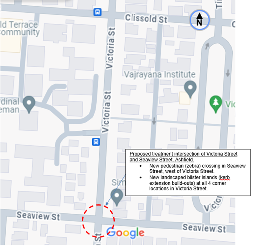
Figure 1. Locality Plan
|
Street Name
|
Victoria Street (at intersection to Seaview Street) |
|
Carriageway width (m) kerb to kerb |
Approx. 12.8m |
|
Carriageway type |
Two-way, one travel lane each direction. |
|
Classification |
Local |
|
Speed Limit km/h |
50 |
|
85th percentile speed km/h |
-- |
|
Vehicles per day (vpd) |
Approx. 2530 to the north. |
|
Available TfNSW recorded crash history Last 5 years (2018- 2023)
|
(1) X 2021, at intersection , RUM 6, vehicle heading west impacted with pedestrian on footpath. Serious injury. (2) X 2018, at intersection, RUM 10, cross traffic, vehicles traveling in east and south directions-minor/other injury. |
|
Parking arrangements |
Unrestricted parking both sides, ‘No Stopping’ to corners of intersection |
|
Side street (nearest) |
Seaview Street |
Table 1. Road Network detail
The Plan
The following works are proposed and are illustrated on the attached plan in Attachment 1.
Victoria Street (at Seaview Street), Ashfield (Plan No. 10282):
- Construct four (4) new landscaped kerb blister islands with integrated footpaths and kerb ramps to improve pedestrian points & safety whilst slowing traffic approaching the intersection;
- Construct a new concrete raised pedestrian crossing. The new pedestrian crossing will be of terracotta coloured concrete finish (flat top area only);
- Reconstruct sections of damaged concrete footpath with new concrete footpath
- Reconstruct some damaged concrete kerb & gutter with new kerb & gutter;
- Provide new line marking at the Seaview Street intersection (extending into Victoria Street) to improve sight lines for motorists (refer to Plans);
- Adjust existing ‘No Stopping’ signs and zones in Seaview Street to improve vehicle access into/out of the Street and comply with current pedestrian crossing standards;
- Resurface the road pavement with new asphalt (where shown on Plans). Extent of resurfacing will be subject to final budget allocations;
- Install associated signage associated with the works as required and where shown on Plans;
- Repaint existing road pavement markings as required after completion of the works.
Parking Changes
The proposal will require an adjustment to some of the existing on-street parking arrangements. It is proposed to adjust the existing ‘No Stopping’ signage and zones in Seaview Street to accommodate the new raised pedestrian crossing & provide the required safe vehicular access into and out of Seaview Street.
This adjustment will result the loss of six (6) existing on-street parking spaces in Seaview Street. Please refer to the attached plans.
Streetlighting
The new raised pedestrian crossing will require new flood lighting to be provided in order for it to comply with current standards. This will involve the provision of at least 1 floodlight (on a new power pole) typical of other locations with pedestrian crossings. At this stage, this design is not complete and will be undertaken by a specialist lighting consultant at a later stage.
Further information
The following is further advised:
· The pedestrian (zebra) crossing in Seaview Street has no accompanying kerb extensions owing to the narrow width of the road with 2-way traffic needing to be maintained.
· The kerb blister islands, or kerb extension build outs with compliant pram ramps assist pedestrians to cross-over Victoria Street over a shorter distance, whilst being refuged by the islands.
· The alignment of the kerb blister islands assists to bring out the STOP lines in Seaview Street to improve the sight view of traffic.
· The kerb blister islands are widened out as far possible to provide a narrowing channel for 2-way traffic in Victoria Street in attempt to control speed through the intersection. Associated and extended edge line marking in Victoria Street assists to guide and control traffic movement though and around the intersection.
· Buses turn right out from Seaview Street into Victoria Street and turn left from Victoria Street into Seaview Street. Garbage and Bus turning paths are provided in Annexure 2.
FINANCIAL IMPLICATIONS
The project is listed on Council’s Traffic Facilities Capital Works budget for works to be carried out in 2024/2025, subject to funding. The work is estimated to be around $124,000. Council has applied for external funding for this project under the Get Active NSW/Road Safety Program.
CONSULTATION
A letter outlining the proposal was mailed out to 13 properties (33 letters) around the intersection of Victoria Street and Seaview Street requesting residents’ views regarding the proposal.
Figure 2. Map on Consultation Area.
Council officers also convened a presentation session on the 2 May 2024 at the Cardinal Freeman Village outlining the proposal to the residents of the Village.
Two (2) responses were received from street residents with concerns to the proposal. 11-12 residents of the village who attended the presentation session and who provided comments on the proposal on the day were wholly in support of the proposal with or without certain concerns. One (1) resident was unsure.
One (1) response was submitted under email by a visually impaired resident of the village raising primary concern with the ability to cross over Seaview Street with the proposed crossing.
Transit Systems Australia being the public bus operator for TfNSW raises no objection.
The main traffic related concerns raised by the residents are outlined below in the table.
|
Residents Comments |
Officers Response |
|
Concerns raised by street residents. Resident 1. · The new gardens are too wide and should be no wider than the width of a car.
· Loss of parking is shown on the north side of Seaview Street, west of Victoria Street, and north and south side, east of Victoria Street, but no one really parks in these locations. The only parking actually lost will be two on the southern side of the street.
· The narrowing of Victoria St will make the ingress and egress of buses into and out of Seaview St east, more difficult and dangerous. It is already tight and the mooted changes will only increase turning difficulties and potential for collision.
· The garden bed shown on plan on the western side of Victoria Street, south Seaview is too long with one parking space likely being removed.
· Why is the crossing placed in Seaview Street? It would be best placed in Victoria set back from the corners to assist in traffic calming along Victoria Street.
· Placing the raised crossing where planned will only result in it being ignored and pedestrians walking straight over Seaview St at the stop signs as they currently do. No one will make that detour, walking north or south across Seaview st, then back to Victoria St. Pedestrian behaviour will be monitored after it is built, and additional measures may be implemented if warranted.
Resident 2 · I am a resident and frequent user of the above intersection, it is extremely dangerous as there is no view up Victoria Street when you come up Seaview Street and turn right onto Victoria Street, Ashfield. Frequently have to drive halfway onto Victoria street to have any chance of seeing if there are any oncoming traffic, as the view is obscured by the large palm tree ( as seen in attached photo). Would need to remove palm tree for view of oncoming traffic to be improved. Or if council really want to make the above mention intersection, I feel the only way is traffic lights.
|
· The proposed garden beds have deliberately been made wider to narrow the road width to 6.8m. The wider islands assist to bring out the STOP lines as far possible to improve sight view.
· No one parks to the northern side of Seaview Street between Victoria Street and Queen Street, given the narrowness of the road. Parking exists to the southern side and there is a need to maintain 2-way traffic flow in this narrow section of Seaview Street. Council will seek to separately investigate to formalise the northern side with either ‘No Parking’ or ‘No Stopping.’
· The presence of a centreline in Seaview Street, west of Victoria Street dictates that vehicles do not park within 3 metres of a centreline under the Road Rules, or that in practice no vehicles park in the area due to the nature and need for buses and traffic to negotiate around the intersection. The proposal as shown on plan is to formalise and clear vehicle parking with full-time ‘No Stopping’ restrictions. · Bus turns have modelled & been checked and the results indicate the proposal will accommodate bus turns into & out of Seaview Street from Victoria Street. The kerb extensions will prevent buses and heavy vehicles from cutting over the corners. It is not uncommon for Buses executing wider turns at intersections. Buses will do so with caution. The Public Bus operator Transit Systems Australia raises no objection to the proposal. · The kerb extension-blister (garden bed) is proposed within the length of the existing ‘No Stopping’ zone, hence no parking is lost.
· The crossing in Seaview Street was chosen to provide a close desired linkage path from the Village towards Yeo Park for pedestrians to walk down the western side of Victoria Street and then use the existing crossing near Harland Street at Trinity Grammar to cross-over onto the eastern (park) side of Victoria Street. Sufficient pedestrian numbers or linked desired path movement could not be substantiated to consider a crossing over Victoria Street under appropriate Transport for NSW/Council guidelines/policies. Kerb blister (or kerb extension build outs) with compliant pram ramps are alternatively considered to allow pedestrians to cross -over at a shorter distance in Victoria Street. The kerb extensions are built out to narrow the road passageway with the intent to control traffic movement through the intersection. · The crossing in Seaview Street is set back to prevent a vehicle at the STOP sign standing over the crossing. Any existing kerb ramps to the corners will be removed. Pedestrian behaviour will be monitored after the crossing is built, and additional measures may be implemented if warranted. · · · There is nil or low accident history in the area to justify any warrant for traffic lights. Transport for NSW who authorises the installation of traffic signals would not approve traffic signals on this type of local road area.
The proposal to provide kerb extension or build- outs to the corners of Victoria Street, provides the opportunity to bring out the STOP lines for improved sight view of traffic around the trees and prevents vehicles from pulling up or parking to the corners in Victoria Street. |
|
Main concerns/comments as raised by Village residents. · Concerned about continuous path on the proposed raised pedestrian (zebra) crossing in Seaview Street as it has minimal grade and Guide Dog (for visual impaired resident), will not recognise unless there is a change in grade.
· Why IWC can’t install smaller ramps as with City of Sydney, which will indicate to guide dog, that a ped crossing is approaching.
· Residents queried why speed humps/cushions could not be installed on approach to the pedestrian (zebra) crossing if made at road level allowing ramp down to the crossing for sake of the visual impaired resident- same question raised with the proposed raised (zebra) crossing in Victoria Street.
· Lighting design queries at pedestrian crossing.
· Concerns relating to road narrowing at Seaview Street.
· Residents commend Council’s efforts and applaud staff for working with ‘Guide Dogs Australia’ and ‘Better Streets’ via impending workshop and hope for a favourable outcome.
· Residents have queried why the pedestrian crossing was chosen at this location.
· Residents queried whether treatments will reduce speeds
|
· See below response to the visual impaired resident regard to continuous path over crossings.
· Council is looking to eventually raise all its ‘at level’ road crossing on local roads. Establishing speed humps/cushions either side of an ‘at level’ road crossing only doubles up on raised treatments. Drivers can be inconvenienced and concentrate on mounting the speed humps and could loose focus on the crossing. Increase noise and pollution (decelerating and accelerating) is also a concern, and driveways may be affected. Raised crossing are considered safer and allow pedestrians to cross over at ease.
· Appropriate lighting must be made to illuminate the crossing under Australian Standards. See below in the need to use timber poles.
· No further road narrowing is done in Seaview Street, as this would severely affect 2-way traffic movement given the already narrowness of the road.
· The crossing in Seaview Street was chosen to provide a close desired linkage path from the Village towards Yeo Park for pedestrians to walk down the western side of Victoria Street and then use the existing crossing near Harland Street at Trinity Grammar to cross-over onto the eastern (park) side of Victoria Street. Sufficient pedestrian numbers or linked desired path movement could not be substantiated to consider a crossing over Victoria Street under appropriate Transport for NSW/Council guidelines/policies. Kerb blister (or kerb extension build outs) with compliant pram ramps are alternatively considered to allow pedestrians to cross -over Victoria Street at a shorter distance.
· The kerb extensions in Victoria Street are widened out as much as possible to narrow in the traffic passageway in effort to control traffic movement and speeding. |
|
Concerns raised by visually impaired resident. · Suggests prioritization of this crossing to improve pedestrian safety
· Request for graded slope from footpath to road surface or alternatively, a curvature integrated as a foothold either side of a flush surface design.
· Tactile ground surface indicators (TGSI’s) should not be used in isolation but in association with kerb ramps or graded slope to assist recognition of pedestrian crossing.
· As an alternative to a new electricity pole, Belisha beacons could be considered as an option (electricity poles may block sightlines of pedestrians the beacons are easily visible by drivers).
|
· Noted on prioritisation request.
· The narrow road and footpath width, drainage, and the inability to provide kerb extensions prevents any opportunity to apply slope deviation over this crossing. Alternate treatment is provided, in this case, with tactiles placed 600mm deep to alert the presence of a crossing. Bollards are provided either ends of the crossing (in this case) to direct pedestrians over the crossing. The flush/continuous path connection over crossings will be considered, under construction detail, in a workshop to be organised by Council with relevant organisations for the visual and mobility impaired. This report only seeks approval for the type and position of the devices proposed around the intersection.
· New (timber) poles required for lighting are normally set a distance away of the crossing with overhead wiring. Steel poles or Belisha Beacon or similar type lighting devices require underground cabling and are normally provided in town centre developments. They could be expensive and timed delayed pending on utility searches and lighting authority approval. |
|
Other matters: · Emergency vehicles, and vehicles dropping off children at Trinity Grammar dash past the existing crossing in Victoria Street at Harland Street, to turn into Harland Street. Concern is raised with the safety of the crossing. It forms part of the route to Yeo Park, and therefore part of the overall pedestrian safety and walkability plan for the CFRV surrounds. |
· The conditions of this crossing will need to be investigated separately.
|
CONCLUSION
It is recommended that the detailed design plan (10282) to install a new raised pedestrian (zebra) crossing in Seaview Street, west of Victoria Street, and provide landscaped blister islands (kerb extension build-outs) to all corners of Victoria Street and bring out the ‘STOP’ lines from both ends of Seaview Street together with associated signs and line marking as shown in Attachment 1, be approved.
|
1.⇩ |
Detailed design plan- Raised(zebra) crossing in Seaview Street, and kerb extension to the Victoria Street corners. |
|
2.⇩ |
Turning path diagrams-Garbage trucks and Buses. |
|
Local Traffic Committee Meeting 20 May 2024 |
Subject: Proposed new kerb extension facilites at intersection of Prospect Road and Clissold Street, Ashfield (Djarrawunang-Ashfield Ward/Summer Hill Electorate/ Burwood PAC)
Prepared By: Boris Muha - Traffic Engineer
Authorised By: Manod Wickramasinghe - Traffic and Transport Planning Manager
|
RECOMMENDATION
1. That the detailed design plan (10280) to install new landscaped blister islands (kerb extension build-outs) to the western corners of Victoria Street at Clissold Street, and bring out the ‘STOP’ lines from Clissold Street, together with associated signs and marking as shown in Attachment 1, be approved.
2. That edge line marking (along the western side of Prospect Road, north and south of Clissold Street) commencing and tapered at the corner and extending approximately 25m from the corner be incorporated into the final design. |
STRATEGIC OBJECTIVE
This report supports the following strategic directions contained within Council’s Community Strategic Plan:
|
2: Liveable, connected neighbourhoods and transport |
EXECUTIVE SUMMARY
Council is planning to improve safety at the intersection of Clissold Street & Prospect Rd, Ashfield by constructing kerb blister islands and making changes to the intersection to improve safety at this location. The proposal aims to improve pedestrian and motorist safety by better defining safe pedestrian crossing points, reducing traffic speeds and improving sight distances & conflicts with traffic movements at this location.
BACKGROUND
The proposal to install kerb blister islands to the western corners of Prospect Road at the T- intersection of Clissold Street, was approved by Council in principle, subject to detail design, in February 2020. This traffic facility improvement falls outside the scope of the proposals which were considered around or near the Cardinal Freeman Village, early in 2024.
All other treatments as previously considered for traffic facility improvement have been captured and included and modified/expanded under the current scheme for improved pedestrian and traffic safety around and near the Cardinal Freeman Village.
DISCUSSION
The following information is provided in discussion.
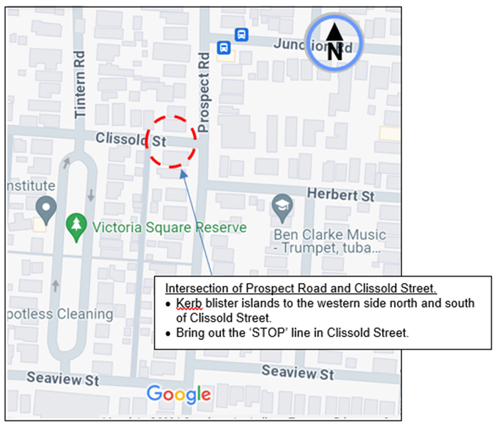
Figure 1. Locality Plan
|
|
Prospect Road (at intersection to Clissold Street) |
|
Carriageway width (m) kerb to kerb |
Approx. 10.1m |
|
Carriageway type |
Two-way, one travel lane each direction. |
|
Classification |
Local |
|
Speed Limit km/h |
50 |
|
85th percentile speed km/h |
Approx. 42-45 |
|
Vehicles per day (vpd) |
Approx. 3700-4500 |
|
Available TfNSW recorded crash history Last 5 years (2018- 2023)
|
Nil 2018-2023
Prior to 2018 1x2015, RUM 19, vehicle from adjacent direction at intersection -minor/other injury. 1X 2012, RUM 53 overtaking-turing at intersection, moderate injury. |
|
Parking arrangements |
Unrestricted parking both sides, ‘No Stopping’ to corners of intersection |
|
Side street (nearest) |
- |
Table 1. Road Network detail.
The following works are proposed and are illustrated on the attached plans:
Clissold Street (at Prospect Road), Ashfield (Plan No. 10280):
· Construct two (2) new landscaped kerb blister islands to safety by slowing traffic & improving sight distance.
· Construct one (1) new kerb ramp to improve pedestrian accessibility.
· Reconstruct sections of damaged concrete footpath with new concrete footpath.
· Provide new line marking at the Clissold Street intersection (extending into Prospect Road) to improve sight lines for motorists (refer to Plans).
· Adjust a section of the existing ‘No Stopping’ zone in Prospect Road and replace it with a dedicated ‘Mail Zone’ (refer to plans).
· Reconstruct 2 existing stormwater drainage pits to improve drainage the facilities.
· Reconstruct part of the existing concrete road pavement with new concrete (subject to final budget allocations).
· Provide new pavement line markings (as shown on attached plans).
· Relocate some existing signage (as shown on attached plans) & install associated new signage associated with the works were shown on Plans.
Parking Changes
The proposal will require an adjustment to some of the existing on-street parking arrangements. It is proposed to adjust the existing ‘No Stopping’ signage and zone in Prospect Road to accommodate a dedicated Mail Zone. This adjustment will not result any loss of existing on-street parking spaces in Victoria Street or Clissold Street.
Further information
· The alignment of the kerb blister islands assists to bring out the STOP lines in Clissold Street to improve the sight view of traffic.
· The kerb blister islands are widened out as far possible to reduce the road width though the intersection, and control vehicle movement around the intersection.
· Buses turn left out into Prospect Road from Clissold Street and turn right from Prospect Road into Clissold Street. Buses are known to turn out wide around the intersection and so do with caution. The islands are designed and set back from the corners so not to interfere with bus or heavy vehicle movement around the intersection. Transit Systems Australia, being the public bus operator for Transport for NSW raises no objection to the proposal.
· Design Bus and garbage turn path movements are provided in Annexure 2. 20m of ‘No Stopping’ restriction exist on the eastern side of Prospect Street, north of Clissold Street. This allows buses to further come in close to the eastern kerbside of Prospect Road to execute the right turn in from Prospect Road to Clissold Street.
· It is further recommended that edge line marking be added to curl around the corners of the intersection and extend approximately 25 metres along the western side of Prospect Road, north and south of Clissold Street, at 2.1m out from the footpath face of kerb. The edges line will further assist to control and guide traffic around the kerb blisters.
FINANCIAL IMPLICATIONS
The project is listed on Council’s Traffic Facilities Capital Works budget for works to be carried out in 2024/2025. The work is estimated to be around $67,000.
CONSULTATION
A letter outlining the proposal was mailed out to 12 properties (36 letters) around the intersection of Prospect Road and Clissold Street, Ashfield requesting residents’ views regarding the proposal.
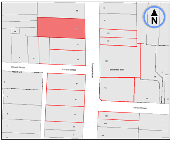
Figure 2. Map on Consultation Area.
No traffic related comments were received relative to the Scope of works of the project. Any comments outside the scope of works will be responded to separately.
CONCLUSION
It is recommended that the detailed design plan (10280) to install new landscaped blister islands (kerb extension build-outs) to the western corners of Victoria Street at Clissold Street and bring out the ‘STOP’ lines from Clissold Street, together with associated signs and marking as shown in Attachment 1, be approved.
In addition, it is recommended that edge line marking be added to the corners of the intersection and extend approx. 25 metres along the western side of Prospect Road, north and south of Clissold Street, at 2.1m out from the footpath face of kerb.
ATTACHMENTS
|
1.⇩ |
Proposed Detail plan-kerb blister islands on western side of Prospect Road at Clissold Street, Ashfield. |
|
2.⇩ |
Bus and garbage truck turning path movements. |
|
Local Traffic Committee Meeting 20 May 2024 |
Subject: Leichhardt Oval TMP and Special Event Parking Zone
Prepared By: Jason Scoufis - Coordinator Traffic Studies and Road Safety
Authorised By: Manod Wickramasinghe - Traffic and Transport Planning Manager
|
RECOMMENDATION
1. That the Leichhardt Oval and the Surrounds TMP report be received and noted.
2. That existing ‘1P during sporting fixtures at Leichhardt Oval, Authorised Residents Vehicles Excepted Area LY’, on streets surrounding Leichhardt Oval be replaced with ‘1P Special Events Permit Holders Excepted Area SE’, including Special Event Parking – Major Entry, Special Event Parking – Repeater, and Special Event Parking – End signage be installed as shown in Attachment 2.
|
STRATEGIC OBJECTIVE
This report supports the following strategic directions contained within Council’s Community Strategic Plan:
|
2: Liveable, connected neighbourhoods and transport |
|
|
EXECUTIVE SUMMARY
A TMP has been prepared providing details of the traffic and transport arrangements on NRL game day at Leichhardt Oval. This is based on game day observations and existing arrangements in place which are detailed in the attached ‘Traffic Management Plan – Leichhardt Oval and the Surrounds’. See Attachment 1 for the associated Leichhardt Oval and the Surrounds TMP report.
The TMP is to provide guidance for the requirements for the following 3 types of events at Leichhardt Oval so that the TMP can be forwarded to organisers of events to be aware of what are Council requirements based on the size of the event.
· Level 1 Small Scale Event of less than 1,500 attendees
· Level 2 Medium Scale Event of less than 5,000 attendees
· Level 3 Large Scale Event of 5,000 attendees or more
The TMP sets out the means and measures by which roads may be closed to through traffic so that the event described above may take place for various sized events including Level1, Level 2 and Level 3 Events.
It also provides details of the Special Event Parking arrangements which will be triggered at events at Leichhardt Oval and provides the prime document detailing the traffic, transport and pedestrian arrangements under which an event will operate.
BACKGROUND
The Lilyfield Precinct Parking study was recommended for adoption by Traffic Committee in March 2021 and subsequently endorsed by Council at its April 2021 meeting.
The recommendation in part stated the following:
· An additional parking review be undertaken to establish a Special Events Traffic Management Plan (TMP) and Special Event Parking Scheme, updating the existing area LY Resident Parking Scheme
· Council to work with event organisers to prepare and implement a standardised Traffic Management Plan and Special Event Parking Scheme for large events at Leichhardt Oval.
In this regard, a parking occupancy survey was undertaken on NRL Game Day, Wests Tigers vs Newcastle Knights kick off at 4:05pm on Sunday 12th March 2023 with a crowd of 13,214 attendees. The survey was carried out between the hours of 8:00am and 10:00pm. The parking survey encompassed the area bounded by Wharf Road, Maliyawul St, Canal Road, Athol Street William Street and Balmain Road.
The parking occupancy data demonstrates that the overall area had a parking occupancy of 87% at kick off time, leaving minimal opportunities for drivers to find a parking space. The area around Leichhardt Oval is already signposted as an LY Permit Zone with street sign displaying ‘1P during sporting fixtures at Leichhardt Oval authorised residents vehicles excepted, Area LY’.
This LY permit zone was introduced to prioritised on street parking spaces on residential streets for residents over Leichhardt Oval visitors during sporting events. It does not encompass parking in Leichhardt Park (e.g., Maliyawul Street and Mary Street and Glover Street adjacent to Leichhardt Oval).
Resident Parking Permits are issued to residents living in the resident parking scheme (RPS) area LY, which are issued by Council free of charge.
Given the Lilyfield Precinct Parking Study recommended that a Special Event Parking Scheme replace the existing LY permit zone, it is proposed to replace the LY Permit Zone scheme with a Special Event (SE) Scheme. This will provide clarity regarding when the parking restrictions apply and updates the signs to the current signposting standards.
The existing ‘2P 8am-1pm Sat Permit Holders Excepted area LY’ installed in 2021 in streets near Orange Grove Markets will remain and that area will also have the SE Scheme apply to it with residents provided with permits that allow parking in both permit parking scheme areas. The special event permit parking scheme will be triggered during Level 3 Large Scale Event of 5,000 attendees or more, most likely only during NRL Games or other one-off events that a large crowd can be expected. See Attachment 2 for details of signposting of Special Event Parking.
CONSULTATION
A notification letter will be sent to all residents prior to upgrade of the signposting of the resident parking scheme that operates during special events. This will provide details of upcoming events that will trigger the Special Event Parking Scheme and information on permit allocation, which is yet to be determined.
FINANCIAL IMPLICATIONS
The costs of the signposting will be funded from Council’s signs and linemarking budget.
|
1.⇩ |
Leichhardt Oval and Surrounds TMP Report |
|
2.⇩ |
Special Event Parking Signposting |
|
|
Local Traffic Committee Meeting 20 May 2024 |
Subject: Amendment to signposted car share vehicle spaces in the Inner West (All wards, all electorates, all PACs)
Prepared By: Sarah Guan - Graduate Strategic Transport Planner
Authorised By: Manod Wickramasinghe - Traffic and Transport Planning Manager
|
RECOMMENDATION
1. That the existing car share spaces signposted as ‘No Parking, Council Authorised Car Share Vehicles Excepted’(or similar) in the locations scheduled in Attachment 2 be amended to ‘No Parking Authorised Car Share Vehicle Expected, Area GOGET’.
2. That the following signposting convention be endorsed for the current Council car share providers: a) Car share spaces operated by GoGet be signposted as ‘No Parking Authorised Car Share Vehicle Expected, Area GOGET’; b) Car share spaces operated by Flexicar by signposted as ‘No Parking Authorised Car Share Vehicle Expected, Area FLEXICAR’; and c) Car share spaces operated by Popcar be signposted as ‘No Parking Authorised Car Share Vehicle Expected, Area POPCAR’.
|
STRATEGIC OBJECTIVE
This report supports the following strategic directions contained within Council’s Community Strategic Plan:
|
2: Liveable, connected neighbourhoods and transport |
|
|
EXECUTIVE SUMMARY
Currently Council has signposted 116 fixed on-street car share spaces in the LGA which are operated by GoGet.
Following the adoption of the Inner West Car Share Policy (Attachment 1), additional car share operators have been selected to operate in the Inner West which requires amendment to existing signage to accommodate multiple companies.
It is recommended that Council adopts changes to signage for on-street fixed space car share parking.
BACKGROUND
Car share parking is an efficient use of parking spaces because one shared vehicle can replace several private vehicles that would otherwise compete for local parking. Car share also reduces overheads for residents who don't need to own a car.
Council supports car sharing as a part of its drive to:
· reduce greenhouse gas emissions;
· reduce on-street parking demand;
· reduce congestion and the competition for parking spaces; and
· encourage active lifestyles by reducing dependency on private cars.
Users of car share schemes in the Inner West report reduced car ownership and greater use of other transport options including public transport, walking and cycling.
GoGet was the car share operator for the former Marrickville Council and Leichhardt Council and continue to operate in Inner West Council.
Currently car share parking spaces are signposted differently depending on the location and include variations of:
· ’No Parking Council authorised car share vehicles excepted’
· ‘No Parking Leichhardt Council authorised car share vehicles excepted’
· ‘No Parking Car share vehicles authorised by Marrickville Council excepted’
The map shows the geographic distribution of fixed GoGet car share vehicles in the Inner West. Note that the map does not show the number of car share parking spots at each location and does not include car share vehicles on private land. For a complete list of GoGet’s existing dedicated on-street car share parking spaces, please refer to Attachment 2.
Figure 1: GoGet car share distribution in Inner West
On 3 August 2021, Council resolved to adopt the Inner West Council Car Share Policy and following this, in October 2023, an RfQ for car share operators in Inner West LGA was released.
This was in response to overwhelming interest from other car share operators and to provide variety of options to our Community.
The benefits of multiple car share operators include:
· Providing our community with a variety of choices;
· Creating a competitive market to benefit our community; and
· Increase resilience within the car share industry in Inner West to reduce impacts of shocks from the market.
There are 3 car share operators appointed from the RfQ: GoGet, Hertz/Flexicar and PopCar. Changes to existing car share signage are required to allow for proper allocation and enforcement of car share spaces between the multiple car share operators.
At Council’s April Meeting, a previous recommendation of the Traffic Committee was considered to signpost new car share spaces with area codes GG, FC, PC to represent the three chosen car share companies. Council resolved that “amendment to signposted Car Share Vehicle spaces in the Inner West to be deferred pending further review of the signage especially the use of abbreviations”. Following from the resolution, Council had discussed with Transport for NSW (TfNSW) who have provided in-principle agreement to allow the names of car share operators to be displayed on the signage.
DISCUSSION
Changes to the signage will follow TfNSW’s Guidelines for on-street fixed car share parking as shown below.

Figure 2: Example signage from TfNSW's Guidelines for on-street fixed space car share parking
Council proposes using the following area codes for Authorised Car Share Operators:
|
Authorised Car Share Operator |
Area Code |
|
GoGet |
GOGET |
|
Flexicar |
FLEXICAR |
|
PopCar |
POPCAR |
Table 1: Proposed area codes for Authorised Car Share Operators
The area codes will allow the community and Council’s Parking and Ranger services staff to identify which car share operator is assigned to a fixed car share space.
FINANCIAL IMPLICATIONS
Authorised car share operators are required to pay for application fees, supply and installation of signposting fees in addition to an annual fee for each signposted parking space.
These fees cover the maintenance and updating of signage.
Fees associated with car share parking for FY23/24 is outlined below:
|
Fee Type |
FY23/24 Fee |
|
Car Share space application – per application |
$179.80 |
|
Install/replace car share signposting supply and install signs (includes first years fee) – per sign |
$422.40 |
|
Car share Annual Fee – per year or part there of |
$192.60 |
Table 2: Fees and charges for car share parking space (Source: Inner West Fees & Charges 2023/24)
|
1.⇩ |
Inner West Council's Car Share Policy |
|
2.⇩ |
List of Goget's existing dedicated car share parking spaces |