|
AGENDA R |

Extraordinary Local Traffic Committee Meeting
MONDAY 3 JUNE 2024
11:00 AM
|
|
Extraordinary Local Traffic Committee Meeting 3 June 2024 |
Function of the Local Traffic Committee
Background
Roads and Maritime Services (RMS) is legislated as the Authority responsible for the control of traffic on all NSW Roads. The RMS has delegated certain aspects of the control of traffic on local roads to councils. To exercise this delegation, councils must establish a local traffic committee and obtain the advice of the RMS and Police. The Inner West Council Local Traffic Committee has been constituted by Council as a result of the delegation granted by the RMS pursuant to Section 50 of the Transport Administration Act 1988.
Role of the Committee
The Local Traffic Committee is primarily a technical review and advisory committee which considers the technical merits of proposals and ensures that current technical guidelines are considered. It provides recommendations to Council on traffic and parking control matters and on the provision of traffic control facilities and prescribed traffic control devices for which Council has delegated authority. These matters are dealt with under Part A of the agenda and require Council to consider exercising its delegation.
In addition to its formal role as the Local Traffic Committee, the Committee may also be requested to provide informal traffic engineering advice on traffic matters not requiring Council to exercise its delegated function at that point in time, for example, advice to Council’s Development Assessment Section on traffic generating developments. These matters are dealt with under Part C of the agenda and are for information or advice only and do not require Council to exercise its delegation.
Committee Delegations
The Local Traffic Committee has no decision-making powers. The Council must refer all traffic related matters to the Local Traffic Committee prior to exercising its delegated functions. Matters related to State Roads or functions that have not been delegated to Council must be referred directly to the RMS or relevant organisation.
The Committee provides recommendations to Council. Should Council wish to act contrary to the advice of the Committee or if that advice is not supported unanimously by the Committee members, then the Police or RMS have an opportunity to appeal to the Regional Traffic Committee.
Committee Membership & Voting
Formal voting membership comprises the following:
· one representative of Council as nominated by Council;
· one representative of the NSW Police from each Local Area Command (LAC) within the LGA, being Newtown, Marrickville, Leichhardt and Ashfield LAC’s.
· one representative from the RMS; and
· State Members of Parliament (MP) for the electorates of Summer Hill, Newtown, Heffron, Canterbury, Strathfield and Balmain or their nominees.
Where the Council area is represented by more than one MP or covered by more than one Police LAC, representatives are only permitted to vote on matters which effect their electorate or LAC.
Informal (non-voting) advisors from within Council or external authorities may also attend Committee meetings to provide expert advice.
Committee Chair
Council’s representative will chair the meetings.
Public Participation
Members of the public or other stakeholders may address the Committee on agenda items to be considered by the Committee. The format and number of presentations is at the discretion of the Chairperson and is generally limited to 3 minutes per speaker. Committee debate on agenda items is not open to the public.
|
|
Extraordinary Local Traffic Committee Meeting 3 June 2024 |
|
AGENDA |
1 Apologies
2 Disclosures of Interest
3 Matters Arising from Council’s Resolution of Minutes
4 Part A – Items Where Council May Exercise Its Delegated Functions
Traffic Matters
ITEM Page
LTC0624(2)
Item 1 Interim East-West Pedestrian and Cycle Link (EWPCL) Proposal
from Sydenham Station to Marrickville Station (Midjuburi - Marrickville
Ward/Summer Hill Electorate/ Inner West PAC) 4
LTC0624(2)
Item 2 Burrows Avenue and Railway Road, Sydenham - Proposed Bus
layover and parking changes (Midjuburi – Marrickville Ward/Hefron
Electorate / Inner West PAC) 34
LTC0624(2)
Item 3 Railway Road, Sydenham - Proposed changes to parking and
traffic arrangements as a result of construction works (Midjuburi- Marrickville
Ward / Hefron Electorate / Inner West PAC) 143
LTC0624(2)
Item 4 Proposed new kerb extension facilities at intersection of Victoria
Street and Clissold Street, Ashfield (Djarrawawunang- Ashfield Ward/Summer Hill
Electorate/Burwood PAC) 145
Parking Matters
Nil at the time of printing.
Late Items
Nil at time of printing.
5 Part B - Items for Information Only
Nil at the time of printing.
6 Part C - Items for General Advice
Nil at the time of printing.
7 General Business
8 Close of Meeting
|
|
Extraordinary Local Traffic Committee Meeting 3 June 2024 |
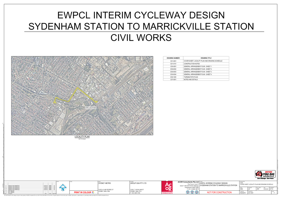
Subject: Interim East-West Pedestrian and Cycle Link (EWPCL) Proposal from Sydenham Station to Marrickville Sation (Midjuburi - Marrickville Ward/Summer Hill Electorate/ Inner West PAC)
Prepared By: George Tsaprounis - Coordinator Traffic Engineering Services (south)
Authorised By: Manod Wickramasinghe - Traffic and Transport Planning Manager
|
RECOMMENDATION
That the following design plans for the proposed interim EWPCL (East West Pedestrian and Cycleway Link) between Sydenham and Marrickville stations submitted by Sydney Metro (Group GSA, EWPCL INTERIM CYCLEWAY DESIGN, drawings A241703 L-2101 to 2104 issue H, A241703 L-2105 to 2110 Issue I and ACOR Consultants, EWPCL INTERIM CYCLEWAY DESIGN SYDENHAM STATION TO MARRICKVILLE STATION, drawings C05-0001 to C05-0004 Issue F and C05-1000 Issue F) be approved, subject to the following conditions:
a) Sydney Metro undertaking all maintenance and management activities (including community liaison) for the duration of the interim EWPCL; b) any amendments and or changes to the interim EWPCL be undertaken by Sydney Metro; c) all proposed treatments are to be constructed, installed or marked as per Council standards and/or specifications and to the satisfaction of Council; and d) Sydney Metro undertake all necessary work to implement a 40 km/h zone for the following streets/lanes (Meeks Road, Gerald Street, Sydney Lane, Maude Lane and Meeks Lane) prior to completion of the works, subject TfNSW approval.
|
STRATEGIC OBJECTIVE
This report supports the following strategic directions contained within Council’s Community Strategic Plan:
|
2: Liveable, connected neighbourhoods and transport |
|
|
EXECUTIVE SUMMARY
This report outlines proposed interim EWPCL (East West Pedestrian and Cycleway Link) between Sydenham and Marrickville and seeking approval for its implementation. This cycleway link will play an important role during the upcoming track possession of Southwest Rail Line between Sydenham and Bankstown by providing alternate options for the commuters and local community. Part of this interim EWPCL is consistent with Council’s future bike strategy.
It is recommended that the proposed attached design submitted by Sydney Metro be approved subject to conditions.
BACKGROUND
Sydney Metro proposes to deliver an interim cycle link between Marrickville Station and Sydenham Station for the community to use during the final Metro conversion shutdown of the T3 Bankstown Line. It is planned for the interim cycle link to be opened before the final conversion shutdown of up to 12 months. Works along the route are proposed at Lower Railway Parade, Marrickville Road, Meeks Road, Victoria Road up to Station Street. (refer to figure 1 below).
These works form part of Southwest Link– a fully integrated transport plan for Southwest Sydney giving passengers choices between dedicated and existing local bus services, rail services, light rail, active transport and turn up and go Metro services to and from Sydenham station.
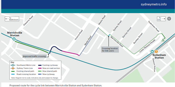
Figure 1 – Proposed route
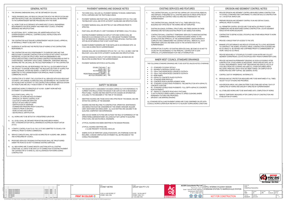
DISCUSSION
The EWPCL is a Sydney Metro project which seeks to improve east- west pedestrian and cyclist facilities between Sydenham and Bankstown along the T3 line. Components of the end-state EWPCL design are being led by Council and procurement for undertaking the detailed design is currently in progress. Sydney Metro will then undertake the delivery component. Sydney Metro will also be undertaking community engagement for the end-state EWPCL later this year.
Sydney Metro has engaged with both Council and TfNSW staff to ensure that comments and requirements have been considered and incorporated into the design as agreed upon by the stakeholders. The attached design plans are the final product of these stakeholder meetings.
It should be noted that there is potential alignment with some of the interim EWPCL and Marrickville Road East routes that form part of Council’s capital works program. Marrickville Road East provides a separated cycleway along Marrickville Road from Meeks Road to Railway Parade/Gleeson Avenue and is currently undergoing detailed design. The final treatments for Marrickville Road will differ from those included as part of the TTP which is expected to provide shared paths rather than a separated cycleway. In this respect, Council may be able to retain constructed infrastructure where it provides synergies with the proposed Marrickville Road East route and where it provides a benefit to the public.
Design components of the proposed works include:
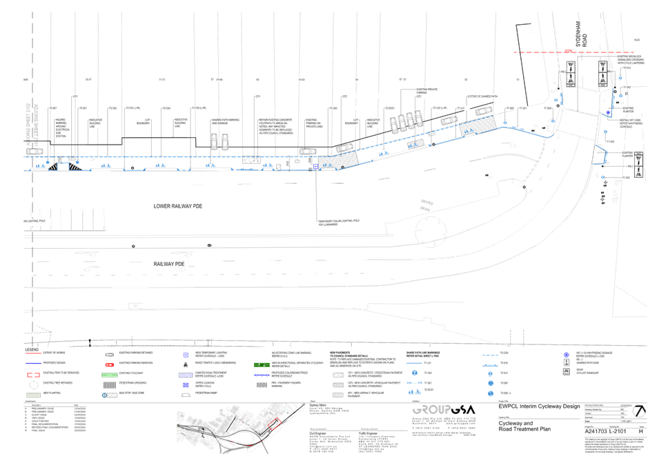
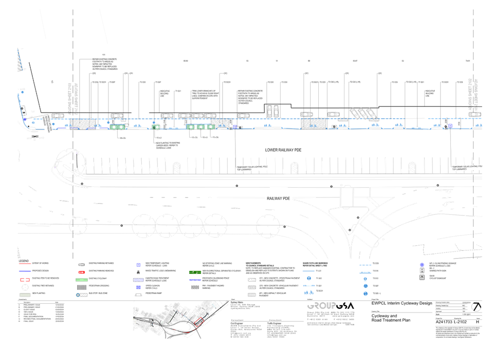
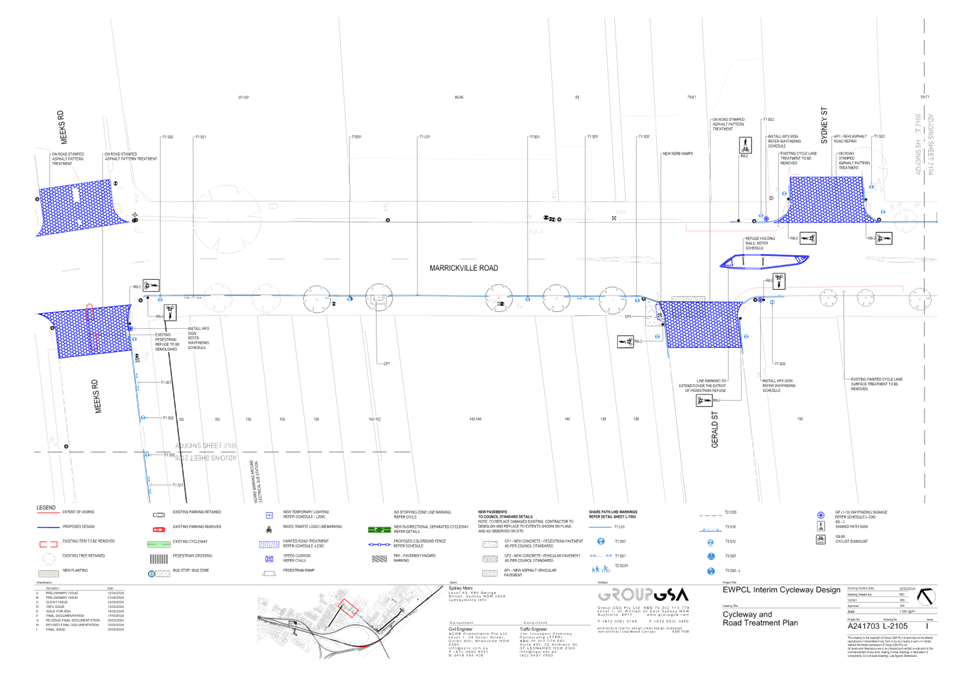
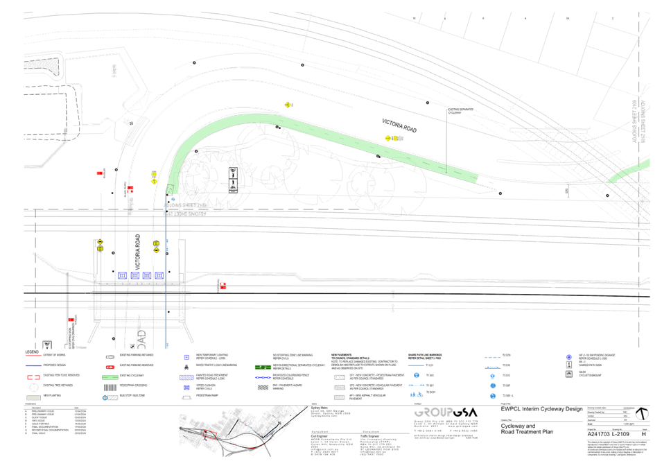
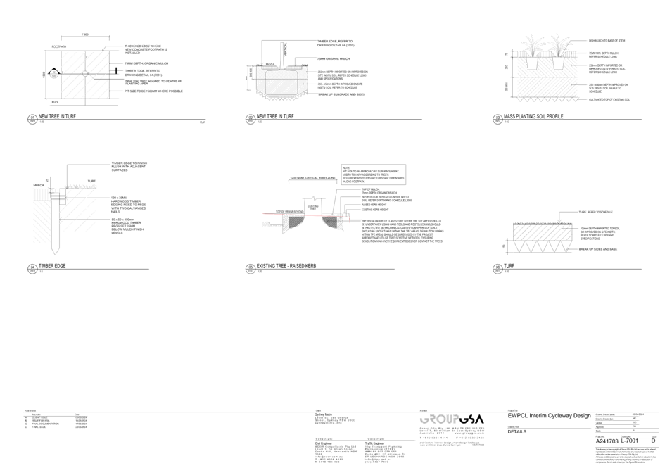
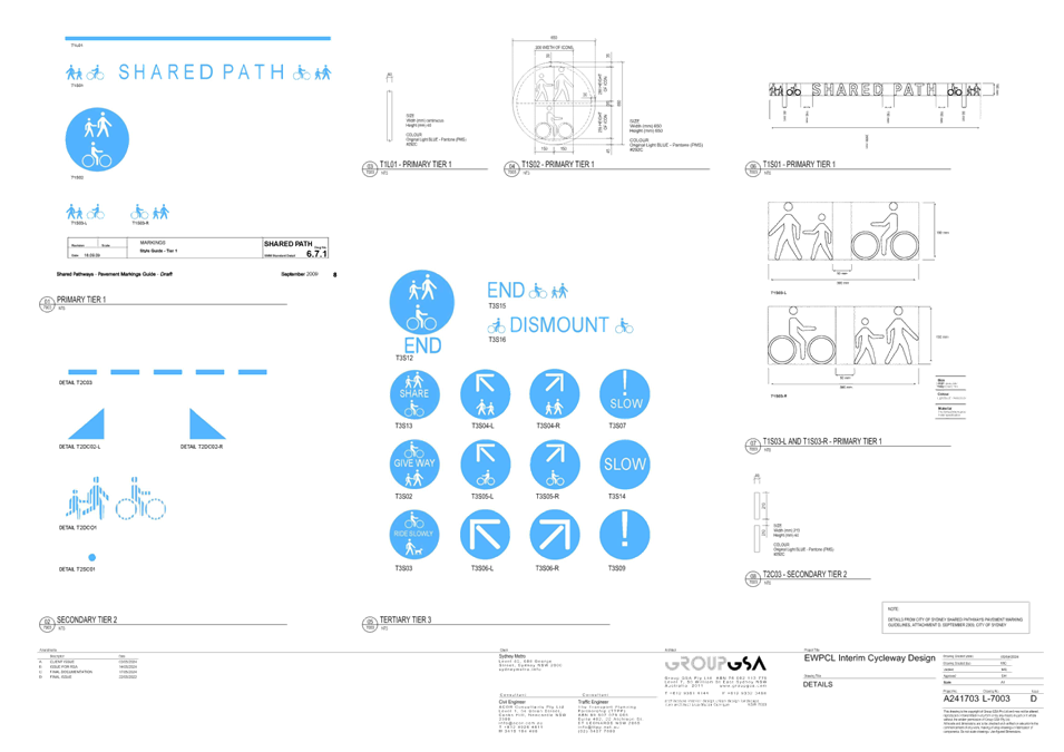
· Shared path along Lower Railway Parade – This will involve the installation of relevant signage, line marking and symbols, various repair works along the footpath, tree trimming and tree planting (refer to attached drawings A241703 L-2101 and 2102 issue H)
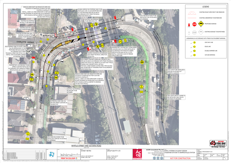
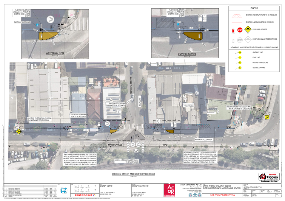
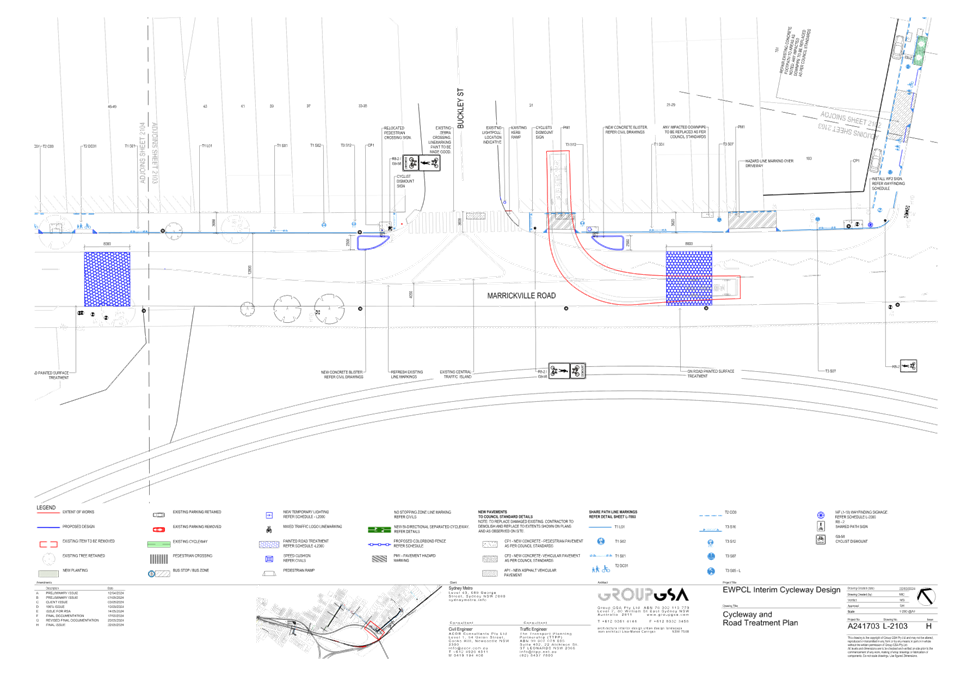
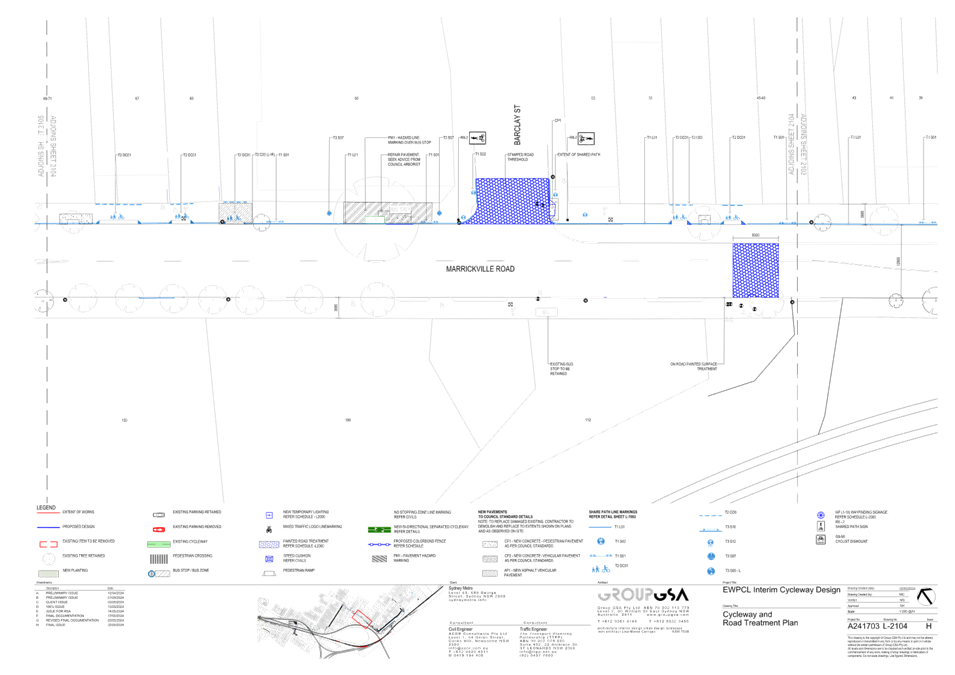
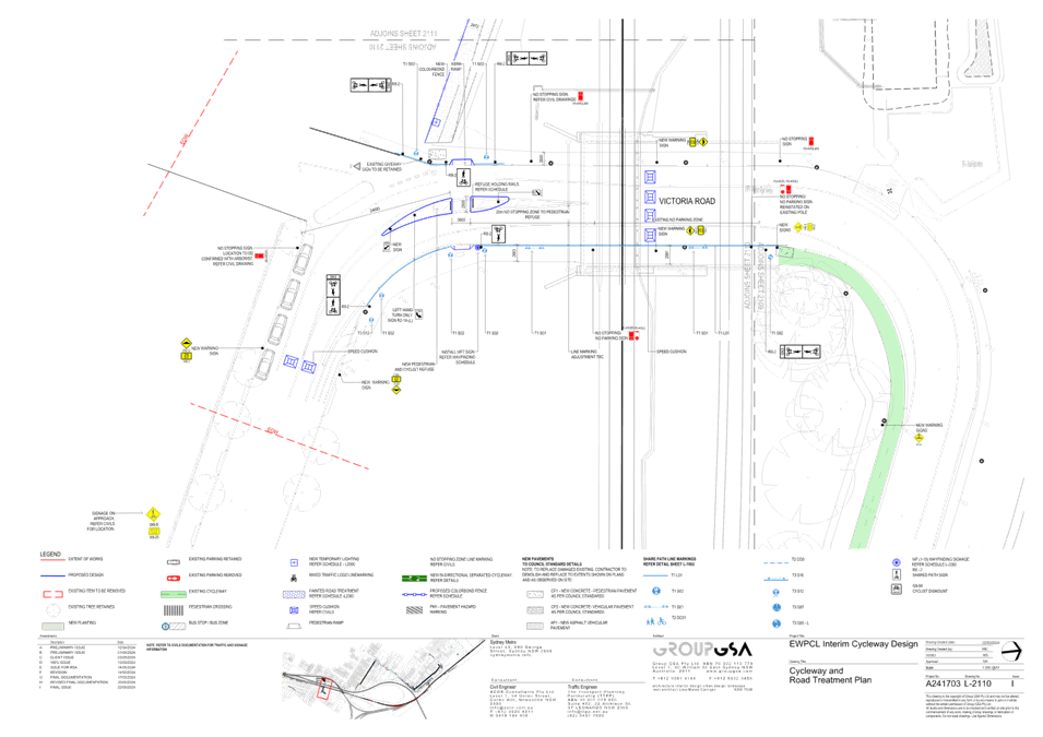
· Shared path along Marrickville Road (northern side from Lower Railway Parade to Sydney Street and southern side from Sydney Street to Meeks Road) – This will involve hazard driveway markings, installation of relevant signage, line marking and symbols, painted road treatment on Marrickville Road, new kerb blisters (either side of Buckley Street), various works along the footpath, stamped on-road threshold treatment at Barclay Street, Sydney Street and Gerald Street and hold rails to existing refuge island on Marrickville Road at Sydney Street (refer to attached drawings A241703 L-2103 and 2104 issue H and 2105 Issue I, C05-0003 Issue F and C05-0002 Issue F)
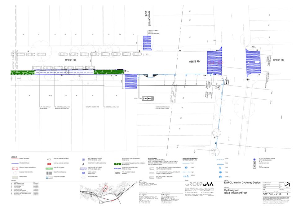
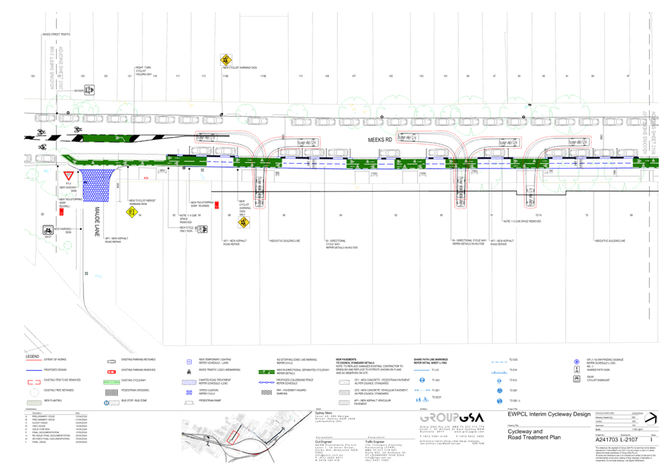
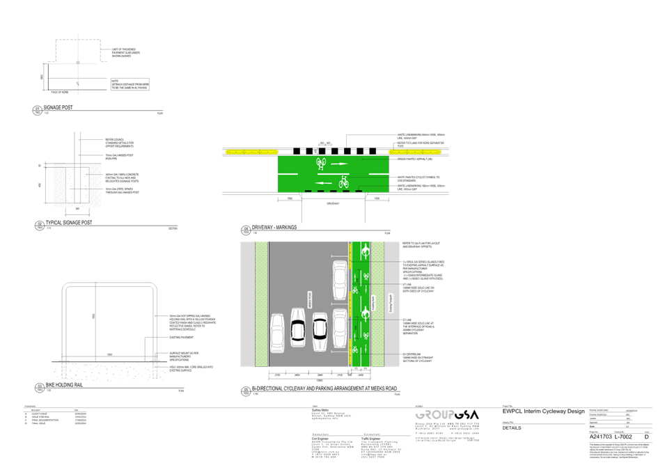
· Bi-directional on-road bicycle lane along Meeks Road between Sydney Lane and Maude Lane (eastern side) and on-road mixed traffic treatment for the remainder of Meeks Road to Victoria Road – This will involve on road stamped threshold treatment on Meeks Road, either side of Marrickville Road, Sydney Lane, Marrickville Lane and Maude Lane, painted road treatment across driveways, separation treatment between bicycle lane and parking lanes, , installation of relevant signage, line marking and symbols, painted bicycle refuge and transition zone and on-road threshold treatment at the bend in Meeks Road (refer to attached drawings A241703 L-2106, 2107 and 2108 Issue I and C05-0004 Issue F)
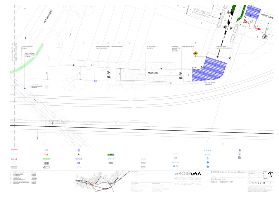
· Use of existing council bi-directional lane along Victoria Road from Meeks Road to Myrtle Street and connection to off road shared path connecting Marrickville Station to Victoria Road – This will involve installation of relevant signage, line marking and symbols, installation of speed cushions and refuge island (refer to attached drawings A241703 L-2109 and 2110 Issue I, C05-0001 and C05-1000 Issue F)
It should be noted that a Pre-Construction Concept Design Road Safety Audit was undertaken to support the proposal.
Council Officers did raise concerns in relation to cyclists crossing at the intersection of Buckley Street and Marrickville Road as the intersection does carry large volume of traffic and the geometric features of the intersection are not ideal for a pedestrian crossing. Although the cyclist will be asked to dismount at this location, this will provide motorists with additional stopping time to give way to crossing cyclists.
The ‘pros and cons’ of installing a mixed traffic treatment versus a bi-directional cycle lane in Meeks Road was discussed prior to the final proposal for a bi-directional cycle lane to be provided on the eastern side of the roadway. This is envisaged to provide a safe and separated cycleway facility and aligns with the end state EWPCL design.
Following a discussion on lowering the speed limit on Meeks Road, Council Officers asked that Sydney Metro pursue lowering the speed limit along Meek Roads (and adjacent Street(s)/laneways to 40km/h.
Sydney Metro will be requested to construct, install and line mark all proposed treatments as per Council standards or specifications and to the satisfaction of Council.
COMMUNITY ENGAGEMENT
Sydney Metro undertook doorknocks with adjacent businesses to the proposed cycle link alignment (as well as on Buckley Street) on Wednesday 15 May and Thursday 16 May. 27 businesses were spoken to directly about the interim path (and provided with a copy of the factsheet), while the cycle link fact sheet was letterbox dropped at other businesses (where possible) and adjacent residential properties. Areas where doorknocks were undertaken are marked in yellow in the below map.

Business feedback was generally positive. A summary of issues/concerns is detailed below (further consultation will be conducted with these businesses prior to the start of construction).
Sydney Metro have indicated that they will conduct further engagement following approval of this proposal by the Traffic Committee, including:
· Distributing the fact sheet to a wider footprint of properties in Marrickville
· Emailing the fact sheet to Sydney Metro’s Marrickville Station distribution list
· Distributing the fact sheet as a handout to train users at Marrickville and Sydenham Stations ahead of construction of the interim link commencing.
|
Issue raised |
Sydney Metro response |
|
Safety issues re heavy vehicle/car driveway access in and out and potential conflict with cyclists using path |
· Several measures, including the marking of chevrons on business driveways along the link, are within the design to increase awareness of potential for heavy vehicles in the area · Sydney Metro will continue to consult with businesses with these concerns around potential for additional signage (non-regulatory signage) |
|
Loss of parking on Lower Railway Parade throughout shutdowns
Driver behaviour issues during previous shutdowns |
· These are unrelated to the interim cycle path · Parking changes relate to previous shutdowns where Lower Railway Parade was used as a laydown area for replacement buses · It is likely that there will be less parking loss during final shutdown, alternative layover spaces are currently being progressed (TBC) · Drivers will be briefed and reminded about appropriate behaviours. |
|
Potential parking loss on Meeks Road |
· The design minimises impacts to local parking, resulting in the loss of only two spots on Meeks Road |
CONCLUSION
It is recommended that Council conditionally approve the following attached design drawings for the interim EWPCL (East West Pedestrian and Cycleway Link) between Sydenham and Marrickville. These conditions to pertain to responsibilities for management and maintenance as well as responsibilities pre, post and during construction of the route.
FINANCIAL IMPLICATIONS
There are no financial implications associated with the implementation of the proposed recommendations outlined in the report.
|
1.⇩ |
EWPCL INTERIM CYCLEWAY DESIGN |
|
2.⇩ |
EWPCL INTERIM CYCLEWAY DESIGN |
|
Extraordinary Local Traffic Committee Meeting 3 June 2024 |
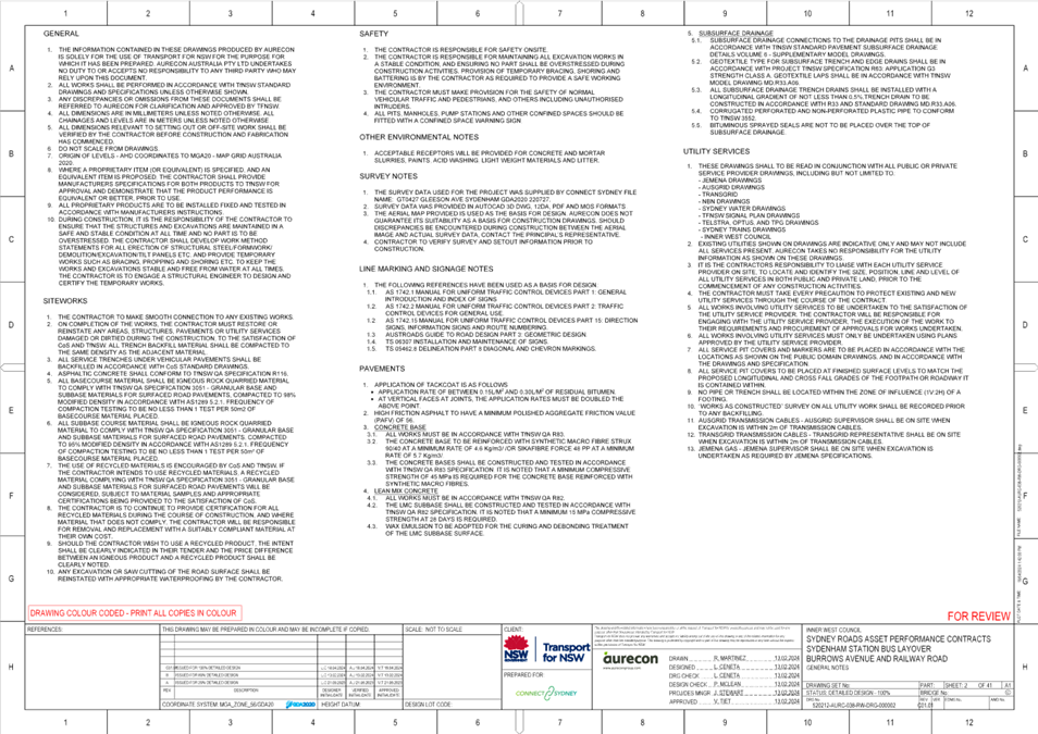
Subject: Burrows Avenue and Railway Road, Sydenham - Proposed Bus layover and parking changes (Midjuburi - Marrickville Ward / Hefron Electorate / Inner West PAC)
Prepared By: George Tsaprounis - Coordinator Traffic Engineering Services (south)
Authorised By: Manod Wickramasinghe - Traffic and Transport Planning Manager
|
RECOMMENDATION
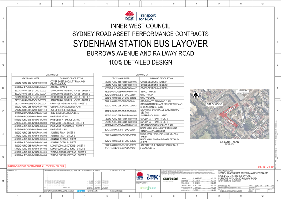
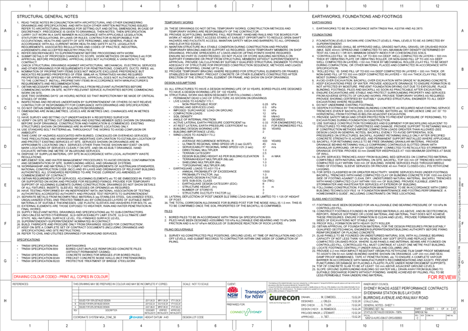
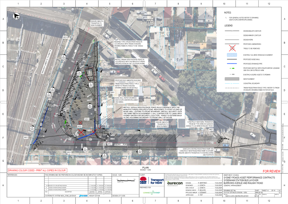
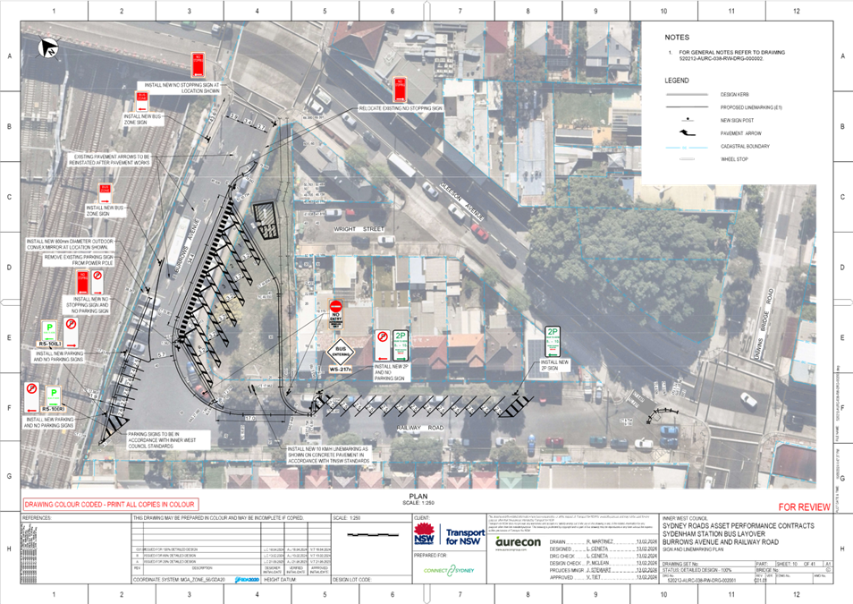
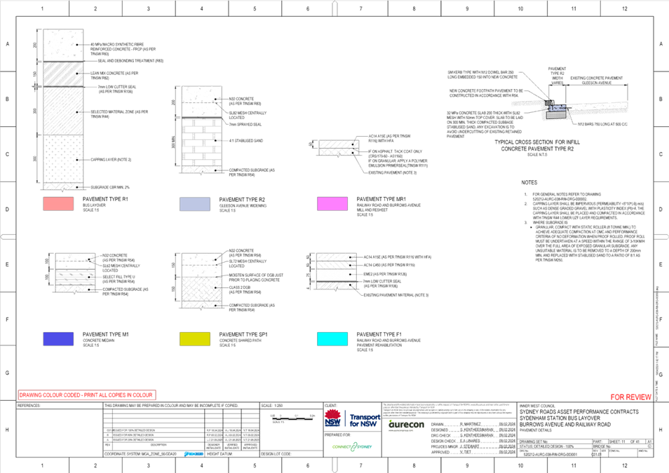
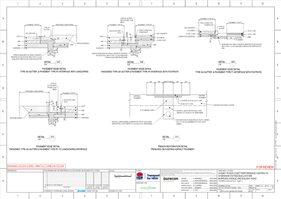
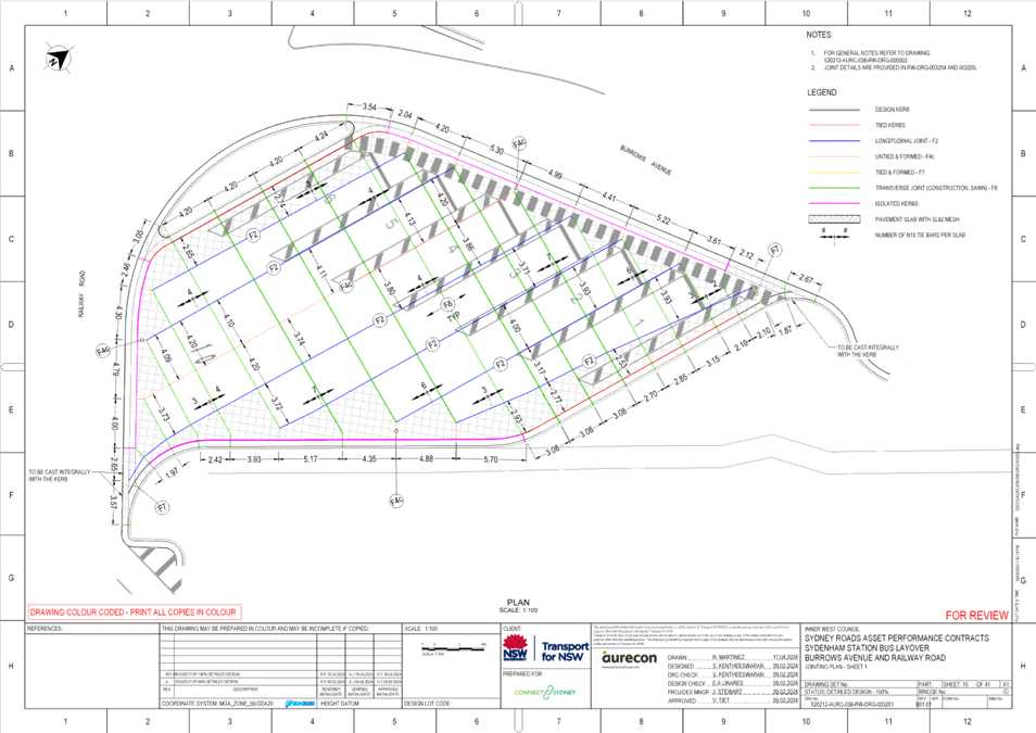
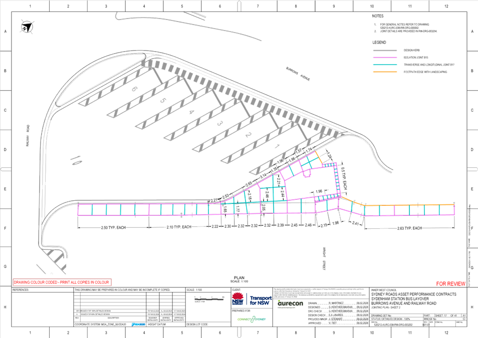
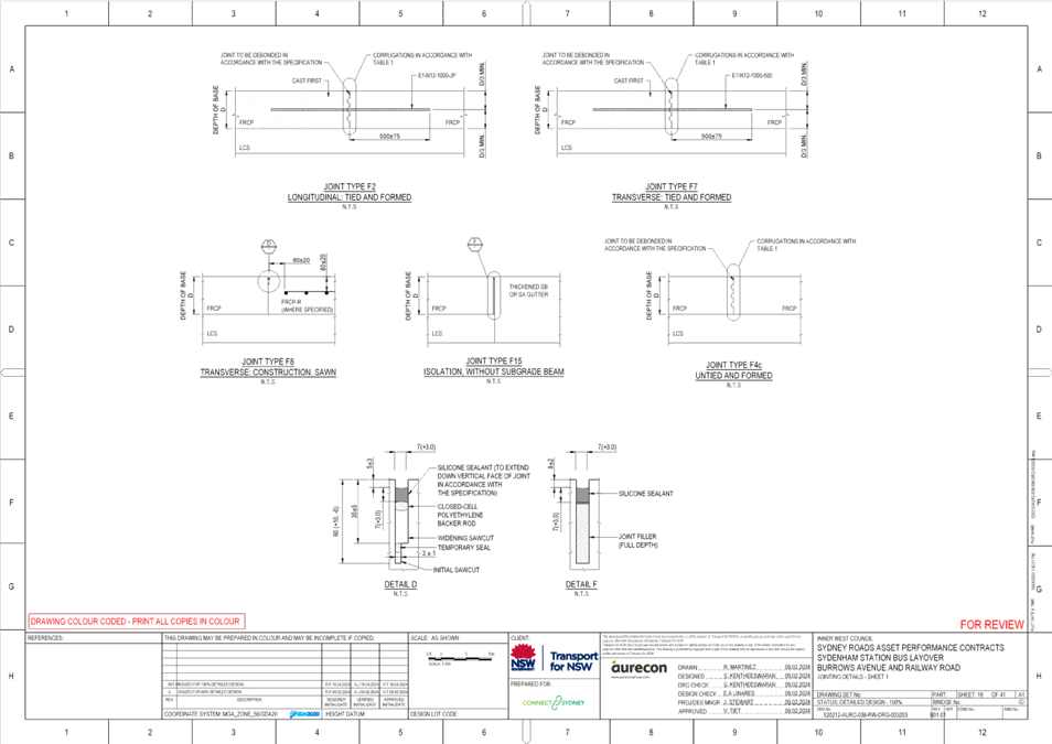
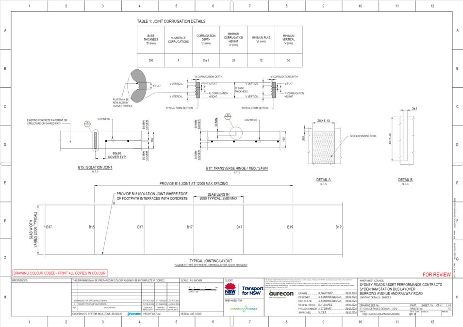
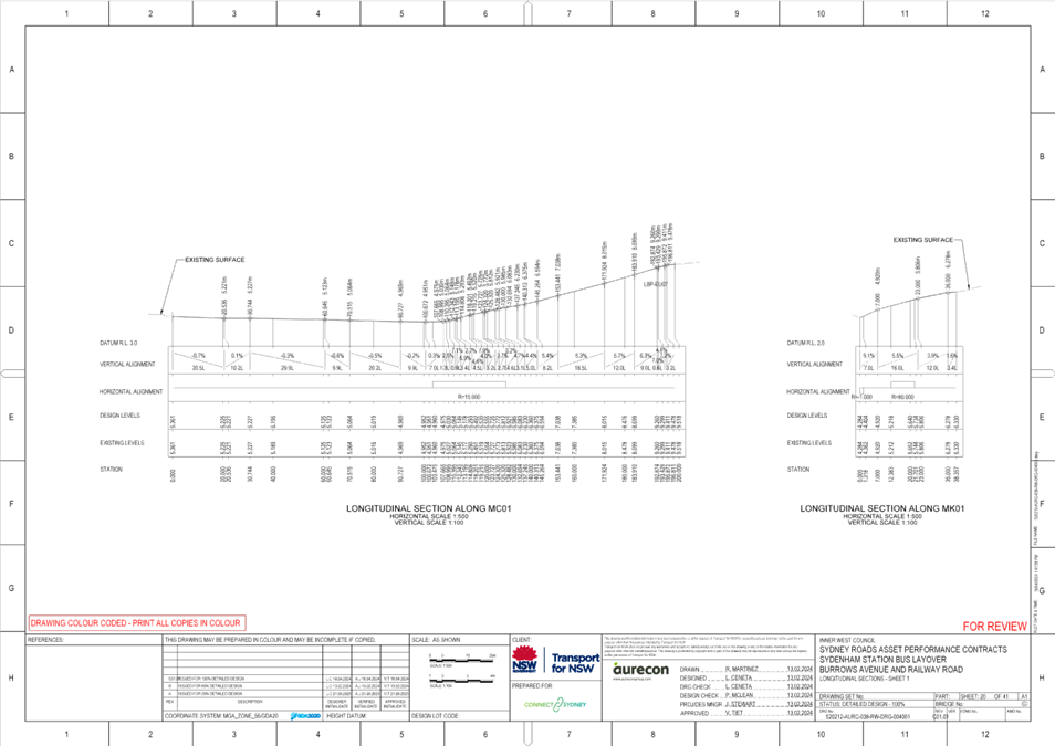
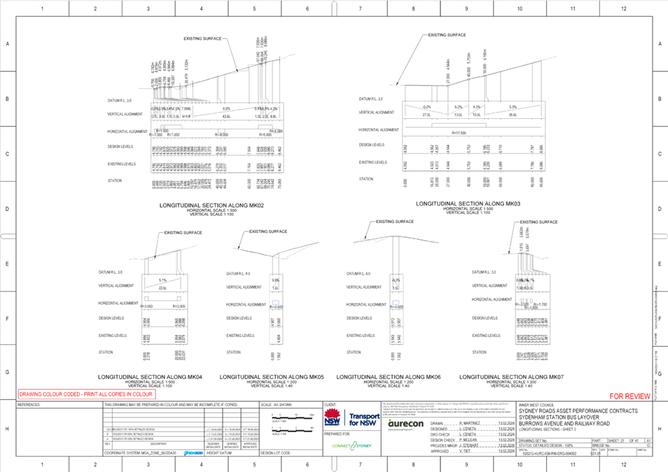
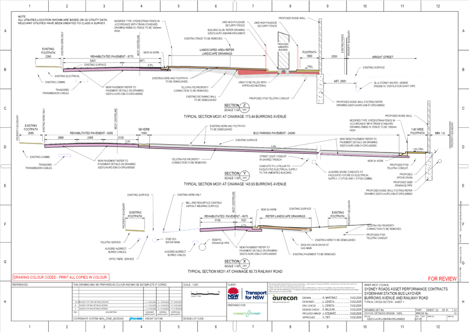
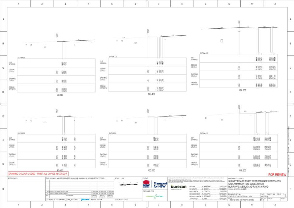
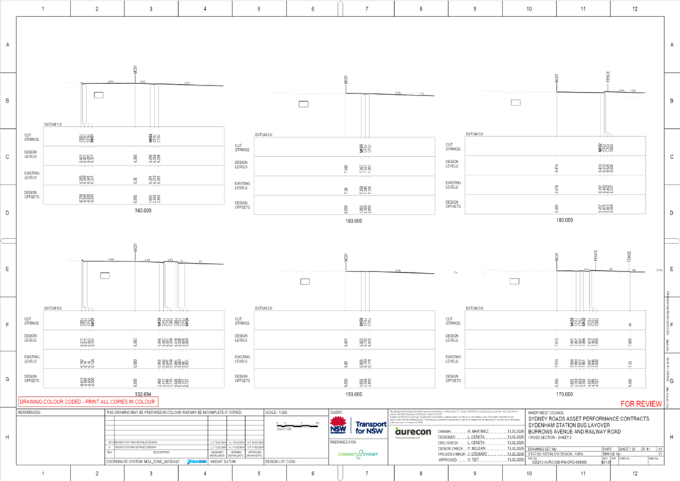
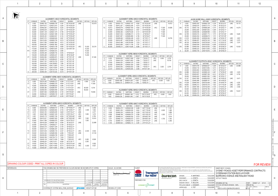
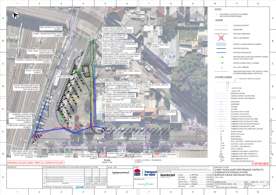
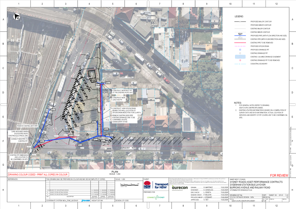
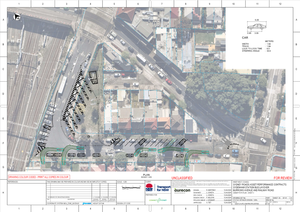
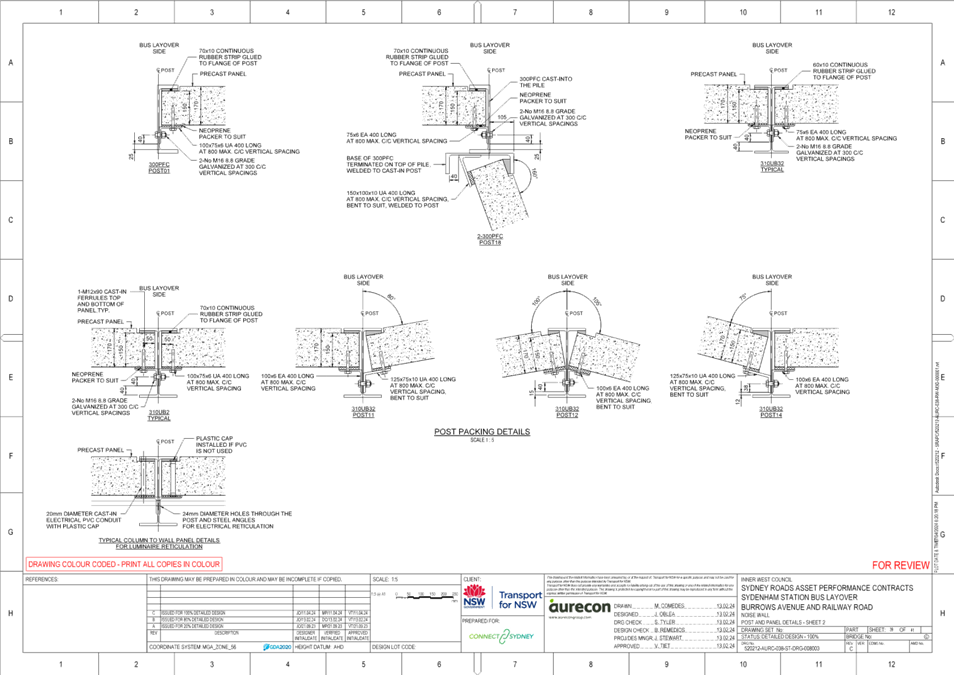
That the detail design drawing for the on-road changes associated with the proposed construction of a bus layover area in Burrows Avenue, west of Gleeson Avenue, Sydenham (as per attached drawing “Sydenham Station Bus Layover Burrows Avenue and Railway Road Signs and line marking plan” by Aurecon, dated 13/2/24, drawing no. 520212-AURC-038-RW-DRG-002001, sheet 10 of 41) be approved, subject to the following conditions:
a) TfNSW
provide assurances to Council with regards to buses servicing
b) TfNSW monitor the interaction between buses and vehicles along Railway |
STRATEGIC OBJECTIVE
This report supports the following strategic directions contained within Council’s Community Strategic Plan:
|
2: Liveable, connected neighbourhoods and transport |
|
|
EXECUTIVE SUMMARY
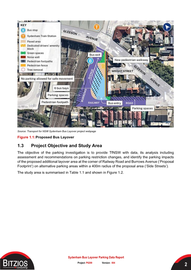
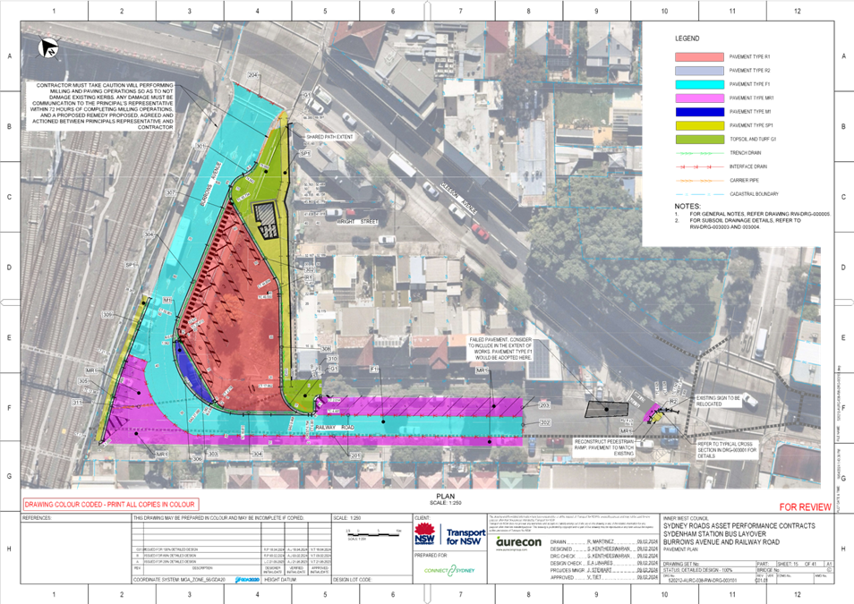
Transport for New South Wales (TfNSW) has approached Council with regards to a proposal for the construction of a bus layover area in Burrows Avenue, west of Gleeson Avenue, Sydenham. The designated bus layover area is required at Sydenham Station to cater for the growing number of bus services in this area. Prior to picking up passengers, buses currently park along Burrows Avenue which creates congestion and safety issues for pedestrians and drivers. The bus layover area will store up to 6 buses. The existing unrestricted parking spaces (approximately 11 spaces) on the south side of Burrows Avenue (adjacent to the vacant property) and six (6) 90-degree angle parking spaces on the north side of Burrows Avenue will be lost as a result of the proposal. In response to this loss of parking it is proposed to convert the parallel parking on the east side of Railway Road to 45-degree rear to kerb parking to lessen the impact from the loss of parking because of this proposal.
Community engagement was undertaken and it began on Friday 24 November and ended on Friday 8 December 2023. Community notifications, letterbox dropped and nearby properties door knocked on Railway Road, Burrows Avenue and Wright Street were part of the consultation process.
It is recommended that Council approve the signs and line marking plan (drawing no. 520212-AURC-038-RW-DRG-002001 sheet 10 of 41).
BACKGROUND
Sydenham Station is an important junction with the Bankstown Railway Line (T3), Illawarra and Eastern Suburbs line (T4) and Airport and South line (T8) and interchange with east-west bus routes. It continues to be a logical bus terminus for passengers interchanging with rail services from Sydney’s Inner East and Inner West. This interchange function is expected to intensify in coming years with:
· The opening of the City & Southwest Metro between Chatswood and Bankstown. Increased Illawarra Line services
· Increased bus service levels and patronage to and from Sydenham Station. Population growth in surrounding precincts
· Sydenham being identified as the terminus for future new bus routes under the Greater Sydney Bus Network Strategy.
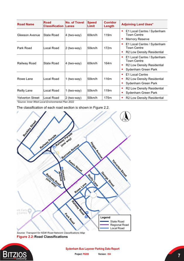
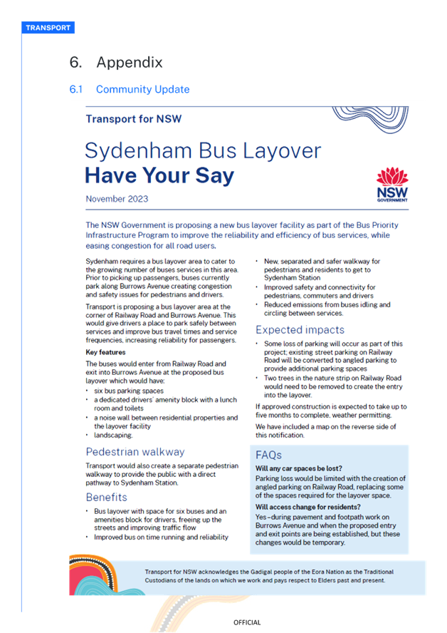
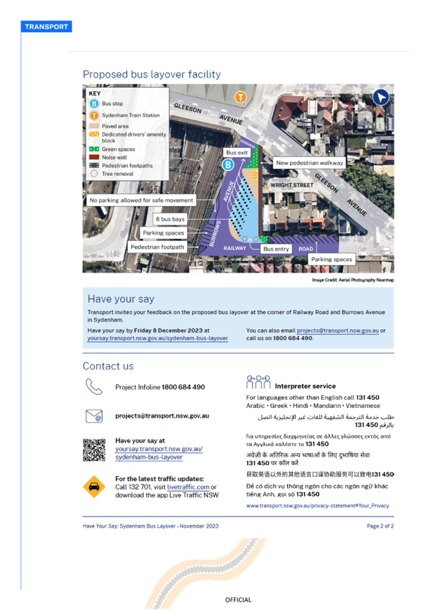
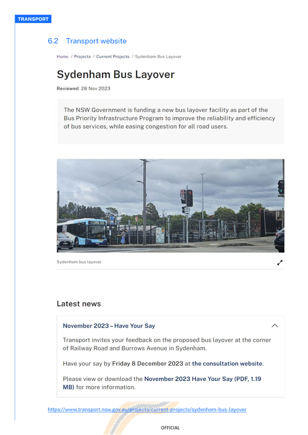
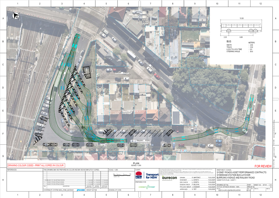
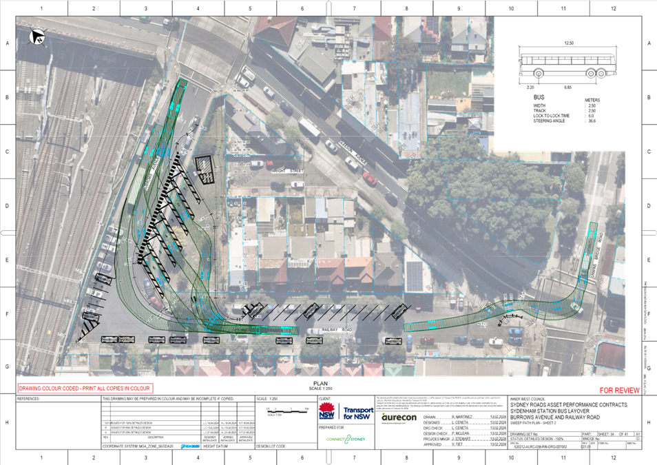
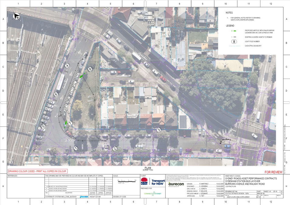
Given the importance of Sydenham Station as a multimodal transport interchange, buses servicing this major hub don't have enough room to terminate and layover between services. This creates congestion on Railway Road, Burrows Avenue and Gleeson Avenue (a freight corridor to the Airport and Port Botany). The limited bus layover options in the area results in buses idling in these streets, causing obstruction to pedestrians and cars, in active bus zones and surrounding streets. Transport for NSW representatives have advised of safety issues, delays to passengers and bus services which are currently being experienced as a result. To resolve this issue, Transport for NSW is proposing to construct a bus layover facility at the corner of Railway Road and Burrows Avenue in Sydenham (refer to figure 1 below)
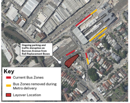
Figure 1 – Locality Plan
DISCUSSION
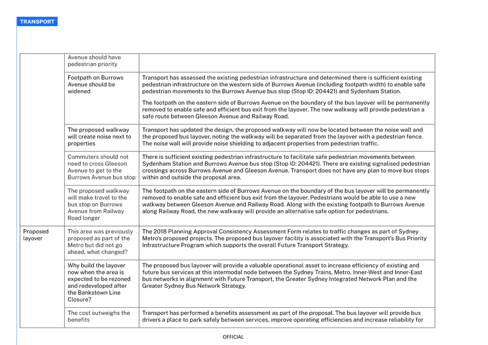
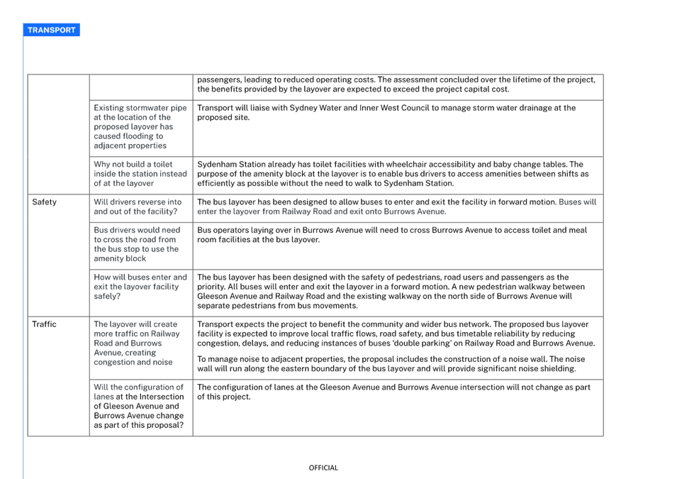
Transport for New South Wales (TfNSW) is proposing a new bus layover facility at the corner of Railway Road and Burrows Avenue as part of the Bus Priority Infrastructure Program (BPIP) to improve the reliability and efficiency of bus services. Prior to picking up passengers, buses currently park along Burrows Avenue which creates congestion and safety issues for pedestrians and drivers.
The proposed bus layover would give bus drivers a place to park safely between services and improve bus travel times and service frequencies, increasing reliability for passengers. Sydenham requires a bus layover area to cater to the growing number of bus services in this area. At present, prior to picking up passengers, buses park along Burrows Avenue and Railway Road creating congestion and impacting bus operations.
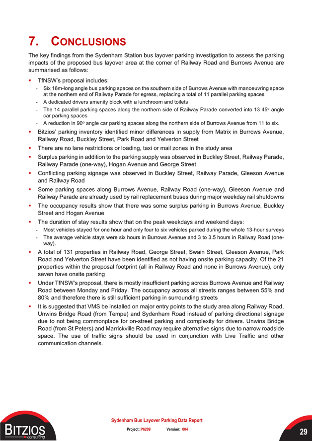
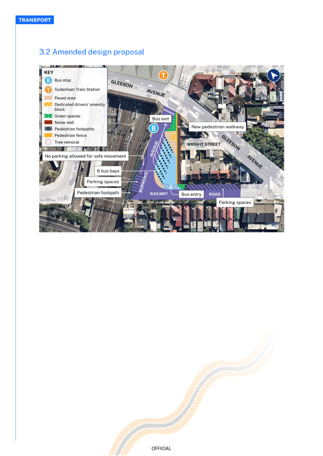
The proposed bus layover facility at the corner of Railway Road and Burrows Avenue in Sydenham will include the following changes (refer to figure 2):
· Six 16m-long angle bus parking spaces on the southern side of Burrows Avenue with manoeuvring space at the northern end of Railway Parade for egress, replacing a total of 11 parallel parking spaces.
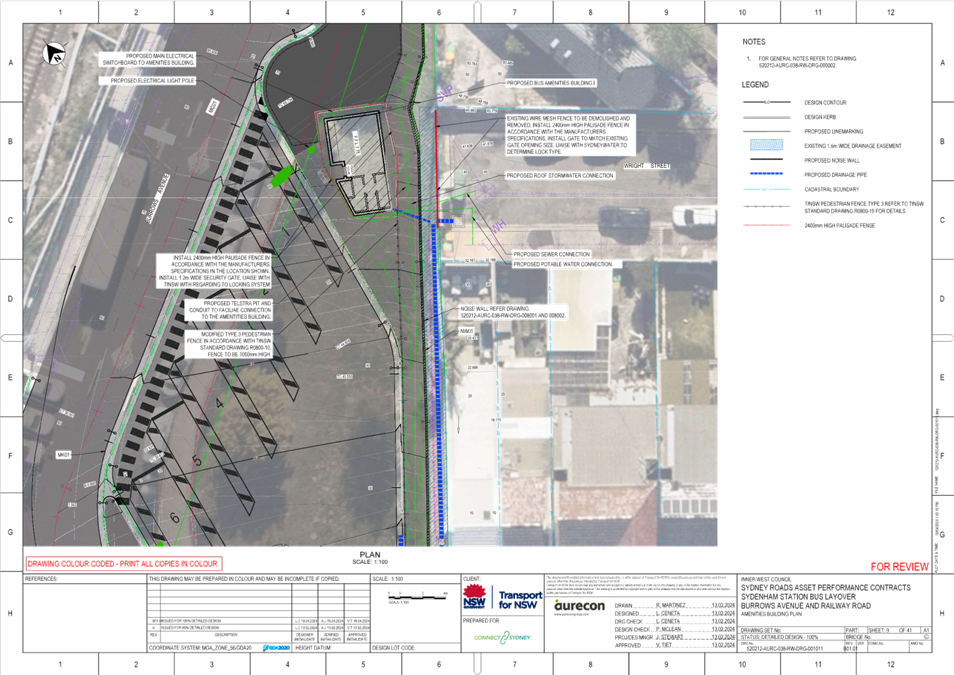
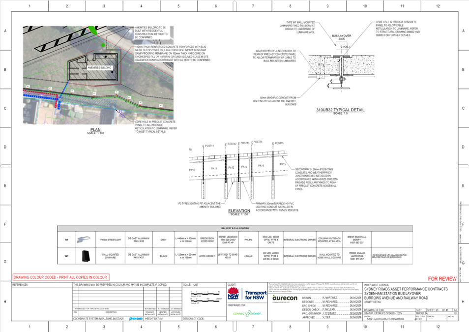
· A dedicated drivers amenity block with a lunchroom and toilets.
· The 8 parallel parking spaces along the eastern side of Railway Road converted into 13 45-degree angle car parking spaces.
· A reduction in 90 degree angle car parking spaces along the northern side of Burrows Avenue from 12 to 6.
· Create a path for pedestrians, passengers and the community to safely walk to and from Railway Road to Gleeson Avenue.
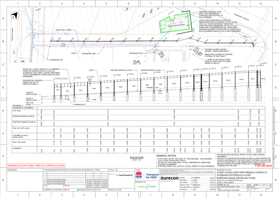
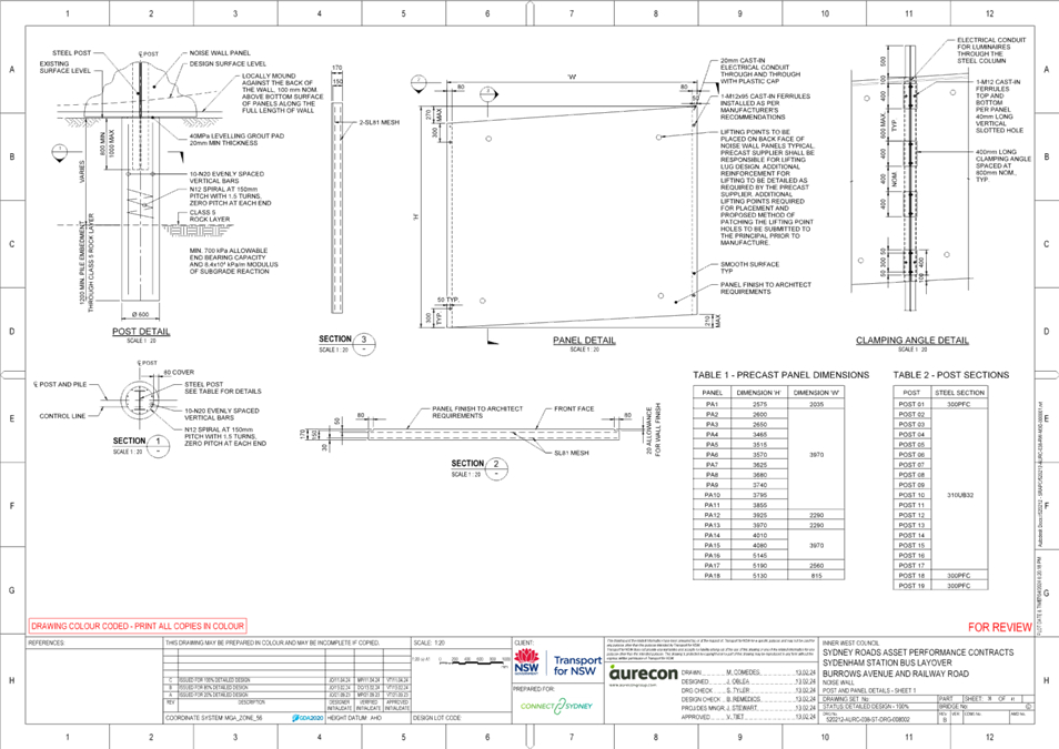
· Build a noise wall to separate the nearby homes from the new bus layover facility and minimise noise impacts from the bus layover facility.
· Install driveways for buses to enter from Railway Road and leave through Burrows Avenue.
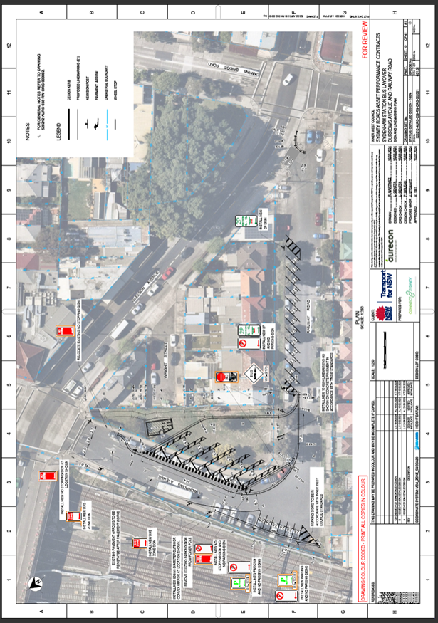
Figure 2 – Bus layover proposal
The above changes result in a net loss of 17 unrestricted parking spaces across the two streets. The impacts of the proposed changes to the current parking arrangements along Burrows Avenue and Railway Road are provided in table 1 below.
|
Road Name |
Parking Restrictions |
Parking supply |
Impact |
Justification |
|
Burrows Avenue – East * |
Unrestricted |
11 |
- 11 |
Required for the buses to exit from the new layover into Burrows Avenue |
|
Burrows Avenue – West |
Unrestricted |
12 |
- 6 |
Required for buses to safe turning movements |
|
Railway Rd -East |
2 P |
10 |
+5 |
Changing to angle parking |
|
Railway Rd -West |
1P, 2P |
23 |
zero |
No change |
Table 1 – Proposed changes to parking
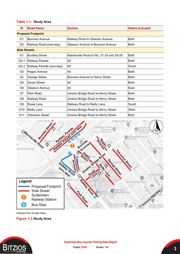
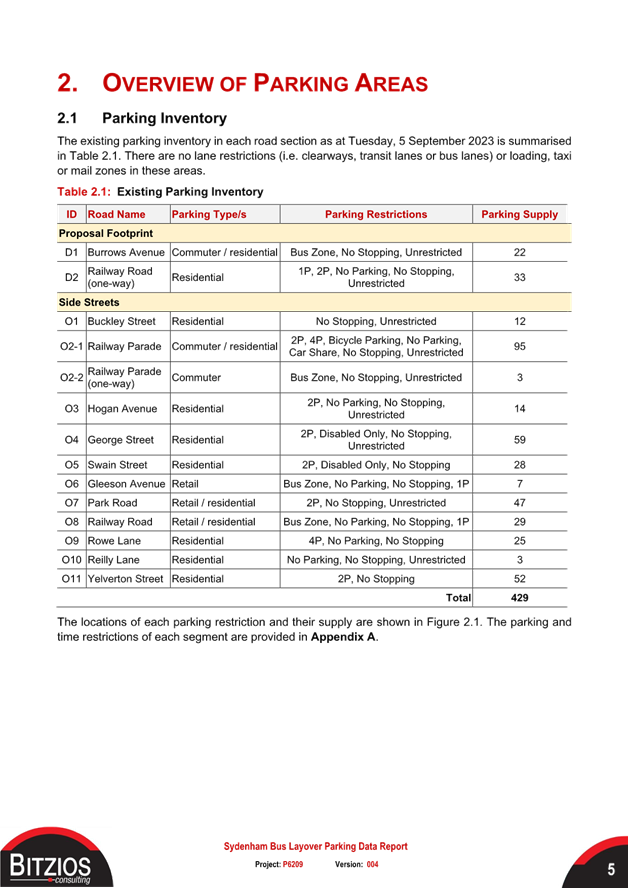
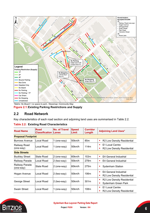
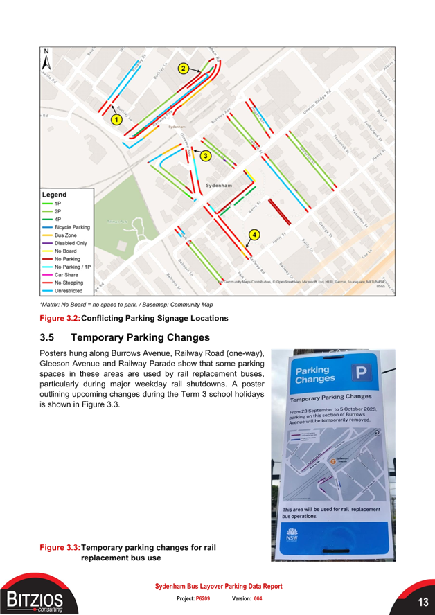
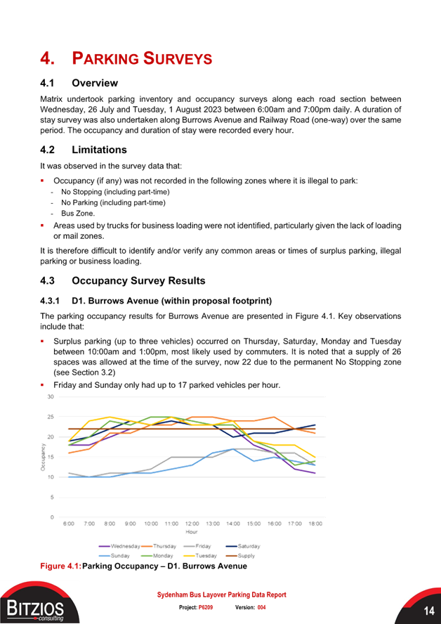
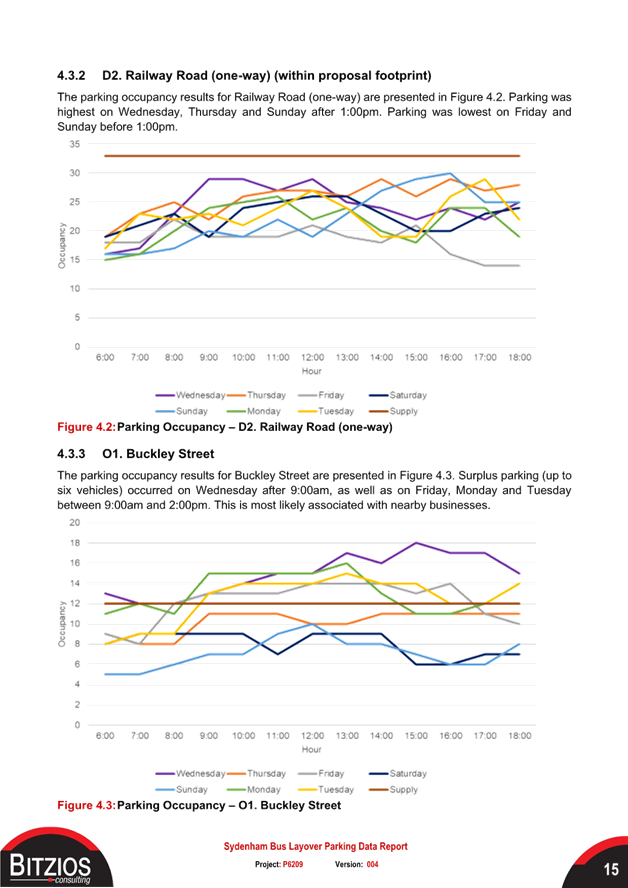
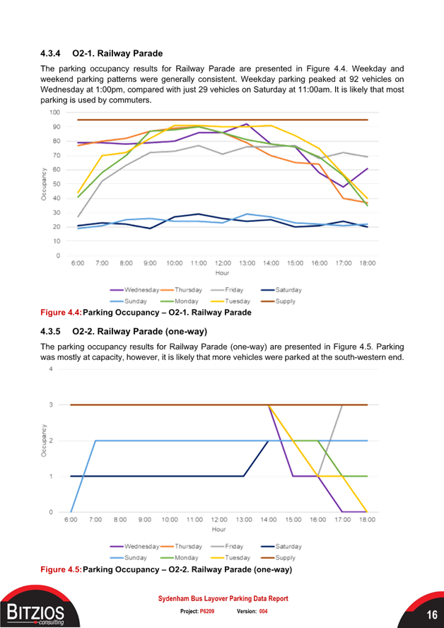
Given the loss of parking Council requested that parking data be collected by TfNSW to determine the impact of the proposed loss. The objective of the parking investigation was to provide TfNSW and Council with data, its analysis including assessment and recommendations on parking restriction changes and identify the parking impacts of the proposed layover area at the corner of Railway Road and Burrows Avenue (‘Proposal Footprint’) and on alternative parking areas within a 400m radius of the proposal area (‘Side Streets). Refer to attached Parking Data Report for further details.
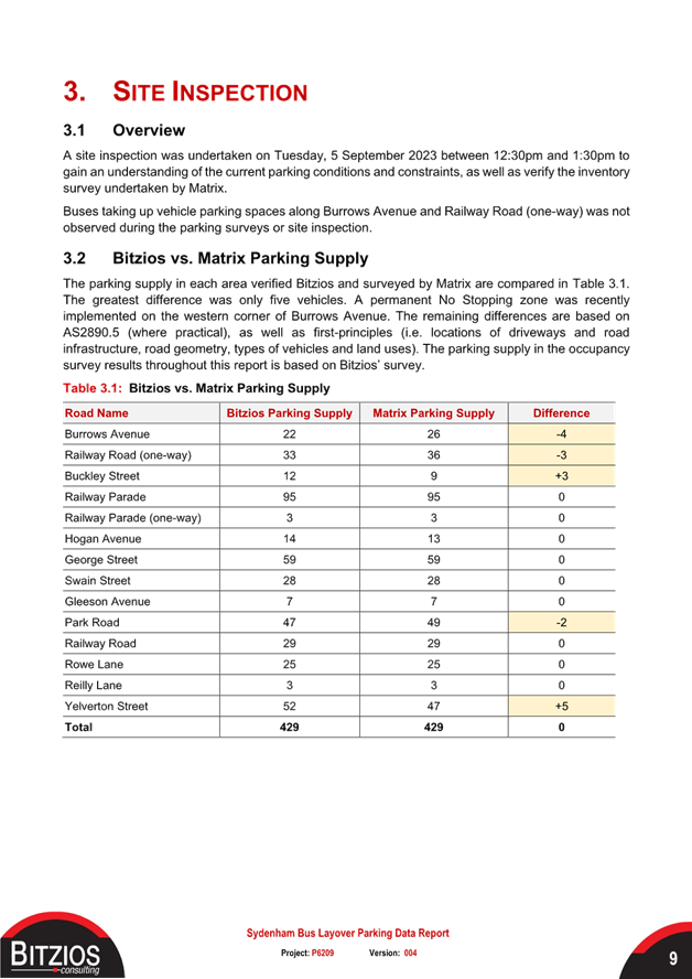
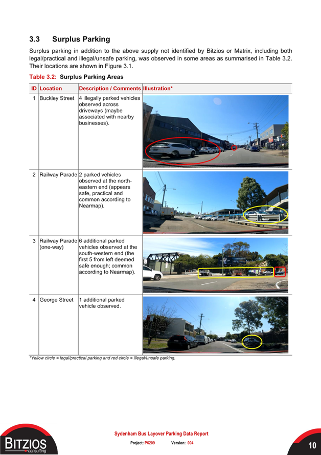
A site inspection was undertaken on Tuesday, 5 September 2023 between 12:30pm and 1:30pm to gain an understanding of the current parking conditions and constraints. Some of the key conclusions are listed below.
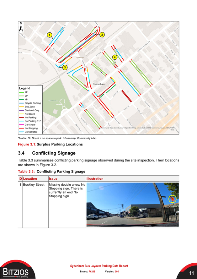
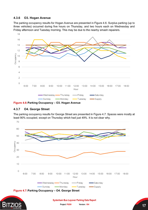
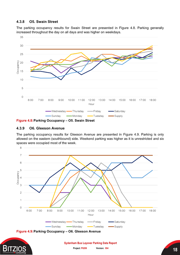
· Surplus parking in addition to the parking supply was observed in Buckley Street, Railway Parade, Railway Road (one-way), Hogan Avenue and George Street.
· The occupancy results show that there was some surplus parking in Burrows Avenue, Buckley Street and Hogan Avenue.
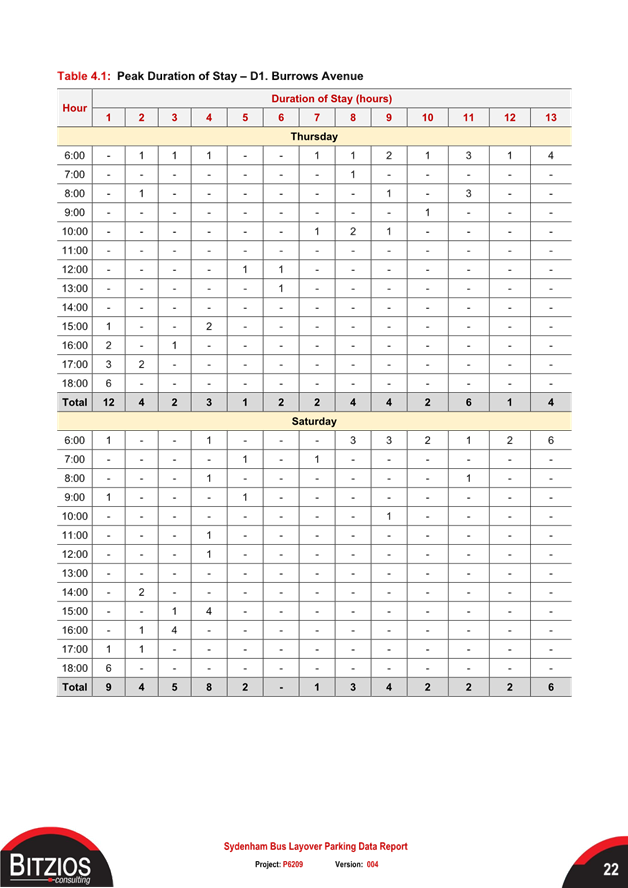
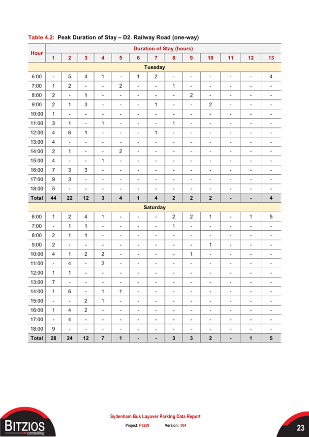
· The duration of stay results showed that on the peak weekdays and weekend days:
- Most vehicles stayed for one hour and only four to six vehicles parked during the whole 13-hour surveys.
- The average vehicle stays were six hours in Burrows Avenue and 3 to 3.5 hours in Railway Road (one-way).
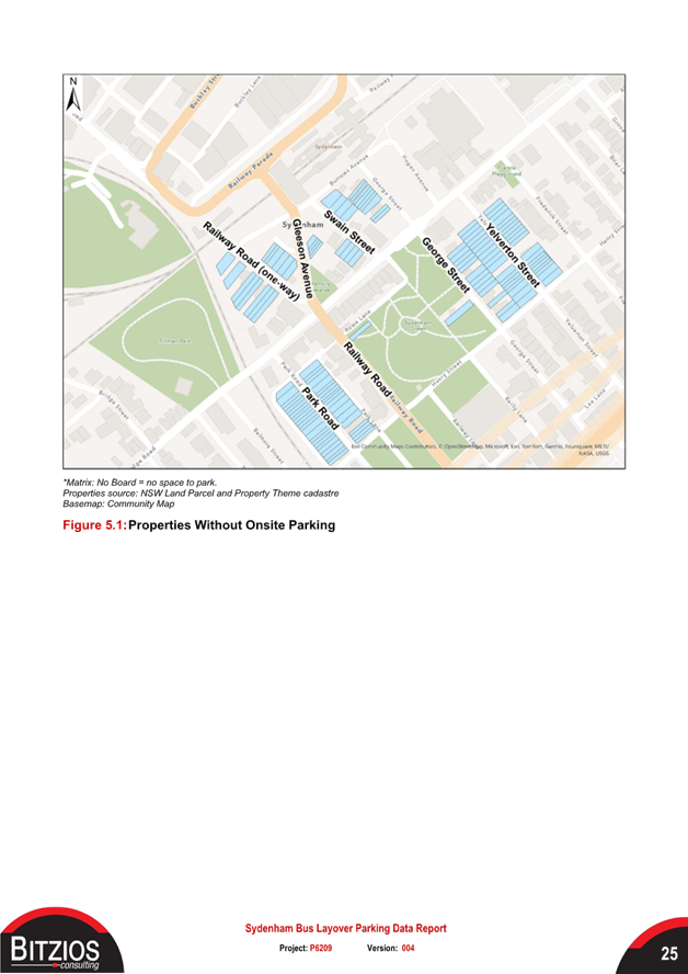
· A total of 131 properties in Railway Road, George Street, Swain Street, Gleeson Avenue, Park Road and Yelverton Street were identified as not having onsite parking capacity. Of the 21 properties within the proposal footprint (all in Railway Road and none in Burrows Avenue), only seven had onsite parking.
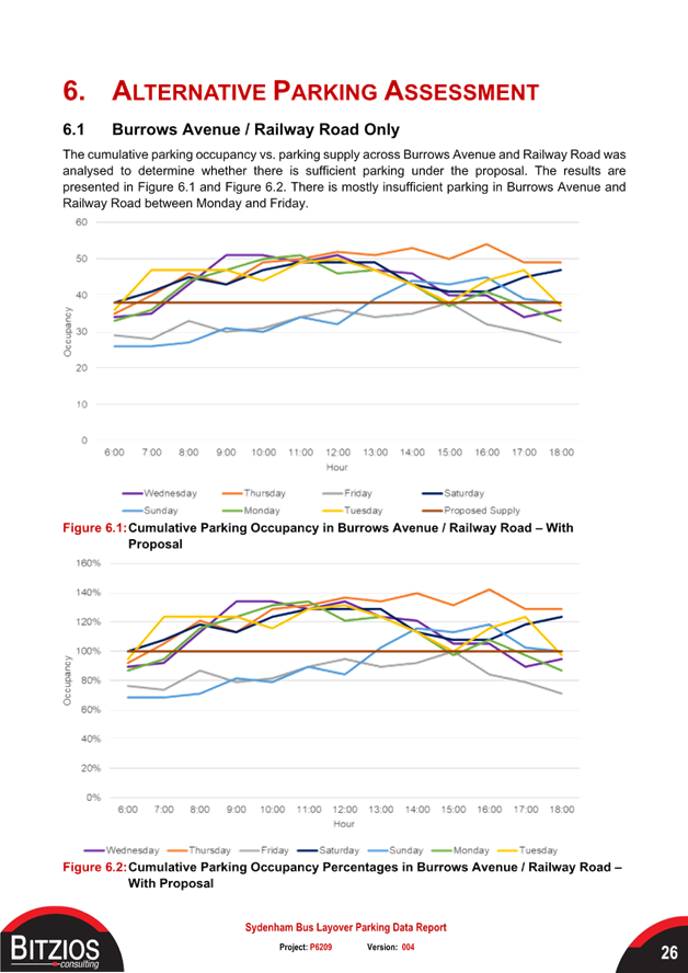
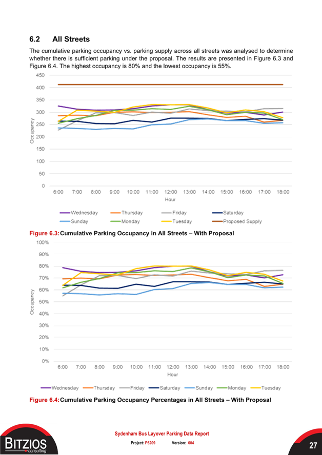
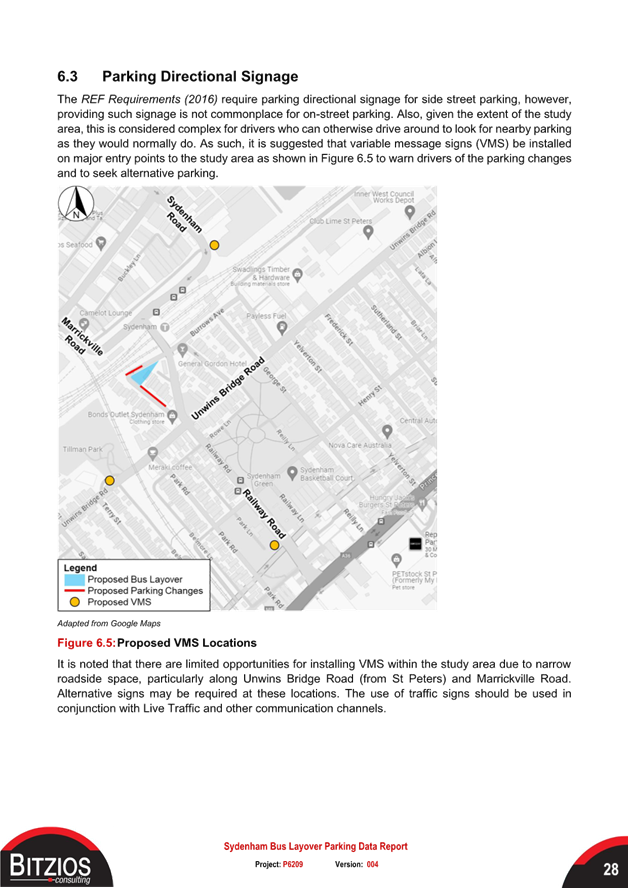
· Under TfNSW’s proposal, there is mostly insufficient parking across Burrows Avenue and Railway Road between Monday and Friday. The occupancy across all streets ranges between 55% and 80% and therefore there is still sufficient parking in surrounding streets.
In order to address the shortfall in parking, TfNSW have proposed that the current parking spaces along the eastern side of Railway Road be converted from 2P parallel parking spaces to 2P 45-degree, (rear to kerb) parking spaces. It has been calculated that this will result in a net gain of 5 timed parking spaces. It should be noted that the majority of the spaces lost as a result of the proposed works will be unrestricted spaces and adjacent to railway land. From the data analysis, it does seem that spare capacity does exist within a 400m radius to cope with the transfer of these spaces. It should also be noted that the majority of residential streets within close proximity to Sydenham Station have been treated with 2P resident parking restrictions.
COMMUNITY ENGAGEMENT
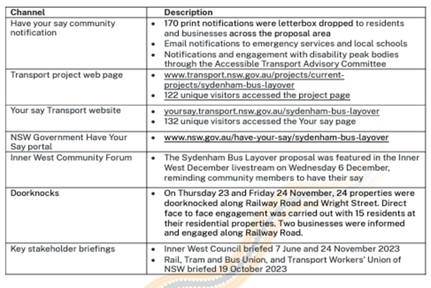
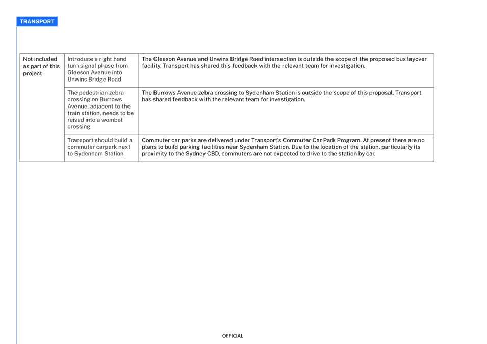
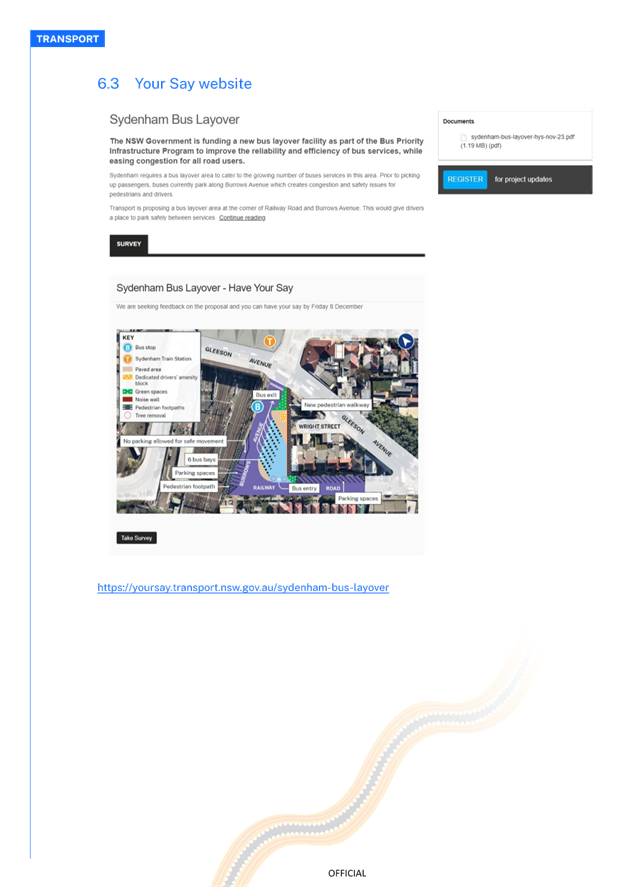
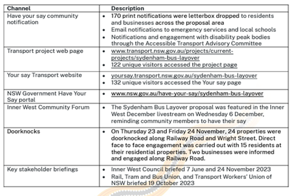
Community engagement began on Friday 24 November and ended on Friday 8 December 2023, with community notifications letterbox dropped and nearby properties doorknocked on Railway Road, Burrows Avenue and Wright Street. Feedback was invited in person, on the phone, via email and through the Sydenham bus layover project web page, the Transport Your Say website, and the NSW Government Have Your Say portal. (Refer to the attached Community Engagement Report). A summary of the channels of engagement and description is provided in table 2 below.
At the end of the engagement period, feedback was received from 18 individuals. The local community supported the proposed bus layover in principle but had concerns around parking and the proposed location.
Transport used an ‘inform’ and ‘consult’ engagement approach for this project:
• ‘Inform’ the community, businesses and other stakeholders on the proposal.
• ‘Consult’ on changes to parking on Railway Road and Burrows Avenue.
Table 2 – Summary of channels of engagement
The main issues raised in relation to traffic and parking from the engagement that was undertaken by TfNSW are summarised below as follows.
|
|
Issue Raised |
Response from TfNSW |
|
Traffic |
The layover will create more traffic on Railway Road and Burrows Avenue, creating congestion and noise |
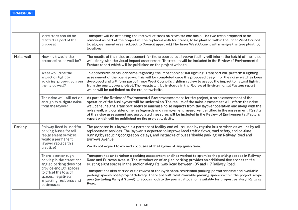
Transport expects the project to benefit the community and wider bus network. The proposed bus layover facility is expected to improve local traffic flows, road safety, and bus timetable reliability by reducing congestion, delays, and reducing instances of buses ‘double parking’ on Railway Road and Burrows Avenue. To manage noise to adjacent properties, the proposal includes the construction of a noise wall. The noise wall will run along the eastern boundary of the bus layover and will provide significant noise shielding. |
|
|
Will the configuration of lanes at the Intersection of Gleeson Avenue and Burrows Avenue change as part of this proposal? |
The configuration of lanes at the Gleeson Avenue and Burrows Avenue intersection will not change as part of this project. |
|
Parking |
Railway Road is used for parking buses for rail replacement services, would a permanent layover replace this practice? |
The proposed bus layover is a permanent facility and will be used by regular bus services as well as by rail replacement services. The layover is expected to improve local traffic flows, road safety, and on-time running by reducing congestion, delays, and instances of buses ‘double parking’ on Railway Road and Burrows Avenue. We do not expect to exceed six buses at the layover at any given time. |
|
|
There is not enough parking in the street and angled parking does not provide enough spaces to offset the loss of spaces, negatively impacting residents and businesses. |
Transport has undertaken a parking assessment and has worked to optimise the parking spaces in Railway Road and Burrows Avenue. The introduction of angled parking provides an additional five spaces to the existing eight spaces in the section along Railway Road between Nos.105 and 117 Railway Road.
Transport has also carried out a review of the Sydenham residential parking permit scheme and available parking spaces post- project delivery. There are sufficient available parking spaces within the project scope area (including Wright Street) to accommodate the permit allocation available for properties along Railway Road. |
|
|
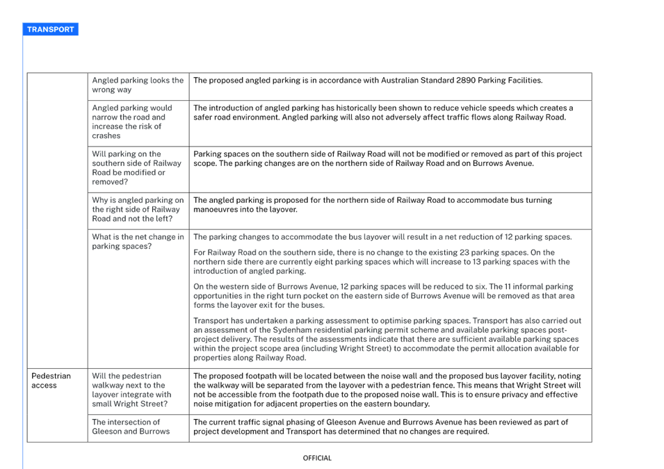
Angled parking looks the wrong way |
The proposed angled parking is in accordance with Australian Standard 2890 Parking Facilities. |
|
|
Angled parking would narrow the road and increase the risk of crashes |
The introduction of angled parking has historically been shown to reduce vehicle speeds which creates a safer road environment. Angled parking will also not adversely affect traffic flows along Railway Road. |
|
|
Will parking on the southern side of Railway Road be modified or removed? |
Parking spaces on the southern side of Railway Road will not be modified or removed as part of this project scope. The parking changes are on the northern side of Railway Road and on Burrows Avenue. |
|
|
Why is angled parking on the right side of Railway Road and not the left? |
The angled parking is proposed for the northern side of Railway Road to accommodate bus turning maneuvers into the layover. |
|
|
What is the net change in parking spaces? |
The parking changes to accommodate the bus layover will result in a net reduction of 12 parking spaces.
For Railway Road on the southern side, there is no change to the existing 23 parking spaces. On the northern side there are currently eight parking spaces which will increase to 13 parking spaces with the introduction of angled parking.
On the western side of Burrows Avenue, 12 parking spaces will be reduced to six. The 11 informal parking opportunities in the right turn pocket on the eastern side of Burrows Avenue will be removed as that area forms the layover exit for the buses.
Transport has undertaken a parking assessment to optimise parking spaces. Transport has also carried out an assessment of the Sydenham residential parking permit scheme and available parking spaces post project delivery. The results of the assessments indicate that there are sufficient available parking spaces within the project scope area (including Wright Street) to accommodate the permit allocation available for properties along Railway Road. |
CONCLUSION
The new bus layover facility project will benefit Sydenham Station as a multimodal transport interchange and support public transport infrastructure within the Inner West area. However, this will come at a cost to the adjoining residents with possible noise and exhaust impacts from the additional buses laying over and loss of overall parking. The creation of 45 degree angle parking will help ease the burden for resident as the additional spaces will be posted as 2P RPS area. It would also seem like the loss in unrestricted parking spaces can be accommodated in the adjacent street network. Issues of additional buses along Railway Road and their impacts are not properly addressed. Council should seek assurances from TfNSW as to servicing this node point with a quieter bus fleet with a reduced footprint in relation to exhaust fumes. Furthermore, given the increase in buses, the interaction of buses and vehicles should be monitored over a period of time and that TfNSW be responsible implementing further traffic control measures should they be required in future.
FINANCIAL IMPLICATIONS
There are no financial implications associated with the implementation of the proposed recommendations outlined in the report.
|
1.⇩ |
Sydenham Bus Layover - Parking Data report |
|
2.⇩ |
Sydenham Bus Layover - Community Engagement Report |
|
3.⇩ |
Sydenham Bus Layover - Detailed Design |
|
Extraordinary Local Traffic Committee Meeting 3 June 2024 |
Subject: Railway Road, Sydenham - Proposed changes to parking and traffic arrangements as a result of construction works (Midjuburi- Marrickville Ward / Hefron Electorate / Inner West PAC)
Prepared By: George Tsaprounis - Coordinator Traffic Engineering Services (south)
Authorised By: Manod Wickramasinghe - Traffic and Transport Planning Manager
|
RECOMMENDATION
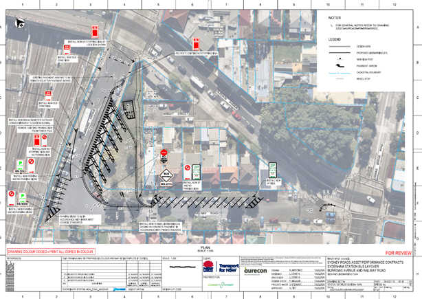
That 45-degree rear to kerb angle parking signposted as ‘2P 8am-10pm Permit Holders Excepted Area M4’ be approved for the eastern side of Railway Road from no. 101/103 to 111/113 Railway Road in order to lessen parking impacts from construction activities. |
STRATEGIC OBJECTIVE
This report supports the following strategic directions contained within Council’s Community Strategic Plan:
|
2: Liveable, connected neighbourhoods and transport |
|
|
EXECUTIVE SUMMARY
Transport for New South Wales (TfNSW) has approached Council with regards to a proposal for the construction of a bus layover area in Burrows Avenue, west of Gleeson Avenue, Sydenham. The designated bus layover area is required at Sydenham Station to cater for the growing number of bus services in this area.
It is proposed to increase parking capacity in Railway Road during construction activities to reduce the impact on residents.
BACKGROUND
The proposed bus layover facility at the corner of Railway Road and Burrows Avenue in Sydenham will include the following changes (refer to figure 2):
· Six 16m-long angle bus parking spaces on the southern side of Burrows Avenue with manoeuvring space at the northern end of Railway Parade for egress, replacing a total of 11 parallel parking spaces.
· A dedicated drivers amenity block with a lunchroom and toilets.
· The 8 parallel parking spaces along the eastern side of Railway Road converted into 13x 45 degree angle car parking spaces.
· A reduction in 90 degree angle car parking spaces along the northern side of Burrows Avenue from 12 to 6 spaces.
· Create a path for pedestrians, passengers and the community to safely walk to and from Railway Road to Gleeson Avenue.
· Build a noise wall to separate the nearby homes from the new bus layover facility and minimise noise impacts from the bus layover facility.
· Install driveways for buses to enter from Railway Road and leave through Burrows Avenue.
DISCUSSION
TfNSW are planning to commence construction activities for the new bus layover area on 10 June 2024. This will involve installing a temporary site compound on Burrows Avenue at Railway Road (in the existing 90-degree parking area against the railway fence on Burrows Avenue). This will temporarily remove all 12 spaces in this area (6 spaces will be returned in the final layout).
Upon completion of stormwater drainage and roadworks in bus layover area (on 22 July 2024) the site compound will then be relocated into the bus layover area. The project is expected to be finished by mid September 2024. In order to lessen the burden of loss in parking for residents of Railway Road, it is proposed to install the 45 degree 2P Residential Parking spaces during this phase of the works. This will assist the residents by creating some parking. These spaces will remain in place at the end of the works.
FINANCIAL IMPLICATIONS
There are no financial implications associated with the implementation of the proposed recommendations outlined in the report.
Nil.
|
|
Extraordinary Local Traffic Committee Meeting 3 June 2024 |
Subject: Proposed new kerb extension facilites at
intersection of Victoria Street and Clissold Street, Ashfield.
(Djarrawawunang- Ashfield Ward/Summer Hill Electrate/Burwood PAC)
Prepared By: Boris Muha - Traffic Engineer
Authorised By: Manod Wickramasinghe - Traffic and Transport Planning Manager
|
RECOMMENDATION
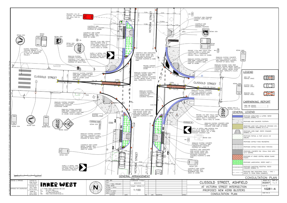
That the detailed amended design plan (10281-A) to install new landscaped blister islands (kerb extension build-outs) and painted island/line marking to all corners of Victoria Street at Clissold Street, plus realign the ‘STOP’ lines on both approaches on Clissold Street and remove the raised central median islands to be replaced with road at- grade stenciled marked islands in Clissold Street as shown in Attachment 1, be approved.
|
STRATEGIC OBJECTIVE
This report supports the following strategic directions contained within Council’s Community Strategic Plan:
|
2: Liveable, connected neighbourhoods and transport |
|
|
EXECUTIVE SUMMARY
Council at its meetings on 18 March 2024 (through its Traffic Committee 11 December 2023) approved in principle, subject to detailed design, a series of proposed pedestrian (zebra) crossings and kerb extension treatments (under concept) for improved pedestrian and road safety around and near to the Cardinal Freeman (Retirement) Village, Ashfield.
This report discusses the prepared design of the proposed treatment, i.e., provide new landscaped blister islands (kerb extension build-outs) and painted island/line marking to all corners of Victoria Street at Clissold Street. In addition, the ‘STOP’ lines are realigned on both approaches of Clissold Street and the raised central median islands are replaced with at-grade stenciled islands in Clissold Street. This work is programmed to be constructed in the 2024/2025 financial year.
BACKGROUND
The Cardinal Freeman Village (currently known as Levande Cardinal Freeman) is bounded by Clissold Street to the north, Victoria Street to the east, Seaview Street to the south and Queen Street to the west.
The village caters to an independent living lifestyle however as the average age is over 82 years there are a significant number of residents with mobility issues that hinder their ability to move around freely.
Many of the elderly residents are capable, and desire to walk to and from various destinations outside of the village, and/or take other forms of public transportation (e.g., bus and train) to travel to other parts of Sydney.
This has prompted a general request from the elderly residents to improve pedestrian safety around the village to enable them to walk to various desired destinations and take public transport within the area.
Other Aged care facilities such as the Ashfield Baptist Homes, Bethal Nursing Homes, Ashfield Terrace Care Community, and other community facilities are also located adjacent or near to the Cardinal Freeman Village.
The proposed treatment in this report received a high support rate (80%) under a general community engagement consultation conducted through Council’s ‘Have Your Say’ back in October 2023. The facility is viewed in benefit and supported by the community at large, and not only for the elderly of the Cardinal Freeman Village.
DISCUSSION
The following information is provided in discussion.
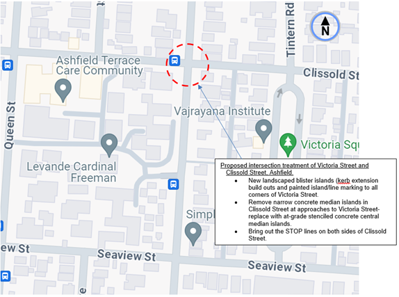
Figure 1. Locality Plan
![]()
|
Street Name
|
Victoria Street (at intersection to Clissold Street) |
|
Carriageway width (m) kerb to kerb |
Approx. 12.8m |
|
Carriageway type |
Two-way, one travel lane each direction. |
|
Classification |
Local |
|
Speed Limit km/h |
50 |
|
85th percentile speed km/h |
-- |
|
Vehicles per day (vpd) |
Approx. 2500 |
|
Available TfNSW recorded crash history Last 5 years (2018- 2023)
|
2 X RUM 10 at intersection 2021 and 2023, cross-traffic, both non-casualty tow-away
Prior to 2018, 5 incident occasions recorded as far back to 2009 , mainly RUM 10, cross traffic, non injury to moderate injury. |
|
Parking arrangements |
Unrestricted parking both sides, ‘No Stopping’ to corners of intersection |
|
Side street (nearest) |
- |
Table 1. Road Network detail. Change
The Plan
The following works are proposed and are illustrated on the attached plans:
Clissold Street (at Victoria Street), Ashfield (Amended Plan No. 10281-A):
- Construct three (3) new landscaped kerb blister islands with integrated footpaths and kerb ramps to improve pedestrian points & safety whilst slowing traffic approaching the intersection;
- Provide painted island/line marking treatment to the north-eastern corner of the intersection to maintain the existing Bus Stop at the corner;
- Construct four (4) new kerb ramps to improve pedestrian accessibility;
- Reconstruct sections of damaged concrete footpath with new concrete footpath
- Reconstruct some damaged concrete kerb & gutter with new kerb & gutter;
- Remove the 2 raised concrete median islands in Clissold Street and construct new ‘at-grade’ (flat) central median islands in their place (with stencilled & coloured finish);
- Provide new line marking at the Clissold Street intersection (extending into Victoria Street) to improve sight lines for motorists (refer to Plans);
- Adjust 1 existing ‘No Stopping’ sign and zone in Victoria Street to cater for one of the new kerb blister islands (refer to plans);
- Install associated signage associated with the works as required and where shown on Plan;
Parking Changes
The proposal will require an adjustment to some of the existing on-street parking arrangements. It is proposed to adjust the existing ‘No Stopping’ signage and zone in Victoria Street to accommodate one of the new landscaped kerb blister islands needed to improve pedestrian safety.
This adjustment will not result any loss of existing on-street parking spaces in Victoria Street or Clissold Street.
Streetlighting
The existing lighting is deemed adequate and therefore there will be no changes to the existing street lighting due to the proposed works.
Further information
· The kerb blister islands, or kerb extension build outs with compliant pram ramps assist pedestrians to cross-over Victoria Street over a shorter distance, whilst being refuged by the islands.
· The north-eastern corner of the intersection is treated in painted island/line marking to maintain the function and operation of the existing Bus Stop on the eastern side of Victoria Street, north of Clissold Street. A complaint pram ramp is constructed away of the required front door boarding area of the bus.
· The alignment of the kerb blister islands and painted line marked island assists to bring out the STOP lines in Seaview Street to improve the sight view of traffic.
· The kerb blister islands and line marked island are widened out as far possible to provide a narrowing channel for 2-way traffic in Victoria Street in attempt to control speed through the intersection. Associated and extended edge line marking in Victoria Street assists to guide and control traffic movement though and around the intersection.
· The existing narrow (raised) concrete median islands in Clissold Street, in approach to the Victoria Street are removed and replaced with road at-grade stencil marked islands with associated line marking to maintain the separation in traffic. The physical islands are narrow and are known to be hit with signage on top being continuously damaged, particularly with vehicles turning at the intersection. They are therefore viewed to be hazardous.
· Transit Systems Australia, being the public bus operator for Transport for NSW raises no objection to the proposal.
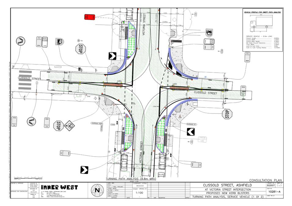
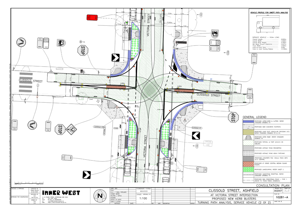
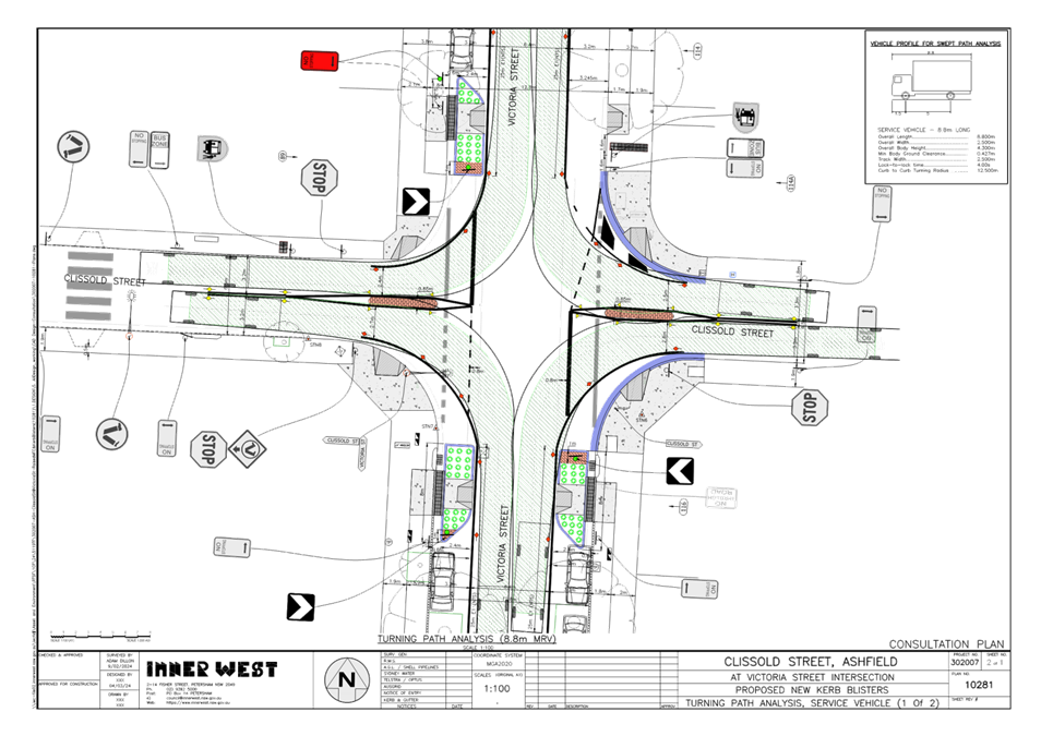
· Design garbage turn path movements are provided in Attachment 2.
· An original plan (10281) was issued out to consultation as shown in Figure 2 below. Based on certain concerns as raised by residents regarding illegal parking and the need for improved sight view at the corners of the intersection, the kerb blister islands are amended and extended and tailed off in towards Clissold Street. -see amended plan 10281-A Attachment 1. This further signifies the presence and effectiveness of the kerb extensions to assist and guide traffic through and around the intersection and ensures that vehicles do not park at the corners. The extension of the kerb blister islands further improves to assist and bring out the ‘STOP’ lines in Clissold Street, particularly on the western side of Victoria Street, nearest the Cardinal Freeman Village.
The north-western kerb return corner of the intersection (under amended plan) is extended out to widen the pram ramp at the corner of Clissold Street.
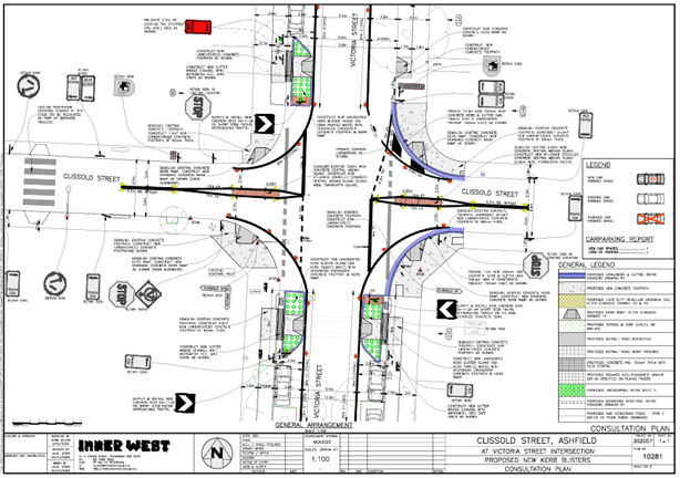
Figure 2. Original plan (10281) issued out to consultation
FINANCIAL IMPLICATIONS
The project is listed on Council’s Traffic Facilities Capital Works budget for works to be carried out in 2024/2025, subject to funding. The work is estimated to be around $95,000. Council has applied for external funding for this project under the Get Active NSW/Road Safety Program.
CONSULTATION
A letter outlining the proposal was mailed out to 18 properties (55 letters) around the intersection of Victoria Street and Clissold Street, Ashfield requesting residents’ views regarding the proposal.
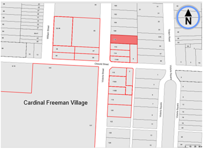
Figure 2. Map on Consultation Area
Council officers also convened a presentation session on the 2 May 2024 at the Cardinal Freeman Village outlining the proposal to the elderly residents of the Village.
One (1) street resident raised concerns as to why a kerb-blister island was not going in one of the corner locations in Victoria Street. 11-12 residents of the village who attended the presentation session and who provided comments on the proposal on the day were wholly in support of the proposal with or without certain concerns. One (1) resident was unsure.
One (1) response was submitted under email by a visually impaired resident of the village raising various concerns to the proposal.
Transit Systems Australia being the public bus operator for TfNSW raised no objection to the proposal.
The main traffic related concerns raised (to date) by the residents are outlined below in the table.
|
Residents Comments |
Officers Response |
|
Street resident concern/comments. Request for an additional kerb blister island(s) (Our only query pertains to the south-west junction at Victoria Street on the Clissold St corner).
|
The concern may well be related to the north-eastern corner and not the south-western corner (side of the Village) where a kerb blister is proposed. It is not possible to provide an additional kerb blister island to the north-eastern corner of Victoria Street due to the existing Bus Zone and the road space needed for buses to access the area. Additional kerb blister islands in Clissold Street are not feasible due to the narrowness of the road and the clearances needed for vehicles to enter & exit Clissold Street safely.
|
|
Cardinal Freeman Village- Elderly resident concerns/ comments (inclusive with those of the visual impaired resident). · Concerns with deep grooves around corner of Clissold St- request resurfacing as part of proposal.
· Bus stop relocation concerns.
· Will sight lines improve at this location? Concerns about existing sight lines at Clissold Street. · Why is Council proposing another pedestrian crossing at close location to existing pedestrian crossing?
· Are pram ramps compliant and will they improve crossover?
· Victoria Street is referred to as a ‘race track’ due to speed and dangerous driving.
· Residents hope that changes to grade can be made to assist Giselle.
· Drop kerbs on the north side of Clissold Street may be a potential trip hazard?
· Proposed turning radius is too wide allowing vehicles to turn corners at speed. This is exacerbated by removal of the existing raised median islands and replacement road line markings.
· Relocation of the crossing on Victoria Street will encourage pedestrians to deviate from their walking route to the new crossing point. This is unsafe as pedestrians may decide to cross directly along the alignment of Clissold Street footpath at the intersection of Victoria Street.
Suggested Recommendations:
· An alternative design as advised by ‘Better Streets’ to construct kerb build outs at intersection and include minor narrowing of Clissold Street. Creating slower, tighter turns for cars and heavy vehicles.
· Identify trip hazards and remove or repair. This is important for aged individuals and individuals with a disability or mobility issues.
· ‘Better Streets’ suggest that the nearby ‘Bus Stop’ be situated in-lane with the footpath extending into the parking lane so the bus stops traffic only within that lane. The plan shows the ‘Bus Stop’ being retained with no change to the kerb location for buses travelling south along Victoria Street The bus would need to move from the travel lane to the parking lane to drop-off/pick-up passengers. A build out on the northeast corner of the intersection would allow for safer crossing for pedestrians.
· Request for an additional pedestrian (zebra) crossing along with kerb ramps at this intersection of Victoria Street at Clissold Street to improve safety for pedestrians and visually impaired individuals crossing with the assistance of their guide dog.
· The existing lighting at the intersection is deemed inadequate.
· Concerns raised with the safety at the pedestrian (zebra) crossing at Yeo Park and Harland Street.
|
· The request for resurfacing of the road under the proposal will be referred to the design team of Council to investigate the matter under detailed planning for construction.
· No bus stop will be relocated under this proposal.
· Sight lines between pedestrians and traffic will be improved at the corners with the kerb blister islands built out into Victoria Street. The islands will be placed within the existing ‘No Stopping’ zones at the corners. An amendment to plan is made to extend the physical kerb islands towards Clissold Street, by tailing them off into the corners. This would ensure that vehicles do not park at the corners and that the necessary sight view is acquired.
· The existing at -grade pedestrian (zebra) crossing in Clissold Street (under a separate proposal) will be removed, and a new raised pedestrian (zebra) will be constructed further west near towards the Village’s Gate 11.
· Yes, new pram ramps will be made complaint. Any old ramps will be rectified to comply within this proposal.
· There will be sufficient grade variation to all pram ramps irrespective if constructed alone to the corners or incorporated within the kerb -blister islands.
· The intention of building the kerb blister islands out as far possible and/or use associated line marking is to narrow the traffic passageway at the intersection to lend and assist in traffic control through the area.
· The corners will be rebuilt to provide compliant pram ramps and kerbing. The matter of drop kerbs (within the scope of works) will be referred to the design team to investigate under construction detail.
· The proposed build outs/painted island markings to the corners with associated edge line marking, narrows and channelises the intersection to control and guide traffic movement in the area. The existing narrow (raised) concrete median islands in Clissold Street, in both approaches to Victoria Street are removed and replaced with at-grade stencil marked islands with associated line marking for appropriate separation in traffic.
· The relocation of the crossing points across Victoria Street away from the corners provide an improved pedestrian facility with kerb blister islands and new pram ramps established to cross at a shorter distance. Pram ramps are not built right at the Victoria Street corners. Pedestrians are discouraged from crossing right at the corners.
Response to suggested recommendation by resident(s).
· Clissold Steet cannot be further narrowed owing to 2-way traffic movement. The kerb blisters islands (in amendment to plan) will be extended in Victoria Street towards Clissold Steet and tailed off in towards the corners. The kerb blister islands are widened out into Victoria Street as far possible, with edge line marking going around the corners. This will sufficiently tighten, control and guide traffic movement around the intersection.
· Any trip hazards revolving around the proposed scope of works will be further examined under construction detail.
· The Bus stop on the eastern side of Victoria Street, north of Clissold Street is maintained as existing. Bus platforms are only limited to locations where current designed buses cannot pull up safely close to the kerb, e.g., Bus Stops located in a short span distance between trees. An out reached bus platform at the corner would pose danger and hazard with buses pulling up ‘in lane’ and obstructing the view of cross-traffic. A kerb blister island to the western side but no kerb blister island to the eastern side, north of Clissold Street, with complaint aligned pram ramps to both sides of the road, is still considered as an improved cross-over path for pedestrians at a shorter distance.
· A pedestrian (zebra) crossing is not proposed in Victoria Steet, to the north side of Clissold. Sufficient pedestrian numbers could not be substantiated to consider a crossing over Victoria Street under appropriate Transport for NSW/Council guidelines/policies.
It was viewed and approved by Council (in principle) that a crossing further up at Robert Street next to the Sydney Private Hospital, would accommodate path movements across Victoria Street, allowing visitors/outpatients of the Sydney Private Hospital to reach out to bus stops on the eastern side and destined movements towards Summer Hill. A pedestrian (zebra) crossing in Victoria Street, south of Robert Street, is yet to be proposed in detail and will be reported separately. It is viewed that this crossing will cater for improved pedestrian access for other community needs in the area. Notwithstanding this, kerb blister island(s) with complaint aligned pram ramps are proposed as an alternative facility for improved pedestrian access across Victoria Street at Clissold Street. · Lighting in the area is considered appropriate, however Council’s Design Section will be asked to re-look at this.
· Concerns raised with the safety at the pedestrian (zebra) crossing at Yeo Park and Harland Street will be investigated separately.
|
CONCLUSION
ATTACHMENTS
|
1.⇩ |
Proposed (amended) kerb extensions at the intersection of Victoria Street and Clissold Street, Ashfield. |
|
2.⇩ |
Design Garbage Truck turning paths. |