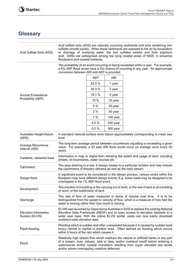
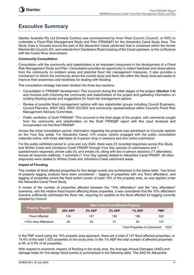
Flood Management Advisory
Committee Meeting
WEDNESDAY 24 JULY 2024
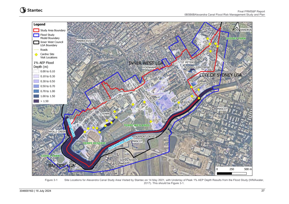
2:00 PM
1 Apologies
2 Disclosures
of Interest
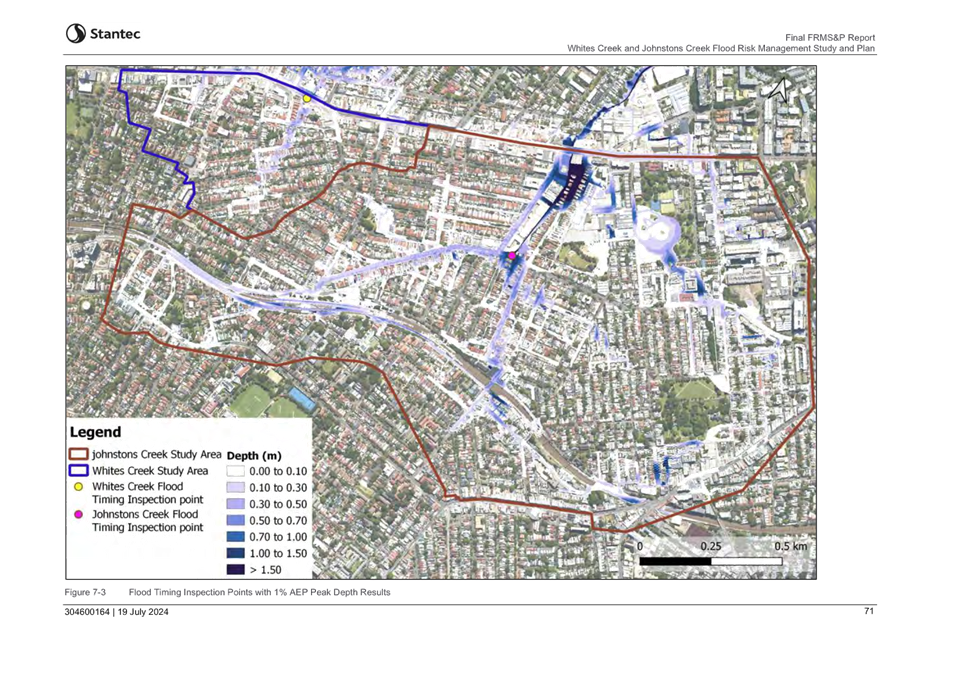
3 Confirmation
of Minutes Page
Minutes of 29 February 2024 Flood
Management Advisory Committee 3
4 Staff
Reports
ITEM Page
FMACC0724(1) Item 1 Outstanding
Actions Register 9
FMACC0724(1) Item 2 Flood
Mitigation and Upcoming Projects 11
FMACC0724(1) Item 3 Outcomes of the
exhibition of the final Alexandra Canal
Flood Risk Management Study and Plan and Whites Creek
and Johnstons Creek Flood Risk
Management Study and Plan 16
5 General
Business
6 Close
of Meeting
|

|
Flood Management Advisory Committee Meeting
24
July 2024
|
Minutes
of the Flood Risk Management Advisory Committee Meeting held on 29 February
2024 on Microsoft Teams
Meeting
commenced at 2:00 PM
|
Directorate
Name
|
Infrastructure
|
|
Date / Time
|
29 February
2024 - 2:00 PM
|
|
Venue
|
Microsoft
Teams
|
|
Chairperson
|
Councillor Mat Howard
|
|
Voting
Attendees
|
Clr Mat Howard
|
Clr Marghanita
Da Cruz
|
Lois Gray (CR)
|
|
Shad Wall (CR)
|
Alexander
Bailey (SES)
|
Michael Carney
(SES)
|
|
Non –
Voting Technical Advisory Attendees
|
Ryann Midei
(IWC)
|
David Paton
(IWC)
|
James Ogg
(IWC)
|
|
Rafaah Georges
(IWC)
|
Sadeq Zaman
(DCCEEW)
|
Martin Griffin
(Stantec)
|
|
Alireza Pouya
(Stantec)
|
|
|
|
Observers
|
Klaus
Neuscheler (SES)
|
Helen Slater
(SES)
|
Robert Baker
(SES)
|
|
Anson Chang
(Stantec)
|
Habba Rahimi
(Stantec)
|
Jogo Jayanti
(City of
Sydney)
|
|
Well Yum
(City of
Sydney)
|
Aaron Biffin
(Bayside
Council)
|
Christy Li
(IWC)
|
|
Apologies
|
David Grasby
(Sydney Water)
|
|
|
|
1. 1.
Acknowledgement Of Country – Clr Howard
|
I acknowledge that we are meeting on the land of the Gadigal and
Wangal people of the Eora Nation and pay my respects to the elders past and
present and I extend that respect and acknowledgement to any Aboriginal people
who are here with us today.
|
2. Disclosures
of Interest
|
Nil.
|
3.
Confirmation of Minutes of 27 July 2023 Flood Management Advisory Committee
|
That the Minutes of the Flood Risk
Management Advisory Committee Meeting held on 27 July 2023 be confirmed.
|
4. Review
of Flood Management Advisory Committee Terms of Reference
|
SUMMARY
An amended Terms of Reference was presented to the committee
incorporating a review of NSW legislation and flood management guidance
manuals, current membership, meeting schedule, consistency with other Flood
Management Committees, and consistency with similar committees of Inner West
Council.
OFFICERS RECOMMENDATION
That the Flood Management Advisory Committee endorse the updated
Terms of Reference.
DISCUSSION
Councillor Da Cruz noted that the terms
of reference only include Transport for NSW Roads, which leaves out Maritime
and other public transport. Councillor Howard questioned whether
specifying Transport for NSW will provide them with more capacity to determine
who would be best to come address certain matters. Council Officers advised
that while Transport for NSW is a large organisation with many units of
responsibilities, the Roads unit are the third largest stakeholder in asset
ownership in terms of pipes within Inner West Council and are the most affected
by proposals to upgrade those networks and more impacted by flooding through
road closures and evacuation routes. which would be relevant to flooding,
however accepted that the Terms of Reference include Transport for NSW to
provide greater flexibility to invite specific teams with greater interest in a
particular item.
Councillor Da Cruz questioned whether we
should have a representative from Planning and Infrastructure. Council
Officers advised that the NSW Department of Climate Change, Energy,
Environment and Water are the experts for flooding in the NSW Government and
receive referrals from the Department of Planning, Housing and Infrastructure.
Councillor Da Cruz queried whether
Council has communication channels with SSROC noting a recent grant they
received from to do resilience planning. Council Officers advised that
the resilience grant was about the preservation of waste services to natural
disasters, rather than specific flood resilience. SSROC operates to serve its
member Councils and Council interacts with them though other avenues.
Councillor Howard queried how many of
the local community representative positions were currently filled and the
recruitment process for vacancies. Council Officers advised that due to
recent resignations there are 2 of the possible 8 positions filled. The terms
of reference specify that a new expression of interest is not undertaken within
6 months of a Council Elections. A new expression of interest process will be
undertaken following Council elections.
Councillor Da Cruz queried whether
Council could investigate having a pool of community members to select from
when items are relevant to their catchment as it may provide greater local
knowledge as the current commitment may discourage people from joining. Alexander
Bailey expressed that while the representatives may come from a catchment
the purpose of the committee was not on a local flooding environment, but the
general overall changes that affect the whole community. Councillor Howard noted
that what happens in one part of the community does impact what's happening in
the others, particularly regarding hydrology and flood impacts. Therefore,
having representation that reflects and reports back to the larger community
helps plays a part in the success of the committee. Council Officers noted
that this was part of the reason that the scope for possible community
representatives was broadened. The Committee supported the proposed
community representative selection criteria.
COMMITTEE RECOMMENDATION
That the
Flood Management Advisory Committee endorse the updated Terms of Reference
subject to replacing Transport for NSW Roads with Transport for NSW.
For Motion: Unanimous
|
5. Future Flood Education
|
SUMMARY
Council resolved on the 12 September 2023:
C0923(1) Item 12 – 3. That a future flood education strategy for
the wider local government area be developed and presented to the Flood
Management Advisory Committee.
Council Officers presented a report outlining the responsibilities
for Flood Education and ways in which Council can support these efforts.
Community engagement is an integral part of the flood risk management process
as it raises overall community flood awareness and supports community response
strategies. The NSW State Emergency Service (SES) acts as the lead agency under
the Emergency Management framework for flooding and flood management, including
ongoing community awareness and education, informing the community on how to
prepare for and act in response to a flood threat, and assisting with the
issuance of flood warnings.
A proposed shortlist of actions and activities was presented to the
committee with short-, medium- and long-term timeframes, as outlined in the
report to the committee.
OFFICERS RECOMMENDATION
That the Flood Management Advisory Committee support the schedule of
actions to be taken to facilitate flood education within Inner West Council.
DISCUSSION
Lois Gray suggested that when a Flood
Plan document is adopted by Council, that real estate agents in the LGA be
informed. Councillor Howard agreed to Lois’ suggestion and
proposed an amendment to the recommendation that Council develop a flier or
postcard regarding flooding and relevant services in the local area including
the SES that can be made available through customer service centres, libraries
and be made available to local real estate or rental agencies for new residents
to the local community.
Alexander Bailey noted that the SES
would look forward to a closer liaison between Ashfield, Leichhardt and Council
in terms of presentations to the community and what the planning indicates.
Alexander noted that through the indication of what state emergency services
can respond to, local communities can be become more resilient by becoming
better informed, allowing them to prepare ahead and watch the warning signs.
Councillor Howard questioned whether
Council will be working with our local SES commands to deliver some of that
information. Council Officers responded that Council will be doing
drop-in sessions where the SES will be invited to those sessions to engage with
the community such as when Council did the Hawthorn Canal, Dot Rd Canal and
Marrickville Valley engagement. Councillor Howard proposed that the
Committee note that the proposed drop-in sessions will be held with our local
SES units.
Robert Baker queried whether the
proposed signage would include potential evacuation routes. Council Officers
responded that there is currently no specific schedule of signage yet. Councillor
Howard proposed that in the public signage section, Council to investigate
the role of specific evacuation signage and how that might compliment other
public education programs Council is undertaking.
Councillor Da Cruz questioned whether
public education programs need to be aimed at different groups visiting our
community. Council Officers responded that a program that accounts for all visitors, the scope of a campaign
can become unmanageably broad. However, by engaging the local community first
and supporting their preparations and awareness, it would reduce the burden on
our SES partners in a flood event.
Councillor Da Cruz questioned whether
Council’s education program identify the community groups who are at risk
because they are located on the foreshore. Councillor Howard suggested
we were to add to the recommendation that we increase public engagement through
working with community organisations located on the foreshore who may be
potentially at a higher risk of flooding.
Councillor Howard proposed an amended
motion to include the development of a flier regarding flooding and relevant
services in the local area to be provided Council’s Customer Service
Centres and to real estate agents to inform new and existing residents of the
local community. The Committee debated the purpose and scope of such a
communication piece.
Robert Baker raised concerns to not
being able to tell when roads are closed due to flooding. Robert Baker
suggested that Council investigate how Council can put road closure information
on the Councils website, noting that some Councils have arrangements with Live
Traffic to get local road information up onto Live Traffic. David Paton advised
that Council is already investigating ways to enact such an arrangement to
allow Council staff to upload information to the Live Traffic website.
Councillor Howard moved an amended
recommendation to address the Committees concerns.
COMMITTEE RECOMMENDATION
1.
That the Flood Management
Advisory Committee support the schedule of actions to be taken to facilitate
flood education within Inner West Council.
2.
That Council develop
communications regarding flooding and relevant services in the local area
including the SES that can be made available through customer service centres,
libraries and be made available to local real estate or rental agencies for new
residents to the local community.
3.
That Council better support
and promote the activities of the SES, including in our local newsletter.
4.
That in the development of
the Flood Information Hub, Council work to make emergency information for
accessible and visible, that Council investigates the reporting of local road
closure information.
5.
That the proposed
information sessions undertaken with the Alexandra Canal Flood Risk Management
Study and Plan and Johnstons Creek Whites Creek Flood Risk Management Study and
Plan be undertaken with SES Officers.
6.
That Council investigate
the publication of evacuation routes among consideration of public signage.
7.
That Council engage
directly with community groups on the foreshore impacted by flooding.
For Motion: Unanimous
|
6. Inner
West Local Flood Plan
|
SUMMARY
This report details the amendments to the Inner West Emergency Plan,
adopted in 2016, particularly the Volume 1 of the Flood Emergency Sub Plan. It
was noted that these amendments have been led by the NSW SES Metro Zone,
following the adoption of the Australian Warning System and changes to NSW
Government departments and agencies.
Helen Slater from NSW SES Metro Zone was
invited to providing an overview of the Local Flood Plans for the
Inner West. Volume 1 addresses the roles and responsibilities in flood
emergency management as well as the range of strategies available to manage an
emergency. The updates impact the Warning Categories and NSW Government
departments and agencies described in Volume 1.
NSW SES continues to progress the development Volume 2 and 3, which
describes the hazard and risk specific to the Inner West and outline how SES
will manage these specific floods the triggers used to enact the various strategies
in the plan.
OFFICERS RECOMMENDATION
That the Flood Management Advisory Committee endorse
the amended Inner West Council Flood Emergency Sub Plan
DISCUSSION
The Committee members supported the Council Officers recommendation.
COMMITTEE RECOMMENDATION
That the
Flood Management Advisory Committee endorse the amended Inner West Council
Flood Emergency Sub Plan.
For Motion: Unanimous
|
7.
Presentation of Alexandra Canal Flood Risk Management Study & Plan and
Johnstons Creek / Whites Creek Flood Risk Management Study& Plan
(Confidential)
|
SUMMARY
The Alexandra Canal Flood Risk Management Study and Plan and
Johnstons Creek & Whites Creek Flood Risk Management Study and Plan were
presented to the Committee.
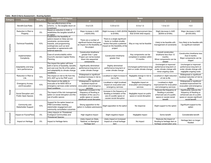
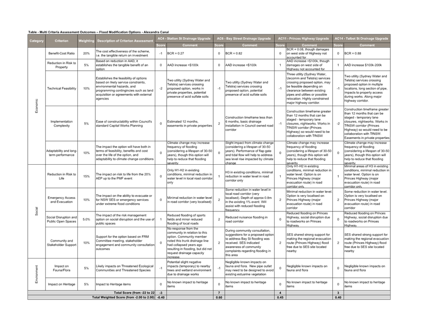
Martin Griffin, representing Council’s technical consultant
Stantec was invited to provide a presentation detailing the progress to date,
the risks affecting the two catchments and potential damages, the overall
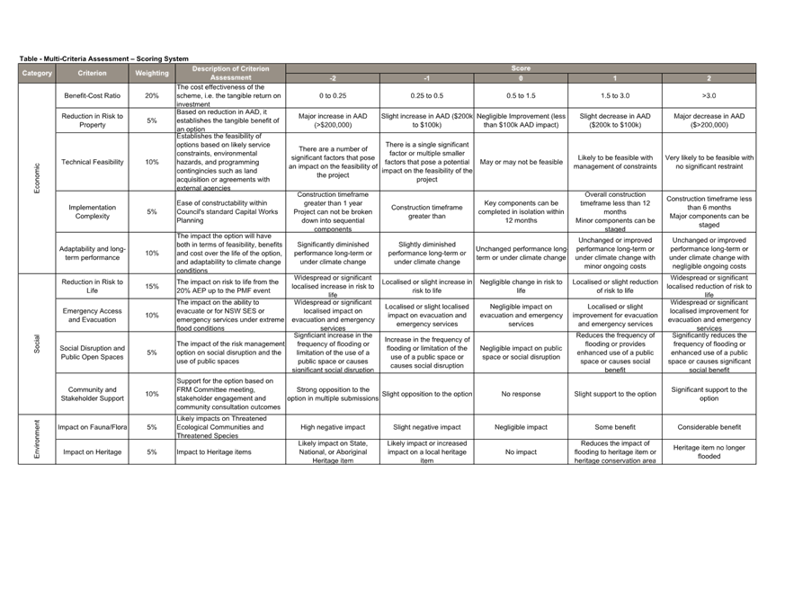
review of options and the multicriteria analysis that was used to develop the
final prioritisation listings that are presented in the Draft Flood Risk
Management Studies and Plans for the two catchments.
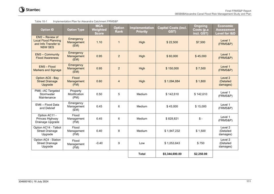
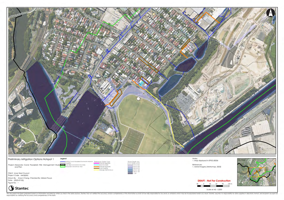
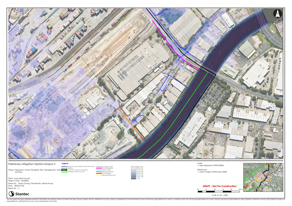
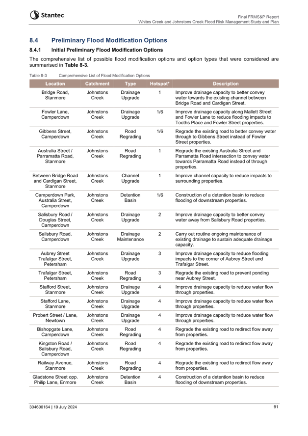
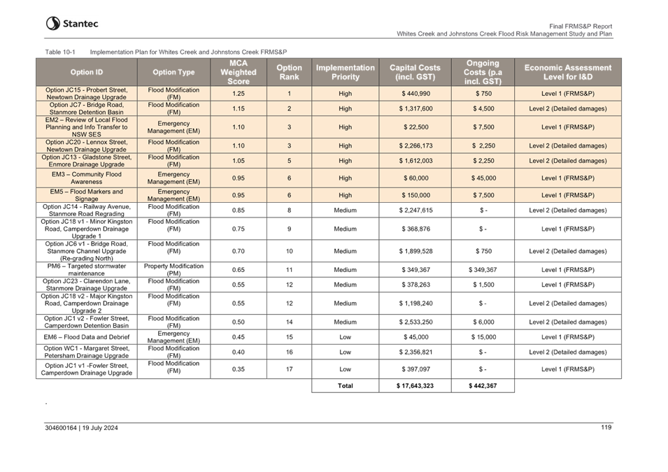
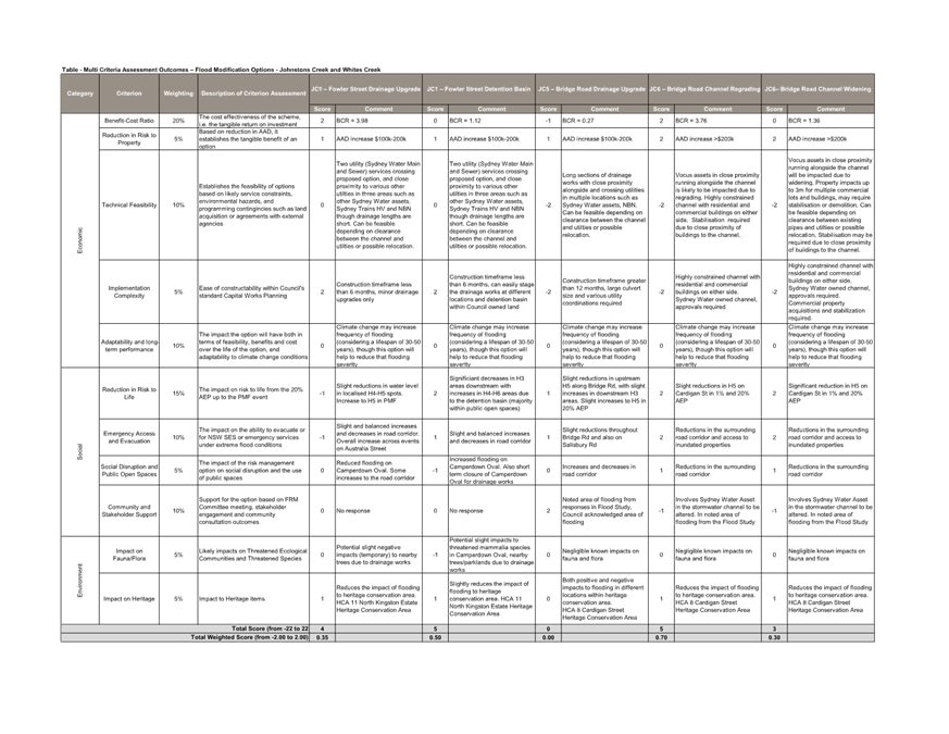
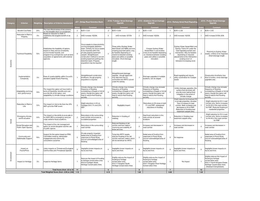
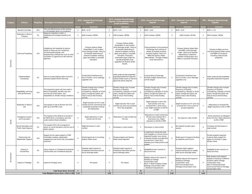
The initial assessment included 21 options for Alexandra Canal, 9
options for Whites Creek and 28 options for Johnstons Creek. The final
implementation plan includes
-
9 options for Alexandra Canal (4 flood management options, 1
property management option and 4 emergency management options) with the 4 high
priority options totalling $1.3 million
-
17 options for Johnstons Creek and Whites Creek (11 flood
management options, 1 property management option and 4 emergency management
options) with the 7 high priority options totalling $5.9 million.
Subject to the endorsement of the Committee, Council Officers will
take the Studies and Plans to Council in April for community engagement in May.
The community engagement would incorporate comments and feedback from the
affected residents about the proposed options, which could result in amended
prioritisation if the community expressed strong desire for particular
outcomes.
OFFICERS RECOMMENDATION
1. That the Flood Management Advisory
Committee endorse the public exhibition of the Alexandra Canal Flood Risk
Management Study and Plan.
2. That the Flood Management Advisory
Committee endorse the public exhibition of the Johnstons Creek and Whites Creek
Flood Risk Management Study and Plan.
DISCUSSION
The Committee members supported the Council Officers recommendation.
COMMITTEE RECOMMENDATION
1.
That the Flood Management
Advisory Committee endorse the public exhibition of the Alexandra Canal Flood
Risk Management Study and Plan.
2.
That the Flood Management
Advisory Committee endorse the public exhibition of the Johnstons Creek and
Whites Creek Flood Risk Management Study and Plan
For Motion: Unanimous
Update on Council Resolutions:
Council Officers advised that the
letters for the community member affected by Hawthorn Canal and Dot Road Canal
have been distributed.
Update on Flood Mitigation Programming
Council Officers advised this was
touched on in the July Flood Advisory Committee Meeting, and that council is
looking to have a document stating Council have the 7 reports which lists
options on improving and mitigating flooding for Councils investigation and how
Council is progressing. It was noted that this document will be brought back to
the Committee for review.
|
Meeting Closed 4:05pm – Clr Howard
|
|
|
Flood Management Advisory Committee Meeting
24
July 2024
|
Item No: FMACC0724(1)
Item 1
Subject: Outstanding Actions Register
Prepared By: David
Paton - Engineering Services Manager
Authorised By: Ryann Midei -
Director Infrastructure
|
RECOMMENDATION
That the Outstanding Actions
Register be received and noted.
|
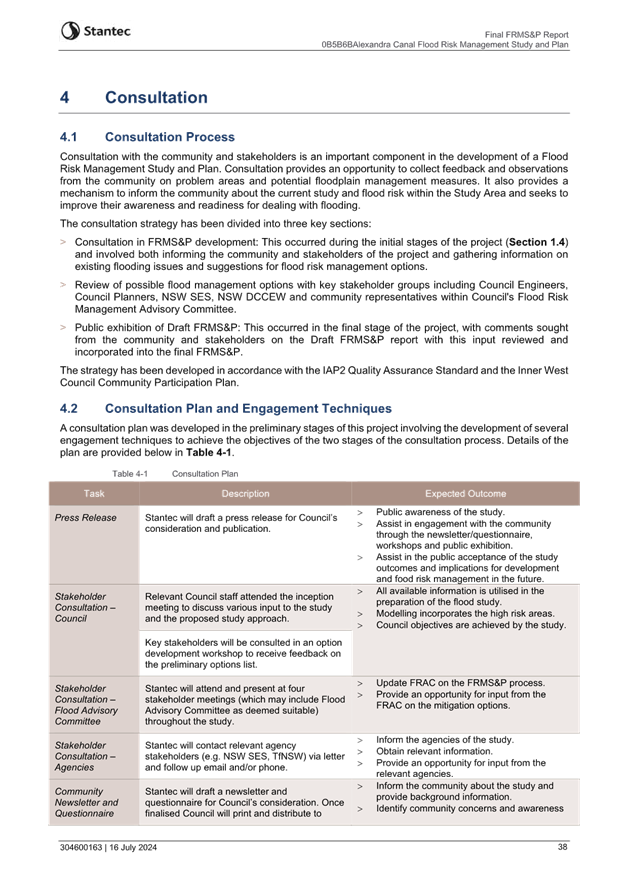
OUTSTANDING ACTIONS REGISTER
The following table provides the status of outstanding
actions from previous Flood Management Advisory Committee meetings.
|
Meeting
|
Item
|
Actions
|
Comments
|
Status
|
|
29/2/24
|
4.1
|
That the Flood Management Advisory Committee endorse the
updated Terms of Reference subject to replacing Transport for NSW Roads with
Transport for NSW.
|
The Terms of Reference were adopted by Council at its
meeting on 9 April 2024
|
Completed
|
|
29/2/24
|
5.1
|
That the Flood Management Advisory Committee support the
schedule of actions to be taken to facilitate flood education within Inner
West Council.
|
Noted
|
No action required
|
|
29/2/24
|
5.2
|
That Council develop communications regarding flooding and
relevant services in the local area including the SES that can be made available
through customer service centres, libraries and be made available to local
real estate or rental agencies for new residents to the local community
|
An update will be provided at the next Committee meeting
|
In Progress
|
|
29/2/24
|
5.3
|
That Council better support and promote the activities of
the SES, including in our local newsletter.
|
An update will be provided at the next Committee meeting
|
In Progress
|
|
29/2/24
|
5.4
|
That in the development of the Flood Information Hub,
Council work to make emergency information for accessible and visible, that
Council investigates the reporting of local road closure information.
|
An update will be provided at the next Committee meeting
|
In Progress
|
|
29/2/24
|
5.5
|
That the proposed information sessions undertaken with the
Alexandra Canal Flood Risk Management Study and Plan and Johnstons Creek
Whites Creek Flood Risk Management Study and Plan be undertaken with SES
Officers.
|
SES Officers participated in the four information sessions
during the exhibition period.
|
Completed
|
|
29/2/24
|
5.6
|
That Council investigate the publication of evacuation
routes among consideration of public signage.
|
An update will be provided at the next Committee meeting
|
In Progress
|
|
29/2/24
|
5.7
|
That Council engage directly with community groups on the
foreshore impacted by flooding.
|
An update will be provided at the next Committee meeting
|
In Progress
|
|
29/2/24
|
7.1
|
That the Flood Management Advisory Committee endorse the
public exhibition of the Alexandra Canal Flood Risk Management Study and
Plan.
|
Council resolved to exhibit the Study and Plan at its
meeting on 9 April 2024. Exhibition is now complete, with its outcomes being
tabled at July committee meeting
|
Completed
|
|
29/2/24
|
7.2
|
That the Flood Management Advisory Committee endorse the
public exhibition of the Johnstons Creek and Whites Creek Flood Risk
Management Study and Plan
|
Council resolved to exhibit the Study and Plan at its
meeting on 9 April 2024. Exhibition is now complete, with its outcomes being
tabled at July committee meeting
|
Completed
|
ATTACHMENTS
Nil.
|
|
Flood Management Advisory Committee Meeting
24
July 2024
|
Item No: FMACC0724(1)
Item 2
Subject: Flood Mitigation and Upcoming Projects
Prepared By: David
Paton - Engineering Services Manager
Authorised By: Ryann Midei -
Director Infrastructure
|
RECOMMENDATION
The Flood Management
Advisory Committee receive and note this report.
|
STRATEGIC
OBJECTIVE
This report
supports the following strategic directions contained within Council’s
Community Strategic Plan:
1: An
ecologically sustainable Inner West
5:
Progressive, responsive and effective civic leadership
EXECUTIVE SUMMARY
Council have adopted four Flood
Risk Management Study and Plans to date, with an additional two to be reported
to Council for adoption in September 2024. These Flood Risk Management Study
and Plans outline proposed flood mitigation options across the Local Government
Area in order of priority or in accordance with cost benefit throughout their
relevant catchments.
Council have
implemented a number of flood mitigation actions across the Local Government
Area, including:
· A review of
structural mitigation options identified in Flood Risk Management Studies and
Plans
· A grant
application for the Marrickville South Flood Study,
· Progressed grant
funded flood mitigation designs at Lord Street Newtown and three other
locations in Marrickville and Newtown,
· Responded to a
significant flood event in April 2024, and
· CCTV inspections,
cleaning and maintenance to stormwater assets.
BACKGROUND
At the Flood Management Advisory
Committee Meeting held on the 29 February 2024, the Flood Management Advisory
Committee was advised that an update on flood mitigation programming would be
brought to the Committee for review.
DISCUSSION
Flood Mitigation Programming
Council have adopted four Flood
Risk Management Study and Plans to date, with an additional two to be reported
to Council for adoption in September 2024. These include:
Adopted
1. Eastern Channel Subcatchment Management Plan (Golder
Associates, 2011)
2. Marrickville Valley Flood Risk Management Study and
Plan (Cardno,2017)
3. Leichardt Flood Risk Management Study & Plan
(Cardno, 2017)
4. Dobroyd Canal and Hawthorne Canal Flood Risk Management
Study and Plan (WMA, 2019)
To be adopted
5. Alexandra Canal Flood Risk Management Study and Plan
(Stantec, 2024)
6. Whites Creek and Johnstons Creek Flood Risk Management
Study and Plan (Stantec, 2024).
The studies and plans provide a
list of flood mitigation options covering almost 90% of the Local Government
Area, including recommendations for structural management options, such as
stormwater drainage upgrades which have been ranked in order of priority or in
accordance with cost and benefit.
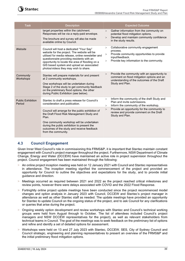
|
Catchment
|
Infrastructure
Upgrade Options
(Total
number/cost)
|
Costs/ Prioritisation
|
|
Eastern Channel Subcatchment
|
10/ $16 million
|
Estimated project costs range
from $76,000 to $3.6 million
|
|
Marrickville Valley
|
32/ $35 million
|
9 projects are listed as high
priority, 11 as medium and 12 as low
|
|
Leichardt (whole of former LGA)
|
36/ $250 million
|
The recommended projects are
prioritised and categorised in their respective sub-catchments
|
|
Dobroyd Canal and Hawthorne Canal
|
6/ $20 million
|
3 projects are listed as high
priority, 2 as medium and 2 as low
|
|
Alexandra Canal
|
4/ $5 million
|
One project is listed as high
priority, 2 as medium and 1 as low
|
|
Whites Creek and Johnstons Creek
|
12/ $15 million
|
4 projects are listed as high
priority, 6 as medium and 2 as low
|
Although the studies and plans do
not provide a prescribed schedule for implementation, they identify the
mitigation measures that have merit for implementation as funding becomes
available or when opportunity arises for Council to seek funding and support
through NSW government including the Department of Planning and Environment.
These plans provide a sound basis from which Council can make decisions
concerning the undertaking of works, planning decisions, and developing
response arrangements to reduce the impact of flooding.
Notwithstanding the above, a
further analysis of the mitigation options will be undertaken to assist with
the comparative prioritisation between individual options across the various
catchments and help formulate the annual Capital Works programs and balance
community expectations.
A report will be prepared for the
next Committee meeting to present the outcomes of this analysis.
Marrickville South Flood
Study
Council
has applied to the Department of Planning and Environment under the Floodplain
Management Program for funding for the Marrickville South Flood Study in early
May 2024. This is the final catchment area within Inner West Council Local
Government Area that has not had a comprehensive catchment-based modelled flood
study.
The study area is approximately
200 hectares and encompasses areas draining directly to the Cooks River,
including parts of the suburbs of Marrickville and Dulwich Hill, and is bounded
by the Cooks River in the south, Garnett Avenue to the west and New Canterbury
Road to the north.
The catchment is fully urbanised
and susceptible to localised flash flooding. Low lying areas along the Cooks
River are particularly susceptible to overland flooding during high tides or
river flood event. The age of the area means that there are also many trapped
low points which are particularly susceptible to flooding.
The flood study will provide
updated 2D flood depth modelling with TUFLOW, and more comprehensive
identification of flood affected lots within this area. Characterisation of
flood behavior and an identification of flood affected properties within the
area will support better targeting of planning controls and facilitate future
Flood Risk Management Planning.
Previous studies were limited to
localised 1D studies of parts of the area (approximately 60% of proposed study
area), undertaken in 2000 and 2009 and identifying 106 properties affected by flooding
in the 1% Annual Exceedance Probability event.
The project is anticipated to be
commenced during the 2024/25 financial year after a decision on the funding
application (a condition of the grant application), which is anticipated in the
coming months.
Lord Street Design Update
The Lord Street Drainage Upgrade
project was identified as a high priority project in the Eastern Channel East
Subcatchment Flood Risk Management Study and Plan, listed for the 2020/21
Stormwater Capital Works Upgrade Program for design.
The initial scoping consisted of
stormwater pit and pipe upgrades and extensions through John Street, Wells
Street, Pearl Street, Edgeware Road and Lords Street, Enmore and a consultant, Warren
Smith Partners (WSP) were engaged by Council to undertake this design concept.
There have been a number of
challenges during this design process and as a result the original project
scope has evolved. WSP commenced borehole and pothole investigations to
accurately identify underground services, and as a result several have been
detected in the project area, including Transgrid high voltage transmission
lines, Ausgrid lines and high-pressure Jemena Gas lines.
The main difficulty has been to
design stormwater pipes that have safe clearance from existing services, hence
reducing not only construction costs but risk to life during the construction
phase of this project.
Design Grant Funding
Council has successfully obtained
funding from the Department of Planning and Environment in January 2024,
totalling $231,392 under the Flood Recovery and Resilience Grant program.
The grant fund is for 75% of
proposed design work and requires a 25% Council co-contribution of $107,983.25,
with a total project cost of $339,375.25 for the following projects:
1. Illawarra Rd, Marrickville - Increase stormwater inlet
capacity along Illawarra Rd, York and Shephard Streets, Marrickville. This
project is from the Marrickville Valley Flood Risk Management Plan and is
listed as high priority.
2. Addison Road, Marrickville - Installation of new inlet
pits and 600mm diameter pipes along England Avenue, Agar Street and Wemyss
Street, Marrickville. This project is from the Marrickville Valley Flood Risk
Management Plan and is listed as high priority.
3. Edgeware Rd, Newtown New pit/pipe along Edgeware Rd
from Sarah St to Camden Street. New Pit/pipe at the corner of Lynch Avenue and
Edgeware Rd. This project is from the Eastern Channel Subcatchment Management
Plan and listed as fourth in regard to economic ranking.
These designs are currently under
way and are anticipated to be completed by June 2025. Council will need to
apply again for funding from Department of Planning and Environment for the
delivery of these works.
April 2024 Flood Response
The rainfall events in April 2024
occurred in short intense bursts, with 6th April having the highest rainfall
for the month at 167mm, measured at the Marrickville Golf Club. This resulted
in Council receiving a total of forty-nine requests from residents across the
LGA. Council staff arranged times, convenient to the residents and met most of
them (dependent on resident availability) on site to better understand their
concerns and action accordingly.
As a result of these site
meetings and subsequent investigations, the following projects were scoped and
brought forward into Council’s 2024/25 Stormwater Capital Works Program
for design, with delivery in 2025/26:
1. Roseberry
Street, Balmain
2. Ramsay
Street and Bland Street, Haberfield
3. Palace
Street and Holden Street, Ashfield
4. Pyrmont
Street, Queen Street and Robert Street, Ashfield
5. Malakoff
Street, Marrickville
6. Piggott
Street, Dulwich Hill
In addition, minor modifications
will be made to the local drainage systems at these locations as part of the
2024/25 Stormwater Capital Works Program to improve the existing systems and optimize
capacity.
Hawthorne Parade, Haberfield was
also identified as requiring stormwater upgrade works during this process. In
addition to stormwater pit and pipe upgrades, this location will also require
upgrade to multiple elements, including kerb and gutter and road re-sheeting,
estimated at more than $1 million. These works are currently being considered
for construction on a staged basis from 2026/27, with design to take place in
2025/26.
Flooding also occurred in the
streets around Northcote Street Marrickville, which already has stormwater
upgrade works programmed for 2024/25.
Stormwater Asset Maintenance
Stormwater asset maintenance can
be described as actions that are undertaken either on a day-to-day basis
necessary to meet levels of service delivery requirements and can include
clearing debris from stormwater pits and pipes and proactive and reactive inspections,
undertaken by in-house technical staff and/or specialist contractors. These
activities do not improve the condition of the assets; however, they provide
relief by removing blockages within the stormwater network or assisting with
investigative works for future planning.
In the 2023/24 financial year Council
have spent a total of $183,742.29 on stormwater CCTV inspections and $243,587.17
on stormwater pit and pipe cleaning, covering 18 kilometres or close to 10% of Councils
stormwater network. Locations are most often actioned based on reactive
responses or resident requests.
Dependent on the findings of
these inspections, they can form the basis for projects being added to future
Councils Stormwater Capital Works Program, for renewal and/or upgrade.
Otherwise, they may result in minor maintenance or upgrade works by
Council’s Civil Works Team, such as new pits or reconstruction of inlet
pits.
FINANCIAL IMPLICATIONS
There are no financial
implications associated with the implementation of the proposed recommendations
outlined in the report.
ATTACHMENTS
Nil.
|

|
Flood Management Advisory Committee Meeting
24
July 2024
|
Item No: FMACC0724(1)
Item 3
Subject: Outcomes of the exhibition of the final
Alexandra Canal Flood Risk Management Study and Plan and Whites Creek and
Johnstons Creek Flood Risk Management Study and Plan
Prepared By: David
Paton - Engineering Services Manager
Authorised By: Ryann Midei -
Director Infrastructure
|
RECOMMENDATION
That the Flood Management
Advisory Committee note the outcomes of the exhibition of the final draft
Alexandra Canal Flood Risk Management Study and Plan and Whites Creek and
Johnstons Creek Flood Risk Management Study and Plan and endorse them to be
tabled at Council.
|
STRATEGIC
OBJECTIVE
This report supports the
following strategic directions contained within Council’s Community
Strategic Plan:
1: An ecologically sustainable
Inner West
5: Progressive, responsive and
effective civic leadership
EXECUTIVE
SUMMARY
The draft Alexandra Canal
Flood Risk Management Study and Plan and draft Whites Creek and Johnstons Creek
Flood Risk Management Study and Plan was placed on public exhibition for five
weeks from the 4 June to the 12 July 2024.
This report discusses the
outcomes of the community engagement held for the Alexandra Canal Flood Risk
Management Study and Plan and the Whites Creek and Johnstons Creek Flood Risk
Management Study and Plan and seeks the endorsement of both documents for adoption
by Council.
BACKGROUND
At the Council meeting held on 9
April 2024, Council resolved the following in part:
3. That Council publicly exhibit the draft Alexandra
Canal Flood Risk Management Study and Plan for a period of 28 days and seek community
feedback on it.
4. That Council publicly exhibit the draft Whites Creek
and Johnstons Creek Flood Risk Management Study and Plan for a period of 28
days and seek community feedback on it.
5. That following the conclusion of the
exhibition period, the draft Alexandra Canal Flood Risk Management Study
and Plan and the Whites Creek and Johnstons Creek Flood Risk Management Study
and Plan be brought back to Council for consideration for adoption.
Council has completed five Flood
Risk Management Study and Plans across eight of its catchments, covering almost
80% of the Local Government Area (LGA). After adoption of the Alexandra Canal
Flood Risk Management Study and Plan and the Whites Creek and Johnstons Creek
Flood Risk Management Study and Plan, 90% of the LGA will have been completed.
The Alexandra Canal Flood Risk
Management Study and Plan and Whites Creek and Johnstons Creek Flood Risk
Management Study and Plan have been developed by Council Engineers,
representatives from the NSW Department of Climate
Change, Energy, the Environment and Water, and specialist flood modelling
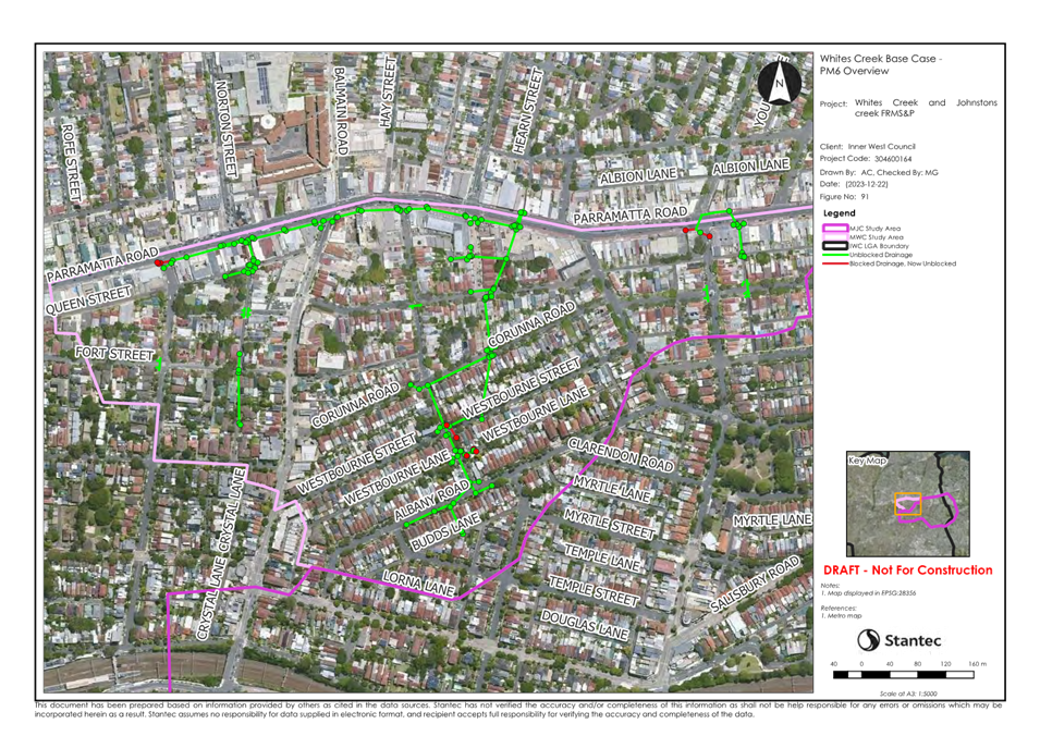
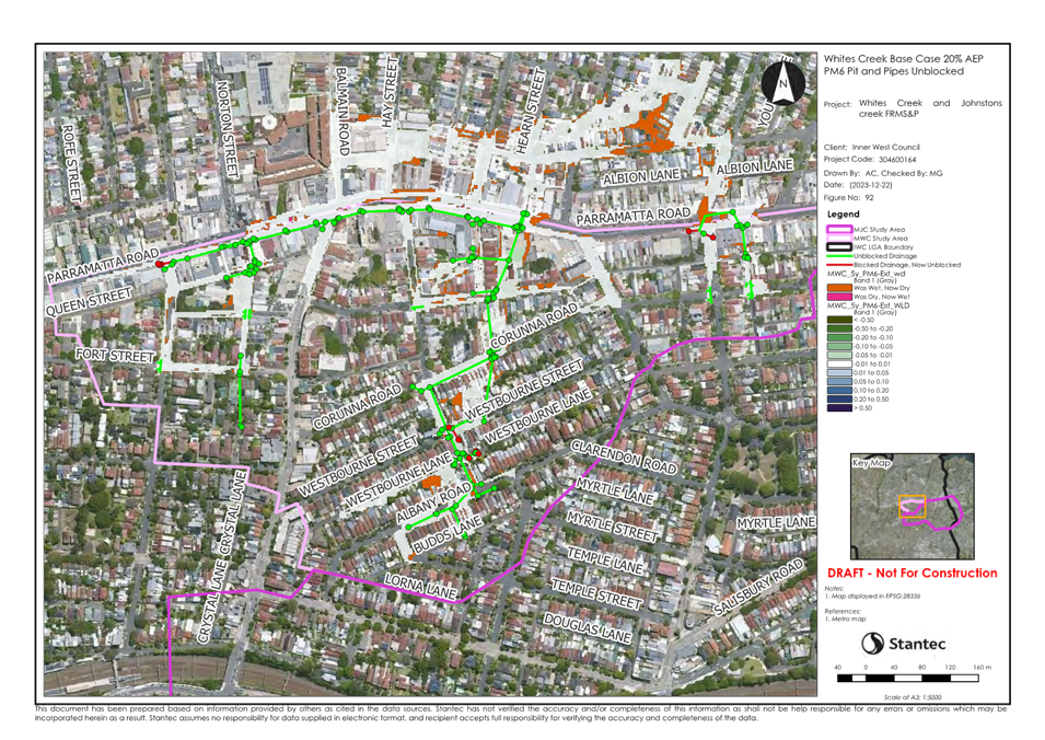
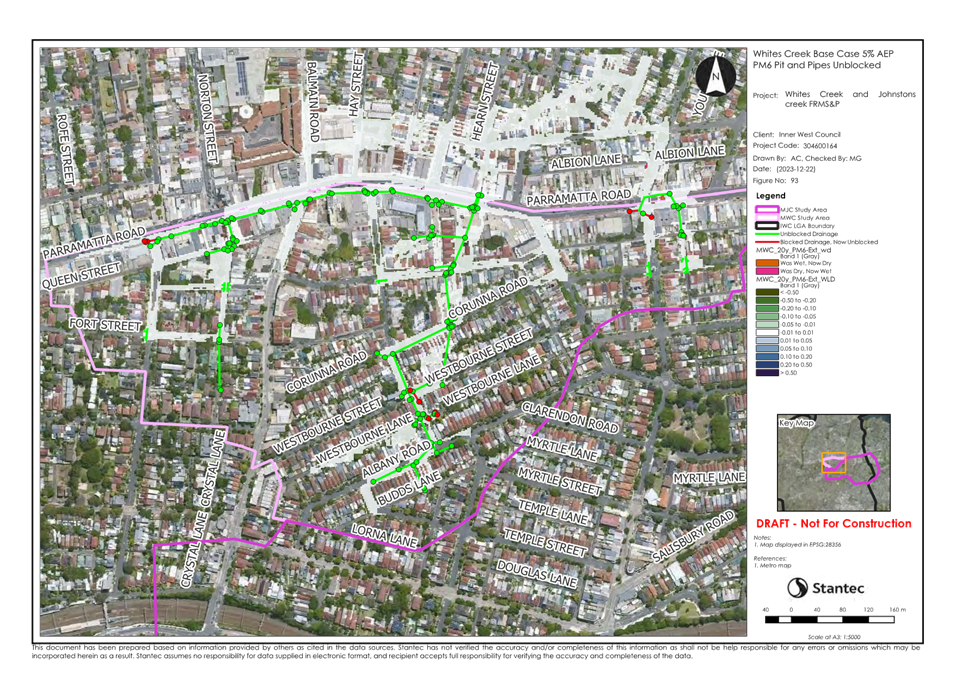
consultants Stantec.
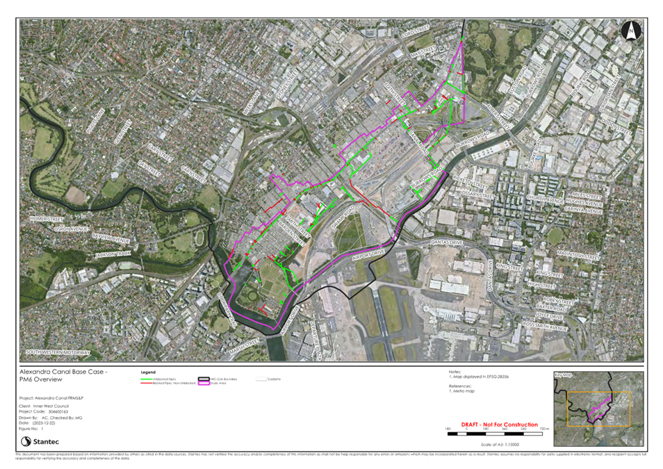
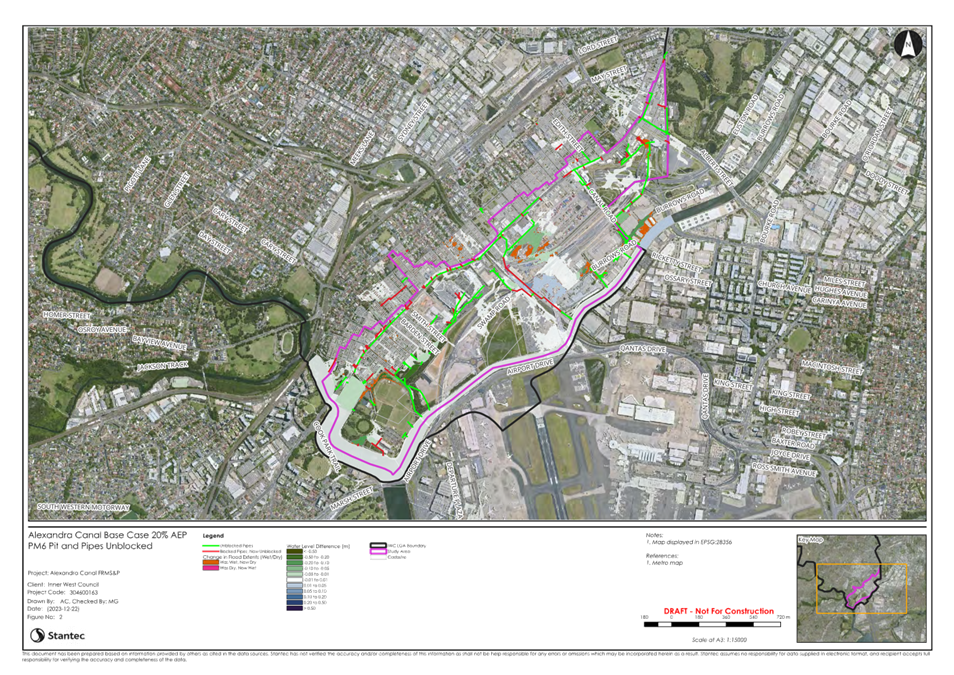
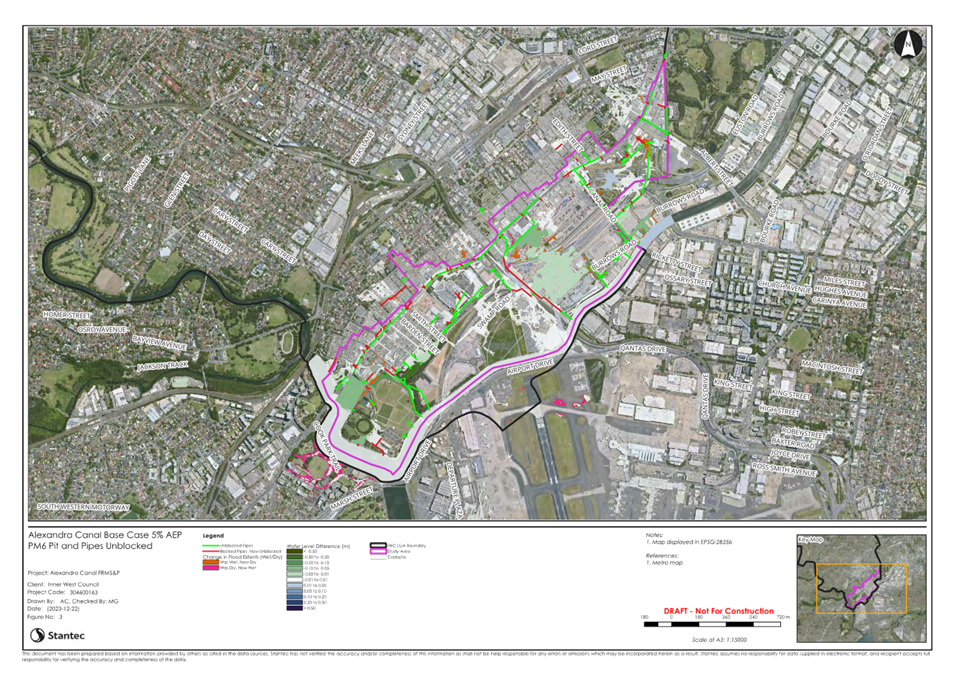
The
studies include a comprehensive review of the existing flood models for these
catchments and further modelling to assess the impacts of possible upgrade
measures to reduce flooding across the catchments.
An initial count of 40 possible
flood mitigation works, including pipe upgrades, road
modifications, detention basins and pit improvements were assessed for overall
impact and improvement to flood risk in the community, in conjunction with 6
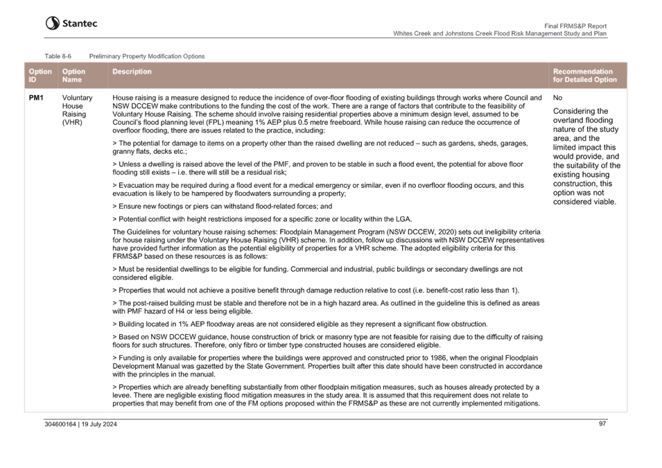
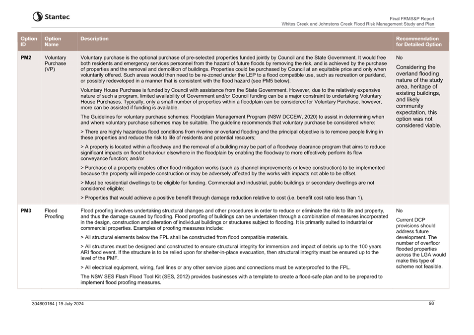
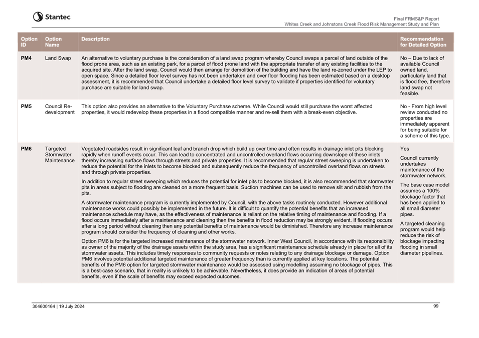
options for Council-led property modification and 6 options for emergency
management improvements.
The assessment resulted in a
shortlist of six mitigation options for Alexandra Canal, 13 mitigation options
for Whites Creek and Johnstons Creek, and five property and emergency
management measures for both studies.
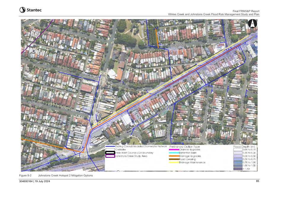
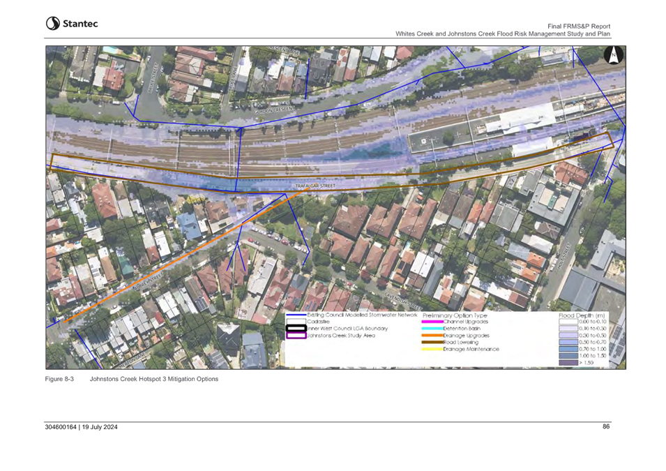
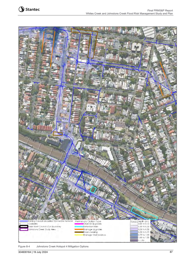
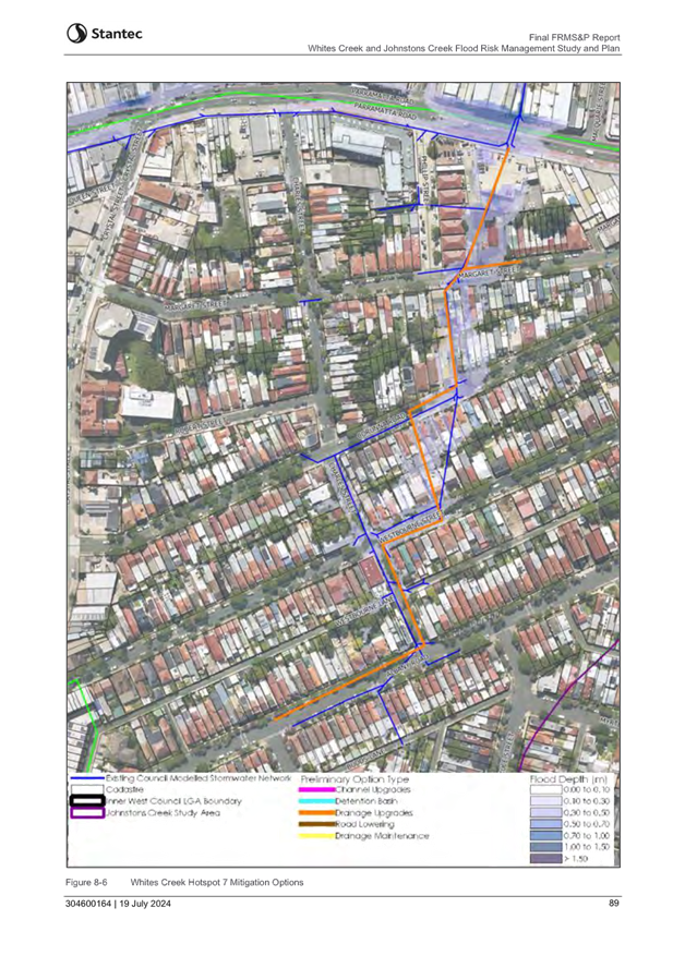
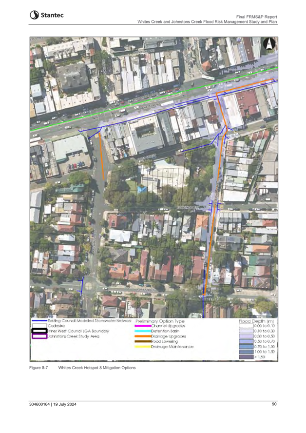
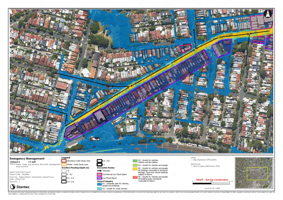
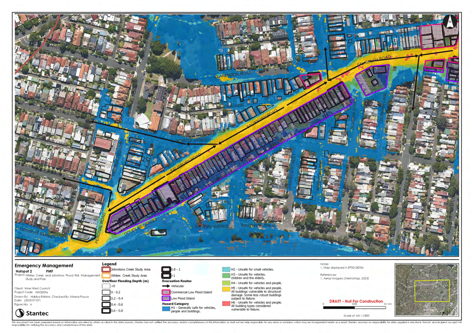
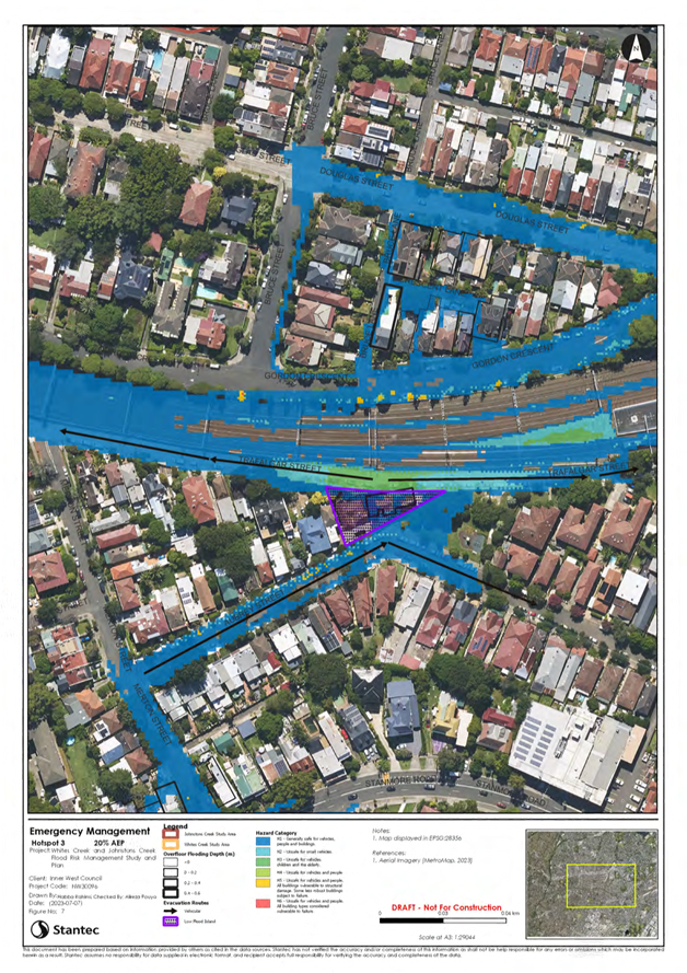
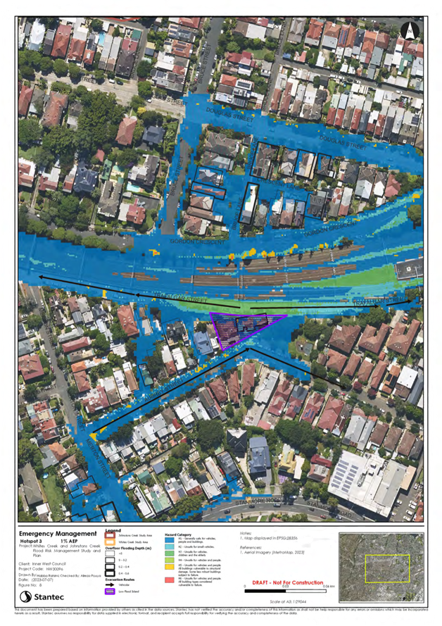
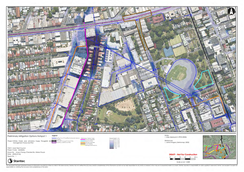
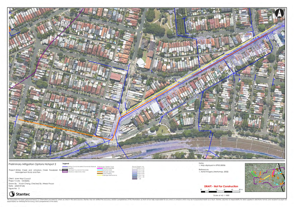
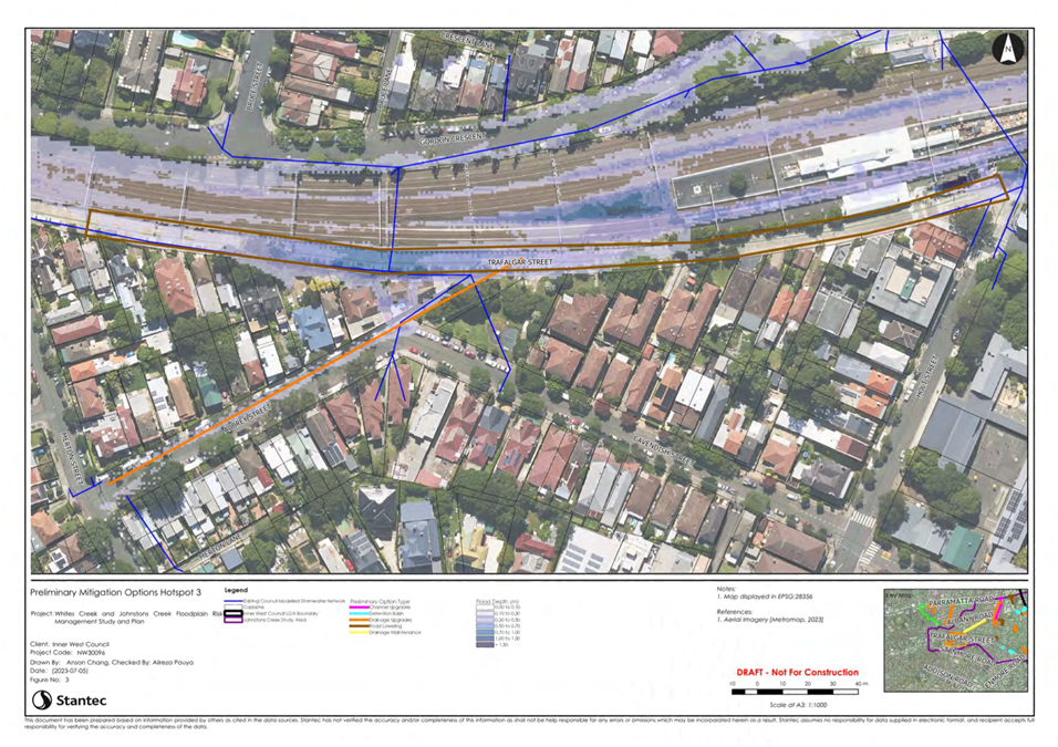
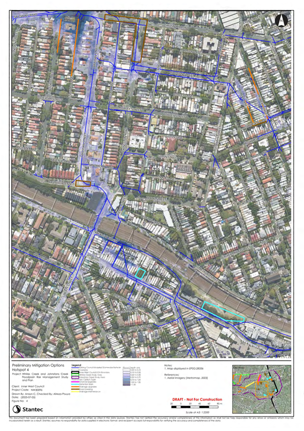
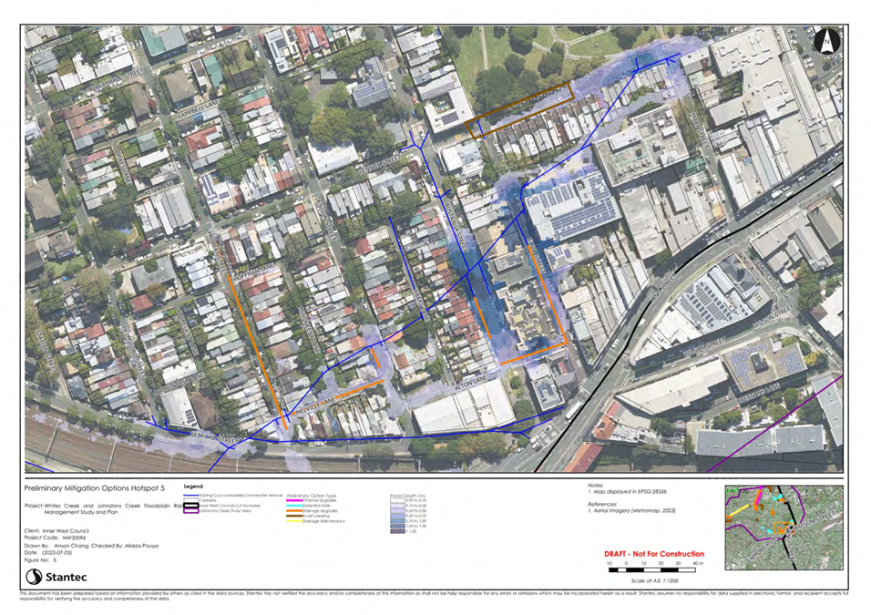
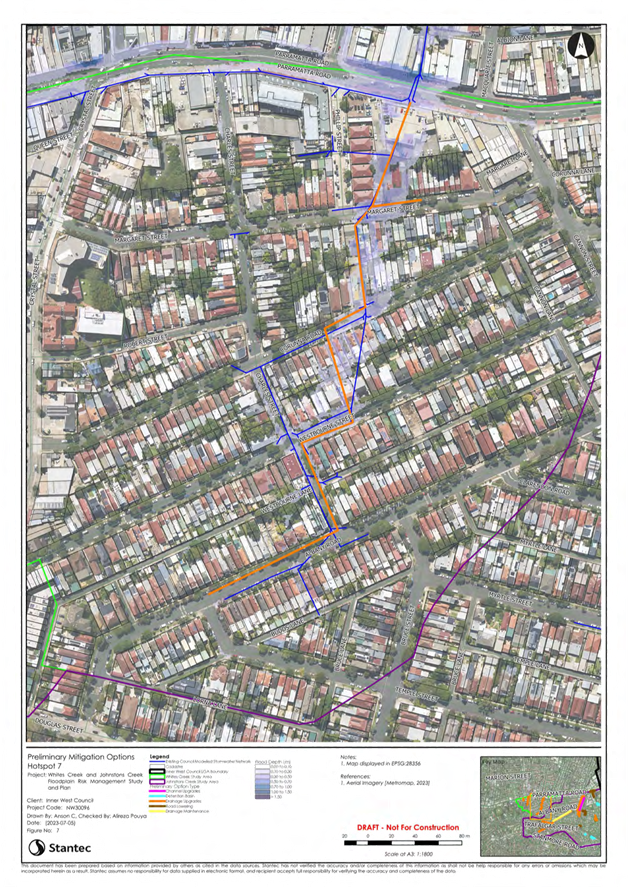
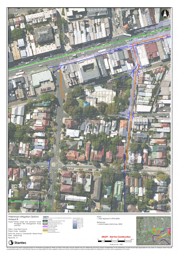
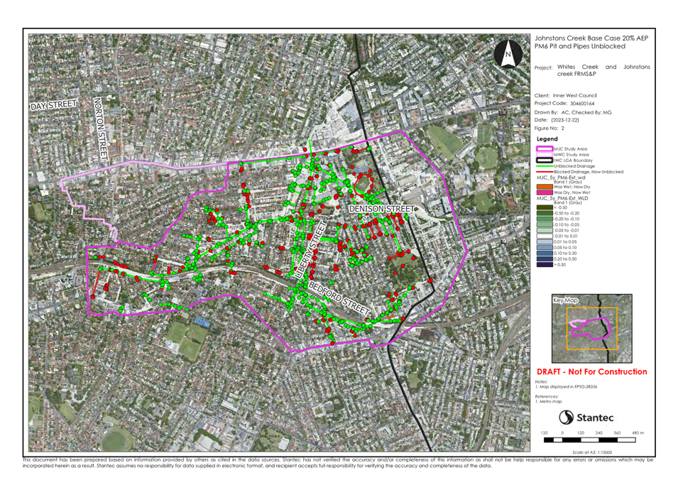
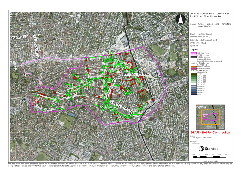
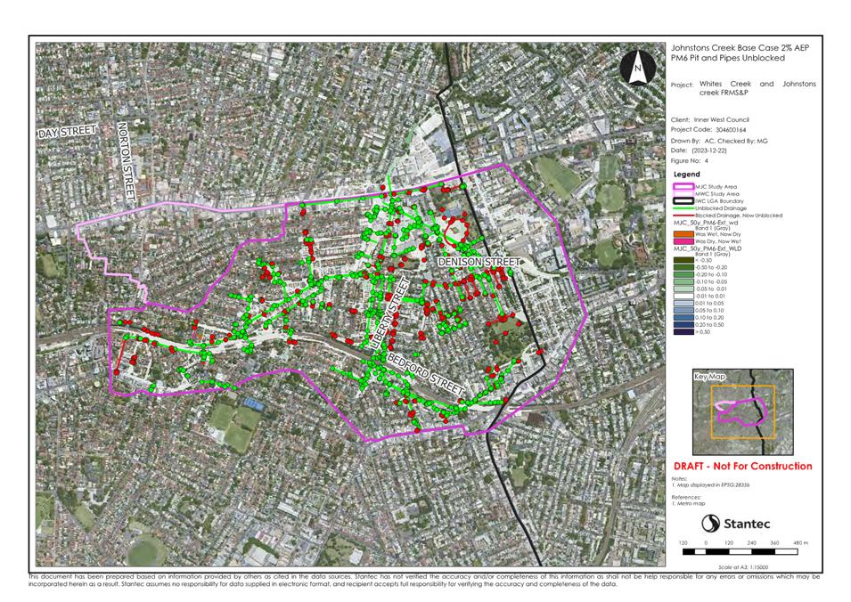
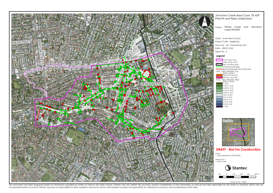
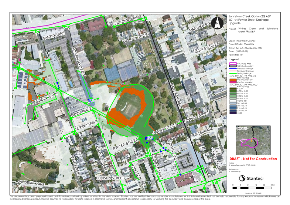
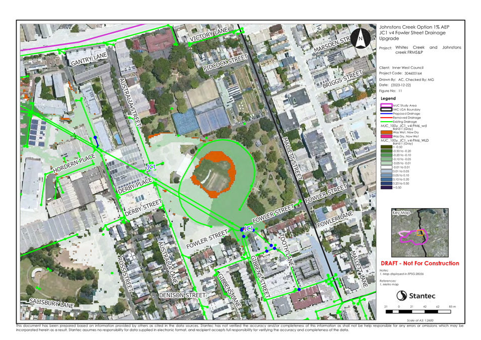
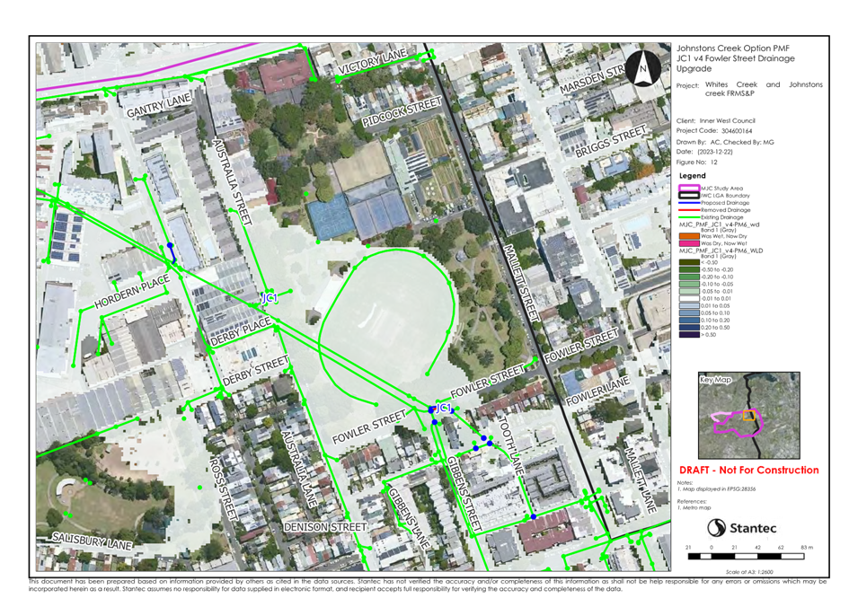
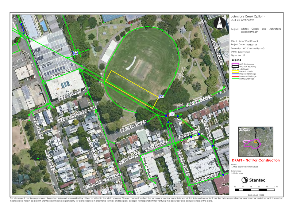
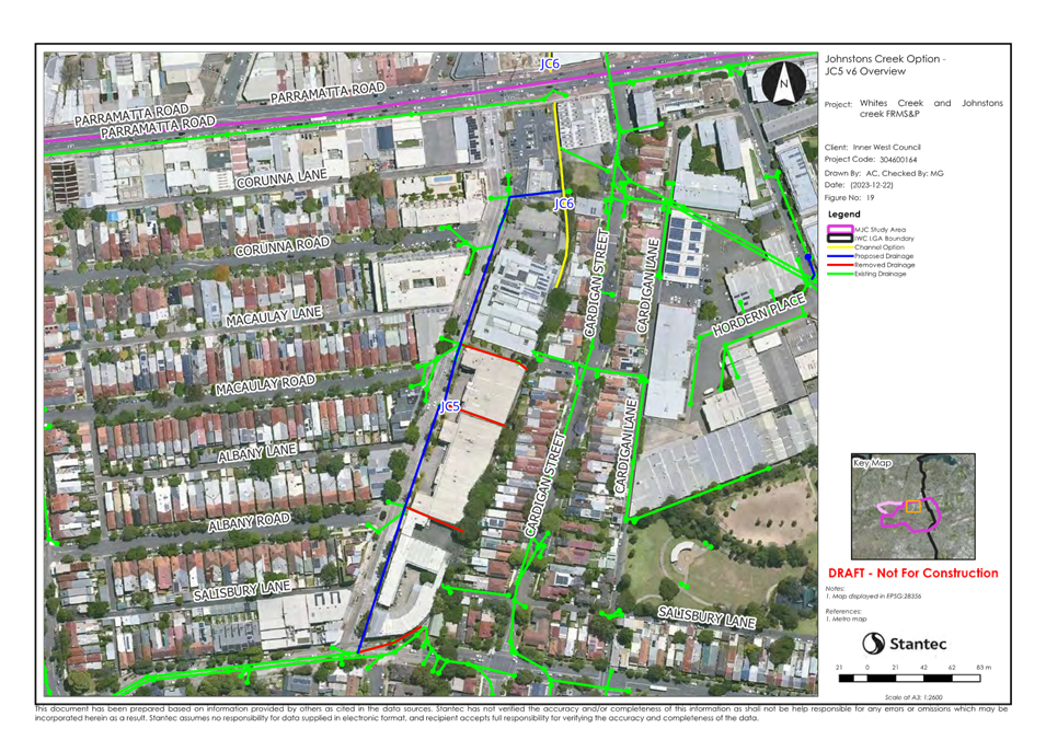
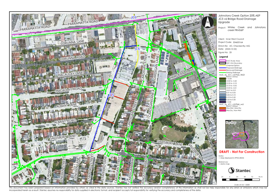
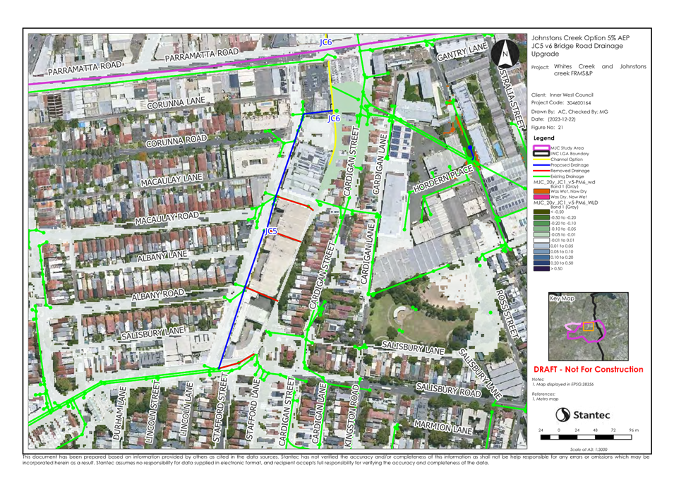
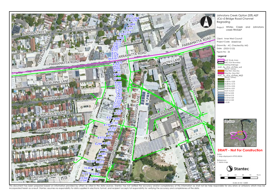
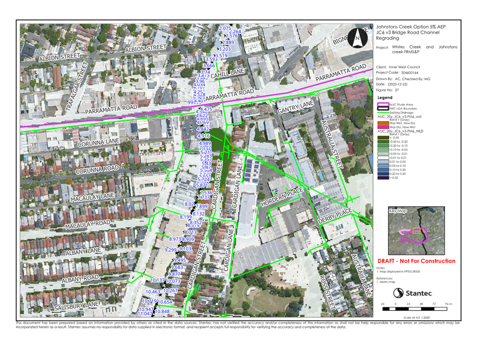
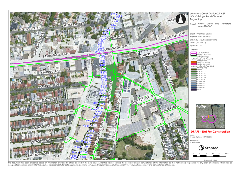
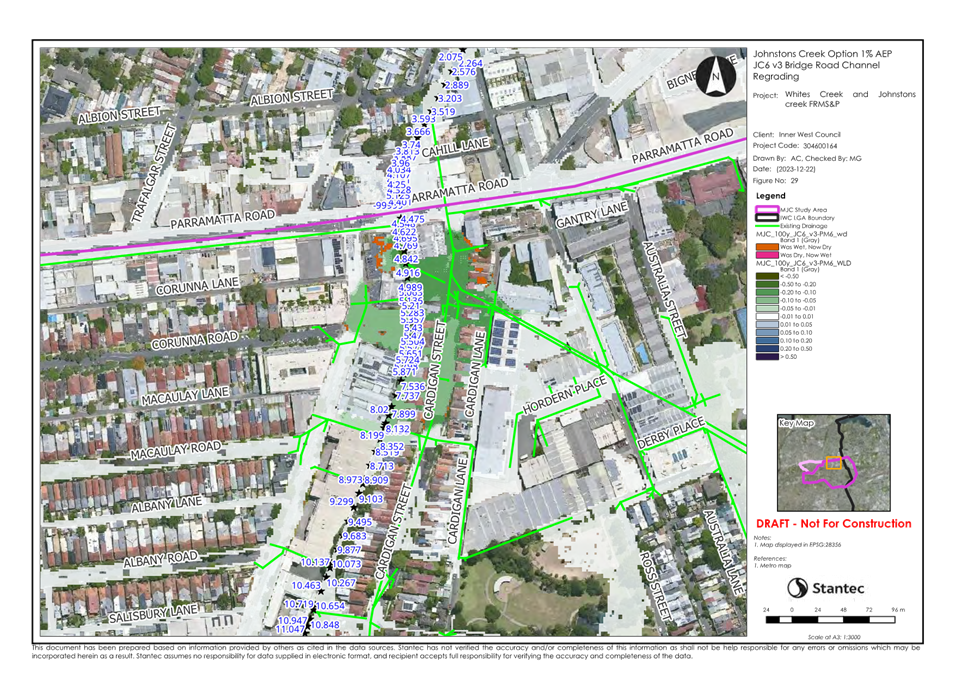
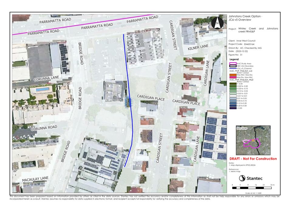
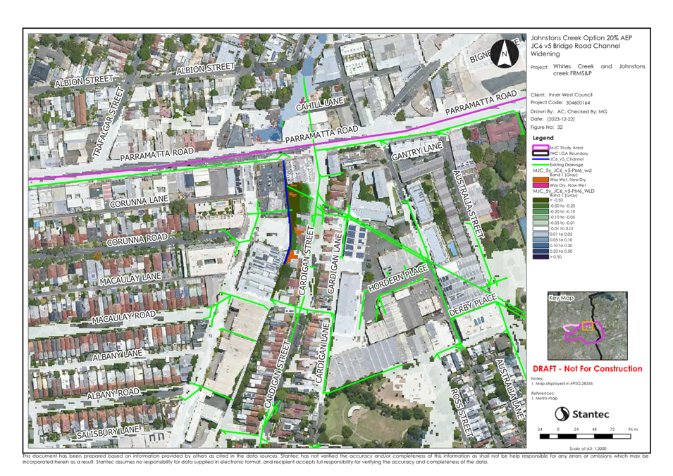
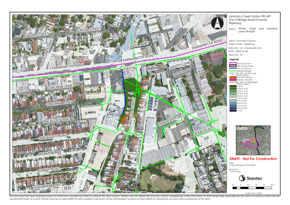
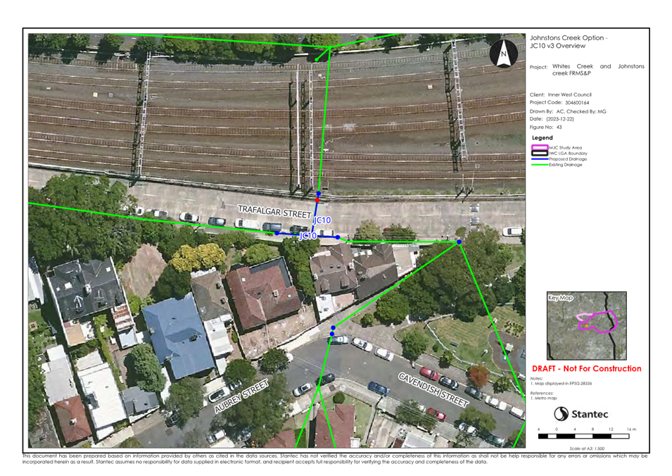
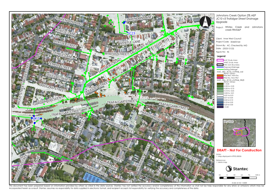
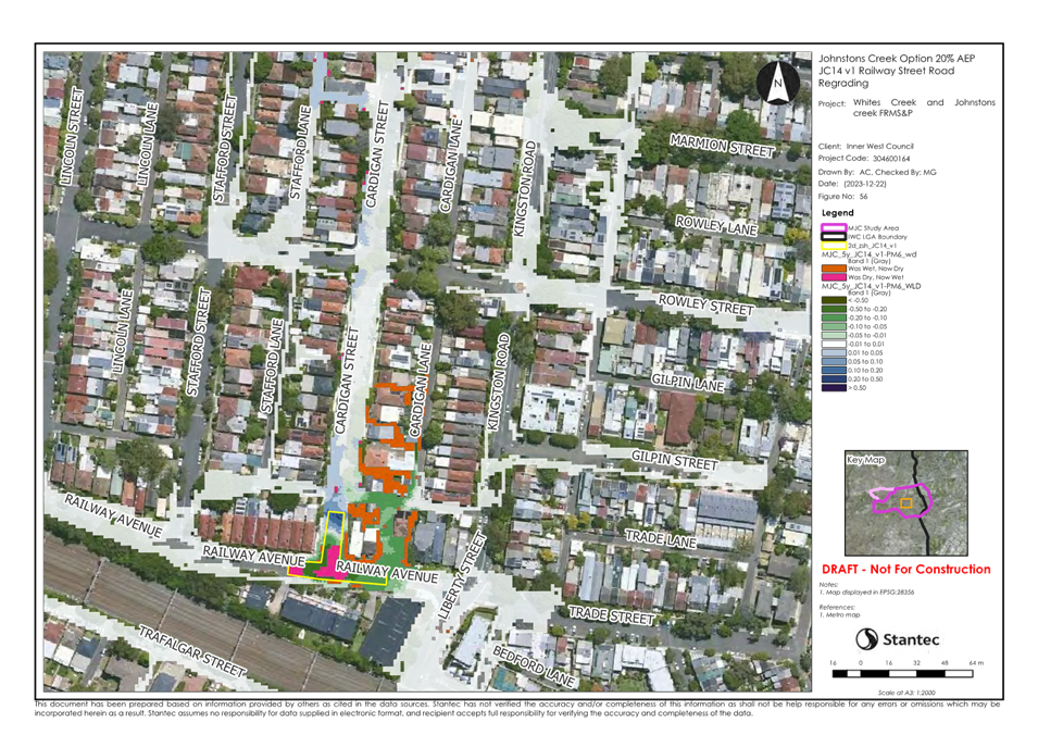
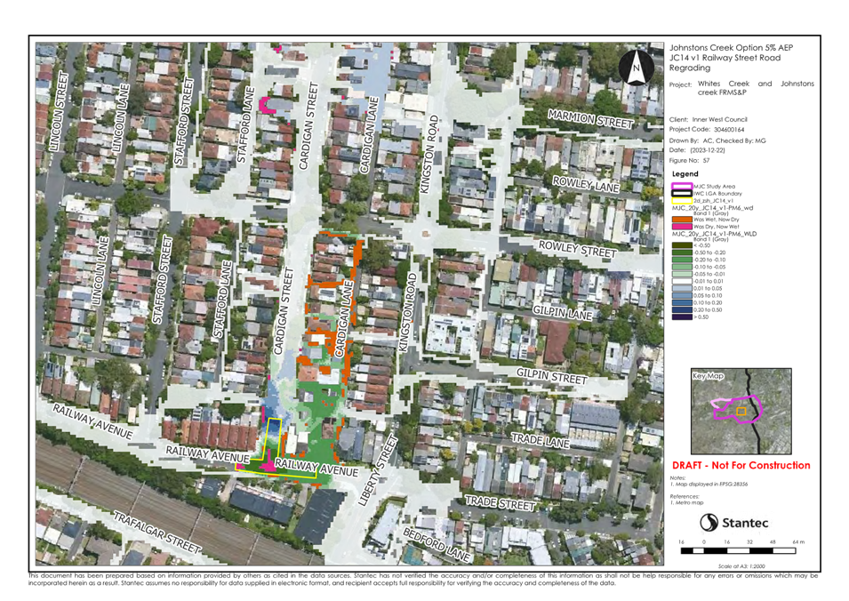
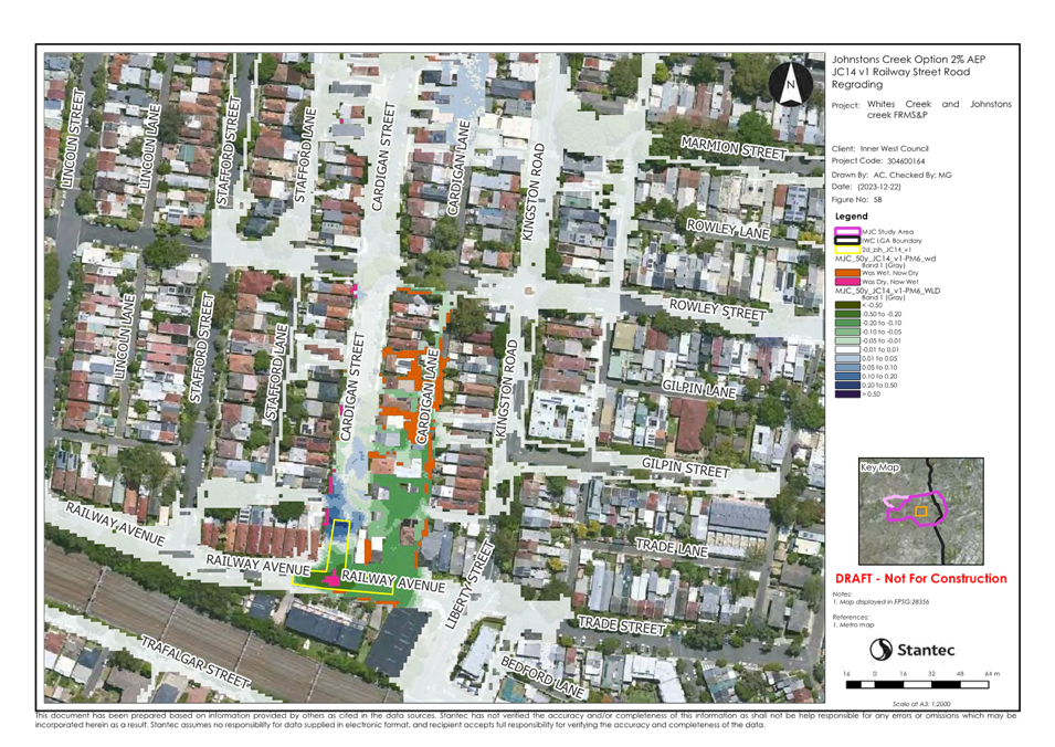
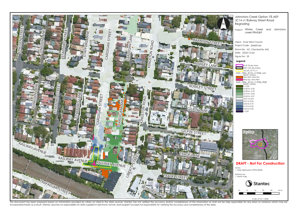
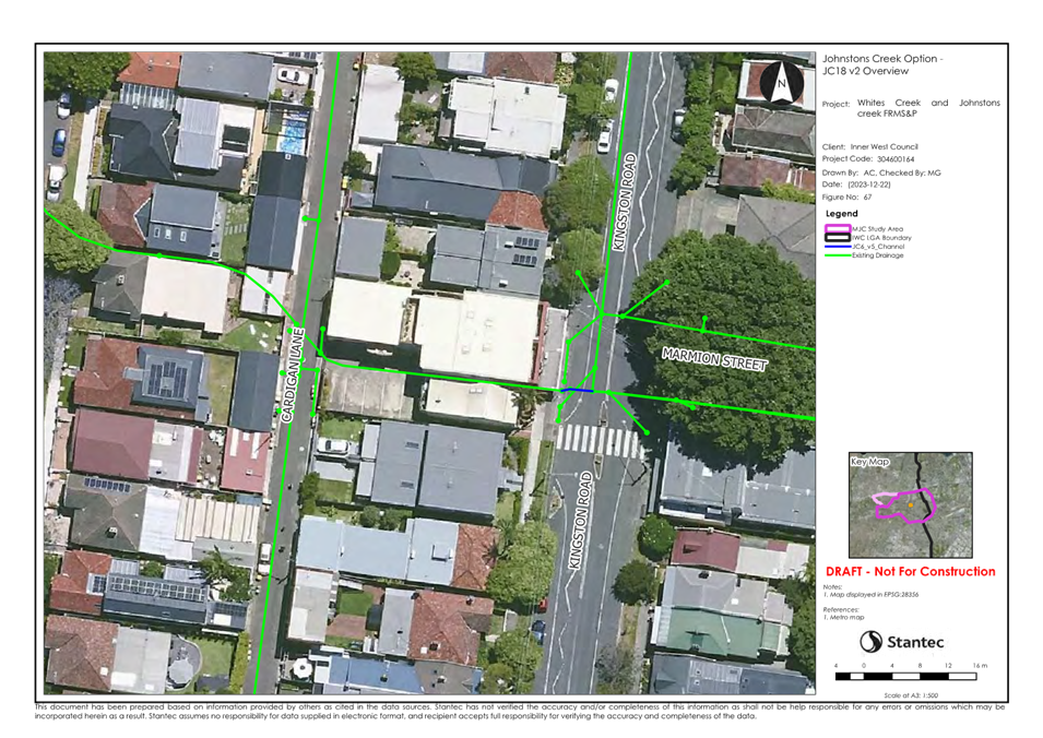
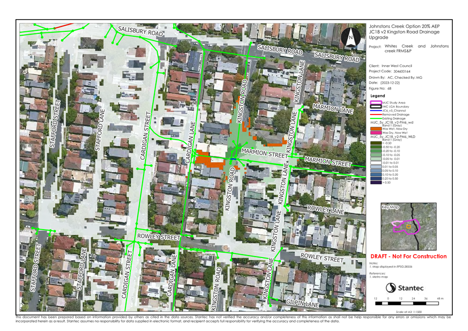
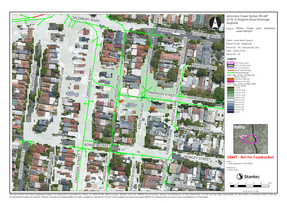
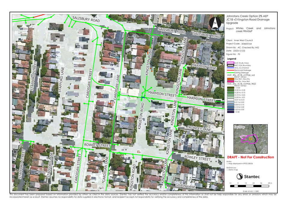
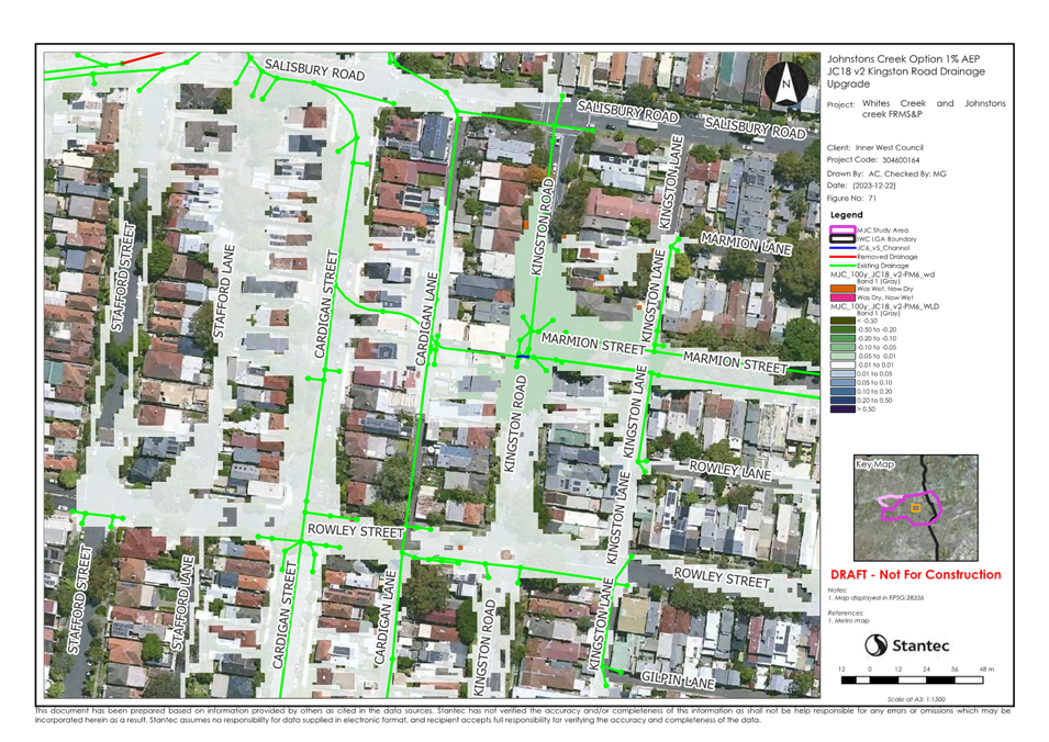
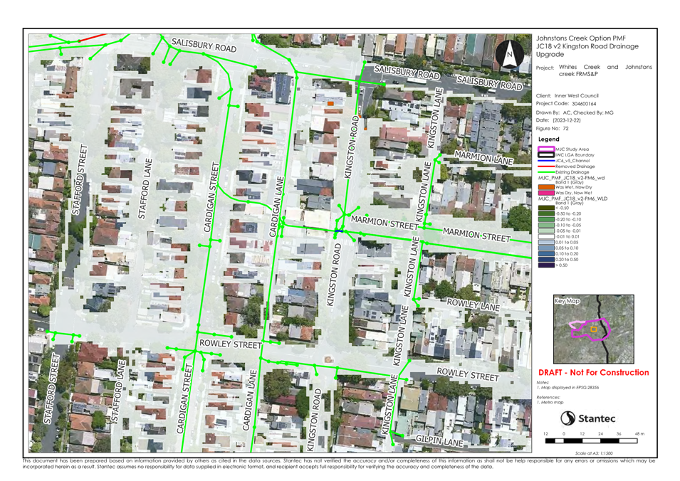
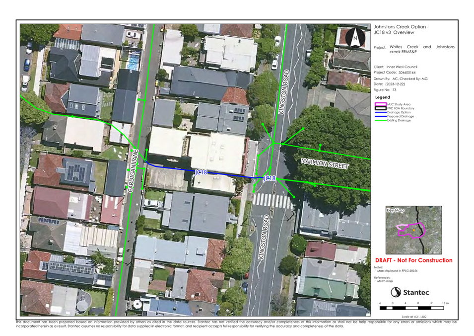
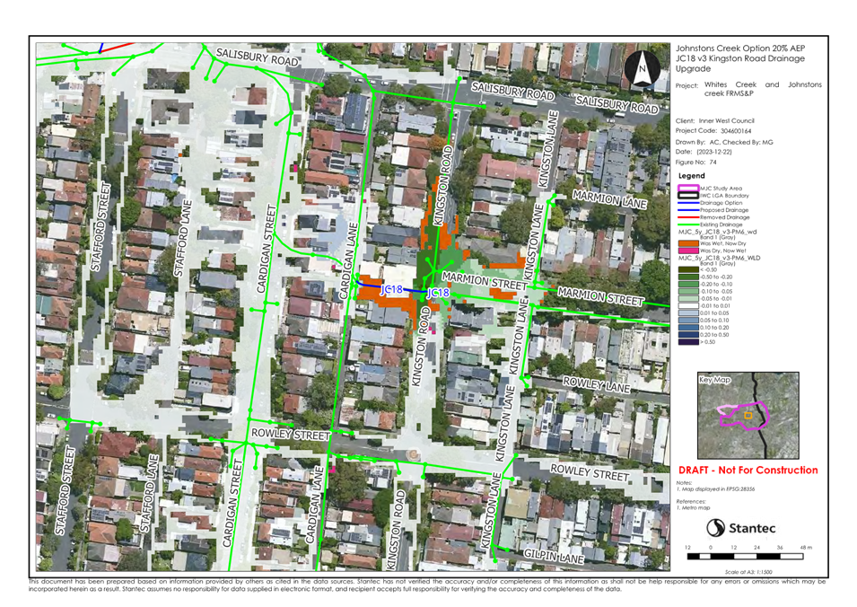
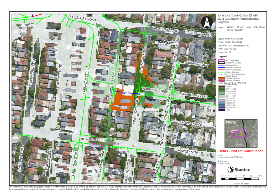
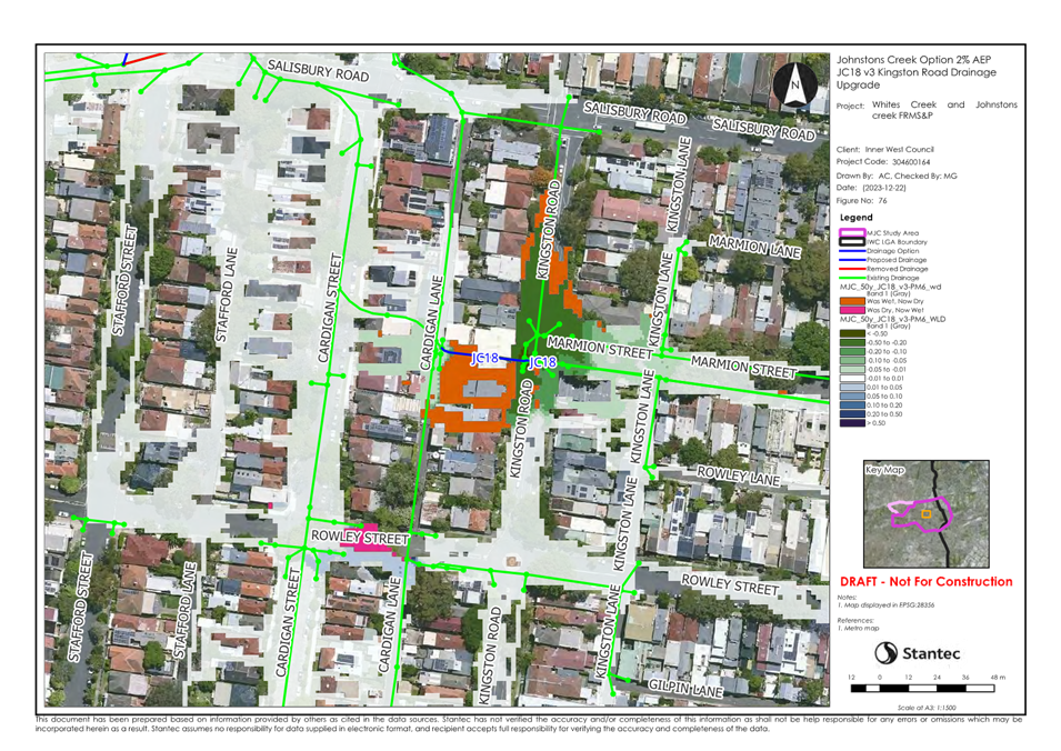
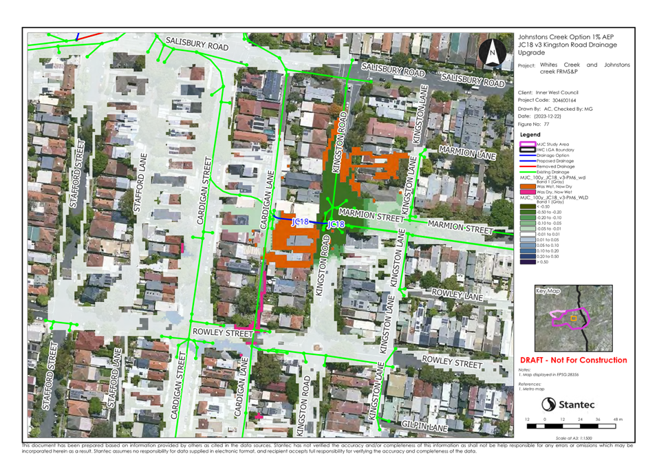
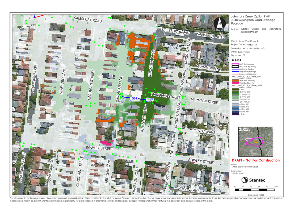
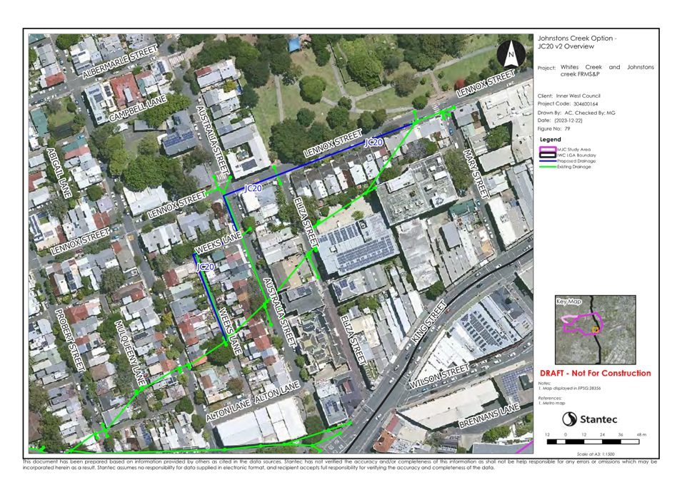
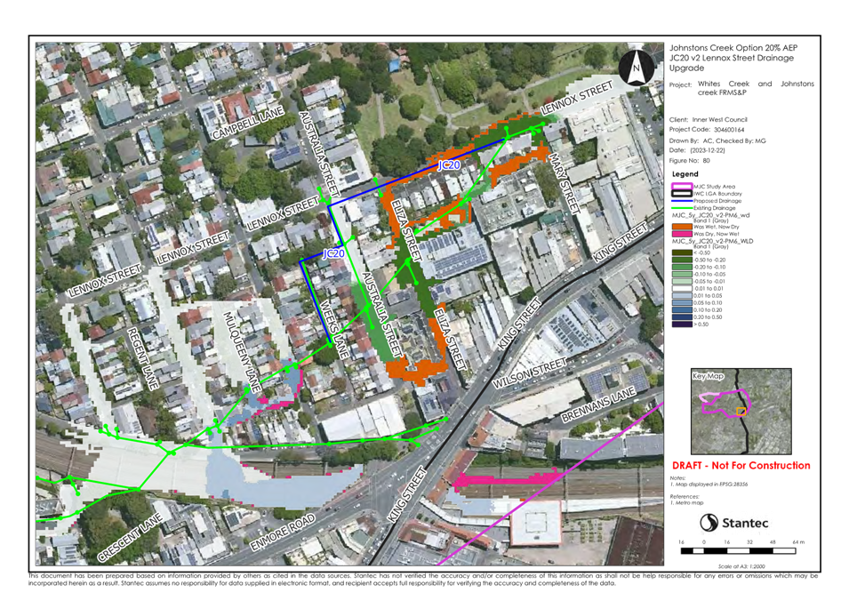
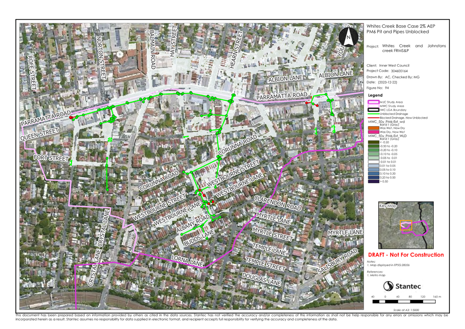
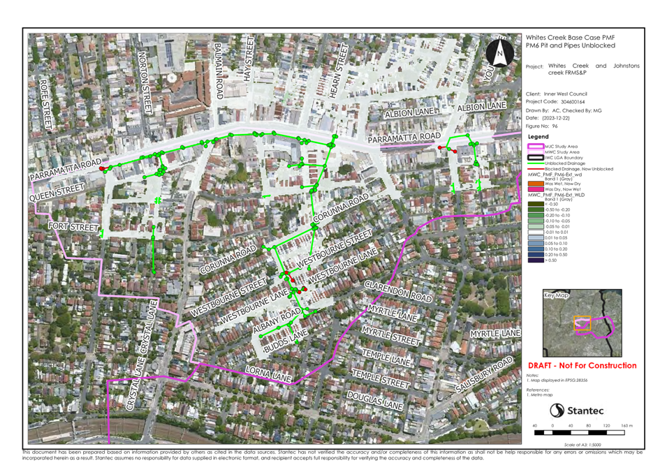
The Whites Creek and Johnstons
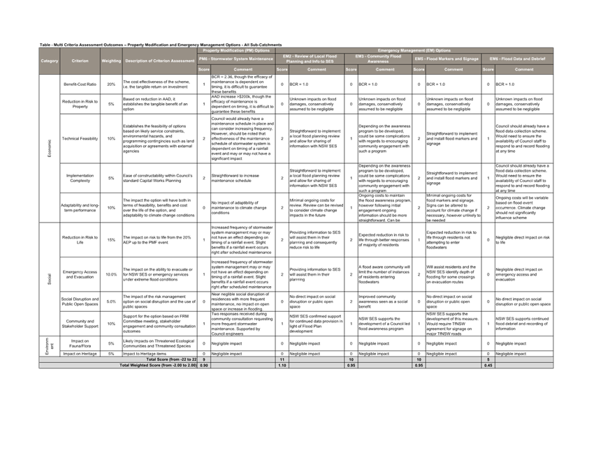
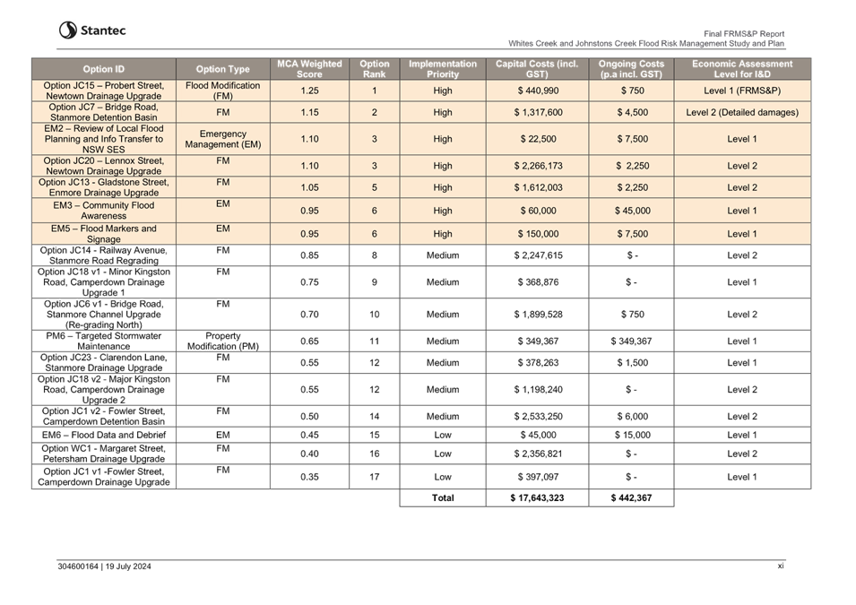
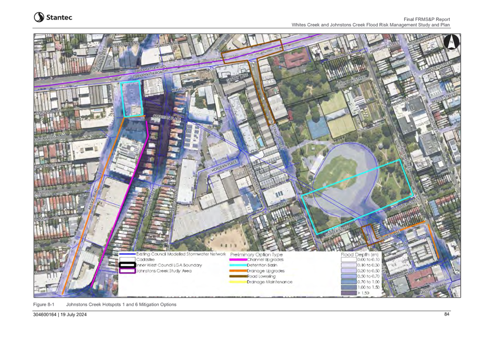
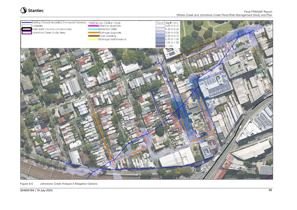
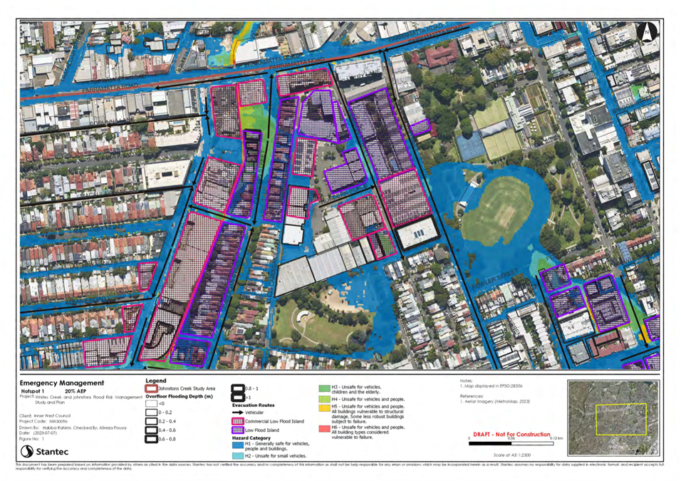
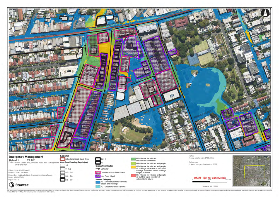
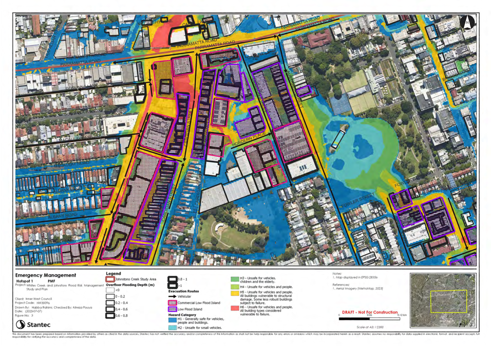
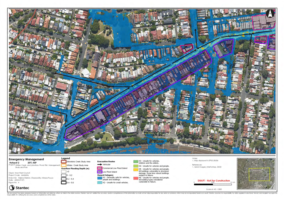
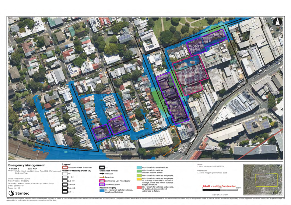
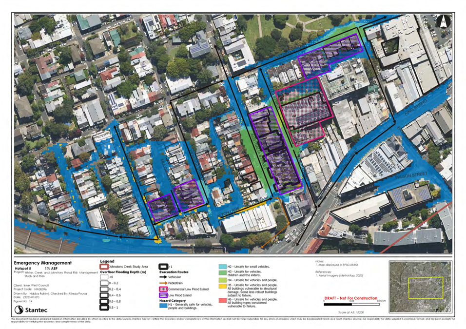
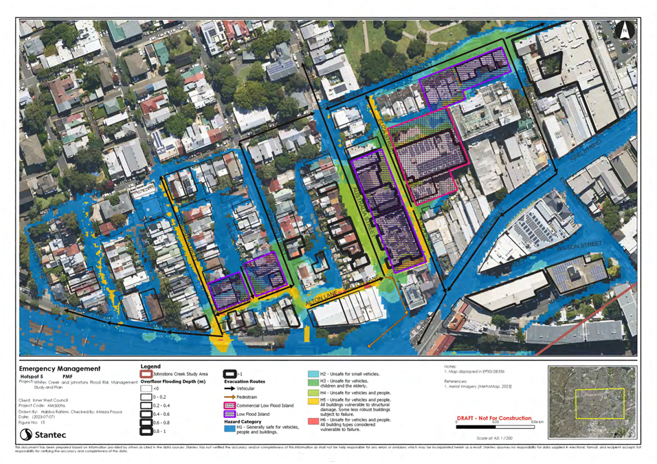
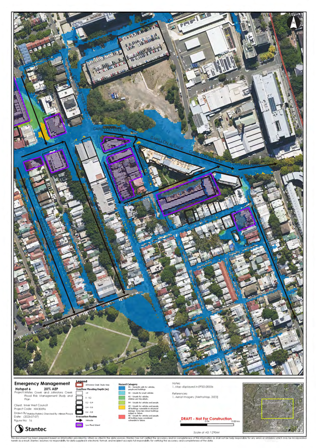
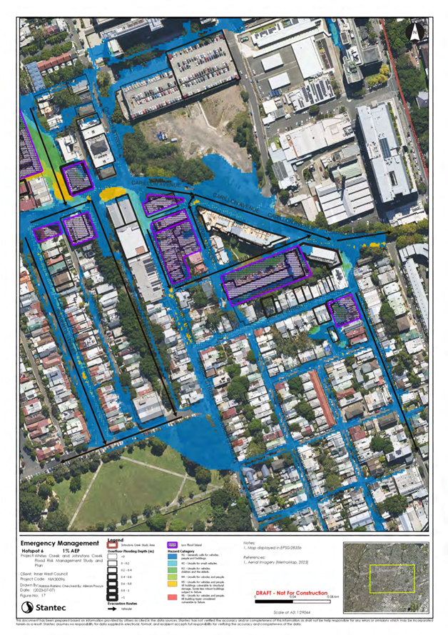
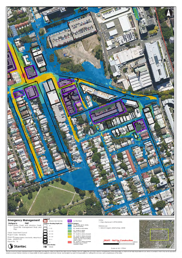
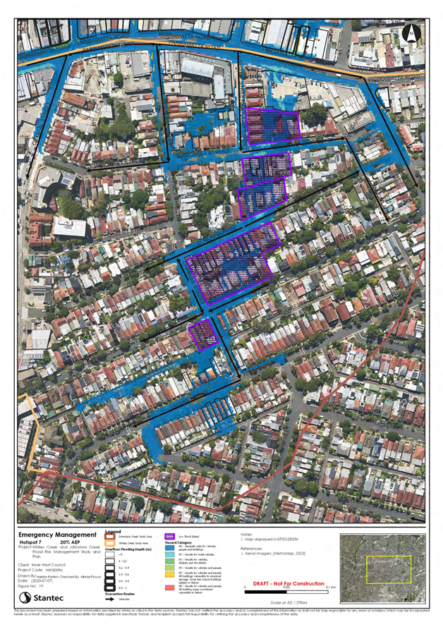
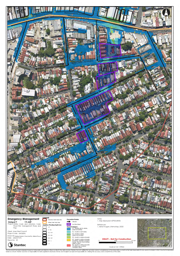
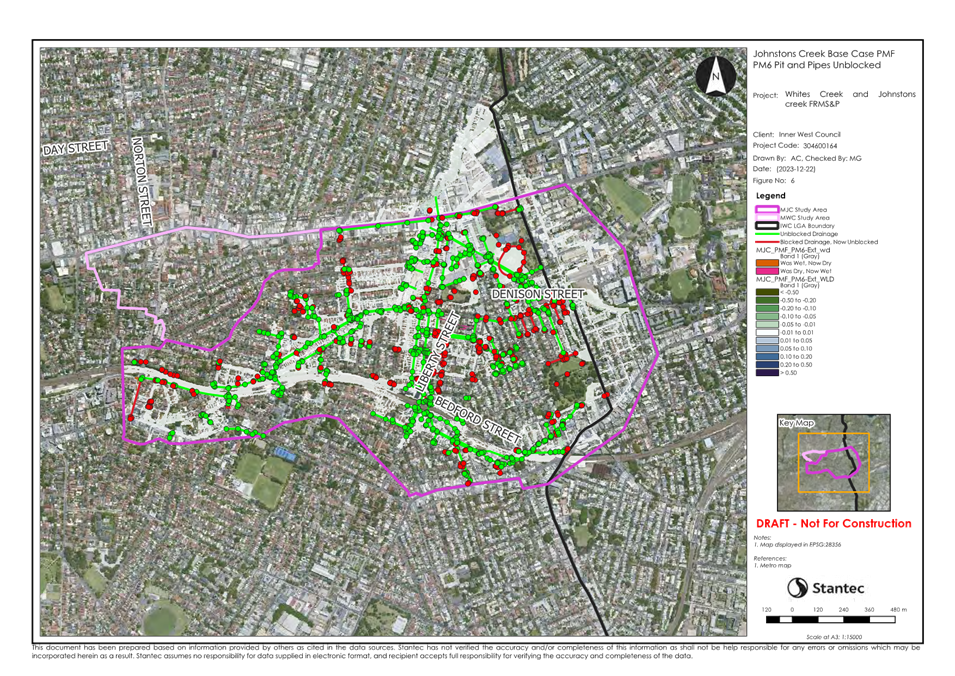
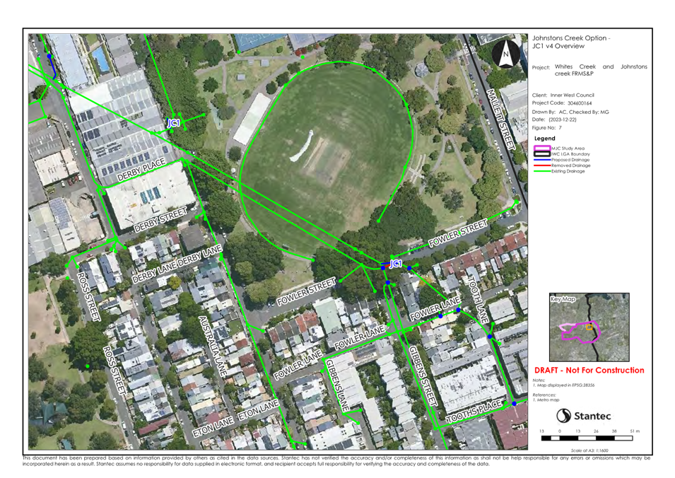
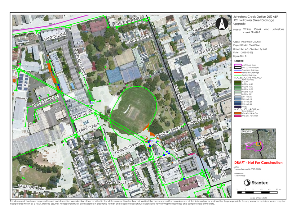
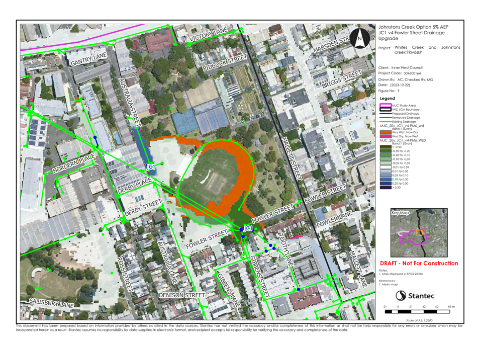
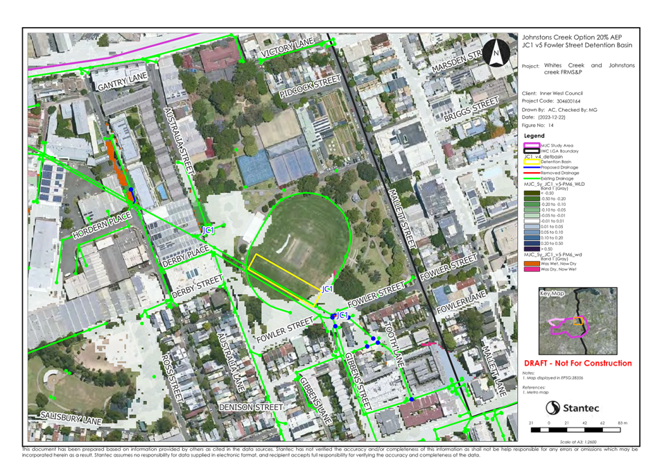
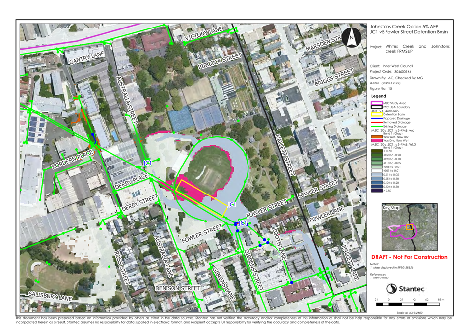
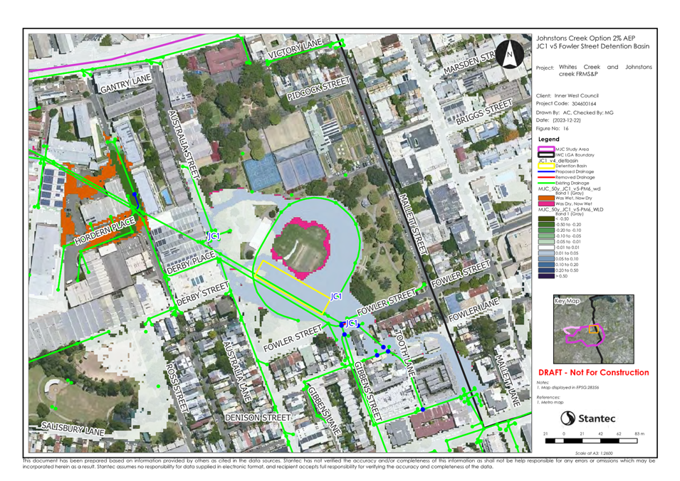
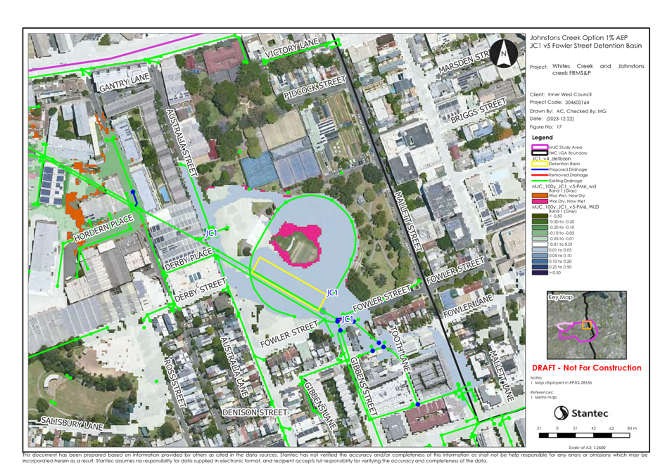
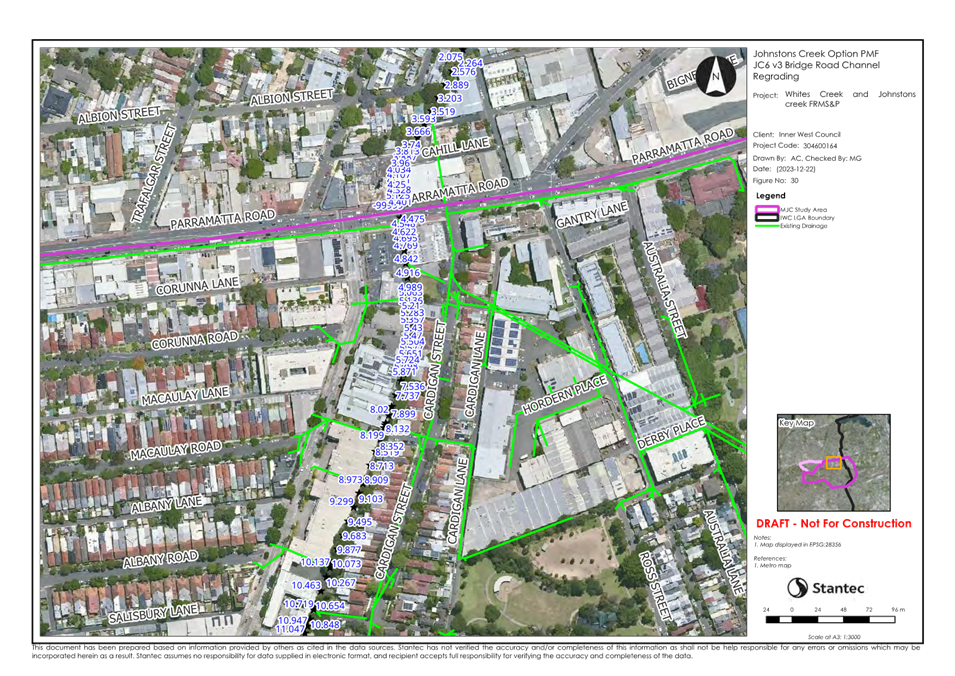
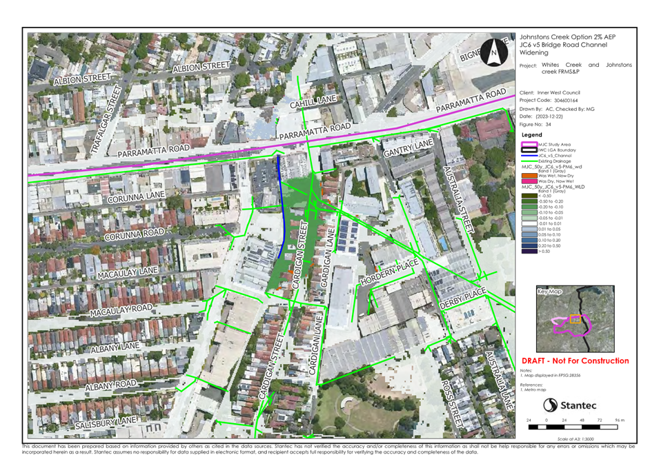
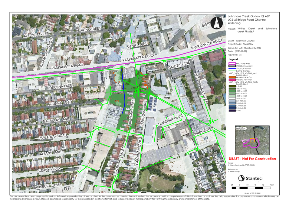
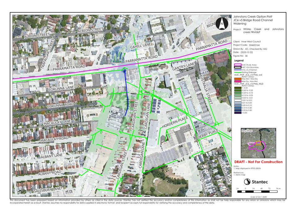
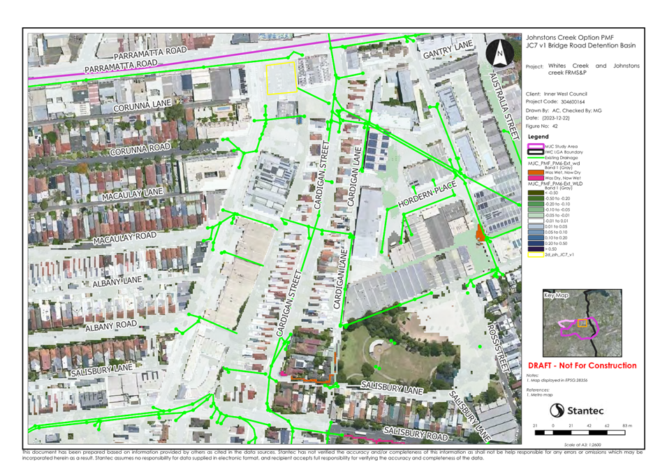
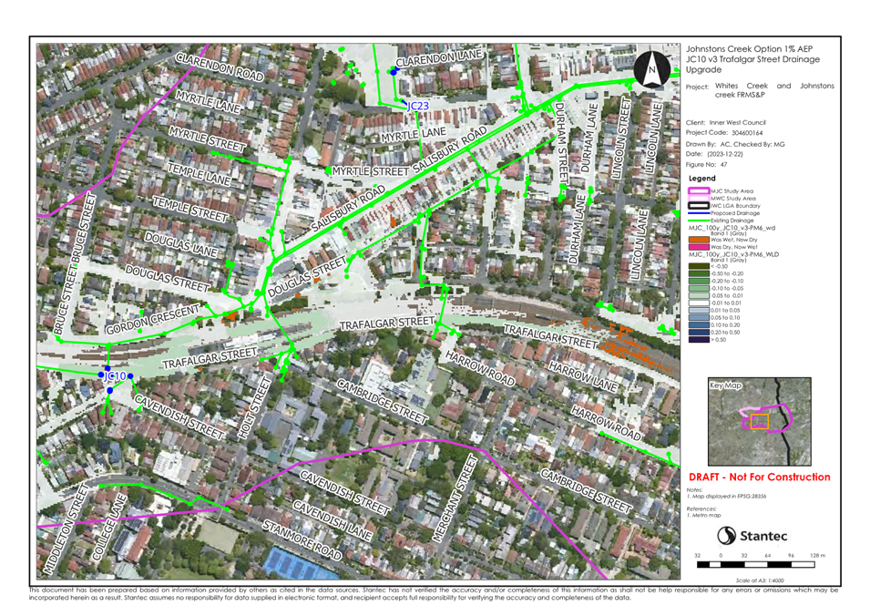
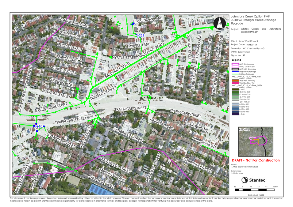
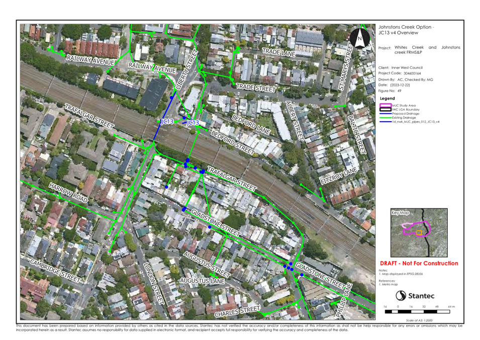
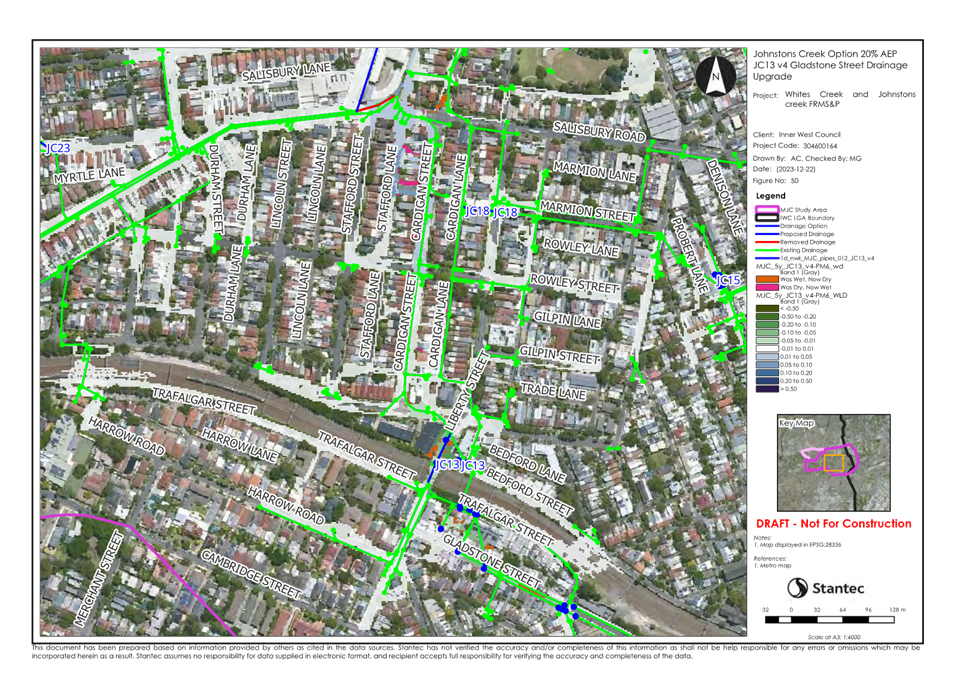
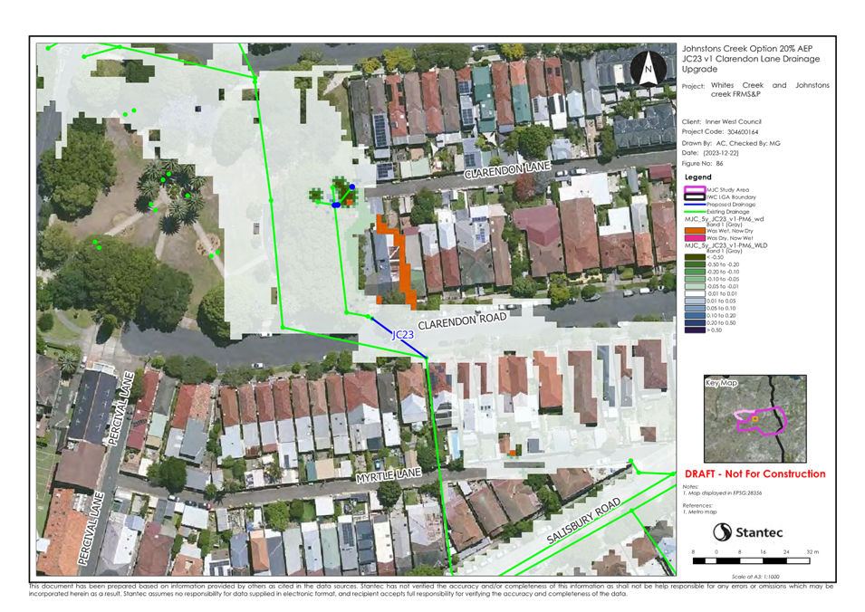
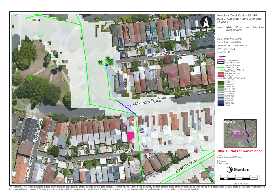
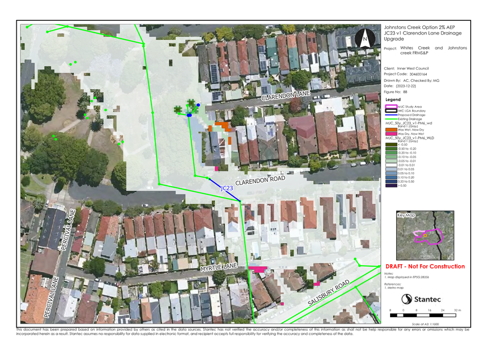
Creek FRMSP reviews 20 options and considers seven options to have a high
implementation priority including:
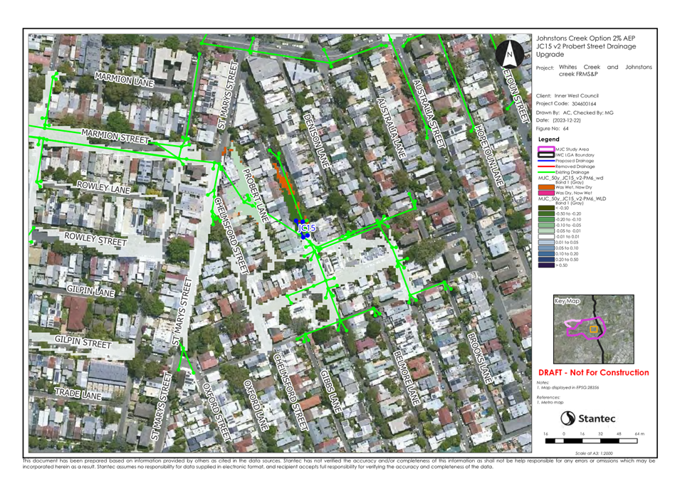
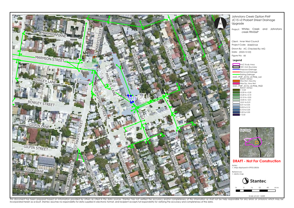
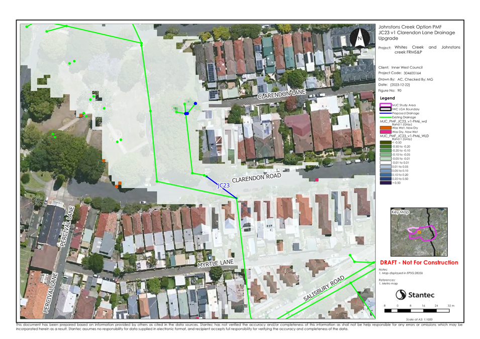
- Drainage Upgrade at Probert Street
($500,000)
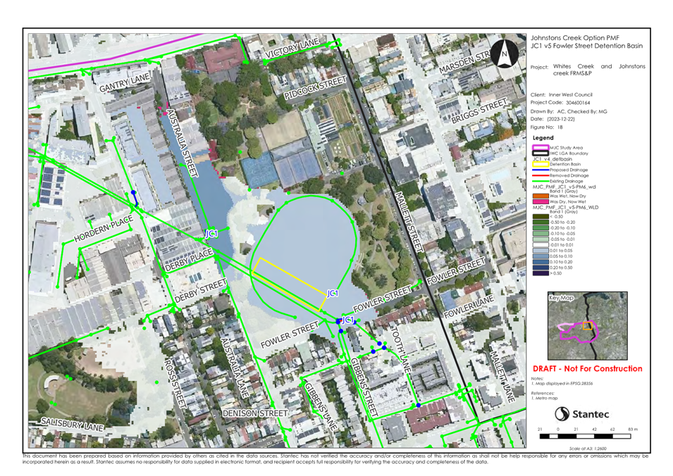
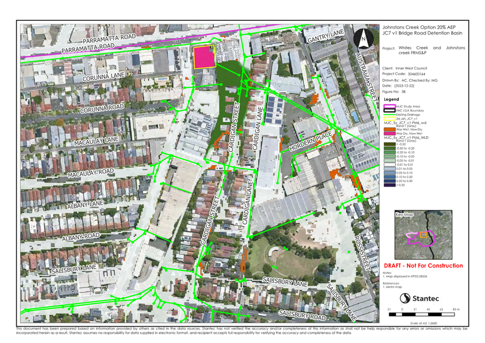
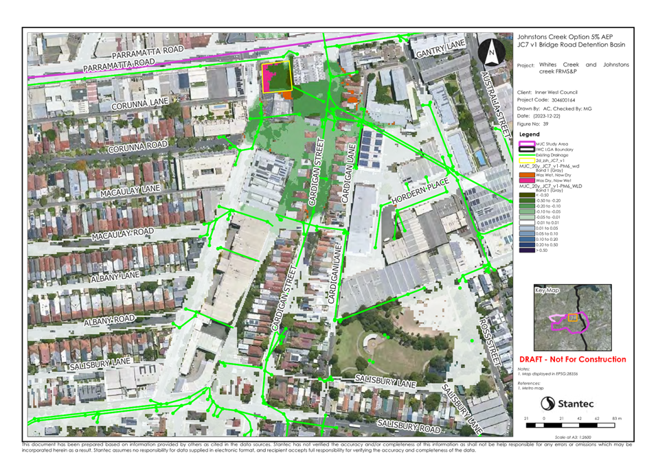
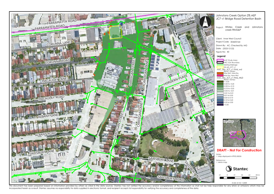
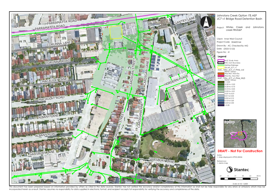
- Detention Basin at Bridge Road ($1.4
million)
- Drainage Upgrade at Lennox Street ($2.3
million)
- Drainage Upgrade at Gladstone Street ($1.6
million)
- Data Coordination with NSW SES
- Community Flood Awareness Strategies
- Implementation of Flood Markers &
Signage
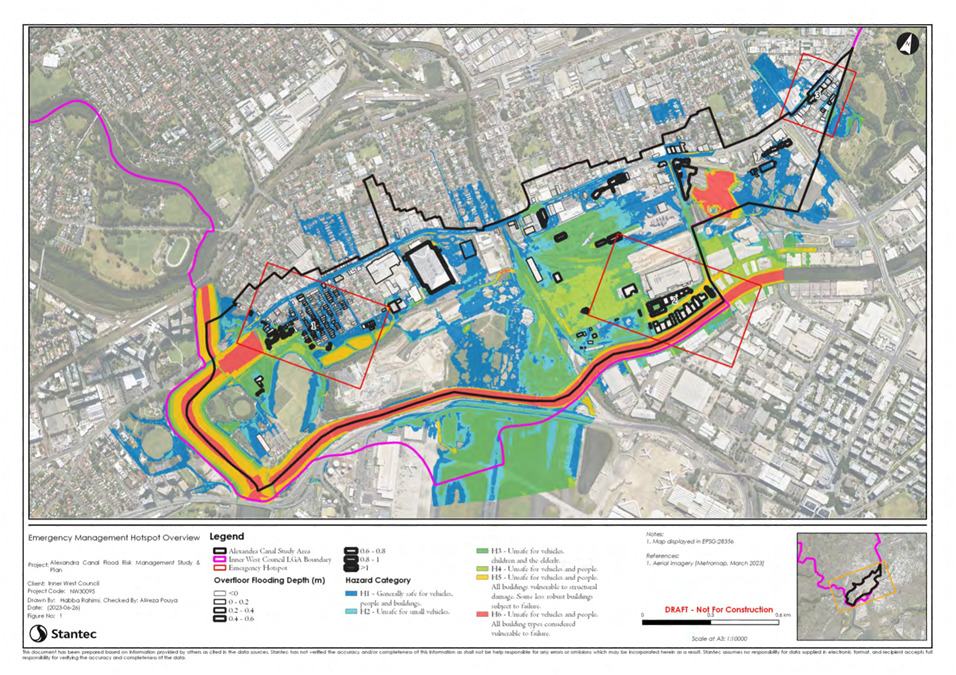
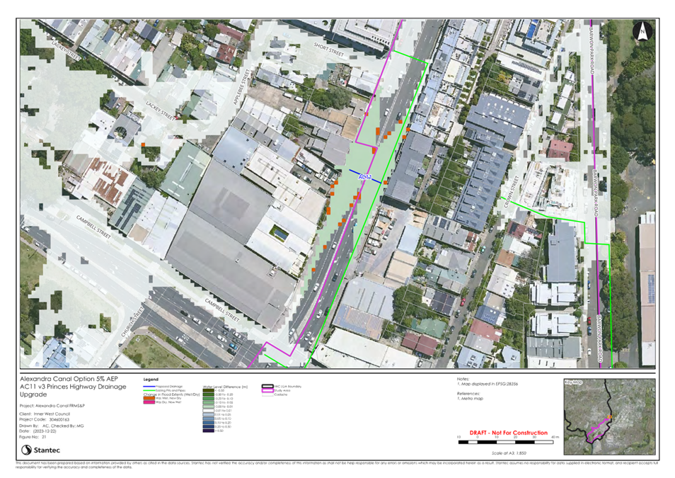
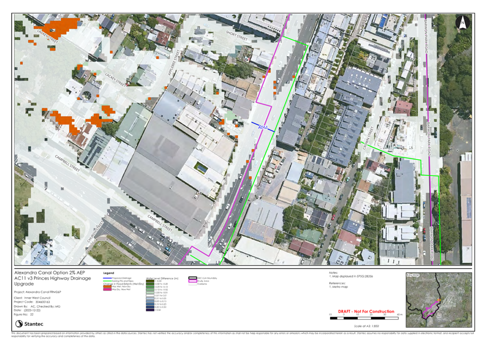
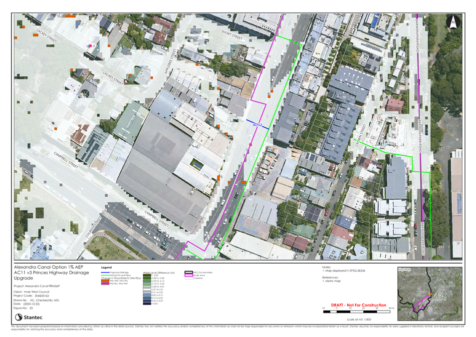
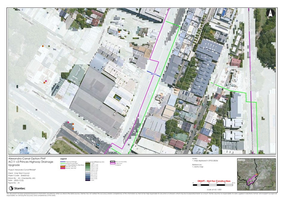
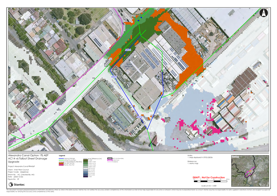
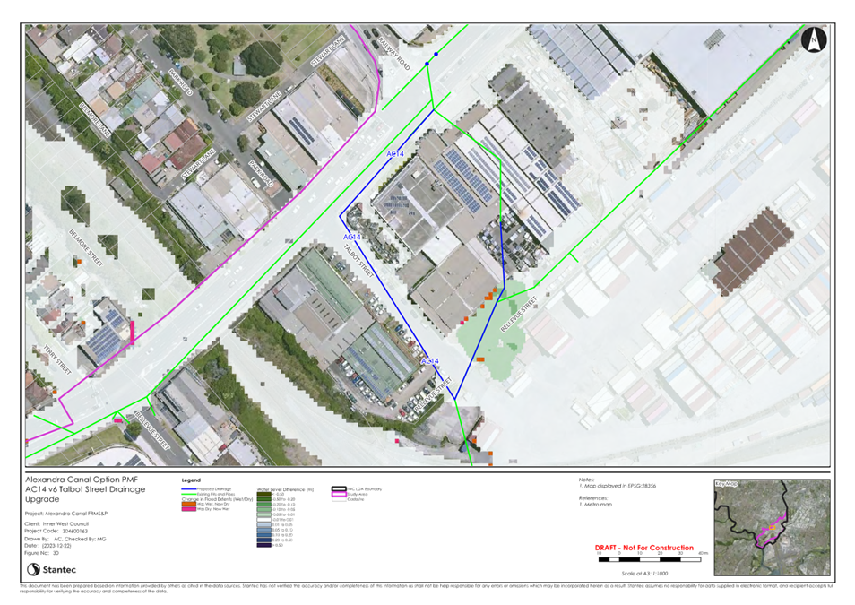
The Alexandra Canal FRMSP reviews
nine options and considers four options to have a high implementation priority
including:
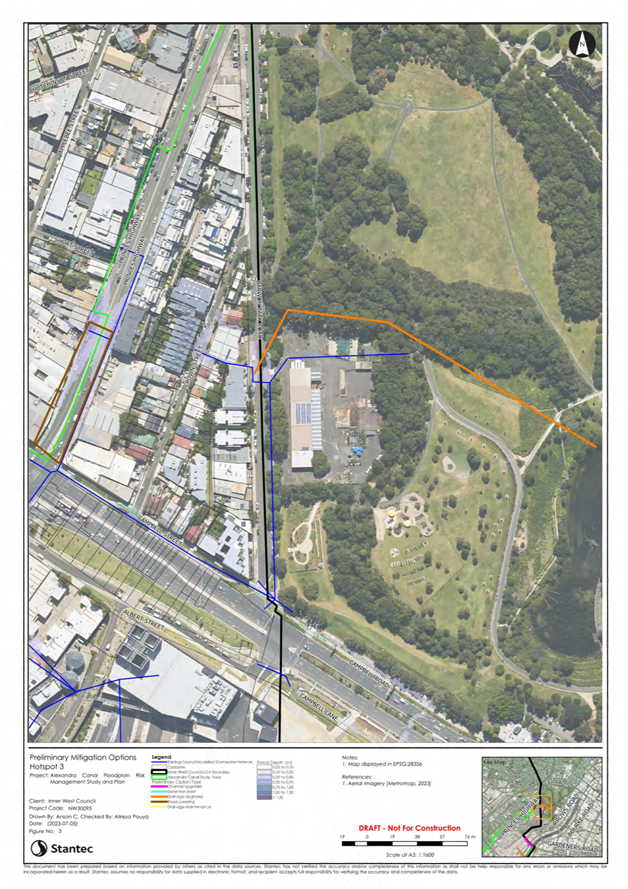
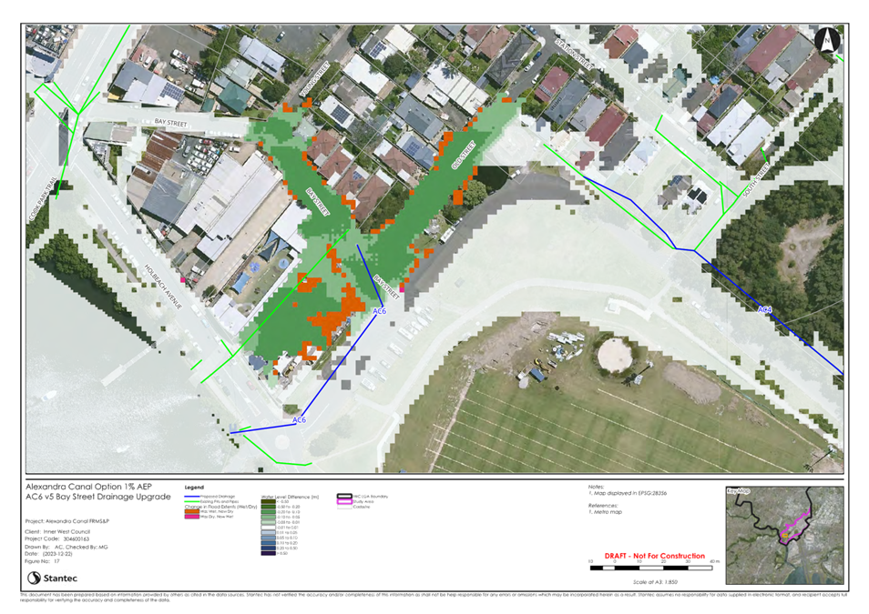
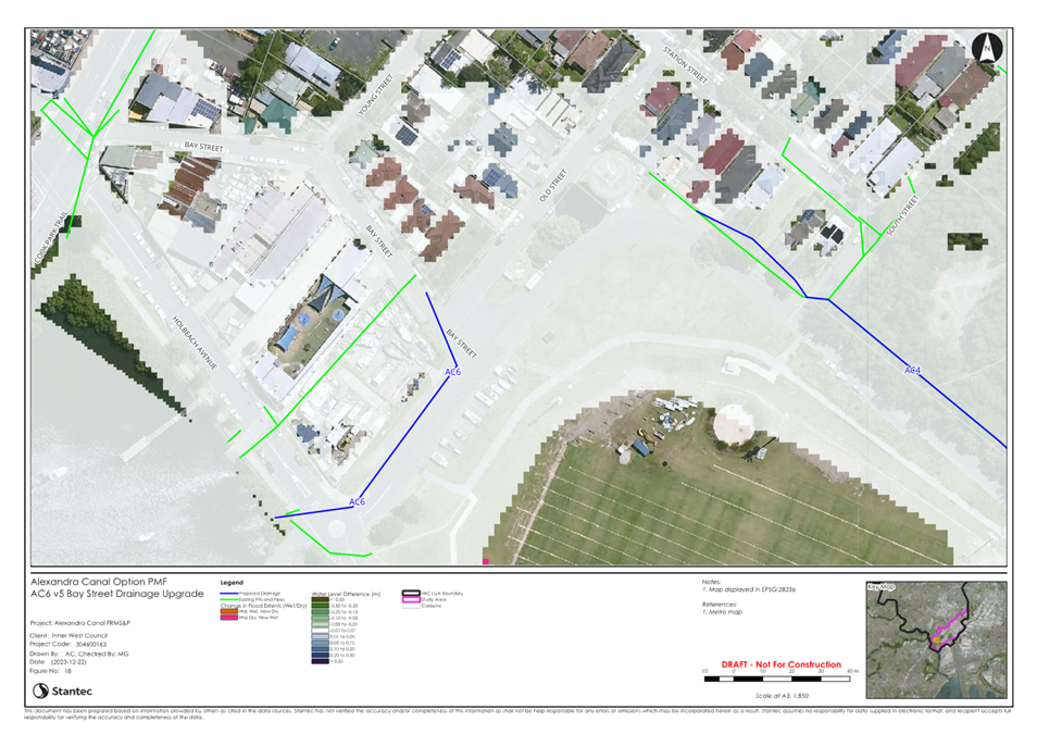
- Drainage Upgrade at Bay Street ($1.1
million)
- Data Coordination with NSW SES
- Community Flood Awareness Strategies
- Implementation of Flood Markers &
Signage
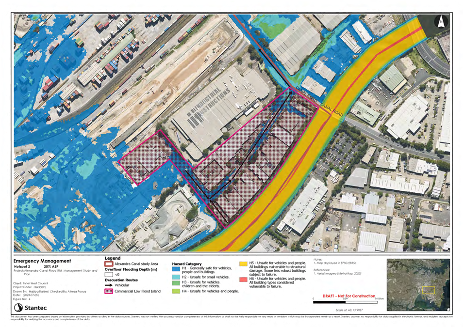
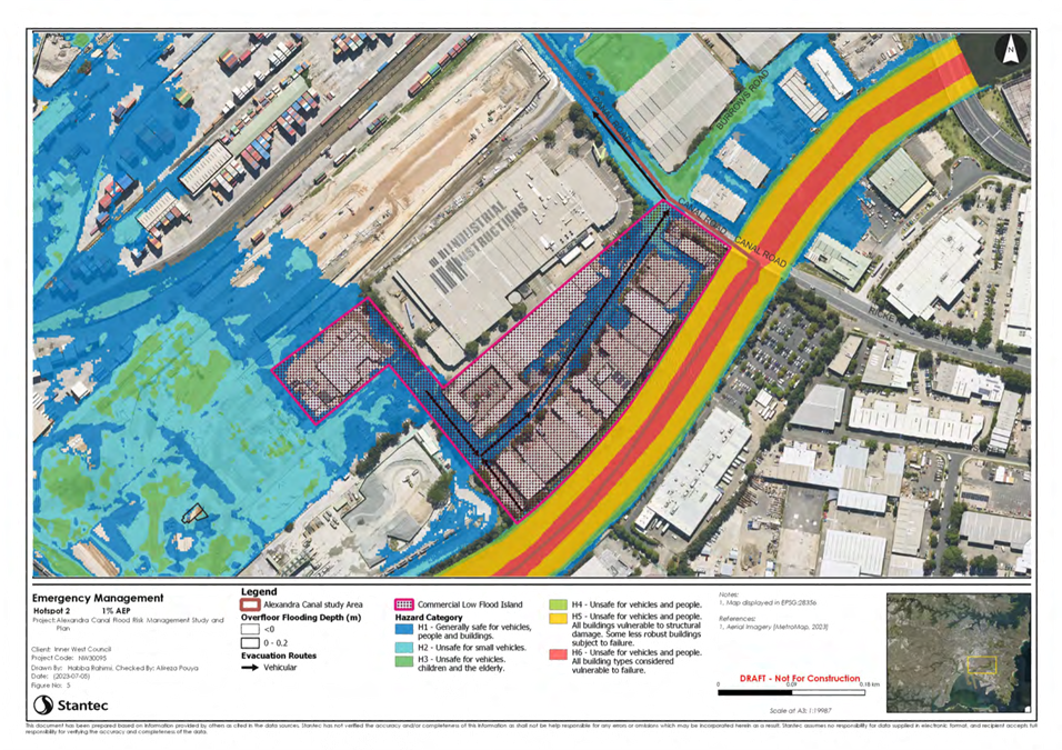
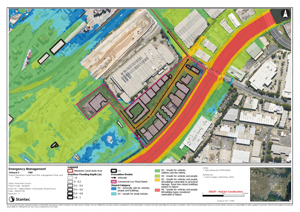
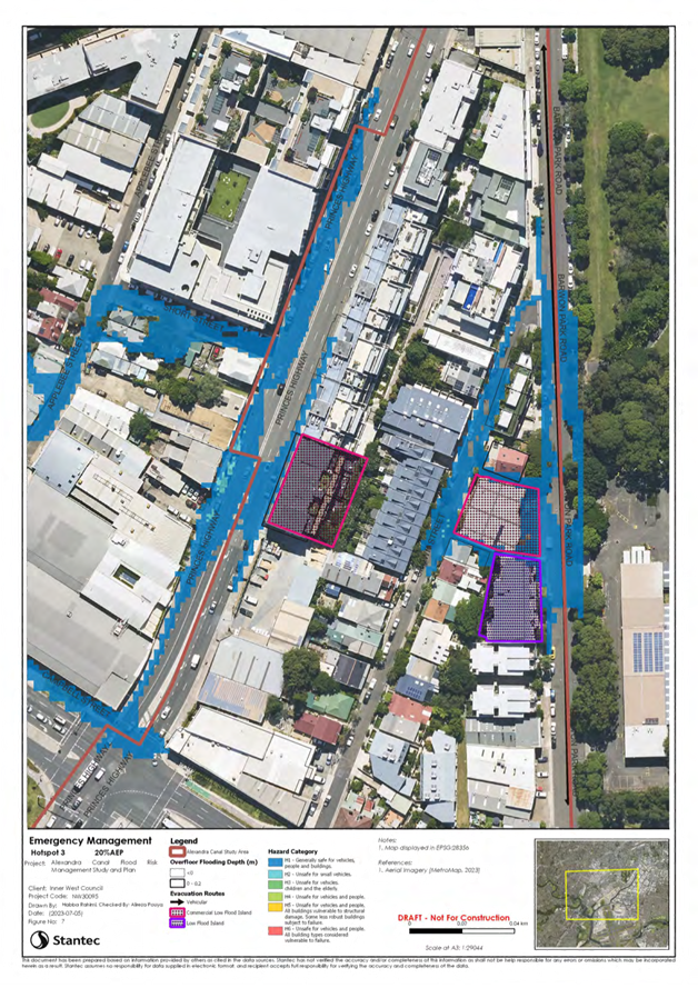
Of the
non-capital options – i.e., Data Coordination, Community Flood Awareness,
and Flood Markers, Council Engineers will continue to work with NSW SES to
further develop and implement these strategies. Data Coordination takes place
as part of the overall handover of materials following completion of a Flood
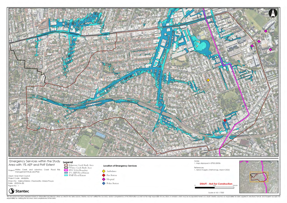
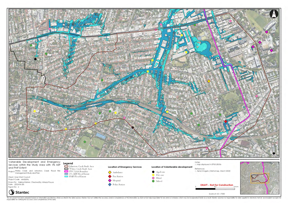
Risk Management Study and provides NSW SES with flood depths, response times,
isolated areas, and road cutoffs to inform their decision-making.
Beyond capital works upgrades,
the reports also provide a review of current planning controls, and a review of Emergency Management information, including
response times, isolated areas, and road cutoffs to inform their decision
making and planning.
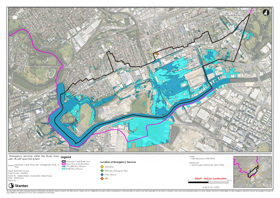
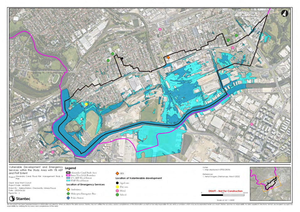
The Final Flood Risk Management
Studies and Plans are included as attachments to this report.
DISCUSSION
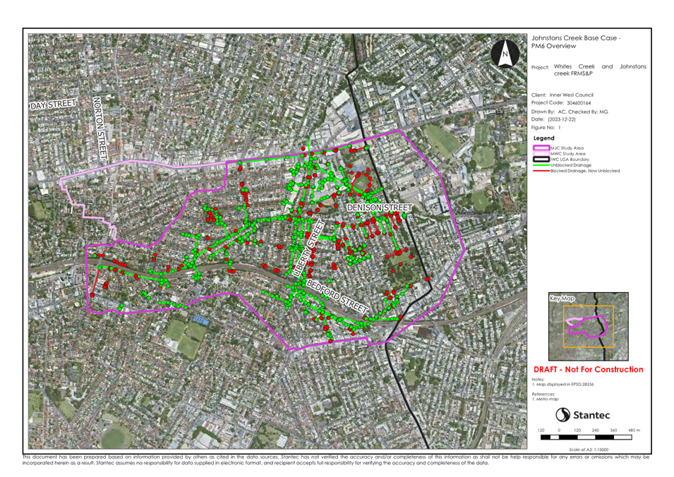
Community engagement is
identified in the NSW Flood Risk Management Manual as an integral part of the
flood risk management process as it raises awareness and can provide base
information for further community flood awareness activities.
The draft Alexandra Canal Flood
Risk Management Study and Plan and the Whites Creek and Johnstons Creek Flood
Risk Management Study and Plan was placed on public exhibition for a period of
five weeks from the 4 June to 12 July 2024.The exhibition was coordinated
through Council’s Your Say Inner West community engagement page and
letters of notification were also extended to owners of properties identified
as Flood Affected Properties.
During the public exhibition
period, the community members, SES and interested parties were invited to
review the study and plan, submit comments, and indicate the extent of their
support for the study, plan and its outcomes. Community members were also able
to provide comment on which options they support, which options they do not
support, and any matters related to flood mitigations and management that had
not been addressed in the study and plan.
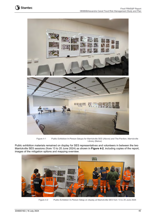
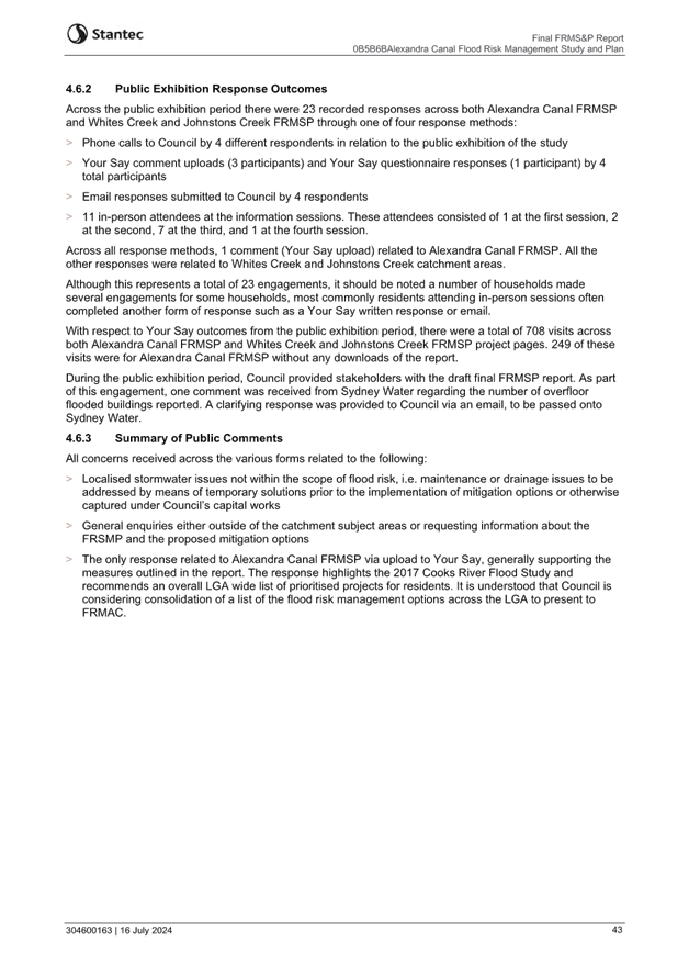
Four community workshops were
held during the public exhibition period to present the findings of the study
and plan and sought input from the community. The workshops were held at
Marrickville SES on 13 June and 20 June 2024 and at Marrickville Library, The
Pavilion on 24 June and 2 July 2024. Draft documents and printed flood
mitigation options maps were also displayed as part of the exhibition.
Public
Exhibition Response Statistics
Across
the public exhibition period there were 23 recorded responses across both
Alexandra Canal FRMSP and Whites Creek and Johnstons Creek FRMSP through one of
four response methods:
· Phone
calls to Council by 4 different respondents in relation to the public
exhibition of the study.
· Your
Say comment uploads (3 participants) and Your Say questionnaire responses (1
participant) by 4 total participants.
· Email
responses submitted to Council by 4 respondents.
· 11
in-person attendees at the information sessions. These attendees consisted of 1
at the first session, 2 at the second, 7 at the third, and 1 at the fourth
session.
Across
all response methods, 1 comment (Your Say upload) related to Alexandra Canal
FRMSP. All other responses were related to Whites Creek and Johnstons Creek
catchment areas.
Although
this represents a total of 23 engagements, it should be noted a number of
households made several engagements for some households, most commonly
residents attending in-person sessions often completed another form of response
such as a Your Say written response or email.
With respect to Your
Say outcomes from the public exhibition period, there were a total of 708
visits across both Alexandra Canal FRMSP and Whites Creek and Johnstons Creek
FRMSP project pages. 459 of these visits were for Whites Creek and Johnstons
Creek FRMSP, with 68 downloads, and 249 were for Alexandra Canal FRMSP, with no
downloads.
During
the public exhibition period, Council provided stakeholders with the draft
final FRMSP report. As part of this engagement;
One comment was received from Sydney Water regarding the
number of overfloor flooded buildings reported. A clarifying response was
provided to Council via an email, to be passed onto Sydney Water.
Council’s Strategic Planning team commented on the
report. Clarifying responses were provided to Council via an email, and updates
to the report were made where necessary.
Whites Creek and Johnston Creek
– Summary of Comments from the Public
The
most common concerns received across the various forms related to the
following:
· Localised
stormwater issues not within the scope of flood risk, i.e. maintenance or
drainage issues to be addressed by means of temporary solutions prior to the
implementation of mitigation options or otherwise captured under
Council’s capital works
· General
enquiries either outside of the catchment subject areas or requesting
information about the FRSMP and the proposed mitigation options.
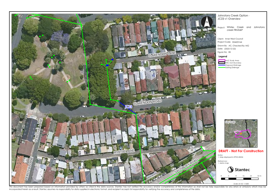
Specifically
relating to the flood risk management options, the following comments were
received during public exhibition:
· A
concern was raised about flooding in the junction of Gladstone Street and
Phillip Street in Enmore. The attendee communicated that the flooding was
caused by insufficient drainage on King Street. There is a valid flood risk
concern to properties further downstream of this intersection, which are
subject to low flood island effects. These properties have been assessed to
benefit from Option JC13. However, at the intersection where the concern was
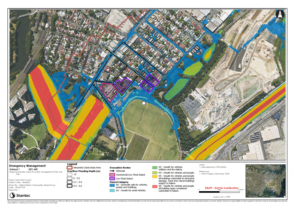
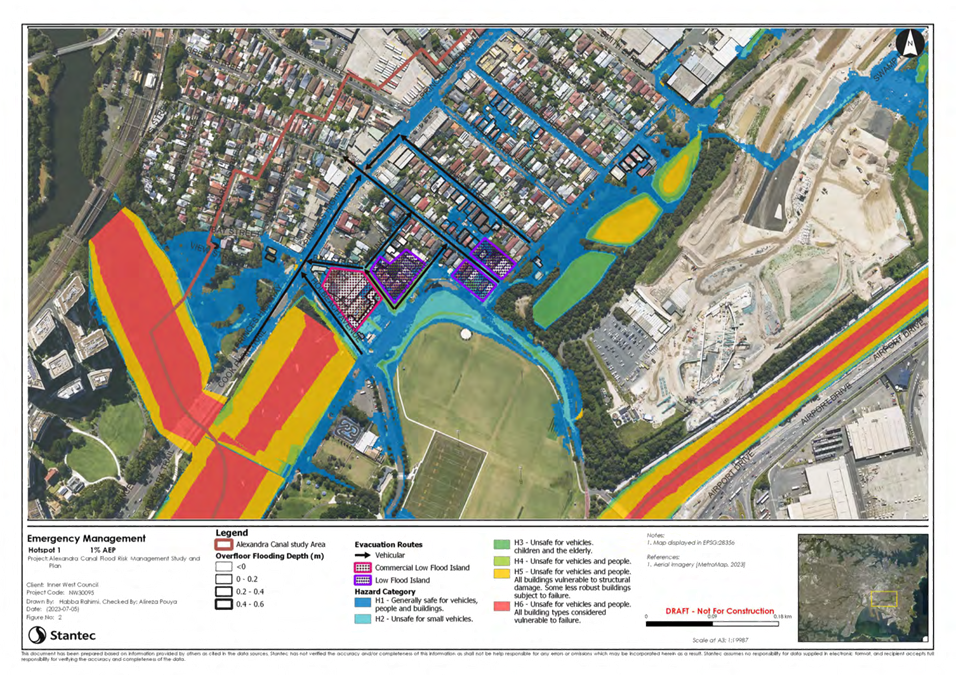
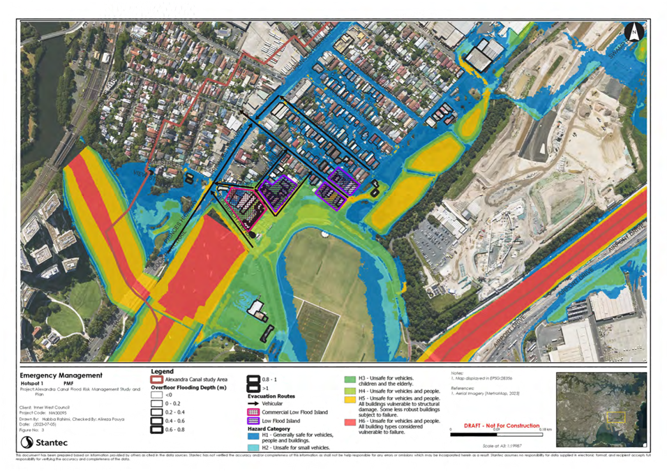
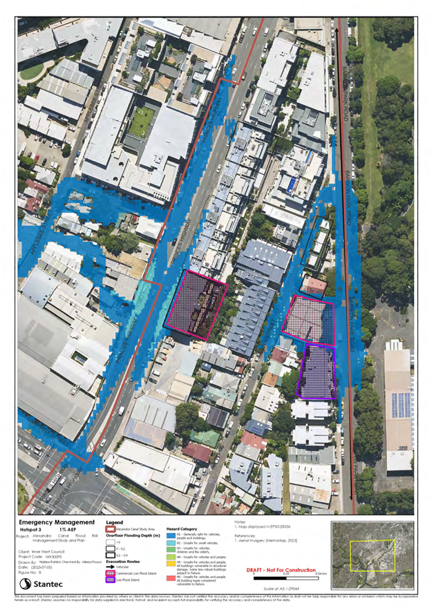
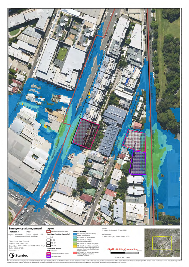
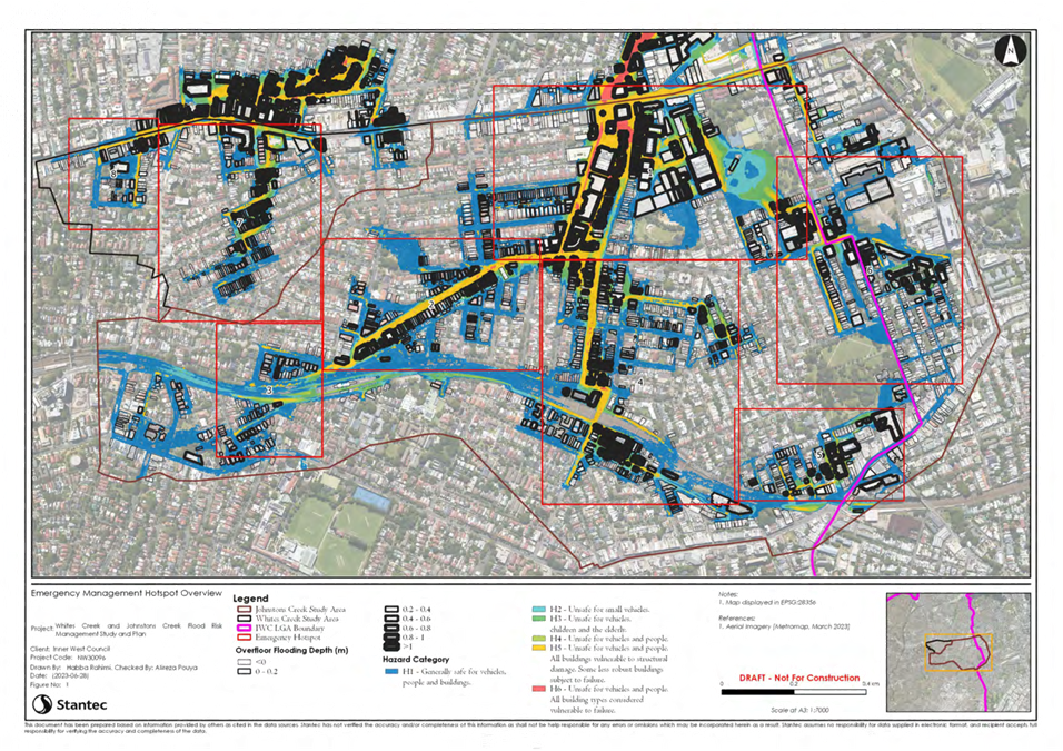
raised, the observed H5 hazard category within a 1% AEP event is contained
within the road corridor. It is also understood that the further upstream King
Street is a TfNSW owned asset. Due to these factors affecting feasibility
comparative to flood risk benefits, it is unlikely for further proposed
solutions in this location to be scored favourably in terms of CBR and MCA.
· A
concern was raised about flooding to a property on Salisbury Road, Camperdown
near Church Street in the Johnstons Creek catchment. There is a valid flood
risk concern to these properties due to the trapped low point with H4-H5 hazard
category of flooding within a 1% AEP event. No solution was proposed during
option development due to high level feasibility issues resulting from the
limited diameter of downstream pipes. It is noted that the subject pits are
part of Council’s capital works program, and that Council is currently
progressing longer term feasibility assessments as part of a separate study. In
the meantime, Council may implement an interim approach to mitigate flooding in
the short-term including investigating the inlet capacity at that location.
· A
concern was raised about Salisbury Lane, Stanmore near the inlets to the
Johnstons Creek stormwater channel. The attendee provided images showing
flooding of the street, caused by the invert levels of the inlet pipes sitting
above the existing street surface level. The subject location is mostly H2
hazard, with minor spots of H3-H4 within a 1% AEP event. The feedback provided
by the attendee merits public safety concerns, and it is understood that
Council will investigate inlet capacity or drainage upgrades in this area
separate from the FRMSP and as part of their capital works.
· Two
concerns were raised regarding flood risk classification, insurance premiums
and property values in the Johnstons Creek catchment. The community members for
these areas did not consider their property to be flood affected. The Flood
Study model has been reviewed as part of the FRMSP, and the assumptions used
were found to be generally reasonable in line with industry best practice and
guidelines. It is noted that these types of concerns relate to the previous
Flood Study process where flood affectation of properties was assessed, whereas
the focus of the FRMS&P engagement was on the proposed flood risk
management options. On Australia Street, there is a proposed JC20 drainage
upgrade option directly benefiting the affected properties in this subject
area, which are subject to H4 hazard category of flooding within a 1% AEP
event.
· A
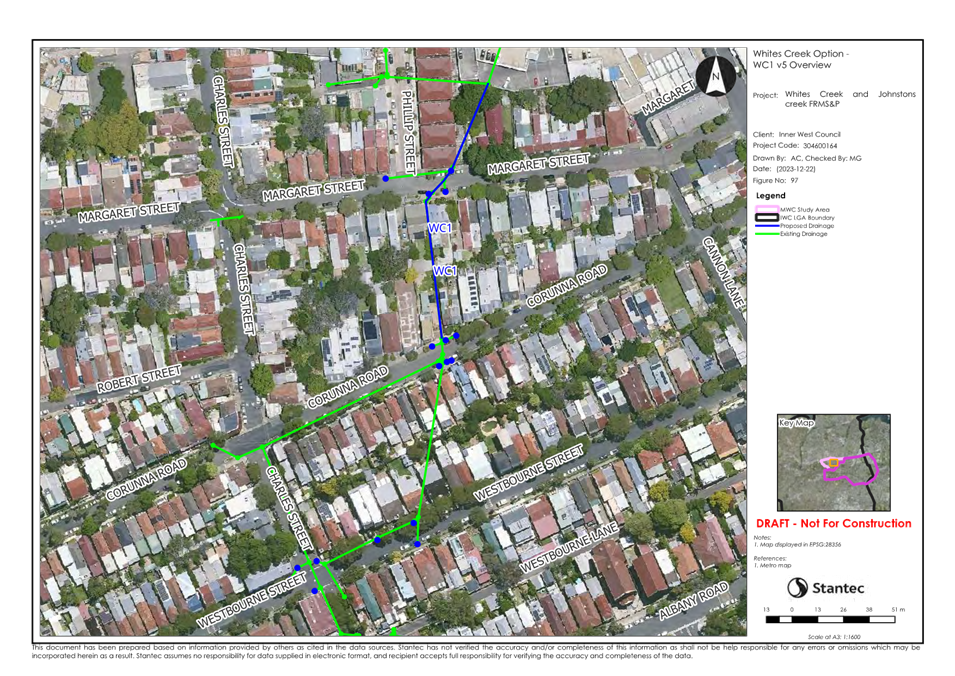
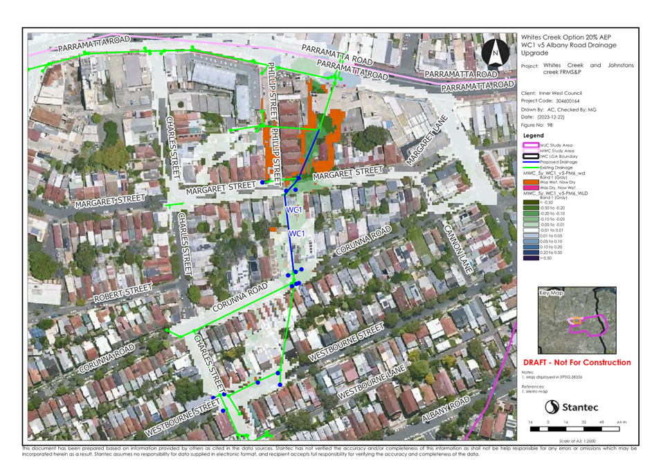
concern was raised regarding Corunna Street in the Whites Creek catchment. The
attendee suggested the installation of raingardens additional to the proposed
WC1 drainage upgrade option. The option types (i.e. drainage upgrade, road
regrading, detention basin, etc) were developed with consideration of
feasibility, cost and likelihood of scoring favourably in terms of CBR and MCA.
The introduction of a raingarden, though may slow flows and improve water
quality treatment in higher frequency events, is not likely to cause reductions
to flooding downstream in larger rare events such as the 1% AEP. Council may
wish to consider the benefits of installing raingardens as part of a separate
feasibility study or included within the capital works program.
Alexandra Canal –
Summary of Comments from the Public
The
concerns received across the various forms related to the following:
· Localised
stormwater issues not within the scope of flood risk, i.e. maintenance or
drainage issues to be addressed by means of temporary solutions prior to the
implementation of mitigation options or otherwise captured under
Council’s capital works.
· General
enquiries either outside of the catchment subject areas or requesting
information about the FRSMP and the proposed mitigation options.
· The
only response related to Alexandra Canal FRMSP via upload to Your Say,
generally supporting the measures outlined in the report. The response
highlights the 2017 Cooks River Flood Study and recommends an overall LGA wide
list of prioritised projects for residents. Council is considering
consolidation of a list of the flood risk management options across the LGA to
present to FRMAC.
Outcome of Consultation
The consultation process was well
received, with strong engagement achieved through the Your Say webpages,
combined with moderate attendance at the information sessions and other modes
of communication.
Overall, the submissions received
were supportive of the two draft Studies and Plans. Where concerns were raised,
the reports have been updated to summarise them, and provide an explanation of
how they were answered or will be addressed, as above.
The two final draft reports are
attached to this report and are recommended for endorsement.
FINANCIAL IMPLICATIONS
The Alexandra Canal draft report
recommends four infrastructure upgrade projects at a total cost to Council of
$5 million.
The Whites Creek and Johnstons
Creek draft report recommends twelve infrastructure upgrade projects at a total
of $15 million.
These projects will be
progressively incorporated into the future works program on a priority basis,
and as opportunity and funding are available.
ATTACHMENTS
|
1.⇩
|
Alexandra Canal FRMS&P Final Draft
|
|
2.⇩
|
Whites Creek and Johnstons Creek FRMS&P Final Draft
|
|

|
Flood Management Advisory Committee Meeting
24
July 2024
|
|

|
Flood Management Advisory Committee Meeting
24
July 2024
|