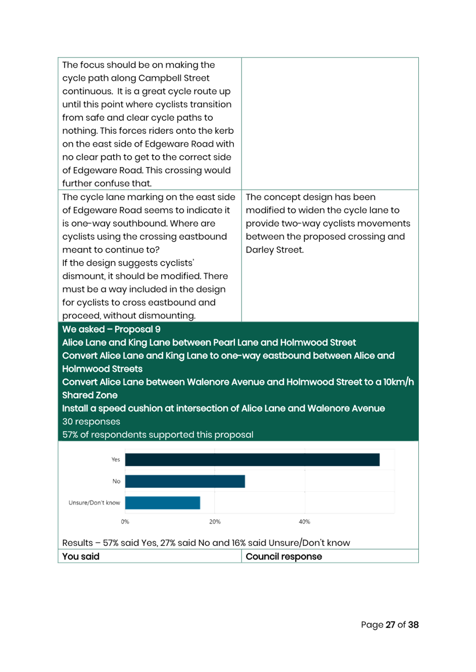
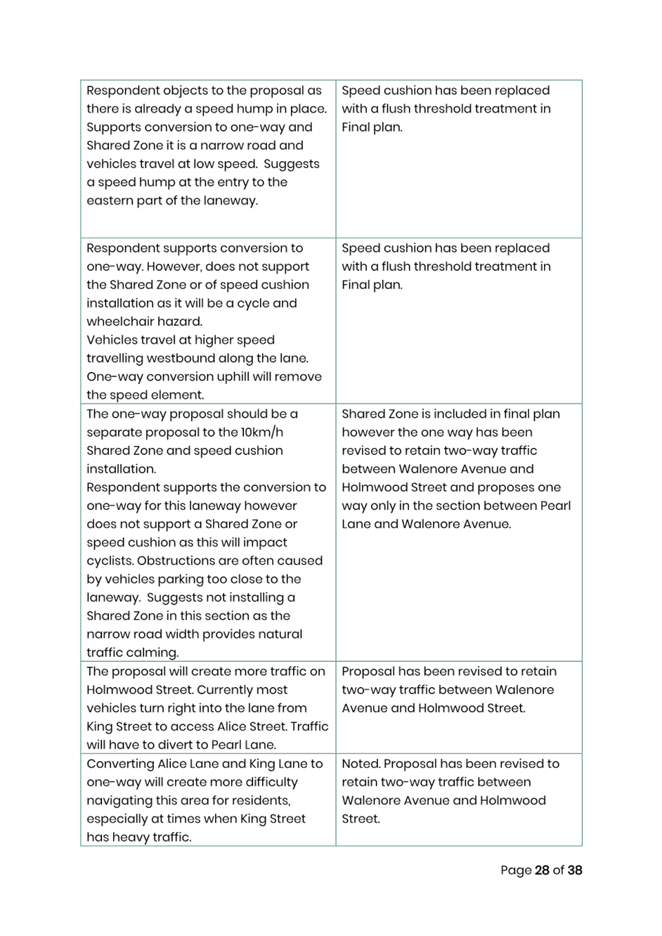
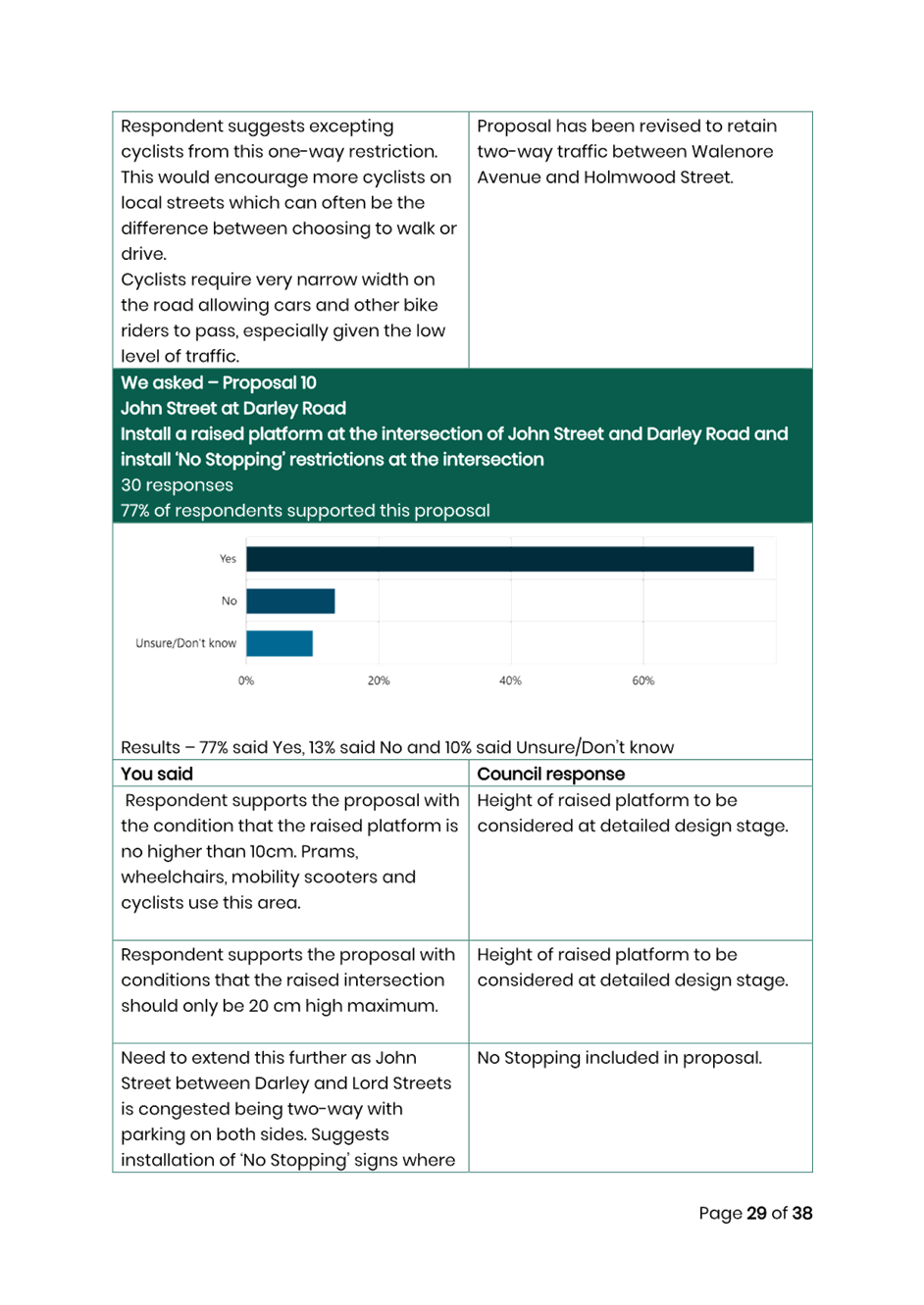
|
AGENDA R |
Local Traffic Committee Meeting
MONDAY 16 SEPTEMBER 2024
11:00 AM
|
|
Local Traffic Committee Meeting 16 September 2024 |
Function of the Local Traffic Committee
Background
Roads and Maritime Services (RMS) is legislated as the Authority responsible for the control of traffic on all NSW Roads. The RMS has delegated certain aspects of the control of traffic on local roads to councils. To exercise this delegation, councils must establish a local traffic committee and obtain the advice of the RMS and Police. The Inner West Council Local Traffic Committee has been constituted by Council as a result of the delegation granted by the RMS pursuant to Section 50 of the Transport Administration Act 1988.
Role of the Committee
The Local Traffic Committee is primarily a technical review and advisory committee which considers the technical merits of proposals and ensures that current technical guidelines are considered. It provides recommendations to Council on traffic and parking control matters and on the provision of traffic control facilities and prescribed traffic control devices for which Council has delegated authority. These matters are dealt with under Part A of the agenda and require Council to consider exercising its delegation.
In addition to its formal role as the Local Traffic Committee, the Committee may also be requested to provide informal traffic engineering advice on traffic matters not requiring Council to exercise its delegated function at that point in time, for example, advice to Council’s Development Assessment Section on traffic generating developments. These matters are dealt with under Part C of the agenda and are for information or advice only and do not require Council to exercise its delegation.
Committee Delegations
The Local Traffic Committee has no decision-making powers. The Council must refer all traffic related matters to the Local Traffic Committee prior to exercising its delegated functions. Matters related to State Roads or functions that have not been delegated to Council must be referred directly to the RMS or relevant organisation.
The Committee provides recommendations to Council. Should Council wish to act contrary to the advice of the Committee or if that advice is not supported unanimously by the Committee members, then the Police or RMS have an opportunity to appeal to the Regional Traffic Committee.
Committee Membership & Voting
Formal voting membership comprises the following:
· one representative of Council as nominated by Council;
· one representative of the NSW Police from each Local Area Command (LAC) within the LGA, being Newtown, Marrickville, Leichhardt and Ashfield LAC’s.
· one representative from the RMS; and
· State Members of Parliament (MP) for the electorates of Summer Hill, Newtown, Heffron, Canterbury, Strathfield and Balmain or their nominees.
Where the Council area is represented by more than one MP or covered by more than one Police LAC, representatives are only permitted to vote on matters which effect their electorate or LAC.
Informal (non-voting) advisors from within Council or external authorities may also attend Committee meetings to provide expert advice.
Committee Chair
Council’s representative will chair the meetings.
Public Participation
Members of the public or other stakeholders may address the Committee on agenda items to be considered by the Committee. The format and number of presentations is at the discretion of the Chairperson and is generally limited to 3 minutes per speaker. Committee debate on agenda items is not open to the public.
|
|
Local Traffic Committee Meeting 16 September 2024 |
|
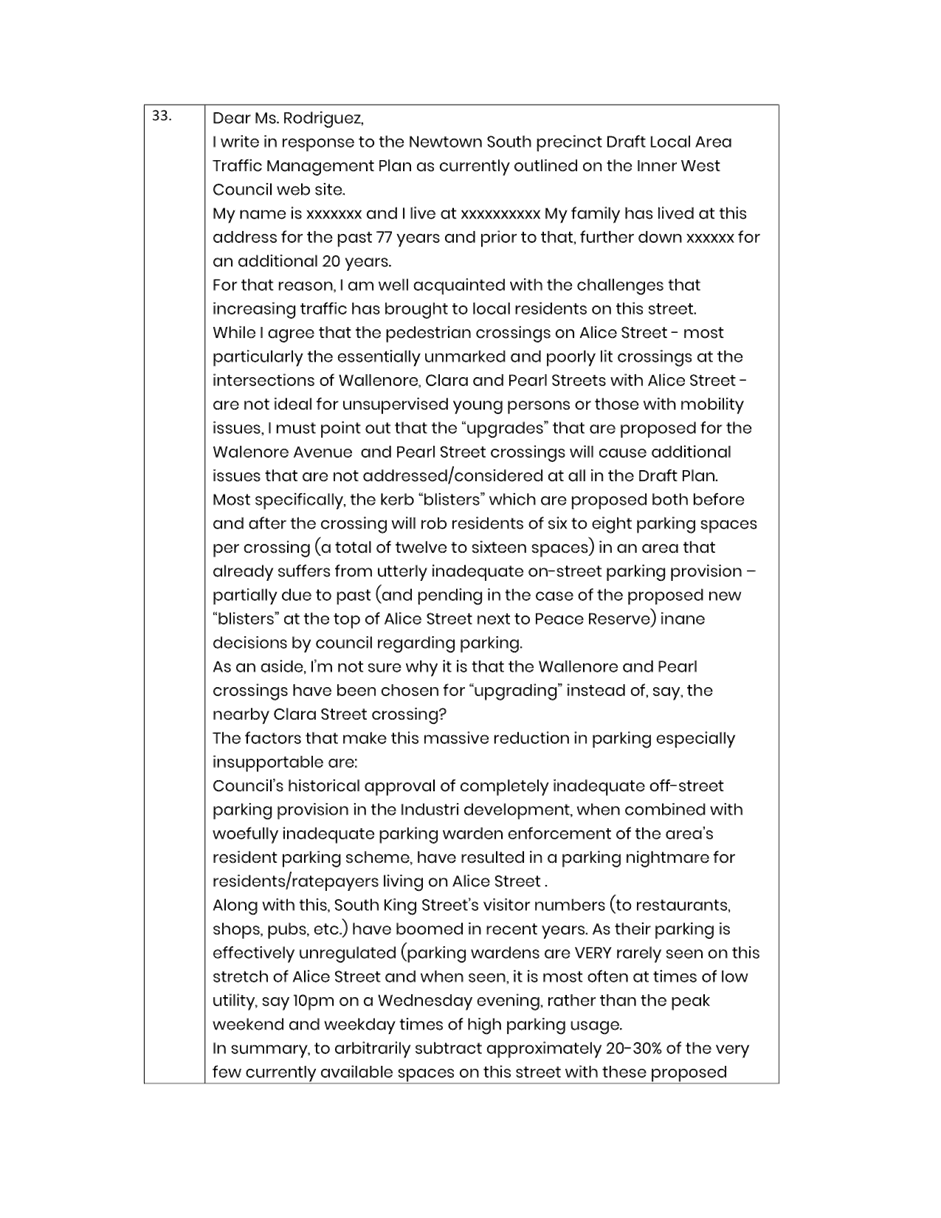
AGENDA |
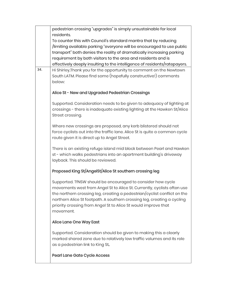
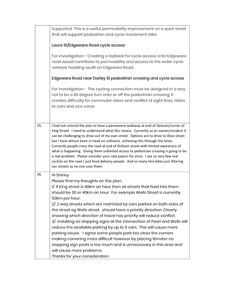
1 Apologies
2 Disclosures of Interest
3 Confirmation of Minutes
Minutes of 19 August 2024 Local Traffic Committee 6
4 Matters Arising from Council’s Resolution of Minutes
5 Part A – Items Where Council May Exercise Its Delegated Functions
Traffic Matters
ITEM Page
LTC0924(1) Item 1 The Boulevarde, Lilyfield - Proposed Streetscape improvements and Civil Works (Baludarri-Balmain Ward/Balmain Electorate/Leichhardt PAC) 19
LTC0924(1) Item 2 Derbyshire Road, Leichhardt - Sydney Secondary College Leichhardt - Proposed Kerb Extension (Baludarri-Balmain Ward/Balmain Electorate/Leichhardt PAC) 25
LTC0924(1) Item 3 IW@40 - Area 6 Enmore & Marrickville East; Area 7 Marrickville & Tempe - Proposed speed limit reduction from 50km/h to 40 km/h (Midjuburi-Marrickville & Damun-Stanmore Wards/ Heffron,Summer Hill & Newtown Electorates/Inner West PAC) 29
LTC0924(1) Item 4 Newtown South Local Area Traffic Management Plan (LATM) Final Report (Damun-Stanmore Ward/Newtown Electorate/Inner West PAC) 45
LTC0924(1) Item 5 Marrickville Road at Despointes Street, Marrickville – Proposed new raised pedestrian crossing - Design Plan 10297 (Midjuburi-Marrickville Ward / Summer Hill Electorate / Inner West PAC) 162
LTC0924(1) Item 6 Clissold Street, between Queen Street and Victoria Street, Ashfield- Proposed removal of existing at-grade crossing and provide a new raised pedestrian (zebra) crossing (Djarrawunang-Ashfield Ward/Summer Hill Electorate/Burwood PAC) 166
LTC0924(1) Item 7 Flood Street, Leichhardt – Proposed Slow Point at Regent Street (Gulgadya-Leichhardt Ward/Balmain Electorate/ Leichhardt PAC) 173
LTC0924(1) Item 8 Alt Street, south of Albert Parade, Ashfield-Proposed raising of existing pedestrian (zebra) crossing adjacent to St. Vincent's College (Gulgadya-Leichhardt Ward/Summer Hill Electorate/Burwood PAC) 177
LTC0924(1) Item 9 Ryan Street, Lilyfield (at Joseph Street) – Proposed Landscaped Kerb Blister Island (Baludarri-Balmain Ward/Balmain Electorate/Leichhardt PAC) 183
Parking Matters
Nil at the time of printing.
Late Items
Nil at time of printing.
6 Part B - Items for Information Only
Nil at the time of printing.
7 Part C - Items for General Advice
Nil at the time of printing.
8 General Business
9 Close of Meeting
|
|
Local Traffic Committee Meeting 16 September 2024 |
Minutes of Local Traffic Committee Meeting
Meeting held on 19 August 2024 commenced at 11:02AM
ACKNOWLEDGEMENT OF COUNTRY BY CHAIRPERSON
I acknowledge the Gadigal and Wangal people of the Eora nation on whose country we are meeting today, and their elders past and present.
COMMITTEE REPRESENTATIVES PRESENT
|
Jason Scoufis |
IWC’s Acting Traffic and Transport Planning Manager (Chair) |
|
Bill Holliday |
Representative for Kobi Shetty MP, Member for Balmain |
|
Graeme McKay |
Representative for Jo Haylen MP, Member for Summer Hill |
|
Eleanor Nurse |
Representative for Jenny Leong MP, Member for Newtown |
|
Nina Fard |
Transport for NSW (TfNSW) |
|
|
|
|
NON VOTING MEMBERS IN ATTENDANCE |
|
|
|
|
|
Bob Moore |
Representative for the Inner West Bicycle Coalition (IWBC) |
|
Sunny Jo |
IWC’s Coordinator Traffic Engineering Services (North) |
|
George Tsaprounis |
IWC’s Coordinator Traffic Engineering Services (South) |
|
Daniel Li |
IWC’s Graduate Traffic Engineer |
|
Christy Li |
IWC’s Business Administration Officer |
|
|
|
|
VISITORS |
|
|
|
|
|
Adrian Barritt |
Representative for Transport for NSW/ Sydney Metro (Items 1 & 3) |
|
|
|
|
APOLOGIES: |
|
|
|
|
|
Mayor Darcy Byrne |
Councillor – Baludarri-Balmain Ward |
|
Manod Wickramasinghe |
IWC’s Traffic and Transport Planning Manager |
DISCLOSURES OF INTERESTS:
Nil.
CONFIRMATION OF MINUTES
|
That the Minutes of the Local Traffic Committee held on Monday, 15 July 2024 be confirmed. |
MATTERS ARISING FROM COUNCIL’S RESOLUTION OF MINUTES
Nil.
|
LTC0824(1) Item 3 Ewart Street, Dulwich Hill; Illawarra Road, Marrickville; Burrows Avenue, Railway Road, Gleeson Avenue and Lower Railway Parade, Sydenham – Temporary medium-term parking changes during major rail shutdown of T3 line for Sydney Metro Upgrade works – Bus replacements for an approximate 12-month period from October 2024 (Midjuburi-Marrickville Ward / Summer Hill Electorate / Inner West PAC) |
|
Council has been notified by Transport for NSW (TfNSW) that Sydney Metro works will involve a final major rail shutdown of the Sydenham to Bankstown rail line (T3) for approximately 12 months starting no later than October 2024. During the shutdown buses will replace train services along the T3 line and to accommodate the increased bus movements and necessary holding areas some short-term parking changes are required at a number of locations.
Specifically, TfNSW is requesting approval for the temporary conversion of multiple parking spaces at the following locations: Ewart Street, Dulwich Hill; Illawarra Road, Marrickville; Burrows Avenue, Railway Road, Gleeson Avenue and (Lower) Railway Parade, Sydenham. It is recommended that no objections be raised, and Council approves the temporary medium-term parking changes at the identified locations during the rail shutdowns.
All changes to street signage will be made by TfNSW contractor(s) from 10pm the night before the closures and will be reinstated at the completion of the planned shutdown.
Officers Recommendation:
1. That the following temporary medium-term parking changes for an approximate 12-month period from October 2024 be approved to support the rail upgrade works required to convert the T3 Bankstown Line to a Metro Line:
a) Dulwich Hill Station Precinct - Ewart Street (3 parking spaces): The medium-term conversion of 20m (3 parking spaces) ‘2P 8am–6pm Mon–Fri’ on the northern side of Ewart Street (between Wardell Road and Bayley Street) to a ‘Bus Zone’;
b) The medium-term conversion of 25m ‘No Parking’ restrictions on the southern side of Ewart Street (between Wardell Road and Riverside Crescent) to a ‘Bus Zone’;
c) Marrickville Station Precinct - Illawarra Road (1 parking space): The medium-term conversion of 7m ‘1P 8:30am–6pm’ on the western side of Illawarra Road (between Warburton Street and Greenbank Street) to a ‘Bus Zone’;
d) Sydenham Station Precinct - Burrows Avenue (10 parking spaces): The medium-term conversion of 26m rear to kerb 90 degree angle ‘unrestricted parking’ on the northern kerb of Burrows Avenue (west of Gleeson Avenue) to a ‘Bus Zone’;
e) The medium-term conversion of 58m (9 parking spaces) ‘unrestricted parking’ on the eastern kerb of Burrows Avenue (west of Gleeson Avenue) to a ‘Bus Zone’;
f) Sydenham Station Precinct – Railway Road (3 parking spaces): The medium-term conversion of 18m ‘2P 8:30am–10pm Mon-Fri’ on the eastern side kerb of Railway Road (between Burrows Avenue and Gleeson Avenue) to a ‘Bus Zone’;
g) Sydenham Station Precinct - Gleeson Avenue (2 parking spaces): The medium-term conversion of 12m ‘1P 9:00am–3:30pm Mon-Fri and ‘No Parking’ 6am-9am, 3:30pm–6:30pm’ on the eastern kerb of Gleeson Avenue between Burrows Avenue and Unwins Bridge Road to a ‘Bus Zone’; and
h) Sydenham Station Precinct - Lower Railway Parade (29 parking spaces): The medium-term conversion of 29m (10 parking spaces) 45 degree angled ‘4P 8:30am–6pm Mon-Fri’ and 53m (19 parking spaces) 45 degree angled unrestricted parking on the southwest kerb of Lower Railway Parade (between Gleeson Avenue and Marrickville Road) to a ‘Bus Zone’.
2. That the cost of all works of the statement and/or reinstatement of any/all signage will be borne by TfNSW.
3. That the applicant and Council Rangers be advised in terms of this report.
DISCUSSION:
The Committee members agreed with the Officer’s recommendation.
COMMITTEE RECOMMENDATION:
1. That the following temporary medium-term parking changes for an approximate 12-month period from October 2024 be approved to support the rail upgrade works required to convert the T3 Bankstown Line to a Metro Line:
a) Dulwich Hill Station Precinct - Ewart Street (3 parking spaces): The medium-term conversion of 20m (3 parking spaces) ‘2P 8am–6pm Mon–Fri’ on the northern side of Ewart Street (between Wardell Road and Bayley Street) to a ‘Bus Zone’;
b) The medium-term conversion of 25m ‘No Parking’ restrictions on the southern side of Ewart Street (between Wardell Road and Riverside Crescent) to a ‘Bus Zone’;
c) Marrickville Station Precinct - Illawarra Road (1 parking space): The medium-term conversion of 7m ‘1P 8:30am–6pm’ on the western side of Illawarra Road (between Warburton Street and Greenbank Street) to a ‘Bus Zone’;
d) Sydenham Station Precinct - Burrows Avenue (10 parking spaces): The medium-term conversion of 26m rear to kerb 90 degree angle ‘unrestricted parking’ on the northern kerb of Burrows Avenue (west of Gleeson Avenue) to a ‘Bus Zone’;
e) The medium-term conversion of 58m (9 parking spaces) ‘unrestricted parking’ on the eastern kerb of Burrows Avenue (west of Gleeson Avenue) to a ‘Bus Zone’;
f) Sydenham Station Precinct – Railway Road (3 parking spaces): The medium-term conversion of 18m ‘2P 8:30am–10pm Mon-Fri’ on the eastern side kerb of Railway Road (between Burrows Avenue and Gleeson Avenue) to a ‘Bus Zone’;
g) Sydenham Station Precinct - Gleeson Avenue (2 parking spaces): The medium-term conversion of 12m ‘1P 9:00am–3:30pm Mon-Fri and ‘No Parking’ 6am-9am, 3:30pm–6:30pm’ on the eastern kerb of Gleeson Avenue between Burrows Avenue and Unwins Bridge Road to a ‘Bus Zone’; and
h) Sydenham Station Precinct - Lower Railway Parade (29 parking spaces): The medium-term conversion of 29m (10 parking spaces) 45 degree angled ‘4P 8:30am–6pm Mon-Fri’ and 53m (19 parking spaces) 45 degree angled unrestricted parking on the southwest kerb of Lower Railway Parade (between Gleeson Avenue and Marrickville Road) to a ‘Bus Zone’.
2. That the cost of all works of the statement and/or reinstatement of any/all signage will be borne by TfNSW.
3. That the applicant and Council Rangers be advised in terms of this report.
For Motion: Unanimous |
|
LTC0824(1) Item 4 Woodland Street and Holmesdale Street, Marrickville – Temporary Road Closures for up to seven (7) separate weekend days to hold AFLW matches at Henson Park - (Midjuburi-Marrickville Ward /Summer Hill Electorate /Inner West PAC) |
|
An application has been received from AFL NSW/ACT to hold up to seven (7) AFLW matches at Henson Park Oval. The events require the temporary full road closure of Woodland Street, between Illawarra Road and dead-end, and Holmesdale Street, between Sydenham Road and Woodland Street, Marrickville to allow for pedestrian entry to Henson Park on the AFLW match days. It is recommended that Council agree to the temporary full road closures subject to the applicant complying with the above conditions.
Officers Recommendation:
That the proposed temporary full road closure (ENRC/2024/0043) of Woodland Street, between Illawarra Road and dead-end, and Holmesdale Street, between Sydenham Road and Woodland Street, Marrickville on Sunday 22 September: 11:30am-3:30pm; Sunday 29 September: 3:30pm–7:30pm; Sunday 6 October: 11:30am-3:30pm; Sunday 13 October: 3:30pm–7:30pm; Saturday 19 October: 11:30am–4:30pm; and Saturday 26 October: 11.30am-4.30pm (contingency period of one month) for the purpose of holding up to seven (7) AFLW matches at Henson Park be approved, subject to the applicant complying with, but not limited to, the following conditions:
a) A Road Occupancy License application be obtained by the applicant from the Transport Management Centre; b) All affected residents and businesses, including NSW Police Local Area Commander, Transit Systems, Fire and Rescue NSW and NSW Ambulance Services, shall be notified in writing by the applicant of the proposed temporary road closure at least 7 days prior to the event, with the applicant making reasonable provision for residents and businesses; and c) The occupation of the road carriageway must not occur until the road has been physically closed.
DISCUSSION:
The Representative for the Member of Newtown noted that Council only notifies affected residents and businesses and advised this is insufficient notice to the wider community. The Representative for the Member of Newtown suggested that Council publish notices of events and road closures in parks so that people in the wider community are aware of upcoming events and road closures.
Council Officers advised that they would request Council’s Parks team to place notice of pending events within Henson Park.
The Committee members agreed with the Officer’s recommendation.
COMMITTEE RECOMMENDATION:
That the proposed temporary full road closure (ENRC/2024/0043) of Woodland Street, between Illawarra Road and dead-end, and Holmesdale Street, between Sydenham Road and Woodland Street, Marrickville on Sunday 22 September: 11:30am-3:30pm; Sunday 29 September: 3:30pm–7:30pm; Sunday 6 October: 11:30am-3:30pm; Sunday 13 October: 3:30pm–7:30pm; Saturday 19 October: 11:30am–4:30pm; and Saturday 26 October: 11.30am-4.30pm (contingency period of one month) for the purpose of holding up to seven (7) AFLW matches at Henson Park be approved, subject to the applicant complying with, but not limited to, the following conditions:
a) A Road Occupancy License application be obtained by the applicant from the Transport Management Centre; b) All affected residents and businesses, including NSW Police Local Area Commander, Transit Systems, Fire and Rescue NSW and NSW Ambulance Services, shall be notified in writing by the applicant of the proposed temporary road closure at least 7 days prior to the event, with the applicant making reasonable provision for residents and businesses; and c) The occupation of the road carriageway must not occur until the road has been physically closed.
For Motion: Unanimous |
|
LTC0824(1) Item 7 Eliza Street, Newtown – Temporary full road closure for a community event on Saturday 7 December 2024 – ENRC/2024/0035 (Damun-Stanmore Ward / Newtown Electorate / Inner West PAC) |
|
Council has been notified by Young Henrys Pty Ltd about a proposed temporary full road closure of Eliza Street, Newtown between Lennox Street and King Street, for an 18-hour period from 6:00am on Saturday 7 December 2024 to 12.00am midnight in order to hold the event ‘Young Henrys Newtown Festival 2024’. It is recommended that Council agree to the temporary full road closure subject to complying with all conditions as set out in this report.
Officers Recommendation: That the proposed temporary full road closure of Eliza Street, between Lennox Street and King Street, Newtown for an 18-hour period from 6:00am Saturday 7 December 2024 to 12:00am midnight (contingency period 2 weeks) be approved, for the purpose of holding the event ‘Young Henrys Newtown Festival 2024’, subject to the following conditions and all standard Council conditions for a temporary full road closure: a) A Road Occupancy License (ROL) be obtained by the applicant from the Transport Management Centre (TMC); b) All affected residents and businesses, including the NSW Police Local Area Commander, Fire & Rescue NSW and NSW Ambulance Services be notified in writing, by the applicant, of the proposed temporary road closure at least 14 days in advance of the closure with the applicant making reasonable provision for stakeholders; c) A 4m wide emergency vehicle access must be maintained through the closed road areas during the course of the event; and d) The occupation of the road carriageway must not occur until the road has been physically closed.
DISCUSSION:
The Representative for the IWBC noted that the report does take into consideration how the road closure may affect cyclists. Council Officers have taken the feedback into consideration and advised they will speak to the applicant regarding taking into consideration the needs of cyclists in their planning.
Council Officers agreed and updated the approval to include a condition regarding bicycle detour signage.
The Committee members agreed with the amended recommendation.
COMMITTEE RECOMMENDATION: That the proposed temporary full road closure of Eliza Street, between Lennox Street and King Street, Newtown for an 18-hour period from 6:00am Saturday 7 December 2024 to 12:00am midnight (contingency period 2 weeks) be approved, for the purpose of holding the event ‘Young Henrys Newtown Festival 2024’, subject to the following conditions and all standard Council conditions for a temporary full road closure: a) A Road Occupancy License (ROL) be obtained by the applicant from the Transport Management Centre (TMC); b) All affected residents and businesses, including the NSW Police Local Area Commander, Fire & Rescue NSW and NSW Ambulance Services be notified in writing, by the applicant, of the proposed temporary road closure at least 14 days in advance of the closure with the applicant making reasonable provision for stakeholders; c) A 4m wide emergency vehicle access must be maintained through the closed road areas during the course of the event; and d) The occupation of the road carriageway must not occur until the road has been physically closed. e) The Applicant to provide cycle detour signage at the event.
For Motion: Unanimous |
General Business:
|
Item 12: Extended school zone on Campbell Street for St Peters Public School |
|
Council Officers advised that TfNSW have installed a 40km/h school zone for St Peters Public School along Campbell Street, to improve pedestrian safety during school zone times. The school zone extends from 10 metres east of Florence Street to 30 metres west of Princes Highway. It covers a length of 200 metres and will enhance safety for students and the local community.
|
Meeting closed at 12.11pm.
CHAIRPERSON
Jason Scoufis – Acting Traffic and Transport Planning Manager
|
|
Local Traffic Committee Meeting 16 September 2024 |
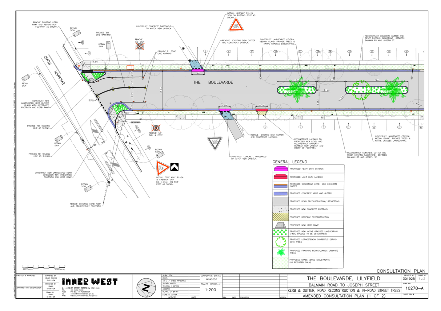
Subject: The Boulevarde, Lilyfield - Proposed Streetscape improvements and Civil Works (Baludarri - Balmain Ward/Balmain Electorate/Leichhardt PAC)
Prepared By: Charbel El Kazzi - Traffic Engineer
Authorised By: Jason Scoufis - Acting Traffic and Transport Planning Manager
|
RECOMMENDATION
That the attached detailed design plan No.10278-A for the proposed streetscape improvements and civil works on The Boulevarde between Balmain Road and Joseph Street, Lilyfield be approved.
|
STRATEGIC OBJECTIVE
This report supports the following strategic directions contained within Council’s Community Strategic Plan:
|
2: Liveable, connected neighbourhoods and transport |
|
|
EXECUTIVE SUMMARY
The Council is planning to undertake streetscape improvement works in The Boulevarde, Lilyfield. The works are intended to improve pedestrian and motorist safety at the intersection of the Boulevarde and Balmain Road by constructing kerb extensions as well as improving the general amenity of the street by providing in-road trees, including repairing the road and footpaths.
The proposal works does not change the existing parking spaces in the street.
BACKGROUND
The detailed design plan shown in Attachment 1 outlines the proposed works on The Boulevarde, Lilyfield and includes the following:
· Construct five (5) landscaped central median islands along the centreline of the road;
· Provide trees and native landscaping within central median islands;
· Construct new landscaped kerb blister islands with integrated footpaths and kerb ramps to improve pedestrian safety whilst reducing approach speeds in The Boulevarde at the intersection with Balmain Road;
· Reset existing sandstone kerb and construct new concrete gutters on both sides (final extents to be determined at a later stage);
· Reconstruct two (2) existing driveways as required to match the new kerb and gutter levels;
· Reconstruct laybacks and entry thresholds on both sides of unnamed lane to make more pedestrian friendly;
· Reconstruct damaged sections of concrete footpaths on both sides of the street (final extent to be determined at a later stage);
· Remove the damaged road surface and resurface with new asphalt (final extent to be determined at a later stage and subject to final budget allocations);
· Provide new pavement line markings as indicated in plan; and
· Install signage associated with the works as shown in plans.
DISCUSSION
A letter outlining the proposal was issued to the properties shown in the distribution map below. Twenty submissions were received in response to this proposal with 11 in support and 9 opposed. Comments in relation to the proposal are summarised within the below table.
Following feedback received during the consultation, the design plan has been revised to replace the total number of trees and the tree species.
|
Resident Comments |
Officer Comments |
|
The tree planting – Jacaranda mimosifolia grow to a height of 15 metres and a width of 10 metres and have invasive root systems. Many of the homes on the western side of The Boulevarde currently enjoy views to the city. A 15m high tree will block these views and adversely affect their property values. The trees drop very large quantities of flowers, leaves and seed pods which are a nuisance to clean up and will • require regular street sweeping to prevent the tree litter from blocking the stormwater drains. • result in their small leaves and flowers falling into and blocking vents on cars which can cause a build-up of dust/dirt/mud which retains moisture and causing premature rusting in the vehicle. • result in risk of damage from seed pods falling onto cars or dropped flowers which become mushy, stick to cars and can stain/mark the paint work • fallen flowers are slippery and can cause a risk to people crossing the road. Many of the houses in The Boulevarde are either terraces and/or have their side walls constructed up to the side boundaries with no north facing windows. This means they rely on windows in the eastern and western facing walls to allow natural light to penetrate into them. The size of the proposed planting when mature will result in severely reducing natural light into these homes. (6 similar comments) |
Council has noted the feedback received and has decided to replace the proposed Jacaranda Trees with Fraxinus Pennsylvanica Urbanite. This species is expected to grow 12m in height and a canopy width of 8m.
Council has also reduced the overall number of in-road trees from fifteen (15) to ten (10). This will space the trees out more and reduce the density of the tree canopy of the in-road trees.
Council will be responsible for the on-going maintenance of the trees and landscaping within the central median island. Maintenance will be undertaken as needed as part of an overall maintenance program. |
|
It is unclear what benefit constructing five landscaped central median islands would provide to the amenity and safety of the street. Currently, the wide street provides a clear view of pedestrians and cars, promoting safety in the street. We are concerned that the median islands will create a serious safety issue for pedestrians and motorists. The median islands with significant trees and plantings will obstruct the view of oncoming pedestrians crossing the street (particularly young people who are small), block the views of some residents entering/exiting their driveway which could lead to accidents. Of particular concern is that children play in the street and in the existing trees |
The central median islands will act as traffic calming devices which will slow down traffic and provide better opportunity for pedestrians to cross in between the gaps.
Note that the islands are midblock treatments and will be low level with native grass at approximately 400-500mm in height. This will have minimal impact on visibility for motorists.
|
|
Narrowing of roadway – we feel the proposed road lane width is too narrow – Australian road standards for a traffic lane is 3.5m with a 1m clearance to barriers or structures. Even if the clearance to the central island was reduced to 0.5m this would only leave a 2.05m parking lane. Public transport buses regularly using our street as well as garbage & other trucks which would pose a risk of damage to both the trees planted in the centre of the road and parked cars. |
6.05m of space between the kerb and the central island is provided. This is adequate space to accommodate parking and one way travel along each side of the road. A turning path assessment undertaken has demonstrated that there is adequate space for an 8.8m service vehicle to travel. |
|
The current width of The Boulevarde affords drivers ability to see traffic more clearly than other streets along Balmain Road. Entering and exiting is easier from The Boulevarde due to the width of the street. Adding kerb extensions will restrict visibility and make it more challenging to enter The Boulevarde southbound off Balmain Road and any vehicle waiting to turn right into Balmain Road will prevent any vehicles behind them from turning left. (1 similar comment) |
This location was identified as under the Pedestrian Access and Mobility Plan as a location requiring safety improvements due to its “long crossing” width. As a result, a “road narrowing” treatment in the form of kerb extensions are being introduced to shorten the pedestrian walking distance. Turning movements for vehicles have been checked and the proposal is appropriate to cater for all required turn movements, including service vehicles. Improvements to pedestrian safety will outweigh any negative impact on traffic delays. |
|
Any rework of the original Sandstone block gutters would potentially change established Surveyor markers along the street adding substantial disruption, necessary further survey work and extra costs for any future building work/any development applications for residents. (1 similar comment) |
Prior to the commencement of any works, any existing State Survey or cadastral reference marks affected by works would be located by a Registered Surveyor to apply to Land Registry Services for permission to remove such marks. Upon receiving approval, the Registered Surveyor will document the existing marks in the street, then return to site after construction works are complete, to re-establish new marks to the satisfaction of Land Registry Services. This is a standard process that Council follows in all such construction works. |
FINANCIAL IMPLICATIONS
The works are expected to cost approximately $800,000 and is funded under Council’s Pedestrian Access and Mobility Plan (PAMP) program, Councils Capital Works and Tree program.
|
1.⇩ |
The Boulevarde, Lilyfield - Plan |
|
Local Traffic Committee Meeting 16 September 2024 |
Subject: Derbyshire Road, Leichhardt - Sydney Secondary College Leichhardt - Proposed Kerb Extension (Baludarri-Balmain Ward/Balmain Electorate/Leichhardt PAC)
Prepared By: Jackie Ng - Graduate Traffic Engineer
Authorised By: Jason Scoufis - Acting Traffic and Transport Planning Manager
|
RECOMMENDATION
1. That the proposed kerb extension, footpath, and ramps on Derbyshire Road, Leichhardt between Pioneer Memorial Park and the rear gate of Sydney Secondary College Leichhardt as shown in Figure 1 be supported in principle and included for consideration in Council’s Capital Works program.
2. That the interim measures, including a painted chevron, two W6-1A pedestrian warning signs, and an 8.0m length ‘No Stopping’ zone at the east side of Derbyshire Road, Leichhardt near the rear gate of Sydney Secondary College Leichhardt as shown in Figure 2 be approved for installation.
|
STRATEGIC OBJECTIVE
This report supports the following strategic directions contained within Council’s Community Strategic Plan:
|
2: Liveable, connected neighbourhoods and transport |
|
|
EXECUTIVE SUMMARY
This report outlines the pedestrian safety issues raised by Sydney Secondary College Leichhardt on Derbyshire Road, Leichhardt between Pioneer Memorial Park and the rear gate of the school. It is proposed that a kerb extension be installed as a long-term treatment to assist pedestrians crossing Derbyshire Road during community, sporting and school events. A short term proposed ‘No Stopping’ zone, warning signs and line marking is recommended to be installed as an interim measure.
BACKGROUND
Council has received concerns from Sydney Secondary College Leichhardt regarding the safety of pedestrians when crossing between Pioneer Memorial Park and the rear gate of the school on Derbyshire Road, Leichhardt. This section of Derbyshire Road currently has no pedestrian facilities and has unrestricted parking along the eastern side of the road and ‘No Parking’ on the western side. The school has raised a safety issue where groups of students and hall users are being forced to walk between parked vehicles, and as a result, having limited visibility of oncoming traffic in Derbyshire Road.
The rear gate of the school provides access to the school hall and is used by groups of pedestrians during many scheduled community events such as sports training and fixtures, elections, and evening events.
It is proposed that a kerb extension, footpath and kerb ramps be installed at the rear of Sydney Secondary College Leichhardt to assist with students and pedestrians crossing Derbyshire Road, Leichhardt as shown in Figure 1. The treatment will provide a safer dedicated crossing facility for pedestrians and will improve visibility between oncoming traffic and pedestrians.
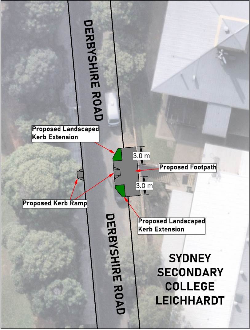
Figure 1
– Proposed Pedestrian Crossing Treatment
Additionally, it is proposed that an interim treatment of an 8.0m length ‘No Stopping’ zone, supplemented by a line marked chevron, and ‘Pedestrian Warning’ signs be installed on each approach as shown in Figure 2.
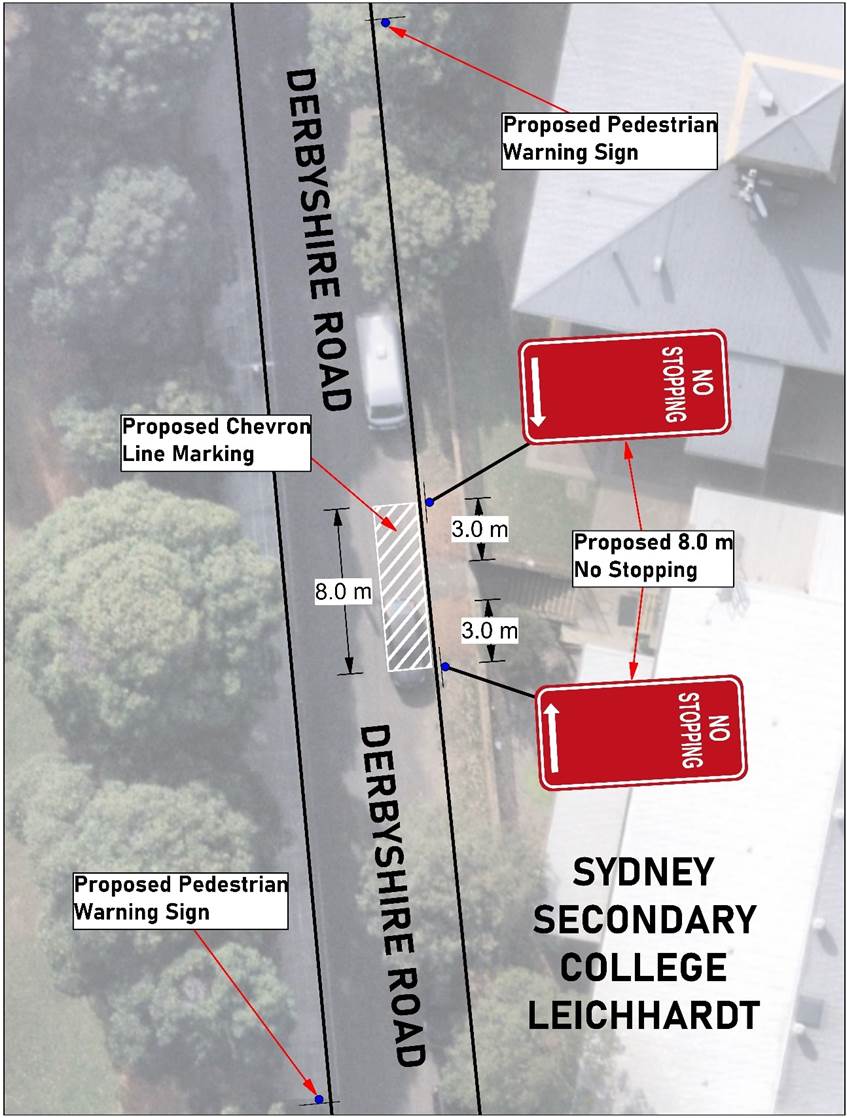
Figure 2 – Proposed Interim Treatment
FINANCIAL IMPLICATIONS
Initial estimate of the proposed kerb extension, footpath and ramps would be approximately $23,000.
Works are to be considered as part of Council’s Capital Works program for Traffic Facilities with final costing to be finalised following completion of detailed design.
The cost of installation of the proposed interim treatment can be funded within Council’s signs and line marking budget.
Nil.
|
|
Local Traffic Committee Meeting 16 September 2024 |
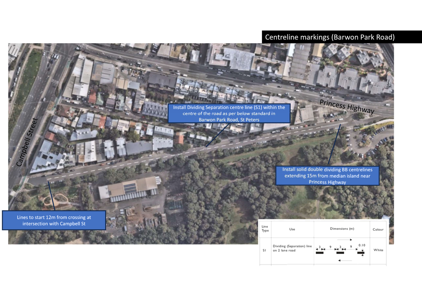
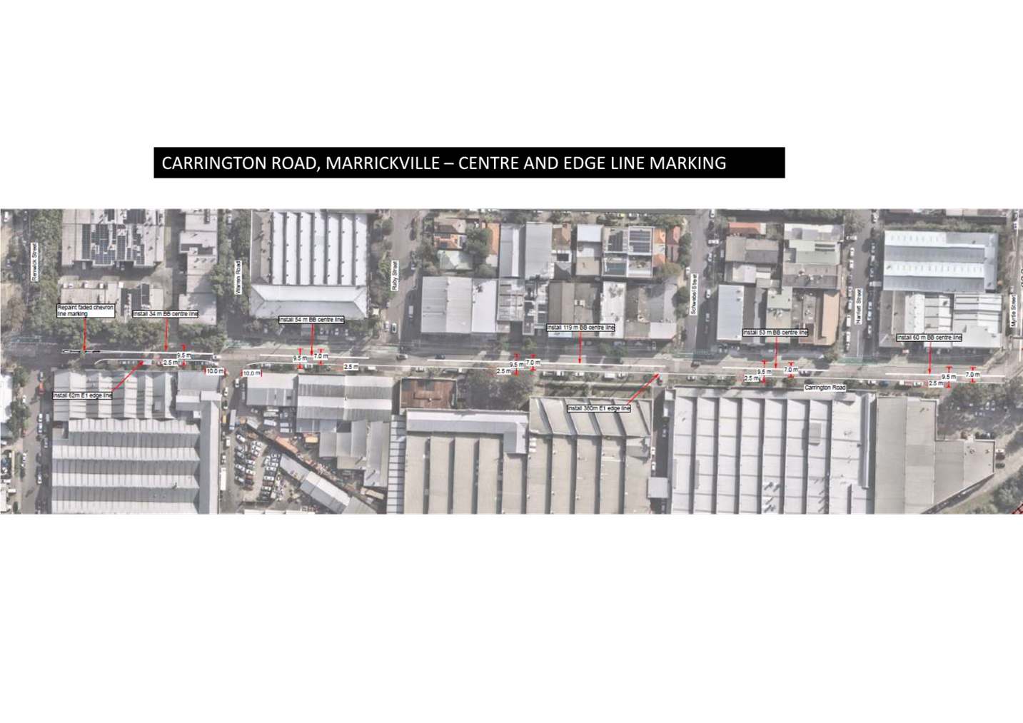
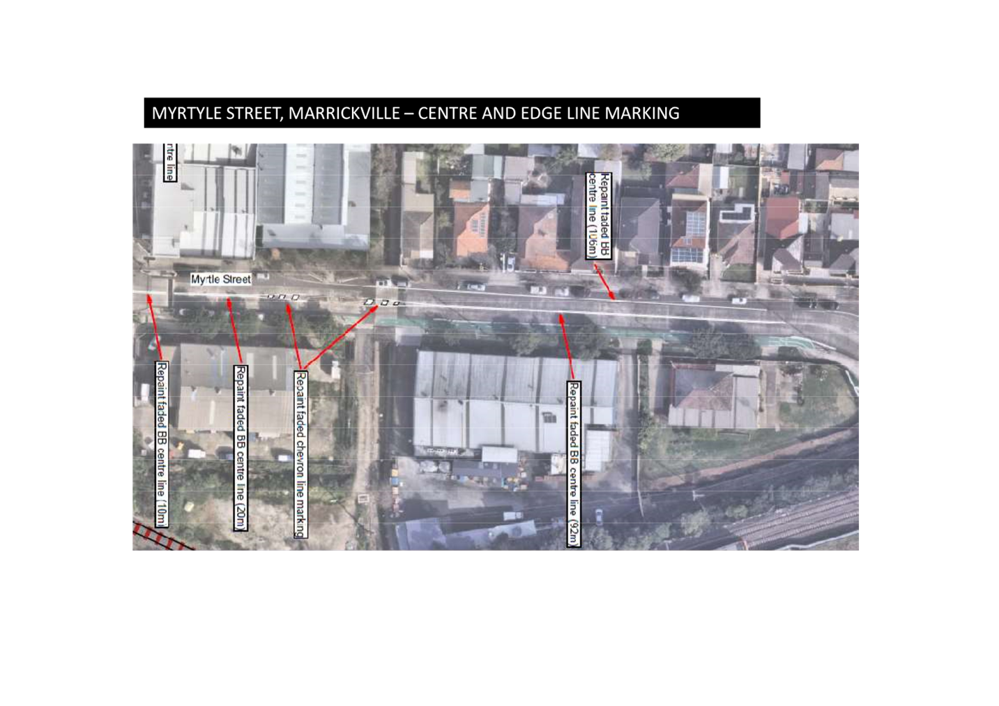
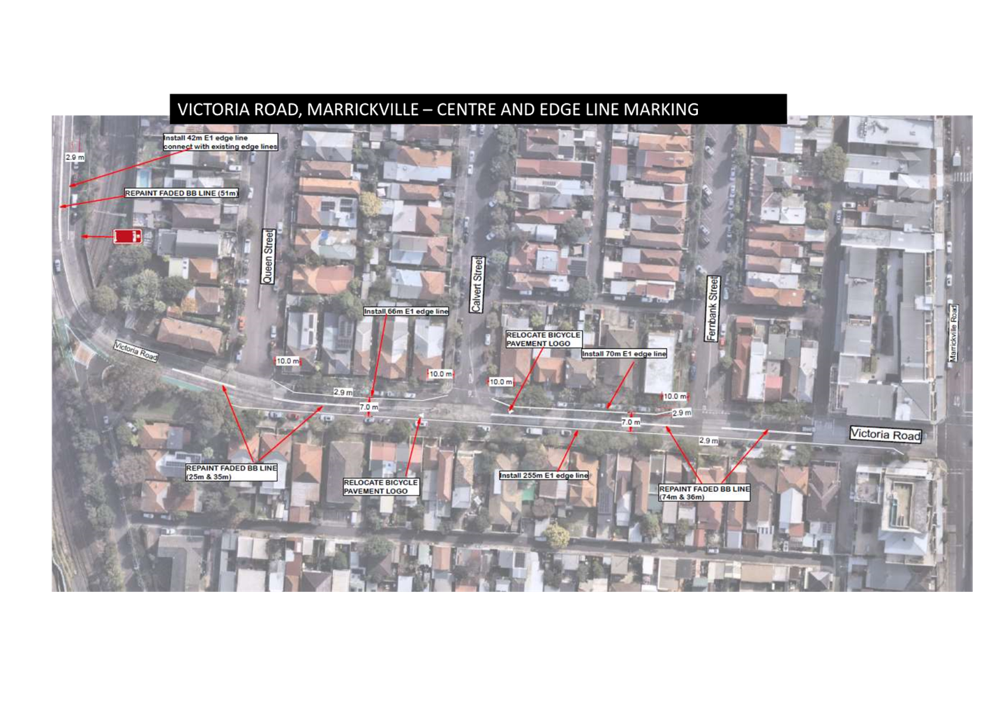
Subject: IW@40 - Area 6 Enmore & Marrickville East; Area 7 Marrickville & Tempe - Proposed speed limit reduction from 50km/h to 40 km/h (Midjuburi-Marrickville & Damun-Stanmore Wards/ Heffron,Summer Hill & Newtown Electorates/Inner West PAC)
Prepared By: James Nguyen - Traffic Engineer
Authorised By: Jason Scoufis - Acting Traffic and Transport Planning Manager
|
RECOMMENDATION
That the proposed signage and line marking plans for the reduction in posted speed limit from 50km/h to 40km/h in all local roads in Areas 6 and 7 of the innerwest@40study of Enmore, Marrickville and Tempe be approved.
|
STRATEGIC OBJECTIVE
This report supports the following strategic directions contained within Council’s Community Strategic Plan:
|
2: Liveable, connected neighbourhoods and transport |
|
|
EXECUTIVE SUMMARY
TfNSW have approved the reduction in speed limit from 50km/h to 40km/h on all local streets within the Inner West LGA and Council was successful in receiving grant funding (approximately $1.8M) under the 2024-2025 Safe Speed Program to undertake the necessary implementation work (signage and linemarking) for two of the high priority areas: Area 6 – Enmore & Marrickville East and Area 7 – Marrickville & Tempe.
Proposed signs and linemarking plans are enclosed.
BACKGROUND
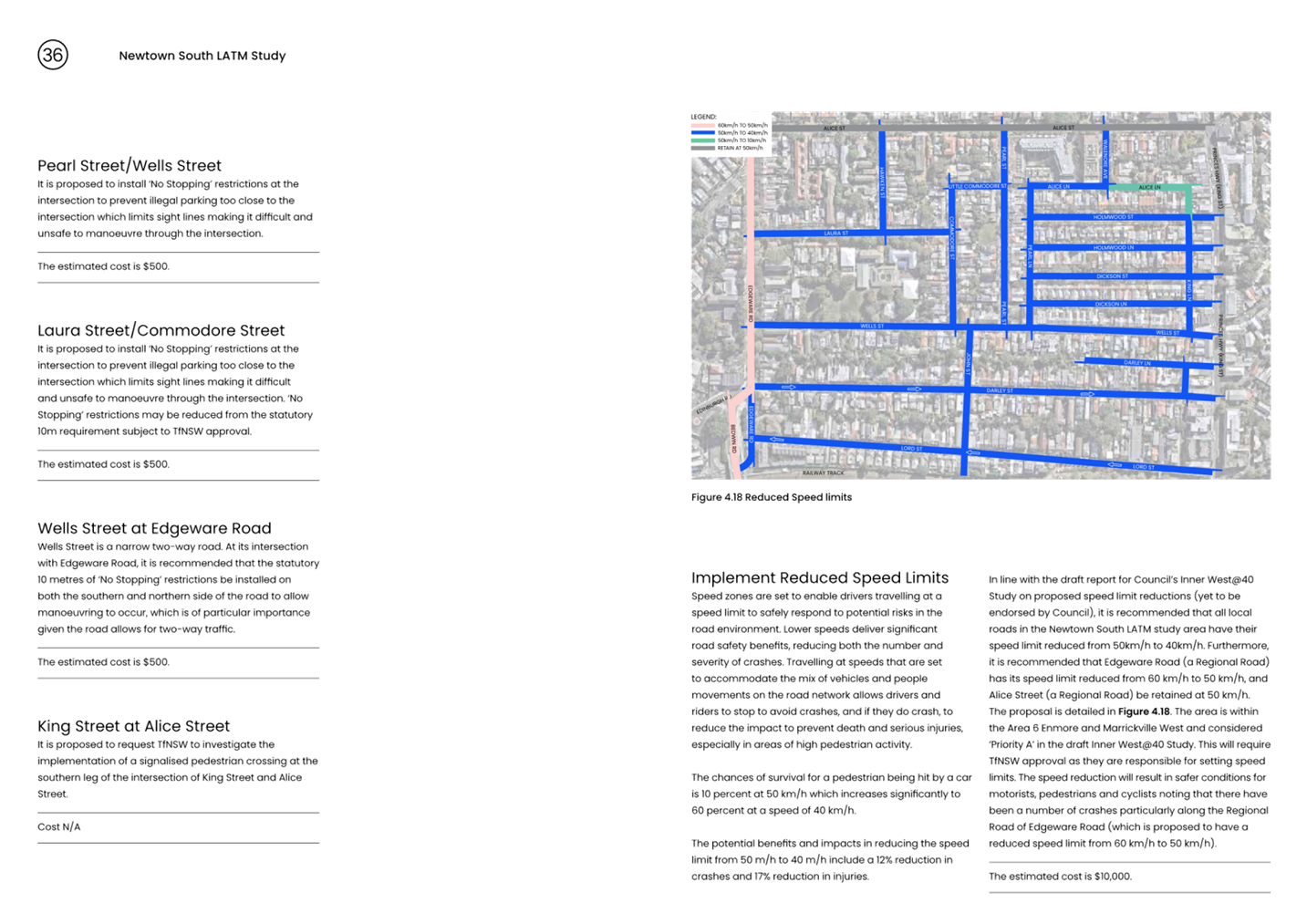
Council’s Integrated Transport Strategy, ‘GOING PLACES’, has identified a key project of reducing the speed limit from 50 km/h to 40 km/h on the local road network within the Inner West Council Area. Accordingly, Council commissioned Beca Consulting to prepare the Innerwest@40 Study. The study found that reductions in signposted speed limits are likely to significantly improve safety with only minimal impacts on travel times.
The Innerwest@40 Study adopted in Council Meeting, March 2024 has identified priority areas for the staged implementation of the area-wide 40km/h limit in the Council area. This is shown in Figure 1 below.
The reduction of speed limit to 40km/h in our local streets for the Area 6: Enmore & Marrickville East and Area 7: Marrickville & Tempe are proposed to be implemented first. These areas have been identified as “Priority A” under the Inner West@40 study as they have existing street environments that generally make streets self-enforcing to the proposed 40km/h speed limit in line with TfNSW’s expectation for the rollout.
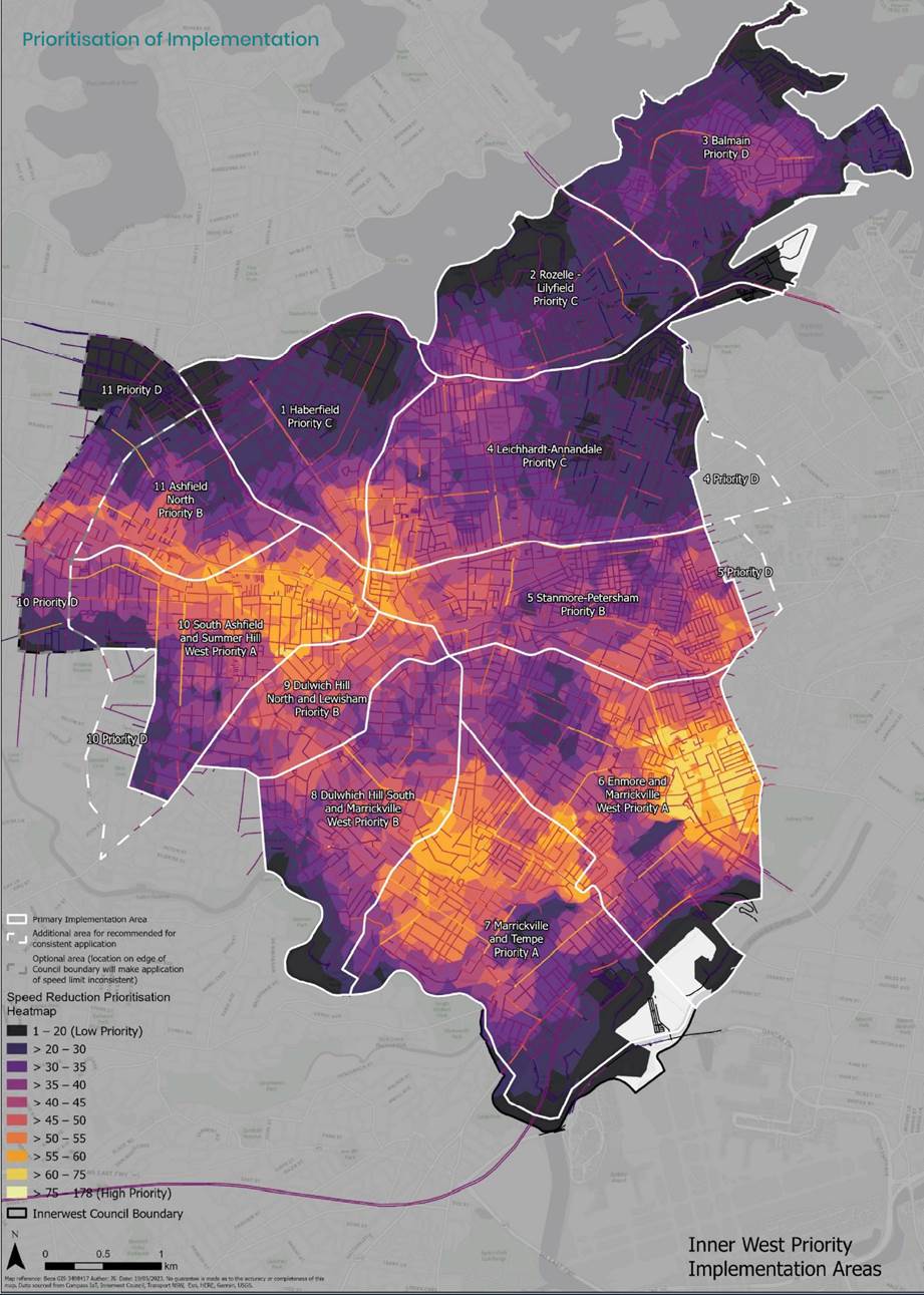
Figure 1 - Prioritisation of 40km/h speed limit reduction (source: Innerwest@40 Study)
DISCUSSION
The 85th percentile speeds (as indicated in the report by BECA) are generally at or below the existing posted speed limit of 50km/h with the average 85th percentile speed within Area 6 and 7 being approximately 37-38km/h with 50 percent of the streets within areas 6 and 7 having an 85% speed of less than 38km/h. Most of the streets under 38km/h would be located in the Enmore area. (It should be noted that the data collected is not tube count data and is based on vehicles fitted technology that utilizes cloud collecting speeds from vehicles. The data is taken over the entire segment of roadway rather than at the highest point. The sample size in terms of traffic volume using this method is small. It should also be noted that there are discrepancies in this form of data collection versus the tube count data).

Figure 2- 85th Percentile Speed Profile
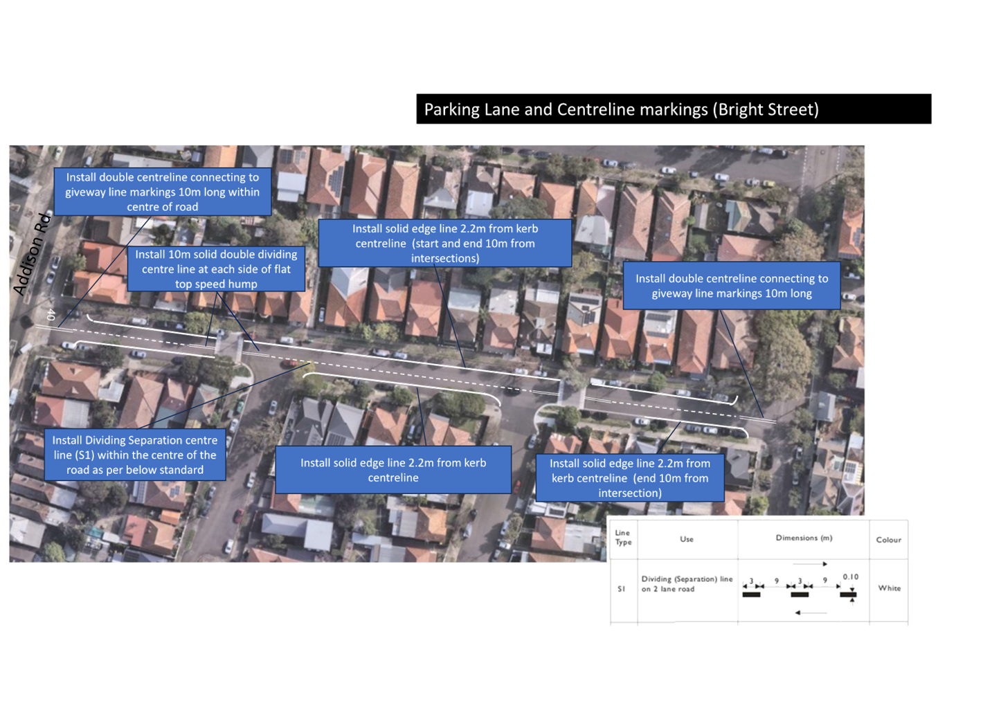
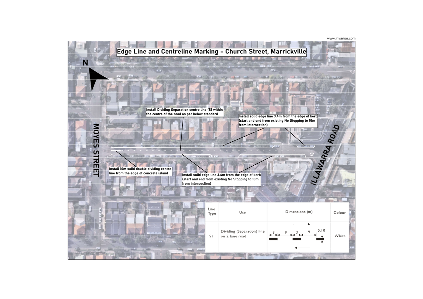
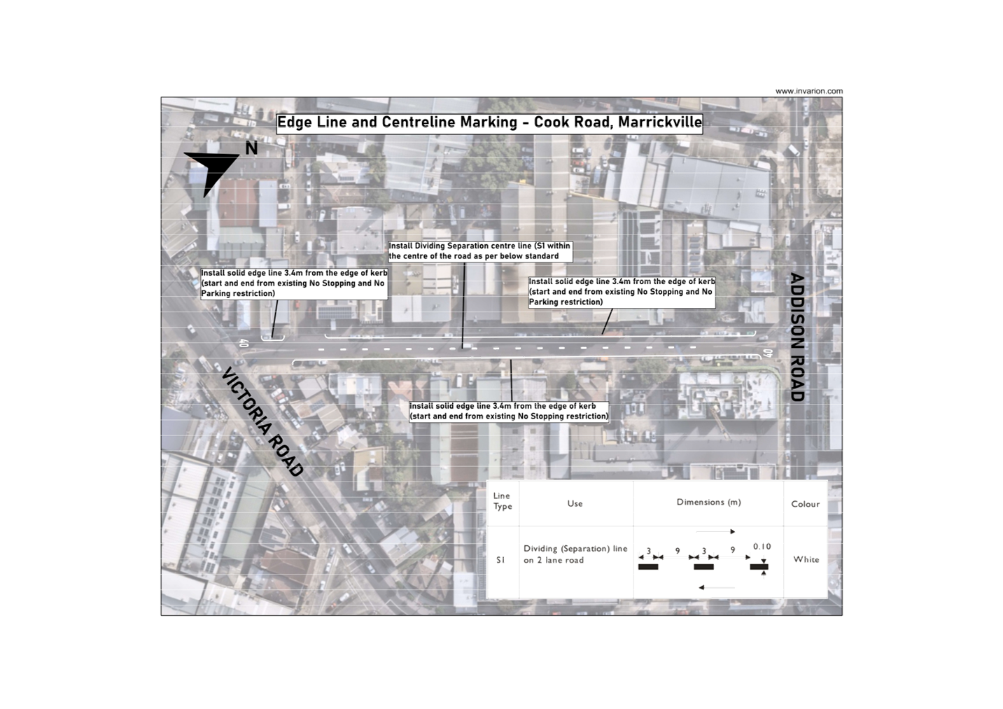
Accordingly, any local street that has a recorded 85th percentile speed of less than 45 km/h falls within acceptable limits and is consider self-enforcing. It is proposed to install entry treatments in the form of new 40km/h Area entry signs and pavement patches to these local roads (shown in Figures 3 and 4). Local streets identified to be slightly higher than the benchmark of 45km/h will require additional speed reduction treatment to provide an environment that will be self-enforcing. These streets are listed in Table 1 below and the line marking plans are provided in Attachment 1. It should be noted that no calibration of the collected cloud speed data was undertaken for the Marrickville and Tempe areas. In this respect, the streets listed in the table below are an initial list based on the Beca report data. Calibration of the data will need to be undertaken and this may reveal additional streets within the Marrickville and Tempe areas (areas 6 and 7) which will also require treatment.
|
Street |
Suburb |
Area |
Treatment |
|
Carrington Road |
Marrickville |
7 |
centre line and edge line |
|
Myrtle Street |
Marrickville |
7 |
centre line and edge line |
|
Victoria Road |
Marrickville |
7 |
2 x edge lines and 1 x centreline |
|
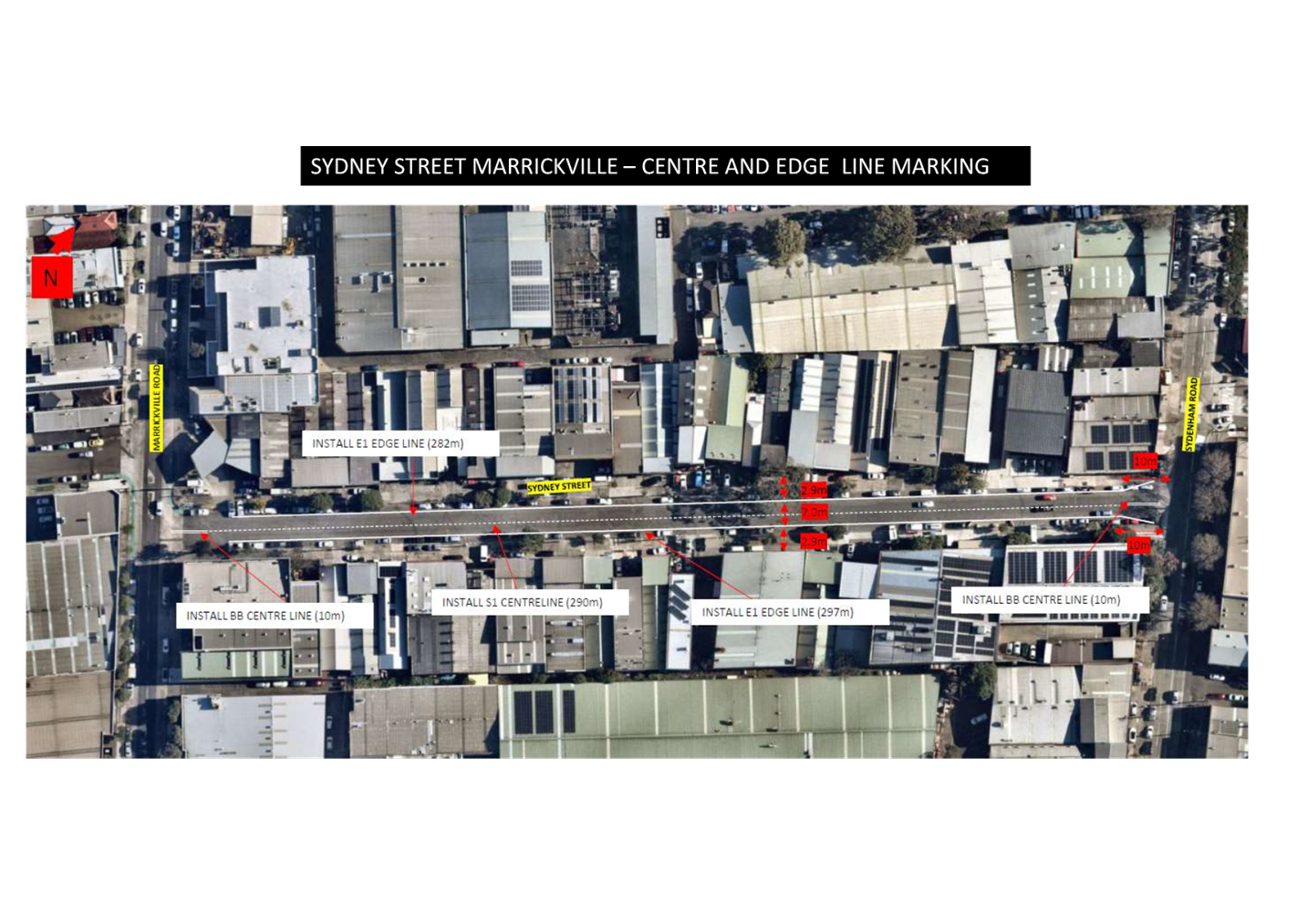
Sydney Street |
Marrickville |
7 |
2 x edge lines and 1 x centreline |
|
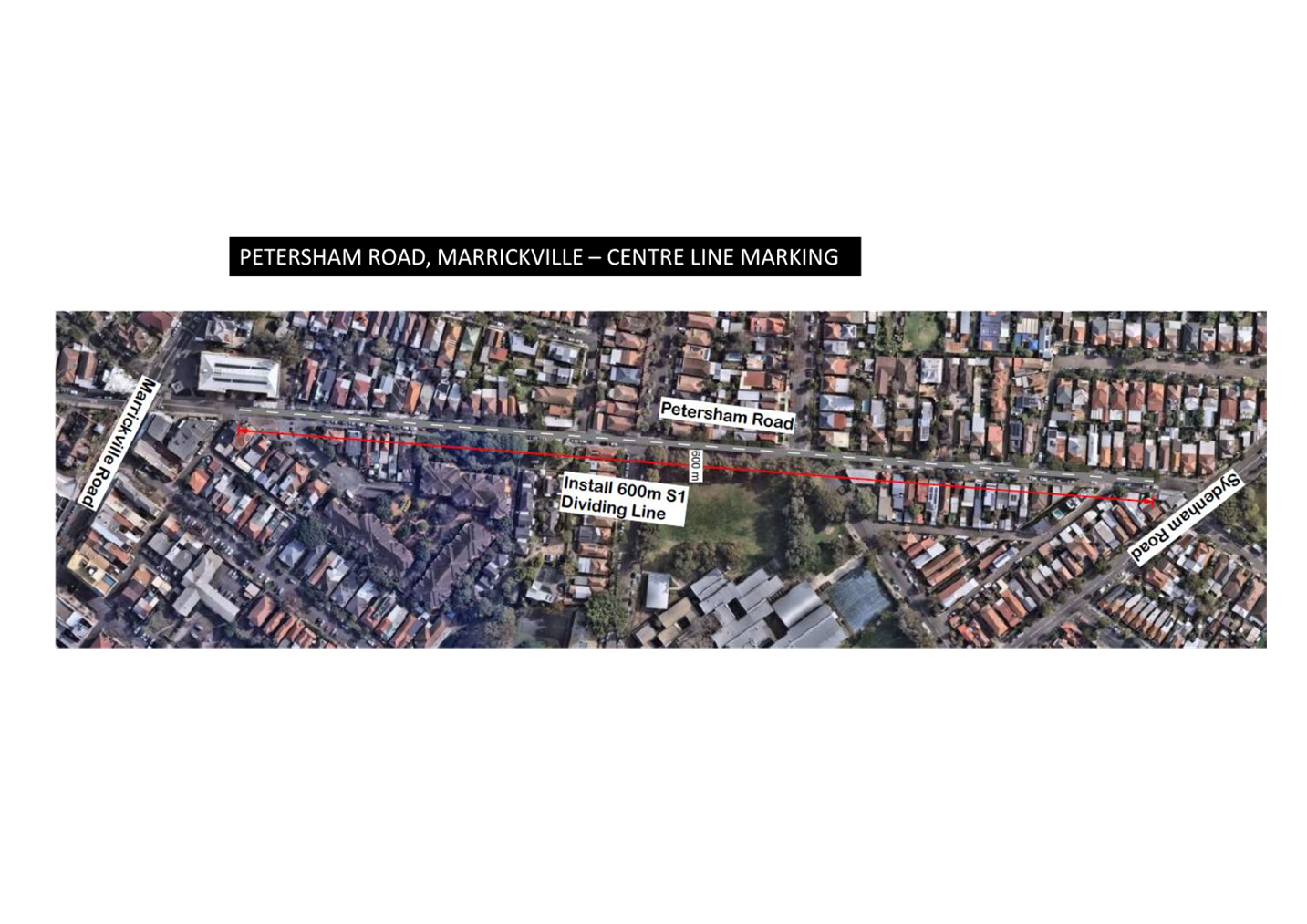
Petersham Road |
Marrickville |
7 |
1 x centre line |
|
Barwon Park Road |
St Peters |
6 |
Centre Line linemarking |
|
Bright Street |
Marrickville |
6 |
Parking lane and centre line linemarking |
|
Church Street |
Camperdown |
6 |
Parking lane and centre line linemarking |
|
Cook Road |
Marrickville |
6 |
Parking lane and centre line linemarking |
|
Fitzroy Street |
Marrickville |
6 |
Centre Line linemarking |
Table 1 – Streets requiring additional speed reduction treatments
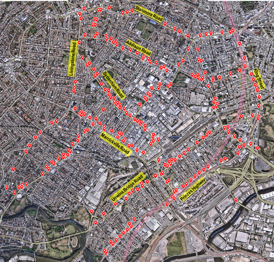
Figure 3 –Proposed Entry Treatment Locations
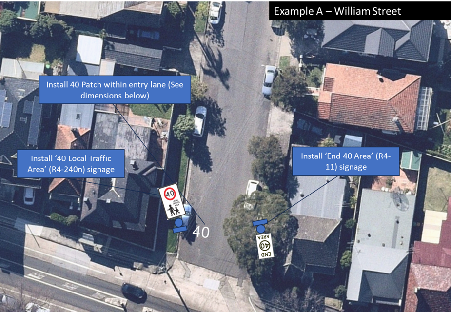
Figure 4 – Example of Entry Treatment Signages
FINANCIAL IMPLICATIONS
Grant funding has been provided for approximately $1.8M received under the Safe Speed Program from Transport for NSW (TfNSW) for the 2024/25 financial year.
|
1.⇩ |
Line marking plans |
|
Local Traffic Committee Meeting 16 September 2024 |
Subject: Newtown South Local Area Traffic Management Plan (LATM) Final Report (Damun-Stanmore Ward/Newtown Electorate/Inner West PAC)
Prepared By: Jason Scoufis - Acting Traffic and Transport Planning Manager
Authorised By: Manod Wickramasinghe - Acting Director Infrastructure
|
RECOMMENDATION
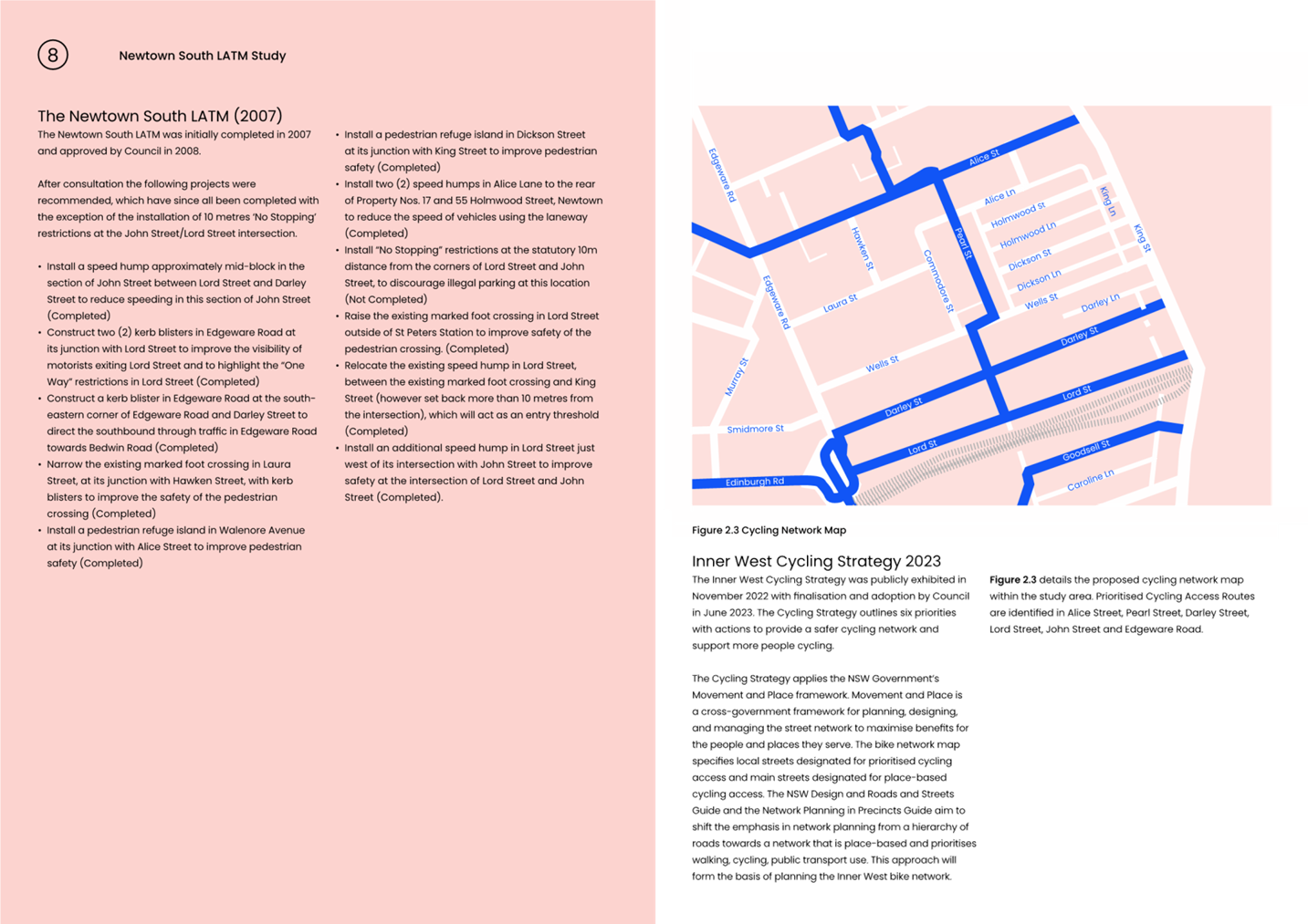
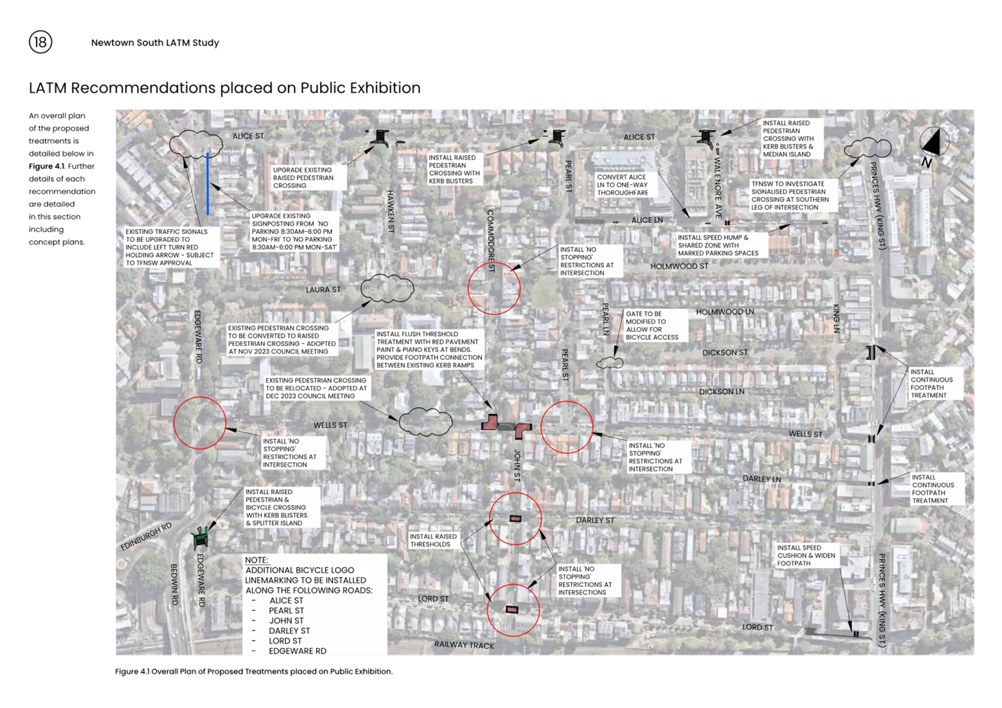
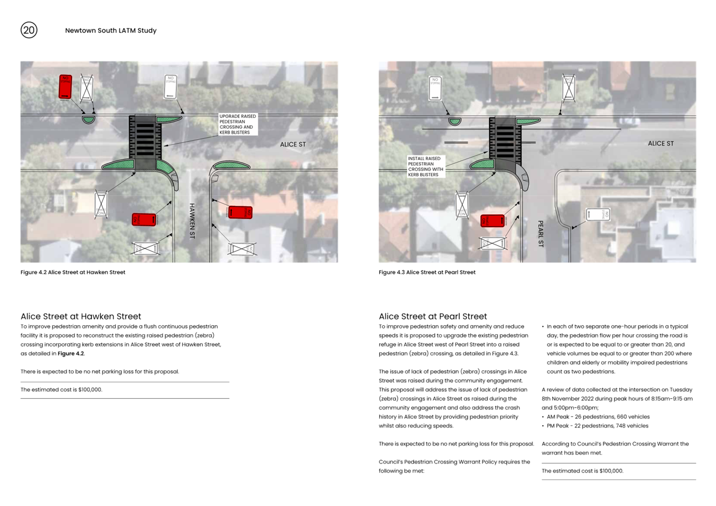
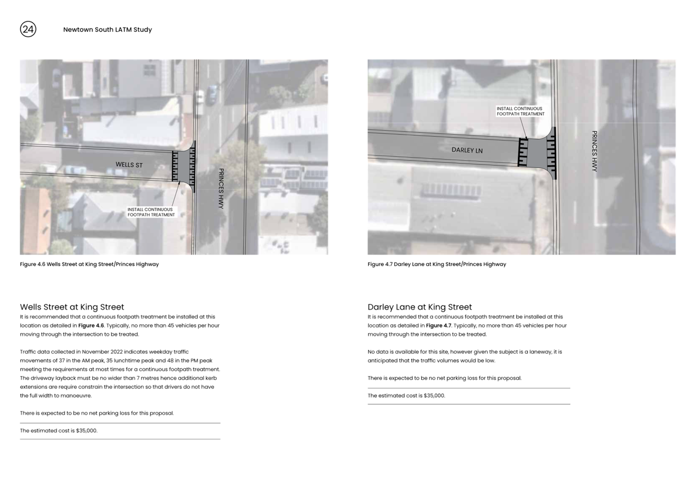
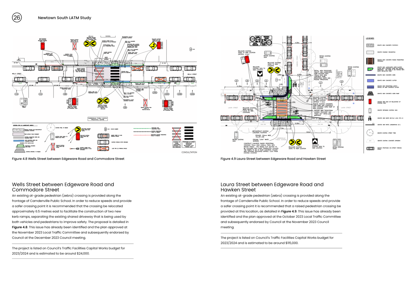
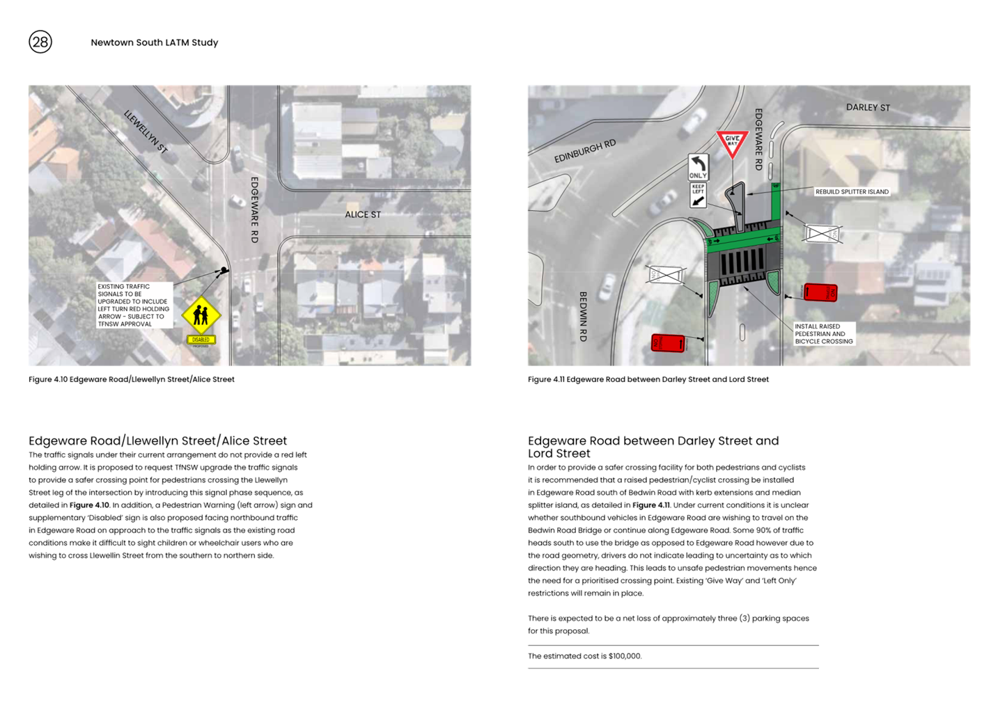
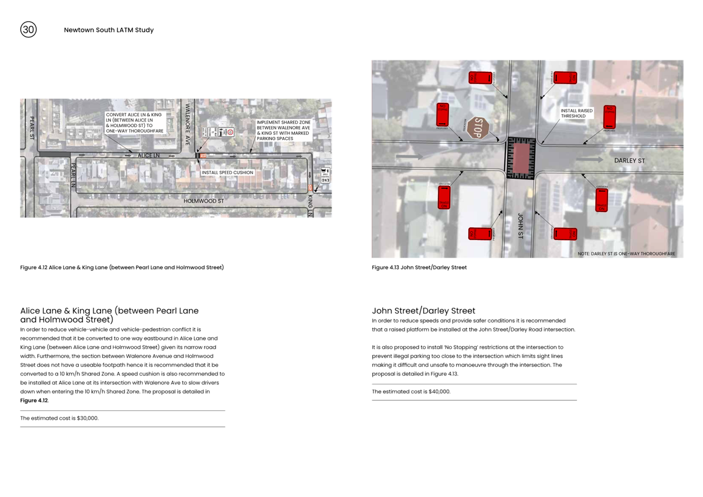
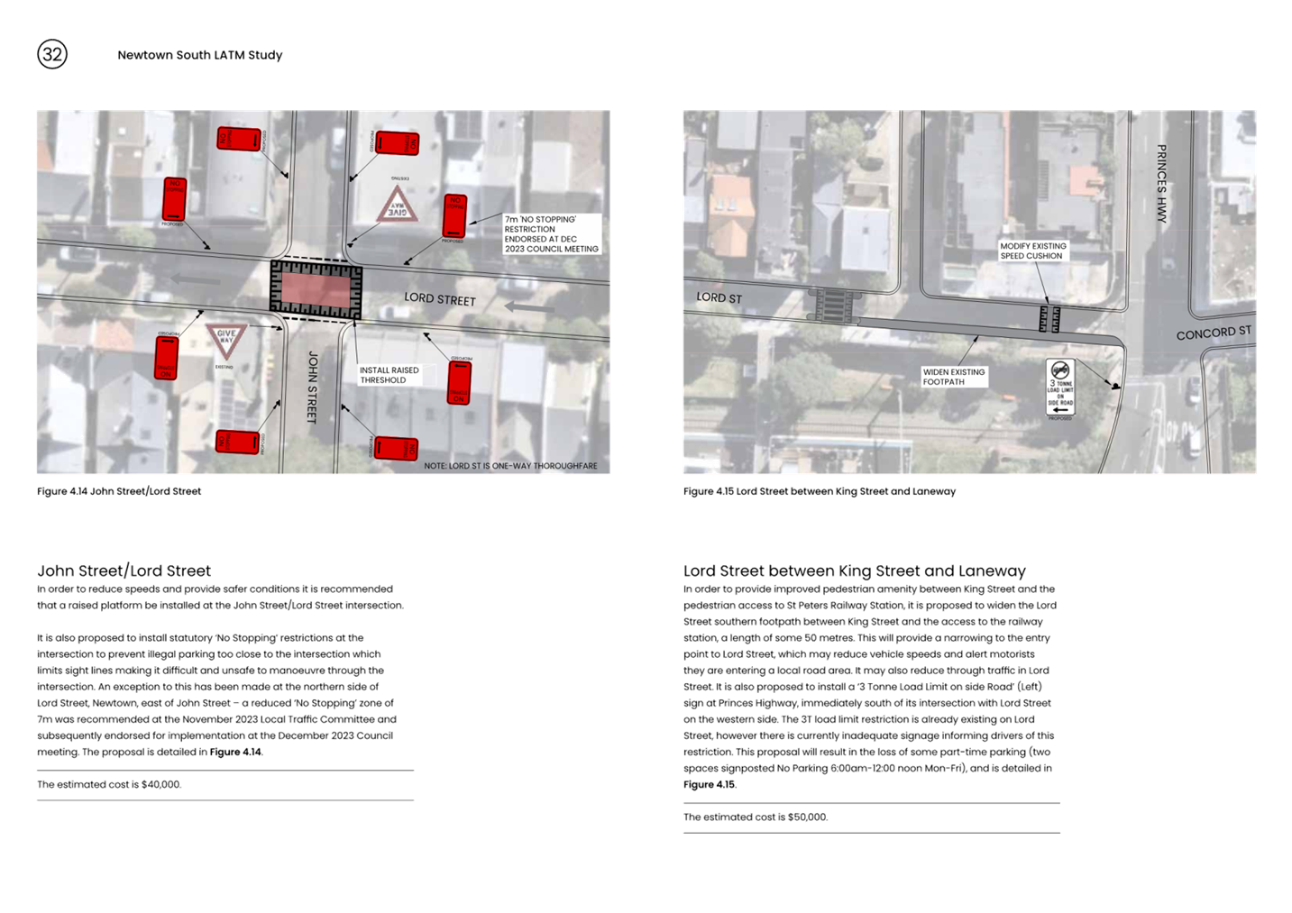
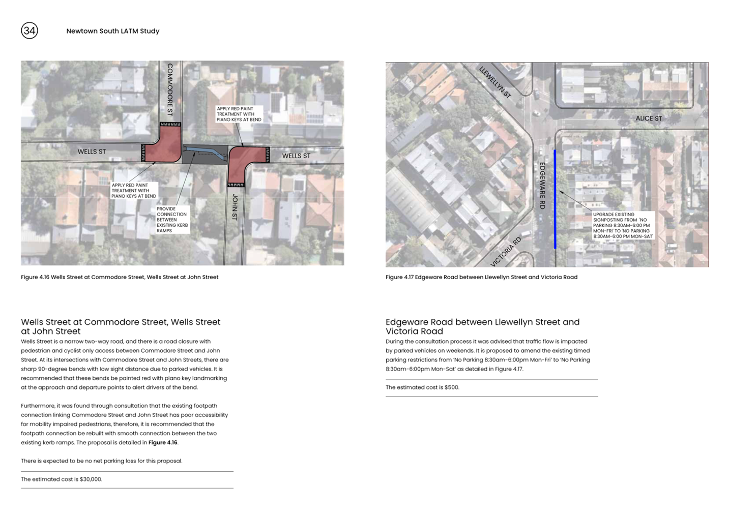
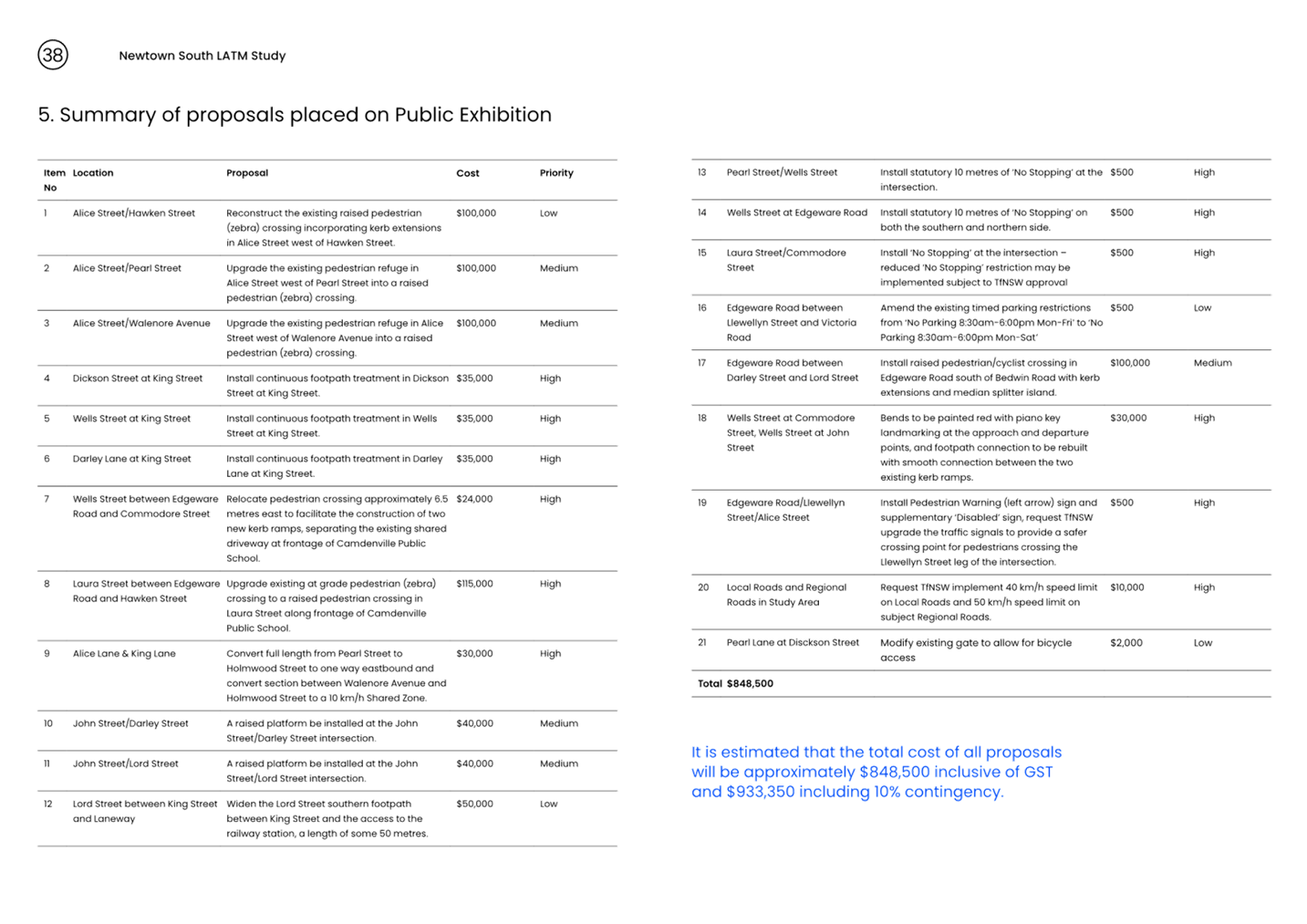
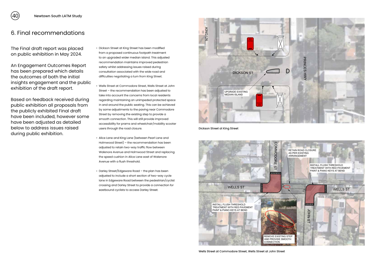
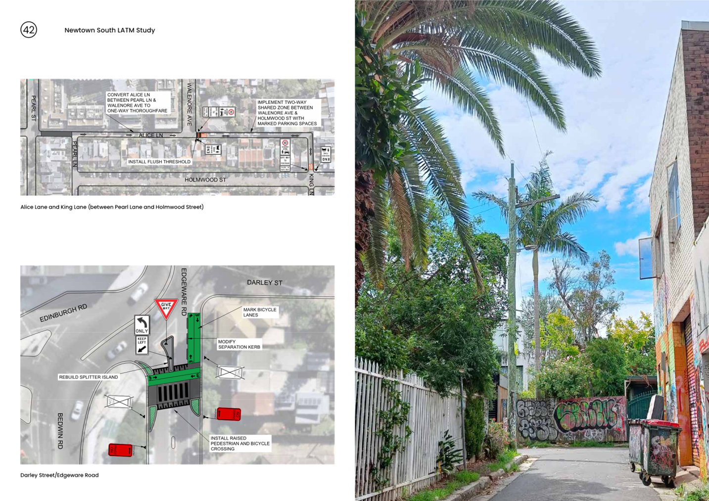
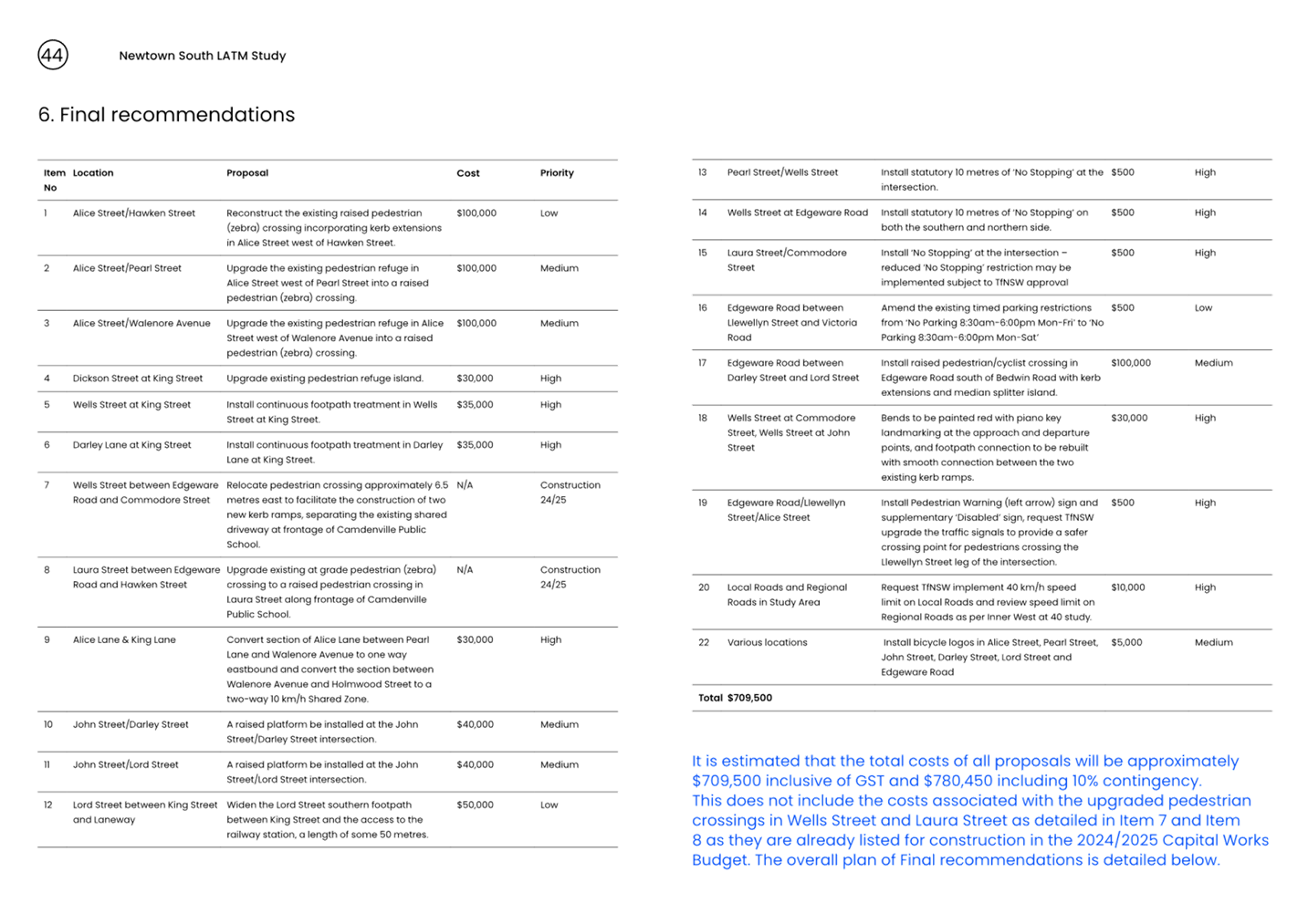
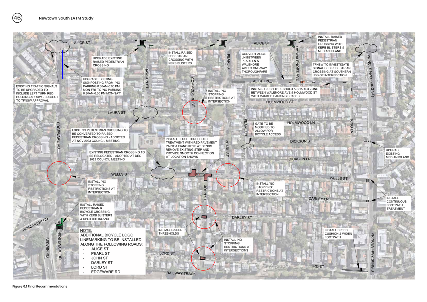
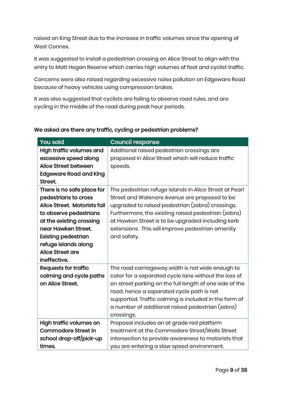
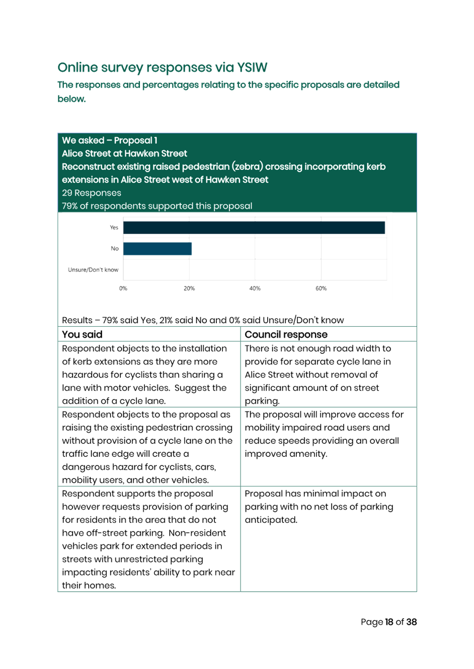
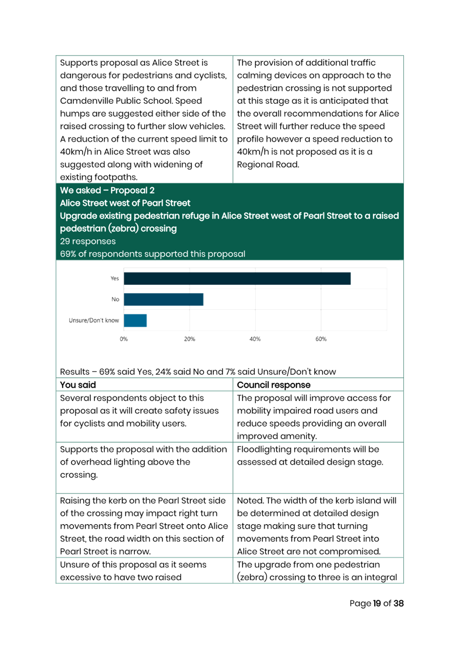
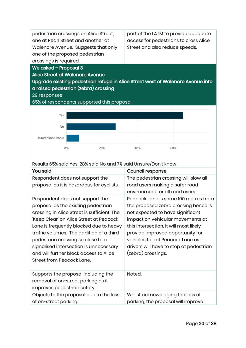
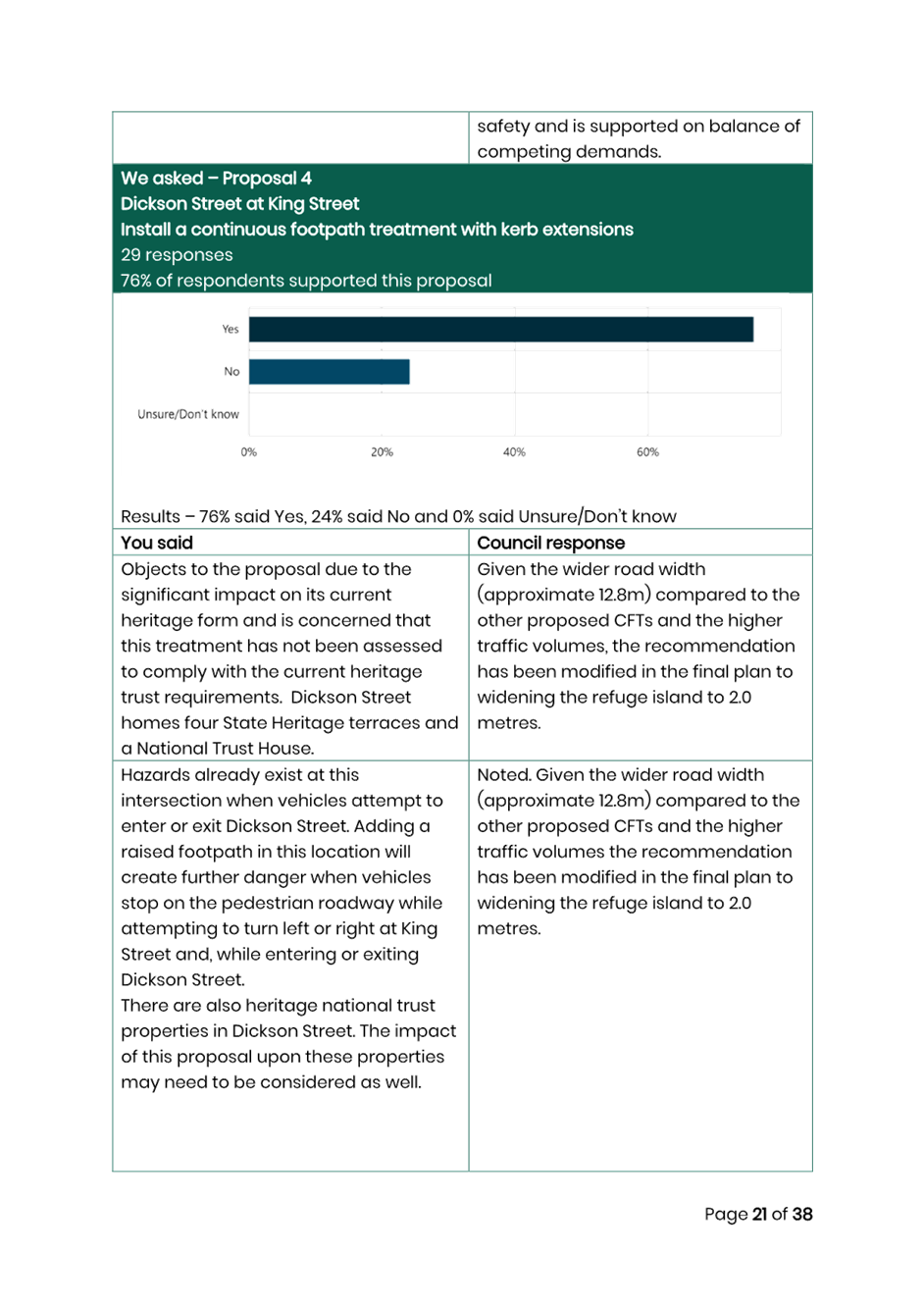
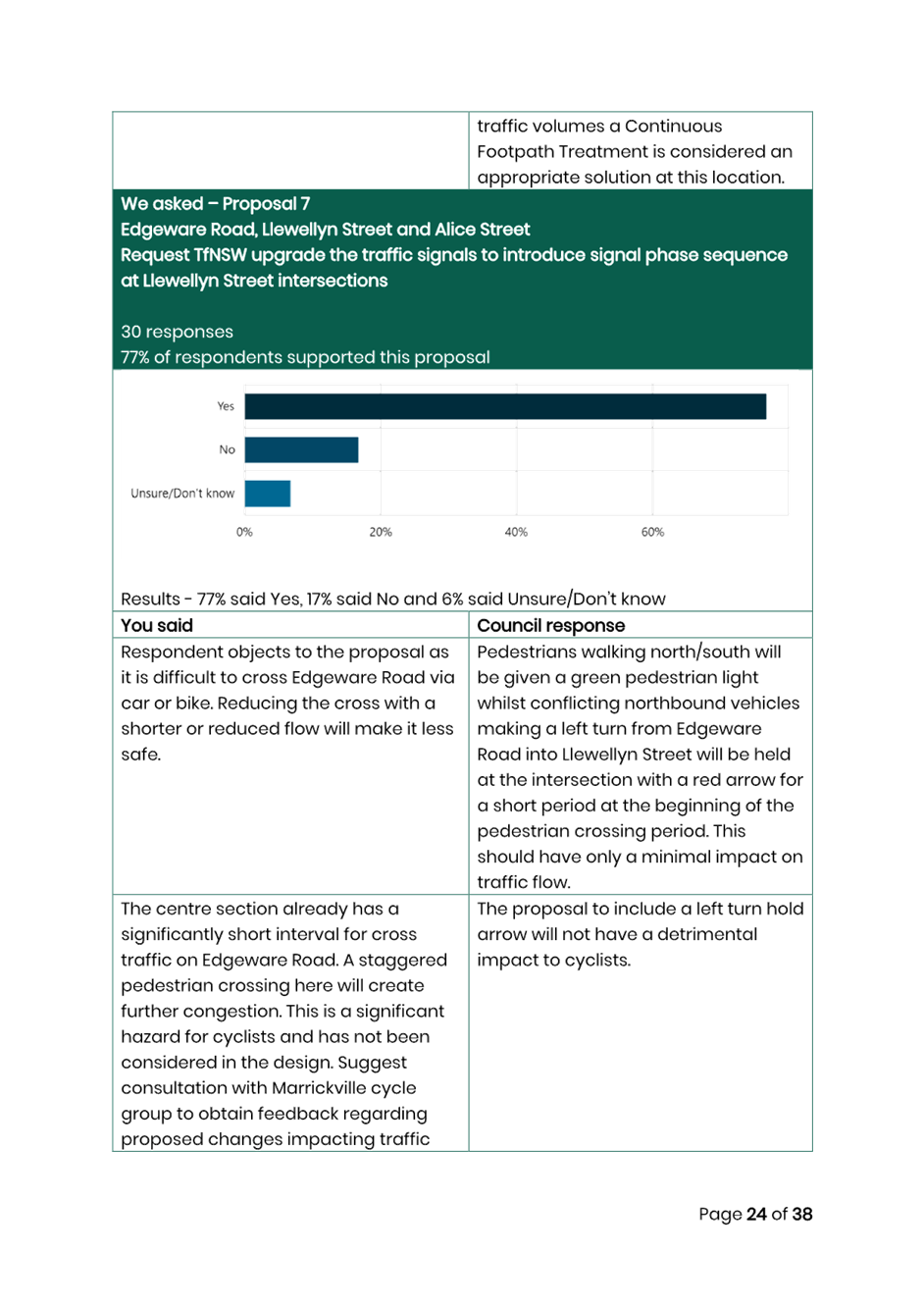
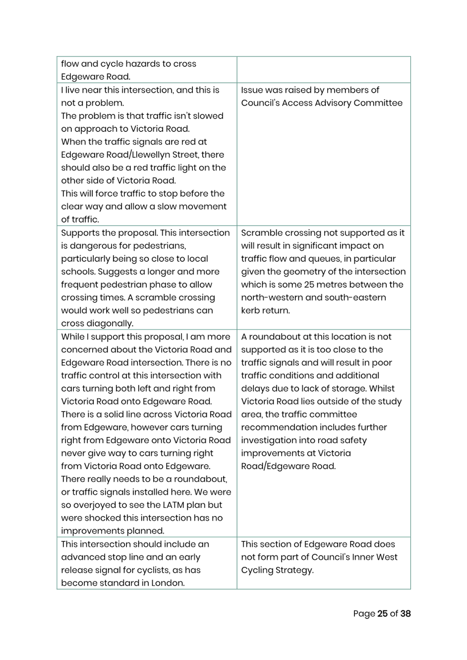
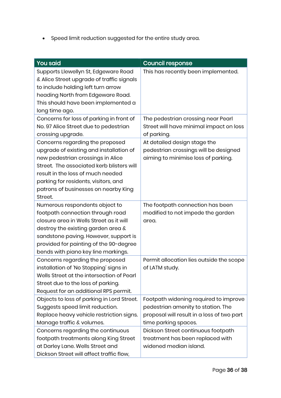
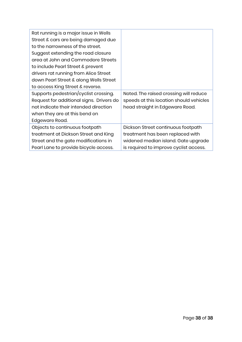
That the treatments listed below from the Newtown South Local Area Traffic Management (LATM) Final Report be listed for consideration in Council’s Traffic Facilities Program and Operational linemarking/signposting program and prioritised as identified in the attached report: a) Reconstruct the existing raised pedestrian (zebra) crossing incorporating kerb extensions in Alice Street west of Hawken Street. b) Upgrade the existing pedestrian refuge in Alice Street west of Pearl Street into a raised pedestrian (zebra) crossing. c) Upgrade the existing pedestrian refuge in Alice Street west of Walenore Avenue into a raised pedestrian (zebra) crossing and upgrade the median island in Walenore Avenue. d) That widened median island be installed to cross Dickson Street at King Street. e) That a continuous footpath treatment be installed to cross Wells Street at King Street. f) That a continuous footpath treatment be installed to cross Darley Lane at King Street. g) That a raised platform be installed at the John Street/Darley Street intersection including No Stopping at the intersection subject to a risk assessment to determine length of No Stopping. h) That a raised platform be installed at the John Street/Lord Street intersection including No Stopping subject to a risk assessment to determine length of No Stopping. i) That subject to TfNSW approval, a 10km/h Shared Zone be installed in Alice Lane between Walenore Avenue and Holmwood Street and Alice Lane be converted to one way eastbound between Pearl Lane and Walenore Avenue. j) The footpath be widened on the southern side of Lord Street between King Street and the railway station access. k) Install statutory 10 metres of No Stopping restrictions at the Pearl Street/Wells Street intersection. l) Install No Stopping restrictions at the Laura Street/Commodore Street intersection. m) Modify the existing timed parking restrictions from ‘No Parking 8:30am-6:00pm Mon-Fri’ to ‘No Parking 8:30am-6:00pm Mon-Sat’ on the eastern side of Edgeware Road between Llewellyn Street and Victoria Road. n) Install a raised pedestrian/cyclist crossing in Edgeware Road south of Bedwin Road with kerb extensions and median splitter island. o) Paint road bends red in Wells Street at Commodore Street and Wells Street at John Street and improve pedestrian connection through the road closure by removing step. p) Install Pedestrian Warning (l) sign and supplementary ‘disabled’ sign at Edgeware Road/Llewellyn Street/Alice Street intersection facing northbound motorists in Edgeware Road q) Replace existing road closure gate in Pearl Lane at Dickson Street to allow for cyclist’s access through the road closure. r) Request TfNSW implement 40 km/h speed limit on Local Roads within the study area and a reduced speed limit on Regional Roads as per innerwest@40 study. s) Linemark additional bicycle logos in Alice Street, Pearl Street, John Street, Darley Street, Lord Street and Edgeware Road. t) Request TfNSW investigate installing a signalised pedestrian crossing on the southern leg of the King Street/Alice Street traffic signals. u) Further investigation into road safety improvements at the Victoria Road/Edgeware Road intersection to improve conditions for right turn movements from Victoria Road into Edgeware Road be undertaken.
|
STRATEGIC OBJECTIVE
This report supports the following strategic directions contained within Council’s Community Strategic Plan:
|
2: Liveable, connected neighbourhoods and transport |
|
|
EXECUTIVE SUMMARY
This report outlines the findings of the Final Newtown South LATM Study report.
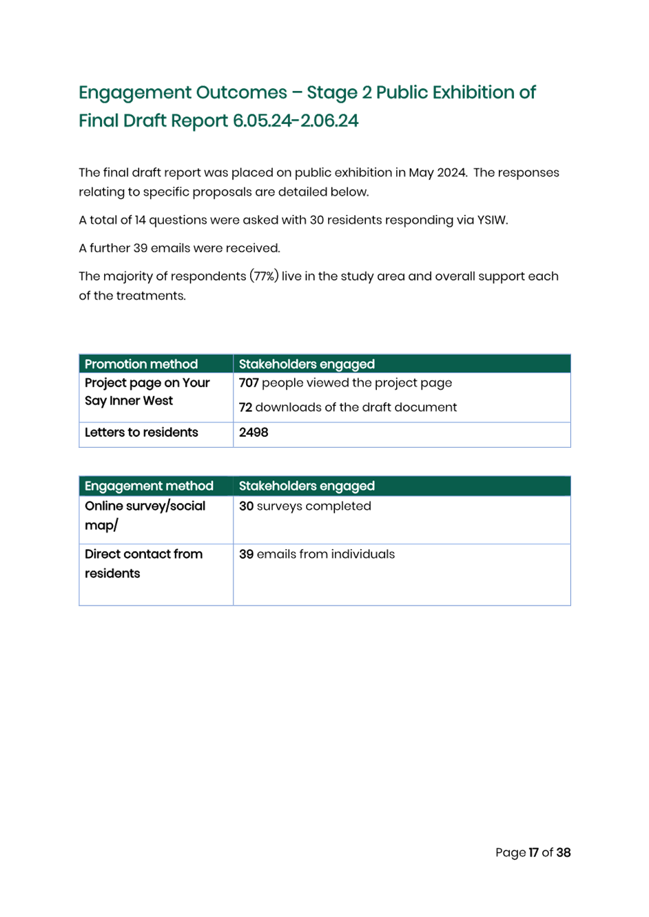
The final draft report was placed on public exhibition in May 2024. A total of 30 contributions were made through YSIW. An additional 39 emails were received regarding the final draft report during the public exhibition period. All recommendations noted in the final draft have been included in the final report with some adjustments.
The response results indicate that the community generally supported all the proposed changes with a support rate through Yoursay Inner West of 57% to 86% for each of the recommendations.
After considering the Public Exhibition feedback, a review on the proposed scheme was undertaken with adjustments made to a few of the LATM Study recommendations.
The recommended treatments will be included for consideration for funding in Council’s Capital Works Program and submitted for State/Federal Government Funding Programs where possible. Minor changes to signs and linemarking will be funded out of Council’s Operational Budgets.
BACKGROUND
As part of Council’s Local Area Traffic Management (LATM) Strategy Review Program, Council has prepared the Newtown South LATM study. The final report is provided in Attachment 1.
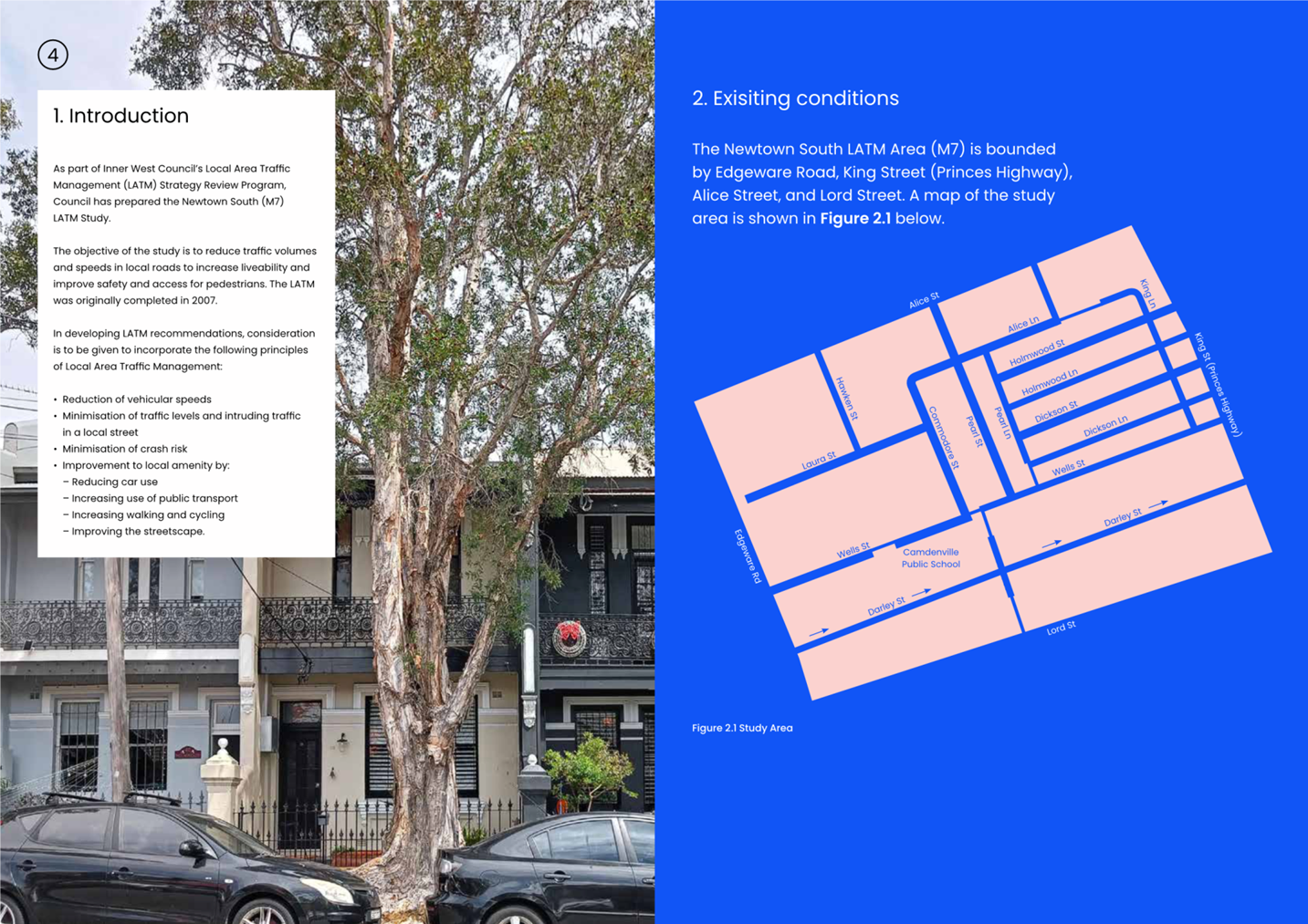
The Newtown South LATM Area is bounded by Edgeware Road, King Street (Princes Highway), Alice Street, and Lord Street.
In developing recommendations for the LATM Study, consideration was given to incorporate the following principals of Local Area Traffic Management:
· Reduction in vehicle speeds.
· Minimise traffic levels and intruding traffic in a local street.
· Minimise crash risk.
· Improve local amenity by:
o Reducing car use
o Increasing use of public transport
o Increasing walking and cycling
o Improving the streetscape
Traffic tube counts and intersection counts were collected, and crash history was reviewed to assist the study. Further site observations and review of community engagement outcomes also assisted to determine what type of facility was warranted in specific locations.
PUBLIC CONSULTATION
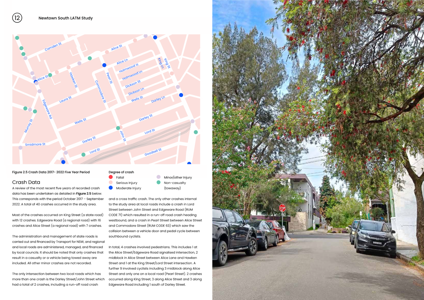
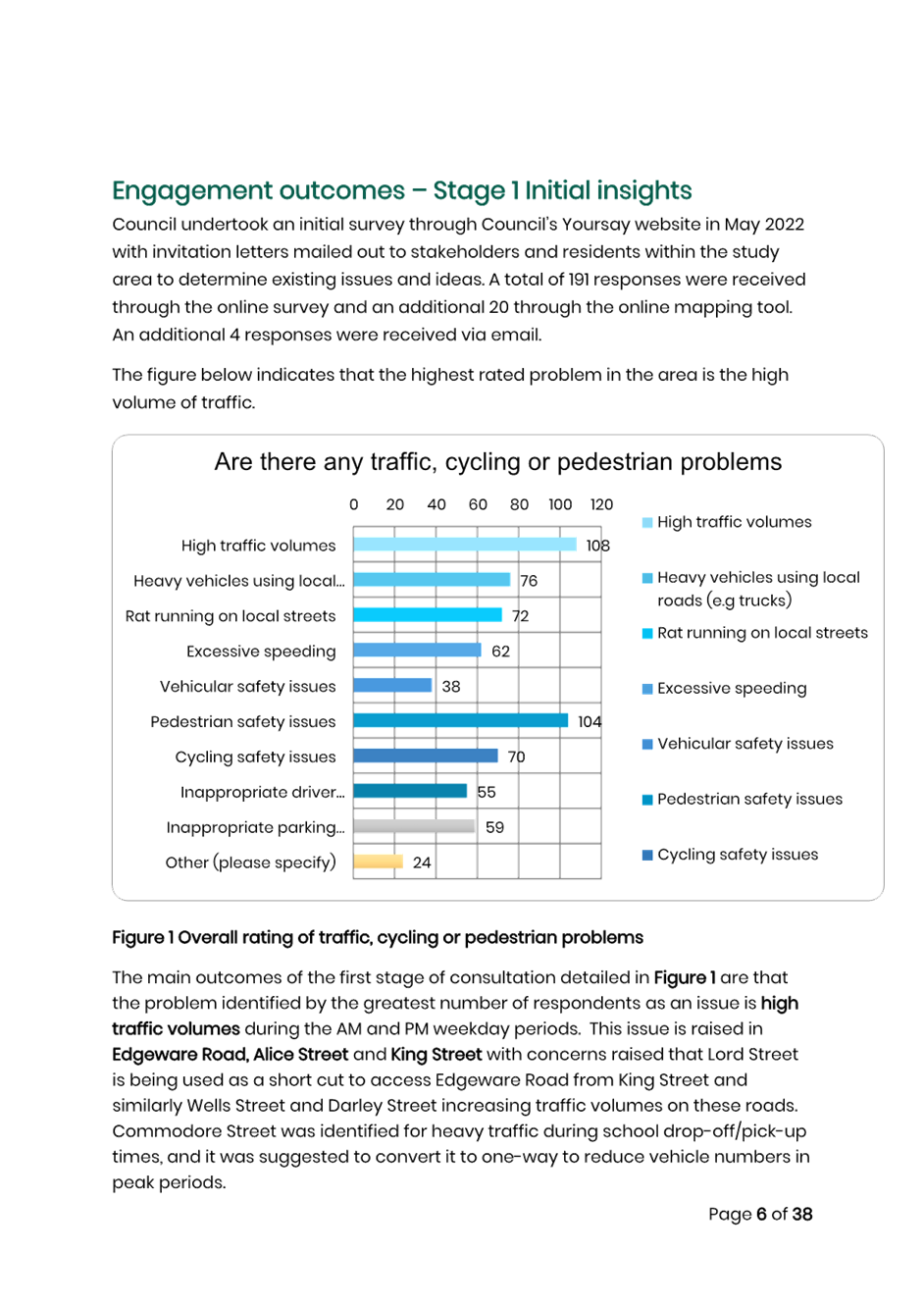
Council undertook an initial survey through Council’s Your say website in May 2022 with invitation letters mailed out to stakeholders and residents within the study area to determine existing issues and ideas. A total of 191 responses were received through the online survey and a further 20 through the mapping tool.
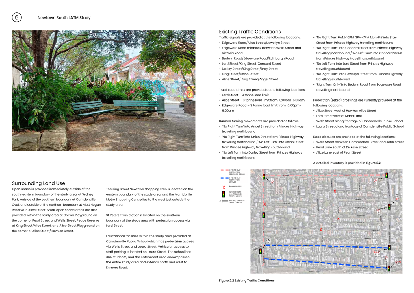
The main outcomes of the first stage of consultation identified by the greatest number of respondents are high traffic volumes, followed by pedestrian safety and the third most raised issue was heavy vehicles using local roads.
Regarding specific streets, Edgeware Road, Alice Street and King Street had the highest level of concern for too much traffic, pedestrian safety, heavy vehicle uses and excessive speed.
Lord Street also had a level of concern for rat running and exceeding the speed limit.
The final draft report was placed on public exhibition in May 2024. A total of 30 contributions were made through YSIW. An additional 39 emails were received regarding the final draft report during the public exhibition period. All recommendations noted in the final draft have been included in the final report with some adjustments.
The recommendation for ‘No Stopping’ restrictions in Wells Street at Edgeware Road was separately approved in June 2024 in a delegated report, hence has been removed from the traffic committee recommendation. Similarly, the red holding arrows at the Alice Street/Edgeware Road/Llewellyn Street traffic signals recommended in the study have been installed.
The Engagement Outcomes Report is included in Attachment 2 and its appendices in Attachment 3.
FINANCIAL IMPLICATIONS
The cost of the proposed treatments is $774,950 (including GST and contingencies). This includes the costs associated with the modified recommendations.
Once the LATM Study is adopted, detailed design and construction would be undertaken in stages as prioritised commencing from the 2025/2026 year. This does not include the costs associated with the upgraded pedestrian crossings in Wells Street and Laura Street as detailed in Item 7 and Item 8 of the final recommendations as they are already listed for construction in the 2024/2025 Capital Works Budget.
The cost to implement the Newtown South LATM Study will be included for consideration for funding in Council’s Capital Works Program and submitted for State/Federal Government Funding Programs where possible. Minor changes to signs and linemarking will be funded out of Council’s Operational Budgets. Council staff will pursue funding opportunities for State and Federal Government Grant Funding Programs including the Blackspot Program, Get NSW Active Program and the Road Safety Program. Subsequent reports during implementation of the recommendations of the study will provide further detailed plans if required.
|
1.⇩ |
Attachment 1 Newtown South LATM Study - Final Report |
|
2.⇩ |
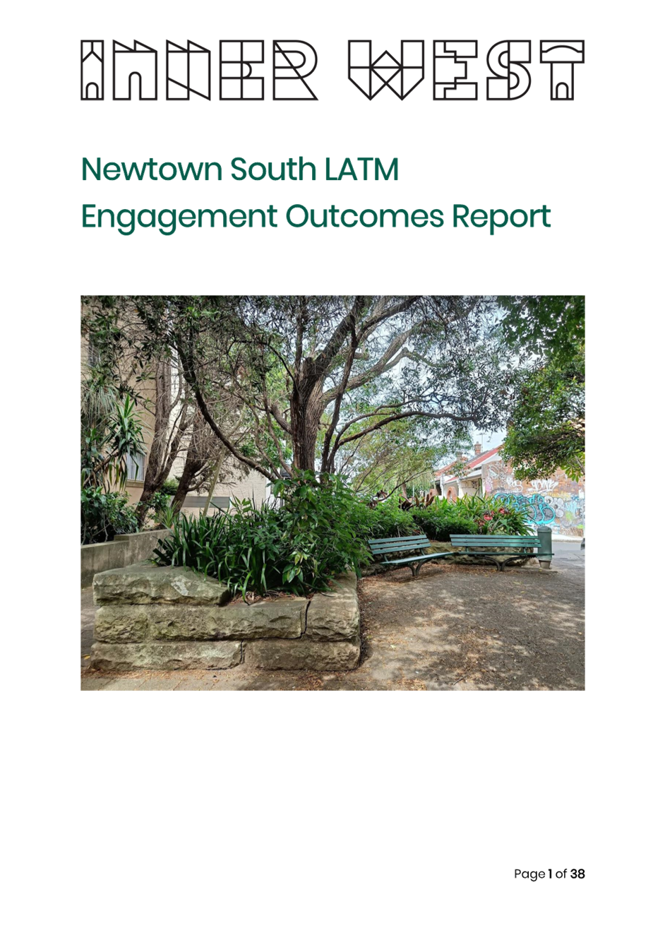
Attachment 2 Engagement Outcomes Report |
|
3.⇩ |
Attachment 3 Engagement Outcomes Report Appendices |
|
Local Traffic Committee Meeting 16 September 2024 |
Subject: Marrickville Road at Despointes Street, Marrickville – Proposed new raised pedestrian crossing - Design Plan 10297 (MIDJUBURI-MARRICKVILLE WARD / SUMMER HILL ELECTORATE / INNER WEST PAC)
Prepared By: Jennifer Adams - Traffic Engineer
Authorised By: Jason Scoufis - Acting Traffic and Transport Planning Manager
|
RECOMMENDATION
That the detailed design plan for the proposed new raised pedestrian crossing on Marrickville Road at Despointes Street, Marrickville and associated signs and line markings (as per Design Plan No.10297) be approved. |
STRATEGIC OBJECTIVE
This report supports the following strategic directions contained within Council’s Community Strategic Plan:
|
2: Liveable, connected neighbourhoods and transport |
|
|
EXECUTIVE SUMMARY
Council is planning to improve safety in Marrickville Road, Marrickville by constructing a new raised pedestrian crossing near Despointes Street to replace the existing “at-grade” flat pedestrian crossing. The proposal aims to improve pedestrian safety by better defining the safe pedestrian crossing point and addresses concerns for pedestrian safety and driver behaviour at this location. It is noted that Council has received Blackspot funding to raise the crossing.
BACKGROUND
A Blackspot funding application was submitted in 2023 to convert an existing at-grade pedestrian crossing to a raised pedestrian crossing on Marrickville Road at Despointes Street, Marrickville. There were a number of pedestrian related injury crashes at the location.
The existing at-grade pedestrian crossing on Marrickville Road, west of Despointes Street, Marrickville is located within the Marrickville Town Centre. The crossing is located within an existing 40 km/h High Pedestrian Activity Area which commences at the intersection of Petersham Road (a signalised intersection). There is an at-grade entry pavement treatment along the eastbound carriageway denoting the commencement of the 40 km/h HPAA, however there is no secondary raised treatment following. This conversion addresses two issues: reducing vehicle speeds on approaches to the pedestrian crossing and addresses the existing pedestrian related crashes by providing a raised traffic calming device following the at-grade entry 40km/h treatment to reduce vehicle speeds. Marrickville Road is a Regional road and the section through Marrickville Town Centre carries around 15,000 vehicles per day.
This report details the design plan for those improvement works and its related consultation results.
FINANCIAL IMPLICATIONS
The project is listed in Council’s Traffic Facilities Capital Works budget for 2024/2025 and Blackspot funding of $151,000 has been received for this project. Project number is 303399.
OTHER STAFF COMMENTS
The following works are proposed and are illustrated on the attached Consultation Plan (Plan No. 10297). The proposed works aim to improve pedestrian safety by better defining the safe pedestrian crossing point and addresses concerns for pedestrian safety and driver behaviour at this location.
Specifically, the proposed scope of works includes the following:
· Construct a new raised concrete pedestrian crossing to replace the existing “at-grade” flat pedestrian crossing. (Refer to attached Plans):
· Install associated signage associated with the works as required and where shown on Plans.
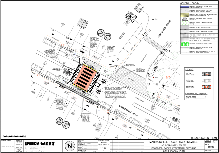
Parking changes
The proposal will not impact the existing parking arrangements in the street. Therefore, there will be no loss of parking spaces resulting from the proposed works.
Streetlighting
The existing pedestrian crossing lighting is deemed appropriate to meet the current lighting standards for new pedestrian crossings. Therefore, no changes are proposed to the existing street lighting due to the works.
Please note however that Ausgrid is progressively replacing all existing streetlights throughout the Local Government area with new energy efficient and environmentally friendly LED streetlights, and this will be completed independently of this project.
PUBLIC CONSULTATION
Consultation was conducted between 12 August 2024 and 30 August 2024. A letter along with a copy of the design plan was sent to residents / businesses in the immediate locality. A total of 136 letters were distributed. There were no responses.
CONCLUSION
It is recommended that the detailed design plan of the proposed new raised pedestrian crossing and associated signs and line markings be supported to improve road safety at this location.
|
1.⇩ |
303399-10297-ConsultationPlan |
|
|
Local Traffic Committee Meeting 16 September 2024 |
Subject: Clissold Street, between Queen Street and Victoria Street, Ashfield- Proposed removal of existing at-grade crossing and provide a new raised pedestrian (zebra) crossing. (Djarrawunang-Ashfield Ward/Summer Hill Electorate/Burwood PAC.)
Prepared By: Boris Muha - Traffic Engineer
Authorised By: Jason Scoufis - Acting Traffic and Transport Planning Manager
|
RECOMMENDATION
That the detailed design plan (10296) for the proposed new raised pedestrian (zebra) crossing in Clissold Street, just east of gate No.11 to the Cardinal Freeman Village (near William Street), and the removal of the at-grade pedestrian crossing further east in Clissold Street, between Queen Street and Victoria Road, Ashfield, as shown in Attachment 1 be approved.
|
STRATEGIC OBJECTIVE
This report supports the following strategic directions contained within Council’s Community Strategic Plan:
|
2: Liveable, connected neighbourhoods and transport |
|
|
EXECUTIVE SUMMARY
This report describes and shows the detailed design plan of one of the proposed treatments, i.e. install a proposed new raised pedestrian (zebra) crossing in Clissold Street, just east of gate No.11 to the Cardinal Freeman Village (near William Street), and the removal of the existing at-grade pedestrian crossing further east in Clissold Street, between Queen Street and Victoria Road. This work is programmed and envisaged to be constructed in the 2024/2025 financial year, subject to funding.
BACKGROUND
The village caters to an independent living lifestyle however as the average age is over 82 years there are a significant number of residents with mobility issues that hinder their ability to move around freely.
Many of the elderly residents are capable, and desire to walk to and from various destinations outside of the village, and/or take other forms of public transportation (e.g., bus and train) to travel to other parts of Sydney.
This has prompted a general request from the elderly residents to improve pedestrian safety around the village to enable them to walk to various desired destinations and take public transport within the area.
Other Aged care facilities such as the Ashfield Baptist Homes, Bethel Nursing Homes, Ashfield Terrace Care Community, and other community facilities are also located adjacent or near to the Cardinal Freeman Village.
The proposed treatment in this report received a major (80% rate) support under a general community engagement consultation conducted through Council’s ‘Have Your Say’ back in October 2023. The facility is viewed in benefit and supported by the community at large, and not only for the elderly of the Cardinal Freeman Village.
DISCUSSION
The following information is provided in discussion.
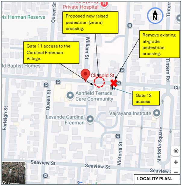
Figure 1. Locality Plan
|
Street Name
|
Clissold Street (Near Victoria Street) |
|
Carriageway width (m) kerb to kerb |
Approx. 6.7-7.0m |
|
Carriageway type |
Two-way, one travel lane each direction. |
|
Classification |
Local |
|
Speed Limit km/h |
50 |
|
85th percentile speed km/h |
47.2 |
|
Vehicles per day (vpd) |
2109 |
|
Last available 5 years of TfNSW recorded crash history
|
NIL in last 5 years in Clissold Street (Queen Street to Victoria Street) 1 prior recorded accident in 2015 resulted in pedestrian on carriageway being hit by vehicle in area of existing crossing (RUM 3) - moderate injury. |
|
Parking arrangements |
Parking not permitted on both sides between William Street and Victoria Street. Parking permitted on north side between William Street and Queen Street. |
|
Side street(nearest) |
William Street |
Table 1. Road Network detail
The Plan
The following works are proposed and are illustrated on the attached plans:
Clissold Street (between William Street & Victoria Street), Ashfield (Plan No. 10296):
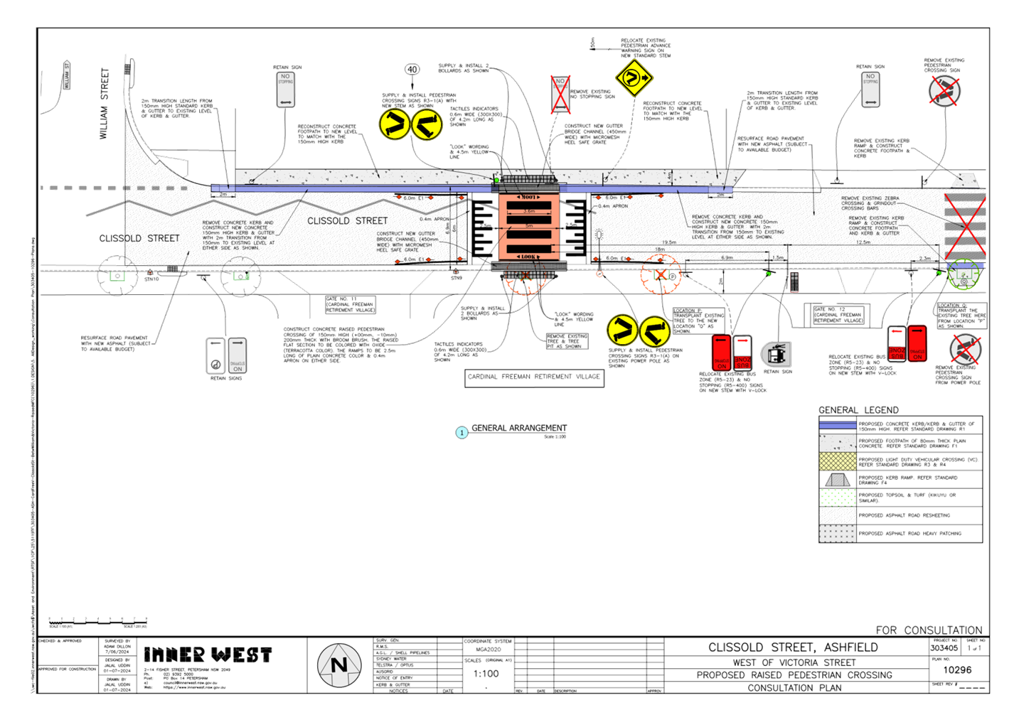
· Construct a new raised concrete pedestrian crossing with “gutter bridge” crossings closer to William Street to replace the existing “at-grade” flat pedestrian crossing approximately 35m to the east. The existing pedestrian crossing to the east and associated kerb ramps will be removed (refer to attached Plan):
· Construct new concrete kerb & gutter on the north side of Clissold Street where shown;
· Construct new concrete footpath in place of the existing damaged concrete footpath on the north side of Clissold Street where shown;
· Remove 1 existing street tree and transplant 1 existing street tree to a new location on the south side of Clissold Street to facilitate the construction of the new raised pedestrian crossing and to provide adequate site distances on the approach side;
· Relocate/adjust existing ”No Stopping” & ”Bus Zone” signage on the south side of Clissold Street to satisfy sight distance and bus zone length requirements;
· Provide new “edge” line markings either side of the new raised pedestrian crossing to provide guidance for the motorists;
· Install associated signage associated with the works as required and where shown on the Plans;
· Resurface the road pavement with new asphalt. Note: - this will be subject to final budget allocations at the time of the project being implemented and may be undertaken at a later or prior date within the Local Roads Capital Program.
Parking Changes
The existing Bus Zone and No Stopping Zones on the south side of Clissold Street will be adjusted slightly to accommodate the new raised pedestrian crossing. However, this will not impact on existing parking arrangements in the street. Please refer to the attached plan.
Streetlighting
The new raised pedestrian crossing will require new flood lighting to be provided for it to comply with current standards. This will involve the provision of at least 1 floodlight (on a new power pole) or up to 2 floodlights (on 2 new power poles) typical of other locations with pedestrian crossings. At this stage, this design is not complete and will be undertaken by a specialist lighting consultant at a later stage.
Other Information
The proposed raised pedestrian crossing to the east of gate 11 replaces the removed (at road level) zebra crossing at gate 12. The new raised pedestrian (zebra) crossing will be situated further west away of the conflict area of the Bus Stops and traffic turning in from Victoria Street and coming across Victoria Street from Clissold Street (east).
Access to the Bus stops can be attained via Gate 11 or 12 with the new crossing going in just east of gate 11. The new crossing location can also provide connection to the northern side of Clissold Street to link pedestrian movement towards Queen Street and Victoria Street.
Clissold Street is a Bus Route. The platform height of the crossing is 150mm high to blend in level with the footpath and provide appropriate ‘gutter bridge’ clearance over the kerb for drainage. The ramps are lengthened to 2.5m in this instance to provide appropriate bus rideability over the crossing.
FINANCIAL IMPLICATIONS
CONSULTATION
A copy of the letter was also sent directly to the Manager of the Cardinal Freeman Village to distribute amongst its elderly residents inviting them to comment also.
![]()
![]()
![]()
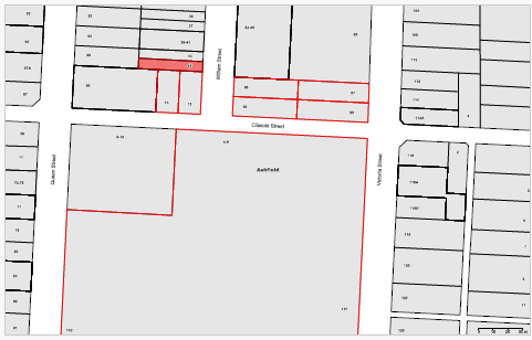
Figure 2. Map on Consultation Area
(1) Resident response was received concerning tree planting and floodlighting of the crossing.
The concerns raised by the resident are outlined below in the table.
|
Residents Comments |
Officers Response |
|
· Request not to replant one existing tree in new location which might limit vision of oncoming traffic.
· Are floodlights really necessary? These will have an impact on nearby residents. |
· It is proposed to remove 1 tree just east of Gate 11 to make way for the new raised pedestrian crossing. It is also proposed to relocate (1) existing tree (between gate 11 and gate 12) to a new location east of Gate 12 to provide suitable unimpeded sight distance to the new pedestrian crossing.
Trees are an important part of the overall landscape and provide much needed tree canopy cover to the footpath environment. The tree species has a moderately high canopy and therefore is considered suitable for its new (transplanted) location.
· Council is required to provide lighting to all new pedestrian crossings compliant to the required Standards to ensure pedestrian safety - particularly at night. A lighting design will need to be prepared by a suitably qualified lighting consultant to meet this requirement. Council will endeavour to provide only the minimum required levels of lighting whilst still complying with the Standards.
|
CONCLUSION
It is recommended that the detailed design plan (10296) for the proposed new raised pedestrian (zebra) crossing in Clissold Street, just east of gate No.11 to the Cardinal Freeman Village (near William Street), and the removal of the at-grade pedestrian crossing further east in Clissold Street, between Queen Street and Victoria Road, Ashfield, as shown in Attachment 1 be approved.
|
1.⇩ |
Proposed plan of raised crossing and removal of existing at-grade crossing in Clissold Street, Ashfield. |
|
|
Local Traffic Committee Meeting 16 September 2024 |
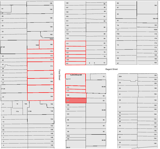
Subject: Flood Street, Leichhardt – Proposed Slow Point at Regent Street (GULGADYA-LEICHHARDT WARD/BALMAIN ELECTORATE/ LEICHHARDT PAC)
Prepared By: Charbel El Kazzi - Traffic Engineer
Authorised By: Jason Scoufis - Acting Traffic and Transport Planning Manager
|
RECOMMENDATION
That the attached detailed design plan No.10269 for the proposed slow point on Flood Street at the intersection with Regent Street in Leichhardt be approved. |
STRATEGIC OBJECTIVE
This report supports the following strategic directions contained within Council’s Community Strategic Plan:
|
2: Liveable, connected neighbourhoods and transport |
|
|
EXECUTIVE SUMMARY
The proposed slow point will have no impact on the existing parking arrangements in the street.
BACKGROUND
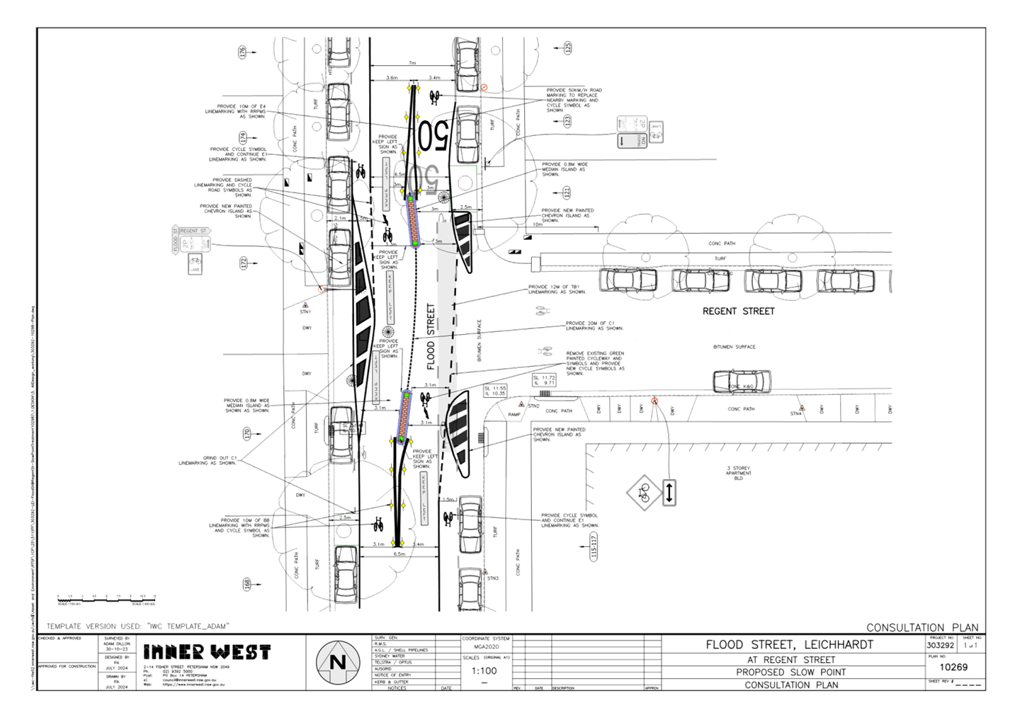
The detailed design plan shown in Attachment 1 outlines the proposed works on Flood Street, Leichhardt and includes the following:
· Construction of two (2) new concrete central median islands;
· Provide three (3) new painted chevron islands;
· Remove existing green bicycle lane & replace with new bicycle logos;
· Repaint edge lines and install associated signage and line marking associated with the works as required as detailed in the attached plan.
DISCUSSION
|
Street Name |
Flood Street (at intersection with Regent Street) in Leichhardt |
|
Kerb to Kerb Width (m) |
Approximately 12.6m |
|
Carriageway Type |
Two-way, one travel lane each direction |
|
Classification |
Local |
|
Speed Limit km/h |
50 |
|
85th Percentile Speed km/h |
54.7km/h (bidirectional) |
|
Vehicles Per Day (vpd) |
3,620 (bidirectional) |
|
Available TfNSW recorded crash history last 5 years (2018-2023) |
One (1) reported crash: 2019, RUM 21, at intersection with Regent Street, right through, moderate injury |
|
Parking Arrangements |
Unrestricted parking on both sides |
Table 1: Road Network Detail
A letter outlining the proposal was issued to the properties shown in the distribution map below. Four (4) submissions were received in response to this proposal with two (2) responses in objection and two (2) in support. The comments are summarised within the below table.
|
Resident Comments |
Officer Feedback |
|
The ‘Keep Left’ signs on the median islands have a limited life span and are soon knocked down, again I suspect, by the speeding drivers.
When putting the slow point into Flood Street could we consider putting in speed bumps on both north and south bound lanes? This would get traffic to slow before negotiating the slow point. |
Narrow Keep Left signs are being used as part of the project. Council will also replace any missing signage as part of its sign maintenance works.
The proposed slow point is intended to reduce approaching vehicle speeds without the need to have additional devices such as a speed hump. |
|
I do have concerns on the width of the cycleway heading north on Flood St approaching the first chevron. I feel this is a pinch point for cyclists to be pushed into the door zone for parked cars on the left. Please consider some painted cycleway marking to keep cars to the right.
I also observe cars parking on the south-east corner of the intersection, where the chevrons are to be painted. I suggest a no stopping sign be erected to ensure cars do not park too close to the corner, blocking southbound traffic down Flood Street |
The width of the cycleway heading north has remained unchanged and any proposal to move the cycleway to the traffic lane should be considered in a separate investigation.
|
|
I am totally against the installation of new concrete median islands. I don’t see why more concrete needs to be installed.
The plan also mentions that the street lighting is adequate in this location. I don’t believe the street lighting is adequate in most of Flood St. I walk my dog at night and need to take a torch because it’s so dark. |
The concrete islands were intended to reduce vehicle speeds, providing a traffic calming effect and improve road safety.
An existing streetlight is positioned at the intersection. |
|
I suggest the use of Stop Signs at the intersection as opposed to the slow point treatment. |
The slow point is intended to reduce vehicle speeds in Flood Street. A Stop sign treatment for Regent Street will not achieve the same speed reduction. Alternatively, a Stop control on Flood Street will result in a change of intersection priority which is not supported. |
FINANCIAL IMPLICATIONS
The works are expected to cost approximately $35,000 and are to be funded under Council’s Capital Works Program.
|
1.⇩ |
Flood Street at Regent Street, Leichhardt - Plan |
|
|
Local Traffic Committee Meeting 16 September 2024 |
Subject: Alt Street, south of Albert Parade, Ashfield-Proposed raising of existing pedestrian (zebra) crossing adjacent to St. Vincent's College.(Gulgadya-Leichhardt Ward/Summer Hill Electorate/Burwood PAC)
Prepared By: Boris Muha - Traffic Engineer
Authorised By: Jason Scoufis - Acting Traffic and Transport Planning Manager
|
RECOMMENDATION
That the detailed design plan (10256) to raise the existing at-grade pedestrian (zebra) crossing with associated signs and markings in Alt Street, Ashfield, just south of Albert Parade and adjacent to St Vincent’s College (including the ‘No Stopping at other times’ restriction at the rear of the part-time Bus zone being removed) be approved. |
STRATEGIC OBJECTIVE
This report supports the following strategic directions contained within Council’s Community Strategic Plan:
|
2: Liveable, connected neighbourhoods and transport |
|
|
EXECUTIVE SUMMARY
Council is planning to improve safety in Alt Street, Ashfield by constructing a new Raised Pedestrian Crossing near Albert Parade to replace the existing “at-grade” flat pedestrian crossing adjacent to St Vincent’s College (formerly De La Salle College).
The proposal aims to improve pedestrian and motorist safety by better defining safe pedestrian crossing points and addresses pedestrian safety and driver behaviour at this location.
BACKGROUND
The proposed raising of the pedestrian crossing was identified in the Ashfield Traffic Management Strategy 2017. It has also been captured under a School Road Safety Program to eventually raise all at-grade pedestrian (zebra) crossings adjacent to various schools.
DISCUSSION
The following information is provided in discussion.
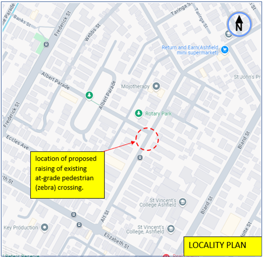
Figure 1. Locality Plan
|
Street Name
|
Alt Street, Ashfield (Near Albert Parade) |
|
Carriageway width (m) kerb to kerb |
Approx. 10.1m |
|
Carriageway type |
Two-way, one travel lane each direction. |
|
Classification |
Local |
|
Speed Limit km/h |
50 |
|
85th percentile speed km/h |
44.9 |
|
Vehicles per day (vpd) |
3390 |
|
Available TfNSW recorded crash history Last 5 years |
(2) accidents in the last 5 years. 1 recorded accident in 2021, north of Elizabeth Street, o/s No.29- RUM 2- pedestrian far side- moderate injury. 1 recorded .accident in 2023, north of Albert Parade, o/s No.52- RUM 42-leaving parking-non-casualty tow -away. |
|
Parking arrangements |
Unrestricted parking is permitted on both sides with Bus zone(s) on the eastern side between Elizabeth Street and Albert Parade. |
|
Side street(nearest) |
Albert Parade. |
Table 1. Road Network detail
The Plan
The following works are proposed and are illustrated on the attached plans:
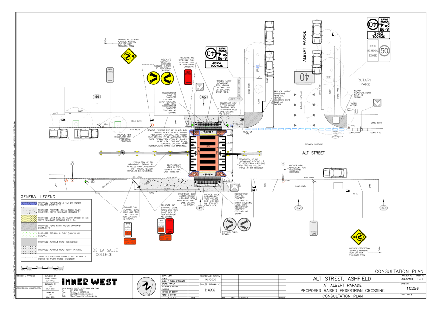
Alt Street (at Albert Parade), Ashfield (Plan No. 10256):
· Construct a new raised concrete pedestrian crossing with “gutter bridge” crossings to replace the existing “at-grade” flat pedestrian crossing. (Refer to attached Plan):
· Relocate/adjust existing ”No Stopping” & ”Bus Zone” signage on the east side of Alt Street to satisfy sight distance and bus zone length requirements;
· Install associated signage associated with the works as required and where shown on the Plan.
Parking Changes
The existing Bus Zone and No Stopping Zones on the east side of Alt Street will be adjusted slightly to accommodate the new raised pedestrian crossing. However, this will not impact on existing parking arrangements around the area of the crossing.
Streetlighting
The new raised pedestrian crossing will require new flood lighting to be provided in order for it to comply with current standards. This will involve the provision of at least 1 (or 2) floodlight (s) on existing or new power poles typical of other locations with pedestrian crossings. At this stage, this design is not complete and will be undertaken by a specialist lighting consultant at a later stage.
Additional Information.
The Local traffic committee at its meeting on the 17 June 2024 recommended in a separate report to relocate or shift the part time ‘Bus zone’ on the eastern side of Alt Street, outside the St Vincent’s College (premises no.45 Alt Street) so that the rear of the zone is set at a minimum of 10 metres away in departure of the crossing.
This was in anticipation of the crossing being upgraded and adherence to current TfNSW guidelines for sight view clearance around the pedestrian(zebra) crossing. The rear of the bus Zone is close to the departure side of the crossing and was originally installed using legacy RMS/RTA guidelines for sight view clearances. General parking was not permitted at other times near the crossing.
As the Bus zone will be wholly shifted at least 10 metres away of the crossing, the rear added restriction to the Bus Zone reading ‘No Stopping at other times’ is no longer applicable and can be recommended to be removed under this proposal to allow for general parking outside of the Bus zone hours.
FINANCIAL IMPLICATIONS
The project is listed on Council’s Traffic Facilities Capital Works budget for works to be carried out in 2024/2025, subject to funding. The work is estimated to be around $60,000.
CONSULTATION
A letter outlining the proposal was mailed out to (20) properties (316 letters) in Alt Street in vicinity of the crossing, requesting residents’ views regarding the proposal. (See also map of consultation area Figure 2).
![]()

Figure 2. Map on Consultation Area
(4) Resident responses were received with (2) supporting the proposal and (2) raising concerning with driveway access, floodlighting and speeding.
The concerns raised by the residents are outlined below in the table.
|
Residents Comments |
Officers Response |
|
Concern kerb blister (islands) will block my driveway. |
The proposed kerb blister (islands) are of the same length and envelope area as the existing islands. Adjoining driveway access will not change or be blocked due to the proposal. |
|
Concern speed hump will slow people down below the speed limit, suggest zig-zag lines instead. Does not want flood lights for the new pedestrian crossing, as does not want intrusive lighting. |
The aim is to physically slow vehicles down to make the crossing safer for pedestrians and improve accessibility over the crossing. Zig-Zag lines currently exist to alert motorists of the on-coming crossing over a crest. Compliant lighting is required for a pedestrian crossing according to Australian Standards. A lighting design will need to be prepared by a suitably qualified lighting consultant to meet this requirement. Council will endeavour to provide only the minimum required levels of lighting whilst still complying with the Standards.
|
CONCLUSION
It is recommended that the design plan (10256) to raise the existing at-grade pedestrian (zebra) crossing with associated signs and markings in Alt Street, Ashfield, just south of Albert Parade and adjacent to St Vincent’s College, as shown in Attachment 1 be approved, subject to the ‘No Stopping at other times’ restriction at the rear of the part-time Bus zone being removed.
|
1.⇩ |
Proposed raising of pedestrian crossing in Alt Street, Ashfield. |
|
|
Local Traffic Committee Meeting 16 September 2024 |
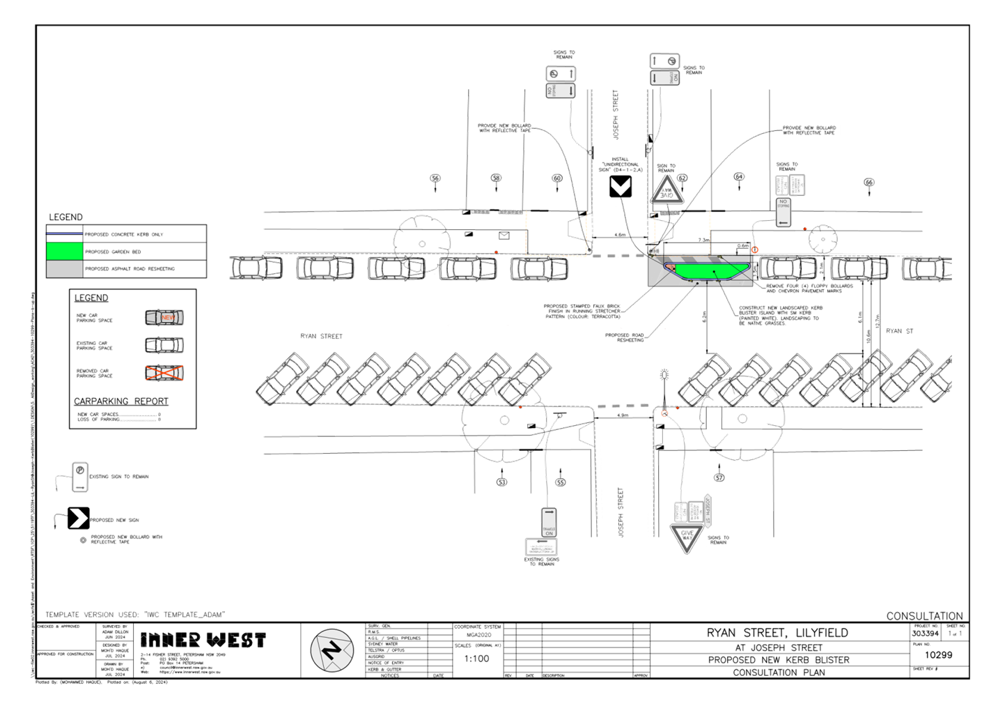
Subject: Ryan Street, Lilyfield (at Joseph Street)
– Proposed Landscaped Kerb Blister Island (BALUDARRI-BALMAIN WARD/BALMAIN
ELECTORATE/LEICHHARDT PAC)
Prepared By: Charbel El Kazzi - Traffic Engineer
Authorised By: Jason Scoufis - Acting Traffic and Transport Planning Manager
|
RECOMMENDATION
That the attached detailed design plan No.10299 for the proposed landscaped kerb blister island, bollards, road re-sheeting and associated new signage on Ryan Street at the intersection with Joseph Street, Lilyfield be approved. |
STRATEGIC OBJECTIVE
This report supports the following strategic directions contained within Council’s Community Strategic Plan:
|
2: Liveable, connected neighbourhoods and transport |
|
|
EXECUTIVE SUMMARY
Council is planning to construct a landscaped kerb blister island outside the property No. 62 Ryan Street, Lilyfield. The proposal aims to protect the heritage awning and its posts from turning vehicles at this intersection.
It is noted that there will be no loss of on-street parking due position of the kerb blister island being installed within the existing ‘No Stopping’ zone.
BACKGROUND
The proposal for the construction of a landscaped kerb blister island in Ryan Street at the intersection with Joseph Street outside 62 Ryan Street, Lilyfield was approved by the Local Traffic Committee on 20 November 2023, with the project to be listed in Council’s capital works program.
The detailed design plan shown in Attachment 1 outlines the proposed works on Ryan Street and Joseph Street, Lilyfield and includes the following:
• Construct a landscaped kerb blister island in front of No.62 Ryan Street with landscaping to be suitable species of native grasses;
• Install associated signage associated with the works as shown in the plan;
• Provide two bollards within the footpath to help protect the two awning posts.
Ryan Street is a local road with a speed limit of 50km/h with 45 degree front to kerb angle parking on the western side and parallel parking on the eastern side. The road generally has a two-way single lane configuration in each direction. Joseph Street is approximately 5m in width between kerbs and operates as a two-way laneway.
DISCUSSION
A letter outlining the above proposal was distributed to the directly affected properties (11 properties) in Ryan Street, Lilyfield. No submissions were received in response to this proposal.
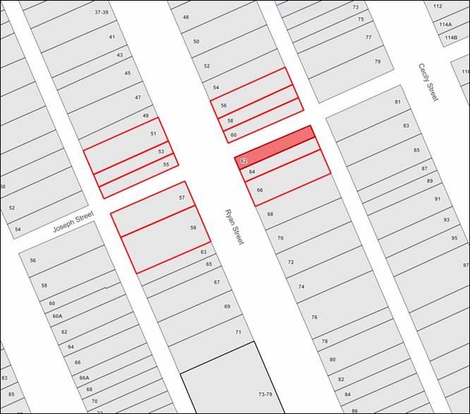
FINANCIAL IMPLICATIONS
The project is listed on Council’s Traffic Facilities Capital Works budget for 2024/2025 and is estimated to be around $21,000.
|
1.⇩ |
Ryan Street, Lilyfield (at Joseph Street) - Design Plan |