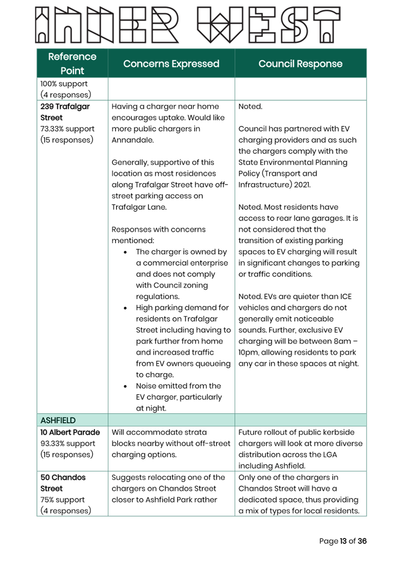
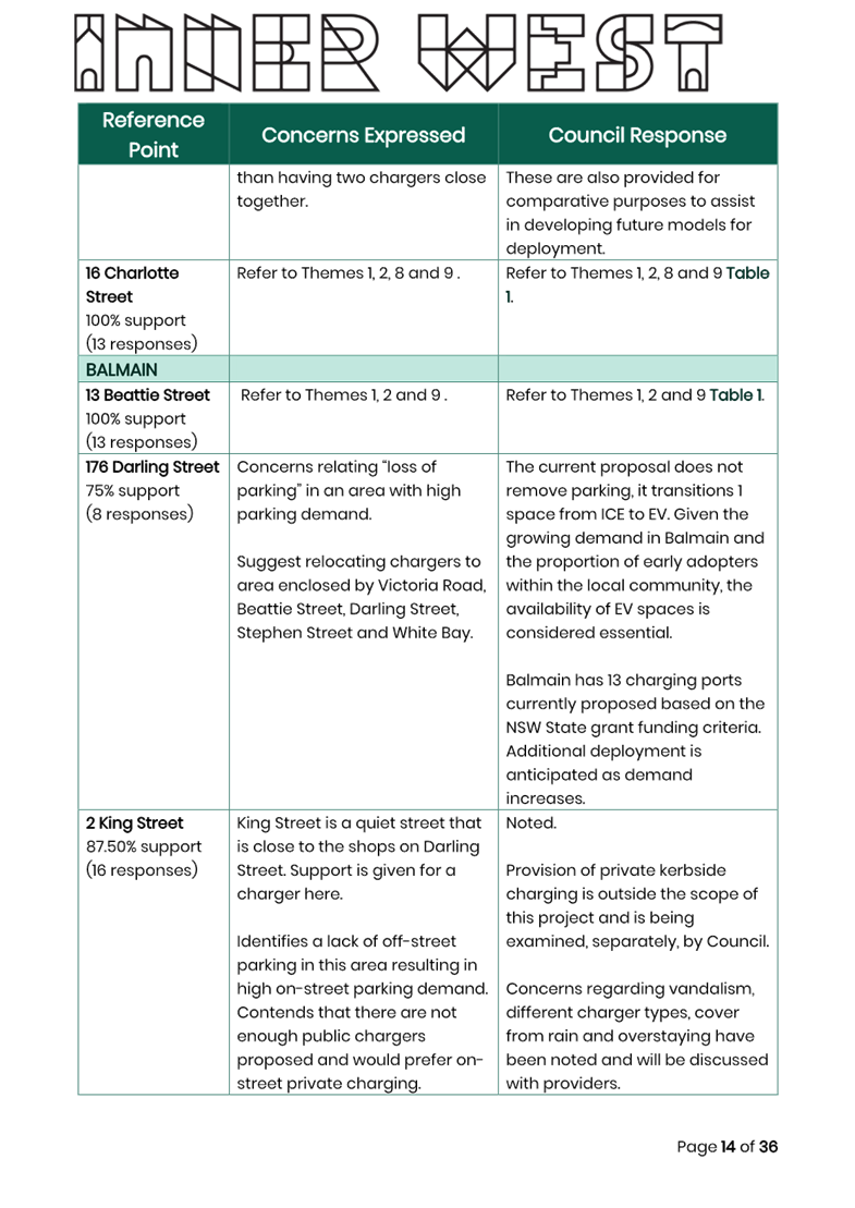
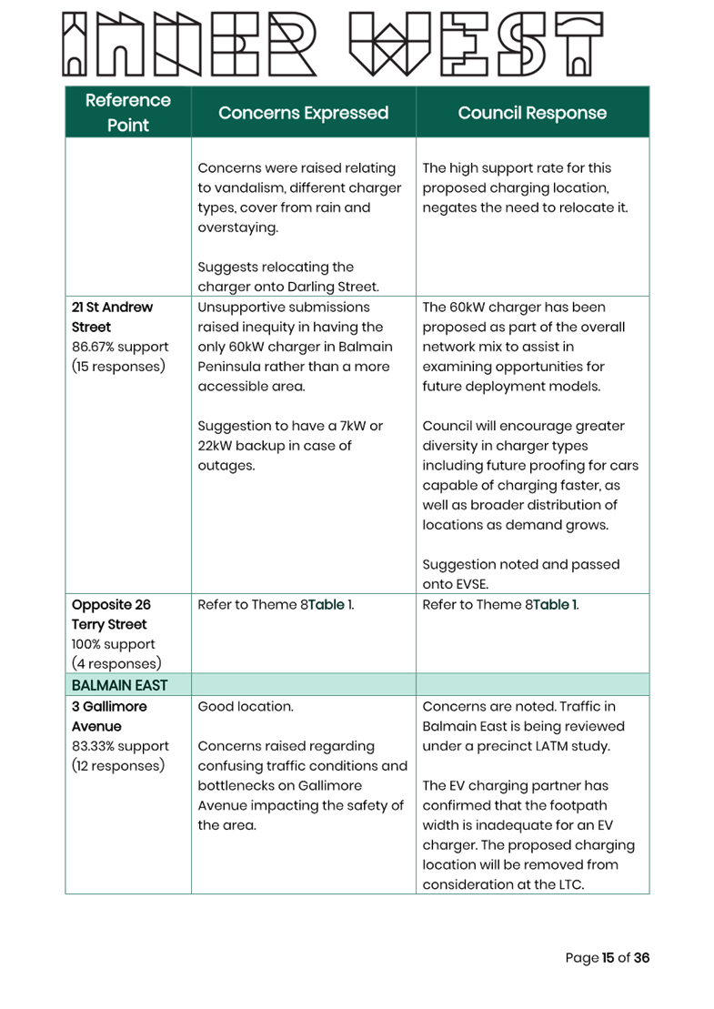
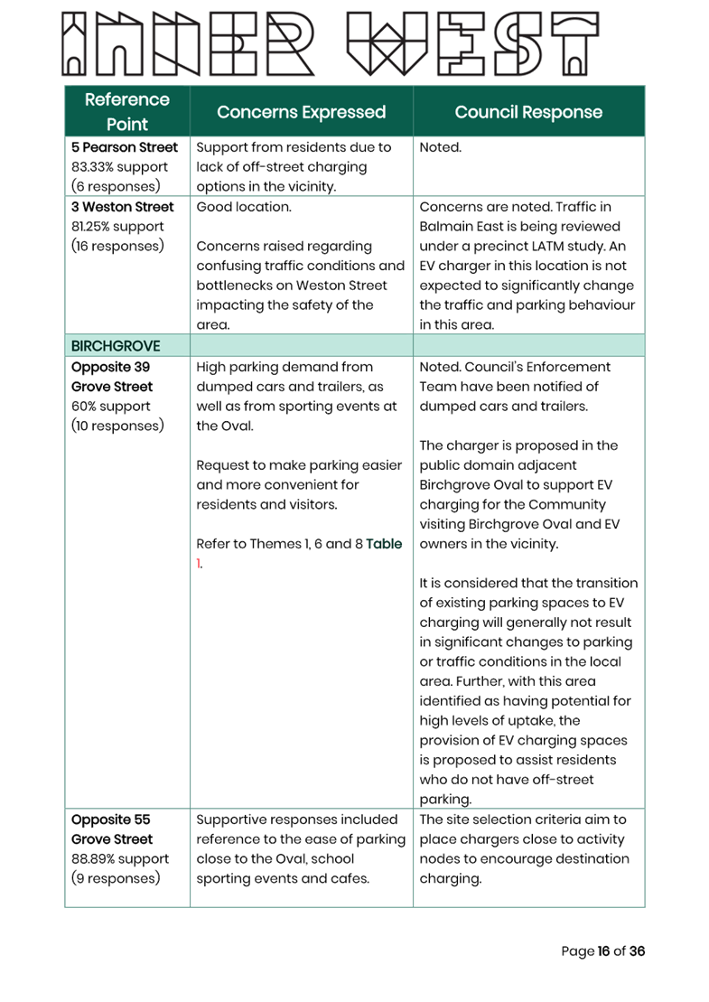
|
AGENDA R |

Local Traffic Committee Meeting
MONDAY 21 OCTOBER 2024
11:00 AM
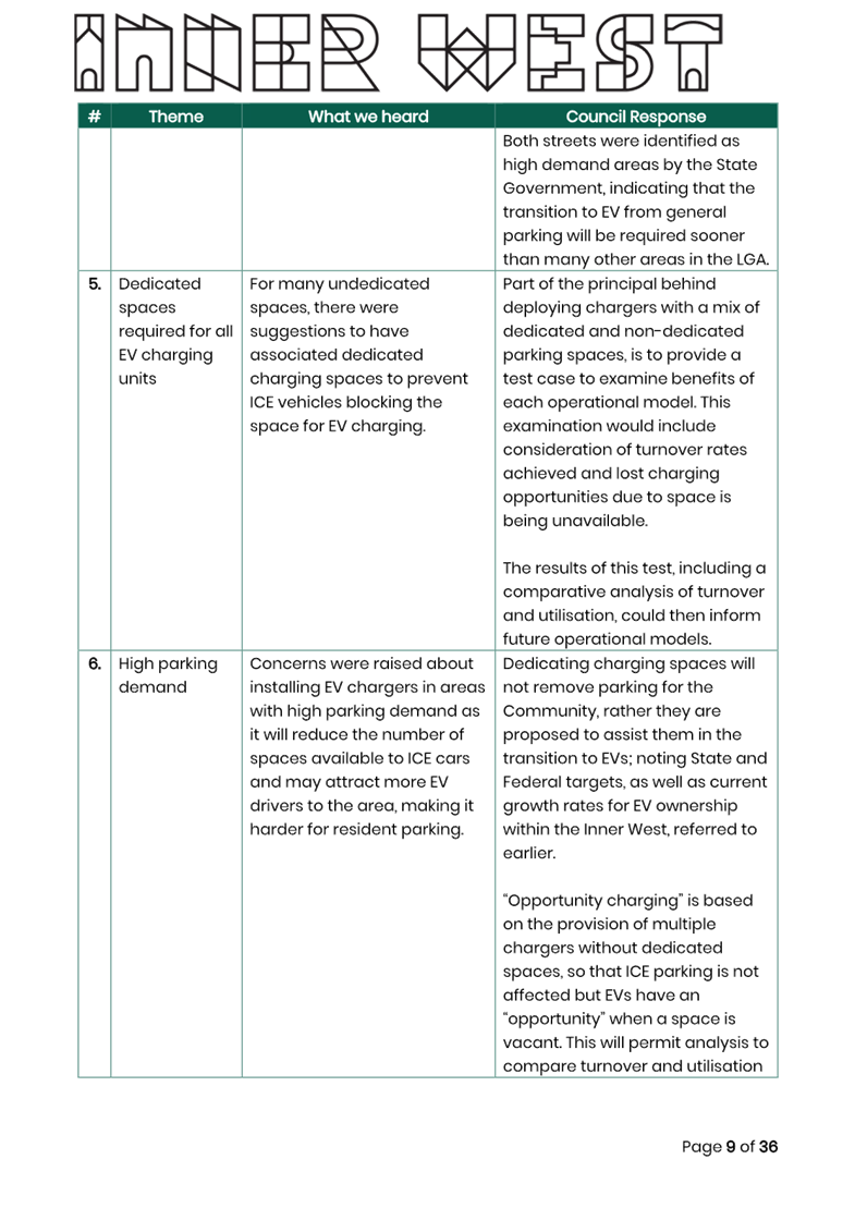
|
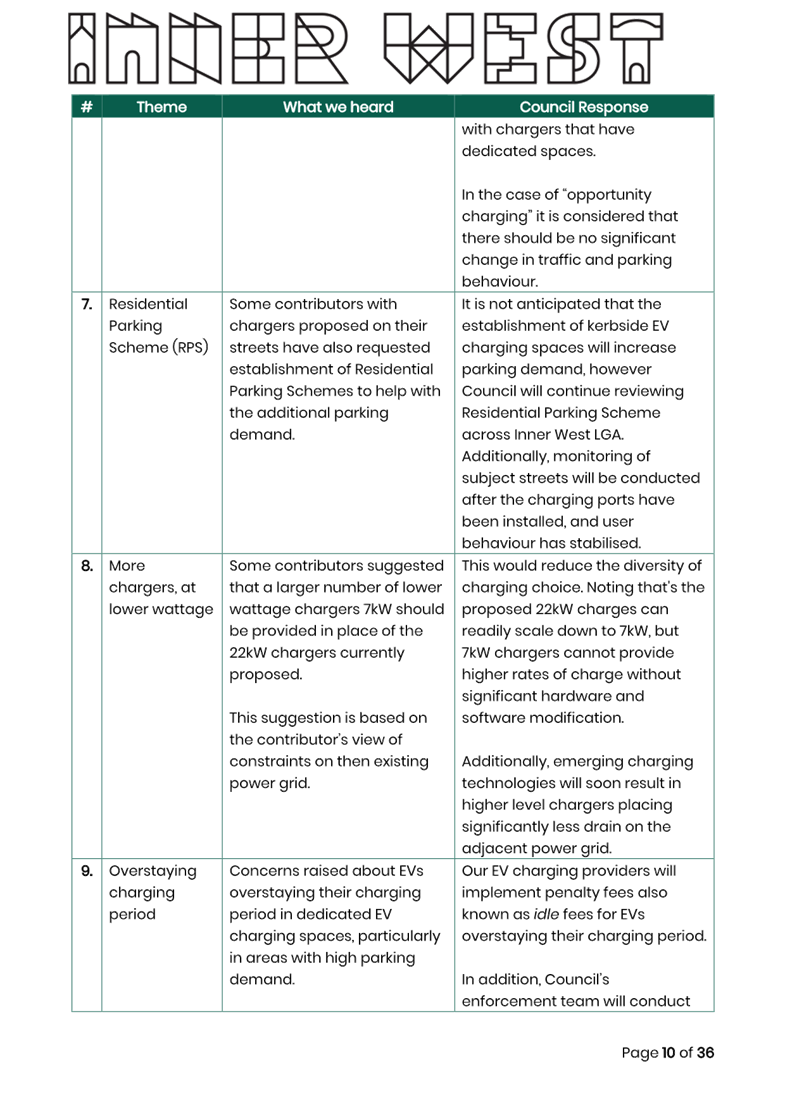
|
Local Traffic Committee Meeting 21 October 2024 |
Function of the Local Traffic Committee
Background
Roads and Maritime Services (RMS) is legislated as the Authority responsible for the control of traffic on all NSW Roads. The RMS has delegated certain aspects of the control of traffic on local roads to councils. To exercise this delegation, councils must establish a local traffic committee and obtain the advice of the RMS and Police. The Inner West Council Local Traffic Committee has been constituted by Council as a result of the delegation granted by the RMS pursuant to Section 50 of the Transport Administration Act 1988.
Role of the Committee
The Local Traffic Committee is primarily a technical review and advisory committee which considers the technical merits of proposals and ensures that current technical guidelines are considered. It provides recommendations to Council on traffic and parking control matters and on the provision of traffic control facilities and prescribed traffic control devices for which Council has delegated authority. These matters are dealt with under Part A of the agenda and require Council to consider exercising its delegation.
In addition to its formal role as the Local Traffic Committee, the Committee may also be requested to provide informal traffic engineering advice on traffic matters not requiring Council to exercise its delegated function at that point in time, for example, advice to Council’s Development Assessment Section on traffic generating developments. These matters are dealt with under Part C of the agenda and are for information or advice only and do not require Council to exercise its delegation.
Committee Delegations
The Local Traffic Committee has no decision-making powers. The Council must refer all traffic related matters to the Local Traffic Committee prior to exercising its delegated functions. Matters related to State Roads or functions that have not been delegated to Council must be referred directly to the RMS or relevant organisation.
The Committee provides recommendations to Council. Should Council wish to act contrary to the advice of the Committee or if that advice is not supported unanimously by the Committee members, then the Police or RMS have an opportunity to appeal to the Regional Traffic Committee.
Committee Membership & Voting
Formal voting membership comprises the following:
· one representative of Council as nominated by Council;
· one representative of the NSW Police from each Local Area Command (LAC) within the LGA, being Newtown, Marrickville, Leichhardt and Ashfield LAC’s.
· one representative from the RMS; and
· State Members of Parliament (MP) for the electorates of Summer Hill, Newtown, Heffron, Canterbury, Strathfield and Balmain or their nominees.
Where the Council area is represented by more than one MP or covered by more than one Police LAC, representatives are only permitted to vote on matters which effect their electorate or LAC.
Informal (non-voting) advisors from within Council or external authorities may also attend Committee meetings to provide expert advice.
Committee Chair
Council’s representative will chair the meetings.
Public Participation
Members of the public or other stakeholders may address the Committee on agenda items to be considered by the Committee. The format and number of presentations is at the discretion of the Chairperson and is generally limited to 3 minutes per speaker. Committee debate on agenda items is not open to the public.
|
|
Local Traffic Committee Meeting 21 October 2024 |
|
AGENDA |
1 Apologies
2 Disclosures of Interest
3 Confirmation of Minutes Page
Minutes of 16 September 2024 Local Traffic Committee 6
4 Matters Arising from Council’s Resolution of Minutes
5 Part A – Items Where Council May Exercise Its Delegated Functions
Traffic Matters
ITEM Page
LTC1024(1) Item 1 Intersection of Evans Street and Nelson Street, Rozelle - Proposed kerb extensions (Baludarri-Balmain Ward/Balmain Electorate/Leichhardt PAC) 19
LTC1024(1) Item 2 Traffic Management Plan for the 2024 New Year's Eve Event (Baludarri-Balmain Ward/ Balmain Electorate/ Leichhardt Pac) 21
LTC1024(1) Item 3 Intersection of Glassop Street and White Street, Balmain - Proposed Treatment of Intersection for Improved Sight Lines (Baludarri-Balmain Ward/Balmain Electorate/Leichhardt PAC) 50
LTC1024(1) Item 4 Lilyfield Road, Lilyfield - Proposed Raised Pedestrian and Bicycle Crossings (Baludarri-Balmain Ward/Balmain Electorate/Leichhardt PAC) 53
LTC1024(1) Item 5 Moyes Street, Marrickville - Proposed 'No Stopping' relocation (Marrickville-Midjuburi/Summer Hill Electorate/Inner West PAC) 60
LTC1024(1) Item 6 Pilgrim Avenue, Marrickville - Proposed ‘No Parking’ restrictions on the inner bend to improve access (Midjuburi - Marrickville Ward / Summer Hill Electorate / Inner West PAC) 67
LTC1024(1) Item 7 Church Street, Ashfield, between Knocklayde Street and Alt Street-Proposed Raised Thresholds & Kerb Blister Islands (Traffic Calming)(Gulgadya-Leichhardt Ward/Summer Hill Electorate/Burwood PAC). 69
LTC1024(1) Item 8 Ramsay Street & Dalhousie Street, Haberfield - 40km/h High Pedestrian Activity Area (HPAA) (Gulgadya-Leichhardt Ward/Summer Hill Electorate/Burwood PAC) 82
LTC1024(1) Item 9 Clissold
Street, between Queen Street and Victoria Street, Ashfield-Proposed removal of
existing at-grade crossing and provide a new raised pedestrian(zebra) crossing-
Deferred Item for additional information.
(Djarrawunang-Ashfield Ward/Summer Hill Electorate/Burwood PAC) 182
LTC1024(1) Item 10 Victoria Street, Ashfield - Installation of a ‘Keep Clear’ zone at the front of Ashfield Police Station (Djarrawunang-Ashfield Ward/Summer Hill Electorate/Burwood PAC) 189
Parking Matters
ITEM Page
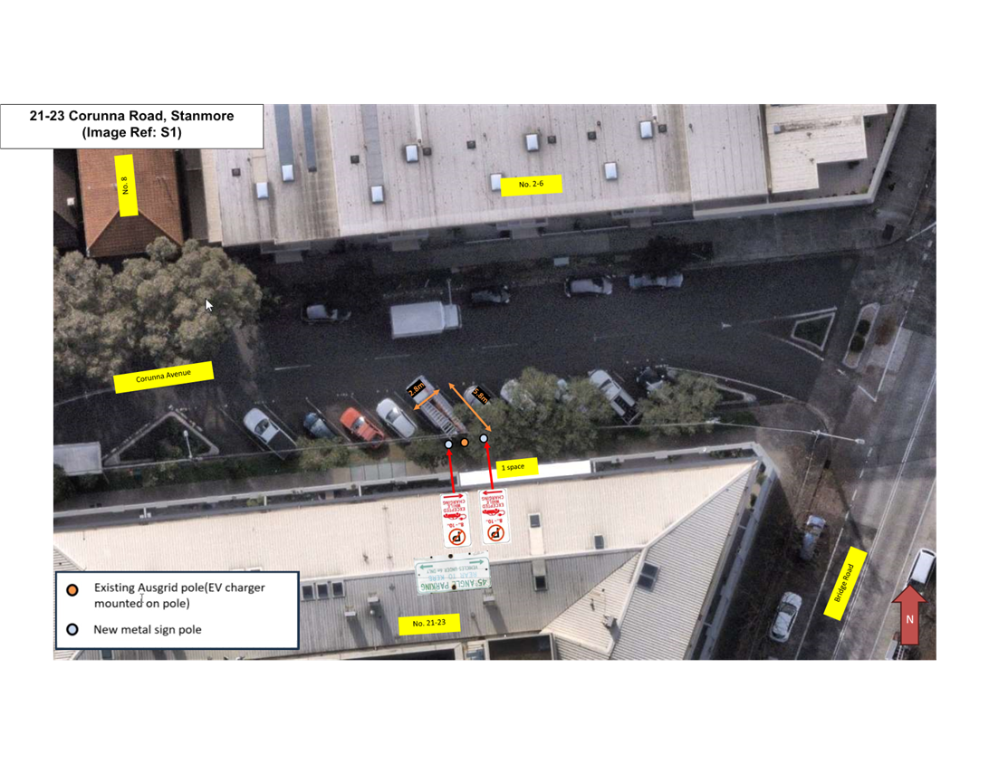
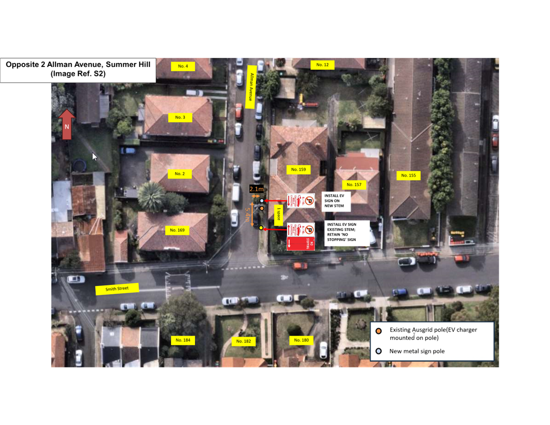
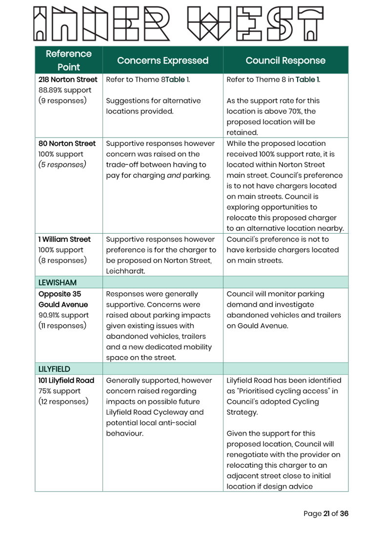
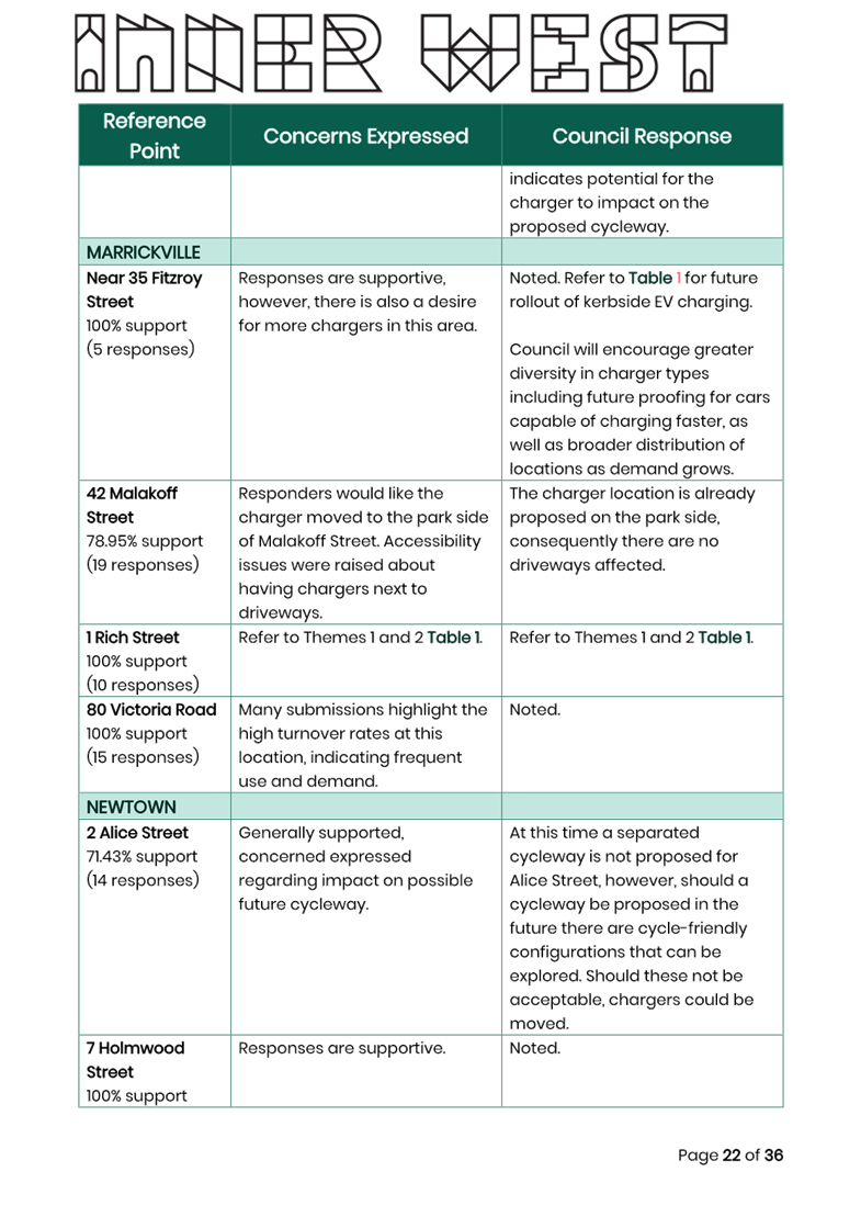
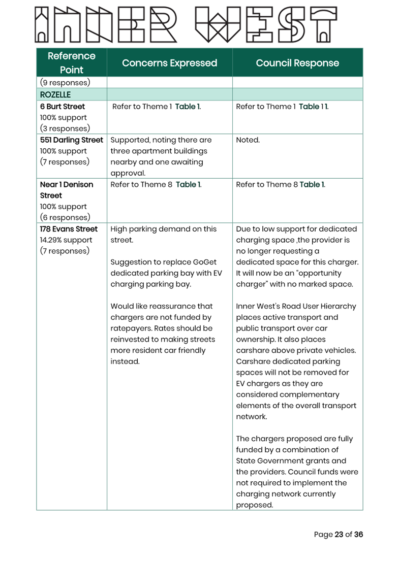
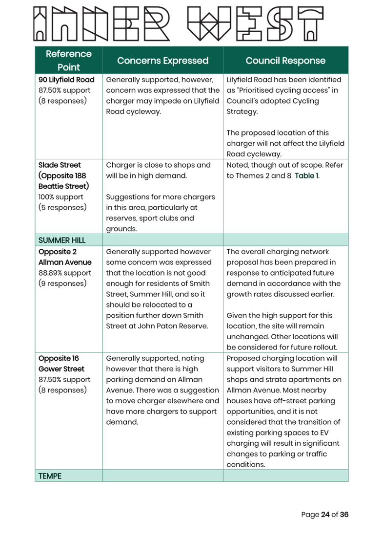
LTC1024(1) Item 11 Proposed EV Kerbside Charging Locations (All Wards / All Electorates / All PACs) 191
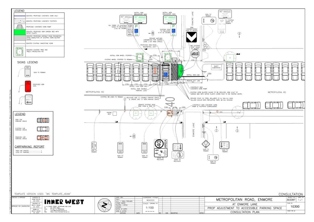
LTC1024(1) Item 12 Metropolitan Road, Enmore - Proposed changes to mobility parking (Damun-Stanmore Ward/Newtown Electorate/Inner West PAC) 294
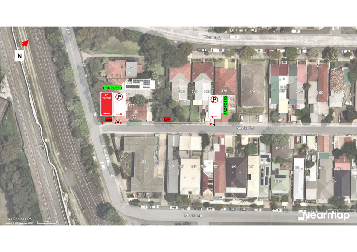
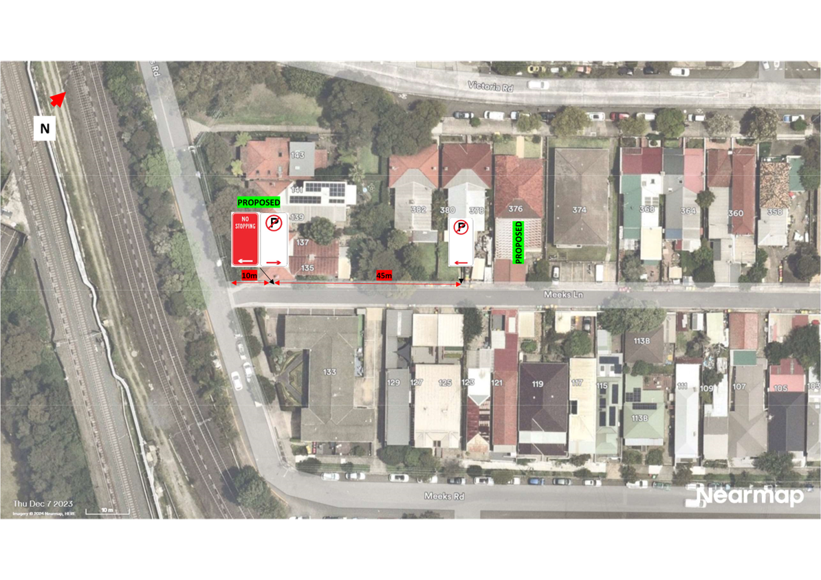
LTC1024(1) Item 13 Meeks Lane, Marrickville - Proposed 'No Stopping' and 'No Parking' restrictions (Midjuburi-Marrickville Ward/Summer Hill Electorate/Inner West PAC) 297
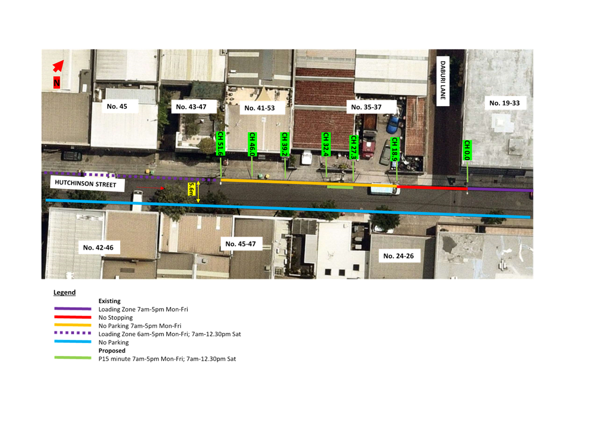
LTC1024(1) Item 14 Hutchinson Street, St Peters - Proposed 15-minute timed parking restrictions (Marrickville-Midjuburi Ward/Heffron Electorate/Inner West PAC) 303
Late Items
Nil at time of printing.
6 Part B - Items for Information Only
ITEM Page
LTC1024(1) Item 15 Temporary speed reductions to 40 km/h for Southwest Link 309
7 Part C - Items for General Advice
Nil at the time of printing.
8 General Business
9 Close of Meeting
|
|
Local Traffic Committee Meeting 21 October 2024 |
Minutes of Local Traffic Committee Meeting held on 16 September 2024
Meeting commenced at 11:01 AM
ACKNOWLEDGEMENT OF COUNTRY BY CHAIRPERSON
I acknowledge the Gadigal and Wangal people of the Eora nation on whose country we are meeting today, and their elders past and present.
COMMITTEE REPRESENTATIVES PRESENT
|
Manod Wickramasinghe |
IWC’s Traffic and Transport Planning Manager (Chair) |
|
Graeme McKay |
Representative for Jo Haylen MP, Member for Summer Hill |
|
Eleanor Nurse |
Representative for Jenny Leong MP, Member for Newtown |
|
Nina Fard |
Transport for NSW (TfNSW) |
|
|
|
|
NON VOTING MEMBERS IN ATTENDANCE |
|
|
|
|
|
Colin Jones |
Representative for the Inner West Bicycle Coalition (IWBC) |
|
Michael Takla |
Representative for Transit Systems |
|
Sunny Jo |
IWC’s Coordinator Traffic Engineering Services (North) |
|
George Tsaprounis |
IWC’s Coordinator Traffic Engineering Services (South) |
|
Jason Scoufis |
IWC’s Coordinator Traffic Studies & Road Safety |
|
Christy Li |
IWC’s Business Administration Officer |
|
|
|
|
VISITORS |
|
|
|
|
|
John Parrington |
Resident (Item 4) |
|
Kate Parrington |
Resident (Item 4) |
|
|
|
|
APOLOGIES: |
|
|
|
|
|
Bill Holliday |
Representative for Kobi Shetty MP, Member for Balmain |
|
Ben Walters |
Representative for NSW Police – Inner West Police Area Command |
DISCLOSURES OF INTERESTS:
Nil.
CONFIRMATION OF MINUTES
|
That the Minutes of the Local Traffic Committee held on Monday, 19 August 2024 be confirmed. |
MATTERS ARISING FROM COUNCIL’S RESOLUTION OF MINUTES
The Minutes of the Local Traffic Committee meeting held on 17 June 2024 were adopted at
Council’s meeting held on 03 September 2024 subject to the following:
The Minutes of the Local Traffic Committee meeting held on 15 July 2024 were adopted at
Council’s meeting held on 03 September 2024 subject to the following:
The Minutes of the Local Traffic Committee meeting held on 19 August 2024 were adopted at Council’s meeting held on 03 September 2024.
General Business
|
Item 10 - Frederick Street and John Street, Ashfield traffic signal update |
|
The Representative for the Member for Summer Hill requested an update on the traffic signals at the intersection of Fredrick Street and John Street, Ashfield. The Representative for Transport for NSW advised that the project is currently in the detailed design stage and that Transport for NSW has applied for funding for the next two financial years for construction. The Representative for Transport for NSW advised that the construction would have to be staged over two years as it is a difficult site for the construction of traffic signals. |
|
Item 11 - Edward Street at Old Canterbury Road signalised intersection update |
|
The Representative for the Bicycle Coalition requested an update on the traffic signals on the intersection of Edward Street at Old Canterbury Road. Council Officers advised they are currently in the design stage and are currently negotiating final approvals with Transport for NSW. Council Officers noted that the works are proposed to be completed this financial year as part of the Greenway project. |
Meeting closed at 12.05pm.
CHAIRPERSON
Manod Wickramasinghe
|
|
Local Traffic Committee Meeting 21 October 2024 |
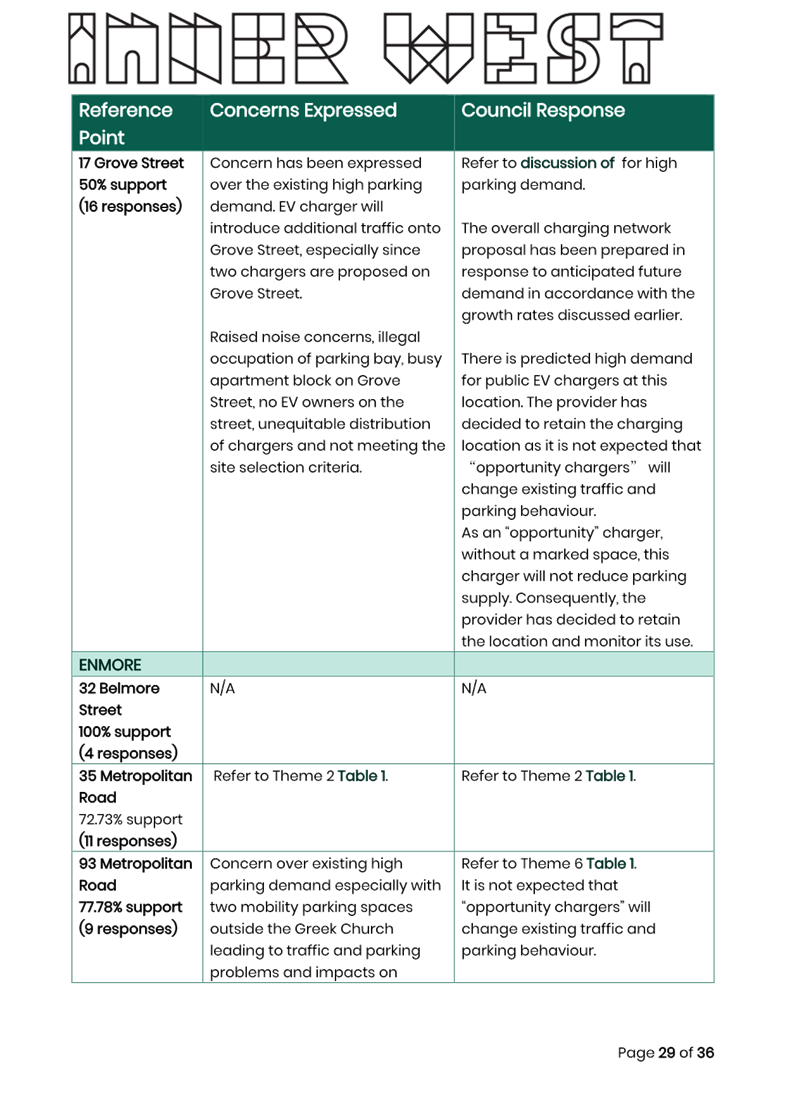
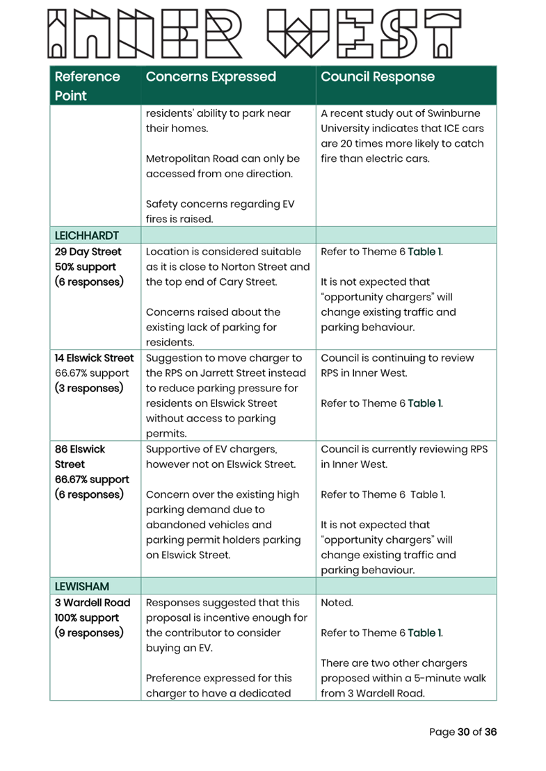
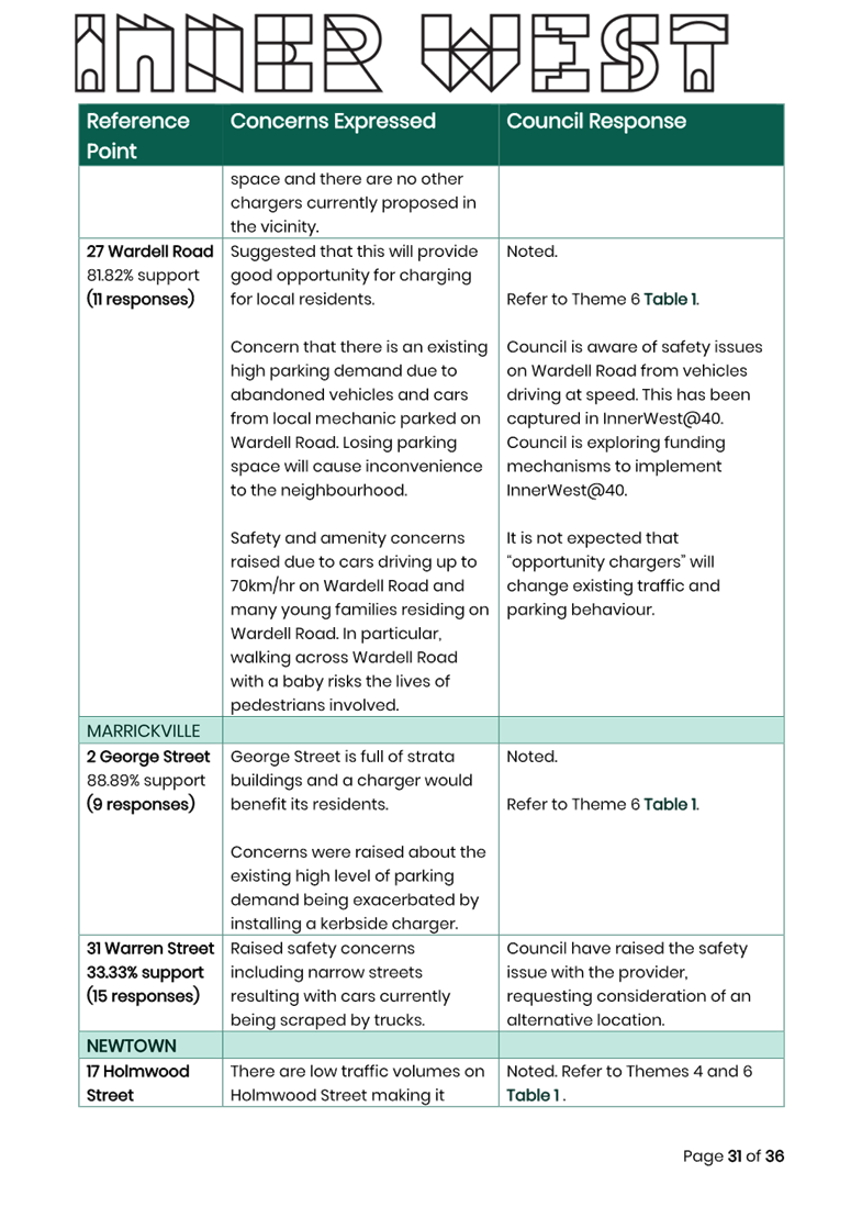
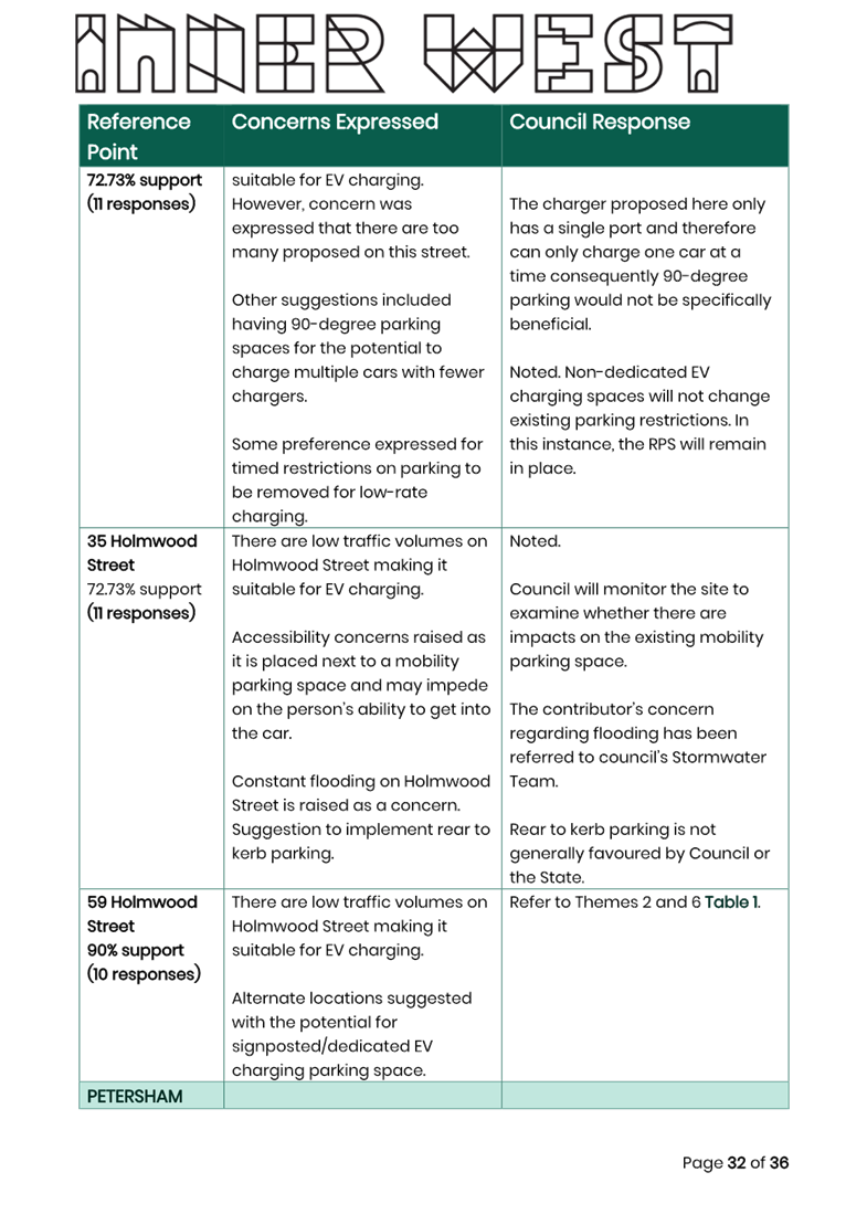
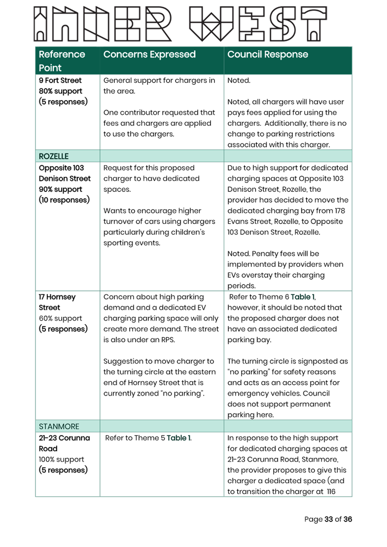
Subject: Intersection of Evans Street and Nelson Street, Rozelle - Proposed kerb extensions (Baludarri-Balmain Ward/Balmain Electorate/Leichhardt PAC)
Prepared By: Amir Falamarzi - Traffic Engineer
Authorised By: Manod Wickramasinghe - Traffic and Transport Planning Manager
|
RECOMMENDATION
1. That the proposed kerb extensions in Evans Street, at Nelson Street, Rozelle be supported in principle and included in Council’s Capital Works Program.
2. That the detailed design for the proposed kerb extensions be brought back to the Traffic Committee for consideration, including the results of Community Engagement.
|
STRATEGIC OBJECTIVE
This report supports the following strategic directions contained within Council’s Community Strategic Plan:
|
2: Liveable, connected neighbourhoods and transport |
|
|
EXECUTIVE SUMMARY
In October 2023, Council adopted the Balmain Local Area Traffic Management (LATM) Study for the Balmain precinct. One of the recommendations from the study was to further investigate the provision of kerb extensions at the intersection of Evans Street and Nelson Street, Rozelle. The proposal aims to improve traffic safety for pedestrian by shortening the crossing distance and enhancing visibility as well as enhancing driver sight distance for traffic exiting Nelson Street. Additionally, the work will provide opportunities for landscaping and kerbspace for on-street parking.
BACKGROUND & DISCUSSION
The Council’s adopted Balmain LATM study in 2023 made several recommendations to improve safety in the Rozelle and Balmain area. The Balmain LATM study area is bounded by Victoria Road, Robert Street, Mullens Street, Montague Street, and Darling Street. One of the recommendations from the study was to further investigate kerb extensions on Evans Street at Nelson Street to improve intersection safety.
The proposed kerb extensions have several safety benefits, including shortening the crossing distance required for pedestrians, improved pedestrian visibility, opportunities for landscaping and increasing the kerbside parking capacity by approximately 4.8m. A concept plan of the proposed treatment is shown in Figure 1.
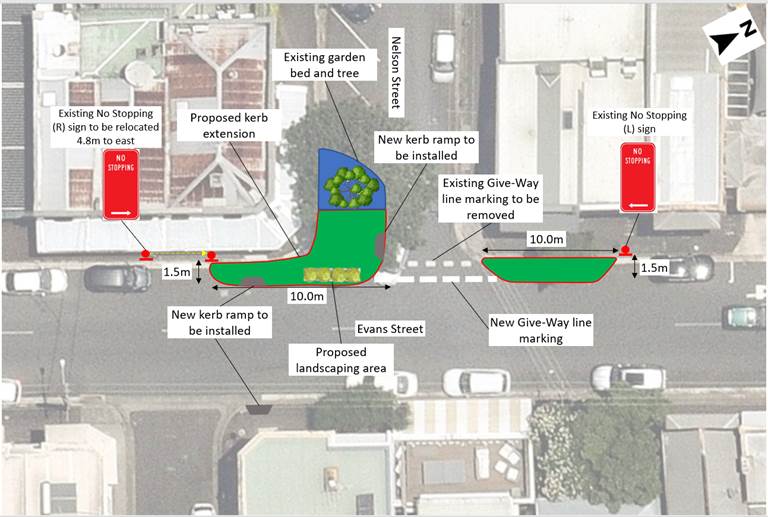
Figure 1. Proposed kerb extension at the intersection of Evans Street and Nelson Street
PUBLIC CONSULTATION
A public consultation was conducted with the affected residents along Evans Street and Nelson Street between 26 June 2024 and 12 August 2024 inviting to provide feedback on the proposal. At the time of this report one comment was received from The Welcome Hotel, which is immediately adjacent to the site, expressing their interest in a kerbside Loading Zone. This will be investigated in further detail and discussed with the hotel management prior to the development of the detailed design.
FINANCIAL IMPLICATIONS
Initial cost estimate of the proposed kerb extensions, ramps, and landscaping is estimated at $40,000. Works are to be considered as part of Council’s Capital Works Program for Traffic Facilities, with final costing to be finalized following the completion of detailed design.
Nil.
|
|
Local Traffic Committee Meeting 21 October 2024 |
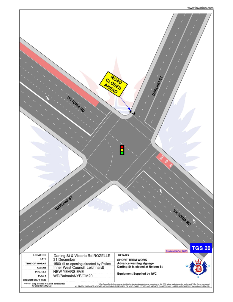
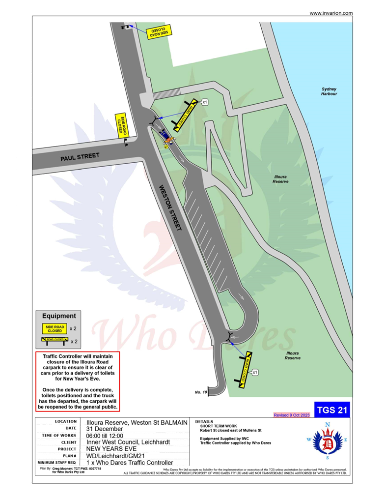
Subject: Traffic Management Plan for the 2024 New Year's Eve Event (Baludarri-Balmain Ward/ Balmain Electorate/ Leichhardt Pac)
Prepared By: Amir Falamarzi - Traffic Engineer
Authorised By: Manod Wickramasinghe - Traffic and Transport Planning Manager
|
RECOMMENDATION
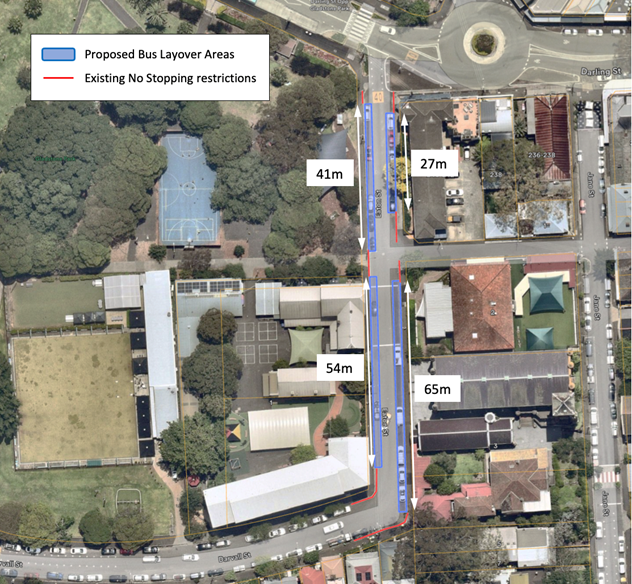
1. That the Traffic Management Plan (Attachment 1) detailing the traffic arrangements for the 2024 New Year’s Eve be supported with the temporary modifications to bus stops being revised to also include: a) On Eaton Street: i. Install a temporary 27m and 41m length ‘Bus Zone’ between Darling Street and Gladstone Street on the east and west side respectively; ii. Install a temporary 65m and 54m length ‘Bus Zone’ between Gladstone Street and Darvall Street on the east and west side respectively;
2. That the Traffic Management Plan (Attachment 1) be forwarded to Council’s Parks and Streetscapes Coordinator, Transport Management Centre and the Major Events & Incidents Group (NSW Police).
|
STRATEGIC OBJECTIVE
This report supports the following strategic directions contained within Council’s Community Strategic Plan:
|
2: Liveable, connected neighbourhoods and transport |
|
|
EXECUTIVE SUMMARY
As part of the annual New Years Eve celebrations, Council implements a Traffic Management Plan to support NSW Police operations in the Balmain Peninsula.
This report outlines the traffic management plan for the 2024 New Year’s Eve event including temporary road closures, ‘Bus Zones’ and ‘No Stopping’ zones. Following last year’s event, there was a need to modify the TMP to address the following matters:
· Lack of an emergency access route during the Balmain NYE closures for NSW Ambulances
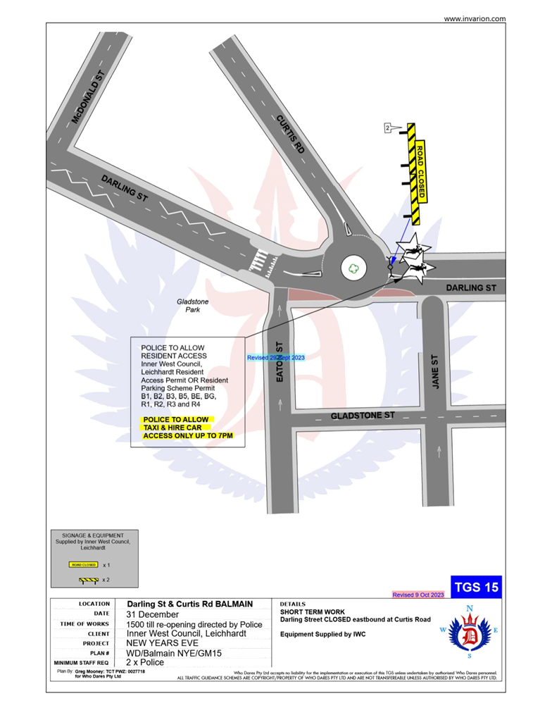
· Safety issues with crowds conflicting with buses turning around at the roundabout at the intersection of Darling Street and Curtis Road.
These matters are detailed in the report and resulted in the addition of an emergency access route via Mackenzie Street, Rozelle and a Bus Loop via Booth Street/Darvall Street/Eaton Street, Balmain as an alternative to turning buses at the congested Darling Street/Curtis Road roundabout.
BACKGROUND
As part of the annual New Year’s Eve celebrations, Council implements a Traffic Management Plan to support NSW Police operations in the Balmain Peninsula.
Matters arising from the previous new Year’s Event has been summarized below.
|
Stakeholders Comments |
Officer Comments |
|
Lack of an emergency access route during the Balmain NYE has been highlighted by NSW ambulance during a joint meeting with the stakeholders involved in Balmain NYE. It was raised that emergency vehicles to access the Balmain Peninsula need to use the roads manned by NSW Police officers. As a result, these vehicles have to queue along the above roads with other vehicles, which can significantly affect their response time.
|
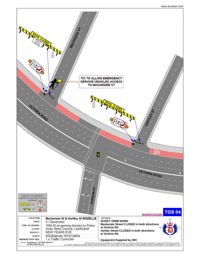
To address the issue a meeting was held with representatives from Council’s Traffic Team, Council’s Event Team, NSW Police, NSW Ambulance. It was proposed that emergency vehicles access the Balmain Peninsula via Mackenzie Street, turning right into Mansfield Street and then turn left into Mullens Street. As part of Balmain NYE traffic management plan, the intersection of Mackenzie Street and Victoria Road will be barricaded. In this regard, a traffic controller will be stationed at the intersection of Mackenzie Street and Victoria Road to maintain the access of emergency vehicles. In addition, the existing TGS at the above intersection has been modified to include a traffic controller and an ‘EMERGENCY VEHICLES EXCEPTED’ sign will be installed on the existing road barricade. |
|
Safety issues with crowds conflicting with buses turning around at the roundabout at Darling Street and Curtis Road. |
A new request from Transit Systems has been included for consideration to utilise Booth Street and Eaton Street as a turning point back to Darling Street. This will also require additional Bus Layover areas in Eaton Street as outlined in this report. |
DISCUSSION
Traffic Management
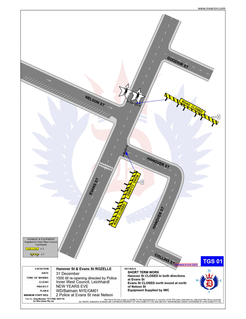
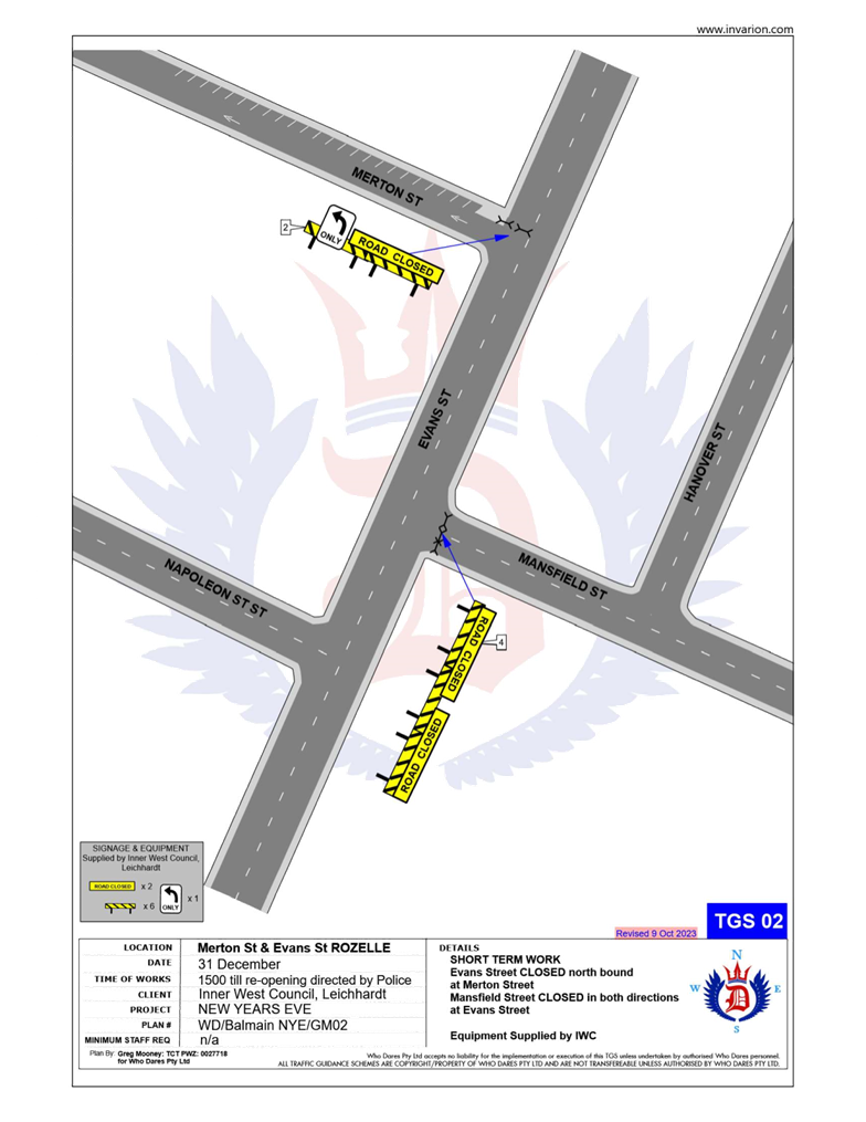
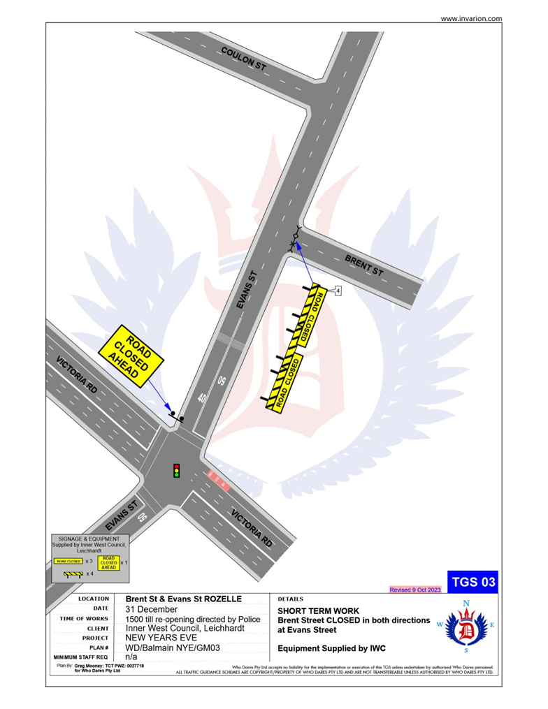
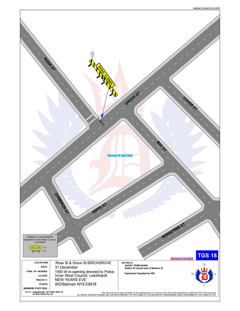
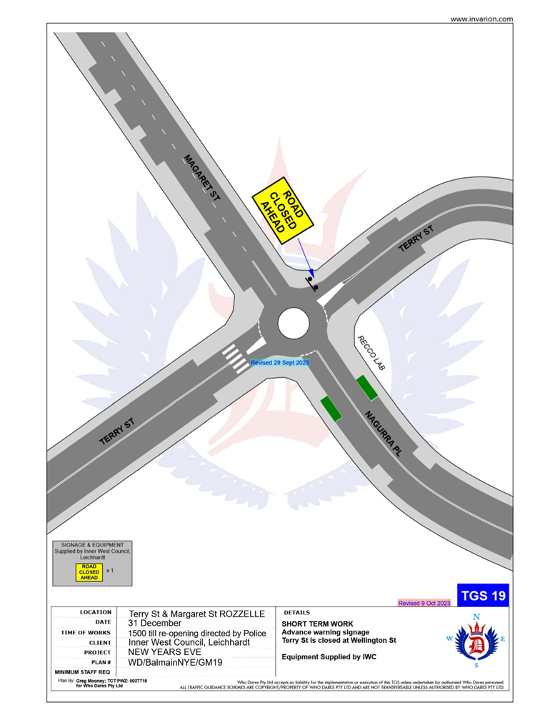
The following roads will be closed to all vehicular traffic between 3:00pm Tuesday, 31 December 2024 and 12:00am on Wednesday, 1 January 2025 to cater for the New Year’s Eve celebrations:
· Brent Street at Evans Street intersection, Rozelle (both directions).
· Mansfield Street at Evans Street intersection, Rozelle (both directions).
· Hanover Street at Evans Street intersection, Rozelle (both directions).
· Mackenzie Street at Victoria Road intersection, Rozelle (both directions).
· Hartley Street at Victoria Road intersection, Rozelle (both directions).
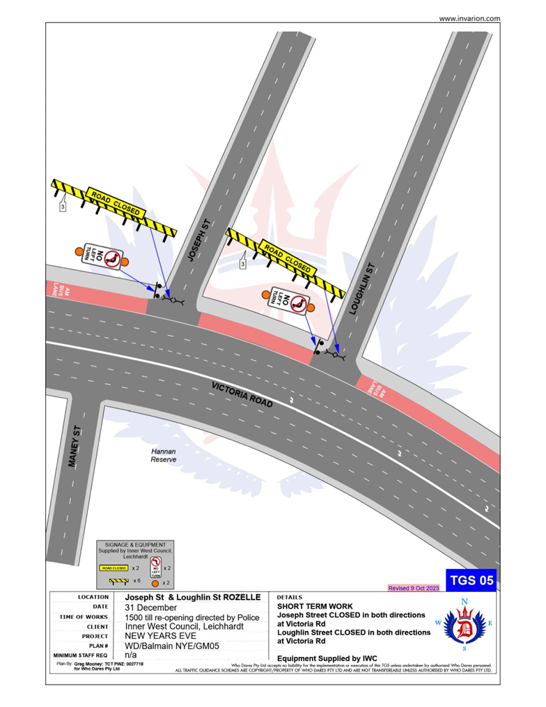
· Joseph Street at Victoria Road intersection, Rozelle (both directions).
· Loughlin Street at Victoria Road intersection, Rozelle (both directions).
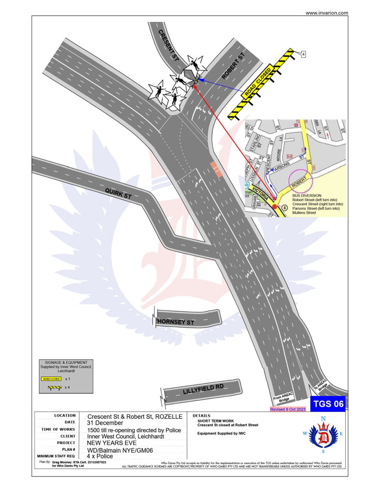
· Crescent Street at Robert Street intersection, Rozelle (both directions).
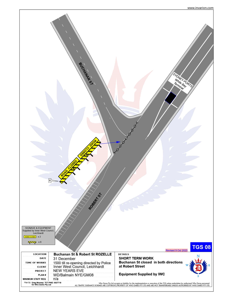
· Buchanan Street at Robert Street intersection, Balmain (both directions).
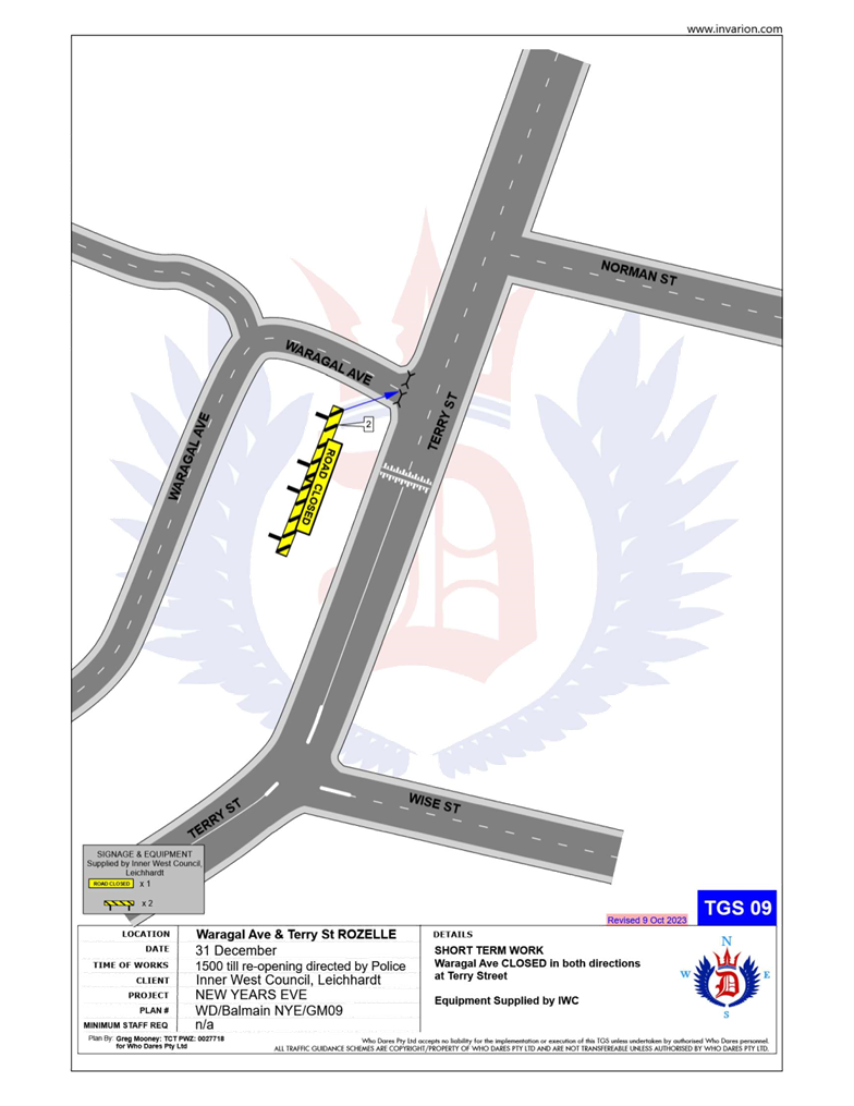
· Waragal Avenue at Terry Street intersection, Rozelle (both directions).
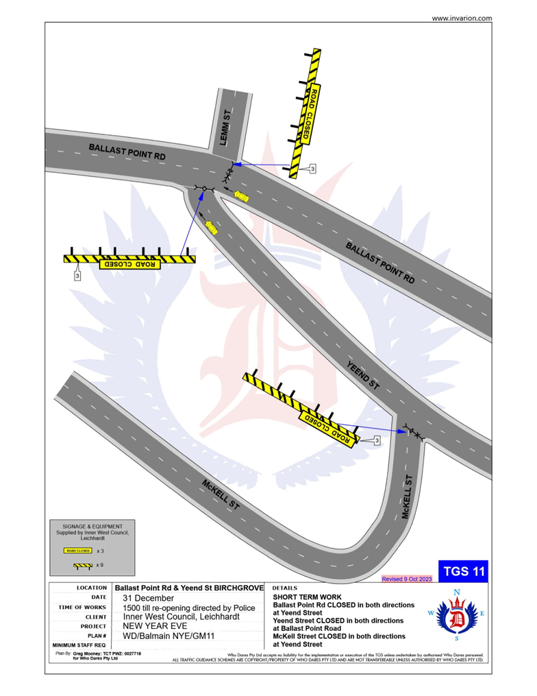
· McKell Street at Yeend Street intersection, Birchgrove (both directions).
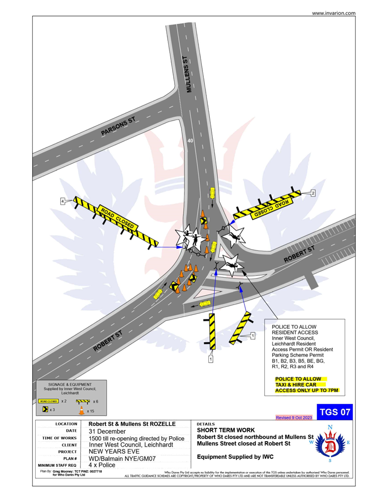
In addition, the following roads will be closed to all vehicular traffic except State Transit Authority/Transit Systems buses, Taxis, Hire Cars and Balmain Access Permit holders and will be manned by NSW Police officers between 3:00pm Tuesday, 31st December 2024 and 12:00am on Wednesday, 1st January 2025:
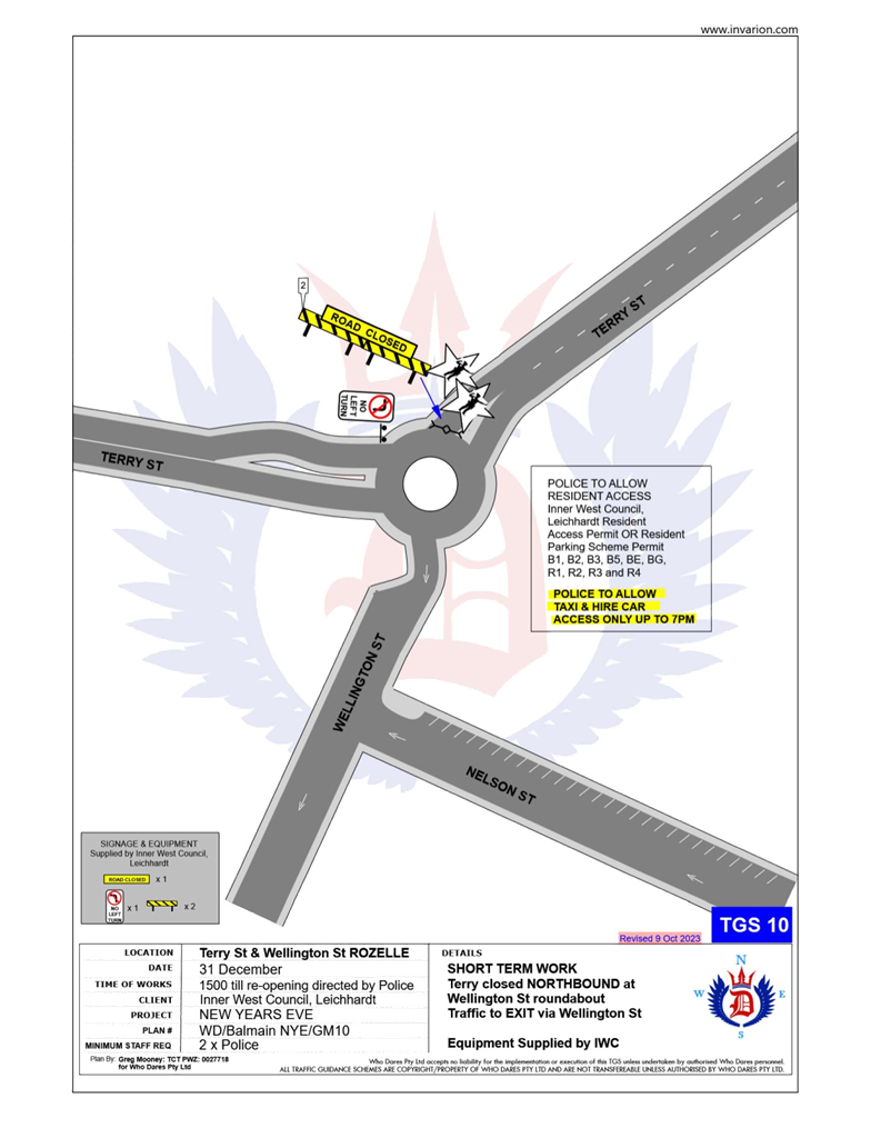
· Terry Street at Wellington Street intersection, Rozelle (northbound direction).
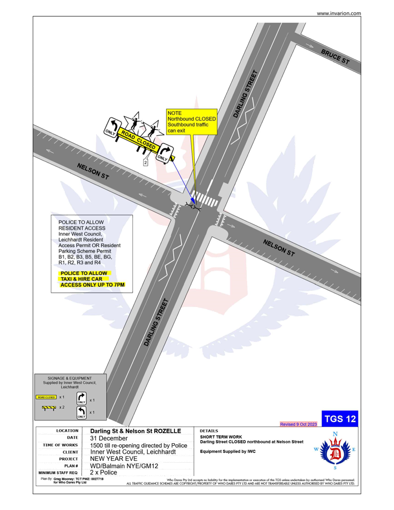
· Darling Street at Nelson Street intersection, Rozelle (northbound direction).
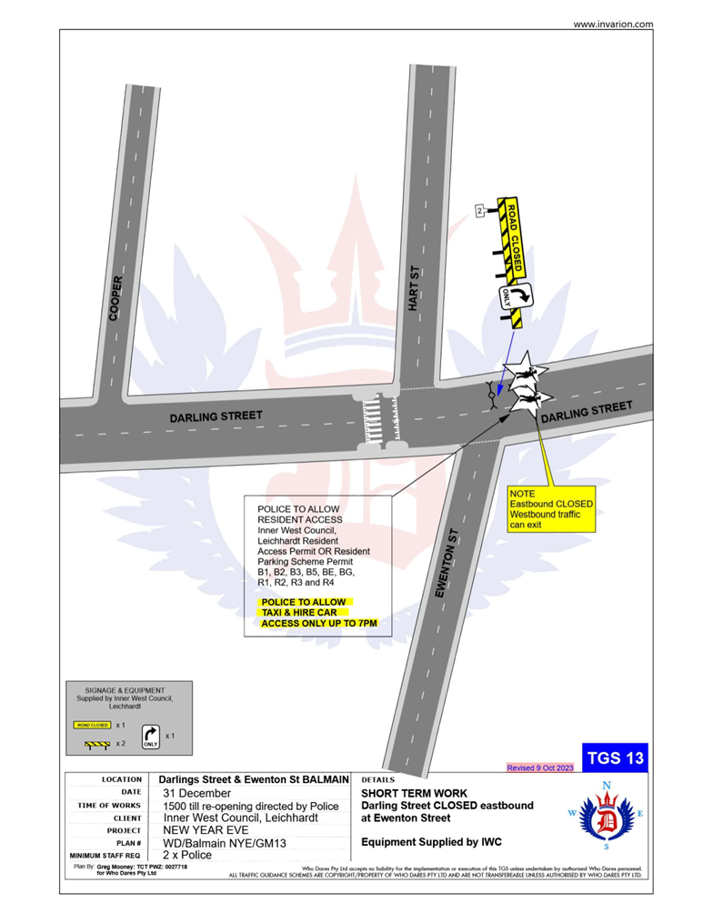
· Darling Street at Ewenton Street intersection, Balmain (eastbound direction).
· Evans Street at Merton Street intersection, Rozelle (northbound direction).
· Evans Street at Nelson Street, Rozelle (both directions).
· Mullens Street at Robert Street intersection, Rozelle (both directions).
· Ballast Point Road at Lemm Street-Yeend Street intersection, Birchgrove (south and eastbound directions).
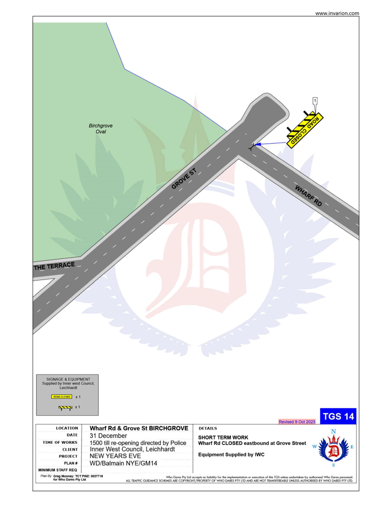
· Wharf Road at Grove Street intersection, Birchgrove (eastbound direction).
· Robert Street at Crescent Street, Rozelle (northbound direction).
· Grove Street at Rose Street, Birchgrove (eastbound direction).
The following plan indicates the road closure points:
A Traffic Management Plan including Traffic Control Plans outlining the above road closures and the bus route changes is attached in Attachment 1.
Taxi Access
As previously recommended, the NSW Taxi Council will again be requested to inform their members of the proposed taxi access restriction after 7pm to minimise traffic congestion in the peninsula and improve pedestrian safety. Taxis will therefore need to use the following drop-off point locations:
· Taxis entering Terry Street - In the unrestricted parking on the eastern side of Terry Street or ‘Bus Zone’ and timed kerbside parking along Wellington Street.
· Taxis entering Darling Street - In the ticket parking areas along Darling Street and Nelson Street.
· Taxis entering Robert Street – In the restricted parking area and ‘Bus Zone’.
Public Transport Access
Transit Systems will be scheduling additional services into the Balmain peninsula to cater for the New Year’s Eve celebrations.
As such, temporary ‘Bus Zones’ will be installed at the following locations:
· Darling Street and the existing ‘Bus Zones’ on Darling Street between Mort Street and Curtis Road, Balmain.
· Eastern side of Grove Street between Wharf Road and Bay Street, Birchgrove.
The ‘Bus Zones’ on Grove Street will be used by Transit Systems and the Police to store buses on New Year's Eve. This is required for the safe bump out of the general public from Birchgrove as identified from a debrief from a previous New Year's Eve event conducted in the Balmain Peninsular.
The signs defining the temporary restrictions be in place after 12 Noon on 31 December 2024 and will be removed the following day.
In addition, to avoid delays at the Robert Street/Mullens Street intersection (which is a Police check point), buses entering Robert Street from Victoria Road are proposed to use Crescent Street and Parsons Street to access Mullens Street (see TCP 06/07 in Attachment 1).
It should be noted that Council will install variable message signs (“Balmain Peninsula is closed”) on the main access roads into Balmain Peninsula a few days in advance of the event;
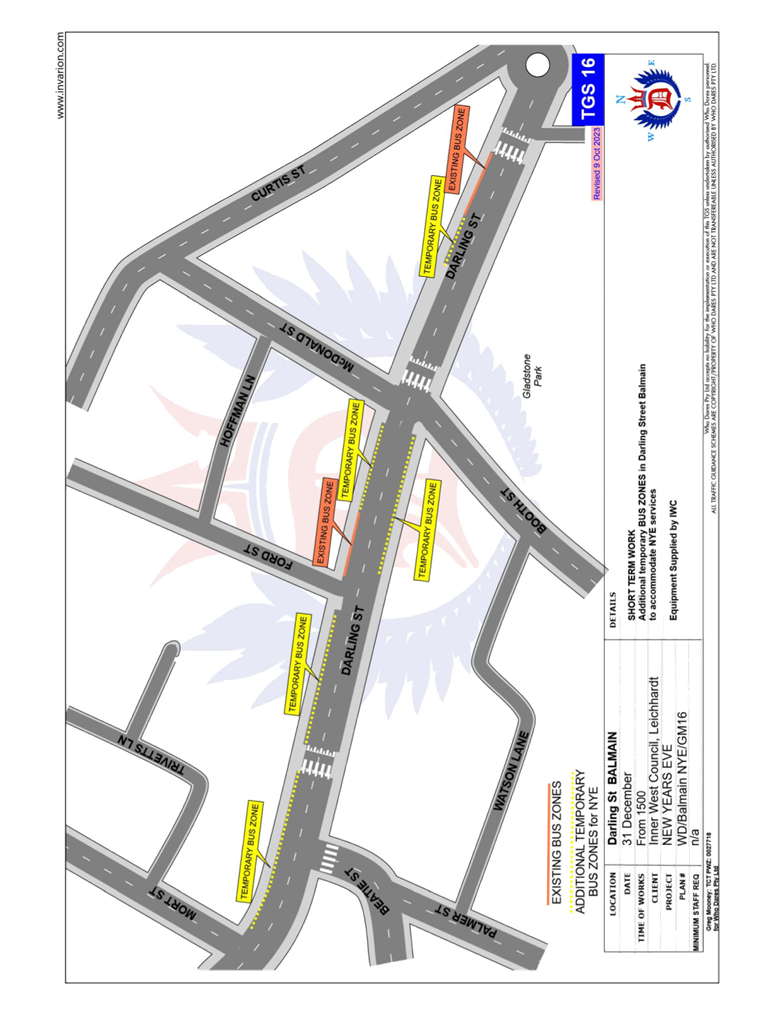
Request for a bus loop utilising Booth Street and Eaton Street
Feedback from Transit Systems and NSW Police have indicated that there has been some safety concerns at the roundabout of Darling Street and Curtis Road. Previously buses utilised the roundabout for bus turnarounds during the Balmain New Year’s Eve. Due to the large crowds egressing the peninsula, it was deemed difficult to control crowds from spilling onto the roadway and obstructing buses. Transit Systems and Transport for NSW have advised that this has affected service times and the ability to efficiently move large crowds out of the area.
To address this issue, it has been proposed to utilise Booth Street, Darvall Street and Eaton Street as a turning route back to Darling Street. An adjustment to the Traffic Guidance Scheme will temporarily prevent northbound traffic flow in Booth Street at Darvall Street to ensure that Buses can freely circulate without opposing vehicle movements in Booth Street. The route around Gladstone Park is outlined below:
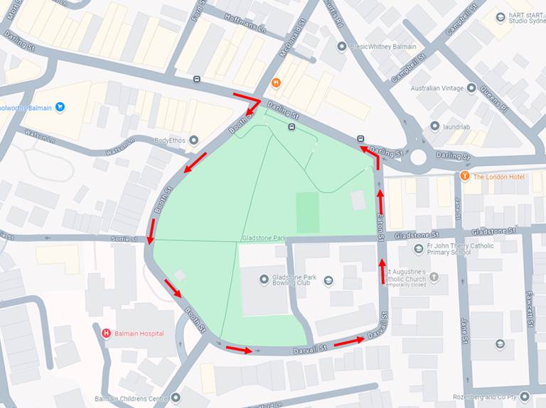
As part of this request on New Year’s Eve:
· On-street parking spaces on both sides of Eaton Street, between Darling Street Darvall Street, will be temporarily replaced Bus Zone restriction from 3pm New Year’s Eve until 3am New Year’s Day.
· Temporary on-street Bus Zones in Darling Street, between McDonald Street and Mort Street, will continue unchanged to the previous year’s arrangement.
· Traffic on Booth Street between Darling Street and Darvall Street, will be temporarily adjusted to discourage northbound movements in order to improve bus movements. This will include changes at Watson Lane and Booth Street.
· It is estimated that approximately 31 on-street parking spaces on Eaton Street will be temporarily changed to a Bus Zone.
The parking changes in Eaton Street is outlined in the diagram below:
Council has discussed this request with Transit Systems, NSW Police and Transport for NSW and identified the following for consideration:
· Community Consultation should be undertaken including Balmain Hospital and the affected businesses and residents along Booth Street/Darvall Street/Eaton Street and its side streets regarding parking removal and changes to traffic conditions.
· The crowd management strategy needs to be considered due to the potential conflicts between crowd movements at the intersections of Darling Street/Eaton Street and Darling Street/Booth Street with the new bus movements and the high volume of pedestrians. There is also a risk that the crowds may consider detouring through Gladstone Street which is a narrow residential laneway to access Gladstone Park and conflict with bus movements.
· Council has noted that the temporary Bus Zone may have enforcement issues especially considering that the event is on New Year’s Eve. This will need to be observed during the upcoming event and consider possible future refinements for future events.
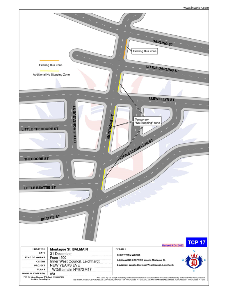
Temporary ‘No Stopping’ Restrictions
Following a previous year’s event, the Sydney Buses representative advised that several vehicles parked on Montague Street out from the kerb thus narrowing the carriageway and preventing buses from passing each other. Therefore, it is proposed to install temporary ‘No Stopping’ zone on the eastern side of Montague Street between Darling Street and Beattie Street. The residents will be advised of this arrangement in advance of the event.
Resident Access
To ensure resident access is maintained, the following permits will be accepted for access to the Balmain / Rozelle peninsula:
· Inner West Council Resident Access Permit.
· Inner West Council current Resident Parking Scheme Permit for Areas; B1, B2, B3, B5, BE, BG, R1, R2, R3 & R4.
· Australian Mobility Parking Scheme permit
NOTIFICATION
The proposed road closures are currently being advertised on Council’s website in accordance with the Roads Act 1993 for a period of 28 days from 29 August 2024 to 26 September 2024. No comments have been received to date.
In December, the details of these traffic arrangements will be re-advertised on Council’s website and via a mail out to all occupants in the Balmain peninsula.
The road closures and other event information will also be available on the Sydney New Year’s Eve Event website.
FINANCIAL IMPLICATIONS
Funding for costs associated with New Year’s Eve including labour, notifications and permits have been budgeted for in the 2024-25 operational plan.
|
1.⇩ |
New Year's Eve Fireworks. Balmain Peninsular Traffic Management 2024 |
|
Local Traffic Committee Meeting 21 October 2024 |
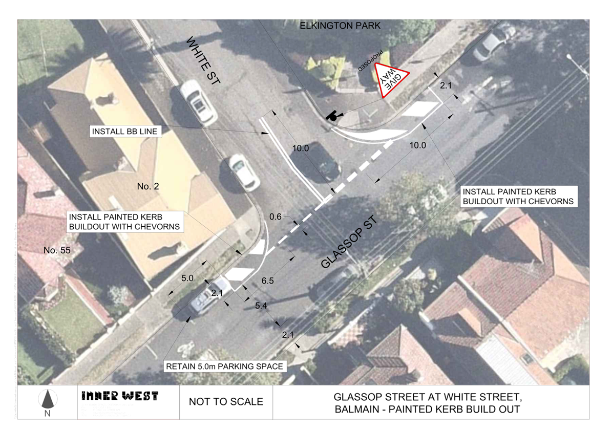
Subject: Intersection of Glassop Street and White Street, Balmain - Proposed Treatment of Intersection for Improved Sight Lines (Baludarri-Balmain Ward/Balmain Electorate/Leichhardt PAC)
Prepared By: Zara Helal - Traffic Engineer
Authorised By: Manod Wickramasinghe - Traffic and Transport Planning Manager
|
RECOMMENDATION
That the following treatment at the intersection of Glassop Street and White Street, Balmain be approved as follows:
a) Linemark chevron islands on Glassop Street at the intersection of Glassop Street and White Street; b) Install a ‘Give Way’ (R1-2A) sign and supporting give way lines (TB & TB1) across White Street at Glassop Street; and c) Install 10m length double barrier lines (BB) in White Street commencing from Glassop Street.
|
STRATEGIC OBJECTIVE
This report supports the following strategic directions contained within Council’s Community Strategic Plan:
|
2: Liveable, connected neighbourhoods and transport |
|
|
EXECUTIVE SUMMARY
Council has received concerns from the community regarding insufficient visibility at the intersection of Glassop Street and White Street, Balmain.
This location formed part of the Rozelle North precinct where a Local Area Traffic Management (LATM) study was undertaken in 2022. The study recommended the installation of kerb extensions at the location at a medium priority, which was adopted by Council at the meeting held on 13 September 2022. As this project was not an immediate priority under the Council’s Capital Works Program, an interim treatment has been proposed to address the safety issue.
The proposal sees the installation of painted kerb buildouts at the corners of Glassop Street at its intersection with White Street, and the introduction of ‘Give Way’ control for the White Street leg. The proposal aims to improve visibility at this intersection by bringing the give way line forward toward the Glassop Street travel lanes.
BACKGROUND
During the initial community engagement undertaken as part of the Rozelle North LATM study, residents raised concerns regarding sight line obstructions at the intersection of Glassop Street and White Street. The intersection currently does not have any signposted ‘No Stopping’ restrictions or priority control.
The Rozelle North LATM study proposed the construction of physical kerb extensions at the corners of Glassop Street at its intersection with White Street, and the introduction of ‘Give Way’ restrictions at White Street at its intersection with Glassop Street. This was supported by the community during the Public Exhibition of the report. Further concerns from the community have been received since the adoption of the LATM regarding safety at this intersection.
The interim proposal of painted kerb buildouts in place of the kerb extensions and introduction of ‘Give Way’ priority will improve visibility and safety at this intersection by ensuring that adequate visibility is maintained and vehicles give way when entering Glassop Street from White Street.
DISCUSSION
A concept plan for the proposed painted kerb build outs is provided in Attachment 1 and features the following treatment:
· Linemark chevron islands at the intersection of Glassop Street and White Street,
· Install ‘Give Way’ (R1-2A) sign, give way lines (TB & TB1) across White Street at Glassop Street;
· Install 10m length double barrier lines (BB) in White Street commencing from Glassop Street;
The original concept design as recommended in the Rozelle North LATM is shown below.
FINANCIAL IMPLICATIONS
The proposed works at the intersection of Glassop Street and White Street will funded under the Council’s general signs and line marking budget.
|
|
|
|
Local Traffic Committee Meeting 21 October 2024 |
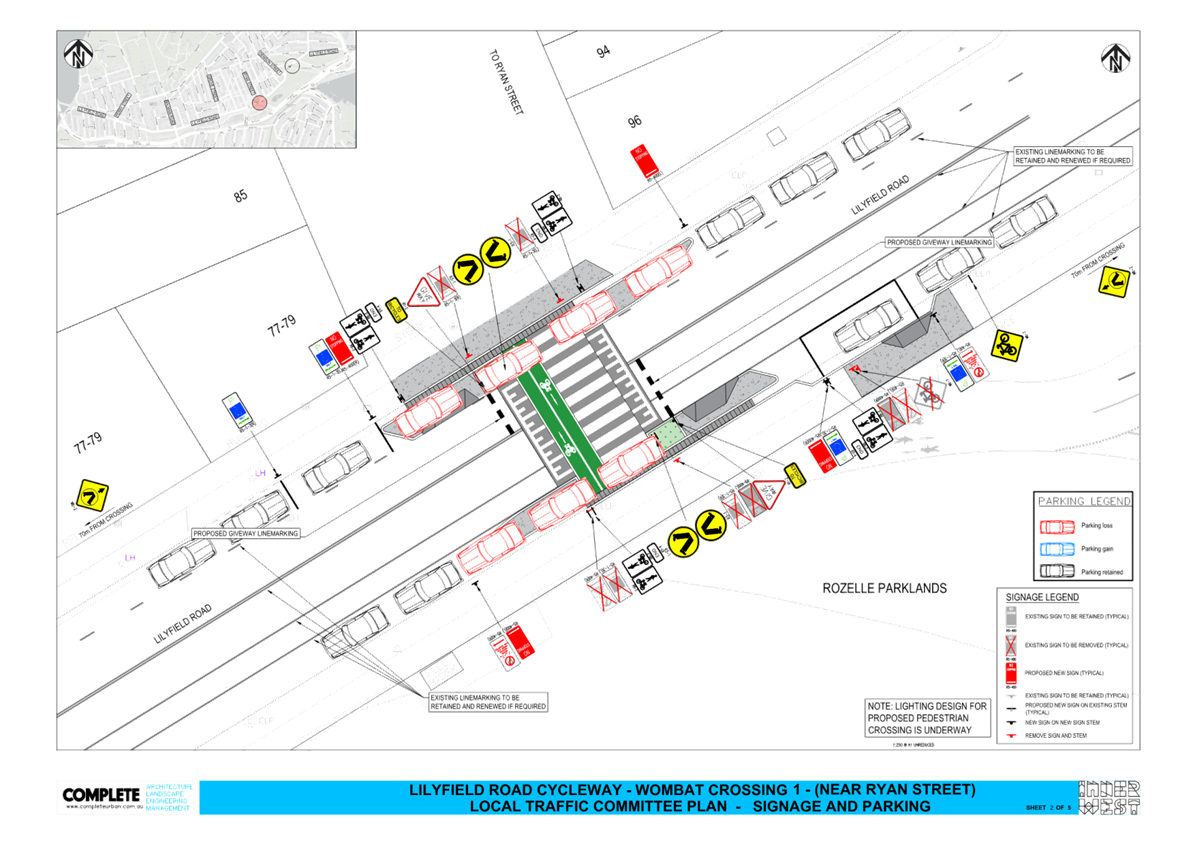
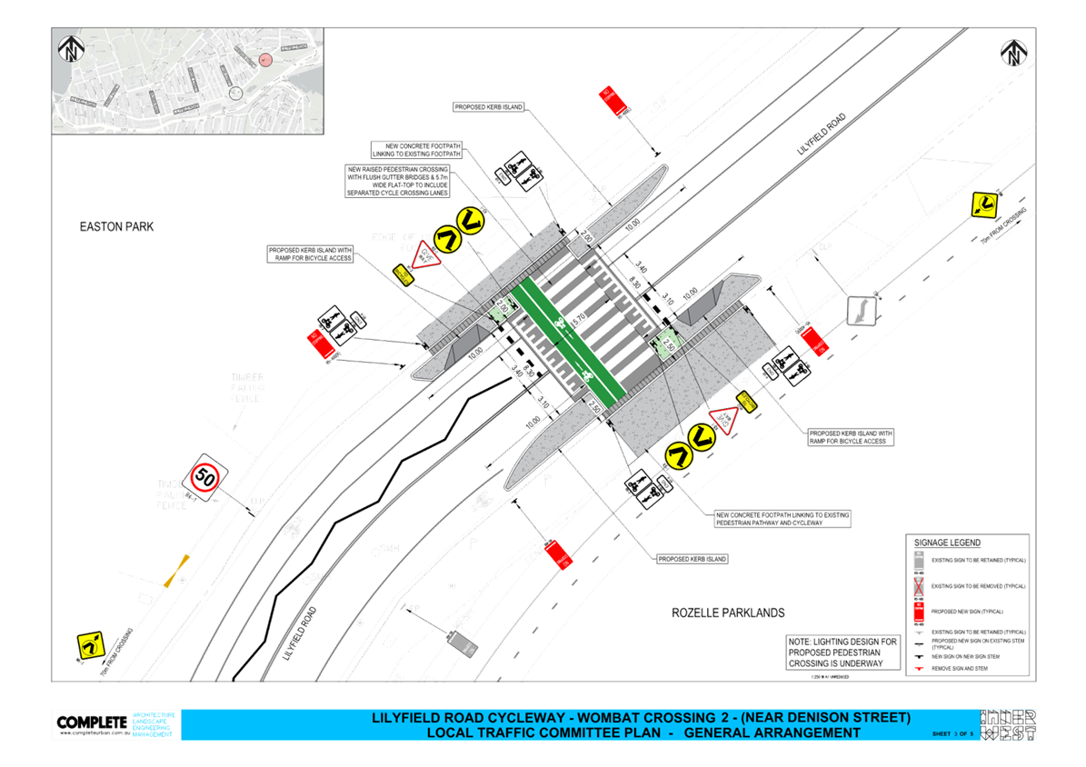
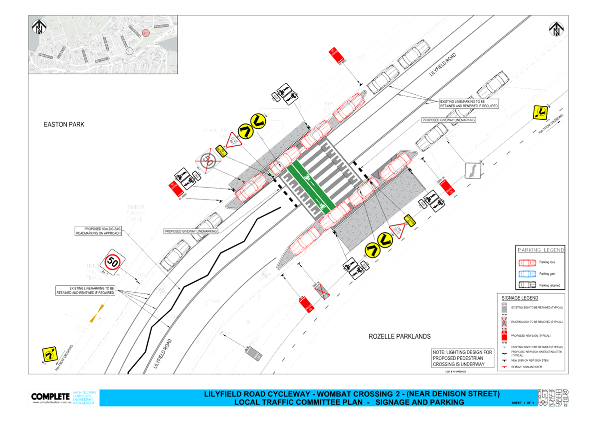
Subject: Lilyfield Road, Lilyfield - Proposed Raised Pedestrian and Bicycle Crossings (Baludarri-Balmain Ward/Balmain Electorate/Leichhardt PAC)
Prepared By: Charbel El Kazzi - Traffic Engineer
Authorised By: Manod Wickramasinghe - Traffic and Transport Planning Manager
|
RECOMMENDATION
That the attached detailed design plan (Attachment 1) for the proposed Raised Pedestrian and Bicycle crossings on Lilyfield Road at Ryan Street and Lilyfield Road approximately 80m east of Denison Street, Lilyfield be approved.
|
STRATEGIC OBJECTIVE
This report supports the following strategic directions contained within Council’s Community Strategic Plan:
|
2: Liveable, connected neighbourhoods and transport |
|
|
EXECUTIVE SUMMARY
Detailed design plans for the two Raised Pedestrian and Bicycle crossings along Lilyfield Road has been prepared to improve pedestrians and bicycles connectivity to and from the Rozelle Parklands. There is ongoing work undertaken by Council to finalise the Plan of Management and revising the Masterplan for Rozelle Parklands and Eastern Park, which amongst many elements, includes pedestrian accessibility and safety in the vicinity at these parks. With the recognized need from the community to improve road safety, Council has expediated the design and development of two key crossing facilities in advance of the finalization of the Masterplan and the Lilyfield Road Cycleway design. The proposed two facilities will address key concerns from the community and Bicycle User Groups regarding the need to provide a safe interface point from Lilyfield Road into Rozelle Parklands and vice versa.
BACKGROUND
With the completion of the Rozelle Parklands in late 2023, Council has resolved to expediate the design and development of the key pedestrian and bicycle crossing locations to improve pedestrian and bicycle safety in Lilyfield Road. A Masterplan for the Rozelle Parklands is in development and is expected to include elements such as pedestrian and bicycle safety and connectivity. The Masterplan will also consider how the Parklands can be improved over time in addition to consideration for improvement of active transport links around the Parklands.
Two crossing points have been identified along Lilyfield Road as a safety concern from the community and bicycle user groups. These are the two locations:
· Lilyfield Road at Ryan Street, where the current pedestrian and bicycle shared paths terminate at the western end of the parkland.
· Lilyfield Road approximately 80m east of Denison Street, which connects existing paths from Easton Park directly to the Rozelle Parklands.
The traffic and roadway features of Lilyfield Road at Ryan Street and East of Denison Street is tabled below:
|
Street Name |
Lilyfield Road |
|
Kerb to Kerb Width (m) |
Ranges between 13.0 and 13.3m |
|
Carriageway Type |
Two-way, one travel lane each direction. Combination of bicycle shoulder lane and bicycle logo mixed traffic arrangement. |
|
Classification |
Regional |
|
Speed Limit |
50km/h |
|
85th Percentile Speed |
43.1km/h |
|
Average Traffic Volume |
6,000veh/day |
|
Available TfNSW recorded crash history last 5 years (2018-2023) |
No reported crashes on Lilyfield Road between Ryan Street and Gordon Street |
|
Parking Arrangements |
Parking permitted on both sides |
DISCUSSION
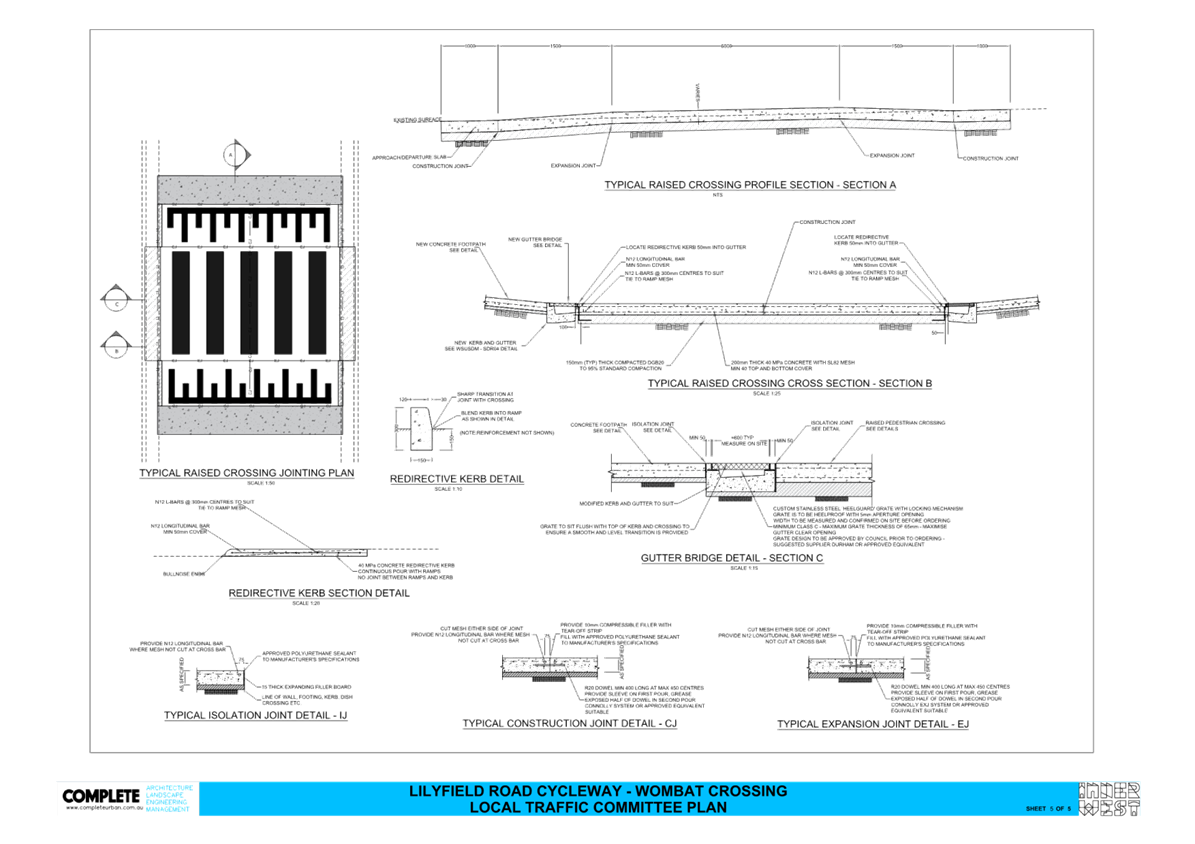
The design plans shown in Attachment 1 outline the proposed works on Lilyfield Road at the two locations which includes the following:
· Raised pedestrian and bicycle crossing thresholds with new flush gutter bridge and 5.7m wide flat top to include separated bicycle crossing lanes;
· Kerb islands in the road adjacent to the new raised crossing as detailed within the attached plans;
· New concrete footpath linking crossings to existing footpaths as detailed in the attached plans;
· New kerb ramps to link on-road bicycle riders to access the crossings;
· Short lengths of Bicycle/Pedestrian Shared Paths on each side of the crossings, as indicated on the plans;
· Inclusion of a permanent mobility parking space adjacent to the parklands near Ryan Street;
· Associated signage and line marking as detailed in the attached plans.
The proposal will result in the loss of 7 on-street parking spaces for the crossing at Ryan Street, and 8 spaces for the crossing east of Denison Street. These spaces are not located directly in front of residential properties and as part of the Rozelle Parklands Masterplan, there are consideration to introduce angle parking in some sections of Lilyfield Road as the primary bicycle route will be through the Rozelle Parklands. This could potentially offset the loss of parking from the construction of the two crossings.
FINANCIAL IMPLICATIONS
The works are expected to cost approximately $192,000 ex. GST and are to be funded under Council’s Capital Works Program with final costing to be finalised following completion of detailed design.
|
1.⇩ |
Lilyfield Road Pedestrian and Bicycle Crossing - Detailed Design Plan |
|
Local Traffic Committee Meeting 21 October 2024 |
Subject: Moyes Street, Marrickville - Proposed 'No Stopping' relocation (Marrickville-Midjuburi/Summer Hill Electorate/Inner West PAC)
Prepared By: James Nguyen - Traffic Engineer
Authorised By: Manod Wickramasinghe - Traffic and Transport Planning Manager
|
RECOMMENDATION
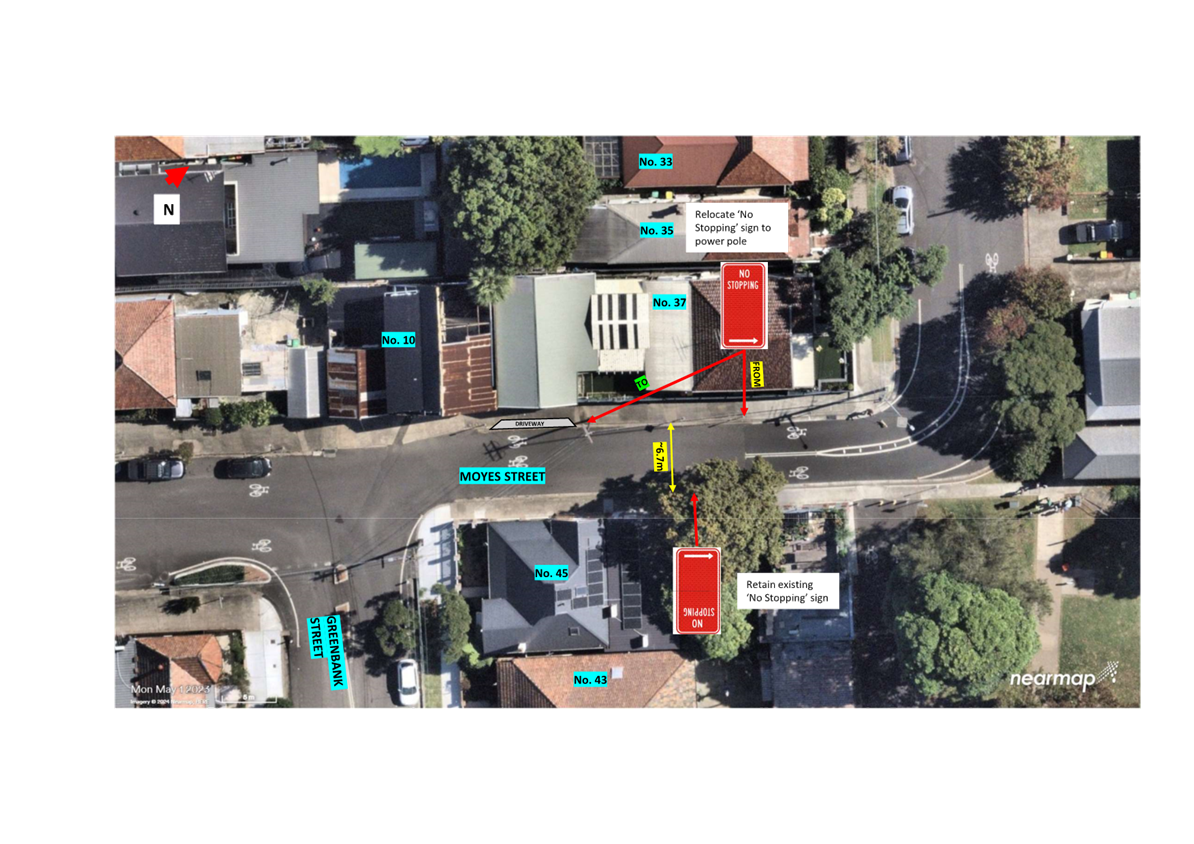
That the existing ‘No Stopping’ restriction on the western side of Moyes Street, Marrickville (located approximately 17m from the bend) between Greenbank and Jersey Streets, be extended a further 13.5m (to the power pole adjacent to the driveway for 37 Moyes Street) to improve road safety in the vicinity of the bend.
|
STRATEGIC OBJECTIVE
This report supports the following strategic directions contained within Council’s Community Strategic Plan:
|
2: Liveable, connected neighbourhoods and transport |
|
|
EXECUTIVE SUMMARY
This report outlines current parking and road safety issues on Moyes Street, Marrickville between Greenbank and Jersey Streets. It outlines key findings from an assessment carried out and proposes parking changes to improve safety.
BACKGROUND
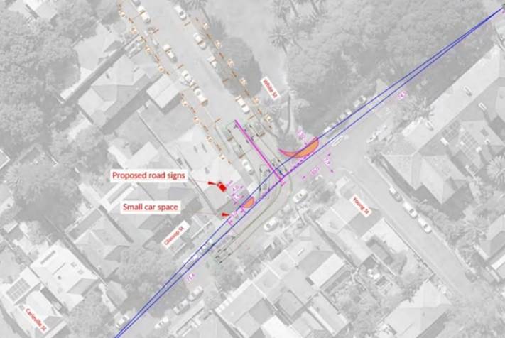
Council has received a request to relocate the existing ‘No Stopping’ restriction on the western side of Moyes Street, Marrickville between Jersey and Greenbank Streets due to safety concerns with allowing parking on the eastern side of Moyes Street, as it forces a northbound motorist to cross the opposing travel lane (southbound) just before the bend ahead. The concern is shown in Figure 1 below:
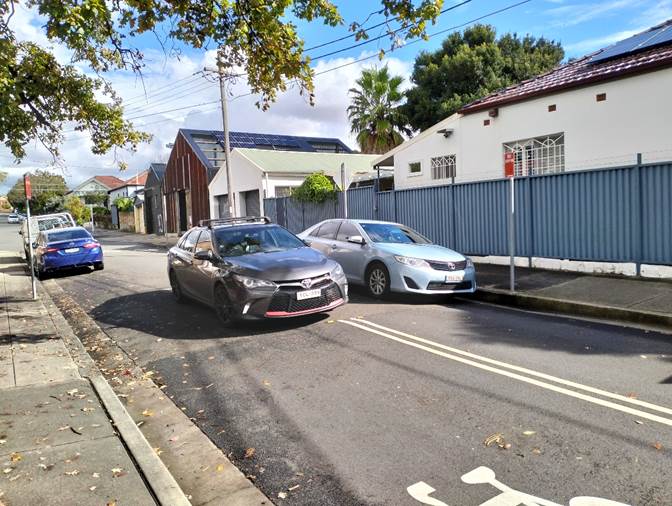
Figure 1 - Moyes Street, Marrickville (facing west)
![]()
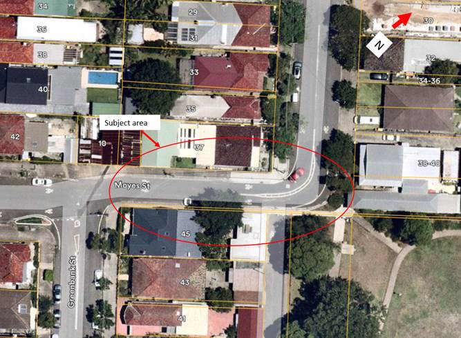
Figure 2 - Locality plan
DISCUSSION
Moyes Street, Marrickville is approximately 6.7m wide between Greenbank Street and Jersey Street is with unrestricted parking on both sides. There are no recorded accidents within the last five (5) years at the bend in Moyes Street near Jersey Streets. As shown in Figure 1, the ‘No Stopping’ (right) restriction is installed up to the existing centre line before the bend. This leaves the kerb space south of this sign free for parking. The current restrictions allow for the parking configuration as shown in Figure 3 below:
![]()
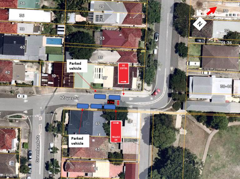
Figure 3 - Current permitted parking configuration
The current location of ‘No Stopping’ signs create the following issues:
· Forces a northbound vehicle travelling along Moyes Street to cross the centre line in
· to the southbound lane, as shown in Figure 1.
· Reduces the travel lane width to 2.7 metres, less than the desired 3.0-metre-wide lane width, and less than the width of a 2.8 metre width of a light vehicle.
· Reduces the sight distance of a pedestrian crossing Moyes Street at the existing kerb ramp on Moyes Street at the bend from the western side to McNeilly Park.
Accordingly, it is proposed to relocate the existing ‘No Stopping’ (right) sign on the western side of Moyes Street, further south along the kerb line. This is shown in Figure 4 below:
![]()
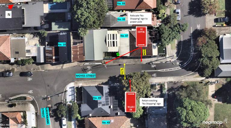
Figure 4 - Proposed parking changes
This proposal will remove two (2) unrestricted parking spaces from the western side of Moyes Street. There are no changes proposed to the eastern side and three (3) parking spaces are retained.
This proposal will provide a 4.7-metre-wide passageway for two opposing road users to pass, and cyclists can occupy the road space closer to the kerb line. Whilst this is less than six (6) metres (3-metre-wide lane in each direction), the narrow road width will encourage lower vehicle speeds.
PUBLIC CONSULTATION
Council consulted with nearby affected residents. There were 30 letters sent with two (2) responses received supporting, one (1) response opposing and one (1) response neutral to the proposal.
The responses are noted in Table 1 below:
|
Support/object |
Resident response |
Officer response |
|
Support |
Vehicles parking on both sides of Moyes Street reduces the travel lane width and vehicle access – it is hard for larger vehicles to pass in some instances.
Vehicles sometimes park on the eastern side of Moyes Street occurs infrequently, when there is no other parking options nearby. |
Noted. |
|
|
We have recently moved into Jersey Street and we were commenting about how unsafe the placement of the ‘No Stopping’ sign is, in terms of visibility when a car is parked right up to it. We would fully support the relocation of No Stopping sign to approx. 14m south as proposed |
Noted. |
|
Object |
The reason for the change cited notes safety concerns, however there has never been an incident at the location when a car is parked on the western side of the street. The car acts as a traffic calming device which is needed in this section of the street.
Moyes street is a major access point to McNeally park and is used by many pedestrians, cyclists and children. It is a continuation of the cycleway through the park and a major point of conflict with the traffic that travels at high speed through this intersection. This is in our opinion a major risk for a potential incident causing injury or death. The removal of this parking space will exacerbate this problem.
We have repeatedly requested that traffic calming be implemented to ameliorate this problem and the lack of action exposes the Council to liability in the event of an incident.
An additional issue is that the parking in the general area, which is unrestricted, is increasingly taken up by commuters using Marrickville station. Resident permit parking will be required when the Station is converted to a Metro.
|
The proposal to relocate the ‘No Stopping’ sign on the western side of Moyes Street seeks to further improve safety and reduce the risk of a potential accident(s), as currently, motorists are forced to cross to the wrong side of the road at the bend.
In addition, this proposal will also improve sight lines for pedestrians crossing Moyes Street to McNeilly Park at the bend.
Council is proposing to introduce a 40 km/h speed limit on all local streets in Marrickville which includes Moyes and Jersey Streets. In combination, these treatments will improve safety for motorists, pedestrians and cyclists on Moyes and Jersey Streets.
Council can investigate a resident parking scheme on Moyes Street and Greenbank Street upon receipt of a minimum 10 requests from affected households. |
|
This point should be closed to traffic to alleviate this risk, and not made worse by removing car spaces and resulting higher speeds. The road closure has been discussed in Council at a number of times, this action should be reconsidered because there is a serious risk of injury or fatality at this point, although it is very unlikely to be someone in a vehicle.
|
Given the good safety record at the subject location, and given that traffic volumes are likely to be within acceptable limits for a local road, a road closure at this location is not considered necessary. The current combination of centre rumble strips, line marking, and parking on the western side of Moyes Street provides adequate traffic calming. |
FINANCIAL IMPLICATIONS
The of installation of the parking restrictions as recommended will be funded within Council’s operational signs and line marking budget.
|
1.⇩ |
Proposed parking change |
|
|
Local Traffic Committee Meeting 21 October 2024 |
Subject: Pilgrim Avenue, Marrickville - Proposed ‘No Parking’ restrictions on the inner bend to improve access (Midjuburi - Marrickville Ward / Summer Hill Electorate / Inner West PAC)
Prepared By: Jennifer Adams - Traffic Engineer
Authorised By: Manod Wickramasinghe - Traffic and Transport Planning Manager
|
RECOMMENDATION
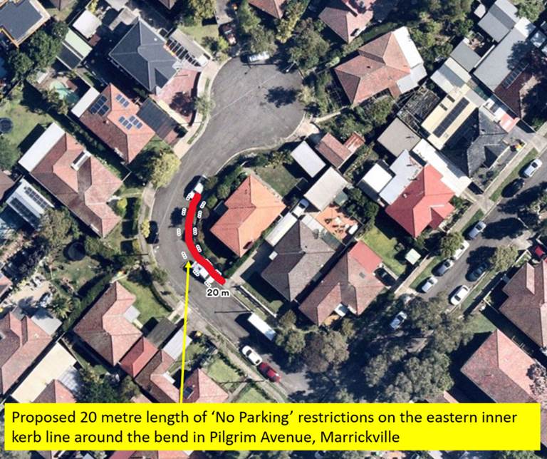
That a 20-metre length ‘No Parking’ zone be installed on the inner bend in Pilgrim Avenue, Marrickville (eastern side starting from the boundary of No’s 2 and 3 Pilgrim Avenue and extending 20m north around the bend) in order to improve access in the street.
|
STRATEGIC OBJECTIVE
This report supports the following strategic directions contained within Council’s Community Strategic Plan:
|
2: Liveable, connected neighbourhoods and transport |
|
|
EXECUTIVE SUMMARY
Currently large vehicles, including Council Waste Services vehicles, are having difficulty in manoeuvring around the bend in Pilgrim Avenue, Marrickville due to vehicles being parked near the bend therefore Council is proposing to install a 20-metre length of ‘No Parking’ restrictions on the inner side of the bend in Pilgrim Avenue, Marrickville to improve access in the street.
DISCUSSION
It has been reported to Council that vehicles, at times, are having difficulty in manoeuvring around the bend in Pilgrim Avenue, Marrickville due to vehicles being parked near and/or on the bend. Pilgrim Avenue is a local street with two-way traffic and is approximately 7.3 metres in width with unrestricted parking permitted on both sides.
A consultation letter was sent out to adjoining properties informing them that Council is proposing to install a 20 metre length of ‘No Parking’ restriction on the inner side of the bend (eastern side of roadway) in Pilgrim Avenue, Marrickville to improve access in the street (refer to the plan below).
FINANCIAL IMPLICATIONS
The of installation of the parking restrictions as recommended will be funded within Council’s operational signs and line marking budget.
PUBLIC CONSULTATION
Eleven (11) letters were sent to owners / occupiers of properties in Pilgrim Avenue, Marrickville. Three (3) responses were received with all three (3) supporting the proposal. The general agreement was that motorists have difficulty negotiating the bend in the road when other vehicles are parked near or on the bend. One resident was concerned that cars in future may be parked too close to their driveway and they separately were given details of how to install driveway lines should they wish to do so. It is recommended that the ‘No Parking’ restrictions as proposed be approved and installed.
Nil.
|
|
Local Traffic Committee Meeting 21 October 2024 |
Subject: Church Street, Ashfield, between Knocklayde Street and Alt Street-Proposed Raised Thresholds & Kerb Blister Islands (Traffic Calming)(Gulgadya-Leichhardt Ward/Summer Hill Electorate/Burwood PAC).
Prepared By: Boris Muha - Traffic Engineer
Authorised By: Manod Wickramasinghe - Traffic and Transport Planning Manager
|
RECOMMENDATION
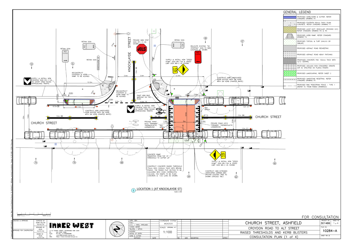
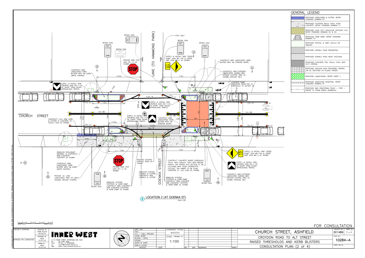
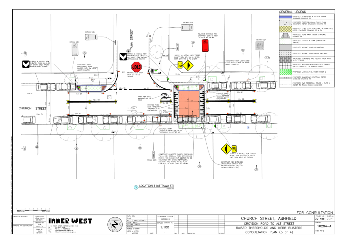
That the amended detailed design plans (10284-A) sheets 1-4 to propose raised concrete thresholds and kerb blister islands with associated line and marking in Church Street, Ashfield, between Knocklayde Street and Alt Street, as shown in Attachment 1 be approved.
|
STRATEGIC OBJECTIVE
This report supports the following strategic directions contained within Council’s Community Strategic Plan:
|
2: Liveable, connected neighbourhoods and transport |
|
|
EXECUTIVE SUMMARY
Council is planning to provide traffic calming measures to improve safety in Church Street, Ashfield by constructing new raised thresholds & landscaped kerb blisters along Church Street near Knocklayde St, Goenka St, Tawa St & Taringa Lane. The traffic calming proposal aims to slow traffic & improve road safety in this part of Church Street and helps address concerns relating to pedestrian safety and driver behaviour.
BACKGROUND
The proposed treatments form a corridor for traffic calming along Church Street, between Croydon Road and Alt Street, Ashfield, as captured under the Ashfield Traffic Management Strategy 2017. There have also been continuing concerns raised by the community to reduce speeding in the street.
DISCUSSION
The following information is provided in the discussion.
![]()
![]()
![]()
![]()
![]()
![]()
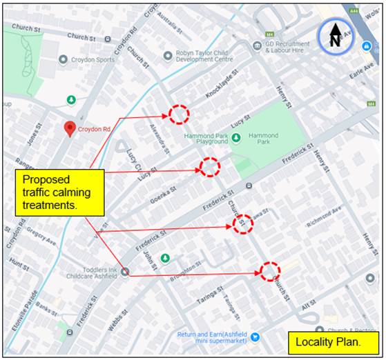
Figure 1. Locality Plan
|
Street Name
|
Church Street (Between Knocklayde Street to Alt Street) |
|
Carriageway width (m) kerb to kerb |
Approx. 10m |
|
Carraigeway type |
Two-way, one travel lane each direction. |
|
Classification |
Local |
|
Speed Limit km/h |
50 |
|
85th percentile speed km/h |
43.7- 48.9 |
|
Vehicles per day (vpd) |
2650-3690 |
|
|
6 recorded accidents as far back to 2017 in Church Street between Knocklayde Street to Alt Street. (4) of the recorded accidents were at Lucy Street from 2017-2018. (1) X2017, Rum 16, at Lucy Street, left near-moderate injury. (1) X 2018, Rum 20, at Lucy Street, head on-minor /other injury. (1) X 2018, Rum 10, at Lucy Street, cross traffic, minor/other injury. (1) X 2018, Rum 12, at Lucy Street, left far, moderate injury. **Lucy Street has since been treated with kerb extension build outs in Church Street for traffic calming, and also assisting in bringing out the STOP into Church Street for improved sight view. (1) X 2018, Rum 19, at Alt Street, vehicles from adjacent directions, tow-away(non-casualty). (1) X 2021, Rum 1, at No 19 Church Street, Pedestrian near side, moderate injury. |
|
Parking arrangements |
Unrestricted parking to both sides of the street. ‘No Stopping’ to corners of all intersections. |
|
Side street(nearest) |
Knocklayde Street, Goenka Street, Tawa Street, Taringa Street |
Table 1. Road Network detail
The Plan
The following works proposed is illustrated on the attached plans that were issued out under consultation as shown below (figures 2-5).
Church Street, Ashfield (from Knocklayde Street to Alt Street) - 4 Locations (Plan 10284):
· Near Knocklayde St
o Construct 1 new raised concrete threshold with 1 ‘full length’ integrated landscaped kerb blister island;
o Construct 1 new ‘stand-alone’ landscaped kerb blister island;
o Construct 1 new landscaped garden bed around an existing street tree within the footpath adjacent to the new raised threshold; and
o Adjust 1 existing ‘No Stopping’ sign in Church St by approx. 4m to accommodate the new raised threshold.
· Near Goenka St
o Construct 1 new raised concrete threshold with 2 ‘half length’ integrated landscaped kerb blister islands;
o Construct 2 new stand-alone landscaped kerb blister islands;
o Construct 2 new landscaped garden beds around existing street trees within the footpath adjacent to the new raised threshold (both sides); and
o Adjust 1 existing ‘No Stopping’ sign in Church St by approx. 5m to accommodate the new landscaped kerb blister island.
· Near Tawa St
o Construct 1 new raised concrete threshold with 1 integrated landscaped kerb blister islands;
o Construct 2 new ‘stand-alone’ landscaped kerb blister islands;
o Construct 1 new landscaped garden bed around an existing street tree within the footpath adjacent to the new raised threshold; and
o Adjust 1 existing ‘No Stopping’ sign in Church St by approx. 4m to accommodate the new landscaped kerb blister island
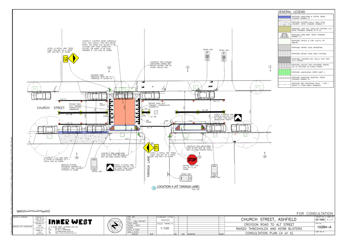
· Near Taringa Lane
o Construct 1 new raised concrete threshold with 1 integrated landscaped kerb blister islands;
o Construct 1 new ‘stand-alone’ landscaped kerb blister island;
o Construct 1 new landscaped garden bed around an existing street tree within the footpath adjacent to the new raised threshold;
o Remove 1 redundant driveway and replace with new concrete kerb & gutter and footpath
o Installation of edge line marking as well as new BB line marking; and
o Install signage associated with the works as required and as shown on the plans.
· Generally
o Install new edge line marking, new BB line marking; new ‘Give-way’ line marking; and
o Install signage associated with the works as required and as shown on the plans.
Parking Changes
There are some minor adjustments proposed to the existing ‘No Stopping’ signs & zones in Church Street to facilitate implementation of the proposal. However, these changes will result in no change to existing on-street parking arrangements in the Street. Please refer to the attached plans.
Streetlighting
The existing lighting is deemed adequate and therefore there will be no changes to the existing street lighting due to the proposed works.
Other Information and proposed amendments to drawings following consultation.
The locations of the devices have been strategically placed at corners to intersections to utilise the ‘No Stopping’ zones to avoid the removal of parking. Vehicles can park over the sides of the raised threshold devices where no kerb blister islands are proposed.
The proposed kerb blister on the south-western corner side of Church Street and Goenka Street will be reduced back in length to the current ‘No Stopping’ distance to maintain or provide for 1-2 parking spaces, at the request of the resident, rather than providing one space between the lengthen kerb blister and the driveway to No 50, as initially proposed.
The deteriorated or damage kerb and footpath to the Goenka Street corners will be re-constructed and that a road surface correction will be carried out to eliminate or reduce the scraping effect of a DIP at the southern intersection of Church Street and Goenka Street.
All give way lines that are bought out close to traffic at the intersections are converted to ‘STOP line’ control.
The initial consultation plans are shown below. The amendment plans showing the above changes are shown in Annexure 1.
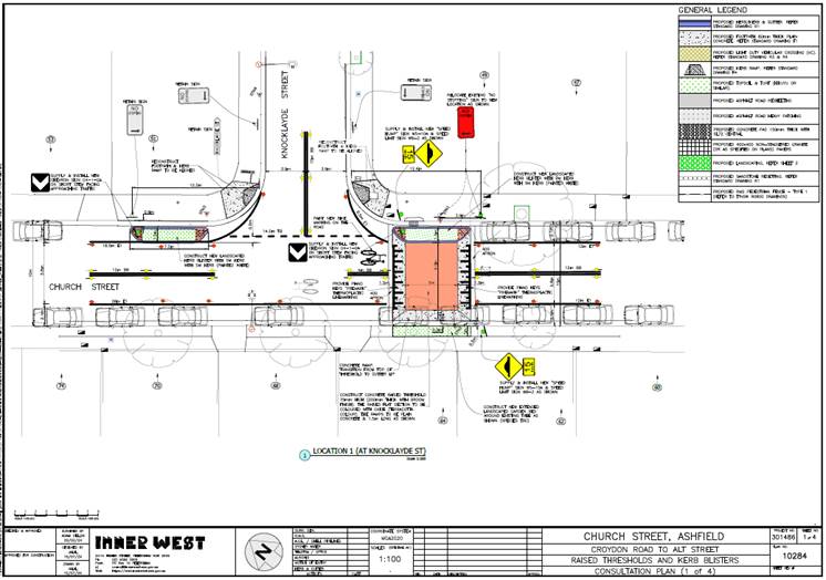
Figure 2. initial consultation plan 10284 (plan 1of 4)
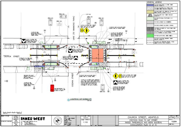
Figure 3. Initial consultation plan 10284 (plan 2 of 4)
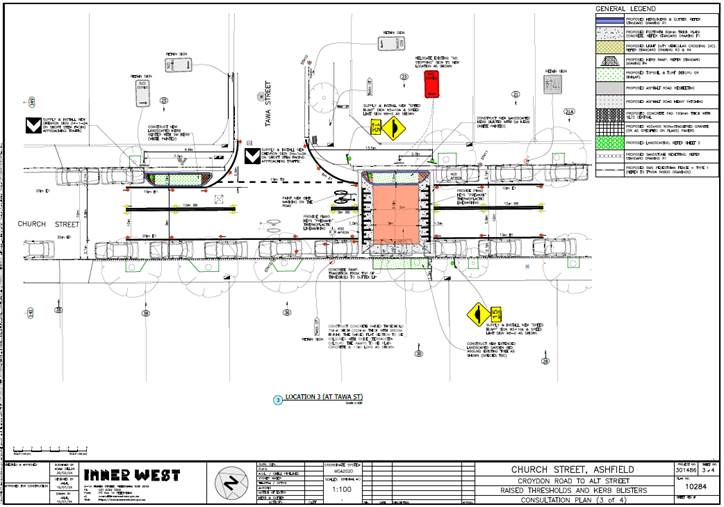
Figure 4. Initial consultation plan 10284 (plan 3 of 4)
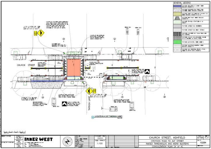
Figure 5. Initial consultation plan 10284 (plan 4 of 4)
FINANCIAL IMPLICATIONS
CONSULTATION
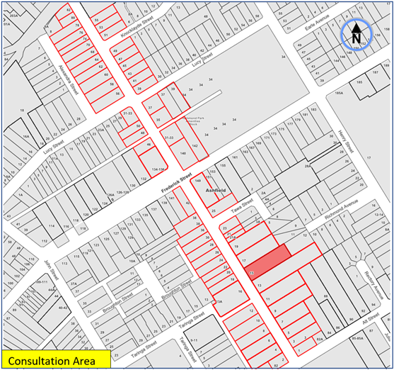
Figure 6. Map on Consultation Area
(6) Resident response was received with (4) expressing support with/without concerns or suggestions, and (2) expressing concerns.
The concerns raised by the resident are outlined below in the table.
|
Residents Comments |
Officers Response |
|
· Request more signage in front of Robyn Taylor Childcare Centre. (65 Church Street).
· Would support a pedestrian crossing at one of the raised speed humps proposed to allow children to cross the road more safely.
· Like to see the island on Croydon Road at the top of Church Street converted to a raised pedestrian crossing.
|
· This is outside the Scope of works. ‘Children’ warning signs will be considered in Church Street at the approaches to the childcare centre, under separate investigation. · Pedestrian crossings have not been identified under the Ashfield Traffic Management Strategy (ATMS) nor Council’s Pedestrian Access Mobility Plan (PAMP) along Church Street. Pedestrians are generally observed to freely cross in varied locations along Church Street. It is considered in this case that the proposed traffic calming will reduce the speeds in the area to assist pedestrians in crossing the road.
· The request to convert the island (existing pedestrian refuge) to a pedestrian crossing in Croydon Road at Church Street is outside the Scope of Works. However, the matter will be listed for consideration under a Local Area Traffic Management (LATM) investigation for Ashfield North.
|
|
· Request to reduce length of the proposed kerb blister (outside 48 Church St).
· Request to extend scope of footpath reconstruction, and repair to damaged gutter at the intersection of Goenka Street with Church Street.
|
· The proposal has been amended by reducing the length of the kerb blister island at this location. The existing ‘No Stopping’ sign will be retained at its existing location.
· The plans will be amended to include new concrete footpath on both sides of Goenka Street. |
|
· Ensure provision of drainage between garden and the kerb outside No.23.
· Request to line mark parking spaces outside No. 21
· Concern regarding noise due to new speed humps. I hope that this large hump will assist in negating the noise of cars speeding up the street. In a reckless manner. |
· Council has ensured at least 0.6m gap is provided between the kerb and the back of the new kerb blister islands which will provide sufficient space for stormwater to pass during rain events.
· Council is currently not looking to line-mark parking bays in residential streets. Bay markings do not always provide an increase in parking capacity. If the parking bays are to be line marked, the standard parking bay length needs to be used. However, it is often feasible to accommodate a greater number of small and medium size vehicles without the need of parking spaces being line marked.
· The device is so designed with intent to minimise noise, and control traffic behaviour in the street. |
|
· The Traffic doesn’t need to be calmed in Church St as you cannot go faster than 40kms.
· The problem isn’t with speed on Church St the main problem is speed on Alt Street in both directions. Concern is also raised with the visibility from Ilford Avenue, Henry Street Rectory Ave, Church Street, John Street and Albert Parade. The cars travel at such great speeds there are always screeching of breaks.
· The other problem with doing these raised thresholds and curb blisters is that there are many parking spaces being removed to accommodate them. There is limited parking in Church St as it is and to remove these will cause problems.
|
· The last recorded traffic counts in Church Street registered speeds in the high 40’s. Church Street has been identified under the (ATMS) and /or community concerns to traffic calm the street and further reduce the speeds. This will compliment with any proposed future reduction of the speed limit.
· Alt Street has also been recognised under the ATMS to traffic calm the street. This will be investigated separately and considered under an area wide LATM for the Ashfield North area.
· The location of the devices in this case have been strategically placed at corners to intersections to utilise the ‘No Stopping’ zones to avoid the removal of parking. Vehicles can park over the sides of the raised threshold devices where no kerb blister islands are proposed.
|
CONCLUSION
It is recommended that the amended detailed design plans (10284-A) sheets 1-4 to install proposed raised concrete thresholds and kerb blister islands with associated line and marking in Church Street, Ashfield, between Knocklayde Street and Alt Street, as shown in Attachment 1 be approved.
|
1.⇩ |
Amended detailed design plans (10284-A) -sheets 1 to 4. |
|
Local Traffic Committee Meeting 21 October 2024 |
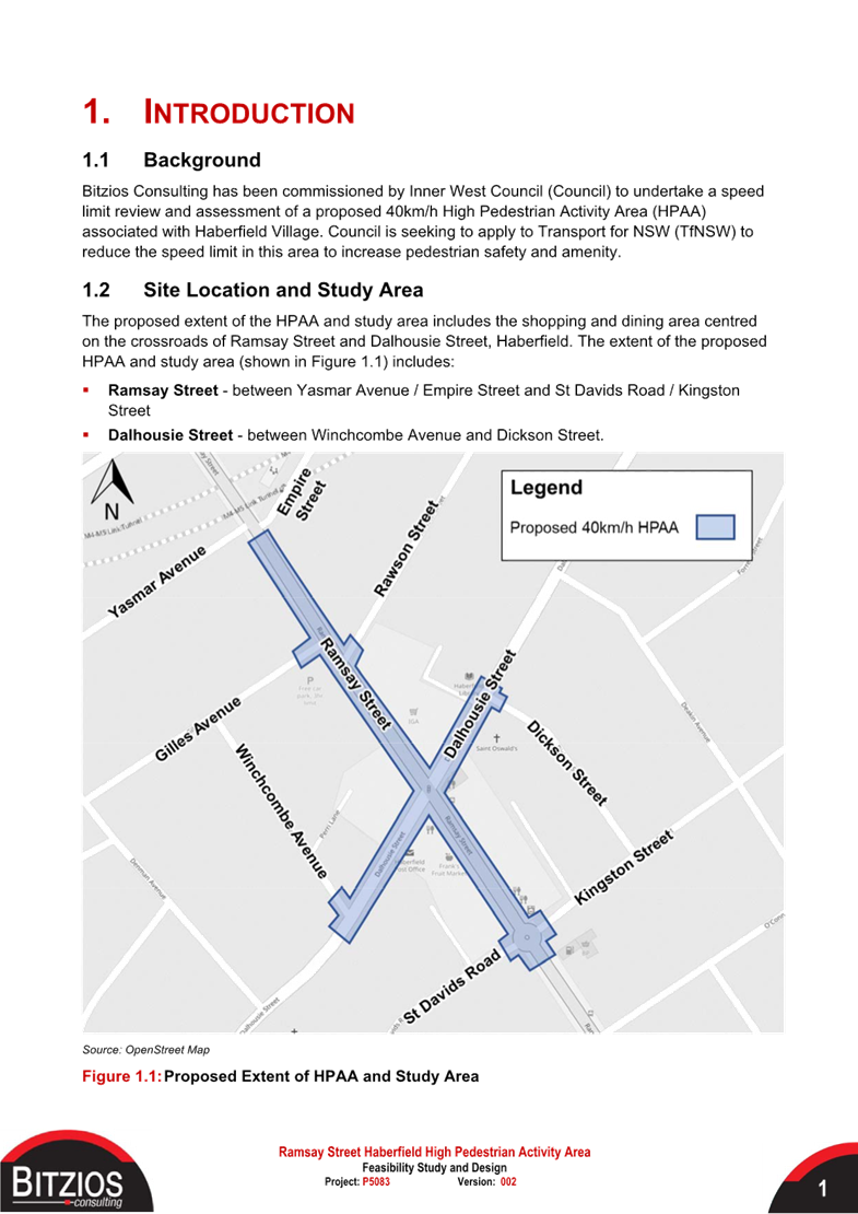
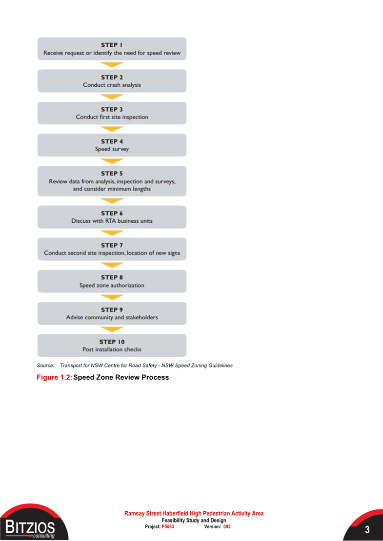
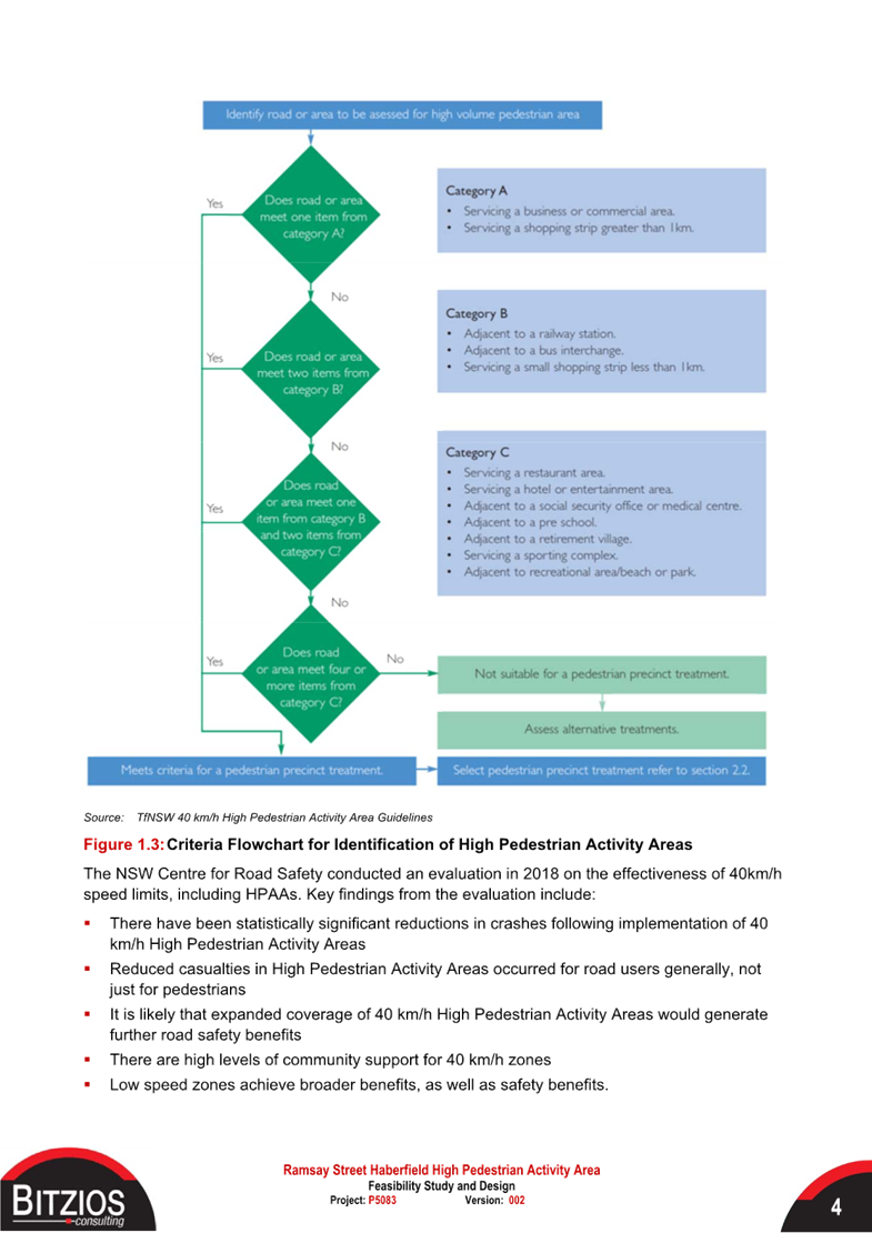
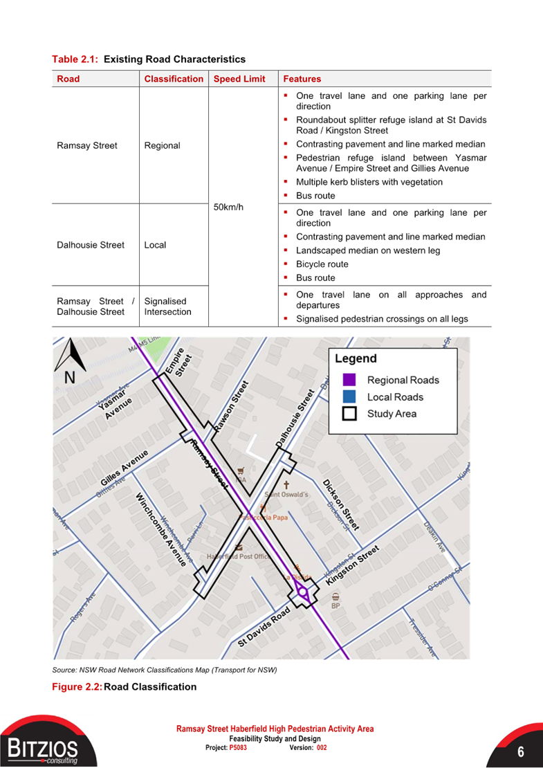
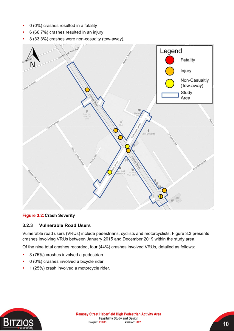
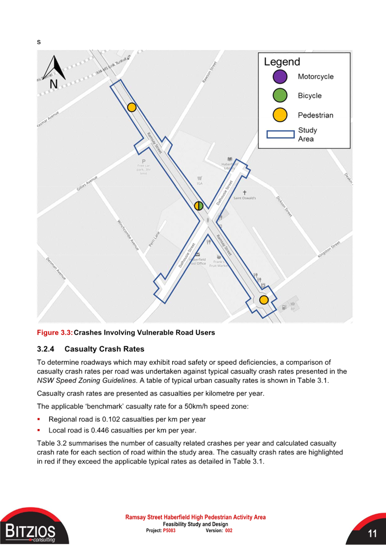
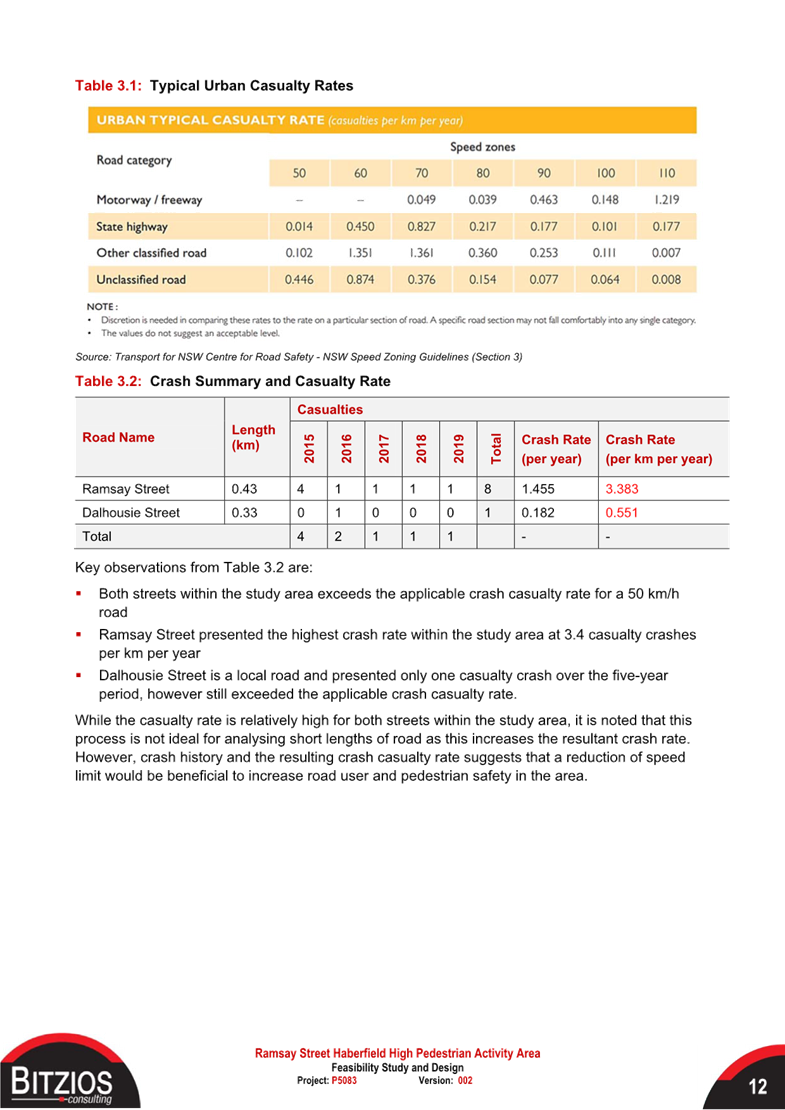
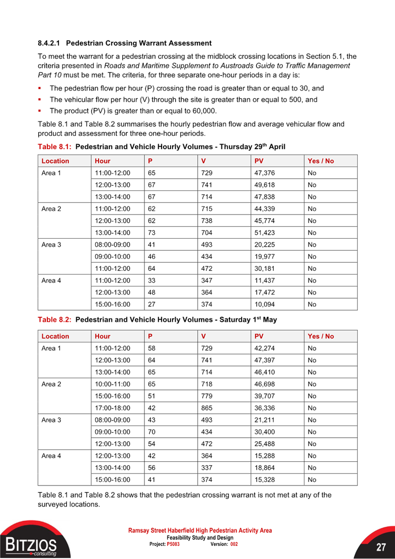
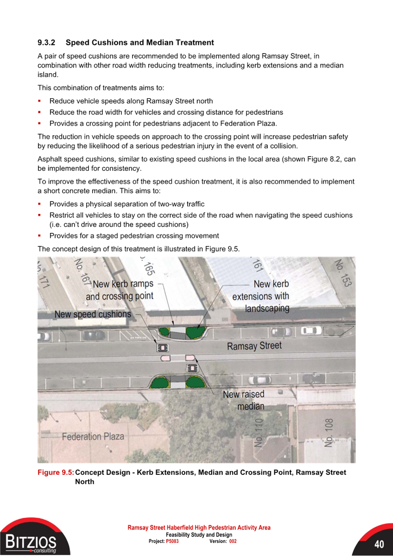
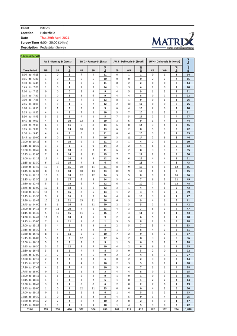
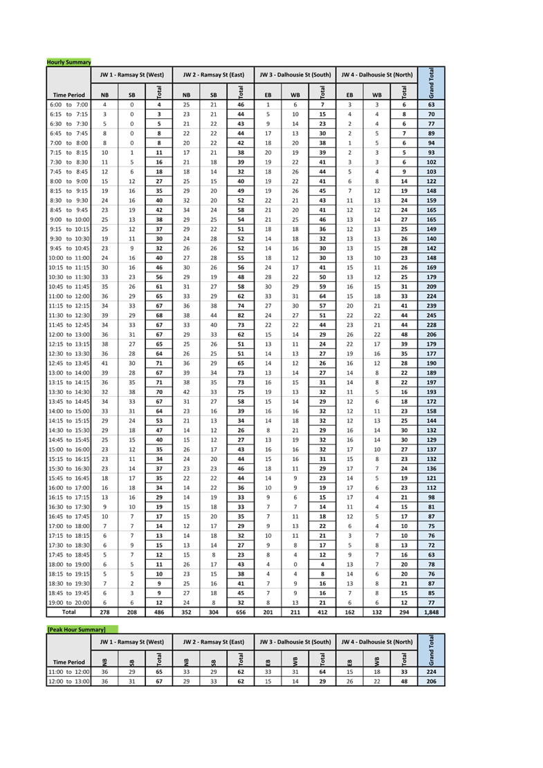
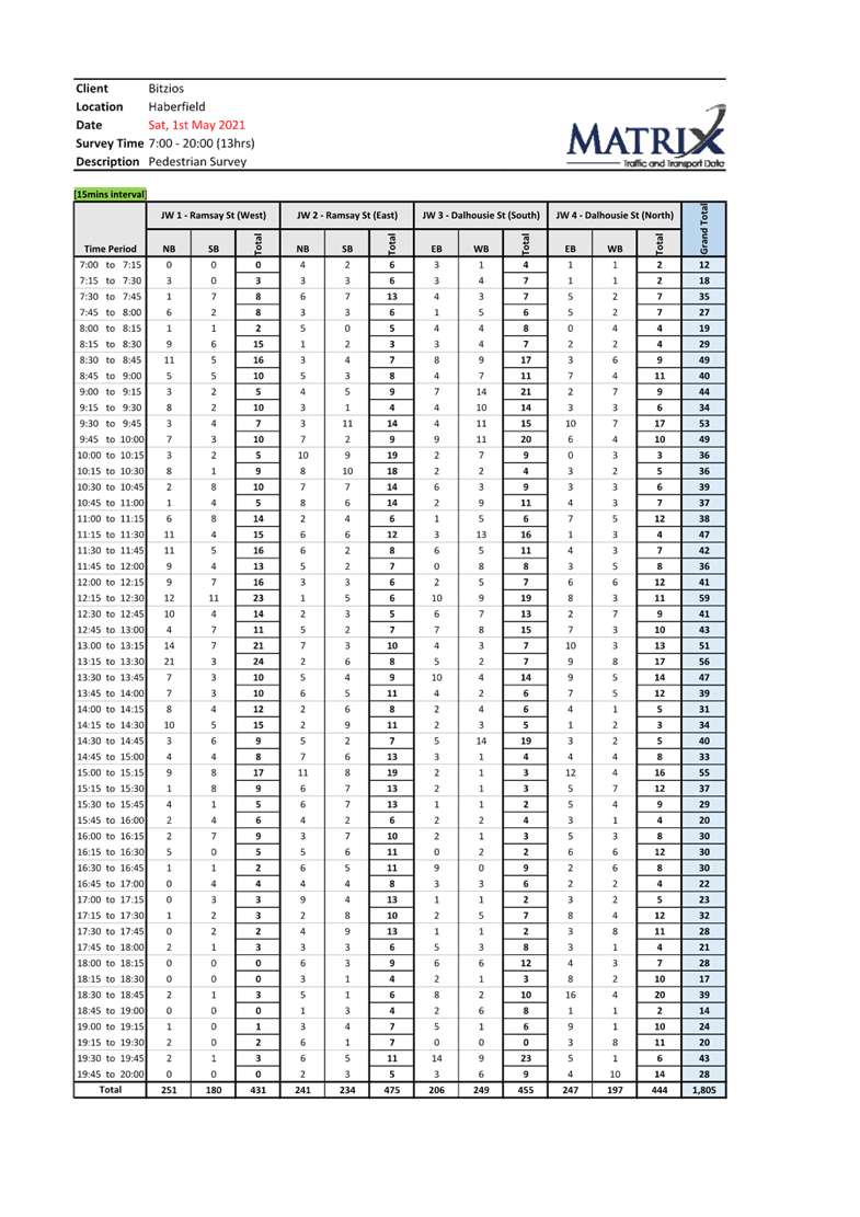
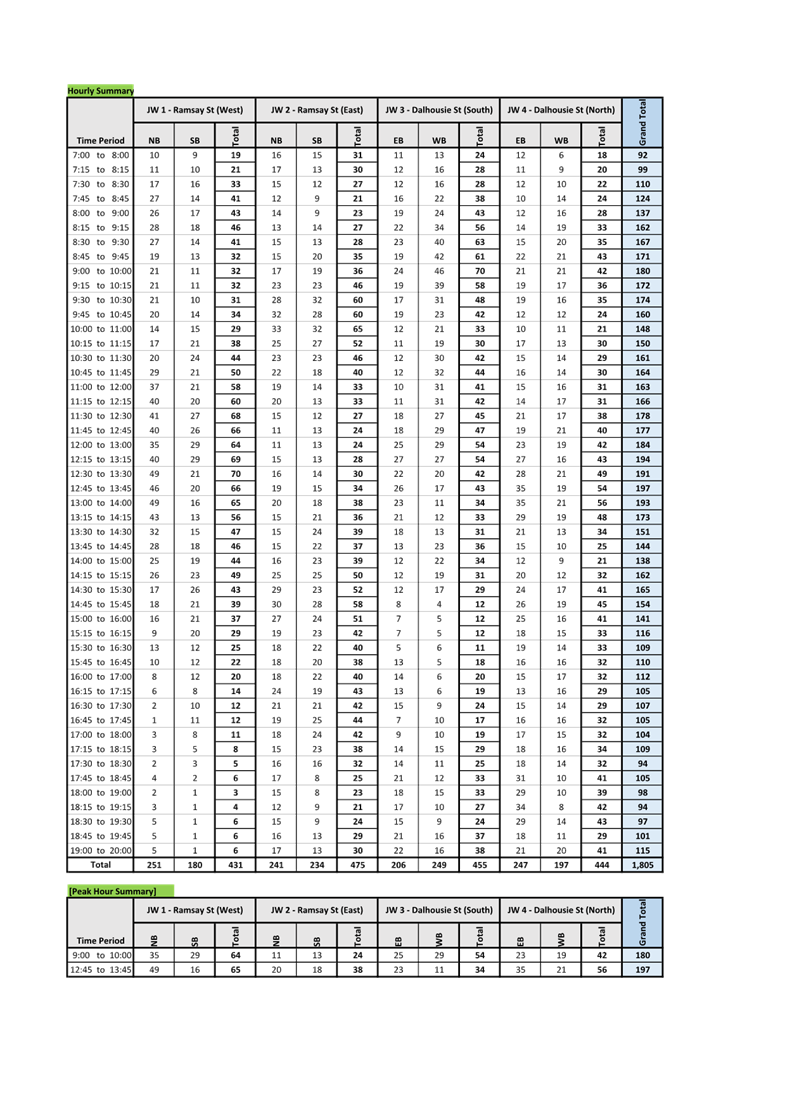
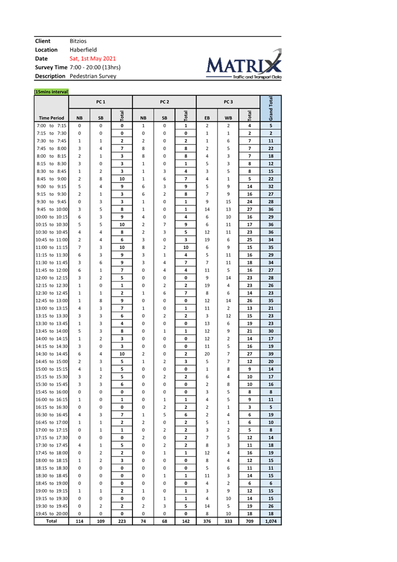
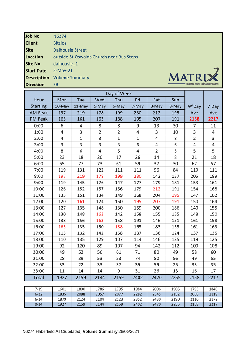
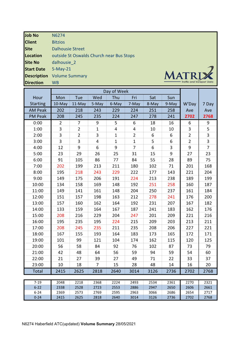
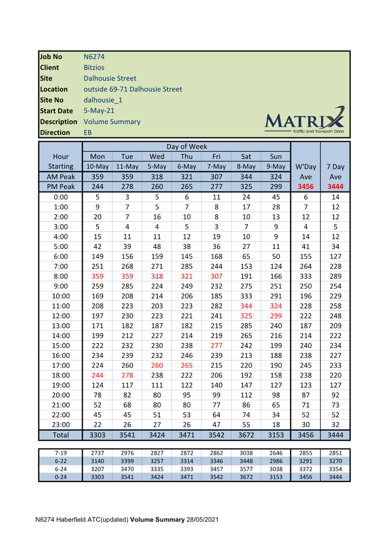
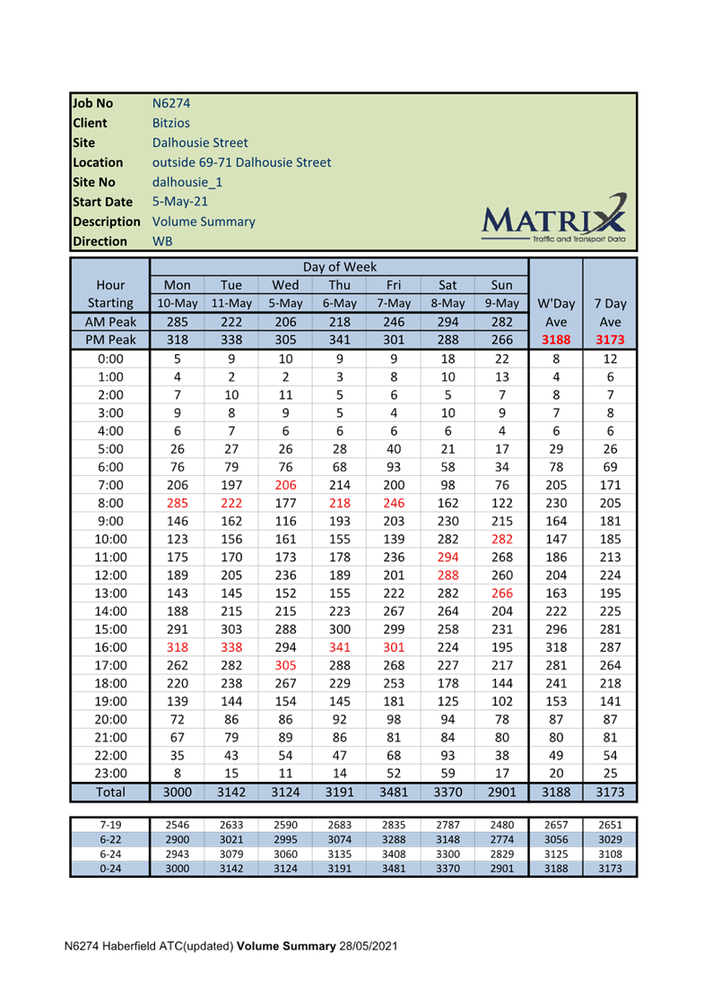
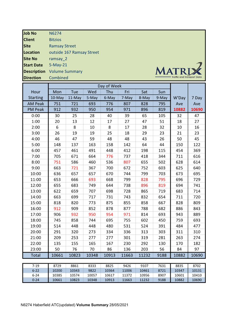
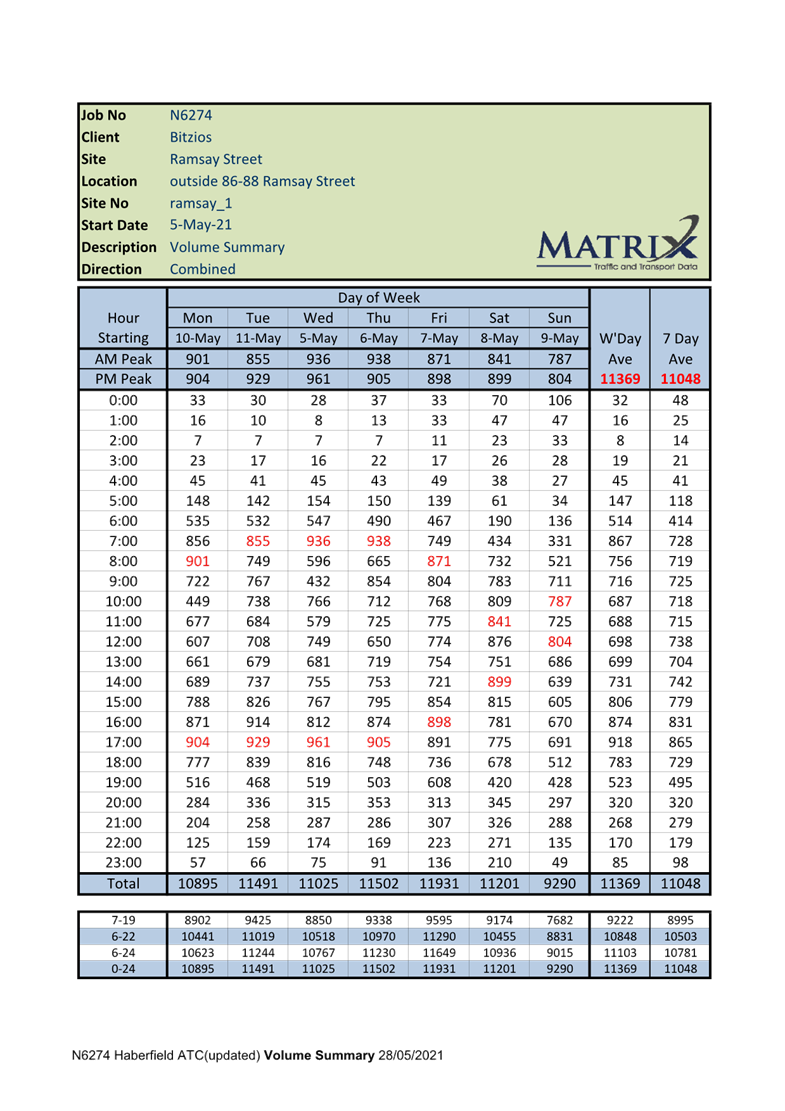
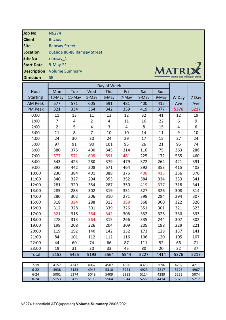
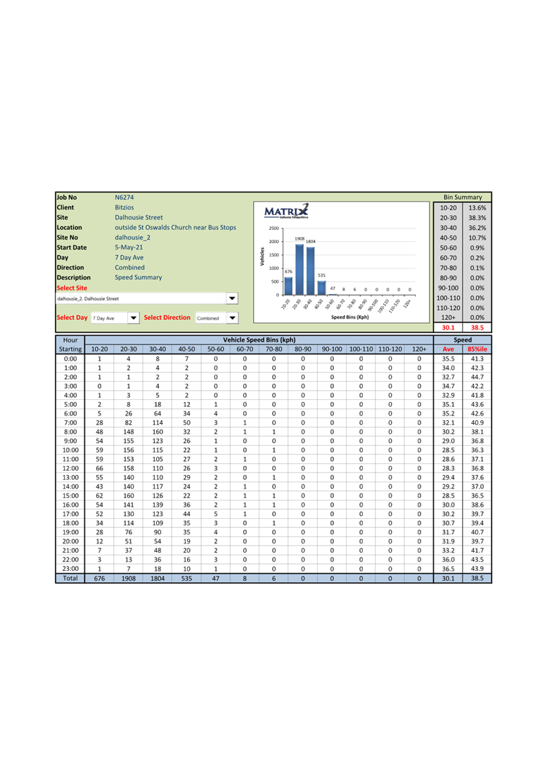
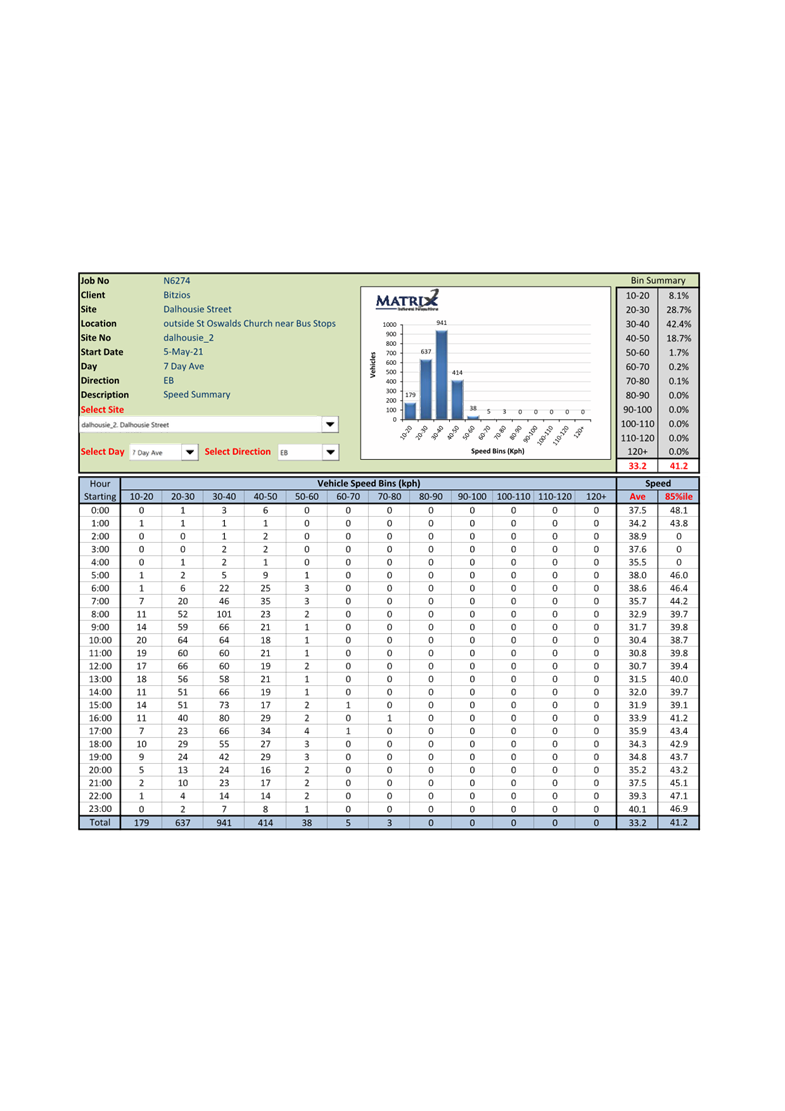
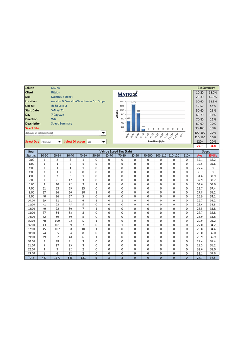
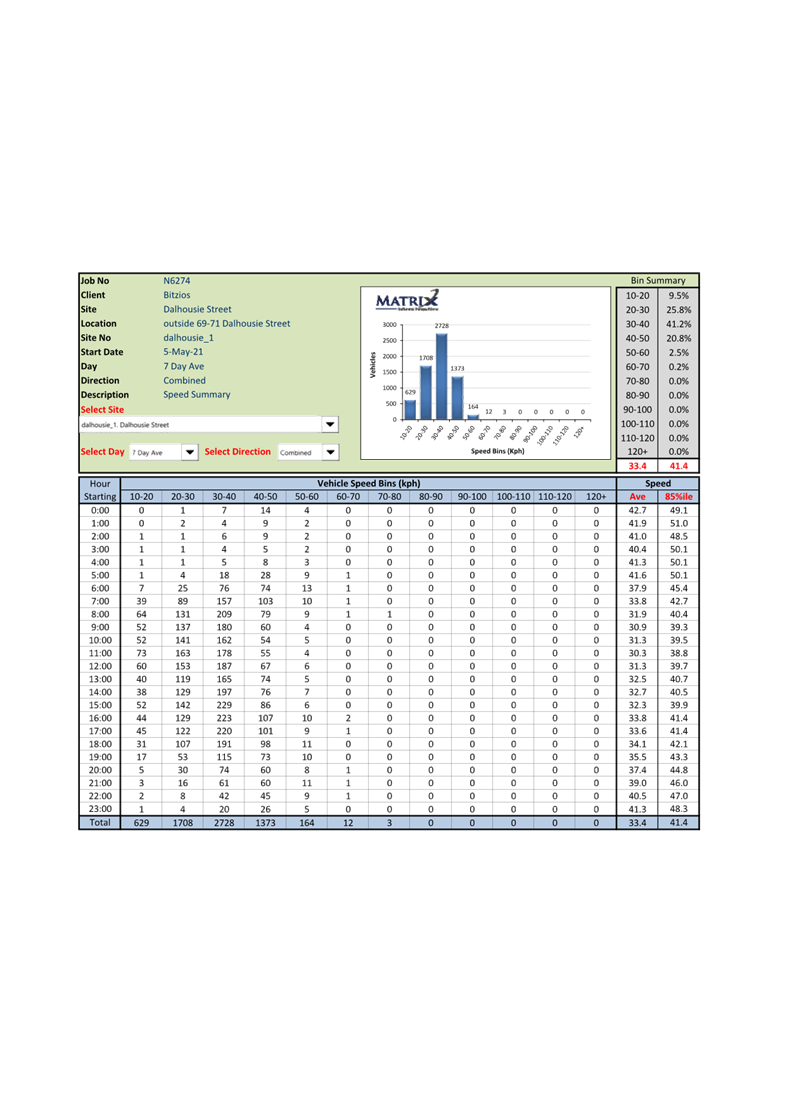
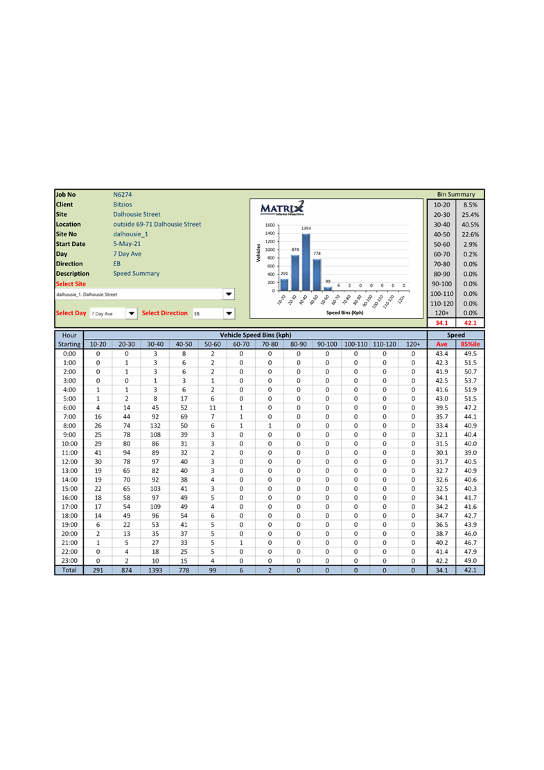
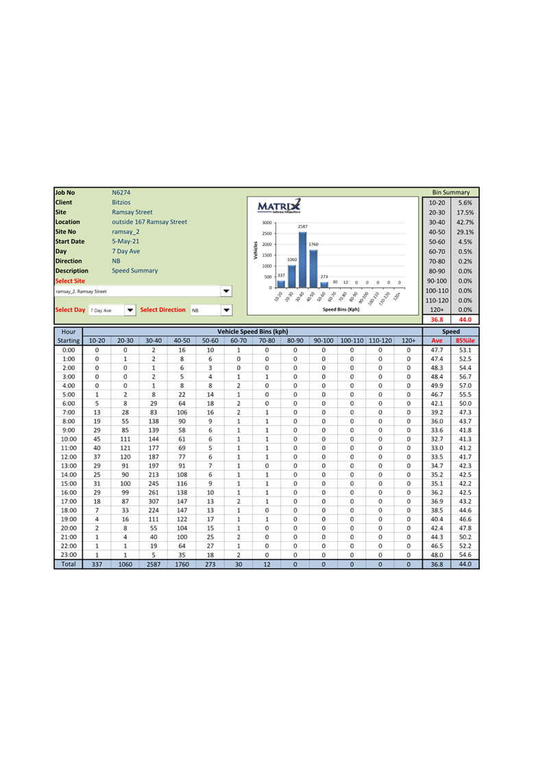
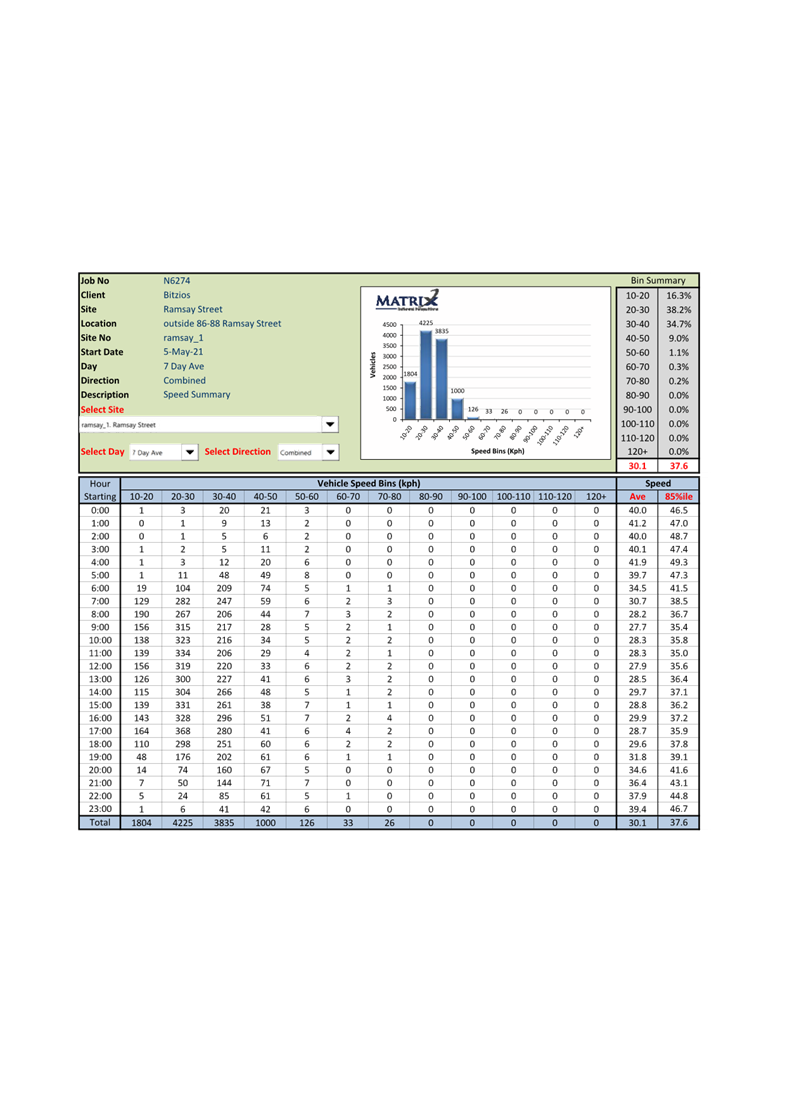
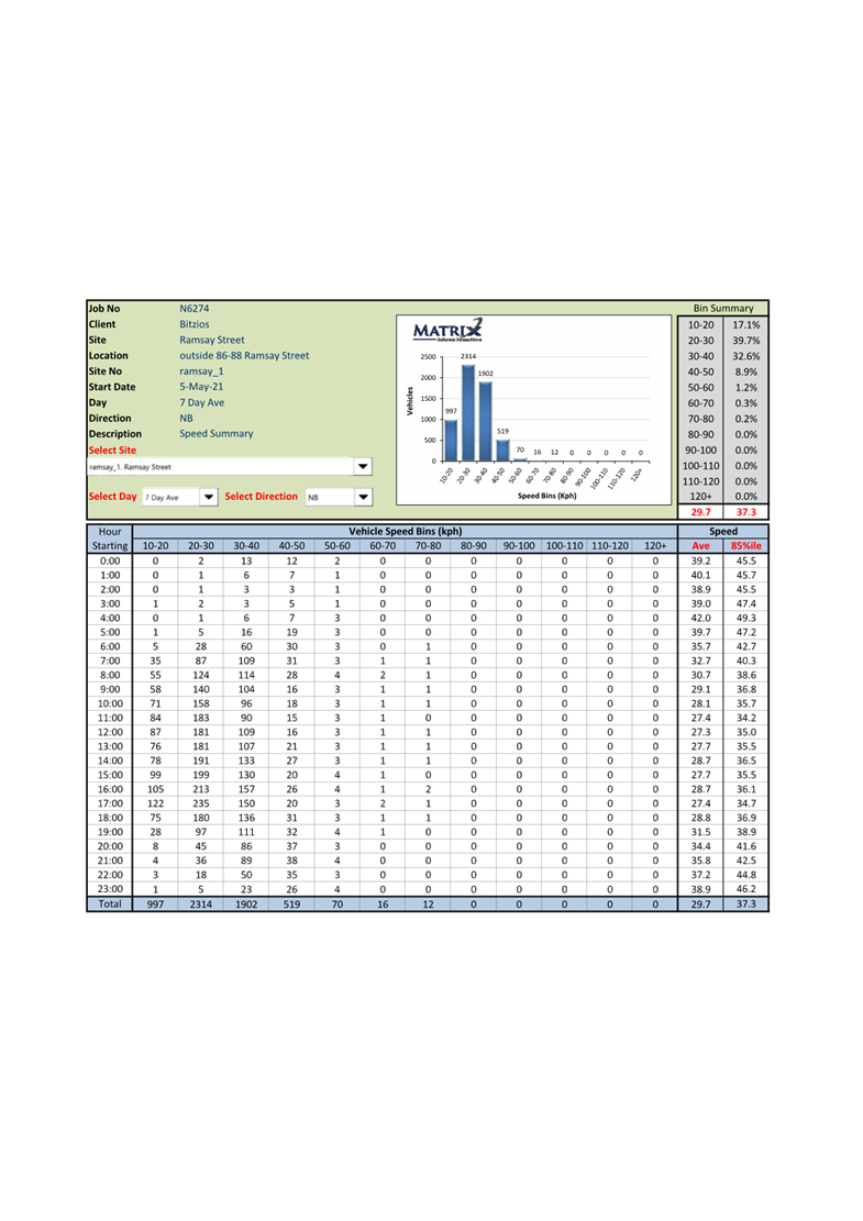
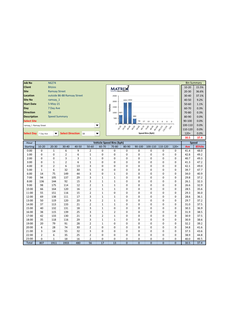
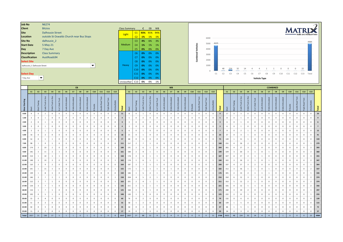
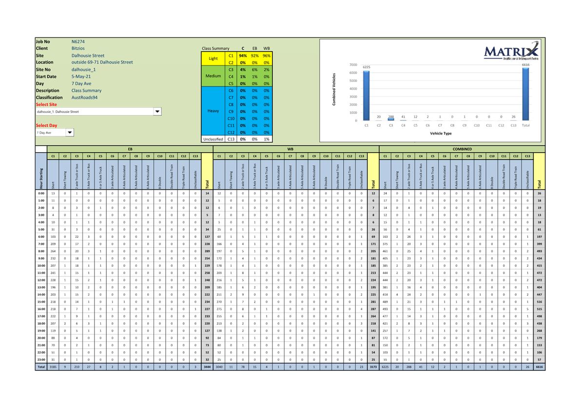
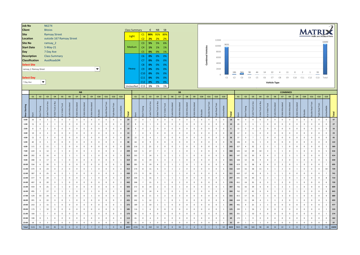
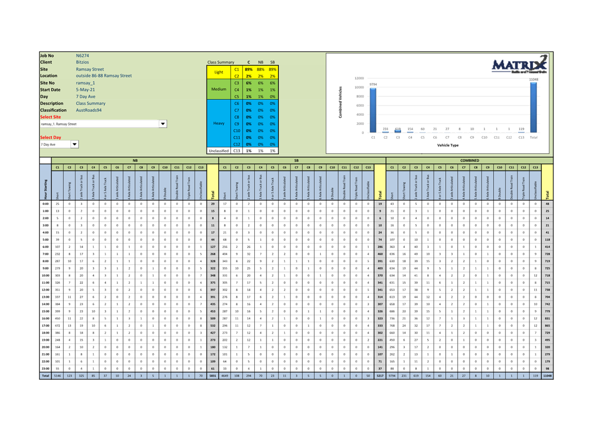
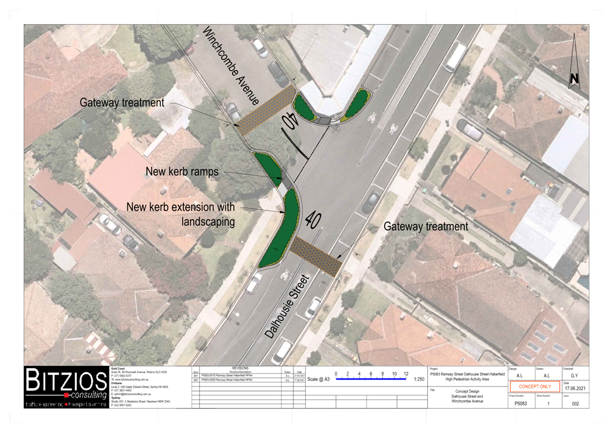
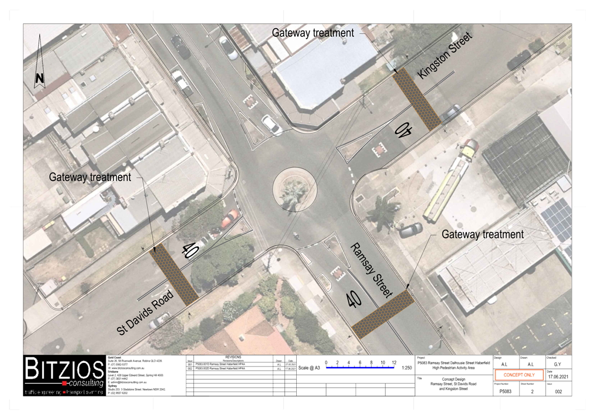
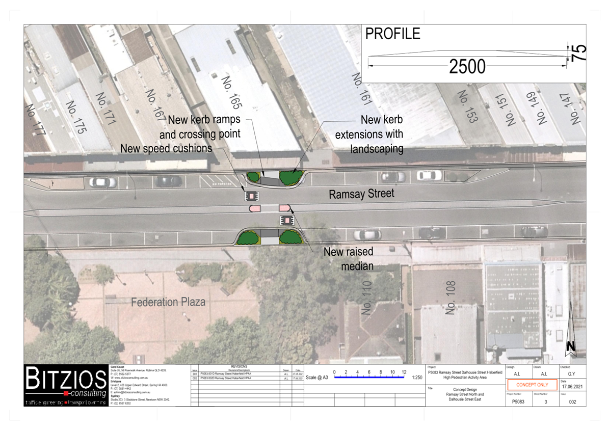
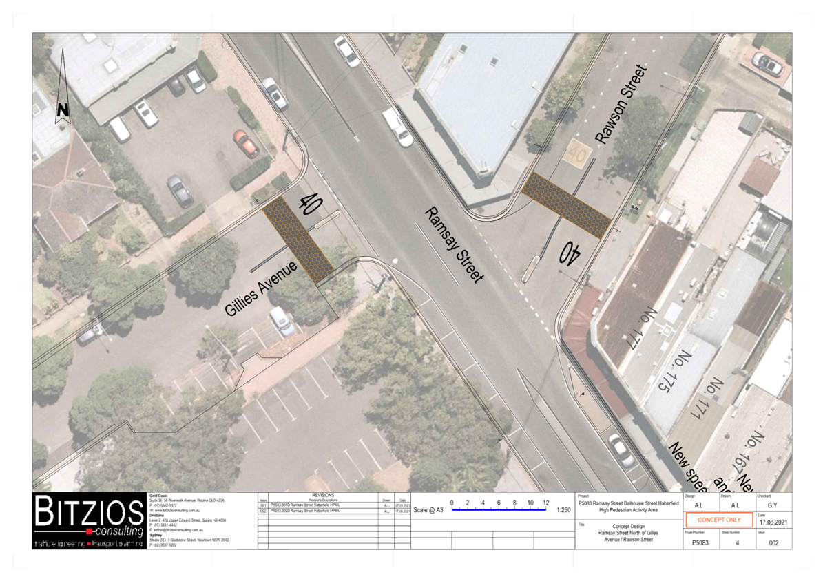
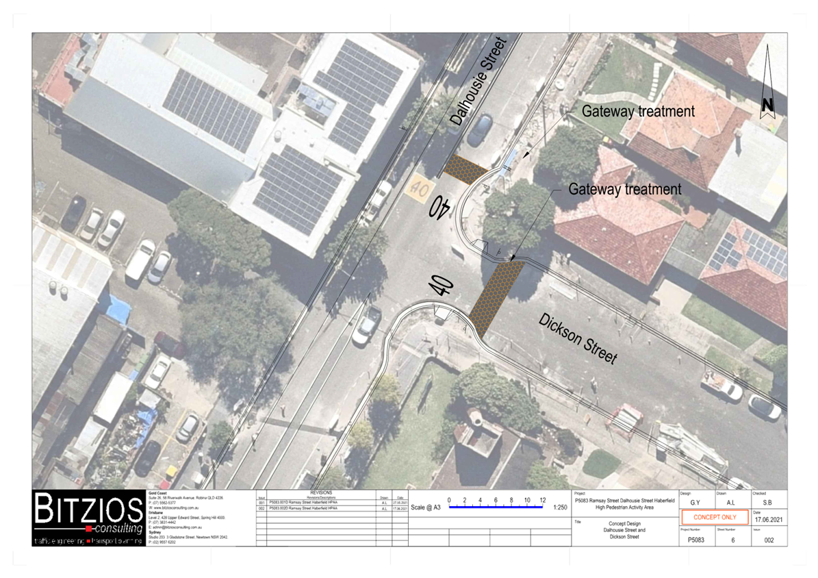
Subject: Ramsay Street & Dalhousie Street, Haberfield - 40km/h High Pedestrian Activity Area (HPAA) (Galgadya-Leichhardt Ward/Summer Hill Electorate/Burwood PAC)
Prepared By: Sunny Jo - Coordinator Traffic Engineering Services North
Authorised By: Manod Wickramasinghe - Traffic and Transport Planning Manager
|
RECOMMENDATION
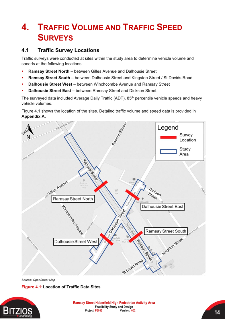
1. That the attached detailed design plan (Design Plan No.10312) for the proposed 40km/h High Pedestrian Activity Area (HPAA) treatments in Ramsay Street, Dalhousie Street, Gillies Avenue, Rawson Street, Dickson Street, Winchcombe Avenue, St Davids Road, and Kingston Street, Haberfield be approved.
2. That it should be noted that Council has submitted a Traffic Management Plan for the proposed 40km/h HPAA to Transport for NSW approval.
|
STRATEGIC OBJECTIVE
This report supports the following strategic directions contained within Council’s Community Strategic Plan:
|
2: Liveable, connected neighbourhoods and transport |
|
|
EXECUTIVE SUMMARY
Council is planning to improve safety for all road users in Ramsay Street and Dalhousie Street, Haberfield by establishing a 40km/h High Pedestrian Activity Area (HPAA) for the core commercial and retail areas of Haberfield.
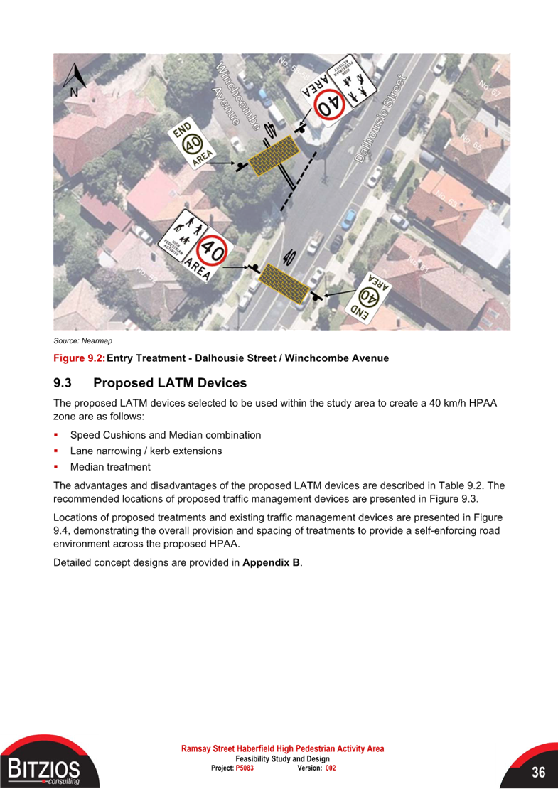
The proposal feature a number of linemarking treatments to indicate a reduced 40km/h speed limit, with accompanying entry, repeater and exit HPAA signs. Additionally, a landscaped kerb blister island will be constructed at the intersection of Dalhousie Street and Winchcombe Avenue which will complement the proposed treatments for a lower speed road environment.
The project will not impact on any legal on-street parking spaces in the area.
BACKGROUND
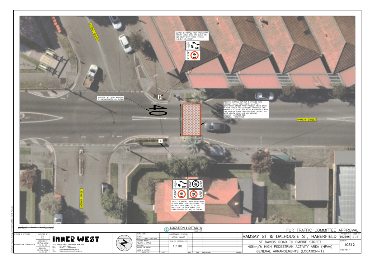
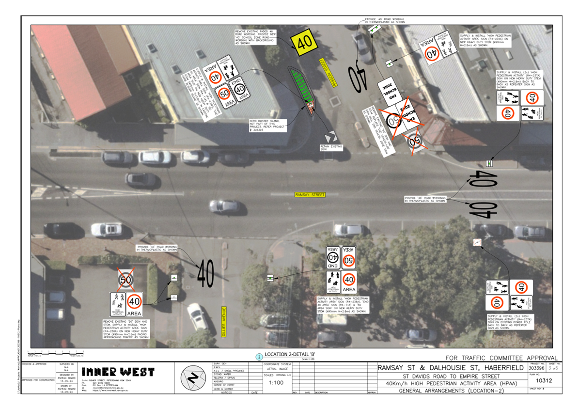
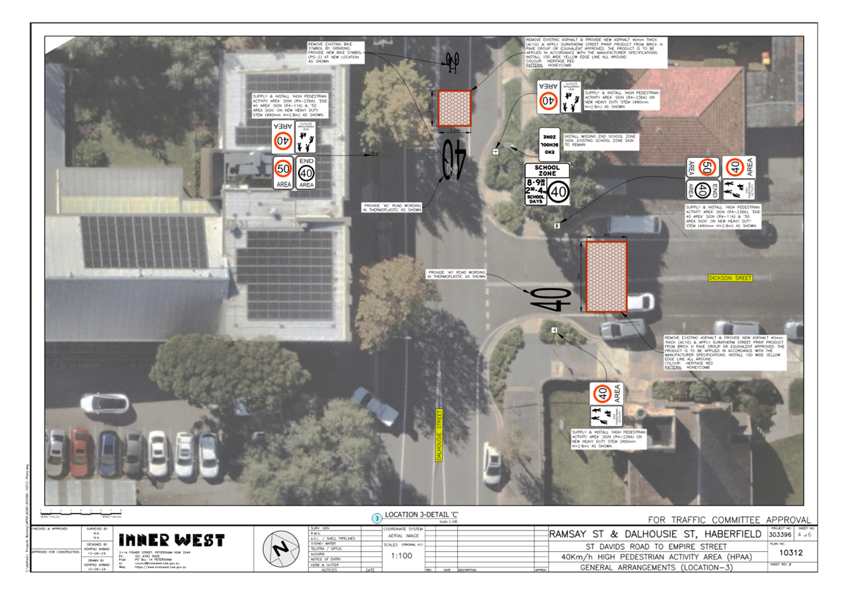
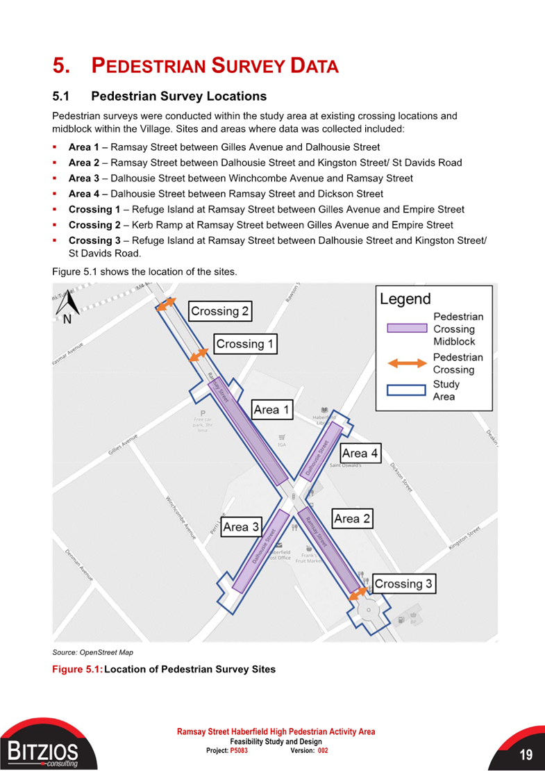
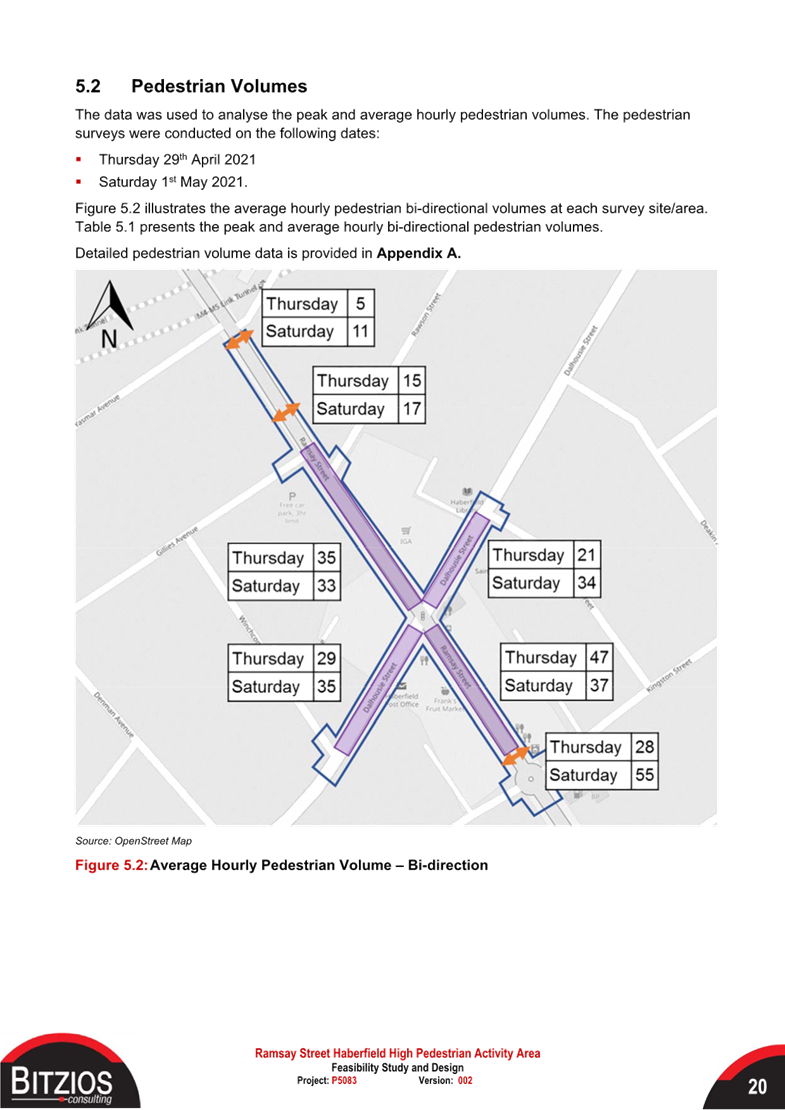
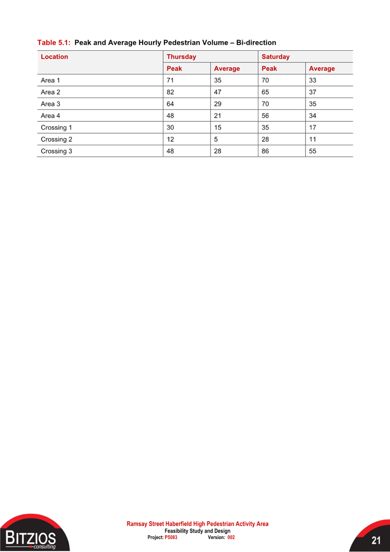
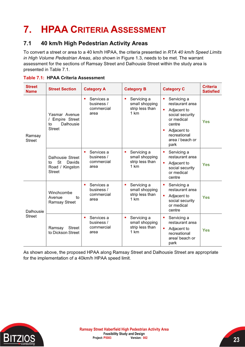
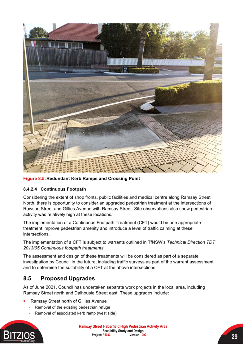
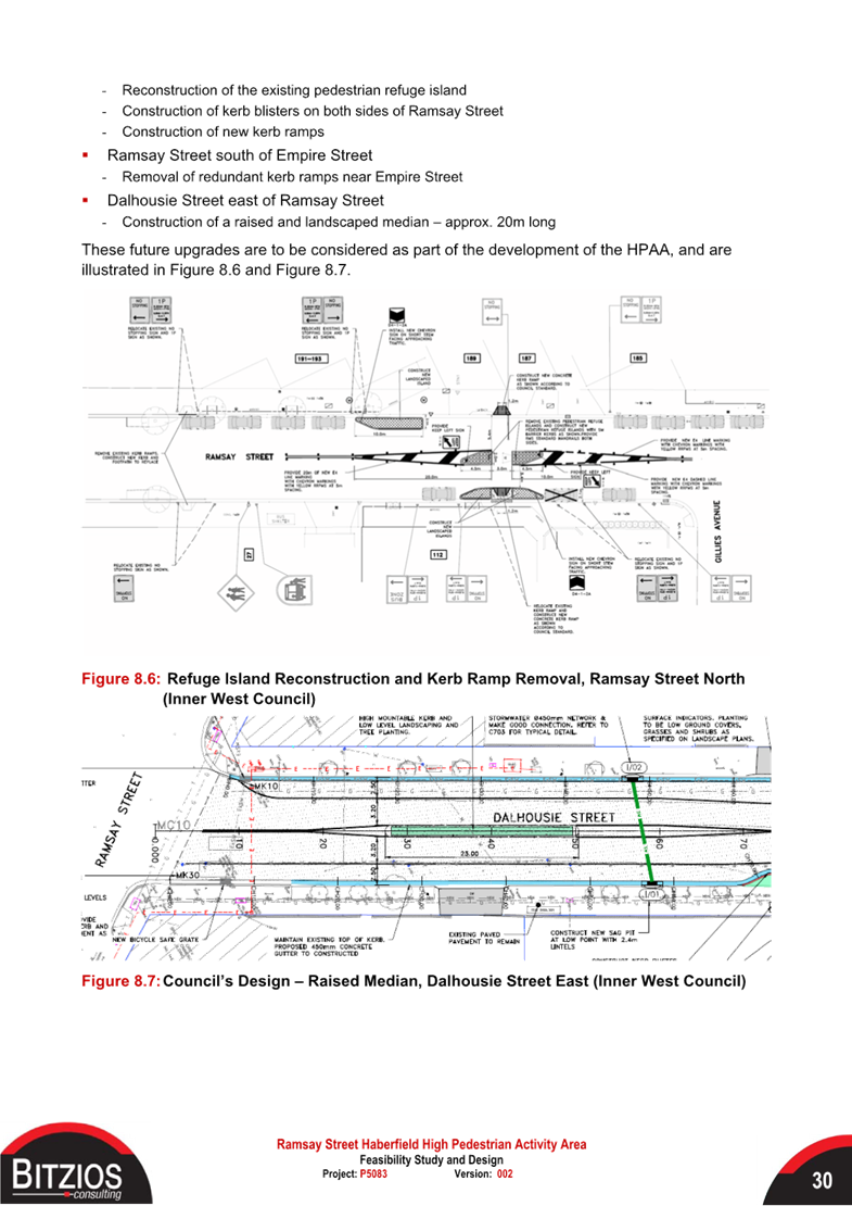
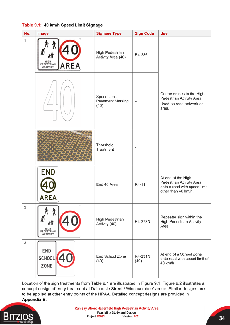
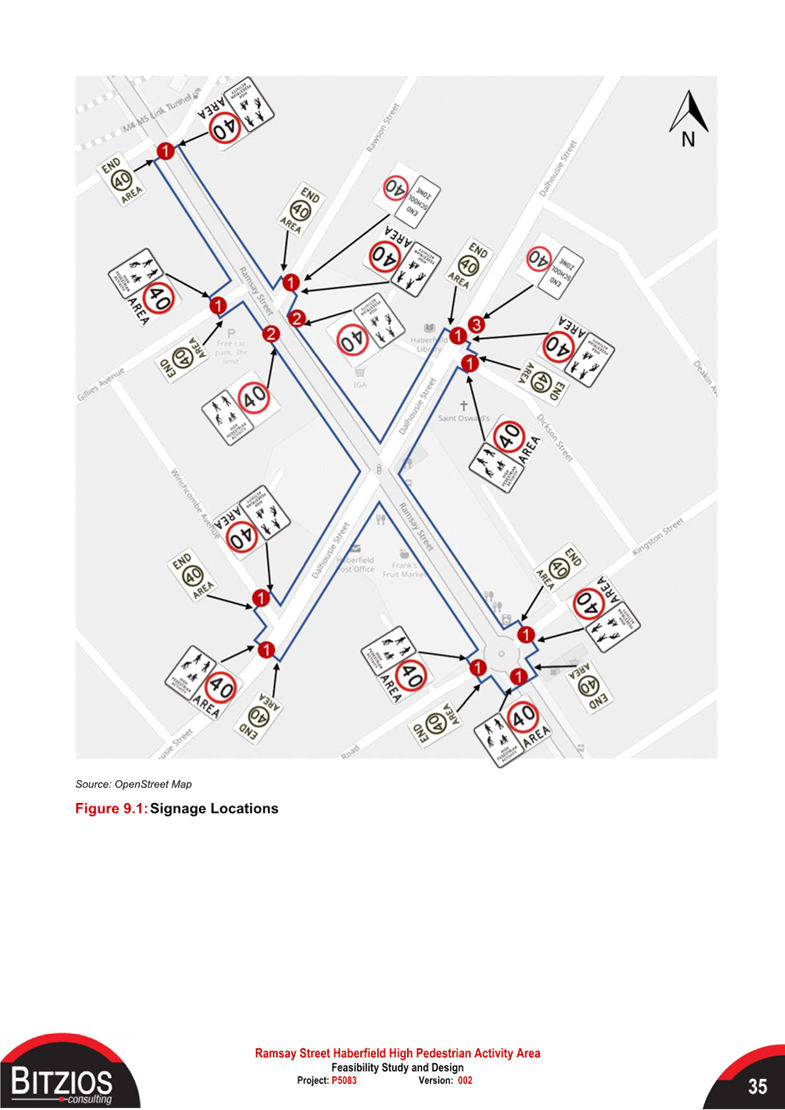
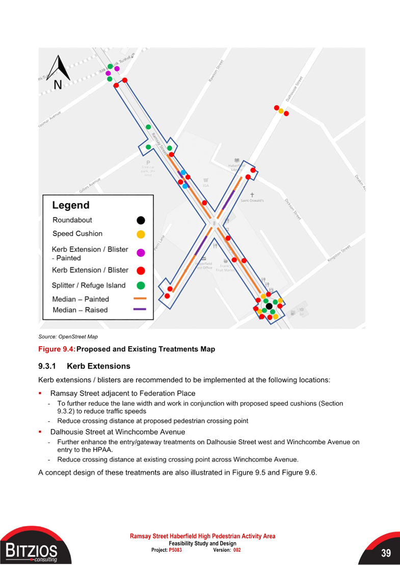
In 2021 Council undertook a preliminary eligibility assessment (Attachment 2) in Ramsay Street and Dalhousie Street, Haberfield for a 40km/h High Pedestrian Activity Area. Transport for NSW had provided in-principle support for the proposed HPAA and provided funding to undertake this study. Subsequently a detail design has been completed and as shown in Attachment 1, which outlines the proposed works, including the following:
· 40 patches on entry and ‘Duratherm’ honeycomb linemarking pattern in Heritage Red on entry and exit carriageways in Ramsay Street, Dalhousie Street and Dickson Street.
· Entry ‘40 High Pedestrian Activity Area’ sign (R4-237A) and ‘End 40 Area, 50 Area’ (R4-11A) at each HPAA boundaries.
· Construct new Landscaped Kerb Blister Island with mountable kerb at the intersection of Dalhousie Street and Winchcombe Avenue.
· New ‘Give Way’ sign (R1-2A) and lines across the throat of Winchcombe Avenue at Dalhousie Street.
· Additional linemarking and signage as shown in the attached design plan.
DISCUSSION
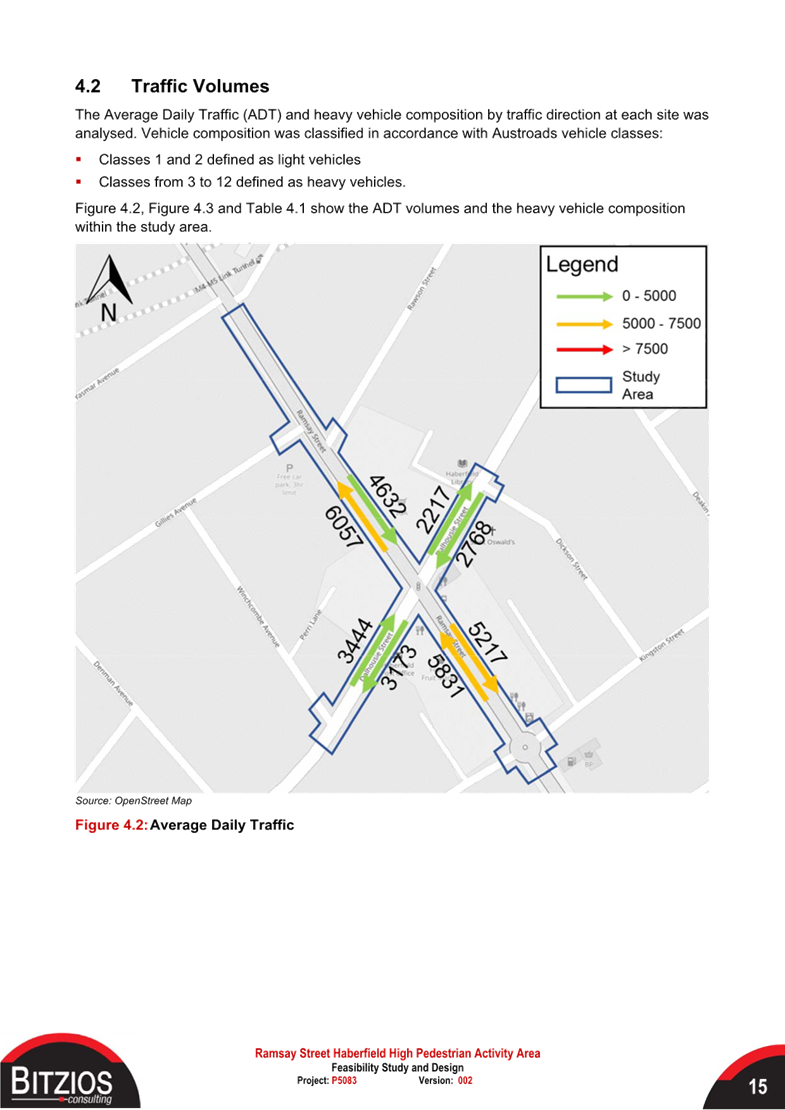
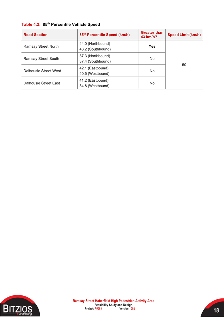
Ramsay Street is a regional road, estimated to have daily traffic volume of approximately 10,000 vehicles along with Dalhousie Street having an estimated daily traffic volume of approximately 6,000 vehicles.
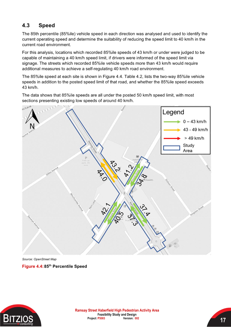
The traffic data collected during the preliminary study revealed traffic speeds within both roads to be within the ranges of 40.5km/h and 44.0km/h which is considered suitable for the implementation of a 40km/h HPAA.
As the proposed treatments do not result in the loss of any on-street parking and no raised devices are being constructed, community consultation was not considered necessary at this time. Notification will be undertaken following final TfNSW approval and subject to allocation of grant funding.
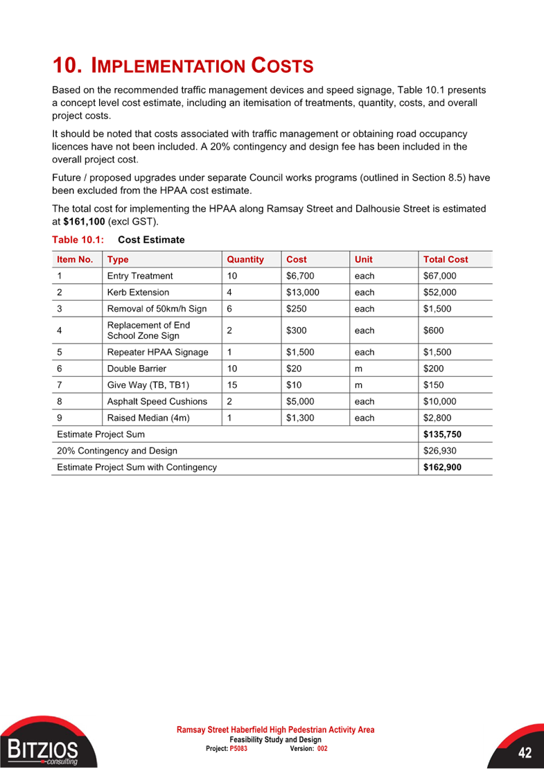
FINANCIAL IMPLICATIONS
The proposed project has an estimated cost of $120,000 and is planned to be submitted for the 2025/26 Federal Black Spot Program.
|
1.⇩ |
Haberfield HPAA Design Plan |
|
2.⇩ |
Haberfield HPAA Feasibility Study |
|
Local Traffic Committee Meeting 21 October 2024 |
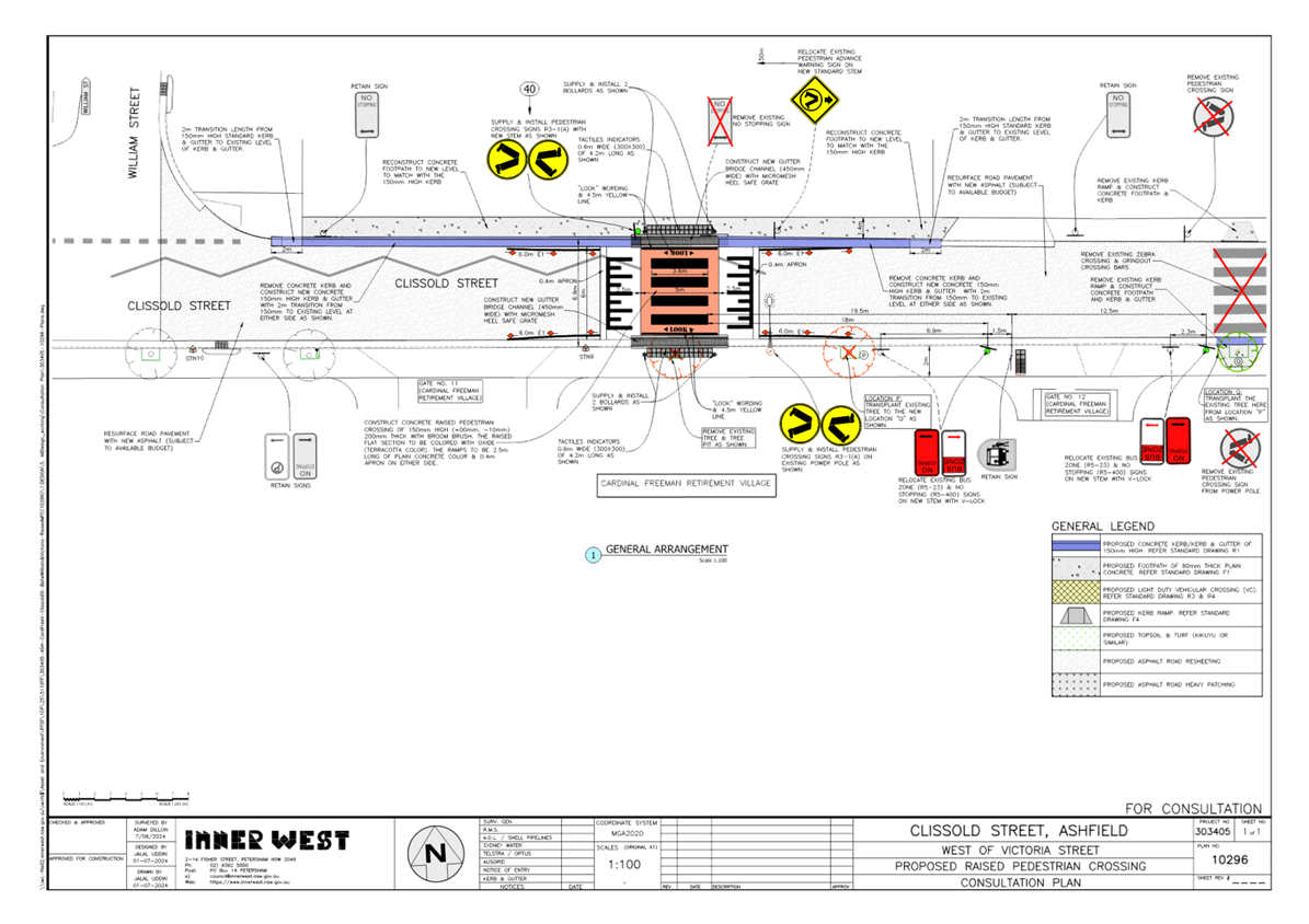
Subject: Clissold Street, between Queen Street and
Victoria Street, Ashfield-Proposed removal of existing at-grade crossing and
provide a new raised pedestrian(zebra) crossing- Deffered Item for additional
information
(Djarrawunang-Ashfield Ward/Summer Hill Electorate/Burwood
PAC)
Prepared By: Boris Muha - Traffic Engineer
Authorised By: Manod Wickramasinghe - Traffic and Transport Planning Manager
|
RECOMMENDATION
That the detailed design plan (10296) for the proposed new raised pedestrian (zebra) crossing in Clissold Street, just east of gate No.11 to the Cardinal Freeman Village (near William Street), and the removal of the at-grade pedestrian crossing further east in Clissold Street, between Queen Street and Victoria Road, Ashfield, as shown in Attachment 1 be approved.
|
STRATEGIC OBJECTIVE
This report supports the following strategic directions contained within Council’s Community Strategic Plan:
|
2: Liveable, connected neighbourhoods and transport |
|
|
EXECUTIVE SUMMARY
The detailed design plan for this proposed treatment was raised at the Local Traffic Committee (LTC) on the 16 September 2024 and deferred to provide additional information on the concerns raised by the representatives from Transit Systems Australia (TSA) and TFNSW on the existing Bus Stops and reduced ‘No Stopping’ length on approach to the new crossing. This additional information is provided below under Discussion-Additional information in deferral of the item. It should be noted that the remainder of the report is that which was presented at the September 2024 LTC meeting and is presented for information and context with regards to the recommendation.
Council at its meetings on the 18 March 2024 (through its Traffic Committee 11 December 2023) approved in principle, subject to detailed design, a series of proposed pedestrian (zebra) crossings and kerb extension treatments (under concept) for improved pedestrian and road safety around and near to the Cardinal Freeman (Retirement) Village, Ashfield.
This report describes and shows the detailed design plan of one of the proposed treatments, i.e. install a proposed new raised pedestrian (zebra) crossing in Clissold Street, just east of gate No.11 to the Cardinal Freeman Village (near William Street), and the removal of the existing at-grade pedestrian crossing further east in Clissold Street, between Queen Street and Victoria Road. This work is programmed and envisaged to be constructed in the 2024/2025 financial year, subject to funding.
BACKGROUND
The Cardinal Freeman Village (currently known as Levande Cardinal Freeman) is bounded by Clissold Street to the north, Victoria Street to the east, Seaview Street to the south and Queen Street to the west.
The village caters to an independent living lifestyle however as the average age is over 82 years there are a significant number of residents with mobility issues that hinder their ability to move around freely.
Many of the elderly residents are capable, and desire to walk to and from various destinations outside of the village, and/or take other forms of public transportation (e.g., bus and train) to travel to other parts of Sydney.
This has prompted a general request from the elderly residents to improve pedestrian safety around the village to enable them to walk to various desired destinations and take public transport within the area.
Other Aged care facilities such as the Ashfield Baptist Homes, Bethel Nursing Homes, Ashfield Terrace Care Community, and other community facilities are also located adjacent or near to the Cardinal Freeman Village.
The proposed treatment in this report received a major (80% rate) support under a general community engagement consultation conducted through Council’s ‘Have Your Say’ back in October 2023. The facility is viewed in benefit and supported by the community at large, and not only for the elderly of the Cardinal Freeman Village.
DISCUSSION
The following information is provided in discussion.
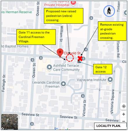
Figure 1. Locality Plan
|
Street Name
|
Clissold Street (Near Victoria Street) |
|
Carriageway width (m) kerb to kerb |
Approx. 6.7-7.0m |
|
Carriageway type |
Two-way, one travel lane each direction. |
|
Classification |
Local |
|
Speed Limit km/h |
50 |
|
85th percentile speed km/h |
47.2 |
|
Vehicles per day (vpd) |
2109 |
|
Last available 5 years of TfNSW recorded crash history
|
NIL in last 5 years in Clissold Street (Queen Street to Victoria Street) 1 prior recorded accident in 2015 resulted in pedestrian on carriageway being hit by vehicle in area of existing crossing (RUM 3) - moderate injury. |
|
Parking arrangements |
Parking not permitted on both sides between William Street and Victoria Street. Parking permitted on north side between William Street and Queen Street. |
|
Side street(nearest) |
William Street |
Table 1. Road Network detail
The Plan
The following works are proposed and are illustrated on the attached plans:
Clissold Street (between William Street & Victoria Street), Ashfield (Plan No. 10296):
· Construct a new raised concrete pedestrian crossing with “gutter bridge” crossings closer to William Street to replace the existing “at-grade” flat pedestrian crossing approximately 35m to the east. The existing pedestrian crossing to the east and associated kerb ramps will be removed (refer to attached Plan):
· Construct new concrete kerb & gutter on the north side of Clissold Street where shown;
· Construct new concrete footpath in place of the existing damaged concrete footpath on the north side of Clissold Street where shown;
· Remove 1 existing street tree and transplant 1 existing street tree to a new location on the south side of Clissold Street to facilitate the construction of the new raised pedestrian crossing and to provide adequate site distances on the approach side;
· Relocate/adjust existing ”No Stopping” & ”Bus Zone” signage on the south side of Clissold Street to satisfy sight distance and bus zone length requirements;
· Provide new “edge” line markings either side of the new raised pedestrian crossing to provide guidance for the motorists;
· Install associated signage associated with the works as required and where shown on the Plans;
· Resurface the road pavement with new asphalt. Note: - this will be subject to final budget allocations at the time of the project being implemented and may be undertaken at a later or prior date within the Local Roads Capital Program.
Parking Changes
The existing Bus Zone and No Stopping Zones on the south side of Clissold Street will be adjusted slightly to accommodate the new raised pedestrian crossing. However, this will not impact on existing parking arrangements in the street. Please refer to the attached plan.
Streetlighting
The new raised pedestrian crossing will require new flood lighting to be provided for it to comply with current standards. This will involve the provision of at least 1 floodlight (on a new power pole) or up to 2 floodlights (on 2 new power poles) typical of other locations with pedestrian crossings. At this stage, this design is not complete and will be undertaken by a specialist lighting consultant at a later stage.
Other Information
The proposed raised pedestrian crossing to the east of gate 11 replaces the removed (at road level) zebra crossing at gate 12. The new raised pedestrian (zebra) crossing will be situated further west away of the conflict area of the Bus Stops and traffic turning in from Victoria Street and coming across Victoria Street from Clissold Street (east).
Access to the Bus stops can be attained via Gate 11 or 12 with the new crossing going in just east of gate 11. The new crossing location can also provide connection to the northern side of Clissold Street to link pedestrian movement towards Queen Street and Victoria Street.
Clissold Street is a Bus Route. The platform height of the crossing is 150mm high to blend in level with the footpath and provide appropriate ‘gutter bridge’ clearance over the kerb for drainage. The ramps are lengthened to 2.5m in this instance to provide appropriate bus rideability over the crossing.
Additional information under deferral of the item
Council officers did meet on site with representatives of the TSA to discuss the proposal in removing the existing at-grade crossing and provide a new raised crossing further west in Clissold Street.
Both the Bus Stops in Clissold Street have not been moved. The Bus Zone signs to the bus stop on the southern side of Clissold Street are altered in length to accommodate the current fleet of 12.5m buses over that of the old 11m length buses.
There is ‘No Stopping’ either way of the bus zones, creating a clear draw in and draw out from the Bus Stops.
The TfNSW representative questioned the proposed ‘No Stopping’ length in approach to the new crossing from 20 metres down to 18m on the southern side of Clissold Street. The ‘No Stopping’ is measured to the beginning the Bus Zone which signposts the area of the Bus Stop to the southern side of Clissold Street. It should be noted that the ‘flagpole’ of the bus stop is not moved and is approx. 19.5 metres away of the crossing. Buses would pull up to the ‘flagpole’ not the beginning of the Bus Zone. Therefore, the clearance in standing a vehicle (i.e. Buses) away of the crossing is in tolerance of the 20metres. Moving the bus zone and bus stop will mean moving the ‘flagpole’ stand back into the path of a village gate entrance thereby hindering bus and pedestrian access.
In view of the above, the 18 metres of ‘No Stopping’ to the beginning of the Bus Zone, in this case, is considered acceptable. Bus stop patronage frequency in the area is low, with buses not pulling up that readily. Parking is not permitted with ‘No Stopping’ signposted on both sides of Clissold Street in the vicinity of the proposed new crossing.
Both the TSA and TfNSW representatives have in turn raised no objection to the proposal which maintains the bus stops at their current locations, and that 18m of ‘No Stopping’ zone signposted in approach to the new crossing instead of the standard 20m is considered acceptable in this case.
FINANCIAL IMPLICATIONS
The project is listed in Council’s Traffic Facilities Capital Works budget for works to be carried out in 2024/2025, subject to funding. The work is estimated to be around $90,000.
CONSULTATION
A letter outlining the proposal was mailed out to 8 properties (9 letters) in Clissold Street, Ashfield, between Queen Street and Victoria Street requesting residents’ views regarding the proposal. (see also map of consultation area Figure 2).
A copy of the letter was also sent directly to the Manager of the Cardinal Freeman Village to distribute amongst its residents inviting them to comment also.
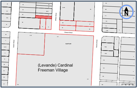
Figure 2. Map on Consultation Area
(1) Resident response was received concerning tree planting and floodlighting of the crossing.
The concerns raised by the resident are outlined below in the table.
|
Residents Comments |
Officers Response |
|
· Request not to replant one existing tree in new location which might limit vision of oncoming traffic.
· Are floodlights really necessary? These will have an impact on nearby residents. |
· It is proposed to remove 1 tree just east of Gate 11 to make way for the new raised pedestrian crossing. It is also proposed to relocate (1) existing tree (between gate 11 and gate 12) to a new location east of Gate 12 to provide suitable unimpeded sight distance to the new pedestrian crossing.
Trees are an important part of the overall landscape and provide much needed tree canopy cover to the footpath environment. The tree species has a moderately high canopy and therefore is considered suitable for its new (transplanted) location.
· Council is required to provide lighting to all new pedestrian crossings compliant to the required Standards to ensure pedestrian safety - particularly at night. A lighting design will need to be prepared by a suitably qualified lighting consultant to meet this requirement. Council will endeavour to provide only the minimum required levels of lighting whilst still complying with the Standards.
|
CONCLUSION
Additional information has been provided in this report to address the concerns raised by TSA and TfNSW in maintaining the Bus Stops ‘No Stopping’ restrictions on approach to the proposed new crossing in Clissold Street.
It is therefore recommended that the detailed design plan (10296) for the proposed new raised pedestrian (zebra) crossing in Clissold Street, just east of gate No.11 to the Cardinal Freeman Village (near William Street), and the removal of the at-grade pedestrian crossing further east in Clissold Street, between Queen Street and Victoria Road, Ashfield, as shown in Attachment 1 be approved.
|
1.⇩ |
Proposed plan 10296- Removal of at-grade crossing and construction of a new raised pedestrian (zebra) crossing in Clissold Street, Ashfield, between Queen Street and Victoria Street. |
|
|
Local Traffic Committee Meeting 21 October 2024 |
Subject: Victoria Street, Ashfield - Installation of a ‘Keep Clear’ zone at the front of Ashfield Police Station (Djarrawunang-Ashfield Ward/Summer Hill Electorate/Burwood PAC)
Prepared By: Daniel Li - Student/Graduate Traffic Engineer
Authorised By: Manod Wickramasinghe - Traffic and Transport Planning Manager
|
RECOMMENDATION
That the installation of a ‘Keep Clear’ zone on Victoria Street, Ashfield at the main driveway for Ashfield Police Station be approved.
|
STRATEGIC OBJECTIVE
This report supports the following strategic directions contained within Council’s Community Strategic Plan:
|
2: Liveable, connected neighbourhoods and transport |
|
|
EXECUTIVE SUMMARY
This report outlines current emergency vehicle accessibility issues at Victoria Street between Liverpool Road and Norton Street and proposes the appropriate road treatment to improve police operations of Ashfield Police Station.
BACKGROUND
Council has received a Councillor’s request to install a ‘Keep Clear’ zone at the front of Ashfield Police Station, located at 14 Victoria Street, Ashfield due to excessive road traffic congestion during the morning and afternoon peak hours.
DISCUSSION
The nature of police work often involves officers to urgently respond to local incidents, maintain public safety, enforcing laws and protecting the community. As a result of the identified congestion during the morning and afternoon peak hours, police officers have been unable to egress from the police station driveway perform their duties as public law enforcement.
Victoria Street provides an approximate pavement width of 13 metres, facilitating one lane of travel in the northbound and southbound directions as well as restricted 1P parking on the western side and unrestricted parking on the eastern side. Notwithstanding the above, this section of Victoria Street provides access to high traffic generating facilities such as Ashfield Boys High School, Ashfield Public School and Trinity Grammar School as well signalised access to Liverpool Road near Ashfield shopping strip thereby validating the identified traffic congestion during the peak morning and afternoon periods.
Whilst the installation of a ‘Keep Clear’ zone will vastly assist with the ingress and egress movements of police vehicles from the driveway, it should be noted that this section of Victoria Street is operating under a signalized control at its intersection with Liverpool Road and this fact in conjunction with the high traffic volumes would still result in police vehicles queuing in the roadway for a brief period of time. However, it is proposed that a 10 metre ‘Keep Clear’ zone be installed in both travel lanes at the frontage of Ashfield Police Station to facilitate unrestricted ingress and egress movements for police operations. A concept plan of the proposed ‘Keep Clear’ marking is provided in the diagram below.
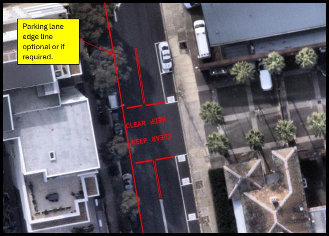
Figure 1. Proposed Concept Plan
PUBLIC CONSULTATION
As the ‘Keep Clear’ zone is designated for the Ashfield Police Station, which is an emergency service and the “Keep Clear” was requested by the Police Service public consultation was not undertaken. According to Transport for NSW, a ‘Keep Clear’ marking is used to keep the road clear outside of areas of high traffic demand such as hospitals, fire stations and police stations.
FINANCIAL IMPLICATION
The cost of installation of the line marking as recommended will be funded within Council’s signs and line marking budget.
Nil.
|
|
Local Traffic Committee Meeting 21 October 2024 |
Subject: Proposed EV Kerbside Charging Locations (All Wards / All Electorates / All PACs)
Prepared By: Sarah Guan - Graduate Strategic Transport Planner, James Nguyen - Traffic Engineer and Felicia Lau - Traffic Engineer
Authorised By: Manod Wickramasinghe - Traffic and Transport Planning Manager
|
RECOMMENDATION
1. That the EV charging sites identified in Table 3 be supported for installation as per the signage and line marking plans provided in Attachment 1.
2. That the EV charging sites identified in Table 2 be supported subject to targeted engagement and TfNSW approval as required.
|
STRATEGIC OBJECTIVE
This report supports the following strategic directions contained within Council’s Community Strategic Plan:
|
2: Liveable, connected neighbourhoods and transport |
|
|
EXECUTIVE SUMMARY
Council is committed to supporting and encouraging the use of electric vehicles (EVs) in the Inner West. Consequently, Council chose three kerbside public charging providers, as partners, through a Request for Quotation (RFQ) process. Subsequently, Council supported these partners in successfully applying for State Government funding.
Council’s charging partners secured grant funding to roll-out 136 public EV charging ports; 95 of which is dedicated with signs and line marking, across our community by mid-April 2025.
The proposed initial network of EV kerbside charging port locations was publicly exhibited in July and August 2024, to gain community feedback. The overall proposal received 84% support from the community. In response to community feedback, on specific locations, the number of EV charging ports with dedicated kerbside spaces is proposed to be reduced from 95 to 81.
The community consultation included both dedicated and undedicated charging locations so that the community could understand the overall charging network proposed. In considering this it is important to note that; as chargers without dedicated spaces do not alter kerbside conditions and would be installed on existing AusGrid infrastructure, they could be installed without Council approval. Their installation could be carried out under the Transport and Infrastructure State Environmental Planning Policy (SEPP).
Proposed signs and line marking plans for the chargers with dedicated kerbside spaces are included in Attachment 1.
BACKGROUND
In May 2023, Inner West Council adopted POWERING AHEAD, its Electric Vehicle Encouragement Strategy. This Strategy was prepared based on over three years of research and consultation, with the Community, adjacent councils and industry stakeholders. The Strategy was prepared in response to a number of factors including a worldwide commitment to conversion of internal combustion engine (ICE) vehicles to electric vehicles (EVs), rapidly growing demand from the Inner West Community, State and Federal Government policies targeting 50% of all new vehicles being sold in Australia to be electric by 2030, as well as Council’s sustainability and net zero policies.
The Strategy contains 3 key actions relating to the implementation of public EV charging across the Inner West:
Action 3 – Public kerbside charging partnerships
Council works with charging providers to develop pilot programs to initiate the phased-in provision of kerbside charging facilities to assist residents in areas where housing does not generally have driveways/off-street access (and consequently residents are unable to provide their own on-site charging facilities).
Action 4 – Public car park charging partnerships
Council works with charging providers to develop pilot programs to initiate the phased-in provision of charging facilities in Council’s public off-street parking areas. These programs should aim at providing a minimum of 2 bays (1 x double charging unit) dedicated to electric vehicle charging in off-street parking areas which have 20 or more car spaces, subject to considerations including existing infrastructure limitations and existing public domain projects.
Action 6 – Light poles with charging
Council will endeavour to work with Ausgrid to ensure that, subject to the delivery of suitable lighting pole designs (e.g. recognising the local character including heritage considerations), at least 20% of new lighting poles in the Inner West LGA will be capable of accommodating EV charging facilities.
In response to the adoption of the Strategy by Council, and demand from the Community, an Expression of Interest (EOI) and a subsequent RFQ were initiated to attract charging providers to partner with Council to provide kerbside charging. As a result of the RFQ Council selected three partners to provide kerbside public charging - EVSE, EVX and PLUS ES.
Subsequently, an additional RFQ was also launched to attract partners to provide charging in council car parks.
In July 2023, The NSW Government launched Round One of its Electric Vehicle Kerbside charging grants. On 26 May 2024 it was announced that Council’s charging partners were successful in acquiring grant funding for a total of 136 charging ports.
Conditions of the grant approval required all charging ports to be installed by mid-April 2025.
To provide the Community with a comprehensive overview of the proposed kerbside charging network, Council exhibited all 136 charging port locations between the 4 July and 11 August 2024. In summary, the overall network proposal received 84% support from the Community.
DISCUSSION
On 26 May 2024, it was announced that Council’s three charging partners were successful in acquiring grant funding for a total of 136 charging ports. Of the ports in the grant approval, 95 ports (a mix of dual and single port chargers) require dedicated kerbside spaces at 56 sites, and 41 single port “opportunity” chargers which do not require dedicated spaces. These 41 “opportunity chargers” will only be available able for charging if the associated kerbside is vacant. This will provide the Council and its partners with two different operational models for comparative analysis to inform future charger deployment.
The sites were selected by Council’s charging providers, in conjunction with the State Government, using site selection criteria including:
· Capacity of the electrical grid;
· Areas with projected high EV uptake and low access to off-street parking (as identified by the State Government and Council’s charging partners);
· Optimising access while minimising inconvenience for residents; and
· Safety and accessibility requirements.
In considering the proposed network, the following should be noted:
· Around 1,000 EVs are currently registered within the LGA;
· During 2023 the total number of EVs registered in the Inner West increased by 43%, and projections indicate that a similar growth rate is likely over the next three to five years;
· The current State and Federal Government target for conversion of the Australian fleet, is for 50% all new car sales to be electric by 2030;
· Recent projections supplied by the State Government indicate that the number of EVs registered in the Inner West is likely to rise to over 20,000 by 2030
· Approximately 65% of households in the Inner West cannot readily charge vehicles on site, it can be anticipated that demand for public charging in the Inner West will increase significantly over the next few years;
· The lead time for installing public EV charging units is between 6 and 8 months;
· In accordance with Council’s adopted Road User Hierarchy, and implied through Council’s net zero and sustainability policies, priority is to be provided to active and public transport ahead of private car use. Council’s current position on private electric cars is that; if a private car must be used for a journey the preference is for that car to be and EV rather than an Internal Combustion Engined vehicle (ICE);
· The proposed 95 ports with spaces (56 sites) dedicated to EV charging should not be considered removal of a parking space, rather they are a transition from one type of parking to another. Further, because of the proposed 8.00am to 10.00pm restriction these spaces will be available to other vehicles between 10:00pm and 8:00am;
· As the dedication of the spaces for electric vehicle charging is simply a transition from one vehicle type to another no significant alteration of traffic patterns is anticipated; and
· The Inner West LGA is estimated to have approximately 130,000 kerbside spaces, with the proposed 95 ports with dedicated spaces representing less than 0.08% of all kerbside spaces in the LGA.
PUBLIC CONSULTATION
Public consultation was undertaken between 4 July 2024 to 11 August 2024.
All proposed EV kerbside charging locations were presented to the Community for feedback.
The proposed charging locations include:
· 95 charging ports in 56 dedicated locations, and
· 41 single charging ports that is ‘opportunity’ (not dedicated to EV only) charging locations.
A total of 854 submissions were received through Your Say Inner West (YSIW) and an additional 156 emails received (33 also provided additional submissions via YSIW). The proposal received an overall support of 83% with the following (as shown in Figure 1):
· Dedicated sites (56 locations):
o 53 sites, support rate above 70%.
o One (1) site, support rate between 50%-69%.
o Two (2) sites, support rate below 50%.
· Non-dedicated sites:
o 29 sites, support rate above 70%.
o Eight (8) sites, support rate between 50%-69%.
o Seven (7) sites, support rate below 50%.
The community consultation included both dedicated and undedicated charging locations so that the community could understand the overall charging network proposed. It is important to note that; as chargers without dedicated spaces do not alter kerbside conditions and would be installed on existing AusGrid infrastructure, they could be installed without Council approval. Their installation could be carried out under the Transport and Infrastructure State Environmental Planning Policy (SEPP).
For the EV charging ports with dedicated kerbside spaces, the following rational has been applied:
· locations with a support rate below 50% are not recommended for installation (Table 1).
· locations with a support rate between 50%-69% have been reviewed to determine their suitability in response to community feedback and if an alternative site should be proposed (Table 2);
· locations that have received support rate above 70% are proposed, as is, for priority installation (Table 3).
Table 1: Proposed Dedicated Sites Not Recommended for Installation/Changes to Parking Restrictions.
|
Address |
Suburb |
Side |
No. of bays |
Reason for omission |
|
182 Annandale St |
Annandale |
W |
1 |
EV charging provider has advised the power pole is not suitable. |
|
3 Gallimore Ave |
Balmain East |
E |
2 |
EV charging provider confirms that the footpath width is inadequate for the installation. |
|
116 Rowntree St |
Birchgrove |
N |
1 |
Low community support. |
|
Opposite 79 Pigott St |
Dulwich Hill |
N |
2 |
EV charger provided have advised the pole is a private power pole. |
|
80 Norton St |
Leichhardt |
E |
2 |
Against Council’s position to place AC chargers on main street. |
|
101 Lilyfield Rd |
Lilyfield |
S |
2 |
Conflict with future cycle way. |
|
178 Evans St |
Rozelle |
S |
1 |
Community objection in changing the parking restriction, installation continues but without changing the existing parking restriction on site. |
|
Tempe Reserve Park |
Tempe |
E |
2 |
EV charging provider have advised the power pole does not have enough capacity for an EV charger. |
Figure 1 provides a map of the engagement results and a detailed Engagement Outcomes Report (EOR) is provided in Attachment 2.
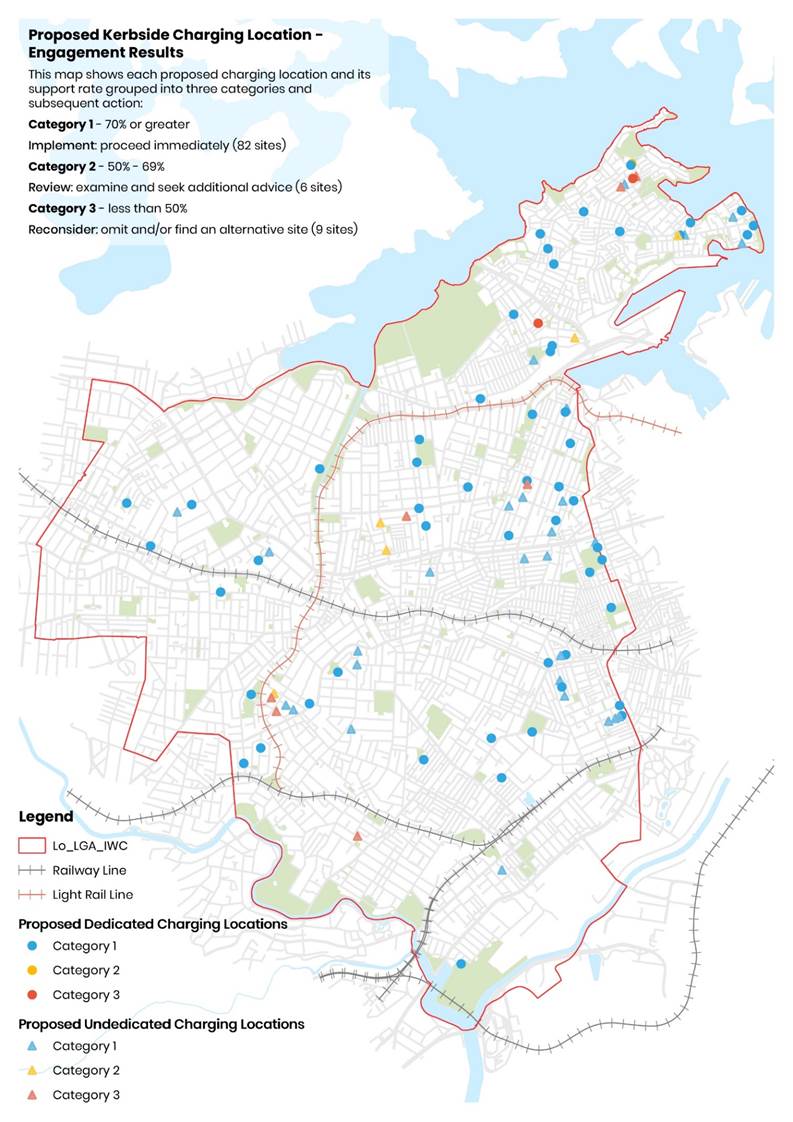
Figure 1: Engagement Result Map
|
|
Local Traffic Committee Meeting 21 October 2024 |
Table 2: Alternative/Additional Proposed Dedicated EV Kerbside Charging Locations
|
Address |
Suburb |
Side |
No. of Bays |
Existing Restriction |
Proposed Restriction |
Image Ref. |
|
216 Darling Street |
Balmain |
South |
2 |
2P 8am-10pm Permit holders excepted Area B2 |
No Parking 8am-10pm EV vehicles Excepted While Charging |
B10 |
|
146 Flood Street |
Leichhardt |
West |
2 |
Unrestricted |
No Parking 8am-10pm EV vehicles Excepted While Charging |
L5 |
|
2 Tebbutt Street |
Leichhardt |
East |
2 |
Unrestricted |
No Parking 8am-10pm EV Vehicles Excepted While Charging |
L6 |
|
770 Darling Street |
Rozelle |
South |
2 |
Unrestricted |
No Parking 8am-10pm EV vehicles Excepted While Charging |
R7 |
Table 3: Proposed Dedicated EV Kerbside Charging Locations for Installation
|
Address |
Suburb |
Side |
No. of bays |
Existing restriction |
Proposed restriction |
Image ref. |
|
Opposite 24 Annandale Street |
Annandale |
East |
1 |
Unrestricted 90 Angle parking |
No Parking 8am-10pm EV Vehicles Excepted While Charging |
A1 |
|
65 Booth Street |
Annandale |
North |
2 |
1P 8am-8pm Permit Holder Excepted Area A2 |
No Parking 8am-10pm EV Vehicles Excepted While Charging |
A2 |
|
5 Hutchinson Street |
Annandale |
South |
2 |
Unrestricted |
No Parking 8am-10pm EV Vehicles Excepted While Charging |
A3 |
|
268 Johnston Street |
Annandale |
West |
1 |
Unrestricted 45 Angle Parking |
No Parking 8am-10pm EV Vehicles Excepted While Charging |
A4 |
|
50 Nelson Street |
Annandale |
West |
1 |
Unrestricted 45 Angle Parking |
No Parking 8am-10pm EV Vehicles Excepted While Charging |
A5 |
|
34C Taylor Street |
Annandale |
West |
2 |
2P 8am-6pm Permit Holder Excepted Area A1 |
No Parking 8am-10pm EV Vehicles Excepted While Charging |
A6 |
|
239 Trafalgar Street |
Annandale |
East |
1 |
Unrestricted 45 Angle Parking |
No Parking 8am-10pm EV Vehicles Excepted While Charging |
A7 |
|
10 Albert Parade |
Ashfield |
West |
2 |
Unrestricted |
No Parking 8am-10pm EV Vehicles Excepted While Charging |
A8 |
|
50 Chandos Street |
Ashfield |
North |
1 |
Unrestricted |
No Parking 8am-10pm EV Vehicles Excepted While Charging |
A9 |
|
16 Charlotte Street |
Ashfield |
East |
2 |
1P 8.30am-6pm Mon-Sun |
No Parking 8am-10pm EV Vehicles Excepted While Charging; adjust existing ‘BUS ZONE 6pm-11.30pm’ increase from 6 metres to 7 metres |
A10 |
|
13 Beattie Street |
Balmain |
North |
2 |
4P Ticket 8am-10pm Permit Holders Excepted Area B2 |
No Parking 8am-10pm EV Vehicles Excepted While Charging |
B1 |
|
176 Darling Street |
Balmain |
South |
1 |
Unrestricted |
No Parking 8am-10pm EV Vehicles Excepted While Charging |
B2 |
|
2 King Street |
Balmain |
South |
2 |
4P Ticket 8am-10pm Permit Holders Excepted Area B1 |
No Parking 8am-10pm EV Vehicles Excepted While Charging |
B3 |
|
21 St Andrew Street |
Balmain |
North |
2 |
Unrestricted |
No Parking 8am-10pm EV Vehicles Excepted While Charging |
B4 |
|
Opposite 26 Terry Street |
Balmain |
West |
2 |
Unrestricted |
No Parking 8am-10pm EV Vehicles Excepted While Charging |
B5 |
|
5 Pearson Street |
Balmain East |
North |
1 |
2P 8am-6pm Mon-Fri Permit Holders Excepted Area BE |
No Parking 8am-10pm EV Vehicles Excepted While Charging |
B6 |
|
3 Weston Street |
Balmain East |
East |
2 |
2P 8am-6pm |
No Parking 8am-10pm EV Vehicles Excepted While Charging |
B7 |
|
Opposite 39 Grove Street |
Birchgrove |
North |
1 |
Unrestricted |
No Parking 8am-10pm EV Vehicles Excepted While Charging |
B8 |
|
Opposite 55 Grove Street |
Birchgrove |
North |
1 |
Unrestricted |
No Parking 8am-10pm EV Vehicles Excepted While Charging |
B9 |
|
8 Federation Road |
Camperdown |
South |
2 |
4P 6am-6pm; 90 degree angle parking rear to kerb vehicles under 6m only |
No Parking 8am-10pm EV Vehicles Excepted While Charging |
C1 |
|
15 Fowler Street |
Camperdown |
North |
4 |
Unrestricted; 90 degree angle parking rear to kerb vehicles under 6m only |
No Parking 8am-10pm EV Vehicles Excepted While Charging |
C2 |
|
Opposite 46-48 Mallett Street |
Camperdown |
East |
1 |
2P 8.30am-5pm Mon-Fri, 8.30am-12.30pm Sat |
No Parking 8am-10pm EV Vehicles Excepted While Charging; Relocate existing ‘No Stopping’ and ‘2P 8.30am-6pm Mon-Fri; 8.30am-12.30pm Sat’ restriction 3 metres further south |
C3 |
|
Opposite 94 Mallett Street |
Camperdown |
East |
1 |
Unrestricted |
No Parking 8am-10pm EV Vehicles Excepted While Charging, and ‘P Motor Bikes Only’ restriction |
C4 |
|
61 Constitution Road |
Dulwich Hill |
North |
2 |
Unrestricted |
No Parking 8am-10pm EV Vehicles Excepted While Charging |
D1 |
|
1 Myra Road |
Dulwich Hill |
West |
4 |
Unrestricted |
No Parking 8am-10pm EV Vehicles Excepted While Charging; adjust existing bus zone (shift 0.7 metres further south) |
D2 |
|
23 Terrace Road |
Dulwich Hill |
East |
1 |
Unrestricted; 90 degree angle parking rear to kerb vehicles under 6m only |
No Parking 8am-10pm EV Vehicles Excepted While Charging |
D3 |
|
8 Belmore Street |
Enmore |
South |
1 |
1P 6pm-10pm Permit Holders Excepted Area M3 |
No Parking 8am-10pm EV Vehicles Excepted While Charging |
E1 |
|
2 Cavendish Street |
Enmore |
South |
2 |
Unrestricted |
No Parking 8am-10pm EV Vehicles Excepted While Charging and ‘No Stopping’ |
E2 |
|
59 Metropolitan Road |
Enmore |
West |
1 |
Unrestricted; 45 degree angle parking rear to kerb vehicles under 6m only |
No Parking 8am-10pm EV Vehicles Excepted While Charging |
E3 |
|
170 Hawthorne Parade |
Haberfield |
West |
2 |
Unrestricted |
No Parking 8am-10pm EV Vehicles Excepted While Charging |
H1 |
|
31 Coleridge Street |
Leichhardt |
East |
1 |
Unrestricted |
No Parking 8am-10pm EV Vehicles Excepted While Charging |
L1 |
|
Near 2 Marion Street |
Leichhardt |
South |
2 |
P15min 7am-9am, 4pm-6pm Mon-Fri; 2P Ticket 9am-4pm Mon-Fri, 8am-6pm Sat; 4P Ticket 6pm-10pm Mon-Sat, 8am-10pm Sun Permit Holders Excepted L2 |
No Parking 8am-10pm EV Vehicles Excepted While Charging |
L2 |
|
218 Norton Street |
Leichhardt |
West |
2 |
2P 8am-10pm Mon-Fri, 6am-10pm Sat-Sun Permit Holders Excepted L2 |
No Parking 8am-10pm EV Vehicles Excepted While Charging |
L3 |
|
1 William Street |
Leichhardt |
North |
2 |
Unrestricted |
No Parking 8am-10pm EV Vehicles Excepted While Charging |
L4 |
|
Opposite 35 Gould Avenue |
Lewisham |
North |
1 |
Unrestricted |
No Parking 8am-10pm EV Vehicles Excepted While Charging |
L5 |
|
Near 35 Fitzroy Street |
Marrickville |
South |
2 |
Unrestricted; 90 degree angle parking rear to kerb vehicles under 6m only |
No Parking 8am-10pm EV Vehicles Excepted While Charging |
M1 |
|
42 Malakoff Street |
Marrickville |
South |
2 |
2P 8.30am-6pm, 8.30am-12.30pm Sat Permit Holders Excepted Area M2 |
No Parking 8am-10pm EV Vehicles Excepted While Charging |
M2 |
|
1 Rich Street |
Marrickville |
North |
2 |
Unrestricted; 90 degree angle parking rear to kerb vehicles under 6m only |
No Parking 8am-10pm EV Vehicles Excepted While Charging |
M3 |
|
80 Victoria Road |
Marrickville |
North |
2 |
Unrestricted; 90 degree angle parking rear to kerb vehicles under 6m only |
No Parking 8am-10pm EV Vehicles Excepted While Charging |
M4 |
|
2 Alice Street |
Newtown |
S |
1 |
Unrestricted |
No Parking 8am-10pm EV Vehicles Excepted While Charging |
N1 |
|
7 Holmwood Street |
Newtown |
N |
1 |
2P 8am-10pm, Permit Holders Excepted Area M14 |
No Parking 8am-10pm EV Vehicles Excepted While Charging |
N2 |
|
6 Burt Street |
Rozelle |
North |
1 |
2P 8am-6pm Mon-Fri Permit Holders Excepted Area R1 |
No Parking 8am-10pm EV Vehicles Excepted While Charging |
R1 |
|
551 Darling Street |
Rozelle |
West |
2 |
2P 8am-10pm, Permit Holders Excepted Area R2 |
No Parking 8am-10pm EV Vehicles Excepted While Charging |
R2 |
|
Near 1 Denison Street |
Rozelle |
West |
2 |
2P 8am-10pm Permit Holders Excepted Area R1 |
No Parking 8am-10pm EV Vehicles Excepted While Charging |
R3 |
|
Opposite 103 Denison Street |
Rozelle |
East |
1 |
2P 8am-6pm Mon-Fri 4P 8am-1pm Sat |
No Parking 8am-10pm EV Vehicles Excepted While Charging |
R4 |
|
90 Lilyfield Road |
Rozelle |
North |
2 |
Unrestricted |
No Parking 8am-10pm EV Vehicles Excepted While Charging |
R5 |
|
Slade Street (Opposite 188 Beattie Street) |
Rozelle |
West |
2 |
2P 8am-10pm Permit Holders Excepted Area R1 |
No Parking 8am-10pm EV Vehicles Excepted While Charging |
R6 |
|
21-23 Corunna Road |
Stanmore |
South |
1 |
Unrestricted (45-degree angle parking) |
No Parking 8am-10pm EV Vehicles Excepted While Charging |
S1 |
|
Opposite 2 Allman Avenue |
Summer Hill |
East |
1 |
Unrestricted |
No Parking 8am-10pm EV Vehicles Excepted While Charging |
S2 |
|
Opposite 16 Gower Street |
Summer Hill |
North |
1 |
2P 8am-6pm Mon-Fri Permit Holders Excepted Area 10 |
No Parking 8am-10pm EV Vehicles Excepted While Charging |
S3 |
Post public consultation, further alternative/ additional locations were proposed by the EV charger provider that would require further community consultation where the outcome will be presented in the next LTC.
|
|
Local Traffic Committee Meeting 21 October 2024 |
FINANCIAL IMPLICATIONS
On 26 May 2024, Council’s EV Kerbside Charging Partners, EVSE, EVX and PLUS ES, received funding from State Government’s NSW EV Kerbside Charging Grant for 136 charging ports. This round of EV kerbside chargers is fully funded by NSW Government and our EV Kerbside Charging Partners.
|
1.⇩ |
Signs and Line Marking Plan |
|
2.⇩ |
Engagement Outcomes Report |
|
Local Traffic Committee Meeting 21 October 2024 |
Subject: Metropolitan Road, Enmore - Proposed changes to mobility parking (Damun-Stanmore Ward/Newtown Electorate/Inner West PAC)
Prepared By: James Nguyen - Traffic Engineer
Authorised By: Manod Wickramasinghe - Traffic and Transport Planning Manager
|
RECOMMENDATION
That the drawing showing additional timed parking restriction, changes to the existing mobility parking space, kerb extension, ‘STOP’ control line and kerb ramps on Metropolitan Road, Enmore (drawing no. 10300 sheet 1 of 1 – Metropolitan Road, Enmore - proposed adjustment to accessible parking space) be approved.
|
STRATEGIC OBJECTIVE
This report supports the following strategic directions contained within Council’s Community Strategic Plan:
|
2: Liveable, connected neighbourhoods and transport |
|
|
EXECUTIVE SUMMARY
This report outlines a proposal to improve an existing mobility parking space on Metropolitan Road between Enmore Road and Enmore Lane, and accessibility across Metropolitan Road.
BACKGROUND
Council is proposing to adjust the existing angle parking layout and restrictions on the eastern side of Metropolitan Road, Enmore to improve access to the mobility parking space.
DISCUSSION
The eastern side of Metropolitan Road between Enmore Road and Enmore Lane is 90 degree rear to kerb angle parking consisting of a mail zone, timed parking (1-hour), and a mobility parking space. The existing mobility parking space is substandard (2.8m wide) and does not have an accompanying kerb ramp or adjacent manoeuvre space (shared area) that is required for a mobility parking space. Accordingly, it is proposed to:
· Widen the existing mobility parking space from 2.8m to 3.2m;
· Provide 1.6-metre-wide line marked shared area;
· Provide a new concrete kerb ramp next to the mobility parking space;
· Install bollards to provide delineation between the mobility parking space and shared zone; and
· Install a new ‘disability parking’ logo.
In addition, it is also proposed to provide one (1) additional timed parking space signposted as ‘1P 8.30am-6pm Mon-Fri 8.30am-12.30pm Sat’.
The changes above will require reducing the existing kerb extension on the eastern side of Metropolitan Road, north of Enmore Lane. The kerb extension is currently 6m wide and it is proposed to reduce the length to 1.5m.
The proposed changes will improve the existing mobility parking space and provide an extra parking space in a high demand parking area.
In addition to the proposed parking changes are changes to the existing ‘STOP’ control holding line, which is proposed to be shifted 0.8m back from the existing location. This is to ensure vehicles stop slightly back from the edge of the travel lane to improve safety.
PUBLIC CONSULTATION
Council consulted with nearby affected residents. Consultation letters were sent out on 23 August 2024 and closed on 20 September 2024. A total of 28 letters were distributed to the community with no responses received.
FINANCIAL IMPLICATIONS
The proposal will be funded and delivered under Council’s 2024/25 Traffic Capital Works Program.
|
1.⇩ |
Consultation plan |
|
|
Local Traffic Committee Meeting 21 October 2024 |
Subject: Meeks Lane, Marrickville - Proposed 'No Stopping' and 'No Parking' restrictions (Midjuburi-Marrickville Ward/Summer Hill Electorate/Inner West PAC)
Prepared By: James Nguyen - Traffic Engineer
Authorised By: Manod Wickramasinghe - Traffic and Transport Planning Manager
|
RECOMMENDATION
That ‘No Stopping’ and ‘No Parking’ restrictions on the western side of Meeks Lane, Marrickville (i.e., along Boundary of 135 Meek Road) be installed as follows; · ‘No Stopping’ restrictions extending for first 10m north of Meeks Road, and · ‘No Parking’ restrictions extending 45m north from the proposed ‘No Stopping’ restrictions.
|
STRATEGIC OBJECTIVE
This report supports the following strategic directions contained within Council’s Community Strategic Plan:
|
2: Liveable, connected neighbourhoods and transport |
|
|
EXECUTIVE SUMMARY
This report outlines parking issues in Meeks Lane, Marrickville and identifies the appropriate parking treatment to address them. The proposed parking treatment will improve access to Meeks Lane for adjacent properties.
BACKGROUND
Council has received a request for ‘No Parking’ restrictions on the western side of Meeks Lane, north of Meeks Road due to vehicles parking opposite existing driveways and obstructing access to Meeks Lane.
DISCUSSION
Meeks Lane, Marrickville is a two-way laneway and approximately 4.3-metres-wide. A site inspection was completed on 23 July 2024 to assess parking conditions. The site inspection completed revealed motorists parking on the western side of Meeks Lane, opposite the rear driveway of no.133 Meeks Road. Figures 1 and 2 below show the current parking conditions.
![]()
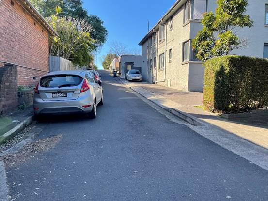
Figure 1 - Meeks Lane, Marrickville
![]()
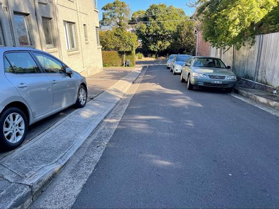
Figure 2 - Meeks Lane Marrickville
When motorists park in the manner shown in Figures 1 and 2, access to Meeks Lane from the opposing rear driveway of no.133 Meeks Road is restricted as vehicles require the full length of the laneway to enter and exit.
Furthermore, given the narrow width of the laneway (4.3 metres) parking on one-side of the laneway reduces the through lane width to approximately 2.3 metres, and less than the desirable 2.8-3 metres minimum needed for a typical service vehicle.
Accordingly, a ‘No Parking’ restriction is considered at locations where motorists may park along the western kerb and proposed to commence 10 metres from the kerb line of Meeks Road and terminate at the property boundary between no. 376 and no. 378 Victoria Road. A ‘No Stopping’ restriction is proposed adjacent to the ‘No Parking’ restriction to ensure compliance with the NSW Road Rules. This consultation plan is shown in Attachment 1.
PUBLIC CONSULTATION
Council consulted on the proposal with affected residents. There were 39 letters sent with 10 responses supporting and two (2) responses opposing the proposal.
|
Resident comments |
Officer comments |
|
The responses supporting the proposal noted the need for ‘No Parking’ and ‘No Stopping’ restrictions as motorists parking on the northern side of Meeks Lane are affecting access into the laneway from Meeks Road and access to opposing rear-lane driveways.
|
Noted. |
|
A response opposing the proposal noted that these restrictions will reduce limited parking spaces needed for resident on Meeks Road as parking spaces are occupied by workers during the day and affect households who need to park close to their homes who do not have off-street parking. The response noted there is sufficient access for households to enter and exit their driveways when cars are parked opposite. The response requested for a reduction in the ‘No Parking restriction to not include the kerb opposite no. 133 Meeks Road where the parallel parking spaces are located.
The response noted that drivers should be able to navigate laneways as is part of living in the Inner West/Inner City, and that If people require more space they should live in a more suburban area further away from the city.
|
Households who do not have off-street parking can request for Council to investigate the installation of permit parking restrictions outside or near their homes to assist with finding a parking space near their residence, should parking opportunities be affected by external parking demands. It is understood this street block on Meeks Road does not have off-street parking and there are no current permit parking restrictions along their property frontage.
It is recommended that this approach be taken over the current use of the northern side of Meeks Lane as a parking area which is affecting other residents. Given the narrow width of Meek Lane, through access can be affected as well as access to the opposite parking spaces. |
|
A response requested that the ‘No Parking’ restriction terminate at the rear of the property boundary of no.378 and no.380 Victoria Road, as the sometimes needs to use the rear access for dropping off and picking up of goods. They advised of a mobility impairment and that the 2-minute time limit with ‘No Parking’ restrictions is insufficient. |
Given this household does not use the Meeks Lane for long-term parking, and they have a mobility impairment, consideration should be given to not allocate the ‘No Parking’ restriction to the kerb space (retain the existing) at the rear of their property to allow for them to drop-off and pick-up goods.
The ’No Parking’ restriction has been amended to terminate along the kerb space at the property boundary of no. 380 and no.378 Victoria Road.
However, should the existing parking issues transfer further up along the laneway to this short section of kerb, Council engineer’s may need to consider extending the ‘No Parking’ restriction to the property boundary of no.376 and no.378 Victoria Road. |
FINANCIAL IMPLICATIONS
The of installation of the parking restrictions as recommended will be funded within Council’s operational signs and line marking budget.
|
1.⇩ |
Consultation plan |
|
2.⇩ |
Revised (final) proposal |
|
|
Local Traffic Committee Meeting 21 October 2024 |
Subject: Hutchinson Street, St Peters - Proposed 15-minute timed parking restrictions (Marrickville-Midjuburi Ward/Heffron Electorate/Inner West PAC)
Prepared By: James Nguyen - Traffic Engineer
Authorised By: Manod Wickramasinghe - Traffic and Transport Planning Manager
|
RECOMMENDATION
That the proposed timed parking space (5.1m) signposted as ‘P15 minute 7am-5pm Mon-Fri; 7am-12.30pm Sat’ on the northern side of Hutchinson Street as shown in Attachment 1 be approved.
|
STRATEGIC OBJECTIVE
This report supports the following strategic directions contained within Council’s Community Strategic Plan:
|
2: Liveable, connected neighbourhoods and transport |
|
|
EXECUTIVE SUMMARY
This report outlines parking issues in Hutchinson Street, St Peters and proposes 15-minute timed parking restrictions to provide short-term parking opportunities for nearby businesses.
BACKGROUND
Council has received a request for 15-minute timed parking restrictions outside no 35-37 Hutchinson Street, St Peters to provide short-term parking opportunities for nearby businesses.
DISCUSSION
Hutchinson Street is approximately 5.6 metres wide and one-way eastbound. There are existing timed parking restrictions, loading zones and timed no parking restrictions on the northern side which provides various parking options to support residents and businesses. The southern side of Hutchinson Street is signposted as ‘No Parking’ to allow for drop-off and pick-up, and through access. These restrictions are shown in Figure 1 below:
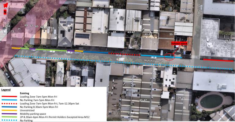
Figure 1 - Existing parking restrictions - Hutchinson Street, St Peters
Currently, there are no existing short-term parking options for nearby businesses, with the shortest timed parking restriction to be the two-hour limit between no. 55 and no. 71. The existing ‘No Parking 7am-5pm Mon-Fri’ restriction outside businesses permits motorists two-minutes to drop-off and pick-up and an unviable option for short-term parking.
Accordingly, Council officers have received a request by businesses to consider short-term parking on Hutchinson Street where practical.
The existing ‘No Parking 7am-5pm Mon-Fri’ restriction on the northern side of Hutchinson Street, between no.35-37 and no.41-53 was installed to enable larger truck and trailers for trucks of no.45-47 Applebee Street to exit the driveway. However, this business is no longer operating from this building and there are now new building occupants.
Council officer’s requested feedback from the new building occupiers to obtain the largest sized vehicle that exits the driveway to complete a swept path assessment and determine whether timed parking restrictions can be considered on the northern side of Hutchinson Street outside no. 35-37. Council has been advised by the building users that the largest sized vehicle exiting the driveway is an 8-metre-long vehicle.
Accordingly, a swept path assessment was completed for an 8.8-metre-long service vehicle with acceptable clearances provided with one (1) timed parking restriction outside no.35-37 Hutchinson Street.
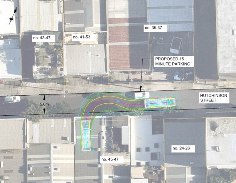
Figure 2 - Swept path - 8.8-metre service vehicle
Based on this swept path assessment, Council officer’s developed a proposal to reallocate some of the existing ‘No Parking 7am-5pm Mon-Fri’ to short-term timed parking. Businesses requesting for the timed parking restriction had provided feedback to consider timed operation during business hours and on partial restrictions on weekends. This is shown in Figure 3 below.
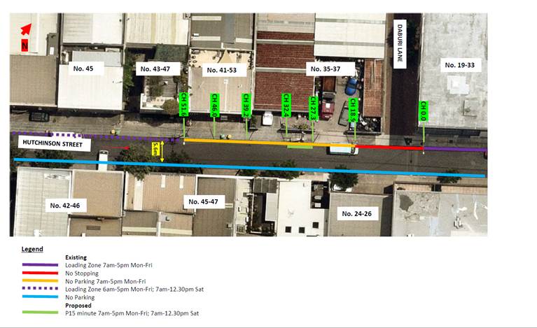
Figure 3 - Proposed parking changes
To consider business operating hours and ensure consistency with the adjacent ‘No Parking 7am-5pm Mon-Fri’ restrictions, it is proposed to reallocate a short section of kerb (5.1 metres) to time restricted parking signposted as ‘P15 minute 7am-5pm Mon-Fri; 7am-12.30pm Sat’.
This proposal provides an additional short-term timed parking option in conjunction with the nearby two-hour timed parking restrictions, loading zones and no parking zones as shown in Figure 1.
PUBLIC CONSULTATION
Council consulted with affected businesses and residents. Two (2) responses supporting, two (2) responses opposing, and two (2) responses undecided on the proposal. The community consultation responses are presented in Table 1 below:
|
Resident/business response |
Officer response |
|
Supportive of the proposal, suggest to increase the time limit to 1 hour or P30 as 15 minute is too short |
Given the limited number of spaces that are being reallocated (1 space), a one (1) hour time limit may not be appropriate. The proposed 15-minute time limit provides a higher turnover rate to support businesses. However, if it is found that 15-minutes may not be sufficient, consideration can be given to extending the time limit to P30 minute in the future. In addition there is two-hour timed permit parking restrictions between no. 57 and no. 71 for those who require longer timed parking. |
|
Not support due to limited parking on Hutchinson Street which will further limit parking space |
The proposal (P15 minute 7am-5pm Mon-Fri; 7am-12.30pm Sat) gains one parking space on Hutchinson Street as the current parking restriction is ‘No Parking 7am-5pm Mon-Fri. It is noted that the unrestricted hours between 7am-12.30pm Sat will be affected by this proposal, however there are adjacent parking spaces that are already unrestricted for parking on weekends. The time restriction on the Saturday morning seeks to support short-term parking needs for businesses that may be open. |
|
Not support – trucks exiting 45-47 Applebee Street will not be able to turn out of the driveway – leave parking as it is |
Council has been advised by the building strata/occupiers that the largest vehicle exiting the driveway of no.45-47 Applebee Street is an 8-metre-long vehicle. The swept path assessment completed (shown in Figure 2) suggests an 8.8-metre-long vehicle can clear a vehicle parked on the northern side where the P15 timed parking is proposed. |
FINANCIAL IMPLICATIONS
The of installation of the parking restrictions as recommended will be funded within Council’s operational signs and line marking budget.
|
1.⇩ |
Parking plan |
|
|
Local Traffic Committee Meeting 21 October 2024 |
Subject: Temporary speed reductions to 40 km/h for Southwest Link
Prepared By: Ken Welsh - Coordinator Strategic Transport Planning
Authorised By: Manod Wickramasinghe - Traffic and Transport Planning Manager
|
RECOMMENDATION
That it be noted that TfNSW will be implementing Traffic Guidance Schemes (TGS) to support the delivery of temporary speed zone reductions for the Southwest Link as outlined in the report.
|
STRATEGIC OBJECTIVE
This report supports the following strategic directions contained within Council’s Community Strategic Plan:
|
2: Liveable, connected neighbourhoods and transport |
|
|
EXECUTIVE SUMMARY
During the 12-month closure of the T3 line (Sydenham to Bankstown), rail replacement Southwest Link bus services are expected to carry 56,000 (and up to 72,000) passengers a day, with the majority of passengers expected to transfer at Sydenham Station to access Metro and Train services to and from the CBD.
Temporary bus stops are being established at each station from Sydenham to Bankstown, resulting in a significant increase in pedestrian activity and footpath use.
As part of the Sydney Metro City & Southwest project, Transport for NSW is introducing temporary speed reductions at key locations to support safer streets around Southwest Link bus stops, cycling routes and to reduce noise impact on residents from replacement buses.
To support the temporary speed reductions in the Inner West Council area, Transport for NSW have procured traffic guidance schemes for the delivery of these changes.
BACKGROUND
Proposed Scope Details
· Introduce the temporary reductions for the full extent of the Southwest Link period, expected to be 12 months.
· The temporary changes will be reviewed throughout the project and can be adjusted as needed.
· Traffic counts to be collected throughout the temporary period to allow for evaluation and future decision-making.
Proposed changes
The following locations have had traffic guidance schemes developed and are proposed to be reduced to 40km/h. Please see attached traffic guidance scheme for details.
Local Roads:
1. Garnett St, between Floss St and Tennent Pde (Council Boundary)
2. Ness Ave, between Garnett St and Tennyson St
3. Tennyson St, between Ness Ave and Riverside Cres
4. Riverside Cres, between Tennyson St and Wardell Rd
5. Albermarle St, between Kays Avenue E (shared path) and Livingstone Rd
6. Moncur St, between Livingstone Rd and Moyes St
7. Jersey St, between Livingstone Rd and Moyes St
8. Moyes St, between Jersey Street and Moncur St
9. Warburton St, between Moyes St and Illawarra Rd
10. Lower Railway Pde between Marrickville Rd and Sydenham Rd
11. Gleeson Ave, between Railway Pde and Burrows Ave
12. Burrows Ave, between Railway Rd and Gleeson Ave
13. Hill Road, between Illawarra Road and Livingstone Road
14. Carrington Road, between Richardsons Cres and Premier St, Marrickville
State & Regional Roads:
1. Wardell Rd, between Lang Rd and Pine St
2. Illawarra Rd, between Harnett Ave and Marrickville Rd
3. Marrickville Rd, between Meeks Rd and Railway Pde
4. Buckley St, between Marrickville Rd and Sydenham Rd
5. Railway Pde, between and Marrickville Rd and Sydenham
6. Railway Rd, between Burrows Ave and Gleeson Ave
![]() Proposed Temporary Speed Reduction Areas
Proposed Temporary Speed Reduction Areas
DISCUSSION
Transport for NSW have procured the traffic guidance schemes, planning and design work to determine the delivery of temporary speed reductions to support the Temporary Transport Plan. This has involved working with Inner West Council officers to explore options and seek input on suitable tactical improvements.
Temporary Speed Reductions will be co-located with Southwest Link Bus Stops to improve pedestrian safety outcomes during the Temporary Transport Plan. Other temporary speed reductions are designed to create a safer environment for using the Southwest Link riding routes in the Inner West. Additionally, a temporary speed reduction is proposed for Hill Street, Marrickville to reduce noise output from replacement buses and improve comfort for local residents.
The following benefits of the proposal are noted:
· Pedestrian and Cycling
o Speed reduction of roads adjacent to the SWL bus stops is required for pedestrian safety. There will be a significant increase in pedestrian activity and footpath use due to the temporary bus stops, increasing the risk of collision between pedestrians and vehicles.
o Encouraging cycling is a key aspect of the Southwest Link integrated transport plan. Where cyclists are proposed to ride on road, 40 km/h speed limits are required to improve safety outcomes.
o Offer opportunities for people to build their skills, confidence and desire to ride and walk more during the T3 Bankstown Line conversion period.
· Motorist Safety
o Increase in regular buses stopping is an additional hazard for motorists, with reduced speeds mitigating risk of collision.
o The temporary 40 km/h zone will allow for buses to pull out into traffic more easily improving operations.
o Further, the temporary 40 km/h zones will ensure that motorists are not overtaking buses at a dangerous speed, complying with the law that a driver must not overtake or pass a bus with flashing lights at more than 40km/h.
· Bus movements
o Southwest Link operations introduce a temporary bus layover facility on Lower Railway Parade, adjacent to Sydenham Station. Investigations have shown that there is a safety issue in this area relating to the sight distance available for buses exiting the layover area onto Sydenham Rd to access the Railway Parade bus stops. A decrease in the speed limit for traffic approaching this intersection will contribute to a significant reduction in the probability of an incident occurring.
· Noise mitigation
o Residents at Hill Street, Marrickville have raised concerns regarding the SWL buses route. A noise and vibration report was undertaken to assess the impacts of TTP buses. One of the recommendations out of this report to mitigate noise and vibration impacts to residents, was to reduce the speed limit to 40 km/h
FINANCIAL IMPLICATIONS
The cost of the work will be absorbed by Transport for NSW.
Transport for NSW will work with IWC to retain assets and signage as suitable should permanent 40 km/h zones need to be considered before the completion of the temporary speed zone reductions as part of innerWest@40. Discussions regarding transfer of assets to IWC would then be undertaken as appropriate.
|
1.⇩ |
Traffic Guidance System - Temporary Speed Reductions |