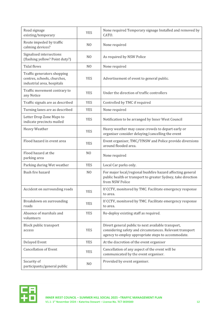
|
AGENDA R |

Local Traffic Committee Meeting
MONDAY 18 NOVEMBER 2024
11:00 AM
|
|
Local Traffic Committee Meeting 18 November 2024 |
Function of the Local Traffic Committee
Background
Roads and Maritime Services (RMS) is legislated as the Authority responsible for the control of traffic on all NSW Roads. The RMS has delegated certain aspects of the control of traffic on local roads to councils. To exercise this delegation, councils must establish a local traffic committee and obtain the advice of the RMS and Police. The Inner West Council Local Traffic Committee has been constituted by Council as a result of the delegation granted by the RMS pursuant to Section 50 of the Transport Administration Act 1988.
Role of the Committee
The Local Traffic Committee is primarily a technical review and advisory committee which considers the technical merits of proposals and ensures that current technical guidelines are considered. It provides recommendations to Council on traffic and parking control matters and on the provision of traffic control facilities and prescribed traffic control devices for which Council has delegated authority. These matters are dealt with under Part A of the agenda and require Council to consider exercising its delegation.
In addition to its formal role as the Local Traffic Committee, the Committee may also be requested to provide informal traffic engineering advice on traffic matters not requiring Council to exercise its delegated function at that point in time, for example, advice to Council’s Development Assessment Section on traffic generating developments. These matters are dealt with under Part C of the agenda and are for information or advice only and do not require Council to exercise its delegation.
Committee Delegations
The Local Traffic Committee has no decision-making powers. The Council must refer all traffic related matters to the Local Traffic Committee prior to exercising its delegated functions. Matters related to State Roads or functions that have not been delegated to Council must be referred directly to the RMS or relevant organisation.
The Committee provides recommendations to Council. Should Council wish to act contrary to the advice of the Committee or if that advice is not supported unanimously by the Committee members, then the Police or RMS have an opportunity to appeal to the Regional Traffic Committee.
Committee Membership & Voting
Formal voting membership comprises the following:
· one representative of Council as nominated by Council;
· one representative of the NSW Police from each Local Area Command (LAC) within the LGA, being Newtown, Marrickville, Leichhardt and Ashfield LAC’s.
· one representative from the RMS; and
· State Members of Parliament (MP) for the electorates of Summer Hill, Newtown, Heffron, Canterbury, Strathfield and Balmain or their nominees.
Where the Council area is represented by more than one MP or covered by more than one Police LAC, representatives are only permitted to vote on matters which effect their electorate or LAC.
Informal (non-voting) advisors from within Council or external authorities may also attend Committee meetings to provide expert advice.
Committee Chair
Council’s representative will chair the meetings.
Public Participation
Members of the public or other stakeholders may address the Committee on agenda items to be considered by the Committee. The format and number of presentations is at the discretion of the Chairperson and is generally limited to 3 minutes per speaker. Committee debate on agenda items is not open to the public.
|
|
Local Traffic Committee Meeting 18 November 2024 |
|
AGENDA |
1 Apologies
2 Disclosures of Interest
3 Confirmation of Minutes Page
Minutes of 21 October 2024 Local Traffic Committee 5
4 Matters Arising from Council’s Resolution of Minutes
5 Part A – Items Where Council May Exercise Its Delegated Functions
ITEM Page
LTC1124(1) Item 1 Illawarra Road, Wharf Street and Thornley Street, Marrickville – Traffic safety review of streets around Steel Park (Midjuburi-Marrickville Ward /Summer Hill Electorate /Inner West LAC) 32
LTC1124(1) Item 2 Station Street, Marrickville - Proposed bicycle Excepted signage (Midjuburi-Marrickville Ward / Summer Hill Electorate / Inner West PAC) 39
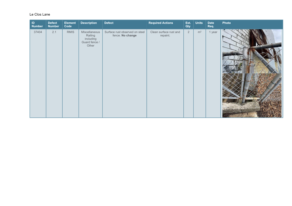
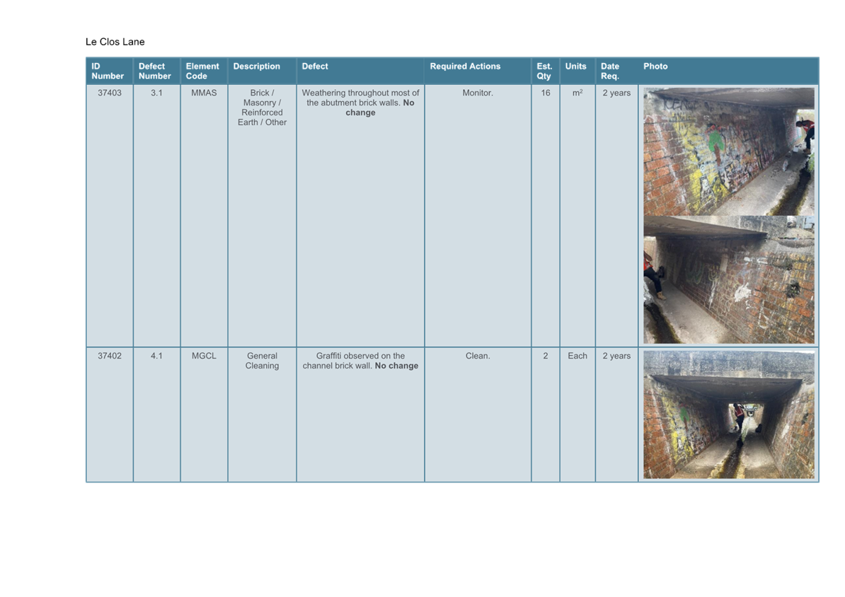
LTC1124(1) Item 3 Le Clos Lane, Marrickville - Proposed 30 Tonne weight limit on the Le Clos Lane Bridge (Midjuburi-Marrickville Ward / Summer Hill Electorate / Inner West PAC) 42
LTC1124(1) Item 4 Illawarra Road at Thornley Street, Marrickville – Proposed raised pedestrian crossing - Design Plan 10304 (Midjuburi-Marrickville Ward / Summer Hill Electorate / Inner West PAC) 80
LTC1124(1) Item 5 Illawarra Road at Warburton Street, Marrickville - Proposed 'Zig Zag' line marking for the pedestrian crossing (Midjuburi-Marrickville Ward / Summer Hill Electorate / Inner West PAC) 85
LTC1124(1) Item 6 St Peters Interchange Active Transport Works - Part 1 (Midjuburi-Marrickville Ward/Heffron Electorate/Inner West PAC) 87
LTC1124(1) Item 7 Abergeldie Street at Arlington Street, Dulwich Hill – Proposed installation of statutory ‘No Stopping’ continuous yellow line marking restrictions at the intersection (Djarrawunang - Ashfield Ward/ Summer Hill Electorate/ Inner West PAC) 103
LTC1124(1) Item 8 Carrington Street, Lilyfield - Construction Traffic Management Plan (Baludarri-Balmain Ward/Balmain Electorate/Leichhardt PAC) 106
LTC1124(1) Item 9 Balmain Road, Lilyfield - Orange Grove Raised Pedestrian Crossing (Baludarri-Balmain Ward/Balmain Electorate/Leichhardt PAC) 145
LTC1124(1) Item 10 Curtis Road, Balmain - Proposed Pedestrian Improvement Works Curtis Road, Balmain - Proposed Pedestrian Improvement Works (Baludarri-Balmain Ward/Balmain Electorate/Leichhardt PAC) 150
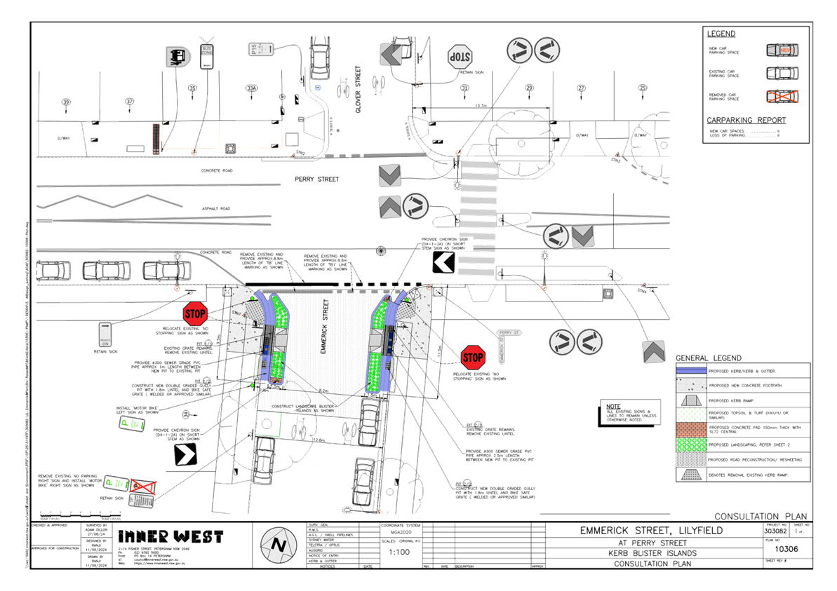
LTC1124(1) Item 11 Emmerick Street, Lilyfield - Proposed New Kerb Blister (Baludarri-Balmain Ward/Balmain Electorate/Leichhardt PAC) 159
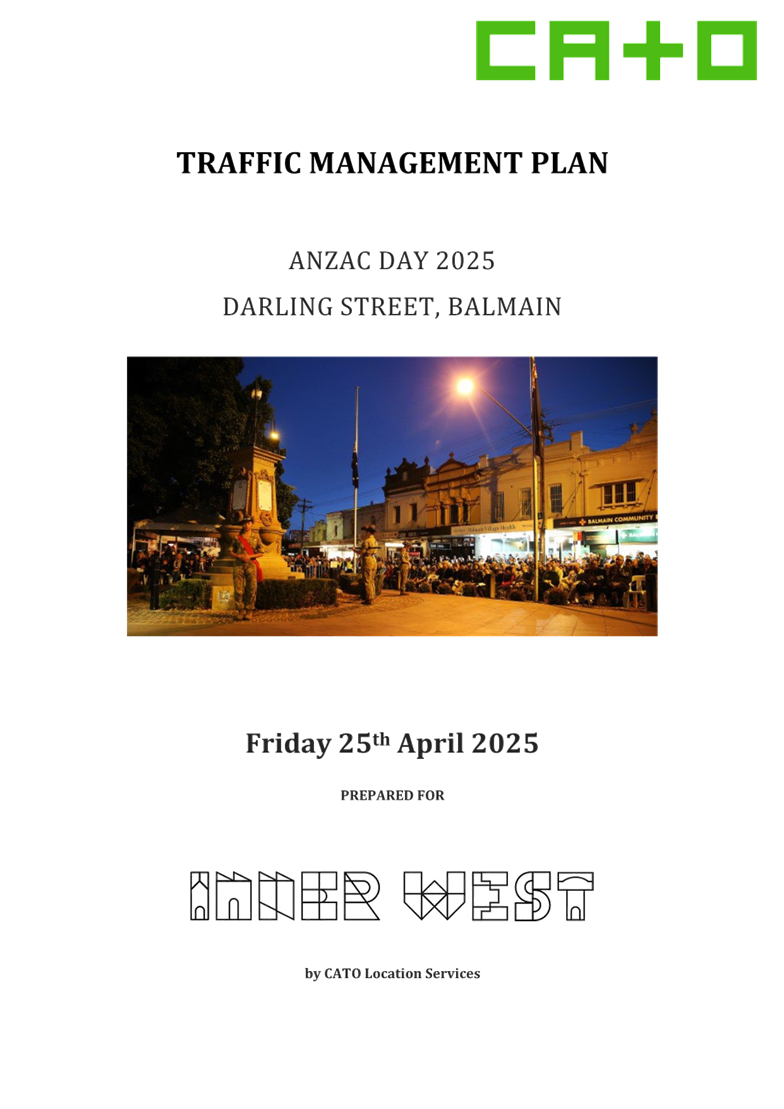
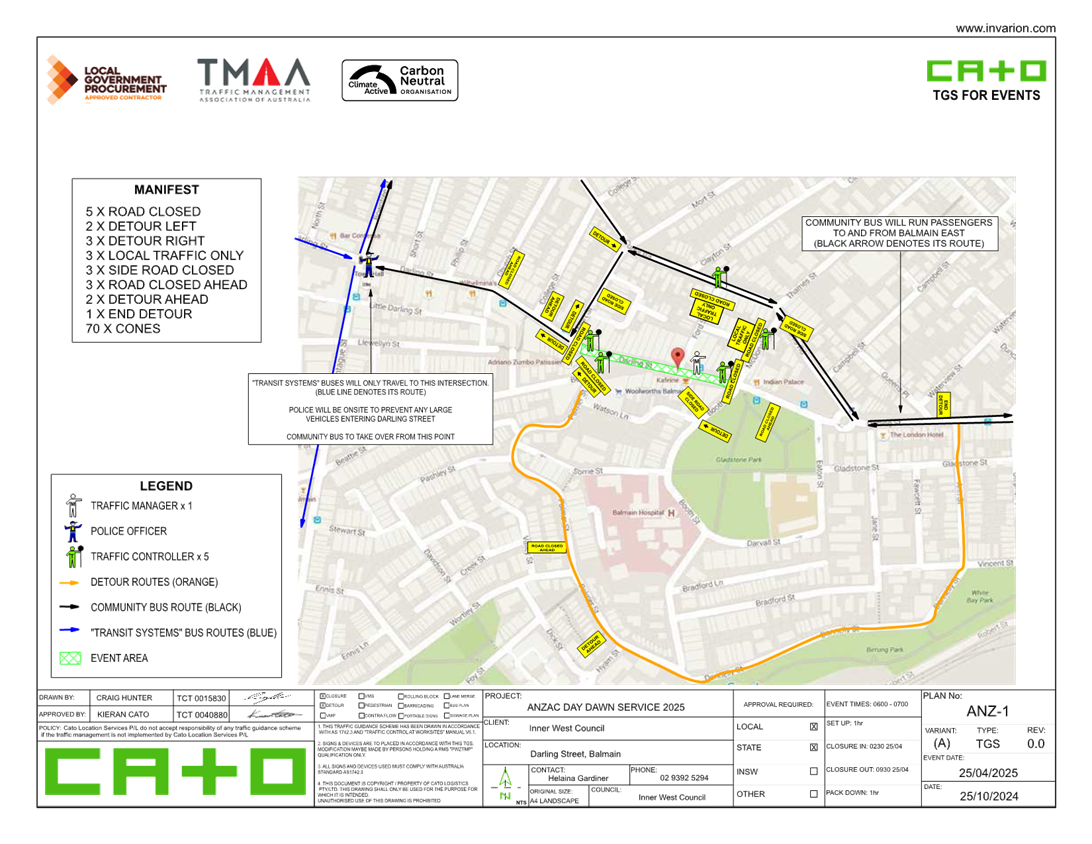
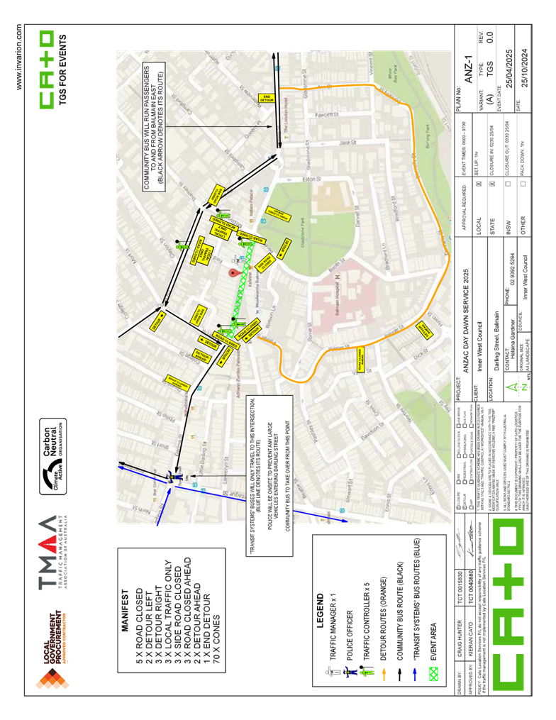
LTC1124(1) Item 12 Darling Street Between Mort Street and Booth Street, Balmain - Road Occupancy - Anzac Day Dawn Service (Baludarri - Balmain Ward/ Balmain Electorate/ Leichhardt PAC) 162
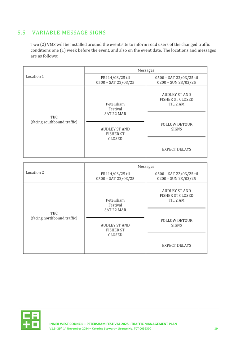
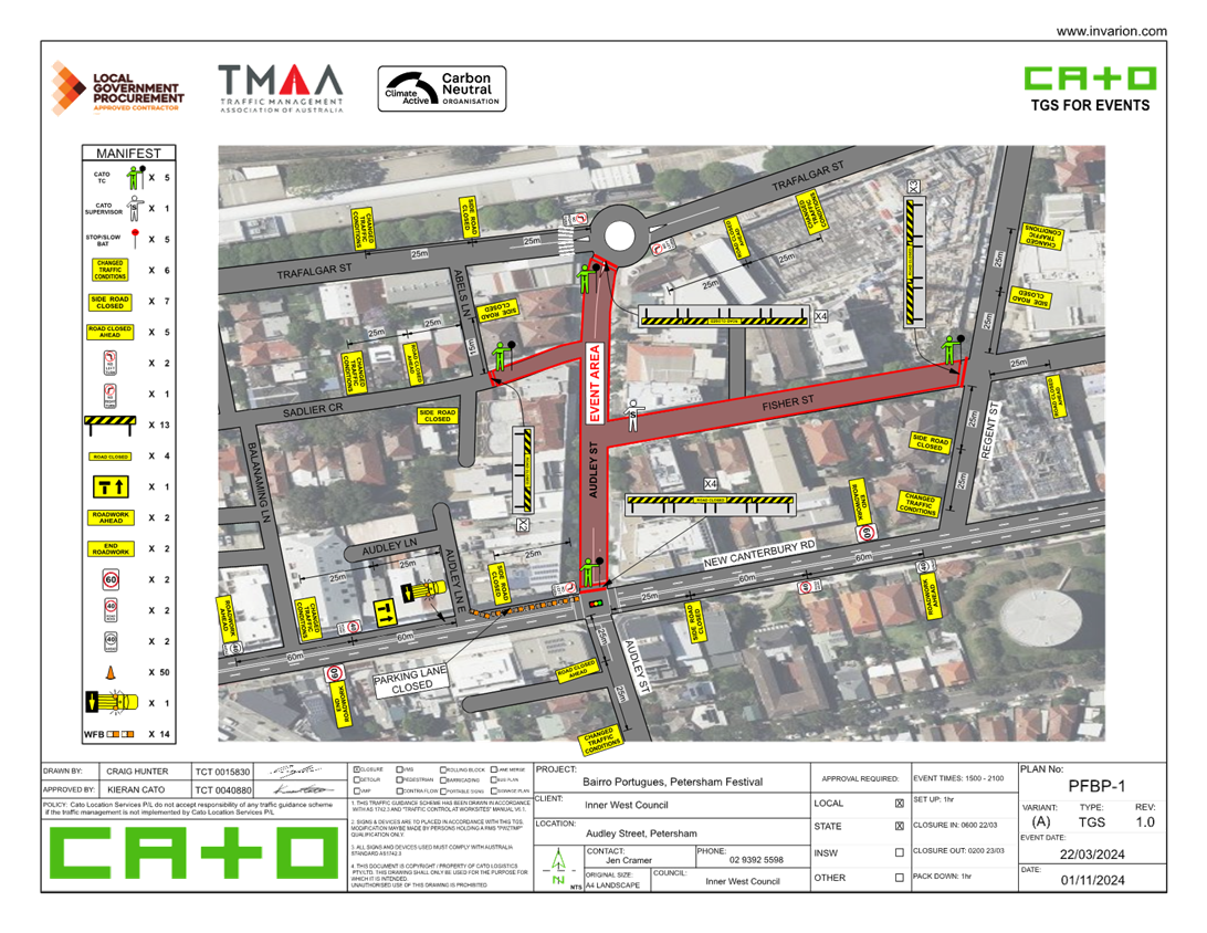
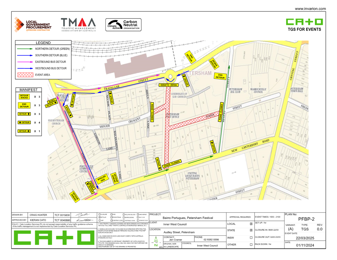
LTC1124(1) Item 13 Audley Street, Audley Lane, Sadlier Crescent, Fisher Street, and eastbound parking lanes on New Canterbury Road Petersham – Temporary Full Road Closures For Special Event On Saturday 22 March 2025 – Petersham Festival Bairro Portuguese (Damum - Stanmore Ward / Newtown Electorate / Inner West PAC) 187
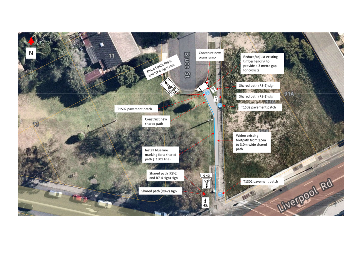
LTC1124(1) Item 14 Bruce Street, Ashfield - Proposed 'shared path' (Djarrawunang-Ashfield Ward/Summer Hill Electorate/Burwood PAC) 220
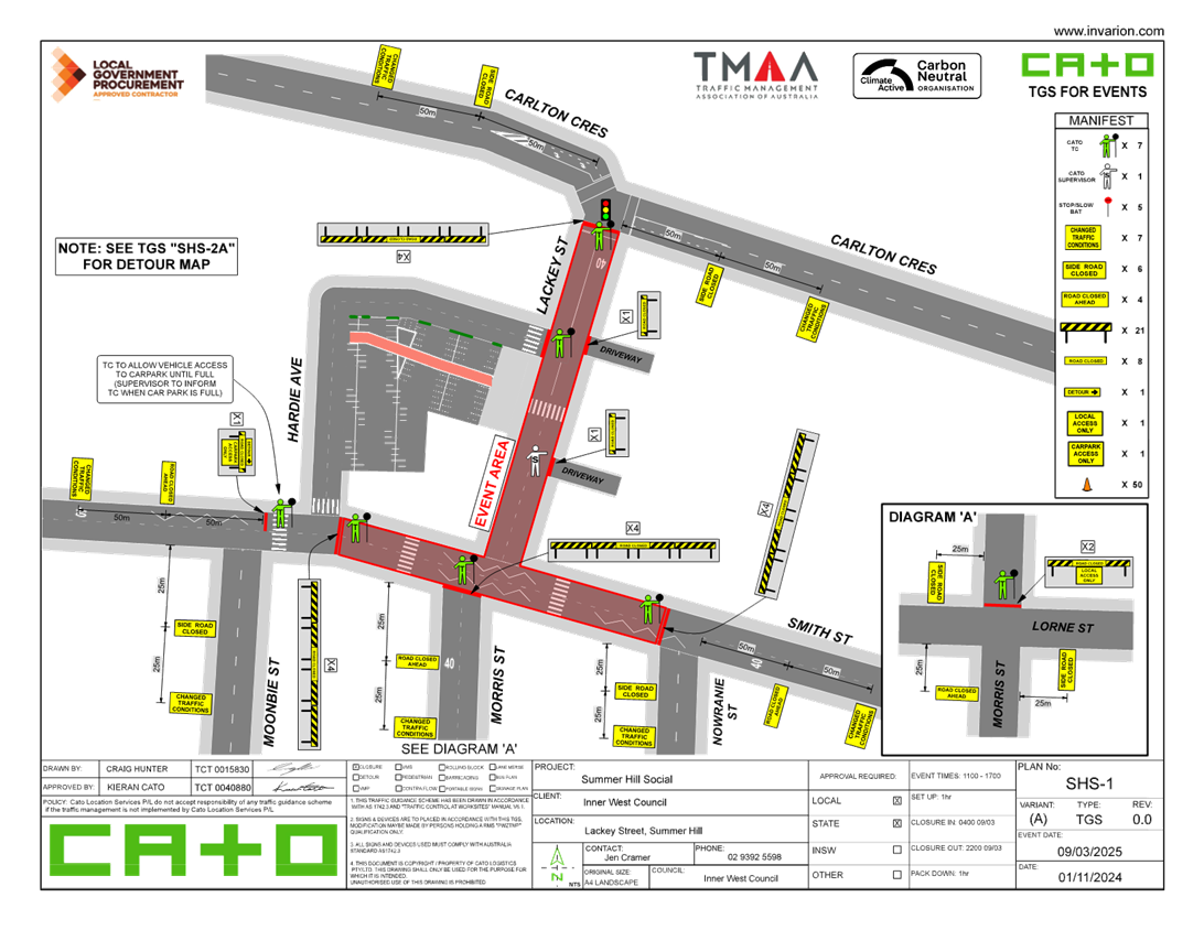
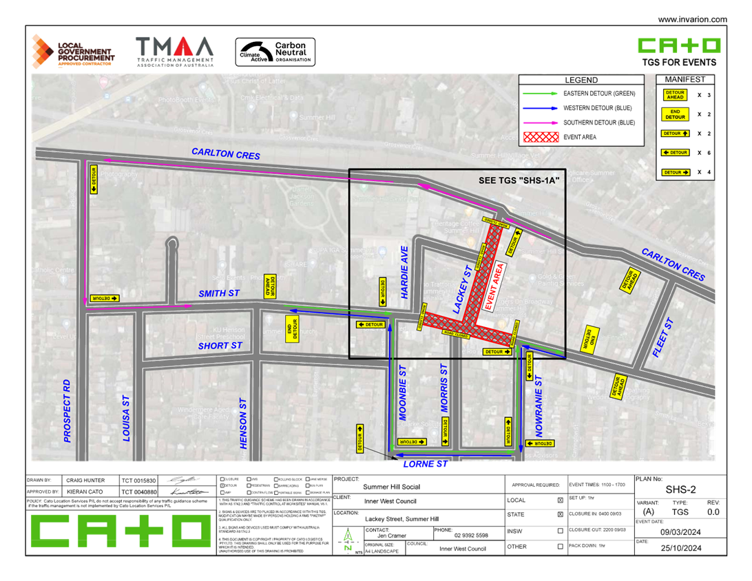
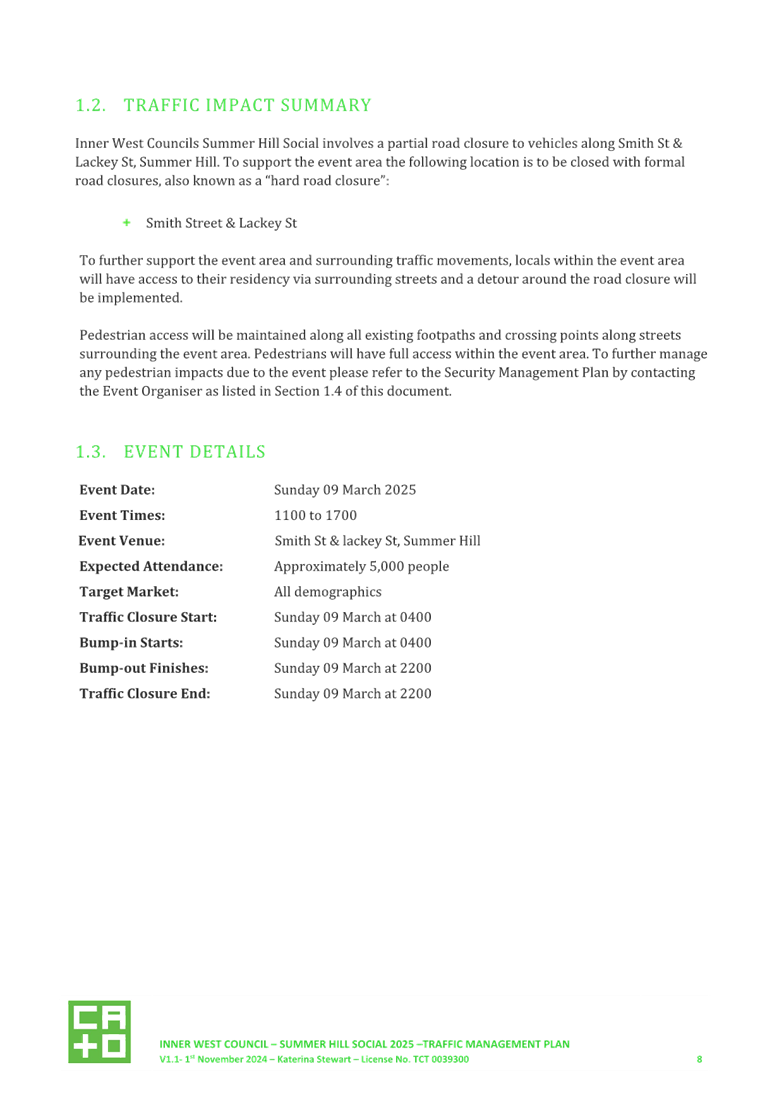
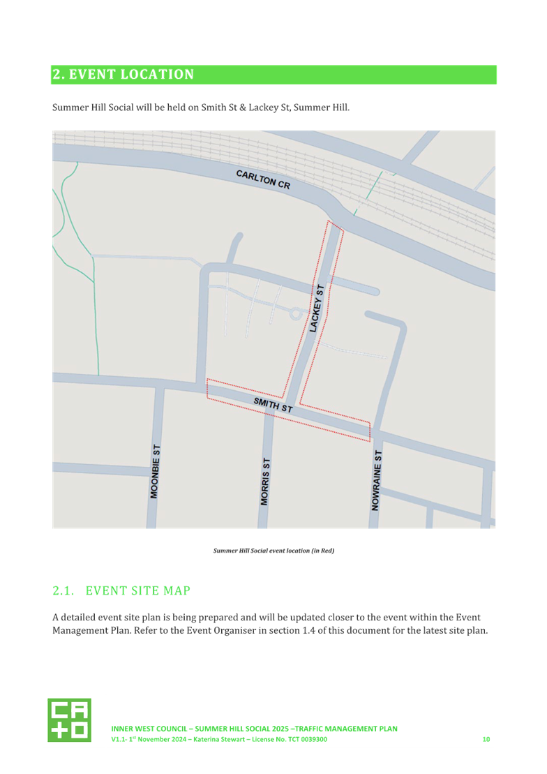
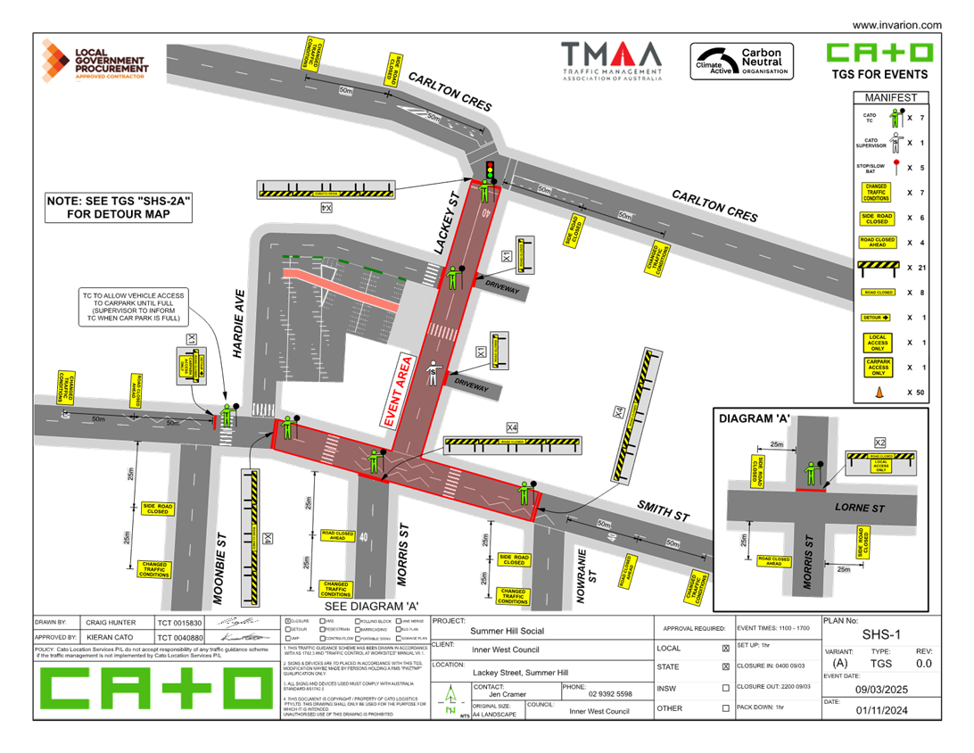
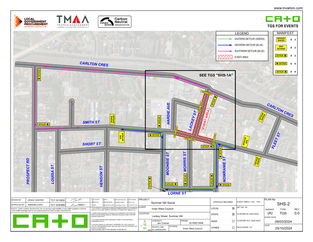
LTC1124(1) Item 15 Lackey Street & Smith Street (between Moonbie Street and Nowranie Street), Summer Hill-ENRC/2024/0062 Temporary Full Road Closure- 'Summer Hill Social' event on Sunday 9 March 2025 (Djarrawunang-Ashfield Ward/Summer Hill Electorate/Burwood PAC) 223
Parking Matters
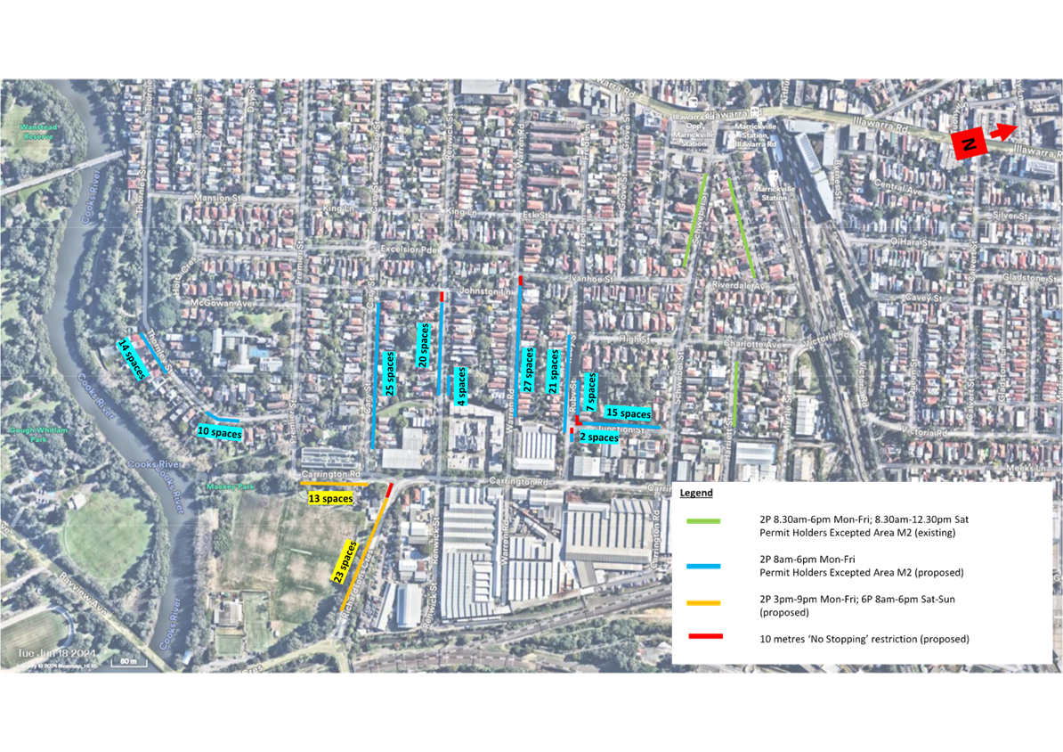
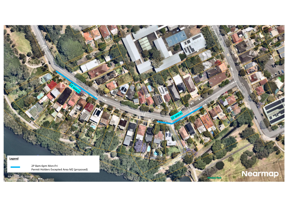
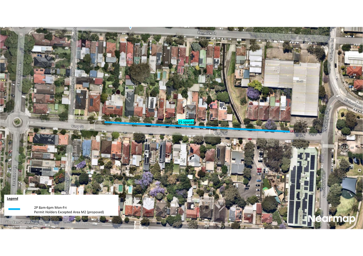
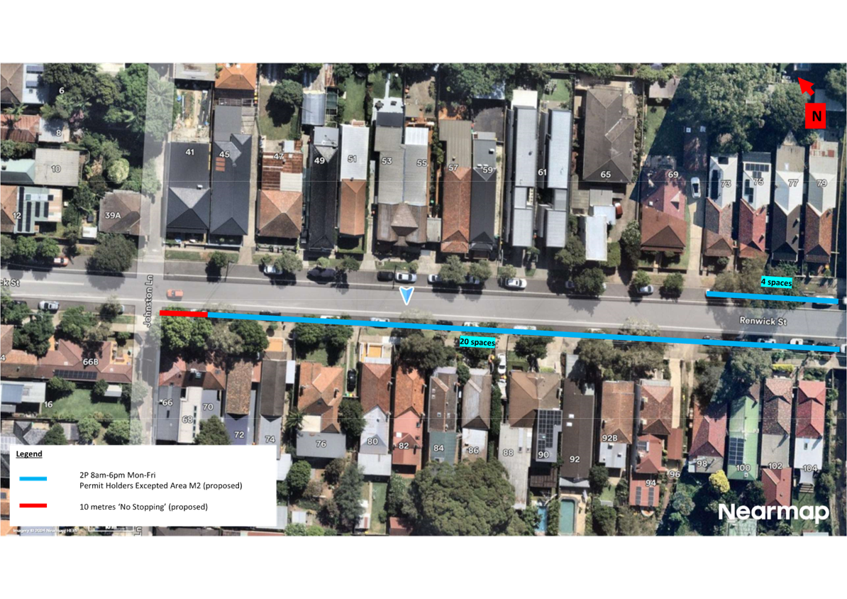
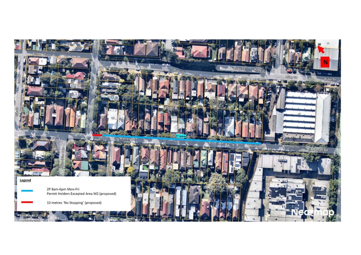
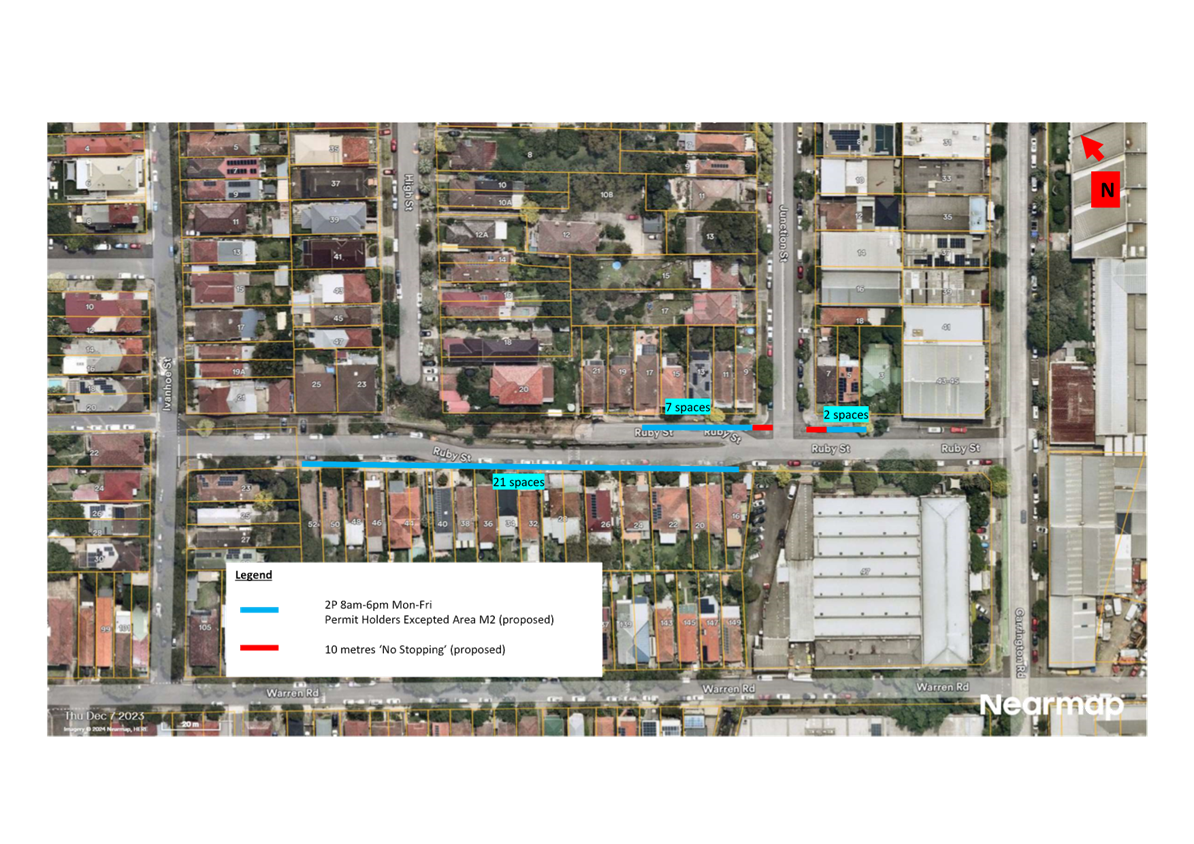
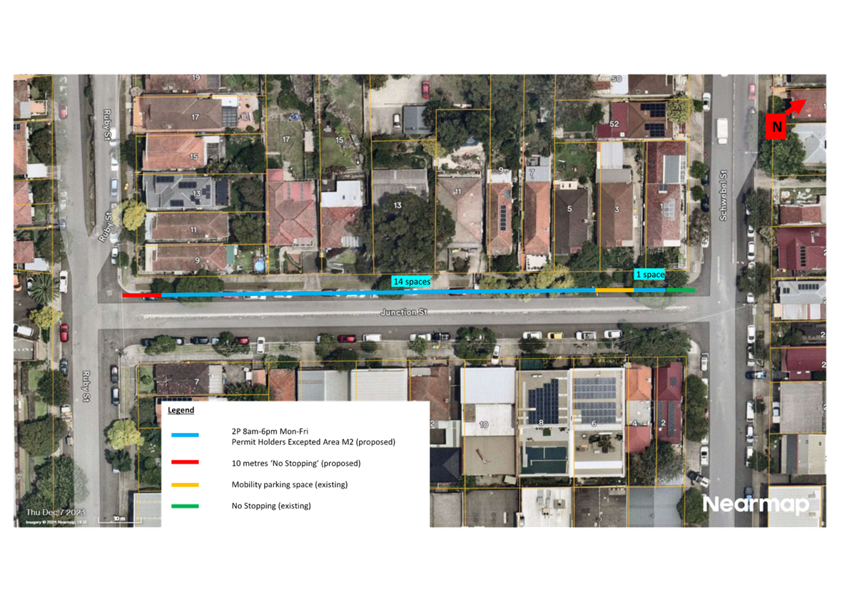
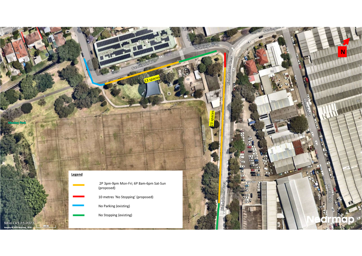
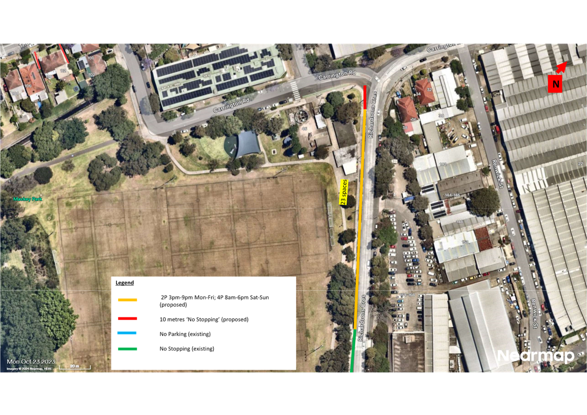
LTC1124(1) Item 16 Mackey Park and Carrington Road Survey Area, Marrickville - Request for extension of M2 Residential Parking Scheme - Resident Parking Questionnaire Survey Results (Midjuburi-Marrickville Ward/Summer Hill Electorate/Inner West PAC) 252
LTC1124(1) Item 17 Tempe Reserve - Parking Study (Midjuburi-Marrickville Ward/Heffron Electorate/Inner West PAC) 280
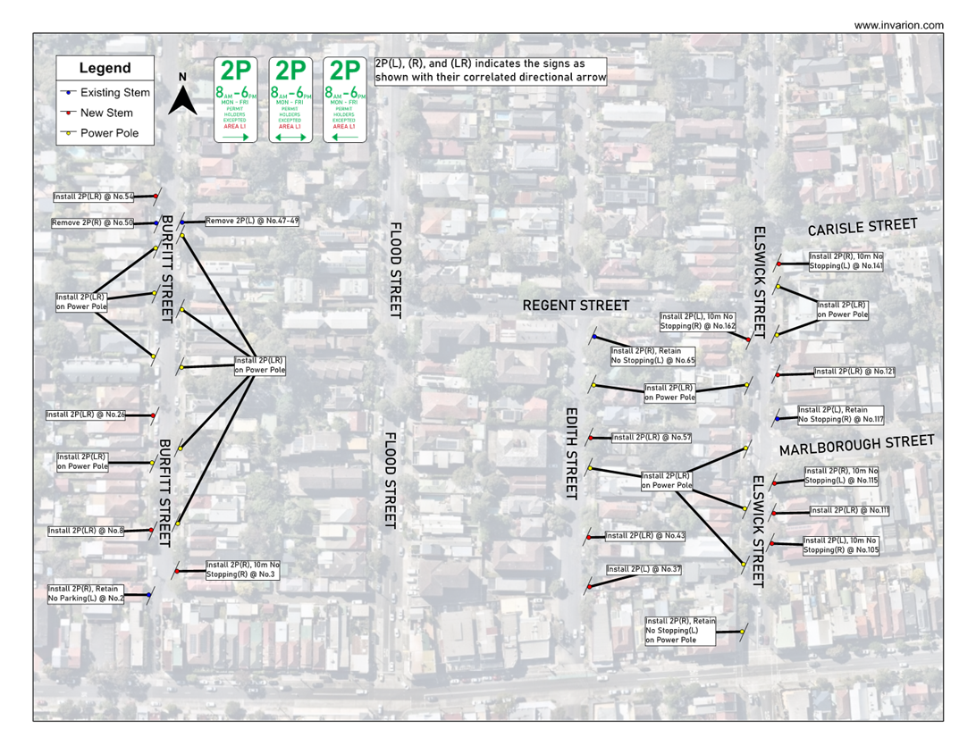
LTC1124(1) Item 18 Leichhardt West - Proposed Residential Parking Scheme Expansion (Baludarri-Balmain Ward/Balmain Electorate/Leichhardt PAC) 283
Late Items
Nil at time of printing.
6 Part B - Items for Information Only
ITEM Page
LTC1124(1) Item 19 Traffic Committee Schedule 2025 289
7 Part C - Items for General Advice
Nil at the time of printing.
8 General Business
9 Close of Meeting
|
|
Local Traffic Committee Meeting 18 November 2024 |
Minutes of Meeting held on 21 October 2024
Meeting commenced at 11:01 AM
ACKNOWLEDGEMENT OF COUNTRY BY CHAIRPERSON
I acknowledge the Gadigal and Wangal people of the Eora nation on whose country we are meeting today, and their elders past and present.
COMMITTEE REPRESENTATIVES PRESENT
|
Manod Wickramasinghe |
IWC’s Traffic and Transport Planning Manager (Chair) |
|
Graeme McKay |
Representative for Jo Haylen MP, Member for Summer Hill |
|
Eleanor Nurse |
Representative for Jenny Leong MP, Member for Newtown |
|
Sgt Charles Buttrose |
NSW Police – Leichhardt Police Area Command |
|
Nina Fard |
Transport for NSW (TfNSW) |
|
|
|
|
NON VOTING MEMBERS IN ATTENDANCE |
|
|
|
|
|
Shannon Burns |
NSW Police – Leichhardt Police Area Command |
|
Colin Jones |
Representative for the Inner West Bicycle Coalition (IWBC) |
|
Michael Takla |
Representative for Transit Systems |
|
Sunny Jo |
IWC’s Coordinator Traffic Engineering Services (North) |
|
George Tsaprounis |
IWC’s Coordinator Traffic Engineering Services (South) |
|
Jason Scoufis |
IWC’s Coordinator Traffic Studies & Road Safety |
|
Ken Welsh |
IWC’s Coordinator Strategic Transport Planning |
|
James Nguyen |
IWC’s Traffic Engineer |
|
Christy Li |
IWC’s Business Administration Officer |
|
|
|
|
VISITORS |
|
|
|
|
|
Adrian King |
Resident (Item 5) |
|
David Benham |
Resident (Item 11) |
|
Brendan Jones |
Resident (Item 11) |
|
Barry Ireland |
Resident (Item 11) |
|
Benjamin Borger |
Transport for NSW (TfNSW) (Item 15) |
|
|
|
|
APOLOGIES: |
|
|
|
|
|
Bill Holliday |
Representative for Kobi Shetty MP, Member for Balmain |
|
|
|
DISCLOSURES OF INTERESTS:
Nil.
CONFIRMATION OF MINUTES
|
That the Minutes of the Local Traffic Committee held on Monday, 16 September 2024 be confirmed. |
MATTERS ARISING FROM COUNCIL’S RESOLUTION OF MINUTES
Nil.
|
LTC1024(1) Item 7 Church Street, Ashfield, between Knocklayde Street and Alt Street-Proposed Raised Thresholds & Kerb Blister Islands (Traffic Calming)(Gulgadya-Leichhardt Ward/Summer Hill Electorate/Burwood PAC). |
|
SUMMARY
Council is planning to provide traffic calming measures to improve safety in Church Street, Ashfield by constructing new raised thresholds & landscaped kerb blisters along Church Street near Knocklayde St, Goenka St, Tawa St & Taringa Lane. The traffic calming proposal aims to slow traffic & improve road safety in this part of Church Street and helps address concerns relating to pedestrian safety and driver behaviour.
Officers Recommendation:
That the amended detailed design plans (10284-A) sheets 1-4 to propose raised concrete thresholds and kerb blister islands with associated line and marking in Church Street, Ashfield, between Knocklayde Street and Alt Street, as shown in Attachment 1 be approved.
DISCUSSION:
The Committee members agreed with the Officer’s recommendation.
COMMITTEE RECOMMENDATION:
That the amended detailed design plans (10284-A) sheets 1-4 to propose raised concrete thresholds and kerb blister islands with associated line and marking in Church Street, Ashfield, between Knocklayde Street and Alt Street, as shown in Attachment 1 be approved.
For Motion: Unanimous |
General Business:
|
Item 16: Review of Mobility Parking near Henson Park for the upcoming AFLW events |
|
The Representative for the Member for Summer Hill requested a review of Mobility Parking near Henson Park for the upcoming AFLW events. Council Officers advised they will take the request on notice and will look into discussing the possibility of putting aside spaces for mobility parking with the event organisers. It was noted that such request will need to be investigated and incorporated into the Traffic Management Plan. |
Meeting closed at 12.55 pm.
CHAIRPERSON
Manod Wickramasinghe
Appendix 1  – Item 2 Traffic Management Plan for the 2024 New Year's Eve
Event
– Item 2 Traffic Management Plan for the 2024 New Year's Eve
Event
 Appendix
2 - Item 2 Traffic Management Plan for the 2024 New Year's Eve Event
Appendix
2 - Item 2 Traffic Management Plan for the 2024 New Year's Eve Event
 Appendix
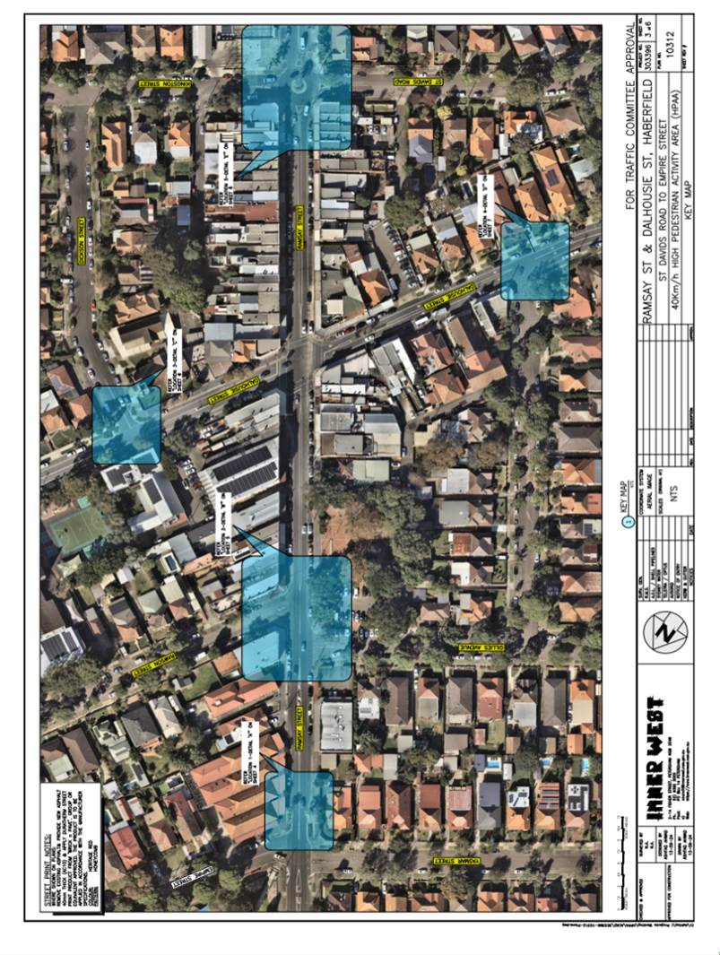
3 – Item 8 Ramsay Street & Dalhousie Street, Haberfield - 40km/h High
Pedestrian Activity Area (HPAA)
Appendix
3 – Item 8 Ramsay Street & Dalhousie Street, Haberfield - 40km/h High
Pedestrian Activity Area (HPAA)
![]()
![]()
![]()
![]()
![]()
![]()
|
|
Local Traffic Committee Meeting 18 November 2024 |
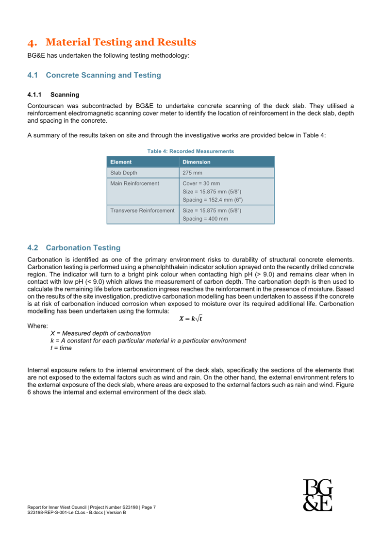
Subject: Illawarra Road, Wharf Street and Thornley Street, Marrickville – Traffic safety review of streets around Steel Park (Midjuburi-Marrickville Ward /Summer Hill Electorate /Inner West LAC)
Prepared By: Jennifer Adams - Traffic Engineer
Authorised By: Manod Wickramasinghe - Traffic and Transport Planning Manager
|
RECOMMENDATION
1. That this report be received and noted.
2. That the following works to be completed in 2024/25 be noted: a) Upgrade of pedestrian crossing on Illawarra Road, immediately west of Thornley Street to a raised crossing facility; and b) Reduction to a 40 km/h speed limit for Thornley Street and other local streets in the Marrickville area as part of the InnerWest@40 project rollout (Area 6 Enmore & Marrickville East; Area 7 Marrickville & Tempe).
3. That Police be requested to undertake regular Police patrols/enforcement of Illawarra road in the vicinity of Steel Park.
|
STRATEGIC OBJECTIVE
This report supports the following strategic directions contained within Council’s Community Strategic Plan:
|
2: Liveable, connected neighbourhoods and transport |
|
|
EXECUTIVE SUMMARY
BACKGROUND
At the Council Meeting held on 25 June 2024, Council resolved the following in part:
2. That Council undertakes an investigation to determine the need for additional traffic calming measures to reduce risk to pedestrians and dogs in the busy area bounded by Thornley and Quarry Streets. The area includes pedestrian entry and exit points adjacent to PCYC car park and the entry and exit of the PCYC / Debbie and Abbey Borgia Centre car park and the Yirran Gumal Early Learning Centre. Council to report the outcome of the investigation to the Local Traffic Committee.
It should be noted that Quarry Street is located in the Tempe area which is some distance away from the facilities mentioned within the NoM. Wharf Street has instead been taken as the boundary as it bounds the facilities stated. This report provides an assessment of whether any additional traffic calming measures are required in the busy area bounded by Thornley and Wharf Streets near Steel Park and also lists recent works completed or planned in the area.
DISCUSSION
Local road network
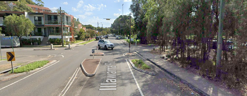
Illawarra Road in the vicinity of Steel Park is a Regional Road that carries around 14,500 vehicles per day. It is a 13.1 metre wide two-way road with one travel lane in each direction, in addition to kerbside parking on both sides. It has a posted speed limit of 50km/h however the 85th percentile speed (ie design speed) is 52.2 km/h. Heavy vehicle volume is around 3%. It is a bus route.
Thornley Street is a local residential street running west-east between Illawarra Road and Premier Street, Marrickville. It provides one travel lane in each direction, in addition to kerbside parking lanes. Parking along the western section is unrestricted. Carriage width at the Illawarra Road end is 8.3 metres. It carries around 700 vehicles per day and the 85th percentile speed (ie design speed) is 41.4km/h.
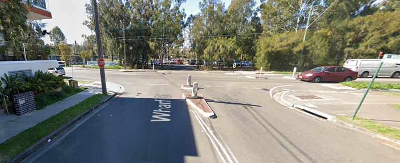
Wharf Street is a two-way local residential street running east-west between Illawarra Road and Beauchamp Street, Marrickville. It has a carriageway width of approximately 13.1 metres, with a small narrow section opposite properties No. 3 to 7 having a width of 7.9 metres. It carries around 1,150 vehicles per day and the 85th percentile speed is 47.8km/h.
On review of the volume data, Illawarra Road being one of the few roads connecting to the Canterbury Bankstown LGA has a volume relatively high of traffic for a regional road, however both Thornley and Wharf Streets have traffic volumes which are relatively low and are typical of local roads. In relation to speed, whilst both local roads are below the posted speed limit, Illawarra Road is slightly higher. Given that Illawarra Road is one of the main routes through the Marrickville area and carries a large volume of traffic, it is not unusual to have a slightly higher 85th percentile speed over the posted speed limit. This can be managed through regular enforcement of the speed limit.
Pedestrian facilities previously constructed or in process of being constructed in locality
In 2005, as part of Council's 2005/2006 Capital Works Program, Council implemented traffic and pedestrian safety measures in Wharf Street, Marrickville. A central pedestrian median island was installed in Wharf Street, Marrickville at the intersection of Illawarra Road to improve pedestrian and traffic safety at this location. In 2012 this pedestrian refuge was upgraded funded by Black Spot funding.
In 2010 Council upgraded the pedestrian refuge island on Illawarra Road at its junction with Wharf Street, Marrickville as part of the refurbishment works in Steel Park. The refurbishment works included construction of a salt marsh, relocation of the cycleway, relocation of the car park and construction of a water play facility. Upgrading the pedestrian refuge to current RTA/TfNSW guidelines was a consent condition so as to provide satisfactory pedestrian access at the intersection of Illawarra Road and Wharf Street.
In 2012 as part of its Traffic Capital Works Program, Council implemented traffic and pedestrian safety measures in Illawarra Road near Wallace Street, Marrickville. A pedestrian refuge island in Illawarra Road just north of Wallace Street was installed to improve pedestrian and traffic safety at this location. Council received funding from the Federal Government as part of the Nation Building Black Spot Funding Program for 2011/12 for this project.
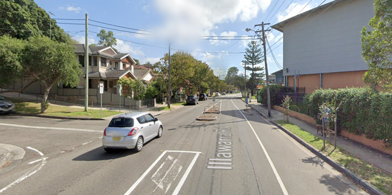
There is currently a pedestrian crossing on Illawarra Road, immediately west of Thornley Street (and adjacent to the Yirran Gumal Early Learning Centre and Debbie and Abbey Borgia Community Recreation Centre). It is an at-grade crossing facility with kerb blisters and a centre refuge island. The facility is well used by the adjacent facilities and by bus patrons as bus stops are present (nearby) on either side of this existing crossing facility.
It is noted that Council is in the process of upgrading this pedestrian crossing on Illawarra Road near Thornley Street to a raised crossing facility. A report went to Local Traffic Committee at its 15 April 2024 meeting (Item 6) recommending that the upgrade of the existing pedestrian (zebra) crossing on Illawarra Road near Thornley Street to a raised crossing facility be approved in principle and that the detail design be bought back to the Traffic Committee for consideration.
A separate report within this agenda details the design plan (Design Plan 10304) for those upgrade works. The proposed works will improve safety of pedestrians at this crossing and addresses community concerns which have been raised.
Pedestrian crossing facilities have been located along Illawarra at or very close to intersections with side streets and also close to entry points into the Steel Park or the Debbie and Abbey Borgia Centre. In this respect, these facilities would attract the highest volume of pedestrian traffic and provide a safe place for pedestrians to cross.
Steel Park
Steel Park is a large recreational area that is home to a Waterplay Park, sports grounds, covered picnic tables with barbecues and a playground featuring slides and swings. The park includes the Debbie & Abbey Borgia Community Recreation Centre, outdoor gyms and access to the Cooks River Cycleway. Steel Park Steel Park is bounded by Thornley Street to the north, residential properties and the Cooks River Foreshore Park to the east, the Cooks River to the south and Illawarra Road to the west.
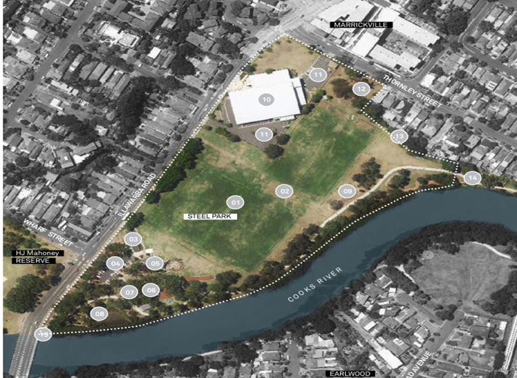
The character of Steel Park is dominated by three major elements; the Debbie and Abbey Borgia Community Recreation Centre (DAB), the sports fields and the river edge with its vegetation and play facilities. The play facilities themselves contribute to the parks character with their high visitation and close proximity to the car park and access points to the park.
The pedestrian pathways within Steel Park are mostly located around the children’s play area, the riverside cycle way and as access paths to the DAB Community Recreation Centre. The pathways are constructed of in situ concrete and vary in width depending on function. The pathways in Steel Park are in good condition.
Steel Park has three car parking areas. One is accessed off Illawarra Road providing car parking for the children’s playground and picnic areas. Another car park adjacent the DAB is accessed off Illawarra Road and is for users of the DAB facility. The third car park is accessed off Thornley Street and is primarily used by users of the DAB facility. All carparks are paved and have good pedestrian access.
1. Debbie and Abbey Borgia Recreation Centre carpark accessed off Illawarra Road, Marrickville. It has approximately 85 spaces (4 mobility) with no parking restrictions.
2. Debbie and Abbey Borgia Recreation Centre carpark accessed off Thornley Street, Marrickville. It has 27 spaces (4 mobility) with ‘2P 8am-6pm Mon – Sun’ restrictions. In 2024 Council formalised a ‘15-minute Parking 7.00am-9.30am and 4.00pm-6.30pm Monday to Friday’ zone on the southern side of Thornley Street car park outside Yirran Gumal Early Learning Centre to assist parents/carers with the drop-off and pick-up of children.
3. Steel Park carpark accessed off Illawarra Road, Marrickville. It has 25 spaces (2 Mobility) with ‘4P 6am-9pm, Free Parking Area closed 9pm-6am’ restrictions.
Inspections of the pedestrian entry and exit points adjacent to PCYC car park / Debbie and Abbey Borgia Centre car park and the Yirran Gumal Early Learning Centre have been undertaken and are considered suitable. Footpaths are around 2 metres wide at each entryway, sight lines are good for both pedestrians and motorists and the footpath / driveway surfaces are in good condition.
Further, the riverside pedestrian / share pathways travelling through Steel Park are well maintained and in good condition. The cycle connection links to an on-road cycle link along Illawarra Road to Marrickville and across the Cooks River to Earlwood. A further connection crosses Illawarra Road and links through the Marrickville Golf Course along Wharf Street. In the 350-metre length between Thornley Street and Wharf Street there are 3 pedestrian facilities which are considered adequate.
Crash history / road safety investigations
In the last 5 years of recorded TfNSW crash data there have been two injury crashes along Illawarra Road between Thornley Street and Wharf Street, Marrickville.
In December 2020 there was a cross traffic (RUM 10) incident on Illawarra Road at Cahill Place, Marrickville. A car exiting Cahill Place did not give way to a vehicle travelling north along Illawarra Road. In April 2023 there was an off-road (RUM 71) incident involving a vehicle travelling north along Illawarra Road losing control and running off the road mid-way between Wallace Street and Wharf Street, Marrickville.
A check of the crash history to 2009 reveals only one pedestrian related crash in the last 14 years of recorded TfNSW crash data. In June 2009 a pedestrian on the Illawarra Road carriageway (RUM 3) at Wallace Street was hit by a vehicle travelling south. The pedestrian refuge built after this incident had addressed the matter.
In 2013 Council investigated pedestrian safety adjacent Steel Park in depth after representations were made to Council in regard to pedestrian safety in the area. At that time traffic and pedestrian data was collected along Illawarra Road between Wharf Street and the Cooks River on both a typical weekday as well as on a Saturday to reflect weekend usage. Warrants were not met for the installation of a pedestrian zebra crossing. Further, it was considered the pedestrian refuge was the safest option at that location due to low pedestrian numbers crossing the road. The pedestrian refuge allows a two staged crossing manoeuvre where pedestrians only have to judge gaps in one direction of traffic flow at a time. Also, a reduced carriageway width at the crossing point minimizing exposure time in the traffic lane.
Recent traffic and pedestrian works completed in the area
In July 2024 Council received concerns regarding vehicles being parked too close to existing barrier lines in Thornley Street, Marrickville and not having adequate road space for traffic exiting out of Thornley Street to Illawarra Road. To alleviate this, the existing BB lines were shortened and ‘No Stopping’ restrictions were installed on the southern side of Thornley Street at its intersection with Illawarra Road, Marrickville making the intersection safer.
In early 2024 Council installed a ‘15-minute Parking 7.00am-9.30am and 4.00pm-6.30pm Monday to Friday’ zone on the southern side of Thornley Street car park outside Yirran Gumal Early Learning Centre to assist parents/carers with the drop-off and pick-up of children. A report regarding this matter went to Local Traffic Committee at its 11 December 2023 meeting (Item 7).
Moreover, the recommended works to upgrade the pedestrian crossing on Illawarra Road at Thornley Street will improve safety of pedestrians at this crossing and addresses community concerns which have been raised.
It should also be noted that Council is planning to introduce a 40 km/h speed limit for local streets in the Marrickville area as part of the InnerWest@40 project which will have some effect on the local roads surrounding the park and this may also transfer over to a lower speed along Illawarra Road which will remain sign posted at 50km/h. Moreover, regular police enforcement will more likely result in a slight reduction in the traffic speeds along Illawarra Road. The speed limit reduction in this area is expected to be completed in the 2024/2 financial year.
Conclusion
Currently, pedestrian safety in the vicinity of Steel Park is considered satisfactory. There have been no TfNSW recorded pedestrian incidents for some time along Illawarra Road and/or the vicinity of the other streets surrounding Steel Park. Thus, at this time, no other additional traffic calming measures that could reduce risk to pedestrians are considered necessary in the locality.
As noted, the current situation will also improve with the upgrading of the pedestrian crossing on Illawarra Road near Thornley Street to a raised crossing facility. It is anticipated that the raising of the crossing will effectively slow traffic down acting as a proxy speed hump on Illawarra Road adjacent to the Yirran Gumal Early Learning Centre. In addition, the reduced speed limits to be introduced in local streets in the 2024/25 financial year will improve safety for all road users.
Nil.
|
|
Local Traffic Committee Meeting 18 November 2024 |
Subject: Station Street, Marrickville - Proposed bicycle Excepted signage (Midjuburi-Marrickville Ward / Summer Hill Electorate / Inner West PAC)
Prepared By: Daniel Li - Student/Graduate Traffic Engineer
Authorised By: Manod Wickramasinghe - Traffic and Transport Planning Manager
|
RECOMMENDATION
That the installation of ‘Bicycle Excepted’ signage at the entry of Station Street and Leofrene Avenue from Schwebel Street, Marrickville as well as Leofrene Avenue at Station Street (below the existing ‘One Way’ and ‘No Entry’ signage) be approved.
|
STRATEGIC OBJECTIVE
This report supports the following strategic directions contained within Council’s Community Strategic Plan:
|
2: Liveable, connected neighbourhoods and transport |
|
|
BACKGROUND
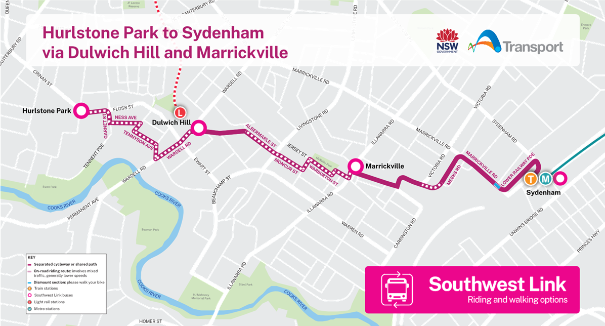
As part of the TfNSW Southwest Metro project, the T3 Bankstown Line from Sydenham to Bankstown is being converted to Metro standards to improve the reliability of Sydney’s transportation network. To aid affected commuters along the T3 Line, TfNSW has implemented temporary bike riding routes as part of its Temporary Transport Plan (TTP) to encourage people to travel by bike during the conversion of the T3 Bankstown Line.
To assist with active transport users, the TTP provides a cycleway route between Hurlstone Park to Sydenham via Dulwich Hill and Marrickville, see Attachment 1.
Council has received concerns from active transport users and local residents about the route through Station Street, Marrickville.
DISCUSSION
Currently, Station Street, Marrickville operates with one directional traffic flow starting from Schwebel Street and terminating at Leofrene Avenue. Council have received requests from local residents and active transport users to address cyclists going against the one way directional traffic flow thereby resulting in illegal and unsafe movements in Station Street.
To resolve this problem and to ensure that all bicycle activities are legal and safe in Station Street and Leofrene Avenue, Council proposes the installation of ‘Bicycles Excepted’ signage at the locations which contain regulatory signage (‘One-way’ or ‘No Entry’) as seen in the proposed concept plan (Figure 1).
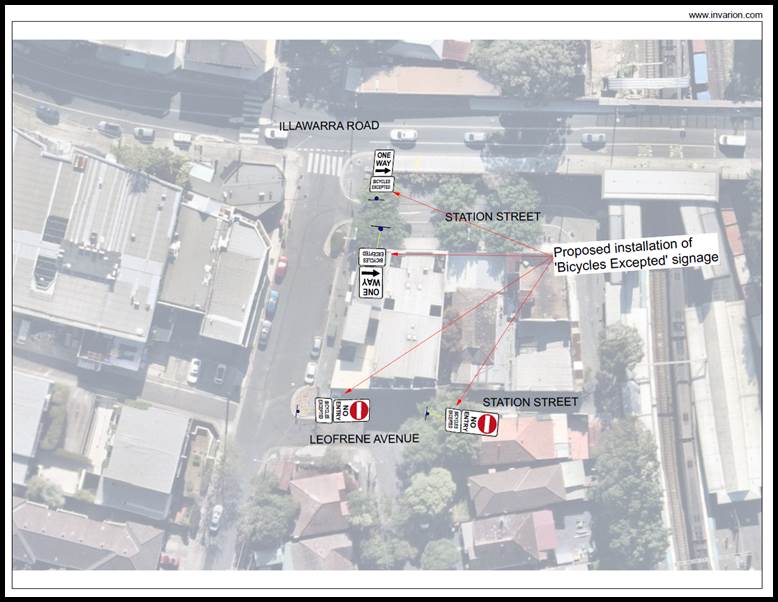
Figure 1. Proposed Concept Plan
FINANCIAL IMPLICATIONS
The cost of the installation of ‘Bicycle Excepted’ signage is to be funded from Council’s operating budget for signs and line marking.
|
1.⇩ |
TfNSW Southwest Link - Bicycle Riding Map |
|
|
Local Traffic Committee Meeting 18 November 2024 |
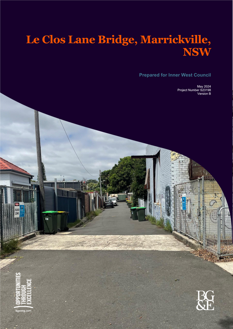
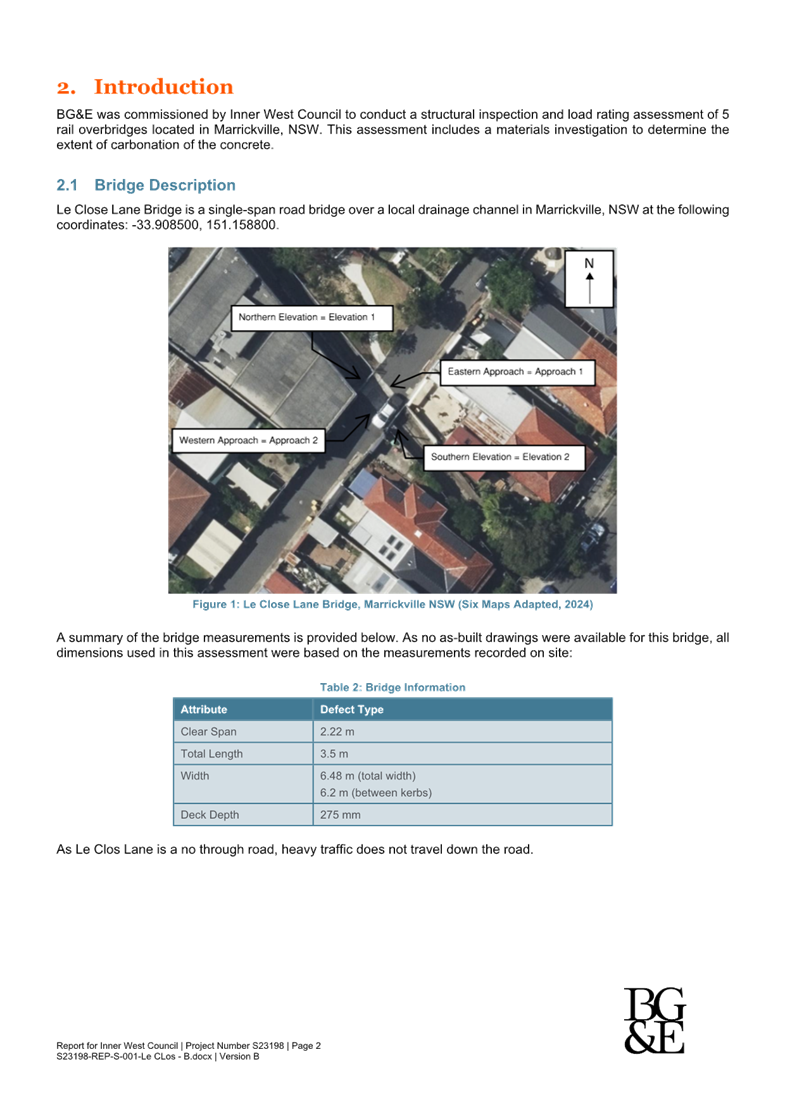
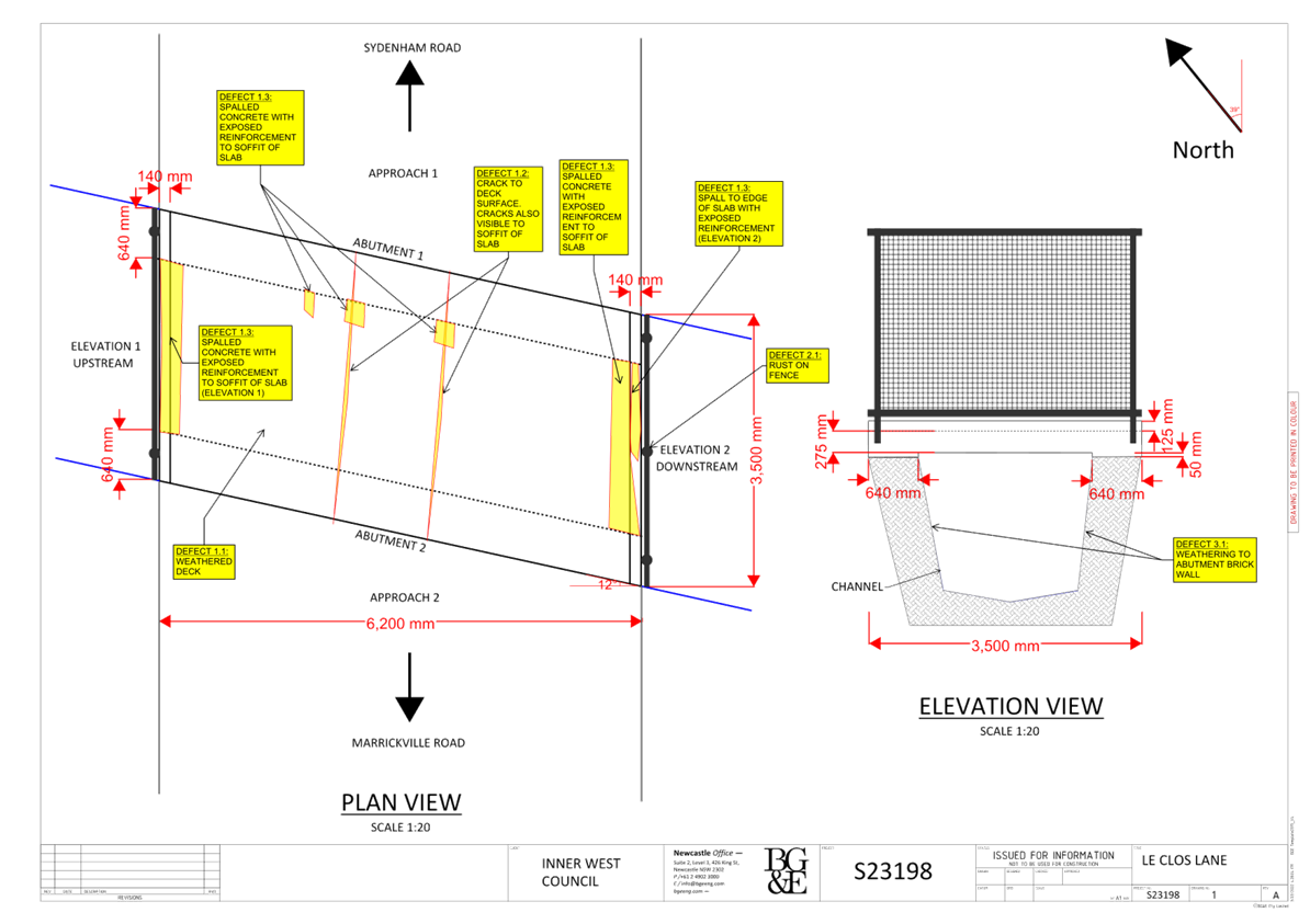
Subject: Le Clos Lane, Marrickville - Proposed 30 Tonne weight limit on the Le Clos Lane Bridge (Midjuburi-Marrickville Ward / Summer Hill Electorate / Inner West PAC)
Prepared By: Daniel Li - Student/Graduate Traffic Engineer
Authorised By: Manod Wickramasinghe - Traffic and Transport Planning Manager
|
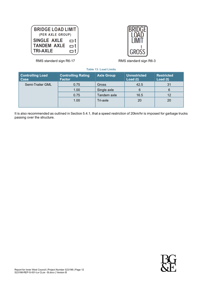
RECOMMENDATION
That a ‘Bridge Load Limit 30T Gross’ weight limit at the entry to Le Clos Lane and at the Le Clos Lane bridge in Marrickville be approved. |
STRATEGIC OBJECTIVE
This report supports the following strategic directions contained within Council’s Community Strategic Plan:
|
2: Liveable, connected neighbourhoods and transport |
|
|
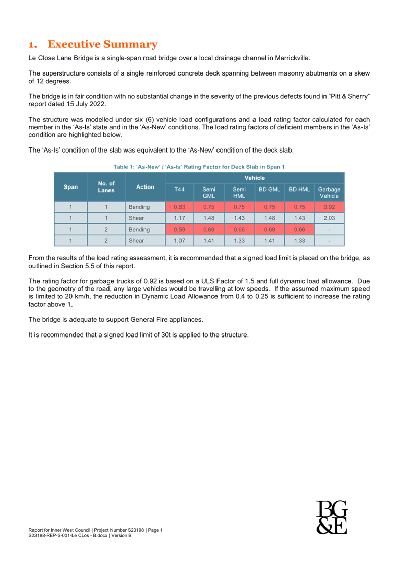
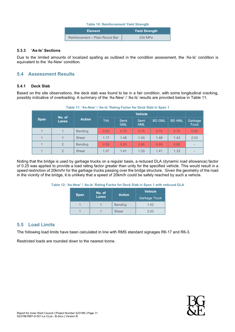
EXECUTIVE SUMMARY
This report outlines the current structural engineering concerns associated with the Le Clos Lane bridge in Marrickville and proposes the appropriate traffic treatments to maintain the structural integrity of the bridge following the completion of maintenance works.
BACKGROUND
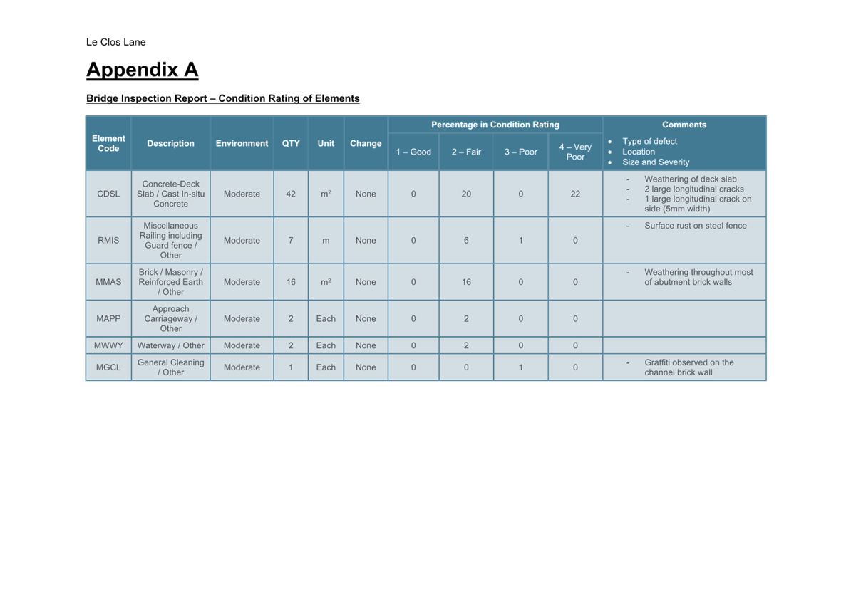
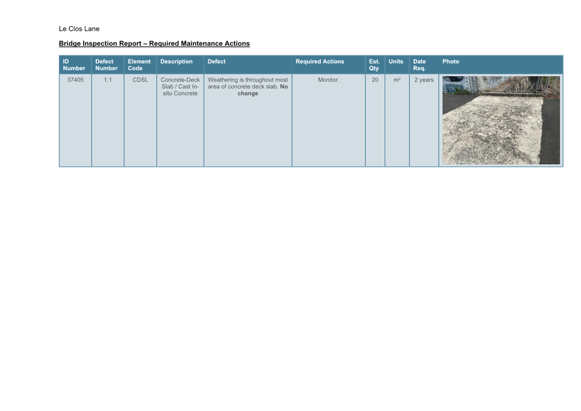
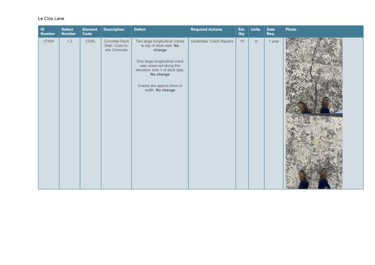
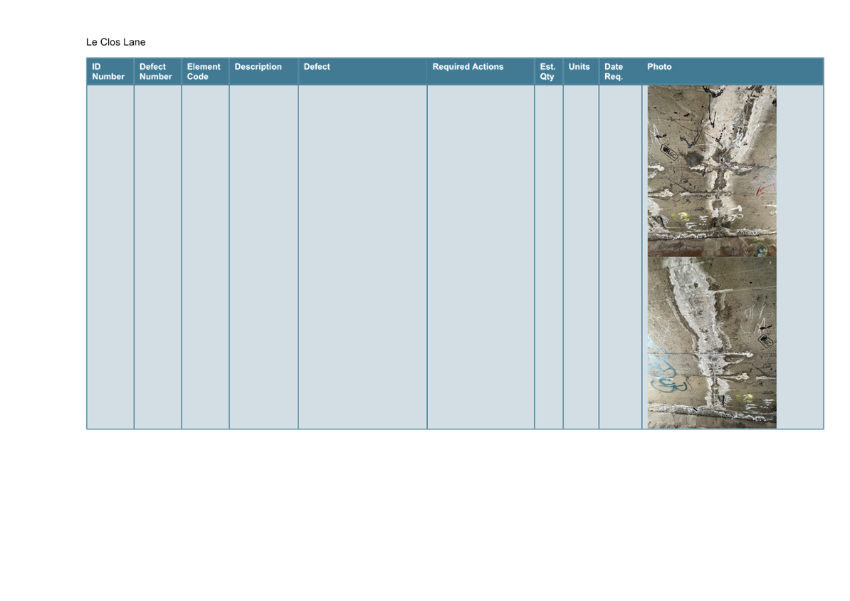
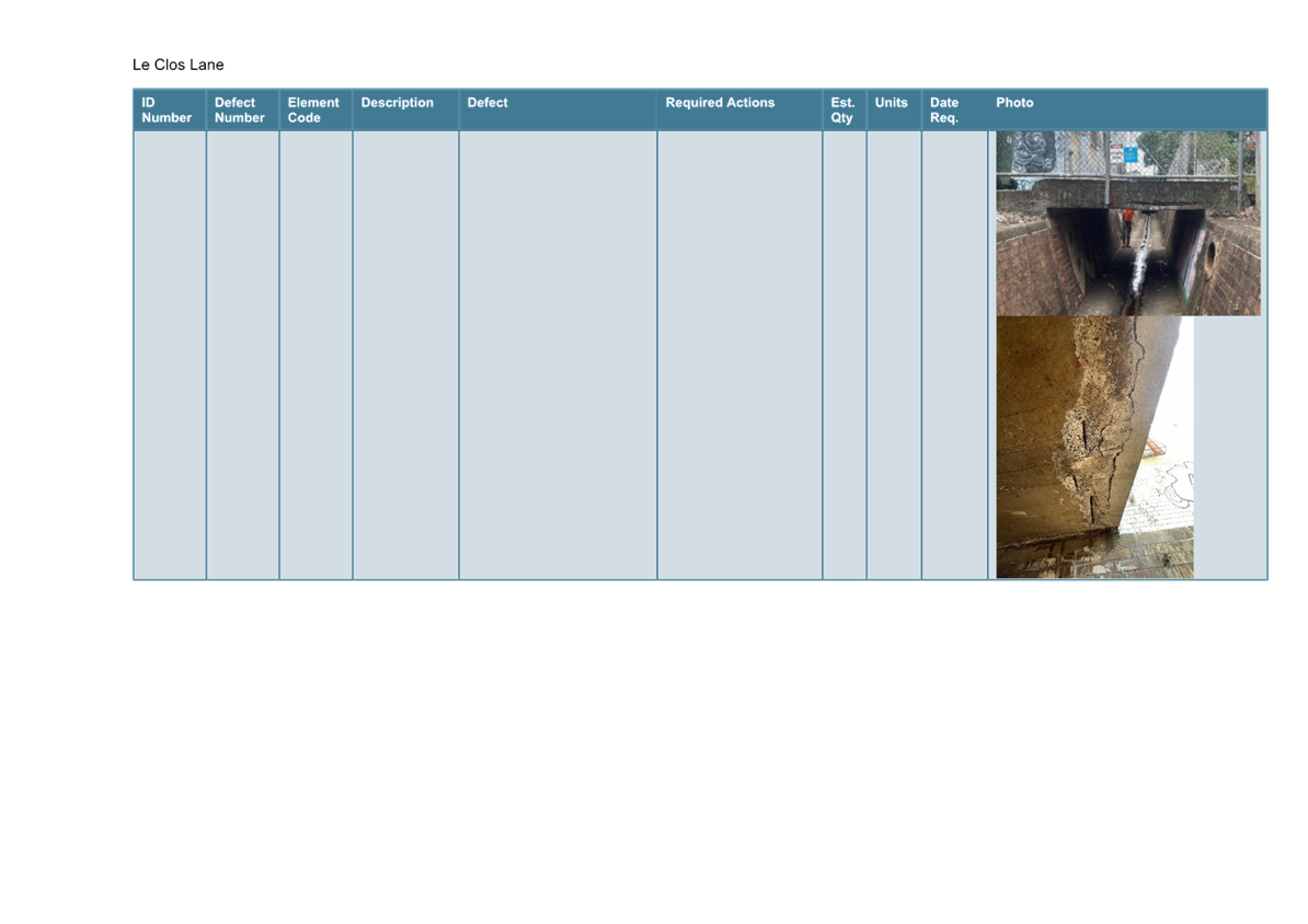
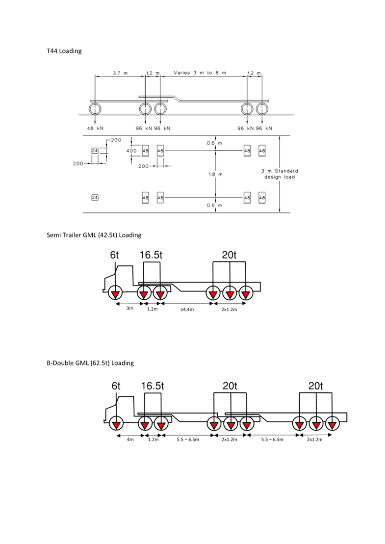
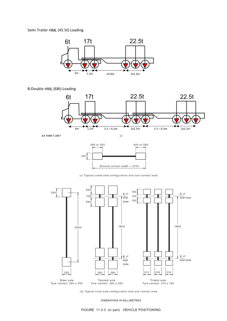
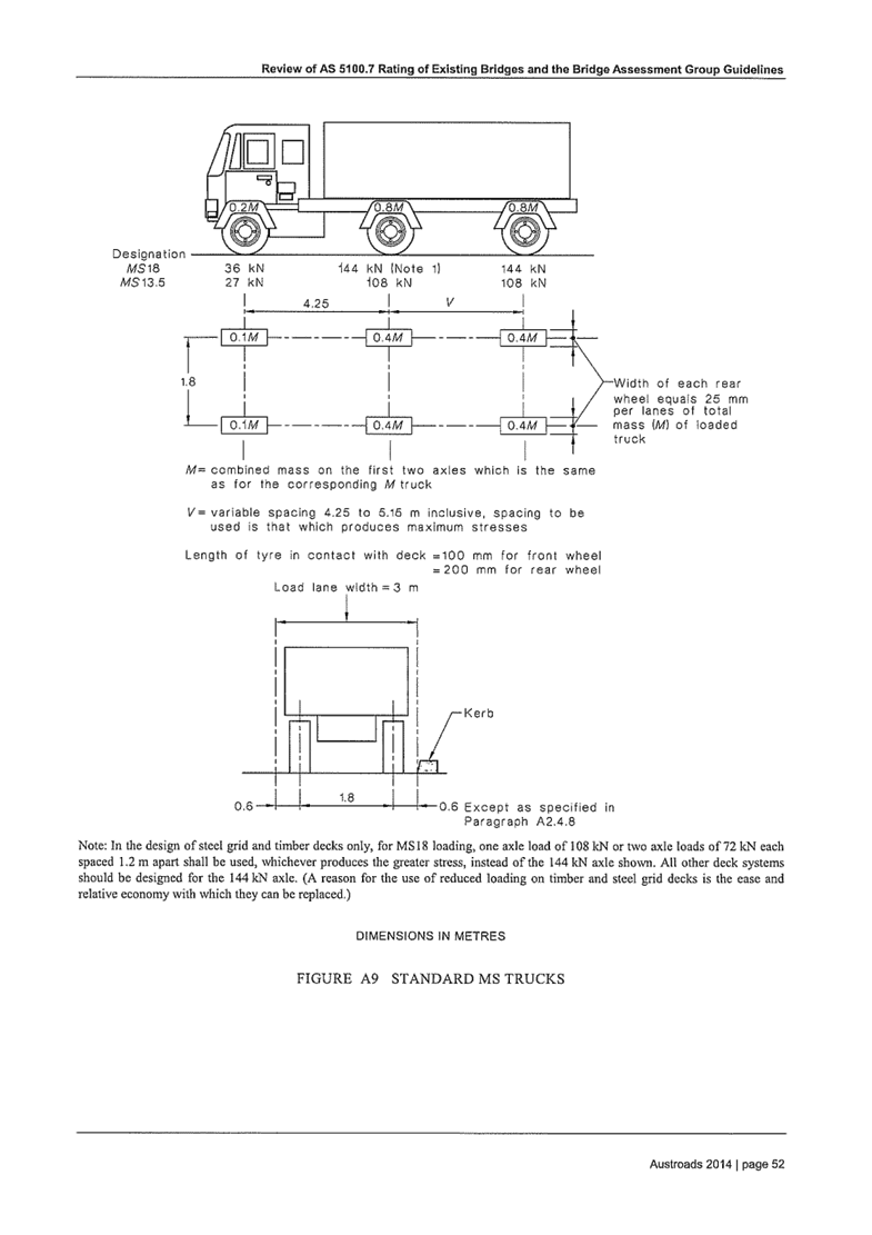
Council has engaged consultants BG&E to perform a Level 3 Bridge Assessment of five short span bridges in Marrickville. Following the bridge assessment, BG&E have provided a structural engineering report which can be seen in Attachment 1, featuring recommendations and ameliorations for the bridge in Le Clos Lane, Marrickville. BG&E have recommended the installation of a 30T load limit signage and a speed restriction for Council waste trucks travelling across the bridge to prevent substantial degradation of the structure.
DISCUSSION
Council Officers undertook a traffic tube survey between 18 September 2024 to 2 October 2024 to identify the average speed and type of vehicles travelling across the bridge.
Given that Le Clos Lane primarily functions as a laneway for residential access, the majority of the collected data was derived from small vehicles travelling in the laneway to access residential garages. These small vehicles have a maximum gross limit of 5T, thereby providing minimal impact to the bridge. As such, the proposed recommendations of reduced speed restrictions and load limit is not applicable to these vehicles.
In comparison, based on the traffic tube surveys, there were only two recorded counts of Council waste vehicles, both of which were travelling within the desirable 10km/h – 20km/h speed range. A contributing factor to Council’s waste trucks travelling within this range of speed is due to Le Clos Lane providing an approximate road width of 5m, facilitating one lane of travel and one lane of unrestricted parking. While the speed restriction is not enforceable in the laneway, to reduce the degradation of the bridge structure, Council proposes the installation of the 30T Gross Limit signage at the following locations of Le Clos Lane, Marrickville.
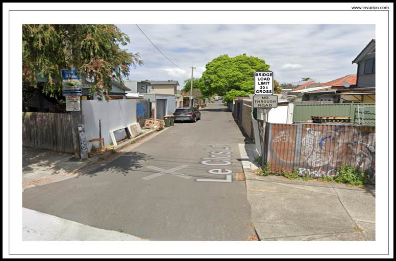
Figure 1. Signage plan of 30T Gross Limit Sign at the Le Clos Lane entrance.
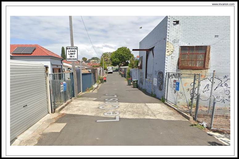
Figure 2. Signage plan of 30T Gross Limit Sign at the Le Clos Lane bridge.
FINANCIAL IMPLICATIONS
The cost of installing a ‘Bridge Load Limit 30T Gross’ signage as recommended will be funded within Council’s operational budget for signs and line marking.
|
1.⇩ |
BG&E Bridge Assessment Report |
|
|
Local Traffic Committee Meeting 18 November 2024 |
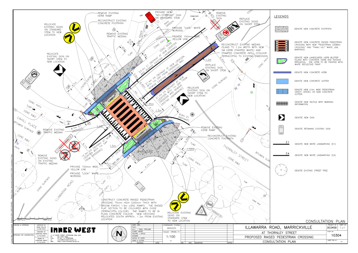
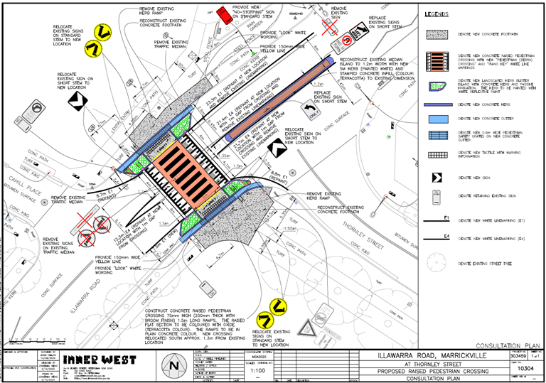
Subject: Illawarra Road at Thornley Street, Marrickville – Proposed raised pedestrian crossing - Design Plan 10304 (Midjuburi-Marrickville Ward / Summer Hill Electorate / Inner West PAC)
Prepared By: Jennifer Adams - Traffic Engineer
Authorised By: Manod Wickramasinghe - Traffic and Transport Planning Manager
|
RECOMMENDATION
That the detailed design plan for the proposed new raised pedestrian crossing on Illawarra Road at Thornley Street, Marrickville and associated signs and line markings (as per Design Plan No.10304) be approved. |
STRATEGIC OBJECTIVE
This report supports the following strategic directions contained within Council’s Community Strategic Plan:
|
2: Liveable, connected neighbourhoods and transport |
|
|
EXECUTIVE SUMMARY
Council has prepared a design plan to construct a raised concrete pedestrian crossing at the intersection of Illawarra Road and Thornley Street, Marrickville. The proposal aims to improve safety for pedestrian and motorist and will help address concerns with pedestrian and motorist behaviour at this location, particularly during busy times.
BACKGROUND
Council has in the past received concerns as to the safety of the pedestrian crossing on Illawarra Road near Thornley Street, Marrickville.
The Minutes of the Local Traffic Committee meeting held on 11 December 2023 were adopted at Council’s meeting held on 05 March 2024 subject to the following amendments:
3. The following amendments to LTC1223(1) Item 7 to include urgent action being taken to improve visibility of the pedestrian crossing at Illawarra Road at Yirran Gumal Early Learning Centre (refer to figure 1), including:
a) a report including designs to improve visibility at the crossing be brought to the next possible Local Traffic Committee Meeting, considering options to raise the crossing, implement flashing lights, or any other measure to improve safety; and
b) that upon approval by the Local Traffic Committee and Council, these works be immediately prioritised and undertaken, funded through the quarterly budget update.
A report went to the April 2024 Local Traffic Committee recommending that “the upgrade of the existing pedestrian (zebra) crossing on Illawarra Road near Thornley Street to a raised crossing facility be approved in principle and that the detail design be bought back to the Traffic Committee for consideration.”
The existing pedestrian crossing located on Illawarra Road, immediately west of Thornley Street (and adjacent to the Yirran Gumal Early Learning Centre and Debbie and Abbey Borgia Community Recreation Centre on Illawarra Road) is an at grade crossing facility with kerb blisters and a centre refuge island. The facility is well used by the adjacent facilities and by bus patrons as bus stops are present nearby on either side of this crossing facility.
Illawarra Road is a Regional Road carrying around 14,500 vehicles per day. It is a bus route. In order to improve safety of pedestrians at this crossing and to address community concerns which have been raised, it was proposed to raise this crossing.
This report details the design plan for those improvement works and its related consultation results. It is noted that the original consultation plan sent out for consultation differs from the plan presented in this report in that the location of the proposed new tactiles is now relocated within the footpath ramps and no new bollards are included.
FINANCIAL IMPLICATIONS
The project is listed on Council’s 2024/2025 PAMP Capital Program for construction and estimated cost is $207,800. Project number is 303459.
OTHER STAFF COMMENTS
The following works are proposed and are illustrated on the attached Consultation Plan (Plan No. 10304). The proposed works aim to improve pedestrian safety by better defining the safe pedestrian crossing point and addresses concerns for pedestrian safety and driver behaviour at this location.
Specifically, the proposed scope of works includes the following:
· Construct a new raised concrete pedestrian crossing to replace existing at grade (flat) pedestrian crossing. The new pedestrian crossing will be slightly relocated from the existing location by approx. 1.3m south (refer to plan);
· Construct “gutter bridges” with heel safe grating to provide safe access over existing kerb and guttering to the new raised pedestrian crossing (where required);
· Construct landscaped kerb blister islands in the road adjacent to the new raised pedestrian crossing. Landscaping to be suitable species of native grasses (subject to final design);
· Reconstruct existing central median island north of the new raised pedestrian crossing;
· Reconstruct some sections of damaged concrete footpath with new concrete footpath (as shown on the attached plan);
· Reconstruct sections of kerb & gutter with new concrete kerb & gutter (where shown on plan);
· Install new tactiles with bollards on either side of the new raised pedestrian crossing (where shown on plan);
· Install associated pavement line marking and signage as required;
Parking Changes
This proposal will result in no loss of on-street parking space. Some street parking will be affected temporarily to facilitate the construction activities during construction.
Streetlighting
The existing street lighting at the location for the proposed new raised pedestrian crossing is deemed adequate. Therefore, no new floodlights are proposed to be included as part of the works.
PUBLIC CONSULTATION
Consultation was conducted between 10 October and 30 October 20224. A letter along with a copy of the design plan was sent to residents / businesses in the immediate locality. A total of 8 letters were distributed. There were no responses.
CONCLUSION
It is recommended that the detailed design plan of the proposed new raised pedestrian crossing and associated signs and line markings be supported to improve road safety at this location.
|
1.⇩ |
Consultation Plan(Amended) |
|
|
Local Traffic Committee Meeting 18 November 2024 |
Subject: Illawarra Road at Warburton Street, Marrickville - Proposed 'Zig Zag' line marking for the pedestrian crossing (Midjuburi-Marrickville Ward / Summer Hill Electorate / Inner West PAC)
Prepared By: Daniel Li - Student/Graduate Traffic Engineer
Authorised By: Manod Wickramasinghe - Traffic and Transport Planning Manager
|
RECOMMENDATION
That the installation of ‘Zig Zag’ line markings on both approaches to the pedestrian crossing of Illawarra Road near the intersection with Warburton Street, Marrickville be approved.
|
STRATEGIC OBJECTIVE
This report supports the following strategic directions contained within Council’s Community Strategic Plan:
|
2: Liveable, connected neighbourhoods and transport |
|
|
EXECUTIVE SUMMARY
This report outlines current sight distance issues at the Illawarra Road pedestrian crossing at its intersection with Warburton Street, Marrickville and proposes the appropriate traffic treatments to improve the safety of the community.
BACKGROUND
Council has received several concerns from residents and pedestrians regarding vehicles not slowing down as they approach the pedestrian crossing at Illawarra Road near the intersection with Warburton Street, Marrickville.
In the past, Council Officers have investigated the raising of this pedestrian crossing. However, raising of this crossing is likely to create flooding issues and interrupt the over land flow into Station Street making such a solution complicated and expensive to implement.
Following an investigation Council Officers are proposing to install ‘Zig Zag’ line markings on both approaches to the crossing to indicate to motorists that a pedestrian crossing is ahead.
DISCUSSION
Council has received several concerns from residents and pedestrians regarding vehicles not slowing down as they approach the pedestrian crossing in Illawarra Road, Marrickville near Warburton Street.
A review of this site indicates that Illawarra Road has a change in horizontal and vertical alignment on approach to the pedestrian crossing, resulting in obstructed sight lines which raises safety concerns.
By providing ‘zig zag’ line markings, motorists will be advised of the incoming pedestrians and cyclists and will be aware of the crossing ahead, thereby improving pedestrian safety. As such, Council is proposing the ‘zig zag’ line marking treatment in accordance with the below concept plan in Figure 1.
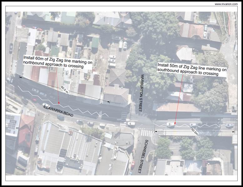
Figure 1. Proposed concept plan of Zig Zag line marking.
FINANCIAL IMPLICATIONS
The cost of the installation the of ‘Zig Zag’ line marking is to be funded from Council’s operating budget for signs and line marking.
Nil.
|
|
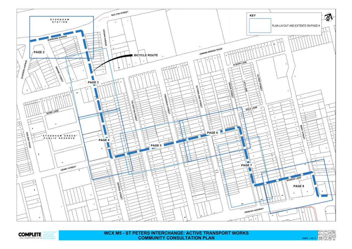
Local Traffic Committee Meeting 18 November 2024 |
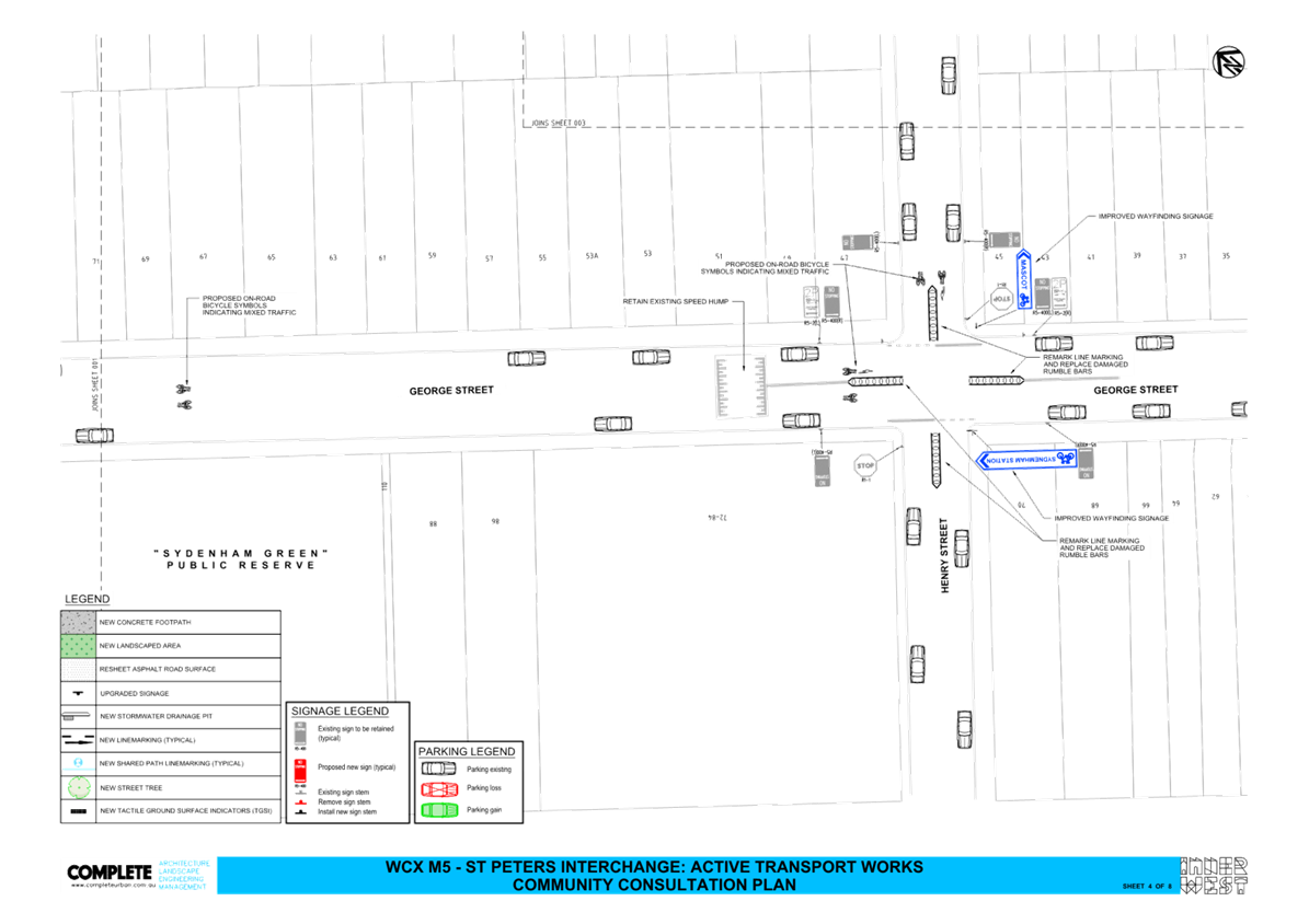
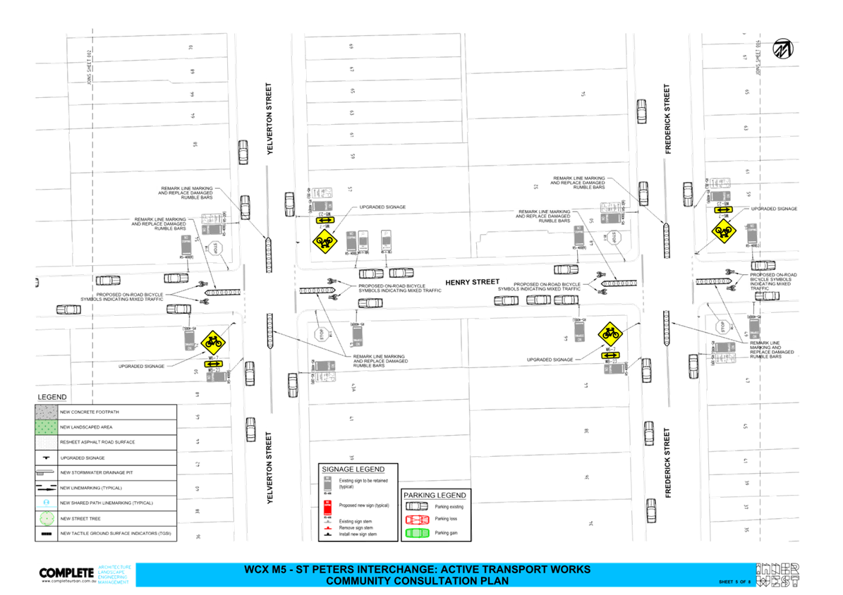
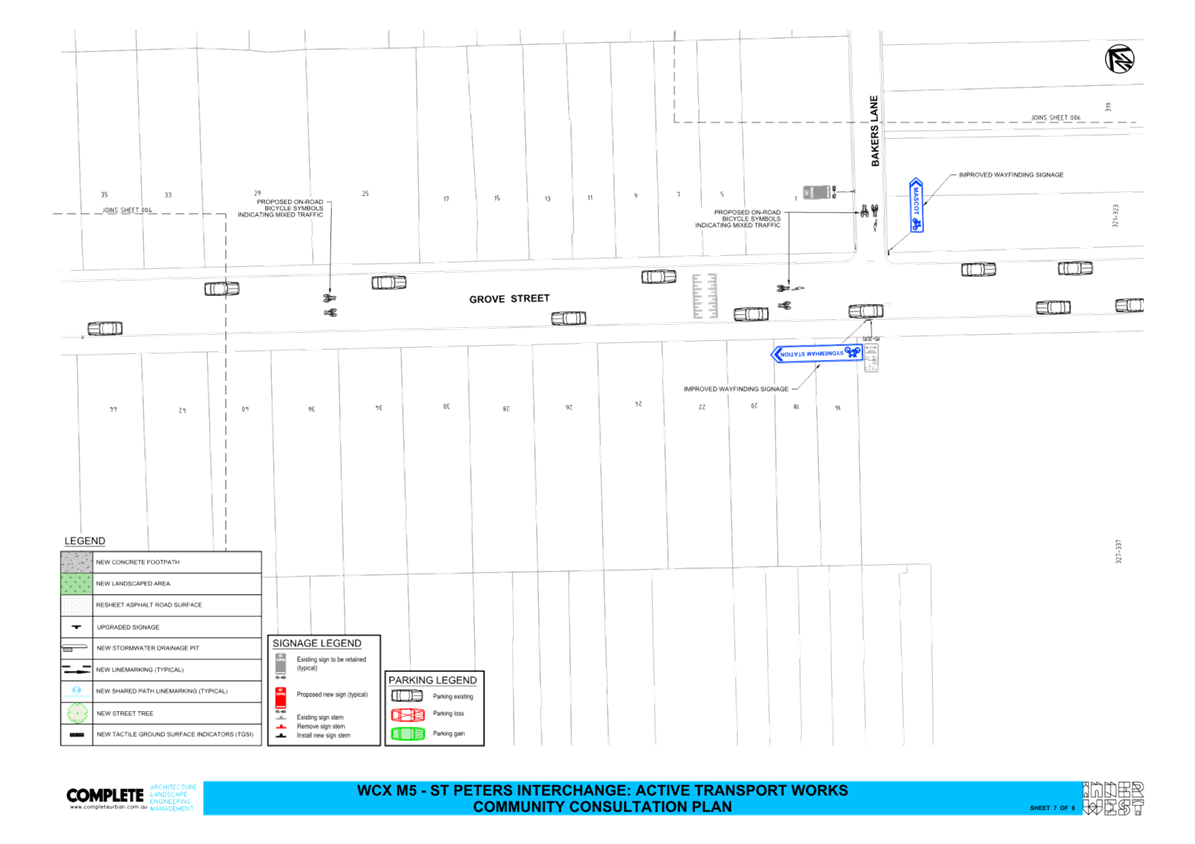
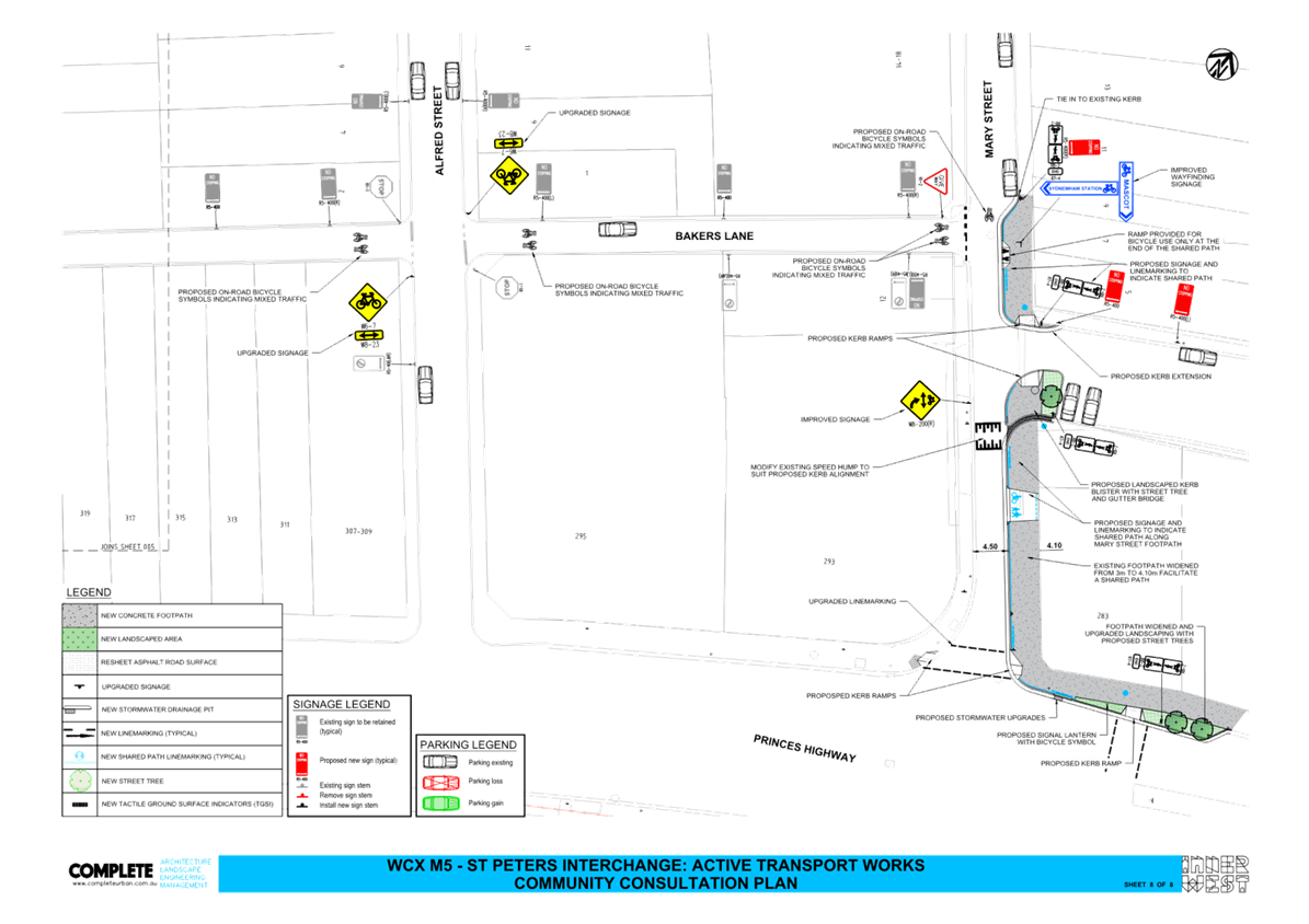
Subject: St Peters Interchange Active Transport Works - Part 1 (Midjuburi-Marrickville Ward/Heffron Electorate/Inner West PAC)
Prepared By: James Nguyen - Traffic Engineer
Authorised By: Manod Wickramasinghe - Traffic and Transport Planning Manager
|
RECOMMENDATION
That the detailed design (WCX M5 – St Peters Interchange: Active Transport Works Community Consultation Plan, Sheets 1-8) prepared by COMPLETE URBAN for the St Peters Interchange Active Transport Works be approved.
|
STRATEGIC OBJECTIVE
This report supports the following strategic directions contained within Council’s Community Strategic Plan:
|
2: Liveable, connected neighbourhoods and transport |
|
|
EXECUTIVE SUMMARY
This report outlines the design development of the St Peters Interchange Active Transport Works – Part 1 and notes key changes from the concept design. It also provides a summary of the community consultation that was completed. Accordingly, the design is to progress to construction.
BACKGROUND
The St Peters Interchange Active Transport Works – Part 1 project was previously referred to the Local Traffic Committee on 2 December 2019 and 6 July 2020. The concept design for this project was approved at the Local Traffic Committee meeting of 6 July 2020.
This report outlines subsequent detail design and community consultation developments from the concept design.
DISCUSSION
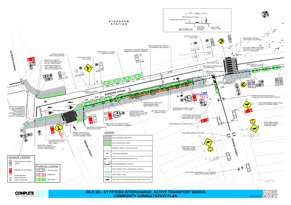
Table 1 below notes the changes or deviations made from the originally approved concept plan in the latest design development. The design plans are shown in Attachment 2:
Table 1 - Design changes/amendments
|
Street |
Amendments/changes |
Reason for change |
|
Burrows Avenue |
Remove the existing bicycle crossing on the proposed conversion of the at-grade crossing to a raised pedestrian crossing, east of George Street |
New furniture/bollards installed at the Sydenham Station entrance would obstruct cyclists |
|
Removal of kerb extension and reduction of the ‘KISS AND RIDE’ to provide four (4) new timed parking (1-hour) spaces on the northern side |
Provide additional timed parking to address concerns parking loss and also provide an area for longer stay parking adjacent to the Station. |
|
|
Three (3) timed parking (2-hour) restrictions on the southern side of Burrows Avenue, east of George Street |
Provide timed parking for adjacent users. |
|
|
George Street |
Retain the length of the existing kerb extension on the eastern side of George Street, south of Burrows Avenue (concept plan approved had a 25-metre-long kerb extension up to house no. 24 George Street) |
Extended length is not required |
|
Retain existing speed hump on George Street, south of Unwins Bridge Road |
Reconstruction to speed humps is not required due to existing humps providing speed reduction |
|
|
Retain existing speed hump on George Street, north of Henry Street |
Reconstruction to speed humps is not required due to existing humps providing speed reduction |
|
|
Remark line marking and replace rumble bars at the intersection of George and Henry Streets |
Improve safety at intersection |
|
|
Install wayfinding signs at the intersection of George and Henry Streets |
Additional signs to improve wayfinding for cyclists |
|
|
Yelverton Street |
Upgrade/replace existing warning signs (W6-7 and W8-23) on Yelverton Street |
Improve safety for cyclists |
|
Remark line marking and replace rumble bars at the intersection of Yelverton and Henry Streets |
Improve safety at intersection |
|
|
Frederick Street |
Upgrade/replace existing warning signs (W6-7 and W8-23) on Frederick Street |
Improve safety for cyclists |
|
Remark line marking and replace rumble bars at the intersection of Frederick and Henry Streets
|
Improve safety at intersection |
|
|
Sutherland Street |
Upgrade/replace existing warning signs (W6-7 and W8-23) on Frederick Street |
Improve safety for cyclists |
|
Remark line marking and replace rumble bars at the intersection of Henry and Sutherland Streets |
Improve safety at intersection |
|
|
Henry Street |
Install wayfinding signs at the intersection of Grove and Henry Streets |
Additional signs to improve wayfinding for cyclists |
|
Grove Street |
Install wayfinding signs at the intersection of Grove Street and Bakers Lane |
Additional signs to improve wayfinding for cyclists |
|
Alfred Street |
Upgrade/replace existing warning signs (W6-7 and W8-23) on Alfred Street |
Improve safety for cyclists |
|
Bakers Lane |
Install ‘GIVE WAY’ sign and line on Bakers Lane at the intersection of Mary Street (included following feedback from community consultation) |
Improve safety at intersection |
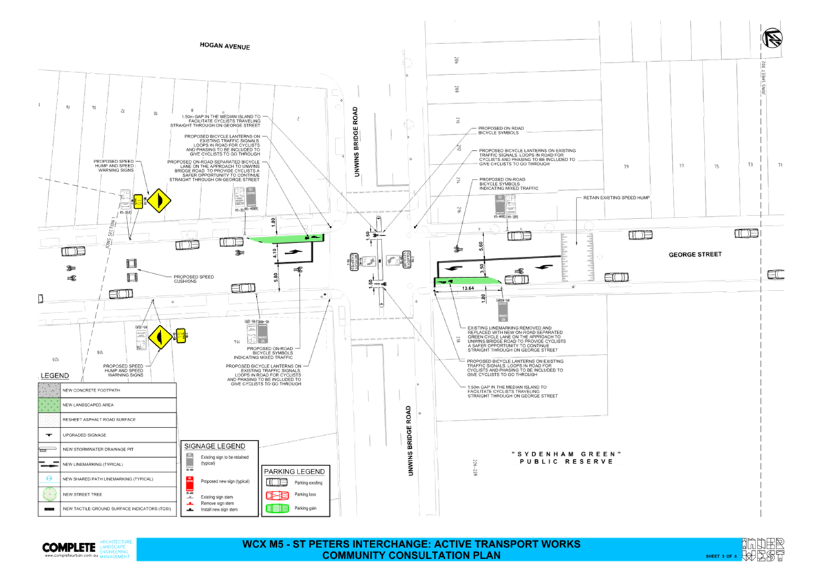
In addition to the above changes, a request has been made to consider changing the ‘STOP’ priority controls on Henry Street at the intersections of Sutherland, Frederick and Yelverton Streets to give road users along the minor leg, particularly cyclists priority.
Council engineers have assessed the viability of changing the ‘STOP’ priority controls on Henry Street at Sutherland, Frederick and Yelverton Streets. ‘STOP’ controls are installed at four-way intersections on the minor road. Based on the existing traffic volumes as shown in Table 2 below, both Sutherland and Frederick Street have higher levels of traffic volume, compared to Henry Street, and changing the ‘STOP’ priority control is not recommended.
The traffic volume on Yelverton Street is similar to Henry Street, and Council engineers are investigating further whether changing the ‘STOP’ priority control at this intersection can be considered.
Table 2 - Traffic volumes
|
Street |
Volume (vpd) |
|
Henry Street |
~536 |
|
Sutherland Street |
1086 |
|
Frederick Street |
1250 |
|
Yelverton Street |
415 |
PUBLIC CONSULTATION
The proposal was publicly exhibited on Your Say Inner West between 7 October 2024 and 5 November 2024. There were 50 responses received with 39 responses (78%) supporting and six (6) responses (12%) opposing the proposal. Five (5) responses received were unsure about the proposal.
The responses have been summarised into themes and shown in Table 3 below:
Table 3 - Community consultation summary
|
Theme |
Community feedback |
Council response |
|
Connection to Inner West Bike Network |
Many respondents desire expanded connections to key areas, including Wolli Creek, Mascot, Marrickville, and the SW Metro corridor, while ensuring safe and well-connected endpoints to avoid detours and unfinished segments. |
Connection to Wolli Creek will be provided via new proposed Marrickville Road East (Sydenham Station to Meeks Road Marrickville along Marrickville Road) and EWPCL (between Edgeware Road, Marrickville, and Garnet Street Dulwich Hill) projects. On the other end, the proposed cycleway will link with the existing cycleway at St Peters interchange. |
|
Location of Bi-directional Cycleway on Burrows Road |
Respondents suggest relocating the cycle path to the western side of Burrows Avenue for better access to the station, reduced pedestrian conflict, minimized impact on parking, and enhanced opportunities for local dining, while avoiding the need for cyclists to cross the road in high-traffic areas. |
The bi-directional cycleway on Burrows Avenue was strategically placed on the side opposite the station due to multiple uses and parking restrictions on the station side. These restrictions include 'No Parking' zones, car share spaces, taxi stands, and a mailbox, which made this placement unfeasible. TfNSW, who is funding the project, required that the cycleway not be placed on the northern (station) side of Burrows Avenue due to potential conflicts with various users, including those accessing the train station, car share parking, train and taxi drop-offs and pick-ups, and the mailbox. During rail line shutdowns, when replacement buses are in operation, this side of Burrows Avenue is also used for passenger drop-offs, pick-ups, and temporary bus stops. For these reasons, TfNSW did not endorse locating the cycleway on the northern side of the road. |
|
Parking |
Opinions on parking removal are mixed, with some advocating for reduced parking to promote sustainable transport, while others express concern over the impact on local businesses, residents, and overall livability, suggesting alternatives like shared paths, timed parking, and better enforcement of existing parking limits. |
Adequate "No Parking" spaces have been designated to accommodate pick-up and drop-off needs during peak times, resulting in minimal impact on parking availability. Only parking on Burrows Avenue has been affected; however, Council has minimised disruption by rearranging the existing spaces. Instances of parking overstays on Swaine Street will be referred to our rangers for enforcement. The proposed time restrictions for parking areas have been carefully selected to support the operation of the train station, nearby businesses, and peak demand for pick-up and drop-off. Overall, the proposal will result in a net increase in available parking in the area. The proposed parking restrictions will be actively monitored, and adjustments can be made in the future if deemed necessary. |
|
Intersection of Burrows Avenue and George Street |
Respondents suggest moving the stop line on George Street to prevent blocking cyclists, upgrading the Burrows Avenue crossing to a raised cycle and zebra crossing, and redesigning the intersection with George Street as a continuous footpath to provide a smoother and more attractive route for cyclists. |
The bicycle route has been designed in compliance with all relevant standards and guidelines. A raised treatment at the intersection was deemed unnecessary, as the main bicycle path continues along George Street, not directly to the station entrance. Continuous footpath treatment across George Street is not feasible due to stormwater flow considerations and is currently not warranted based on pedestrian traffic counts. This will continue to be monitored in the future for any necessary adjustments. |
|
Henry Street Priority
|
Respondents advocate for prioritizing cyclists along Henry Street by reorienting stop signs to cross streets, implementing "No Stopping" zones for clearer sightlines, and making Henry Street the through route to improve cyclist safety, reduce stop-starting, and enhance traffic calming for local residents. |
The possibility of adjusting priorities at Henry Street intersections was thoroughly considered, with traffic counts collected for pedestrians, vehicles, and cyclists. Findings indicate that only the intersection between Yelverton Street and Henry Street meets criteria warranting a priority change, which Council is currently evaluating. All other intersections will retain their existing arrangements. Cyclist safety was a key factor in this decision-making process, and Council will continue to monitor the effectiveness of these arrangements. |
|
Signalised Intersection of Unwins Bridge Road and George Street |
Respondents suggest improving pedestrian and cyclist safety at the Unwins Bridge Road and George Street intersection by adjusting signal phasing, adding a pedestrian crossing, creating advanced stopping areas and green bike zones, and shifting cycle lanes to the center to reduce conflicts with left-turning vehicles and improve lane legibility. |
The proposal includes the upgrade of an existing signalised intersection at George Street and Unwins Bridge Road. In collaboration with Transport for NSW (TfNSW), the Council has ensured that the upgraded signals provide protected bicycle access concurrent with pedestrian access, allowing safe passage for both cyclists and pedestrians without motor vehicle conflict. The new configuration incorporates cycle lanterns, enabling cyclists to move during the pedestrian phase, signalled by a green cycle symbol. This enhancement maintains existing traffic priorities and overall intersection phasing, with the only change being the integration of cyclists into the pedestrian phase. The positioning of turning vehicles has been strategically designed to accommodate turning movements and ensure clear sight lines. |
|
Traffic Matters
|
Respondents appreciate the upgrades near Sydenham Station but emphasise the need for safer cycle paths, lower speed limits (suggesting 30km/h), and improved intersections, while expressing concerns over the removal of the right-turn lane from Burrows to Gleeson, which impacts Swain Street residents, and suggesting a zebra crossing on Roberts Lane for shared path users. |
Improvements to the intersection of Burrows, Bolton, and Hogan Streets were undertaken a few years ago as part of TfNSW's enhancements to Sydenham Train Station. It is important to note that options for intersection improvements are somewhat limited due to the regular presence of heavy vehicles, such as semi-trailers. The Council has strategically chosen routes that avoid streets with high traffic volumes. In other areas, efforts have been made to provide clear separation between vehicles and cyclists. Additionally, the Council is working on reducing speeds in the vicinity by implementing a 40 km/h speed limit. Further reductions in speed are not proposed currently. Wherever feasible, amendments will be made to the existing traffic infrastructure to align with current standards. Council has collaborated closely with TfNSW on signalized intersections, and adjustments were necessary to accommodate turning movements of larger vehicles. TfNSW has reviewed and approved the proposed intersection designs. The Council remains committed to enhancing cycleway connections within our LGA and will closely monitor the new arrangements post-construction to ensure they function as intended. |
|
Bakers Lane Ends Priorities
|
Respondents express concerns about safety at the Mary Street and Bakers Lane intersection, suggesting a dedicated cycle path, improved signage, traffic calming measures, and lane modifications to reduce hazards from heavy traffic, poor sight lines, and shared paths, while proposing one-way traffic on Bakers Lane to better accommodate pedestrians and cyclists. |
Initially, warning signs will be installed, followed by Give Way signs at Bakers Lane. A speed hump is in place to slow traffic, given the limited sight lines. The position of the bicycle symbols has been adjusted, shifting them closer to the kerb at the intersection of Bakers Lane and Mary Street to enhance visibility. The current line markings shown on the plan are deemed sufficient. Additionally, a bicycle warning sign will be placed on Mary Street near its intersection with Bakers Lane. The cycleway design utilises local streets due to their low traffic volumes and speeds, providing a safer environment for cyclists. Mary Street includes a shared path, ensuring cyclists remain separate from vehicular traffic. Due to its high traffic volume, making any changes to the priority or perceived priority between Mary Street and the side streets is considered unsuitable, as it could significantly impact safety. Grove Street, with its low volume and 40 km/h speed limit, offers a safe route for cyclists. This proposal was developed by a team of designers as the optimal solution, and TfNSW has reviewed and approved the design as acceptable. |
|
Rumble Bars |
Respondents question the necessity and benefits of rumble bars, expressing concerns about their impact on road usability for both cars and bicycles, and suggest exploring a more secure installation method to prevent dislodgement. |
Rumble bars are used at the intersection to control vehicle speeds and manage turning movements, necessitated by the narrow roadways and limited alternative measures. It is important to note that no new rumble bars are being introduced; the proposal only includes the renewal of the existing ones. |
|
Stormwater Upgrade |
There is a major stormwater management issue at the northern end of Hogan Ave. |
Stormwater infrastructure upgrades at the intersection of Burrows, Bolton, and Hogan will be incorporated in this project. |
FINANCIAL IMPLICATIONS
The cost of the project is to be funded by Transport for NSW.
|
1.⇩ |
Final design plan |
|
Local Traffic Committee Meeting 18 November 2024 |
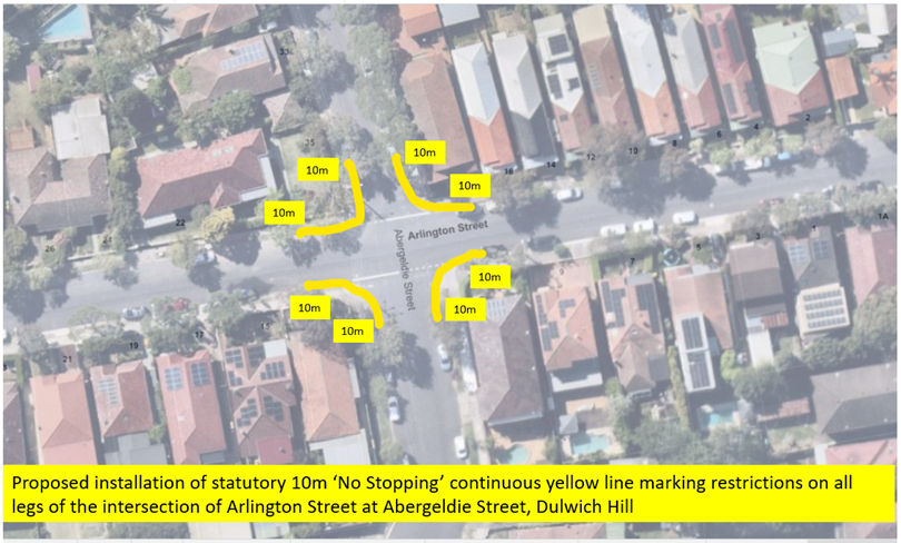
Subject: Abergeldie Street at Arlington Street, Dulwich Hill – Proposed installation of statutory ‘No Stopping’ continuous yellow line marking restrictions at the intersection (Djarrawunang - Ashfield Ward/ Summer Hill Electorate/ Inner West PAC)
Prepared By: Jennifer Adams - Traffic Engineer
Authorised By: Manod Wickramasinghe - Traffic and Transport Planning Manager
|
RECOMMENDATION
1. That unbroken yellow lines (statutory 10 metre ‘No Stopping’ lines) be approved for installation on both sides of all approaches to the intersection of Abergeldie Street at Arlington Street, Dulwich Hill as follows in order to deter illegal parking, increase safety and improve motorist visibility and access for turning motorists: a) Install solid yellow line marking on Abergeldie Street (northern side) for a distance of 10 metres west of Arlington Street, b) Install solid yellow line marking on Abergeldie Street (northern side) for a distance of 10 metres east of Arlington Street, c) Install solid yellow line marking on Abergeldie Street (southern side) for a distance of 10 metres west of Arlington Street, d) Install solid yellow line marking on Abergeldie Street (southern side) for a distance of 10 metres east of Arlington Street, e) Install solid yellow line marking on Arlington Street (western side) for a distance of 10 metres north of Abergeldie Street, f) Install solid yellow line marking on Arlington Street (eastern side) for a distance of 10 metres north of Abergeldie Street, g) Install solid yellow line marking on Arlington Street (western side) for a distance of 10 metres south of Abergeldie Street, h) Install solid yellow line marking on Arlington Street (eastern side) for a distance of 10 metres south of Abergeldie Street.
2. That Council Rangers be advised in terms of this report.
|
STRATEGIC OBJECTIVE
This report supports the following strategic directions contained within Council’s Community Strategic Plan:
|
2: Liveable, connected neighbourhoods and transport |
|
|
EXECUTIVE SUMMARY
Council has received concerns regarding vehicles obstructing sightlines and traffic movement by parking within the statutory ‘No Stopping’ zones at the intersection of Abergeldie Street and Arlington Street, Dulwich Hill.
In order to alleviate this issue, it is proposed to install 10-metre statutory “No Stopping’ yellow line zones on all legs of the intersection at Abergeldie Street and Arlington Street, Dulwich Hill.
BACKGROUND
RMS Technical Directions state that signposting and/or marking with a solid yellow line at an unsignalised intersection (without pedestrian crossing) “should only be required where there is a compliance problem or there is adjoining signposting”. In this case, there is evidence that of a compliance problem which is causing problems for motorists wanting to turn through the intersection.
In order to avoid signage clutter in the area, continuous yellow edge linemarking is proposed. An unbroken yellow kerb line is a NO STOPPING line. Under the Road Rules, a driver must not stop at the side of a road marked with a continuous yellow edge line unless there is a medical or other emergency. The yellow lines are enforceable.
A consultation letter went out to the surrounding residents detailing the proposal to install statutory ‘No Stopping’ restrictions at the intersection to improve access through the intersection. (Refer to map below). This report gives a summary of the results of that consultation.
PUBLIC CONSULTATION
A notification letter was posted out to 8 properties in the immediate locality in both Abergeldie Street and Arlington Street, Dulwich Hill. on 14 October 2024.
The closing date for submissions ended on Friday 8 November 2024. There were no responses.
FINANCIAL IMPLICATIONS
The cost of the installation of the painted road markings associated with the proposed ‘No Stopping’ is to be funded from Council’s operating budget for signs and line marking.
CONCLUSION
It is recommended that the statutory 'No Stopping' restrictions, in the form of unbroken yellow lines, be installed on both sides of all approaches to the intersection of Abergeldie Street and Arlington Street, Dulwich Hill for the distances as indicated in order to deter illegal parking, improve visibility and access and increase safety for all road users.
Nil.
|
|
Local Traffic Committee Meeting 18 November 2024 |
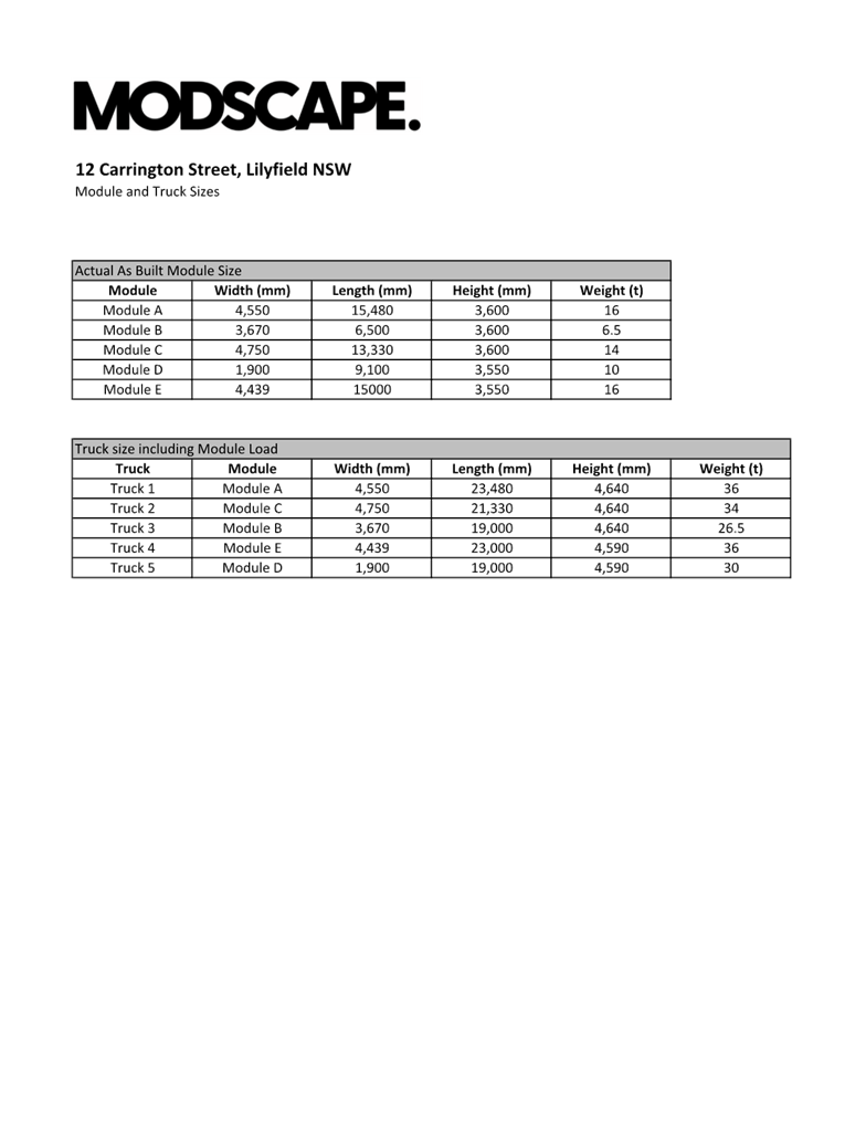
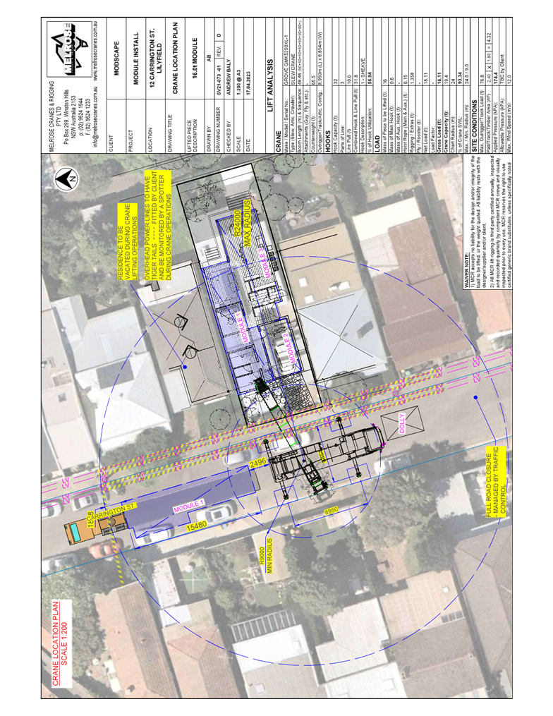
Subject: Carrington Street, Lilyfield - Construction Traffic Management Plan (Baludarri-Balmain Ward/Balmain Electorate/Leichhardt PAC)
Prepared By: Amir Falamarzi - Traffic Engineer
Authorised By: Manod Wickramasinghe - Traffic and Transport Planning Manager
|
RECOMMENDATION
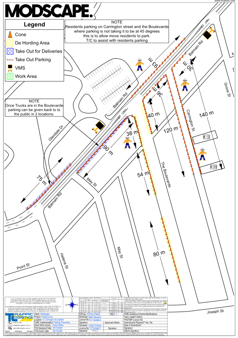
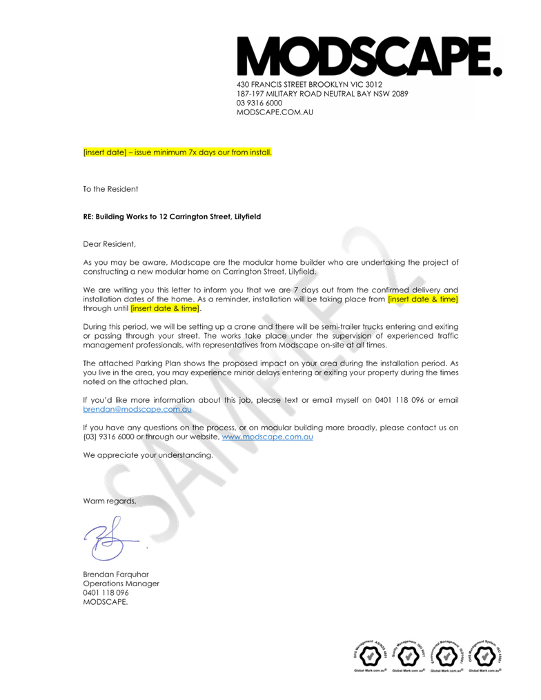
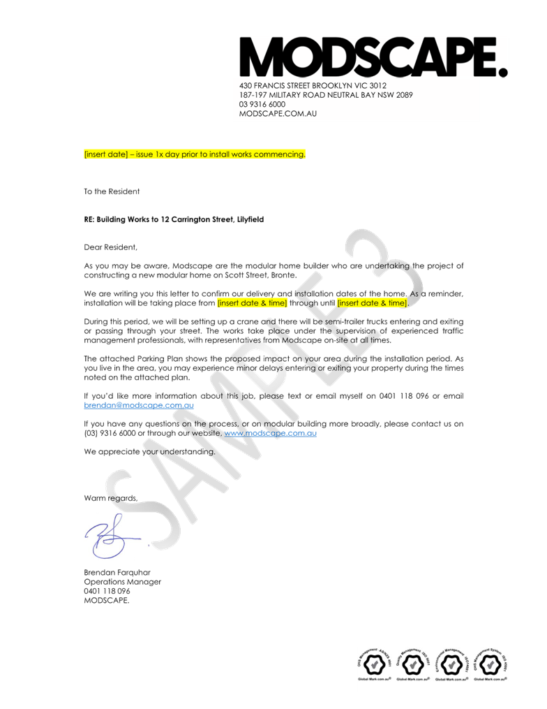
That the temporary full road closure of Carrington Street (between Joseph Street and Balmain Road), The Boulevarde (between Joseph Street and Balmain Road) and partial temporary on-street parking removal along Balmain Road (between Helena Street and Grove Street) be approved for the purpose of the installation of a modular building at No.12 Carrington Street, Lilyfield for a 2 day period in the week commencing 24 March 2025, with a four week contingency, subject to the following conditions and all standard Council conditions for temporary full road closures:
a) A Road Occupancy License application be obtained from the Transport Management Centre for road closure on Balmain Road.
b) Road, footpath and car park occupancy permit to be obtained from the Council for road closure on The Boulevardee.
c) Temporary parking arrangements must be provided for the existing disabled parking bays on Balmain Road, Carrington Street and The Boulevardee which will be affected during the work and should be located as close as possible to their original locations.
d) NHVR permit to be obtained prior to the work.
e) Notice of the proposed event be forwarded to the NSW Police Local Area Commander, Transit Systems, the NSW Fire Brigades and the NSW Ambulance Services.
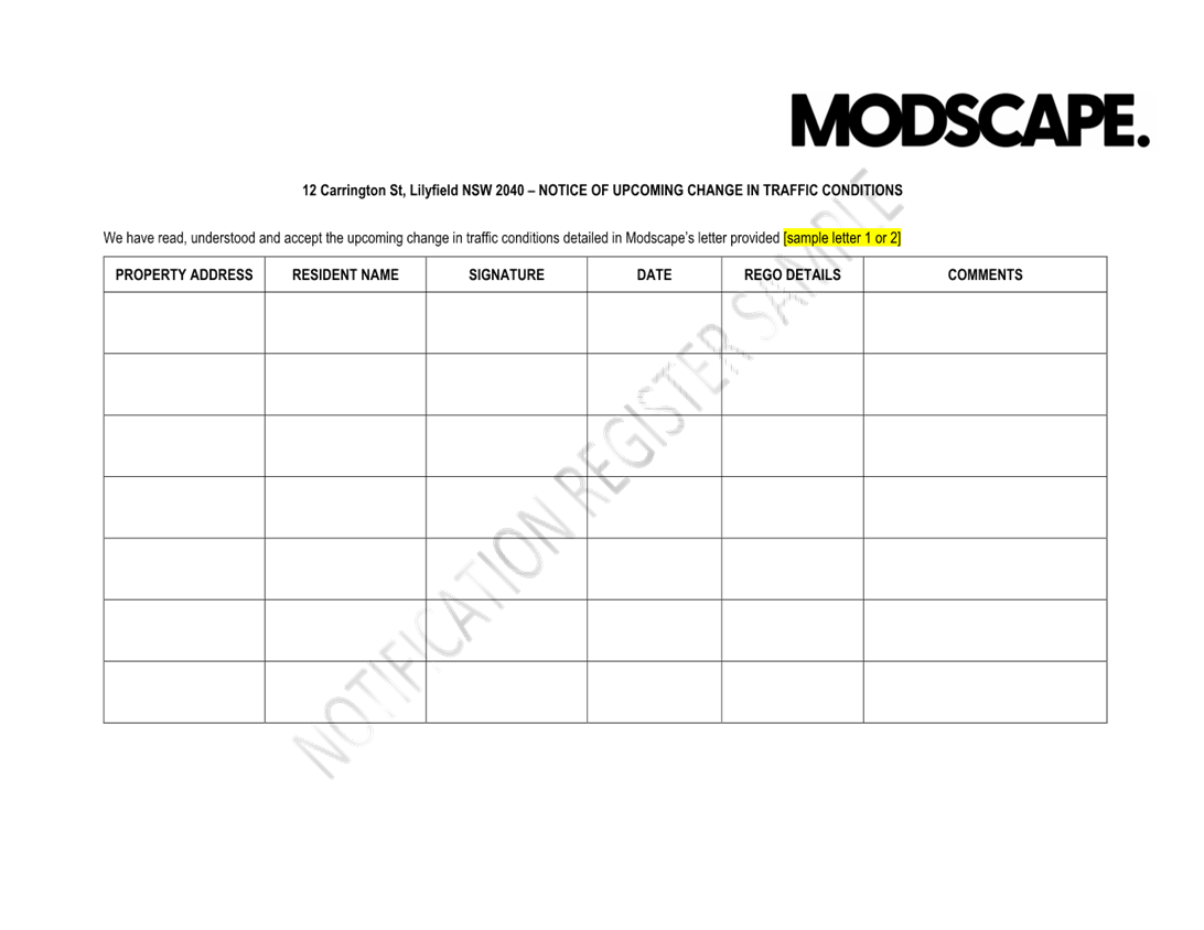
f) All residents and businesses in and around the affected area are to be notified of the temporary road closure in writing by the applicant in advance (at least 7 days prior to the event) with the applicant making reasonable provision for stakeholders.
g) On-street parking to be maintained for local residents along the east side of The Boulevarde (between Joseph Street and the laneway south of Balmain Road).
h) Vehicular access to the laneway south of Balmain Road to be maintained within the road closure zone.
i) Authorised pilot vehicles to accompany and manage the trucks at major intersections including City West Link Road at Balmain Road, Balmain Road at Perry Street, Balmain Road at The Boulevarde and Balmain Road at Carrington Road.
|
STRATEGIC OBJECTIVE
This report supports the following strategic directions contained within Council’s Community Strategic Plan:
|
2: Liveable, connected neighbourhoods and transport |
|
|
EXECUTIVE SUMMARY
Inner West City Council has received a Temporary Road Closure (TMP) application from Modscape (Attachment 1) seeking an in-principal approval for delivering a modular building at No.12 Carrington Street, Lilyfield in the week commencing 24 March 2025. As part of this road closure, there will be full road closure on Carrington Street (between Joseph Street and Balmain Road), The Boulevarde (between Joseph Street and Balmain Road) and partial temporary on-street parking removal along Balmain Road (between Helena Street and Grove Street).
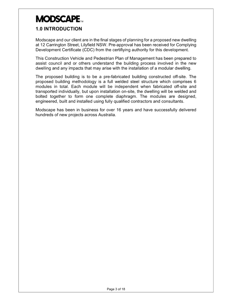
BACKGROUND
Modscape and its client are in the final stages of planning for a proposed new dwelling at 12 Carrington Street, Lilyfield NSW. The proposed building is to be a pre-fabricated building constructed off-site. The proposed building methodology is a full welded steel structure which comprises 6 modules in total. Each module will be independent when fabricated off-site and transported individually, but upon installation on-site, the dwelling will be welded and bolted together to form one complete diaphragm.
DISCUSSION
Site and the proposed development
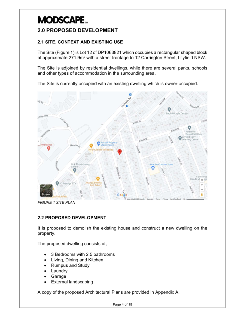
The Site is Lot 12 of DP1063821 which occupies a rectangular shaped block of approximate 271.9m² with a street frontage to 12 Carrington Street, Lilyfield NSW. It is proposed to demolish the existing house and construct a new single dwelling on the property. The Site is adjoined by residential dwellings, while there are several parks, school, playgrounds, early centers and other types of accommodation in the surrounding area.
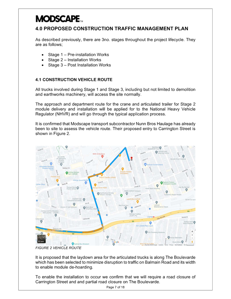
Construction vehicle route
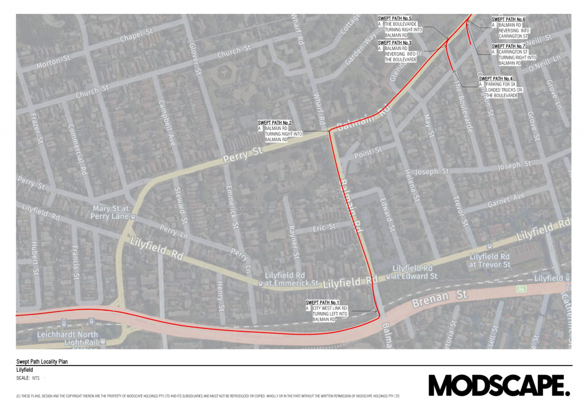
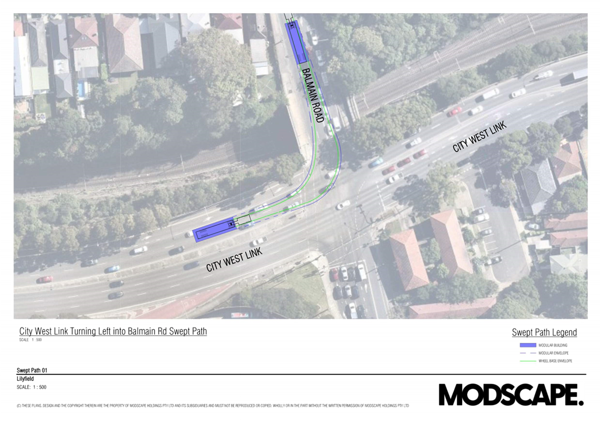
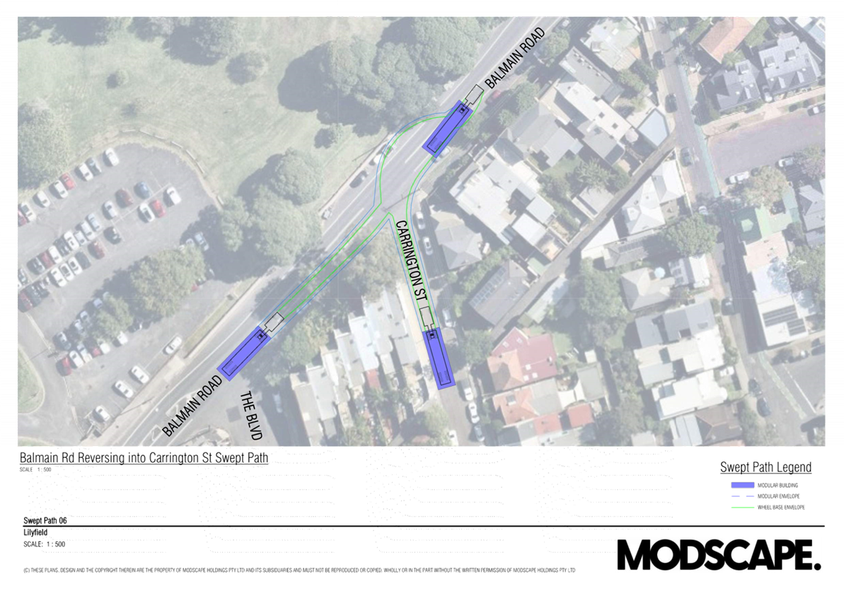
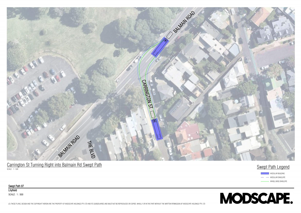
All trucks involving the delivery of the work will follow the proposed route to Carrington Street including City West Link, Balmain Road, The Boulevarde (temporary truck standby zone) and Carrington Street. As part of this route:
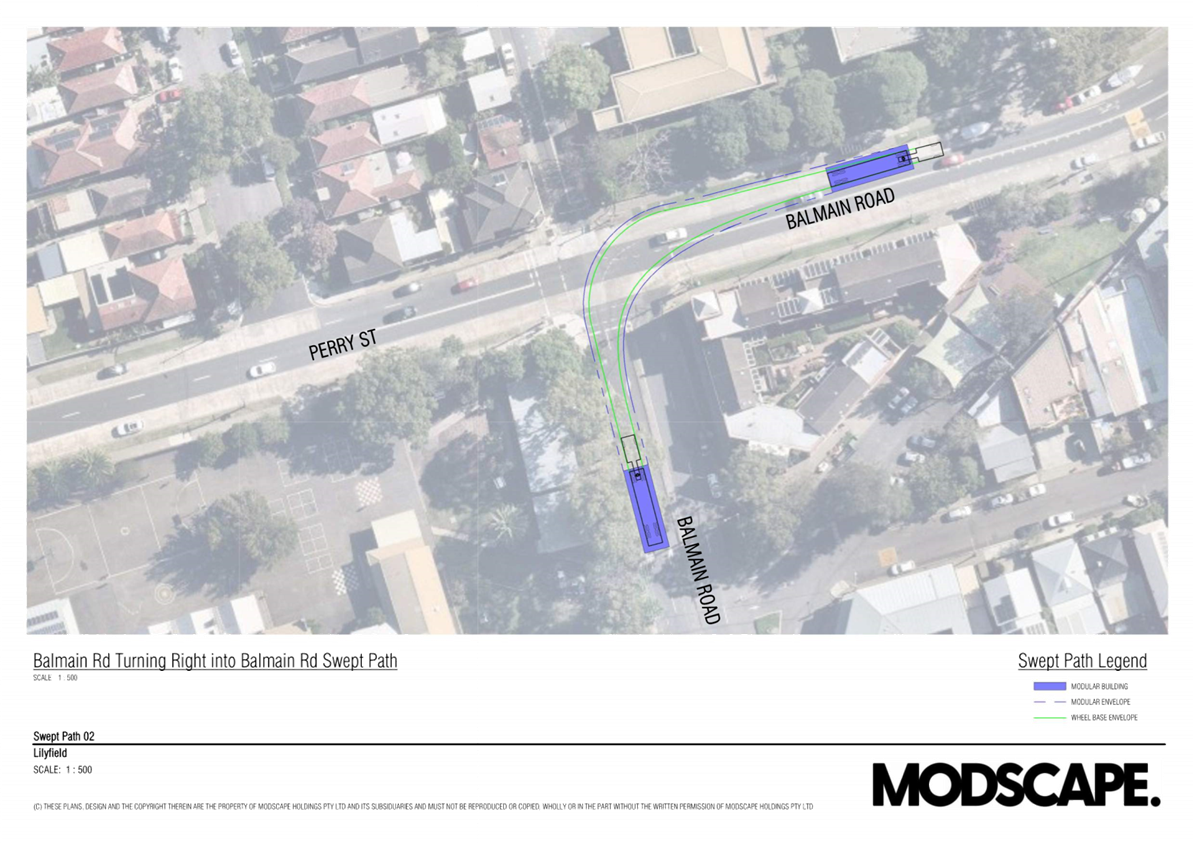
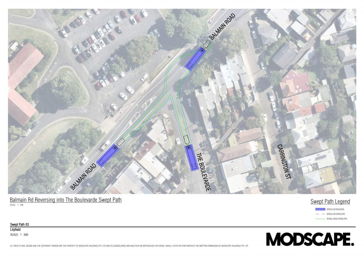
· Authorised pilot vehicles will accompany and manage the trucks at major intersections including City West Link Road at Balmain Road, Balmain Road at Perry Street, Balmain Road at The Boulevardee and Balmain Road at Carrington Road.
· It is proposed that the laydown area for the articulated trucks is along The Boulevarde which has been selected to minimize disruption to traffic on Balmain Road and its width to enable module de-hoarding.
· Modscape has confirmed that a swept path assessment has been undertaken and was deemed achievable.
Traffic and Parking management plans
The proposed traffic and parking management plans include:
1. Work area and where the crane will be located.
2. Full road closure on Balmain Road between May Street and Grove Street.
3. Full road closure on Carrington Street between Balmain Road and Joseph Street.
4. Full road closure on The Boulevarde between Balmain Road and Joseph Street.
5. Detour plan
6. Parking removal along north side of Balmain Road between Helena Street and May Street.
7. Parking removal along south side of Balmain Road between May Street and The Boulevarde.
8. Partial parking removal on both sides of Balmain Road between The Boulevarde and Grove Street.
9. Partial parking removal along west side of The Boulevarde between Joseph Street and Balmain Road.
10. Parking removal along east side of The Boulevarde between Balmain Road and the laneway south of Balmain Road.
11. Parking removal on both sides of Carrington Street between Balmain Road and No.22 Carrington Street.
Pedestrian management
Pedestrian access will be provided with the assistance of licensed traffic controllers.
Impact on public transport and other modes of transport
Consultation with residents within the works zones will be undertaken to ensure plans,
times and level of impact is clearly articulated to affected residents.
Initially will undertake a door knock for the more severely affected residents and
neighbours to allow questions and introduce a point of contact for the works. This is
normally undertaken once site has been established.
Modscape typically will undertake a minimum of 2x letterbox drops with in a drop zone
determined by council. These being 7x day prior to road closures and another the day
prior to road closure.
Work schedule
The above-mentioned works are confirmed to be conducted over Tuesday through to Wednesday. The running sheet for the work is as follows:
Tuesday 7:00AM
· Traffic Management commence on-site to notify residents of the impending works and restricted parking as per Parking Prevention Plan ‘TLTGS219453’
Tuesday 11:00AM to 12:00PM
· Traffic Management commence set-up of the impending works as per Crane Works ‘TLTGS219451’
Tuesday 11:30AM
· Traffic control to close off access to Carrington Street in anticipation of crane arrival.
· Tuesday 12:00PM to 6:00PM250T Crane mobilization / arrival to site and commences set-up.
· 20T Franna Crane to be used to lay out crane pads.
· Approx. 4x counterweight trucks to be unloaded in Carrington Street and leave the area.
· 250T crane to be left on site overnight.
· Crane crew to leave site once crane is set-up.
· Counterweight trucks to arrive in scheduled intervals of approx. 45mins.
· Communication to be in place to ensure the area doesn’t become congested with unscheduled arrivals.
· Sufficient room within Carrington Street to cater for up to 4x counterweight trucks if there are any delays with crane set-up.
· No counterweight trucks are to be left within the local area affected by these works.
Tuesday 6:00PM to 9:30PM
· Traffic Management enforcing Parking Prevention Plan ‘TLTGS219453’
· Traffic Management enforcing works as per Crane Works ‘TLTGS219451’
Wednesday 12:00AM to 3:30AM
· Traffic Management enforcing Parking Prevention Plan ‘TLTGS219453’
· Traffic Management enforcing works as per Crane Works ‘TLTGS219451’
· Trucks to commence arriving to site in spaced intervals under escort in accordance with NHVR permit approvals.
· Trucks to reverse into The Boulevarde per Sweep Path 03
· Total of 5x oversize loads with associated pilot / escorts
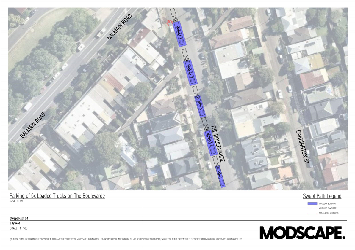
· Trucks to turn off amber beacon lights once entered into closed road The Boulevarde and park up per Sweep Path 04
· Truck drivers and pilot vehicles to park up and remain vehicles until 7:00am
Wednesday 3:00AM to 7:00AM
· Traffic Management enforcing Parking Prevention Plan ‘TLTGS219453’
· Traffic Management enforcing works as per Crane Works ‘TLTGS219451’
Wednesday 6:30AM to 7:15AM
· Worker’s arrival, unload tools & equipment and morning prestart meeting
Wednesday 7:00AM to Approx. 8:00AM
· Commence module de-hoarding in The Boulevarde
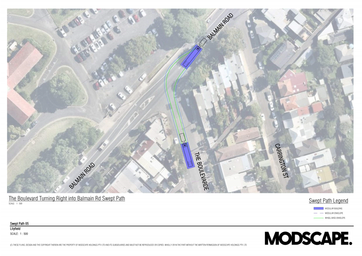
· Once first module has been de-hoarded, truck to move from The Boulevarde and reverse into Carrington Street under traffic management guidance per Sweep Path 06
· Refer to attached truck movements and sequencing on TMP-01 to TMP-16
· The process is repeated until all 5 trucks have been de-hoarded.
· Traffic Management enforcing Parking Prevention Plan ‘TLTGS219453’
· Traffic Management enforcing works as per Crane Works ‘TLTGS219451’
Wednesday Approx. 8:00AM to approx. 3:00PM
· Commence module installation.
· Anticipated 1hr required per module install.
· Truck 1, once unloaded to close trailer and leave Carrington Street in forwards direction per Sweep Path 07
· The process is repeated until all 5 trucks have been unloaded and installed into position.
· Traffic Management enforcing Parking Prevention Plan ‘TLTGS219453’
· Traffic Management enforcing works as per Crane Works ‘TLTGS219451’
Wednesday approx. 3:00PM to approx. 7:30PM
· 250T Crane pack down and de-mobilization / removal from site
· Approx. 4x counterweight trucks to be loaded in Carrington Street and leave
· the area.
· Counterweight trucks to arrive in scheduled intervals of approx. 45mins.
· Communication to be in place to ensure the area doesn’t become congested with unscheduled arrivals.
· 20T Franna Crane to be used to pack-up crane pads.
· Sufficient room within Carrington Street to cater for up to 4x counterweight trucks if there are any delays with crane pack down.
· Traffic Management enforcing Parking Prevention Plan ‘TLTGS219453’
· Traffic Management enforcing works as per Crane Works ‘TLTGS219451’
Wednesday 3:00PM to 5:00PM
· Clean and tidy all street work areas.
· Construction crews to leave site.
Wednesday 7:30PM to 9:30PM
· Traffic control to pack up and demobilize from site.
COMMUNITY CONSULTATION
Consultation with residents within the works zones will be undertaken to ensure plans,
times and level of impact is clearly articulated to affected residents.
Initially will undertake a door knock for the more severely affected residents and neighbors to allow questions and introduce a point of contact for the works. This is normally undertaken once site has been established.
Modscape typically will undertake a minimum of 2x letterbox drops with in a drop zone determined by council. These being seven days prior to road closures and another the day prior to road closure.
It is requested that a complaints/feedback register be created for post event review.
Notice of the temporary full road closure has been advertised in accordance with the Roads Act.
FINANCIAL IMPLICATIONS
There are no financial implications associated with the implementation of the proposed recommendations outlined in the report.
|
1.⇩ |
Carrington Street, Lilyfield - Traffic Management Plan |
|
Local Traffic Committee Meeting 18 November 2024 |
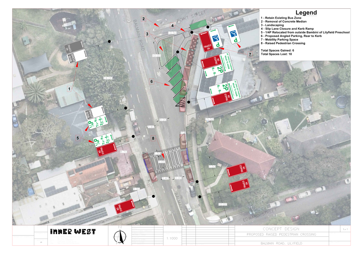
Subject: Balmain Road, Lilyfield - Orange Grove Raised Pedestrian Crossing (Baludarri-Balmain Ward/Balmain Electorate/Leichhardt PAC)
Prepared By: Jackie Ng - Graduate Traffic Engineer
Authorised By: Manod Wickramasinghe - Traffic and Transport Planning Manager
|
RECOMMENDATION
1. That the proposed Raised Pedestrian Crossing at Balmain Road between Point Street and Edward Street, Lilyfield including the closure of the slip lane at the intersection of Point Street and Balmain Road from Point Street to the crossing, and introduction of angle parking on the east side of Balmain Road be supported in principle and included for consideration in Council’s Capital Works Program and that Grant funding opportunities be sought for delivery of the crossing.
2. That the detailed design for the proposed works be brought back to the Traffic Committee for consideration. |
STRATEGIC OBJECTIVE
This report supports the following strategic directions contained within Council’s Community Strategic Plan:
|
2: Liveable, connected neighbourhoods and transport |
|
|
EXECUTIVE SUMMARY
This report outlines the proposed public domain works to support the upgrade of Orange Grove Public School by NSW Department of Education – School Infrastructure. With the school upgrade, the Department has requested a pedestrian crossing at Balmain Road between Point Street and Edward Street, to cover walking catchment areas predominantly to the east of the school and to improve road safety for school children and pedestrians. The proposal also includes closure of the slip lane in front of Orange Grove Hotel, public domain improvements, and new angle parking arrangement.
BACKGROUND
The NSW Department of Education – School Infrastructure has proposed an upgrade to Orange Grove Public School, to meet the enrolment needs for the community. To support the school upgrade and improve safety for children and pedestrians, the following public domain works are proposed:
· A raised pedestrian crossing across Balmain Road between Point Street and Edward Street, Lilyfield.
· Closure of the slip lane outside the Orange Grove Hotel, public domain improvements, and angled parking arrangements.
The proposed raised pedestrian crossing location has been carefully selected to minimise the loss of on-street parking, improve accessibility to the school’s entrance and in consideration of its distance and queuing with existing traffic signals. Additionally, the public domain improvements will also provide opportunities for landscaping and outdoor dining.
DISCUSSION
A Transport Working Group comprising of representatives and stakeholders for the Orange Grove Public School upgrade developed a case to improve accessibility and road safety in Balmain Road. The crossing was also required to cover the walking catchments for the Orange Grove Public School, predominantly the areas to the east for school children and their carers. Several concept designs were developed and considered, taking into consideration many factors such as loss of parking, Bus operations, pedestrian walking paths and queuing from the existing traffic signals at the Perry Street/Balmain Road intersection, loading requirements for the Orange Grove Hotel, as well as queuing from Lilyfield Road/Balmain Road intersection. The latest concept is attached for consideration and attempts to balance stakeholder concerns.
The existing school gate at Balmain Road located approximately 30m south of Point Street is expected to remain unchanged when the upgrade works are completed at the School. An assessment undertaken by consultants on behalf of NSW Depart of Education – School Infrastructure indicate that 38% of the School’s catchment is expected to use the proposed crossing mainly to the residential areas to the east of the school between Balmain Road and Lilyfield Road. This would indicate that the forecast pedestrian movements at the crossing will meet the minimum pedestrian volumes outlined in Council’s Crossing warrants.
Council’s current revised pedestrian crossing warrants comprise of:
In each of two separate one-hour periods in a typical day, the pedestrian flow per hour crossing the road is or is expected to be equal to or greater than 20, and vehicle volumes be equal to or greater than 200 where children and elderly or mobility impaired pedestrians count as two pedestrians.
Previous traffic count in Balmain Road near the proposed location indicate that Balmain Road carries in the order of 6,000 vehicles/day, this equates to approximately 600 vehicles in the peak hours, which would meet the vehicle warrants.
An examination of the crash database provided from Transport for NSW, indicate one reported crash in Balmain Road between Point Street and Lilyfield Road for the 5 year period ending in 2022, Rum code 73- Light truck westbound at intersection, off-road right into object at Point Street, two injuries.
To support the school upgrade and improve safety for children and pedestrians, the following public domain works are proposed:
· A raised pedestrian crossing across Balmain Road between Point Street and Edward Street, Lilyfield.
· Closure of the slip lane outside the Orange Grove Hotel, public domain improvements, and angled parking arrangements.
A letter outlining the proposal was distributed to 105 properties and a total of six (6) responses were received.
Feedback and comments have been summarized in the table below.
|
Resident Comments |
Council Comments
|
|
Loss of Parking
The proposed location will wipe out many parking spaces as well as the long-standing parent drop-off and pick-up location in front of the Childcare Centre. |
The current design aims to prioritize pedestrian safety while minimizing the impact the project will have on the surrounding public domain. The proposal will relocate the same number of parent short-term parking for the childcare centre, and minimise the loss of parking capacity by providing angle parking at the closure of the Point Street slip lane.
The raised pedestrian crossing will also provide opportunities for parents and pedestrians to park in nearby streets and safely cross Balmain Road through the new crossing. |
|
Location of the Crossing
There is an existing signalized crossing at the Balmain Road and Perry Street intersection that appears adequate and much safer.
The crossing will impact driveways in the surrounding area. We suggest moving the crossing further north or south. |
The location of the raised pedestrian crossing was chosen as it was the optimum location, taking into consideration of issues such as loss of parking, Bus operations, pedestrian walking paths and queuing from the existing traffic signals at the Perry Street/Balmain Road intersection, loading requirements for the Orange Grove Hotel, as well as queuing from Lilyfield Road/Balmain Road intersection.
Balmain Road currently only has two crossing points that allow pedestrians to cross safely in a stretch of approximately 300 metres (at Perry Street and Lilyfield Road). The crossing is required to provide a suitable crossing for school students and their carers, in particular the school catchment areas to the east of Orange Grove School. |
|
Traffic Congestion and Safety
The proposed changes will create considerable disruption in the area due to the angled parking and the closure of the slip lane increasing risk of injury to pedestrians and damage to vehicles.
The additional extension of the bicycle track will reduce the lanes available for vehicular traffic again adding to the congestion. |
See comment about loss of parking for angled parking concerns.
The closure of the slip lane will reduce the number of conflict points at the intersection and reduce vehicular speeds. A reduction in conflict points will reduce the possibility of collisions and will also provide opportunity for outdoor dining, street beautification, landscaping, improving walkability.
Balmain Road predominantly operates as a single lane in each direction between Point Street and Lilyfield Road. The current proposal is not expected to change the existing road configuration, although the crossing will be expected to help lower vehicle speeds in a sensitive land use area. |
|
Delivery Vehicles
The inability of the large delivery vehicles being able to manoeuvre properly to the loading areas for the Orange Grove Hotel will cause additional congestion.
The pedestrian fence will most likely be a problem for larger rear loading delivery trucks that point into and across the centre of the road to reverse into the hotel driveway. |
The revised concept does not propose a pedestrian fence along the central median. Additionally an analysis on vehicle swept path has been conducted and it is found that the proposal will provide adequate space to allow for a medium rigid vehicle movement into the Orange Grove Hotel driveway without impacting the existing central median or the proposed kerb islands. |
|
Parking Restrictions
It is requested that the new angle parking spaces be either untimed or reduced to 2P 8am-4pm Mon-Fri.
|
Council will consider changes to the restrictions during the development of the detailed design. If necessary, additional consultation will be undertaken for the parking changes. |
FINANCIAL IMPLICATIONS
Initial estimate of the proposed raised pedestrian crossing, including public domain works to be approximately $400,000. It is expected that this project would be eligible for funding streams from the NSW Government.
Works are to be considered as part of Council’s Capital Works program for Traffic Facilities with final costing to be finalized following completion of detailed design.
|
1.⇩ |
Proposed Orange Grove Raised Pedestrian Crossing - Concept Plan |
|
|
Local Traffic Committee Meeting 18 November 2024 |
Subject: Curtis Road, Balmain - Proposed Pedestrian Improvement Works Curtis Road, Balmain - Proposed Pedestrian Improvement Works (Baludarri-Balmain Ward/Balmain Electorate/Leichhardt PAC)
Prepared By: Zara Helal - Traffic Engineer
Authorised By: Manod Wickramasinghe - Traffic and Transport Planning Manager
|
RECOMMENDATION
That the following treatments be approved in principle for inclusion in Council’s Traffic Facility Capital Works Program and that a detailed design including consultation be brought back to the Committee for consideration: a) Raised pedestrian crossing on Curtis Road, north of Darling Street as shown in Attachment 1. b) Raised pedestrian crossing on Curtis Road between McDonald Street and Thames Street, continuous footpath treatment on Thames Street at Curtis Road, and conversion of McDonald Street from Curtis Road to Hoffmans Lane to one-way northbound (subject to approval of a TMP by TfNSW) as shown in Attachment 2.
|
STRATEGIC OBJECTIVE
This report supports the following strategic directions contained within Council’s Community Strategic Plan:
|
2: Liveable, connected neighbourhoods and transport |
|
|
EXECUTIVE SUMMARY
Council has received requests for consideration of pedestrian crossing points at Curtis Road, Balmain between Thames Street and Darling Street, to give pedestrians priority when crossing the road. To improve pedestrian safety and deter speeding in this area, it is proposed to install the following treatments:
1. Raised pedestrian crossing on Curtis Road, north of Darling Street as shown in Attachment 1
2. Raised pedestrian crossing on Curtis Road between McDonald Street and Thames Street, as per Attachment 2
3. Continuous footpath treatment on Thames Street at Curtis Road, as per Attachment 2.
Furthermore, it is proposed that McDonald Street from Curtis Road to Hoffmans Lane, be converted to one-way northbound as shown in Attachment 2 which is required to accommodate the pedestrian crossing. A tree will need to be removed in front of No. 31 Curtis Road as detailed on the plan to accommodate the crossing.
BACKGROUND
Table 1 outlines the features of Curtis Road between Thames Street and Darling Street.
|
Street Name |
Curtis Road – between Thames Street and Darling Street |
|
Kerb to Kerb Width |
9.7m approx. |
|
Carriageway Type |
Two-way, one travel lane each direction, mixed traffic with parking lanes on both sides of the road. |
|
Classification |
Local |
|
Speed Limit |
40 km/h |
|
Available TfNSW recorded crash history last 5 years (2019-2023) |
One (1) crash occurred between ‘unknown’ type vehicle turning left from McDonald Street to Curtis Road and pedal cycle travelling east on Curtis Road. RUM code: 16 Injury type: Serious injury Date: 16/02/2021 |
|
Parking Arrangements |
Parking permitted on both sides |
DISCUSSION
Road Network
The section of Curtis Road between Thames Street and Darling Street serves as a pedestrian connection between the Montrose Aged Care Centre and Balmain Care for Kids Preschool on Thames Street, to key land use attractors such as the Balmain shopping strip and Gladstone Park located west of the Curtis Road / Darling Street intersection. There are other pedestrian movements associated with local schools and residents walking to bus stops in Darling Street. As such, there is a high number of pedestrians, namely children and elderly pedestrians, that cross Curtis Road to travel to these locations. Darling Street and Curtis Road intersect to form a three-leg intersection, and traffic movements are regulated by an existing roundabout.
Council completed pedestrian and vehicle counts to determine if the volumes satisfy the warrants for a pedestrian crossing as required in Council’s Pedestrian Crossing Warrant Policy. Both the vehicle and pedestrian volumes exceed the minimum required volumes, at both proposed crossing locations with more than 20 pedestrian movements and 200 vehicular movements.
AM peak traffic counts in the form of tube counts and intersection counts at Curtis Road between Thames Street and Darling Street are shown in Figure 1.
PM peak traffic counts in the form of tube counts and intersection counts at Curtis Road between Thames Street and Darling Street are shown in Figure 2.
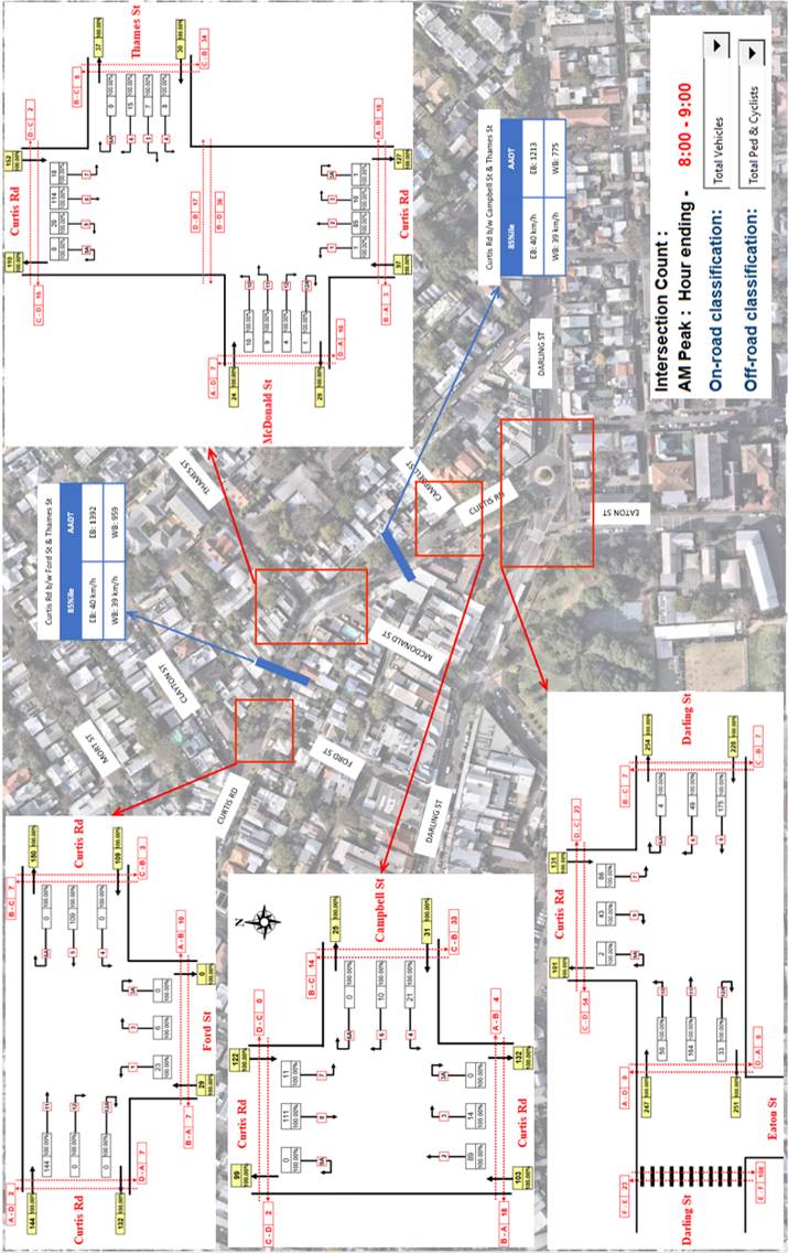
Figure 1: Tube count and intersection count traffic data – AM Peak 8:00AM-9:00AM

Figure 2: Tube count and intersection count traffic data – PM Peak 4:00PM-5:00PM
Geometry Assessment
Council assessed the approach sight distance (ASD) with respect to Austroads Guide to Road Design Part 4A: Unsignalised and signalised intersections to assess the feasibility and safety of installing a pedestrian crossing at Curtis Road between McDonald Street and Thames Street, as there is an identified sight constraint for eastbound movements in Curtis Road due to the curvature and slope of the road.
The ASD for the proposed raised pedestrian crossing at Curtis Road between McDonald Street and Thames Street is shown in Table 2.
|
Street |
85th %Ile speed (km/h) |
ASD (required) (metres) |
ASD (existing) (metres) |
Acceptable (Yes/No) |
|
Curtis Road (travelling eastbound from west of crossing) |
40 |
34 |
43 |
Yes |
The following assumptions were made in determining the ASD:
· A reaction time of 1.5 seconds (Absolute minimum value. Only used in very constrained situations where drivers will be alert)
· A coefficient of deceleration value of 0.36 (Desirable value for calculating minimum stopping sight distance for most urban and rural road types, and level crossings)
·
Based on the ASD assessment, the existing sight distance from the location the proposed pedestrian crossing is acceptable.
PUBLIC CONSULTATION
Initial community consultation for the Birchgrove / Balmain East Local Area Traffic Management (LATM) study was undertaken from Monday 27 May to Sunday 23 June 2024. This study area includes Curtis Road. A draft plan for the entire LATM area is currently being prepared.
Further to this consultation, an on-site meeting was held on Thursday 11 July 2024 to gather additional specific feedback relating to improving safety along Curtis Road between Campbell Street and Ford Street as raised by some members of the public. 14 residents attended the on-site meeting.
Feedback and comments from the on-site meeting have been summarized in the table below.
|
Resident Comments |
Officer Comments |
|
Curtis Road at intersections with Thames Street & McDonald Street - Sightline issues from both streets upon entering Curtis Road. - Both Thames & McDonald Streets have narrow road width. |
Noted. A continuous footpath treatment is proposed at Thames Street at its intersection with Curtis Road. This treatment will require road users to give way to pedestrians, and lower speeds when approaching the intersection.
Additionally, McDonald Street is proposed to be converted to one-way northbound between Hoffmans Lane and Curtis Road, which will reduce conflict points at the intersection.
The proposed raised pedestrian crossing at Curtis Road near its intersection with McDonald Street and Thames Street will provide pedestrians priority when crossing the road. |
|
Curtis Road is used as a rat run to avoid Darling Street. |
Noted. The two (2) proposed raised pedestrian crossings will provide traffic calming and deter speeding behaviours along Curtis Road. |
|
Speed issues mostly occur on the top slope northbound of Curtis Road between Darling Street and McDonald Street. - VMS speed sign is facing the wrong direction to capture vehicle speed on this section of Curtis Road. - Most vehicles exceeding the 40km/h speed limit are high-performance SUV vehicles. - Excessive speeds occur mainly during am/pm peak periods and evening hours. |
The proposed raised pedestrian crossing at Curtis Road near its intersection with McDonald Street and Thames Street will provide traffic calming and deter speeding behaviours at this location.
|
|
Residents suggest traffic calming is required on Curtis Road to slow speed. |
Noted. Traffic calming in the form of two (2) raised pedestrian crossings at Curtis Road are proposed. |
|
Drivers circulate from Curtis Road into surrounding streets to locate parking when visiting nearby cafes often performing dangerous U-turns at the McDonald Street intersection to secure a parking space. |
McDonald Street is proposed to be converted to one-way northbound between Hoffmans Lane to deter U-turns at its intersection with Curtis Road. |
|
Hotel/pub located on Curtis Road attracts additional traffic from patrons. |
Noted. The two (2) proposed raised pedestrian crossings will provide pedestrians priority when crossing the road. |
|
Drivers entering Curtis Road from Ford Street fail to stop before turning onto Curtis Road. |
The proposed treatments will reduce the speed profile in Curtis Road heading westbound. |
|
Residents have concerns regarding noise association with speed humps to provide traffic calming however acknowledge that pedestrian safety is the priority. |
Noted. The location of the two (2) proposed raised pedestrian crossings have been selected as such that there is minimal disturbance on neighbouring properties whilst providing priority crossing opportunity for pedestrians at desire lines. |
|
The existing pedestrian refuge at the intersection of McDonald Street/Thames Street is the preferred desire line for pedestrians and the most obvious location for a raised pedestrian (zebra) crossing. However, due to the complex geometry of the intersection along with vehicles parked nearby, visibility and sightlines are impacted. Relocation or loss of parking may be considered to ensure visibility of pedestrians when crossing. |
Noted. The proposed pedestrian crossing at Curtis Road near its intersection with McDonald Street and Thames Street follows the existing pedestrian desire line.
Council assessed the approach sight distance (ASD) determine the feasibility and safety of installing a pedestrian crossing at Curtis Road between McDonald Street and Thames Street, as there is an identified sight constraint due to the curvature and slope of the road. Parking is proposed to be removed and/or relocated as required by NSW Road Rules for stopping on or near a pedestrian crossing, and to ensure adequate sight distance. Conversion to one way northbound in McDonald Street required to allow sufficient space for pedestrian crossing to be provided conflict points at intersection. |
|
Vehicles that reverse out of driveways at Curtis Road are causing safety issues. |
Noted. It is the drivers’ responsibility to reverse out when it is safe to do so. |
FINANCIAL IMPLICATIONS
Works are to be considered as part of Council’s Capital Works program for Traffic Facilities with final costing to be finalised following completion of detailed design.
|
1.⇩ |
Curtis Road at Darling Street, Balmain - Concept Design |
|
2.⇩ |
Curtis Road at McDonald Street and Thames Street, Balmain - Concept Design |
|
|
Local Traffic Committee Meeting 18 November 2024 |
Subject: Emmerick Street, Lilyfield - Proposed New Kerb Blister (Baludarri-Balmain Ward/Balmain Electorate/Leichhardt PAC)
Prepared By: Amir Falamarzi - Traffic Engineer
Authorised By: Manod Wickramasinghe - Traffic and Transport Planning Manager
|
RECOMMENDATION
That the attached detailed design plan (Design Plan No. 10306) for the proposed kerb blisters in Emmerick Street at the intersection with Perry Street, Lilyfield be approved.
|
STRATEGIC OBJECTIVE
This report supports the following strategic directions contained within Council’s Community Strategic Plan:
|
2: Liveable, connected neighbourhoods and transport |
|
|
EXECUTIVE SUMMARY
Council is planning to improve pedestrian accessibility and safety in Emmerick Street, Lilyfield at Perry Street by constructing kerb blister islands with integrated kerb ramps at this location. The works aim to improve road safety by better defining the pedestrian crossing points, reducing vehicle speeds and reducing the overall crossing distance for pedestrians crossing Emmerick Street.
BACKGROUND
The detailed design plan shown in Attachment 1 outlines the proposed work on Emmerick Street, Lilyfield and includes the following:
· Construct two landscaped kerb blister islands with ‘gutter bridge’ crossings and integrated kerb ramps in Emmerick Street at its intersection with Perry Street.
· Resurface the road pavement with new asphalt as shown in the plan (final extent of any resurfacing will be subject to final funding allocations).
· Remove the existing kerb ramps and reconstruct damaged sections of concrete footpath with new concrete footpath.
· Construct two new stormwater drainage inlet pits in new locations in Emmerick Street and provide space for the new landscaped kerb blister islands, connect to the existing stormwater drainage system.
· Provide new ‘Motor Bike’ parking spaces between the existing in-road tree and the new landscaped kerb blister island on the west side of Emmerick Street.
· Slightly adjust the existing ‘No Stopping’ signage, and provide new ‘No Stopping’ signs.
· Adjust existing regulatory signage as indicated on the plan.
· Install associated new pavement line marking and signage as indicated on the plan.
The works are generally being proposed within the statutory 10m No Stopping zone in Emmerick Street, and therefore the proposal will not result any loss of any legal on-street parking spaces. A small section of ‘Motor Bike’ parking will be created within the residual kerbspace created between the kerb blister island and an existing street tree on the west side of Emmerick Street.
PUBLIC CONSULTATION
A letter outlining the proposal was issued to the properties (39 properties) shown in the distribution map below. No response has been received from the consultation.
![]()

FINANCIAL IMPLICATIONS
Funding of $106,500 will be allocated from the PAMP programs with construction scheduled to commence in 2024/2025.
|
1.⇩ |
Emmerick Street - Kerb Blister Islands Detailed Design Plan |
|
|
Local Traffic Committee Meeting 18 November 2024 |
Subject: Darling Street Between Mort Street and Booth Street, Balmain - Road Occupancy - Anzac Day Dawn Service (Baludarri - Balmain Ward/ Balmain Electorate/ Leichhardt PAC)
Prepared By: Amir Falamarzi - Traffic Engineer
Authorised By: Manod Wickramasinghe - Traffic and Transport Planning Manager
|
RECOMMENDATION
That the temporary road closure of Darling Street (Mort Street to Booth Street), Balmain on Friday, 25 April 2025 between 2.30am – 9.30am be approved, subject to the following conditions be approved: a) all affected residents and businesses, including the NSW Police Local Area Commander, Fire & Rescue NSW and NSW Ambulance Services be notified in writing, by the applicant, of the proposed temporary road closure at least 14 days in advance of the closure with the applicant making reasonable provision for stakeholders;
b) that an unencumbered passage minimum 3.0m wide be available for emergency vehicles through the closed section of Darling Street, Balmain; and
c) the occupation of the road carriageway must not occur until the road has been physically closed. |
STRATEGIC OBJECTIVE
This report supports the following strategic directions contained within Council’s Community Strategic Plan:
|
2: Liveable, connected neighbourhoods and transport |
|
|
EXECUTIVE SUMMARY
In preparation to mark the ANZAC Day Dawn Service 2025 on Friday, 25 April 2025, Inner West Council is organising the ANZAC Day dawn Service at the Loyalty Square War Memorial, Balmain. To facilitate the event, it is proposed to close Darling Street between Mort Street and Booth Street between 2:30am and 9:30am.
BACKGROUND
In preparation to mark the ANZAC Day Dawn Service 2025, Council is organising an event at the Loyalty Square memorial, Balmain.
The details of the event are as follows:
· Day: Friday, 25 April 2025
· Commemorative Service: 6.00am – 7.00am
· Venue: Loyalty Square, Balmain (outside Woolworths)
· Procession: There will be no march down Darling Street for 2025
To facilitate the event, it is proposed to close Darling Street between Mort Street and Booth Street (approximately 200m) between 2.30am and 9.30am. This road closure will prevent all traffic travelling through this closed section and will prevent any additional on-street parking on both sides of the subject section of Darling Street.
To further support the event area and surrounding businesses and commercial operators, Ford Street and Hoffmans Lane, between Curtis Road and McDonald Street will have local access permitted via a soft closure.
It should be noted that although the land uses in this area are predominantly retail/commercial, there are a number of residential properties in this section of Darling Street.
The Traffic Management Plan prepared for the event is outlined in Attachment 1.
DISCUSSION
All businesses/residents in the affected area will be advised to avoid parking in the subject section of Darling Street.
Based on the discussions held with the Transit Systems representative, buses would need to terminate at Darling Street/Rowntree Street/Montague Street intersection as Curtis Road is not suitable for bus movements. To maintain transport services between Balmain East and Balmain, Council will organise two shuttle bus services running between Balmain East and Darling Street/Rowntree Street/Montague Street. The shuttle bus service routes are shown on the attached TGS (Attachment 2).
Transit Systems will post notifications at all bus stops on Darling Street between Beattie Street and Balmain East wharf to advise passengers to use Council’s community buses on the morning of 25 April 2025. All other eastbound and westbound traffic will need to use Curtis Road or Palmer Street to access Balmain East.
The Transit Systems representative has also requested the temporary expansion of the bus turning area at Grove Street to accommodate additional buses. Therefore, it is proposed to temporarily remove three parking spaces on the northern side even numbered side (No. 22, 24, 26A) of Grove Street near Deloitte Avenue, Birchgrove. Affected residents will be notified.
PUBLIC CONSULTATION
Council’s Community Events Coordinator will organise a notification letter outlining the closure of Darling Street (between Mort Street and Booth Street) to all affected properties and the emergency services, including Balmain Hospital of the temporary road closure.
The proposed road closure is currently advertised on Council’s website in accordance with the Roads Act 1993.
FINANCIAL IMPLICATIONS
There are no financial implications associated with the implementation of the proposed recommendations outlined in the report.
|
1.⇩ |
ANZAC 2025 Traffic Management Plan |
|
2.⇩ |
ANZAC 2025 Traffic Guidance Scheme |
|
|
Local Traffic Committee Meeting 18 November 2024 |
Subject: Audley Street, Audley Lane, Sadlier Crescent, Fisher Street, and eastbound parking lanes on New Canterbury Road Petersham – Temporary Full Road Closures For Special Event On Saturday 22 March 2025 – Petersham Festival Bairro Portuguese (Damum - Stanmore Ward / Newtown Electorate / Inner West PAC)
Prepared By: Jennifer Adams - Traffic Engineer
Authorised By: Manod Wickramasinghe - Traffic and Transport Planning Manager
|
That the proposed temporary road closure of Audley Street (between New Canterbury Road and Trafalgar Street), Sadlier Crescent (between Audley Street and Abels Lane) and Fisher Street (between Audley Street and Regent Street), Audley Lane north of New Canterbury Road (resident access excepted) as well as the eastbound parking lane on New Canterbury Road (between Audley Street and Audley Lane), Petersham on Saturday 22 March 2025, from 6:00am until 2.00am (Sunday), for the holding of ‘2025 Bairro Portuguese Petersham Festival’, be approved subject to the applicant complying with but not limited to the following conditions: 1. A Traffic Management Plan (TMP) is submitted to and approved by Transport for NSW; and an application for a Road Occupancy Licence and a temporary Speed Zone Authorisation is forwarded to and approved by the Transport Management Centre.
2. Notice of the proposed event is forwarded to all affected residents and businesses, including the N.S.W. Police / Inner West Local Area Commander, Fire and Rescue NSW, NSW Ambulance and Transit Systems.
3. Transit Systems – Inner West Bus Services be requested to implement a revised routing for scheduled bus services in Audley Street on the day of the event and install temporary bus stops as required.
4. A minimum four (4) metre unencumbered passage be available for emergency vehicles through the closed section.
5. The occupation of the road carriageways must not occur until the roads have been physically closed.
|
STRATEGIC OBJECTIVE
This report supports the following strategic directions contained within Council’s Community Strategic Plan:
|
2: Liveable, connected neighbourhoods and transport |
|
|
EXECUTIVE SUMMARY
Inner West Council will be presenting Petersham Festival - Bairro Portuguese on Saturday 22 March 2025 from 3:00pm until 9:00pm on Audley Street and Fisher Street, Petersham. This event celebrates the very best of Portuguese culture with entertainment, music, dance, cultural activities, and traditional and contemporary foods. To facilitate the event, areas of Petersham will be closed and there will be road closures necessitating some road detours and bus diversions in surrounding streets.
Roads affected include Audley Street (between New Canterbury Road and Trafalgar Street), Sadlier Crescent (between Audley Street and Abels Lane) and Fisher Street (between Audley Street and Regent Street), Audley Lane north of New Canterbury Road (resident access excepted) as well as the eastbound parking lane on New Canterbury Road (between Audley Street and Audley Lane), Petersham from 6.00am Saturday 22 March 2025 until 2.00am Sunday 23 March 2025. It is recommended that Council agree to the temporary full road closures subject to all standard Council conditions for a temporary full road closure (ENRC/2024/0064). This report outlines the traffic management plan for the 2025 event.
BACKGROUND
Temporary road closures have been successfully implemented in previous years to hold the ‘Bairro Portuguese Food and Wine Fair’. This Fair, since its inception in 2003, aims to showcase Petersham’s businesses and services, attracts people to the area and has a multicultural theme. On all previous occasions, the closures were effective, and no major problems were experienced.
OFFICERS COMMENTS
Event
The event will be held on Saturday 22 March 2025 between 3.00pm and 9.00pm and will necessitate the temporary closure of the nominated streets in Petersham from 6.00am Saturday 22 March 2025 until 2.00am Sunday 23 March 2025. Refer to the site map below.

This is an extension of a Class 2 Event under the TfNSW’ Special Events Guide where it impacts local traffic and transport systems but does not impact major traffic and transport systems and it disrupts the non-event community in the area around the event but not over a wide area. The event requires the involvement of Police and Local Council and a detailed Transport Management Plan (TMP).
Traffic Management Plan and Traffic Guidance Scheme
A Traffic Management Plan (TMP) has been supplied by CATO Location Services, the scope of which includes the provision for the safe movement of vehicular traffic in and out of the event areas at the Bairro Portuguese Food and Wine Fair on Saturday 22 March 2025. The Traffic Management Plan (TMP) and Traffic Guidance Scheme (TGS) are attached at the end of this report.
Access around the event site will be maintained by 2 detours. The detour loops will include New Canterbury Road, Regent Street, Trafalgar Street and Gordon Street. Please refer to the Detour Plan reproduced below.
Access for local residents and businesses will be maintained wherever possible. It is noted that the road closure area for the Petersham Festival includes several residences and businesses fronting Audley Street. Pedestrian access to these businesses and residences will be managed within the closure, however businesses vehicle access will not be permitted within the event area. All non-local traffic will be redirected around the area via the detour as per the implemented detour plan. The Event Organiser will notify all residents and businesses impacted by the event including confirmation of the restricted vehicle movements during the event operating times. This will include reviewing any requirements for changes to commercial waste collection times and/or locations.
Access for emergency vehicles will be maintained at all times. A minimum four metre emergency lane will be preserved along the entire closure. There will be no event infrastructure in the emergency lane. Traffic controllers will be onsite to assist emergency vehicle through the closure points.
A Traffic Guidance System (TGS) will be implemented for the closures and detours noted above. Refer to the attached TMP.
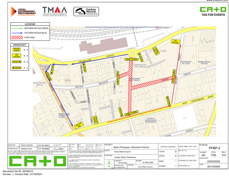
Lane closures of New Canterbury Road
As per previous events held, it is proposed to close the parking lanes on New Canterbury Road (between Audley Lane and Audley Street).
In previous years the event attracted in excess of 15,000 attendees prompting the event coordinators to look at ways to ease congestion at the main site and make access easier from New Canterbury Road. The closure of the parking lanes on New Canterbury Road improves access to the area where the main event is to be conducted and improves the amenity of the footpath dining outside a number of the eateries along New Canterbury Road which are adjacent to the closure.
There is significant improvement in access for people with disabilities as congestion will be reduced and there will be no obstacles such as tables, chairs, planter boxes, light/sign poles and bins in the closed lanes. The solid barriers will separate the pedestrians from the moving traffic on the adjacent lane and will also help prevent young children who may be separated from their custodians escaping onto the main thoroughfare and possibly being hit by passing traffic.
The TGS indicates that a reduced temporary speed limit of 40km/h is required on New Canterbury Road (between Gordon Street and Audley Street) during the closure of the parking lanes for the subject event. Thus, an application for a Road Occupancy Licence will be necessary. It is noted that New Canterbury Road is a State Road and under the jurisdiction of Transport for NSW (TfNSW).
Duration of road closures
The timespan for the road closure is necessary to allow stalls and stages to be set up before the event and dismantled after the event. The closure will be affected by the placement of barricades at the nominated locations shown in the TGS.
Impacts on buses
Audley Street is used by scheduled Transit Systems bus services and they will need to implement the re-routing of services on the day as in previous years. Transit Systems 445 service will all be impacted by the event road closures.
Local buses will operate on a weekend timetable and will therefore be reduced on the event day in comparison to a weekday. Bus route 445 will be detoured around the event area via 2 detours, 1 detour for eastbound buses and 1 detour for westbound buses as shown below.
· Eastbound detour – New Canterbury Road > Gordon Street > Trafalgar Street
· Westbound detour – Trafalgar Street > Gordon Street > New Canterbury Road
The stops listed below will be affected during the proposed event times. Notices will be put up at impacted bus stops to direct passengers to the nearest stop.
Bus stops impacted – Eastbound, 204937 & 204911
– Westbound 204938 & 204946
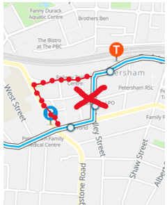
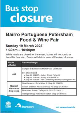
Impacts on traffic
There will be no special event clearways. The TMP states that “The event organisers have engaged Cato Location Services to barricade all parking spaces within the event area the night before the event commences.” Both sides of Audley Street, between Trafalgar Street and New Canterbury Road, will be barricaded to accommodate a pedestrian friendly event area.
In relation to parking it is stated in the TMP that “There is limited street parking available for participants of the event, the event organiser will promote public transport as the best way of getting to the event due to its proximity to regular bus and train services.”
'No Parking - Special Event' signs will be affixed over all existing timed parking restrictions signs in the area to be closed on the afternoon before the day of the event. Residents in Fisher Street will be allowed access into and out of their properties.
The TMP states that “The closure of Audley St and Fisher St will not significantly affect designated cycling routes through Petersham. Cyclists will still be able to dismount and walk their bikes through the event site. All existing cycle routes will remain in place and operational around the event site”.
Variable Message Boards
The TMP notes that there will be two (2) VMS installed around the event site to inform road users of the changed traffic conditions one (1) week before the event, and also on the event date.
The locations and messages are as follows:
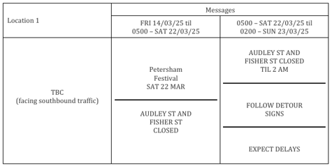
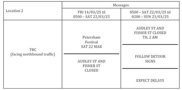
PUBLIC CONSULTATION
The proposed temporary full road closures have been advertised in accordance with the Roads Act 1993.
Advice of the proposed event must be forwarded to all the appropriate authorities, including emergency services. A copy of the draft notification letter is attached at the end of this report.
The TMP states that:
“The Event Organiser will advertise the road closures via social media and on Council’s website. A letterbox drop will be conducted to all resident and businesses in the immediately vicinity of the event sites and road closures as well as the surrounding streets in Petersham”.
“The Event Organiser will promote Petersham Festival and the road closures taking place using a variety of methods in the weeks preceding the event including:
+ Council’s social media platforms,
+ Council’s website,
+ Local signage where available,
+ Flyers,
+ VMS Boards and,
+ Local News Paper”
Funding of $112k has been allocated by Council for organising the ‘Bairro Portuguese Food and Wine Fair’ event under the 2024/2025 Major Community Events Program.
CONCLUSION
It is recommended that Council approve to the temporary full road closures on Saturday 22 March 2025 subject to complying with the recommendations stated in this report along with all standard conditions for temporary full road closures.
Other conditions that need to be complied with include:
· The Traffic Management Plan is to be submitted to TfNSW for consideration and approval and a Road Occupancy License application is to be submitted to the Transport Management Centre by CATO Location Services.
· Advance notifications signs for the event are strategically installed at least two (2) weeks prior to the event;
· "No Parking - Special Event" signs are affixed over all existing timed parking restriction signs within the sections of streets to be closed on the afternoon of the day prior to the event;
· A 4-metre wide emergency vehicle access must be maintained through the closed road areas during the course of the event;
· The applicant is to consult with all affected residents and/or businesses in the area in writing and to conduct a letter box drop of surrounding properties at least two weeks prior to event; and
· Adequate vehicular traffic control shall be provided for the protection and convenience of pedestrians and motorists including appropriate signage and flagging. Workers shall be specially designated for this role (and carry appropriate certificates), as necessary to comply with this condition. This is to be carried out in accordance with the Australian Standard AS 1742.3 - Traffic Control Devices for works on roads.
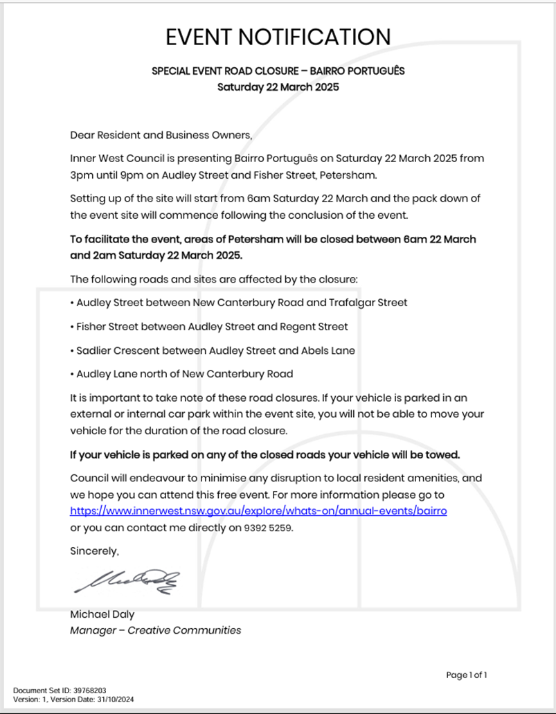
|
1.⇩ |
TMP - Petersham Festival - IWC - 22 March 2025 - V1.3 (003) |
|
Local Traffic Committee Meeting 18 November 2024 |
Subject: Bruce Street, Ashfield - Proposed 'shared path' (Djarrawunang-Ashfield Ward/Summer Hill Electorate/Burwood PAC)
Prepared By: James Nguyen - Traffic Engineer
Authorised By: Manod Wickramasinghe - Traffic and Transport Planning Manager
|
RECOMMENDATION
That the concept plan for the ‘shared path’ along the existing footpath between Bruce Street and Hume Highway, Ashfield (as detailed in Attachment 1) be approved.
|
STRATEGIC OBJECTIVE
This report supports the following strategic directions contained within Council’s Community Strategic Plan:
|
2: Liveable, connected neighbourhoods and transport |
|
|
EXECUTIVE SUMMARY
This report identifies bicycle improvements at an existing missing link on Bruce Street adjacent to the on-road bicycle path along Grosvenor Crescent and Elizabeth Street, Ashfield. The proposed ‘shared path’ will improve bicycle connectivity to the existing on-road bicycle path.
BACKGROUND
Council has received a request from Inner West Bicycle Coalition to convert the existing footpath on the eastern side of Bruce Street, between the cul-de-sac and Hume Highway to a ‘shared path’.
DISCUSSION
Bruce Street intersects with an existing on-road bicycle path on Elizabeth Street and Grosvenor Crescent, Ashfield. Currently, there is no formal facility that legally allows cyclists to enter and exit the on-road bicycle path to access Bruce Street. The existing footpath which connects Bruce Street at the cul-de-sac to the junction at Hume Highway, Grosvenor Crescent and Elizabeth Street is not demarcated as a ‘shared path’. The current provisions are shown in Figure 1 below:
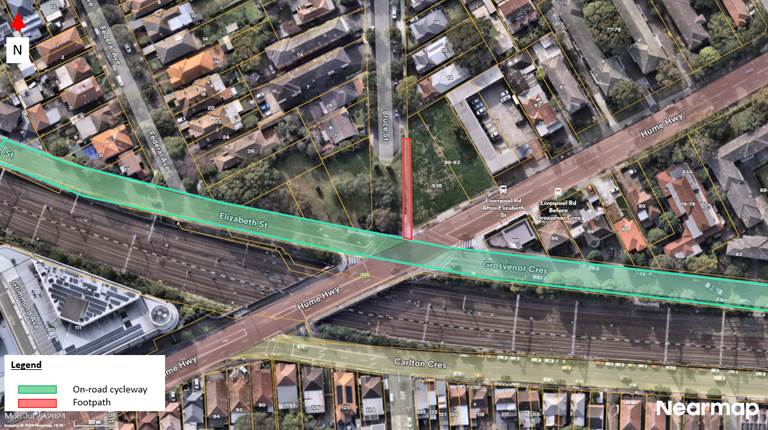
Figure 1 - Existing provisions
Accordingly, it is proposed to convert this footpath to a ‘shared path’ to allow cyclists to access Bruce Street from the adjacent on-road bicycle path at Elizabeth Street and Grosvenor Crescent.
The proposal will consist of the following and is shown in Attachment 1:
· Install a new kerb ramp at the cul-de-sac of Bruce Street;
· Widen a portion of the existing footpath from 1.5 meters to 3.0 meters and install a new 3.0 metre wide concrete path to connect to the kerb ramp;
· Install shared path line marking (T1L01 line);
· Install shared path pavement patches (T1S02 patch); and
· Install R8-2 and R7-4 signs.
FINANCIAL IMPLICATIONS
The project is estimated to cost $20,000 and will be funded under Council’s capital (cycleway) works program.
|
1.⇩ |
Concept plan |
|
|
Local Traffic Committee Meeting 18 November 2024 |
Subject: Lackey Street & Smith Street (between Moonbie Street and Nowranie Street), Summer Hill-ENRC/2024/0062 Temporary Full Road Closure- 'Summer Hill Social' event on Sunday 9 March 2025 (Djarrawunang-Ashfield Ward/Summer Hill Electorate/Burwood PAC)
Prepared By: Boris Muha - Traffic Engineer
Authorised By: Manod Wickramasinghe - Traffic and Transport Planning Manager
|
RECOMMENDATION
THAT the proposed temporary full road closure of Lackey Street & Smith Street (between Moonbie Street and Nowranie Street) Summer Hill, be approved for the purpose of holding a ‘Summer Hill Social’ event on Sunday 9 March 2025 between 4.00am to 11.00 pm as per the submitted TMP and TGS, and subject to the following conditions and all standard Council conditions for a temporary full road closure: a) That a Road Occupancy License application be obtained from the Transport Management Centre.
b) That notice of the proposed event be forwarded to the NSW Police Local Area Commander, Transit Systems, the NSW Fire Brigade and the NSW Ambulance Services.
c) That all residents and businesses in and around the affected area are to be notified of the temporary road closure in writing by the applicant in advance (at least 7 days prior to the event) with the applicant making reasonable provision for stakeholders.
d) That a minimum four (4) metre unencumbered passage be available for emergency vehicles through the closed sections.
e) That the occupation of the road carriageway must not occur until the road has been physically closed.
|
STRATEGIC OBJECTIVE
This report supports the following strategic directions contained within Council’s Community Strategic Plan:
|
2: Liveable, connected neighbourhoods and transport |
|
|
EXECUTIVE SUMMARY
Inner West Council is presenting a ‘Summer Hill Social’ on Sunday 9 March 2025 from 11am until 5pm on Lackey and Smith Street, Summer Hill.
This is a free, family friendly long-lunch style event with an array of food and drinks on offer from local cafes and restaurants, captivating performances by local artists, exciting stalls from the Summer Hill businesses and a fun kids’ activity area.
The setting up of the site will start from 4am and will be removed 10pm, after the event.
To facilitate the event, areas of Summer Hill, i.e. Lackey Street and Smith Street (between Moonbie Street and Nowranie Street) will be closed between 4am and 11pm Sunday 9 March 2025. Hardie Avenue will only be open for carpark access off Smith Street.
BACKGROUND
Lackey Street and the above section of Smith Street have been closed on numerous occasions in the past for various food and musical events, The temporary full road closure of Lackey Street and Smith Street has been approved through the Traffic Committee in the past, subject to appropriate traffic control, specific conditions as recommended above and other standard conditions as set out by Council.
DISCUSSION
It is expected that up to 5,000 people may attend the event. The event would be categorised under a class 2 (if not a 3) event under the TfNSW Special Events Guide where it does not impact on the major traffic and transport systems and non-event community over a wide area. The event requires the involvement of Local Council and Police.
Adequate traffic control will be provided, with traffic made to detour through the surrounding streets. Hardie Avenue will only be opened to access the Summer Hill carpark. If the carpark is full, vehicles will be directed to park elsewhere. Service vehicle activity in the area will be encouraged to be done outside the times of the event. Refer to the Traffic Guidance System (TGS) and Detour plan as shown on Attachment 1 and Traffic Management Plan (TMP) Attachment 2 to explain any further details on the event.
VMS advance advisory boards will be placed on approach ends to Lackey Street in Carlton Crescent, and static advance advisory signs will be placed elsewhere to alert motorists of the closure prior to the event.
The event-coordinator will apply for a Road Occupancy License (ROL). Lackey Street and Smith Streets are not Bus Routes
The proposed temporary full road closure has will be advertised in accordance with the Road Act 1993.
FINANCIAL IMPLICATIONS
Funding of up to approximately $72,400 has been allocated by Council for the event under the 2024/2025 Major Community Events Program.
CONCLUSION
It is recommended that Council agree to the temporary full road closure of Lackey Street and Smith Street (between Moonbie Street and Nowranie Street) Summer Hill, to conduct the ‘Summer Hill Social’ event between 4am-11pm on Sunday 9 March 2025.
|
1.⇩ |
Traffic Guidance System (TGS) - 'Summer Hill Social' 2025. |
|
2.⇩ |
Traffic Management Plan (TMP) - 'Summer Hill Social' 2025 |
|
|
Local Traffic Committee Meeting 18 November 2024 |
Subject: Mackey Park and Carrington Road Survey Area, Marrickville - Request for extension of M2 Residential Parking Scheme - Resident Parking Questionnaire Survey Results (Midjuburi-Marrickville Ward/Summer Hill Electorate/Inner West PAC)
Prepared By: James Nguyen - Traffic Engineer
Authorised By: Manod Wickramasinghe - Traffic and Transport Planning Manager
|
RECOMMENDATION
1. That the proposed three-month trial of timed permit parking restrictions on Thornley, Cary, Renwick, Ruby and Junction Streets, and Warren Road not proceed due to the lack of community response and support.
2. That the proposed ‘2P 3pm-9pm Mon-Fri; 4P 8am-6pm Sat-Sun’ restrictions on the western side of Richardson Crescent south of Carrington Road be installed as shown in Attachment 2.
3. That the current on-going enforcement of unattended and unauthorised vehicles under the Public Spaces (Unattended Property) Act 2021 by Council’s Parking Officers to improve parking conditions for households that are affected by current parking behaviours on the local streets be noted. |
STRATEGIC OBJECTIVE
This report supports the following strategic directions contained within Council’s Community Strategic Plan:
|
2: Liveable, connected neighbourhoods and transport |
|
|
EXECUTIVE SUMMARY
Following a Notice of Motion being raised, Council resolved to undertake a community consultation for a proposed three-month trial to extend the Resident Permit Parking Scheme Area M2 to the industrial precinct around Carrington Road, Cary and Renwick Streets. This report presents results of the parking surveys and community consultation completed in the following streets:
· Thornley Street, south of Premier Street
· Richardson Crescent, east of Carrington Road
· Carrington Road between Premier and Richardson Crescent
· Cary Street between Carrington Road and Johnston Lane
· Renwick Street between Carrington Road and Johnston Lane
· Warren Road between Carrington Road and Johnston Street
· Ruby Street between Carrington Road and High Street
· Junction Street between Ruby Street and Schwebel Street
The parking surveys completed indicate high utilisation surrounding Mackey Park and the nearby streets perpendicular to Carrington Road, and households with no or limited off-street parking may be affected by current parking conditions, and any future potential parking restrictions on Mackey Park.
The results from the community consultation indicate a low response rate from residents for a three-month trial of the extension of the M2 permit parking area despite those responding generally in support of the scheme. Given the low response rate, Resident Parking Scheme restrictions are not recommended at this time.
It is recommended to proceed to install timed parking restrictions on the western side of Richardson Crescent, south of Carrington Road to prevent long-term parking adjacent to the park and improve parking opportunities for park users during the weekday evening and weekend daytime periods.
BACKGROUND
A notice of motion was raised by Council to undertake a community consultation for a proposed three-month trial to extend the Resident Permit Parking Scheme Area M2 to the industrial precinct around Carrington Road, Cary and Renwick Streets.
A parking survey was undertaken in the streets surrounding the industrial precinct near Carrington Road and Mackey Park to assess parking conditions and determine if parking restrictions (timed parking and permit parking restrictions) are necessary. The parking survey was completed on Monday 1 July 2024 between 7am and 7pm.
Based on this survey it was proposed that timed parking restrictions signposted as ‘2P 3pm-9pm Mon-Fri; 6P 8am-6pm Sat-Sun’ be considered on Carrington Road and Richardson Crescent, adjacent to Mackey Park, and that timed permit parking restrictions are considered in conjunction at nearby streets to minimise any impact that the timed parking restriction adjacent to Mackey Park may have (36 spaces), particularly to nearby streets that have high levels of parking utilisation, and limited to no off-street parking.
Accordingly, a Resident Parking questionnaire survey proposing ‘2P 8am-6pm Mon-Fri Permit Holders Excepted Area M2’ was undertaken with affected households in:
· Thornley Street, south of Premier Street
· Cary Street between Carrington Road and Johnston Lane
· Renwick Street between Carrington Road and Johnston Lane
· Warren Road between Carrington Road and Johnston Street
· Ruby Street between Carrington Road and High Street
· Junction Street between Ruby Street and Schwebel Street
There were no proposed parking changes on Premier Street given most households have off-street parking, and on-street parking utilisation was low.
Council Policy/Guidelines
Council's adopted Policy for the introduction of a Permit Parking Area states "that before implementing a resident parking scheme in any area, a survey of residents be undertaken to ascertain the level of support for such a scheme and that such support should be in excess of 65% of submissions received provided that rate of return of submissions is reasonable (higher than 30%)".
DISCUSSION
Table 1 below presents a summary of the parking survey results and investigations into determining which streets may benefit from timed permit parking restrictions. It should be noted that parking utilisation thresholds were in most cases close but did not meet Council’s requirements of 85% occupancy. Nevertheless, due to the closeness of the ultilisation data to the council thresholds, Council Officers followed up with a survey to determine the level of support for Residential Parking Scheme from the community prior making a final recommendation.
|
|
Local Traffic Committee Meeting 18 November 2024 |
Table 1 - Parking survey results and remarks
|
Street |
Between |
Average Parking Occupancy (both sides) |
Remarks |
Consider RPS extension (Y/N) |
Proposed changes |
|
Carrington Road |
Premier and Cary Streets |
79% |
· Average for both sides less than 85% utilisation threshold · Parking utilisation on eastern side adjacent to the park was 88% · Timed parking restrictions adjacent to the park may transfer demand (approximately 13 spaces) to adjacent streets |
No+ |
2P 3pm-9pm Mon-Fri; 6P 8am-6pm Sat-Sun+
+ these parking restrictions do not provide exemptions to RPS permit holders. |
|
Richardson Crescent |
South of Carrington Road |
86% |
· Parking utilisation on southern side adjacent to the park was 91% · Timed parking restrictions adjacent to the park may transfer demand (approximately 23) to adjacent streets |
No+ |
2P 3pm-9pm Mon-Fri; 6P 8am-6pm Sat-Sun+
+ these parking restrictions do not provide exemptions to RPS permit holders. |
|
Premier Street |
Between Carrington Road and Johnston Lane |
68% |
· Average for both sides less than 85% utilisation threshold · Most households have off-street parking |
No |
No change |
|
Thornley Street |
South of Premier Street |
82% |
· Average for both sides slightly less than 85% utilisation threshold · Some households on eastern side have no off-street parking and transfer of parking demand may affect these households |
Yes |
2P 8am-6pm Mon-Fri Permit Holders Excepted Area M2 |
|
Cary Street |
Carrington Road and Johnston Lane |
78% |
· Average for both sides slightly less than 85% utilisation threshold · Some households on both sides have limited or no off-street parking and transfer of parking demand may affect these households |
Yes |
2P 8am-6pm Mon-Fri Permit Holders Excepted Area M2 |
|
Renwick Street |
Carrington Road and Johnston Lane |
82% |
· Average for both sides slightly less than 85% utilisation threshold · Parking utilisation on northern side was 93% · Most households on southern side do not have off-street parking |
Yes |
2P 8am-6pm Mon-Fri Permit Holders Excepted Area M2 |
|
Warren Road |
Carrington Road and Johnston Lane |
82% |
· Average for both sides slightly less than 85% utilisation threshold · Parking utilisation on southern side adjacent to the park was 84% · Most households on both sides do not have off-street parking and transfer of parking demand may affect these households |
Yes |
2P 8am-6pm Mon-Fri Permit Holders Excepted Area M2 |
|
Ruby Street |
Between Carrington Road and Ivanhoe Street |
69% |
· Average for both sides less than 85% utilisation threshold · Parking utilisation on southern side was 81% and higher than the total average between Carrington Road and Ivanhoe Street · Most households on both sides have limited to no-off street parking and transfer of parking demand may affect these households |
Yes |
2P 8am-6pm Mon-Fri Permit Holders Excepted Area M2 |
|
Junction Street |
Between Ruby and Schwebel Streets |
81% |
· Average for both sides slightly less than 85% utilisation threshold · Most households on both sides have limited to no-off street parking and transfer of parking demand may affect these households |
Yes |
2P 8am-6pm Mon-Fri Permit Holders Excepted Area M2 |
Council subsequently consulted on the following parking changes shown in Figure 1 below:
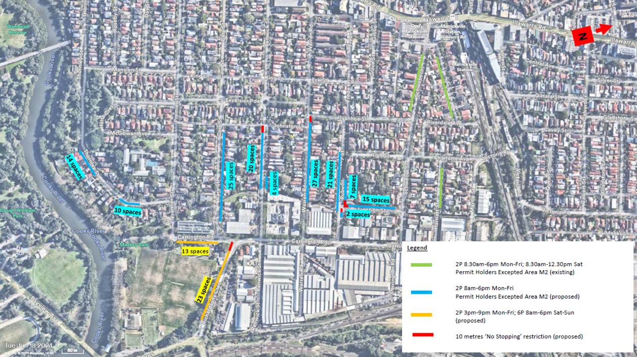
Figure 1 - Proposed parking changes (consultation)
|
|
Local Traffic Committee Meeting 18 November 2024 |
A total of 347 consultation letters outlining the proposal were sent out on Monday 22 July 2024. In conjunction, the proposal was also publicly exhibited on Inner West Council’s haveyoursay page from Tuesday 23 July 2024 to Monday 19 August 2024.
A total of 66 responses to the proposal were received, of which 48 from Inner West Council’s haveyoursay page and 18 were from direct email. The results are summarised in Table 2 below:
Table 2 - Consultation results (summary)
|
Number of Properties |
347 |
|
Total Responses |
66 |
|
|
|
|
Total Support |
51 |
|
Total Support Rate |
77% |
|
|
|
|
Total Oppose |
8 |
|
Total Oppose Rate |
12% |
|
|
|
|
Total – neutral |
7 |
|
Total – neutral Rate |
11% |
|
|
|
|
Overall Response Rate |
19% |
|
Overall Support Rate |
77% |
|
Overall Oppose rate |
12% |
Based on Council’s Resident Parking Policy, a minimum response rate of 30% of households and a minimum of 65% support from respondents is required in order to for Council to proceed with implementation. The overall minimum response rate did not meet the required threshold, however the support rate exceeded the required 65% threshold as shown in Table 3 below. In the break of street by Street, only Cary Street had a response rate approached that of the minimum response rate required by Council’s Policy, however in this case the support from residents was only at 58% which did not meet the support rate as required by Council’s Policy of 66%. This effectively meant that essentially only one of the criteria required for implementation of a Residential Parking Scheme has been met.
Table 3 - Consultation results (by street)
|
|
Street |
|
|||||
|
Thornley Street |
Cary Street |
Renwick Street |
Warren Road |
Ruby Street |
Junction Street |
Carrington Road |
|
|
No. of properties |
44 |
47 |
79 |
76 |
31 |
18 |
56 |
|
No. of responses |
6 |
12 |
13 |
14 |
6 |
3 |
4 |
|
No. of responses from eligible properties |
3 |
7 |
7 |
10 |
3 |
2 |
0 |
|
No. of eligible properties |
13 |
20 |
21 |
29 |
16 |
11 |
0 |
|
No. of support |
5 |
7 |
11 |
13 |
4 |
2 |
3 |
|
No. of object |
0 |
5 |
2 |
0 |
1 |
0 |
1 |
|
No. of neutral
|
1 |
0 |
1 |
1 |
1 |
1 |
0 |
|
Overall response rate |
13% |
26% |
16% |
18% |
19% |
17% |
7% |
|
Overall support rate |
83% |
58% |
84% |
93% |
66% |
66% |
75% |
|
Overall oppose rate |
0% |
42% |
15% |
0% |
17% |
0% |
25% |
Table 4 below presents the responses received during the consultation period.
In summary, households raised issues about taxi’s and businesses parking their vehicles on the street which occupied parking spaces in front or nearby their homes. There were concerns raised about the proposed timed permit parking restrictions being proposed on one side of the streets as this would increase parking pressure or shift the current problems to this side of the street. It should be noted that extending timed permit parking restrictions to both sides of the street would affect households that do not qualify for permit parking, who need to park additional vehicles on the street.
|
|
Local Traffic Committee Meeting 18 November 2024 |
Table 4 - Consultation responses
|
Street |
Theme |
Resident comments |
Officer response |
|
Thornley Street |
Taxi’s and businesses |
· On-street parking is occupied by Taxi’s and cars belonging to smash repairs
· Taxi’s and staff vehicles of businesses will move to the unrestricted areas. Additional restricted parking would need to be considered on Thornley and Premier Street
|
Council’s parking services unit are completing on-going enforcement of unattended vehicles and taxis under the Public Spaces (Unattended Property) Act 2021 by Council’s Parking Officers continue to change parking behaviours. |
|
Resident permit parking |
· Extend the permit parking restrictions on the southern side of Thornley Street to include the full length of Thornley Street, and the southern side of Premier Street between Thornley Street and Carrington Road. |
Permit parking restrictions are not recommended on Thornley Street given the low overall response rate (13%) from community consultation. |
|
|
Cary Street |
Taxi’s and businesses |
· Taxi’s and vehicles from smash repairs have been parking in the street and affecting parking for residents. The cars are often left unattended for many weeks. |
Council’s parking services unit are completing on-going enforcement of unattended vehicles and taxis under the Public Spaces (Unattended Property) Act 2021 by Council’s Parking Officers continue to change parking behaviours. |
|
Resident permit parking |
· Extend the timed permit parking restrictions to 8pm or 9pm as taxi’s will park their vehicles at 4pm and leave them idle overnight · Make both sides of Cary Street, timed permit parking; making one side timed permit parking will shift the problem (taxi’s, trailers, unattended vehicles, commuters) to the other side. Both sides are impacted by the problem. · This will push visitor and excess parking to the surrounding streets and make it worse for other residents |
Permit parking restrictions are not recommended on Cary Street given the low overall response rate (26%) from community consultation. |
|
|
Parking |
· Cary Street would benefit from angle parking to slow traffic down and create more parking |
· Council officers can assess this further subject to a formal request of 10 signatures from households on Cary Street |
|
|
Pedestrian and cyclist safety |
· The shared path along the western side of Carrington Road, just north of Cary Street is unsafe due to larger trucks parking at the intersection and blocking visibility for pedestrians and cyclists. Please consider a ‘No Stopping’ restriction at this intersection · Please consider a pedestrian crossing across Cary Street at Carrington Road. There is high pedestrian activity due to sporting events and may meet the warrants. It will also provide a good connection to the crossing at Carrington Road, making it more attractive to walk and cycle to Mackey Park. · A pedestrian island would benefit at the intersection of Carrington Road to improve safety and slow vehicles down
|
· Council has approved raising the existing pedestrian crossing on Carrington Road. · Currently, there are no plans to install an additional pedestrian crossing across Cary Street. This section of Cary Street is located in the overland flow path and may have drainage issues. · Council officers will investigate further a ‘No Stopping’ sign on the northern side of Cary Street, west of Carrington Road.
|
|
|
Renwick Street |
Taxi’s and businesses |
· Permit parking restrictions without proper enforcement from rangers will shift parking to adjacent streets and needs proper enforcement · Taxi’s, smash repair vehicles and other business vehicles are left on Renwick Street for extended periods · Taxi’s and business vehicles need to be enforced |
Council’s parking services unit are completing on-going enforcement of unattended vehicles and taxis under the Public Spaces (Unattended Property) Act 2021 by Council’s Parking Officers continue to change parking behaviours. |
|
Resident permit parking |
· The permit parking restrictions should include the whole of Renwick Street, otherwise the issues will be transferred to the unrestricted parking spaces and push traffic further up the street and affect other homes · Request to extend RPS towards Illawarra Road |
Permit parking restrictions are not recommended on Renwick Street given the low overall response rate (16%) from community consultation. |
|
|
Parking |
· Request for ‘No Parking’ restrictions in Johnston Lane |
Council officers can investigate this further |
|
|
Warren Road |
Resident permit parking |
· There were some streets that had only one side of the street with restricted parking, but it wasn't clear from the proposal if all residents in the area (including those living opposite restricted areas) would receive permits. I would think this would be an important point to make as it could skew support for the proposal. · Need more resident parking permits · Permit parking restrictions on one-side of the street will affect the other side which is unrestricted. · There are problems with parking on Warren Rod on the southern side with vehicles parking across driveways. The proposal will make it worse on the southern side.
|
Permit parking restrictions are not recommended on Warren Road given the low overall response rate (18%) from community consultation. |
|
Warren Road |
Taxi’s and businesses |
· Businesses and industrial site workers are parking along the street and taking up spaces. Residents are required to park sometimes three (3) streets away. · The restrictions to not go far enough. Taxi’s will park further uphill and continue to affect those who live in the area. This occurs in the middle of the night at taxi shift changeover when no-one is around. |
Council’s parking services unit are completing on-going enforcement of unattended vehicles and taxis under the Public Spaces (Unattended Property) Act 2021 by Council’s Parking Officers continue to change parking behaviours. |
|
Ruby Street |
Taxi’s and businesses
|
· The proposal will not solve the problem of taxi’s and cars parking on Richardson Crescent. This is what pushes the cars up onto the adjoining streets. · The proposal will help remove taxi’s left on the side of the road adjacent to Mackey Park which blocks families and children from accessing the area. · Businesses should be considerate with the surrounding community and operate within their property and not take up parking within the community · Businesses should provide sufficient parking spaces for their staff to use |
Council’s parking services unit are completing on-going enforcement of unattended vehicles and taxis under the Public Spaces (Unattended Property) Act 2021 by Council’s Parking Officers continue to change parking behaviours. |
|
Ruby Street |
Resident permit parking |
· Ruby Street should have 8am-5pm not 6pm and the time period should be 4P not 2P · The proposal will help those with mobility issues who cannot park close to their homes |
Permit parking restrictions are not recommended on Ruby Street given the low overall response rate (19%) from community consultation. |
|
Ruby Street |
Ineligible households |
· I have a driveway to the carport and thus have been classified as having 2 parking spots which is stupid and unrealistic to actually park 2 cars. Otherwise I would of probably approved the parking restrictions. |
Permit parking restrictions are not recommended on Ruby Street given the low overall response rate (19%) from community consultation. |
|
Carrington Road |
Impact to businesses |
Timed permit parking restrictions on Renwick Street will affect businesses on Carrington Road as business would be required to move all day. There is available parking on the street and if the issue with unattended taxi’s was resolved, this would solve the issue |
Permit parking restrictions are not recommended on Renwick Street given the low overall response rate (16%) from community consultation. |
|
Carrington Road |
Impact to businesses |
A business is requesting that Council extend restricted parking along the southern side of Renwick Street and northern side of Cary Street further south terminating at Carrington Road. And that the 2P be changed to 7P.
They have advised implementing restricted parking in only some areas of Renwick Street and Cary Street, it will make it extremely competitive for the remaining unrestricted car spaces.
Other businesses, visitors, taxi operators and the like will be competing for the unrestricted spaces on business frontages, which can be addressed through expanding parking restrictions further south down Renwick Street and Cary Street.
Business is requesting for 5-6 permits and 2 visitors parking. Whilst, Staff can park onsite, there are times we may need to park on the street, with added temp staff and visitors.
Timed parking can be Mon- Fri 7am to 6pm Saturday 7am – 12pm and open on Sunday to accommodate Mackey Park for training and playing on weekends.
|
Permit parking restrictions are not recommended on Renwick Street given the low overall response rate (16%) from community consultation. |
|
|
Local Traffic Committee Meeting 18 November 2024 |
CONCLUSION
Given the low response rate received during consultation, it is not recommended to proceed with the proposed three-month trial to extend the Area M2 resident parking scheme to the streets where they were originally proposed. The low response rate suggests that current parking problems are affecting a small percentage of households rather than the wider precinct, and that permit parking uptake may be low. The installation of permit parking restrictions may also push existing parking issues to nearby streets as noted by households during community consultation.
Council engineers have discussed with the Parking Services unit on the most appropriate action to improve parking conditions for the small percentage of households that are affected by taxi’s or nearby businesses. Council’s Parking Services unit have advised of enforcement action taking place to manage unattended vehicles and taxi’s. Accordingly, it is recommended that this on-going enforcement of unattended vehicles and taxis under the Public Spaces (Unattended Property) Act 2021 by Council’s Parking Officers continue to change parking behaviours. This will increase parking supply on the streets surrounding Carrington Road and adjacent to Mackey Park at Richardson Crescent.
Furthermore, it is recommended to install timed parking restrictions signposted as ‘2P 3pm-9pm Mon-Fri; 4P 8am-6pm Sat-Sun’ on the western side of Richardson Crescent, south of Carrington Road to prevent long-term parking adjacent to the park and improve parking opportunities for park users during the weekday evening and weekend daytime periods. This will reduce parking demand of park-users to nearby residential streets. This proposal is shown in Attachment 2.
FINANCIAL IMPLICATIONS
There are no financial implications associated with the implementation of the proposed recommendations outlined in the report.
|
1.⇩ |
Consultation plans |
|
2.⇩ |
Proposed parking changes - Richardson Crescent, Marrickville |
|
|
Local Traffic Committee Meeting 18 November 2024 |
Subject: Tempe Reserve - Parking Study (Midjuburi-Marrickville Ward/Heffron Electorate/Inner West PAC)
Prepared By: James Nguyen - Traffic Engineer
Authorised By: Manod Wickramasinghe - Traffic and Transport Planning Manager
|
RECOMMENDATION
That the request for consideration of timed permit parking restrictions on streets surrounding Tempe Reserve not be implemented due to adequate parking capacity within the Tempe Reserve car parks.
|
STRATEGIC OBJECTIVE
This report supports the following strategic directions contained within Council’s Community Strategic Plan:
|
2: Liveable, connected neighbourhoods and transport |
|
|
EXECUTIVE SUMMARY
This report outlines the parking investigation completed to assess parking conditions at Tempe Reserve and the surrounding adjacent streets. It presents the parking survey results completed on the weekday evening and weekend peak periods. The results indicate there is adequate parking supply in the streets adjacent to Tempe Reserve, and that parking demand generated from park-users at Tempe Reserve during the evening weekday and weekend peak period has minimal impact to parking to the adjacent residential streets. Accordingly, a resident parking scheme in these streets is not recommended.
BACKGROUND
Council has received a petition from households on Smith Street, Tempe requesting for consideration for a resident permit parking scheme on Smith Street and all nearby streets adjacent to Tempe Reserve. Households have raised concerns that parking in front of homes on these streets are occupied by park users at Tempe Reserve, particularly in the evenings and on the weekend.
DISCUSSION
Council engineers have carried out parking occupancy surveys to assess parking utilisation on these streets and the car parks adjacent to Tempe Reserve during the peak and off-peak soccer seasons. The parking surveys assessed whether there were any ‘spill-over’ parking from the car parks at Tempe Reserve into the adjacent streets. They were carried out on the following dates:
· Thursday 7 December 2023 between 5.30pm and 6.30pm (off-peak season)
· Wednesday 15 May 2024 between 4.00pm and 10pm (peak season)
· Saturday 18 May 2024 between 8.00am and 2.00pm (peak season)
The parking occupancy survey results are shown below in Figures 1, 2 and 3.
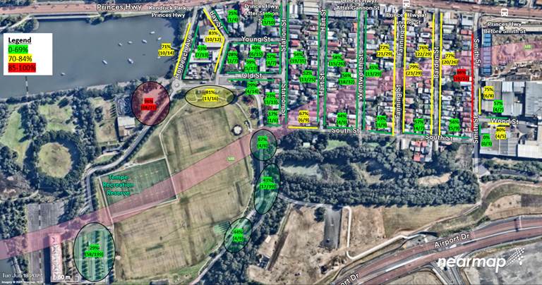
Figure 1 - Parking Occupancy Survey - Thursday 7 December 2023 - 5.30pm-6.30pm
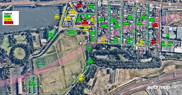
Figure 2 - Parking Occupancy Survey - Wednesday 15 May 2024 - 6.00pm-7.00pm
Based on Figure’s 1 and 2 above, the parking demand generated by training in the evening period varies between seasons, days and the type of training that may take place.
Figure 1 shows high utilisation of the carparks adjacent to Holbeach Avenue with 96 per cent and 81 per cent utilisation. There is parking capacity in the adjacent residential streets such as Old, Bay and Station Streets for residents. Parking spill-over may occur, however given there is available parking capacity in the adjacent streets, any spill over may be minimal and have minimal impact to households.
Figure 2 shows adequate capacity within the car parks at Tempe Reserve during the peak soccer season training period, and there is unlikely to be any ‘spill-over’ of parking to the adjacent residential streets. Parking demand generated by training in the evening periods are likely to be wholly contained within the car parks. Adjacent streets such as Old, Bay and Station Streets are likely to mostly be utilised by residents.
Parking on Smith Street is highly occupied during the evening period, however this is likely to be parking occupied by residents and households. Given the proximity to Tempe Reserve, it is highly unlikely parking on Smith Street is utilised by park-users. A resident permit parking scheme in the evening period is not recommended as parking generation is mostly generated by residential households.
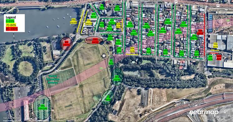
Figure 3 - Parking Occupancy Survey - Saturday 18 May 2024 - 10.00am-11.00am
Figure 3 above shows the peak parking occupancy rates on ‘game day’ at Tempe Reserve and the surrounding nearby streets. Parking utilisation in the car parks adjacent to Holbeach Avenue had the highest utilisation of 98 and 100 per cent. The other car parks surrounding Tempe Reserve have parking capacity. Accordingly, parking ‘spill-over’ from the car parks closest to Holbeach Avenue may occur to the nearby residential streets. However, based on the available parking occupancy rates in nearby residential streets, parking ‘spill-over’ from the car parks is likely to be minimal, and will have minimal impact on nearby streets. Similarly to Figures 1 and 2, Smith Street experiences high parking utilisation, however given the distance to Tempe Reserve, it is highly unlikely that these parking spaces are utilised by park-users. Parking utilisation in Smith Street is likely to mostly be adjacent residents/households. Accordingly, permit parking restrictions is not recommended during the evening weekday weekend periods on streets adjacent to Tempe Reserve.
FINANCIAL IMPLICATIONS
There are no financial implications associated with the implementation of the proposed recommendations outlined in the report.
Nil.
|
|
Local Traffic Committee Meeting 18 November 2024 |
Subject: Leichhardt West - Proposed Residential Parking Scheme Expansion (Baludarri-Balmain Ward/Balmain Electorate/Leichhardt PAC)
Prepared By: Jackie Ng - Graduate Traffic Engineer
Authorised By: Manod Wickramasinghe - Traffic and Transport Planning Manager
|
RECOMMENDATION
That the installation of Resident Parking Scheme ‘2P 8am-6pm Mon-Fri, Permit Holders Excepted, Area L1’ zone be approved as shown in Attachment 1: a) Western and Eastern side of Burfitt Street, Leichhardt – Between No.2 to No.48 and No.1 to No.45 Burfitt Street b) Eastern side Edith Street, Leichhardt – Between No.37 to No.65A Edith Street c) Western and Eastern side of Elswick Street, Leichhardt – Between No.118 to No.162 and No.105 to No.141 Elswick Street
|
STRATEGIC OBJECTIVE
This report supports the following strategic directions contained within Council’s Community Strategic Plan:
|
2: Liveable, connected neighbourhoods and transport |
|
|
EXECUTIVE SUMMARY
This report outlines the outcome from the Community Consultation and the recommended treatment for the expansion of the existing Leichhardt West Resident Parking Scheme (RPS) on section of Burfitt Street, Flood Street, Edith Street and Elswick Street, Leichhardt.
It is recommended that the RPS ‘2P 8AM-6PM, Mon-Fri, Permit Holders Excepted, Area L1’ be expanded into the rest of Burfitt Street, eastern side of Edith Street and Elswick Street from the existing RPS boundary to Marion Street.
BACKGROUND
Council introduced an RPS in the Leichhardt West area in late 2023 which was one of the recommendations from the adopted Leichhardt West Precinct Parking Study. Following the implementation, many requests were received from residents to expand the Stage 1 RPS further south to Marion Street, as it has resulted in a section of unrestricted parking with higher parking demand.
A map showing the Stage 1 RPS for the Leichhardt West area is shown is illustrated below:
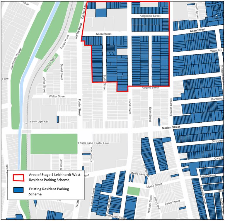
A post implementation review was expedited after the implementation of the Stage 1 RPS, including observing and collecting parking data during different times and days. It was generally found that the unrestricted parking on sections of streets adjacent to the RPS had high occupancy rates.
Hence, Council consulted the community proposing that the RPS would be expanded into Burfitt Street, Flood Street, Edith Street and Elswick Street between the existing RPS boundary to Marion Street, Leichhardt.
DISCUSSION
Between June and September 2024, Council undertook Community Engagement inviting residents to provide feedback expanding the Stage 1 RPS further south to Marion Street.
The community engagement for the proposed RPS expansion in Leichhardt West received a low response rate, and whilst it did not strictly achieve the support level required for the former Leichhardt Resident Parking Scheme Policy, some streets meet the requirements for the Inner West Public Domain Parking Policy and showed a high support rate for the proposal as shown in Table 1 and Figure 1.
|
Street Name |
Side |
Support Rate1 of received submissions |
Response Rate2 |
|
Burfitt Street |
West |
83% |
32% |
|
East |
70% |
34% |
|
|
Flood Street |
West |
33% |
7% |
|
East |
50% |
16% |
|
|
Edith Street |
West |
38% |
13% |
|
East |
67% |
38% |
|
|
Elswick Street |
West |
67% |
55% |
|
East |
83% |
33% |
Table 1 – Support Rate in each section
1. Support Rate is the number of valid votes in the subject section that support the RPS expressed as a percentage of the number of responses for the section.
2. Response Rate is the number of valid votes compared to the number of properties for the section expressed as a percentage.
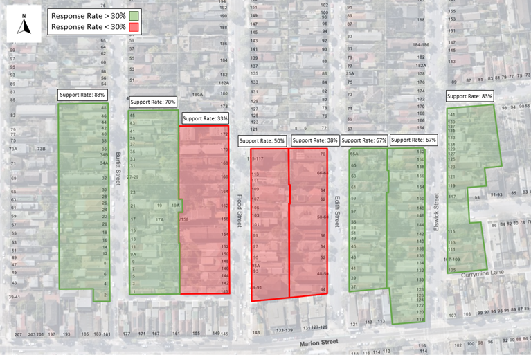
Figure 1 – Support Rate and Response Rate from Council’s Engagement in Leichhardt West
Due to the high support rate of those who responded to the consultation, it is recommended that the existing Resident Parking Scheme be expanded into the following sections:
a. Western and Eastern side of Burfitt Street, Leichhardt – Between No.2 to No.48 and No.1 to No.45
b. Eastern side Edith Street, Leichhardt – Between No.37 to No.65A (permits will be allocated to eligible properties on both sides of the street)
c. Western and Eastern side of Elswick Street, Leichhardt – Between No.118 to No.162 and No.105 to No.141
Council will generally not proceed with implementation of a parking scheme or changes to an existing parking scheme in isolation from a precinct wide parking study unless at least 65% of respondents, from different households within the proposed zone, support the proposal and provided a minimum response rate of 30% of households is achieved in Council’s survey.
A summary of comments from the Community Engagement, including Council response on each issue has been tabled below.
|
Resident Comments |
Council Response |
|
10 metre ‘No Stopping’
The 10 metre ‘No Stopping’ rule seems very unnecessary and counterproductive. Removing 10 metres of parking in an area with already limited parking does not help the situation. |
The proposal will not reduce any legal parking spaces in the area. The NSW Road Rules states that, drivers are not permitted to stop within 10 metres of an intersection unless there are parking control signs or if you are parked along the continuous side of a T-intersection. |
|
Shared Housing
The current proposal does not support the area demographic. There are many adults in shared houses, each owning their own vehicle. Two permits will not be able to support the demand. |
The management of permits is a challenge for Council as parking demand far outweighs the supply of existing on-street spaces, and the permit allocation has remained unchanged for many years. Allocation of extra permits will simply result in less chance of finding available permit parking as they number of permits will outnumber the number of parking spaces. |
|
Visitor Parking
The proposal is not beneficial for people visiting family and friends in the area. The inconvenience of limit visitor parking concerns me. |
The RPS allocates one (1) visitor permit for each property subject to eligibility criteria of Council’s resident parking policy. This permit is transferrable and can be used for any vehicle visiting the area.
The proposed 2P 8am-6pm Mon-Fri restriction provide parking opportunities by allowing for visitors without permits to stay after 4pm on weekdays until 10am next day. Parking on weekends remains unrestricted. |
|
Parking Permit
You neglect to say that people have to pay yearly for the 2nd permit. |
The current parking fees and charges for the Leichhardt West RPS does not require payment for a second permit. |
|
Public & Active Transport
Currently, the public transportation in the area does not support a car free population as much as we’d all like to help our environment by cutting our emissions. |
The RPS supports Council’s initiative to reduce car ownership in the Inner West. Additionally, Council has a number of projects and funding, prioritizing on active transport projects which have reciprocal benefits on public transport use. |
|
Unattended Vehicles
There are many trailers permanently parked on the street and are too many houses without parking spaces. Please ensure these are subject to the same rules as motor vehicles in this parking scheme. |
Unattended trailers may be enforced under the Public Spaces (Unattended Property) Act 2021. More information can be found on Council’s website under “Unattended Vehicles”. |
|
Effect on Businesses
We feel that businesses near Marion Street will be greatly affected and thus losing the character of the area. |
Please see comment regarding visitor parking.
The RPS aims to reduce long-term parking in residential areas which may provide more availability of short-term parking for visitors to find parking during business hours. |
FINANCIAL IMPLICATIONS
The cost of installation of new restrictions as recommended can be funded within Council’s signs and line market budget.
|
1.⇩ |
Leichhardt West - Resident Parking Scheme Expansion - Signage Plan |
|
|
Local Traffic Committee Meeting 18 November 2024 |
Subject: Traffic Committee Schedule 2025
Prepared By: Charbel El Kazzi - Traffic Engineer
Authorised By: Manod Wickramasinghe - Traffic and Transport Planning Manager
|
RECOMMENDATION
That the proposed schedule of meetings of the Local Traffic Committee for the 2025 calendar year be received and noted. |
STRATEGIC OBJECTIVE
This report supports the following strategic directions contained within Council’s Community Strategic Plan:
|
2: Liveable, connected neighbourhoods and transport |
|
|
BACKGROUND
To assist Committee members with forward planning, the schedule of meetings of the Local Traffic Committee for 2025 is detailed below.
DISCUSSION
All meetings will be held on the 3rd Monday of each month, excluding January during which no meeting is held and April and December which has been brought 1 week forward to avoid Easter Monday and the Christmas holiday period. The meetings will commence at 11.00am. The proposed meeting dates for 2025 are as follows:
|
Monday, 17 February 2025 |
11.00am |
|
Monday, 17 March 2025 |
11.00am |
|
Monday, 14 April 2025 |
11.00am |
|
Monday, 19 May 2025 |
11.00am |
|
Monday, 16 June 2025 |
11.00am |
|
Monday, 21 July 2025 |
11.00am |
|
Monday, 18 August 2025 |
11.00am |
|
Monday, 15 September 2025 |
11.00am |
|
Monday, 20 October 2025 |
11.00am |
|
Monday, 17 November 2025 |
11.00am |
|
Monday, 8 December 2025 |
11.00am |