|
AGENDA R |

Local Traffic Committee Meeting
MONDAY 17 FEBRUARY 2025
11:00 AM
|
|
Local Traffic Committee Meeting 17 February 2025 |
Function of the Local Traffic Committee
Background
Roads and Maritime Services (RMS) is legislated as the Authority responsible for the control of traffic on all NSW Roads. The RMS has delegated certain aspects of the control of traffic on local roads to councils. To exercise this delegation, councils must establish a local traffic committee and obtain the advice of the RMS and Police. The Inner West Council Local Traffic Committee has been constituted by Council as a result of the delegation granted by the RMS pursuant to Section 50 of the Transport Administration Act 1988.
Role of the Committee
The Local Traffic Committee is primarily a technical review and advisory committee which considers the technical merits of proposals and ensures that current technical guidelines are considered. It provides recommendations to Council on traffic and parking control matters and on the provision of traffic control facilities and prescribed traffic control devices for which Council has delegated authority. These matters are dealt with under Part A of the agenda and require Council to consider exercising its delegation.
In addition to its formal role as the Local Traffic Committee, the Committee may also be requested to provide informal traffic engineering advice on traffic matters not requiring Council to exercise its delegated function at that point in time, for example, advice to Council’s Development Assessment Section on traffic generating developments. These matters are dealt with under Part C of the agenda and are for information or advice only and do not require Council to exercise its delegation.
Committee Delegations
The Local Traffic Committee has no decision-making powers. The Council must refer all traffic related matters to the Local Traffic Committee prior to exercising its delegated functions. Matters related to State Roads or functions that have not been delegated to Council must be referred directly to the RMS or relevant organisation.
The Committee provides recommendations to Council. Should Council wish to act contrary to the advice of the Committee or if that advice is not supported unanimously by the Committee members, then the Police or RMS have an opportunity to appeal to the Regional Traffic Committee.
Committee Membership & Voting
Formal voting membership comprises the following:
· one representative of Council as nominated by Council;
· one representative of the NSW Police from each Local Area Command (LAC) within the LGA, being Newtown, Marrickville, Leichhardt and Ashfield LAC’s.
· one representative from the RMS; and
· State Members of Parliament (MP) for the electorates of Summer Hill, Newtown, Heffron, Canterbury, Strathfield and Balmain or their nominees.
Where the Council area is represented by more than one MP or covered by more than one Police LAC, representatives are only permitted to vote on matters which effect their electorate or LAC.
Informal (non-voting) advisors from within Council or external authorities may also attend Committee meetings to provide expert advice.
Committee Chair
Council’s representative will chair the meetings.
Public Participation
Members of the public or other stakeholders may address the Committee on agenda items to be considered by the Committee. The format and number of presentations is at the discretion of the Chairperson and is generally limited to 3 minutes per speaker. Committee debate on agenda items is not open to the public.
|
|
Local Traffic Committee Meeting 17 February 2025 |
|
AGENDA |
1 Apologies
2 Disclosures of Interest
3 Confirmation of Minutes
Minutes of 9 December 2024 Local Traffic Committee 5
4 Matters Arising from Council’s Resolution of Minutes
5 Part A – Items Where Council May Exercise Its Delegated Functions
Traffic Matters
ITEM Page
LTC0225(1) Item 1 Lower
Railway Parade, Sydenham –
Temporary medium-term 12P parking changes during major rail shutdown of T3 line
for Sydney Metro Upgrade works (Midjuburi-Marrickville Ward / Summer Hill
Electorate / Inner West PAC) 32
LTC0225(1) Item 2 Charlotte Avenue, Marrickville at Myrtle Street and Victoria Road - Temporary full road closure and temporary regulatory signage changes– Sydney Water sewer upgrade works Marrickville CTMP (Midjuburi-Marrickville Ward / Summer Hill Electorate / Inner West Pac) 36
LTC0225(1) Item 3 Illawarra Road, Marrickville - Proposed roadside barrier (Midjuburi-Marrickville Ward/Summer Hill Electorate/Inner West PAC) 71
LTC0225(1) Item 4 182-189 Victoria Road and 28-30 Faversham Street, Marrickville (Wicks Park) - Traffic intersection assessment (Midjuburi-Marrickville Ward/Summer Hill Electorate/Inner West PAC) 161
LTC0225(1) Item 5 Albermarle Street, Marrickville – Temporary Full Road Closure of Rail Overbridge south of Challis Street - Sydney Metro SWM4 works CTMP (Midjuburi-Marrickville Ward / Summer Hill Electorate / Inner West Pac) 165
LTC0225(1) Item 6 Beattie Street at Mullens Street, Balmain - Proposed Raised Pedestrian Crossing (Baludarri-Balmain Ward/Balmain Electorate/Leichhardt PAC) 207
LTC0225(1) Item 7 Renwick Street & Marion Street, Leichhardt - Proposed Intersection Line Marking Upgrades (Baludarri-Balmain Ward/Balmain Electorate/Leichhardt PAC) 211
LTC0225(1) Item 8 Robert Street, Rozelle - Ministry of Sound Traffic Management Plan (Baludarri-Balmain Ward/Balmain Electorate/Leichhardt PAC) 214
LTC0225(1) Item 9 Lilyfield Road, Lilyfield - Bus Zone Removal (Baludarri-Balmain Ward/Balmain Electorate/Leichhardt PAC) 251
LTC0225(1) Item 10 Robert Street at Holden Street, Ashfield- New at-grade pedestrian (zebra) crossing- amended plan (Djarrawunang-Ashfield Ward/Summer Hill Electorate/Burwood PAC) 253
Parking Matters
ITEM Page
LTC0225(1) Item 11 Goodsell Street, St Peters - Request for an extension to times and days of the existing residential parking scheme (Midjuburi - Marrickville Ward / Heffron Electorate / Inner West PAC) 258
LTC0225(1) Item 12 Leichhardt Oval Special Event Parking Scheme 2025 (Baludarri-Balmain Ward/Balmain Electorate/Leichhardt PAC) 264
LTC0225(1) Item 13 Proposed Parking Restriction Operational Hours Extension - Rozelle South Precinct (Baludarri-Balmain Ward/ Balmain Electorate/ Leichhardt PAC) 266
Late Items
Nil at time of printing.
6 Part B - Items for Information Only
ITEM Page
LTC0225(1) Item 14 Brighton Street, Petersham - Heavy Vehicle Access (Damun - Stanmore Ward/ Newtown Electorate/ Inner West PAC) 270
7 Part C - Items for General Advice
Nil at the time of printing.
8 General Business
9 Close of Meeting
|
|
Local Traffic Committee Meeting 17 February 2025 |
Minutes of Meeting held on 09 December 2024
Meeting commenced at 11:09 AM
ACKNOWLEDGEMENT OF COUNTRY BY CHAIRPERSON
I acknowledge the Gadigal and Wangal people of the Eora nation on whose country we are meeting today, and their elders past and present.
COMMITTEE REPRESENTATIVES PRESENT
|
Victor Macri |
Councillor –Midjuburi - Marrickville Ward (Chair) |
|
Bill Holliday |
Representative for Kobi Shetty MP, Member for Balmain |
|
Graeme McKay |
Representative for Jo Haylen MP, Member for Summer Hill |
|
Eleanor Nurse |
Representative for Jenny Leong MP, Member for Newtown |
|
Nina Fard |
Transport for NSW (TfNSW) |
|
Ben Walters |
NSW Police – Inner West Police Area Command |
|
|
|
|
NON VOTING MEMBERS IN ATTENDANCE |
|
|
|
|
|
Col Jones |
Inner West Bicycle Coalition (IWBC) |
|
Michael Takla |
Representative for Transit Systems |
|
Nalin Rajapaksha |
Representative for U-Go Mobility |
|
Manod Wickramasinghe |
IWC’s Traffic and Transport Planning Manager |
|
Sunny Jo |
IWC’s Coordinator Traffic Engineering Services (North) |
|
George Tsaprounis |
IWC’s Coordinator Traffic Engineering Services (South) |
|
Jason Scoufis |
IWC’s Coordinator Traffic Investigations & Road Safety |
|
Amir Falamarzi |
IWC’s Traffic Engineer |
|
Christy Li |
IWC’s Business Administration Officer |
|
|
|
|
VISITORS |
|
|
|
|
|
Ben Peake |
Public Speaker (Item 4) |
|
Hassan Kharroubi |
Public Speaker (Item 4) |
|
Huw Davis |
Public Speaker (Item 4) |
|
Rory Steinle- Davis |
Public Speaker (Item 4) |
|
Carmel McDonald |
Public Speaker (Item 4) |
|
Dyranda Hortle |
Public Speaker (Item 4) |
|
Edward Walsh |
Public Speaker (Item 4) |
|
Susan Moxham |
Public Speaker (Item 4) |
|
Bob Stephenson |
Public Speaker (Item 4) |
|
Sandra Ianitto |
Public Speaker (Item 5) |
|
Rosanna Martinello |
Public Speaker (Item 5) |
|
Manjur Rahman |
Transport for NSW (TfNSW) (Item 11) |
|
Ahsanul Amin |
Transport for NSW (TfNSW) - Sydney Metro (Item 12) |
|
Nick Windmiller |
Transport for NSW (TfNSW) - Sydney Metro (Item 12) |
|
Imogen Markus |
Transport for NSW (TfNSW) - Sydney Metro (Item 12) |
|
Fernando Guerreiro |
Public Speaker (Item 14) |
|
Bret Tombs |
Public Speaker (Item 14) |
|
Marijke Tombs |
Public Speaker (Item 14) |
|
|
|
|
APOLOGIES: |
|
|
|
|
|
Sgt Charles Buttrose |
NSW Police – Leichhardt Police Area Command |
|
|
|
DISCLOSURES OF INTERESTS:
Nil.
CONFIRMATION OF MINUTES
|
That the Minutes of the Local Traffic Committee held on Monday, 18 November 2024 be confirmed. |
MATTERS ARISING FROM COUNCIL’S RESOLUTION OF MINUTES
The Minutes of the Local Traffic Committee meeting held on 18 November 2024 were adopted at Council’s meeting held on 03 December subject to the following:
1. Item 16 - Mackey Park and Carrington Road Survey Area, Marrickville: Request for extension of M2 Residential Parking Scheme: that Council write to affected residents explaining the actions taken to date and inviting residents to attend a town hall meeting to be organised in February 2025 and held in South Marrickville; and that council investigate and consult the Marrickville Red Devils on establishing a kiss and ride zone at a location near Mackey Park on Saturdays; and
2. Item 17 - Tempe Reserve - Parking Study: that Council write to affected residents explaining the actions taken to date and inviting residents to attend a town hall meeting to be organised in February 2025 and held in Tempe.
|
LTC1224(1) Item 1 Robert Street at Holden Street, Ashfield - New At-Grade Pedestrian (Zebra) Crossing (Djarrawunang-Ashfield Ward/Summer Hill Electorate/Burwood PAC) |
|
Council at its meeting on the 18 March 2024 (through its Traffic Committee 11 December 2023) approved in principle a series of proposed pedestrian (zebra) crossings and kerb extension treatments (under concept) with other auxiliary works (relocation of bus stops, inclusion of raised platform thresholds) for improved pedestrian and road safety around and near to the Cardinal Freeman (Retirement) Village, Ashfield.
This report describes and shows the detailed design plan of one of the proposed treatments involving the placing of a pedestrian (zebra) crossing in Robert Street, at the intersection of Holden Street, Ashfield. This work is programmed and envisaged to be constructed in the 2025/2026 financial year, subject to funding.
Officers Recommendation:
That the detailed design plan (10302) for a proposed new at-grade pedestrian (zebra) crossing in Robert Street at its intersection with Holden Street, Ashfield, with associated signs and line marking (as shown in Attachment 1) be approved.
DISCUSSION:
The Representative for the Transport for NSW raised concerns regarding the crossing not being entirely at the intersection nor offset from the intersection by a vehicle length (6 metres). Due to this, vehicles could stop partially over the pedestrian crossing which could reduce motorist sightlines to pedestrians wishing to cross.
The Representative for Transport for NSW advised they are still in discussion with Council Officers regarding what adjustments can be made whilst taking into consideration the current constraints of the proposed location.
The Representative for Transit Systems questioned when the works would be implemented and whether buses would be allowed through during construction. Council Officers advised that the project is currently scheduled for construction in the next financial year however it will be subject to grant funding opportunities therefore nothing has been determined as of yet. It was noted that once construction is scheduled, Council will be able to provide further information to the Representative for Transit Systems.
Council Officers suggested that this item be deferred to allow for further investigations regarding the proposed location of the crossing and other potential options.
The Committee members agreed with the amended recommendation.
COMMITTEE RECOMMENDATION:
That the detailed design plan (10302) for a proposed new at-grade pedestrian (zebra) crossing in Robert Street at its intersection with Holden Street, Ashfield, with associated signs and line marking (as shown in Attachment 1 of the Local Traffic Committee report) be deferred for further investigation.
For Motion: Unanimous |
|
LTC1224(1) Item 11 Burrows Avenue and Railway Road, Sydenham - Proposed Bus layover and parking changes (Midjuburi - Marrickville Ward / Heffron Electorate / Inner West PAC) |
|
This report follows a previous report to an Extraordinary Local Traffic Committee Meeting on Monday 3 June 2024 in which the proposed bus layover and parking changes along Burrows Avenue and Railway Road, Sydenham were detailed. At the meeting the Transport for NSW representative requested this item be deferred on the basis that the proposed layover will be going to a Review of Environmental Factors (REF) process and once the REF had been determined, Transport for New South Wales (TfNSW) would again request that this matter be brought back to the LTC for consideration. The Traffic Committee therefore recommended that “the Burrows Avenue and Railway Road, Sydenham - Proposed Bus layover and parking changes, be deferred”. Transport for New South Wales (TfNSW) has approached Council with regards to a proposal for the construction of a bus layover area in Burrows Avenue, west of Gleeson Avenue, Sydenham. The designated bus layover area is required at Sydenham Station to cater for the growing number of bus services in this area. Prior to picking up passengers, buses currently park along Burrows Avenue which creates congestion and safety issues for pedestrians and drivers. The bus layover area will store up to 6 buses. The existing unrestricted parking spaces (approximately 11 spaces) on the south side of Burrows Avenue (adjacent to the vacant property) and six (6) 90-degree angle parking spaces on the north side of Burrows Avenue will be lost as a result of the proposal. In response to this loss of parking it is proposed to convert the parallel parking on the east side of Railway Road to 45-degree rear to kerb parking to lessen the impact from the loss of parking because of this proposal.
Community engagement was initially undertaken on Friday 24 November to Friday 8 December 2023. Community notifications, letterbox dropped, and nearby properties door knocked on Railway Road, Burrows Avenue and Wright Street were part of the consultation process. Results of this community engagement process and related parking study (Parking Data Report) were table in the report that was presented to the Extraordinary Local Traffic Committee Meeting on Monday 3 June 2024. Subsequently a Review of Environmental Factors (REF) report was completed in July 2024, and this has been provided to address issues arising because of both operational and construction matters from this project (refer to attachment 1 - Sydenham Bus Layover - Review of Environmental Factors July 2024).
It is recommended that Council approve the signs and line marking plan (drawing no. 520212-AURC-038-RW-DRG-002001, sheet 10 of 41 dated 4 July 2024)
Officers Recommendation:
That the detail design drawing for the on-road changes associated with the proposed construction of a bus layover area in Burrows Avenue, west of Gleeson Avenue, Sydenham (as per attached drawing “Sydenham Station Bus Layover Burrows Avenue and Railway Road Signs and line marking plan” by Aurecon, dated 4/7/24, drawing no. 520212-AURC-038-RW-DRG-002001, sheet 10 of 41) be approved, subject to the following conditions: a) TfNSW monitor the interaction between buses and vehicles along Railway Road (one way) and Burrows Road over the next 12 months and implement further traffic control measures should they be required.
DISCUSSION:
Public Speaker Manjur Rahman entered the meeting at 12.26 pm.
Mr Rahman advised that Transport for NSW (TfNSW) have been managing the design and development of the bus layover project along Burrows Avenue, Sydenham. It was noted that given the importance of the station as a major transport interchange and that bus operators are missing the ability to layover and terminate between services. Mr Rahman advised in order to address these issues; Transport for NSW is proposing to create a bus layover for the buses to use along Burrows Avenue. Mr Rahman advised that this proposal includes a plan to have 6, 16 metre bus spaces, 1 amenity block and some changes to the current parking arrangements in the area noting this will remove 11 parking spaces on Burrows Avenue. It was noted that removal of those parking spaces will allow for buses to maneuverer and egress safely. Mr Rahman advised that there were plans to convert 8 parallel parking spaces along the eastern side of Railway Road into 13, 45-degree angle car parking spaces to reduce the impact of the parking loss.
The Chairperson queried whether buses would be able to layover at Tempe Depot instead as the depot has all the required facilities and it will cause fewer parking disruptions in the local area. Mr Rahman advised they have considered that possibility however found that the depot did not have the capacity to take on the extra buses and that factors such as time, and traffic were also taken into consideration if buses were to layover at Tempe Depot.
The Chairperson queried if there was a requirement to stack the buses in such a way that would require 11 parking spaces to be removed from the community and whether there would be another way to utilise the site so that there was less of an impact on parking for the community. Mr Rahman advised that various options were explored to ensure minimal impact on parking and that those options were discussed with Council and that this option was concluded to be the optimal option.
Council Officers questioned why there was a need for 6 bus layover spaces. Mr Rahman advised the bus planners have asked for more spaces and that 6 spaces were the maximum Transport for NSW could allocate for the buses. Council Officers questioned if there would be any other opportunities for bus layovers to take place if the area reduces the number of parking spaces taken from the community. Mr Rahman advised that there are currently no other layover locations identified in the vicinity of Sydenham Station, so the current area identified is the best possible location for the layover. Council Officers noted that Burrows Avenue has the capacity for buses to layover on the opposite side of the Gleeson Road intersection, adjacent to the station and questioned whether this option was explored as a possibility. Mr Rahman advised that the option was explored by the team and was deemed to not be a feasible option. The Representative for Transport for NSW added that the reason this was considered not to be a feasible option was due to plans of having a cycleway put in on the opposite side of Burrows Avenue. It was noted that there would be signal upgrades at the intersection of Unwins Bridge Road and Hogan Street to assist with bus access if a bus layover area was placed adjacent to the station on Burrows Avenue and that due to the active transport link along Burrows Avenue the presence of idling buses would cause safety issues.
The Chairperson questioned if the options that were considered by Transport for NSW could be shared with the committee. Mr Rahman advised he will send the options analysis to the Manager of Traffic and Transport to distribute to the Committee. Council Officers questioned where Transport for NSW was with the approval process for the site and when the construction schedule was for this project. Mr Rahman advised that construction is scheduled to begin in January 2025.
Council Officers requested that subject to the approval of the recommendation, that Transport for NSW review the current design to try to minimise the loss of parking in the area.
The Committee members agreed with the amended recommendation.
COMMITTEE RECOMMENDATION:
That the detail design drawing for the on-road changes associated with the proposed construction of a bus layover area in Burrows Avenue, west of Gleeson Avenue, Sydenham (as per attached drawing “Sydenham Station Bus Layover Burrows Avenue and Railway Road Signs and line marking plan” by Aurecon, dated 4/7/24, drawing no. 520212-AURC-038-RW-DRG-002001, sheet 10 of 41) be approved, subject to the following conditions: a) TfNSW monitor the interaction between buses and vehicles along Railway Road (one way) and Burrows Road over the next 12 months and implement further traffic control measures should they be required. b) TfNSW investigate amending the design to incorporate additional on-street parking spaces along Burrows Avenue.
For Motion: Unanimous |
General Business:
|
Item 20: Cars queuing across the pedestrian crossing on Hardie Avenue at Smith Street, Summer Hill. |
|
The Representative for the Inner West Bicycle Coalition raised concerns regarding vehicles queuing across and blocking the pedestrian crossing on Hardie Avenue at Smith Street, Summer Hill as they wait for a break in traffic causing difficulties for pedestrians to cross safely. Council Officers advised that the area is being looked at as part of another project Council is undertaking near Lackey Street, Summer Hill. |
Meeting closed at 1.55pm.
CHAIRPERSON
Clr Victor Macri.
|
|
Local Traffic Committee Meeting 17 February 2025 |
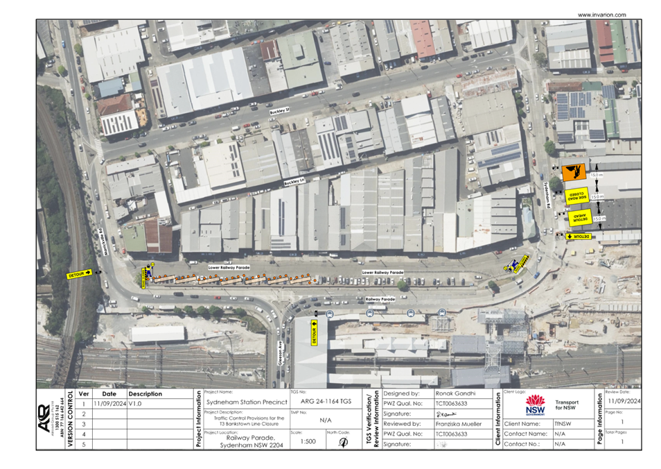
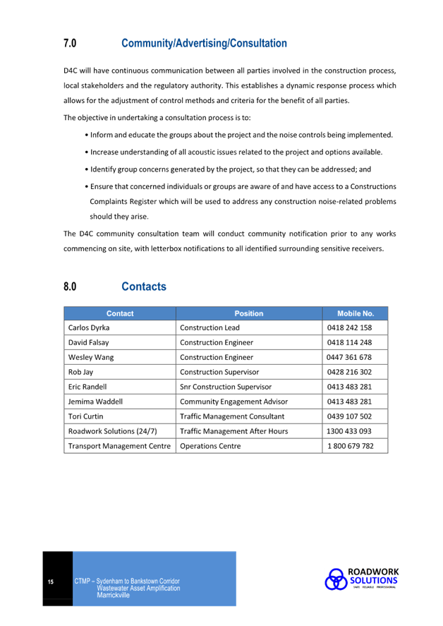
Subject: Lower Railway Parade, Sydenham – Temporary medium-term 12P parking changes during major rail shutdown of T3 line for Sydney Metro Upgrade works (Midjuburi-Marrickville Ward / Summer Hill Electorate / Inner West PAC)
Prepared By: Jennifer Adams - Traffic Engineer
Authorised By: Manod Wickramasinghe - Traffic and Transport Planning Manager
|
RECOMMENDATION
1. That the following temporary medium-term parking / traffic changes be approved:
a) Lower Railway Parade (40 parking spaces) - The medium-term conversion of 109 metres (40 parking spaces) 90 degree angled ‘unrestricted parking’ on the southeast kerb of Lower Railway Parade (between Gleeson Avenue and Marrickville Road) to ‘12P’ restrictions; and b) Temporarily converting Lower Railway Parade into a single direction entry / exit, subject to implementation of the Traffic Management Plan for the proposed access changes.
2. That the cost of all works of the statement and/or reinstatement of any/all signage will be borne by TfNSW.
3. That the applicant and Council Rangers be advised in terms of this report.
|
STRATEGIC OBJECTIVE
This report supports the following strategic directions contained within Council’s Community Strategic Plan:
|
2: Liveable, connected neighbourhoods and transport |
|
|
EXECUTIVE SUMMARY
From Monday 30 September 2024, the T3 Bankstown Line from Sydenham to Bankstown was closed for a 12-month period to enable the final conversion of the 130-year-old line to modern metro standards. A report went to the August 2024 Local Traffic Committee meeting detailing various temporary medium-term parking changes associated with the 12-month T3 shutdown.
Transport for NSW (TfNSW) have notified Council that local businesses along Lower Railway Parade, Sydenham have indicated they are in favour of changing the unrestricted parking in Lower Railway Parade to timed parking to increase availability of spaces for use by customers and employees of the businesses for the remainder of T3 shutdown period.
Specifically, TfNSW is requesting approval for the medium-term conversion of 109 metres (40 parking spaces) 90 degree angled ‘unrestricted parking’ on the southeast kerb of Lower Railway Parade (between Gleeson Avenue and Marrickville Road) to ‘12P’ restrictions.
BACKGROUND
Sydney Metro City & Southwest - Sydenham to Bankstown project will upgrade all 10 stations between Marrickville and Bankstown to meet metro standards before converting the T3 Bankstown Line to Metro operations. Works are now well advanced and the estimated completion date is late 2025.
During the current one-year possession, rail services on the T3 Bankstown Line will not operate and Temporary Transport Plan (TTP) buses, known as ‘Southwest Link’ are operating instead necessitating some short-term changes in parking at a number of locations. These changes were reported to the Committee in August 2024. Lower Railway Parade in particular lost 29 parking spaces along the southwest kerb of Lower Railway Parade (between Gleeson Avenue and Marrickville Road) to become a ‘Bus Zone’ accommodating bus layovers.
TfNSW have notified Council that local businesses along Lower Railway Parade, Sydenham have indicated they are in favour of changing the unrestricted parking in Lower Railway Parade to timed parking to increase availability of spaces for use by customers and employees of the businesses for the remainer of T3 shutdown period.
Specifically, TfNSW is requesting approval for the medium-term conversion of 109 metres (40 parking spaces) 90 degree angled ‘unrestricted parking’ on the southeast kerb of Lower Railway Parade (between Gleeson Avenue and Marrickville Road) to ‘12P’ restrictions. It is expected that the restriction will minimise long term vehicle parking. Refer to the diagram below.
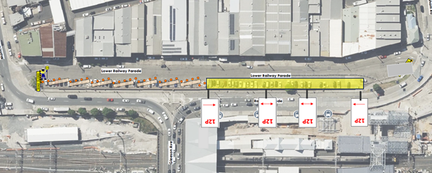
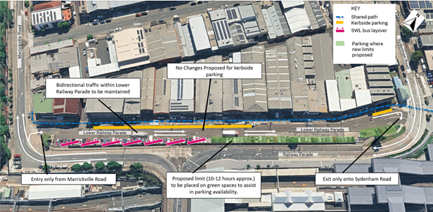
TfNSW has also requested possible temporary changes in the traffic flow in and out of Lower Railway Parade for the remainder of the T3 Shutdown period this involves temporarily converting Lower Railway Parade into a single direction entry whereby:
· Vehicles will only be able to enter but not leave Lower Railway Parade from Marrickville Road at the Southern end of Lower Railway Parade
· Vehicles will only be able to exit but not enter Lower Railway Parade at Sydenham Road at the northern end of Lower Railway Parade.
Refer to the diagram below.
Refer to Attachment 1 for the Traffic Control Plan.
Any changes to street signage/regulatory signage will be made by TfNSW and will be reinstated at the completion of the planned shutdown.
PUBLIC CONSULTATION
Transport for NSW have consulted the local businesses along Lower Railway Parade and they have indicated they are in favour of changing the unlimited parking to timed parking – which aims to increase the availability of space for customers and employees of these businesses.
Pending approval, Transport for NSW would notify nearby residents and businesses via letterbox drop ahead of the changes being implemented.
FINANCIAL IMPLICATIONS
There are no financial implications for Council associated with this matter. The cost of the work will be borne by Transport for NSW.
|
1.⇩ |
Traffic Control Plan |
|
|
Local Traffic Committee Meeting 17 February 2025 |
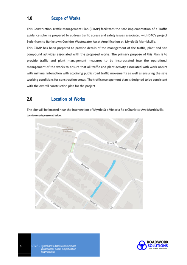
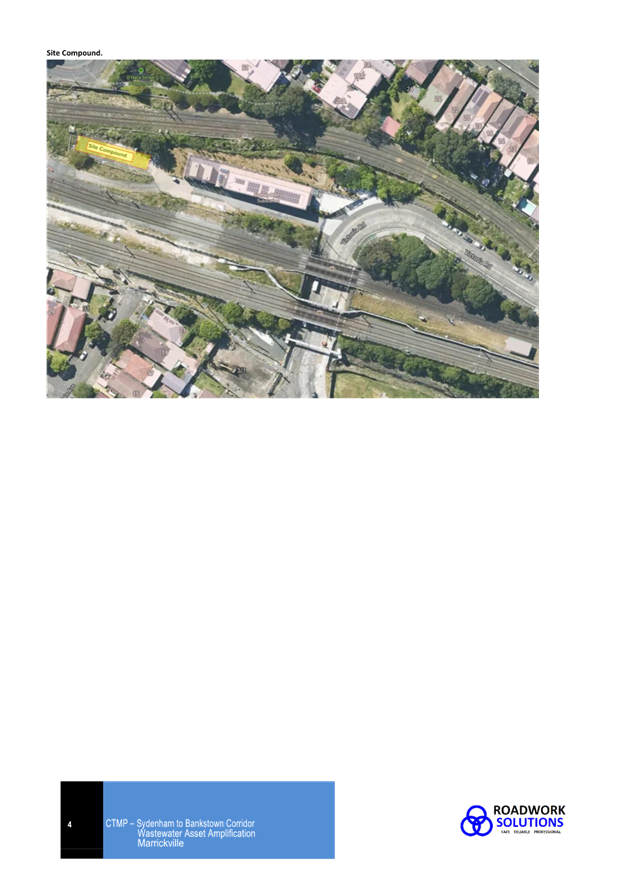
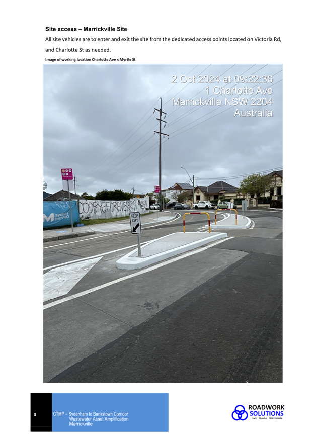
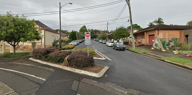
Subject: Charlotte Avenue, Marrickville at Myrtle Street and Victoria Road - Temporary full road closure and temporary regulatory signage changes– Sydney Water sewer upgrade works Marrickville CTMP (Midjuburi-Marrickville Ward / Summer Hill Electorate / Inner West Pac)
Prepared By: Jennifer Adams - Traffic Engineer
Authorised By: Manod Wickramasinghe - Traffic and Transport Planning Manager
|
RECOMMENDATION
That the proposed temporary full road closure (ENRC/2024/0069) of Charlotte Avenue, Marrickville at its junction with Myrtle Street and Victoria Road, for an approximate 6-month period beginning from 1 April 2025 to 1 September 2025 be approved, in order to facilitate Sydney Water’s sewer upgrade works subject to, but not limited to, the following conditions:
1. A Road Occupancy License be obtained by the applicant from the Transport Management Centre;
2. All affected residents and businesses, including the NSW Police Local Area Commander, Fire & Rescue NSW and the NSW Ambulance Services be notified in writing, by the applicant, of the proposed temporary road closure at least 7 days in advance of the closure with the applicant making reasonable provision for stakeholders;
3. The occupation of the road carriageway must not occur until the road has been physically closed; and
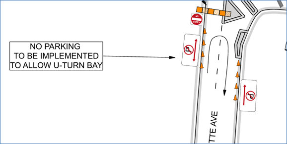
4. The applicant is to bear all costs and works associated with the installation/removal of the temporary “No Parking’ restrictions at the northern end of Charlotte Avenue, Marrickville.
|
STRATEGIC OBJECTIVE
This report supports the following strategic directions contained within Council’s Community Strategic Plan:
|
2: Liveable, connected neighbourhoods and transport |
|
|
An application has been received from D4C for the temporary full road closure of Charlotte Avenue, Marrickville at its junction with Myrtle Street and Victoria Road, for an approximate 6-month period beginning 1 April 2025 to 1 September 2025 in order to facilitate Sydney Water’s sewer upgrade works. As per the supplied Sydney Water sewer upgrade works Marrickville CTMP the road will be temporarily closed to all vehicular traffic and there is a proposed temporary regulatory signage change at the northern end of Charlotte Avenue to facilitate U-turns. It is recommended that the proposed temporary full road closure and temporary signage change be approved, subject to the conditions outlined in this report.
BACKGROUND
The purpose of these works is to improve network functionality by increasing the capacity of the wastewater network to service increased demand, thereby reducing the risk of wastewater main breaks in the future.
Due to the Sydenham to Bankstown Metro Upgrade Project being undertaken by TfNSW, Sydney Water has an opportunity to access the railway corridor and upgrade wastewater infrastructure in these areas. This would be undertaken with ongoing consultation with TfNSW/Sydney Trains.
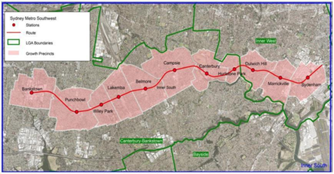
The new Metro Sydenham to Bankstown line shown in the diagram below, shows the new stations at the 11 growth precincts along the metro corridor. Marrickville and Belmore are the first sites selected for increasing the wastewater capacity in areas deemed required to meet the growth needs of the Sydenham to Bankstown Urban Renewal Corridor Strategy.
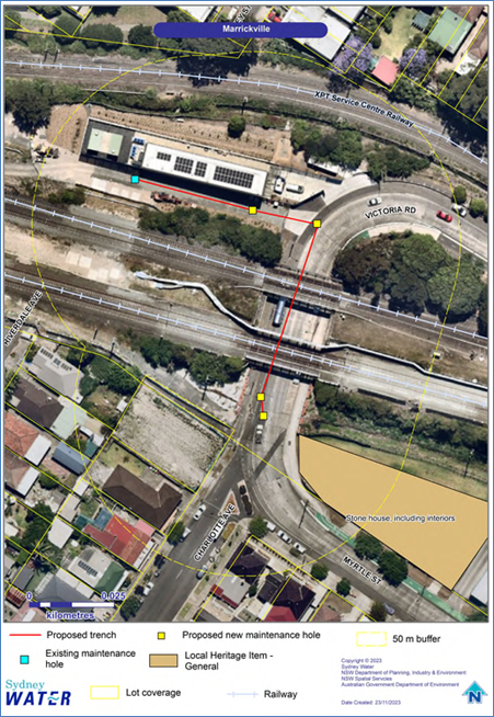
Location of works
The proposal is located in the road and verge of Victoria Road and under the railway overpass.
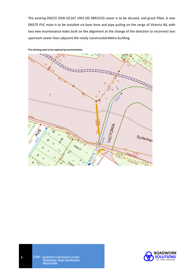
Scope of works
The proposal involves construction of about 111 metres of a DN375 wastewater main via open trench along Victoria Road and into the railway property access driveway. Excavation depths will range from 3 to 4 metres. The proposal would also involve the construction of 4 new maintenance holes, and grouting and decommissioning the existing wastewater pipe.
The scope of work is outlined below:
Pre-Construction
· further site investigations may be required e.g. potholing, boreholes, geotechnical and contamination testing etc
Establishing site
· install erosion and sediment control measures
· install fencing and traffic control measures
Wastewater upsizing works:
· open trench excavation in the verge, roadway, and public land for the new wastewater main, up to about 3 to 4 metres deep and 1.0 metre wide
· minor excavation to create new maintenance holes · minor excavation to create launch and receiving pits, up to about 2.7 metres depth, 6.0 metres long and 4.0 metres wide (Belmore)
· micro tunnelling from the launch to receiving pit, including a new section of the DN450 main (Belmore only)
· install bends, tapers, tees, hydrants, thrust blocks & other fittings for new wastewater mains
· connect the new wastewater main to existing network
· traffic and pedestrian management during work and shutdown periods.
The work site will be restored to the pre-existing condition following construction, in consultation with landowners.
Construction Traffic Management Plan (CTMP)
D4C will work to minimize impacts during this time. However, there may be machinery noise as well as temporary disruptions to local and pedestrian traffic. Access to properties will be maintained at all times where possible. The road closure impacts no bus route. A Construction Traffic Management Plan (CTMP) has been provided and is attached at the end of this report.
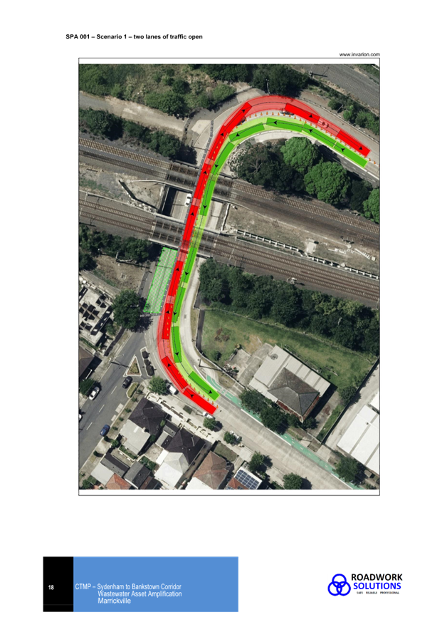
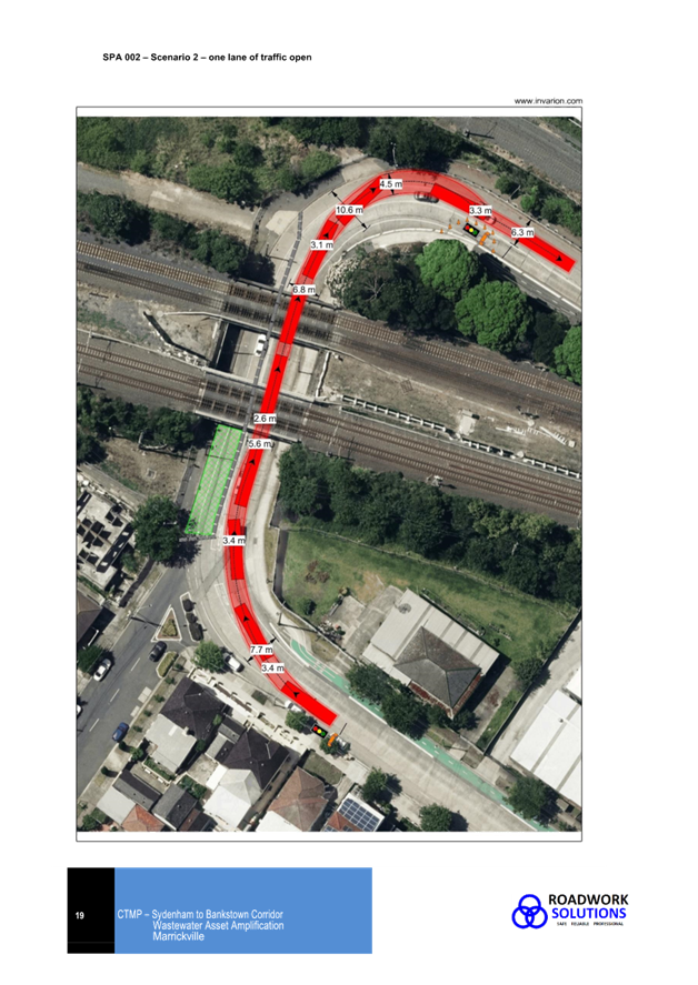
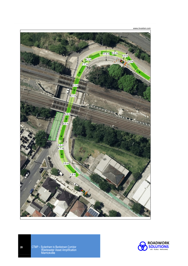
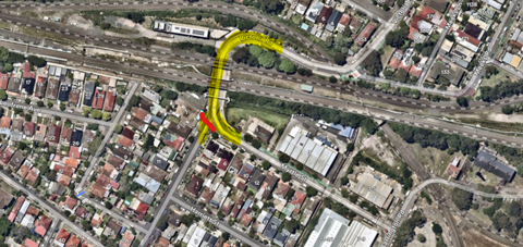
It is proposed to carry out the works with a counterflow system operating on Victoria Road, Marrickville. The CTMP notes that during the planning stage of the project a number of scenarios were run to find the most suitable traffic management for the site. Priority was given to always keeping 2 lanes of traffic open, and this was modelled as Scenario 1. Despite efforts to reduce the Work Zone footprint, and study of the site to cater for passing vehicles, it was determined there was not enough room to maintain adequate trafficable lanes as per the Austroads Guides to Temporary Traffic Management and the TfNSW TCAWS V6 manual. Several swept path analyses were completed with the different compound configurations, and each time the vehicle paths clashed. Refer to SPA001 – Scenario 1 reproduced below.
Scenario 2 was modelled on always keeping 1 trafficable lane open. This allows D4C to meet the minimum lane width requirements of the Austroads Guides to Temporary Traffic Management & the TfNSW TCAWS V6 manual. Several swept path analyses were done, and it was considered that this arrangement would best cater for all expected vehicles travelling this section of roadway. Refer to SPA 002/003 reproduced below.
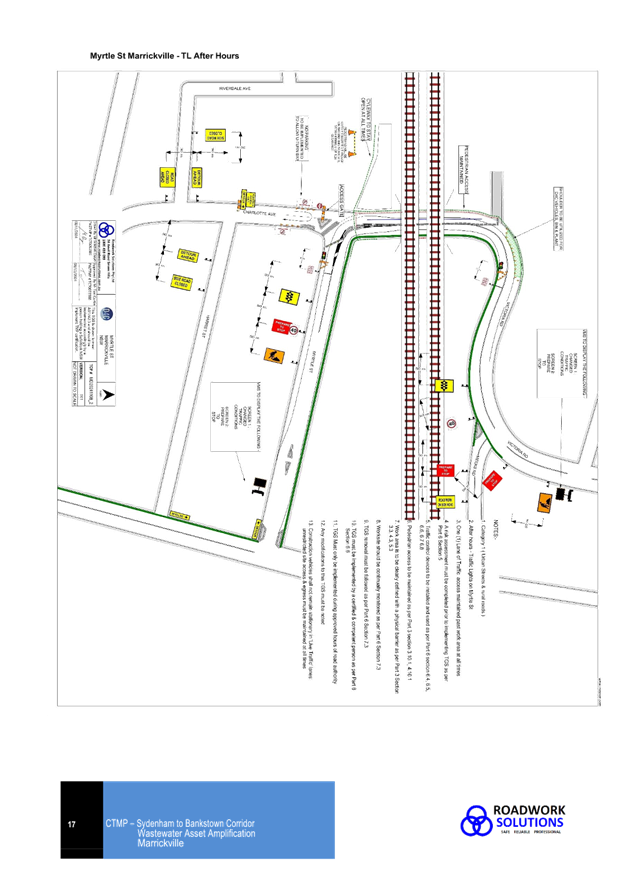
A portable traffic light/signal system will be operating for after-hours traffic management. D4C have stated that malfunction of the system is rare and noted that the traffic lights will be tested and fully charged prior to crews leaving site and that the out of hours traffic management company phone number is on the lights. The traffic management company night shift manager will complete regular site checks of the unmanned site throughout the week.
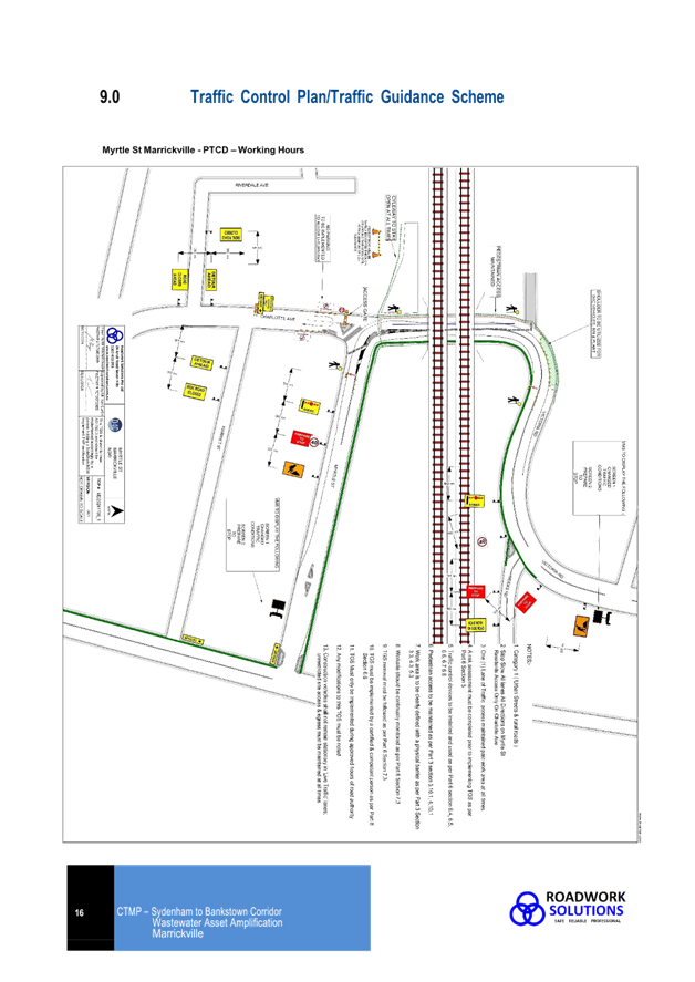
The Traffic Guidance Scheme Plans for the temporary road closure of Charlotte Avenue are shown below. Detours will be in place. VMS boards will be displayed on the perimeter area.
Traffic control and directional signage will be in place for the safety of workers and the community. There may be an increase in traffic movements around the local area. Motorists may experience some delays. Concrete barriers or water filled barriers are to be utilized to delineate the compound. All barriers are to be compliant with AS/NZS 3845.
Pedestrian routes will not be affected by works. All pedestrian paths will be maintained at a minimum clearance of 1.2m at all times. Pedestrians will be adequately separated from always works with appropriate site fencing. The cycleway is to stay open at all times.
Emergency services will be provided with advance notice of any changes via the site management team and email updates. All Emergency services will have access always maintained through the road closures.

FINANCIAL IMPLICATIONS
OFFICER COMMENTS
Thus, it is noted that the medium-term temporary full road closure will divert traffic to other local streets for a period of time which may be disruptive to some local residents.
Myrtle Street is a local road and between Carrington Road and Victoria Road, carries 7,689 vehicles per day. Victoria Road, between Fernbank Street and Calvert Street, carries around 9,408 vehicles per day. As previously noted, motorists may experience some inconvenience and delays over the six-month period.
D4C have stated that VMS boards can go up 2 weeks prior to construction. Initial message of VMS boards will be ‘CONSTRUCTION AHEAD’ & ‘APRIL TO SEPTEMBER’, once construction kicks off onsite, the message will change to ‘CONSTRUCTION AHEAD’ & ‘SLOW DOWN’. It is suggested that the later messages be changed to ‘Expect Delays’ opposed to ‘Slow Down’ and that the VMS boards stay in place for the duration of the works.
Traffic controlled during the day under contra flow arrangement using stop/go with traffic controllers on site and portable traffic light/signal system operating for after-hours traffic management is acceptable and should be reviewed within two weeks of operation and any changes implemented as or if required.
Parking change
D4C have advised that a small parking modification will be made on Charlotte Avenue to allow for vehicles to do a U-turn at the closure point. D4C will supply, install and remove the temporary signage appropriately.
With the construction works and the temporary parking changes some local parking will be lost. The CTMP states:
5.1 Vehicle Access
LVs and Heavy vehicles will be able to enter the site. If parking is not available on site, LVs should be parked legally on the surrounding or other local streets.
6.3 Construction Workers Parking
Construction workers are to park either inside the compound or legally curb side on surrounding or local streets. It is likely D4C will park cars, bins & plant in the Northbound direction’s shoulder area as per TGS in section 9.0.
It is noted, in recent times, residents in Charlotte Avenue have raised concerns about worker parking in their street. Council officers have also reviewed the parking utilization in Charlotte Street and it was noted to be operating at near capacity. As such, all provisions for the approximate 15 workers on-site needs to be within the off-road site compound.
PUBLIC CONSULTATION
The proposed road closure has been advertised on Council’s website in accordance with the Roads Act 1993.
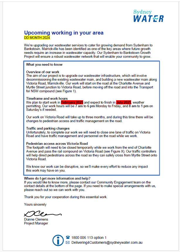
The applicant is to notify all affected residents and businesses in writing at least 7 days prior to the commencement of works. A draft copy of their notification letter is reproduced below.
CONCLUSION
It is recommended that the proposed temporary full road closure be approved, subject to but not limited to the conditions and recommendations outlined in this report.
ATTACHMENTS
|
1.⇩ |
CTMP - Sydenham to Marrickville WAA Marrickville - REV C |
|
Local Traffic Committee Meeting 17 February 2025 |
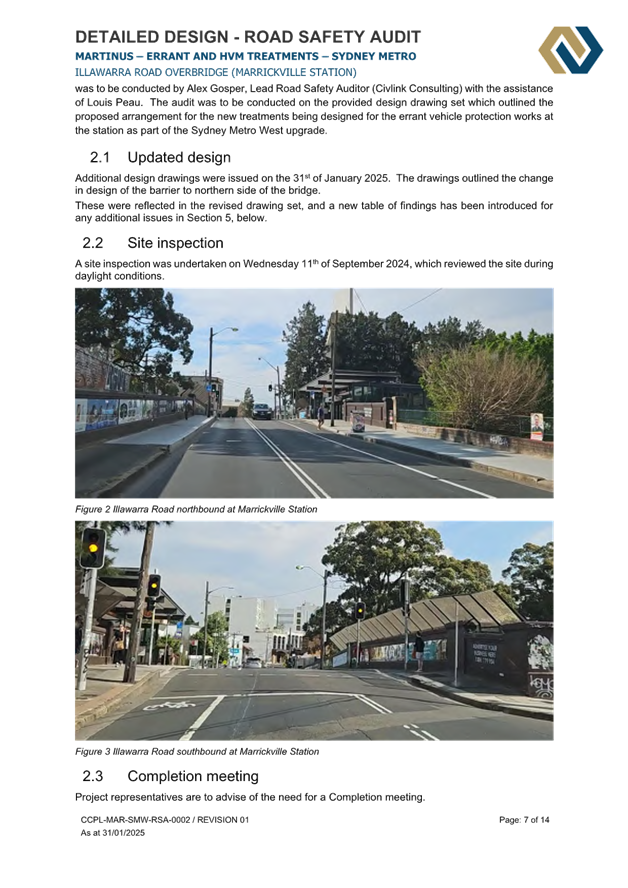
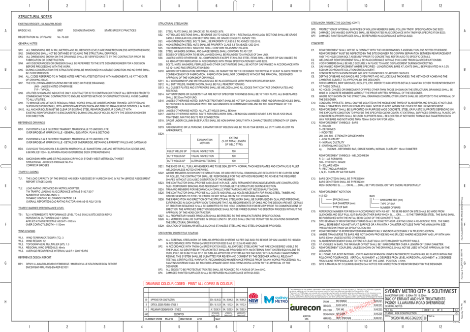
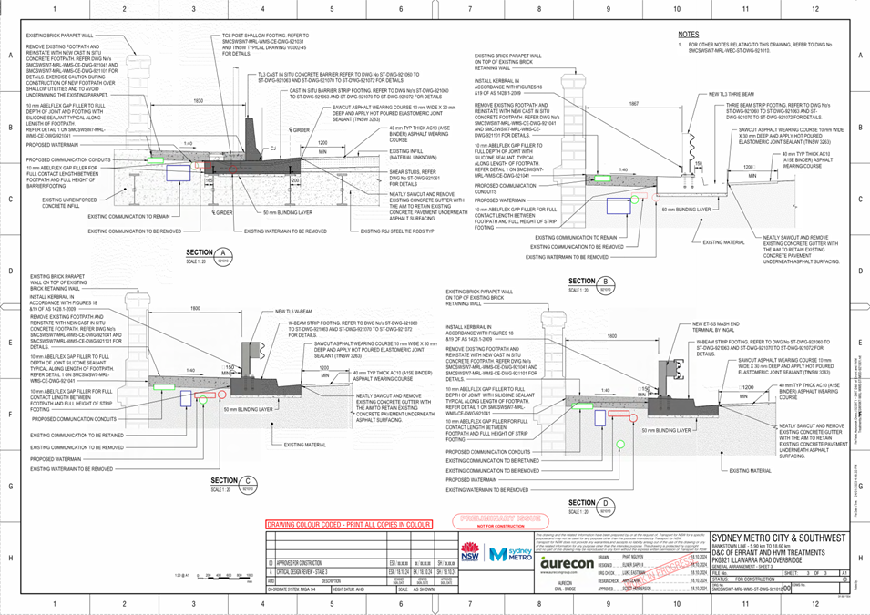
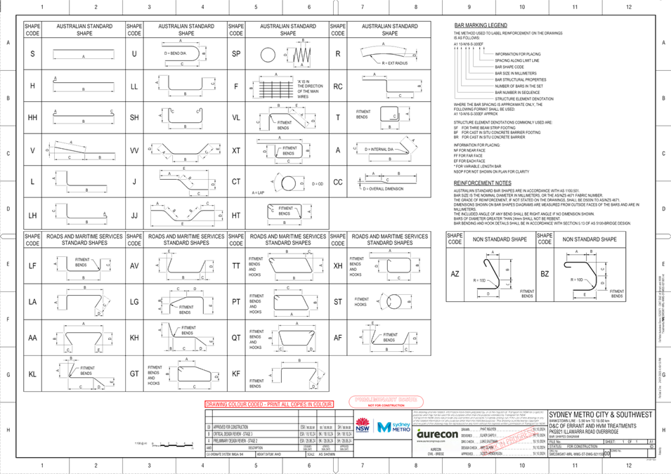
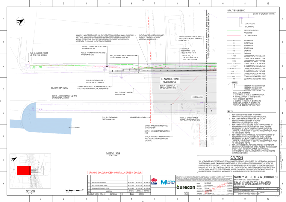
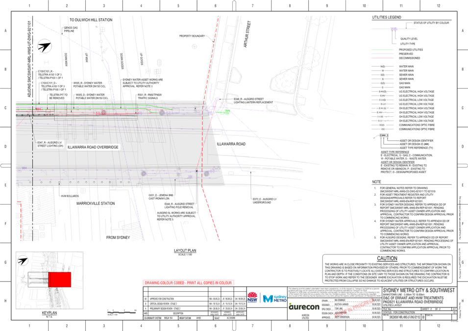
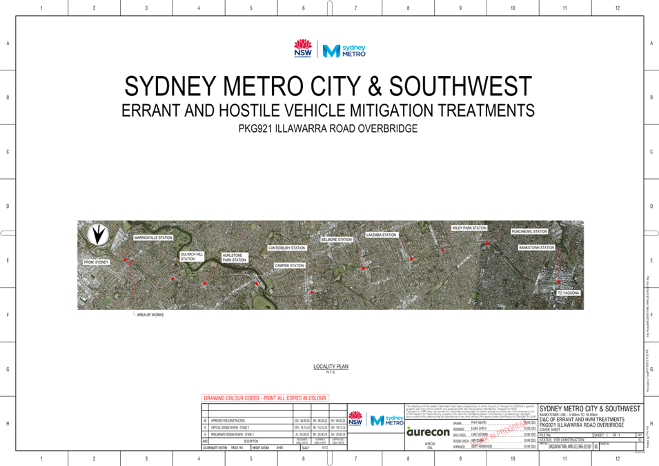
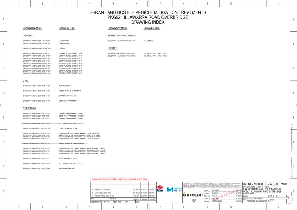
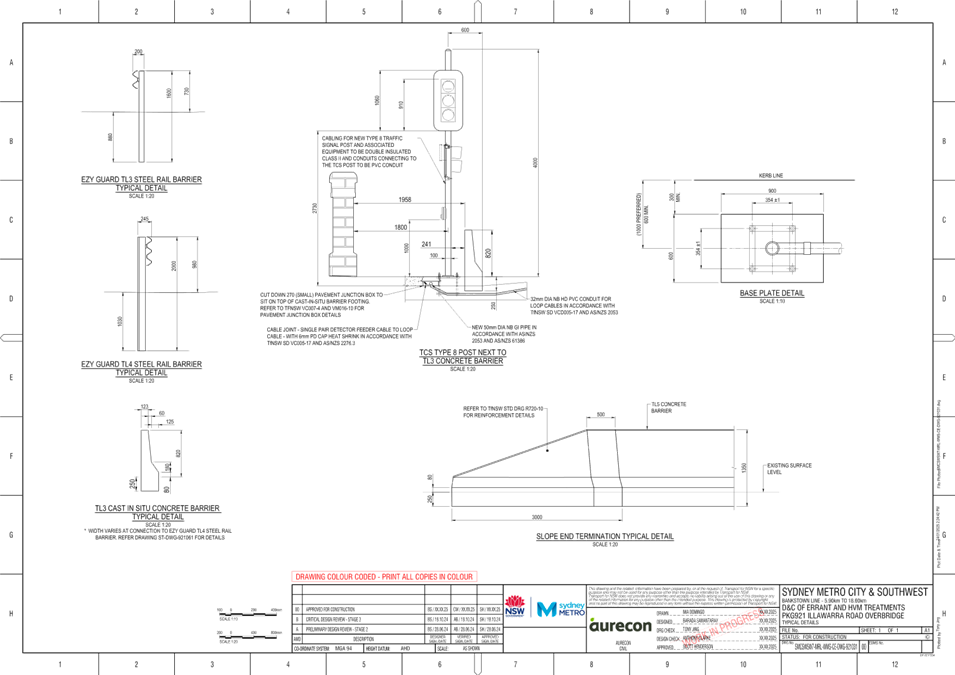
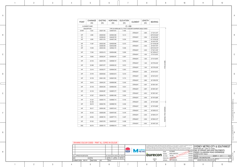
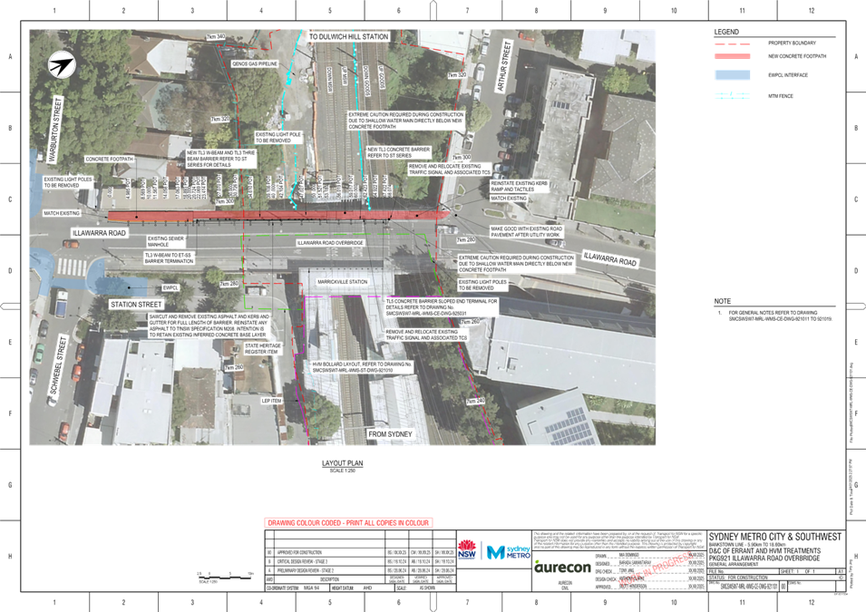
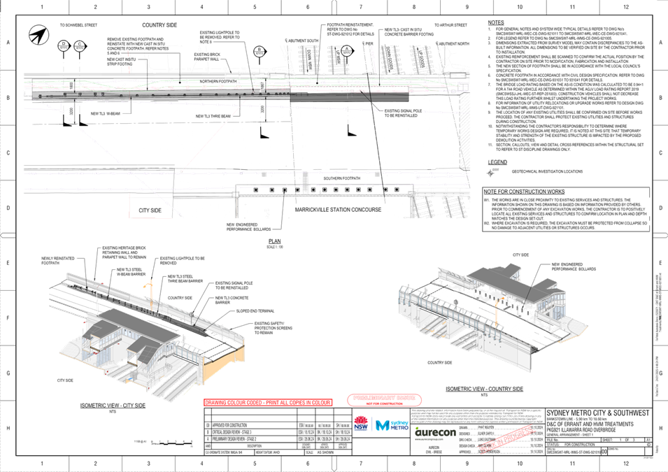
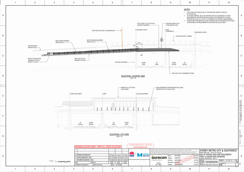
Subject: Illawarra Road, Marrickville - Proposed roadside barrier (Midjuburi-Marrickville Ward/Summer Hill Electorate/Inner West PAC)
Prepared By: James Nguyen - Traffic Engineer
Authorised By: Manod Wickramasinghe - Traffic and Transport Planning Manager
|
RECOMMENDATION
That the protective measure works proposed by Sydney Metro as part of the Sydney Metro Southwest project at the existing bridge on Illawarra Road between Schwebel and Arthur Streets, Marrickville be approved including associated amendments to the travel lanes. |
STRATEGIC OBJECTIVE
This report supports the following strategic directions contained within Council’s Community Strategic Plan:
|
2: Liveable, connected neighbourhoods and transport |
|
|
EXECUTIVE SUMMARY
This report presents the protective measure works proposed by Sydney Metro as part of the Sydney Metro Southwest project, at the existing bridge on Illawarra Road between Schwebel and Arthur Streets, Marrickville. It outlines the scope of work and the implications to the existing footpath and road.
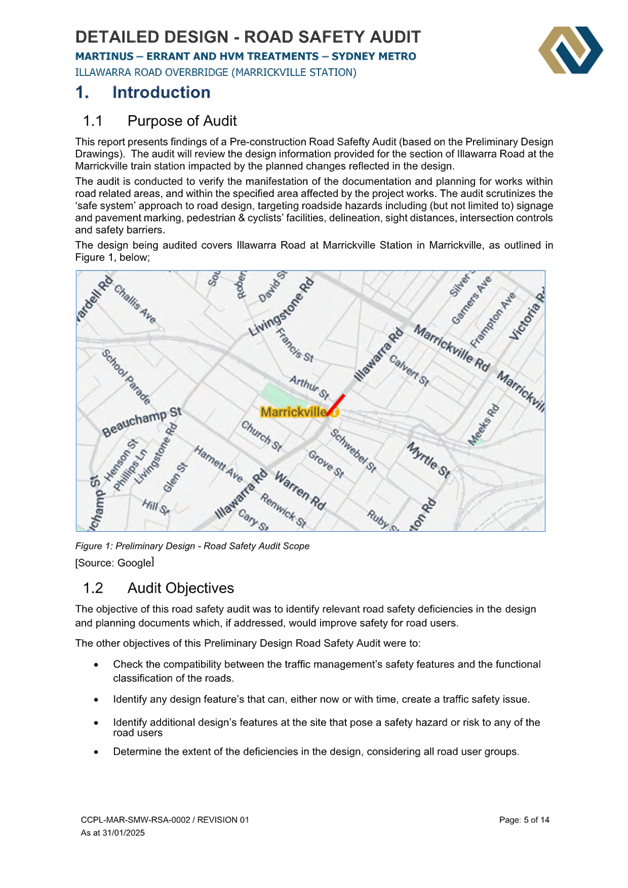
BACKGROUND
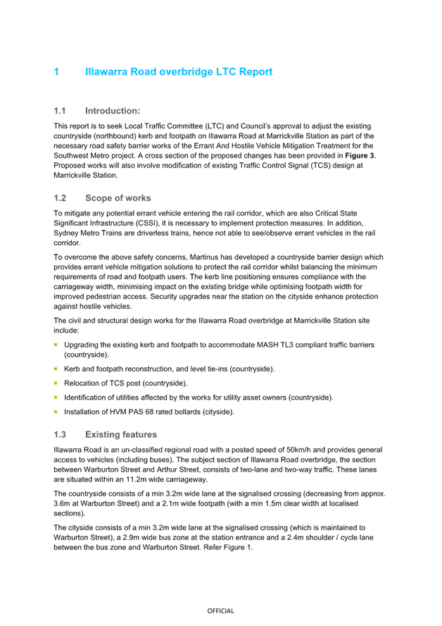
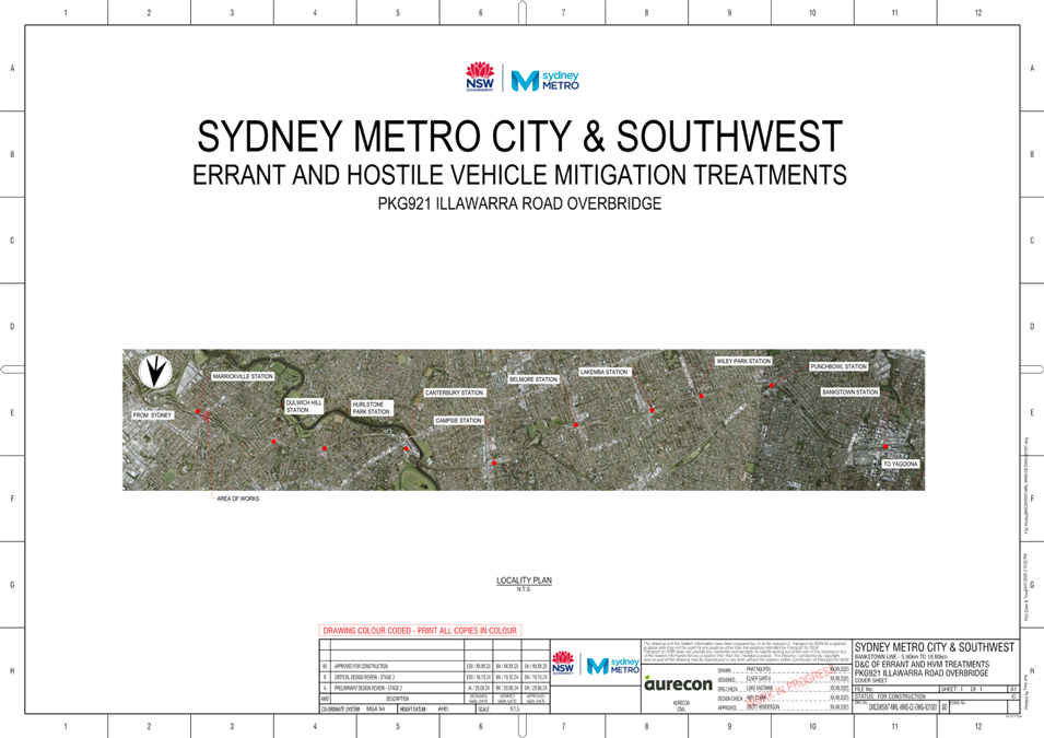
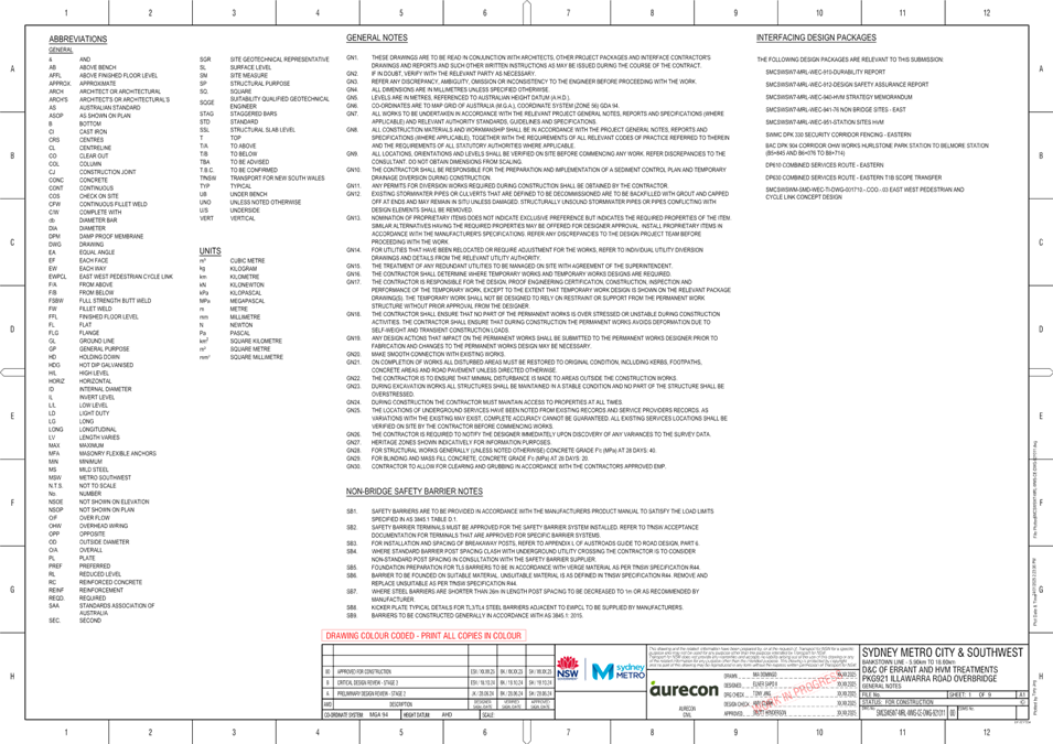
As part of the Sydney Metro Southwest project, Sydney Metro are proposing to provide protective measures at the existing bridge on Illawarra Road between Schwebel and Arthur Streets to prevent any potential errant vehicle from entering the rail corridor. As the proposed works require adjustments to the existing footpath and roadway, Sydney Metro are seeking approval from the Local Traffic Committee and Inner West Council.
DISCUSSION
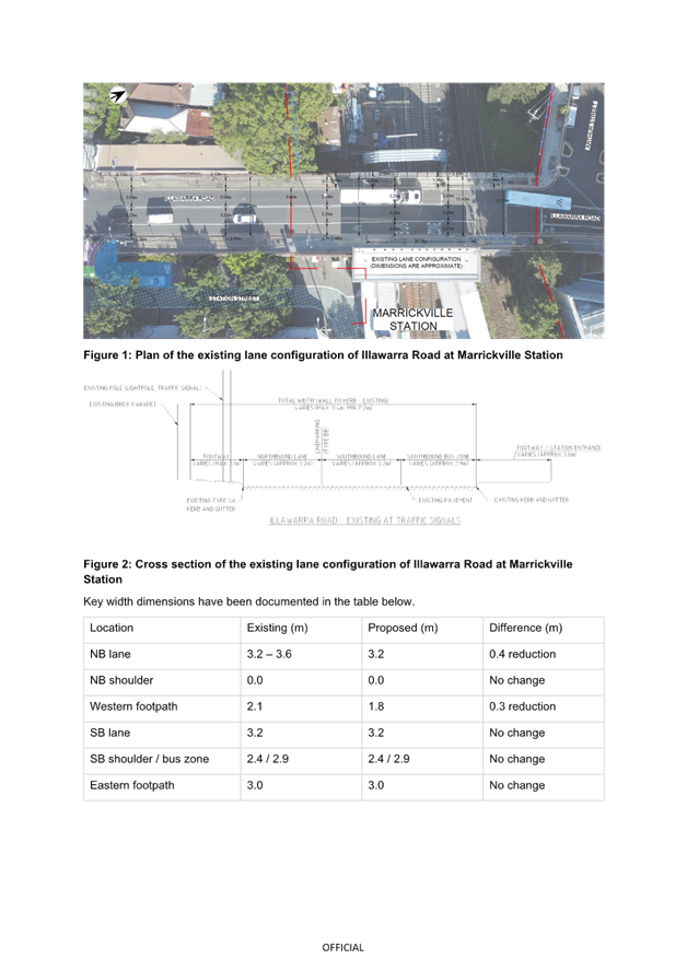
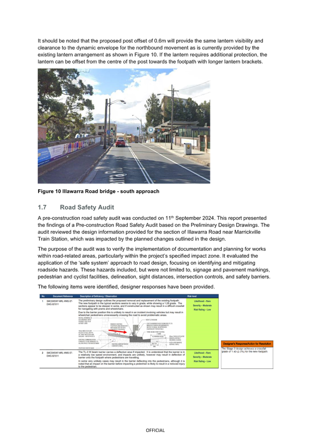
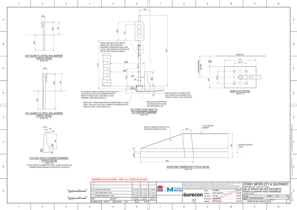
Sydney Metro are proposing to install a roadside safety barrier on the western side of Illawarra Road, as shown in Figure 1 below:
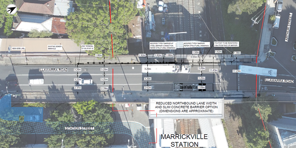
Figure 1: Plan of the proposed lane configuration of Illawarra Road at Marrickville Station
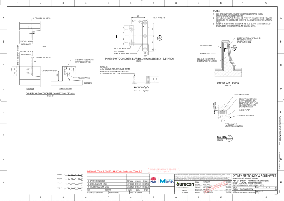
The protective measures at the existing bridge on Illawarra Road consists of the following:
· Kerb replacement works consisting of a new slim TL3 type-f concrete barrier (approx. 15m long) adjoining a standard type-sa kerb and gutter (approx. 53m long), as shown in the section Figure 2 below.

Figure 2: Cross section of the proposed countryside footpath behind type-f barrier
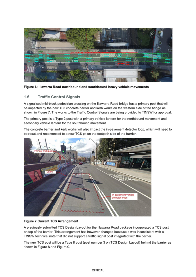
· A TL3 guardrail and ET-SS end terminal (approx. 33m long) as shown in the section Figure 3 below. The TL3 guardrail is connected to the type-f concrete barrier.
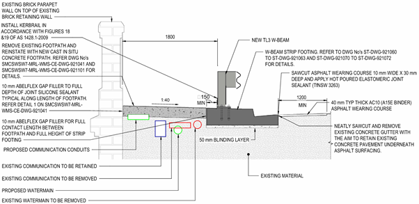
Figure 3: Cross section of the proposed countryside footpath behind TL3 w-beam
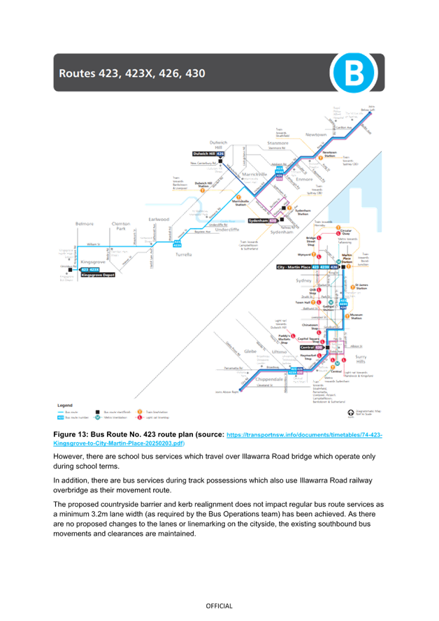
The overall proposal is shown in Figure 1 and Figure 4 below. The protective measure treatments will require the reduction to a short section of the northbound travel lane on Illawarra Road. This section is approximately 3.4-3.6 metres wide, and will be reduced to 3.2 metres wide, and aligns with the travel lane width further north; this will allow appropriate travel widths for buses. In addition, the footpath on the western side will be reduced from 2.1 metres to 1.8 metres and is adequate pedestrians.
![]()
![]()
![]()
![]()
![]()
![]()
![]()
![]()
![]()
![]()
![]()
![]()
![]()
![]()
![]()
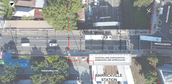
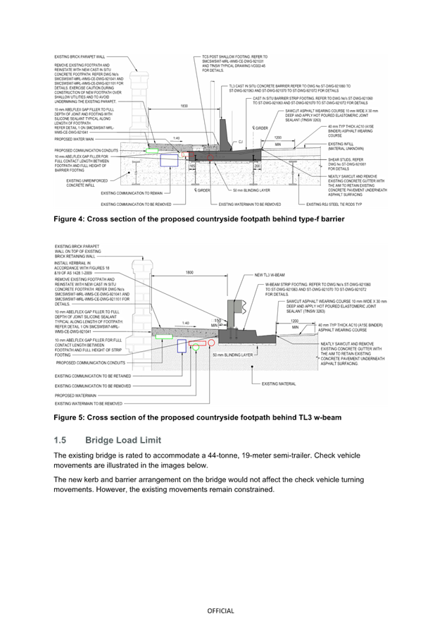
Figure 4: Plan of the existing lane configuration of Illawarra Road at Marrickville Station
The protective measure works will require an adjustment to the existing signalised mid-block pedestrian crossing on Illawarra Road, south of Arthur Street; this is under the jurisdiction of Transport for NSW and subject to Transport for NSW approval. The proposal is shown in Figure 5 below.
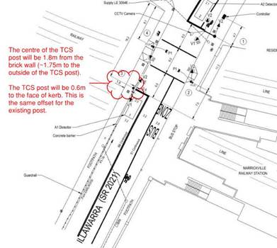
Figure 5: TCS plan - Signal post adjustment at Illawarra Road
FINANCIAL IMPLICATIONS
There are no financial implications associated with the implementation of the proposed recommendations outlined in the report.
|
1.⇩ |
Sydney Metro report |
|
2.⇩ |
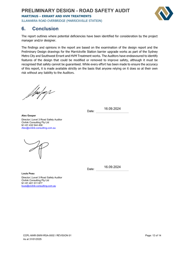
Road Safety Audit |
|
3.⇩ |
Design plan |
|
4.⇩ |
Design plan |
|
5.⇩ |
Design plan |
|
Local Traffic Committee Meeting 17 February 2025 |
Subject: 182-189 Victoria Road and 28-30 Faversham Street, Marrickville (Wicks Park) - Traffic intersection assessment (Midjuburi-Marrickville Ward/Summer Hill Electorate/Inner West PAC)
Prepared By: James Nguyen - Traffic Engineer
Authorised By: Manod Wickramasinghe - Traffic and Transport Planning Manager
|
RECOMMENDATION
That no further right turn restrictions outside the current morning peak period (7am-9.30am Mon-Fri) be implemented from Victoria Road into the private road at Wicks Place. |
STRATEGIC OBJECTIVE
This report supports the following strategic directions contained within Council’s Community Strategic Plan:
|
2: Liveable, connected neighbourhoods and transport |
|
|
EXECUTIVE SUMMARY
This report outlines the traffic intersection assessment at Victoria Road and the private access road of Wicks Place, Marrickville. The assessment found low right turning volumes and low levels of queuing at this intersection and no further right turn restrictions are necessary at this stage.
BACKGROUND
A notice of motion (Item:C024(2) Item 27 Notice of Motion: Wicks Park) was raised at the Ordinary Council Meeting on 25 June 2024 requesting for the assessment of the right turn movement from Victoria Road into the Wicks Place development to determine if this movement is causing significant congestion and safety issues on Victoria and Sydenham Roads, and whether a right turn restriction is necessary.
DISCUSSION
The right turn movement from Victoria Road into the private road of Wicks Place is restricted during the morning peak period and signposted as ‘No Right Turn 7am-9.30am Mon-Fri’. Council officer’s commissioned an intersection count to assess peak right turn volumes outside the restricted hours to assess the intersection performance. The intersection counts were completed during the following peak periods:
· Wednesday 18 September 2024, 11am-1pm and 4pm-6pm
· Saturday 21 September 2024, 11am-1pm
The results are presented in Table 1 below:
Table 1 – Traffic intersection counts (right turn movements)
|
Day |
Time |
Right turn movements (total vehicles) |
|
Wednesday 18 September 2024 |
12noon-1pm |
7 |
|
Wednesday 18 September 2024 |
4.30pm-5.30pm |
17 |
|
Saturday 21 September 2024 |
12noon-1pm |
9 |
Council officer’s subsequently prepared a SIDRA model to assess the level of queuing with these right turn volumes. The results are provided below:
Table 2 - SIDRA results - Queuing assessment
|
Day |
Time |
Right turn movements (total vehicles) |
Vehicle Queue – average (no. of vehicles) |
Vehicle Queue – 95th percentile (no. of vehicles) |
|
Wednesday 18 September 2024 |
12noon-1pm |
7 |
0.0 |
0.1 |
|
Wednesday 18 September 2024 |
4.30pm-5.30pm |
17 |
0.1 |
0.3 |
|
Saturday 21 September 2024 |
12noon-1pm |
9 |
0.0 |
1 |
Table 2 above uses a 4.5 second critical gap, and a 3 second follow-up headway. The results from the SIDRA model were assessed further and calibrated with a site inspection.
Council officer’s completed an evening peak hour site inspection on 4 December 2024 between 4.30pm to 5.30pm to assess queuing on-site. For the one (1) hour period, there were 11 right turning vehicles. The queues for each right turning instance is recorded below in Table 3 and the frequencies of queuing are presented in Table 4.
Table 3 - On-site queuing assessment results
|
Instance (right turn) |
No. of queued vehicles before turn |
|
1 |
6 |
|
2 |
0 |
|
3 |
0 |
|
4 |
0 |
|
5 |
2 |
|
6 |
0 |
|
7 |
4 |
|
8 |
5 |
|
9 |
0 |
|
10 |
1 |
|
11 |
0 |
Table 4 - Summary of on-site queuing results
|
No. of queued vehicles |
Frequency |
|
0 |
6 |
|
1 |
1 |
|
2 |
1 |
|
3 |
0 |
|
4 |
1 |
|
5 |
1 |
|
6 |
1 |
Table 5 - Site observations – Queuing assessment
|
Day |
Time |
Right turn movements (total vehicles) |
Vehicle Queue – average (no. of vehicles) |
Vehicle Queue – 95th percentile (no. of vehicles) |
|
Wednesday 4 December 2024 |
4.30pm-5.30pm |
11 |
1.57 |
5.5 |
Based on Tables 3 and 4, the site visit completed recorded an average of 1.57 vehicles queued per instance, with most right turns recording no vehicles queuing (6 instances). The 95th percentile queue is approximately 5.5 vehicles. This is shown in Table 5 above.
Site observations recorded more conservative queuing results compared to the SIDRA model. Both the SIDRA model and site observations suggest there is no significant queuing caused by the right turn from Victoria Road into Wicks Place. This is likely due to the low number of vehicles, and opposing traffic flow arriving in ‘bunches’ which allows for large gaps that was observed on-site. Larger queuing instances occur, when a right turning vehicle arrives at the start of the bunching of the opposing traffic flow as per instances 1, 7 and 8 in Table 3.
Accordingly, based on these results, no further right turn restrictions from Victoria Road to Wick Place is necessary at this stage.
FINANCIAL IMPLICATIONS
There are no financial implications associated with the implementation of the proposed recommendations outlined in the report.
Nil.
|
|
Local Traffic Committee Meeting 17 February 2025 |
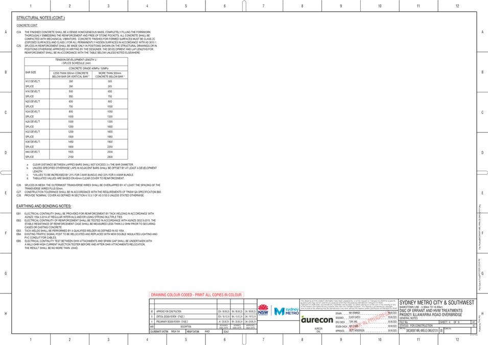
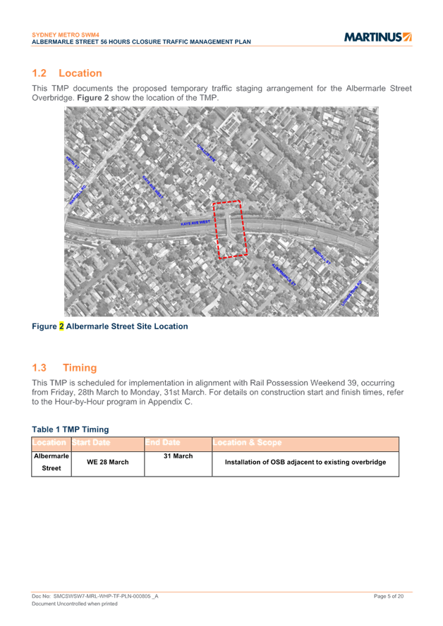
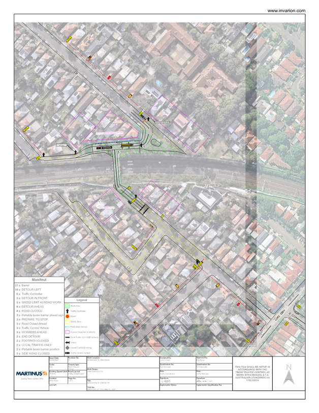
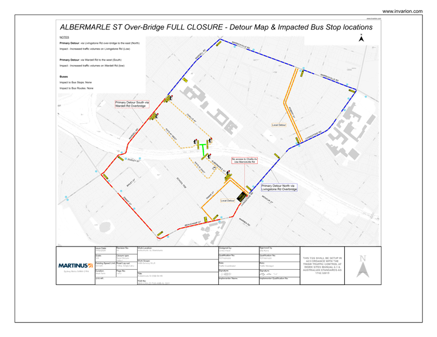
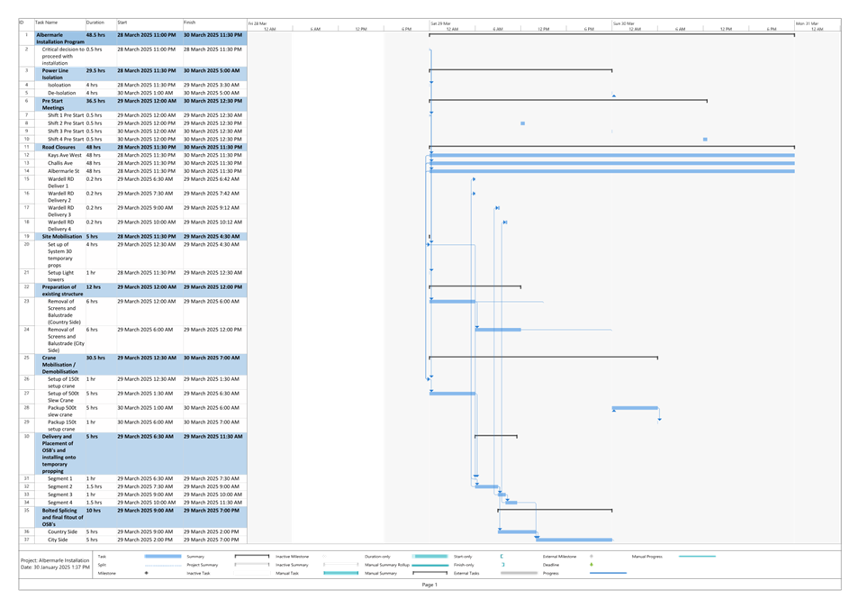
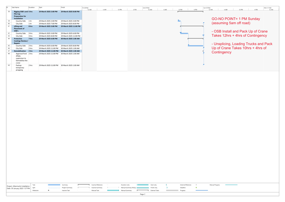
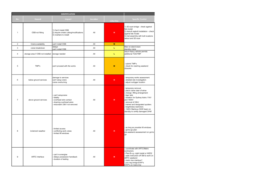
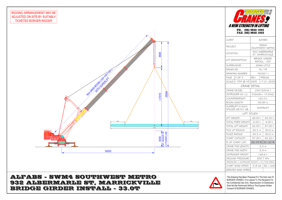
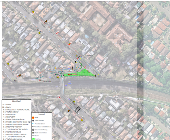
Subject: Albermarle Street, Marrickville – Temporary Full Road Closure of Rail Overbridge south of Challis Street - Sydney Metro SWM4 works CTMP (Midjuburi-Marrickville Ward / Summer Hill Electorate / Inner West Pac)
Prepared By: Jennifer Adams - Traffic Engineer
Authorised By: Manod Wickramasinghe - Traffic and Transport Planning Manager
|
RECOMMENDATION
That the proposed temporary full road closure of Albermarle Street (between Challis Avenue and Kays Avenue East), Marrickville for a 56-hour period in alignment with Rail Possession occurring from Friday, 28th March to Monday, 31st March.2025 (contingency period of two weeks) be approved, in order to carry out errant and hostile vehicle mitigation works on the Rail Overbridge subject to, but not limited to, the following conditions:
1. A Road Occupancy License be obtained by the applicant from the Transport Management Centre;
2. All affected residents and businesses, including the NSW Police Local Area Commander, Fire & Rescue NSW and the NSW Ambulance Services be notified in writing, by the applicant, of the proposed temporary road closure at least 7 days in advance of the closure with the applicant making reasonable provision for stakeholders; and
3. The occupation of the road carriageway must not occur until the road has been physically closed.
|
STRATEGIC OBJECTIVE
This report supports the following strategic directions contained within Council’s Community Strategic Plan:
|
2: Liveable, connected neighbourhoods and transport |
|
|
EXECUTIVE SUMMARY
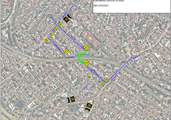
An application has been received from Martinus on behalf of Sydney Metro (SWM4) for the temporary full road closure of the rail over bridge on Albermarle Street just south of Challis Avenue, Marrickville for a 56-hour period in alignment with Rail Possession Weekend 39, occurring from Friday 28th March to Monday 31st March.2025. It is recommended that the proposed temporary full road closure be approved, subject to the conditions outlined in this report.
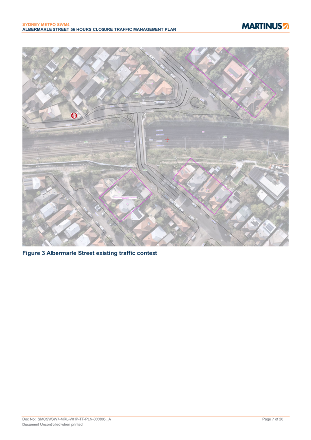
BACKGROUND
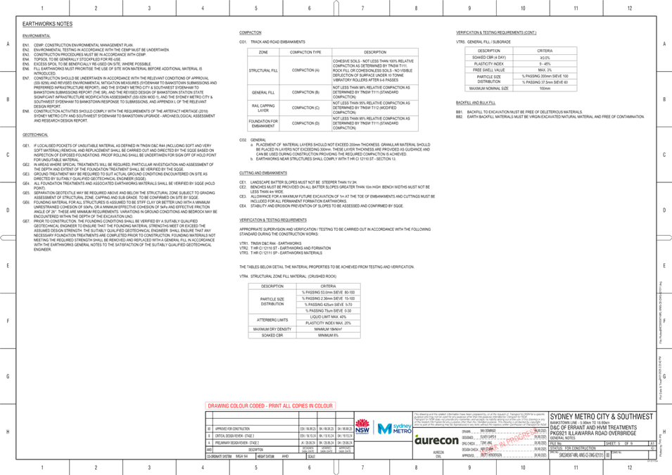
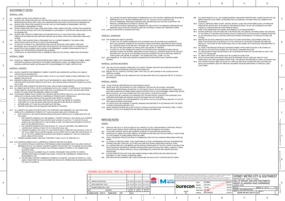
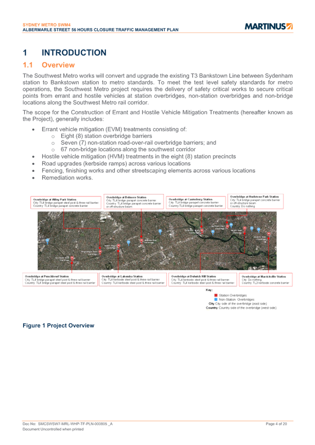
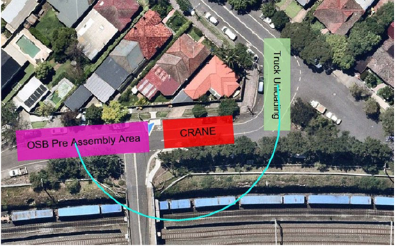
The Southwest Metro works will convert and upgrade the existing T3 Bankstown Line between Sydenham station to Bankstown station to metro standards. To meet the test level safety standards for metro operations, the Southwest Metro project requires the delivery of safety critical works to secure critical points from errant and hostile vehicles at station overbridges, non-station overbridges and non-bridge locations along the Southwest Metro rail corridor.
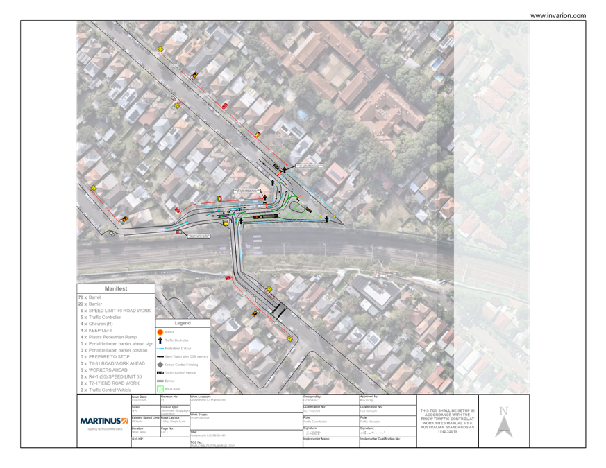
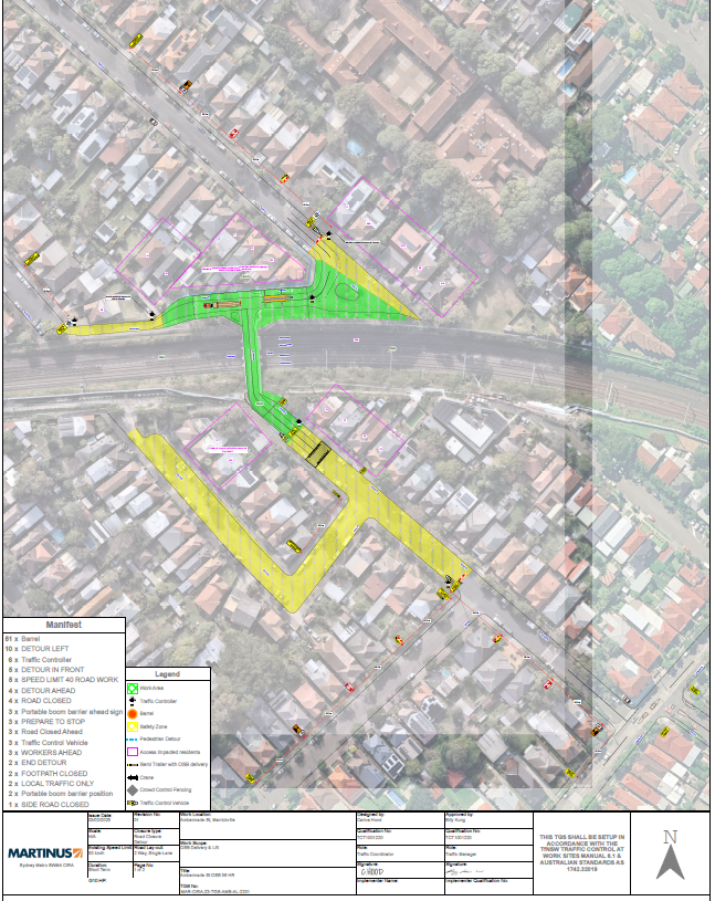
The scope of this Errant and Hostile Vehicle Project includes the installation of anti-throw screens, concrete bollards, and rail barriers along the alignment, as well as other associated works where required. Works on the Albermarle Street overbridge require a temporary full road closure of Albermarle Street (between Challis Avenue and Kays Avenue East), Marrickville. The overbridge will be closed to all vehicles and pedestrians. Detours will be in place for the full duration of the closure. Traffic controllers will be on-site and traffic movements will be managed in accordance with the attached CTMP. A crane will be in use to lift beams into place.
OFFICER COMMENTS
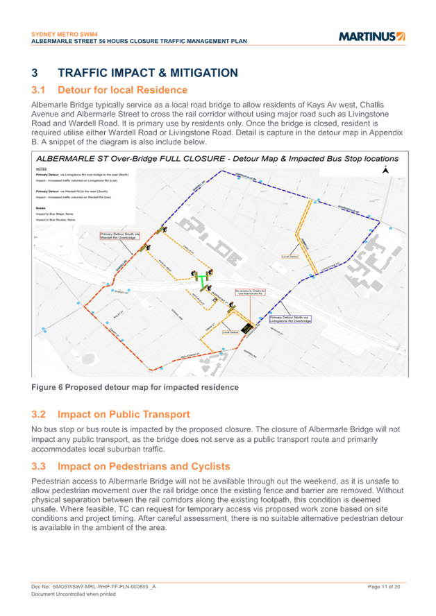
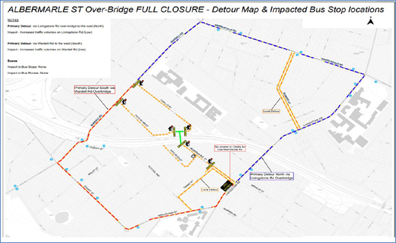
Albermarle Street, between Challis Avenue and Kays Avenue East, carries around 1,600 vehicles per day. At the railway overbridge the width of the road is approximately 5.7 metres in width. It is noted that the full road closure will divert traffic to either Wardell Road in the west or Livingstone Road in the west.
Scope of works
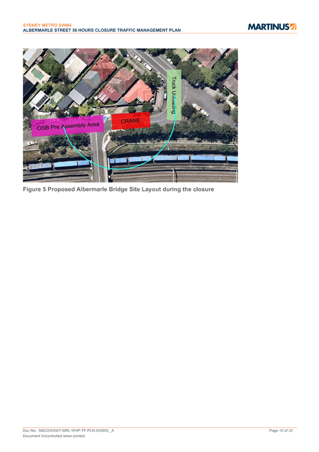
Off structure beams will be installed on the overbridge using a crane. The crane will be located on the Challis Avenue (north) side of the bridge.
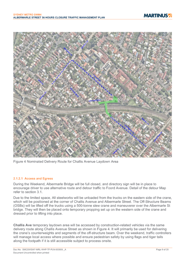
A section of the cu de sac along Challis Avenue, adjacent to house number 35-37 to 41 A, will be occupied and designated as a temporary laydown area from Friday dayshift to Monday morning. Crane and material deliveries will utilise Challis Avenue Street, and workers will have pedestrian access to the site.
Delivery vehicles will use Challis Avenue to access the drop-off area. Freight vehicles will travel north along Wardell Road and make a right turn at its intersection. Additionally, small construction vehicles will require access via Albermarle Street as an alternative route, particularly once the work zone is established and obstructed by materials and equipment on the bridge.
Construction Traffic Management Plan (CTMP)
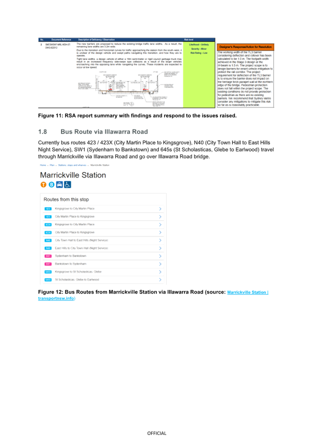
The overbridge will be closed to all vehicles and pedestrians and detours will be in place for the full duration of the closure. Vehicles detoured will be required to use either Wardell Road or Livingstone Road. No bus route will be impacted by the closure.
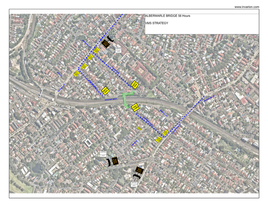
Traffic controllers will be on site and supplied TGSs are reproduced below. A copy of the CTMP is attached at the end of this report. VMS boards will be used.
FINANCIAL IMPLICATIONS
There are no financial implications associated with the implementation of the proposed recommendations outlined in the report.
PUBLIC CONSULTATION
The proposed road closure has been advertised on Council’s website in accordance with the Roads Act 1993.
The applicant is to notify all affected residents and businesses in writing at least 7 days prior to the commencement of works.
CONCLUSION
It is recommended that the proposed temporary full road closure be approved, subject to but not limited to the conditions and recommendations outlined in this report.
ATTACHMENTS
|
1.⇩ |
SMCSWSW7-MRL-WEC-TF-PLN-000960 Albermarle CTMP |
|
Local Traffic Committee Meeting 17 February 2025 |
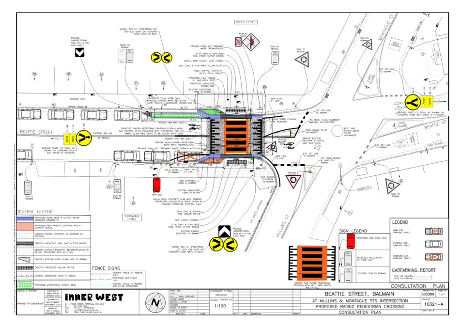
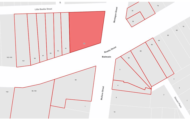
Subject: Beattie Street at Mullens Street, Balmain - Proposed Raised Pedestrian Crossing (Baludarri-Balmain Ward/Balmain Electorate/Leichhardt PAC)
Prepared By: Charbel El Kazzi - Traffic Engineer
Authorised By: Manod Wickramasinghe - Traffic and Transport Planning Manager
|
RECOMMENDATION
That the attached detailed design plan (Design Plan No.10321-A) for the proposed new raised pedestrian crossing on Beattie Street west of Mullens Street, Balmain be approved.
|
STRATEGIC OBJECTIVE
This report supports the following strategic directions contained within Council’s Community Strategic Plan:
|
2: Livable, connected neighborhoods and transport |
|
|
EXECUTIVE SUMMARY
Council is planning to improve safety in Beattie Street, Balmain by constructing a raised pedestrian crossing west of Mullens and Montague Streets to replace two existing kerb ramps. The proposal aims to improve pedestrian and motorist safety by better defining safe pedestrian crossing points and addresses pedestrian safety and driver behavior at this location.
This project is one of the recommendations from the Balmain Local Area Traffic Management (LATM) study adopted by Council on 10 October 2023.
The proposal will require a new ‘No Stopping’ sign to be installed in Beattie Street on the south side of the new raised pedestrian crossing as per attached plan. This will result in the loss of one (1) on street parking space in Beattie Street.
BACKGROUND
The Balmain Local Area Traffic Management (LATM) study adopted by Council on 10 October 2023, recommended the design and construction of a raised pedestrian crossing in Beattie Street, west of Mullens and Montague Streets, Balmain.
The detailed design plan shown in Attachment 1 outlines the proposed works on Beattie Street, Balmain and includes the following:
• Construct a new raised concrete pedestrian crossing to replace the existing kerb ramps (refer to attached plans).
• Construct “gutter bridges” with heel safe grating to provide safe access over existing kerb and gutter to the new raised pedestrian crossing (where required).
• Realign the kerb & gutter as needed to widen the footpath and provide the room needed for the new raised pedestrian crossing.
• Adjust the footpaths as required to match the new kerb alignments on both sides of the street. New pavers and new asphalt footpaths will be provided to match existing footpaths as best as possible (pavers subject to availability).
• Remove the existing speed cushion in Beattie Street.
• Provide new lighting to the new raised pedestrian crossing which complies with the current lighting standards.
• Install a new ‘No Stopping’ (10m from the proposed crossing) sign on the south side of Beattie Street to satisfy sight distance requirements at departure side of the new pedestrian crossing.
• Install associated pavement line marking and signage as required.
The traffic and roadway features of Beattie Street at Mullens Street is tabled below:
|
Street Name |
Lilyfield Road |
|
Kerb to Kerb Width (m) |
9.6m |
|
Carriageway Type |
Two-way, one travel lane each direction. Bicycle logo mixed traffic arrangement. |
|
Classification |
Local Road |
|
Speed Limit |
40km/h |
|
85th Percentile Speed |
35.3km/h |
|
Average Traffic Volume |
3,000 veh/day |
|
Available TfNSW recorded crash history last 5 years (2018-2023) |
2018 – RUM code 30 (Rear End) – Car - Minor injury - Mullens Street at Beattie Street
2021 – RUM code 49 (Parking/u turn) – Bicycle - Minor injury – Roundabout at Mullens and Beattie Street
2023 – RUM code 21 (Right through) - Bicycle - Minor injury – Roundabout at Mullens and Beattie Street |
|
Parking Arrangements |
Parking permitted on both sides |
DISCUSSION
|
Resident Concerns |
Officer Feedback |
|
Large vehicles routinely illegally park out the front of 91 Beattie St outside of Dicks Hotel in within the ‘No Stopping’ zone and legally out the front exchange of Beattie Street obstructing pedestrian visibility.
|
Council has decided to provide an extended landscaped kerb blister island within the ‘No Stopping’ zone of the north side of Beattie Street to prevent illegal parking within this area and has amended the design accordingly.
The small space on the south side of Beattie Street is on the departure side of the pedestrian crossing and thus will not impact on approach site distances to the pedestrian crossing. Raising the pedestrian crossing will also improve site distances for vehicles on both approaches. Additionally, parking within this locale is in high demand and therefore the removal of an additional space is not supported. |
FINANCIAL IMPLICATIONS
The works are expected to cost approximately $90,000 and are to be funded under Council’s Capital Works Program.
|
1.⇩ |
Raised Pedestrian Crossing Beattie St at Mullen St, Balmain Detailed Plan 10321-A |
|
|
Local Traffic Committee Meeting 17 February 2025 |
Subject: Renwick Street & Marion Street, Leichhardt - Proposed Intersection Line Marking Upgrades (Baludarri-Balmain Ward/Balmain Electorate/Leichhardt PAC)
Prepared By: Jackie Ng - Graduate Traffic Engineer
Authorised By: Manod Wickramasinghe - Traffic and Transport Planning Manager
|
RECOMMENDATION
That the proposed intersection line marking upgrades at the Renwick Street and Marion Street, Leichhardt intersection shown in Attachment 1 be approved.
|
STRATEGIC OBJECTIVE
This report supports the following strategic directions contained within Council’s Community Strategic Plan:
|
2: Liveable, connected neighbourhoods and transport |
|
|
EXECUTIVE SUMMARY
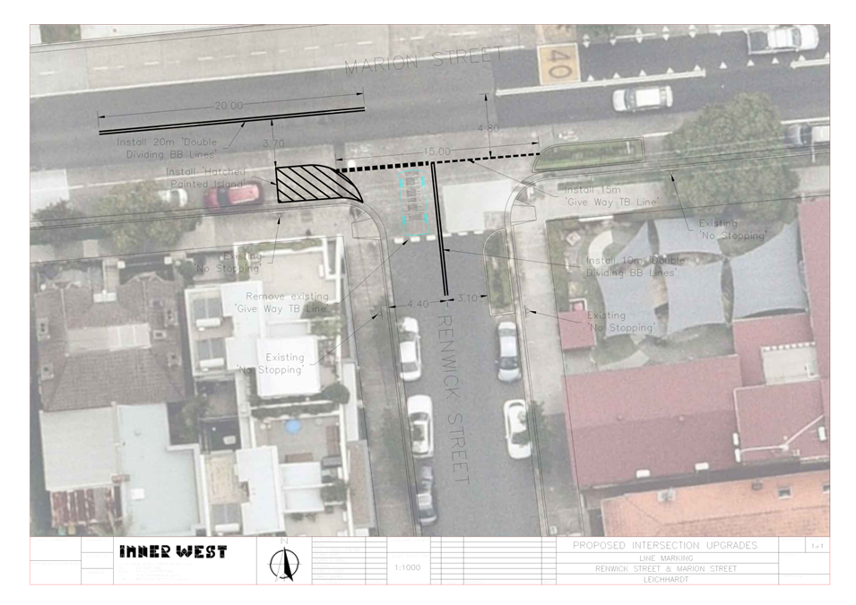
This report outlines safety concerns raised by residents at the intersection of Renwick Street and Marion Street, Leichhardt. A high volume of parents, students and children can be observed by the public using this crossing point due to the proximity of the childcare and public school. A review has been undertaken and proposes to upgrade the existing line marking at the intersection, which improves driver visibility and clarity for pedestrians and vehicle movements at this intersection.
BACKGROUND
Council has received concerns from residents regarding the intersection of Renwick Street and Marion Street, Leichhardt. The site is highly used by all road users as it is within close proximity to the Norton Street shopping village, Leichhardt Public School and Child Care Centre.
The current position of the ‘Give Way’ line marking across Renwick Street requires cars to slow down and give way well before being able to adequately see oncoming traffic on Marion Street. Visibility is further exacerbated due to the high building alignment of the corner property for drivers entering Marion Street. Additionally, with the ‘Give Way’ line is located before the pedestrian kerb ramp, occasional confusion and hesitation was observed between vehicles and pedestrians.
It is proposed that the following line marking treatments are installed at the intersection as shown in Attachment 1:
· Install 20m length double separation (BB) lines on Marion Street on the west and east approach to Renwick Street;
· Install 10m length double separation (BB) lines on Renwick Street;
· Reposition existing give way (TB and TB1) lines, as shown in the attached plan.
· Install painted hatched island on the south side of Marion Street, west of Renwick Street
The proposed works does not impact on any on-street parking spaces.
DISCUSSION
No consultation was conducted as the proposal does not affect any on-street parking spaces.
FINANCIAL IMPLICATIONS
The cost of installation of the proposed line marking can be funded within Council’s signs and line marking budget.
|
1.⇩ |
Renwick Street & Marion Street, Leichhardt - Proposed Intersection Line Marking Upgrade |
|
|
Local Traffic Committee Meeting 17 February 2025 |
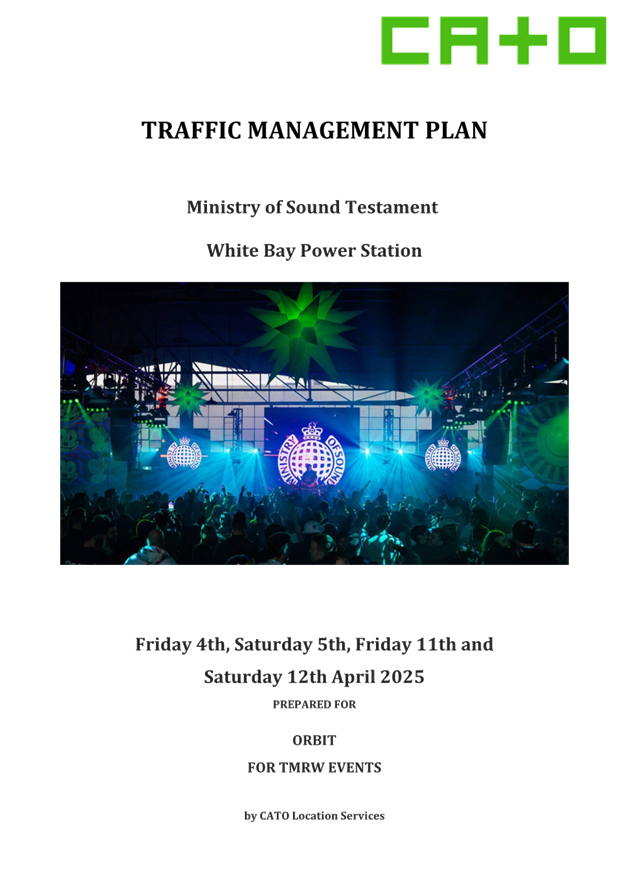
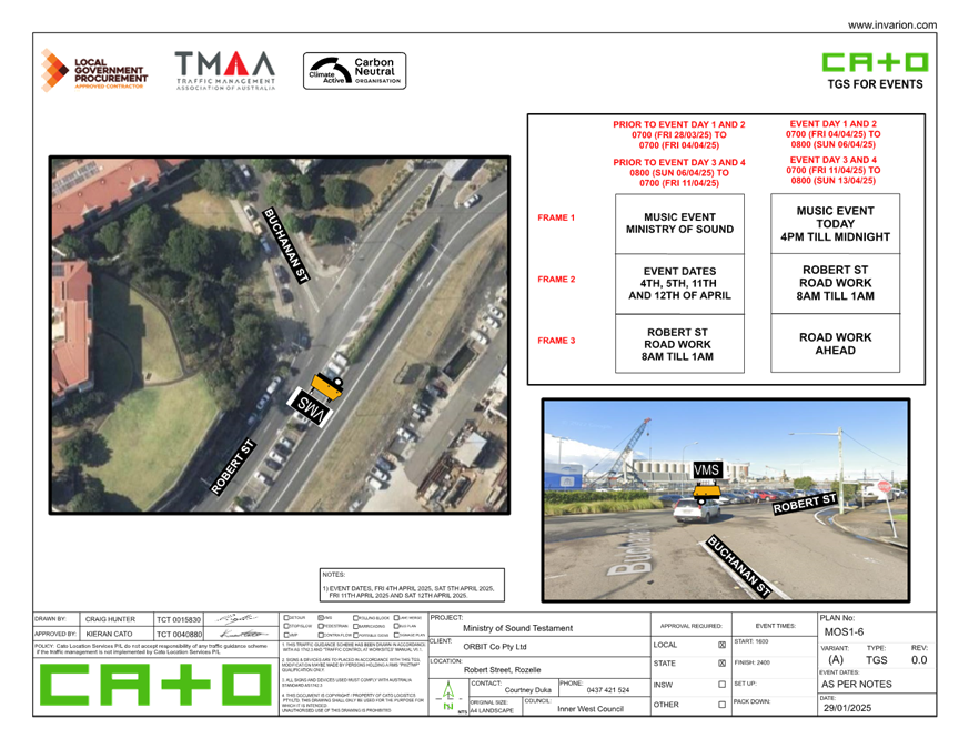
Subject: Robert Street, Rozelle - Minstry of Sound Traffic Management Plan (Baludarri-Balmain Ward/Balmain Electorate/Leichhardt PAC)
Prepared By: Amir Falamarzi - Traffic Engineer
Authorised By: Manod Wickramasinghe - Traffic and Transport Planning Manager
|
RECOMMENDATION
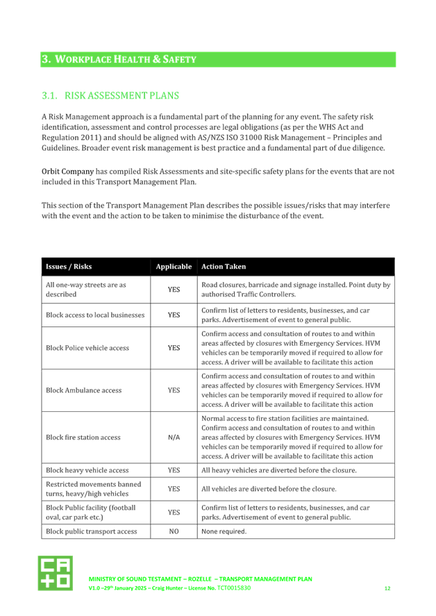
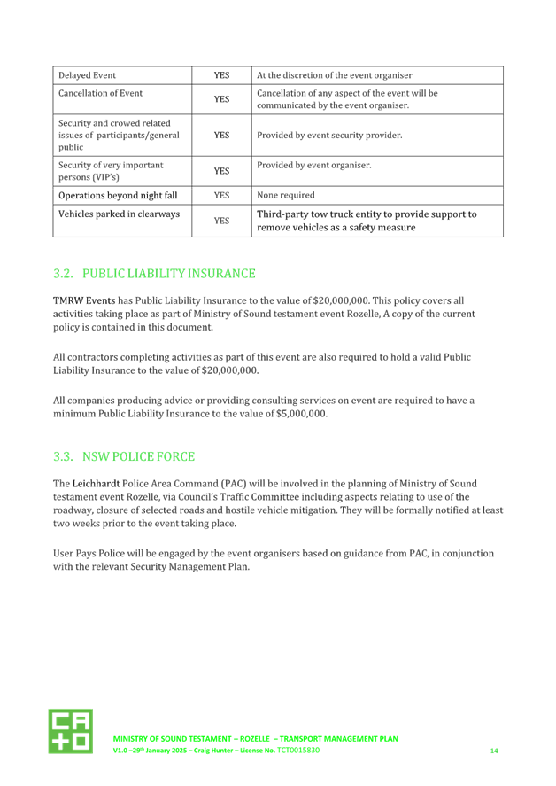
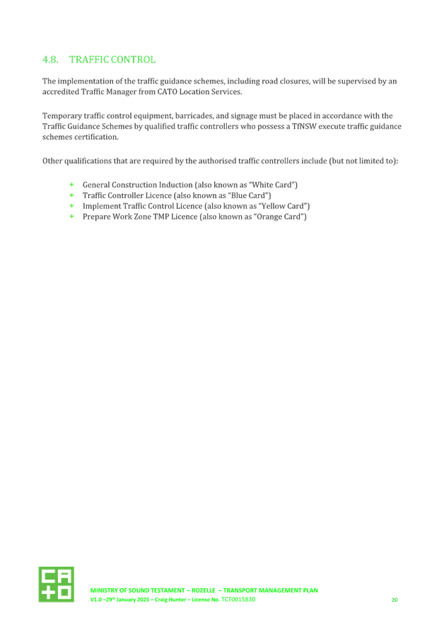
That the Traffic Management Plan (TMP) for Ministry of Sound 2025 at the White Bay Power Station proposed on 4-5 April and 11-12 April 2025 be approved subject to the following conditions: a) the event organisers notify the community including residents and businesses of the proposed event, changes to traffic and parking in the area; b) road closures are only implemented by order of NSW police to ensure public safety during event egress; c) all barricades and necessary signposting shall be provided by the event organisers and maintained during the period of the event by TfNSW-accredited marshals, or Police engaged by the applicant; d) all traffic control facilities are to be installed in accordance with Australian Standard 1742.3; e) the event organiser shall indemnify Inner West Council against all claims for damage or injury that may result from the activity or occupation of part of the public way during the activity. The event organiser must provide documentary evidence of public risk insurance cover of at least $20,000,000 indemnifying Council; and f) the event organiser shall be responsible for the reimbursement for the cost of repair of any damage caused to the public way, or as a result of the activities.
|
STRATEGIC OBJECTIVE
This report supports the following strategic directions contained within Council’s Community Strategic Plan:
|
2: Liveable, connected neighbourhoods and transport |
|
|
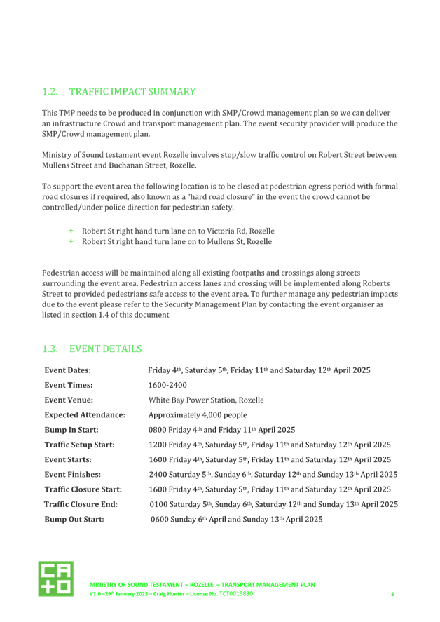
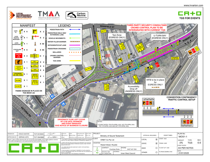
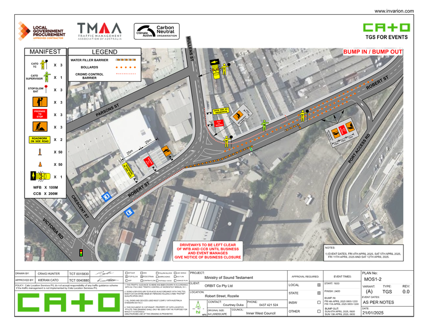
EXECUTIVE SUMMARY
Ministry of Sound 2025 event is scheduled to take place at White Bay Power Station (WBPS) on Roberts Street Rozelle, which will host a music party on four separate dates Fridays and Saturdays 4-5 April, and 11-12 April 2025.
The Traffic Management Plan (TMP) was prepared and aims to provide safe pedestrian access routes to the site through a proposed pedestrian crossing point in Robert Street, pick-up and drop-off zone for private vehicles and taxis along Robert Street and Mullens Street.
BACKGROUND
Orbit for TMRW Events has submitted a TMP application for the 2025 Ministry of Sound at the WPBS which will host a music party on four separate dates including Fridays and Saturdays 4-5 April, and 11-12 April 2025. The Testament event last took place in Sydney at White Bay Power Station in 2024 and will return this year.
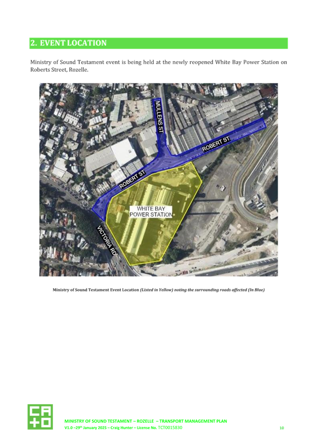
It is expected that approximately 4,000 people will attend the event. During the event dates, traffic setup will start at 12pm, event will start at 4pm and event will finish at 12am. Figure 1 shows the location of the event and affected
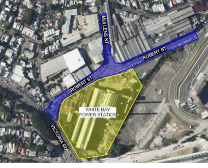
Figure 1: Ministry of Sound Testament Event Location (in Yellow) noting the surrounding roads affected (In Blue)
DISCUSSION
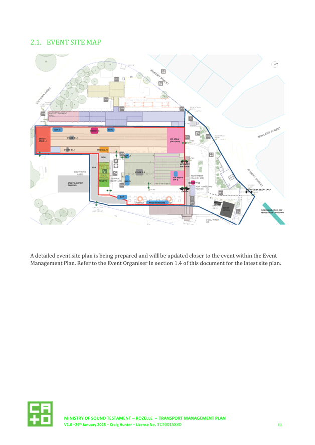
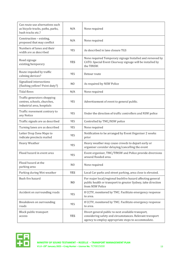
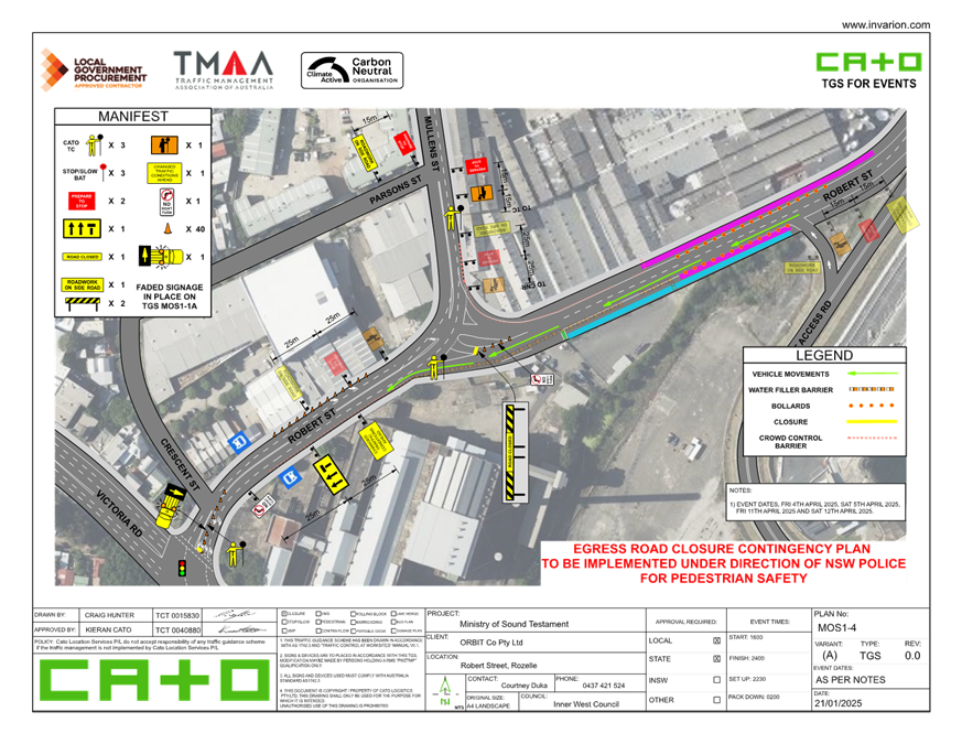
The proposed TMP (Attachment 1) includes two Traffic Guidance Schemes (TGS): one for typical operation and another for the egress road closure contingency plan, which will be implemented under the direction of NSW Police for pedestrian safety. The TMP includes the following features:
Traffic management on Robert Street and Mullens Street
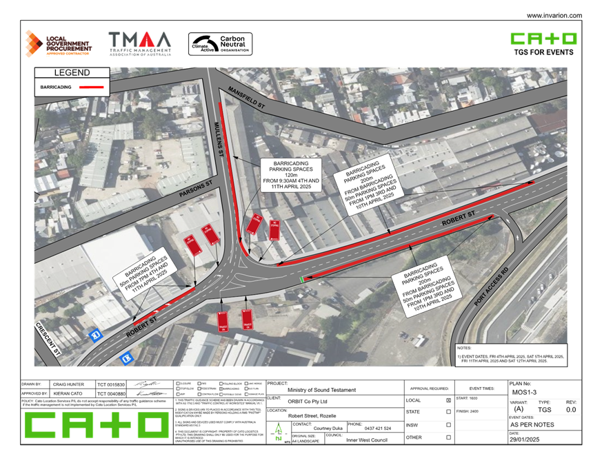
· Waterfilled barriers, bollards and crowd control barriers will be installed along Robert Street and Mullens Street to manage traffic, pick up/ drop off zone and facilitate pedestrian access
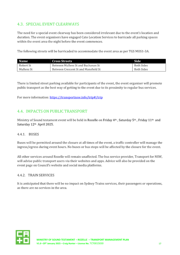
· The event organisers will barricade all parking spaces within the event area the night before the event commences, including Robert Street between Crescent Street and No.58 Robert Street (both sides) and Mullens Street between Robert Street and Mansfield Street (east side) to set up the proposed TGS.
· Pick up/drop of zones will be installed on Robert Street (both sides) 80m east of the intersection of Robert Street and Mullens Street.
· U-turn bay will be installed on Robert Street in front of Port access road ramp during egress time.
· To support the event area, the right-turn lanes from Robert Street onto Victoria Road and from Robert Street onto Mullens Street, Rozelle, will be closed during the pedestrian egress period with formal road closures if required. This will occur under NSW Police direction if the crowd cannot be controlled to ensure pedestrian safety.
· There is limited street parking available for participants of the event. The event organiser will promote public transport as the best way of getting to the event due to its proximity to regular bus services.
· No vehicles will be permitted access to the event site via the Northern Forecourt (existing traffic loop) other than emergency vehicles.
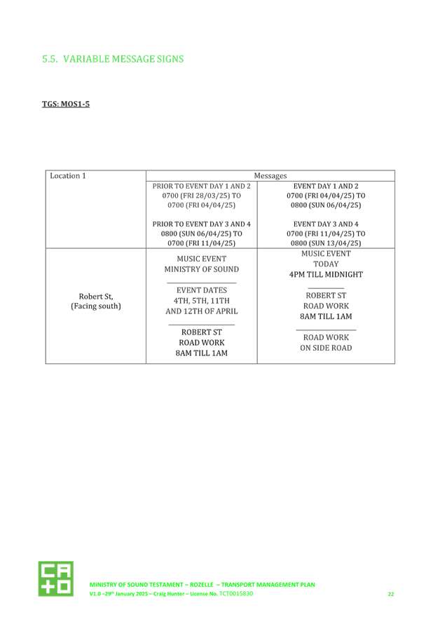
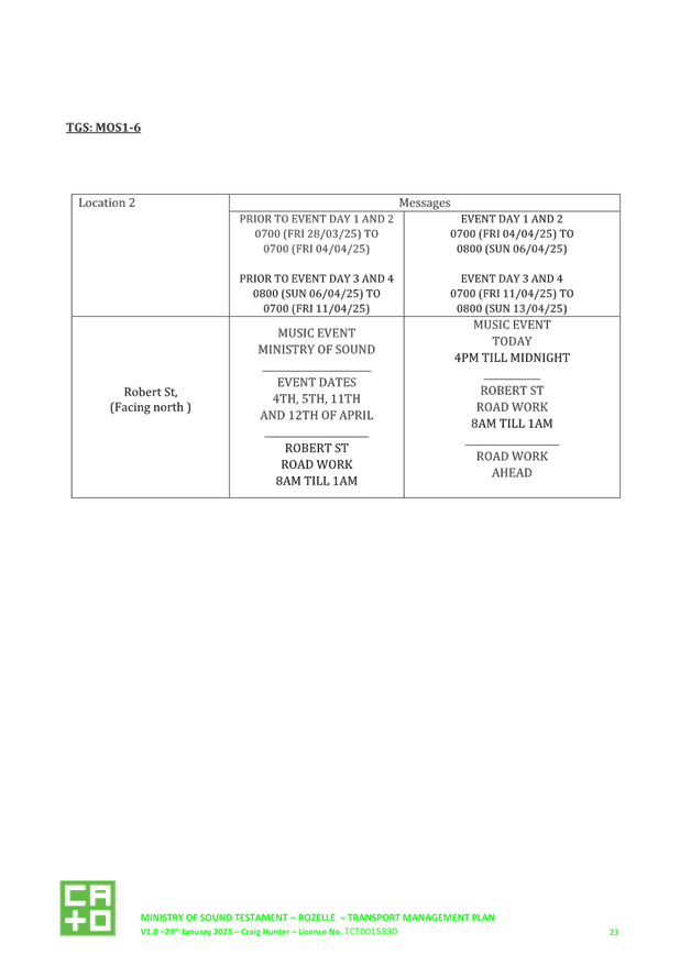
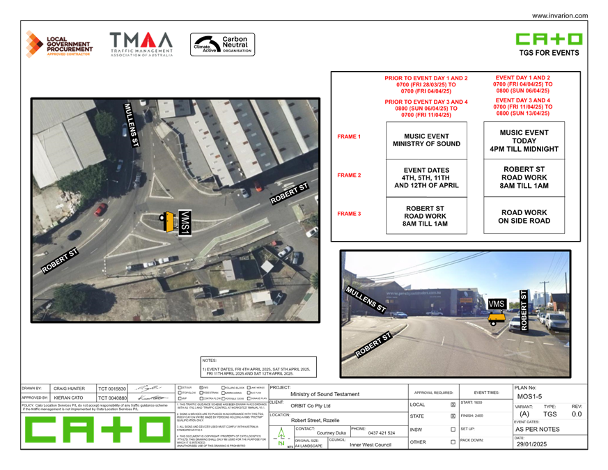
· Two VMS board signs will be installed on Robert Street with one at the intersection of Mullens Street and another one at the intersection of Buchanan Street before and during the events to inform road users of changes in traffic condition.
NSW Police engagement
· The Leichhardt Police Area Command (PAC) will be involved in the planning of Ministry of Sound testament event Rozelle, via Council’s Traffic Committee including aspects relating to use of the roadway, closure of selected roads and hostile vehicle mitigation. They will be formally notified at least two weeks prior to the event taking place.
· User Pays Police will be engaged by the event organisers based on guidance from PAC, in conjunction with the relevant Security Management Plan.
Pedestrian access
· Pedestrian access lanes and crossing will be implemented along and across Roberts Street to provided pedestrians safe access to the event area.
· Traffic controllers will be stationed at the proposed pedestrian crossing to facilitate safe pedestrian movement.
Access for local residents and businesses
· Pedestrian access lanes and crossings will be implemented along and across Robert Street to provide pedestrians with safe access to the event area.
· Traffic controllers will be stationed at the proposed pedestrian crossings to facilitate safe pedestrian movement.
Hostile vehicles mitigation
· The Event Organiser may, in conjunction with the nominated Security Advisor, produce a Hostile Vehicle Mitigation (HVM), and Target Hardening Plan for the event.
Access for emergency vehicles
· A minimum four metre emergency lane will be maintained along the entire closure, beyond the HVM vehicles. There will be no event infrastructure in the emergency lane.
· Traffic controllers will be onsite to assist emergency vehicle through the closure points. While HVM measures will be in place, a driver for all vehicles will always be present in case the vehicle needs to be moved to allow access for emergency vehicles.
Buses
· Buses will be permitted around the closure at all times of the event, a traffic controller will manage the ingress/egress during event hours. No buses or bus stops will be affected by the closure for the event.
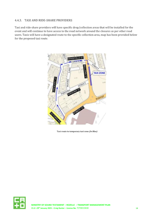
Taxis
· Taxi and ride-share providers will have specific drop/collection areas along Mullens Street that will be installed for the event and will continue to have access to the road network around the closures as per other road users.
Cycle routes
· The closure of Robert Street will not significantly affect designated cycling routes through Rozelle.
· Cyclists will still be able to dismount and walk their bikes around the event site. All existing cycle routes will remain in place and operational around the event site.
Special event clearways
· The need for a special event clearway has been considered irrelevant due to the event's location and duration.
PUBLIC AND EMERGENCY NOTIFICATION
The event organiser will notify all residents and businesses impacted by the event, including confirmation of restricted vehicle movements during event operating times. This will include reviewing any necessary changes to commercial waste collection times and/or locations. A notification letter drop will be arranged by the event organiser two weeks prior to the event.
NSW Fire & Rescue and NSW Ambulance will be notified at least two weeks prior to the event.
FINANCIAL IMPLICATIONS
There are no financial implications associated with the implementation of the proposed recommendations outlined in the report.
|
1.⇩ |
Ministry of Sound 2025 Traffic Management Plan |
|
Local Traffic Committee Meeting 17 February 2025 |
Subject: Lilyfield Road, Lilyfield - Bus Zone Removal (Baludarri-Balmain Ward/Balmain Electorate/Leichhardt PAC)
Prepared By: Amir Falamarzi - Traffic Engineer
Authorised By: Manod Wickramasinghe - Traffic and Transport Planning Manager
|
RECOMMENDATION
That removal of the existing Bus Zones on Lilyfield Road, in front of No.147 and No.158 Lilyfield Road, Lilyfield be approved.
|
STRATEGIC OBJECTIVE
This report supports the following strategic directions contained within Council’s Community Strategic Plan:
|
2: Liveable, connected neighbourhoods and transport |
|
|
EXECUTIVE SUMMARY
Council has been advised that the two Bus Stops in Lilyfield Road between Perry Lane and Rayner Street are now redundant due to revised bus routes in the area. As these stops are no longer operational, it is proposed that the Bus Zones be removed and reinstated as unrestricted parking.
BACKGROUND
Council has been advised that there have been changes in the bus routes in Lilyfield Road and Bus Stops ID 204077 and ID 204084 are no longer operational and will be removed by Transit Systems. The corresponding Bus Zone signs as shown in Figure 1 are proposed to be removed as part of this change.
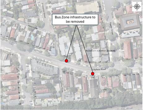
Figure 1: The locations of the Bus Zone infrastructure
DISCUSSION
The removal of the proposed Bus Stops will include removal of associated J-stem signs, tactile paving, concrete slab and street bench (in front of No.147 Lilyfield Road) as illustrated in Figure 2 and 3.
The removal of Bus Zone signs will result in the reinstatement of two (2) unrestricted parking spaces on Lilyfield Road between the existing ‘No Stopping’ zone east of Perry Lane and the driveway of No.147 Lilyfield Road. The removal of the Bus Stop outside No.158 Lilyfield Road will reinstate one (1) parking space.
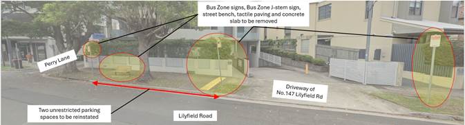
Figure 2: Bus Zone infrastructure removal outside No.147 Lilyfield Road, Lilyfield
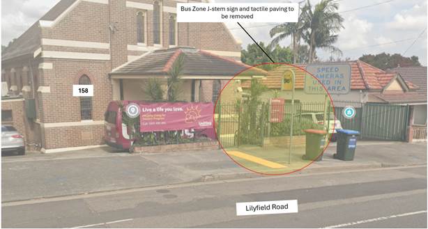
Figure 3: Bus Zone infrastructure removal outside No.158 Lilyfield Road, Lilyfield
FINANCIAL IMPLICATIONS
These minor works can be accommodated under Council’s operational budget.
Nil.
|
|
Local Traffic Committee Meeting 17 February 2025 |
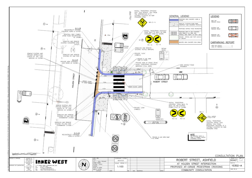
Subject: Robert Street at Holden Street, Ashfield- New at-grade pedestrian (zebra) crossing- amended plan (Djarrawunang-Ashfield Ward/Summer Hill Electorate/Burwood PAC)
Prepared By: Boris Muha - Traffic Engineer
Authorised By: Manod Wickramasinghe - Traffic and Transport Planning Manager
|
RECOMMENDATION
That the detailed amended design plan (10302-A) for a proposed new at-grade pedestrian (zebra) crossing in Robert Street at its intersection with Holden Street, Ashfield, with associated signs and line marking (as shown in Attachment 1) be approved.
|
STRATEGIC OBJECTIVE
This report supports the following strategic directions contained within Council’s Community Strategic Plan:
|
2: Liveable, connected neighbourhoods and transport |
|
|
EXECUTIVE SUMMARY
Council at its meeting on the 18 March 2024 (through its Traffic Committee 11 December 2023) approved in principle a series of proposed pedestrian (zebra) crossings and kerb extension treatments (under concept) with other auxiliary works (relocation of bus stops, inclusion of raised platform thresholds) for improved pedestrian and road safety around and near to the Cardinal Freeman (Retirement) Village, Ashfield.
This report describes and shows the amended detailed design plan of one of the proposed treatments involving the placing of a pedestrian (zebra) crossing in Robert Street, at the intersection of Holden Street, Ashfield. This work is programmed and envisaged to be constructed in the 2025/2026 financial year, subject to funding.
BACKGROUND
The detailed design plan proposal was initially reported to Local Traffic Committee at its meeting on 9 December 2024. The Representative for the Transport for NSW raised concerns regarding the crossing not being entirely at the intersection nor offset from the intersection by a vehicle length (approximately 6 metres). Due to this, vehicles could stop partially over the pedestrian crossing which could reduce motorist sightlines to pedestrians wishing to cross.
The item was deferred to allow for further investigations regarding the proposed location of the crossing and other potential options.
DISCUSSION
Figure 1. Locality Plan
|
Street Name
|
Robert Street at Holden Steet
|
|
Carriageway width (m) kerb to kerb |
Approx. 6.4m. |
|
Carriageway type |
Two-way, one travel lane each direction. |
|
Classification |
Local |
|
Speed Limit km/h |
50 |
|
85th percentile speed km/h |
30 |
|
Vehicles per day (vpd) |
2500 |
|
Last available 5 years of TfNSW recorded crash history
|
NIL in last 5 years in Robert Street at the intersection with Holden Street. |
|
Parking arrangements |
Parking is available in the northern side however there are ‘No Stopping’ restrictions on the southern side. |
|
Side street(nearest or along) |
Holden Street. |
Table 1. Road Network detail.
The Plan
The following works are proposed and are illustrated on the amended plan shown in Attachment 1.
Robert Street, Ashfield (Plan No. 10302):
· Resurface the road pavement with new asphalt and provide new pedestrian crossing markings and associated signage to formalise a new pedestrian crossing;
· Remove old kerb pram ramps and construct new in line kerb ramps on either side of the new pedestrian crossing in Robert Street at its intersection with Holden Street;
· Reconstruct some kerb and gutter with new concrete kerb & gutter (generally where shown on the plans);
· Remove existing pits and pipes and provide new concrete dish drain across the intersection;
· Remove some damaged concrete footpaths and construct new concrete footpaths;
· Undertake some minor returfing works in the grass verge area to match new works; and
· Install new signage associated with the works.
Parking Changes
The works are fully contained within the existing ‘No Stopping’ zones of Robert Street Therefore, the proposal will not result any loss of parking.
Streetlighting
The new pedestrian crossing will require new lighting for it to meet the minimum lighting safety and compliance standards. This may involve either 1 or 2 new flood lights provided on either side each of the new raised pedestrian crossings (on either existing or new power poles). The attached plans indicatively show the locations of the proposed new flood lights and power poles, with the final location to be confirmed during the lighting design development phase of the project by qualified Electrical Consultant.
Other Information
Council would normally raise pedestrian (zebra) crossings for ease of pedestrian access; however, in this case, the existing underground drainage and utilities in the vicinity of the proposed crossing raises the concern of additional excavation works which are deemed to be complex. As such Council has resorted to surface drainage works which features readjustments to the kerb and gutter as well as the installation of a dish drain, and resort to proposing an at-grade crossing in this case.
The proposed crossing links up with other proposed crossings to connect walking path movements to various desired destinations (e.g. Herman Lewis Reserve and Ashfield CBD.)-see Figure 1.
Amended Plan detail
Investigations reveal that the crossing could be set back within Robert Street by 5.5m from the STOP line, which is considered sufficient in length for a general size vehicle (i.e. a car) not to stop over the crossing.
Any further movement of the crossing back into Robert Street will impact on parking and interfere with an existing light pole to the southern side of road. The crossing would be away in sight view of traffic turning left and right from Holden Street if moved further into Robert Street.
The original (consultation) plan is shown below in Figure 2 below to compare to the amended plan in Attachment 1.
The original plan also showed pram ramp re-construction to the crossing. It is proposed under the amended plan to include in line kerb ramps for narrow footpaths permitted under Australian Standards in lieu of the proposed pram ramps which were shown in the original consultation plans. The footpath on either side of the ramp is transitioned down to a lower path level onto the crossing, allowing improved landing and turning in and off the crossing.
The amended plan does not show an approach centre line in Robert Street. This is to avoid the hindering of traffic movement around the parked cars in Robert Street (as shown in the amended plan), and the occasional wide turning of larger vehicles from Holden Street. No centre line exists in Robert Street. The traffic volumes in Robert Street are considered low, nor has there been any recorded accident history to necessitate the need for line marking.
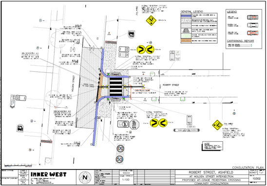
Figure 2-Original consultation plan.
FINANCIAL IMPLICATIONS
CONSULTATION
The relocation of the crossing a short distance into Robert Street is considered only to serve as a minor amendment not bearing any further or real impact upon the community. Therefore no additional consultation was undertaken.
Only one response was received to the original proposal with a resident concerned that a vehicle giving way to pedestrians may obstruct traffic on Holden Street. This concern is addressed by the revised proposal.
|
1.⇩ |
Amended plan-Proposed at-grade crossing in Robert Street at Holden Street, Ashfield. |
|
|
Local Traffic Committee Meeting 17 February 2025 |
Subject: Goodsell Street, St Peters - Request for an extension to times and days of the existing residential parking scheme (Midjuburi - Marrickville Ward / Heffron Electorate / Inner West PAC)
Prepared By: Jennifer Adams - Traffic Engineer
Authorised By: Manod Wickramasinghe - Traffic and Transport Planning Manager
|
RECOMMENDATION 1. That the existing ‘2P 8.30am-6pm Mon-Fri’, Permit Holders Excepted Area M12’ resident parking restrictions on the northern side of Goodsell Street between Council Street and the units at no. 1 Goodsell Street be amended to ‘2P 8am to 10pm, Permit Holders Excepted Area M12’ to provide all week parking opportunities for local residents.
2. That the existing ‘2P 8.30am-6pm Mon-Fri’, Permit Holders Excepted Area M12’ resident parking restrictions on the southern side of Goodsell Street between Council Street and May Lane be amended to ‘2P 8am to 10pm Mon-Fri, Permit Holders Excepted Area M12’ to provide weekday parking opportunities for local residents and to provide opportunities for other users of local facilities as well.
3. That the ‘2P 8.30am-6pm Mon-Fri, Permit Holders Excepted Area M12’ parking adjacent to no. 1 Goodsell Street to be amended to ‘2P 8am-6pm Mon-Fri, Permit Holders Excepted Area M12’. |
STRATEGIC OBJECTIVE
This report supports the following strategic directions contained within Council’s Community Strategic Plan:
|
2: Liveable, connected neighbourhoods and transport |
|
|
EXECUTIVE SUMMARY
A petition has been received from 41 residents of Goodsell Street, St Peters for an extension to times and days of the existing Resident Parking Scheme (RPS) in their street. Concerns were also raised with possible greater demands for parking in the area after current Camdenville Oval Upgrade works are completed.
This report provides the results of the recent resident parking scheme investigation in Goodsell Street, St Peters and recommends the modification of existing resident parking restrictions from ‘2P 8.30am-6pm Mon-Fri, Permit Holders Excepted Area M12’ to a combination of ‘2P 8am-10pm, Permit Holders Excepted Area M12’, ‘2P 8am to 10pm Mon-Fri, Permit Holders Excepted Area M12’and ‘2P 8am-6pm Mon-Fri, Permit Holders Excepted Area M12’.
BACKGROUND
A petition signed by 41 local residents in Goodsell Street has been received for the provision of an extension to times and days of the existing Resident Parking Scheme in their street.
The existing M12 permit parking area in Goodsell Street, St Peters was implemented in 2008 after a petition was received by a number of residents at that time. The head petitioner at the time advised that on street parking spaces is Goodsell Street were heavily utilised by train commuters and the parking situation became more difficult for residents due to the new block of residential units at No.1 Goodsell Street. Subsequently Council adopted the recommendation that ‘2P - 8.30AM-6.00PM Mon-Fri - Permit Holders Excepted - Area M12’ parking restrictions be installed on both sides of Goodsell Street, between Council Street and May Lane, St Peters; Residents of the new development at 1 Goodsell Street were not eligible to participate in the scheme. The RPS was installed in July 2008.
Following the receipt of the current petition, Council Officers have recently carried out a parking utilisation survey in Goodsell Street on a typical Saturday and the results indicated high utilisation of on-street parking, so in late November 2024 a Resident Parking survey was undertaken of all residential properties in Goodsell Street, St Peters between Council Street and May Lane and also of residents in adjoining Council Street (10 Properties). This report details the results of the recent parking utilisation survey and Resident Parking survey.
DISCUSSION
Goodsell Street is a local residential street that runs east-west between Council Street and King Street (Princes Highway) and is in close proximity to St Peters Railway Station. It is 12.8 metres wide with one travel lane in each direction. Both parallel and angle parking is permitted on both sides of the street. At present, resident parking restrictions are in place for the parallel and angle parking on both sides of the street between Council Street and May Lane.
Parking Utilisation Survey:
A parking utilisation survey was undertaken in Goodsell Street, St Peters on a typical Saturday early November 2024 (between 7.00am and 7.00pm) to gauge current on-street parking utilisation. The results of the survey are summarised in the following table:
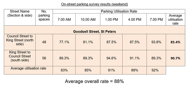
The results of the weekend parking survey for Goodsell Street showed that the street had an average overall occupancy of 88% which exceeds Council’s 85% threshold for parking occupancy for consideration for implementation or extension of a residential parking scheme.
Subsequently, a Resident Parking questionnaire survey was undertaken in Goodsell Street to gauge resident’s support of an extension of time and days of the existing residential parking scheme.
Council proposed to expand the existing M12 RPS with the following proposal:
· Implement ‘2P 8.30AM - 10PM Monday to Sunday, Permit Holders Excepted, Area M12’ on both sides of Goodsell Street between Council Street and May Lane, St Peters.
Council Policy/Guidelines
Council's adopted Policy for the introduction or extension of a Permit Parking Area states "that before implementing a resident parking scheme in any area, a survey of residents be undertaken to ascertain the level of support for such a scheme and that such support should be in excess of 65% of submissions received provided that rate of return of submissions is reasonable (higher than 30%)".
“In completing this analysis Council may differentiate responses from those developments excluded from participation in a Resident Parking Scheme (Table 7.1).” (non-eligible properties).
PUBLIC CONSULTATION
A total of 132 consultation letters were hand delivered to owners/occupiers of both eligible and non-eligible properties in Goodsell Street between May Lane and Council Street and also to Council Street residents, St Peters on 29 November 2024. Submissions closed on Friday 20 December 2024.
Distribution of letters are highlighted in the diagram below. Yellow being eligible properties and blue non-eligible.
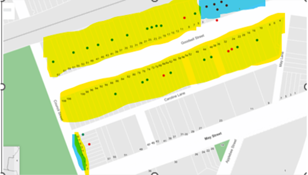
At the end of the survey period thirty-one (31) responses were received. Twenty (20) were in support of the proposal and eleven (11) opposed the proposal. The overall response rate was 24%, and of that 35.5% opposed the proposal and 64.5% supported it.
Number of properties responded - 31
Number of properties supported - 20
Response Rate - 24%
Support Rate - 64.5%
There are 80 eligible properties in Goodsell Street, St Peters. Even through letters detailing the proposal were delivered to the multi-unit development at 1 Goodsell Street and to 10 residencies in Council Street, in general Council places a higher emphasis on responses from the residents of the single unit dwellings (in Goodsell Street) when making a determination when dealing with resident parking schemes.
The return and support rates of eligible Goodsell Street (eligible) properties are given below.
Number of eligible properties - 80
Number of eligible properties responded - 23
Number of eligible properties supported - 19
Eligible Response Rate - 29%
Eligible Support Rate - 83%
Council guidelines state that there should be a response rate of 30% of households that were surveyed, with 65% of respondents supporting the proposal. In this case, the return rate and support rate of eligible Goodsell Street residents confirm support for an extension to times and days of the existing Resident Parking Scheme (RPS) in the street.
Note: In order to best gauge the level of support of directly affected residents, the response-rate analysis in this case was conducted on the basis of considering only single unit dwellings in Goodsell Street.
The return and support rates of residents surveyed in Council Street are given below.
Number of properties - 10
Number of properties responded - 2
Number of properties supported - 1
Response Rate - 20%
Support Rate - 10% (50% of respondents)
The return and support rates of non-eligible residents surveyed at 1 Goodsell Street are given below.
Number of properties - 42
Number of properties responded - 6
Number of properties supported - 0
Response Rate - 14%
Support Rate - 0%
Of the 11 objections it is noted that 6 were received from 1 Goodsell Street residents (non-eligible) and 4 from single dwelling units in Goodsell Street (eligible) and one from a resident in Council Street.
Key concerns / issues raised from the responses of eligible residents in Goodsell Street supporting the proposal have been summarised below:
· As residents, we face significant challenges finding parking during match days and weekends, which makes it incredibly difficult to manage daily routines, especially when returning home from work.
· 2-hour parking restrictions won’t help the lack of parking when football is played in Camdenville Oval. There is a general lack of parking spaces, and it can be extremely difficult to find a parking spot when there are games being played.
· With the current upgrade of Camdenville Oval and its increased usage, the parking situation will no doubt only get worse for residential parking.
· The new Camdenville Oval improvements will worsen the already problematic parking situation on Goodsell Street.
· Request the Council to consider adding dedicated parking spaces for the soccer ground.
· new businesses taking up much of the street parking with their own vehicles or customers' vehicles.
· include the 7 parking spots in Council Street with the new restrictions and the parking spots next to the toilet block at Camdenville oval.
· 3 support marking out of parking to maximise parking spaces through clear parking bays
Key concerns / issues raised by objectors to the proposal (both eligible and non-eligible residents) include the following:
· The proposed changes to the existing RPS are overly restrictive and deny visitors parking flexibility, particularly on the weekends.
· The proposed changes would have detrimental effects on our community and family, friends and partners who want to come and visit us.
· it would be difficult for our guests to visit on the weekends for over 2 hours without the risk of a fine. This area is a residential area and there should be no restrictions to parking times over the weekend as this would hinder our social activities should we choose to have guests over.
· I do not support the proposal in its current form. My view is the proposed expansion of the RPS hours/days needs to be based on evidence. Collect evidence/observations to understand if there is greater demand for parking during the night after 6pm. I am not convinced that there will be a greater demand for parking after 6pm i.e. Camdenville Oval is predominantly used during daytime hours.
· parking around amateur sporting events needs some more patrolling/ attention as this can cause issues of illegal and double parking on the street. Also, illegal parking around Caroline lane of trade vehicles needs attention and is often a more frustrating issue.
· The reason that the parking gets full on some weekdays with people parking and using the station is because overstaying the 2-hour max is seldom monitored by rangers.
As a result of the feedback received, especially concerns with regards to availability of parking on the weekends an adjustment to the final proposal has been made. This looks to address issues of lack of parking as a result of lack of parking in the evenings whilst attempting to find a balance between resident needs and visitors on the weekend. The 2P parking restriction have therefore been extended into the weeknights as well as the weekend for the northern side which will discourage long term parking during weekend periods as well as weekday periods whilst on the southern side the restrictions have been extended into the evening to discourage long term parking during the evenings. There is a small section of 2P parking adjacent to the unit block adjacent to no. 1 Goodsell Street which will remain essentially unchanged.
Concern is valid also that restrictions in Council Street may need to be amended in the near future due to vehicles parking out the available parking on weekends. It is noted that when the original RPS went into Goodsell Street in July 2008 not long after a petition was received from residents in Council Street, St Peters stating that the parking situation had become more difficult for residents in their street following the recent introduction of the RPS in Goodsell Street. Subsequently, RPS – M12 restrictions were installed on the east side of Council Street between May Street and Goodsell Street, St Peters in July 2009.
Resident Parking Schemes are intended to give priority parking to those who may be
disadvantaged by others taking the limited parking spaces available. Eligible residents may obtain a maximum of 2 permits per dwelling house provided they have no off-street parking. This is reduced by one permit for each off-street parking space.
CONCLUSION
Council guidelines state that there should be a response rate of 30% of households that were surveyed, with 65% of respondents supporting the proposal. In this case, the return rate and support rate (29% and 83% respectively) of eligible Goodsell Street residents confirm support for an extension to times and days of the existing Resident Parking Scheme (RPS) in the street.
It is recommended to change existing ‘2P 8.30am-6pm Mon-Fri, Permit Holders Excepted Area M12’ resident parking restrictions on the northern side of Goodsell Street between Council Street and the units at no. 1 Goodsell Street to 2P 8am to 10pm and to change the existing ‘2P 8.30am-6pm Mon-Fri, Permit Holders Excepted Area M12’ resident parking restrictions on the southern side of Goodsell Street between Council Street and May Lane to ‘2P 8am to 10pm Mon-Fri, Permit Holders Excepted Area M12’ in order to provide residents with greater opportunities to find parking and also to balance the needs of residents with other users and visitors.
To ensure a consistent start time for Resident Parking restrictions, it is further recommended that the ‘2P 8.30am-6pm Mon-Fri, Permit Holders Excepted Area M12’ parking adjacent to no. 1 Goodsell Street to be amended to ‘2P 8am-6pm Mon-Fri, Permit Holders Excepted Area M12’.
Nil.
|
|
Local Traffic Committee Meeting 17 February 2025 |
Subject: Leichhardt Oval Special Event Parking Scheme 2025 (Baludarri-Balmain Ward/Balmain Electorate/Leichhardt PAC)
Prepared By: Jason Scoufis - Coordinator Traffic Investigations and Road Safety
Authorised By: Manod Wickramasinghe - Traffic and Transport Planning Manager
|
RECOMMENDATION
That the Special Event Parking Scheme (SE) in the roads surrounding Leichhardt Oval be activated for the following three days during the times of 12:00 pm – 8:00pm for NRL Fixtures in 2025: a) Sunday 27 April 2025; b) Sunday 20 July 2025; and c) Sunday 24 August 2025.
|
STRATEGIC OBJECTIVE
This report supports the following strategic directions contained within Council’s Community Strategic Plan:
|
2: Liveable, connected neighbourhoods and transport |
|
|
EXECUTIVE SUMMARY
The existing signs on streets surrounding Leichhardt Oval that read ‘1P during sporting fixtures at Leichhardt Oval, Authorised Residents Vehicles Excepted Area LY’, are being replaced with ‘1P Special Events Permit Holders Excepted Area SE’ restrictions, in order to update the signs to the latest TfNSW requirements.
BACKGROUND
At the Local Traffic Committee held in May 2024, a report was considered relating to the Leichhardt Oval TMP and Special Event Parking Zone and it in part recommended the following which was subsequently endorsed by Council:
That existing ‘1P during sporting fixtures at Leichhardt Oval, Authorised Residents Vehicles Excepted Area LY’, on streets surrounding Leichhardt Oval be replaced with ‘1P Special Events Permit Holders Excepted Area SE’, including Special Event Parking – Major Entry, Special Event Parking – Repeater, and Special Event Parking – End signage be installed as shown in Attachment 2.
The days and times that the Special Event Parking Scheme will be active in 2025 are detailed below which comprises of three NRL Fixtures at Leichhardt Oval in 2025:
|
NRL Game |
Date |
NRL Kick Off |
Special Event Parking Scheme Hours |
|
Round 8 - Wests Tigers vs Cronulla sharks |
Sunday 27th April 2025 |
4:00pm |
12:00pm-8:00pm |
|
Round 20 – Wests Tigers vs Gold Coast Titans |
Sunday 20th July 2025 |
2:00pm |
12:00pm-8:00pm |
|
Round 25 – Wests Tigers vs North Queensland Cowboys |
Sunday 24th August 2025 |
4:00pm |
12:00pm-8:00pm |
Only during these times detailed above, the one hour parking restriction will be enforceable. At all other times throughout the year the one hour parking restrictions will not be applicable.
CONSULTATION
Residents entitled to parking permits will be notified via letter prior to the scheme being active.
FINANCIAL IMPLICATIONS
The cost of installation of the proposed signposting can be funded within Council’s signs and line marking budget.
Nil.
|
|
Local Traffic Committee Meeting 17 February 2025 |
Subject: Proposed Parking Restriction Operational Hours Extension - Rozelle South Precinct (Baludarri-Balmain Ward/ Balmain Electorate/ Leichhardt PAC)
Prepared By: Felicia Lau - Traffic Engineer
Authorised By: Manod Wickramasinghe - Traffic and Transport Planning Manager
|
RECOMMENDATION
That the existing parking restriction in the Rozelle South precinct currently signposted as ‘2P 8am-8pm Area R1 Permit Holder Excepted’, ‘2P 8am-6pm Mon-Fri Area R1 Permit Holder Excepted’ and ‘2P 8am-10pm Mon-Fri Area R1 Permit Holder Excepted’ be changed to ‘2P 8am-10pm Area R1 Permit Holder Excepted’ on the following streets: · Evans Street between Denison Street and Victoria Road · Catherine Street · Keniff Street · Elizabeth Street · Prince Street · Gordon Street between Lilyfield Road and Victoria Road · Maney Street · Graham Street · Quirk Street · Hornsey Street · Burt Street between No.30 and Gordon Street · Lilyfield Road between No.65 and Victoria Road
|
STRATEGIC OBJECTIVE
This report supports the following strategic directions contained within Council’s Community Strategic Plan:
|
2: Liveable, connected neighbourhoods and transport |
|
|
EXECUTIVE SUMMARY
This report outlines the results of the Community Engagement undertaken regarding changes to the existing resident parking scheme operational hours in Rozelle South precinct as shown in Figure 1 below.
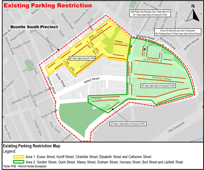
Figure 1: Existing Parking Restriction
BACKGROUND
Residents within the Rozelle South precinct have raised concerns regarding difficulty finding on-street parking due to after-hours and long-term visitors occupying on-street parking spaces. The popularity of restaurants, performance venues, and a new school has brought visitors to the area and contributing to the parking pressure in this precinct.
The Rozelle South precinct is bounded by Lilyfield Road, Denison Street, Evans Street, and Victoria Road.
Council has reviewed the existing Resident Parking Scheme (RPS) operational hours and has proposed to unify the operational hours for Rozelle South precinct R1 Area parking restriction. This will normalise the parking restrictions in the area, particularly during night where visitors to certain venues may exceed well beyond 6pm on both weekdays and weekends.
Community Engagement was undertaken proposing changes to the existing RPS hours extended to 10pm everyday, as shown in Figure 2 below.
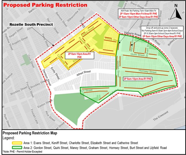
Figure 2: Proposed Parking Restriction
DISCUSSION
Between November and December 2024, Council undertook Community Engagement inviting residents to provide feedback regarding a proposal to normalise the RPS operational hours to 10pm everyday.
The results at the conclusion of the Community Engagement received a support rate of 67% for the proposal in the Rozelle South precinct. Accordingly, it is recommended that the proposal (shown in Figure 2) for changes to the RPS operational hours to ‘2P 8pm-10pm Permit Holder Excepted’. All other specific parking zones, such as Mobility Parking, ‘No Parking’, and ‘No Stopping’ restrictions will be retained.
A summary of comments including Council response on each issue is tabled below.
|
Resident/Stakeholder Comments |
Officer’s Response |
|
This will further restrict residents with multiple vehicles to park in the street |
The proposed changes are intended to establish a balance for the community to meet the parking needs of both residents and visitors to the area. |
|
Enforcement is required to ensure that measures are effective |
Council parking enforcement team will schedule enforcement to all areas with parking restrictions. |
|
Extended hours would assist. Preferably convert the 2 hour parking limit to 1 hour |
A 2 hour parking limit provides a better balance to residential areas for visitors. Council do not intend to exclude visitors from parking in the precinct as 1 hour stay would not be practical for visitors to some local businesses. Hence a 1P is not supported at this stage. |
|
Why does the changes not apply to Red Lion Street? |
The current proposal is to extend the RPS operational hours to 10pm, and Red Lion Street parking restriction already ends at 10pm. |
|
Prefer the parking restriction to end at 11pm to restrict visitors to the businesses at least till 9pm before restriction ends. |
Existing RPS within the LGA’s urbanised areas generally ends at 10pm to ensure consistency with other areas it is proposed that the RPS ends at 10pm. |
|
Parking problem will improve |
Noted and Council will monitor the parking conditions after the changes are implemented. |
|
Maney Street is used as a rat run, it should be closed off at Victoria Road |
This is not part of the proposal presented at this time. Council officers will investigate this separately and will provide a response when completed. |
FINANCIAL IMPLICATIONS
There are no financial implications associated with the implementation of the proposed recommendations outlined in the report.
Nil.
|
|
Local Traffic Committee Meeting 17 February 2025 |
Subject: Brighton Street, Petersham - Heavy Vehicle Access (Damun - Stanmore Ward/ Newtown Electorate/ Inner West PAC)
Prepared By: Zara Helal - Traffic Engineer
Authorised By: Manod Wickramasinghe - Traffic and Transport Planning Manager
|
RECOMMENDATION
That the report be received and noted. |
STRATEGIC OBJECTIVE
This report supports the following strategic directions contained within Council’s Community Strategic Plan:
|
2: Liveable, connected neighbourhoods and transport |
|
|
EXECUTIVE SUMMARY
Council at its meeting held on 3 September 2024 considered a Notice of Motion regarding Pedestrian Safety on Brighton Steet, Petersham and resolved to write to Transport for NSW seeking advice on how existing heavy vehicle restrictions on Brighton Street can be better enforced and what other measures Council can take to deter heavy vehicle through access. This report summaries advice from Transport for NSW, Council’s Regulatory Services team and provides an update on capital works.
BACKGROUND
Council at its meeting held on 3 September 2024 considered a Notice of Motion regarding Pedestrian Safety on Brighton Steet, Petersham, and resolved in part:
That Council write to Transport for NSW seeking advice on how existing heavy vehicle restrictions on Brighton Street can be better enforced and what other measures Council can take to deter heavy vehicle through access.
That as part of the Petersham North LATM Plan endorsed by the Traffic Committee, Council investigate and expedite measures to prevent speeding and improve pedestrian safety on Brighton Street, including but not limited to:
a) reducing the speed limit to 40km/h;
b) installation of raised pedestrian crossings on Brighton Street at the Petersham Park gate, Palace Street and Railway Street intersections;
c) installation of a pedestrian island; and
d) installation of additional speed humps and kerb blisters.
That Council receive a report back on the above to the Traffic Committee.
DISCUSSION
Transport for NSW has responded, as detailed below to the Notice of Motion regarding heavy vehicles in Brighton Street and have provided information on how existing heavy vehicle restrictions on Brighton Street can be better enforced and what other measures Council can take to deter heavy vehicle through access:
NSW heavy vehicle compliance is managed by the National Heavy Vehicle Regulator (NHVR). Local council officers can become authorised to carry out local road heavy vehicle enforcement of Road Rules, to regulate mass (weight) and length of heavy vehicles on signposted local roads, by engaging directly with Transport for NSW.
Council’s Senior Manager Regulatory Services has advised that Council, like many other Councils did not opt in for the enforcement of heavy vehicles on local roads as minimum qualification requirements, specialised training and additional equipment is required to be authorised and undertake this type of enforcement. Officers would be authorised to undertake traffic stops by pulling vehicles over, directing vehicles not to move, requiring drivers to produce their licences among other things. Our local roads are not suitable for effecting traffic stops in this manner. In addition, NSW Police can already enforce this on local roads and can stop vehicles anywhere.
Despite the above, Regulatory Services has contacted Transport for NSW and is making further enquiries regarding any other available options that would assist Council in enforcing mass restrictions.
As part of the Petersham North LATM, Council had received concerns by residents regarding speeding vehicles on Brighton Street, Petersham, particularly those travelling from West Street. These concerns are exacerbated given the proximity of Brighton Street to a preschool and Petersham Park, and the frequency of heavy vehicles accessing Brighton Street as a rat run despite existing heavy vehicle restrictions. These concerns were considered as part of the Petersham North Local Area Traffic Management (LATM) plan endorsed by the Traffic Committee in June 2024.
Regarding the resolution relating to the LATM plan, the following is advised:
a) Reducing the speed limit to 40km/h; - The conversion of the Stanmore – Petersham area to 40 km/h is Priority B. This is anticipated to be implemented in the next few years as part of the InnerWest@40 project rollout which reduces speed limits on all out the speed limit reduction throughout the LGA.
b) Installation of raised pedestrian crossings at:
· Brighton Street (eastern leg) at Brighton Street/Railway Street intersection
· Brighton Street (eastern leg) of Brighton Street/Palace Street intersection
· Brighton Street (western leg) of Brighton Street/Palace Street intersection
· Brighton Street between Wentworth Street and The Avenue - raised threshold to be upgraded to a raised pedestrian (zebra) crossing
· Palace Street (southern leg) of Brighton Street/Palace Street intersection
· Railway Street (southern leg) at Brighton Street/Railway Street intersection.
c) Installation of a continuous footpath treatment to cross The Avenue at Brighton Street
d) Installation of a speed hump in Brighton Street between Crystal Lane West and Crystal Street.
Council staff will be preparing detailed design plans for these pedestrian crossings, continuous footpath treatments and speed humps with construction commencing from FY25/26 onwards with priority being placed on the raised pedestrian crossings on Brighton Street between Wentworth Street and The Avenue, Brighton Street at Palace Street (western leg) and Brighton Street at Railway Street intersections. A separate grant application has also been made under the ‘Active Transport Fund’ in relation to works identified in the Petersham North LATM.
Furthermore, in order to provide additional warning for trucks, it is also recommended that larger signs be installed to replace the existing ‘No Trucks Vehicles over 3t GVM’ signs at both ends of Brighton Street and additional similar signs with supplementary arrows to provide advice to truck drivers on approach to the intersection.