|
AGENDA R |

Local Traffic Committee Meeting
MONDAY 14 APRIL 2025
11:00 AM
|
|
Local Traffic Committee Meeting 14 April 2025 |
Function of the Local Traffic Committee
Background
Roads and Maritime Services (RMS) is legislated as the Authority responsible for the control of traffic on all NSW Roads. The RMS has delegated certain aspects of the control of traffic on local roads to councils. To exercise this delegation, councils must establish a local traffic committee and obtain the advice of the RMS and Police. The Inner West Council Local Traffic Committee has been constituted by Council as a result of the delegation granted by the RMS pursuant to Section 50 of the Transport Administration Act 1988.
Role of the Committee
The Local Traffic Committee is primarily a technical review and advisory committee which considers the technical merits of proposals and ensures that current technical guidelines are considered. It provides recommendations to Council on traffic and parking control matters and on the provision of traffic control facilities and prescribed traffic control devices for which Council has delegated authority. These matters are dealt with under Part A of the agenda and require Council to consider exercising its delegation.
In addition to its formal role as the Local Traffic Committee, the Committee may also be requested to provide informal traffic engineering advice on traffic matters not requiring Council to exercise its delegated function at that point in time, for example, advice to Council’s Development Assessment Section on traffic generating developments. These matters are dealt with under Part C of the agenda and are for information or advice only and do not require Council to exercise its delegation.
Committee Delegations
The Local Traffic Committee has no decision-making powers. The Council must refer all traffic related matters to the Local Traffic Committee prior to exercising its delegated functions. Matters related to State Roads or functions that have not been delegated to Council must be referred directly to the RMS or relevant organisation.
The Committee provides recommendations to Council. Should Council wish to act contrary to the advice of the Committee or if that advice is not supported unanimously by the Committee members, then the Police or RMS have an opportunity to appeal to the Regional Traffic Committee.
Committee Membership & Voting
Formal voting membership comprises the following:
· one representative of Council as nominated by Council;
· one representative of the NSW Police from each Local Area Command (LAC) within the LGA, being Newtown, Marrickville, Leichhardt and Ashfield LAC’s.
· one representative from the RMS; and
· State Members of Parliament (MP) for the electorates of Summer Hill, Newtown, Heffron, Canterbury, Strathfield and Balmain or their nominees.
Where the Council area is represented by more than one MP or covered by more than one Police LAC, representatives are only permitted to vote on matters which effect their electorate or LAC.
Informal (non-voting) advisors from within Council or external authorities may also attend Committee meetings to provide expert advice.
Committee Chair
Council’s representative will chair the meetings.
Public Participation
Members of the public or other stakeholders may address the Committee on agenda items to be considered by the Committee. The format and number of presentations is at the discretion of the Chairperson and is generally limited to 3 minutes per speaker. Committee debate on agenda items is not open to the public.
|
|
Local Traffic Committee Meeting 14 April 2025 |
|
AGENDA |
1 Apologies
2 Disclosures of Interest
3 Confirmation of Minutes Page
Minutes of 17 March 2025 Local Traffic Committee 5
4 Matters Arising from Council’s Resolution of Minutes
5 Part A – Items Where Council May Exercise Its Delegated Functions
ITEM Page
LTC0425(1) Item 1 Inner West LGA - Proposal for GoGet car share parking spaces (All wards, all electorates, all PACs) 20
LTC0425(1) Item 2 Cobar Street at Old Canterbury Road, Dulwich Hill – Proposed Kerb Extensions and Kerb Ramps - Design Plan 10334A (Djarrawunang-Ashfield Ward / Summer Hill Electorate / Inner West PAC) 44
LTC0425(1) Item 3 Gower Street, Summer Hill - Proposed Kerb Extensions(Djarrawunang-Ashfield Ward/Summer Hill Electorate/Burwood PAC.) 48
LTC0425(1) Item 4 Mary Street, Lilyfield - Proposed Raised Pedestrian Crossing (Baludarri-Balmain Ward/Balmain Electorate/Leichhardt PAC 60
LTC0425(1) Item 5 Final Draft Annandale LATM Study(Baludarri-Balmain Ward/Balmain Electorate/Leichhardt PAC) 64
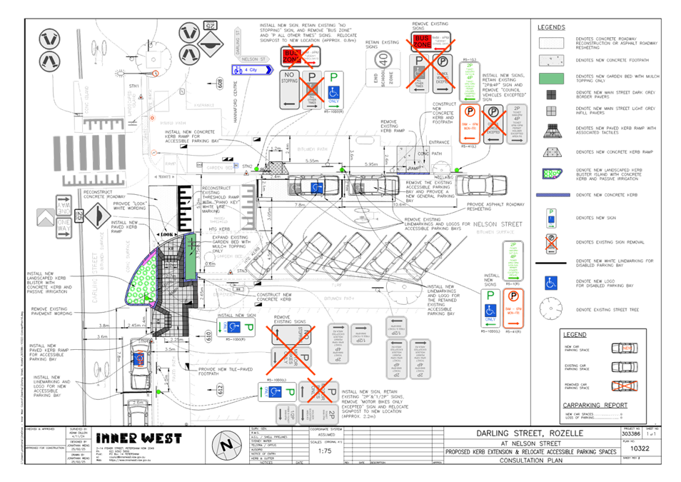
LTC0425(1) Item 6 Darling Street at Nelson Street, Rozelle- Proposed Kerb Extensions & Relocation of Mobility Parking (Baludarri-Balmain Ward/Balmain Electorate/Leichhardt PAC) 156
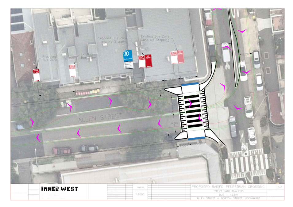
LTC0425(1) Item 7 Allen Street, Leichhardt - Proposed Raised Pedestrian Crossing (Gulgadya-Leichhardt Ward/Summer Hill Electorate/Burwood PAC) 160
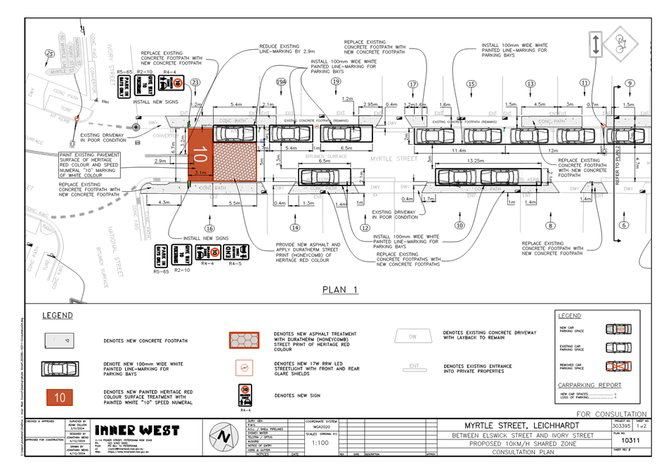
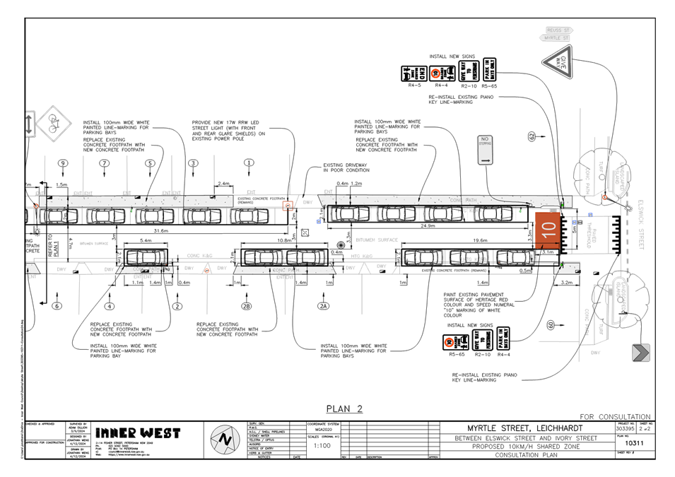
LTC0425(1) Item 8 Myrtle Street, Leichhardt - Proposed 10km/H Shared Zone And Line-Marked Parking Bays (Gulgadya -Leichhardt/Balmain Electorate/ Leichhardt PAC) 164
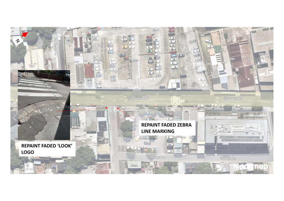
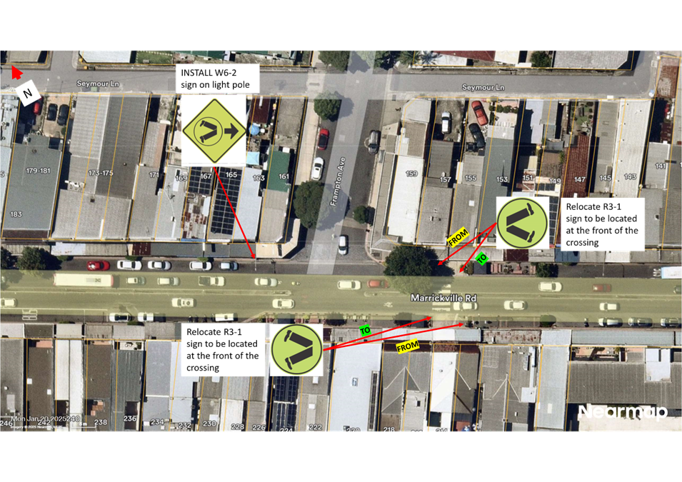
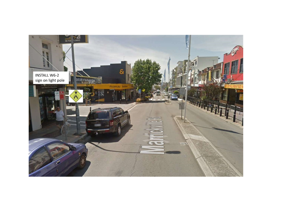
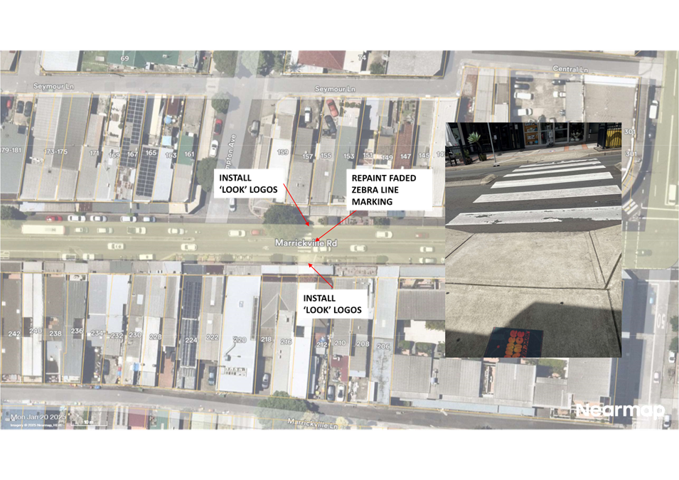
LTC0425(1) Item 9 Review of pedestrian crossings in various locations in Marrickville (Midjuburi-Marrickville Ward/Inner West PAC/Summer Hill Electorate) 170
Parking Matters
ITEM Page
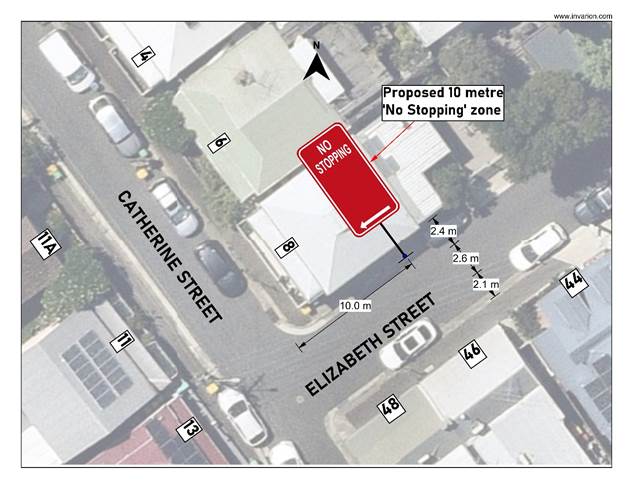
LTC0425(1) Item 10 Elizabeth Street, Rozelle - Proposed 'No Stopping' Zone (Baludarri-Balmain Ward/Balmain Electorate/Leichhardt PAC) 182
LTC0425(1) Item 11 Catherine Street, Leichhardt - Proposed 'No Stopping' Zone (Gulgadya-Leichhardt Ward/Balmain Electorate/Leichhardt PAC) 186
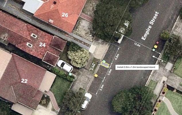
LTC0425(1) Item 12 Empire Street, Haberfield - Proposed Landscaped Island (Galgadya-Leichhardt Ward/Summer Hill Electorate/Burwood PAC) 188
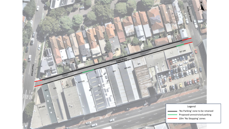
LTC0425(1) Item 13 Easter Street, Leichhardt - Proposed Parking Changes (Gulgadya-Leichhardt/Balmain Electorate/ Leichhardt PAC) 191
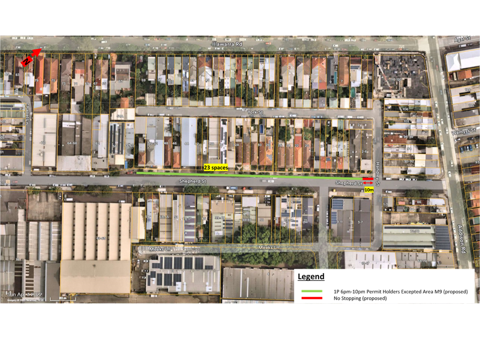
LTC0425(1) Item 14 Shepherd Street, Marrickville - Proposed '1P 6pm-10pm Permit Holders Excepted Area M9' (Midjuburi-Marrickville Ward/Inner West PAC/Summer Hill Electorate) 195
LTC0425(1) Item 15 Goodsell Street, St Peters - Proposed line marking of parking spaces (Midjuburi-MarrickvilleWard/Heffron Electorate/Inner West PAC) 199
Late Items
Nil at time of printing.
6 Part B - Items for Information Only
Nil at the time of printing.
7 Part C - Items for General Advice
Nil at the time of printing.
8 General Business
9 Close of Meeting
|
|
Local Traffic Committee Meeting 14 April 2025 |
Minutes of Meeting held on 17 March 2025
Meeting commenced at 11:00 AM
ACKNOWLEDGEMENT OF COUNTRY BY CHAIRPERSON
I acknowledge the Gadigal and Wangal people of the Eora nation on whose country we are meeting today, and their elders past and present.
COMMITTEE REPRESENTATIVES PRESENT
|
Victor Macri |
Councillor – Midjuburi – Marrickville Ward (Chair) |
|
Bill Holliday |
Representative for Kobi Shetty MP, Member for Balmain |
|
Graeme McKay |
Representative for Jo Haylen MP, Member for Summer Hill |
|
Miriama Tamata |
Representative for Jenny Leong MP, Member for Newtown |
|
Sgt Charles Buttrose |
NSW Police – Leichhardt Police Area Command |
|
Nina Fard |
Transport for NSW (TfNSW) |
|
|
|
|
|
|
|
NON VOTING MEMBERS IN ATTENDANCE |
|
|
|
|
|
Col Jones |
Inner West Bicycle Coalition (IWBC) |
|
Michael Takla |
Representative for Transit Systems |
|
Sunita Sheril |
Representative for Transit Systems |
|
Manod Wickramasinghe |
IWC’s Traffic and Transport Planning Manager |
|
Sunny Jo |
IWC’s Coordinator Traffic Engineering Services (North) |
|
George Tsaprounis |
IWC’s Coordinator Traffic Engineering Services (South) |
|
Christy Li |
IWC’s Business Administration Officer |
|
|
|
|
VISITORS |
|
|
|
|
|
Melissa Zeitouni |
Public Speaker (Item 10) |
|
Julie Waters |
Public Speaker (Item 10) |
|
Amanda Vine |
Public Speaker (Item 10) |
|
|
|
|
APOLOGIES: |
|
|
|
|
|
Ben Walters |
NSW Police – Inner West Police Area Command |
|
|
|
DISCLOSURES OF INTERESTS:
Nil.
CONFIRMATION OF MINUTES
|
That the Minutes of the Local Traffic Committee held on Monday, 17 February 2025 be confirmed. |
MATTERS ARISING FROM COUNCIL’S RESOLUTION OF MINUTES
The Minutes of the Local Traffic Committee meeting held on 09 December 2024 were adopted at Council’s meeting held on 18 February 2025 subject to the following amendments:
The Minutes of the Local Traffic Committee meeting held on 17 February 2025 were adopted at Council’s meeting held on 11 March 2025.
|
LTC0325(1) Item 7 Smith Street, Summer Hill – Greenway Project – Proposed splitter island upgrade works at the roundabout with Carlton Crescent, Longport Street and Grosvenor Crescent (Djarrawunang-Ashfield Ward / Summer Hill Electorate / Burwood PAC) |
|
Detailed design plans have been prepared for Greenway On-Road works. The detailed design plans for the proposed Smith Street splitter island upgrade works are based on the Greenway Concept Designs endorsed by Council in May 2019. Consultation was undertaken across the corridor during the Concept Design phase. Specific consultation to affected residents and owners was undertaken on the draft detailed design plans. It is recommended that the detailed design plans are approved for construction.
Officers Recommendation:
That the detailed design plans (Gartner Rose – Greenway in-corridor works Control Zone 1 - 211583-TTW-11-DR-CI-07014-2 and 211583-TTW-11-DR-CI-07015-3) for the proposed splitter island upgrade works for the Greenway on-road works be approved for construction.
DISCUSSION:
The Representative for the Inner West Bicycle Coalition noted that he supported the proposal in principle however had some questions regarding whether the lane splitters are going to be wide enough to store bicycles in them. Council Officers noted that the refuge islands are proposed to be 2 meters minimum so that at the narrowest point the width will be 2 meters, which is sufficient for typical bicycle storage.
The Representative for the Inner West Bicycle Coalition questioned if Council was going to widen the shared path between Longport Street and Malthouse Way.
Council Officers requested that the Representative for the Inner West Bicycle Coalition forward his correspondence so that the Greenway team can advise of the work plans in the area.
The Committee members agreed with the Officer’s recommendation.
COMMITTEE RECOMMENDATION:
That the detailed design plans (Gartner Rose – Greenway in-corridor works Control Zone 1 - 211583-TTW-11-DR-CI-07014-2 and 211583-TTW-11-DR-CI-07015-3) for the proposed splitter island upgrade works for the Greenway on-road works be approved for construction.
For Motion: Unanimous |
|
LTC0325(1) Item 8 Hurlstone Avenue, Summer Hill - Proposed kerb blister islands/narrowing of Hurlstone Avenue at Prospect Road and 'No Left Turn 7.30-9.30am, 3:00-5:00pm Mon-Fri, Bicycles Excepted' from Prospect Road into Hurlstone Avenue (Djarrawunang-Ashfield Ward/Summer Hill Electorate/Burwood PAC) |
|
Council is planning to improve safety in Hurlstone Avenue, Summer Hill by constructing new landscaped kerb blister islands at its intersection with Prospect Road. The proposal aims to improve pedestrian and motorist safety by reducing the width of the roadway which will better define safe pedestrian crossing paths and addresses pedestrian safety and driver behaviour at this location.
It is similarly proposed to introduce ‘No Left Turn ‘No Left Turn 7.30am-9.30am, 3-5pm Mon-Fri, Bicycles Excepted’ ban restrictions from Prospect Road into Hurlstone Avenue. The restrictions aim to relieve traffic volume pressure along Hurlstone Avenue, given that the street caters for by-passing traffic during AM and PM peak periods. The part-time No left Turn ban would be subject to TfNSW approval. Council in addition, resolved that the restrictions, if approved, be trialled for a period of 6 months from the date the restrictions are implemented.
Officers Recommendation:
1. That the detailed design plan (10315 sheet 1) for the proposed new kerb blister island/narrowing of Hurlstone Avenue at Prospect Road, Ashfield with associated pram ramps, signs and line marking (as shown in Attachment 2) be approved.
2. That ‘No Left Turn; 7.30am-9.30am, 3pm-5pm Mon-Fri, Bicycles Excepted’ restriction be installed at the intersection of Prospect Road and Hurlstone Avenue, Summer Hill, subject to approval of a Traffic Management Plan for the part-time ‘No Left Turn’ ban being approved by Transport for NSW.
DISCUSSION:
The Representative for the Member of Summer Hill raised a request from a constituent requesting that a trial of the traffic restrictions be undertaken at the intersection of Hurlstone Avenue and Prospect Road to review the impact of the proposed changes on the intersection of Prospect Road and Old Canterbury Road.
Council Officers advised that a review can be undertaken to review the outcome of the implemented restrictions 6 to 12 months after installation. It was noted that Prospect Road is a collector road, and Council hopes that the trail shows that motorists are using Prospect Road more after the proposed restrictions are implemented as the intention behind the proposal was to shift motorists away from local roads and into collector and major roads.
The Representative for the Inner West Bicycle Coalition questioned if there was data on the accident history at Hurlstone Avenue and Old Canterbury Road. Council Officers advised that during the original proposal.
The Representative for the Member of Summer Hill questioned if there has been any consideration for traffic lights to be installed at the corner of Prospect Road and Old Canterbury Road. Council Officers advised that there have been requests made in the past to Transport for NSW, however, no further feedback has been provided to Council regarding that review.
The Representative for Transport for NSW (TfNSW) noted that Council had sent through the Transport Management Plan (TMP) and has received approval for the TMP from TfNSW and requested that Council advise of the timeframe for the proposed review period so that TfNSW can update the TMP to reflect the agreed timeframe in their systems.
The Committee members agreed with the amended recommendation.
COMMITTEE RECOMMENDATION:
1. That the detailed design plan (10315 sheet 1) for the proposed new kerb blister island/narrowing of Hurlstone Avenue at Prospect Road, Ashfield with associated pram ramps, signs and line marking (as shown in Attachment 2) be approved.
2. That ‘No Left Turn; 7.30am-9.30am, 3pm-5pm Mon-Fri, Bicycles Excepted’ restriction be installed at the intersection of Prospect Road and Hurlstone Avenue, Summer Hill, subject to approval of a Traffic Management Plan for the part-time ‘No Left Turn’ ban being approved by Transport for NSW.
3. That a 12-month review of the implemented restrictions be undertaken
For Motion: Unanimous |
General Business
|
Item 12 – Frederick Street and John Street, Ashfield traffic signal update |
|
The Representative for Transport for NSW advised that the Frederick Street and John Street traffic signals are still currently in the detailed design phase of the project. The Representative for Transport for NSW advised that they have recently received grant funding for construction of the traffic signals over the next 2 financial years (FY25/26 & FY26/27). It was noted that TfNSW will try to construct the signals over one financial year however, this would be dependent on the complexity of the site, the timeline for construction may need to be revised. |
|
Item 13 – Parking concerns on Burrows Road South, St Peters |
|
The Chairperson tabled in correspondence from a business owner advising their concerns regarding trucks parking in the street and impeding their ability to park and operate. The business owners requested consideration for 12P parking to be implemented to prevent people from parking their cars for extended periods whilst they go overseas. Council Officers advised that there have been previous requests in the area regarding the parking on boats, trailers and trucks in the area. Council had investigated the concerns and advised that there was very little boat, trailer and truck parking when they went onsite to review so they could not substantiate those concerns however, Council can re-investigate the concerns. |
|
Item 14 – Concerns regarding the vehicular access from Carrington Road, Marrickville |
|
The Chairperson tabled in correspondence from a resident noting concerns regarding vehicular access at the intersection of Carrington Road onto Richardson’s Crescent noting the difficulty of turning right from Carrington Road into Richardson’s Crescent and requested Council to investigate potential treatments to mitigate the issue. Council Officers advised they are currently reviewing the issue and can update the Chairperson on the outcome of that investigation. |
|
Item 15 – Update on investigation relating to Schwebel Street, Marrickville |
|
The Chairperson requested an update on the investigation relating to the conversion Schwebel Street, Marrickville into ‘One Way’. Council Officers advised they have collected the data and are currently analysing the data and coming up with potential treatment options. It was noted that a report would be brought back to the Traffic Committee for potential options prior to public engagement on the preferred option. |
|
Item 16 – Trial of ‘No Right Turn’ from Ramsey Street into Wolseley Street, Haberfield |
|
The Representative for the Member of Summer Hill advised Jo Haylen’s office have received a letter from Transport for NSW regarding the trial of a ‘No Right Turn’ from Ramsey Street into Wolseley Street, Haberfield between 7am and 9am during weekdays. It was noted that Transport for NSW would be door-knocking and letter-box-dropping residents to advise them of the upcoming changes. Council Officers advised that this had arisen as part of the Road Network Reviews that TfNSW was undertaking following the completion of the WestConnex works. It was noted that traffic in Wolseley Street has increased following the closure of the adjacent Northcote Street which was undertaken in order to place a site compound for WestConnex. On completion of the WestConnex project, the closure of Northcote Street was made permanent by TfNSW, resulting in Wolseley Street continuing to carry the additional traffic. It was noted that the residents of Wolseley Street had raised concerns with Council and the local members of parliament and that the concerns were raised with Transport for NSW as they have committed to undertake 12 months and 5-year road network reviews following the completion of Stage 2 and 3 of WestConnex. It was noted that the implementation of the ‘No Right Turn’ restriction is to minimise traffic impact to Wolseley Street residents during peak hours. |
|
Item 17 – Concerns regarding a raised speed hump in Lackey Street, Summer Hill |
|
The Representative for the Member of Summer Hill advised he had received correspondence from a resident noting their concerns about a raised speed hump near Lackey Street, Summer Hill which pedestrians often mistake/ use as a pedestrian crossing. Council Officers advised that they have also received correspondence from the resident regarding their concerns and are currently investigating potential solutions to discourage the use of that speed hump as a pedestrian crossing. |
CHAIRPERSON
Councillor Macri
|
|
Local Traffic Committee Meeting 14 April 2025 |
Subject: Inner West LGA - Proposal for GoGet car share parking spaces (All wards, all electorates, all PACs)
Prepared By: Jennifer Adams - Traffic Engineer and Amir Falamarzi - Traffic Engineer
Authorised By: Manod Wickramasinghe - Traffic and Transport Planning Manager
|
RECOMMENDATION
That the following ‘No Parking Authorised Car Share Vehicle Expected, Area GOGET’ restrictions be approved:
1. A 5.5m restriction in the first parking space after statutory 10m ‘No Stopping’ restriction sign on the northern side of Albert Parade east of Frederick Street, Ashfield/
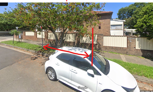
2. A 3.5m wide angled parking space on the western side of Nelson Street, Annadale, immediately south of the driveway of No.22 Nelson Street. To minimise the impact on the adjacent driveway, a small GoGet vehicle allocation is proposed.
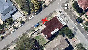
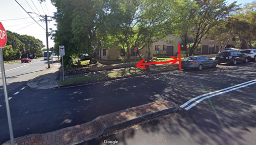
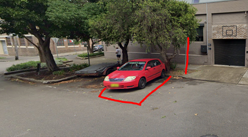
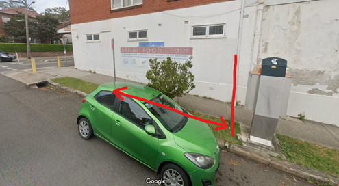
3. A 5.5m restriction in the first parking space after the statutory 10m ‘No Stopping’ restriction sign on the southern side of Alt Street west of Charlotte Street, adjacent to side boundary of No.92 Charlotte Street, Ashfield.
4. A 5.5m restriction in the first parking space after the statutory 10m ‘No Stopping’ sign on northern side of Thomas Street east of Edwin Street, Ashfield (adjacent to side boundary of No.45 Edwin Street) after the kerb blister.
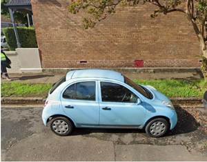
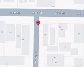
5. A 5.5m restriction in the first parking space after the statutory 10m ‘No Stopping’ restriction sign on the eastern side of Burfitt Street south Allen Street, adjacent to side boundary of No. 102 Allen Street, Leichhardt.
6. A 6.6m restriction in the first legal parking space on the western side of George Street south of Treadgold Street Road, Leichhardt, adjacent to side boundary of No. 30-40 George Street, Leichhardt.
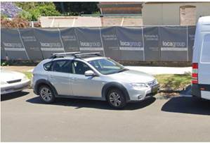
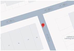
7. A 5.5m restriction in the first legal parking space on the western side of Justin Street south of O’Neill Street, Lilyfield, adjacent to side boundary of No. 29 O'Neill Street, Lilyfield.
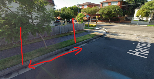
8. A 5.5m restriction in the first legal parking space on the eastern side of Harrison Street north of Marrickville Road, Marrickville (adjacent to the side boundary of 343 Marrickville Road). The statutory 10m ‘No Stopping’ sign will also be included 10m from the intersection of Harrison Street from Marrickville Road.
9. A 5.5m restriction in the first space after statutory 10m ‘No Stopping’ sign on the eastern side of Wemyss Street south of Newington Road (adjacent to the side boundary of 70 Newington Road), Marrickville.
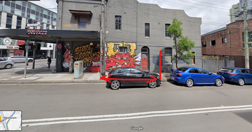
10. A 5.5m restriction in the first parking space after the statutory 10m ‘No Stopping’ restriction sign on the western side of Station Street north of Enmore Road (adjacent to the side boundary of 47 Enmore Road, Newtown.
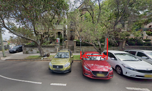
11. A 2.5m wide restriction in the first 90° angle parking space after the ‘Mobility’ parking space on the western side of Middleton Street north of Newington Road, Petersham.
12. A 5.5m restriction in the first parking space after the statutory 10m ‘No Stopping’ sign on southern side of May Street east of Applebee Street, St Peters.
13. A 5.5m restriction in the first legal parking space on the first legal parking space on the western side of Bruce Street south of Albany Road, Stanmore (adjacent to the side boundary of 147 Albany Road). The statutory 10m ‘No Stopping’ sign will also be included 10m from the intersection of Bruce Street and Albany Road.
14. A 5.5m restriction in the first parking space after the statutory 10m ‘No Stopping’ sign on western side of Holt Street north of Cavendish Street (adjacent to boundary of No.16 Holt Street) after the kerb blister, Stanmore.
|
STRATEGIC OBJECTIVE
This report supports the following strategic directions contained within Council’s Community Strategic Plan:
|
2: Liveable, connected neighbourhoods and transport |
|
|
EXECUTIVE SUMMARY
A request has been received from a GoGet Car Share representative for the installation of Fifteen (15) on-street dedicated ‘Car Share’ parking spaces for existing floating car share vehicles around the Inner West. Due to community feedback and opposition to one location only fourteen of the fifteen nominated car share spaces are recommended for installation.
BACKGROUND
Car sharing is well established in the Inner West. Car sharing services provide an additional transport option for the growing population in the Inner West LGA.
Car share parking is an efficient use of parking spaces because one shared vehicle can replace several private vehicles that would otherwise compete for local parking. Car share also reduces overheads for residents who don't need to own a car.
Council supports car sharing as a part of its drive to:
· reduce greenhouse gas emissions;
· reduce on-street parking demand;
· reduce congestion and the competition for parking spaces; and
· encourage active lifestyles by reducing dependency on private cars.
Users of car share schemes in the Inner West report reduced car ownership and greater use of other transport options including public transport, walking and cycling
The following hierarchy of preferred locations for designated car share spaces will be considered when assessing suitability of locations:
a. Within immediate proximity to public transport services such as a rail/metro station/stop.
b. Adjacent to public land such as a park.
c. Adjacent to a public facility such as a leisure centre or library.
d. Within high/medium density residential areas.
e. In or immediately adjacent to retail / commercial streets.
f. Adjacent to the side boundary of single dwellings.
g. Other locations.
Car share parking spaces located in front of single dwellings will be given low priority and avoided in most circumstances.
Consultation will be carried out with residents and businesses in the immediate vicinity of a proposed parking space.
Inner West Council reserves the right to reject, or determine by refusal, any application for a car share parking space.
FINANCIAL IMPLICATIONS
Costs associated with the installation, removal, maintenance and administration of dedicated car share bays/spaces including non-statutory features such as painted road markings will be met by the relevant car share company in accordance with the Schedule of Fees and Charges.
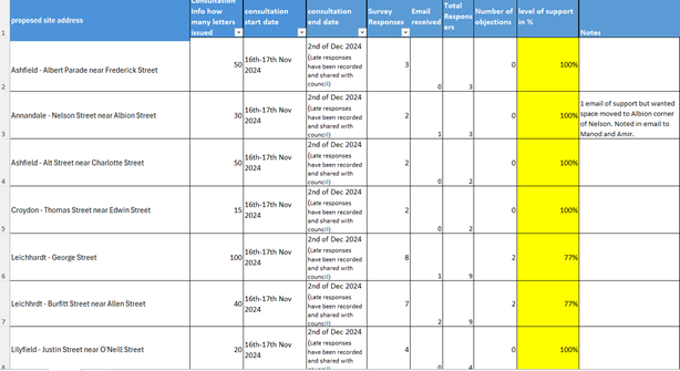
GoGet’s Proposed Locations
A request has been received from GoGet representative for the installation of on-street dedicated car share parking spaces within Inner West. The nominated GoGet locations are:
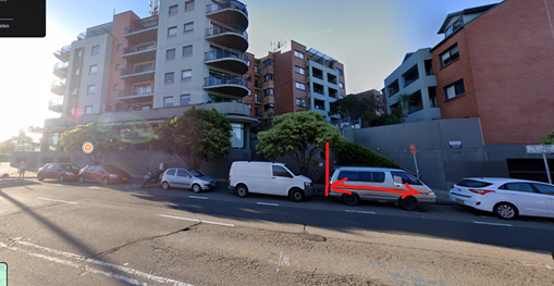
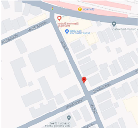
1. Ashfield - Albert Parade near Frederick Street – GoGet notes that this current floating location on Albert Parade is highly utilised, with an average use of 3.0 hours per day between November 2023 and January 2024. The location has been in use approximately 9 months and there are 174 members within 400m of the site.
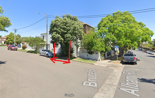
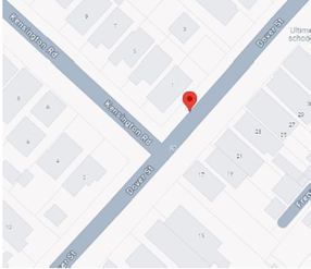
2. Annandale - Nelson Street near Albion Street - GoGet notes that the current nearby floating location on Chester Street is highly utilised, with an average use of between 5.7 - 6.2 hours per day between November 2023 and January 2024. The location has been in use approximately 57 months and there are 498 members within 400m of the site.
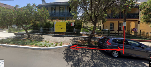
3. Ashfield - Charlotte Street near Alt Street - GoGet notes that the current floating location on Charlotte Street is highly utilised, with an average use of between 3.9 - 6.3 hours per day between November 2023 and January 2024. The location has been in use approximately 59 months and there are 295 members within 400m of the site.
|
Proposed location not supported. The existing P15 short term parking is to support the local businesses.
Alternative location – Alt Street near Charlotte Street - first legal parking space around the corner on Alt Street (adjacent to side boundary of No.92 Charlotte Street)
|
|
:
4. Croydon - Thomas Street near Edwin Street - GoGet notes that this current floating location on Thomas Street is highly utilised, with an average use of between 4.4 – 9.9 hours per day between November 2023 and January 2024. The location has been in use approximately 47 months and there are 123 members within 400m of the site.
5. Leichhardt - George Street near Treadgold Street – GoGet notes that the current floating location on George Street is highly utilised, with an average use of between 3.4 – 5.8 hours per day between November 2023 and January 2024. The location has been in use approximately 48 months and there are 245 members within 400m of the site.
6. Leichhardt - Burfitt Street near Allen Street - GoGet notes that the existing local GoGet bay is highly utilised with an average use of 5.6 - 10.9 hours per day between November 2023 and January 2024. The age of the nearest GoGet bay is approximately 53 months and there are 230 members within 400m of the site.
7. Lilyfield - Justin Street near O'Neill Street - The current floating location on Justin Street is highly utilised, with an average use of 4.3 hours of use per day between November 2023 and January 2024. The location has been in use approximately 87 months and there are 210 members within 400m of the site.
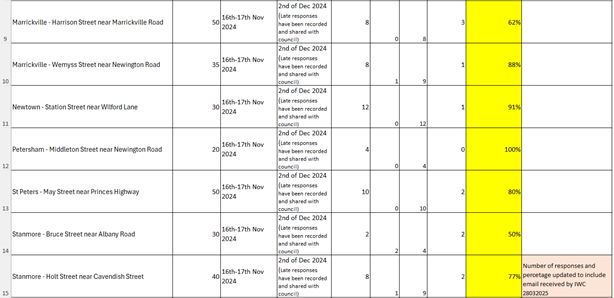
8. Marrickville - Harrison Street near Marrickville Road - GoGet notes that the current floating location on Woodcourt Street is highly utilised, with an average use between 3.3 - 3.9 hours per day between November 2023 and January 2024. The location has been in use approximately 77 months and there are 344 members within 400m of the site.
9. Marrickville - Wemyss Street near Newington Road - GoGet notes that the current floating location on Perry Street is highly utilised, with an average use of between 3.3 - 5.8 hours per day between November 2023 and January 2024. The location has been in use approximately 139 months and there are 437 members within 400m of the site.

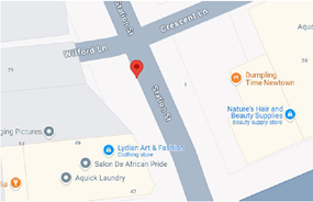
10. Newtown - Station Street near Wilford Lane – GoGet notes that the current floating location on Gladstone Street is highly utilised, with an average use of between 4.6 – 6.0 hours per day between November 2023 and January 2024. The location has been in use approximately 133 months and there are 768 members within 400m of the site.
11. Petersham - Middleton Street near Newington Road - GoGet notes that the current floating location on Newington Road is highly utilised, with an average use of 4.4 hours per day between November 2023 and January 2024. The location has been in use approximately 57 months and there are 291 members within 400m of the site.
12. St Peters - May Street near Princes Highway - GoGet notes that the current floating location on Applebee Street is highly utilised, with an average use of between 5.3 - 5.6 hours per day between November 2023 and January 2024. The location has been in use approximately 155 months and there are 519 members within 400m of the site.
13. Stanmore - Bruce Street near Albany Road - GoGet notes that the current floating location on Charles Street is highly utilised, with an average use of 3.0 hours per day between November 2023 and January 2024. The location has been in use approximately 113 months and there are 294 members within 400m of the site.
14. Stanmore - Holt Street near Cavendish Street - GoGet notes that the current floating location on Cavendish Street is highly utilised, with an average use of between 3.3 - 5.6 hours per day between November 2023 and January 2024. The location has been in use approximately 134 months and there are 337 members within 400m of the site
15. Summer Hill - Dover Street near Kensington Road - GoGet notes that this current floating location on Dover Street is highly utilised, with an average use of 3.8 hours per day between November 2023 and January 2024. The location has been in use approximately 88 months and there are 351 members within 400m of the site.
Public Consultation
Community consultation was led by GoGet representatives during the period between 18 November 2024 and 2 December 2024. Letters were distributed to local residents within 100 metres of each proposed space. A copy of GoGet’s community consultation evaluation is attached at the end of this report.
Officers Comments
A summary of each location is presented below. As necessary details are listed regarding any alternative locations suggested.
|
|
Location |
Letters sent - Responses |
Resident comments |
Supported / not supported |
|
1 |
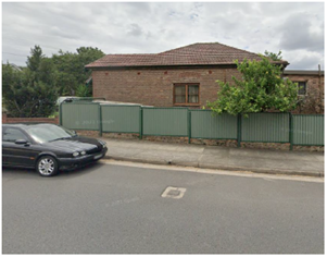
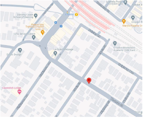
Ashfield - Albert Parade near Frederick Street
Currently unrestricted parking.
-33.882197, 151.121745
|
50 letters sent
3 responses
Response rate = 6%
3 support (100%)
No objections
|
It is very convenient knowing that the car will always be at the same location if needed
I use Goget, would be nice to not have to go looking for the car or walk further when in a rush
It’s close to where I live
|
Proposed site meets Council’s car share Policy – on side boundary and within medium density residential area
Supported – first space after statutory 10m ‘No Stopping’ sign on northern side of Albert Parade east of Frederick Street |
|
2 |
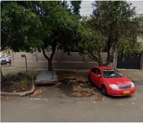
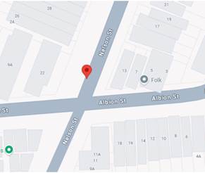
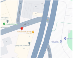
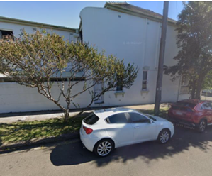
Annandale - Nelson Street between Collins Street and Albion Street Alternative location was investigated as the original proposed location was not supported – as unrestricted parking is preferred over RPS parking. Currently unrestricted - ‘45° ANGLE PARKING Rear to Kerb Vehicles under 6m ONLY’ 33.886446, 151.171692 |
30 letters sent
2 responses
Response rate = 7%
2 support - but in alternative location and/or with conditions (not too close to driveway) (100%)
No objections |
It is already extremely difficult to park at the corner of Albion and nelson for local residents …..it is not feasible or appropriate in the proposed location. Possibly Trafalgar Street is a better option.
If the parking sign was moved further away from the driveway I would consider supporting this… but currently any vehicles, especially vans, make it impossible to see oncoming traffic from my driveway.
|
Proposed site meets Council’s car share Policy – within high/medium density residential area.
Supported – A 3.5m wide angled parking space on the western side of Nelson Street, Annadale, immediately south of the driveway of No.22 Nelson Street. To minimise the impact on the adjacent driveway, a small vehicle allocation is proposed. |
|
3 |
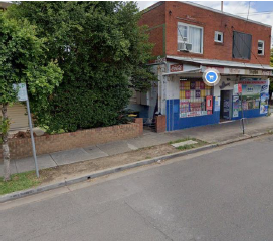
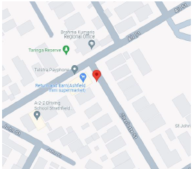
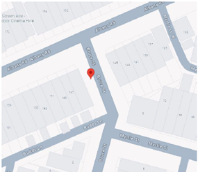
Ashfield - Charlotte Street near Alt Street Proposed location not supported. The existing P15 short term parking is to support the local businesses.
Alternative location – Alt Street near Charlotte Street - first legal parking space around the corner on Alt Street (adjacent to side boundary of No.92 Charlotte Street)
Presently unrestricted
-33.881789, 151.126177 |
50 letters sent
2 responses
Response rate = 4%
2 support (100%)
No objections |
I support the idea of the car share bay moving to Alt St in front of the public phone. This is the ideal location for the car share bay as it is not in front of a residential property and the spot is often vacant. Charlotte Street is often parked out, so having the Go Get car in Charlotte Street just makes it harder for anyone who lives in the street to get a parking spot.
It’s very convenient to have the van in a dedicated spot so it’s easy to find |
Proposed site meets Council’s car share Policy – adjacent to the side boundary of single shop / dwelling
Supported – Alt Street near Charlotte Street - first legal parking space around the corner on Alt Street (adjacent to side boundary of No.92 Charlotte Street) south side of Alt Street
|
|
4 |
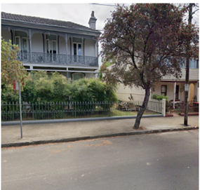
Croydon - Thomas Street near Edwin Street Currently unrestricted.
-33.885013, 151.115505
|
15 letters sent
2 responses
Response rate = 13%
2 support (100%)
No objections |
I am a frequent carshare user, and it comforts me to know this is available.
|
Proposed site meets Council’s car share Policy – adjacent to the side boundary of single dwelling
Supported – first space on northern side of Thomas Street east of Edwin Street (adjacent to side boundary of No.45 Edwin Street) after kerb blister and statutory 10m ‘No Stopping’ sign. |
|
5 |
Leichhardt - George Street - near Treadgold Street
Currently unrestricted
-33.887729, 151.148951
|
100 letters sent
11 responses
Response rate = 11%
6 support (55%)
1 support – but in alternative location (9%)
4 objections (36%)
|
There’s already a massive lack of parking space in the area. Most residents of the buildings in George Street are not entitled to a carapace or council permit.
There are already roughly only 15 free parking spots to accommodate hundreds of apartments. George street is the only street around the area that has free parking….
Parking is already a difficult issue for the unit residents and this will not alleviate it. If anything is required it would be more free parking in surrounding streets or at least some parking permits.
reconsider this location and explore more suitable alternatives, such as: The dead-end of George St at Lords Rd, western side of Flood St near Treadgold St, Upward St, Within the nearby Marketplace Leichhardt car park
|
Proposed site meets Council’s car share Policy – Within high/medium density residential area.
Supported – George Street near Treadgold Street - first legal parking space on the western side of George Street south of Treadgold Street Road, Leichhardt, adjacent to side boundary of No. 30-40 George Street, Leichhardt |
|
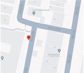
6 |
Leichhardt - Burfitt Street near Allen Street
Currently unrestricted
-33.880489, 151.148796
|
40 letters sent
9 responses
Response rate = 23%
4 support (44%) 3 Support – but in alternative location (33%
2 objections (22%)
|
There is now limited parking available since the new large unit complex has been built recently on the corner of Allen St & Flood St especially in the evening. If there needs to be a Go Get then perhaps on Flood St in front of the Unit complex on the corner of Allen St & Flood St.
Taking an extra space for Go Get cars is unreasonable and will add extra stress on the community
It’s a good location suitable for me
As a resident of over 30 years in this street, I object to a car share in our street. There are already 2 GoGet cars available 2 mins walk away in Darley Road near the Hawthrone Light Rail stop and these cars are usually present when I walk by. |
Proposed site meets Council’s car share Policy – Within high/medium density residential area.
Supported - first parking space after the statutory 10m ‘No Stopping’ restriction sign on the eastern side of Burfitt Street south Allen Street, adjacent to side boundary of No. 102 Allen Street, Leichhardt |
|
7 |
Lilyfield - Justin Street near O'Neill Street
Currently unrestricted
-33.869910, 151.164725
|
20 letters sent
4 responses
Response rate = 20%
3 support (75%)
1 support – but in alternative location (25%)
No objections
|
Because using GoGet, is used by all the community and we need a dedicated space. We can't assume there is somewhere to park, because of other people have multiple vehicles.
Parking in Justin Street is already restricted by the 15 minute only allocated parking for the Child Care Centre. 7.00 - 9.30am / 2.30-6pm. This causes residents to park in the side lanes which creates access and safety issues.
Close access to my home |
Proposed site meets Council’s car share Policy – within high / medium density residential area.
Supported – Justin Street near O’Neill Street - first legal parking space on the western side of Justin Street south of O’Neill Street, Lilyfield, adjacent to side boundary of No. 29 O'Neill St, Lilyfield |
|
8 |
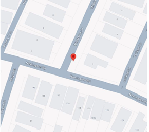
Harrison Street near Marrickville Road, Marrickville - East side of Harrison Street north of Marrickville Road
Currently unrestricted
33.907743 151.150067
|
50 letters sent
8 responses
Response rate = 16%
4 support (50%)
4 object (50%) |
There is limited parking in Harrison St already. The house on the corner has been approved for demolition and units which will result in more cars and no more parking.
Currently not enough parking spaces on this street.
There is inadequate space for a car share bay towards the Marrickville Road end of Harrison Street due to lack of car spaces for residents on this street.
I don't understand why the car is moving from Woodcourt to Harrison?
Convenience.
I use it every week
Lack of a dedicated bay makes things quite difficult when wishing to use the car.
|
Proposed site meets Council’s car share Policy – on side boundary and within medium density residential area
Supported - the first legal parking space on the eastern side of Harrison Street north of Marrickville Road, Marrickville (adjacent to the side boundary of 343 Marrickville Road). The statutory 10m ‘No Stopping’ sign will also be included 10m from the intersection of Harrison Street from Marrickville Road.
|
|
9 |
Marrickville - Wemyss Street near Newington Road - South side of Newington Road east of Wemyss Street
Currently Unrestricted
33.900598 151.165262
|
35 letters sent
9 responses
Response rate = 26%
4 support (44%)
4 support – but in alternative location (44%)
1 objection (12%) |
Parking is challenging enough on Wemyss St, especially as there are already 3 or more mobility parking spots on this half of the street. This will be taking away another parking spot from residents. An alternative spot a short walk away would be more appropriate.
issues are exacerbated on Saturdays when Newington College has sporting and other events, as well as Sundays when the Addison Road markets are in operation. As a result, until the Inner West Council provides alternative options we do not support a car sharing bay on Wemyss Street
It will severely impact parking for residents as street parking is at a premium in that location.
Yes but in an alternate location
There need to be more local spots in the Inner West. And not having to cross a major road is important.
I live close by and would like to be able to access this go get car at times Easy access and more availability |
Proposed site meets Council’s car share Policy – on side boundary of a single dwelling
Supported - first space after statutory 10m ‘No Stopping’ sign on eastern side of Wemyss Street south of Newington Road (adjacent to the side boundary of 70 Newington Road) |
|
10 |
Station Street north of Enmore Road, Newtown – west side north of Enmore Road and south of Wilford Lane, Newtown
Currently unrestricted
-33.898383, 151.176332 |
30 letters sent
12 responses
Response rate = 40%
11 support (92%)
1 objection (8%) |
I am an intermittent GoGet user but the availability of the service means I don't need to have a car. However at times the distance to the nearest bay is difficult particularly carrying heavy objects.
Very useful service Convenience more carshare options is a good thing
There is a strong demand for the service in this area
I don't own a car and rely on goget when I need to get around.
My residence doesn’t qualify for a parking permit so having car share nearby alleviates that inequality
There are barely enough spaces for residents, workers clog the street and park during the day and commute, tradespeople clog the parking all day etc I would support this if you were to offer a compromise and put in a disability spot as well |
Proposed site meets Council’s car share Policy – in or immediately adjacent to retail / commercial street and on side boundary of a shop top dwelling
Supported - first space after statutory 10m ‘No Stopping’ sign on western side of Station Street north of Enmore Road (adjacent to the side boundary of 47 Enmore Road) |
|
11 |
Petersham - Middleton Street near Newington Road - East side of Middleton Street north of Newington Road.
Proposed location is not supported – the proposed location is outside the front of property No.1 Middleton Street
Alternative location - the first 90° angle space after the ‘Mobility’ parking space on the opposite (western) side of Middleton Street north of Newington Road.
Currently unrestricted - ‘90°ANGLE PARKING Rear to Kerb Vehicles under 6m ONLY’
-33.898301, 151.160414 |
20 letters sent
4 responses
Response rate = 20%
4 support (100%)
No objections |
I own a car but used GoGet for many years and support car sharing, as it helps reduce the need for personal car ownership.
We don’t own a car and use GoGet instead. We save a spot in the street, and the GoGet service is essential to us and the neighbourhood.
GoGet is a great service. Please make this car pet friendly.
This GoGet vehicle pod is the closest to my home address in William St Marrickville…..I fully support a dedicated pod parking space be allocated by council to encourage carshare service usage in the area |
Proposed site meets Council’s car share Policy – other location (sufficient number of angle parking spaces available)
Supported - first 90° angle parking space after the ‘Mobility’ parking space on the western side of Middleton Street north of Newington Road.
|
|
12 |
St Peters - May Street near Princes Highway
Proposed location not supported.
Alternative location – the last space before the ‘No Stopping’ sign west of proposed location (approximately 4 spaces west of proposed location).
Currently unrestricted.
-33.908833, 151.180587 |
50 letters sent
10 responses
Response rate = 20%
8 support (80%)
2 objections (20%)
|
I use this car regularly, and it's in a high-use area; it needs a dedicated car bay
WE use this frequently;
The current car share in Applebee Street doesn’t have a dedicated spot which makes it difficult to return. I fully support putting this space in as it is well located on the surround road network.
This car spots are important to the neighborhood
There is not enough parking in the area for local residents, business's and people living and working in the area who need the use of a vehicle.
Not enough parking as it currently stands and they would be removing one of the few all day parks |
Proposed site meets Council’s car share Policy – adjacent to retail / commercial street and within medium / high density residential area
Supported – first space after statutory 10m ‘No Stopping’ sign on southern side of May Street east of Applebee Street, St Peters
|
|
13 |
Stanmore - Bruce Street near Albany Road
West side of Bruce Street, south of Albany Road near Budds Lane
Currently unrestricted
-33.891479, 151.161908 |
30 letters sent
2 responses
Response rate = 7%
2 support (100%)
No objections |
I have used the vehicles parked in Gordon Crescent - van & car. Good alternative to having your own vehicle.
GoGet is a great service. Please make this car pet friendly |
Proposed site meets Council’s car share Policy – on side boundary
Supported - the first legal parking space on the western side of Bruce Street south of Albany Road, Stanmore (adjacent to the side boundary of 147 Albany Road). The statutory 10m ‘No Stopping’ sign will also be included 10m from the intersection of Bruce Street and Albany Road.
|
|
14 |
Stanmore - Holt Street near Cavendish Street
West side of Holt Street north of Cavendish Street, near Stanmore station.
Currently ‘1P 8:30am-6pm Mon-Fri, 8:30am-12:30pm Sat’ restrictions
-33.895658, 151.163873 |
40 letters sent
9 responses
Response rate = 22%
7 support (78%)
2 objections (22%) |
I'm a regular GoGet user and I would love there to be a permanent bay on my street.
Sharing a resource (cars) that is otherwise not used a lot of the time is better for everyone
My partner and I use Go Get a lot and more convenient places to pick up a car would be amazing. Please make this car pet friendly.
Holt Street and the surrounding streets have already had too many parking spots removed, for either bus zone, school zones, or corner vegetation to assist with visibility. Parking is extremely limited and on weekends when Newington host sporting events, it is even harder for local residents or customers of the shopping precinct to park
My submission (attached) opposes the GETGO proposal because of the number of residents, organisations and consequent volume of traffic using the street. |
Proposed site meets Council’s car share Policy – within medium density residential area
Supported - A 5.5m restriction in the first parking space after the statutory 10m ‘No Stopping’ sign on western side of Holt Street north of Cavendish Street (adjacent to boundary of No.16 Holt Street) after the kerb blister, Stanmore |
|
15 |
Summer Hill - Dover Street near Kensington Road
Existing parking restrictions – ‘2P 8am-6pm Mon-Fri’
-33.890262 151.143382 |
40 letters sent
6 responses
Response rate = 15%
2 support (33%)
4 objections (77%)
|
There is limited unrestricted parking in Dover St on the east side for residents and visitors.
It will reduce the parking space for the residents in the street which is already very limited thanks to the two hour parking restrictions.
There are significant parking challenges in Dover street today. Primarily due to (public transport commuters-tram and rail, Norman house, NAPF & baby Gym and flats.
There are also commuters who park in the street given its proximity to Summer Hill Station…. There are many local businesses along my end of Dover Street and Parramatta Road where employees park in the street…. a baby gymnastics place opened recently. I can’t go out between 10am and 2pm weekdays if I expect to get a parking space on the street upon my return…. I have seen one go get car parked twice. I would suggest that demand is not that high in our area. |
Not Supported – due to the overwhelming number of concerns raised by the community it is recommended that this location not be supported at this time |
Conclusion
Due to community feedback and opposition to one location only fourteen of the fifteen nominated GoGet car share spaces are recommended for installation. The Dover Street near Kensington Road, Summer Hill car share location is recommended not to proceed.
It is recommended that the installation of the proposed other fourteen on-street dedicated GoGet car share parking spaces be approved in order to provide improved parking opportunities for local residents who participate in the car share scheme.
Concept Diagrams
Supported locations are shown graphically below:
|
Location
|
Concept Diagram for signage location |
|
Location 1 - Ashfield - Albert Parade near Frederick Street |
|
|
Location 2 – Nelson Street, Annadale near Albion Street
|
|
|
Location 3 – Ashfield - Alt Street near Charlotte Street
|
|
|
Location 4 - Croydon - Thomas Street near Edwin Street
|
|
|
Location 5 – Leichhardt - George Street - near Treadgold Street
|
|
|
Location 6 – Leichhardt - Burfitt Street near Allen Street
|
|
|
Location 7 - Lilyfield - Justin Street near O'Neill Street
|
|
|
Location 8 – Marrickville - Harrison Street near Marrickville Road,
|
|
|
Location 9 - Marrickville - Wemyss Street near Newington Road
|
|
|
Location 10 – Station Street north of Enmore Road, Newtown
|
|
|
Location 11 – Petersham - Middleton Street near Newington Road
|
|
|
Location 12 –May Street near Princes Highway, St Peters
|
|
|
Location 13 –Bruce Street near Albany Road, Stanmore
|
|
|
Location 14 – Holt Street, Stanmore
|
|
GoGet’s Consultation Summary
The following GoGet summary of the consultation results was presented to Council:

Nil.
|
|
Local Traffic Committee Meeting 14 April 2025 |
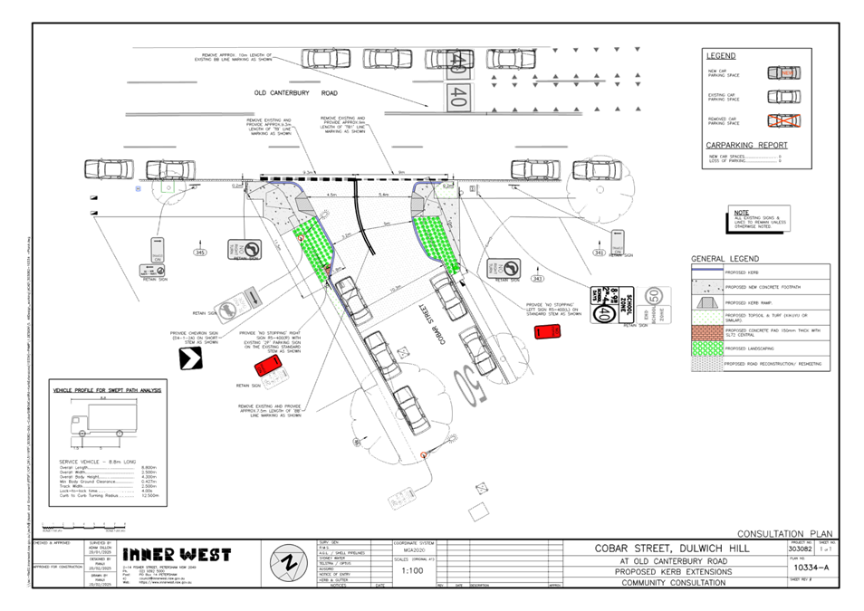
Subject: Cobar Street at Old Canterbury Road, Dulwich Hill – Proposed Kerb Extensions and Kerb Ramps - Design Plan 10334A (Djarrawunang-Ashfield Ward / Summer Hill Electorate / Inner West PAC)
Prepared By: Jennifer Adams - Traffic Engineer
Authorised By: Manod Wickramasinghe - Traffic and Transport Planning Manager
|
RECOMMENDATION
That the detailed design plan for the proposed new kerb extensions and kerb ramps in Cobar Street at its intersection with Old Canterbury Road, Dulwich Hill and associated signs and line markings (as per Design Plan No.10334A) be approved. |
STRATEGIC OBJECTIVE
This report supports the following strategic directions contained within Council’s Community Strategic Plan:
|
2: Liveable, connected neighbourhoods and transport |
|
|
EXECUTIVE SUMMARY
BACKGROUND
This report details the design plan for the improvement works and its related consultation results. It is noted that the original community consultation plan has subsequently been slightly amended by extending the kerb extension island on the north side of Cobar Street. This work is programmed and programmed to be constructed in the 2025/2026 financial year.
Other Staff Comments
The following works were proposed and are illustrated on the attached Consultation Plan (Plan No. 10334). The proposed works aim to improve pedestrian safety by better defining the safe pedestrian crossing point and addresses concerns for pedestrian safety and driver behaviour at this location.
Specifically, the proposed scope of works includes the following:
· Construct kerb extensions with integrated kerb ramps in Cobar Street at its intersection with Old Canterbury Road,
· Resurface the road pavement with new asphalt as shown in the plan (subject to final funding allocations),
· Remove existing kerb ramps and reconstruct damaged sections of concrete footpath with new concrete footpath,
· Provide landscaped garden on kerb extension,
· Install 2 new ‘No Stopping’ signs,
· Remove existing and provide ‘Give Way’ line markings and ‘BB’ line markings to the new alignment,
· Install associated new pavement line marking and signage as shown.
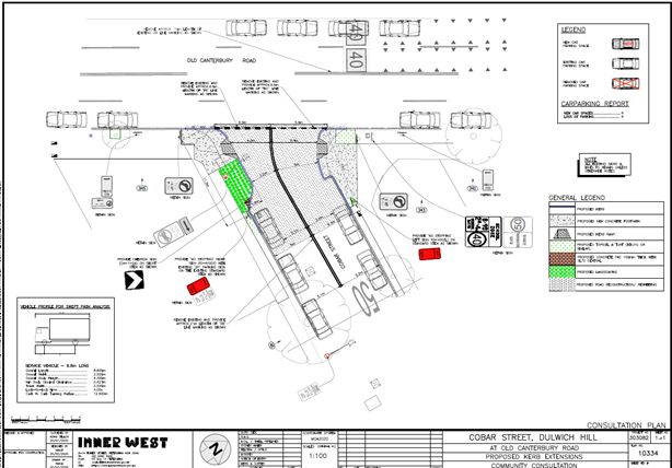
The community consultation plan was subsequently slightly amended by extending the kerb extension island on the northern side of Cobar Street, Dulwich Hill.
Amendments to Design Plan 10334A made are detailed and illustrated below:
· BB line shortened to avoid narrowing of the road near parked vehicles
· Kerb extension island on north side of Cobar Street extended into the existing ‘No Stopping’ zone to reinforce no stopping in this area and to provide a more substantial island for new proposed landscaping
· Truncate proposed new kerb for both kerb extensions approx. 200mm within the kerb alignment of Cobar Street (where it meets existing kerbs) so that no works are undertaken on the State Road (Old Canterbury Road)
Parking changes
The works are generally being undertaken within the statutory 10m No Stopping zone from an intersection. Therefore, the proposal will not result any loss of any existing legal on-street parking spaces in Cobar Street, except on a temporary basis to facilitate construction activities.
Streetlighting
The existing street lighting at the location is deemed adequate. Therefore, no changes are proposed to the existing street lighting due to the works.
Public Consultation
Consultation was conducted between 5 March 2025 and 21 March 2025. A letter along with a copy of the design plan was sent to residents / businesses in the immediate locality. A total of 44 letters were distributed. There were no responses.
FINANCIAL IMPLICATIONS
The project is listed on Council’s 2025/2026 PAMP Capital Program for construction and estimated cost is $50,000. Project number is 303082.
Conclusion
It is recommended that the detailed design plan of the proposed new kerb extensions and kerb ramps and associated signs and line markings be supported to improve road safety at this location.
|
1.⇩ |
303082-10334 - Amend A for LTC approval - Cobar St |
|
|
Local Traffic Committee Meeting 14 April 2025 |
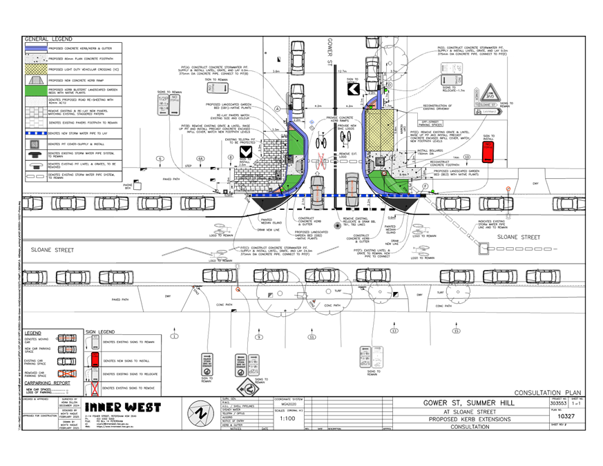
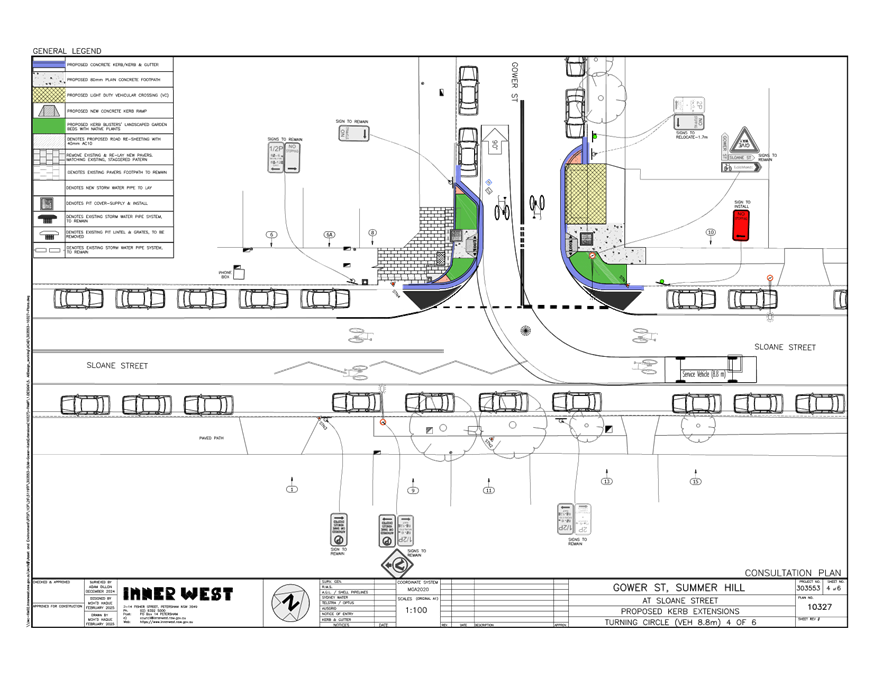
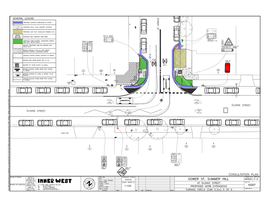
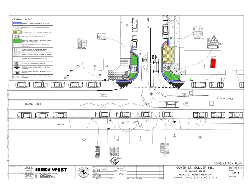
Subject: Gower Street, Summer Hill - Proposed Kerb Extensions(Djarrawunang-Ashfield Ward/Summer Hill Electorate/Burwood PAC.)
Prepared By: Boris Muha - Traffic Engineer
Authorised By: Manod Wickramasinghe - Traffic and Transport Planning Manager
|
RECOMMENDATION
That the detailed design plan (10327) for proposed new kerb extensions to the corners of Gower Street at Sloane Street, with associated pram ramps, signs, line marking, and drainage (as shown in Attachment 1) be approved.
|
STRATEGIC OBJECTIVE
This report supports the following strategic directions contained within Council’s Community Strategic Plan:
|
2: Liveable, connected neighbourhoods and transport |
|
|
EXECUTIVE SUMMARY
BACKGROUND
The proposed kerb extension road narrowing treatment is captured under the Pedestrian Access Mobility Plan (PAMP) 2020 to facilitate and improve pedestrian safety and similarly contribute to traffic calming/control of the area.
DISCUSSION
The following information is provided in discussion.
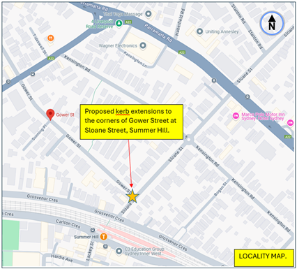
Figure 1. Locality Plan
|
Street Name |
Gower Street
|
|
Carriageway width (m) kerb to kerb |
12.8 |
|
Carriageway type |
Two-way, one travel lane each direction. |
|
Classification |
Local |
|
Speed Limit km/h |
50 and start of 40 kph High Pedestrian Activity to the east of the intersection. |
|
85th percentile speed km/h |
45.1 |
|
Vehicles per day (vpd) |
1500 |
|
TfNSW available reported crash history (last 5 years) |
NIL at or in vicinity of the intersection. |
|
Parking arrangements |
Unrestricted parking both sides |
|
Side intersecting street |
Sloane Street
|
|
Street Name |
Sloane Street (at Gower Street) |
|
Carriageway width (m) kerb to kerb |
12.8 |
|
Carriageway type |
Two-way, one travel lane each direction. |
|
Classification |
Local |
|
Speed Limit km/h |
50 and start of 40 kph High Pedestrian Activity to the north of the intersection. |
|
85th percentile speed km/h |
41.2 |
|
Vehicles per day (vpd) |
3000 |
|
TfNSW available reported crash history (last 5 years) |
NIL at or in vicinity of the intersection. |
|
Parking arrangements |
Unrestricted parking to both sides, |
|
Side intersecting street |
Gower Street. |
Table 1. Road Network detail.
The Plan
The following works are proposed and are illustrated on the attached plans in Attachment 1.
Gower Street (at Sloane Street), Summer Hill (Plan No. 10327):
· Reconstruction of two (2) existing stormwater pits,
· Removal of two (2) sets of existing pit’s EKIs and grates-changes existing pits as junction pits,
· Install two (2) new precast concrete encased infill pits’ covers,
· Construction of three (3) new stormwater pits and connect these pits to the exiting stormwater system by laying 375mm diameter of 25m length concrete pipes,
· Reconstruction of existing driveway with layback, extend driveway up to new kerb face,
· Create three (3) new garden beds with native plants,
· Construction of two (2) concrete kerb ramps, at each side of the Gower Street only,
· Realign existing kerb returns as needed to fit kerb extension/garden beds,
· Reconstruction of adjacent concrete footpaths as required to match existing footpath,
· Construction of new kerb and gutter along new kerb extension lines,
· Replacement and lay existing paved footpath adjacent to the south side of Gower Street, pavers size and colour will be matched,
· Install one (1) new ‘No Stopping’ signs and other signs shown in the attached plan,
· Install associated pavement line marking as required, refer to attached plan,
· Proposed to installation of two (2) yellow colour safety steel bollards, for pedestrian, to prevent against vehicles movement from the adjacent off-street parking spaces,
· Some area of road re-sheeting works will be carried out and will define later.
Due to kerb extensions, pedestrians’ walking distance will reduce from 12.8m to 8.4m.
Parking Changes
The proposal will not result any on-street parking spaces both in Gower Street and Sloane Street. Please refer to the attached plans.
Streetlighting
The preliminary investigation revealed that there is sufficient intensity of light due to the existing streetlights in the vicinity, therefore no additional streetlights have been proposed. Additional lights will result lighting spillages to the adjacent properties.
Other Information
The kerb extensions in this case are integrated into the footpath for improved street scape presence in the shopping centre of Summer Hill to the northside of the railway station. Drainage changes are involved with the proposed kerb extensions being integrated into the footpath.
The proposal improves pedestrian safety with pedestrians crossing over a shorter distance in the view of traffic. The proposal also calms and controls traffic moving around the intersection. The GIVE-WAY lines are moved out in line with the proposed painted islands on the Sloane Street corners of the intersection.
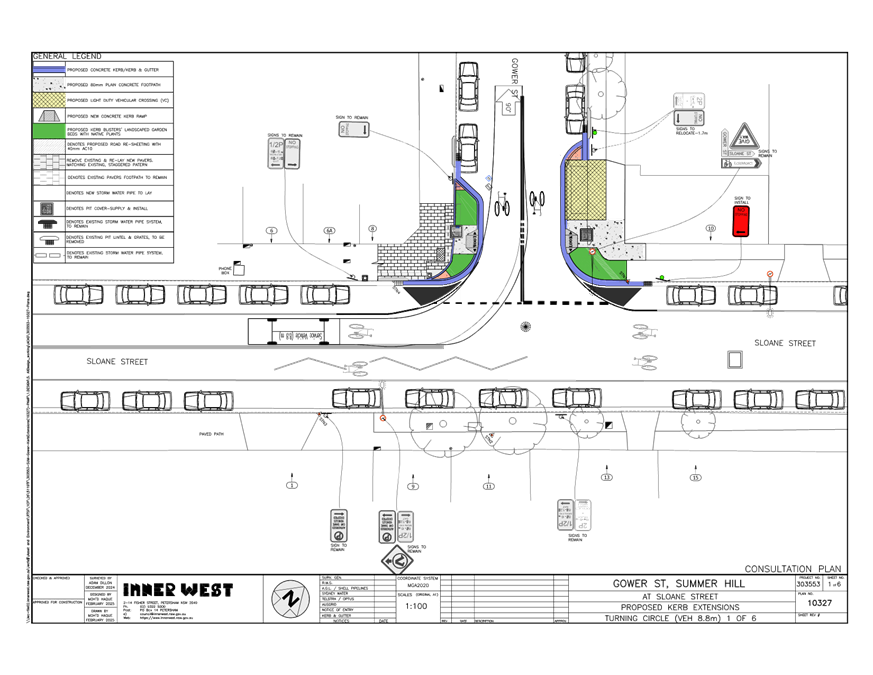
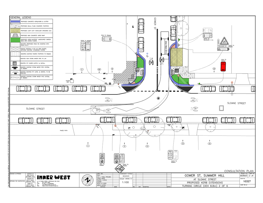
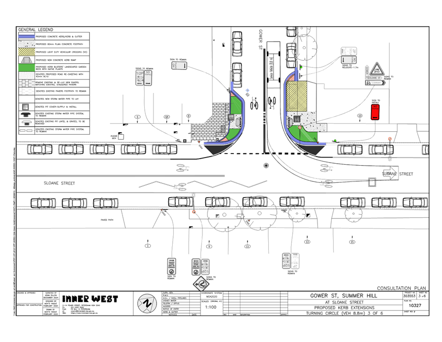
Various design vehicle turning paths are provided in Attachment 2.
Consultation
A letter outlining the proposal was mailed out to (11) properties (155 letters (inclusive of unit apartment residents and non-residing owners)) in Gower Street and Sloane Street, Summer Hill. (see also map of consultation area Figure 2).
Figure 2- Consultation Area - One (1) resident submission was received in support with concerns.
The resident concerns are tabled below together with the officer’s response.
|
Residents Comments |
Officers Response |
|
· Will the proposal improve the sightline for east-bound drivers on Gower Street? Currently, vehicles that park on the NW corner of Gower & Sloane Streets can impede the vision of these drivers of southbound traffic. This results in Gower St users edging forward into Sloane Street to confirm safe progress. Near misses with south bound Sloane Street traffic have occurred because of this.
· Will pavement marking reminding pedestrians to <look> be added in the design?
· Is the lighting of the proposed pedestrian accessway sufficient? The nearest street lamp appears to be some distance away on Sloane Street, and the nearest on Gower Street (north side) is obstructed by vegetation. With the new crossing location being set back from the intersection, this may result in pedestrians not being seen. It may be feasible to put a street lamp on the southern side of Gower Street.
|
· Sight Distance – The current proposal is to bring forward the give-way line by 2.2m, in line with the parked cars. This will improve the line of sight of vehicles coming out of Gower Street and the traffic in Sloane Street.
‘No stopping’ at the statutory distance of 10 metres is added on the northwestern corner of Sloane Street to prevent illegal parking (close to the intersection) and similar improve the line of sight of vehicle coming out of Gower Street.
· <LOOK> pavement marked wording has been added to the pram ramps in the design.
· The current lighting at this location is deemed sufficient.
|
Conclusion
In view of the above, it is recommended that the detailed design plan (10327) for proposed new kerb extensions to the corners of Gower Street at Sloane Street, with associated pram ramps, signs, line marking, and drainage (as shown in Attachment 1) be approved.
FINANCIAL IMPLICATIONS
|
1.⇩ |
Proposed kerb extensions in Gower Street at Sloane Street, Summer Hill. |
|
2.⇩ |
Various design vehicle turning paths (6 Sheets) |
|
Local Traffic Committee Meeting 14 April 2025 |
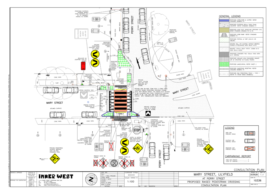
Subject: Mary Street, Lilyfield - Proposed Raised Pedestrian Crossing (Baludarri-Balmain Ward/Balmain Electorate/Leichhardt PAC
Prepared By: Sunny Jo - Coordinator Traffic Engineering Services North
Authorised By: Manod Wickramasinghe - Traffic and Transport Planning Manager
|
RECOMMENDATION
That the attached detailed design plan (No.10336) for the proposed new raised pedestrian crossing and kerb extension on Mary Street, Lilyfield at Perry Street be approved.
|
STRATEGIC OBJECTIVE
This report supports the following strategic directions contained within Council’s Community Strategic Plan:
|
2: Liveable, connected neighbourhoods and transport |
|
|
EXECUTIVE SUMMARY
Council is planning to improve safety for pedestrians in Mary Street, Lilyfield by constructing a new raised pedestrian crossing and kerb extensions in Mary Street at Perry Street. The proposal aims to improve pedestrian and motorist safety by formalising a pedestrian crossing point, improving pedestrian access to existing Bus Stop in Mary Street, and links to footpath to the Orange Grove Public School.
This project was identified as one of the priority projects in Council’s Capital Works program.
It is proposed to replace the existing raised threshold in Mary Street, Lilyfield and replace with a raised pedestrian crossing including landscaped kerb extensions near the crossing.
The proposed crossing will result in no loss of legal on-street parking.
BACKGROUND
The traffic and roadway features of Mary Street at Perry Street, Lilyfield is tabled below.
|
Street Name |
Mary Street Lilyfield |
|
Kerb to Kerb Width (m) |
10.3m |
|
Carriageway Type |
Two-way, one travel lane each direction |
|
Classification |
Local |
|
Speed Limit |
50km/h |
|
85th Percentile Speed |
40km/h |
|
Average Traffic Volume |
2,090 veh/day |
|
Available TfNSW recorded crash history last 5 years (2018-2023) |
No reported crashes near the intersection of Mary Street and Perry Street |
|
Parking Arrangements |
Parking permitted on both sides |
The matter was previously considered by the Traffic Committee on 15 July 2024, where the site conditions were assessed and met Council’s Pedestrian Count warrant.
The detailed design plan shown in Attachment 1 outlines the proposed works on Mary Street at Perry Street, Lilyfield and includes the following:
· Remove existing raised threshold and construct a 75mm height new raised concrete pedestrian crossing, including tactile indicators terracotta colour oxide platform, and 1.5m length ramps.
· Construct landscaped kerb blister islands on both sides of the road adjacent to the new raised pedestrian crossing. Landscaping to be suitable low height species.
· Construct new landscaped kerb extensions in Perry Street east of Mary Street providing suitable deflection for westbound pedestrians at its approach to the pedestrian crossing.
· Installation of Look stencils and yellow line at each pedestrian approach to the crossing.
· Install associated signage and line marking as required indicated on plan.
The new raised pedestrian crossing will require new lighting to satisfy the required lighting standards. This may involve up to two new flood lights provided on either side of the new raised pedestrian crossing (on existing or new power poles) and will be subject to a lighting and electrical design by a consultant.
DISCUSSION
letter outlining the above proposal was distributed to highlighted properties within the below map. At the closing date of the consultation, no submissions were received regarding the proposal.
FINANCIAL IMPLICATIONS
The works are estimated at $100,000 and are funded under Council’s 2025/26 Capital Works Program.
|
1.⇩ |
Mary Street, Lilyfield - Pedestrian Crossing Detailed Design Plan |
|
|
Local Traffic Committee Meeting 14 April 2025 |
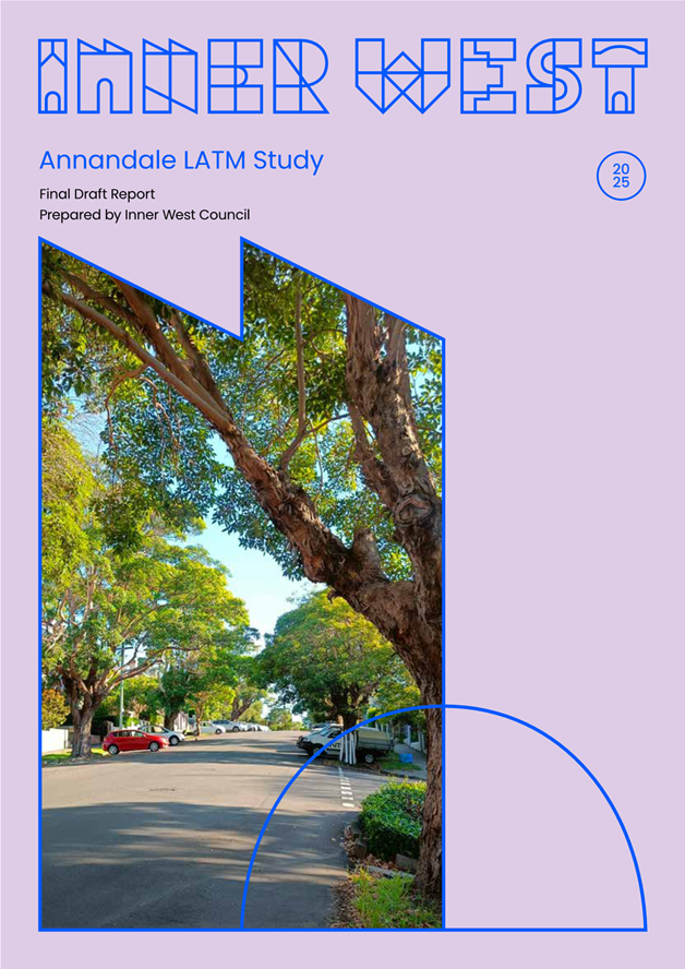
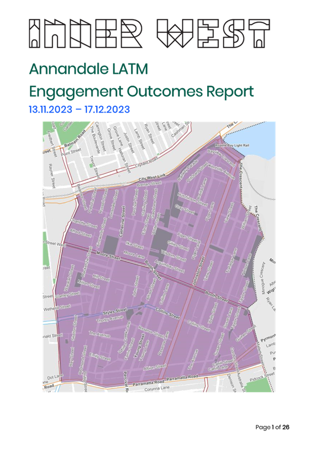
Subject: Final Draft Annandale LATM Study(Baludarri-Balmain Ward/Balmain Electorate/Leichhardt PAC)
Prepared By: Jason Scoufis - Coordinator Traffic Investigations and Road Safety
Authorised By: Manod Wickramasinghe - Traffic and Transport Planning Manager
|
RECOMMENDATION
1. That the final draft Annandale Local Area Traffic Management (LATM) Study be endorsed for community consultation.
2. The report be placed on Public Exhibition, providing a minimum 28 days for community feedback and the results be reported back to the Traffic Committee.
|
STRATEGIC OBJECTIVE
This report supports the following strategic directions contained within Council’s Community Strategic Plan:
|
2: Liveable, connected neighbourhoods and transport |
|
|
EXECUTIVE SUMMARY
Council has prepared the final draft Local Area Traffic Management (LATM) study to address key community concerns about traffic, pedestrian and cycling facilities in the Annandale LATM precinct area.
The recommendations aim to align with Council policies and strategies, with an emphasis on improving pedestrian and cyclist movements, whilst retaining safe and acceptable traffic volume and speeds in local streets.
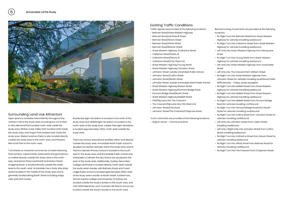
BACKGROUND
As part of Council’s Local Area Traffic Management (LATM) Strategy Review Program Council has prepared the final draft Annandale LATM study.
The study area is bounded by City West Link, Parramatta Road, Balmain Road, The Crescent, Johnstons Creek, Wigram Road and Mallett Street.
The final draft report is provided in Attachment 1 and the Engagement Outcomes Report is provided in Attachment 2.
In developing recommendations for the LATM Study, consideration was given to incorporate the following principals of Local Area Traffic Management:
· Reduction in vehicle speeds.
· Minimise traffic levels and intruding traffic in a local street.
· Minimise crash risk.
· Improve local amenity by:
o Reducing car use
o Increasing use of public transport
o Increasing walking and cycling
o Improving the streetscape
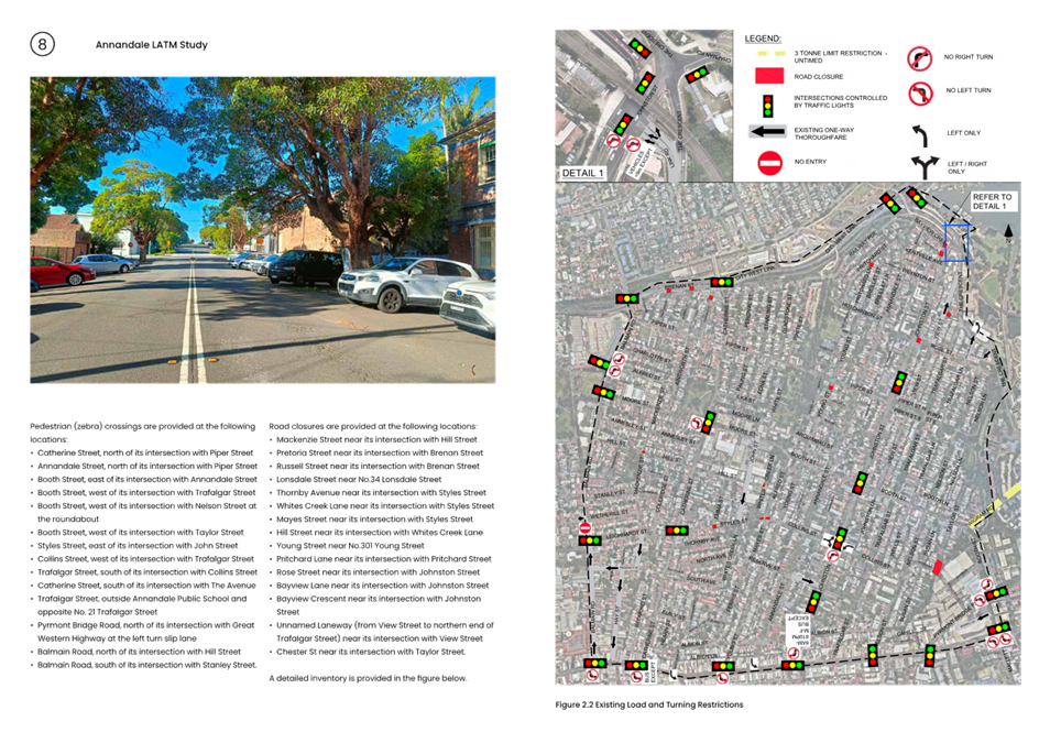
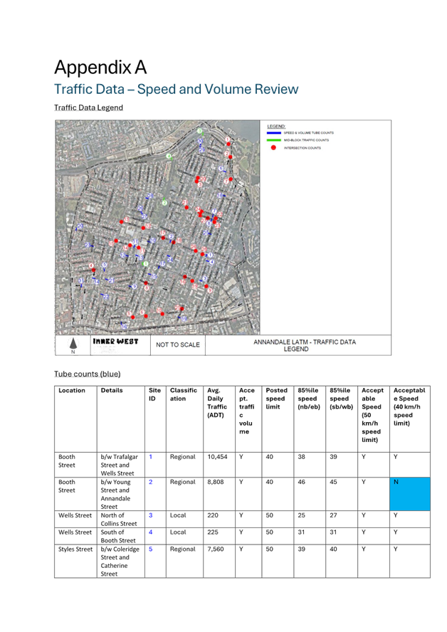
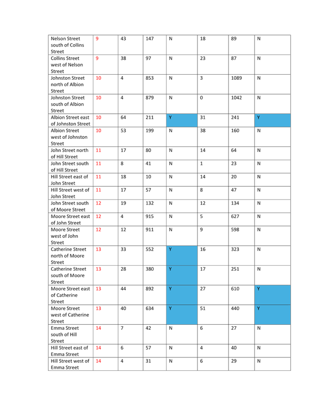
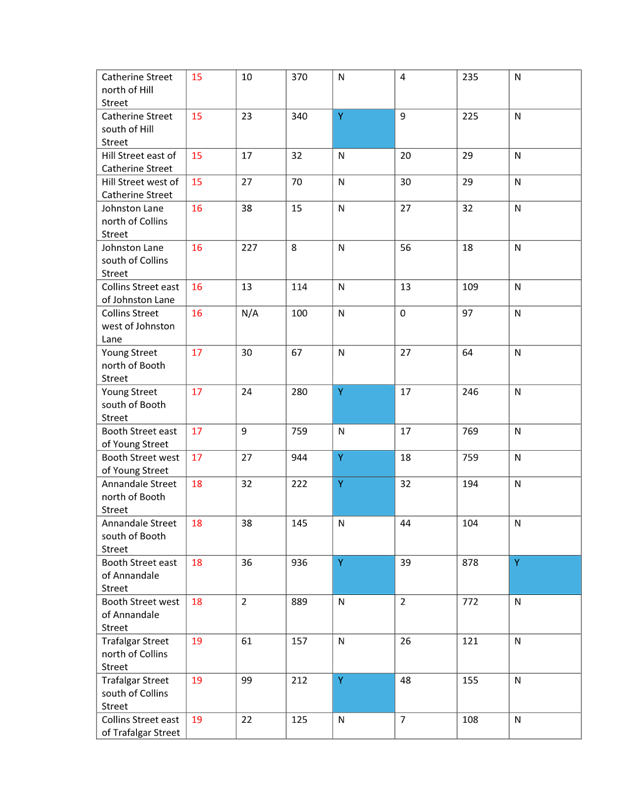
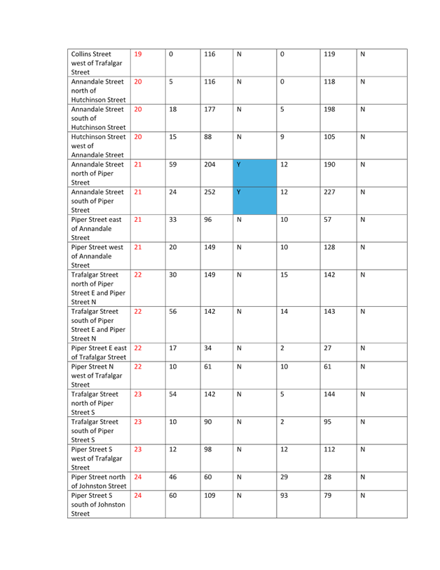
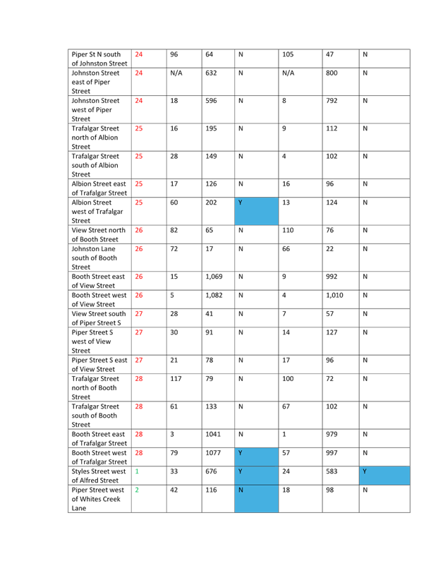
Traffic tube counts and intersection counts were collected, and crash history was reviewed to assist the study. Further site observations and review of community engagement outcomes also assisted to determine what type of facility was warranted in specific locations.
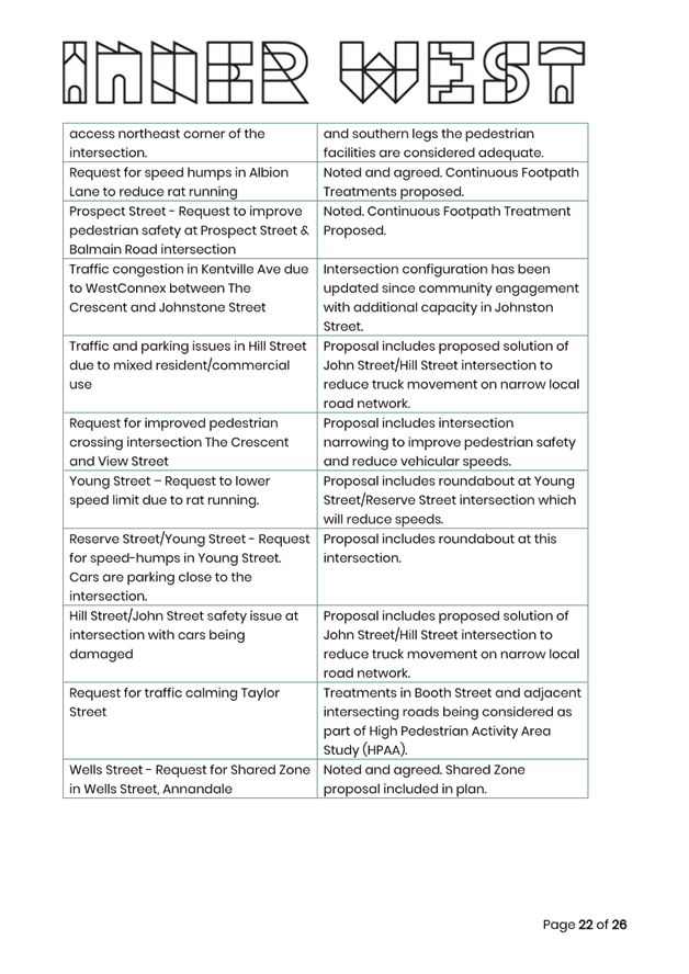
Booth Street
It should be noted that Booth Street and its intersections, has been separately assessed as part of the 40km/h High Pedestrian Activity areas (HPAAs) investigation report which was recently submitted to TfNSW for formal review. A number of proposed traffic calming and pedestrian improvements are included in the HPAA Study of Booth Street, and it includes a recommendation to extend the 40 km HPAA to Alfred Street and Alexandra Drive.
Hinsby Park Future Park Improvements
That as part of its development of a Local Area Traffic Management study for Annandale, Council include consideration of the traffic management engagement outcomes which have been highlighted in the report.
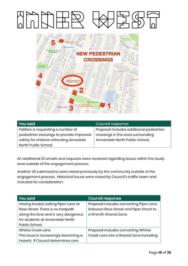
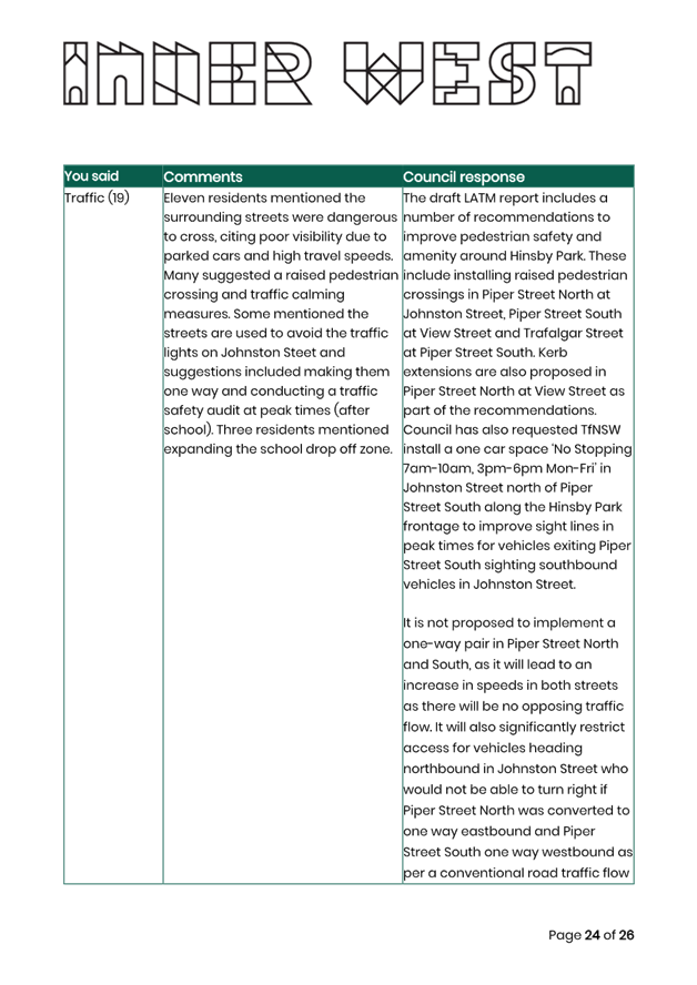
Key community issues which were raised during the engagement process for Hinsby Park which related specifically to traffic impacts included:
· Consideration for pedestrian crossing and/or traffic calming on Piper Street South and Piper Street North.
· Requests to make Piper Street South and Piper Street North a one way pair.
· Requests for a traffic safety audit with the need to undertake such a study in the immediate period when the school finishes (Annandale North Public School-3pm)
· Addressing boat and trailer parking in the area (loss of car parking spaces)
· Options and investigations for improving visibility crossing the road between the Park and the residential area (both sides of Piper Street North and South).
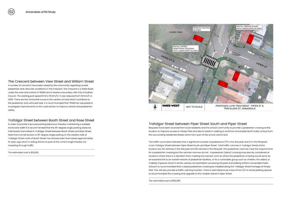
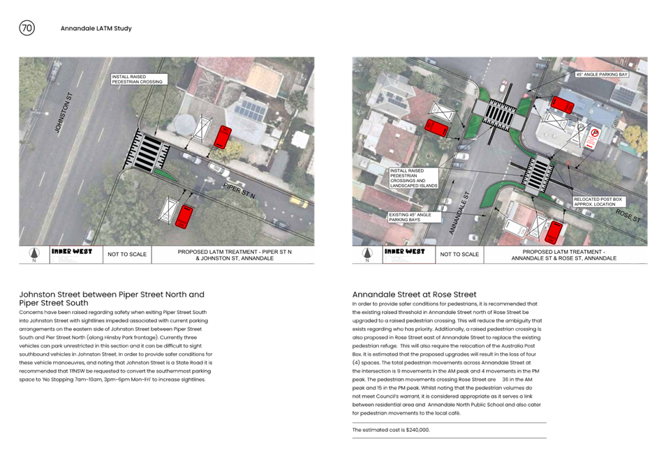
Regarding the above community issues, the draft LATM report includes a number of recommendations to improve pedestrian safety and amenity around Hinsby Park. These include installing raised pedestrian crossings in Piper Street North at Johnston Street, Piper Street South at View Street and Trafalgar Street at Piper Street South. Kerb extensions are also proposed in Piper Street North at View Street as part of the recommendations. Council has also requested TfNSW install a one car space ‘No Stopping 7am-10am, 3pm-6pm Mon-Fri’ in Johnston Street north of Piper Street South along the Hinsby Park frontage to improve sight lines in peak times for vehicles exiting Piper Street South sighting southbound vehicles in Johnston Street. These recommendations have taken into consideration observations by Council’s traffic engineers including during school finishing time at Annandale North Public School of 3pm.
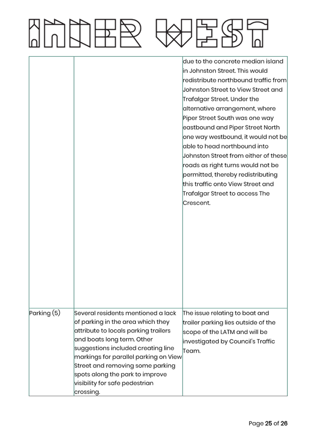
It is not proposed to implement a one way pair in Piper Street North and South, as it will lead to an increase in speeds in both streets as there will be no opposing traffic flow. It will also significantly restrict access for vehicles heading northbound in Johnston Street who would not be able to turn right if Piper Street North was converted to one way eastbound and Piper Street South one way westbound as per a conventional road traffic flow due to the concrete median island in Johnston Street. This would redistribute northbound traffic from Johnston Street to View Street and Trafalgar Street. Under the alternative arrangement, where Piper Street South was one way eastbound and Piper Street North one way westbound, it would not be able to head northbound into Johnston Street from either of these roads as right turns would not be permitted, thereby redistributing this traffic onto View Street and Trafalgar Street to access The Crescent.
The issue relating to boat and trailer parking lies outside of the scope of the LATM and will be investigated by Council’s Traffic Team.
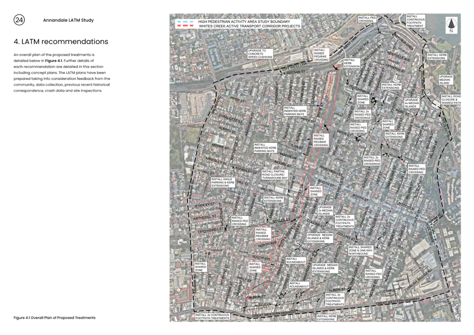
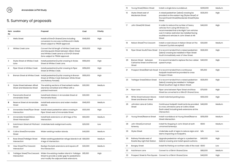
Summary of Recommendations
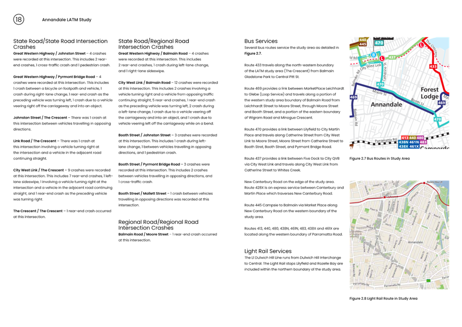
A summary of the recommendations is detailed below.
· Install a 10 km/h Shared Zone including conversion to one way northbound in Wells Street subject to TfNSW approval.
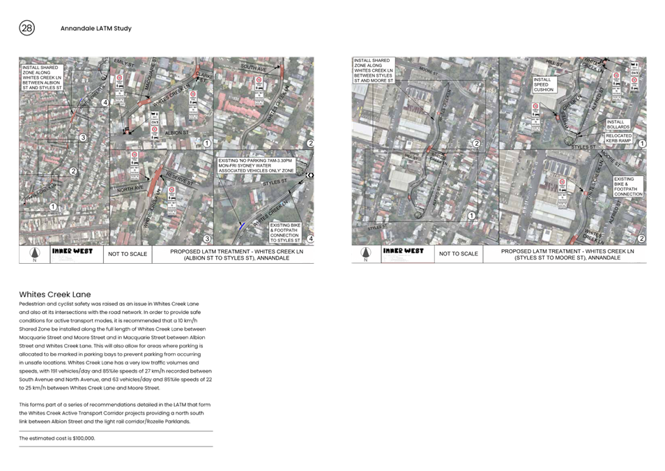
· Convert the full length of Whites Creek Lane and Macquarie Street between Albion Street and Whites Creek Lane to a 10 km/h Shared Zone subject to TfNSW approval.
· Install pedestrian/cyclist crossing in Styles Street at Whites Creek Lane.
· Install pedestrian/cyclist crossing in Piper Street at Whites Creek.
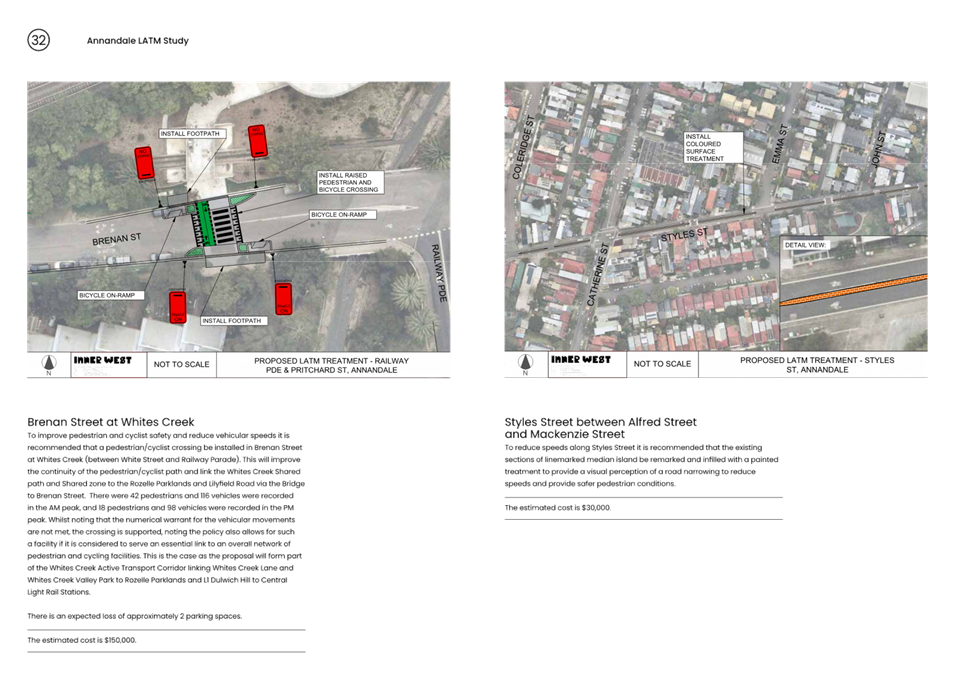
· Install pedestrian/cyclist crossing in Brenan Street at Whites Creek (between White Street and Railway Parade).
· The existing sections of linemarked median island in Styles Street between Alfred Street and Mackenzie Street be remarked and infilled with a painted treatment.
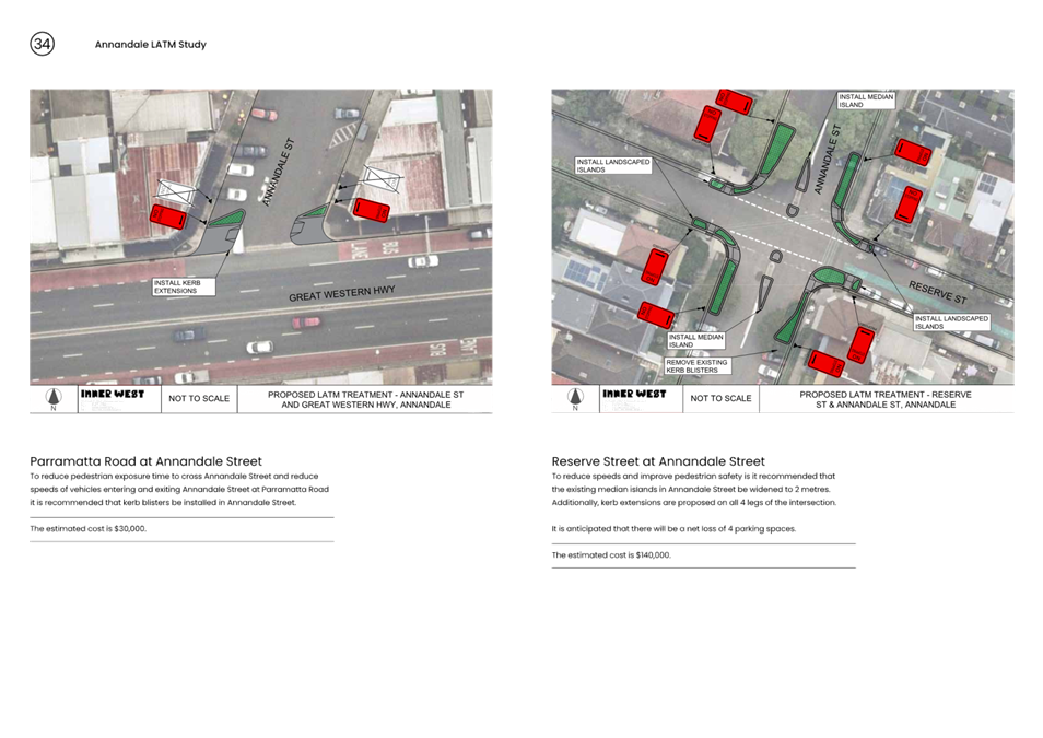
· Install kerb blisters in Annandale Street at Parramatta Road.
· Install kerb extensions and widen median islands in Reserve Street at Annandale Street.
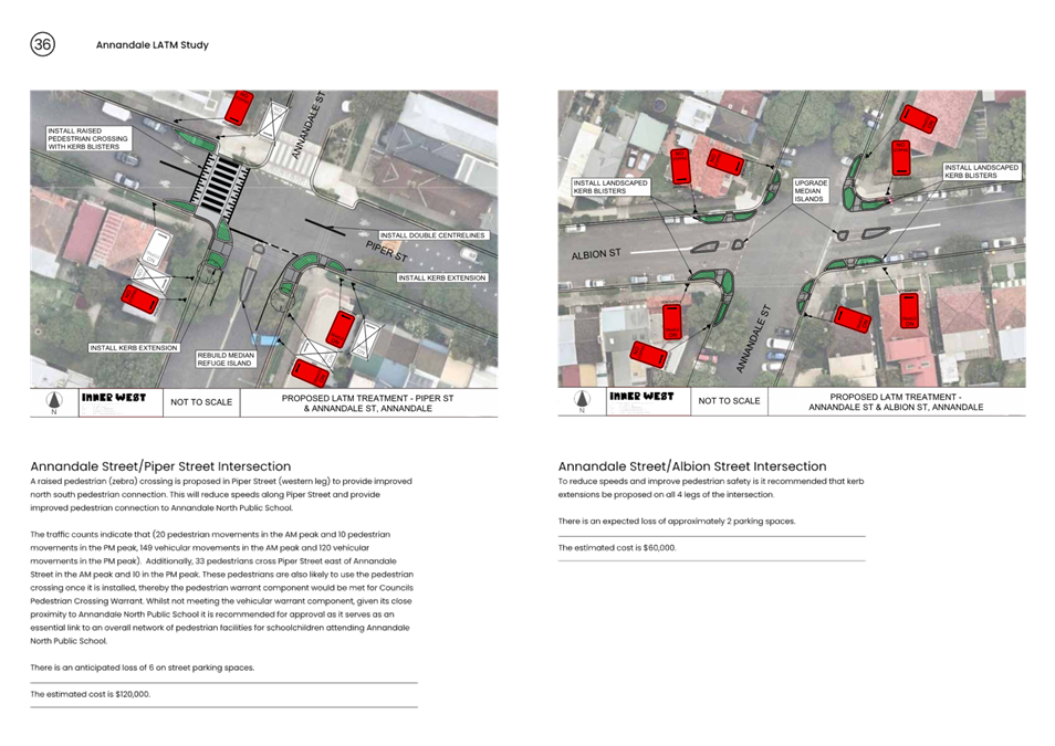
· Install raised pedestrian (zebra) crossing in Piper Street west of Annandale Street.
· Install kerb extensions on all 4 legs of the Annandale Street/Albion Street intersection.
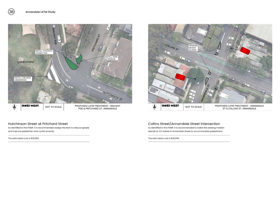
· Undertake kerb realignment works in Hutchinson Street at Pritchard Street.
· Widen existing median islands at the Collins Street/Annandale Street intersection.
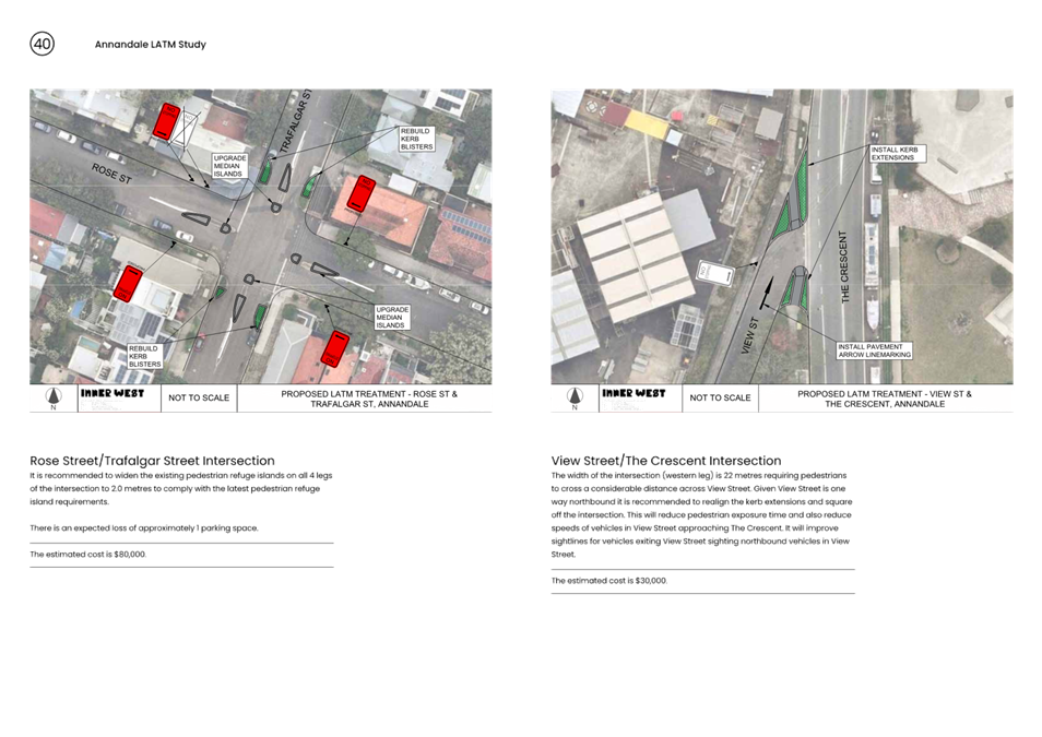
· Widen existing pedestrian refuge islands in all 4 legs of the Rose Street/Trafalgar Street intersection.
· Realign the kerb extensions and square off the View Street/The Crescent intersection.
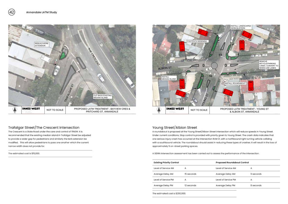
· Widen the existing median island in Trafalgar Street at The Crescent to provide a wider gap for pedestrians and modify the adjacent kerb extensions.
· Install a roundabout at Young Street/Albion Street.
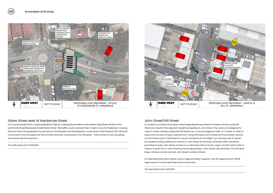
· A raised pedestrian (zebra) crossing be provided on the eastern leg (Styles Street) of the Leichhardt Street/Mackenzie Street/Styles Street intersection.
· A No Right Turn vehicles over 6 metres restriction be installed facing southbound vehicles in John Street at Hill Street.
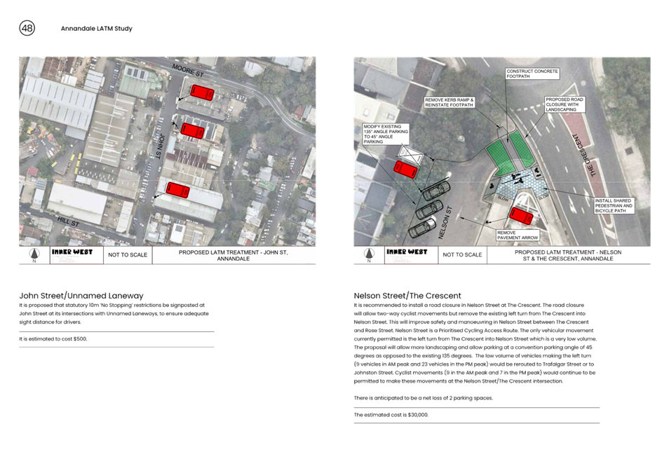
· Install a road closure in Nelson Street at The Crescent (cyclists excepted).
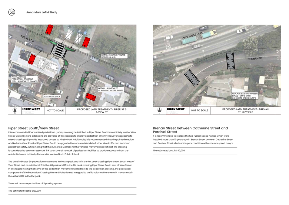
· Install a raised pedestrian (zebra) crossing in Piper Street South immediately west of View Street.
· Replace the two rubber speed humps in Brenan Street between Catherine Street and Percival Street.
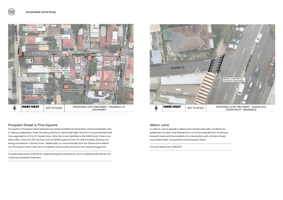
· Install a continuous footpath treatment to cross Prospect Street at Balmain Road.
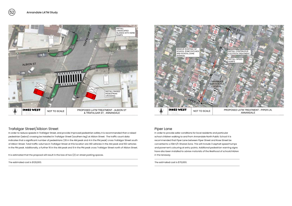
· Install a raised pedestrian (zebra) crossing in Trafalgar Street (southern leg) at Albion Street.
· Convert Piper Lane between Piper Street and Rose Street to a 10km/h Shared Zone subject to TfNSW approval.
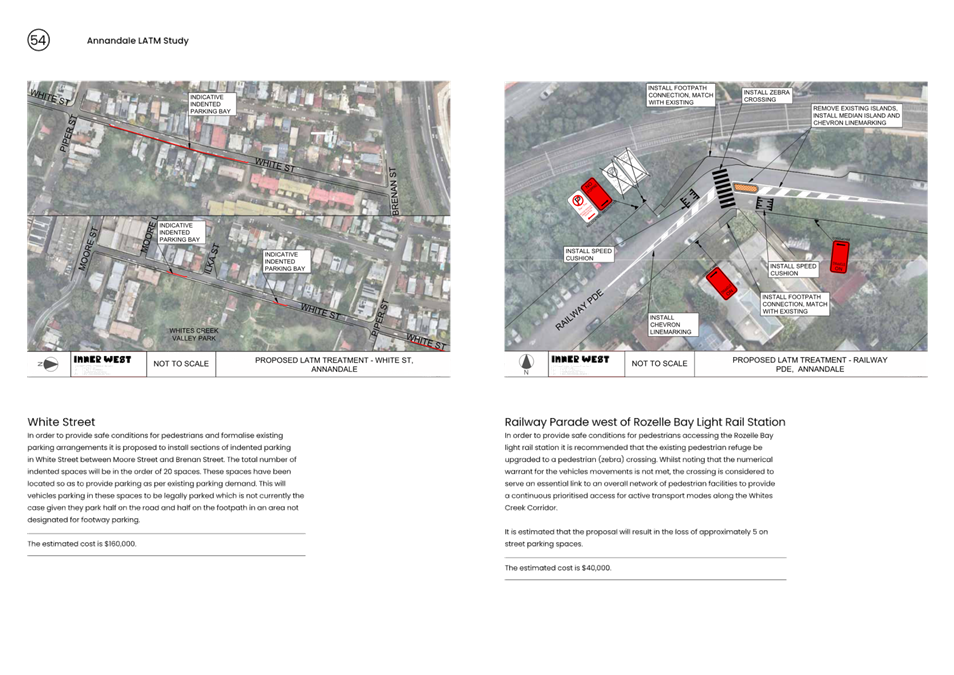
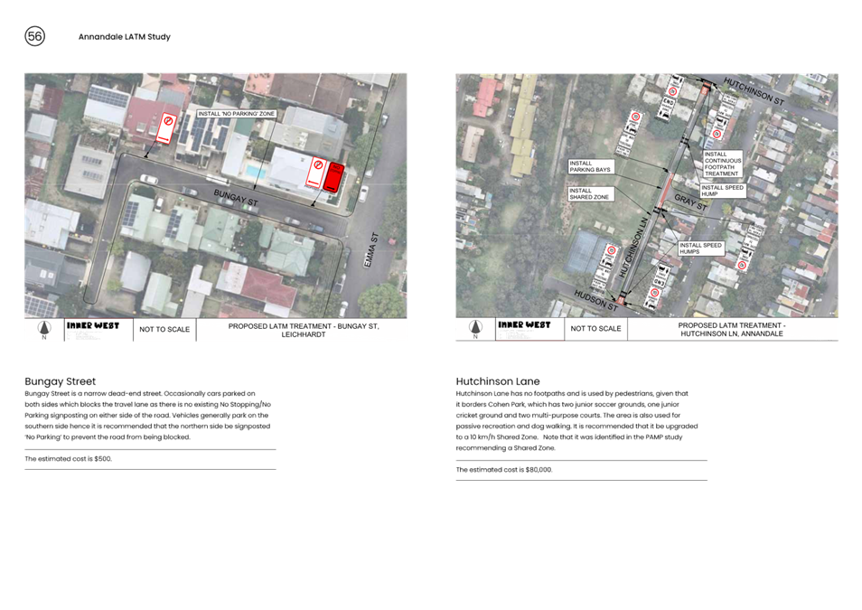
· Install indented parking bays in White Street between Moore Street and Brenan Street.
· Continuous footpath treatments be provided to cross Johnstons Lane at Collins Street (both sides) including kerb extensions at the intersection.
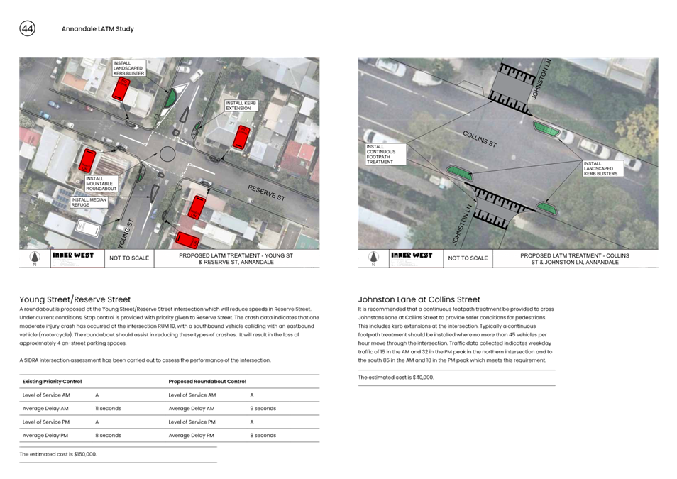
· Install a roundabout at Young Street/Reserve Street intersection.
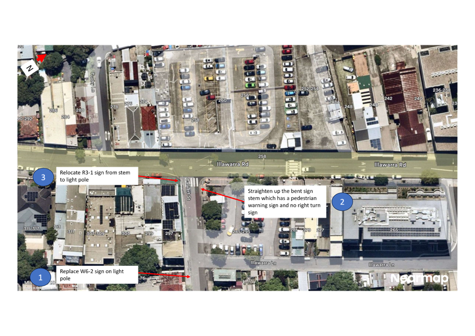
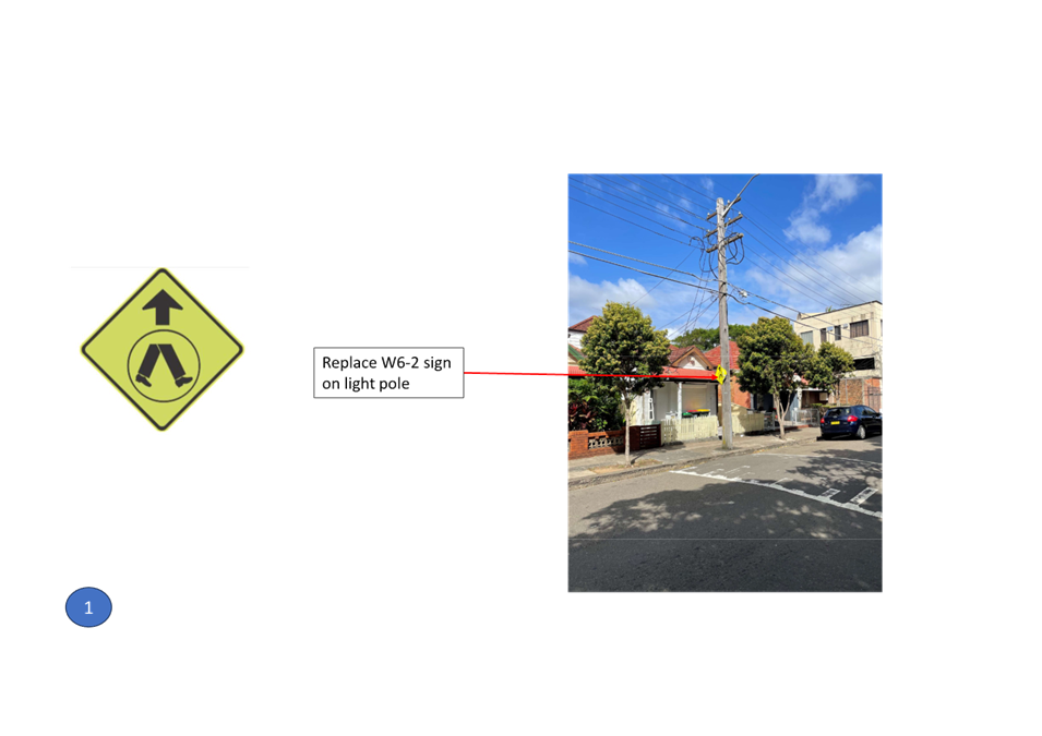
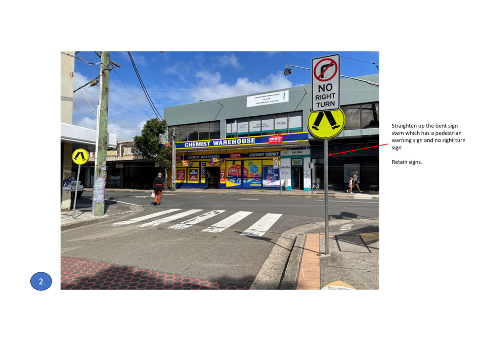
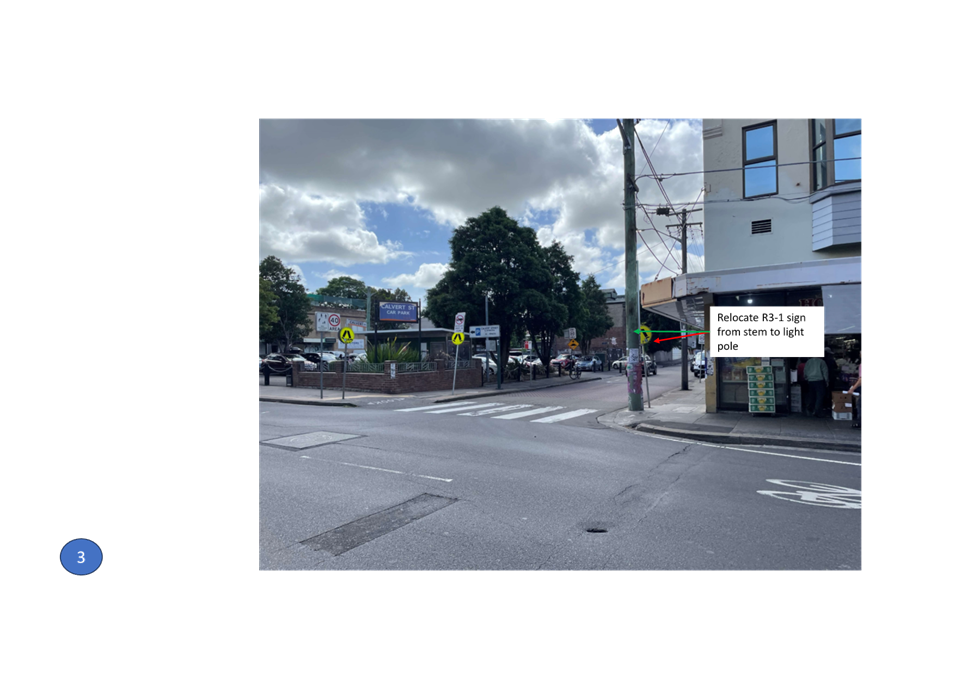
· Install No Stopping in John Street at both unnamed laneways.
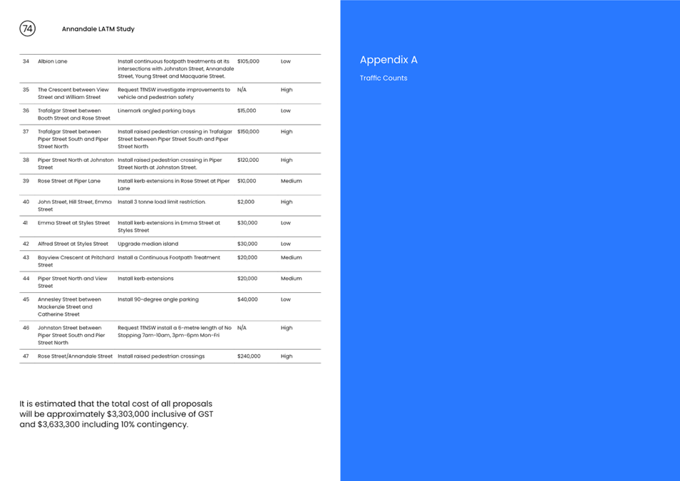
· Undertake audit of signs to reduce signs and stems impacting on footpaths in Styles Street.
· Upgrade pedestrian refuge to a pedestrian crossing in Railway Parade west of Rozelle Bay Light Rail Station including speed cushions.
· Install No Parking on northern side of Bungay Street.
· Convert Hutchinson Lane to a 10kmh Shared Zone.
· Convert Prospect Street & Pine Square to a 10kmh Shared Zone.
· Install continuous footpath treatments at Albion Lane intersections with Johnston Street, Annandale Street, Young Street and Macquarie Street.
· Request TfNSW investigate improvements to vehicle and pedestrian safety in The Crescent between View Street and William Street.
· Linemark angled parking bays in Trafalgar Street between Booth Street and Rose Street.
· Install raised pedestrian crossing in Trafalgar Street between Piper Street South and Piper Street North.
· Install raised pedestrian crossing in Piper Street North at Johnston Street.
· Install kerb extensions in Rose Street at Piper Lane.
· Install 3 tonne load limit restriction in John Street, Hill Street and Emma Street.
· Install kerb extensions in Emma Street at Styles Street.
· Upgrade median island in Alfred Street at Styles Street.
· Install a Continuous Footpath Treatment in Bayview Crescent at Pritchard Street.
· Install kerb extensions Piper Street North and View Street.
· Install 90-degree angle parking in Annesley Street between Mackenzie Street and Catherine Street.
· Request TfNSW install a 6-metre length of No Stopping 7am-10am, 3pm-6pm Mon-Fri.
· Install raised pedestrian crossings on the northern leg and eastern leg of the Rose Street/Annandale Street intersection.
Public Consultation
Council undertook a survey through Council’s Yoursay website with invitation letters mailed out to stakeholders and residents within the study area in November 2023. A total of 237 participants completed the online survey and made 581 contributions. A further 73 contributed via email. An additional 3 responses were received from key stakeholders and community groups and one petition was received.
The main outcomes of the first stage of consultation are that the problems identified by the greatest number of respondents are pedestrian safety issues, followed by driver behaviour and the third most raised issue was parking behaviour.
Regarding specific streets, The Crescent and Johnston Street (both State Roads) and Annadale Street have the highest level of concern for pedestrian safety. In terms of driver behaviour issues The Crescent (State Road) near Trafalgar Street and View Street is raised as Wells Street, Styles Street and Young Street. In relation to parking behaviour, Wells Street and Trafalgar Street have been raised as well as illegal parking outside of Annandale Public School.
The results of the consultation are included in the Engagement Outcome Report as provided in Appendix A of the Final Draft LATM Report.
FINANCIAL IMPLICATIONS
The cost of proposed treatments as listed in the draft proposed treatments arising from the Annandale LATM Study is estimated to cost approximately $3,633,300 (including GST). This cost takes into consideration 10% contingency. This includes a total of $2,312,200 (including GST and contingency) in High Priority Works. Once the LATM Study is adopted, detailed design and construction will be scheduled.
The recommendations will be addressed on a priority basis and matters requiring linemarking and signposting only will be funded through existing operational budgets. Capital works projects will need to prioritised within Council’s limited Traffic Facilities Budget competing with other traffic projects for funding. Some projects may also be submitted for various State government and Federal Government Funding opportunities.
|
1.⇩ |
Annandale LATM Final Draft Report |
|
2.⇩ |
Annandale LATM Appendix A Traffic Counts |
|
3.⇩ |
Annandale LATM Engagement Outcomes Report |
|
Local Traffic Committee Meeting 14 April 2025 |
Subject: Darling Street at Nelson Street, Rozelle- Proposed Kerb Extensions & Relocation of Mobility Parking (Baludarri-Balmain Ward/Balmain Electorate/Leichhardt PAC)
Prepared By: Charbel El Kazzi - Traffic Engineer
Authorised By: Manod Wickramasinghe - Traffic and Transport Planning Manager
|
RECOMMENDATION
That the attached detailed design plan (Design Plan No.10322) for the proposed relocation of a mobility parking space, kerb extensions and associated signposting and linemarking on Darling Street at Nelson Street, Rozelle be approved.
|
STRATEGIC OBJECTIVE
This report supports the following strategic directions contained within Council’s Community Strategic Plan:
|
2: Liveable, connected neighbourhoods and transport |
|
|
EXECUTIVE SUMMARY
Council is planning to improve safety by providing a new landscaped kerb extension and modify the existing accessible parking arrangements at the intersection of Darling Street and Nelson Street, Rozelle. The site is adjacent to the Hannaford Community Centre, which offers a range of welling and social activities for people 55 and over. The proposal aims to improve access to the Hannaford Centre and the surrounding retail shops, including road safety for pedestrians and motorists. This proposal was identified as one of the recommendations from the Rozelle North and Balmain Local Area Traffic Management (LATM) studies.
This proposal will result in the loss of approximately 3m length Motor bike Parking zone.
BACKGROUND
The detailed design plan shown in Attachment 1 outlines the proposed works on Darling Street at Nelson Street, Rozelle and includes the following:
· Remove existing Motor bike Parking zone and provide a new Accessible Parking space with a paved kerb ramp in front of 610 Darling Street.
· Modify existing parking arrangements at the Nelson Street frontage of Hannaford Community Centre, including reducing two existing accessible parking spaces to one and reinstate an additional 2P/4P Ticket space.
· Construct a new landscaped kerb extension in front of 610 Darling Street with new paved footpath and kerb ramp to reduce pedestrian crossing distance.
· Provide new pavement LOOK patches at the paved kerb ramp.
· Relocate existing kerb ramp in Nelson Street to new location near the Hannaford Community Centre.
· Provide Three (3) new bicycle racks in Darling Street, near the Hannaford Community Centre.
· Reconstruct a section of existing concrete roadway and a threshold concrete ramp.
· Install associated pavement line markings and signages as required.
The traffic and roadway features of Darling Street at Nelson Street, Rozelle is tabled below.
|
Street Name |
Darling Street |
|
Kerb to Kerb Width (m) |
12.6m |
|
Carriageway Type |
Two-way, one travel lane each direction. Bicycle logo mixed traffic arrangement. |
|
Classification |
Regional Road |
|
Speed Limit |
40km/h |
|
85th Percentile Speed |
35.3km/h |
|
Average Traffic Volume |
11,000 veh/day |
|
Available TfNSW recorded crash history last 5 years (2018-2023) |
2020 – RUM code 0 – Vehicle-Pedestrian - Minor injury – Darling Street at Nelson Street
|
|
Parking Arrangements |
Parking permitted on both sides |
DISCUSSION
A letter outlining the proposal was issued to the properties shown in the distribution map below. Two (2) submissions were received in response to this proposal with One (1) in support and One (1) against. The feedback is summarised within the below table.
|
Resident Concerns |
Officer Feedback |
|
The two existing disabled parking spaces on Nelson Street are underutilized. I never seen both spaces being used at the same time.
Keeping disabled parking on a quieter street like Nelson Street is safer for passengers getting in and out of vehicles compared to a busier street like Darling Street.
|
Feedback from previous Local Area Traffic Management studies indicate that these mobility parking spaces are in demand by visitors of the Hannaford Community Centre.
Due to the grade of the footpath in Nelson Street it was considered more desirable to relocate one of the mobility spaces to Darling Street, which will improve accessibility for mobility parking space users. The relocation will provide an additional space for permit holders in Nelson Street to park. |
|
There are only six general parking spaces along this section of Darling Street, which serve approximately 20 businesses (both upstairs and downstairs). They are concerned about the loss of parking and motorbike spaces, and do not support Council’s proposal that effectively removes a valuable parking space. The resident is requesting that Council to consider removing Bus zone which is within 100m in this area.
The proposed kerb extension at the intersection would prevent passenger drop-offs and make reverse parking more difficult, which could increase traffic congestion in the area.
|
The new arrangement will result in the reduction of the 6 on-street spaces by approximately 2.2m which would be adequate to support 6 vehicles, and as a result does not remove existing vehicular sparking supply. The proposal does remove approximately 3m length of Motor bike Parking zone.
The removal of a Bus Zone to increase parking is supply is not supported. The locations and placement of Bus Stops are determined by Transport for NSW, and any requests should be forwarded in writing. |
FINANCIAL IMPLICATIONS
The works are expected to cost approximately $56,000 and are to be funded under Council’s Capital Works Program.
|
1.⇩ |
Proposed Kerb Extension and Mobility Parking Relocation - Darling Street and Nelson Street, Rozelle |
|
|
Local Traffic Committee Meeting 14 April 2025 |
Subject: Allen Street, Leichhardt - Proposed Raised Pedestrian Crossing (Gulgadya-Leichhardt Ward/Summer Hill Electorate/Burwood PAC)
Prepared By: Amir Falamarzi - Traffic Engineer
Authorised By: Manod Wickramasinghe - Traffic and Transport Planning Manager
|
RECOMMENDATION
1. That the installation of a raised pedestrian crossing on Allen Street at Norton Street, Leichhardt be supported in-principle and included in Council’s Capital Works program subject to detailed design investigations and community consultation.
2. That the detailed design for the proposed raised pedestrian crossing be brought back to the Traffic Committee for consideration. |
STRATEGIC OBJECTIVE
This report supports the following strategic directions contained within Council’s Community Strategic Plan:
|
2: Liveable, connected neighbourhoods and transport |
|
|
EXECUTIVE SUMMARY
Council is planning to enhance pedestrian safety at the intersection of Allen Street and Norton Street by constructing a new Raised Pedestrian Crossing on Allen Street west of Norton Street with kerb blisters on both the approach and departure sides of the proposed crossing. The proposal aims to improve pedestrian accessibility along the Norton Street shopping area and improve safety for pedestrians and vehicle conflicts at this location.
BACKGROUND
At the Council meeting held on 26 November 2024, Council resolved the following:
That Council officers prepare a report, including identification of budget, at the next opportunity for the Traffic Committee to investigate a pedestrian crossing across Allen Street at the intersection of Allen Street and Norton Street, Leichhardt.
Council has undertaken a preliminary assessment for the provision of a Raised Pedestrian Crossing on Allen Street at Norton Street, Leichhardt.
DISCUSSION
The preliminary assessment included a review into the crash history, traffic count data, and previous safety concerns, including numerical warrants for installing a pedestrian crossing in accordance with Council’s Pedestrian Crossing Policy. A concept plan for a Raised Pedestrian Crossing to address traffic safety concern is provided in Attachment 1.
A review of the reported crash statistics from Transport for NSW for the 5 year period 2017-2021 indicates the following reported crashes:
|
Date |
Location |
Degree |
Road User Movement code Description |
|
June 2020 |
Allen St, on the spot of Norton St Leichhardt |
Injury Pedestrian involved |
0: Pedestrian near side |
|
January 2021 |
Allen St, on the spot of Norton St Leichhardt |
Injury |
37: Left turn sideswipe |
|
August 2022 |
Allen St west of Norton St Leichhardt |
Injury |
44: Parking vehicles |
The proposed pedestrian crossing is expected to address the reported one pedestrian injury accident. In addition, the average hourly pedestrian volume crossing Allen Street at the specified intersection exceeds 33 movements, indicating a high level of pedestrian activity at this location and appropriate being part of the Norton Street commercial area. With Norton Street having a 40km/h High Pedestrian Activity Area, it is expected that the proposed crossing will support pedestrian access to retail shops and bus stops on both Norton Street and Allen Street.
The width of Allen Street at its intersection with Norton Street is 13.6m, requiring pedestrians to cross two eastbound traffic lanes and one westbound traffic lane. This combined with the absence of a formalised pedestrian facility, poses a safety risk and increases the likelihood of collisions between pedestrians and vehicles.
Pedestrian and vehicle counts were conducted at the proposed location during the morning and afternoon peak periods on a school day in March 2025. A diagram showing the captured movements is illustrated in the diagram and tabled below:
|
Pedestrian and vehicle count Allen Street at Norton Street, Leichhardt |
||||
|
Date |
Time |
Pedestrian |
Bike |
Vehicle |
|
5 March 2024 |
13:00 – 14:00 |
33 |
1 |
265 |
|
9:00 – 10:00 |
51 |
8 |
225 |
|
Council’s new Pedestrian Crossing Warrant Policy states that for a pedestrian crossing to be warranted, in each of two separate one-hour periods on a typical day, the pedestrian flow per hour crossing the road must be at least 20, and vehicle volumes must be at least 200. Additionally, children, elderly individuals, and mobility-impaired pedestrians count as two pedestrians.
The traffic and pedestrian count conducted at the location indicated that the site meets the warrants for a pedestrian crossing.
A review was also undertaken on the existing bus route 445 movement, which operates between Campsie and Balmain, and routes through Allen Street and the subject intersection. Buses on this route travel from Campsie to Balmain via Allen Street, turning left onto northbound Norton Street, and vice versa. A vehicle swept path assessment was undertaken to ensure that bus movements do not conflict with the proposed kerb extension and crossing.
Additionally, bus movements at the intersection add to the complexity of the crossing for pedestrians. Observations indicate that buses currently turning from eastbound Allen Street to northbound Norton Street encroach into the opposite traffic direction to complete their turn, creating a potential traffic safety hazard.
Proposed treatment
A concept plan of the Raised Pedestrian Crossing across Allen Street west of Norton Street has been prepared as shown in Attachment 1 and features the following:
· A 75mm height raised pedestrian crossing with kerb blister islands on both approaches.
· Tactile ground surface indicators and landscaped kerb blister islands to prevent jaywalking.
· Painted median on Norton Street north of Allen Street to provide additional turning space for buses turning from Allen Street to Norton Street.
· Relocation of the existing Bus Zone 10m to the west and adjustments to the No Stopping zones. The length of the relocated Bus Zone will comply with the NSW Guidelines and is expected to remove approximately two (2) on-street parking spaces.
Additionally, the following considerations must be addressed:
· Existing manhole and communication pits in Allen Steet will be impacted and should be relocated or integrated with the crossing.
· The existing stormwater pit on northern side of Allen Street at the proposed location including will be relocated and redesigned to accommodate the new crossing design.
· Existing street tree adjacent to the Bus Stop in Allen Street may be impacted and may need to be relocated as part of this project.
· Additional street lighting at the proposed crossing will be considered and included in the project.
Community Engagement
Community consultation with the affected residents on Allen Street will be undertaken if the proposed plan is adopted by Council.
FINANCIAL IMPLICATIONS
The works are estimated to cost approximately $200,000 including modification to the existing stormwater assets and service relocation.
|
1.⇩ |
Proposed Raised Pedestrian Crossing |
|
|
Local Traffic Committee Meeting 14 April 2025 |
Subject: Myrtle Street, Leichhardt - Proposed 10km/H Shared Zone And Line-Marked Parking Bays (Gulgadya -Leichhardt/Balmain Electorate/ Leichhardt PAC)
Prepared By: Charbel El Kazzi - Traffic Engineer
Authorised By: Manod Wickramasinghe - Traffic and Transport Planning Manager
|
RECOMMENDATION
1. That the attached detailed design plan (No. 10311) for the Proposed 10km/h Shared Zone and associated linemarking and signage in Myrtle Street between Elswick and Ivory Street, Leichhardt be approved, subject to TfNSW approval of the reduced speed limit.
2. That a review be undertaken 6 months after the implementation of the 10km/h Shared Zone in Myrtle Street, Leichhardt.
|
STRATEGIC OBJECTIVE
This report supports the following strategic directions contained within Council’s Community Strategic Plan:
|
2: Liveable, connected neighbourhoods and transport |
|
|
EXECUTIVE SUMMARY
Council has prepared a detailed design plan for a 10 km/hr Shared Zone and marked footpath parking for Myrtle Street, Leichhardt (between Elswick Street and Ivory Street). The proposal aims to improve safety for pedestrians and motorists and was developed through previous community consultation to formalise parking on the footpath within marked parking bays, whilst maintaining a clear travel lane and improving pedestrian amenity.
BACKGROUND
Concerns were raised through a petition from residents of Myrtle Street regarding the current speed and volume of vehicles in the street. The issue was exacerbated due to the narrow width of the road and vehicles parking on the footpath on both sides of the street between Elswick Street and Ivory Street, resulting in pedestrians being forced on the road and creating a safety issue.
Subsequently Council undertook community engagement on a 10km/h Shared Zone and footpath parking scheme between Ivory Street and Elswick Street. The proposal was intended to legalise parking of vehicles partially on the footpath within marked bays while maintaining a clear travel lane and providing a 1.2m width for pedestrian amenity. The proposal also featured two sections with pavement surface treatment intended to reduce vehicle speeds.
Two options for Myrtle Street were proposed in January 2023 and was considered by the Local Traffic Committee on 20 March 2023. At the time, 21 responses were received with five (24%) in support of footpath parking bays, fourteen (67%) in support of a 10km/h Shared Zone and footpath parking. Two (2) responses were undecided/supporting neither option.
Council subsequently adopted Option 2, and the project was included in Council’s Capital Works program. A detailed design plan has now been prepared with the following works as illustrated on the attached plan:
· Provide new marked parking bays on footpath, except for in front of No.1 to 17 Myrtle Street (north Side) where new marked parking bays are at kerb side.
· Reconstruct existing sections of damaged concrete footpath with new concrete footpath.
· Provide new heritage red pavement surface and “10” patch at entry points into Myrtle Street from Ivory Street and Elswick Street.
· Provide new asphalt roadway with heritage red Duratherm street print in front of No. 16 Myrtle Street.
· Install associated pavement line markings and signage as shown in plan.
DISCUSSION
A letter outlining the detailed design was issued to the properties shown in the distribution map below. Four (4) submissions were received in response, with two (2) in support and two (2) objections. A summary of the comments with officer’s response is summarized within the below table.
|
Resident Concerns |
Officer Feedback |
|
Resident asks that parking bays in front of 19 and 19a Myrtle Street to not be on footpath but instead on roadway. |
Relocating the proposed footpath parking bays clear of the footpath will result in the road carriageway being less than 3.0m in width which will be inadequate for general vehicular traffic. The parking bays are generally 2.1m width and it may be possible for small vehicles or motorbikes to be parked within the parking bay and within the roadway. |
|
While a 10km/hr speed limit is a sensible measure, it relies solely on voluntary compliance rather than physical speed control. Our observations indicate that vehicles frequently exceed 60 to 70 km/hr, particularly at the section where Myrtle Street transitions from a wide road at Flood Street to a single lane from Ivory Lane to Elswick Street.
Without stringent enforcement against parking along boundary fences that block pedestrian access, Shared Zones will continue to force pedestrians onto the road. This results in frequent emergency braking and near-misses, predominantly involving children due to the proximity of the park.
|
Weekly speed counts data collected in Myrtle Street indicate no vehicles were captured travelling higher than 60km/h, with the 85th percentile speed being 39km/h. The implementation of a 10km/h Shared Zone is expected to reduce non-local traffic by reducing vehicle speeds and requiring drivers to give way and utilise existing driveways in order to pass opposing vehicles. Additionally, Council will undertake a review 6 months following the implementation and determine if additional measures are required.
The implementation of a 10km/h Shared Zone with footpath parking has been had a 67% support in the previous consultation in January 2023.
The intention of a Shared Zone is to have vehicles give way to pedestrians as separation in not feasible due to the narrow road environment, and require vehicle speeds to be limited to 10km/h. |
|
Establish a no-stopping or no-parking zone on one side of Myrtle Street. This would eliminate the need for extensive infrastructure work, requiring only the installation of appropriate signage.
Implement a two-hour parking limit for non-residents. This will reduce the volume of parked cars on either side of the road, creating safer spaces for both pedestrians and vehicles to pass each other.
|
There have been careful considerations of the street layout in the detailed design, and having parking removed on one side of the street will create a car-centric road environment which would not be suitable for ensuring pedestrian safety. This will also reduce available parking for the community.
Requests for a 2P resident parking scheme should be made separately to Council in writing. Investigation work on these can commence when multiple requests from the subject street is received. |
|
The road carries a significant volume of traffic, especially during peak hours which overlaps with peak pedestrian activity. The street is used as a rat tun to avoid traffic lights on both Marion Street and Parramatta Road. The width of the road reserve is only suitable for local traffic (or one way).
The existing streetscape encourages vehicles to accelerate and does not look like an area of pedestrian prioritisation over vehicles with the absence of street trees, planted verges etc and Large building setbacks to the southern side of street
The existing linemarking on the western portion of Myrtle Street (near ivory lane) funnels vehicles at speed. The double centre linemarking is not consistent with an area that prioritises pedestrians over cars, or an area where a driver should anticipate pedestrian to be occupying the street.
Elswick/Myrtle/Reuss St’s is the only 4-way intersection on Elswick Street or Flood Street that doesn’t have a roundabout or lights. This intersection also sits at the bottom of a hill in both directions. People dangerously run this intersection, especially from Reuss to Myrtle without stopping. Nothing in this plan addresses this safety issue.
|
Refer to above response.
The implementation of a one-way restriction will encourage higher vehicle speeds and a car-centric road environment as it won’t require vehicles to slow down and navigate approaching vehicles within the narrow street.
The Myrtle Street/Reuss Street intersection will be included in the 6 month post-implementation review of Myrtle Street.
The existing footpath width being 1.4m-1.6m is insufficient to include tree pits for street trees as a footpath width of 1.8m is typically required. Street tree planting would only be possible if on-street parking is removed.
|
FINANCIAL IMPLICATIONS
The project is estimated to cost $62,000 and is to be funded under Councils Capital Works program to be completed in the 2025/26 financial year.
|
1.⇩ |
Proposed 10 km/h Shared Zone and Footpath Parking Scheme - Myrtle Street Plan |
|
Local Traffic Committee Meeting 14 April 2025 |
Subject: Review of pedestrian crossings in various locations in Marrickville (Midjuburi-Marrickville Ward/Inner West PAC/Summer Hill Electorate)
Prepared By: James Nguyen - Traffic Engineer
Authorised By: Manod Wickramasinghe - Traffic and Transport Planning Manager
|
RECOMMENDATION
That the report be received and noted. |
STRATEGIC OBJECTIVE
This report supports the following strategic directions contained within Council’s Community Strategic Plan:
|
2: Liveable, connected neighbourhoods and transport |
|
|
EXECUTIVE SUMMARY
This report presents findings from investigations completed in response to the Notice of Motion (C0924(1) Item 40) raised at the Council meeting on 22 October 2024. This Notice of Motion raised concerns in relation to motorists speeding through the pedestrian crossings in the Marrickville Town Centre along Marrickville Road and Illawarra Road.
A site assessment has been completed to assess the existing condition of the at-grade pedestrian crossings and a works plan has been issued to address any deficiencies identified.
BACKGROUND AND DISCUSSION
A notice of motion (C0924(1) Item 40) was raised at the Council meeting on 22 October 2024 requesting for the assessment of three (3) pedestrian crossings in Marrickville at the following locations:
· Calvert Street at Illawarra Road;
· Marrickville Road at Despointes Street; and
· Marrickville Road at Frampton Avenue.
All pedestrian crossings of concern are located within the 40 km/h High Pedestrian Activity Area on Illawarra Road and Marrickville Road, and existing speeds are low within the Town Centre.
Marrickville Road at Despointes Street
The at-grade pedestrian crossing on Marrickville Road west of Despointes Street has been converted to a raised pedestrian crossing and was funded under the 2024/25 Australian Government Black Spot Program. Construction of the raised crossing was completed February 2025. Accordingly, the approach speed of eastbound vehicles on Marrickville Road are expected to be within the 40km/h speed limit or lower on approach to this pedestrian crossing. Linemarking and signage is good condition. Completed photos are shown below:
Calvert Street at Illawarra Road
The existing at-grade pedestrian crossing across Calvert Street at Illawarra Road is listed on the Inner West Council’s Pedestrian Access Mobility Plan (PAMP) to be converted to a raised pedestrian crossing. In addition, this location is also within the Marrickville Town Centre Master Plan which focuses on streetscape improvements. The existing Transport for NSW crash data for the last five (5) years at the respective locations do not meet the minimum crash criteria of three (3) crashes to warrant consideration for inclusion in a Australian Government Black Spot Program.
Council officers completed a site inspection to assess the condition of the existing pedestrian crossing. The results are presented in Table 1 below.
Table 1 -
Pedestrian crossing assessment - Calvert Street at Illawarra Road
|
Item |
Assessment (Good, Fair, Poor)
|
Comments |
Recommendation |
|
Sight lines
|
Fair
|
Narrow footpath and high wall. Large power pole obstructing sight lines |
· Replace existing advance warning signs · Note: Increasing footpath width or set back of property line not feasible |
|
Signage condition
|
Poor
|
Damaged warning (W6-2) sign, bent parking stem and obscured warning (R3-1) sign |
· Replace existing advance warning sign (W6-2) · Straighten bent stem for R3-1 sign · Relocate R3-1 sign |
|
Line marking condition |
Fair
|
Faded ‘LOOK’ logo and zebra line marking |
· Repaint ‘LOOK’ patch and zebra line marking |
Refer to Attachment 1 for actions to be undertaken to address the issues above.
Marrickville Road at Frampton Avenue
The existing at-grade pedestrian crossing across Marrickville Road, east of Frampton Avenue is listed on the Inner West Council’s Pedestrian Access Mobility Plan (PAMP) to be converted to a raised pedestrian crossing.
Council officers completed a site inspection to assess the condition of the existing pedestrian crossing. The results are presented in Table 2 below.
Table 2 - Pedestrian crossing assessment - Marrickville Road at Frampton Avenue
|
Item |
Assessment (Good, Fair, Poor) |
Comments |
Recommendation |
|
Sight lines
|
Fair |
Large tree on western approach reduces visibility of pedestrians ahead at the crossing
|
· Install additional W6-2 and R3-1 signs to provide additional warning of the pedestrian crossing
|
|
Signage condition
|
Good
|
Nil |
· No changes |
|
Line marking condition (Good, Okay, Poor) |
Fair |
Partially faded zebra line and missing ‘LOOK’ patch |
· Install new ‘LOOK’ patch and repaint faded zebra line marking
|
Refer to Attachment 2 for actions to be undertaken to address the issues above.
FINANCIAL IMPLICATIONS
The proposed signage and linemarking maintenance will be funded under Council’s existing operational budgets.
|
1.⇩ |
Calvert Street at Illawarra Road - Works Plan |
|
2.⇩ |
Marrickville Road at Frampton Avenue - Works Plan |
|
|
Local Traffic Committee Meeting 14 April 2025 |
Subject: Elizabeth Street, Rozelle - Proposed 'No Stopping' Zone (Baludarri-Balmain Ward/Balmain Electorate/Leichhardt PAC)
Prepared By: Jackie Ng - Graduate Traffic Engineer
Authorised By: Manod Wickramasinghe - Traffic and Transport Planning Manager
|
RECOMMENDATION
That the proposed 10m ‘No Stopping’ zone at the corner of Elizabeth Street and Catherine Street, Rozelle be approved.
|
STRATEGIC OBJECTIVE
This report supports the following strategic directions contained within Council’s Community Strategic Plan:
|
2: Liveable, connected neighbourhoods and transport |
|
|
EXECUTIVE SUMMARY
Council has received concerns regarding parked vehicles near the intersection of Elizabeth Street and Catherine Street, Rozelle causing damage to property and impacting vehicle accessibility. It is proposed that a 10m ‘No Stopping’ zone is installed at the corner of this intersection to prevent damage to the adjacent property and improve vehicle accessibility.
BACKGROUND
Council has received concerns regarding parked vehicles near the intersection of Elizabeth Street and Catherine Street, Rozelle causing damage to property and obstructing vehicular accessibility along the road.
Elizabeth Street currently allows for on-street parking on the southern side and features unrestricted and unformalized footpath parking on the northern side. The local streets surrounding Elizabeth Street have a 2P Resident Parking Scheme in place, which has been established due to its close proximity to nearby shops and restaurants. The subject corner property does not feature a site fence on its side frontage and is built to the property boundary.
A description of the Elizabeth Street parking and road layout is shown in Figure 1.
Figure 1 – Elizabeth Street, Rozelle Road layout
DISCUSSION
As the area experience high demand of on-street parking during both daytime and evening, the occurrence of vehicles parked on both sides of Elizabeth Street is common, including vehicles partially parked on the footpath and very close to the property wall. In such a scenario this often results in 2.6m and less road width for vehicular passage and emergency vehicles. Resident concern included damage to the property wall when drivers attempt to park close to the property boundary and when leaving the parking space. It was observed that even with regular sized vehicles parked very close to the subject property, this resulted in inadequate space for passing.
A consultation letter proposing a 10m length ‘No Stopping’ zone was sent out to nineteen (19) surrounding properties. At the time of this report, seven (7) submissions were received, with one (1) submission in support, and six (6) submissions opposing the proposal.
Comments and feedback from residents regarding the proposal can be seen in the table below.
|
Resident Comments |
Officer response |
|
Loss of Parking Parking is already limited due to the proximity of Totti’s and the recent removal of parking along the northern side of Charlotte Street. Introducing the ‘No Stopping’ restriction will significantly impact parking availability in the area.
|
Council understands the parking pressures created by the proximity of nearby retail and restaurants. The subject parking space adjacent to the corner property does not allow for suitable road width for vehicular passage.
The north side of Charlotte Street has historically been a ‘No Parking’ zone and some signs have been reinstated to reinforce this restriction. |
|
Sufficient Safety The corner of Elizabeth Street and Catherine Street is already safe with sufficient visibility. Vehicles turning left into Elizabeth Street essentially approach the corner form the middle/right hand side of Catherine Street. Vehicles travel at very low speeds and due to the narrowness of the streets, cause for safety concerns are negligible.
|
Elizabeth Street does not have sufficient road width to accommodate parking on both sides and allow passing concurrently. Part of the reason to restrict parking is to protect the property by restricting parking by signage. Although the road is a low speed environment, parking near the intersection of Elizabeth Street increases the risk of a crash. |
Having considered the above, it is recommended that a 10m ‘No Stopping’ zone be installed at the north side of Elizabeth Street, Rozelle east of Catherine Street.
FINANCIAL IMPLICATIONS
The cost of installation of new restriction as recommended can be funded within Council’s signs and line marking budget.
|
1.⇩ |
Elizabeth Street, Rozelle - Proposed No Stopping Zone |
|
Local Traffic Committee Meeting 14 April 2025 |
Subject: Catherine Street, Leichhardt - Proposed 'No Stopping' Zone (Gulgadya-Leichhardt Ward/Balmain Electorate/Leichhardt PAC)
Prepared By: Jackie Ng - Graduate Traffic Engineer
Authorised By: Manod Wickramasinghe - Traffic and Transport Planning Manager
|
RECOMMENDATION
That the requested 7m ‘No Stopping’ zone adjacent the driveway for No.233 Catherine Street, Leichhardt not be supported. |
STRATEGIC OBJECTIVE
This report supports the following strategic directions contained within Council’s Community Strategic Plan:
|
2: Liveable, connected neighbourhoods and transport |
|
|
EXECUTIVE SUMMARY
This report outlines the consultation undertaken for a 7m length ‘No Stopping’ zone adjacent to the driveway of No.233 Catherine Street, Leichhardt. Fire and Rescue NSW (FRNSW) has identified that the on-site 150mm large bore suction was installed in a position that does not facilitate fire brigade pumping appliance access and recommended that a hardstand 9.5m No Stopping zone be installed. Consultation was undertaken on a 7m No Stopping Zone, and due to concern received regarding loss of on-street parking, it is recommended that the 7m No Stopping zone on Catherine Street not be supported.
BACKGROUND
The developers of No.233 Catherine Street, Leichhardt, has made an application to Council for the installation of a 9.5m length No Stopping zone adjacent to the driveway to facilitate fire brigade pumping appliance access in emergency situations.
It is advised that due to design requirements of the project, a large bore suction connection is required at the booster and can only be connected by means of a rigid hose which cannot be maneuverer like a traditional hose.
A fire safety inspection conducted by FRNSW has identified that the 150mm large bore suction was installed in a position that does not facilitate fire brigade pumping appliance access due to the current parking arrangement on Catherine Street. The recommendation provided by FRNSW was that a hardstand area should be clearly defined and designated as a signposted ‘No Parking’ or ‘No Stopping’ zone.
The diagram below from the applicant show that the sprinkler staging area for the FRNSW trucks can be positioned with a 7m No Stopping zone, accordingly a 7m No Stopping zone was used in the community consultation.
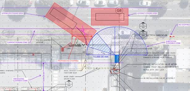
DISCUSSION
A total of fourteen (14) letters were sent out to surrounding businesses and residents in consultation on a proposed 7m No Stopping zone at the subject location. One (1) objection was received expressing that on-street parking should not be limited by the development and should have been considered in the development proposal. Additionally, residents have already been affected by construction and should not be further penalized by poor planning, thus, on-site parking should be sacrificed for this purpose.
Having considered the concerns regarding loss of on-street parking, it is recommended that the proposed 7m No Stopping zone not be supported. Council has been advised that the development has provided 9 additional spaces on-site, more than the required minimum and has effectively reinstated approximately two spaces with disused driveways being reinstated back to kerb and gutter, increasing parking supply.
It is considered that appropriate modifications should be made to the development so that there is no loss of public on-street parking.
FINANCIAL IMPLICATIONS
There are no financial implications associated with the implementation of the proposed recommendations outlined in the report.
Nil.
|
|
Local Traffic Committee Meeting 14 April 2025 |
Subject: Empire Street, Haberfield - Proposed Landscaped Island (Galgadya-Leichhardt Ward/Summer Hill Electorate/Burwood PAC)
Prepared By: Sunny Jo - Coordinator Traffic Engineering Services North
Authorised By: Manod Wickramasinghe - Traffic and Transport Planning Manager
|
RECOMMENDATION
That the proposed landscaped island between the driveway of No.24 and No.26 Empire Street, Haberfield as shown in the attached concept plan be approved.
|
STRATEGIC OBJECTIVE
This report supports the following strategic directions contained within Council’s Community Strategic Plan:
|
2: Liveable, connected neighbourhoods and transport |
|
|
EXECUTIVE SUMMARY
A review has been undertaken regarding the obstructed driveway access from parking of vehicles between the driveways of No.24 and 26 Empire Street, Haberfield, which was previously considered at the Local Traffic Committee meeting on 9 December 2024.
At this meeting, a ‘Motor Bike Parking’ zone proposal was deferred by the Traffic Committee to allow officers to undertake investigation into other options.
After liaison with nearby residents, it is proposed to construct a narrow strip (2m x 1m) landscaped island between the two driveways to deter parked vehicles from encroaching on the driveway of No.26 Empire Street.
BACKGROUND
Council had received several reports of blocked driveway access for property No.26 Empire Street, Haberfield. Initially, Council advised the resident to install driveway delineation linemarking to alleviate the issue. However, the resident has reported that the issue has persisted after the installation of the lines.
The resident has also highlighted that the site is located adjacent to Algie Park, there are increased demand of parking from sporting events. This has led to increased occurrence of vehicles parking at this location. Photos of vehicles partially and completely obstructing the driveway of No.26 has been provided to Council.
This item was presented at the Local Traffic Committee meeting held on 9 December 2024 and considered a proposed ‘Motor Bike Parking’ zone in the 3.9m length kerbspace between the two driveways of No.24 and No.26 Empire Street, Haberfield.
The proposal was developed in order to prevent the occurrence of vehicles partially obstructing driveway access. The adopted recommendation from the Committee was as follows:
That the proposed 4m length ‘Motor Bike Parking’ zone between the driveway of No.24 and No.26 Empire Street, Haberfield be deferred for officers to undertake investigation into other options.
Council officers have subsequently been reviewing the matter including liaison with the residents of No.24 and No.26 Empire Street.
DISCUSSION
Measurements taken onsite indicate the kerbspace between the driveways of No.24 and No.26 Empire Street is 3.9m in length (as measured between the driveway wings) which is insufficient for a standard sized vehicle.
Further discussions with nearby residents have indicated mixed views regarding the use of this kerbspace and the degree to which non-compliant parking is observed.
The following comments from residents are noted.
· Residents concerned by the parking:
o Vehicles partially obstructing either driveway is common during events and field bookings at the adjacent Algie Park
o Vehicles obstructing parked between the driveway can prevent ingress and egress from the driveway, particularly when undertaken by a larger vehicle. This is particularly concerning when access is required in an emergency.
o Sightlines when exiting the driveway are compromised by the parking of large cars
· Residents opposed to removal of parking:
o Vehicles are not often parked in this location and there is not a parking problem
o Small cars can fit between the driveways without impacting access
o Motorbike parking zone or any options resulting in the loss of parking space between the two driveways is not supported
Noting the above comments. It is proposed to introduce a 2m width by 1m landscaped traffic island between the two driveways, positioned immediately south of the driveway of No.26 Empire Street.
With appropriate planting, the proposal would prevent vehicles overhanging the driveway of No.26 Empire Street and gives flexibility for motorbike parking in future if necessary.
A concept plan of the proposal is attached.
The concept plan has been provided to the directly impacted residents and any comments will be tabled at the Traffic Committee meeting.
FINANCIAL IMPLICATIONS
The construction of the traffic island would be funded from existing operational budgets.
|
1.⇩ |
Empire Street, Haberfield Proposed Landscaped Island Plan |
|
Local Traffic Committee Meeting 14 April 2025 |
Subject: Easter Street, Leichhardt - Proposed Parking Changes (Gulgadya-Leichhardt/Balmain Electorate/ Leichhardt PAC)
Prepared By: Charbel El Kazzi - Traffic Engineer
Authorised By: Manod Wickramasinghe - Traffic and Transport Planning Manager
|
RECOMMENDATION
That the proposed parking changes in Easter Street between National Street and Flood Street, Leichhardt as shown within the attached plan be not supported due to concerns received from residents.
|
STRATEGIC OBJECTIVE
This report supports the following strategic directions contained within Council’s Community Strategic Plan:
|
2: Liveable, connected neighbourhoods and transport |
|
|
EXECUTIVE SUMMARY
Council has received several concerns from businesses along Parramatta Road regarding the lack of on-street parking and the impact of the existing ‘No Parking’ zone in Easter Street on business operations. It is also understood that consistent illegal parking behaviour in Easter Street has prevented vehicular access to some residential properties along Easter Street.
In response, Council has investigated reinstating sections of permissible on-street parking spaces in Easter Street between Flood Street and National Street, Leichhardt. These spaces would not prevent vehicular access to all properties on Albert Street, Leichhardt.
BACKGROUND
Easter Street is a laneway providing separation between the commercial and industrial areas of Parramatta Road with residential properties to the north of the laneway. Easter Street between National Street and Flood Street has a No Parking area restriction with a one-way westbound restriction.
The northern side of Easter Street has several rear garage accesses for properties on Albert Street, with the southern side of Easter Street having rear access for a number of businesses on Parramatta Road. Leichhardt Council established a No Parking area restriction to maintain vehicular access for Albert Street residents.
Council officers met with Parramatta Road business owners on 28 May 2024 and discussed concerns on the impact of the existing ‘No Parking’ area restriction in Easter Street, Leichhardt on business operations.
An investigation was undertaken to consider reinstating several legal on-street parking in Easter Street. A turning path analysis was conducted and was determined that approximately 10m length of kerb space could be reinstated on the south side of Easter Street near the intersection of National Street and approximately 9.8m on the south side of Easter Street between property No.617-619 and 611-615 Parramatta Road as shown in the attached plan.
DISCUSSION
A consultation letter was issued to affected properties with the proposed changes distributed on 17 September 2024, closing on 18 October 2024. At the time of this report, the level of support is tabled below:
|
Easter Street Parking Proposal |
|
|
Yes |
4 (28.5%) |
|
Yes, on the condition that Council can guarantee increased enforcement |
2 (14.3%) |
|
No |
8 (57.1%) |
|
Total |
14 |
Out of the 14 submissions, 7 were received as anonymous. It should be noted that support was primarily received from businesses on Parramatta Road and opposition was from residents with rear access in Easter Street, Leichhardt.
The comments in relation to the proposal have been summarised below.
|
Resident Comments |
Officers Response |
|
My concern is that the street is currently zoned as no parking, and this isn’t adhered to or enforced. As it stands today, we aren’t able to either get out or in from our garage consistently as it is often blocked by parked cars. I know other residents have similar issues. (4 similar comments) |
Council has noted a history of illegal parking within the street with records showing Compliance officers have taken action against illegal parking. Council’s rangers operate a combination of routine patrolling regime and respond to specific requests for individual reports. |
|
I operate a business that relies on regular deliveries from large commercial trucks, as well as the timely pickup of commercial garbage bins. With the current illegal parking situation on both streets already causing significant issues, such as blocked access for deliveries and garbage collection, I am extremely concerned that the removal of parking restrictions will exacerbate these problems. (Anonymous submission) |
Council’s intention was to provide parking areas where deliveries and servicing of commercial bins would be possible. Currently deliveries are permissible in a No Parking zone. |
|
Allowing unrestricted parking will likely lead to more vehicles parking illegally. This is a sensitive area and residents prefer the ‘No Parking’ zone to remain in place (7 similar comments). |
Council has noted residents’ concerns with a potential that this will have on increasing existing and persistent illegal parking behaviour. |
|
Nowhere in Leichhardt currently allows unrestricted parking, meaning vehicles could be left in place 24/7, 365 days a year. This opens the street to all types of vehicles, including semi-trailers, caravans, boats, and large haulers, creating serious congestion in an already busy area. It is not appropriate to convert Easter Street into a parking zone. |
Unrestricted parking can be found in many streets in the area including Flood Street and sections of National Street. |
|
Please be advised that we have been operating out of these premises since 2019 and have seen the parking issue go from good to worse. It is essential for me and my clients to be able to park on or along Easter St. Flood St, National St and Parramatta Road is usually fully parked. I hope you will consider parking on Easter St for it is important for the viability of my business. (4 similar comments)
|
Parking is already not permissible in Easter Street and has been for many years.
Unrestricted parking is currently available in Flood Street and in sections of National Street. If the proposed parking arrangement is to be implemented in Easter Street, support from both residents and businesses is required. |
Having considered the results, issues and concerns raised by both residents and businesses, it is recommended that the existing parking arrangement in Easter Street be retained.
FINANCIAL IMPLICATIONS
There are no financial implications associated with the implementation of the proposed recommendations outlined in the report.
|
1.⇩ |
Easter Street, Leichhardt - Plan |
|
|
Local Traffic Committee Meeting 14 April 2025 |
Subject: Shepherd Street, Marrickville - Proposed '1P 6pm-10pm Permit Holders Excepted Area M9' (Midjuburi-Marrickville Ward/Inner West PAC/Summer Hill Electorate)
Prepared By: James Nguyen - Traffic Engineer
Authorised By: Manod Wickramasinghe - Traffic and Transport Planning Manager
|
RECOMMENDATION
That the proposed parking restrictions signposted as ‘1P 6pm-10pm Permit Holders Excepted Area M9’ and ‘No Stopping’ on the northern side of Shepherd Street between Chapel Lane and Handley Street be approved.
|
STRATEGIC OBJECTIVE
This report supports the following strategic directions contained within Council’s Community Strategic Plan:
|
2: Liveable, connected neighbourhoods and transport |
|
|
EXECUTIVE SUMMARY
Upon receiving a petition from residents of Shepherd Street, Marrickville. Council initiated an investigation for implementing residential parking restrictions in Shepherd Street, Marrickville.
A parking utilisation survey was carried out and it was found that there were high parking occupancies on Shepherd Street during the evening period.
Accordingly, Council officer’s proposed timed permit parking restrictions on the northern side of Shepherd Street, signposted as ‘1P 6pm-10pm Permit Holders Excepted Area M9’, and consulted on this proposal with households and businesses. This report provides the results of this survey. Consultation with owners and occupiers in Shepherd Street indicated that there was sufficient support to implement the proposed ‘1P 6pm-10pm Permit Holders Excepted Area M9’ restrictions.
BACKGROUND
Council received a petition from households in Shepherd Street, Marrickville during the community consultation of the Marrickville Special Entertainment Precinct proposal. Households on Shepherd Street raised concerns that this proposal will affect parking opportunities on Shepherd Street during the evening and nighttime. Furthermore, concerns were also raised about vehicles from nearby business occupying parking spaces overnight.
DISCUSSION
Council officer’s completed parking occupancy surveys on Shepherd Street, Marrickville to assess parking utilisation during the evening period on Thursday 8 August 2024. The results are shown in Table 1 below:
Table 1 - Parking survey results
|
Street |
Between |
Side |
Occupancy rate (7pm) |
|
Shepherd Street |
Chapel Lane and Handley Street |
Northern |
88% |
|
Shepherd Street |
Chapel Street and Jabez Street |
Southern |
85% |
The parking occupancy rates shown in Table 1 indicates the parking utilisation on Shepherd Street exceeds the 85 per cent threshold to warrant consideration of parking restriction implementation during the evening period. Site inspections completed also revealed there may be long-term parked or abandoned vehicles along Shepherd Street, which could occupy parking spaces during the evening.
Council introduces Residential Parking Schemes (RPS) outside of residential properties to minimise impacts from other uses in the street or nearby streets which also generate a need for parking (i.e., commuter, industrial, commercial, parks, churches etc). RPS are introduced for the benefit of residents of an area given that the availability of on-street parking is limited in relation to the demand. The scheme ensures that residents are provided with the best opportunity to find parking. Where implemented a residential parking scheme is generally placed on one side of the street. This approach aims to give eligible households in the scheme area, who take up a permit, a greater chance of finding parking closer to their property whilst still providing parking opportunities for other users such as businesses in the area, their patrons, visitors to the area and households that are not eligible to participate in the scheme.
To balance the needs of daytime parking for nearby businesses and employees with resident parking during the evening, and turnover of parking to support the Marrickville Special Entertainment Precinct, a timed permit parking restriction signposted as ‘1P 6pm-10pm Permit Holders Excepted Area M9’ is proposed on the northern side of Shepherd Street, between Chapel Lane and Handley Street with approximately 23 spaces proposed. Whilst parking utilisation is also high on the southern side of Shepherd Street, this side of Shepherd Street is proposed to remain unrestricted, for households and businesses with longer term parking or those that may not wish to obtain a parking permit.
Public Consultation
A total of 49 consultation letters were sent out households and businesses on Shepherd Street between Chapel Lane and Handley Street on Monday 24 February 2025.
There were a total of 21 responses received with 13 responses supporting and eight (8) responses opposing the proposal. The overall response rate was 43% of which 62% were in support and 38% opposed. The support rate is just under the required 65 per cent support rate required. However, given the higher response rate, the support falling just short of 65% (i.e. one (1) more response in support received would have increased the support rate to 67 per cent) and thus is considered acceptable in this case. Comments which were received during the community engagement phase are listed below
|
Resident’s comments |
Officer’s response |
|
There is typically parking available at night after 6pm except for Friday and Saturday night. Parking issues are experienced during the daytime |
Residential parking demand during the daytime is typically lower. Accordingly, the proposed timed permit parking restrictions of ‘1P 6pm-10pm Permit Holders Excepted Area M9’ were proposed to increase parking opportunities during the evening period when households return home from work. |
|
Please consider rear to kerb angle parking on Shepherd Street to increase parking spaces |
Council previously consulted on angle parking in Shepherd Street in 2017. It was found that the majority of residents in Shepherd Street did not support the angle parking proposal. |
|
Parking conditions are acceptable on Shepherd Street during the daytime and night time. Installing timed parking will affect daytime businesses and nightlife. All day parking is more flexible and accessible for businesses and residents |
The proposed parking restrictions are during the evening and only on one-side of Shepherd Street. The timed restrictions will free up parking from long-term vehicles to improve parking opportunities for households and nearby businesses. |
|
The issue is dumped cars and buses that occupy parking spaces and households that have multiple cars. |
Timed permit parking restrictions on one-side of Shepherd Street will reduce the possibility of the dumped cars and long-term parked vehicles which current unrestricted spaces allow opportunity for. |
|
Most residents already have rear lane garage access. Permit parking restrictions will make the parking conditions on Shepherd Street unfair. |
Households may have an additional car, which cannot be accommodated off-street within their single garage. Council permits these households to a single parking permit, to park within timed areas with exemptions.
The timed parking permit restrictions are also proposed on one-side of the street to allow for those who require longer term parking to use the other side of Shepherd Street. |
|
Permit parking restrictions will make the street exclusive to residents and unfair to businesses and trades people who need access to properties on the street to work as well. The restrictions will make Marrickville less inclusive and a great place to live. |
Timed permit parking restrictions are proposed on one-side of the street, with the other side left unrestricted. This seeks to balance the parking needs of both residents and businesses. |
|
There is difficulty finding parking in the day and night |
Residential parking demand during the daytime is typically lower. Accordingly, the proposed timed permit parking restrictions of ‘1P 6pm-10pm Permit Holders Excepted Area M9’ were proposed to increase parking opportunities during the evening period when households return home from work and minimise impacts to businesses that may require longer term and flexible parking during the daytime.
|
FINANCIAL IMPLICATIONS
The installation of the proposed signs is to be funded under the signs and linemarking budget.
|
1.⇩ |
Proposed parking changes - Shepherd Street Marrickville |
|
|
Local Traffic Committee Meeting 14 April 2025 |
Subject: Goodsell Street, St Peters - Proposed line marking of parking spaces (Midjuburi-MarrickvilleWard/Heffron Electorate/Inner West PAC)
Prepared By: James Nguyen - Traffic Engineer
Authorised By: Manod Wickramasinghe - Traffic and Transport Planning Manager
|
RECOMMENDATION
1. That the existing 90 degree parking spaces on the south side of Goodsell Street, St Peters be linemarked to better delineate the parking spaces.
2. That wheel stops be installed and linemarking of the 90 degree spaces be approved for the northern side of Goodsell Street between no.3 and no.15. |
STRATEGIC OBJECTIVE
This report supports the following strategic directions contained within Council’s Community Strategic Plan:
|
2: Liveable, connected neighbourhoods and transport |
|
|
EXECUTIVE SUMMARY
This report outlines current parking problems at the existing unmarked angle parking spaces on Goodsell Street, St Peters and proposes line markings to maximise the number of parking spaces. In addition, wheel stops are also proposed at the angle parking spaces on the northern side of Goodsell Street to improve stormwater flow and reduce flooding.
BACKGROUND
Council has received requests to linemark the existing 90-degree angle parking spaces on Goodsell Street, St Peters to maximise the number of spaces for parking. Currently, some vehicles are occupying wider spaces, which can reduce the total number of parking spaces available. In addition, Council has also received feedback from Council’s Stormwater and Asset Planning team about stormwater issues on the northern side of Goodsell Street which is partially affected by the angle parking spaces on Goodsell Street.
DISCUSSION
Goodsell Street, St Peters has both angle and parallel parking on both sides of the street. Most of the angle parking spaces on the northern side of Goodsell Street near the station have existing line markings, there are some bays on the northern side at the mid-block of Goodsell Street which do not have line marked bays. In addition, all of the angle parking spaces (approximately 39 spaces) on the southern side of Goodsell Street between Council Street and no.62 Goodsell Street are unmarked.
Site inspections completed revealed vehicles are parked within the bays along the southern side of Goodsell Street, near St Peters Station. Whilst the unmarked angle parking spaces on the southern side of Goodsell Street had larger gaps between vehicles and reduced the number of total parking spaces. Current capacity is approximately 35 spaces and linemarking of the parking spaces can gain approximately four (4) spaces on the southern side of Goodsell Street.
PUBLIC CONSULTATION
Council consulted with affected households on the proposal. There were 76 letters sent with nine (9) responses received of which eight (8) responses supported and one (1) response opposed the proposal.
|
Resident’s comments |
Officer’s response |
|
The proposal will maximise parking and make a big difference in the area |
Noted. |
|
Consider line marking the parallel parking spaces |
Line marking parallel parking spaces generally reduces the number of parking spaces as the length of bays are required to be longer, which may not gain spaces and formalise current parking conditions. Line marking parallel spaces are not recommended in this instance |
|
Consider line marking the angle parking spaces between no.3 and no.7 Goodsell Street as well |
These spaces have been included in the final revised plan. |
|
Consider line marking the seven (7) spaces on Council Street as well |
The seven (7) spaces on Council Street are parallel parking spaces. Line marking of parallel parking spaces generally result in a reduction of parking as the length of bays are longer. It is not recommended to line mark the parallel spaces on Council Street. |
|
Request that the grass be reinstated between no.3 and no.7 as part of the works |
This request has been raised with the relevant team |
|
Can wheel stops be considered at parallel parking locations? |
Wheel stops cannot be considered at parallel parked locations. |
|
Wheel stops will only partially address the stormwater overland flow issues and there is a lack of adequate stormwater infrastructure. Can the relevant team at Council investigate the stormwater issues further? |
Council’s Stormwater and Asset Planning team have advised to install wheel stops as part of the line marking proposal to reduce flooding impacts.
They will be advised of the on-going issues and to investigate further a permanent solution.
|
|
The wheel stops will increase the stormwater flow rate and allow flash flooding to flow faster and make the problem worse. The stormwater problems occurred as a result of the development of the units at no.1 Goodsell Street as it increased the stormwater runoff.
Council should consult its flood management plans and mitigation strategies and not address this as a residential parking problem. This problem should be properly addressed by council outside the scope of this proposal by the IWCs flood management plans. |
Council’s Stormwater and Asset Planning team have advised to install wheel stops as part of the line marking proposal to reduce flooding impacts. They will be advised of the flash flooding concerns and of the on-going issues to investigate further a permanent solution.
|
|
For the proposal to mark 2.5m 90 degree parking places on the south side of Goodsell Street, the placement of trees and other herbaceous areas prevents access to car boots/trunks and enforcement of placement of cars using painted lines will impede the utility of the area. Currently there is a degree of organic organisation which manages this. |
Parking bays are proposed to be 5.4 metres deep which allows for a buffer between the kerb line and trees that may impact rear boot access. |
FINANCIAL IMPLICATIONS
The line marking and wheel stops works will be funded under Council’s signs and linemarking budget.
|
1.⇩ |
Consultation plan |
|
2.⇩ |
Final line marking plan |