
Flood Management Advisory
Committee Meeting
WEDNESDAY 28 MAY 2025
2:00 PM
1 Apologies
2 Disclosures
of Interest
3 Confirmation
of Minutes
Minutes of 26 February 2025 Flood
Management Advisory Committee 3
4 Staff
Reports
ITEM Page
FMACC0525(1) Item 1 Outstanding
Actions Register 13
FMACC0525(1) Item 2 Flooding
in the Area of Northcote Street Marrickville 16
FMACC0525(1) Item 3 Flooding
in the Area of Evan Jones Park 21
FMACC0525(1) Item 4 Public
Forum to the Flood Management Advisory Committee 25
5 Close
of Meeting
|

|
Flood Management Advisory Committee Meeting
28
May 2025
|
Minutes of the Flood Risk
Management Advisory Committee Meeting – 26 February 2025
|
Directorate Name
|
Infrastructure
|
|
Date / Time
|
26 February 2025 - 3:00 PM
|
|
Venue
|
Microsoft Teams
|
|
Chairperson
|
Councillor Mat
Howard
|
|
Voting Attendees
|
Clr Mat Howard
|
Clr Olivia Barlow
|
Michael Carney (SES)
|
|
Community Representatives
|
|
|
|
|
|
|
|
|
|
|
|
|
Non – Voting Technical Advisory Attendees
|
Ryann Midei (IWC)
|
David Paton (IWC)
|
James Ogg (IWC)
|
|
Rafaah Georges (IWC)
|
Sadeq
Zaman (DCCEEW)
|
|
|
Claire Wheeler (CRA)
|
Michael
Rosenthal (Rhelm Consulting)
|
|
|
Observers
|
Simon Myall
|
Tim Harnett
|
Jaan Ranniko
|
|
Matthew Murphy
|
Bowen
Hicks
|
Emily McGrath
|
|
Pilar Lorenzo
|
Tiffanie Ong
|
|
|
|
|
|
|
Apologies
|
David Grasby (Sydney Water)
|
Lachlan Broadbent
|
Liam Hogan
|
|
|
|
|
|
|
|
|
|
1. 2.
Acknowledgement Of Country – Clr Howard
|
I acknowledge that we are meeting
on the land of the Gadigal and Wangal people of the Eora Nation and pay my
respects to the elders past and present and I extend that respect and
acknowledgement to any Aboriginal people who are here with us today.
|
3. Disclosures of Interest
|
Nil.
|
4. Confirmation of Minutes
|
That the Minutes of the Flood Risk Management Advisory Committee Meeting
held on 24 July 2024 be
confirmed.
The minutes were confirmed by
Councillor Matt Howard and seconded by Michael Carney
|
5. 1 - FMACC0724(1) Item 1 Outstanding
Actions Register
|
SUMMARY
The following table provides the
status of outstanding actions from previous Flood Management Advisory Committee
meetings.
|
Meeting
|
Item
|
Actions
|
Comments
|
Status
|
|
29/2/24
|
4.1
|
That the Flood
Management Advisory Committee endorse the updated Terms
of Reference subject to replacing Transport
for NSW
Roads with Transport for NSW.
|
The Terms of Reference were adopted by Council at its
meeting on 9 April
2024
|
Completed
|
|
29/2/24
|
5.1
|
That the Flood Management Advisory Committee support the schedule of actions to be
taken to facilitate flood
education within
Inner West Council.
|
Noted
|
No action required
|
|
29/2/24
|
5.2
|
That Council develop
communications regarding flooding and relevant services in the local area
including the SES that can be made
available through customer service centres, libraries and
be made available to local real estate or rental
agencies for
new residents to the local community
|
An update will be
provided at the next Committee meeting
|
In
Progress
|
|
29/2/24
|
5.3
|
That Council better
support and promote the activities of the SES, including in our local
newsletter.
|
An update
will be provided at the
next Committee meeting
|
In
Progress
|
|
29/2/24
|
5.4
|
That in the
development of the Flood Information Hub, Council work to make emergency information for accessible and visible, that Council investigates
the reporting of local road closure
information.
|
An update will be provided at the next Committee meeting
|
In
Progress
|
|
29/2/24
|
5.5
|
That the proposed
information sessions undertaken with the Alexandra Canal Flood Risk
Management Study and Plan and Johnstons Creek
Whites Creek Flood Risk Management Study and Plan be
undertaken with
SES Officers.
|
SES Officers participated in the four information sessions during the
exhibition period.
|
Completed
|
|
29/2/24
|
5.6
|
That Council investigate the publication of
evacuation routes
among consideration of public signage.
|
An update
will be
provided at the next Committee meeting
|
In
Progress
|
|
29/2/24
|
5.7
|
That
Council engage directly with community groups on the foreshore impacted by flooding.
|
An update
will be provided at the
next Committee meeting
|
In Progress
|
|
29/2/24
|
7.1
|
That the
Flood Management Advisory Committee endorse the
public exhibition of the
Alexandra Canal Flood Risk Management Study and Plan.
|
Council resolved to
exhibit the Study and Plan at its meeting on 9 April 2024. Exhibition is now
complete, with its outcomes being tabled
at
July committee meeting
|
Completed
|
|
29/2/24
|
7.2
|
That the
Flood Management Advisory Committee endorse the public exhibition of the Johnstons Creek
and Whites Creek Flood Risk Management Study and
Plan
|
Council resolved to exhibit
the Study and Plan at its meeting on 9 April 2024. Exhibition is now
complete, with its outcomes being tabled
at
July committee meeting
|
Completed
|
OFFICERS RECOMMENDATION
That Flood Management
Advisory Committee receive and note the report.
DISCUSSION
Item 5.2. and 5.3
actions are still in progress. Item 5.4 has been deferred in its development as
council undergoes a website review. Item 5.7 is in progress within the LGA and
item 17.2 as per the outstanding actions register for 26 February 2025 regarding
flooding in Despointes Street is still being investigated and in progress with
further update to be provided in the next meeting.
Michael Carney raised
an issue regarding letting SES attend council events, SES is not receiving any
information on events happening in the area.
Request for Michael
Carney to receive the contact details of who to speak to, to pass along email
address of the units.
James Ogg to action and
speak to the events team and Michael Daley.
COMMITTEE RECOMMENDATION
Councillor Barlow moves the action
register and seconded by Michael Carney.
For Motion: Unanimous.
|
5.2 - FMACC0225(1) Item 2
Update on adopted Flood Risk Management Plan Options
|
SUMMARY
To date, Council has
completed and adopted nine Flood Studies and six Flood Risk Management Studies
& Plans (FRMSP) across 90% of the Local Government Area including:
•
Eastern
Channel Subcatchment Management Plan (Golder Associates, 2011)
•
Leichhardt
Flood Risk Management Study & Plan (Cardno, 2017)
•
Marrickville
Valley Flood Risk Management Study and Plan (Cardno,2017)
•
Dobroyd
Canal & Hawthorne Canal Flood Risk Management Study and Plan (WMA, 2019)
•
Whites
Creek & Johnstons Creek Flood Risk Management Study and Plan (Stantec,
2024)
•
Alexandra
Canal Flood Risk Management Study and Plan (Stantec, 2024)
Marrickville South is
the only catchment of the Inner West LGA without a contemporary flood study or
flood risk management plan. Council has been successful in securing two-thirds
grant funding from the Department of Climate Change, Energy, the Environment
and Water to support the delivery of this Flood Study. Council will be issuing
a request for quotation to engage specialist flood consultants in early March.
The completed Flood
Risk Management Studies and Plans propose a total package of structural
mitigation measures valued at approximately $300 million across assets owned by
Council and other utilities, with 26 options considered high priority totalling
approximately $105 million.
Council currently
budgets $1.5 million to stormwater upgrade projects addressing local catchment
issues as well as some of the smaller mitigation investigations and design.
Council seeks additional funds through state and federal grants to supplement
this work, however due to the limited funding available through these grants,
or the increasing level of detailed design required to support such a grant,
this is generally beyond the financial capacity of Council to deliver in the
short to medium term without significant impact on other Council services.
Currently the primary
management actions to manage and mitigate the impact of flooding are therefore
primarily dependent on non-structural measures such as planning controls,
emergency response planning and reactive maintenance including undertaking CCTV
and cleaning of stormwater assets.
OFFICERS RECOMMENDATION
DISCUSSION
Council Officer advised
the report outlines what the flood risk management process is, the process is
guided by the Department of climate change, energy, environment and water.
Council through its floodplain risk management and its officers look after flood
risk management within the local government area which is carried out across
different stages. A flood study is carried out, which has been done for ~90% of
the LGA, before moving to a floor risk management study and flood risk
management plan. The study indicates where hazards are, where evacuations may
need to be thought through and what measures to reduce or plan for risk. The
study reviews all potential options, impacts the options may have and makes a
cost benefit analysis and multi criteria analysis to come up with a list of
prioritisation within the study for council to pursue and determine which plans
are implemented.
Council Officer advises
the works are undertaken by Council and the Department of Climate Change,
Energy, Environment and Water provide 2/3 grant funding for these activities,
in 2024 there was approximately 10 millions in grants on offer for the state, this
is a competitive grants process and must be applied for each year. Stormwater
fund is separate, council has funds committed, approximately 1.5 million for
stormwater renewal for all stormwater assets and about 1 million for stormwater
upgrades.
Community member Simon
Mya raised concerns regarding extreme flooding in Hearn Street Leichhardt on
February 10th, and noticed the area was not covered by the study
from last year in, and despite flood study carried out in 1990 around the
Whites Creek catchment area included severe observations around flooding in the
area which is still recurrent now, and enquires why it is still not covered in
the new 2024 report.
Council Officer advises
the Hearn Street was part of a previous study started by Leichhardt Council at
the time, to which Hearn Street in particular is within the Leichhardt flood
risk management study and plan. The 2024 Whites Creek and Johnston Street flood
risk management plan focused on areas south of Parramatta Road.
Simon Mya questioned if
there were no actions proposed for the Whites Creek catchment area as part of
the earlier study.
Council Officer advises
no actions were listed specifically within the previous study plan. Hearn
Street backs on to Whites Creek, which is part of what causing flooding, the
Sydney water channel runs at a particular capacity and how swiftly water can drain
into the channel once it is full. There were options in and around Whites
Creek, contingent around upgrades around the channel itself to relive pressure
downstream.
Simon Mya raised
concerns that in the 2024 study, many of the proposed actions were upstream of
the Whites Creek area which could potentially exacerbate flooding issues in
Hearn Street and downstream north of Parramatta road, and this issue has not be
addressed.
Council Officer notes,
any option upstream has to demonstrate that works will not impact downstream.
This excludes many options, for much of Whites Creek there is only one options
in the Whites Creek management plan that was adopted in 2024 as there is only a
small portion that sits below Parramatta Road, all the items within Whites
Creek are within the Leichhardt flood risk management study and plan as Hearn
Street areas above Parramatta Road were part of the former Leichhardt Council
who commenced the Leichhardt flood risk management study ahead of Marrickville
and Ashfield.
Councillor Howard
recommend James Ogg and Simon Mya discuss this after the meeting regarding
further queries.
Simon Mya requested for
clarification regarding if the action plan was still open and under review,
James notes that the table within item 2 in the report speaks to the different
flood risk management plans, and the Leichhardt management plan includes parts
of Hawthorne Canal, Whites Creek and Johnstons Creek and areas around Hearn
Street and above Parramatta Road was included. 8 flood risks management plans
have been carried out to date, Marrickville South, and the areas around Dulwich
Hill, the flood study is set to commence this year. The last two catchments
being William Street and Cooks River are small contributors to other catchments
and other councils, a small portion of land in Croydon that drains into Canada
Bay and portion of Ashfield that drains into Canterbury Bankstown, but these
are minor contributor catchments and will not be looking into details for
those. Each of the 8 flood risk management plans proposed certain options,
there is about $80-90 projects for all those with a projected cost of ~300
million, and the high priority options with a projected cost of ~$100-105
million. Part of prioritising that is working out where council can deliver
most impact fastest, or, the larger multi million dollar projects in Leichhardt
involves correspondence and engagement with Sydney Water as the larger dollar
value projects are on Sydney Water Assets. Each of the 8 plans has a ranking
and prioritisation within the plan itself, moving forward the outcome is to
rank all the projects against each other on the same scale to formally
prioritise them. From the current plans, Council this year has completed and
upgraded Centennial Road, inlet upgrade in Northcote Marrickville, works in
Fitzroy Street, stormwater replacement and upgrade in Wardley Street Balmain.
There are project scheduled to happen this year in Haberfield and Enmore, and
Victoria Road and Railway Parade in Marrickville. Council is also progressing
designs this year for Illawarra Road, Addison Road and Edgeware Road, the three
designs came from the Marrickville and Eastern Channel flood risk management
plan. Council as advises in response to the stormwater and flooding from last
year, there is another 6 upgrade designs progressing for construction next
year. The flood mitigation options are done with the stormwater upgrades.
COMMITTEE RECOMMENDATION
Council Howard declares
a non-significant and no pecuniary interest in this item as he does not reside
within the area of concern. The report is just being notes, no funding
decisions are being made,
Councillor Barlow moved
the report and Michael Carney seconded.
For Motion:
Unanimous
|
5.3 FMACC0724(1) Item 3 LOCAL INCIDENTS OF FLOODING ON
10 FEBURARY 2025
|
SUMMARY
This report supports
the following strategic directions contained within Council’s Community
Strategic Plan: 1: An ecologically sustainable Inner West 2: Liveable,
connected neighbourhoods and transport
At approximately 12pm
on Monday 10 February Sydney experienced widespread thunderstorms affecting
homes and flooding roads, including areas of Inner West Council. Rainfall
data from nearby rain gauges at Sydney Olympic Park, Canterbury Racecourse and
Sydney Observatory indicates that approximately 25mm water fell over the Inner
West over the course of 30 minutes. This dispersion of rain is approximately
equivalent to a 20% AEP event. Council has received 133 requests related
to stormwater and flooding since this event. 46 of these requests have since
been completed, with a further 54 in progress at the time of this report. The
remaining requests require further investigation to determine possible civil
works in the short and medium term. These requests primarily came from
Leichhardt, Marrickville. Annandale and Ashfield.
Many of these requests
related to blocked stormwater pits and inlets resulting from heavy leaf drop
due to strong winds in late January, which consequently limited the speed at
which water could be drained away from the roadway.
OFFICERS RECOMMENDATION
Council Officer advises
that the increase flooding on Illawarra Road between Hill Street and Wharf
Street has been noted and this will be investigated, and continue to raise
issue on Railway Terrace with TfNSW through the local emergency management
committee. Information was provided to TfNSW around the catchment around that
space and they are investigating ways to improve the inlets and this will also
be reviewed before committing to work.
DISCUSSION
The table within the
report provides a breakdown of the suburbs that were mainly affected, a big
concentration within the Leichhardt, Marrickville, with Annandale and Ashfield
being with the impacted areas.
Council Officer notes
one of the factors seen was high number of report of leaf litter or blocked
pits that resulted from strong winds in January. The report lists multiple
areas where resident reported the same flooding area, this included Darley Road
and Elswick Street, Leichhardt, Station Street Petersham, Queen Street /
Pyrmont Street, Holden Street / Palace Street, Ashfield, Probert Street
Camperdown, Camden Street Enmore and Newington Road Marrickville. Some of these
locations where already known to Council through the flood risk management
study of previous events. Council is in progress of designing and delivering
upgrades in four of these location. Camden Street Enmore is expecting a
stormwater upgrade in April, Pyrmont and Queen Street, council has commenced
community consult on the proposed design that has happened within the last week
and the design is expected to be completed later this year for construction
late 2025. Elswick Street, Council expects to construct early 2026, similar to
Holden and Palace Street. The remaining three streets, Station Street
Petersham, Probert Street Camperdown and Newington Road, more assessment is be
undertaken and this will be included in future capital works programs. Darley
Road, which is a state road and Council has informed TFNSW regarding on going
risks and the request Council has received.
Michael Carney raised
concerns of increased flooding at Illawarra Road Marrickville between Hill
Street and Wharf Street over the last 18 months which previously did not occur.
Requesting for investigation if the pits need cleaning or another issue. In regard
to TFNSW, Michael has raised a discussion point about Railway Terrace at
Petersham, and an increase in flooding and there will be shared infrastructure
at that location and is waiting to hear back.
COMMITTEE RECOMMENDATION
For Motion:
Michael Carney moves
the report and seconded by Councillor Barlow
Unanimous
|
5.3 FMACC0225(1) Item 3 Local
Incidents of Flooding on 10 Feburary 2025
|
SUMMARY
Presentation from Cooks
River Alliance by Michael Rosenthal from Rhelm Consulting.
OFFICERS RECOMMENDATION
DISCUSSION
A recent study was
undertaken as part of the coast management program for the Cooks River looking
at inundation from the coastal side.
The coastal management
programme is led by the state government and developed over 5 stages, the
inundation hazard assessment sits in stage 2 of the programme, the study is
currently moving from stage 2 to 3, and identifying and evaluating options for
inclusion in the coastal management programme. The CMP will be publicly
exhibited and certified by the Minister to allow councils to access grant
fundings. The coastal management programme is being built around 9 values which
were identified through community and stakeholder consultation, flood
resilience is one of the 9 value themes of which is specifically relevant to
the Flood management advisory committee.
The CMP study area for
the Cooks River spans 6 councils and cover the entire catchment of the Cooks
River. As part of stage 2, the inundation hazard assessment was carried out
with the purpose of talking to all the councils involved with the CMP to determine
a fit for purpose methodology that works for everyone and identifying
appropriate sea level rise scenarios to consider within the study and mapping
coast and tidal inundation. The maps were then used to do a first pass on
assets and infrastructure exposure assessment under the different types of
flooding. The CMP looked at different scenarios, for tidal inundation a focus
on high water of spring, looking at present day sea level 0.2m, 0.5m and 0.9m,
for costal inundation for event based flooding, looking at present day, 5, 10
and 100 year storm.
The map shown provides
an overview of present day coastal inundation, note, many of these areas that
would be impacted by a coastal storm are much more impacted by catchment
flooding, and some of these areas are already known problem areas when it
rains.
Tidal inundation (sunny
day flooding) was another area of flooding that was looked at. Haberfield is
not within the study area for the Cooks River, but a known location where high
high tides are can come up through the stormwater system and impact the roads.
The study looked at where in the Cooks River area is the to happen more and
more frequently. Tidal inundation become more frequent over time with sea level
rise and is there to stay. It starts by coming up through the stormwater system
and eventually peaking into the low points of road and eventually overtopping
the bank and surpassing the stormwater system entirely.
The study look at
different areas that would be impacted by overbank flooding and backwater
flooding, differentiate between areas that management at the stormwater system
could be used to mitigate flooding and areas where more topographical changes
are needed to limit the flooding. Another idea explored was the drainage window
concept, where the invert and overt of the stormwater outlet when submerged in
low tide, the water in the catchment cannot drain out and over time the
drainage capacity of the systems is reduced, and to look at further
investigation and adaptation would need to occur.
When looking at the
pits and pipe system to determine areas that might be exposed to back water
flooding, a caveat to the assessment was that they were unaware of floodgates
or assume any losses to the system. Key areas around the study area were looked
at, the study looked at asset exposure to get a picture of the risk for each of
the areas. The study also looked at days inundated, the map indicated areas
that are frequently inundated and areas that are not frequently impacted. The
map of Marrickville shows with 0.9m of sea level rise, the drainage window
concept means the stormwater drainage efficiency with the boundary conditions
in the channel would mean the draining is diminished and drainage capacity
diminished.
Rhelm Consulting has
spoken to all the councils affected by this issue and for this information to
be brought to the flood committee. This study will need to be released to the
public domain but before doing so are seeking councils guidance on the best way
to do this, and what is council’s longer term response to this issue and
be part of the stage 2 of the CMP. The CMP development is expected to take
another 9 -12 month before it is out for public exhibition.
The main points brought
to the committee, is that the notification of the study and the stage 2 study
and the maps need to be released to the public and cooks river alliance will
facilitate that. The approach being to prepare and circulate public facing fact
sheet/web copy to support release of the study to help guide the community.
Once the Councils who are affected by the issue have the information and
comfortable with the fact sheet to then upload their reports to the CMP
website.
Council Officer
clarifies where council sits with this study. Council received the information
within the last couple of weeks and have carried out preliminary looks in terms
of the areas affected, and there are properties already in the area that have been
tagged for known inundation. At this stage the study does not speak to planning
changes, this is a risk identification study and not a response study. There
are features that don’t take into account existing infrastructure to such
as flood gates or flood valves to stop tidal flows around the Marrickville
space.
Council Barlow requests
a copy of the presentation.
Ryann Midei advises
this is just early consultation for information purposes, there is still
discussion and approval processes from a council perspective before this is
shared.
COMMITTEE RECOMMENDATION
For Motion:
Councillor Howard notes
the report and seconded by Councillor Barlow.
Unanimous
Jaan Ranniko raised
query regarding the flooding issue at Illawarra Road, and the drains at Cahill
Place appear to have minor damages and request for that to be looked at.
Raised enquiry
regarding tidal inundation, and will backfill and cause more floods and where
more information could be found regarding this.
Council Officer advises
that Marrickville was a former swamp land and there is a low lying area that
cannot drain by gravity itself, and drainage from Marrickville is pumped out to
the Sydney Basin. There are no invert levels in the pipe, as such the pipe is
higher than the river and does not have the same impact as the report may show.
Councillor Barlow notes
that as per the forum held in Ashfield, there are a few places notes for
overland flooding that had not flooded before or to the extend that it was. The
streets mentioned include Arthur Street, Abergeldie Street and Holden Street which
are both known overland risk areas.
Ryann Midei advised
that a register of enquiries that were made and officer already making calls.
Tim Harnett raised the
issue regarding fallen trees on the road at the bottom of Hearn Street which is
blocking the drainage channel which is exacerbating the flood risk at the
junction of Albion Road and Hearn Street and the clearing of leaves appears to
be on an 8 week rotation that does not appear to be enough to clear the
drainage channels.
Councillor Howard
request for Ryann and team to action to look at the frequency to which the
works are being carried out. Ryann has advised that there is a scheduled run of
sweeping footpath and cleaning roads in areas which there is a larger amount of
leaf matter, and this can be looked at to be done more frequently.
Tim Harnett also notes
Wardell Road Petersham that the flooding is becoming more pronounced and the
frequency of clearing of leaves may be a factor to this.
|

|
Flood Management Advisory Committee Meeting
28
May 2025
|
Item No: FMACC0525(1)
Item 1
Subject: Outstanding Actions Register
Prepared By: Rafaah
Georges - Project Engineer - Stormwater & Emergency Planning
Authorised By: David Paton -
Engineering Services Manager
|
RECOMMENDATION
That the Outstanding Actions
Register be received and noted.
|
|
Meeting
|
Item
|
Actions
|
Status
|
Comments
|
|
FMAC 29/02/24
|
5.2
|
That Council develop
communications regarding flooding and relevant services in the local area
including the SES that can be made available through customer service
centres, libraries and be made available to local real estate or rental
agencies for new residents to the local community
|
In Progress
|
Council’s existing web page for emergency
information has been updated to include information links to support services
like SES and Red Cross.
Emergencies - Be prepared - Inner West Council
|
|
FMAC 29/02/24 5.4
|
5.4
|
That in the development of the Flood Information Hub,
Council work to make emergency information for accessible and visible, that
Council investigates the reporting of local road closure information.
|
In Progress
|
Planned road closures are currently reported to state
agencies and digital mapping services via the NSW Government OneRoad portal.
Council will review capacity to provide similar updates for Emergency
operations.
|
|
FMAC 29/02/24
|
5.6
|
That Council investigate the
publication of evacuation routes among consideration of public signage.
|
In Progress
|
|
|
FMAC 29/02/24
|
5.7
|
That Council engage directly
with community groups on the foreshore impacted by flooding
|
In Progress
|
|
|
Ordinary Council 12/11/24
|
C1124(1)
Item 17.2
|
That Council investigate placing stoppers (at Despointes
Street, Marrickville) to maintain the ability for the rainwater to enter the
drain without being diverted onto the footpath and ponding creating a safety
issue.
|
Completed
|
Existing road width does not allow for parking spaces to
be provided with wheel stops while remaining compliant with Australian
Standards.
An alternative design to extend the stormwater drainage
and increase inlet capacity has been prepared for future detailed design,
subject to grant funding.
|
|
Ordinary Council 12/11/24
|
C1124(1)
Item 26.6
|
That Council provide for
members of the public to present to the Flood Risk and Management Committee
on flood related matters by establishing a public forum, as is the case with
the Inner West Council Traffic Committee.
|
In Progress
|
Report provided to the
Committee at this meeting for initial discussion.
|
|
Ordinary Council
18/02/25
|
C0225(1)
Item 39
|
That Council officers list flooding at Northcote Street
and area flooding at the next Flood Management Advisory Committee, including
the extent of flooding, mitigations currently in place and future options to
mitigate and manage flooding
|
Completed
|
Report provided to the Committee at this meeting.
|
|
Ordinary Council
18/02/25
|
C0225(1)
Item 39
|
That Council request officers report to the April Council
meeting with information and future options to mitigate and manage flooding
at Northcote Street, Marrickville
|
Completed
|
|
|
Ordinary Council
11/03/25
|
C0325(1)
Item 40.1
|
That Council develop a plan for safe and effective flood
management across Evan Jones Playground and Whites Creek Lane, Leichhardt and
upgrades to the infrastructure in this playground and street, including:
a) reviewing and reporting on the timeline
|
Completed
|
Report provided to 20 May Council meeting.
|
|
Ordinary Council
11/03/25
|
C0325(1)
Item 40.2
|
That Council report the plan for flood improvement for
Evan Jones Playground and Whites Creek Lane, Leichhardt to the May 2025
Council meeting.
|
Completed
|
Report provided to 20 May Council meeting.
|
|
Ordinary Council
29/04/25
|
C0425(1) Item 7.1
|
That Council receive the minutes and adopt the
recommendations of the Flood Management Advisory Committee held on 26
February 2025
|
Completed
|
|
|
Ordinary Council
29/04/25
|
C0425(1)
Item 7.2
|
That Council approve appointment of the Community
Representatives to the Flood Management Advisory Committee.
|
Completed
|
|
|
Ordinary Council
29/04/25
|
C0425(1) Item 30.1
|
That Council receive and note the report for flooding in
the area of Northcote Street, Marrickville
|
Completed
|
|
|
Ordinary Council
29/04/25
|
C0425(1) Item 30.2
|
That Council write to residents of Northcote Street to
provide an update on actions being undertaken to address flooding in the area
of Northcote Street, Marrickville
|
In Progress
|
Draft Letter prepared at time of publication.
|
|
Ordinary Council
20/05/25
|
C0525(1)
Item 19.1
|
That Council receive and note the report - Flood
Management Plan for Evan Jones Playground
|
Completed
|
|
|
Ordinary Council
20/05/25
|
C0525(1)
Item 19.2
|
That Council write to Sydney Water requesting updated
costing associated with upgrading of the Whites Creek stormwater channel.
|
In Progress
|
|
|
Ordinary Council
20/05/25
|
C0525(1)
Item 19.3
|
That Council identify grant funding options available, and
preparatory work that would be needed to apply for such grants, to fund these
upgrades.
|
In Progress
|
|
|
Ordinary Council
20/05/25
|
C0525(1)
Item 19.4
|
That Council report the outcomes of these engagements to
Council in August 2025.
|
In Progress
|
|
ATTACHMENTS
Nil.
|

|
Flood Management Advisory Committee Meeting
28
May 2025
|
Item No: FMACC0525(1)
Item 2
Subject: FLOODING IN THE AREA OF NORTHCOTE STREET
MARRICKVILLE
Prepared By: James
Ogg - Stormwater and Asset Planning Coordinator
Authorised By: Manod
Wickramasinghe - Acting Director Engineering
STRATEGIC OBJECTIVE
This report supports the following strategic directions
contained within Council’s Community Strategic Plan:
|
1: An ecologically sustainable Inner West
2: Liveable, connected neighbourhoods and transport
4: Healthy, resilient and caring communities
|
|
|
EXECUTIVE SUMMARY
Residents have experienced
flooding in Northcote Street and Malakoff Street on several occasions since
February 2022, affecting several properties and flooding vehicles parked in the
street.
Following initial consultation
with residents in 2022, stormwater upgrade works were planned and completed in
November 2024 at a cost of approximately $180,000 to increase drainage capacity
in Northcote Street, which has improved the capture of stormwater within the
street and reduced the length of time that flood waters remain in the street.
Further works within Carew Lane
and Malakoff Street are included in the draft FY26 budget in the amount of
$240,000.
Despite the completed works
having improved the drainage system in Northcote Street, the capacity of the
stormwater channel running between Northcote Street and Malakoff Street remains
a constraint on the system and impacts on the effectiveness of the above works.
The Marrickville Valley Flood
Risk Management Plan includes a proposal to divert and upgrade the existing
stormwater pipelines within Jarvie Park and Petersham Road to further reduce
flood risk in Northcote Street at an estimated cost of $800,000.
Funding has been included in the
draft FY26 budget for feasibility assessment of a more targeted pipeline
diversion within Jarvie Park, which could potentially be delivered at a lower
cost. The results of this investigation would be presented to Council ahead of
budget considerations for FY27 and beyond.
BACKGROUND
At the Council
meeting held on 18 February 2025, Council resolved the following:
1. That Council
note the ongoing flooding of streets in Northcote and surrounding streets.
2. That Council
acknowledges the work undertaken by Inner West Council to increase the intake
capacity of stormwater on Northcote Street in the 2024-2025 Budget.
3. That Council request officers list
flooding at this location for discussion at the next Flood Management Advisory
Committee, including the extent of flooding, mitigations currently in place,
and future options to mitigate and manage flooding at the location.
4. That Council request officers report to
the April council meeting with information and future options to mitigate and
manage flooding at this location.
5. That Council write to Sydney Water
requesting a meeting to discuss options to improve the capacity and
effectiveness of the water channel that runs through the area.
Council Engineers have been
consulting with the residents of Northcote Street and Malakoff Street since
flooding impacted several properties and flooding parked vehicles in the street
in February 2022. Drainage upgrade works were completed in Northcote Street in
November 2024, improving the capture of stormwater and reducing the length of
time that flood water remains in the street.
However, the stormwater channel
that runs between Northcote Street and Malakoff Street, runs full in
significant storms and impacts on the effectiveness of the recently completed
works.
Council staff met with
representatives from Sydney Water in March this year to discuss the concerns of
the local residents, along with flood mitigation options.
DISCUSSION
History of Flooding at this
Location
Inner West Council is a highly
urbanised Council, with much of the area subdivided and developed prior to
current awareness and understanding of long-term rainfall patterns and
intensity. Many residential areas have been built either immediately adjacent
to or across major creek lines which were channelised in the early 1900s.
This has resulted in many areas
across the Local Government Area that have ongoing exposure to latent flood
risk to varying degrees.
Specifically, Northcote Street is
situated within a local low point of a major tributary to Cooks River via what
was, prior to the industrialisation of Marrickville, the Gumbramorra Swamp.
Inner West Council now calls this catchment Marrickville Valley, draining to
the Sydney Water pumping station in Sydenham before being pumped out to Cooks
River.
The portion of catchment draining
to this location is in the order of 140 hectares and extends to New Canterbury
Road. In the 1960s the Department of Public Works constructed a 1.9km
underground channel which intercepted the open channel just upstream of
Malakoff Street and diverted stormwater directly to Cooks River at Thornley
Street, rather than via the Western Channel in Carrington Road.
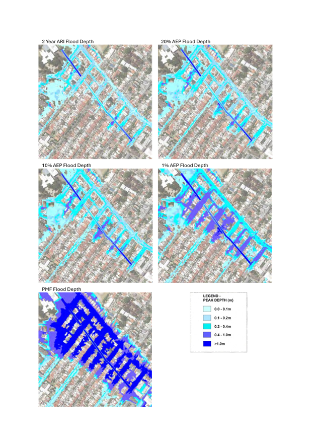
Attachment 1 outlines the depth
and extent of flooding affecting the area from Northcote Street to Garners
Avenue. The figures are extracted from Council’s Marrickville Valley
Flood Risk Management Study.
In February 2022, Inner West
Council experienced significant flooding across areas of Marrickville,
including Northcote Street and Malakoff Street, and was one of 61 Councils
included in the Declared Natural Disaster AGRN 1012 - NSW Severe Weather and
Flooding: 22 February 2022 onwards.
Current and Future Mitigation
Options
Following the flooding in
February 2022, Council developed plans to improve the capacity of the existing
pits and pipelines directly draining Northcote Street and Malakoff Street. This
was split into three projects with design and delivery to be staged between
2023 and 2026.
1. Pipe replacement and inlet upgrades in Northcote Street –
Designed FY24 and delivered November 2024
2. Pipe renewal and new pits in Carew Lane – To be delivered
FY26
3. Inlet Upgrades in Malakoff Street – New pits connecting
directly to Sydney Water infrastructure in Malakoff Street. Designed by Council
and approved by Sydney Water for construction in FY26.
The Marrickville Valley Flood
Risk Management Study and Plan was adopted by Council in 2018. Council has been
progressively investigating the feasibility of the options proposed in the
Plan, including high priority items between Despointes Street and Silver
Street, and Illawarra Road and Shepherd Street.
The Flood Risk Management Plan
includes a further option within Jarvie Park as a medium priority item (Item
FM3.1). The project would upgrade pipelines in Petersham Road and intercept
existing stormwater pipelines from Cecilia Street and Depot Lane within Jarvie
Park to drain directly to the Malakoff Street underground channel downstream of
Northcote Street. It is anticipated that this would divert 23 hectares
(approximately 15% of the total catchment) away from Northcote Street and
reduce flood levels of up to 100mm in the 1% AEP flood event.
Council has been prioritising the
development of High Priority options across the Local Government Area.
Consequently, this option does not currently form part of Council’s Long
Term Financial Plan or Delivery Program. The total estimated cost of this
option is roughly $800,000, which would impact on the delivery of flood
mitigation works elsewhere in the Inner West Council area.
The
report to Council on the 29 April 2025 proposed that an initial
investigation and feasibility study for this option be brought forward to be
undertaken as part of the FY26 Operational Plan to review the scope of works
and develop a more targeted measure that could potentially be delivered at a
lower cost. This has been included within the Draft Budget currently on
exhibition, noting that formal approval by Sydney Water would be required for
any connections to the stormwater infrastructure in Malakoff Street.
Council’s Director
Infrastructure, Engineering Services Manager and Coordinator Stormwater &
Asset Planning met with representatives from Sydney Water in March this year to
discuss the concerns of local residents, along with the above mitigation
option. The Sydney Water representatives supported the proposal in principle
and are committed to working with Council and the community to support measures
to improve flooding in the area.
The Draft Budget also includes
further investigation and design of downstream inlet improvements and upgrades
in Despointes Street, Illawarra Road, Silver Street and Sydney Street, in
addition to the physical works in Carew Lane and Malakoff Street outlined
above.
Council considered the above
matters at the 29 April 2025 Council Meeting and subsequently resolved:
1. That Council receive and note the report.
2. That Council write to residents of Northcote
Street to provide an update on actions being undertaken.
These letters to residents are
currently being prepared.
FINANCIAL IMPLICATIONS
The renewal of the pipeline in
Carew Lane and upgrade of stormwater inlets in Malakoff Street are included in
the draft budget for FY26 in the amount of $100,000 and $140,000 respectively.
An amount of $60,000 has been
included in the draft budget for FY26 for the feasibility assessment and
detailed design of the Jarvie Park stormwater diversion works. An application
for funding is being made through the NSW Flood Recovery and Resilience Grant
Program to support this work.
ATTACHMENTS
|
1.⇩
|
Map of Flood Extents and Depths around Northcote Street
|
|

|
Flood Management Advisory Committee Meeting
28
May 2025
|
|

|
Flood Management Advisory Committee Meeting
28
May 2025
|
Item No: FMACC0525(1)
Item 3
Subject: Flooding in the Area of Evan Jones Park
Prepared By: James
Ogg - Stormwater and Asset Planning Coordinator
Authorised By: Manod
Wickramasinghe - Acting Director Engineering
|
RECOMMENDATION
That Flood Management
Advisory Committee receive and note the report.
|
STRATEGIC OBJECTIVE
This report supports the following strategic directions
contained within Council’s Community Strategic Plan:
|
1: An ecologically sustainable Inner West
2: Liveable, connected neighbourhoods and transport
4: Healthy, resilient and caring communities
|
|
|
EXECUTIVE SUMMARY
On Monday 10 February 2025,
Sydney experienced widespread thunderstorms affecting homes and flooding roads,
including areas of Inner West Council.
Community members have reported
extensive overland flow from Evan Jones Playground into the lane, together with
the lid of the gross pollutant trap (GPT) near Evan Jones Playground dislodging
and causing a dangerous hazard. Additionally, there has been debris
accumulation, including soft-fall wood chips from the playground, regularly
blocking the drainage system and impacting on flooding.
A subsequent investigation was
conducted to examine opportunities to minimise flooding impacts on Evan Jones
Playground and Whites Creek Lane. The primary mitigation options involve
significant upgrades of the trunk drainage systems which are cost prohibitive
to upgrade.
Therefore, the available actions
to manage and mitigate the impact of flooding are non-structural measures such
as planning controls, emergency response planning and inspection and
maintenance of stormwater assets. To reduce the impact of future event, maintenance
activity to the playground and gross pollutant trap (GPT) have been completed.
BACKGROUND
On Monday 10
February 2025, Sydney experienced widespread thunderstorms affecting homes and
flooding roads, including areas of Inner West Council.
Rainfall data from nearby rain
gauges at Sydney Olympic Park, Canterbury Racecourse and Sydney Observatory
indicate that approximately 25mm water fell over the Inner West over the course
of 30 minutes. This dispersion of rain is approximately equivalent to a 20% AEP
event (sometimes known as a 1 in 5 year storm event). Council received more
than 130 stormwater and flood-related requests following that event.
The local community have
documented the impacts of recent weather events that have impacted Evan Jones
Park and the adjacent Whites Creek Lane, including this event in February. Community
members have reported extensive overland flows through Evan Jones Park into the
lane, together with impacts to the playground and gross pollutant trap (GPT) within
the park, causing dangerous hazards.
At the Council
meeting held on 11 March 2025, Council resolved the following:
1. That Council develop a plan
for safe and effective flood management across Evan Jones Playground and Whites
Creek Lane, Leichhardt and upgrades to the infrastructure in this playground
and street, including:
a) reviewing and reporting on the timeline for the
implementation of any relevant recommendations of the Leichhardt Flood Risk
Management Plan which applies to flood management in this area;
b) undertake investigations of all components of the
stormwater drainage system which drains from Emma Street to the Whites Creek
Channel through Evan Jones Park, in collaboration with Sydney Water;
c) ensuring that stormwater improvements are included
as part of the playground upgrade for Evan Jones Playground planned in
FY2025/2026, including the replacement of bark chips in the playground with a
surface that does not clog local drains;
d) clearing and preparing a maintenance plan for the
stormwater drains in Whites Creek Lane, in collaboration with Sydney Water
where necessary;
e) reviewing the street sweeping schedule for the lane
and advising Whites Creek Lane residents via letterbox drop of the schedule;
f) Council officers to hold a public meeting with
residents to publicly discuss and assess the grove of trees in the reserve land
on the corner of Whites Creek Lane and Styles Street for any danger and soft
soil as the result of recent heavy rains; and
g) reviewing and improving the dead-end signage at the
entrance to Whites Creek Lane at Reserve Street.
2. That Council report this plan to the May 2025
Council meeting, in time to inform the budget.
A report was subsequently
presented to the 20 May 2025 Council Meeting. The discussion below includes the
details regarding the Leichhardt Flood Risk Management Plan, the Sydney Water
drainage system within Whites Creek and Evan Jones Park, and recurrent
maintenance of the stormwater system and laneway.
DISCUSSION
Evan Jones Park is located at the
confluence of two significant trunk drainage systems, being Whites Creek, which
is located along Whites Creek Lane, and one of its tributaries which extends up
to Balmain Road in Leichhardt. Both these drainage systems are owned and
managed by Sydney Water.
Whites Creek was channelised between 1898 and 1935,
replacing the natural creek line as development progressed through Leichhardt
and Annandale. The channelised creek takes the form of an underground culvert
between Parramatta Road and Moore Street, upon which it becomes an open channel
through Whites Creek Valley Park and beyond to Rozelle Bay.
Gross pollutant traps (GPTs) have
been constructed to collect litter, silt and debris from these trunk drainage
lines, with both located in Evan Jones Park. Sydney Water owns and cleans the
GPT connected to the Whites Creek Channel, whilst Council is responsible for
the GPT near the Evan Jones Playground which services the tributary.
a) Leichhardt Flood Risk Management Plan
Council adopted the Leichhardt
Flood Risk Management Study and Plan (FRMSP) in 2018, which included mitigation
options to address the risk of flooding across all catchments in the former
Leichhardt Local Government Area, including this area of Whites Creek.
The Leichhardt FRMSP identifies
the following potential flood mitigation options for this area:
· Upgrade
of the Whites Creek stormwater channel, which is largely located within Whites
Creek Lane, but extends from Rozelle Bay to Norton Street and upstream of
Parramatta Road.
· Upgrade
of the stormwater pipeline which extends from Whites Creek Lane to Balmain
Road.
Although these trunk drainage
lines are owned by Sydney Water, previous discussions with their
representatives have indicated that the costs associated with any upgrade or
amplification of these pipelines would need to be funded by Council. The
combined cost for the above works was estimated in 2017 to be approximately $35
million, which is a prohibitive for Council to fund alone.
While Council does seek
additional funds through state and federal grants to support these types of
major upgrades, due to the limited funding available through these grant
programs and the increasing level of detailed design required to support such a
grant, it is likely that such works would be beyond the capacity of Council to
deliver in the short to medium term without significant impact on other Council
services.
Therefore, the current primary
management actions to manage and mitigate the impact of flooding are therefore
primarily dependent on non-structural measures such as planning controls
(raising houses and garages above flood levels), emergency response planning
(evacuation routes and education) and inspection and maintenance of stormwater
assets (video survey of pipelines and cleaning where required).
It must be noted that any upgrade
of Whites Creek and its surrounds would not remove flooding in its entirety
through the former creek line and that these non-structural measures would
still need to be kept in place regardless of the delivery of any stormwater
upgrade.
b) Drainage system from Emma Street
The trunk drainage line between
Emma Street and Whites Creek Lane extends as far north as Balmain Road. This
drainage line is owned and maintained by Sydney Water.
Sydney Water advise that they
undertake yearly condition assessments of their stormwater pipelines. Council
has requested that they undertake a CCTV inspection of this line in light of
the recent flooding event.
c) Drainage maintenance
Maintenance and cleaning of all
Council GPTs is conducted on a quarterly schedule, with the Evan Jones GPT
serviced in December 2024, then again in March 2025 following the storm event.
The most recent service indicated
that the unit was operating as expected, with a volume of collected materials
consistent with previous cleans. However, it was identified that the lids of
the GPT had missing or damaged bolts which have been repaired/replaced.
A specialist consultant has also
been arranged to conduct a comprehensive audit of the GPT in the next four
weeks to confirm the unit is operating effectively and whether any improvements
are necessary.
As above, Council staff have
requested that Sydney Water undertake an inspection of their drainage pipeline
to ensure that it is operating at full capacity.
Staff are also in discussions
with Sydney Water to review our maintenance scheduling and processes to
identify whether there is an opportunity for both organisations to collaborate
to improve our respective maintenance services for the community.
d) Street sweeping
Whites Creek Laneway is currently
serviced on Council’s endorsed 40 working day cleaning program for
residential streets and laneways across the LGA. Council operations teams will
continue to monitor this site and assess the need for an increase in service.
White’s Creek Lane is next due to be serviced in May as per the current
program. This service will include weed removal, collection of dumped rubbish,
gutter cleaning, and debris removal. Council operations teams will letterbox
drop the surrounding properties notifying them of the current service levels,
the last service date and the next proposed service date as per the current
service program.
e) Trees on corner of Styles Street and Whites Creek Lane
Council’s Public Tree team
will lead a meeting on site to discuss any tree matters across the site.
Council’s engagement and Public Tree team will work with the community to
finalise a meeting date and time which is expected to be in the first week of
June.
f) Street signage
The intersection of Whites Creek
Lane and Reserve Street has been reviewed by the Traffic and Transport Planning
team who advise that both approaches have sufficient signage indicating that
the road (Whites Creek Lane) is a ‘No Through Road’ north of
Reserve Street. However, the signage will be repositioned to improve
visibility.
Council considered the above
matters at the 20 May 2025 Council Meeting and resolved:
1. That Council receive and note the report.
2. That Council write to Sydney Water requesting
updated costing associated with upgrading of the Whites Creek stormwater
channel.
3. That Council identify grant funding options
available, and preparatory work that would be needed to apply for such grants,
to fund these upgrades.
4. That Council report the outcomes of these
engagements to Council in August 2025.
Items 2, 3 and 4 are currently
being actioned.
FINANCIAL IMPLICATIONS
An amount of $150,000
has been included in the draft budget for the 2026/27 financial year for the
upgrade of the Evan Jones Playground.
Maintenance undertaken to date,
including installation of timber edging in the park and cleaning of the Evan
Jones GPT, was funded through existing operational budgets.
ATTACHMENTS
Nil.
|
|
Flood Management Advisory Committee Meeting
28
May 2025
|
Item No: FMACC0525(1)
Item 4
Subject: Public Forum to the Flood Management Advisory
Committee
Prepared By: James
Ogg - Stormwater and Asset Planning Coordinator
Authorised By: Manod
Wickramasinghe - Acting Director Engineering
|
RECOMMENDATION
1. That Flood Management Advisory Committee
receive and note the report.
2. That a revised Terms of Reference including
details of the Public Forum is provided to the Flood Management Advisory
Committee in August following a review by Council’s Governance team.
|
STRATEGIC OBJECTIVE
This report
supports the following strategic directions contained within Council’s
Community Strategic Plan:
|
5: Progressive, responsive and effective civic
leadership
|
|
|
EXECUTIVE
SUMMARY
The Inner West Flood Management Advisory Committee was first
established in 2017 in accordance with the Floodplain Development Manual
(2005).
The committee is advisory in nature and does not have or
exercise any formal powers of Council. The committee is established by Council
and reports its recommendations to Council via a report and publication of its
minutes. Any resulting actions ultimately require the approval of Council.
This report reviews the purpose of the Flood Management
Advisory Committee, compares the operation and procedures of the Local Traffic
Committee and makes suggestions for implementation of a public forum for the
Flood Management Advisory Committee, ahead of formal recommendations at a later
meeting.
BACKGROUND
The Inner West Flood Management
Advisory Committee (FMAC) was first established in 2017 in accordance with the
Floodplain Development Manual (2005) – since superseded by the Flood Risk
Management Manual (2023) (the Manual).
The FMAC is established by
Council to support and oversee the flood risk management process in accordance
with the guidance of the Manual.
At its
meeting on 12 November 2024 (C1124(1) Item 26), Council resolved:
6. That
Council provide for members of the public to present to the Flood Risk and
Management Committee on flood related matters by establishing a public forum,
as is the case with the Inner West Council Traffic Committee.
DISCUSSION
Under the guidance of the Manual,
the main objective of a Flood Management Advisory Committee is to assist
councils in undertaking flood studies and developing Flood Risk Management Plans
for a given study area, including advice on priorities for implementation. The
committee primarily acts as a forum to discuss technical, social, economic,
environmental and cultural issues and distil these viewpoints into the final
Flood Studies and Flood Risk Management Plans adopted by the Council.
The committee is advisory in
nature and does not have or exercise any formal powers of Council. The FMAC
reports to the Council through the reporting of its minutes, with any
recommendations requiring the approval of Council, which has the final
decision-making authority.
It is similar to, though not directly comparable with,
Council’s Local Traffic Committee (LTC). Like the Flood Management
Advisory Committee, the Local Traffic Committee is advisory in nature with no
decision-making powers. The LTC is primarily a technical review committee
designed to consider the technical merits of proposals, ensuring that any
proposal meets current technical guidelines, prior to being approved by
Council.
Current Operation of the Local Traffic Committee
The LTC is primarily a technical
review committee, made up of representatives of Council, NSW Police, Transport
for NSW and the local State MP. The LTC is designed to consider the technical
merits of proposals, ensuring that any proposal meets current technical
guidelines, prior to being approved by Council. The merits of the scheme, from
a public perspective, is the responsibility of the Council and thus
residents’ views should be taken into account by the Council rather than
the LTC.
Noting this, public participation
in the LTC operates on an invitational basis. Residents and other stakeholders
are notified when a specific report is to be tabled at the LTC relating to
their immediate area or an item that they have previously been consulted on or
made a submission to.
Reports to the Committee are
typically prepared following completion of an investigation into requested
parking or traffic management changes, exhibition of a Local Area Traffic
Management Plan, or the detailed design of structures that might change road
shape or performance (such as a raised pedestrian crossing).
Those interested in making a
submission to the committee are required to register their intention by the
close of business the day before the meeting is held.
Considerations for a Flood Management Advisory Committee
Public Forum
As noted above, the main
objective of a FMAC is to assist the council in undertaking flood studies and
develop a Flood Risk Management Plan for a given study area, including advice
on priorities for implementation.
The ongoing input and engagement
of residents, businesses and community groups is important to this process of
ongoing oversight and review. The design of a public forum process should aim
to improve the Committee and Council’s understanding of matters under
consideration to achieve better decision-making outcomes.
With these in mind, the following
measures are put forward to the FMAC for consideration:
Reports to the committee:
- Progress reports and consultation reports
during the preparation of a Flood Study or Flood Risk Management Plan will
continue to be presented to the FMAC in accordance with the guidance of the
Flood Risk Management Manual.
- It is proposed that a standing item be
included within the meeting agenda where staff report on requests related to
substantial flooding of a street or building, and the outcome (not including
drainage or minor nuisance flooding within a street, such as might be caused by
gutter damage or minor stormwater overflows).
- A location that receives multiple requests
from separate addresses may trigger a report to be presented to the committee
- An investigation that proposes new flood
mitigation works would be presented to the committee for review
- The committee can resolve that an
investigation be undertaken into a specific location or issue, and a report
provided at a following committee meeting.
Submissions:
- Where a request has resulted in proposed
capital works, the resident is informed of this and advised of the next meeting
of the FMAC where this will be presented
- Where multiple requests have triggered a
report to the FMAC, all those who submitted a request will advised of the next
meeting of the FMAC where this will be presented
- Any member of the public requesting to speak
to an item at the meeting is required to register their intent prior to the
meeting to receive an invitation to the online meeting
- Submissions are to be made at the start of a
meeting for the consideration of members during the remainder of the meeting
- Submissions are to be limited to three
minutes in accordance with the Council’s Code of Meeting Practice.
Note that detailed design
undergoes a separate community engagement and submissions are managed within
this process
Following the feedback of the
committee Council officers will undertake a review of procedures with the
support of Council’s Governance team and provide an updated Terms of
Reference to the August committee meeting for endorsement.
FINANCIAL IMPLICATIONS
There are no financial
implications associated with the implementation of the proposed recommendations
outlined in the report.
ATTACHMENTS
Nil.