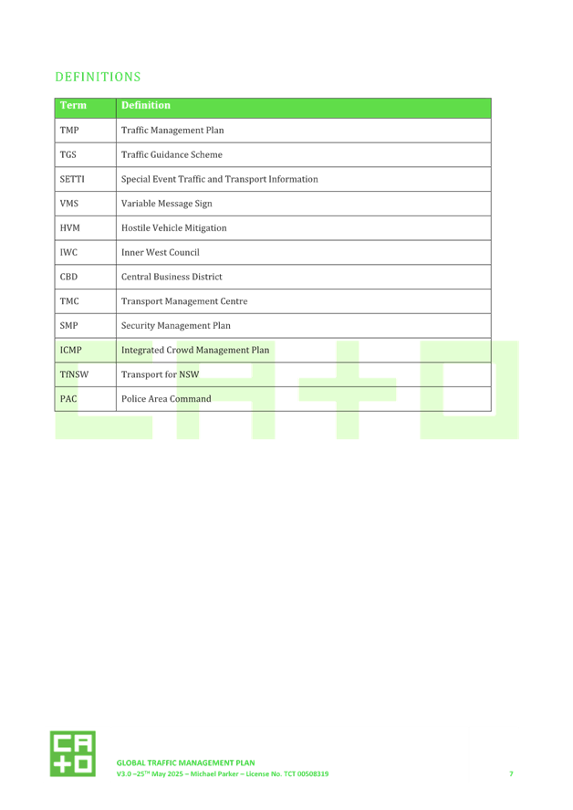
|
AGENDA R |

Local Traffic Committee Meeting
MONDAY 16 JUNE 2025
11:00 AM
|
|
Local Traffic Committee Meeting 16 June 2025 |
Function of the Local Traffic Committee
Background
Roads and Maritime Services (RMS) is legislated as the Authority responsible for the control of traffic on all NSW Roads. The RMS has delegated certain aspects of the control of traffic on local roads to councils. To exercise this delegation, councils must establish a local traffic committee and obtain the advice of the RMS and Police. The Inner West Council Local Traffic Committee has been constituted by Council as a result of the delegation granted by the RMS pursuant to Section 50 of the Transport Administration Act 1988.
Role of the Committee
The Local Traffic Committee is primarily a technical review and advisory committee which considers the technical merits of proposals and ensures that current technical guidelines are considered. It provides recommendations to Council on traffic and parking control matters and on the provision of traffic control facilities and prescribed traffic control devices for which Council has delegated authority. These matters are dealt with under Part A of the agenda and require Council to consider exercising its delegation.
In addition to its formal role as the Local Traffic Committee, the Committee may also be requested to provide informal traffic engineering advice on traffic matters not requiring Council to exercise its delegated function at that point in time, for example, advice to Council’s Development Assessment Section on traffic generating developments. These matters are dealt with under Part C of the agenda and are for information or advice only and do not require Council to exercise its delegation.
Committee Delegations
The Local Traffic Committee has no decision-making powers. The Council must refer all traffic related matters to the Local Traffic Committee prior to exercising its delegated functions. Matters related to State Roads or functions that have not been delegated to Council must be referred directly to the RMS or relevant organisation.
The Committee provides recommendations to Council. Should Council wish to act contrary to the advice of the Committee or if that advice is not supported unanimously by the Committee members, then the Police or RMS have an opportunity to appeal to the Regional Traffic Committee.
Committee Membership & Voting
Formal voting membership comprises the following:
· one representative of Council as nominated by Council;
· one representative of the NSW Police from each Local Area Command (LAC) within the LGA, being Newtown, Marrickville, Leichhardt and Ashfield LAC’s.
· one representative from the RMS; and
· State Members of Parliament (MP) for the electorates of Summer Hill, Newtown, Heffron, Canterbury, Strathfield and Balmain or their nominees.
Where the Council area is represented by more than one MP or covered by more than one Police LAC, representatives are only permitted to vote on matters which effect their electorate or LAC.
Informal (non-voting) advisors from within Council or external authorities may also attend Committee meetings to provide expert advice.
Committee Chair
Council’s representative will chair the meetings.
Public Participation
Members of the public or other stakeholders may address the Committee on agenda items to be considered by the Committee. The format and number of presentations is at the discretion of the Chairperson and is generally limited to 3 minutes per speaker. Committee debate on agenda items is not open to the public.
|
|
Local Traffic Committee Meeting 16 June 2025 |
|
AGENDA |
1 Apologies
2 Disclosures of Interest
3 Confirmation of Minutes Page
Minutes of 19 May 2025 Local Traffic Committee 5
4 Matters Arising from Council’s Resolution of Minutes
5 Part A – Items Where Council May Exercise Its Delegated Functions
Traffic Matters
ITEM Page
LTC0625(1) Item 1 Richardson's Crescent, Marrickville - Traffic treatments at the intersection of Richardson's Crescent and Carrington Road (Midjuburi-Marrickville Ward / Summer Hill Electorate / Inner West PAC) 19
LTC0625(1) Item 2 Shepherd Street and Chapel Street, Marrickville – Proposed two raised pedestrian crossings and kerb extensions - Design Plan 10339 (Midjuburi - Marrickville Ward / Summer Hill Electorate / Inner West PAC) 34
LTC0625(1) Item 3 McGill Street, Lewisham - Proposed Shared Zone (Damun-Stanmore Ward/Newtown Electorate/Inner West PAC) 43
LTC0625(1) Item 4 Holborow Street (at Liverpool Road), Croydon.(Djarrawunang-Ashfield Ward/Summer Hill Electorate/Burwood PAC) 50
LTC0625(1) Item 5 Beattie Street, Balmain – Proposed linemarking changes between Elliott Street and Evans Street (Baldurri-Balmain/Balmain Electorate/Leichhardt PAC) 57
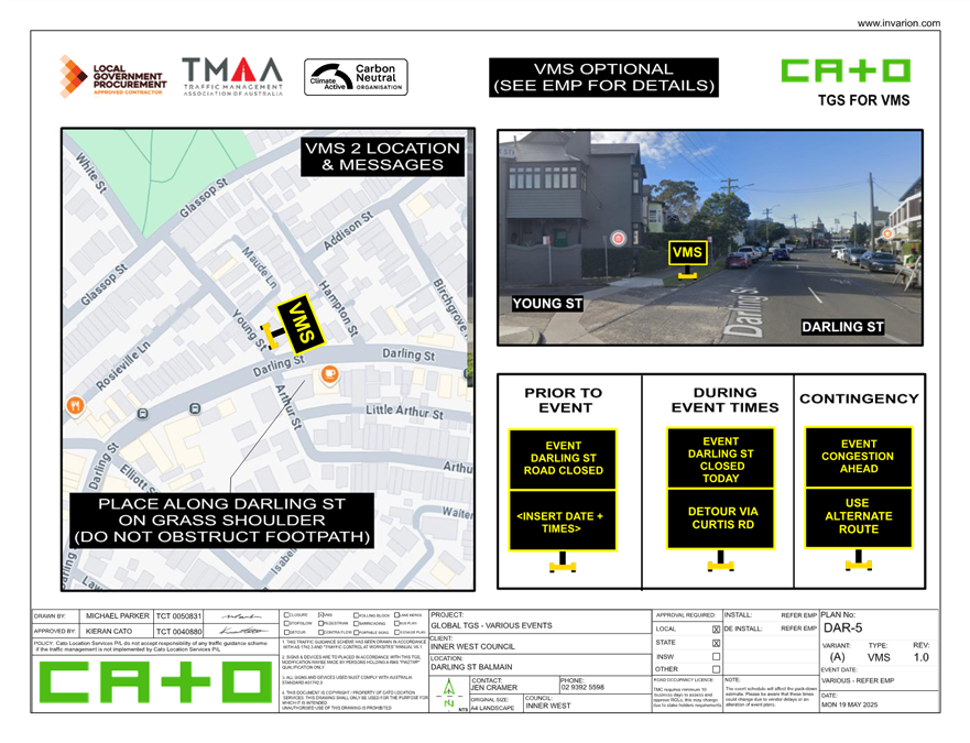
LTC0625(1) Item 6 Darling Street, Balmain - Global TMP for Balmain Street - (Baludarri-Balmain Ward Balmain Electorate Leichhardt PAC) 61
Parking Matters
ITEM Page
LTC0625(1) Item 7 Darling Street, Balmain - Proposed motor bike parking restriction (Baludarri-balmain/balmain electorate/leichhardt pac) 106
LTC0625(1) Item 8 Elliott Street, Balmain - Proposed Resident Parking Scheme (Baludarri-Balmain Ward/Balmain Electorate/Leichhardt PAC) 109
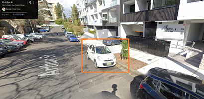
LTC0625(1) Item 9 Inner West LGA - Proposal for Flexicar Car Share Parking Spaces (All Wards/All Electorates/All PACs) 111
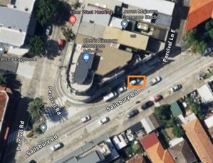
LTC0625(1) Item 10 Camdenville Park, St Peters - Proposed parking changes to the Camdenville Park carpark at Council Street, St Peters (Midjuburi - Marrickville Ward / Heffron Electorate / Inner West PAC) 125
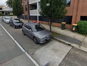
LTC0625(1) Item 11 Gower Street, Ashfield - Proposed Resident Parking Scheme at Gower Street between Liverpool Road and Ormond Street (Djarrawunang-Ashfield Ward) / Summer Hill Electorate / Burwood PAC) 129
Late Items
Nil at time of printing.
6 Part B - Items for Information Only
ITEM Page
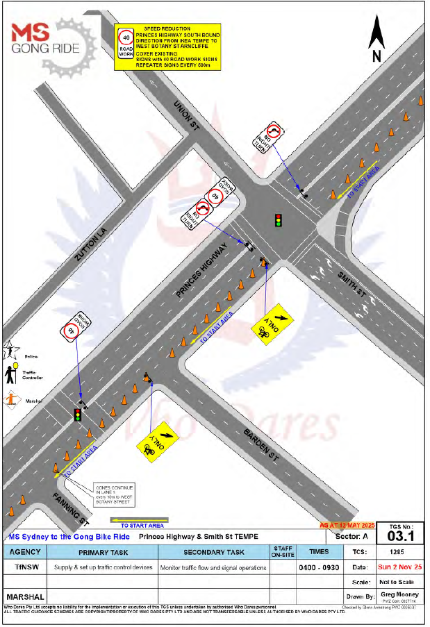
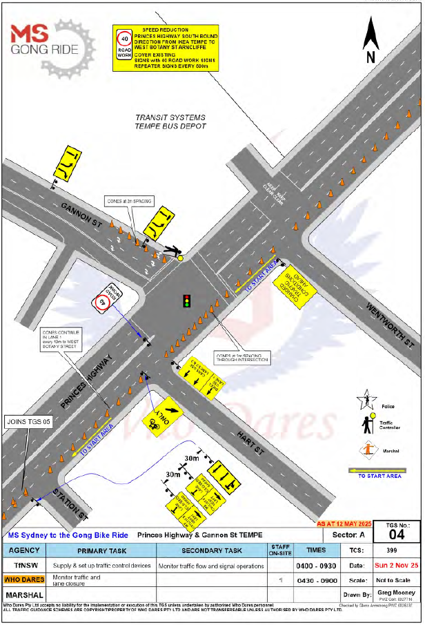
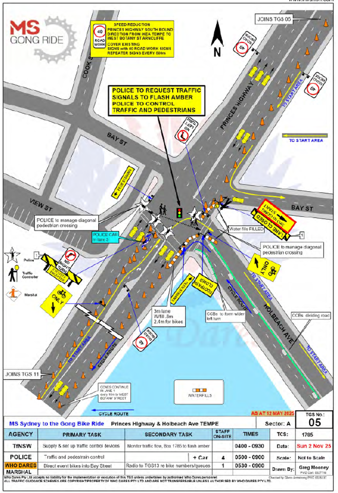
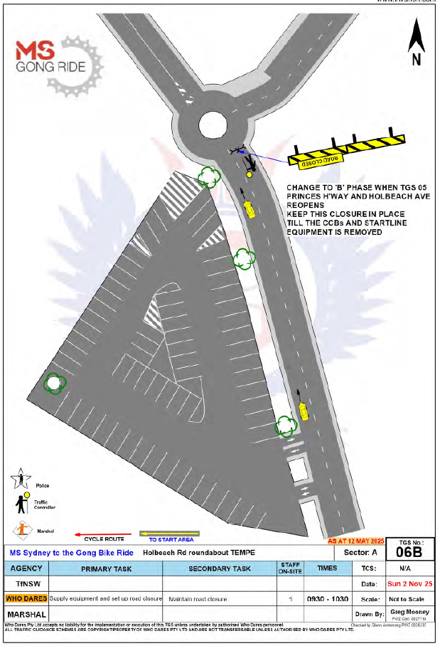
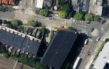
LTC0625(1) Item 12 Holbeach Avenue, Tempe – Temporary Full Road Closure for MS Sydney to the Gong Bike Ride on Sunday 2 November 2025 – (Midjuburi-Marrickville Ward / Heffron Electorate / Inner West PAC) 133
7 Part C - Items for General Advice
Nil at the time of printing.
8 General Business
9 Close of Meeting
|
|
Local Traffic Committee Meeting 16 June 2025 |
Minutes of the Local Traffic Committee Meeting held on 19 May 2025
Meeting commenced at 11:05 AM
ACKNOWLEDGEMENT OF COUNTRY BY CHAIRPERSON
I acknowledge the Gadigal and Wangal people of the Eora nation on whose country we are meeting today, and their elders past and present.
COMMITTEE REPRESENTATIVES PRESENT
|
Liz Atkins |
Councillor – Damun - Stanmore Ward |
|
Bill Holliday |
Representative for Jamie Parker MP, Member for Balmain |
|
Graeme McKay |
Representative for Jo Haylen MP, Member for Summer Hill |
|
Nina Fard |
Transport for NSW (TfNSW) |
|
Vinoth Srinivasan |
Transport for NSW (TfNSW) |
|
|
|
|
NON VOTING MEMBERS IN ATTENDANCE |
|
|
|
|
|
Michael Takla |
Representative for Transit Systems |
|
Jason Scoufis |
IWC’s Acting Traffic and Transport Planning Manager |
|
Sunny Jo |
IWC’s Coordinator Traffic Engineering Services (North) |
|
George Tsaprounis |
IWC’s Coordinator Traffic Engineering Services (South) |
|
Miia Hynninen |
IWC’s Business Administration Officer |
|
|
|
|
VISITORS |
|
|
|
|
|
Fernando Guerreiro |
Public Speaker (Item 13) |
|
Marijke Tombs |
Public Speaker (Item 13) |
|
|
|
|
APOLOGIES: |
|
|
Victor Macri |
Councillor – Midjuburi - Marrickville Ward |
|
|
|
DISCLOSURES OF INTERESTS:
Nil.
CONFIRMATION OF MINUTES
|
That the Minutes of the Local Traffic Committee held on Monday, 14 April 2025 be confirmed. |
MATTERS ARISING FROM COUNCIL’S RESOLUTION OF MINUTES
Nil.
|
LTC0525(1) Item 7 Centennial Street, Marrickville – Temporary Road Closure for Special Event at Henson Park – 2025 Beer, Footy and Food Festival on Saturday 26 July 2025 - (Midjuburi-Marrickville Ward /Summer Hill Electorate /Inner West LAC) |
|
An application has been received from the Music & Booze Company together with the Newtown Rugby League Football Club (the Jets) to hold the 2025 Beer, Footy and Food Festival between 10.00am and 8.00pm on Saturday 26 July 2025 at Henson Park Oval. The event requires the temporary full road closure of Centennial Street, Marrickville between Sydenham Road and the entrance gate to Henson Park Oval. It is recommended that Council agree to the temporary full road closure subject to the applicant complying with the above conditions and obtaining concurrence from Transport for NSW as the closure entails lane closures on Sydenham Road, Marrickville.
Officers Recommendation:
That the proposed temporary full road closure (ENRC/2025/0027) of Centennial Street, Marrickville between Sydenham Road and the entrance to Henson Park and Marrickville & District Hardcourt Tennis Club car park, between 10.00am and 8.00pm on Saturday 26 July 2025 (contingency period of two months) for the purpose of holding the ‘Beer, Footy and Food Festival 2025’ event be approved, subject to the approval of the S68 Application and the applicant complying with, but not limited to, the following conditions:
a) A Road Occupancy License application be obtained by the applicant from the Transport Management Centre; b) All affected residents and businesses, including NSW Police Local Area Commander, Transit Systems, Fire and Rescue NSW and NSW Ambulance Services, shall be notified in writing by the applicant of the proposed temporary road closure at least 7 days prior to the event, with the applicant making reasonable provision for residents and businesses; c) A VMS be placed displaying that there is ‘No Public Parking’ in Centennial Street; d) The occupation of the road carriageway must not occur until the road has been physically closed; and e) Subject to written concurrence from Transport for New South Wales.
DISCUSSION:
The Committee members agreed with the Officer’s recommendation.
COMMITTEE RECOMMENDATION:
That the proposed temporary full road closure (ENRC/2025/0027) of Centennial Street, Marrickville between Sydenham Road and the entrance to Henson Park and Marrickville & District Hardcourt Tennis Club car park, between 10.00am and 8.00pm on Saturday 26 July 2025 (contingency period of two months) for the purpose of holding the ‘Beer, Footy and Food Festival 2025’ event be approved, subject to the approval of the S68 Application and the applicant complying with, but not limited to, the following conditions:
a) A Road Occupancy License application be obtained by the applicant from the Transport Management Centre; b) All affected residents and businesses, including NSW Police Local Area Commander, Transit Systems, Fire and Rescue NSW and NSW Ambulance Services, shall be notified in writing by the applicant of the proposed temporary road closure at least 7 days prior to the event, with the applicant making reasonable provision for residents and businesses; c) A VMS be placed displaying that there is ‘No Public Parking’ in Centennial Street; d) The occupation of the road carriageway must not occur until the road has been physically closed; and e) Subject to written concurrence from Transport for New South Wales.
For Motion: Unanimous |
|
LTC0525(1) Item 8 Marrickville Road, part of Seaview Street and Durham Street, Caves Lane, Marrickville – Temporary full Road Closures for Dulwich Hill Village Fair – Sunday 21 September 2025 (Djarrawunang-Ashfield Ward / Summer Hill Electorate / Inner West PAC) |
|
‘Dulwich Hill Village Fair' is an annual event and this year it will be held on Sunday 21 September 2025. As per previous years the event will necessitate the temporary full road closure of Marrickville Road (between New Canterbury Road and Fairfowl Street); part of Seaview Street (between Marrickville Road and south of the entrance to the car park south of Herbert Street), Caves Lane, and the Seaview Street car park (car park adjacent to Caves Lane), Dulwich Hill.
Officers Recommendation:
That:
1. The proposed temporary full road closure of Marrickville Road (between New Canterbury Road and Fairfowl Street), part of Seaview Street (between Marrickville Road and south of the entrance to the car park south of Herbert Street), Durham Street (between Marrickville Road and Durham Lane), Caves Lane, and the Seaview Street car park (car park adjacent to Caves Lane), Dulwich Hill for the ‘Dulwich Hill Village Fair’ Event on Sunday 21 September 2025 between the hours of 3:00am and 9:00pm be approved as per the submitted TMP and TGSs;
2. A Road Occupancy License application be obtained from the Transport Management Centre;
3. Notice of the proposed event be forwarded to the NSW Police Local Area Commander, Transit Systems, the NSW Fire Brigades and the NSW Ambulance Services;
4. All residents and businesses in and around the affected area are to be notified of the temporary road closure in writing by the applicant in advance (at least 7 days prior to the event) with the applicant making reasonable provision for stakeholders; 4. A minimum four (4) metre unencumbered passage be available for emergency vehicles through the closed section; and 5. The occupation of the road carriageway must not occur until the road has been physically closed.
DISCUSSION:
The Committee members agreed with the Officer’s recommendation.
COMMITTEE RECOMMENDATION:
That:
1. The proposed temporary full road closure of Marrickville Road (between New Canterbury Road and Fairfowl Street), part of Seaview Street (between Marrickville Road and south of the entrance to the car park south of Herbert Street), Durham Street (between Marrickville Road and Durham Lane), Caves Lane, and the Seaview Street car park (car park adjacent to Caves Lane), Dulwich Hill for the ‘Dulwich Hill Village Fair’ Event on Sunday 21 September 2025 between the hours of 3:00am and 9:00pm be approved as per the submitted TMP and TGSs;
2. A Road Occupancy License application be obtained from the Transport Management Centre;
3. Notice of the proposed event be forwarded to the NSW Police Local Area Commander, Transit Systems, the NSW Fire Brigades and the NSW Ambulance Services;
4. All residents and businesses in and around the affected area are to be notified of the temporary road closure in writing by the applicant in advance (at least 7 days prior to the event) with the applicant making reasonable provision for stakeholders; 4. A minimum four (4) metre unencumbered passage be available for emergency vehicles through the closed section; and 5. The occupation of the road carriageway must not occur until the road has been physically closed.
For Motion: Unanimous |
|
LTC0525(1) Item 9 Marrickville Road, Marrickville – Temporary full road closure for Marrickville Music Festival – Sunday 12 October 2025 (Midjuburi - Marrickville Ward / Summer Hill Electorate / Inner West PAC) |
|
Inner West Council is presenting Marrickville Music Festival on Sunday 12 October 2025 from 12:00noon until 6:00pm. The event will feature multiple outdoor live music stages across the festival site. Including activation of Marrickville laneways through music and art. As part of the event there will be a temporary full road closure of Marrickville Road and Central Lane. This will require some road detours and bus diversions in surrounding streets. Event bump in will occur from 01:30am and bump out will conclude by 11:00pm. It is recommended that Council agree to the temporary full road closures subject to all standard Council conditions for a temporary full road closure.
Officers Recommendation:
That the proposed temporary full road closure of Marrickville Road (between Illawarra Road and Victoria Road), Central Lane (between Victoria Road and Meeks Road), Seymour Lane (between Garners Lane and Garners Avenue and between Frampton Avenue and Garners Lane), Garners Lane (north of Seymour Lane) along with short sections of Silver Street, Garners Avenue, Gladstone Street, and Frampton Avenue where these streets intersect with Marrickville Road, Marrickville be APPROVED for the purpose of holding the ‘Marrickville Music Festival’ Event on Sunday 12 October 2025 between 01:30am and 11:00pm as per the submitted TMP and TGSs and subject to the following conditions and all standard Council conditions for temporary full road closures.
2. That a Road Occupancy License application be obtained from the Transport Management Centre.
3. That notice of the proposed event be forwarded to the NSW Police Local Area Commander, Transit Systems, the NSW Fire Brigades and the NSW Ambulance Services.
4. That all residents and businesses in and around the affected area are to be notified of the temporary road closure in writing by the applicant in advance (at least 7 days prior to the event) with the applicant making reasonable provision for stakeholders. 5. That a minimum four (4) metre unencumbered passage be available for emergency vehicles through the closed sections. 6. That the occupation of the road carriageway must not occur until the road has been physically closed.
DISCUSSION:
The Committee members agreed with the Officer’s recommendation.
COMMITTEE RECOMMENDATION:
1. That the proposed temporary full road closure of Marrickville Road (between Illawarra Road and Victoria Road), Central Lane (between Victoria Road and Meeks Road), Seymour Lane (between Garners Lane and Garners Avenue and between Frampton Avenue and Garners Lane), Garners Lane (north of Seymour Lane) along with short sections of Silver Street, Garners Avenue, Gladstone Street, and Frampton Avenue where these streets intersect with Marrickville Road, Marrickville be APPROVED for the purpose of holding the ‘Marrickville Music Festival’ Event on Sunday 12 October 2025 between 01:30am and 11:00pm as per the submitted TMP and TGSs and subject to the following conditions and all standard Council conditions for temporary full road closures.
2. That a Road Occupancy License application be obtained from the Transport Management Centre.
3. That notice of the proposed event be forwarded to the NSW Police Local Area Commander, Transit Systems, the NSW Fire Brigades and the NSW Ambulance Services.
4. That all residents and businesses in and around the affected area are to be notified of the temporary road closure in writing by the applicant in advance (at least 7 days prior to the event) with the applicant making reasonable provision for stakeholders. 5. That a minimum four (4) metre unencumbered passage be available for emergency vehicles through the closed sections.
6. That the occupation of the road carriageway must not occur until the road has been physically closed.
For Motion: Unanimous |
|
LTC0525(1) Item 10 Henson Street (at Herbert Street), Summer Hill-Proposed New Raised pedestrian crossing (Djarrawunang-Ashfield Ward/Summer Hill Electorate/Burwood PAC) |
|
Council is planning to improve safety in Henson Street, Summer Hill by constructing a new raised pedestrian crossing near Herbert Street to replace the existing “at-grade” flat pedestrian crossing. The proposal aims to improve pedestrian and motorist safety by better defining safe pedestrian crossing points and addresses pedestrian safety and driver behaviour at this location.
Officers Recommendation:
That the detailed design plan (10314) for a proposed new raised crossing in Henson Street at Herbert Street, with associated signs and line marking (as shown in Attachment 1) be approved.
DISCUSSION:
The Committee members agreed with the Officer’s recommendation.
COMMITTEE RECOMMENDATION:
That the detailed design plan (10314) for a proposed new raised crossing in Henson Street at Herbert Street, with associated signs and line marking (as shown in Attachment 1) be approved.
For Motion: Unanimous |
|
LTC0525(1) General Business – Item 15 New Canterbury Road and Toothill Street Signalised Intersection – Road Safety Concerns |
|
DISCUSSION:
Council Officers advised that a resident has raised concerns regarding pedestrian safety at the signalised intersection at New Canterbury Road and Toothill Street. The concerns will be forwarded to Transport for NSW for their consideration.
For Motion: Unanimous |
Meeting closed at 12:02pm.
CHAIRPERSON
Jason Scoufis
|
|
Local Traffic Committee Meeting 16 June 2025 |
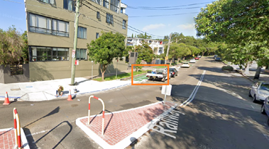
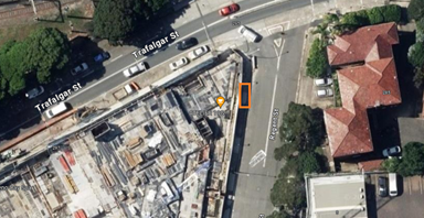
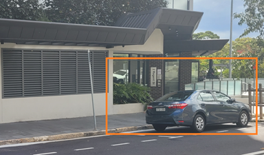
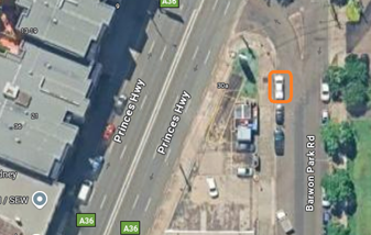
Subject: Richardson's Crescent, Marrickville - Traffic treatments at the intersection of Richardson's Crescent and Carrington Road (Midjuburi-Marrickville Ward / Summer Hill Electorate / Inner West PAC)
Prepared By: Daniel Li - Student/Graduate Traffic Engineer
Authorised By: Sunny Jo - Acting Traffic and Transport Planning Manager
|
RECOMMENDATION
1. That Council note the design of a proposed roundabout at the intersection of Richardson’s Crescent and Carrington Road.
2. That Council note the design of a proposed seagull treatment at the intersection of Richardson’s Crescent and Carrington Road.
|
STRATEGIC OBJECTIVE
This report supports the following strategic directions contained within Council’s Community Strategic Plan:
|
2: Liveable, connected neighbourhoods and transport |
|
|
EXECUTIVE SUMMARY
At Council’s Local Traffic Committee on the 17 March 2025, item 14 – Concerns regarding the vehicular access from Carrington Road, Marrickville was raised by the Chair as part of the General Business items for Local Traffic Committee. This item included correspondence from a resident noting concern regarding vehicular access at the intersection of Carrington Road onto Richardson’s Crescent stating the difficulty of turning right from Carrington Road into Richardson’s Crescent. As such, Council’s Traffic Engineering team was tasked to investigate potential treatments to address the concern raised by the resident.
This report investigates two potential proposals to address the alleged turning delays associated with this intersection, including a roundabout treatment and a seagull treatment. The results of the analysis for a roundabout reveal that at this point in time efficiency of the intersection is satisfactory as well as a low accident history meaning that a proposed roundabout would not be the most cost effective solution for an intersection which is essentially operating at an acceptable level of service. Whilst a Seagull Island treatment is more cost effective and would provide the same benefit in terms of intersection efficiency as a roundabout, the fact the intersection is currently operating acceptable means that at present, the benefit provided in relation to the cost is debatable. It is recommended that Council note both proposals and that a Seagull Island treatment would be a better proposed option for this intersection.
BACKGROUND
Item 14 of Council’s Local Traffic Committee held on the 17 March 2025 was raised by a Councillor of the Marrickville ward on behalf of local community members, Council’s traffic engineering team has been tasked with investigating concerns regarding the vehicular access from Carrington Road, Marrickville and to investigate potential treatment options at this junction. As noted by community members, it was observed that vehicles would have difficulty turning right from Carrington Road onto Richardson’s Crescent.
DISCUSSION
Existing conditions
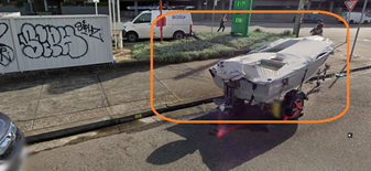
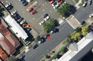
![]()
![]()
![]()
![]()
![]()
Figure 1 Subject site and locality plan
|
Street Name |
Richardson’s Crescent |
|
Section |
Bend at Carrington Road and Richardson’s Crescent |
|
Carriageway width (m) kerb to kerb |
13.2 |
|
Carriageway Type |
Two-way road with one travel lane in each direction. Kerb side parking is available on Richardson’s Crescent between the raised pedestrian crossing and the intersection |
|
Classification |
Local |
|
Speed limit |
50 |
|
85th Percentile Speed (km/h) |
56.2 |
|
Vehicles per day (vpd) |
14,563 |
|
Reported Crash History (2020-2024) |
1x Minor Injury – RUM 30 (Rear End) – July 2021 |
|
Parking arrangements |
Unrestricted parking along both sides of Richardson’s Crescent |
Table 1. Summary of Richardson’s Crescent
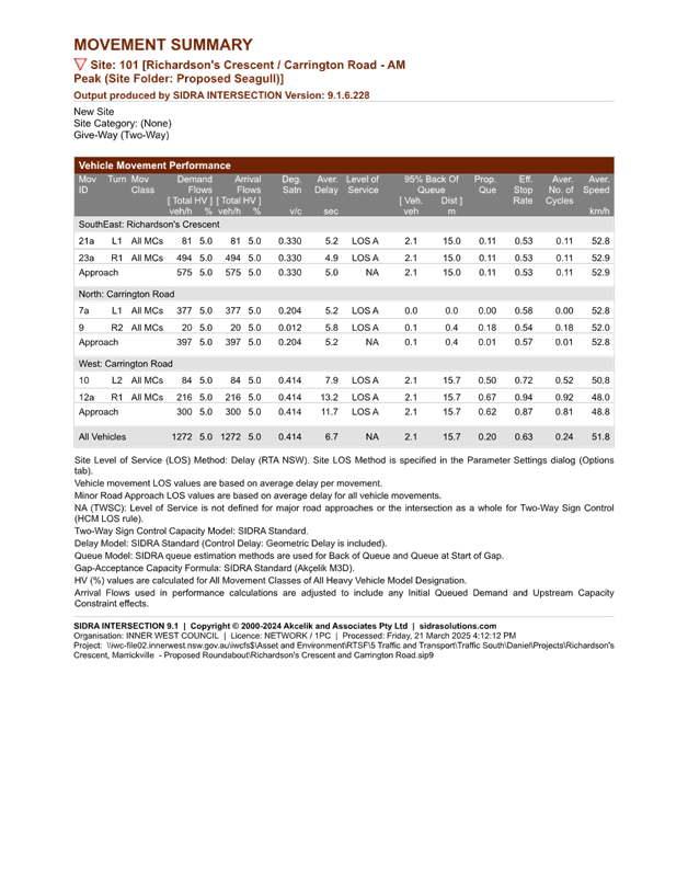
Using SIDRA, a traffic modelling software, the performance at each leg of the intersection was modelled based on the existing morning and afternoon peak hour conditions as seen in figure 2 and summary of the conditions is provided in table 2.
Figure 2 Intersection traffic counts at the intersection of Carrington Road and Richardson’s Crescent.
The SIDRA model suggests that the average delay for each vehicle undertaking right-turning traffic movements was 26.6 seconds and 20.9 seconds respectively for the morning and afternoon peak hours, resulting in the overall intersection being graded as a Level of Service B. In accordance with RTA’s Guide to Traffic Generating Developments, a Level of Service B indicates that the operating performance of the intersection is deemed to be acceptable with spare capacity
In comparison, as observed onsite at the location through traffic counts and queue analysis, the average delay was calculated to be 10.4 seconds with the longest delay being 50.2 seconds. While it is understood that there are concerns associated with the vehicle delays, the existing performance is considered to be satisfactory and would not require traffic improvements in accordance with Transport for NSW. Notwithstanding the above, the following observations were observed onsite during traffic counts:
· Vehicles that experienced significant delays would often become impatient and accelerate into the carriageway despite not achieving a safe turning gap and resulted in near collisions.
· As a result of traffic control devices (including traffic signals at Unwins Bridge Road, raised pedestrian crossing and roundabout facilities approximately 170m south from the current site), occasional gaps were created to assist with right turning traffic movements.
· Despite a gap being formed from northbound traffic from Richardson’s Crescent, vehicles were unable to complete the right turning traffic movement from the minor road due to vehicle platooning from the intersection of Renwick Street and Carrington Road, further contributing to the delays of right turning movements.
|
|
AM Peak (7:45am – 8:45am) |
PM Peak (3:00pm – 4:00pm) |
|
Richardson’s Crescent Delay (seconds/vehicle) Level of Service |
5.1 A |
5.1 A |
|
Carrington Road North Approach Delay (seconds/vehicle) Level of Service |
4.4 A |
4.8 A |
|
Carrington Road West Approach Delay (seconds/vehicle) Level of Service |
26.6 B |
20.9 B |
Table 2. Movement summary of existing conditions
1. Proposal for a roundabout treatment
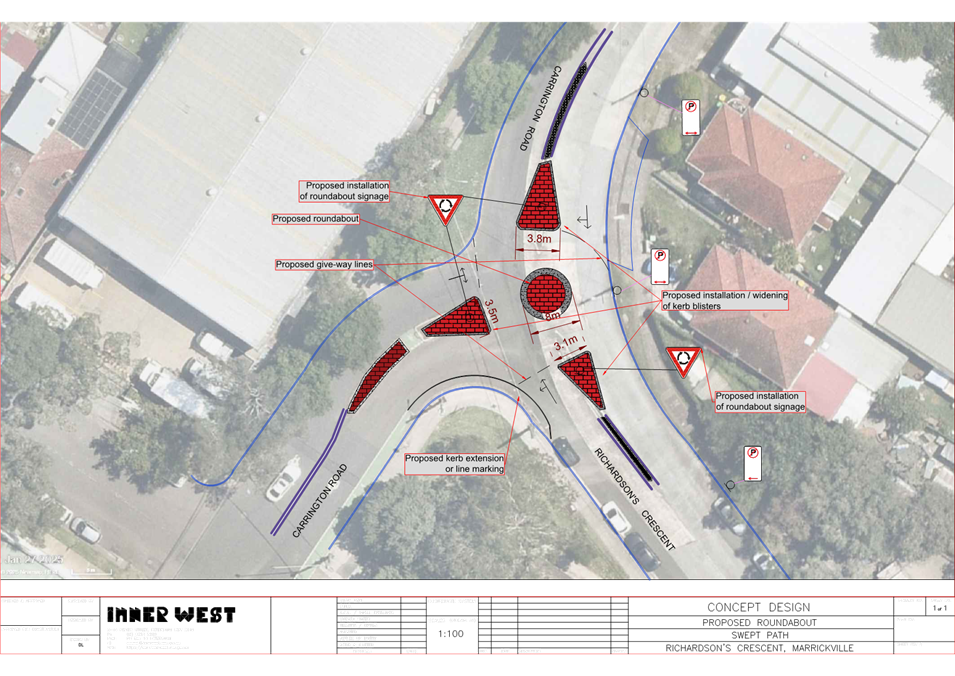
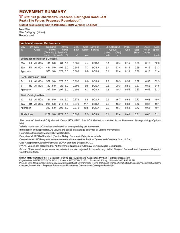
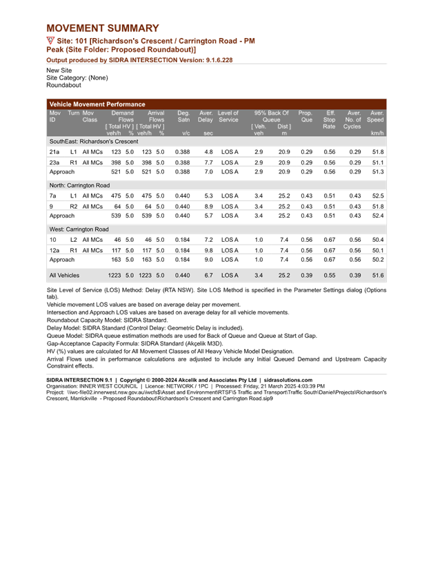
In order to improve traffic flow for right-turning vehicle movements on Carrington Road onto Richardson’s Crescent, a roundabout treatment could be considered to improve the situation. A concept plan showing the proposed roundabout can be seen in Attachment 1 and further details of the SIDRA results can be seen in Attachment 2. While the SIDRA results in table 3 indicate an improvement to the road network, at present, Council officers cannot support a roundabout at this location due to the following reasons:
· This location does not meet the warrants required for a roundabout treatment as specified by Austroads and Transport for NSW in terms of crashes and an equal distribution of traffic across all legs of the junction;
· As observed onsite, the through lanes at each approach provides an approximate width of 6.7m each which is capable of facilitating two-lane traffic and is consistent with onsite investigations. The swept paths indicate that the intersection does not provide enough width for a two-lane roundabout to effectively circulate traffic from all vehicle lanes and would require wider kerb blisters to be installed to restrict the roundabout to single lane traffic only;
· Installation costs for the roundabout being approximately $150,000.
|
|
AM Peak (7:45am – 8:45am) |
PM Peak (3:00pm – 4:00pm) |
|
Richardson’s Crescent Delay (seconds/vehicle) Level of Service |
7.2 A |
7.7 A |
|
Carrington Road North Approach Delay (seconds/vehicle) Level of Service |
9.6 A |
8.9 A |
|
Carrington Road West Approach Delay (seconds/vehicle) Level of Service |
11.1 A |
9.8 A |
Table 3. Projected conditions of the intersection with a roundabout proposal.
|
Option A: Roundabout treatment |
|
|
Advantages |
Disadvantages |
|
· Improves traffic safety and allows for right-turning movements to efficiently turn into the major carriageway. · No loss of on-street parking spaces · Reduced likelihood of potential collision points and accidents · Acts as a traffic calming device
|
· Cost of installation is high · Traffic on the major route will have increased delays and a lower level of service · Reduced sight visibility of the potential pedestrians and cyclists utilizing the existing refuges on Carrington Road. · Road curvature limits sight visibility of motorists from Renwick Street.
|
Table 4. Advantages and disadvantages of a roundabout treatment
Warrants for a roundabout
According to TfNSW guidelines, roundabouts are generally installed where there is a crash history involving a number of cross traffic incidents and it is often used to treat blackspot locations as a result of this type of crash history. Although there may have been near misses at this junction, it cannot be used as justification for such treatments as Council can only use recorded data provided by TfNSW which at this time has recorded a rear end accident with a minor injury in 2021.
In accordance with the Austroads Guide to Traffic Management Part 8 – Local Area Traffic Management (LATM), apart from the crash history, it is also noted that traffic volume data is an important factor to consider when investigating the feasibility of a roundabout treatment at an intersection. The Austroads guide states that a suitable intersection should ideally have approximately equal traffic flow from all approaches and be local streets in residential areas that have a high volume of unnecessary through traffic.
Accordingly, in conjunction with the lack of traffic accidents as well as the intersection counts in figure 2 which indicate an unequal amount of traffic volumes across all legs of the intersection, the warrants for a roundabout to be installed at this intersection have not been met. Should traffic volumes and the number of traffic accidents increase at this junction, a roundabout could be considered as a traffic management treatment in the future.
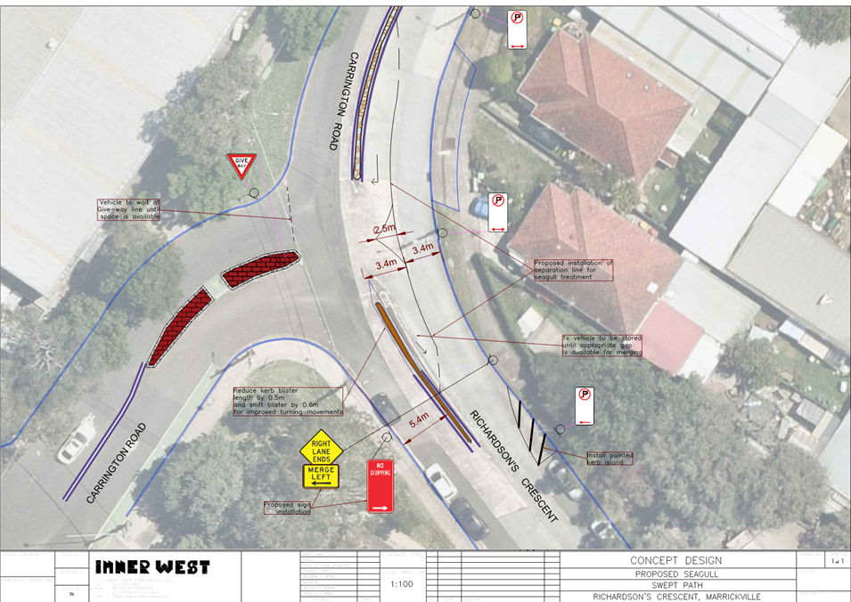
2. Proposal for a seagull treatment
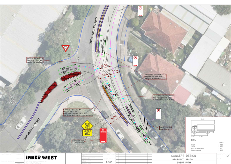
As the proposed roundabout treatment does not meet the required warrants by Transport for NSW and Austroads, an alternative proposed traffic treatment that could be considered at this intersection is a seagull treatment. A seagull treatment is typically used at intersections where the right turning traffic movements of a minor road experiences delays due to high traffic volumes experienced on the major route.
Typically, in a seagull treatment, there are two designs depending on the number of right-turning vehicles at an intersection. In this context where the right turning movements is relatively low compared to the high traffic volumes of a major road, a two-staged crossing treatment is preferred and has been proposed. This involves storing up to two (2) standard B85 vehicles along a median which would merge with through traffic where available. A concept plan and a swept path analysis of the proposed seagull treatment can be seen in Attachments 3 and 4.
In comparison to the existing intersection conditions modelled in SIDRA, the modelled seagull treatment in SIDRA is evidenced to also improve the conditions and level of service of the road network as seen in Attachment 5. Since the seagull treatment operates similarly to the roundabout treatment, Council officers are more supportive of this traffic treatment proposal due to the lower installation costs of approximately $30,000 and the intersection meeting the warrants for a seagull treatment. Additionally, if there are future developments with large volumes of traffic generation in the South Marrickville Area, the seagull treatment can easily be removed to allow for alternative and improved traffic treatments.
|
|
AM Peak (7:45am – 8:45am) |
PM Peak (3:00pm – 4:00pm) |
|
Richardson’s Crescent Delay (seconds/vehicle) Level of Service |
5.2 A |
5.4 A |
|
Carrington Road North Approach Delay (seconds/vehicle) Level of Service |
5.8 A |
5.9 A |
|
Carrington Road West Approach Delay (seconds/vehicle) Level of Service |
13.2 A |
10.8 A |
Table 5. Projected conditions of the intersection with a seagull treatment
Warrants for a seagull treatment
According to the Austroads Guide to Traffic Management Part 6: Intersections, Interchanges and Crossings, seagull treatments are generally only provided at T-intersections where right-turning traffic from a minor road would be delayed for extended periods due to the small number of coincident gaps on the major road. Notwithstanding, the decision to implement a seagull treatment should be based on traffic analysis that demonstrates that the treatment would operate satisfactorily and be advantageous in terms of safety. Generally, roundabouts where it is warranted are preferred over seagull treatments.
Accordingly, a seagull treatment is appropriate where:
· A substantial volume of traffic turns right from a minor road of a T-intersection to the extent that a two-stage right-turn through a conventional median opening would not operate satisfactorily.
· Traffic turning right from the minor road has adequate gaps in traffic on the nearer carriageway and is able to merge satisfactorily with the traffic on the other carriageway.
· It is unlikely that an access from a major traffic generator will be proposed adjacent to the major and opposite the minor road.
It should be noted that the proposed seagull treatment is located on a curve. According to Austroads, “where possible, overtaking lanes should be located so that merge tapers are not located on curves. Where this is not possible, care should be exercised with the location design of all merging tapers to ensure that there is adequate sight distance for the approaching driver to comprehend the existence of the merge and its geometry.”
An analysis into the road geometry and sight distance indicates that vehicles on the bend of Carrington Road provides a line of sight of 6.5m and an overall sight distance of 40m to the vehicles on the merging lane of the seagull treatment and is therefore compliant with the Austroads design guidelines for a geometric design.
|
Option B: Seagull treatment at the junction of Richardson’s Crescent and Carrington Road |
|
|
Advantages |
Disadvantages |
|
· Enables right-turning traffic from Carrington Road to merge onto Richardson’s Crescent without extensive delays. · No loss of on-street parking spaces · Speeds may reduce as a result of the seagull treatment due to the introduction of a merging lane. · Low cost of installation and maintenance
|
· Implementation of a seagull treatment may confuse road users · Increased likelihood of vehicle side swiping · Could lead to reduced vehicle visibility |
Table 6. Advantages and disadvantages of a seagull treatment
CONCLUSION
A feasibility analysis of the initially proposed roundabout treatment was carried out. Based on the traffic analysis within this report, the existing conditions of this intersection do not meet the required criteria to warrant the installation of a roundabout. However, while the existing conditions indicate that no further traffic management devices would be required at this intersection at this stage, as an alternative which would assist motorist in exiting Carrington Road right into Richardson Crescent is a Seagull Island treatment. This would be a lower cost solution which would provide similar efficiency benefits for right turning vehicles as a roundabout. It is recommended that the treatments within this report be received and noted.
|
1.⇩ |
Richardson's Crescent, Carrington Road - Concept of Proposed Roundabout |
|
2.⇩ |
Projected SIDRA Conditions - Proposed Roundabout Treatment |
|
3.⇩ |
Richardson's Crescent, Carrington Road - Concept of Proposed Seagull Treatment |
|
4.⇩ |
Proposed Seagull Treatment - Swept Path |
|
5.⇩ |
Projected SIDRA Conditions - Proposed Seagull Treatment |
|
Local Traffic Committee Meeting 16 June 2025 |
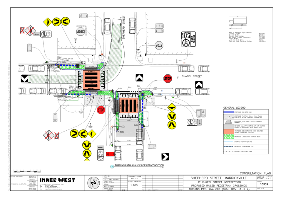
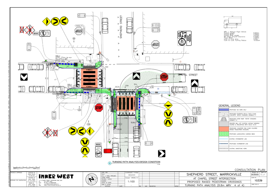
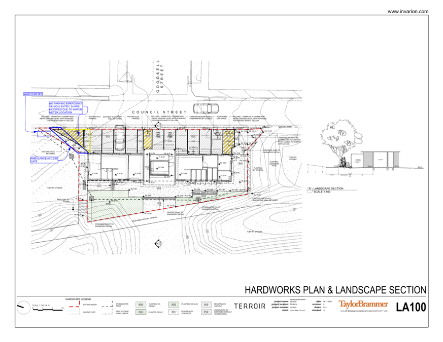
Subject: Shepherd Street and Chapel Street, Marrickville – Proposed two raised pedestrian crossings and kerb extensions - Design Plan 10339 (Midjuburi - Marrickville Ward / Summer Hill Electorate / Inner West PAC)
Prepared By: Jennifer Adams - Traffic Engineer
Authorised By: Sunny Jo - Acting Traffic and Transport Planning Manager
|
RECOMMENDATION
That the detailed design plan for the proposed raised pedestrian crossings in Shepherd Street and Chapel Street, Marrickville and associated signs and line markings (as per Design Plan No.10339) be APPROVED. |
STRATEGIC OBJECTIVE
This report supports the following strategic directions contained within Council’s Community Strategic Plan:
|
2: Liveable, connected neighbourhoods and transport |
|
|
EXECUTIVE SUMMARY
Council is planning to improve safety for pedestrians in Shepherd Street and Chapel Street, Marrickville by converting the 2 existing ‘at-grade’ pedestrian crossings to raised pedestrian crossings together with landscaped kerb blister islands. The proposal aims to improve pedestrian and motorist safety by better defining safe pedestrian crossing points; improve sight distances, reduce traffic speeds and conflicts with traffic movements at this location.
BACKGROUND
This report details the design plan for the pedestrian improvement works and its related consultation results. The works are expected to be undertaken during the 2024/2025 financial year, subject to final approvals, and budget allocations. Residents, businesses and other stakeholders will be notified prior to any work starts in the streets.
FINANCIAL IMPLICATIONS
The project is listed on Council’s 2025/2026 Traffic Capital Program for construction and estimated cost is $190,000.
OTHER STAFF COMMENTS
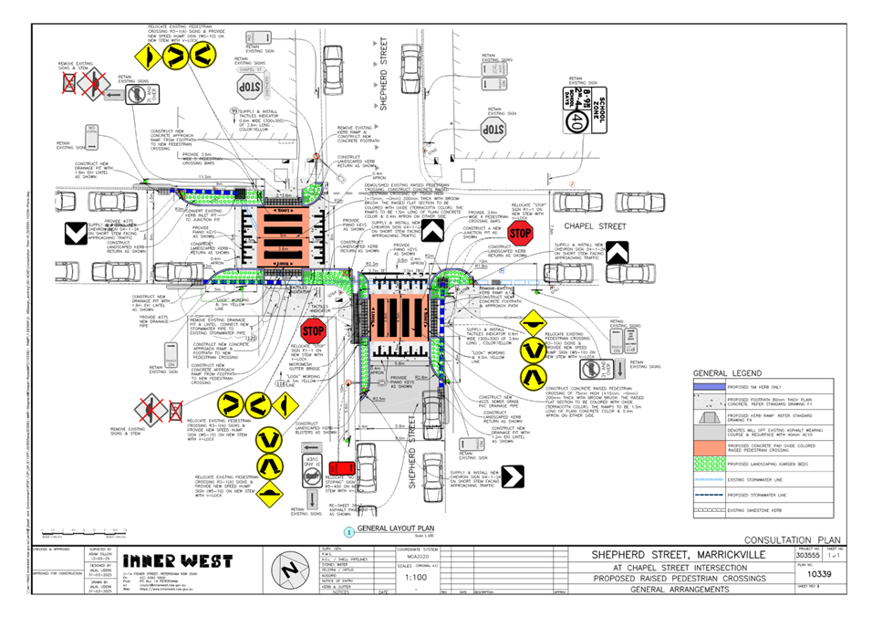
The following works were proposed and are illustrated on the attached Consultation Plan (Plan No. 10339). The proposed works aims to improve pedestrian and motorist safety by better defining safe pedestrian crossing points; improving sight distances, reducing traffic speeds and conflicts with traffic movements at this location.
Specifically, the proposed scope of works includes the following:
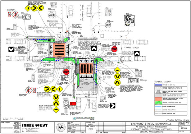
Chapel Street
· Construct a new raised concrete pedestrian crossing, with cross over paths to provide safe access over existing the kerb and guttering to the new raised pedestrian crossing. Tactile indicators will also be provided either side of the new raised pedestrian crossing;
· Construct landscaped kerb blister islands on both sides of the road adjacent to the new raised pedestrian crossing. Landscaping to be suitable species of native grasses (subject to final design);
· Provide new stormwater drainage pits and pipes to cater for the stormwater flows towards the new raised pedestrian crossing;
· Reconstruct some sections of the concrete footpath with new concrete; and
· Install signage and line marking associated with the works as required and where shown on the Plan.
Shepherd Street
· Construct a new raised concrete pedestrian crossing, with cross over paths to provide safe access over the existing kerb and guttering to the new raised pedestrian crossing. Tactile indicators will also be provided either side of the new raised pedestrian crossing;
· Construct landscaped kerb blister islands on both sides of the road adjacent to the new raised pedestrian crossing. Landscaping to be suitable species of native grasses (subject to final design);
· Reconstruct some sections of the concrete footpath with new concrete
· Provide new stormwater drainage pits and pipes to cater for the stormwater flows towards the new raised pedestrian crossing;
· Resurface a small area of the road pavement on approach to the new raised pedestrian crossing;
· Adjust and relocate the existing “No Stopping’ and ‘Stop’ signs as shown on the plans to cater for the new raised pedestrian crossing and comply with minimum sight distance requirements (refer to Plans); and
· Install signage and line marking associated with the works as required and where shown on Plan.
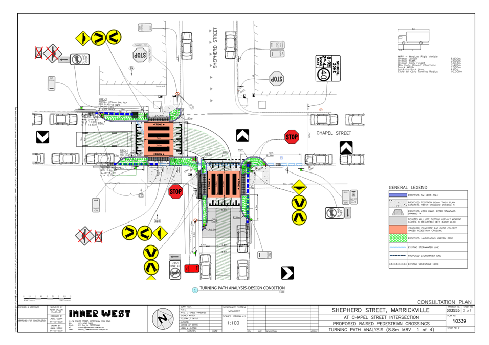
The consultation Plan along with the turning path analysis are provided in the attachments at the end of this report.
Parking Changes
It is proposed to slightly adjust the existing “No Stopping” signage by approximately 2.1m on the south side of Shepherd Street to meet minimum requirements for pedestrian crossings. However, no existing on-street car parking spaces will be lost as a result of the proposed works.
Streetlighting
The existing flood lighting at the location is deemed adequate for the new raised pedestrian crossings. Therefore, no changes are proposed to the existing street lighting due to the works.
PUBLIC CONSULTATION
Consultation was conducted between 22 April 2025 and 16 May 2025. A letter along with a copy of the design plan was sent to residents / businesses in the immediate locality and also separately to Inner West Council Bike Group. A total of 32 letters were distributed.
There were no responses.
CONCLUSION
It is recommended that the detailed design plan (10339) for the proposed new raised pedestrian crossings in Shepherd Street and Chapel Street, Marrickville (as shown in Attachment 1) be approved
|
1.⇩ |
303555-10339-Consultation Plans Turning Path (002) |
|
Local Traffic Committee Meeting 16 June 2025 |
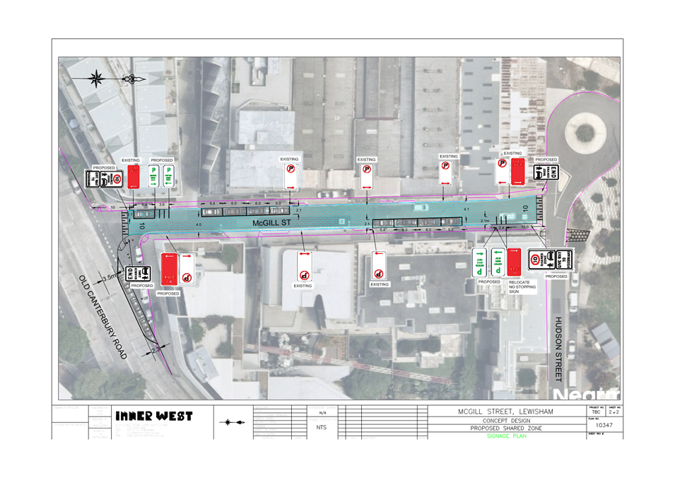
Subject: McGill Street, Lewisham - Proposed Shared Zone (Damun-Stanmore Ward/Newtown Electorate/Inner West PAC)
Prepared By: James Nguyen - Traffic Engineer
Authorised By: Sunny Jo - Acting Traffic and Transport Planning Manager
|
RECOMMENDATION
1. That a Shared Zone on McGill Street between Old Canterbury Road and Hudson Street, Lewisham, as per plan no.10347, be supported in-principle and included in Council’s Capital Works program subject to detailed design, support from Transport for NSW the community.
2. That the detailed design for the proposed Shared Zone in McGill Street, Lewisham be brought back to the Traffic Committee for consideration. |
STRATEGIC OBJECTIVE
This report supports the following strategic directions contained within Council’s Community Strategic Plan:
|
2: Liveable, connected neighbourhoods and transport |
|
|
EXECUTIVE SUMMARY
The adopted Inner West Council Pedestrian Access Management Plan (PAMP) recommends the investigation of a Shared Zone on McGill Street, Petersham, and pedestrian improvements at the intersection of Old Canterbury Road and Hudson Street. This report outlines further investigations completed along McGill Street and the nearby intersections, to assess the feasibility of the recommended treatments identified within the PAMP and develop them further. A concept plan has been developed proposing treatments which addresses some of these issues identified (some recommendations from the PAMP plan were unfeasible due to site constraints.
BACKGROUND
The adopted Inner West Council’s PAMP in February 2022 recommends the investigation of a Shared Zone on McGill Street, Petersham. In addition, the PAMP has also identified crossing deficiencies on McGill Street at the intersection of Old Canterbury Road and Hudson Street.
DISCUSSION
McGill Street is approximately 6 metres wide and is a two-way street with parallel parking provided on both sides. Parking is staggered on the kerbside to allow a wider two-way through lane of approximately 4 metres. Whilst this is narrow for two-way movements, the traffic volumes on McGill Street are low and traffic flow impacts are considered low.
The street is located just north of Old Canterbury Road and south of the Lewisham West Light Rail station. The surrounding land use consists of medium to high density residential, and industrial buildings, and small businesses. McGill Street is a local street which provides access to residential and industrial buildings, including the Lewisham West Light Rail station.
Inner West Council’s PAMP plan has identified the following deficiencies on McGill Street and is shown in Figure 1 below:
1. Crossing deficiency with poor kerb ramp alignment on McGill Street at the intersection of Old Canterbury Road;
2. Crossing deficiency with poor kerb ramp alignment on the eastern side of McGill Street, south of Hudson Street;
3. Crossin deficiency with missing kerb ramp on the western side of McGill Street, south of Hudson Street; and
4. Missing footpath along McGill Street.
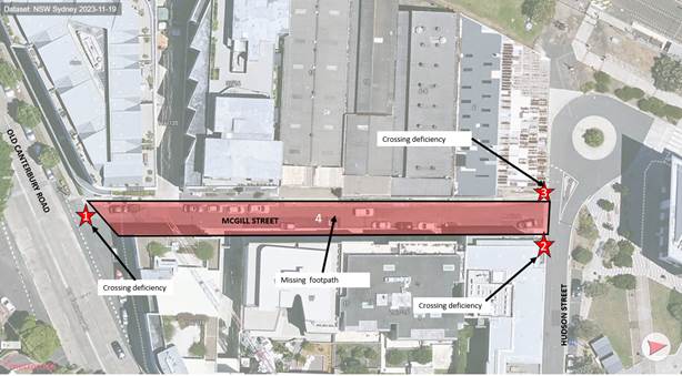
Figure 1 – McGill Street, Issues identified in the PAMP
Council has investigated these issues further and the findings are outlined below in Figure 2 and 3 below:
· The kerb ramps at the intersection of McGill Street and Old Canterbury Road are poorly aligned, with a large crossing distance (11.0m) for pedestrians.
· There are no kerb ramps to assist pedestrians cross Hudson Street from the eastern side of McGill Street, south of Hudson Street.
· There is no setback from the existing building to facilitate a path or kerb ramp to provide a connection on the southern side of Hudson Street, west of McGill Street.
· The widths of the existing footpath on both sides of McGill Street vary, with the largest width being 1.4m, and the narrowest point being 0.8m. The reduction in footpath widths are due to existing service utility boxes and light poles that are located within the footpath which are cost prohibitive to relocate. Accordingly, the footpath width is less than the desirable minimum of 1.2 metres in some sections.
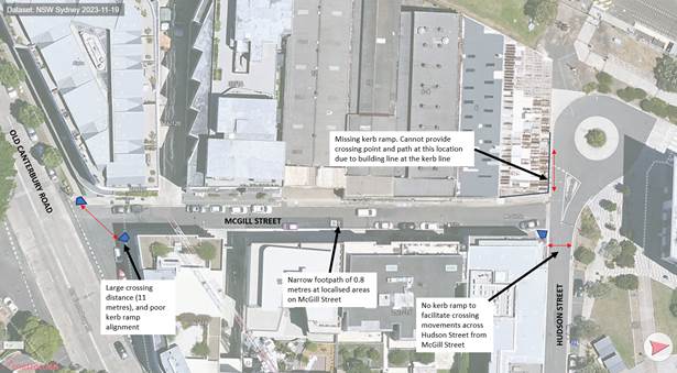
Figure 2 – McGill Street Site findings
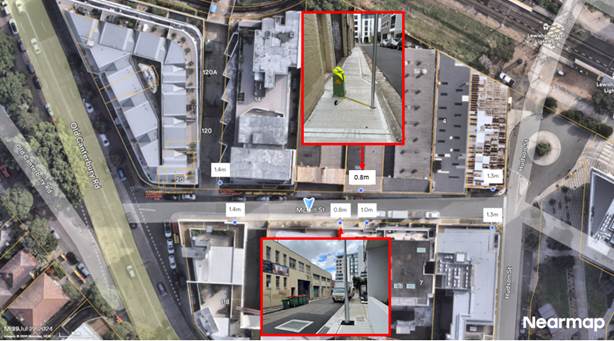
Figure 3 – McGill Street Footpath widths
Pedestrian crossing warrant assessment
Council officers have completed pedestrian and vehicle counts at the intersection of Old Canterbury Road and McGill Street to determine whether the pedestrian and vehicle volumes meet the minimum volumes required for consideration of a pedestrian crossing across McGill Street, just north of Old Canterbury Road. The results are presented in Table 1 below:
Table 1 - Pedestrian and vehicle movements across McGill Street, at Old Canterbury Road
|
Date |
Time |
Pedestrians (pedestrians per hour) |
Vehicles (vehicles per hour) |
Result |
|
Wednesday 18 September 2024 |
8.15am-9.15am |
64 |
111 |
· Vehicle volumes is less than the minimum 200 vehicles per hour warrant. · Pedestrian volumes exceeds the minimum 20 pedestrians per hour warrant
|
|
Tuesday 17 September 2024 |
4.30pm-5.30pm |
112 |
130 |
· Vehicle volumes is less than the minimum 200 vehicles per hour warrant. · Pedestrian volumes exceeds the minimum 20 pedestrians per hour warrant
|
The recorded morning and evening peak hour volumes for vehicles is less than the 200 vehicles per hour required within Inner West Council’s Pedestrian Crossing Warrant Policy.
Design proposal
Council officers have prepared a concept design to address the issues identified. The proposal consists of the following:
· Widen the existing footpath on the northern side of Old Canterbury Road, east of McGill Street and install a new kerb ramp. The existing parking spaces will be relocated to the northern side of Old Canterbury Road, east of McGill Street. It is proposed to install an edge line to clearly delineate the parking spaces and travel lane. The width of the parking spaces is approximately 2.3m.
· Install a raised Category 1 10km/h Shared Zone, with stamped asphalt pattern, and associated pavement line marking.
· New kerb ramps on Hudson Street, north of McGill Street.
· Line marking of existing parallel parking spaces within the proposed shared zone.
· Line marking to create five (5) new motorcycle parking spaces.
The following parking restrictions are also proposed as part of the proposal:
· ‘No Stopping’ restriction on the eastern side of McGill Street, north of Old Canterbury Road;
· Relocate the existing ‘No Stopping’ restriction on the eastern side of McGill Street, to extend the ‘No Stopping’ zone to 10m;
· ‘P Motor Bikes Only’ restrictions on the eastern side of McGill Street, south of Hudson Street; and
· ‘P Motor Bikes Only’ restrictions on the western side of McGill Street, north of Old Canterbury Road.
FINANCIAL IMPLICATIONS
A cost estimate and detailed design will be prepared during the design development of the proposal and referred to a future Local Traffic Committee meeting.
|
1.⇩ |
McGill Street Concept Plan |
|
2.⇩ |
McGill Street Signage and line marking plan |
|
|
Local Traffic Committee Meeting 16 June 2025 |
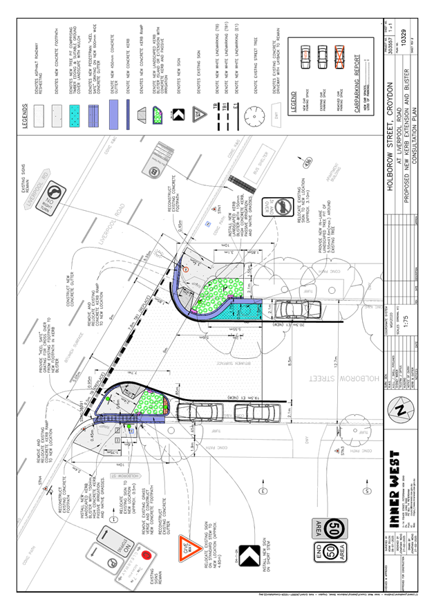
Subject: Holborow Street (at Liverpool Road), Croydon.(Djarrawunang-Ashfield Ward/Summer Hill Electorate/Burwood PAC)
Prepared By: Boris Muha - Traffic Engineer
Authorised By: Sunny Jo - Acting Traffic and Transport Planning Manager
|
RECOMMENDATION
That the detailed design plan (10329) for a proposed new landscaped kerb blister and extension re-alignment of the intersection of Holborow Street and Liverpool Road, Croydon, with associated signs and line marking (as shown in Attachment 1) be approved.
|
STRATEGIC OBJECTIVE
This report supports the following strategic directions contained within Council’s Community Strategic Plan:
|
2: Liveable, connected neighbourhoods and transport |
EXECUTIVE SUMMARY
Council has prepared a design plan to provide a new landscaped kerb blister and extension to re-align the intersection of Holborow Street and Liverpool Road, Croydon. The proposal aims to slow traffic and improve road safety for pedestrians and motorists at the intersection.
BACKGROUND
DISCUSSION
The following information is provided in discussion.
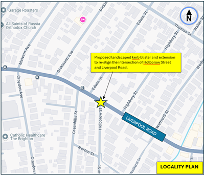
Figure 1. Locality Plan
|
Street Name |
Holborow Street
|
|
Carriageway width (m) kerb to kerb |
12.7 |
|
Carraigeway type |
Two-way, one travel lane each direction. |
|
Classification |
Local |
|
Speed Limit km/h |
50 |
|
85th percentile speed km/h |
49 (midblock-Arthur Street to Liverpool Road) |
|
Vehicles per day (vpd) |
700 |
|
TfNSW available reported crash history (last 5 years) |
(1) x 2019- RUM 73, off right into object, near west of Holborow Street, vehicle travelling west in Liverpool Road. Non-casualty (2) x 2021- RUM 11, right far, vehicle turning right out of Holborow Street into vehicle heading east on Liverpool Road. Moderate injury. |
|
Parking arrangements |
Unrestricted parking both sides |
|
|
|
|
Side intersecting street |
Liverpool Road. |
Table 1: Holborow Street Road Network Detail
The following works are proposed and are illustrated on the attached plan as shown in Attachment 1.
Holborow Street, Croydon (Plan No. 10329):
· Construct a new landscaped kerb blister (in front of 1 Holborow Street) with new concrete footpath and kerb ramp to reduce pedestrian crossover distance as shown in plan;
· Construct “gutter bridges” with heel safe grating to provide safe access over existing kerb and guttering to the new landscaped kerb blister (where required);
· Construct a new landscaped kerb extension (at Holborow Street frontage of 436 Liverpool Road) with new concrete footpath and kerb ramp to reduce pedestrian crossover distance as shown in plan;
· Construct new concrete gutter around new kerb extension (at Holborow Street frontage of 436 Liverpool Road) as shown in plan;
· Provide new edging treatment around an existing in-road street tree and landscape with groundcovers (where feasible);
· Resurface existing asphalt roadway as shown in plan;
· Install associated pavement line markings and signages as required.
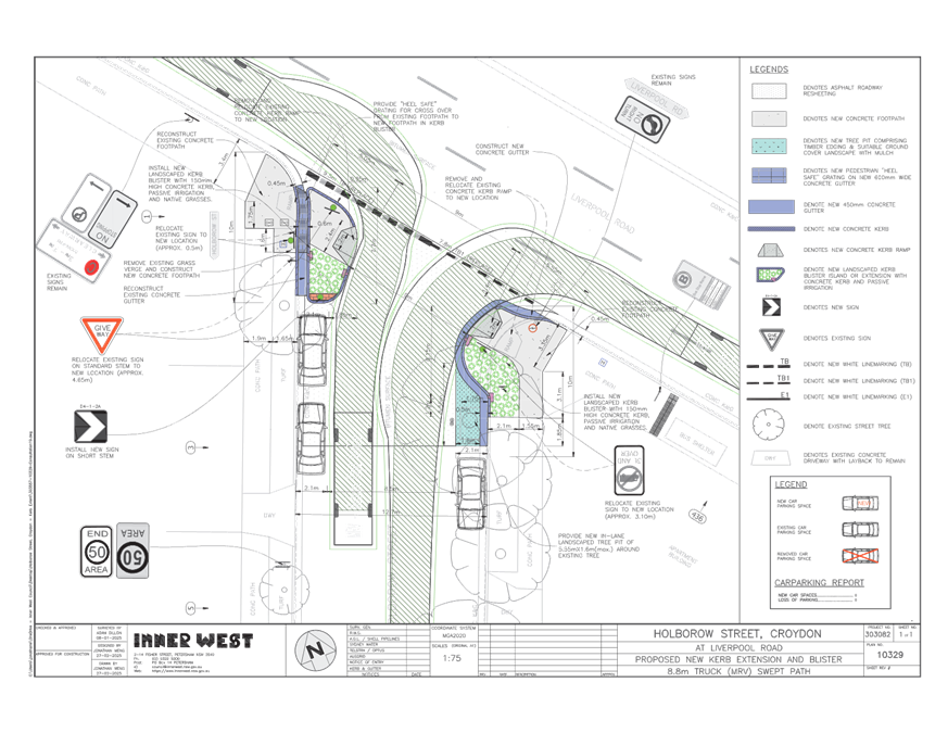
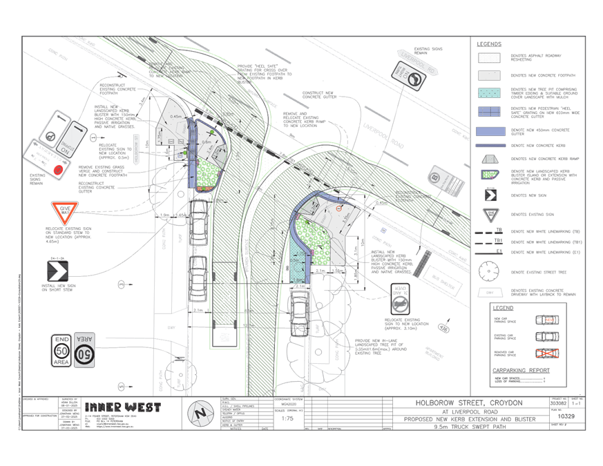
A swept path analysis has been undertaken for both a service vehicle and garbage truck. Trucks of this size are permitted to turn left from the second lane of Liverpool Road under the road rules and can turn left out into the second lane of Liverpool Road. Trucks are shown to primarily turn in and out of Holborow Street from the correct side of the road.
This proposal will not result in the loss of any on-street parking spaces, except during construction where some street parking may be affected temporarily.
FINANCIAL IMPLICATIONS
The project is listed in Council’s Traffic Facilities Capital Works program to be carried out in 2025/2026, subject to funding and programming. The work is estimated to be around $68,200.
CONSULTATION
A letter outlining the proposal was mailed out to (6) properties (30 letters), in Holborow Street and Liverpool Road, Croydon. (see also map of consultation area Figure 2).
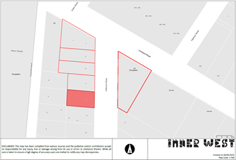
Figure 2- Consultation Area
No Submissions were received at the close of the submissions.
CONCLUSION
It is recommended that the detailed design plan (10329) for a proposed new landscaped kerb blister and extension re-alignment of the intersection of Holborow Street and Liverpool Road, Croydon, with associated signs and line marking (as shown in Attachment 1) be approved.
|
1.⇩ |
Proposed design plan- kerb blister, extension and re-alignment of Holborow Street at the intersection of Liverpool Road, Croydon. |
|
2.⇩ |
Swept path 8.8m truck |
|
3.⇩ |
Swept path 9.5m truck (garbage truck) |
|
|
Local Traffic Committee Meeting 16 June 2025 |
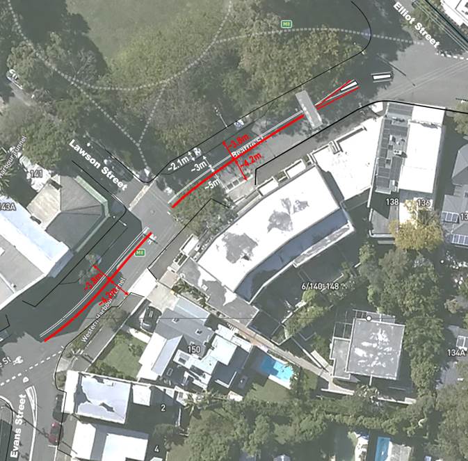
Subject: Beattie Street, Balmain – Proposed linemarking changes between Elliott Street and Evans Street (Baldurri-Balmain/Balmain Electorate/Leichhardt PAC)
Prepared By: Felicia Lau - Acting Coordinator Traffic Engineering Services North
Authorised By: Sunny Jo - Acting Traffic and Transport Planning Manager
|
RECOMMENDATION
That the proposed line marking changes for Beattie Street between Elliott Street and Evans Street, Balmain be approved.
|
STRATEGIC OBJECTIVE
This report supports the following strategic directions contained within Council’s Community Strategic Plan:
|
2: Liveable, connected neighbourhoods and transport |
|
|
EXECUTIVE SUMMARY
Council is planning to improve road safety along Beattie Street, Balmain between Elliott Street and Evans Street. The proposed realignment of the undivided centre lines is intended to encourage lower vehicle speeds and improve vehicle delineation.
BACKGROUND
Residents in Balmain has raised concerns regarding vehicle speeds in Beattie Street between Ann Cashman Reserve and Evans Street, which is a safety concern for pedestrians.
To improve road safety and improve vehicle delineation around the bend in Beattie Street between Elliott Street and Evans Street, it is proposed to realign the undivided centre line as shown below. The design proposes to widen the eastbound travel lane by 0.8m to reduce incidents of vehicles travelling over the existing lines and reducing the width of westbound travel lane to provide a visual narrowing that instinctively encourages lower vehicle speeds.
DISCUSSION
Council has undertaken a review of the road width in Beattie Street between Elliott Street and Evans Street. The existing condition of this section of Beattie Street is outlined below:
|
Street Name |
Beattie Street, Balmain |
|
|
Section |
Elliott Street and Evans Street |
|
|
Carriageway Width (m) |
10.1m |
|
|
Classification |
collector road |
|
|
Posted Speed Limit |
40kmh |
|
|
85th percentile speed |
36.4km/h |
|
|
Vehicles Per Day (vpd) |
3,185 |
|
|
Heavy vehicle Volume (%) |
2.4 |
|
|
Reported Crash History |
Nil for the last 5 years |
|
|
Parking Arrangement |
Parking is allowed on the northern side and ‘No Parking’ on the southern side |
|
A review of the existing road configuration indicate that the westbound travel lane is 5.0m wide, with the eastbound travel lane is 3m wide, excluding the parking lane. Due to the wider eastbound travel lane, drivers were observed to be navigating the bend without slowing down, and hence this imposes a safety risk to pedestrians and vehicles at the Evans Street intersection. Therefore, to improve the current situation it is proposed to realign the centre line that provides a visual narrowing that instinctively encourages lower vehicle speeds.
Beattie Street is not a public bus route but is an on-road cycling route featuring bicycle logos placed throughout Elliott Street.
A medium rigid vehicle (MRV) swept path has been undertaken to test that the proposal does not have a significant impact to larger vehicle that requires to service the street such as a waste collection vehicle, shown in the diagram below.
FINANCIAL IMPLICATIONS
There are no financial implications associated with the implementation of the proposed recommendations outlined in the report.
Nil.
|
|
Local Traffic Committee Meeting 16 June 2025 |
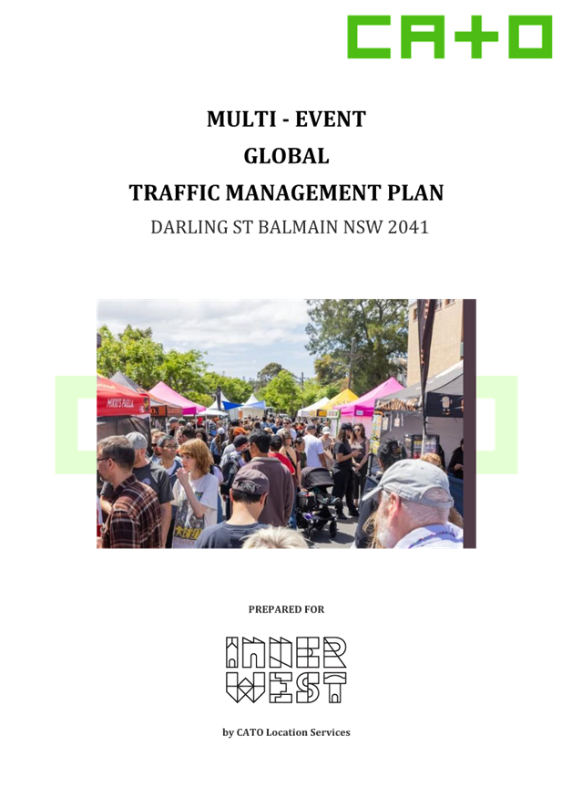
Subject: Darling Street, Balmain - Global TMP for Balmain Street - (Baludarri-Balmain Ward Balmain Electorate Leichhardt PAC)
Prepared By: Amir Falamarzi - Traffic Engineer
Authorised By: Sunny Jo - Acting Traffic and Transport Planning Manager
|
RECOMMENDATION
That the proposed global multi-event Traffic Management Plan (TMP) for Darling Street between Montague Street and Booth Street, Balmain, be approved-in principle for a period of five (5) years, with this year’s event to be held on a weekend during the month of November 2025, subject to the following conditions: a) The event organisers notify the community including residents and businesses of the proposed event, changes to traffic and parking in the area; b) All barricades and necessary signposting shall be provided by the event organisers and maintained during the period of the event by TfNSW-accredited marshals, or Police engaged by the applicant; c) All traffic control facilities are to be installed in accordance with Australian Standard 1742.3; d) The event organiser shall indemnify Inner West Council against all claims for damage or injury that may result from the activity or occupation of part of the public way during the activity. The event organiser must provide documentary evidence of public risk insurance cover of at least $20,000,000 indemnifying Council; and e) The event organiser shall be responsible for the reimbursement for the cost of repair of any damage caused to the public way, or as a result of the activities.
|
STRATEGIC OBJECTIVE
This report supports the following strategic directions contained within Council’s Community Strategic Plan:
|
2: Liveable, connected neighbourhoods and transport |
|
|
EXECUTIVE SUMMARY
Council has received a grant to develop a global Traffic Management Plan (TMP) for events on Darling Street in Balmain.
The purpose of the program is to help secure a brighter future for our communities by unlocking more walkable, safer, and activated neighborhoods.
Preparation is underway for a multi-event on Darling Street between Booth Street and Montague Street, Balmain. The global TMP will be used for future events at this location, with the first expected to be held on a weekend during the month of November 2025.
The event components may include a variety of activities, such as market stalls, themed displays, food trucks, tables and chairs and entertainment. Local commercial cafes and restaurants may have the opportunity to expand outdoor seating numbers to increase trading and enhance the specific event.
The event will impact surrounding streets within the Balmain area. The TMP was prepared to outline the effects on the road network, parking, pedestrian and bicycle routes, emergency routes and access to local properties and businesses.
BACKGROUND
Inner West Council has received a grant to develop a global TMP for events on Darling Street in Balmain.
The purpose of the program to help secure a brighter future for our communities by unlocking more walkable, safer, and activated neighborhoods.
The proposed global TMP aims to:
· Promote vibrant local communities with event-ready streets by activating streets and centres through streamlined temporary events, generating social, cultural, and economic benefits within local NSW communities, and supporting in-person social settings for all ages and genders.
· Support cultural industries and drive economic growth with event-ready streets by targeting reductions in event costs and complexities, aiming to boost local businesses’ visibility and engagement, and leveraging the economic and cultural potential of street-based events.
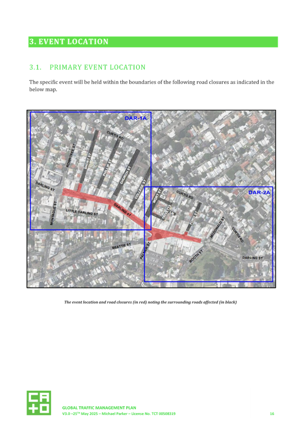
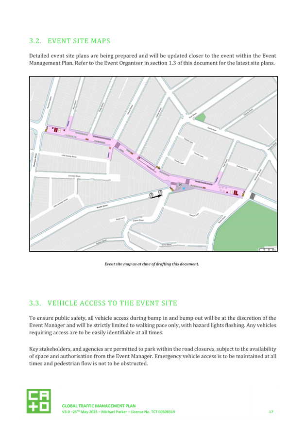
The first event will take place on a weekend during November 2025. Figure 1 shows the location of the event area and proposed road closures.
Figure 1: Event location and proposed road closures (in purple) in Darling Street, Balmain
DISCUSSION
The Multi-Event Global TMP (Attachment 1) provides details of the traffic and transport changes.
Event details
The event will take place on Darling Street, Balmain, between Montague/Rowntree Streets and Booth Street. Expected attendance ranges from approximately 5,000 to 15,000 people, depending on the implementation of the global TMP. The target market includes all demographics, which may vary based on the event theme, such as culture, age, activity, or other specific audiences.
Traffic Impact Summary
Street that will be closed via ‘hard’ road closure:
· Darling Street - between Montague/Rowntree Streets and McDonald/Booth Street;
· Short Street – between Darling Street and 28m from the intersection with Darling Street;
· Ford Street – between Darling Street and 28m from the intersection with Darling Street;
· Little Darling Street – between Darling Street and 28m from the intersection with Darling Street.
Street that will be closed via ‘soft’ road closure where local access will be permitted:
· Short Street – between the above mentioned ‘hard’ closure and Curtis Road,
· Phillip Street – between Darling Street and Curtis Road,
· Church Street – between Darling Street and Curtis Road,
· College Street – between Darling Street and Curtis Road, and
· Mort Street – between Darling Street and Curtis Road
Pedestrian access
Pedestrian access will be maintained along all existing footpaths in and around the event area. Pedestrian access to residences and local businesses will be maintained at all times.
Signalised Intersections
The road closures are not expected to impact traffic signal operations at Darling Street and Montague Street. There are no other signalised intersections in the local area.
Vehicle Access to The Event Site
To ensure public safety, all vehicle access during bump in and bump out will be at the discretion of the Event Manager and will be strictly limited to walking pace only, with hazard lights flashing. Any vehicles requiring access are to be easily identifiable at all times.
Key stakeholders, and agencies are permitted to park within the road closures, subject to the availability of space and authorisation from the Event Manager. Emergency vehicle access is to be maintained at all times and pedestrian flow is not to be obstructed.
Once the closures are installed and the event commences, no vehicle access is permitted within the event area except for emergency vehicles.
Detours and Diversions
A detour plan will be in place and access around the closures will be via Rowntree Street, Curtis Road, and McDonald Street.
Detour signs will be implemented along these streets as outlined in the Traffic Guidance Scheme within the TMP.
Parking Management
Parking will be cleared on the following road section to allow the event to proceed on the closed portion of the road:
· Darling Street, between Montague Street and McDonald Street, both sides
· Church Street, between Darling Street and Little Darling Street, both sides
· Short Street, between Darling Street and No.4 Short Street, both sides
· Phillip Street, between Darling Street and No.8 Phillip Street, both sides
· Church Street, between Darling Street and No.2 Church Street, both sides
· College Street, between Darling Street and No.1 College Street, both sides
· Mort Street, between Darling Street and Trivetts Lane, both sides
· Ford Street, between Darling Street and Hoffmans Lane, both sides
· Beattie Street, 5 spaces west of Palmer Street, south side
Impact on Public Transport
No public bus services or bus stops will operate through the road closure area during the event. The route numbers affected by the TMP will be service 433, 442 and 445. The bus route of 441 will remain unchanged.
To maintain access to public transport between Balmain and East Balmain, Council will organise smaller shuttle bus services to run between Balmain East and Darling Street / Rowntree Street for Council-run events.
Taxis and ride-share providers will continue to have access to the road network around the closures as per other road users. No additional drop off or pick up standing zones will be arranged for these providers.
Changes to Cycle Routes
The event road closures for the event is not expected to affect designated cycle routes. All cyclists that utilise any of the abovementioned routes will be redirected around the event location on the existing road or shared path network.
To encourage event patrons to utilise bicycles as a mode of transportation to and from the event, a designated bicycle parking area will be installed as part of the event.
Access for Local Residents
The road closures for the event in Balmain includes a number of businesses and residential premises around the area. Pedestrian access to residences and local businesses will be maintained at all times, however businesses and resident vehicle access will only be permitted during specified dates and times.
The event organiser will notify any residents and businesses directly impacted by the event including confirmation of the restricted vehicle movements during the event operating times.
Access for Emergency Vehicles
A minimum four (4) metre emergency lane will be maintained along the entire closure to maintain access at all times. There will be no event infrastructure in the path of the emergency vehicle to obstruct access or the route. Authorised traffic controllers, security and event staff will be onsite to assist emergency vehicle through the closure points to access the required destination.
Advertisement of the TMP
The event organiser will advertise the road closures taking place using a variety of methods a minimum two (2) weeks preceding the event via Council’s social media platforms, Council’s website, and local signage where required.
The road closures may also be advertised by way of trailer mounted variable message signs (VMS) to warn other road users of the upcoming event, and the road closures that will be implemented.
NSW Police engagement
The Leichhardt Police Area Command (PAC) will be involved in the planning of the specific event at Balmain.
The PAC will be involved via Council’s Traffic Committee and planning consultation meetings, including aspects relating to use of the roadway, closure of selected roads, Hostile Vehicles Mitigation (HVM) and crowd management. Internal departments will be formally notified at least two weeks prior to the event taking place.
Hostile Vehicle Mitigation (HVM) Plan
The event organiser will, in conjunction with the nominated security advisor, produce a Hostile Vehicle Mitigation (HVM), and Target Hardening Plan for the event.
When the closures are installed, applicable HVM vehicles or barriers will be placed at each entry point to prevent access to the site by unauthorised or errant vehicles.
FINANCIAL IMPLICATIONS
The costs for the planning and execution of the event are expected to be funded from Transport for NSW’s Open Streets Program grant.
|
1.⇩ |
Global Multi-Event TMP for Darling Street, Balmain |
|
|
Local Traffic Committee Meeting 16 June 2025 |
Subject: Darling Street, Balmain - Proposed motor bike parking restriction (Baludarri-balmain/balmain electorate/leichhardt pac)
Prepared By: Felicia Lau - Acting Coordinator Traffic Engineering Services North
Authorised By: Sunny Jo - Acting Traffic and Transport Planning Manager
|
RECOMMENDATION
1. That the installation of a 5m length ‘Motor Bikes Only’ parking zone on the northern side of Darling Street 10m west of Duke Street, Balmain East be approved.
2. That a Give Way (R1-2A) sign be installed in Duke Street at its intersection with Darling Street, with Give Way (TB and TB1) lines across Duke Street. |
STRATEGIC OBJECTIVE
This report supports the following strategic directions contained within Council’s Community Strategic Plan:
|
2: Liveable, connected neighbourhoods and transport |
|
|
EXECUTIVE SUMMARY
To improve intersection safety at the Duke Street and Darling Street intersection, Balmain East, the following are proposed:
§ Converting a 5m unrestricted parking space in Darling Street, west of Duke Street to ‘Motor Bikes Only’ parking zone;
§ Formalising give-way treatment with sign and line marking at Duke Street; and
§ Consideration of a variable speed radar to be installed along the frontage of St. Mary’s Balmain Anglican Church facing eastbound traffic in Darling Street.
BACKGROUND
Council has received correspondence from several residents regarding the intersection of Darling Street and Duke Street, Balmain East. There are concerns of limited driver visibility in Darling Street for vehicles exiting Duke Street.
DISCUSSION
To improve visibility, it is proposed to convert the existing 5m unrestricted parking space in Darling Street, west of Duke Street to a ‘Motor Bike Only’ parking zone. Additionally, it is proposed that transverse Give Way (TB and TB1) lines be installed as shown in the figure below.
Council will also consider implementing including a variable speed radar to be installed along the frontage of St. Mary’s Balmain Anglican Church facing eastbound traffic in Darling Street. This will visually inform drivers travelling above speed limit to slow down as they approach the subject intersection.
A letter outlining the proposal to convert the 5m unrestricted parking space in Darling Street, west of Duke Street to ‘Motor Bikes Only’ parking zone was mailed out to all affected residents accessing Duke Street, including Gilchrist Place and Duke Place. A total of 128 letters were distributed.
At the end of the consultation period, 20 submissions were received and 14 were in support of the proposal, representing a support rate of 70%. A summary of the response comments provided below.
|
Residents Comments |
Officers Comments |
|
Make the space a no parking for vehicles at all times, ideally a garden bed to restrict illegal parking. |
The intersection already has the minimum 10m length ‘No Stopping’ zones in both directions at Darling Street. The proposal is to further improve sight distance for drivers exiting Duke Street. As the subject parking space is highly utilised, and there is high demand of on-street parking in the area, there is a need to balance the parking needs and improve visibility. Hence, it is proposed to convert the space to a motorbike parking as the height of motorbikes generally allow for drivers to see further onto oncoming vehicles in Darling Street. |
|
A few years ago, Council converted a small space next to the space in question, into ‘motorbike only’ parking, as a response to resident concerns about the same issue. Unfortunately, it has helped only marginally, I would not like to see the same mistakes repeated. |
The installation of motorbike parking in this location was to assist in maintaining vehicular access due to parked vehicle encroaches adjacent driveway access to properties. |
|
Consider traffic calming to slow down traffic in Darling Street. |
The existing posted speed limit in Balmain East is 40km/h and with parked vehicles on both side of Darling Street, it provides a visually narrower road environment that encourages lower traffic speed. However, Council is also assessing the site for a variable speed radar to be installed along the frontage of St. Mary’s Balmain Anglican Church. This will visually inform drivers travelling above speed limit to slow down in Darling Street. |
|
Consider a pedestrian crossing in Darling Street. |
Initial assessment indicate that the location may not be along pedestrian desire lines. A crossing also would result in additional loss of on-street parking and should be carefully considered. This is currently being considered in the Balmain East and Birchgrove Precinct Local Area Traffic Management (LATM) Study. |
FINANCIAL IMPLICATIONS
There are no financial implications associated with the implementation of the proposed recommendations outlined in the report.
Nil.
|
|
Local Traffic Committee Meeting 16 June 2025 |
Subject: Elliott Street, Balmain - Proposed Resident Parking Scheme (Baludarri-Balmain Ward/Balmain Electorate/Leichhardt PAC)
Prepared By: Charbel El Kazzi - Traffic Engineer
Authorised By: Sunny Jo - Acting Traffic and Transport Planning Manager
|
RECOMMENDATION
That the proposed resident parking scheme ‘2P 8am-10pm Permit Holders Excepted Area B1’ on the north side of Elliott Street between Rosieville Lane and Glassop Street, and south side of Elliott Street in between Claremont and Terry Street, Balmain as per below plan be approved.
|
STRATEGIC OBJECTIVE
This report supports the following strategic directions contained within Council’s Community Strategic Plan:
|
2: Liveable, connected neighbourhoods and transport |
|
|
EXECUTIVE SUMMARY
Several residents in Elliott Street, Balmain have expressed concerns regarding long-term non-resident parking and requested a Resident Parking Scheme (RPS) for their street.
In response, preliminary investigation and community engagement were undertaken by Council on a ‘2P 8am-10pm Permit Holders Excepted Area B1’ proposal on the north side of Elliott Street between Rosieville Lane and Glassop Street, and south side of Elliott Street in between Claremont and Terry Street, Balmain.
The results of the community engagement indicated adequate support for the implementation of the proposed Resident Parking Scheme.
BACKGROUND
Council has received several concerns from residents in Elliott Street regarding long-term non-resident parking and have requested a resident parking scheme for their street. In response a parking occupancy survey was undertaken, and high parking occupancy levels (above 85%) were found in several sections of Elliott Street. A resident parking scheme was deemed suitable and proposed within the high occupancy sections as illustrated in figure 1. Council’s resident parking scheme policy requires a minimum of 50% support from properties in the subject section with each property entitled to a single preference.
On-street parking demand in Elliott Street was reported to be exacerbated due to the Casa Esquina restaurant, along with restaurant staff parking, local retail stores and cafes along Darling Street. Residents have also flagged that parking demand would be expected to increase with the opening of the Balmain West Ferry Wharf later this year.
![]()
![]()
DISCUSSION
A letter outlining the proposal was issued to the affected properties seeking resident’s views. It is worth noting that no residents within the subject section opposed the proposal. During consultation period, council received a petition in support of the proposal and this has been included within the results shown in the below table.
|
Number of properties |
Number of properties in support |
Number of properties in objection |
Response rate |
Support rate |
|
20 |
12 |
0 |
60% |
60% |
As the above results exceeded the 50% support rate, it is recommended that a RPS be supported in the proposed sections of Elliott Street, Balmain.
FINANCIAL IMPLICATIONS
The funding for the proposed signage is available within Council’s sign and linemarking budget.
Nil.
|
|
Local Traffic Committee Meeting 16 June 2025 |
Subject: Inner West LGA - Proposal for Flexicar Car Share Parking Spaces (All Wards/All Electorates/All PACs)
Prepared By: James Nguyen - Traffic Engineer
Authorised By: Sunny Jo - Acting Traffic and Transport Planning Manager
|
RECOMMENDATION
That the following ‘No Parking Authorised Car Share Vehicle Expected, Area FLEXICAR’ restrictions be approved:
a) A 2.5m wide space in the Edgeware Road Council car park, Enmore next to the existing car share space.
b) A 5.5m restriction on the southern side of Arthur Street, Marrickville east of Ann Street outside no.10 Arthur Street.
c) A 5.5m restriction on the northern side of Salisbury Road, Stanmore east of Percival Road.
d) A 5.5m restriction on the southern side of Railway Avenue, Newtown west of Liberty Street.
e) A 5.5m restriction on the eastern side of Regent Street, Petersham south of Trafalgar Street.
f) A 5.5m restriction on the western side of Barwon Park Road, St Peters south of Princes Highway.
g) A 2.5m wide space in the Seaview Street Council car park, Dulwich Hill to the existing car share space.
h) A 5.5m restriction on the southern side of Guihen Street, Camperdown west of Booth Street.
|
STRATEGIC OBJECTIVE
This report supports the following strategic directions contained within Council’s Community Strategic Plan:
|
2: Liveable, connected neighbourhoods and transport |
|
|
EXECUTIVE SUMMARY
A request has been received from Flexicar to install 12 on-street dedicated ‘Car Share’ parking spaces for existing floating car share vehicles around the Inner West.
BACKGROUND
Car sharing has been well established in the Inner West and provide an additional transport option for the growing population in the Inner West LGA.
One of the benefits of a car share scheme is that one shared vehicle can replace several private vehicles that would otherwise compete for local parking. The scheme also reduces overheads for residents who don't need to own a car. Other benefits align to Council’s Integrated Transport Strategy by supporting sustainable transport as a part of its drive to:
· reduce greenhouse gas emissions;
· reduce on-street parking demand;
· reduce congestion and the competition for parking spaces; and
· encourage active lifestyles by reducing dependency on private cars.
Users of car share schemes in the Inner West report reduced car ownership and greater use of other transport options including public transport, walking and cycling.
The following hierarchy of preferred locations for designated car share spaces has been applied when assessing suitability of locations:
a) Within immediate proximity to public transport services such as a rail/metro station/stop;
b) Adjacent to public land such as a park;
c) Adjacent to a public facility such as a leisure centre or library;
d) Within high/medium density residential areas;
e) In or immediately adjacent to retail / commercial streets;
f) Adjacent to the side boundary of single dwellings;
g) Other locations.
Car share parking spaces located in front of single dwellings will be given low priority and avoided in most circumstances. Consultation will be carried out with residents and businesses in the immediate vicinity of a proposed parking space.
Inner West Council reserves the right to reject, or determine by refusal, any application for a car share parking space.
|
|
Local Traffic Committee Meeting 16 June 2025 |
|
Street |
Suburb |
Specific Location |
Image |
|
Edgeware Road |
Enmore |
Edgeware Road Car Park next to exiting car share space |
|
|
Arthur Street |
Marrickville |
Southern side of Arthur Street, east of Ann Street outside no. 10. |
|
|
Salisbury Road |
Stanmore |
Northern side of Salisbury Road, east of Percival Street. |
|
|
Railway Avenue |
Newtown |
Southern side of Railway Avenue, west of Liberty Street |
|
|
Regent Street |
Petersham |
Eastern side of Regent Street, south of Trafalgar Street |
|
|
Barwon Park Road |
St Peters |
Western side of Barwon Park Road, south of Princes Highway |
|
|
Seaview Street |
Dulwich Hill |
Seaview Street, car park, next to existing car share space |
|
|
Guihen Street |
Camperdown |
Southern side of Guihen Street, west of Booth Street |
|
|
|
Local Traffic Committee Meeting 16 June 2025 |
Community consultation was led by Flexicar representatives between 11 March 2025 and 18 April 2025. Letters were distributed to local residents within 100 metres of each proposed space.
|
Location |
No. of responses |
Resident comments |
Officer comments |
Recommendation |
|
Edgeware Road, Enmore; Edgeware Road Car Park next to exiting car share space |
· One (1) response · One (1) objection |
Objection due to limited parking in the street |
The proposal is located within the Council public car park at no.2 Edgeware Road. There are no changes to on-street parking. Car share will also reduce the number of private vehicle ownership that may otherwise occupy on-street parking |
Install |
|
Arthur Street, Marrickville; Southern side of Arthur Street, east of Ann Street outside no. 10. |
· Six (6) responses · Six (6) objections |
The six (6) submissions objecting to the proposal noted the following concerns:
Parking is in high demand and already competitive for residents and guests who visit.
Households with no parking permits will be affected.
The location is well serviced by public transport.
Council should reconsider this proposal and explore alternative locations.
It is encouraged that Council make public transport more effective and efficient.
There is already a GoGet car share space on Arthur Street and Francis Street
There are concerns about the increased commercialisation of public space
The location is used for bin collection each week on Tuesday.
There is limited off-street parking in the adjacent apartment.
The location is in front of a building that houses elderly and disabled residents, who require accessible parking near their homes.
|
Whilst this is adjacent to medium-high density units, this is considered suitable as a car share location.
There is already an existing car share space nearby, however the vehicle is a van. This proposed car share proposal will provide a passenger vehicle.
|
Install |
|
Salisbury Road, Stanmore; Northern side of Salisbury Road, east of Percival Street. |
· One (1) response · One (1) supportive |
Request for driveway line marking, 3 metres from the driveway to improve sight lines of approaching traffic on Salisbury Road.
|
Proposal is located near medium-density residential units and train station and is considered suitable as a car share location.
Driveway line markings are permitted at a maximum of 1m from the edge of the property access line.
The space can be installed approximately 1m from the edge of the nearby property access line. |
Install |
|
Railway Avenue, Newtown; Southern side of Railway Avenue, west of Liberty Street |
Nil responses |
Nil responses |
Proposal is located near medium-density residential units, and is considered suitable as a car share location.
The existing car share spaces nearby on Trade Street have high utilisation. |
Install |
|
Regent Street, Petersham; Western side of Regent Street, south of Trafalgar Street |
· Two (2) responses · Two (2) objections |
The two (2) responses opposing the proposal raised concerns about the lack of parking and it was suggested to relocate the space to another location. |
The car share space is proposed in an existing timed restricted parking space signposted as ‘1P 8.30am-6pm Mon-Fri; 8.30am-12.30pm Sat’ and will impact short term parking for nearby businesses and residents.
It is recommended to relocate the car share space to the other side (eastern side) of Regent Street to the unrestricted parking space.
Proposal on Regent Street is located near medium-density residential units, near Petersham Station and is considered suitable as a car share location. There are no existing car share spaces on Regent Street. It is not recommended to relocate this space to another street.
|
Install on eastern side of Regent Street, in the unrestricted parking space.
|
|
Barwon Park Road, St Peters; Western side of Barwon Park Road, south of Princes Highway |
· One (1) response · One (1) objection |
Unsupportive due to loss of on-street parking spaces for residents. |
Proposal is adjacent to Sydney Park and near medium-high density residential units, and is considered suitable as a car share location. There are no existing car share spaces on Barwon Park Road.
|
Install |
|
Seaview Street, Dulwich Hill; Seaview Street, car park, next to existing car share space |
Nil responses |
Nil |
Proposal is located in an off-street car park, near shops, Dulwich Hill Library, medium-high density units, and is considered suitable as a car share location.
|
Install |
|
Guihen Street, Camperdown;
Southern side of Guihen Street, west of Booth Street |
Nil responses |
Nil |
Proposal is located near high-density residential units, is considered suitable as a car share location. No existing car share space on Giuhen Street. |
Install
|
|
|
Local Traffic Committee Meeting 16 June 2025 |
Costs associated with the installation, removal, maintenance and administration of dedicated car share bays/spaces including non-statutory features such as painted road markings will be met by the relevant car share company in accordance with the Schedule of Fees and Charges.
Nil.
|
|
Local Traffic Committee Meeting 16 June 2025 |
Subject: Camdenville Park, St Peters - Proposed parking changes to the Camdenville Park carpark at Council Street, St Peters (Midjuburi - Marrickville Ward / Heffron Electorate / Inner West PAC)
Prepared By: Daniel Li - Student/Graduate Traffic Engineer
Authorised By: Sunny Jo - Acting Traffic and Transport Planning Manager
|
RECOMMENDATION
That the carpark design and signage plan of the Camdenville Park Amenities Refurbishment be approved by Council.
|
STRATEGIC OBJECTIVE
This report supports the following strategic directions contained within Council’s Community Park facility Strategic Plan:
|
2: Liveable, connected neighbourhoods and transport |
|
|
EXECUTIVE SUMMARY
A concept plan which included upgrades to the existing amenities building and existing car parking area at Council Street, St Peters was proposed as part of the Camdenville Park Amenities Refurbishment project. This report is provided to formalize the car parking area including relevant line marking of parking bays and parking signage. It is recommended that Council approve the design of the car park at Camdenville Park fronting Council Street, St Peters.
BACKGROUND
In July 2016 under former Marrickville Council, a proposal including community engagement and concept designs was submitted by Council to upgrade the playground, facilities, sporting fields and amenities at Camdenville Park. The proposed upgrade works were put on hold due to the temporary leasing and acquisition of the site by Transport for NSW for the completion of the WestConnex project. Following completion of the WestConnex project in 2022, Transport for NSW has handed the site of Camdenville Park back to Inner West Council as a park asset, in which proposed upgrade works were able to resume. During the temporary acquisition by Transport for NSW, Council’s Capital Projects team has developed further designs for community feedback and construction in May 2025. As the final design includes changes to the car parking area of Camdenville Park, a report to the Local Traffic Committee is required for the approval of traffic and parking changes.
DISCUSSION
Currently, the car parking area of Camdenville Park at Council Street, St Peters provides 13 non-compliant car parking spaces. As part of the upgrades, the proposed carpark refurbishment will include:
· Nine (9) formalized parking bays
· One (1) motorbike space
· One (1) mobility space including an adjacent shared space; and
· An emergency vehicle access area accessible at all times.
A detailed design plan of the proposed carpark works can be seen in Attachment 1.
While there is a reduction in car parking spaces, by line marking parking bays and formalizing parking spaces, it improves compliance to Table 2.2 of AS2890.5 which requires a minimum width of 2.4m for on-street parking spaces. This will also allow for improved vehicle accessibility from the passenger doors.
Furthermore, due to the existing car park not having any signage installed previously, it was recommended by Council that outside of regulatory signage as shown in Attachment 2, no further parking restrictions were to be introduced after the completion of the project. Notwithstanding, while it is currently proposed to be unrestricted parking, parking restrictions could be introduced similar to the restrictions on Goodsell Street, Council Street and May Street if the car parking spaces are misused for extended long term parking.
As the proposed car park changes are related to Camdenville Park, an asset of Inner West Council, no consultation was undertaken on the car parking area due to the lack of impact on residential on-street parking. However, it should be noted that prior to the construction phase of Camdenville Park, community consultation was undertaken with respect to the master concept designs associated with other proposed park facilities for Camdenville Park. Having considered this report, it is recommended that the carpark design adjacent to the Camdenville Park Amenities Building be approved for installation.
FINANCIAL IMPLICATIONS
The proposed sign installations will cost approximately $30,000 and will be funded with the Capital Projects – Carpark Cost Centre.
|
1.⇩ |
Carpark Design Plan by TaylorBrammer Pty Ltd |
|
2.⇩ |
Camdenville Park - Proposed Carpark Signage Plan |
|
|
Local Traffic Committee Meeting 16 June 2025 |
Subject: Gower Street, Ashfield - Proposed Resident Parking Scheme at Gower Street between Liverpool Road and Ormond Street (Djarrawunang-Ashfield Ward) / Summer Hill Electorate / Burwood PAC)
Prepared By: Daniel Li - Student/Graduate Traffic Engineer
Authorised By: Sunny Jo - Acting Traffic and Transport Planning Manager
|
RECOMMENDATION
That the proposal to implement Resident Parking Scheme restrictions ‘2P 8am – 6pm Mon – Fri Permit Holders Excepted Area 10’ along the western side of Gower Street between Liverpool Road and Ormond Street, Ashfield be approved. |
STRATEGIC OBJECTIVE
This report supports the following strategic directions contained within Council’s Community Strategic Plan:
|
2: Liveable, connected neighbourhoods and transport |
|
|
EXECUTIVE SUMMARY
Upon receiving a petition from residents of Gower Street, Ashfield, Council initiated an investigation for implementing residential parking restrictions in Gower Street, Ashfield. A parking occupancy survey was carried out and it was found that there are high parking occupancies in Gower Street during the morning and evening periods.
Accordingly, Council officer’s proposed timed permit parking restrictions on the western side of Gower Street, signposted as ‘2P 8am – 6pm Mon – Fri Permit Holders Excepted Area 10’, and consulted on this proposal with surrounding households and businesses. This report provides the results of this survey and consultation with owners and occupiers in Gower Street indicated that there was sufficient support to implement the proposed restrictions.
BACKGROUND
A petition signed by 10 residents in Gower Street, Ashfield between Liverpool Road and Ormond Street was received requesting for consideration of a Resident Parking Scheme in Gower Street. This petition was submitted to Council due to concerns about high on-street parking demands from Ashfield Park users and residents/businesses residing on Liverpool Road being subjected to limited off-street parking spaces as well as clearway restrictions. As per Council’s resident parking scheme policy, on-street parking studies at Gower Street were conducted and the results indicate high parking occupancy levels, typically above 85%.
DISCUSSION
Council officers have completed two parking occupancy surveys on Gower Street between Liverpool Road and Ormond Street in February 2025. On both occasions, the parking survey results indicate high parking utilization on both sides of Gower Street and exceeds the 85% threshold utilization to warrant consideration for a Resident Parking Scheme (RPS). The results are show in Table 1 below:
|
Parking occupancy survey: Gower Street between Liverpool Road and Ormond Street |
||||
|
Date of Survey |
Side |
10:00 AM |
2:00 PM |
Average occupancy rate |
|
11 February 2025 |
West |
88% (14/16) |
81% (13/16) |
84% |
|
East |
93% (13/14) |
93% (13/14) |
93% |
|
|
18 February 2025 |
West |
88% (14/16) |
94% (15/16) |
91% |
|
East |
93% (13/14) |
93% (13/14) |
93% |
|
|
|
90% |
|||
Table 1. Parking occupancy surveys at Gower Street between Liverpool Road and Ormond Street, Ashfield
To ensure consistency with the nearby streets namely Gower Street (between Liverpool Road and Sloane Street) which currently have timed permit parking restrictions, parking restrictions signposted as ‘2P 8am – 6pm Mon – Fri Permit Holders Excepted Area 10’ are proposed on the western side of this section of Gower Street. While the eastern side had high parking utilisations, a RPS on the western side of Gower Street would allow for more parking as there were less driveways on the western side in comparison to the eastern side.
It should be noted that at the time of the surveys, Council officers could not verify if Ashfield Park users were a contributing factor to high parking demands along Gower Street. However, Council officers were able to verify that there were multiple businesses and unrated residential properties along Gower Street and Liverpool Road which contributed to the high parking demands.
PUBLIC CONSULTATION
A total of 35 letters were sent out to households and businesses on Gower Street between Liverpool Road and Ormond Street on 20 March 2025. It should also be noted that based on the mailing list, majority of the properties in Gower Street and Liverpool Road consisted of residential standalone buildings which were leased to tenants, hence resulting in a larger number of letters sent out compared to properties in the area.
There was a total of nine (9) responses received with eight (8) responses supporting and one (1) response opposing the proposal. The overall response rate was 26% of which 89% of the received responses were in support and 11% opposed. The response rate does not meet Council’s minimum requirement for a Resident Parking Scheme which requires a 30% response rate with 65% of the responses being in support of the proposal. For a response rate to reach the required 30%, at least eleven (11) responses would be needed to generate an overall response rate of 31%.
Despite the proposed RPS falling short be two (2) responses, given the high support rate from the received responses and high occupancy rates observed during the parking studies, it is recommended that Council approve the proposed resident parking scheme on the western side of Gower Street between Liverpool Road and Ormond Street, Ashfield.
|
No of properties |
21 |
|
Responses |
9 |
|
Response rate |
26% |
|
Support |
8 |
|
Oppose |
1 |
|
Support rate |
89% |
|
Resident’s comments |
Officer’s response |
|
Resident would like to have on-street parking for relatives and friends when visiting the property.
|
The proposed parking restrictions will be installed on only one side of Gower Street. There will be an unrestricted side which can be used by relatives and friends when visiting the property. It should also be noted that if the restrictions are approved to be installed, Council offer visitor permits which can be purchased and used by visiting guests of a property. |
|
Difficulty in finding parking on Gower Street due to the presence of Ashfield Park and residential / business properties on Liverpool Road which have clearway restrictions |
Noted. At the time of Council’s parking surveys, Council officers could not identify Ashfield Park as a major contributor to the high parking levels at Gower Street. |
FINANCIAL IMPLICATIONS
The installation of the proposed signs is to be funded under the signs and line marking budget.
|
1.⇩ |
Gower Street, Ashfield - Resident Parking Scheme Proposed Plan |
|
|
Local Traffic Committee Meeting 16 June 2025 |
Subject: Holbeach Avenue, Tempe – Temporary Full Road Closure for MS Sydney to the Gong Bike Ride on Sunday 2 November 2025 – (Midjuburi-Marrickville Ward / Heffron Electorate / Inner West PAC)
Prepared By: Jennifer Adams - Traffic Engineer
Authorised By: Sunny Jo - Acting Traffic and Transport Planning Manager
|
RECOMMENDATION
That the Local Traffic Committee receive and note the report. |
STRATEGIC OBJECTIVE
This report supports the following strategic directions contained within Council’s Community Strategic Plan:
|
2: Liveable, connected neighbourhoods and transport |
|
|
EXECUTIVE SUMMARY
Council has received an application under Section 68 of the Local Government Act 1993 to use Holbeach Avenue and Tempe Recreation Reserve to hold the annual 'MS Sydney to the Gong Bike Ride' supported by Multiple Sclerosis (MS) Australia on Sunday 2 November 2025. This event will necessitate the temporary full road closure of Holbeach Avenue, Tempe and southbound lane closures on Princes Highway from the car park entrance of IKEA to Cooks River along with closures (Residents Excepted) of South Street, Hart Street, Bay Street and Old Street, Tempe between the hours 0400 to 1000 hours on Sunday 2 November 2025.
The comments of the Local Traffic Committee will be referred to Council’s Development Assessment Section for consideration in determining the Development Application.
BACKGROUND
Council has received notice under an amended Section 68 application (S68201800006) of the Local Government Act 1993 to use Holbeach Avenue and Tempe Recreation Reserve to hold the annual 'MS Sydney to the Gong Bike Ride' supported by Multiple Sclerosis (MS) Australia on Sunday 2 November 2025.
The application is required to be referred to the Local Traffic Committee for consideration under State Environmental Planning Policy (Infrastructure) 2007.
The S68201900006 approval dated 27 September 2019 approves the holding of the MS Sydney to Gong bike ride event at Tempe Recreation Reserve annually on every first Sunday of November from 2019 – 2023 between 5.00am to 9.00am. This has been extended to 2025 due to Covid, as the event was cancelled in 2020 and 2021 and ran again in 2022 on 6 November 2022, on 5 November in 2023 and on 3 November in 2024.
This years’ course will mostly follow that of previous years with the 82Km start location in Tempe Recreation Reserve Tempe, and the 58Km start location in Cooper Reserve Engadine. The riders then join the 82Km riders on Princes Highway following the traditional course through the Royal National Park, traveling south along the coast to Thirroul, riding over Sea Cliff Bridge then following Sandon Point Reserve, at the end of the cycle way through Woonona, East Corrimal, Towradgi, Fairy Meadow, North Wollongong to Finish in W. A. Lang Park, Wollongong.
The number of participant registrations for the 2025 Gong Bike Ride will remain capped at 10,000.
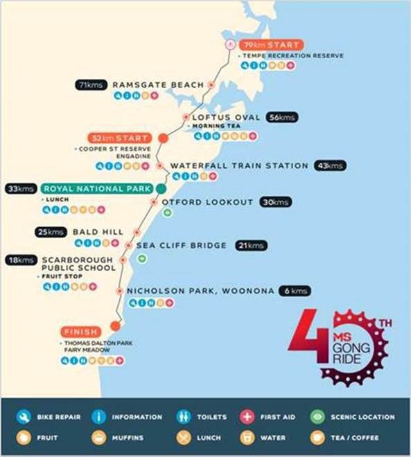
OFFICER COMMENTS
MS Australia will ultilise the IKEA car park as a drop off zone and riders will ride down Princes Highway (southbound) to the starting location at Tempe Recreation Reserve. The traffic management company will put in an access lane along Princes Highway to keep riders safe while entering the event at Tempe Recreation Reserve where this location will be the start of the cycling course.
The event will start at Tempe Recreation Reserve, Tempe. On departing, cyclists will ride west on Holbeach Avenue and then turn left onto Princes Highway. Cyclists will then ride along the southbound lanes on Princes Highway as they make their way south over the Cooks River Bridge and beyond.
The applicant advised that support of the NSW Police and RMS will be sought, and a detailed Traffic Management Plan has been forwarded to TfNSW, NSW Police and relevant Councils and authorities.
NSW Police and the MS Australia Course Marshals will be at critical locations to ensure that participants and motorists follow all proposed traffic management measures. The event will be held on a Sunday morning where traffic volumes are expected to be lower than average.
It is proposed that the traffic control measures would be in place between 4:00am and no later than 10:00am as the event commences at 6.00am and is expected to be concluded by 9.00am. Affected residents and businesses will be allowed access at Police discretion.
PUBLIC CONSULTATION
The applicant advised that the traffic control management on the day of the event will be controlled by NSW Police and MS Australia Course Marshals. The draft Traffic Control Plans for relevant Inner West locations are reproduced at the end of this report.
A Traffic Management Plan will be submitted to Transport for New South Wales (TfNSW) for consideration and approval as well as a Road Occupancy License application will be submitted to the Transport Management Centre.
CONCLUSION
The following traffic related comments be forwarded to Council’s Development Assessment section.
Based on the information presented in the applicant’s submission to Council with regards to the proposed cycling event on Sunday 2 November 2025 with the inclusion of a temporary full road closure of Holbeach Avenue, Tempe, it is acknowledged that the event will be controlled by NSW Police and the MS Australia Course Marshals. Therefore, Council supports the temporary full road closure of Holbeach Avenue, Tempe during the course of the event subject to:
· the applicant submitting a Traffic Management Plan to TfNSW for consideration and approval;
· a Road Occupancy License be obtained from the Transport Management Centre: and
· advice of the proposed event being forwarded all affected properties and to the appropriate authorities including emergency services.
FINANCIAL IMPLICATIONS
There are no financial implications associated with the implementation of the proposed recommendations outlined in the report