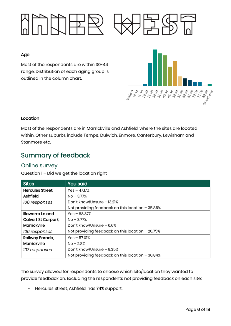
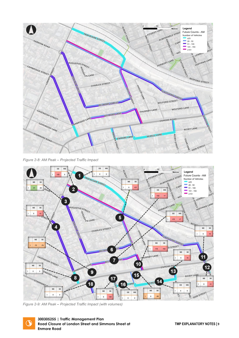
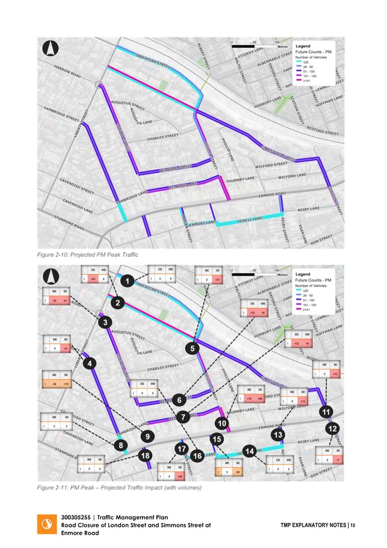
|
AGENDA R |

Local Traffic Committee Meeting
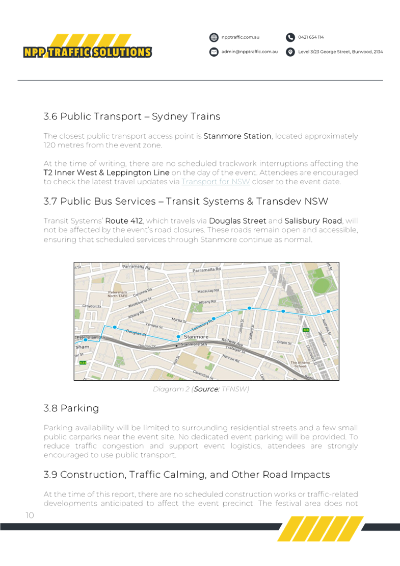
MONDAY 21 JULY 2025
11:00 AM
|
|
Local Traffic Committee Meeting 21 July 2025 |
Function of the Local Traffic Committee
Background
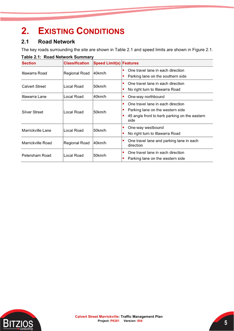
Roads and Maritime Services (RMS) is legislated as the Authority responsible for the control of traffic on all NSW Roads. The RMS has delegated certain aspects of the control of traffic on local roads to councils. To exercise this delegation, councils must establish a local traffic committee and obtain the advice of the RMS and Police. The Inner West Council Local Traffic Committee has been constituted by Council as a result of the delegation granted by the RMS pursuant to Section 50 of the Transport Administration Act 1988.
Role of the Committee
The Local Traffic Committee is primarily a technical review and advisory committee which considers the technical merits of proposals and ensures that current technical guidelines are considered. It provides recommendations to Council on traffic and parking control matters and on the provision of traffic control facilities and prescribed traffic control devices for which Council has delegated authority. These matters are dealt with under Part A of the agenda and require Council to consider exercising its delegation.
In addition to its formal role as the Local Traffic Committee, the Committee may also be requested to provide informal traffic engineering advice on traffic matters not requiring Council to exercise its delegated function at that point in time, for example, advice to Council’s Development Assessment Section on traffic generating developments. These matters are dealt with under Part C of the agenda and are for information or advice only and do not require Council to exercise its delegation.
Committee Delegations
The Local Traffic Committee has no decision-making powers. The Council must refer all traffic related matters to the Local Traffic Committee prior to exercising its delegated functions. Matters related to State Roads or functions that have not been delegated to Council must be referred directly to the RMS or relevant organisation.
The Committee provides recommendations to Council. Should Council wish to act contrary to the advice of the Committee or if that advice is not supported unanimously by the Committee members, then the Police or RMS have an opportunity to appeal to the Regional Traffic Committee.
Committee Membership & Voting
Formal voting membership comprises the following:
· one representative of Council as nominated by Council;
· one representative of the NSW Police from each Local Area Command (LAC) within the LGA, being Newtown, Marrickville, Leichhardt and Ashfield LAC’s.
· one representative from the RMS; and
· State Members of Parliament (MP) for the electorates of Summer Hill, Newtown, Heffron, Canterbury, Strathfield and Balmain or their nominees.
Where the Council area is represented by more than one MP or covered by more than one Police LAC, representatives are only permitted to vote on matters which effect their electorate or LAC.
Informal (non-voting) advisors from within Council or external authorities may also attend Committee meetings to provide expert advice.
Committee Chair
Council’s representative will chair the meetings.
Public Participation
Members of the public or other stakeholders may address the Committee on agenda items to be considered by the Committee. The format and number of presentations is at the discretion of the Chairperson and is generally limited to 3 minutes per speaker. Committee debate on agenda items is not open to the public.
|
|
Local Traffic Committee Meeting 21 July 2025 |
|
AGENDA |
1 Apologies
2 Disclosures of Interest
3 Confirmation of Minutes Page
Minutes of 16 June 2025 Local Traffic Committee 5
4 Matters Arising from Council’s Resolution of Minutes
5 Part A – Items Where Council May Exercise Its Delegated Functions
Traffic Matters
ITEM Page
LTC0725(1) Item 1 Tempe Station - Proposed shared path (Midjuburi-Marrickville Ward/Inner West PAC/Summer Hill Electorate) 17
LTC0725(1) Item 2 Renwick Street at Illawarra Road, Marrickville - Proposed raised pedestrian crossing (Midjuburi-Marrickville Ward/Inner West PAC/Summer Hill Electorate) 22
LTC0725(1) Item 3 Woodland Street, Holmesdale Street and Centennial Street, Marrickville – Temporary Road Closures for up to eight (8) separate weekend days to hold AFLW matches at Henson Park - (Midjuburi-Marrickville Ward /Summer Hill Electorate /Inner West LAC) 31
LTC0725(1) Item 4 Burrows Avenue, Sydenham - Proposed installation of 'No Parking' restrictions to provide one drop-off space on the southern side opposite Sydenham Station (Midjuburi - Marrickville Ward / Heffron Electorate / Inner West PAC) 38
LTC0725(1) Item 5 Permit Plug Play Project – Global TMPs - Temporary Full Time Road Closures for community events - up to six Sunday events per year at three locations (Midjuburi-Marrickville Ward and Djarrawunang-Ashfield Ward /Summer Hill Electorate / Inner West LAC and Burwood PAC) 41
LTC0725(1) Item 6 Victoria Street, Ashfield - Installation of a 'Keep Clear' zone at the front of Ashfield Fire Station (Djarrawunang-Ashfield Ward / Summer Hill Electorate / Burwood PAC) 133
LTC0725(1) Item 7 Railway Parade, Annandale - Proposed Road and Streetscape Upgrade (Baludarri-Balmain Ward/Balmain Electorate/Leichhardt PAC) 135
LTC0725(1) Item 8 Anthony Street, Croydon - Proposed installation of statutory 'No Stopping' restrictions at the junction of the unnamed laneway and Anthony Street between Robinson Street and Edwin Street, Croydon (Gulgadya - Leichhardt Ward / Strathfield Electorate / Burwood PAC) 142
LTC0725(1) Item 9 Carrington Street, Lilyfield - Temporary full road closure and associated construction Traffic Management Plan (Baludarri-Balmain Ward/Balmain Electorate/Leichhardt PAC) 148
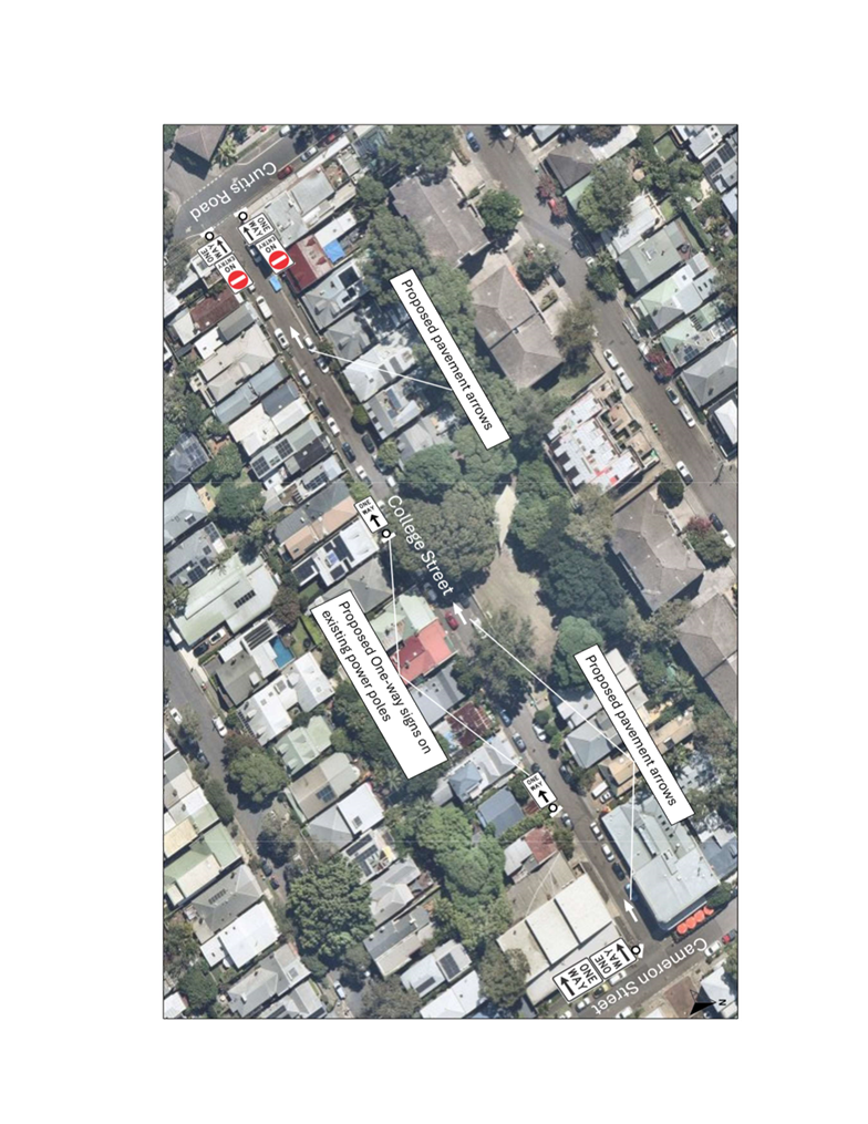
LTC0725(1) Item 10 College Street, Balmain - Proposed One Way Restriction (Baludarri-Balmain Ward/Balmain Electorate/Leichhardt PAC) 222
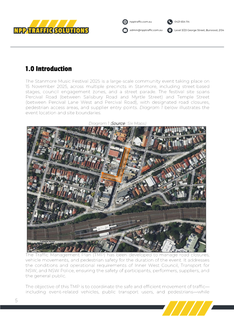
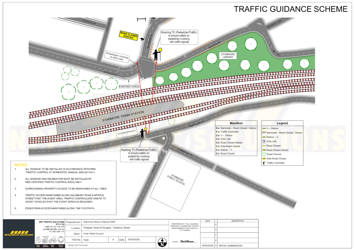
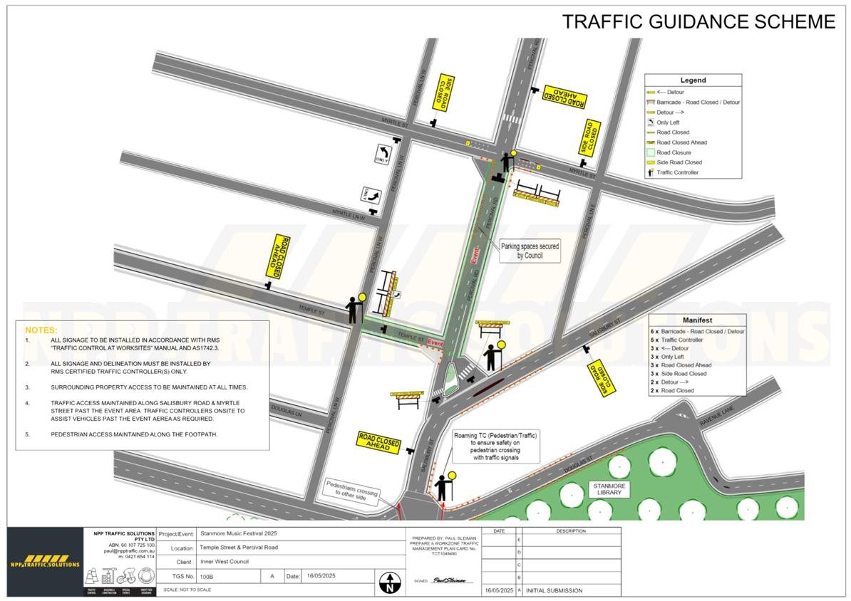
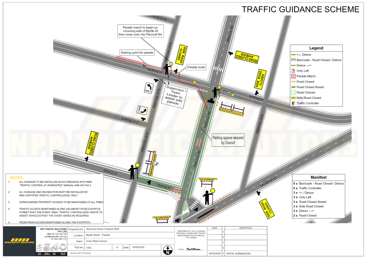
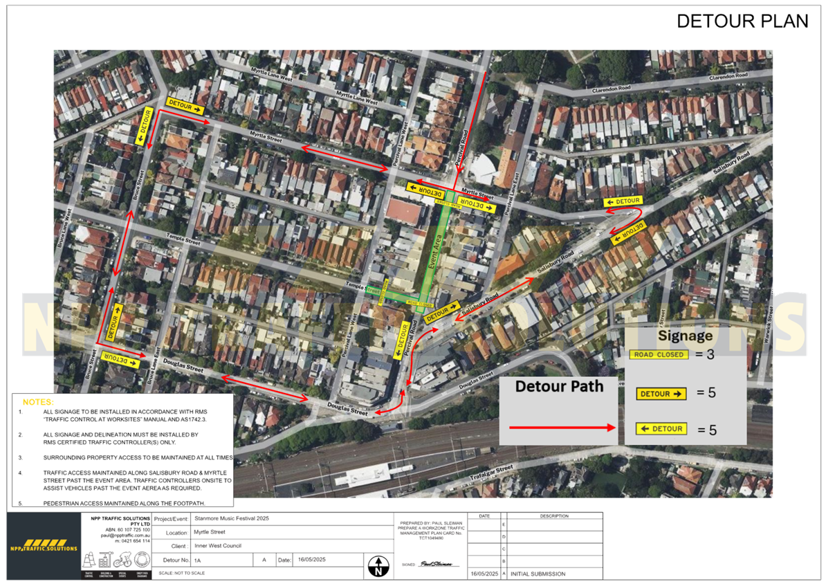
LTC0725(1) Item 11 Percival Road and Temple Street, Stanmore – Temporary full road closure for Stanmore Music Festival – Saturday 15 November 2025 (Damum-Stanmore Ward / Newtown Electorate / Inner West PAC) 227
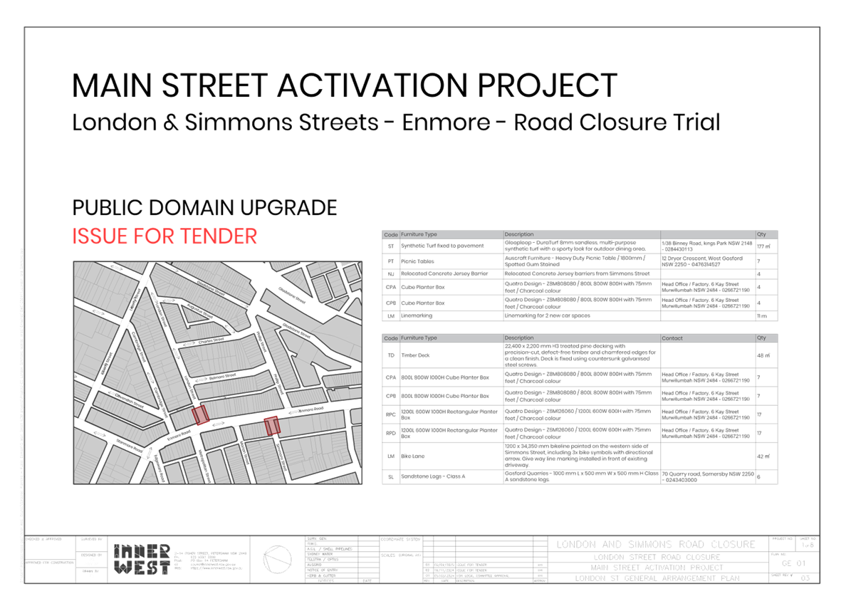
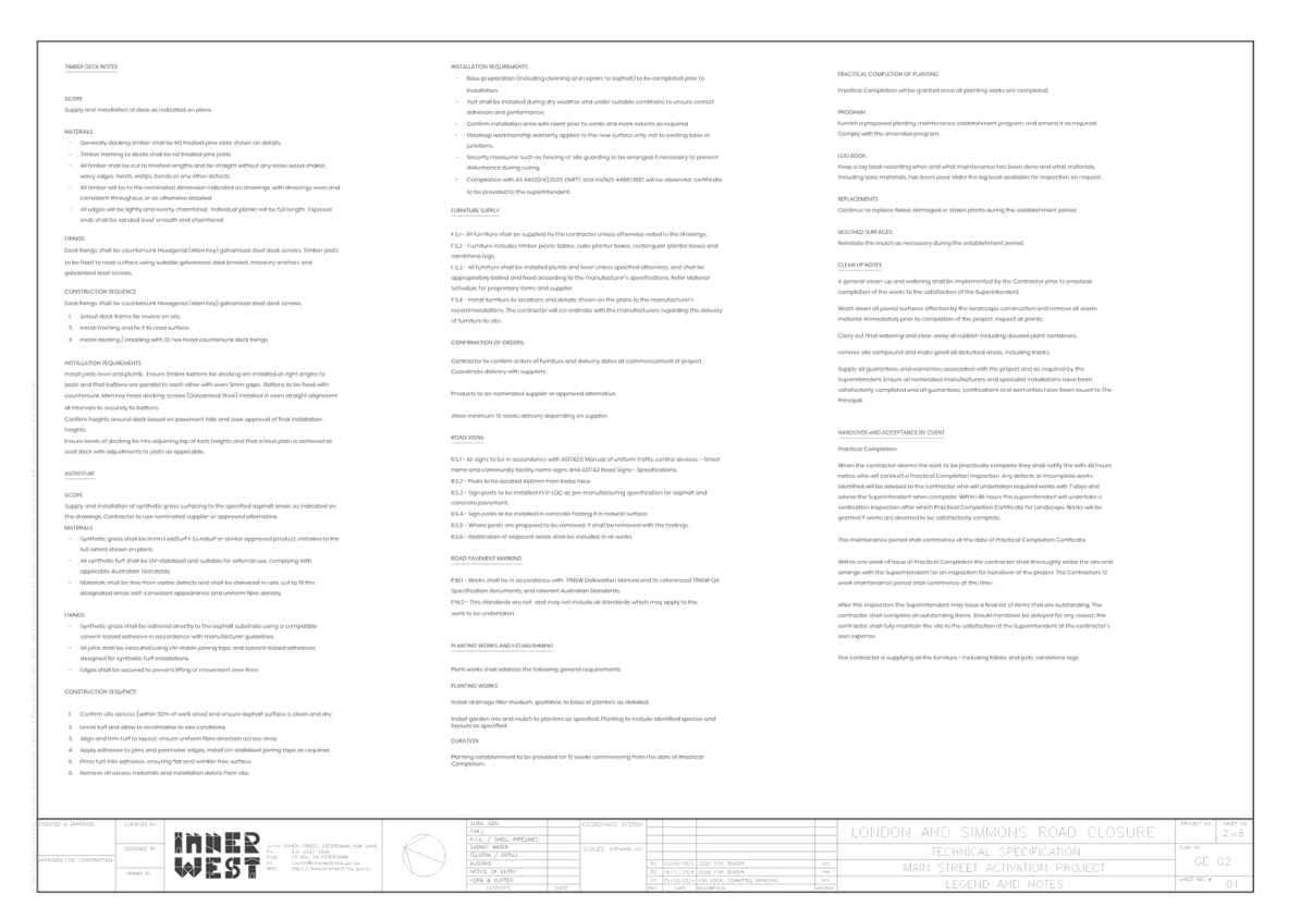
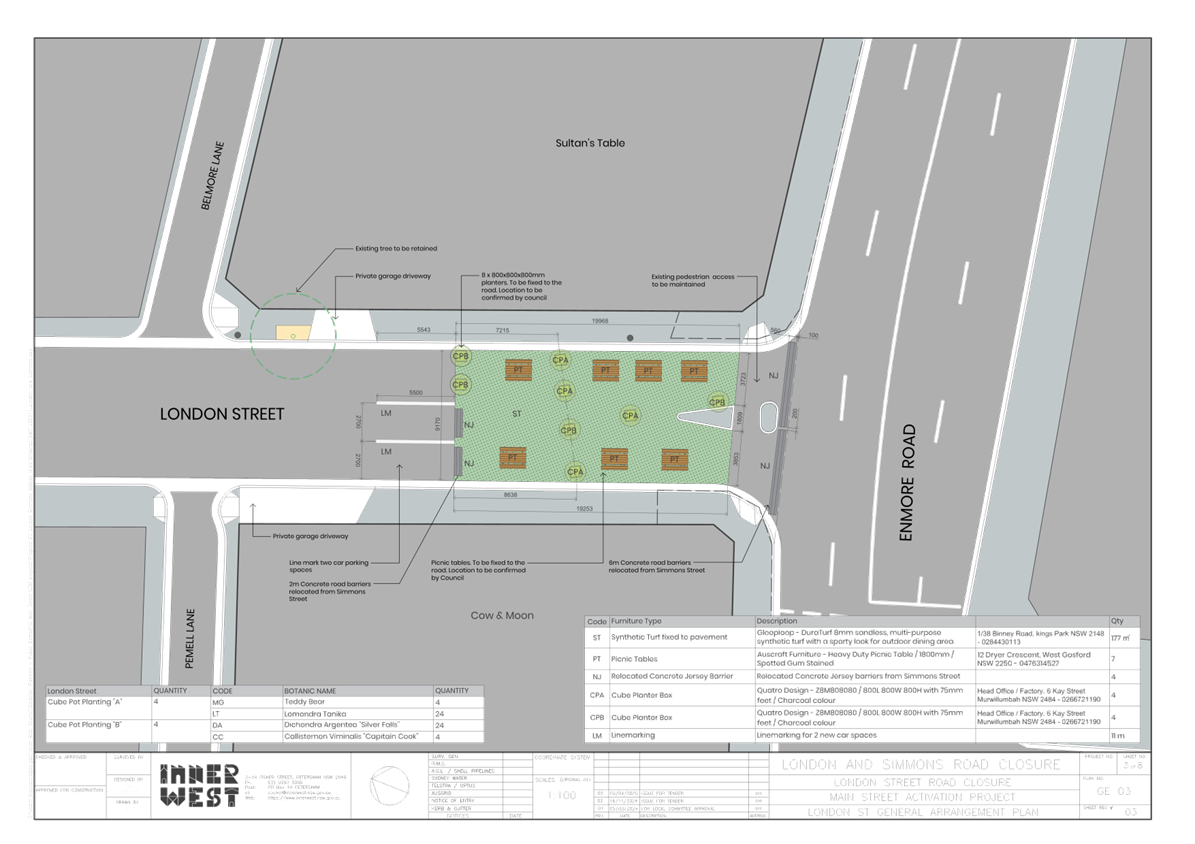
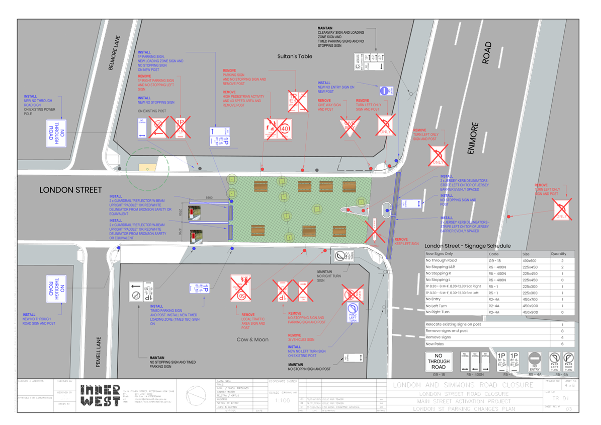
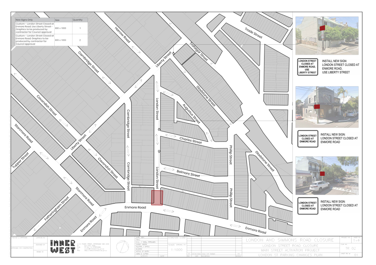
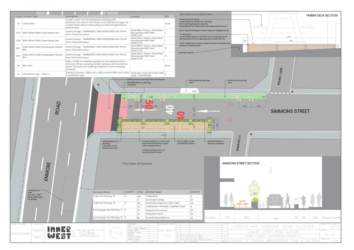
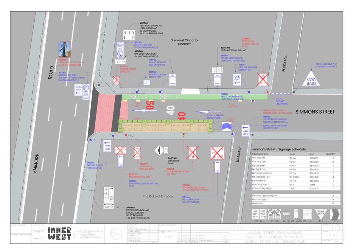
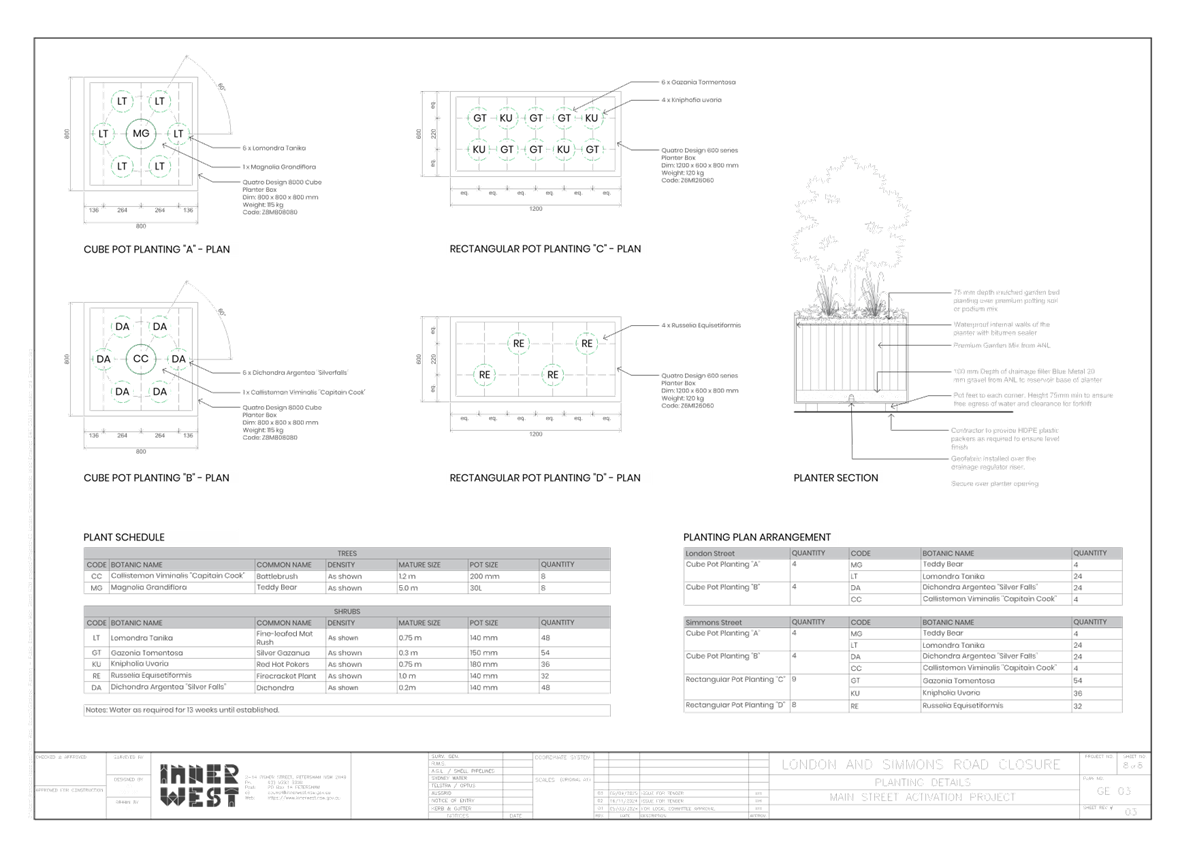
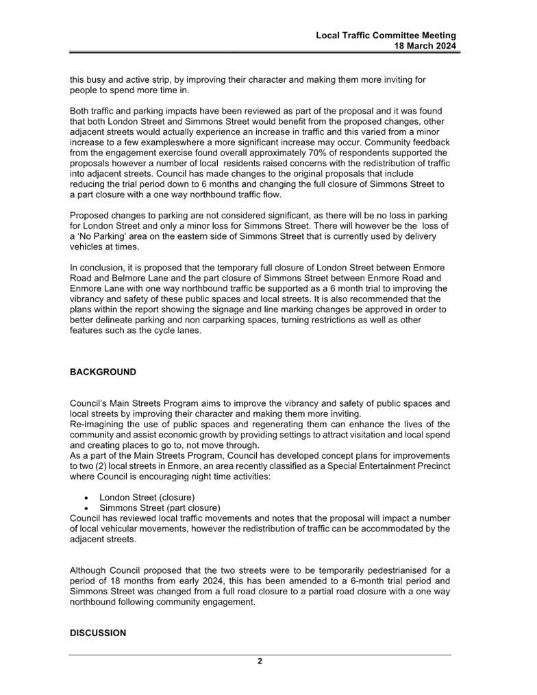
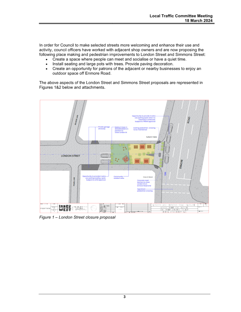
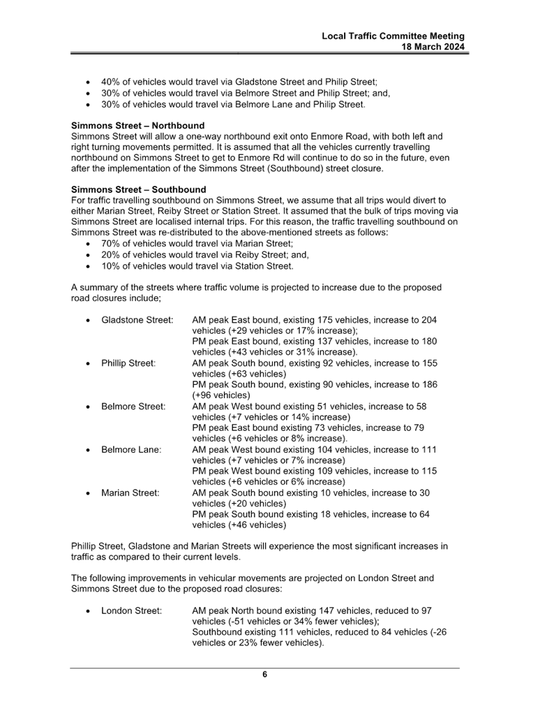
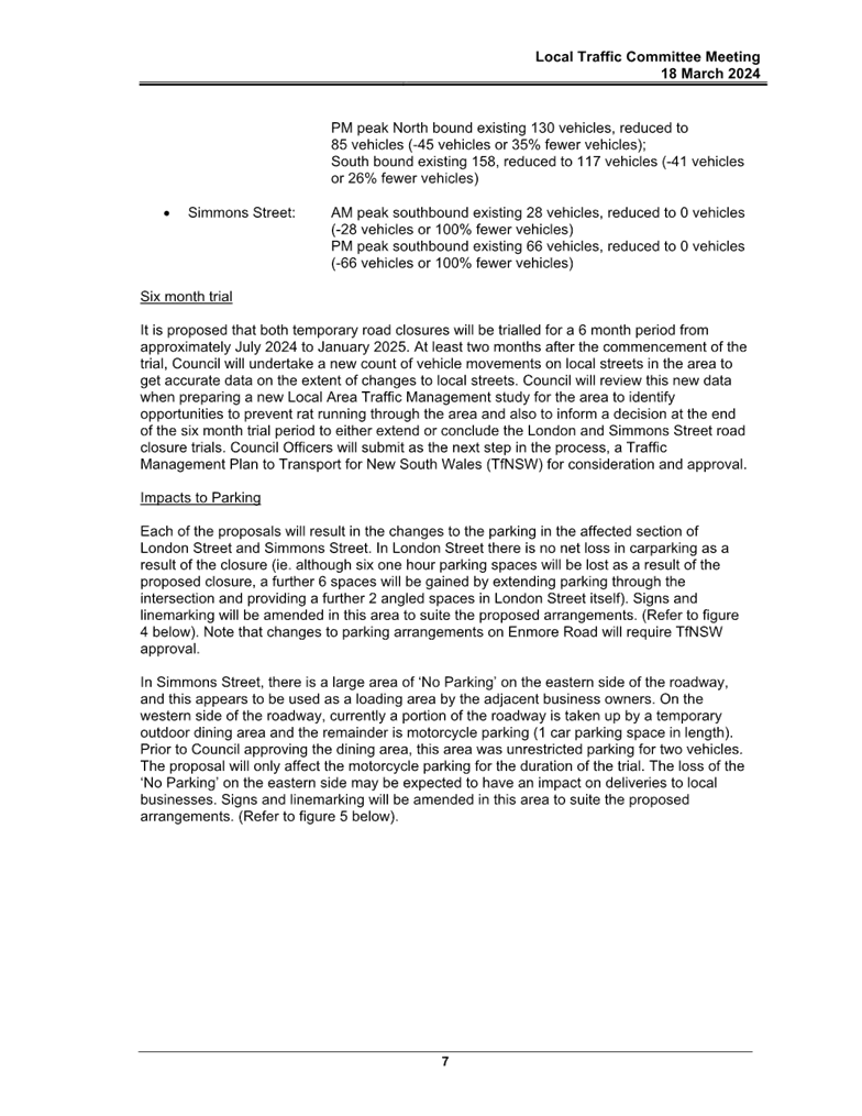
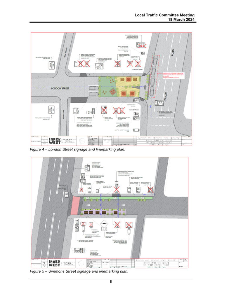
LTC0725(1) Item 12 London Street and Simmons Street, Enmore - Updated Report for the Proposed Temporary Road Closure and Part Road Closure (Damun-Stanmore Ward / Newtown Electorate / Inner West PAC) 259
Parking Matters
ITEM Page
LTC0725(1) Item 13 Salisbury Road, Stanmore - Request for a residential parking scheme (Damum-Stanmore Ward / Newtown Electorate / Inner West PAC) 322
LTC0725(1) Item 14 Baltic and Bedford Streets, Newtown- Proposed 'No Stopping' restrictions (Damun-Stanmore Ward/Inner West PAC/Newtown Electorate) 329
LTC0725(1) Item 15 Allen Street, Leichhardt - Safety at Driveway of 141-143 Allen Street (Gulgadya-Leichhardt Ward/Balmain Electorate/ Leichhardt PAC) 334
Late Items
Nil at time of printing.
6 Part B - Items for Information Only
Nil at the time of printing.
7 Part C - Items for General Advice
Nil at the time of printing.
8 General Business
9 Close of Meeting
|
|
Local Traffic Committee Meeting 21 July 2025 |
Minutes of Meeting held on 16 June 2025
Meeting commenced at 11:03 AM
ACKNOWLEDGEMENT OF COUNTRY BY CHAIRPERSON
I acknowledge the Gadigal and Wangal people of the Eora nation on whose country we are meeting today, and their elders past and present.
COMMITTEE REPRESENTATIVES PRESENT
|
Victor Macri |
Councillor –Midjuburi - Marrickville Ward (Chair) |
|
Bill Holliday |
Representative for Kobi Shetty MP, Member for Balmain |
|
Graeme McKay |
Representative for Jo Haylen MP, Member for Summer Hill |
|
Miriama Tamata |
Representative for Jenny Leong MP, Member for Newtown |
|
Vinoth Srinivasan |
Transport for NSW (TfNSW) |
|
Nina Fard |
Transport for NSW (TfNSW) |
|
|
|
|
NON VOTING MEMBERS IN ATTENDANCE |
|
|
|
|
|
Michael Takla |
Representative for Transit Systems |
|
Sunny Jo |
IWC’s Acting Traffic and Transport Planning Manager |
|
George Tsaprounis |
IWC’s Coordinator Traffic Engineering Services (South) |
|
Felicia Lau |
IWC’s Acting Coordinator Traffic Engineering Services (North) |
|
Christy Li |
IWC’s Business Administration Officer |
|
|
|
|
VISITORS |
|
|
|
|
|
Nil. |
Nil. |
|
|
|
|
APOLOGIES: |
|
|
|
|
|
Liz Atkins |
Councillor – Damun - Stanmore Ward |
|
|
|
DISCLOSURES OF INTERESTS:
Nil.
CONFIRMATION OF MINUTES
|
That the Minutes of the Local Traffic Committee held on Monday, 19 May 2025 be confirmed. |
MATTERS ARISING FROM COUNCIL’S RESOLUTION OF MINUTES
The Minutes of the Local Traffic Committee meeting held on 14 April 2025 were adopted at Council’s meeting held on 20 May 2025 subject to the following amendments:
|
LTC0625(1) Item 4 Holborow Street (at Liverpool Road), Croydon. (Djarrawunang-Ashfield Ward/Summer Hill Electorate/Burwood PAC) |
|
Council has prepared a design plan to provide a new landscaped kerb blister and extension to re-align the intersection of Holborow Street and Liverpool Road, Croydon. The proposal aims to slow traffic and improve road safety for pedestrians and motorists at the intersection.
Officers Recommendation:
That the detailed design plan (10329) for a proposed new landscaped kerb blister and extension re-alignment of the intersection of Holborow Street and Liverpool Road, Croydon, with associated signs and line marking (as shown in Attachment 1) be approved.
DISCUSSION:
The Representative for Transport for NSW raised concerns regarding pedestrian safety and potential impacts to the efficiency of the State Road networks. Council Officer presented additional turning movement diagrams to show the turn path of a passenger vehicle as well as an additional turn path of an 8.8m truck as requested by TfNSW representative prior to the meeting. The Council Officer also advised that the 8.8m truck was the design vehicle in this case.
It was noted that TfNSW representatives raised concerns with the conflict point between the 8.8 metre Medium Rigid Vehicle (MRV) and pedestrians. Council Officers advised that this design would improve safety for pedestrians and didn’t agree that the turn paths of vehicles would pose a safety issue for pedestrians.
Council Officers noted that they have made changes to ensure there would be minimal impact to the State Road networks and that turning templates are usually more conservative so the likelihood of there being issues with vehicle movements is low.
The Committee members agreed with the Officer’s recommendation.
COMMITTEE RECOMMENDATION:
That the detailed design plan (10329) for a proposed new landscaped kerb blister and extension re-alignment of the intersection of Holborow Street and Liverpool Road, Croydon, with associated signs and line marking (as shown in Attachment 1) be approved.
For Motion: Unanimous |
General Business:
|
Item 13- Ramsay Street, Haberfield Road resurfacing works |
|
The Representative for the Member of Summer Hill noted that Council had recently completed road works on Ramsay Street however, stopped a few metres before the intersection at Dalhousie Street and questioned if there are plans for the works to continue to the intersection. The Representative for the Member of Summer Hill notes that currently there is a minor dip in the road due to the uneven road surface. |
|
Item 14- Trucks accessing Sloane Street, Marrickville |
|
The Chairperson questioned if Council has reviewed the issue with trucks accessing Sloane Street, Marrickville. Council Officers advised that consultation letters have been sent out to nearby residents and businesses for feedback regarding the installation of ‘No Stopping’ signs to improve sightlines and manoeuvrability of larger vehicles. |
|
Item 14- Charlotte Street, Marrickville proposed RPS scheme |
|
The Chairperson advised that a petition had been submitted to Council by the residents of Charlotte Street, Marrickville to initiate an investigation for a Resident Parking Scheme (RPS) in Charlotte Street. The Chairperson noted that the residents have advised that the parking situation has deteriorated and that they would like Council to re investigate the possibility of implementing a RPS scheme for the street. Council Officers advised they will investigate the issue and noted that there are currently works being undertaken by Transport for NSW in the close proximity to Charlotte Street, which may also be exacerbating the parking issue. |
|
Item 15- Notification of Road Works in the LGA |
|
The Representative for Transit Systems requested that Council advise Transit Systems of any upcoming projects and road works in the LGA as there have been previous instances where Transit Systems haven’t been notified and the works had caused delays in their services. |
|
Item 16- Sydenham Station Bus Layover |
|
The Representative for Transit Systems noted that the current layover area at Sydenham Station needs to be reviewed as there has been concerns of bus turning movement from Railway Parade to Marrickville Road, Sydenham. The Representative for Transport for NSW advised they will follow up the concerns with the relevant departments. |
Meeting closed at 11.49 am.
CHAIRPERSON
Councillor Victor Macri
|
|
Local Traffic Committee Meeting 21 July 2025 |
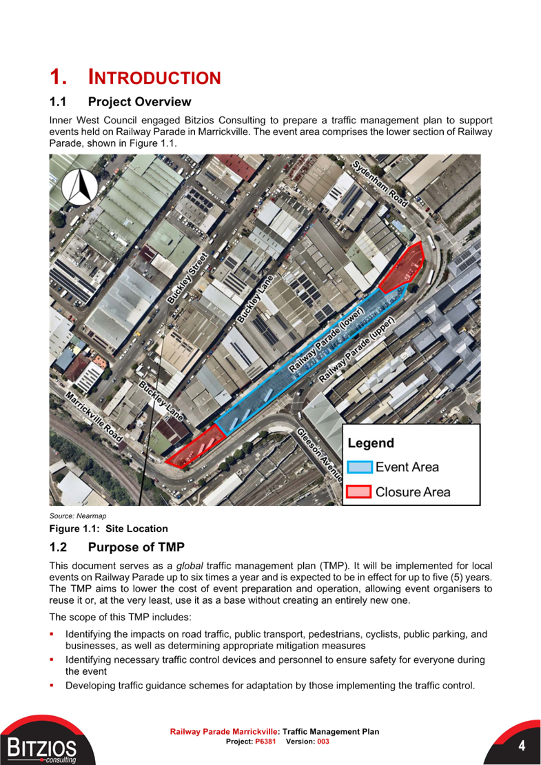
Subject: Tempe Station - Proposed shared path (Midjuburi-Marrickville Ward/Inner West PAC/Summer Hill Electorate)
Prepared By: James Nguyen - Traffic Engineer
Authorised By: George Tsaprounis - Acting Traffic and Transport Planning Manager
|
RECOMMENDATION
1. That a concept shared path within the Tempe Station car park as per plan no.10352, be supported in-principle and included in Council’s Capital Works program subject to support from Transport for NSW and/or relevant rail authority body.
2. That the detailed design for the proposed shared path in Tempe Station car park be brought back to the Traffic Committee for consideration.
|
STRATEGIC OBJECTIVE
This report supports the following strategic directions contained within Council’s Community Strategic Plan:
|
2: Liveable, connected neighbourhoods and transport |
|
|
EXECUTIVE SUMMARY
This report outlines a proposal to install a shared path within the Tempe Station car park to provide separation for cyclists and pedestrians. There is no loss of parking, and a gain of one (1) additional parking space. The proposal will improve safety and connectivity within the car park, whilst also minimising impacts to the existing car parking spaces.
BACKGROUND
At the Council meeting held on 22 October 2024, Council resolved the following in part:
4. That Council Staff investigate a defined cycleway path through the Tempe Station car park, so that people using the car park do not conflict with cyclists for safety reasons.
DISCUSSION
Tempe Station Carpark is located within the Cooks River Cycleway network. Currently, active transport users travelling to and from Richardson Crescent via the Tempe Station Carpark are using the on-road carpark road space along this route.
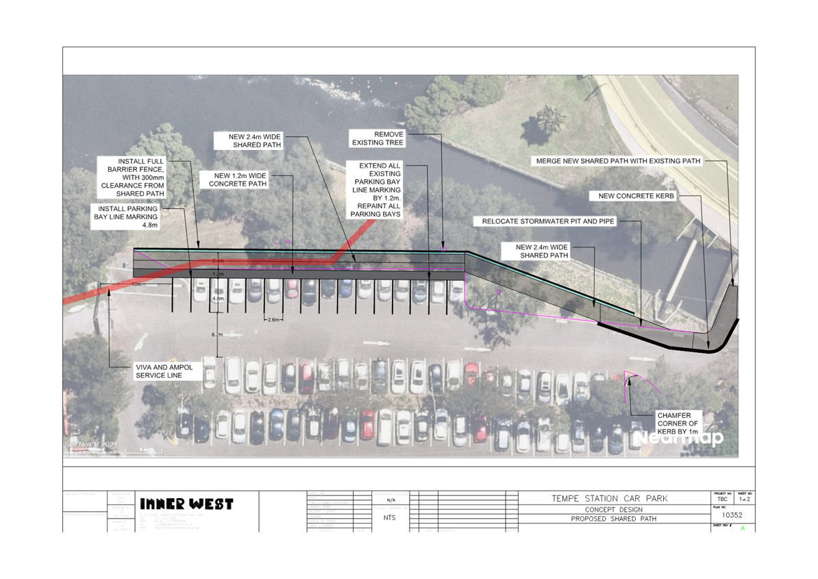
Council officers have developed a shared path concept design along the western side of the car park, behind the parked vehicles to provide separation, and improve safety and connectivity through this carpark.
The concept design as shown in Figure 1 consists of the following:
· Extend the existing shared path which currently terminates at the car park further.
· Construct a new 2.4m wide shared path along the grass verge along the western side of the car park.
· Construct a 1.2m wide concrete path on the existing asphalt carpark behind the parked vehicles to provide a buffer between parked vehicles and the shared path.
· Install a barrier fence adjacent to the shared path.
· Adjust the existing parking bay line markings.
· Adjust the existing parking bay line marking and provide one (1) additional parking space.
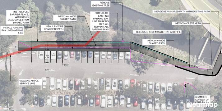
Figure 1 - Concept plan
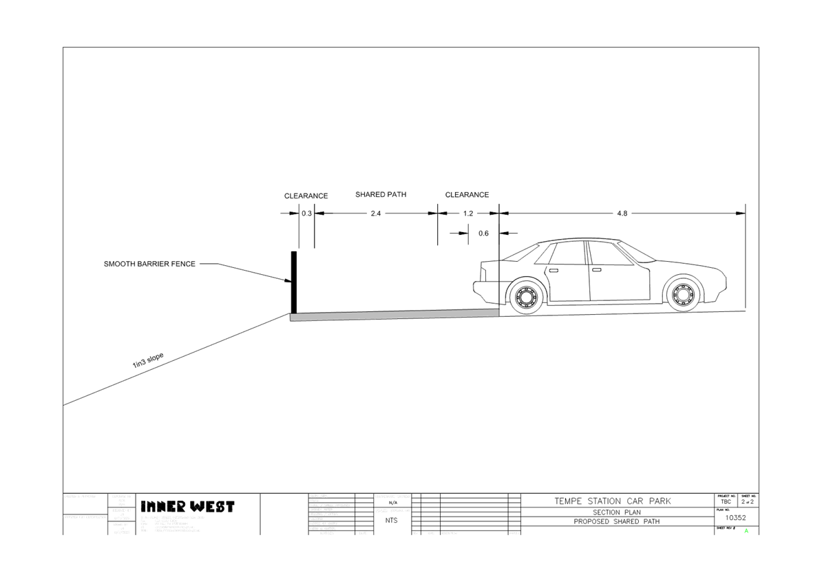
Figure 2 below shows a cross section of the proposal (dimensions in metres):
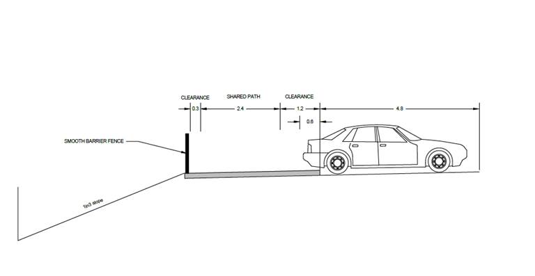
Figure 2 - Shared path cross section
The design allows for the following:
· A 4.8m long parking bay is proposed with a 0.6m overhang for vehicles, in accordance with Australian Standards.
· An additional 0.6m clearance from the shared path to the parked vehicle
· A 0.3m clearance between the edge of the smooth barrier fence and the shared path, in accordance with AusRoad design guidelines.
Council officers have obtained in principle support for this shared path proposal with the service utility provider which the shared path crosses over.
FINANCIAL IMPLICATIONS
An initial cost estimate is $150,000 however a detailed cost estimate will be prepared during the detailed design development of the proposal and referred to a future Local Traffic Committee meeting for consideration
|
1.⇩ |
Concept plan |
|
2.⇩ |
Design cross section |
|
|
Local Traffic Committee Meeting 21 July 2025 |
Subject: Renwick Street at Illawarra Road, Marrickville - Proposed raised pedestrian crossing (Midjuburi-Marrickville Ward/Inner West PAC/Summer Hill Electorate)
Prepared By: James Nguyen - Traffic Engineer
Authorised By: George Tsaprounis - Acting Traffic and Transport Planning Manager
|
RECOMMENDATION
1. That a raised pedestrian crossing on Renwick Street, just east of Illawarra Road, Marrickville, as per plan no.10350, be supported in-principle, and included in Council’s Capital Works program subject to community consultation.
2. That the detailed design for the proposed raised pedestrian crossing on Renwick Steet, just east of Illawarra Road, Marrickville be brought back to the Traffic Committee for consideration.
3. That a raised pedestrian crossing across Renwick Street at Excelsior Parade, Marrickville not be supported.
4. That a raised pedestrian crossing across Illawarra Road, north of Renwick Street be investigated and brought back to the Traffic Committee for consideration.
|
STRATEGIC OBJECTIVE
This report supports the following strategic directions contained within Council’s Community Strategic Plan:
|
2: Liveable, connected neighbourhoods and transport |
|
|
EXECUTIVE SUMMARY
This report outlines the pedestrian crossing investigation completed at the intersections of Illawarra Road and Renwick Street, and Renwick Street and Excelsior Parade, Marrickville. The pedestrian and vehicle volumes were assessed, and it was found that the volumes were met at the intersection of Illawarra Road and Renwick Street, and the volumes were not met at the intersection of Renwick Street and Excelsior Parade.
Accordingly, a pedestrian crossing is proposed at the intersection of Illawarra Road and Renwick Street. It is recommended that, if possible, the design development of the proposed pedestrian crossing across Renwick Street be integrated with the Marrickville Town Centre Master Plan.
Furthermore, it is also recommended that a pedestrian crossing be investigated across the northern leg of Illawarra Road and reported back to the Local Traffic Committee for consideration.
BACKGROUND
Council has received a request for a pedestrian crossing at the intersection of Renwick Street and Illawarra Road (across Renwick Street), and Renwick Street and Excelsior Parade, Marrickville.
DISCUSSION
Council officers completed pedestrian and vehicle counts at both intersections to determine if the pedestrian and vehicle volumes meet the warrants stipulated in the Inner West Council Pedestrian Crossing Warrant Policy.
A pedestrian (zebra) crossing is deemed to meet the numerical warrant for a pedestrian (zebra) crossing if the crossing point meets the following criteria:
· In each of two separate one-hour periods in a typical day, the pedestrian flow per hour crossing the road is or is expected to be equal to or greater than 20, and vehicle volumes be equal to or greater than 200 where children and elderly or mobility impaired pedestrians count as two pedestrians.
The pedestrian and vehicle counts were completed at both intersections on Thursday 23 March 2023 between 7.30am and 9.00am, 11.30am-1.30pm, and 2.00pm-4.00pm. The peak hour results are presented below.
Intersection of Renwick Street and Illawarra Road
The pedestrian and vehicle volume warrants for a pedestrian crossing for two (2) peak hour periods, were met at Illawarra Road (northern leg), and Renwick Street (eastern leg). This is shown in Table 1, Figure 1 and Figure 2 below.
Table 1 - Intersection count - Renwick Street at Illawarra Road
|
Location |
Pedestrian volume |
Vehicle Volume |
Warrant met (Y/N) |
|||
|
AM Peak |
PM Peak |
AM Peak |
PM Peak |
AM Peak |
PM Peak |
|
|
Illawarra Road (northern leg) |
31 |
109 |
1043 |
974 |
Yes |
Yes |
|
Illawarra Road (southern leg) |
1 |
1 |
972 |
973 |
No |
No |
|
Renwick Street (eastern leg) |
80 |
121 |
383 |
469 |
Yes |
Yes |
|
Harnett Avenue (western leg) |
47 |
76 |
70 |
88 |
No |
No |
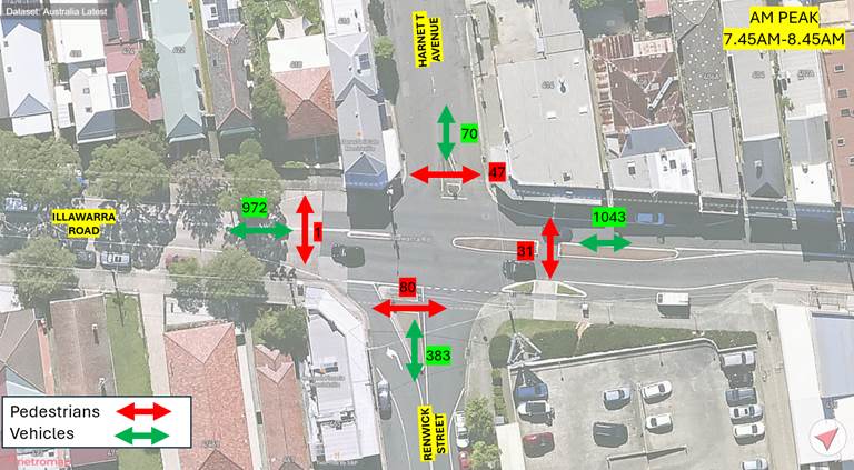
Figure 1 - AM Peak - Renwick Street at Illawarra Road
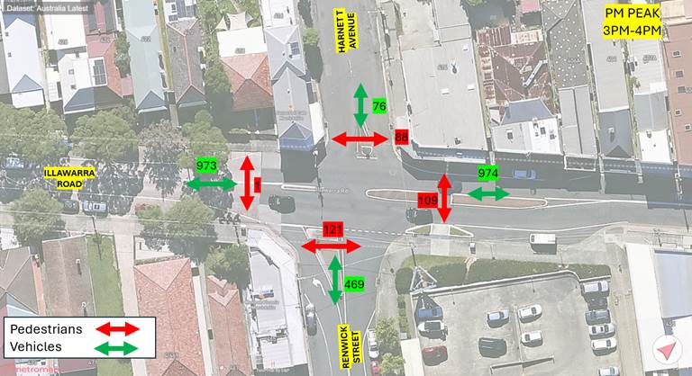
Figure 2 - PM Peak - Renwick Street at Illawarra Road
Intersection of Renwick Street and Excelsior Parade
The pedestrian and vehicle volume warrants for a pedestrian crossing at all legs of the intersection of Renwick Street and Excelsior Parade were not met for both peak hour periods for all crossing legs. The warrants were only met for one (1) peak hour period on Renwick Street. This is shown in Table 2, Figure 3 and Figure 4 below.
Table 2 - Intersection count - Renwick Street at Excelsior Parade
|
Location |
Pedestrian volume |
Vehicle Volume |
Warrant met (Y/N) |
|||
|
AM Peak |
PM Peak |
AM Peak |
PM Peak |
AM Peak |
PM Peak |
|
|
Excelsior Parade (northern leg) |
26 |
46 |
98 |
109 |
No |
No |
|
Excelsior Parade (southern leg) |
15 |
27 |
117 |
84 |
No |
No |
|
Renwick Street (eastern leg) |
15 |
35 |
411 |
373 |
No |
Yes |
|
Renwick Street (western leg) |
23 |
11 |
362 |
376 |
Yes |
No |
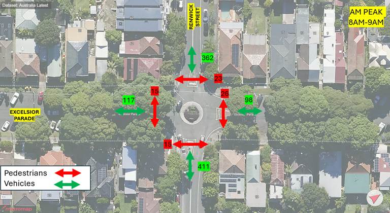
Figure 3 - AM Peak - Renwick Street at Excelsior Parade
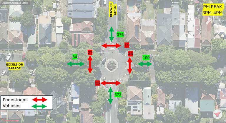
Figure 4 - PM Peak - Renwick Street at Excelsior Parade
Design Development
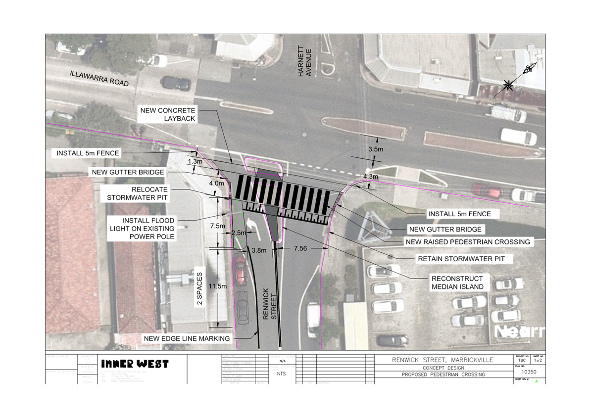
Based on the intersection counts, Council officers further investigated a pedestrian crossing across Renwick Street at the intersection of Illawarra Road. The concept design is shown in Figure 5 below.
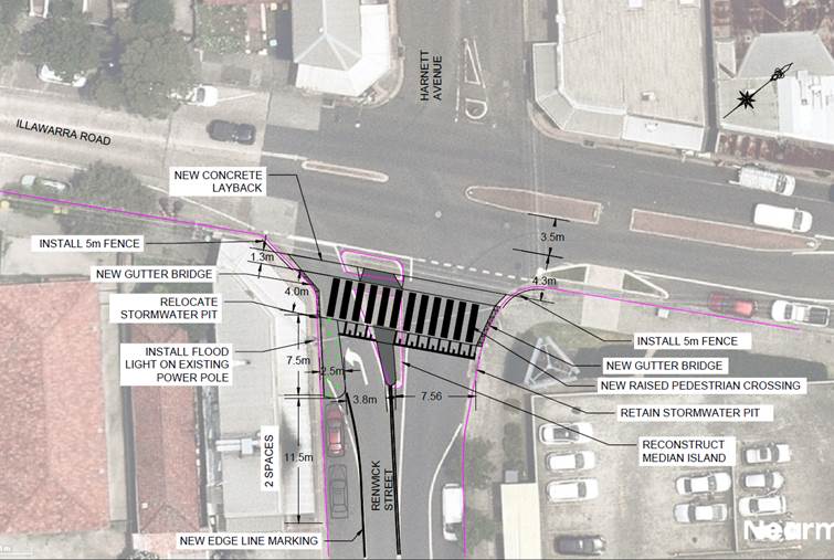
Figure 5 - Concept plan - Proposed pedestrian crossing – Renwick Street at Illawarra Road
The proposed pedestrian crossing consists of the following:
· New raised pedestrian crossing across Renwick Street, east of Illawarra Road.
· A 7.5 metre long, 2.5-metre-wide kerb extension on the western side of Renwick Street, south of Illawarra Road.
· Adjusting and retain the existing central median island due to the wide crossing width for pedestrians. A reduction in the width of the central island median is required due to the proposed kerb extension on the western side of Renwick Street.
· Retain the existing left-only control from Renwick Street to Illawarra Road.
· Adjustments to the existing stormwater pits and provision of gutter bridges.
· Retaining two (2) parking spaces on the western side of Renwick Street, south of Illawarra Road. There is no loss of parking with the proposal due to the 7.5 metre ‘No Stopping’ provision that can be provided due to the 2.5-metre-wide kerb extension.
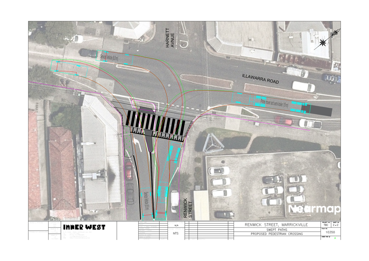
The pedestrian crossing has been designed to accommodate the following vehicle turn movements:
· Left turn from Illawarra Road to Renwick Street for a 19-metre-long semi-trailer. Council officers have been advised by Woolworths that their semi-trailer vehicles make this movement.
· Left turn from Renwick Street to Illawarra Road for an 8.8 metre long service vehicle.
· Right turn from Illawarra Road to Renwick Street for an 8.8 metre long service vehicle.
Swept paths for each turning movement is shown in Figure 6 below.
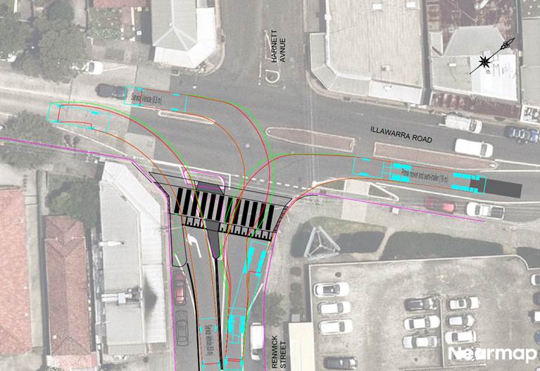
Figure 6 - Swept paths
It should be noted that Council is currently developing the Marrickville Town Centre Master Plan, under the ‘Streets Alive’ program, which includes potential changes to the intersection of Illawarra Road and Renwick Street. Whilst there is adequate pedestrian and vehicle volumes to consider the installation of a raised pedestrian crossing in the short-term, consideration should be given to the timeframes for the implementation of the Marrickville Town Centre Master Plan. It is recommended that, if possible, the design development of the proposed pedestrian crossing across Renwick Street be integrated with the Marrickville Town Centre Master Plan.
Furthermore, it is also recommended that a pedestrian crossing be investigated across the northern leg of Illawarra Road and reported back to the Local Traffic Committee for consideration.
FINANCIAL IMPLICATIONS
A cost estimate and detailed design will be prepared during the design development of the proposal and referred to a future Local Traffic Committee meeting.
|
1.⇩ |
Concept plan |
|
2.⇩ |
Swept path |
|
|
Local Traffic Committee Meeting 21 July 2025 |
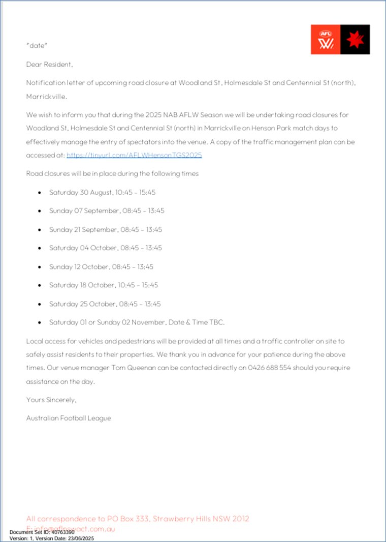
Subject: Woodland Street, Holmesdale Street and Centennial Street, Marrickville – Temporary Road Closures for up to eight (8) separate weekend days to hold AFLW matches at Henson Park - (Midjuburi-Marrickville Ward /Summer Hill Electorate /Inner West LAC)
Prepared By: Jennifer Adams - Traffic Engineer
Authorised By: George Tsaprounis - Acting Traffic and Transport Planning Manager
|
RECOMMENDATION
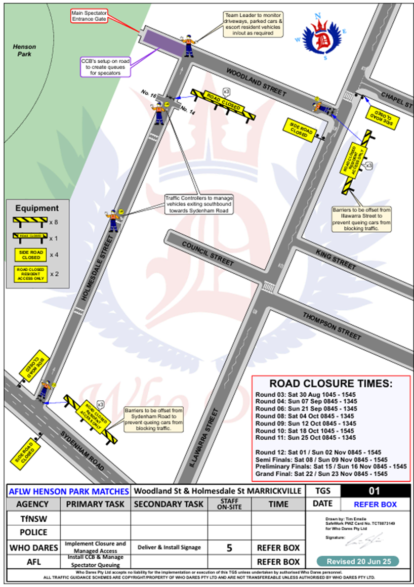
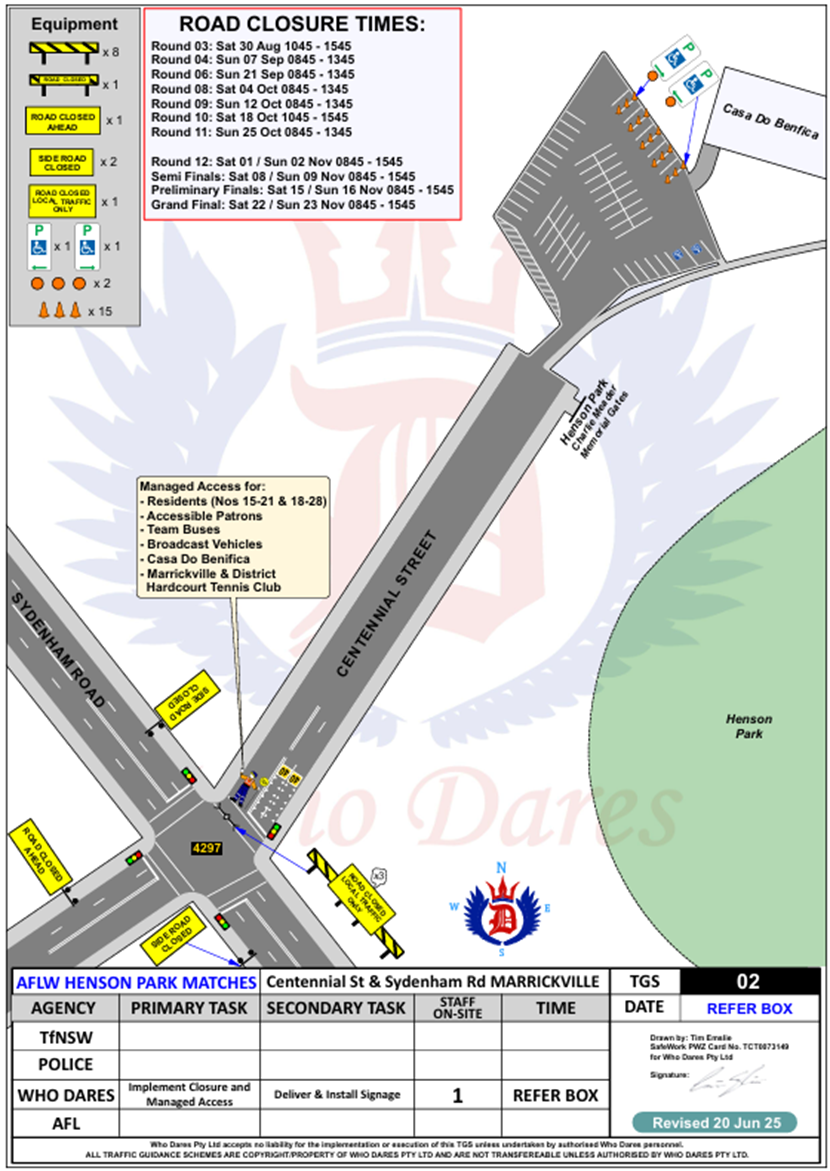
1. That the proposed temporary full road closure (ENRC/2025/0043) of Woodland Street between Illawarra Road and dead-end; Holmesdale Street between Sydenham Road and Woodland Street, and Centennial Street between Sydenham Road and the entrance to Henson Park and Marrickville & District Hardcourt Tennis Club car park, Marrickville on the following dates and times: a) Saturday 30 August 2025, 10:45 – 15:45; b) Sunday 07 September 2025, 08:45 – 13:45; c) Sunday 21 September 2025, 08:45 – 13:45; d) Saturday 04 October 2025, 08:45 – 13:45; e) Sunday 12 October 2025, 08:45 – 13:45; f) Saturday 18 October 2025, 10:45 – 15:45; g) Saturday 25 October 2025, 08:45 – 13:45; and h) Saturday 01 or Sunday 02 November 2025, i) Date & Time TBC (contingency period of one month) for the purpose of holding up to eight (8) AFLW matches at Henson Park be approved, subject to the applicant complying with, but not limited to, the following conditions:
2. That a Road Occupancy License application be obtained by the applicant from the Transport Management Centre.
3. That all affected residents and businesses, including NSW Police Local Area Commander, Transit Systems, Fire and Rescue NSW and NSW Ambulance Services, shall be notified in writing by the applicant of the proposed temporary road closure at least 7 days prior to the event, with the applicant making reasonable provision for residents and businesses.
4. That notification signs advising of the proposed road closures and new traffic arrangements to be strategically installed and maintained by the applicant at each end of each street at least 7 days prior to the closure.
5. That the occupation of the road carriageway must not occur until the road has been physically closed.
6. That subject to written concurrence from Transport for New South Wales.
|
STRATEGIC OBJECTIVE
This report supports the following strategic directions contained within Council’s Community Strategic Plan:
|
2: Liveable, connected neighbourhoods and transport |
EXECUTIVE SUMMARY
An application has been received from AFL NSW/ACT to hold up to eight (8) AFLW matches at Henson Park Oval. The events require the temporary full road closure of Woodland Street, between Illawarra Road and dead-end; Holmesdale Street, between Sydenham Road and Woodland Street, and Centennial Street, between Sydenham Road and the entrance to Henson Park and Marrickville & District Hardcourt Tennis Club car park, Marrickville to allow for pedestrian entry to Henson Park on the AFLW match days. It is recommended that Council agree to the temporary full road closures subject to the applicant complying with Council conditions and obtaining concurrence from Transport for NSW as the closure of Centennial Street is adjacent to a signalised intersection on Sydenham Road, Marrickville (a State Road).
BACKGROUND AND STAFF COMMENTS
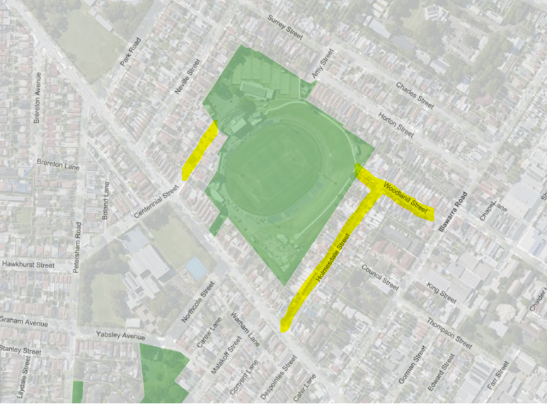
Woodland Street, Holmesdale Street and Centennial Street (north) will be closed to through traffic so the events as proposed can successfully occur. However, the roads will be accessible to all residents and emergency vehicles.
Both Woodland Street and Holmesdale Street are local roads servicing mainly residential properties and carry nominal traffic volumes of around or less than 500 vehicles per day. Holmesdale Street is one-way northbound. Parking is unrestricted in both streets. Centennial Street is a dead-end local two-way street with one travel lane in each direction, in addition to kerbside parking lanes. It carries around 400 vehicles per day. Parking is unrestricted along both sides of the road. It is a residential local road and an entry point to Henson Park.
Road closures will be in place during the following days and times:
• Saturday 30 August, 10:45 – 15:45
• Sunday 7 September, 08:45 – 13:45
• Sunday 21 September, 08:45 – 13:45
• Saturday 4 October, 08:45 – 13:45
• Sunday 12 October, 08:45 – 13:45
• Saturday 18 October, 10:45 – 15:45
• Saturday 25 October, 08:45 – 13:45
• Saturday 1 or Sunday 2 November, Date & Time TBC.
The applicant has specified that the road closures will be undertaken on Henson Park match days to effectively manage the entry of spectators into the venue.
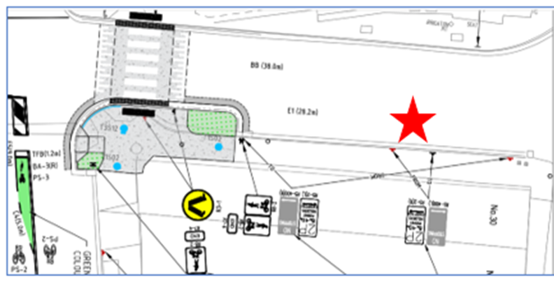
The traffic control measures are diagrammatically shown and detailed in the Traffic Guidance Schemes (TGSs) reproduced below. The TGSs are to be submitted to TfNSW for consideration and approval and a Road Occupancy License application is to be submitted to the Transport Management Centre by Who Dares Pty Ltd.
Local access for resident’s vehicles and pedestrians will be provided at all times and traffic controllers will be on site to safely assist residents to their properties and manage pedestrians.
Adequate vehicular traffic control shall be provided for the protection and convenience of pedestrians and motorists including appropriate signage and flagging. Workers shall be specially designated for this role (and carry appropriate certificates), as necessary to comply with this condition. This is to be carried out in accordance with the Australian Standard AS 1742.3 - Traffic Control Devices for works on roads.
Barriers at Woodland Street at Illawarra Road, Holmesdale Street at Sydenham Road and Centennial Street at Sydenham Road will be set back to accommodate any right turning vehicles should they try to enter the closed roads.
Car parking is limited to on-street parking in surrounding suburban streets.
PUBLIC TRANSPORT
428 bus operates from Martin Place via City, City Rd, Newtown to stop Addison Rd opposite Addison Road Community Centre (220445) – 600m walk to Woodland St gate.
412 bus operates from Martin Place via City, City Rd, Camperdown to stop Livingstone Rd opposite Marrickville Park (220491) – 650m walk to Sydenham Rd gate.
Sydenham Train Station is 1.5km walk.
FINANCIAL IMPLICATIONS
All works and costs of implementation will be borne by the applicant.
PUBLIC CONSULTATION
The applicant is to notify all affected residents and businesses in writing at least 7 days prior to the commencement of works.
The proposed road closures have been advertised on Council’s website in accordance with the Roads Act 1993.
Nil.
|
|
Local Traffic Committee Meeting 21 July 2025 |
Subject: Burrows Avenue, Sydenham - Proposed installation of 'No Parking' restrictions to provide one drop-off space on the southern side opposite Sydenham Station (Midjuburi - Marrickville Ward / Heffron Electorate / Inner West PAC)
Prepared By: Jennifer Adams - Traffic Engineer
Authorised By: George Tsaprounis - Acting Traffic and Transport Planning Manager
|
RECOMMENDATION
That the installation of a short 5 metre length of full-time ‘No Parking drop off/pick up zone’ restrictions on the southern side of Burrows Avenue, west (of existing No Stopping restrictions in Burrows Ave) and of Hogan Avenue, Sydenham be approved, to provide a drop-off space opposite Sydenham Station. |
STRATEGIC OBJECTIVE
This report supports the following strategic directions contained within Council’s Community Strategic Plan:
|
2: Liveable, connected neighbourhoods and transport |
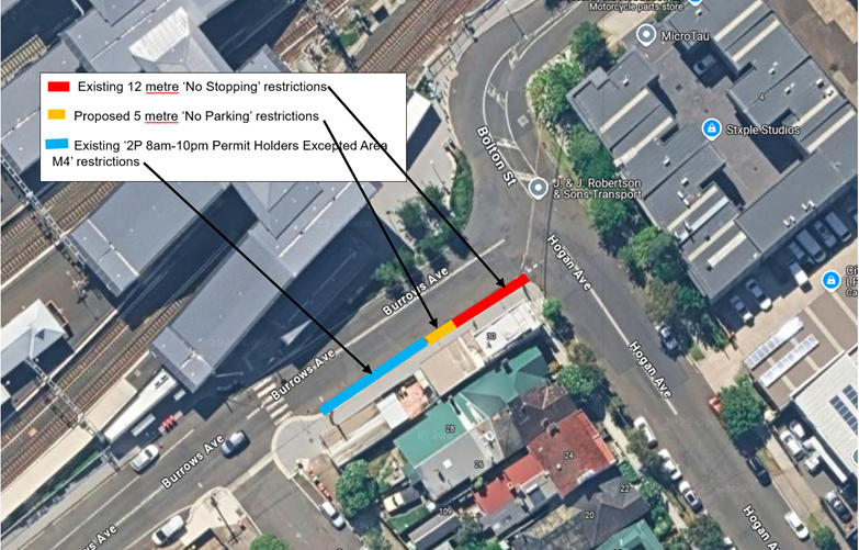
Council is proposing to install a short 5 metre length drop-off zone (in the form of ‘no Parking’ restrictions) on the southern side of Burrows Avenue to compliment the main ‘drop-off’ zone on the northern side of Burrows Avenue adjacent to Sydenham Station, Sydenham
BACKGROUND
A local resident had concerns about the lack of a drop-off area for passengers accessing Sydenham Station from the east via Hogan Avenue, Sydenham. They requested that Council provide a legal drop-off facility on the southern side of Burrows Avenue, Sydenham.
A consultation letter was distributed to residents in Hogan Avenue and George Street, Sydenham proposing to signpost a short 5 metre length drop-off zone (in the form of ‘no Parking’ restrictions) on the southern side of Burrows Avenue to compliment the main ‘drop-off’ zone on the northern side of Burrows Avenue adjacent to Sydenham Station and this report summaries the results of that consultation.
OFFICERS COMMENTS
Burrows Avenue is a two-way local road with one travel lane in each direction, in addition to some kerbside parking lanes and recent cycleway paths.
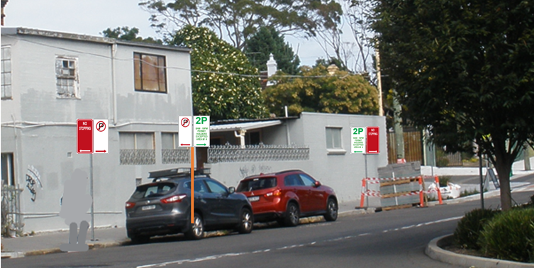
Currently there are residential ‘2P 8am-10pm Permit Holders Excepted – Area M4’ on the southern side of Burrows Avenue between Hogan Avenue and George Street, Sydenham and it is proposed to make the eastern 5 metres of this 2P parking zone ‘No Parking’ restrictions which will provide a drop-off zone and aid in improved manoeuvring for large trucks turning left from Hogan Avenue into Burrows Avenue, Sydenham. (Refer to the diagrams below).
PUBLIC CONSULTATION
A consultation letter was sent out on 3 June 2025 to owners and occupiers of properties in George Street and on the western side of Hogan Street, Sydenham regarding the proposal to install a shorth length of “No Parking’ restrictions on the southern side of Burrows Avenue, west of Hogan Avenue, Sydenham to provide a drop-off space opposite Sydenham Station. The closing date for submissions ended on 27 June 2025. Twenty-eight (28) letters were distributed.
Resident Survey findings
A total of two (2) responses were received one in support and the other in objection to the proposal.
The resident in support noted that a ‘No Parking’ spot as proposed would make it safer and more convenient for passengers to alight/be picked up from nearby Sydenham Station.
A resident in George Street objected to the proposal saying that there are already limited parking spaces in the area for residents living on George Street and Hogan Avenue and that there already is a drop-off zone in Burrows Avenue on the Station side. They stated that George Street is used by commuters / pub goers who do not have parking permits and who park there all day.
Officer’s response - It is noted that both George Street and Hogan Avenue have existing ‘2P’ residential parking restrictions in place (‘2P 8am-10pm Permit Holders Excepted – Area M4’). The ‘2P’ restrictions are in place on both sides of George Street and the western side of Hogan Avenue. Council’s Parking Rangers can be requested to monitor the parking in the locality to check that commuters are not parking all day.
FINANCIAL IMPLICATIONS
The costs of installation of the ‘No Parking’ restrictions as recommended can be funded within Council’s signs and line marking budget.
CONCLUSION
To provide a drop-off space on the southern side of Burrows Avenue to compliment the main ‘drop-off’ zone on the northern side of Burrows Avenue for Sydenham Station it is recommended that the full-time ‘No Parking drop off/pick up’ zone as proposed be installed. Refer to diagram below.
Nil.
|
|
Local Traffic Committee Meeting 21 July 2025 |
Subject: Permit Plug Play Project – Global TMPs - Temporary Full Time Road Closures for community events - up to six Sunday events per year at three locations (Midjuburi-Marrickville Ward and Djarrawunang-Ashfield Ward /Summer Hill Electorate / Inner West LAC and Burwood PAC)
Prepared By: Jennifer Adams - Traffic Engineer
Authorised By: George Tsaprounis - Acting Traffic and Transport Planning Manager
|
RECOMMENDATION
That the Local Traffic Committee supports the approval of the Global Traffic Management Plans for up to six Sunday events for a period of five years at the following three locations: Illawarra Lane and the Calvert Street carpark in Marrickville; on Railway Parade (Lower), Marrickville and Hercules Street, Ashfield subject to (1) approval of the TMPs by TfNSW, (2) the applicant complying with the submitted TMPs and TGSs, (3) Council standard and specific (if required) conditions for a road closure and (4) the following conditions as listed below: a) A temporary full road closure application is lodged with Council in a timely manner for each proposed road closure. b) A Road Occupancy License be obtained by the applicant from the Transport Management Centre; c) All affected residents and businesses, including NSW Police Local Area Commander, Transit Systems, Fire and Rescue NSW and NSW Ambulance Services, shall be notified in writing by the applicant of the proposed temporary road closure at least 14 days prior to the event, with the applicant making reasonable provision for residents and businesses; d) Notification signs advising of the proposed road closures and new traffic arrangements to be strategically installed and maintained by the applicant at each end of each street at least 7 days prior to the closure; e) A 4-metre-wide emergency vehicle access be maintained through the area during the course of the event; and f) The occupation of the road carriageway must not occur until the road has been physically closed.
|
STRATEGIC OBJECTIVE
This report supports the following strategic directions contained within Council’s Community Strategic Plan:
|
2: Liveable, connected neighbourhoods and transport |
EXECUTIVE SUMMARY
The Permit/Plug/Play Pilot Program is a coordinated effort by Transport for NSW, state partners, and local councils to develop tailored, local solutions that address the complexity of approval processes, and the high costs associated with street-based events. It aims to help streamline approval processes for temporary road-closure enabled events and deliver enabling place infrastructure.
Inner West Council received $500,000 grant from Transport for NSW to simplify temporary road closures and promote local street events. The program seeks to activate public spaces by supporting community events, enhancing local business, and fostering social and cultural connections.
The primary goal of the project is to make it easier for councils and event organisers to host street events in urban areas by means of the creation of standard TMPs valid for 5 years across three locations that will be enacted during events, plus the provision of infrastructure improvements such as bollards, lighting, and signage to support these events.
Approval is requested from the Local Traffic Committee for the endorsement of the standard use of the three attached TMPs with a validity of 5 years to enable the program’s objectives of creating active and engaging public spaces through regular community events by reducing the burden, responsibility and expense of individual event holders having to obtain individual TMP’s for each event held at these specific locations.
BACKGROUND
The Permit/Plug/Play Pilot Program is an $8.5 million partnership grant program with 17 pilot councils across NSW. The Program aims to reduce the cost and complexity of delivering street-based events through an innovative “local problems, local solutions” model. The Program is a part of the NSW Government’s Vibrant Streets Package, an over $39 million investment in transforming streets into thriving local places to support the community, businesses and the creative sector.
The program aims to:
1. Improve council process efficiency and communication about temporary road closures and the street-based events that they enable;
2. Reduce the cost of delivering street-based events and temporary road closures for event proponents;
3. Focus investment on strategic locations for maximum impact;
4. Support collaborative engagement and funding; and
5. Deliver enhanced cultural, economic, and social benefits through street-based events.
Pilot councils have been granted up to $500,000 to identify 3-5 streets in their Local Government Area to streamline processes and reduce costs of delivering street-based events.
Pilot councils are required to complete planning and consultation activities to identify challenges and potential solutions that aim to reduce the cost and complexity of delivering street-based events and activations in their Local Government Area (LGA).
Each pilot council will implement a combination of process improvements and enabling place infrastructure to address challenges identified, with a ‘local problems, local solutions’ approach.
Interventions for delivery by pilot councils include (but are not limited to):
• Pre-approved/Global Traffic Management Plans, Development Applications, Risk Assessments, Section 68 Certificates, and amendment of Local Environmental Plans,
• Hostile Vehicle Mitigation (HVM) and establishment of HVM Plans,
• Event application process improvements, e.g. establishment of event toolkits and guidelines, streamlined event application and approval processes, and standardised event templates and documentation, and
• Enabling place infrastructure, e.g. Bollards/vehicle barriers, lighting, power supply/power infrastructure, furniture, marquees, event equipment storage, water infrastructure, public art, staging infrastructure and signage.
Following implementation, each pilot council will deliver a street-based activation to evaluate the impact of process improvements and enabling place infrastructure, delivered under the Program.
STAFF COMMENTS
Council proposes to approve regular and recurring events at the following locations:
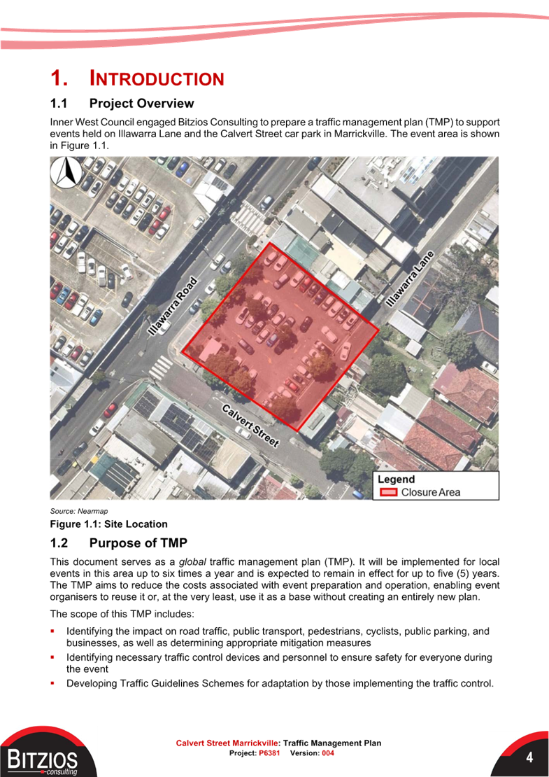
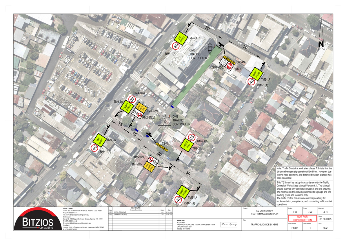
1. Illawarra Lane and Calvert Street carpark, Marrickville
2. Railway Parade (lower), Marrickville
3. Hercules Street, Ashfield
Approval is sought for up to 6 times per calendar year, between 2025 and 2029. The events will be permitted only on a Sunday and will involve temporary full closure of the street to vehicles between 3:30am and 11:30pm on the day of the planned event (dates are subject to individual event applications).
To support event organisers to activate these sites, Council proposes to also develop a global Activity Application form (s68), traffic management plan and explore upgrades to power and enabling infrastructure like removable bollards that can help reduce the costs for event organisers.
Inner West Council engaged Bitzios Consulting to prepare traffic management plans (TMPs) to
support the events. Each TMP document serves as a global traffic management plan (TMP). They will be implemented for local events in each area up to six times a year and are expected to remain in effect for up to five (5) years.
The TMPs aim to reduce the costs associated with event preparation and operation, enabling event organisers to reuse them or, at the very least, use them as a base without creating an entirely new plan.
The scope of the TMPs include:
· Identifying the impact on road traffic, public transport, pedestrians, cyclists, public parking, and businesses, as well as determining appropriate mitigation measures
· Identifying necessary traffic control devices and personnel to ensure safety for everyone during the event
· Developing Traffic Guidelines Schemes for adaptation by those implementing the traffic control
After the first event is held, a full review of the TMP will be undertaken to identify aspects that could be improved upon for subsequent uses.
SITE LOCATIONS
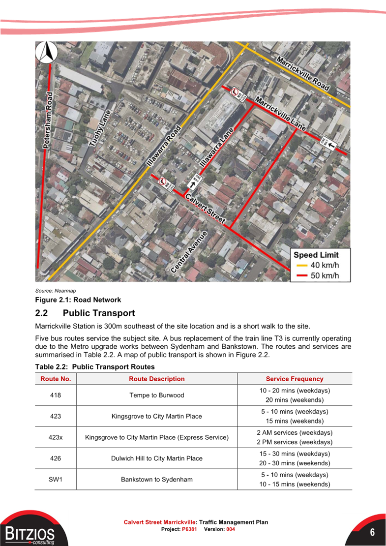
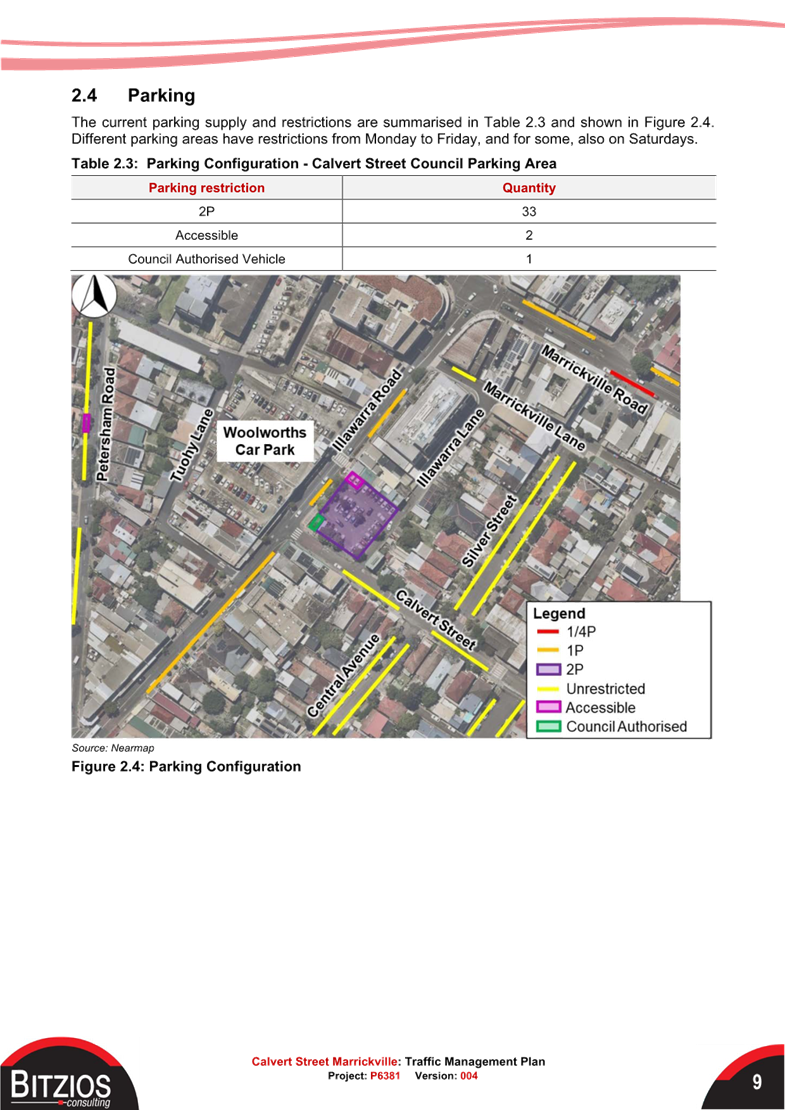
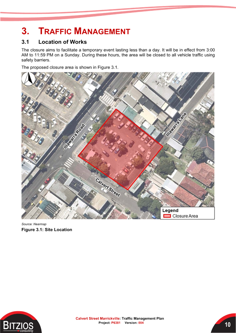
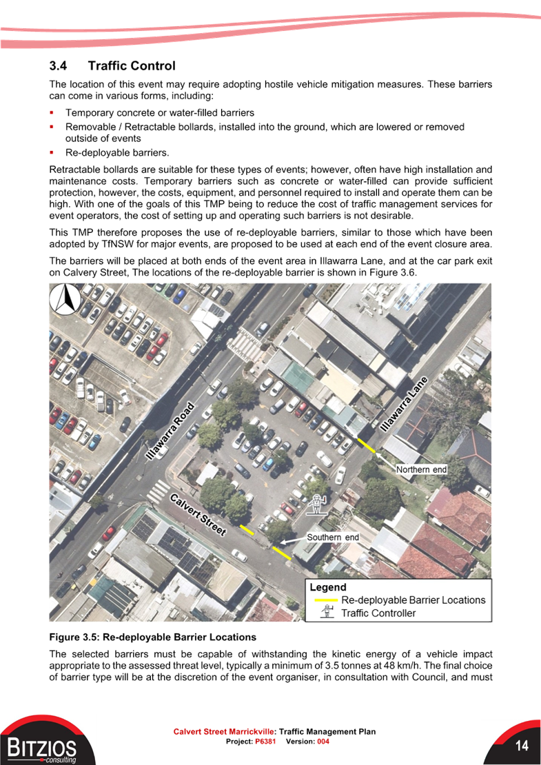
1. Illawarra Lane and Calvert Street carpark, Marrickville
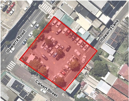
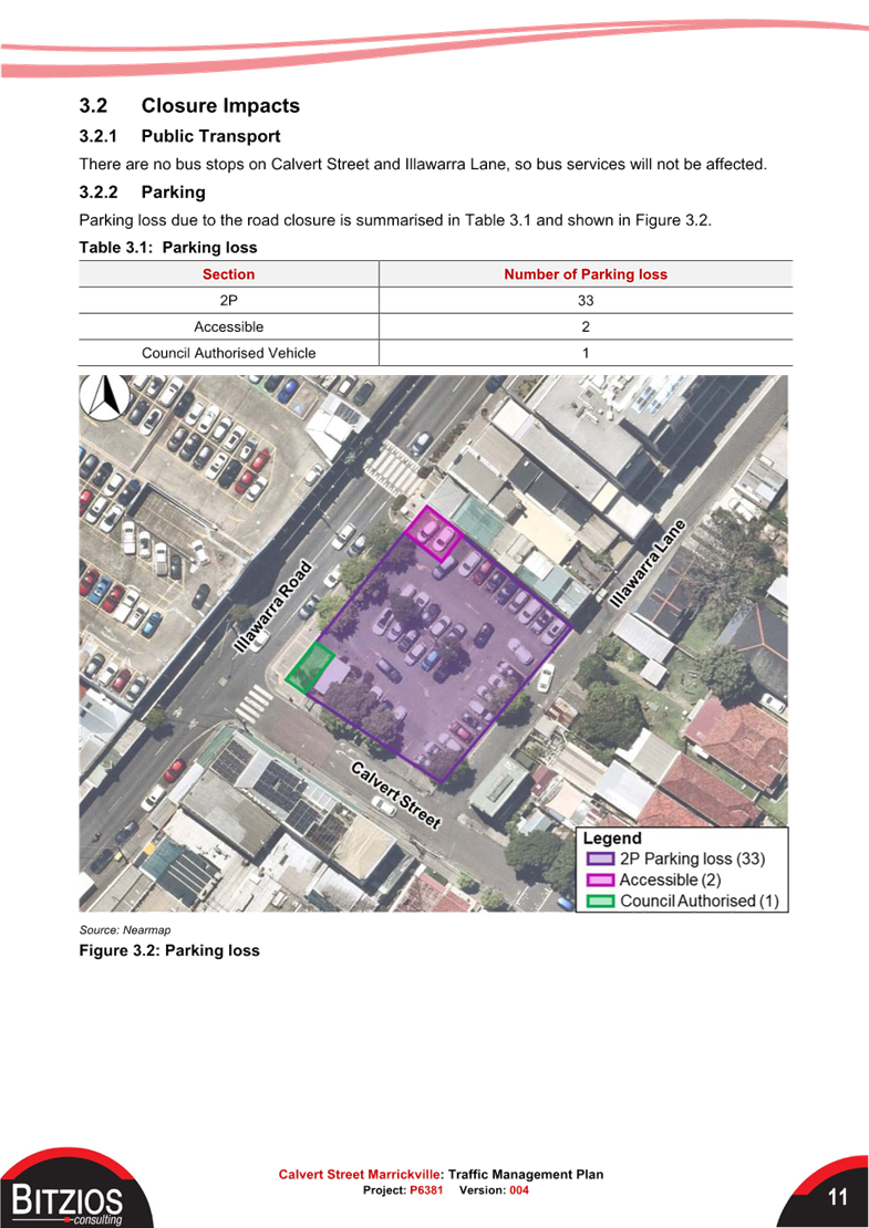
The TMP notes that parking loss due to the road closure would be 36 spaces – 33 ‘2P’ spaces; 2 ‘accessible’ spaces and 1 ‘Council Authorised Vehicle’ space.
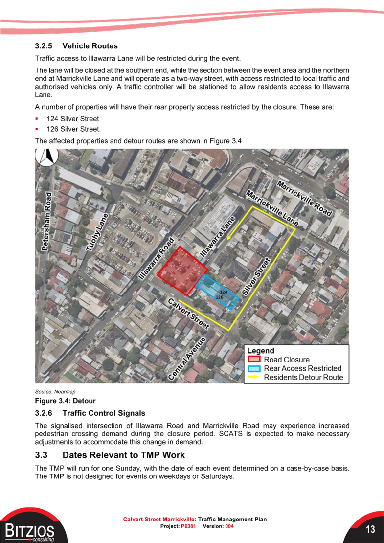
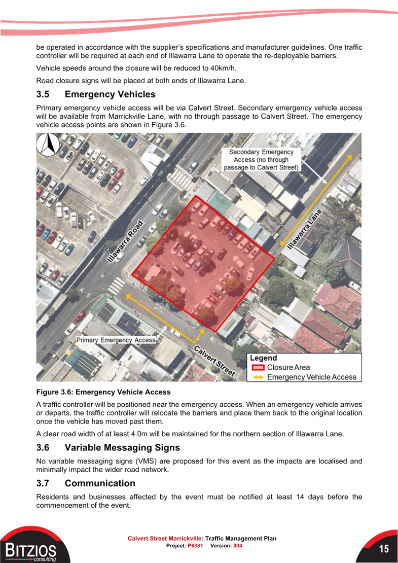
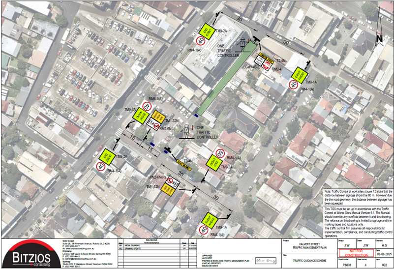
Traffic access to Illawarra Lane will be restricted during the event. The lane will be closed at the southern end, while the section between the event area and the northern end at Marrickville Lane and will operate as a two-way street, with access restricted to local traffic and authorised vehicles only. A traffic controller will be stationed to allow residents access to Illawarra Lane.
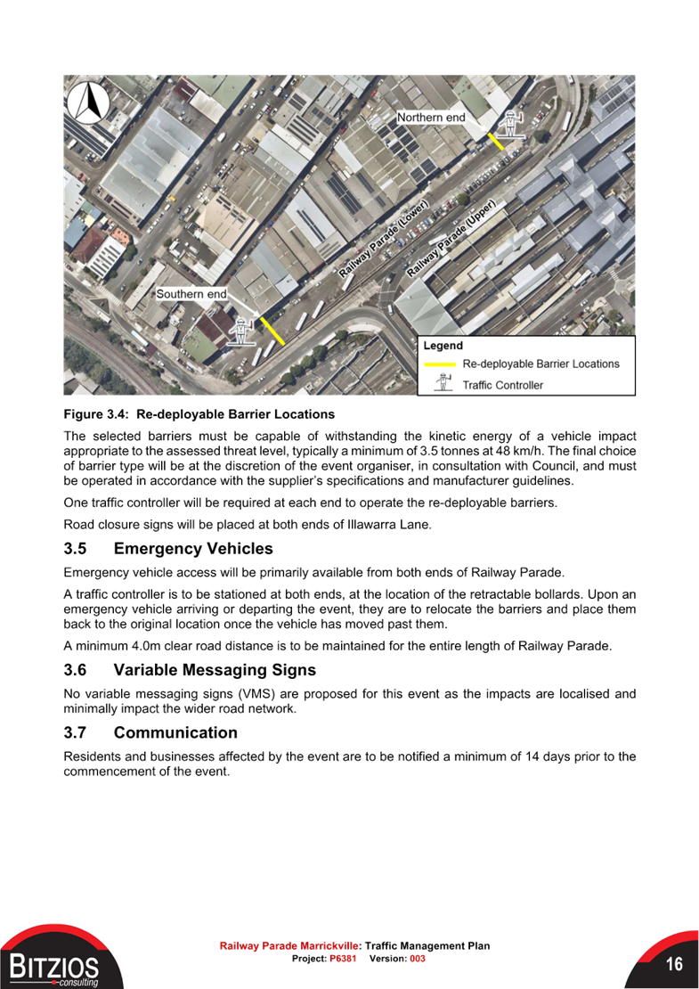
One traffic controller will be positioned at each end of Illawarra Lane to operate the re-deployable barriers. Road closure signs will be placed at both ends of Illawarra Lane. Primary emergency vehicle access will be via Calvert Street. Secondary emergency vehicle access will be available from Marrickville Lane, with no through passage to Calvert Street.
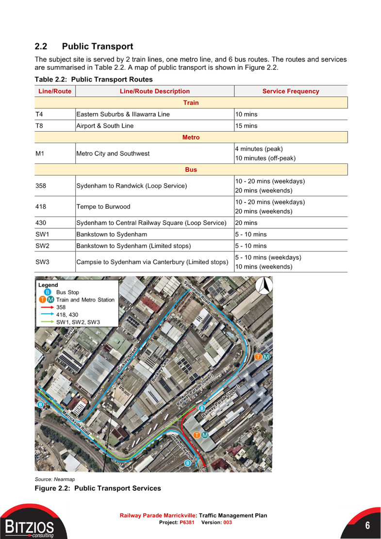
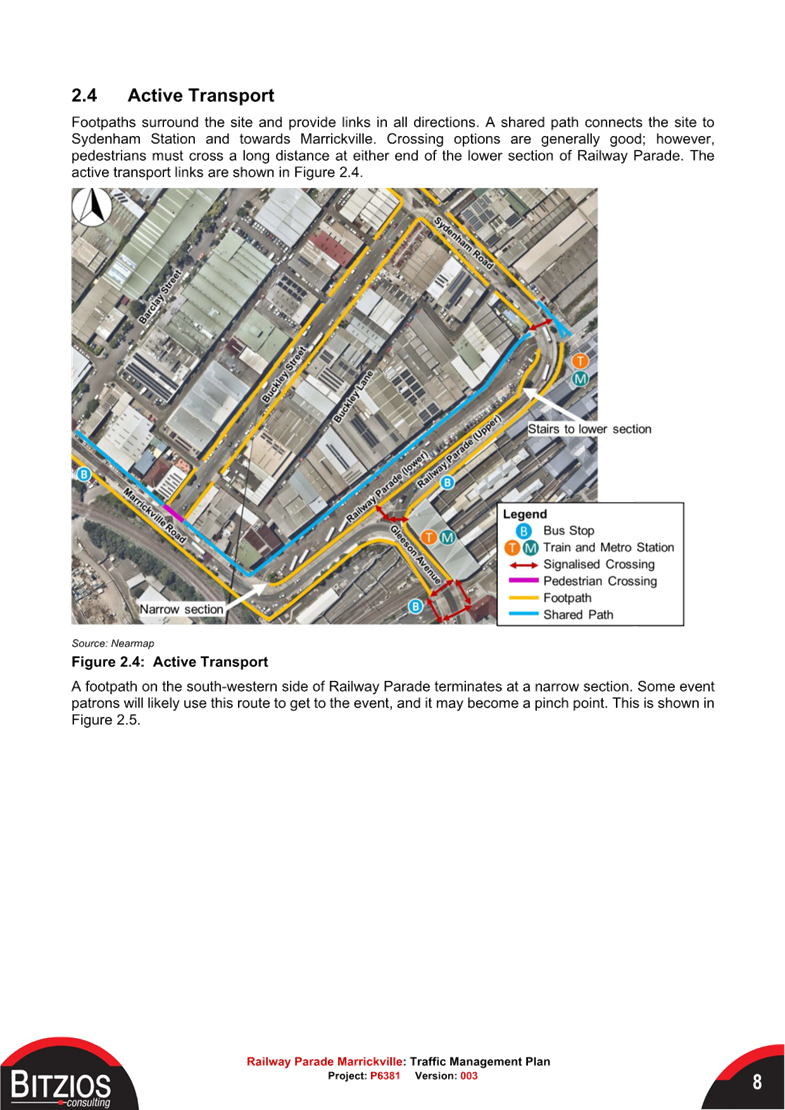
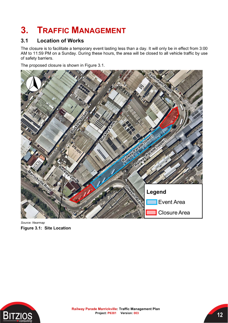
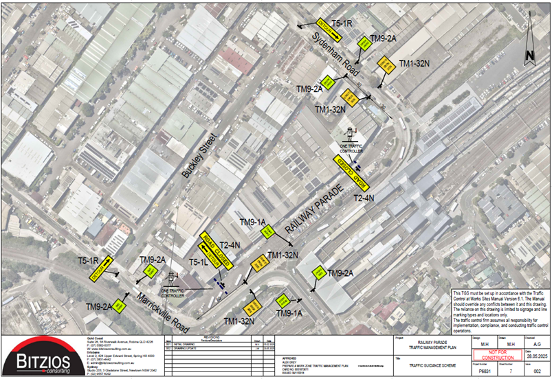
2. Railway Parade (lower), Marrickville
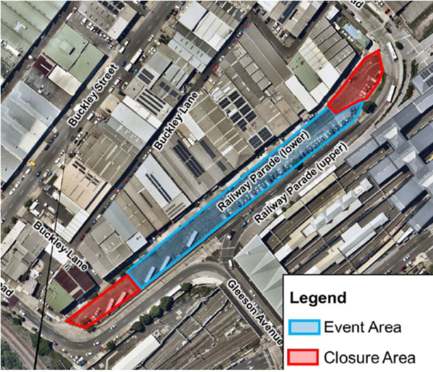
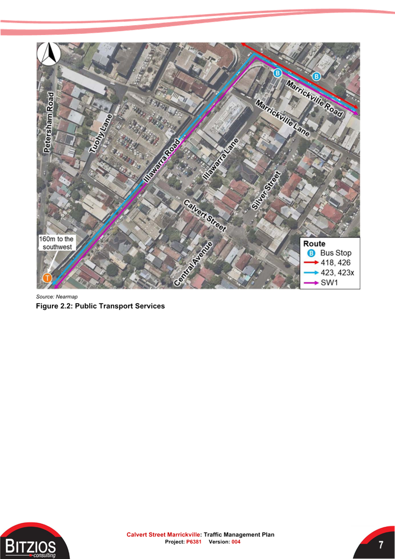
The TMP notes that as of February 2025, the Sydney Metro City and Southwest is still under construction, and this service currently operates between Sydenham and Tallawong. Bus replacement services are in operation to accommodate the closure of the rail line, connecting patrons to other stations along the rail network. These services use part of the lower section of Railway Parade as a layover area. This is expected to remain in place until the Metro construction is completed and the line is opened.
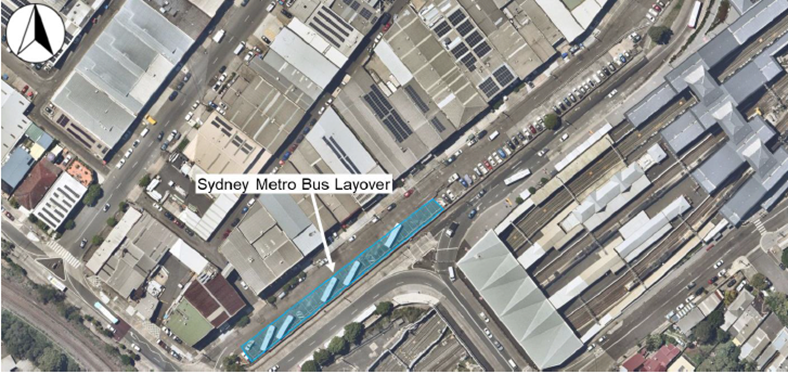
The delivery of enabling infrastructure and events will be on hold until the metro line is opened, and the layover area is no longer needed. It is noted that the site may be required again for layover purposes due to Metro maintenance or breakdowns. In such circumstances, event organisers and Council shall coordinate accordingly during the application process.
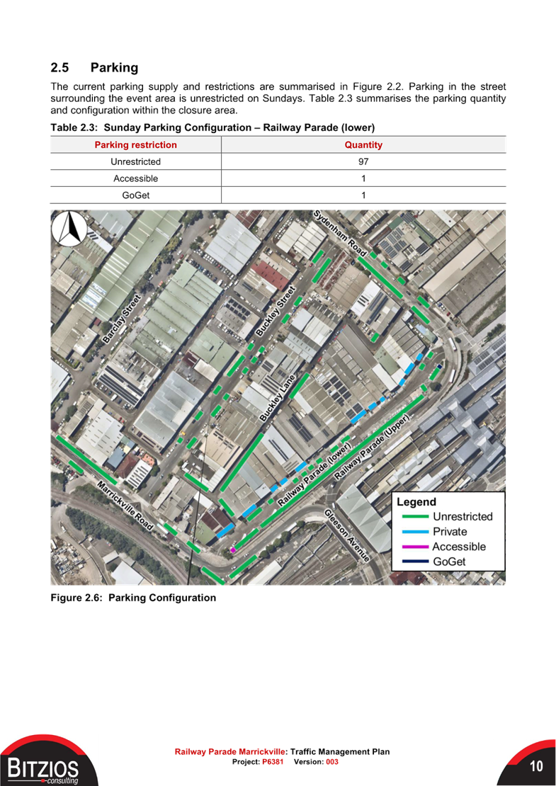
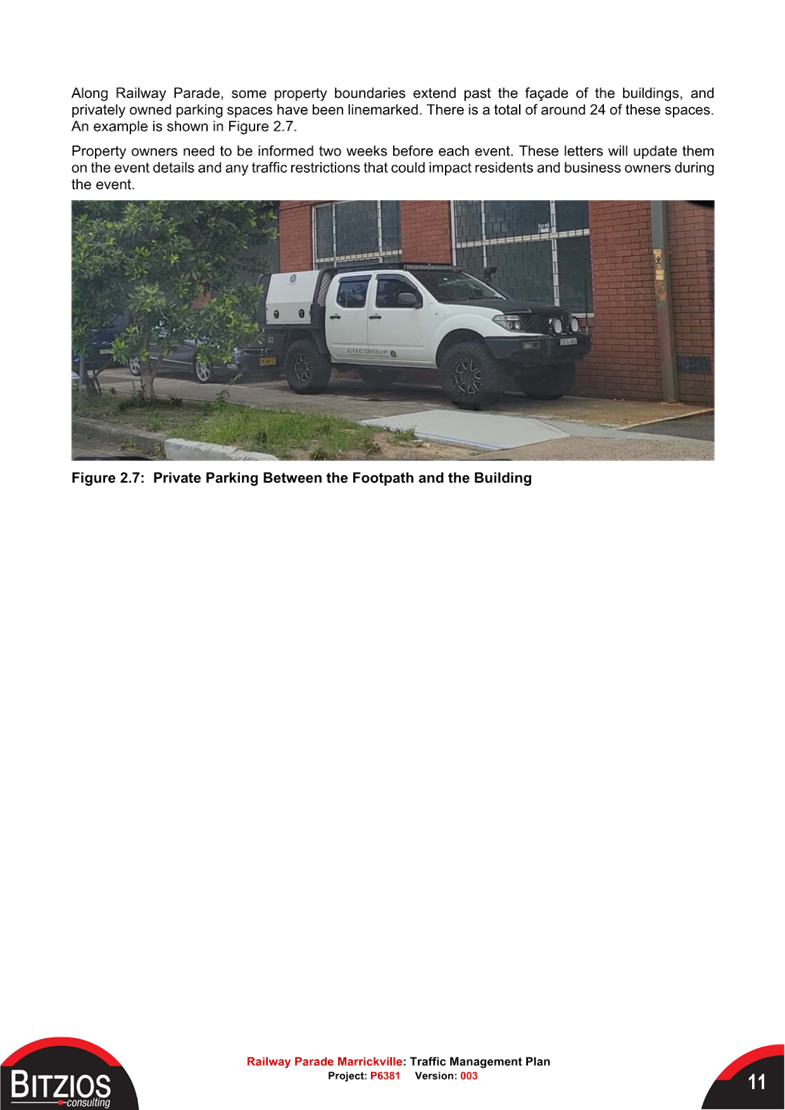
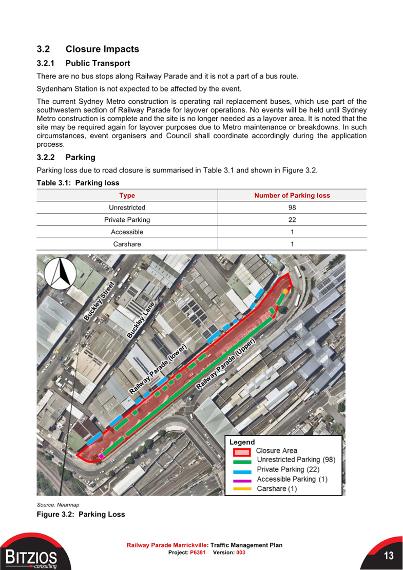
Parking loss due to the road closure would be 99 spaces – 97 ‘unrestricted’ spaces: 1 ‘accessible’ space and 1 ‘GoGet share space. In addition, ‘private’ parking between business property line and footpath would be lost – 22 spaces.
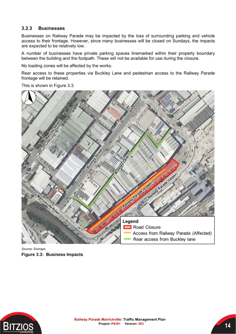
Businesses on Railway Parade may be impacted by the loss of surrounding parking and vehicle
access to their frontage. However, since many businesses will be closed on Sundays, the impacts are expected to be relatively low. Rear access to these properties via Buckley Lane and pedestrian access to the Railway Parade frontage will be retained.
Vehicles will not be able to use Railway Parade during the closure. A detour will be in place via Buckley Street and Railway Parade (upper).
Emergency vehicle access will be primarily available from both ends of Railway Parade. A traffic controller is to be stationed at both ends, at the location of the retractable bollards.
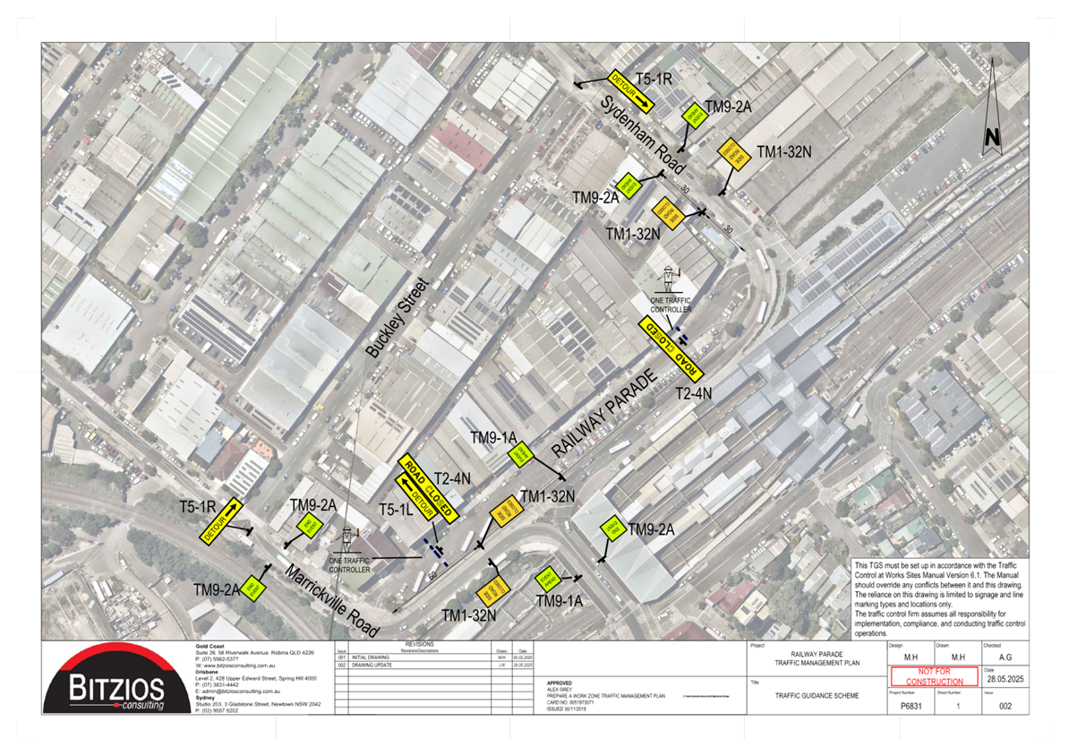
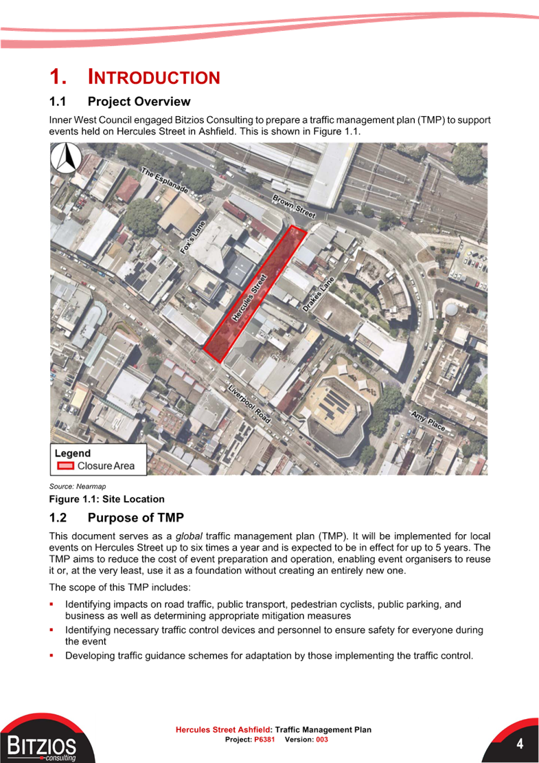
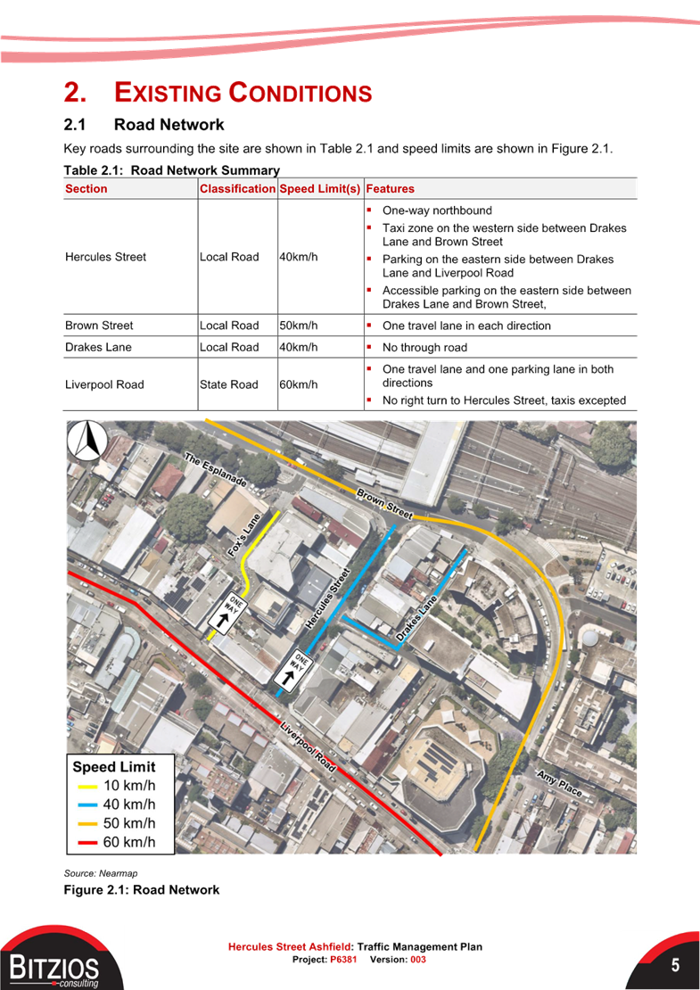
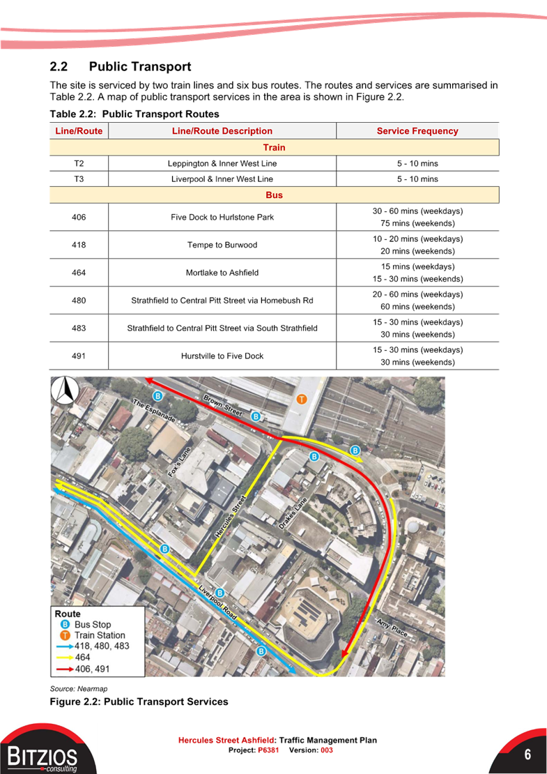
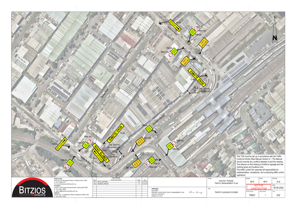
3. Hercules Street, Ashfield.
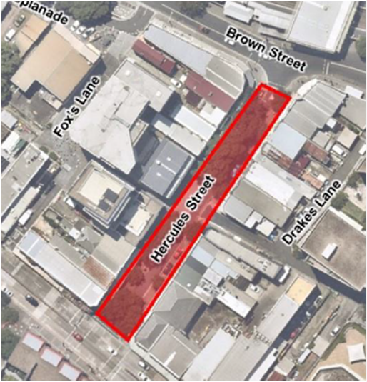
The TMP notes that Hercules Street is a local street one-way northbound. There is a Taxi zone on the western side between Drakes Lane and Brown Street. Parking on the eastern side between Drakes Lane and Liverpool Road includes Accessible parking on the eastern side between Drakes Lane and Brown Street,
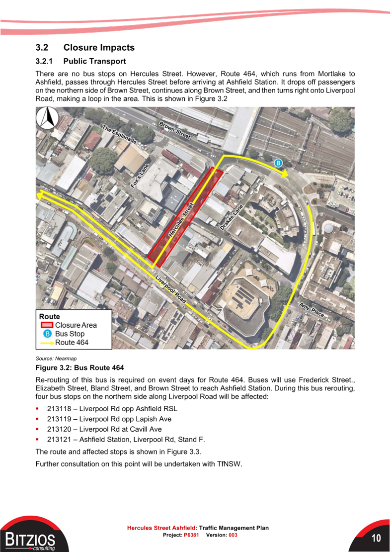
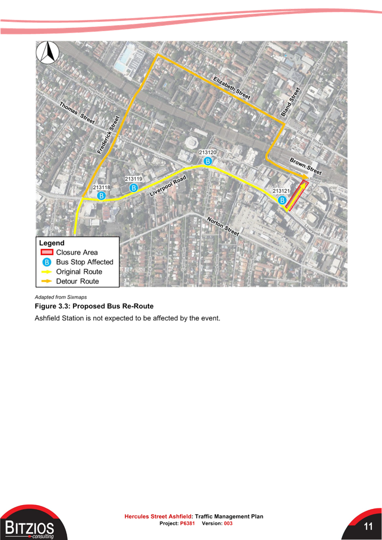
There are no bus stops on Hercules Street. However, Route 464, which runs from Mortlake to
Ashfield passes through Hercules Street before arriving at Ashfield Station. It drops off passengers on the northern side of Brown Street, continues along Brown Street, and then turns right onto Liverpool Road, making a loop in the area.
Re-routing of this bus is required on event days for Route 464. Buses will use Frederick Street., Elizabeth Street, Bland Street, and Brown Street to reach Ashfield Station. During this bus rerouting, four bus stops on the northern side along Liverpool Road will be affected:
▪ 213118 – Liverpool Road opposite Ashfield RSL
▪ 213119 – Liverpool Road opposite Lapish Avenue
▪ 213120 – Liverpool Road at Cavill Avenue
▪ 213121 – Ashfield Station, Liverpool Road, Stand F.
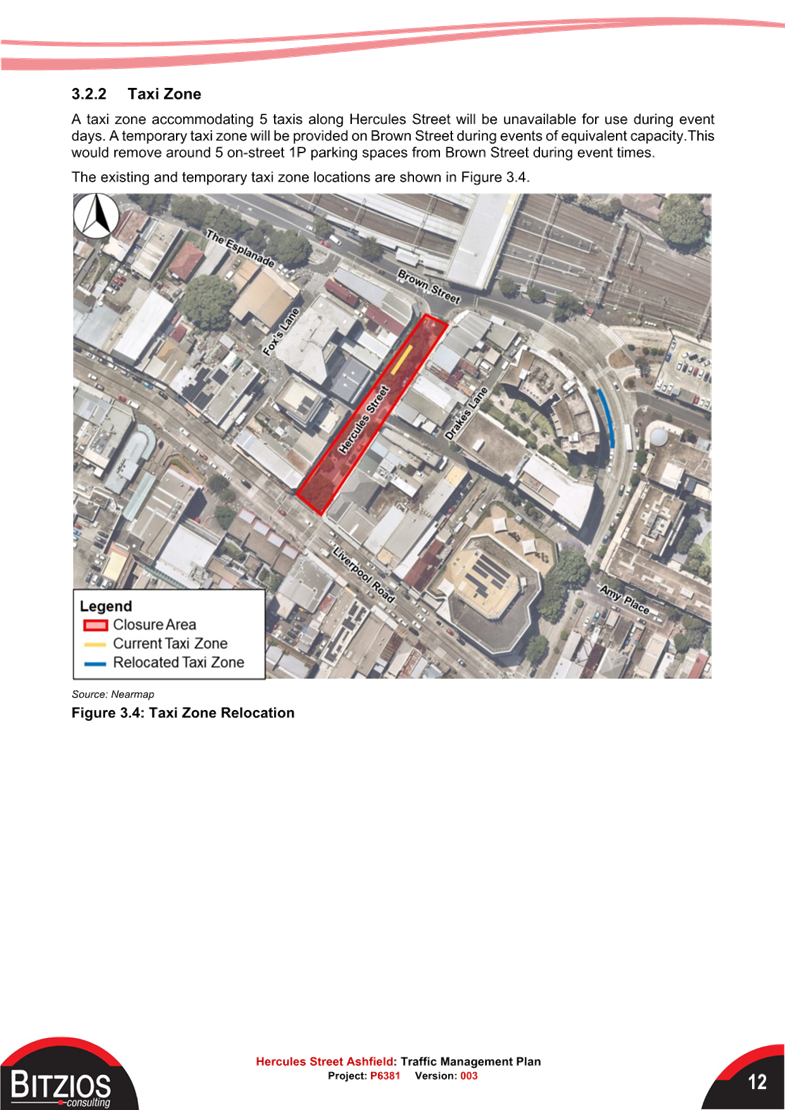
A taxi zone accommodating 5 taxis along Hercules Street will be unavailable for use during event days. A temporary taxi zone will be provided on Brown Street during events of equivalent capacity. This would remove around 5 on-street 1P parking spaces from Brown Street during event times.
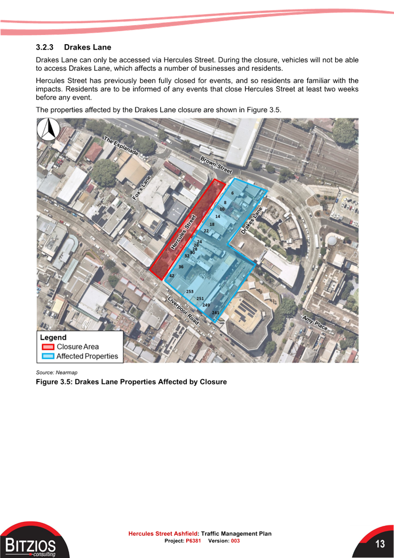
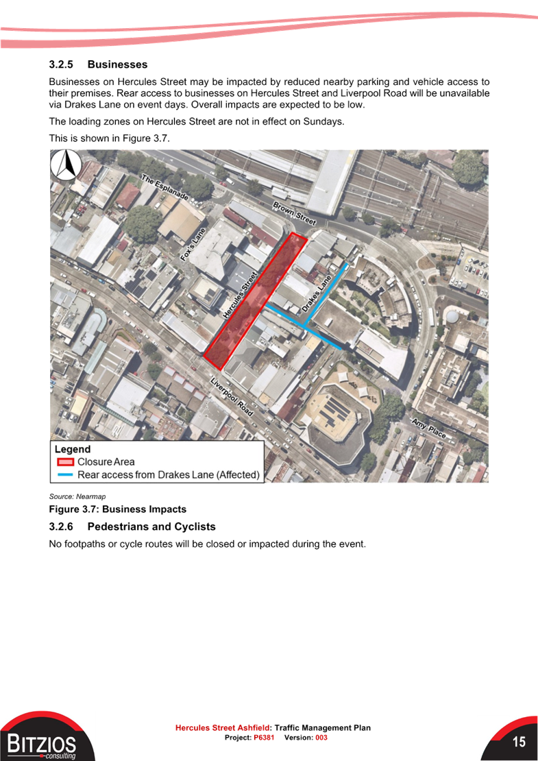
Drakes Lane can only be accessed via Hercules Street. During the closure, vehicles will not be able to access Drakes Lane, which affects a number of businesses and residents.
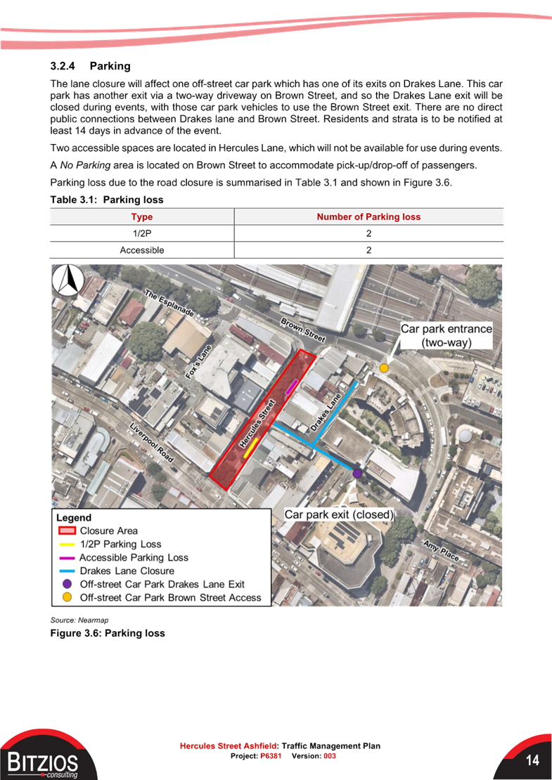
The lane closure will affect one off-street carpark which has one of its exits on Drakes Lane. This car park has another exit via a two-way driveway on Brown Street, and so the Drakes Lane exit will be closed during events, with those car park vehicles to use the Brown Street exit. There are no direct public connections between Drakes Lane and Brown Street. Residents and strata are to be notified at least 14 days in advance of the event.
Two accessible spaces are located in Hercules Lane, which will not be available for use during events. A No Parking area is located on Brown Street to accommodate pick-up/drop-off of passengers. The loading zones on Hercules Street are not in effect on Sundays.
Parking loss due to the road closure would be 4 spaces - 2 ‘1/2P’ spaces and 2 ‘accessible’ spaces.
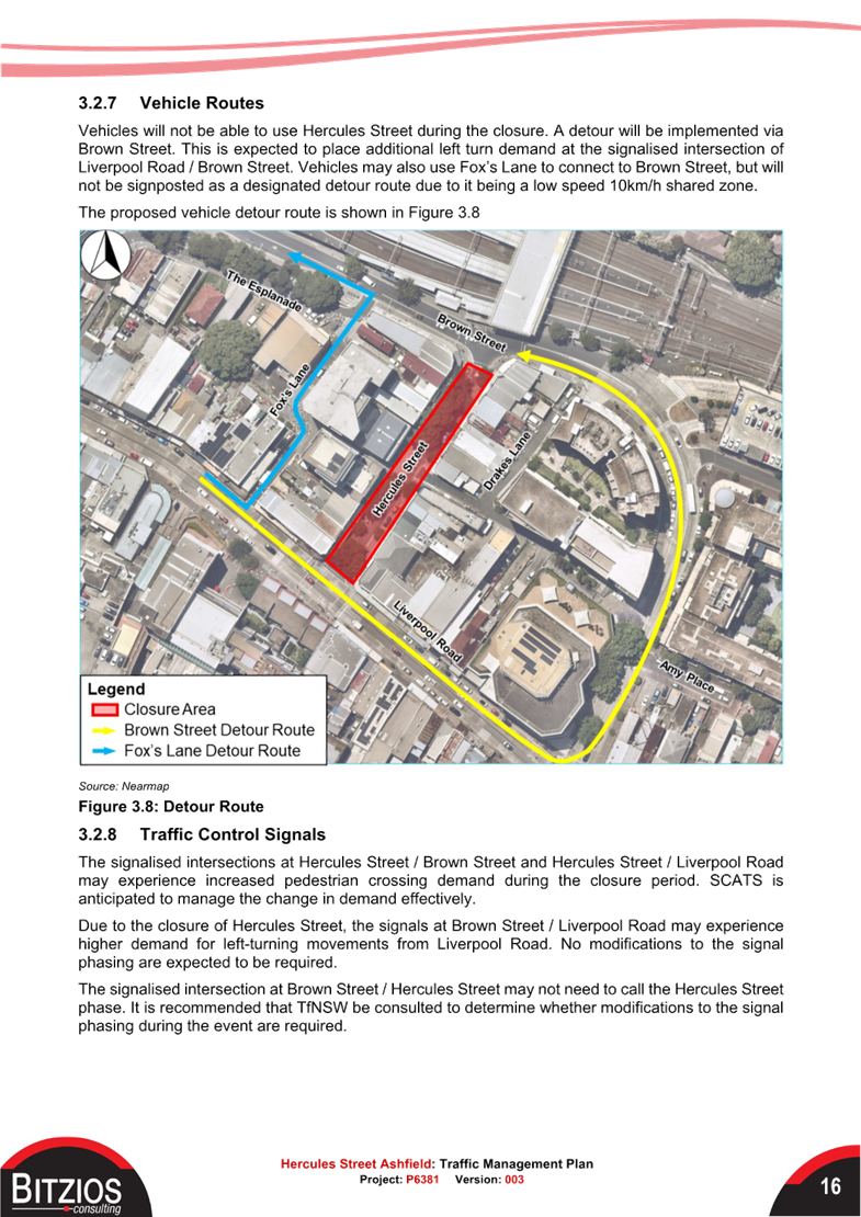
Vehicles will not be able to use Hercules Street during the closure. A detour will be implemented via Brown Street. This is expected to place additional left turn demand at the signalised intersection of Liverpool Road / Brown Street. Vehicles may also use Fox’s Lane to connect to Brown Street but will not be signposted as a designated detour route due to it being a low speed 10km/h shared zone.
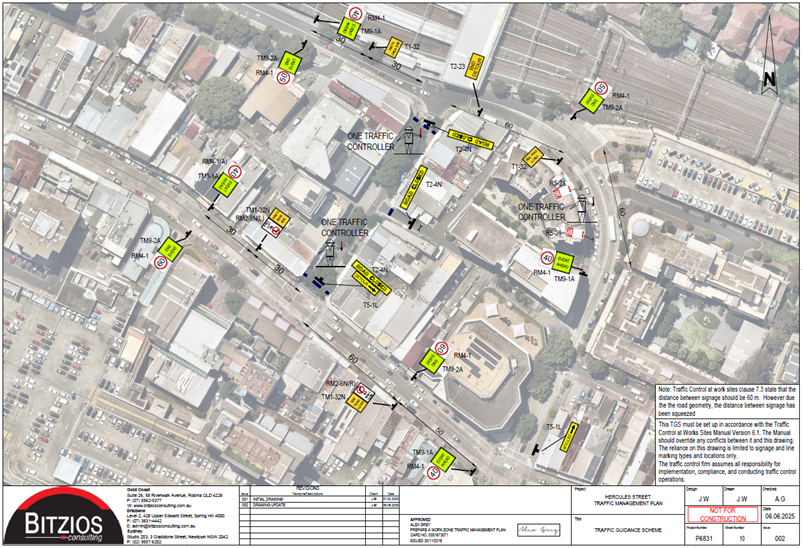
The signalised intersection at Brown Street / Hercules Street may not need to call the Hercules Street phase. It is recommended that TfNSW be consulted to determine whether modifications to the signal phasing during the event are required.
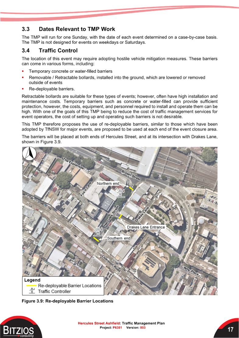
Road closure signs will be placed at both ends of Hercules Street, and detour signs to guide vehicles that intend to use Hercules Street. Emergency vehicle access will be primarily available from the southern end of Hercules Street, with no through access to or from Brown Street.
Typically to facilitate emergency vehicle access, a minimum 4m road width must be maintained,
however, parts of Hercules Street are already narrower than this. Furthermore, event infrastructure such as stages, food trucks, or other attractions would obstruct such traffic. The 4m width is to be maintained as far as possible along the laneway, at least between Liverpool Road and Drakes Lane.
Global Traffic Management Plans
As noted, to enable the street closures, three Global Traffic Management Plans as attached were prepared by Bitzios Consulting for each site to streamline the application processes for event holders.
The TMPs identified impacts on road traffic, public transport, pedestrian cyclists, public parking, and business as well as determining appropriate mitigation measures and recommended traffic control devices and personnel to ensure safety for everyone during the event by developing traffic guidance schemes (TGSs) for adaptation by those implementing the traffic control.
The main site-specific impacts include:
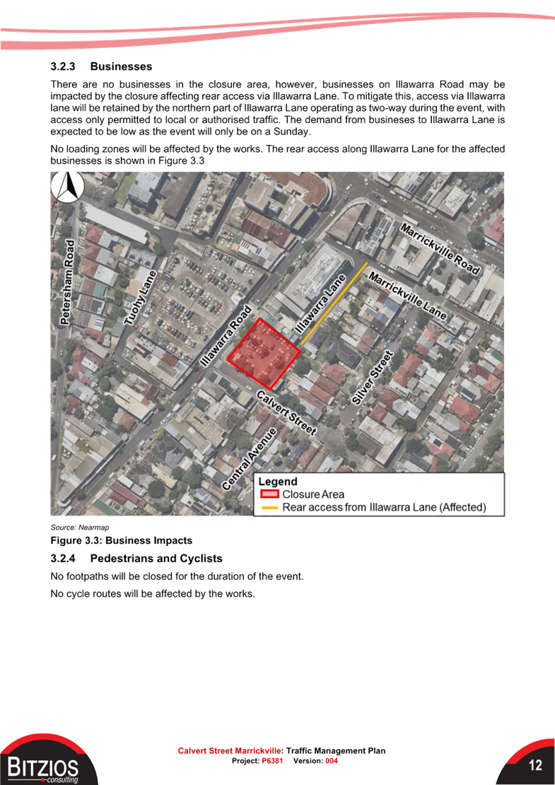
· For Illawarra Lane and Calvert Street Carpark site, the laneway and carpark will be closed, and the remainder of Illawarra Lane will become temporarily two-way on event day. Rear lane garage access of two houses off the laneway will not be accessible.
· For Railway Parade Lower site, the street will be closed on event day, and front-loading functions of adjacent businesses will be disabled from Railway Parade however, they will still have access from Buckley Lane. The delivery of enabling infrastructure and events will be on hold until the metro line is opened, and the bus layover area is no longer needed.
· For Hercules Street site, the bus routes need to be detoured on event day, and existing taxi ranks will be relocated to Brown Street.
It is recommended that Local Traffic Committee supports the approval of the Global Traffic Management Plans for up to six Sunday events for a period of five years at the following three locations: Illawarra Lane and the Calvert Street carpark in Marrickville; on Railway Parade (Lower), Marrickville and Hercules Street, Ashfield subject to approval of the TMPs by TfNSW.
Recommended Hostile Vehicles Mitigation Barriers
Council has conducted extensive market research and has confirmed Pitagone F18 Portable Vehicle Barrier as a recommended HVM Barrier. The Pitagone barrier has been extensively used across Australia, including TfNSW for New Year’s Eve fireworks and Vivid Sydney.
If the event holders decide to adopt the Global TMPs in the future, installation guidance and placing requirements are attached at the back of the TMPs for their information. Council will procure enough barriers with received funding, allowing one event to run on the same day, and the barriers can be lent to external event organisers.
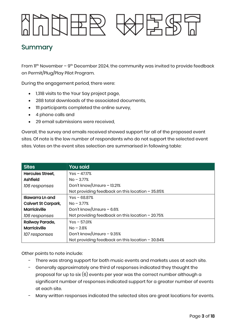
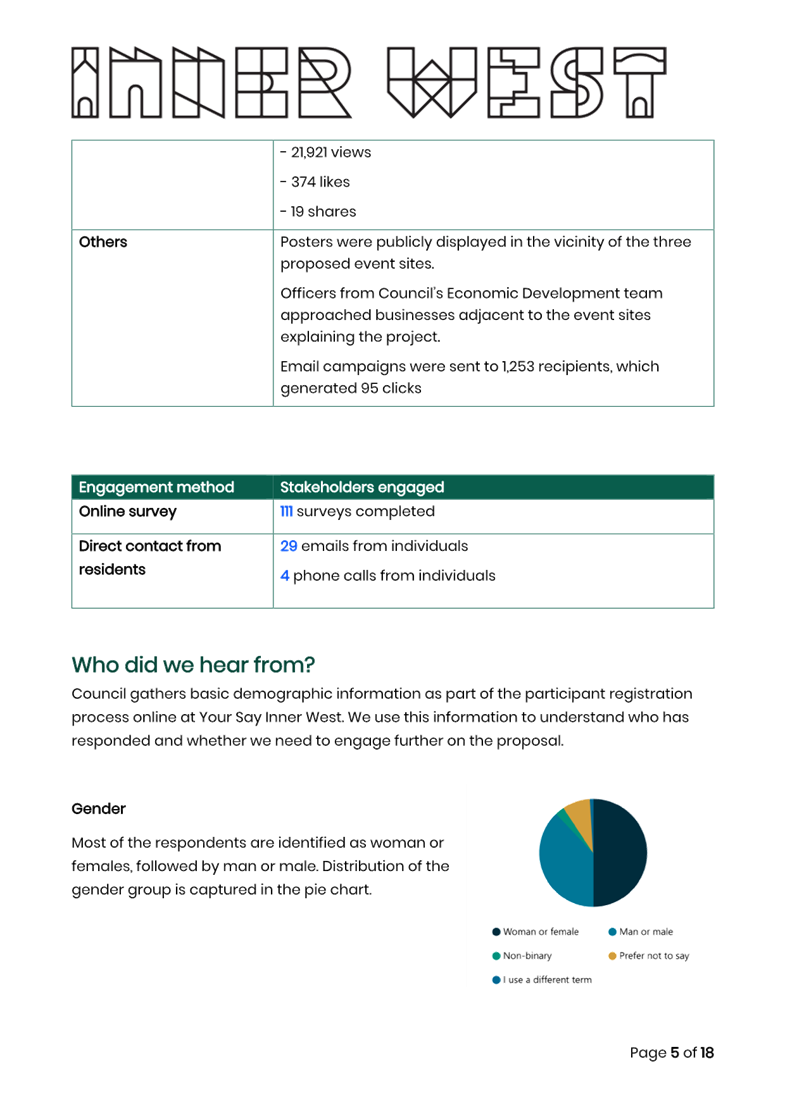
COMMUNITY CONSULTATION
From 11 November to 9 December 2024, the community was invited, by Inner West Council's Building Certification Services team, to provide feedback and complete a survey on Council’s Your Say Inner West platform to garner feedback on:
· Frequency of events; and
· Types of events the community is interested in
To promote the engagement:
· Letters were delivered to residents and businesses within 500m catchment of the proposed sites.
· 2 Instagram posts and 2 Facebook posts were made Council’s social media platform.
· Posters were publicly displayed in the vicinity of the three proposed event sites.
· Officers from Council’s Economic Development team approached businesses adjacent to the event sites explaining the project.
· Email campaigns were sent to 1,253 recipients.
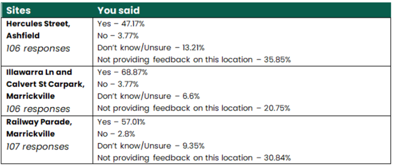
The survey received over 100 responses with respondents mostly supporting the locations. The Engagement Outcomes can be summarised in following table and a copy of the Engagement Outcomes Report is attached for further details:
Council also reached out to the following stakeholders for feedback:
· Transit Systems – who noted that they need 30 days notification of any event. They supported the Hercules Street, Ashfield and Illawarra Lane and Calvert Street carpark, Marrickville sites. However not in favour/support with Railway Parade (lower) with all issues at Sydenham Station and layover shortage. It is noted that the bus layover area is required in Railway Parade site during Sydney Metro construction. Council acknowledges this and confirms that no events will be held at Lower Railway Parade site until Metro construction is complete.
· Taxi Council – no response as of this report.
· Inner West and Burwood Police Area Commands – noted that two-week minimum notification period is required. Residents and shop owners must be informed at least 2 weeks prior to road closures. Support TMPs
· NSW Ambulances – no response as of this report.
· NSW Fire – no response as of this report.
· TfNSW – no response as of this report.
CONCLUSION
It is recommended that Council supports the approval of the Global Traffic Management Plans for up to six Sunday events for a period of five years at the following three locations: Illawarra Lane and the Calvert Street carpark in Marrickville; on Railway Parade (Lower), Marrickville and Hercules Street, Ashfield subject to approval of the TMPs by TfNSW.
It is noted that support of the TMPs does not negate the requirement that separate/specific temporary full road closure applications and approvals will be required for any event at any of the sites. Each applicant needs to comply with the submitted TMPs and TGSs and all standard and specific conditions for a temporary full road closure at all times.
ATTACHMENTS
|
1.⇩ |
P6831.004R Calvert Street Traffic Management Plan |
|
2.⇩ |
P6831.003R Railway Parade Traffic Management Plan |
|
3.⇩ |
P6831.003R Hercules Street Traffic Management Plan |
|
4.⇩ |
Engagement Outcomes Report - Permit Plug Play |
|
Local Traffic Committee Meeting 21 July 2025 |
Subject: Victoria Street, Ashfield - Installation of a 'Keep Clear' zone at the front of Ashfield Fire Station (Djarrawunang-Ashfield Ward / Summer Hill Electorate / Burwood PAC)
Prepared By: Daniel Li - Student/Graduate Traffic Engineer
Authorised By: George Tsaprounis - Acting Traffic and Transport Planning Manager
|
That the installation of a ‘Keep Clear’ zone on Victoria Street, Ashfield at the main driveway for Ashfield Fire Station be approved. |
STRATEGIC OBJECTIVE
This report supports the following strategic directions contained within Council’s Community Strategic Plan:
|
2: Liveable, connected neighbourhoods and transport |
|
|
EXECUTIVE SUMMARY
This report outlines current emergency vehicle accessibility issues at Victoria Street between Liverpool Road and Norton Street and proposes the appropriate road treatment to improve emergency response operations of Ashfield Fire Station
BACKGROUND
Council has received a request from Ashfield Fire and Rescue Station, located at 16 Victoria Street, Ashfield to install a ‘Keep Clear’ zone at the front driveway similar to the Ashfield Police Station at 14 Victoria Street, Ashfield. The Ashfield Fire and Rescue Station have requested a ‘Keep Clear’ to assist with emergency operations and to address traffic congestions during the morning and afternoon peak hours.
DISCUSSION
The nature of fire stations involves firefighters to urgently respond to local incidents associated with fire prevention, hazardous materials and emergency situations.
Victoria Street provides an approximate pavement width of 13m, facilitating one lane of travel in the northbound and southbound directions as well as restricted 1P parking on the western side and unrestricted parking on the eastern side. Notwithstanding the above, this section of Victoria Street provides access to high traffic generating facilities such as Ashfield Boys High School, Ashfield Public School and Trinity Grammar School as well as signalised access to Liverpool Road near Ashfield shopping strip thereby validating the identified traffic congestion during the peak morning and afternoon periods.
Whilst the installation of a ‘Keep Clear’ zone will vastly assist with the ingress and egress movements of fire trucks from the driveway, it should be noted that this section of Victoria Street is operating under signalised control at its intersection with Liverpool Road and priority control with a roundabout at its intersection with Norton Street. These traffic control devices in conjunction with high traffic volumes would result in emergency fire trucks queuing in the roadway for a brief period of time. In this case, given that the driveway of the Ashfield Fire Station is in proximity of the roundabout, it is proposed that a 4m ‘Keep Clear’ zone be installed in the southbound travel lane at the frontage of Ashfield Fire Station to minimise confusion amongst motorists whilst facilitating unrestricted ingress and egress movements for emergency operations. A concept plan of the proposed ‘Keep Clear’ marking is provided in the diagram below.
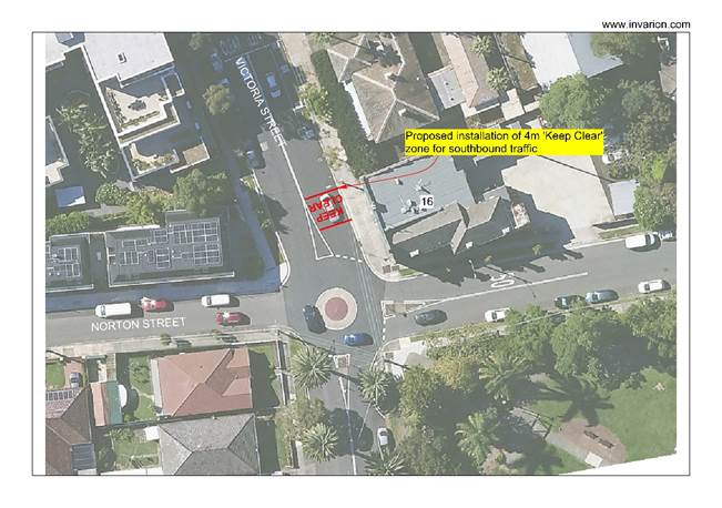
Figure 1 Proposed Concept Plan
Public Consultation:
As the ‘Keep Clear’ zone is designated for the Ashfield Fire and Rescue Station, which is an emergency service (and thus is permissible) and was requested by the Fire Station thus public consultation was not undertaken in this case. According to Transport for NSW, a ‘Keep Clear’ marking is used to keep the road clear outside of areas of high traffic demand such as hospitals, fire stations and police stations.
FINANCIAL IMPLICATIONS
The cost of installing the line marking as recommended will be funded with Council’s signs and line marking budget.
Nil.
|
|
Local Traffic Committee Meeting 21 July 2025 |
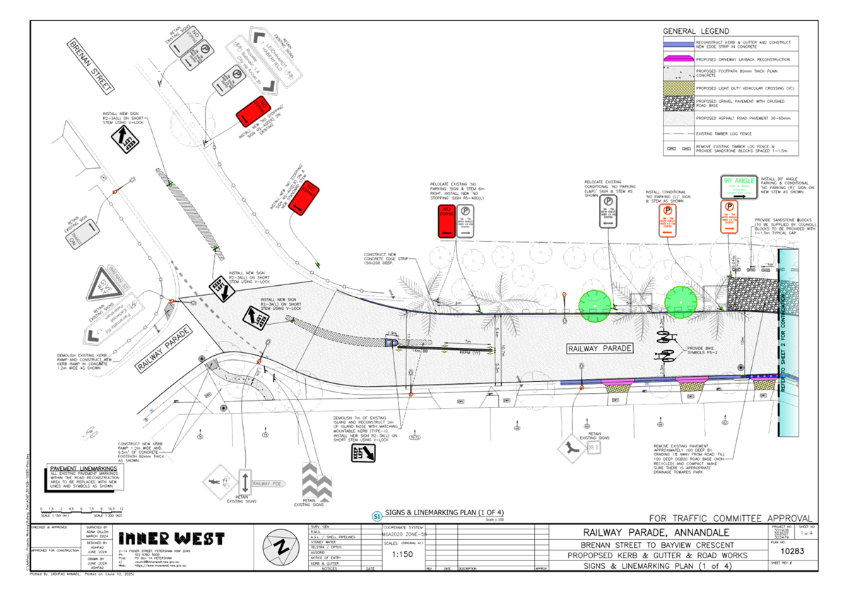
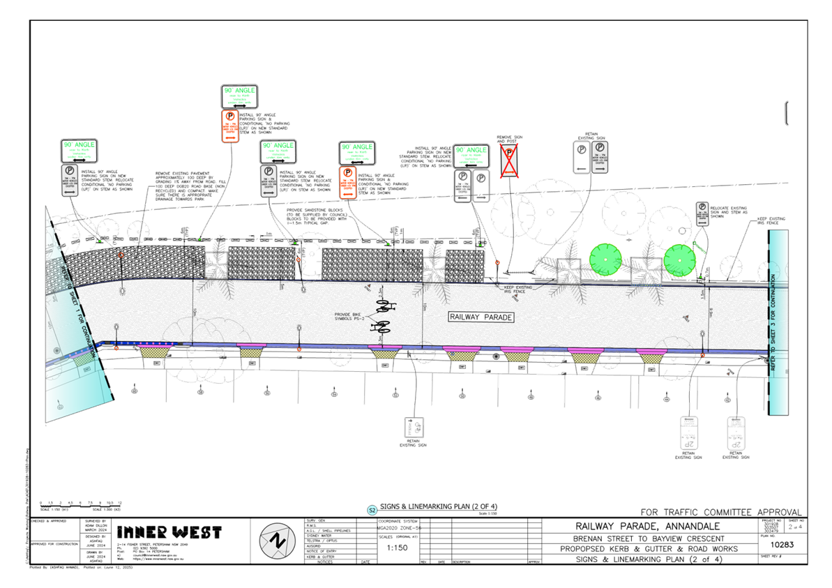
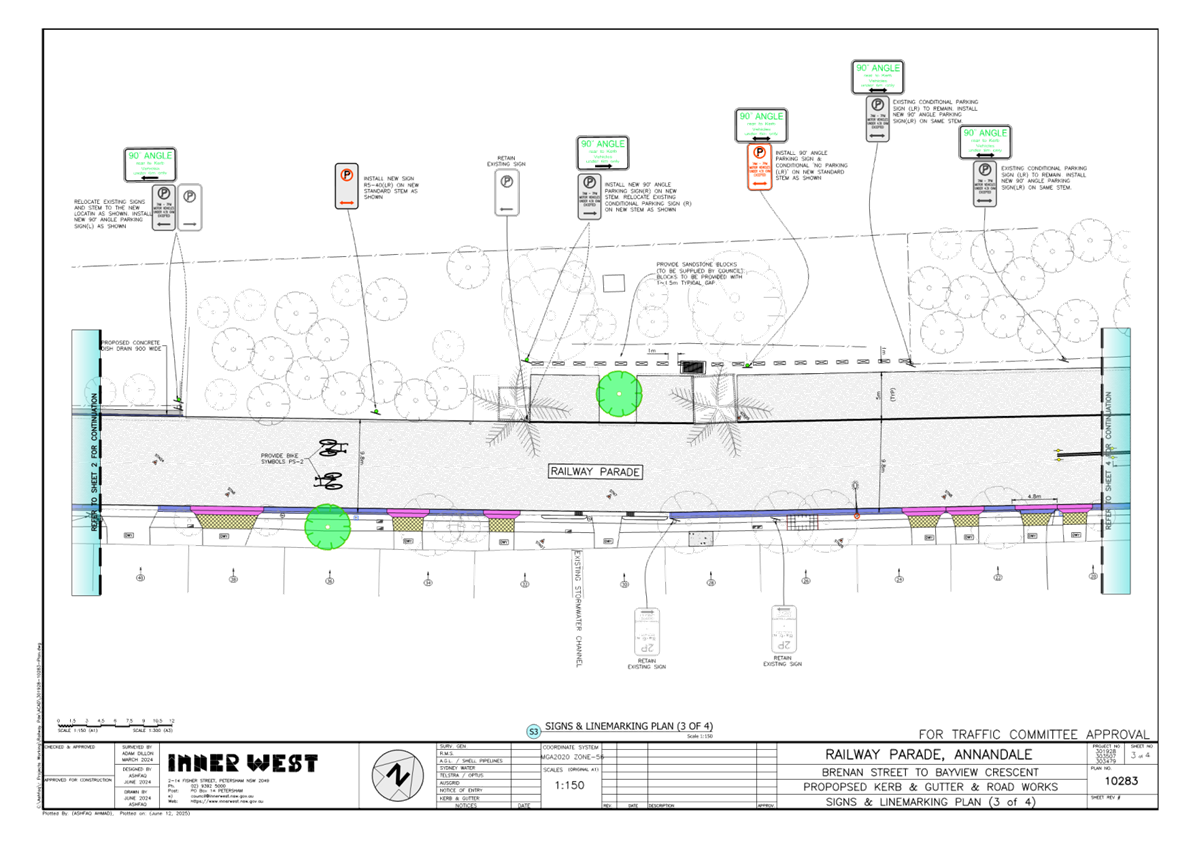
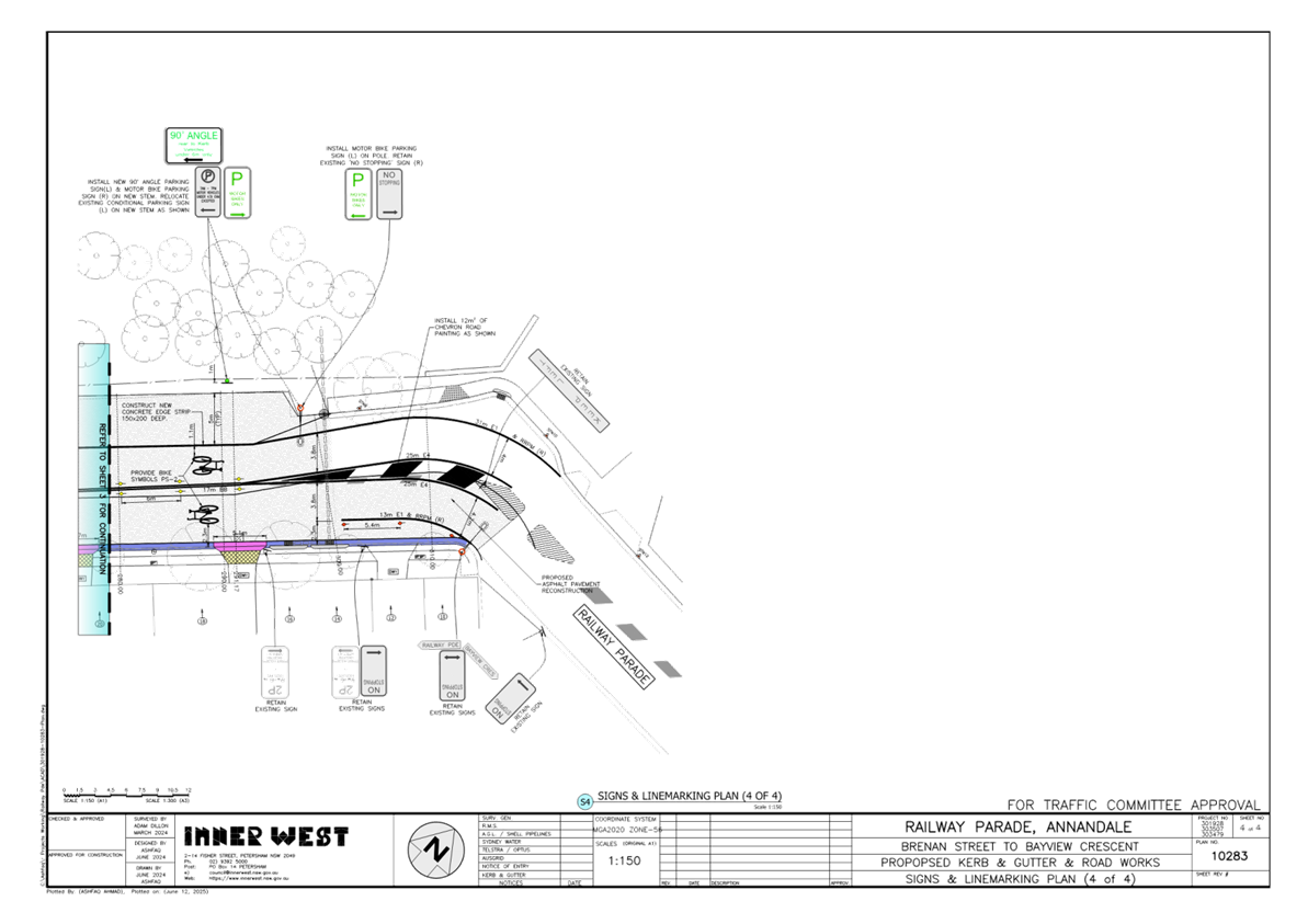
Subject: Railway Parade, Annandale - Proposed Road and Streetscape Upgrade (Baludarri-Balmain Ward/Balmain Electorate/Leichhardt PAC)
Prepared By: Jackie Ng - Graduate Traffic Engineer
Authorised By: George Tsaprounis - Acting Traffic and Transport Planning Manager
|
RECOMMENDATION
That the attached detail design plan (No. 10283) for the proposed road and streetscape upgrade along Railway Parade, Annandale be approved. |
STRATEGIC OBJECTIVE
This report supports the following strategic directions contained within Council’s Community Strategic Plan:
|
2: Liveable, connected neighbourhoods and transport |
EXECUTIVE SUMMARY
Council is planning to undertake works to upgrade the existing road and streetscape along Railway Parade, Annandale between Brenan Street and Bayview Crescent. The project intends to formalise the existing 90-degree angle parking and reduce localised flooding by improving stormwater drainage. Additionally, upgrades and renewals including a new footpath, existing road and footpath works, driveway and layback reconstruction, and landscaping works will improve the overall amenity of the street.
The proposed upgrades will result in no loss of existing on-street parking spaces.
BACKGROUND
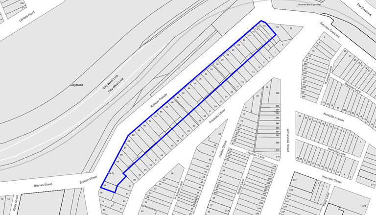
Council has consulted the residents of Railway Parade, Annandale between Brenan Street and Bayview Crescent regarding the proposed road and streetscape upgrades. The proposed detailed design plans have considered resident feedback and have been revised to meet the community’s concerns. A summary of the feedback can be seen in the discussion section.
The detailed design plan shown in Attachment 1 outlines the proposed works along Railway Parade between Brenan Street and Bayview Crescent:
· Kerb and gutter works on the east side of Railway Parade: reconstruction of existing kerb.
· Kerb and gutter works on the west side of Railway Parade: new concrete kerb and guttering to formalize 90-degree angle parking bays.
· Road pavement and angle parking bays:
o Reconstruction and resurfacing of road areas requiring upgrades.
o New asphalt, road pavement and kerbs where new 90-degree angle parking bays will be installed.
· Driveways: reconstruction of some existing driveways and laybacks where required on the east side of Railway Parade to match new kerb and gutter levels.
· Trees: new street trees on the west and east sides of Railway Parade.
· Stormwater drainage: upgrade of existing stormwater drainage in front of No.58, 60 and 62 Railway Parade to help reduce the risk of localised flooding.
· Central median island (south end): demolition of existing central median island near Brenan Street, Lilyfield to shorten its overall length and reconstruction of island nosing. This will create one additional on-street parking space on the west side of the street.
· Landscaping: additional landscaping around the created tree pits and garden beds on the west side of Railway Parade and along the rear of the angle parking bays.
The proposed upgrades will result in no loss of existing on-street parking spaces.
DISCUSSION
A letter outlining the proposal was distributed to the highlighted properties within the map below. A total of eight (8) submissions were received and are summarized in the table below.
|
Resident Comment |
Officer Comment |
|
Mobility Parking Zone: There is currently unrestricted parking at the frontage of my house. I have spoken to my neighbours on either side of my property, and they have raised no objection in having the space rezoned to a mobility parking zone. |
Residents may apply for a mobility parking zone through Council’s online application. |
|
Angled Parking: The consensus is that we prefer to maintain the appearance of a reserve rather than a car park between No.52 and No.60. |
Detailed design plans have been amended to reflect feedback. |
|
Localised Flooding: There is poor drainage outside our house and around the driveway. We are hoping that the improvements to Railway Parade will ensure that water does not collect at the front of our property. Will the additional paving and kerbs along the western side create more flooding or help channel excess water away? |
The proposed stormwater drainage improvements are expected to reduce the localised flooding issue.
|
|
Footpath: The footpath is uneven, narrow and awkwardly angled. Vegetation is also encroaching on the footpath. |
The proposed footpath works is expected to resolve the issue. |
|
Resident Parking Scheme: There is very limited resident parking at this end of Railway Parade due to WestConnex, Metro West and Bays Precinct projects. Could 2P be included in the upgrades? |
In June and July 2024, Council sought resident feedback for a resident parking scheme in Railway Parade and adjacent streets. Due to the low level of support, the proposal was not implemented. Further information can be found at Council’s YourSay Rozelle Bay Resident Parking Scheme website |
FINANCIAL IMPLICATIONS
The works are estimated at $480,000 and are funded under Council’s 2025/26 Local Roads Program.
|
1.⇩ |
Railway Parade, Annandale - Road and Streetscape Upgrade Detailed Design Plan |
|
Local Traffic Committee Meeting 21 July 2025 |
Subject: Anthony Street, Croydon - Proposed installation of statutory 'No Stopping' restrictions at the junction of the unnamed laneway and Anthony Street between Robinson Street and Edwin Street, Croydon (Gulgadya - Leichhardt Ward / Strathfield Electorate / Burwood PAC)
Prepared By: Daniel Li - Student/Graduate Traffic Engineer
Authorised By: George Tsaprounis - Acting Traffic and Transport Planning Manager
|
RECOMMENDATION
1. That Anthony Street next to the unnamed laneway between Robinson Street and Edwin Street, Croydon be signposted with statutory 10m ‘No Stopping’ restrictions on both corners.
2. That the ‘No Stopping’ sign on the northern side of Anthony Street at Burwood Council’s boundary be relocated 3m west to create an additional parking space. |
STRATEGIC OBJECTIVE
This report supports the following strategic directions contained within Council’s Community Strategic Plan:
|
2: Liveable, connected neighbourhoods and transport |
EXECUTIVE SUMMARY
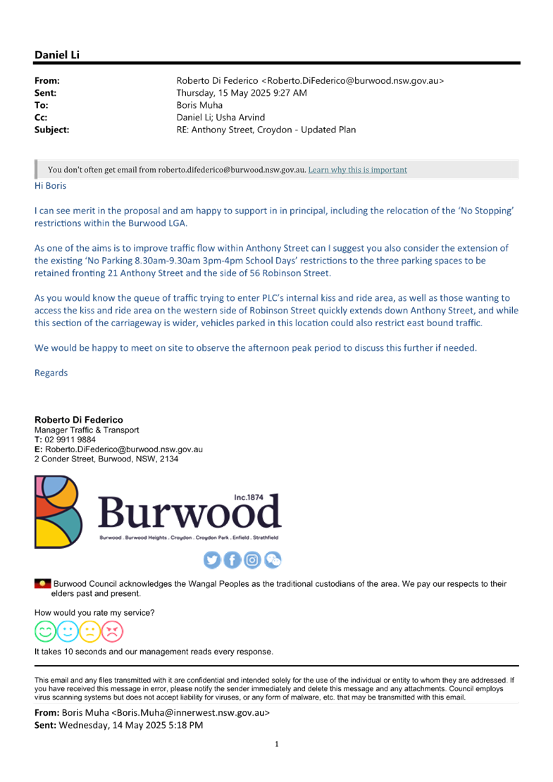
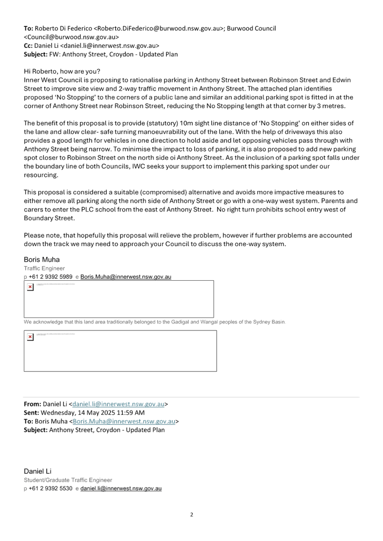
Residents of Edwin Street, Croydon, have raised concerns with vehicles using the pickup / drop off zone associated with PLC School and obstructing residential access to the unnamed laneway. To address the large volumes associated with PLC School during the peak pickup / drop off times and preventing residential access to the laneway, Council proposes to signpost the departure and approaching corners with statutory 10m ‘No Stopping’ signs. Council also proposes to relocate the ‘No Stopping’ sign on Burwood Council’s boundary to create an additional parking space.
BACKGROUND
Residents of Edwin Street, Croydon have raised concerns with vehicles associated with PLC School during peak pick up and drop off periods regarding the obstruction of residential laneway access and restricted sightlines for residents departing the unnamed laneway.
As Anthony Street between Robinson Street and Edwin Street provides a narrow carriageway width and is unable to accommodate two-way traffic movements, vehicles are expected to utilise driveways and parking areas to pass oncoming vehicles. However, due to high traffic volumes along Anthony Street in conjunction with the northern side of Anthony Street being designated as an unofficial pick up and drop off zone associated with PLC School, residents and parents of PLC have reported difficulty in passing oncoming vehicles along with conducting ingress and egress movements.
DISCUSSION
Existing Conditions
Anthony Street is a residential street running east-west between Robinson Street and Croydon Road with varying road widths as shown in Table 1. Despite Anthony Street between Robinson Street and Edwin Street being incapable of accommodating concurrent two-way traffic movements, Anthony Street currently operates as a two-way road where drivers are expected to utilise driveways and parking areas to pass oncoming vehicles.
|
Street Name |
Anthony Street |
|
Carriageway width (m) kerb to kerb |
· Between Robinson Street and Unnamed Laneway – 8.5m · Between Unnamed Laneway and Edwin Street – 6.3m · Between Edwin Street and Croydon Road – 9.0m |
|
Carriageway type |
Two-way with vehicles utilising driveways and parking areas to pass oncoming vehicles |
|
Classification |
Local |
|
Speed Limit (km/h) |
50 outside of peak school hours. 40 during peak school hours. |
|
Parking Arrangements |
· ‘2P 8.30am – 6.00pm Mon-Fri, 8.30am – 12.30pm Sat, Permit Holders Excepted’ on the southern side of Schwebel Street between Leofrene Avenue and Ivanhoe Street. · Unrestricted parking on the northern side. · Unrestricted parking east of Ivanhoe Street to Carrington Road |
Table 1. Road Network Detail
To alleviate the issues of traffic congestion as well as the lack of sightlines from the unnamed laneway into Anthony Street, it is proposed that the Anthony Street be signposted with statutory 10m ‘No Stopping’ restrictions adjacent to the unnamed laneway. This proposal would improve sight view for vehicles coming out of the unnamed laneway and would provide a 25m sections to provide two way passing opportunities for vehicles approaching in the opposing directions, thereby alleviating some of the traffic congestion issues along Anthony Street.
It should also be noted that the relocation of the ‘No Stopping’ sign on the boundary of Burwood Council was not part of the initial proposal. However, following community consultation, a resident with mobility issues had expressed concerns about the loss of a parking space for caretakers within the statutory ‘No Stopping’ zones. As a result, Council officers of Inner West Council have engaged Burwood Council to consider the relocation of a ‘No Stopping’ sign situated on Burwood Council’s boundary by 3m to restore a single parking space for residents of Anthony Street. As seen in Attachment 1, Burwood Council have provided their support to relocate the ‘No Stopping’ sign at the expense of Inner West Council.
To further address traffic congestion issues along Robinson Street and Anthony Street, Burwood Council have also recommended the conversion of the three unrestricted spaces into ‘No Parking 8.30am-9.30am, 3pm-4pm School Days’. The implementation of the above recommendation by Burwood Council will require further consultation in which could be considered by Council officers at a later stage if it is deemed that further traffic treatments are required to address the observed traffic congestion issues in Anthony Street.
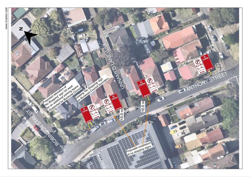
Figure 1 Proposed Concept Plan
CONSULTATION
Consultation letters were sent out to surrounding residents which require laneway access. A total of sixty-three (63) letters were mailed out including a letter to the Principal of PLC School. Seven (7) responses were received, with three responses opposing the ‘No Stopping’ proposal. A summary of the received responses that were not in support of the proposal can be seen below.
|
Resident’s comments |
Officer’s response |
|
The proposal does not address that Anthony Street is not wide enough to accommodate two-way traffic movements. Additionally, the existing ‘No Parking’ times during the pickup and drop off periods should be extended to reduce the amount of congestion in Anthony Street. |
Council has considered multiple proposals to address traffic congestion. Ultimately, the removal of additional parking spaces outside of regulatory restrictions is not supported within Council as there is an increase in on-street parking demands. The intention of maintaining two-way traffic movements within Anthony Street is to control vehicle speeds in high pedestrian areas such as Schools. To address congestion, this proposal aims to create additional spaces in which cars can give-way to opposing traffic via formal passing bays. |
|
Signs would be easily vandalized and cost money to install and maintain. |
It is understandable that Council signs are susceptible to vandalism and damages, however, Council typically installs signs in areas that are related to road safety purposes. These signs are also installed to in situations where there is a history of repeated offences and to provide general guidance to road users. |
|
The removal of on-street parking spaces would affect properties fronting Anthony Street who require aged care and mobility services. PLC School and Burwood Council should be engaged with to address congestion issues and identify areas where additional parking can be created. |
Council has liaised with Burwood Council who have agreed to relocate a ‘No Stopping’ on the northern side of Anthony Street to create an additional parking space.
It should also be noted that PLC School have submitted an application to create more off-street parking spaces on the school campus to reduce on-street parking demands by parents during the pickup and drop of periods. |
FINANCIAL IMPLICATIONS
The installation and relocation of ‘No Stopping’ signs will be funded with Council’s signs and line marking budget.
|
1.⇩ |
Burwood Council Approval - Relocation of 'No Stopping' Sign |
|
Local Traffic Committee Meeting 21 July 2025 |
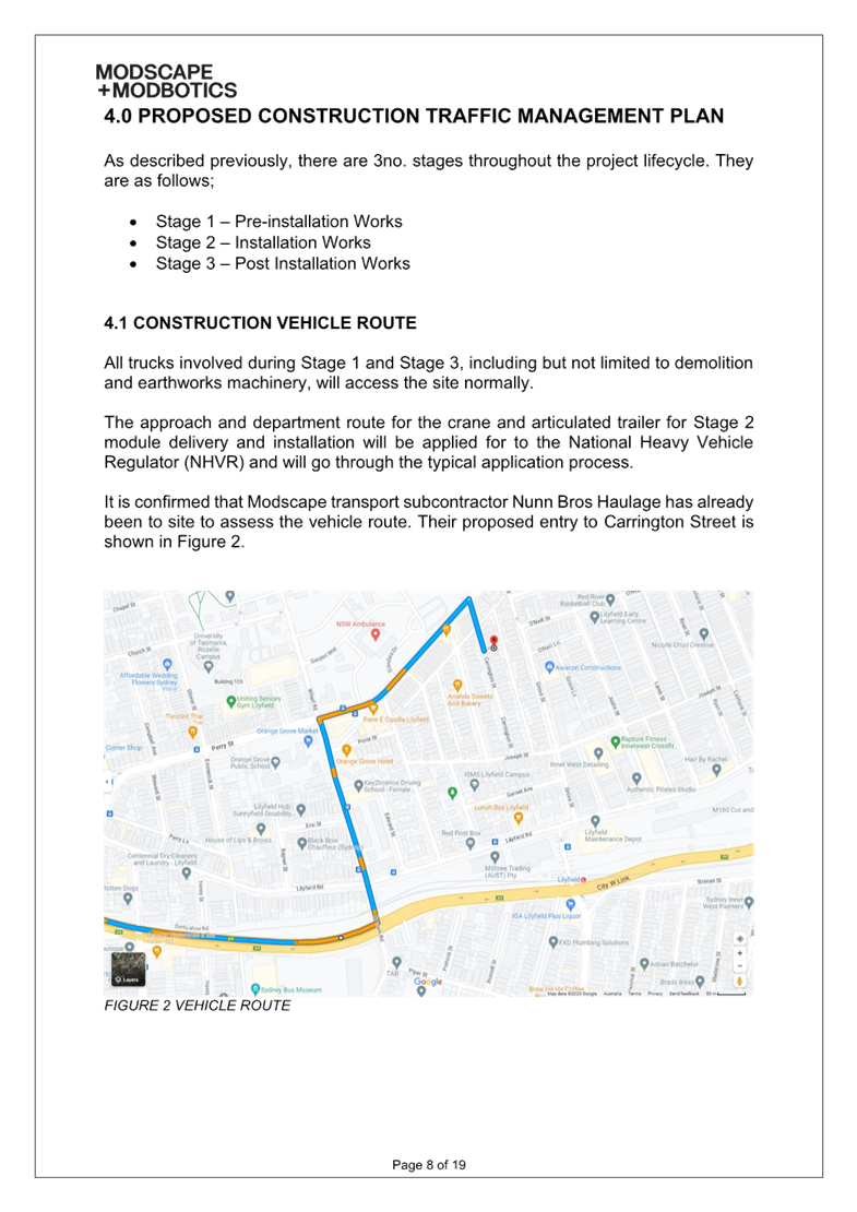
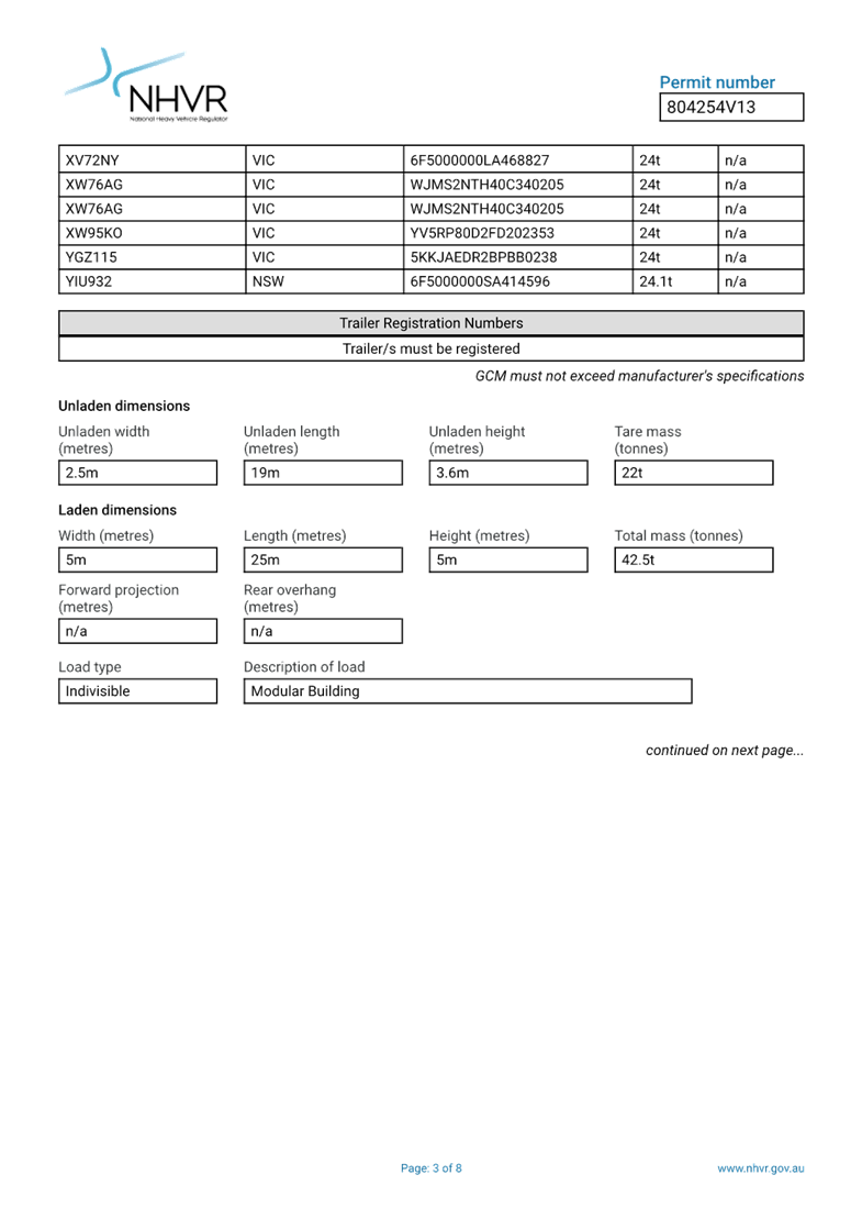
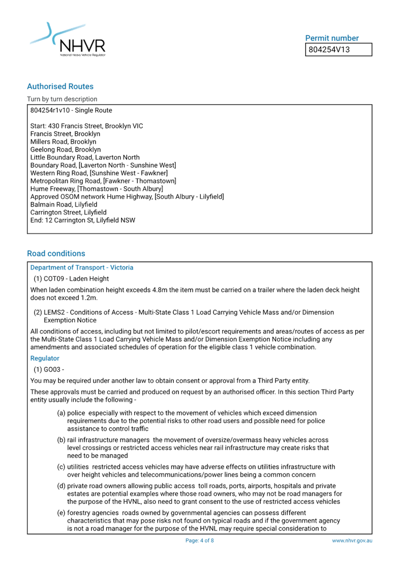
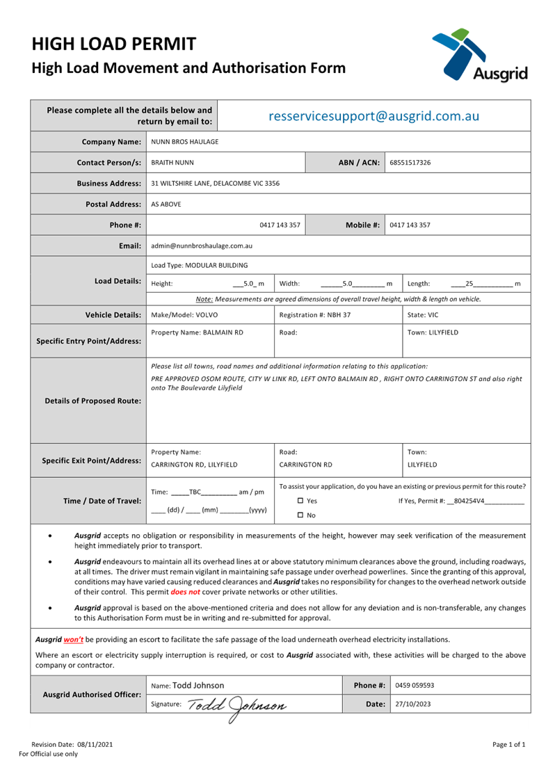
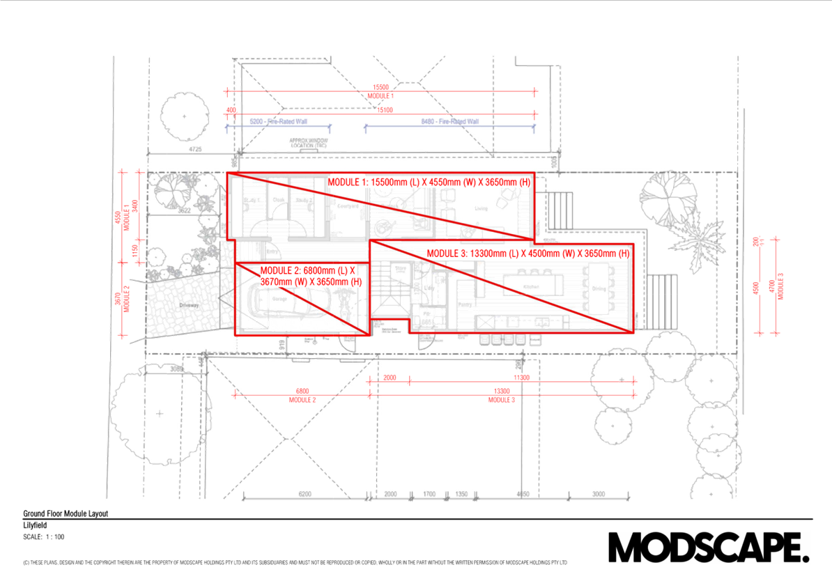
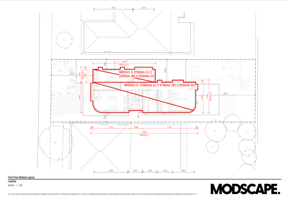
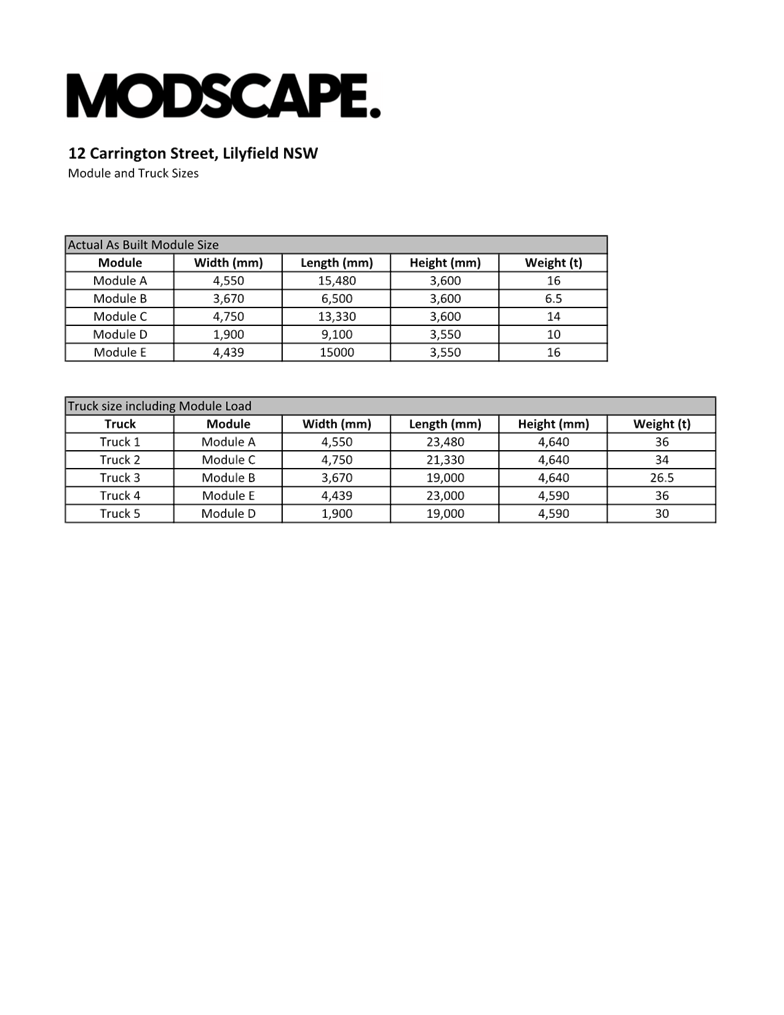
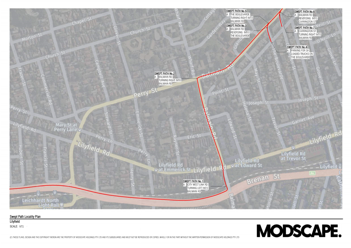
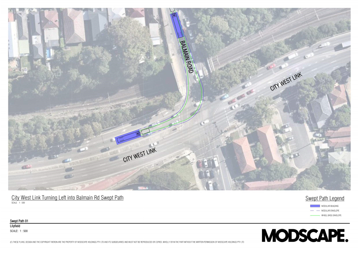
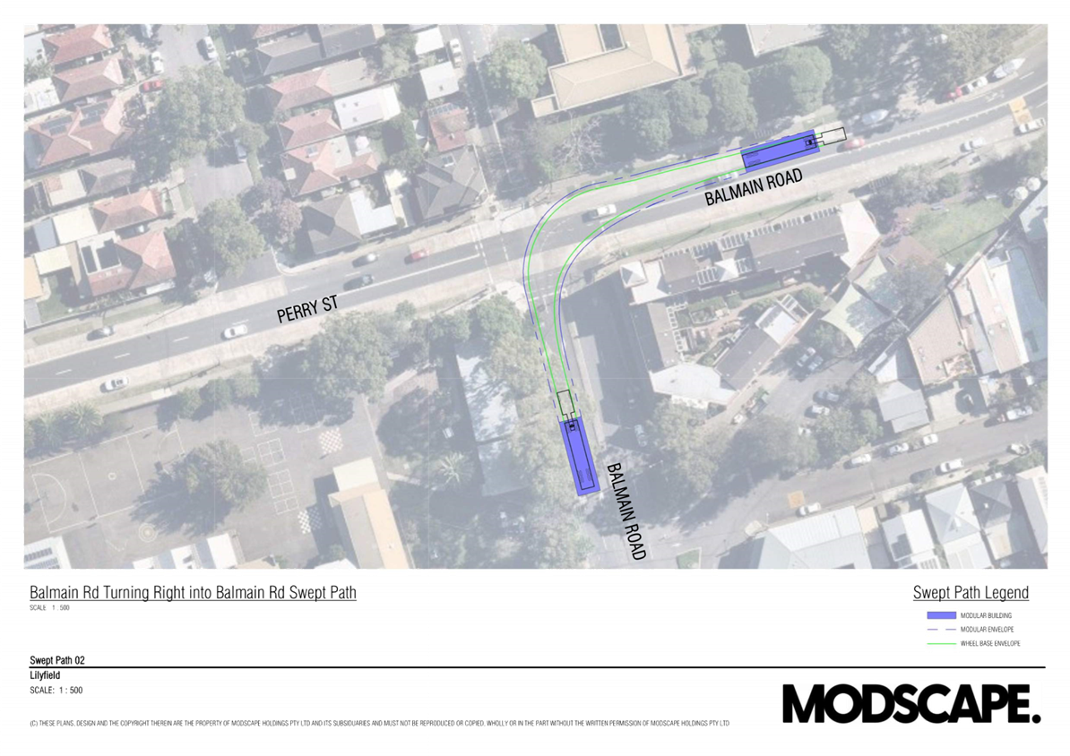
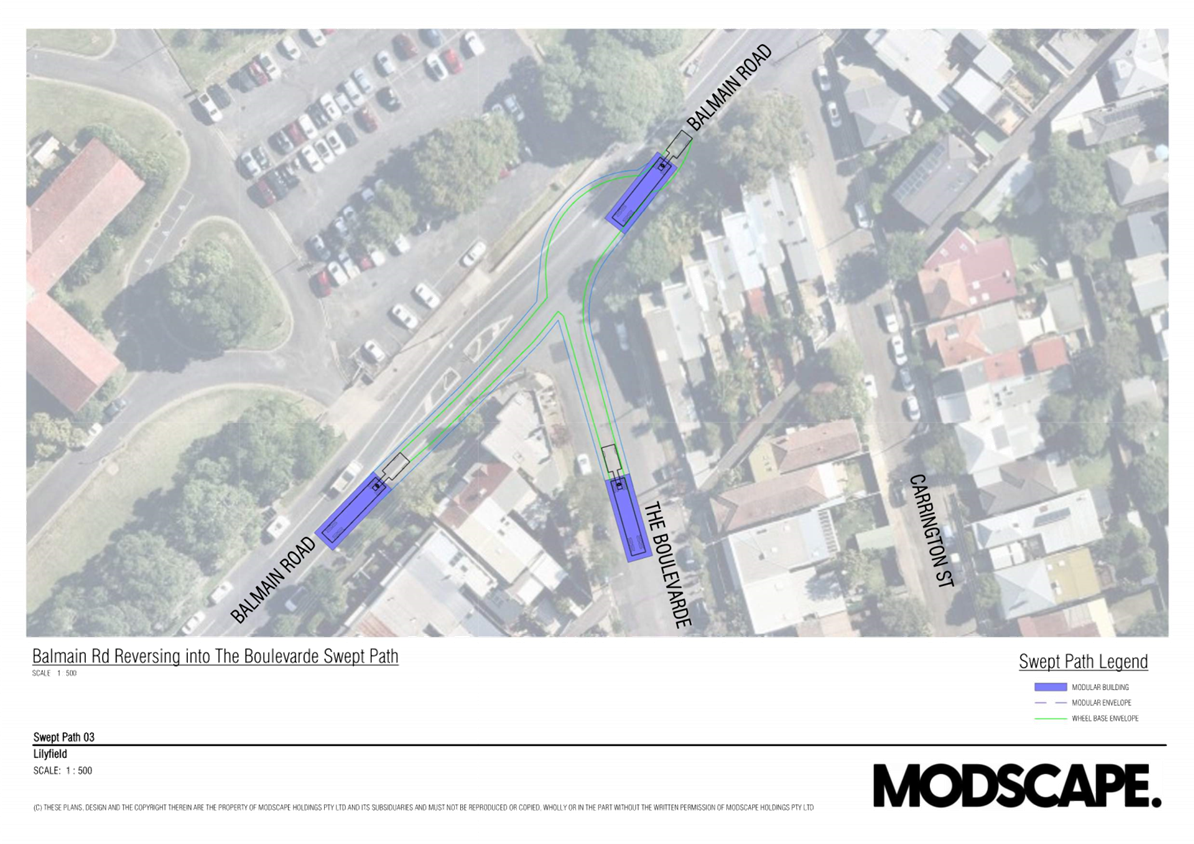
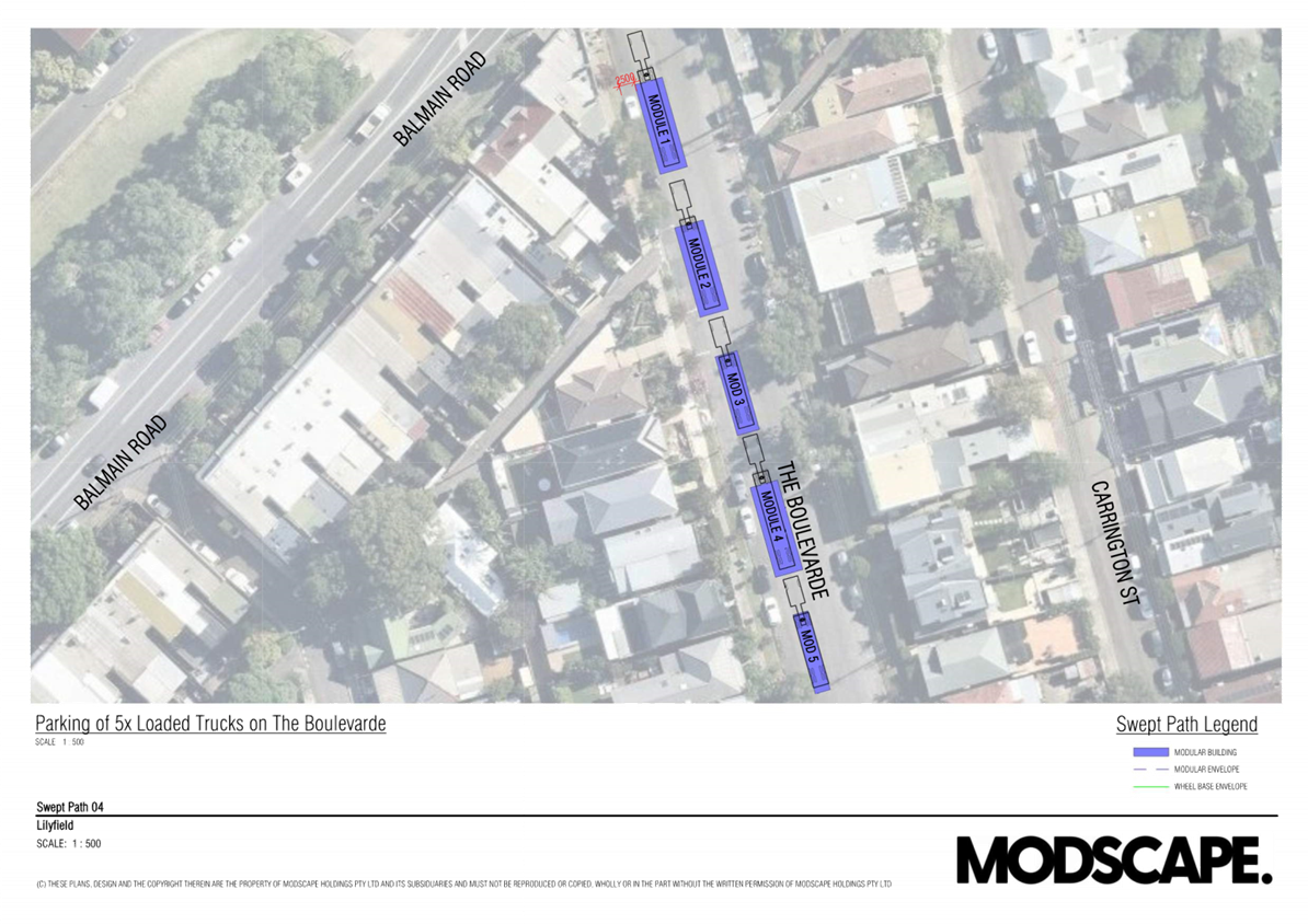
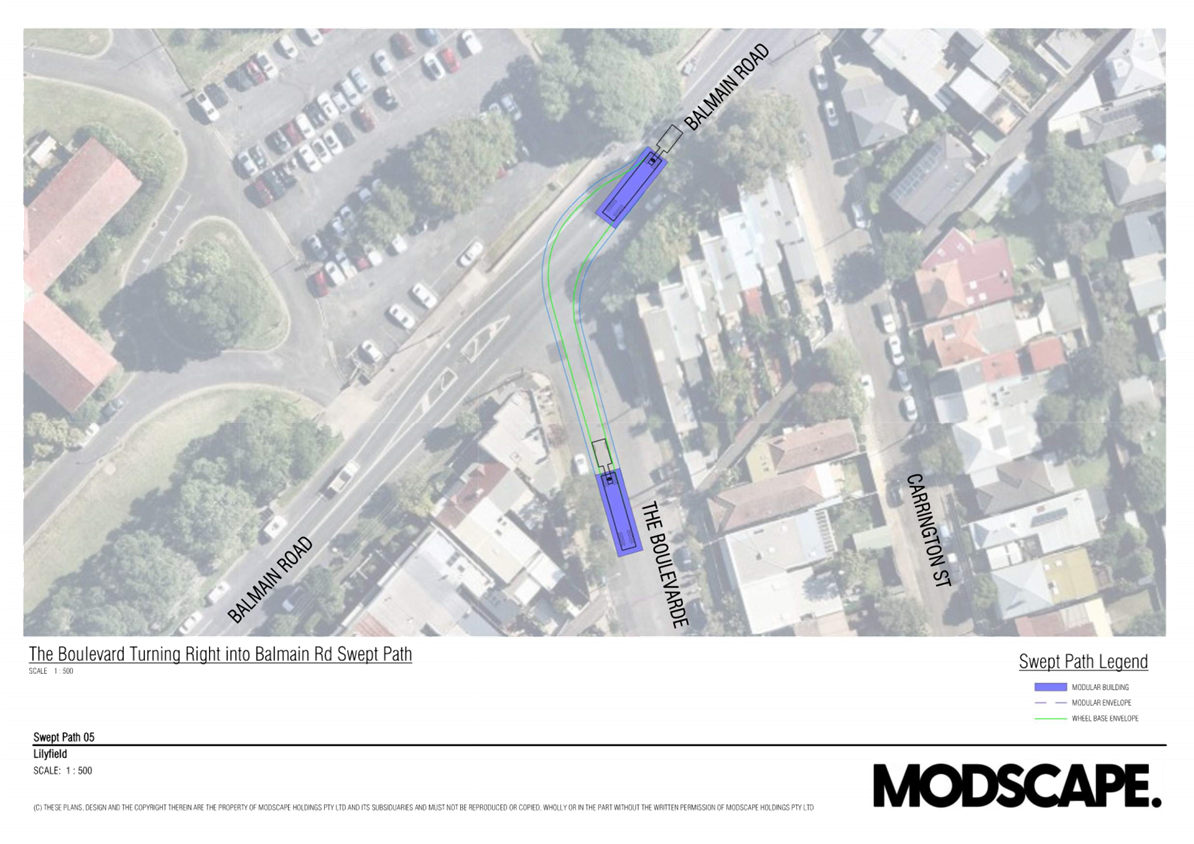
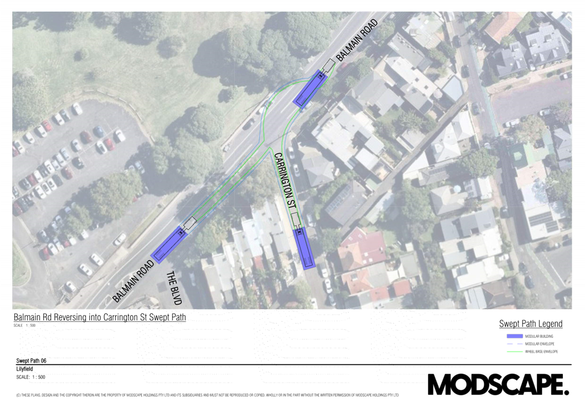
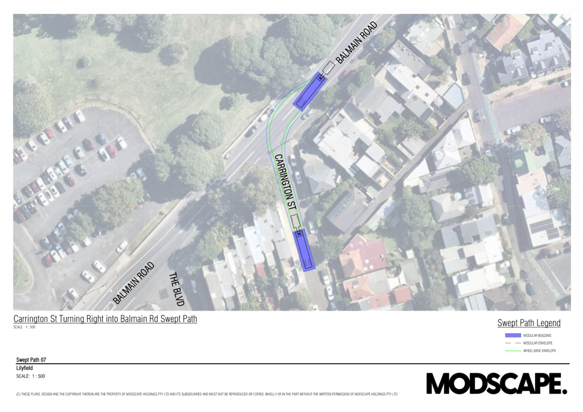
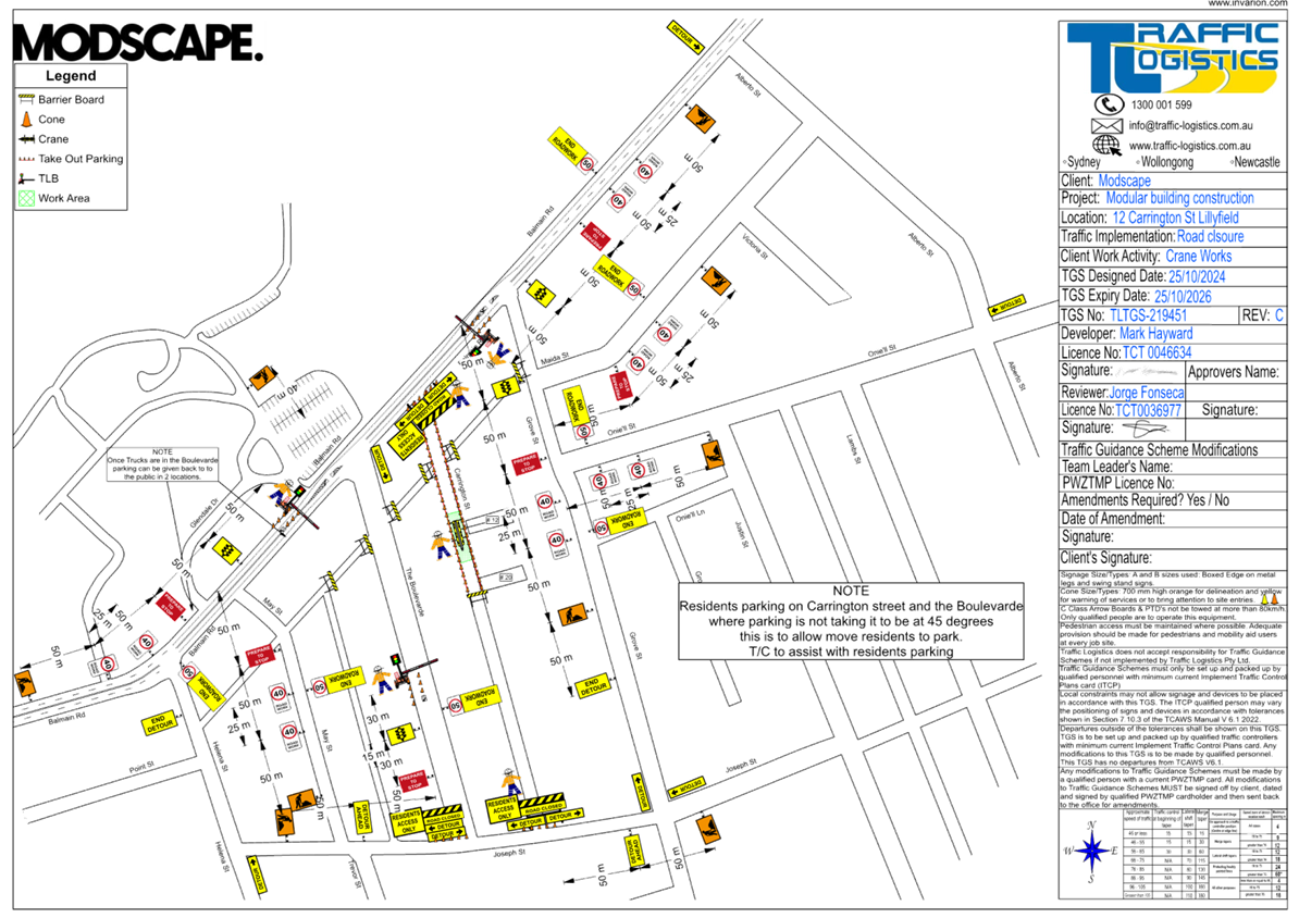
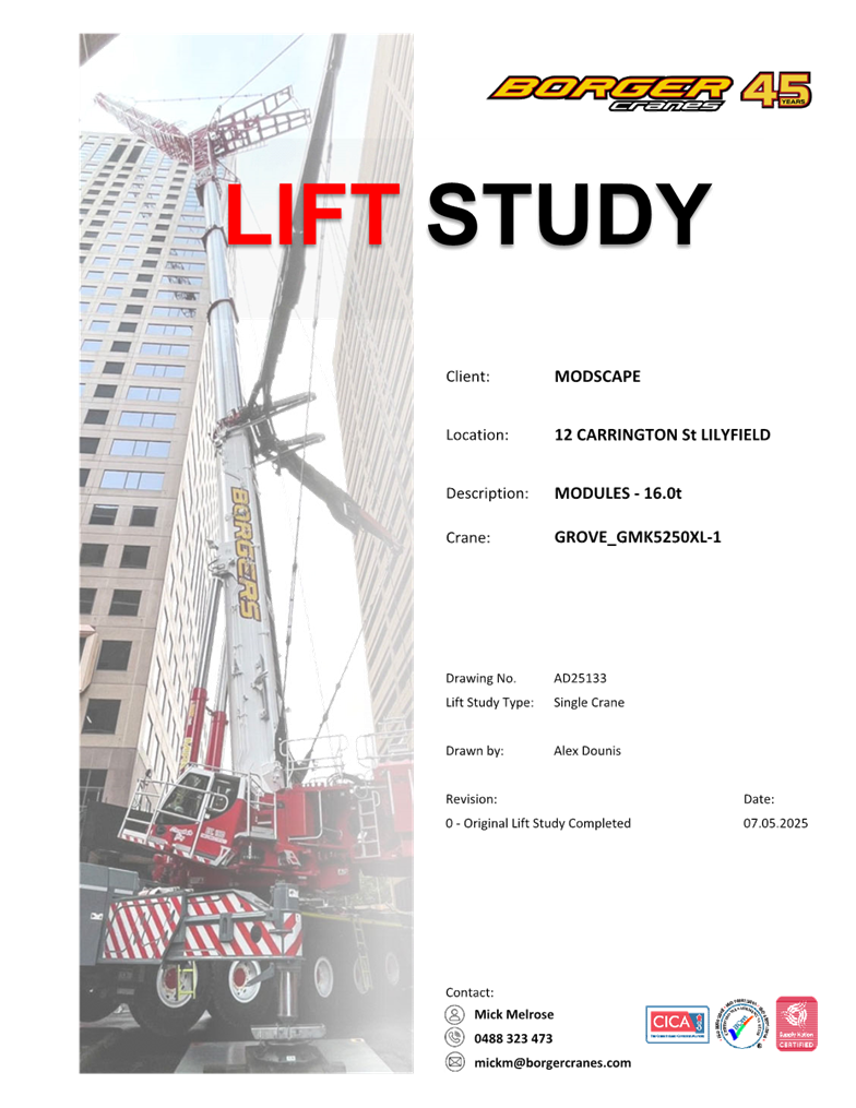
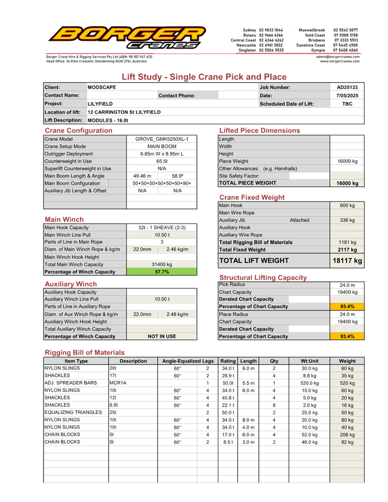
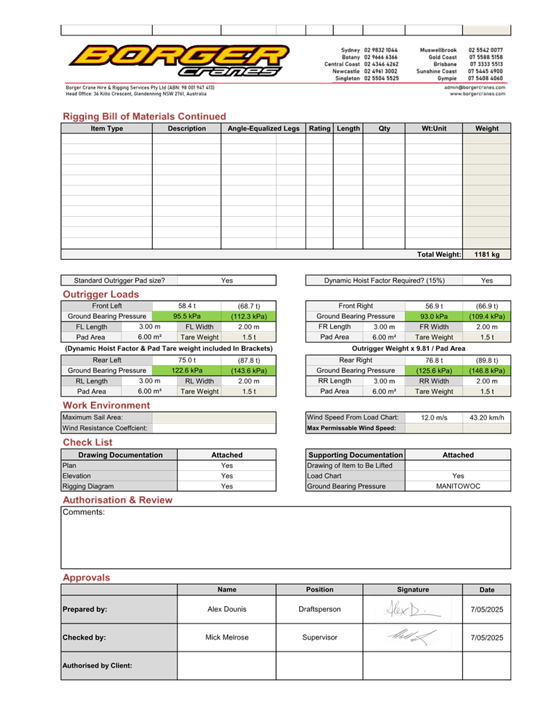
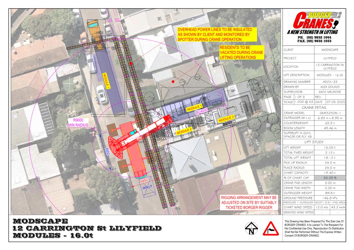
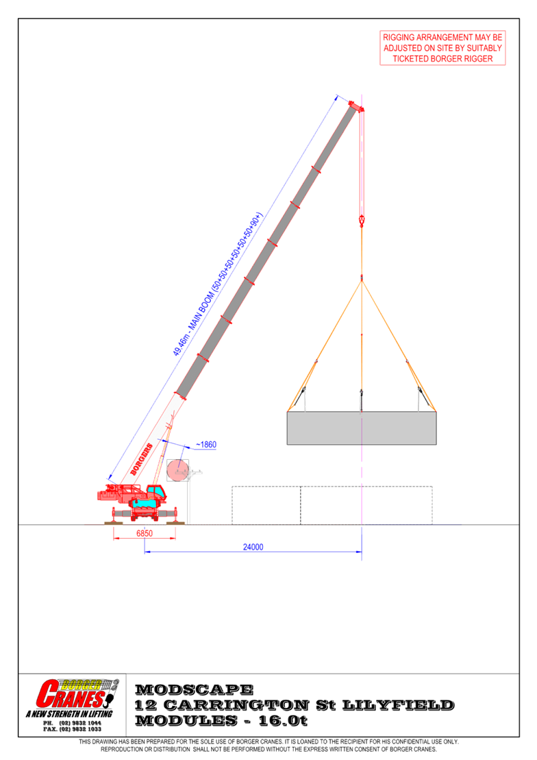
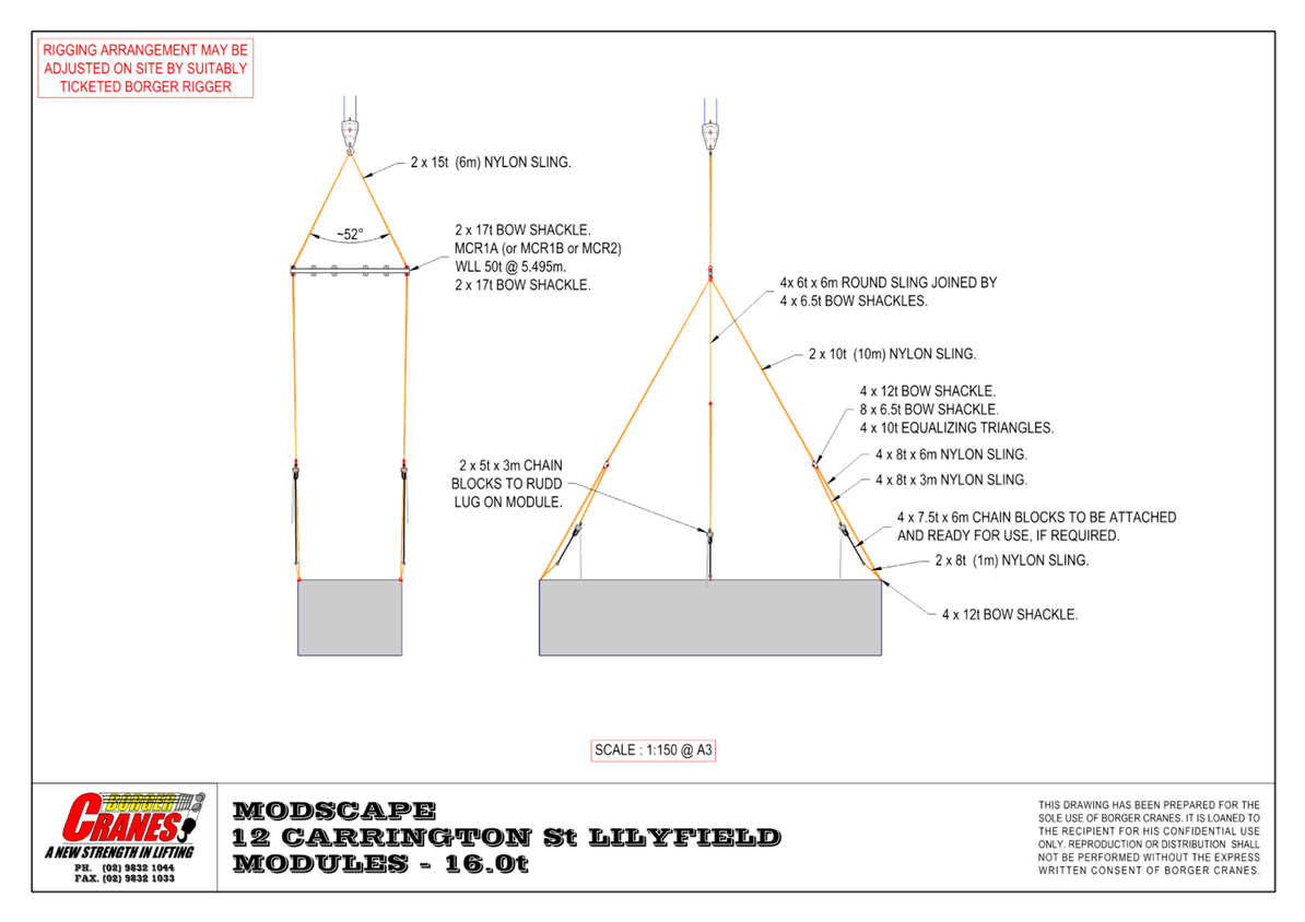
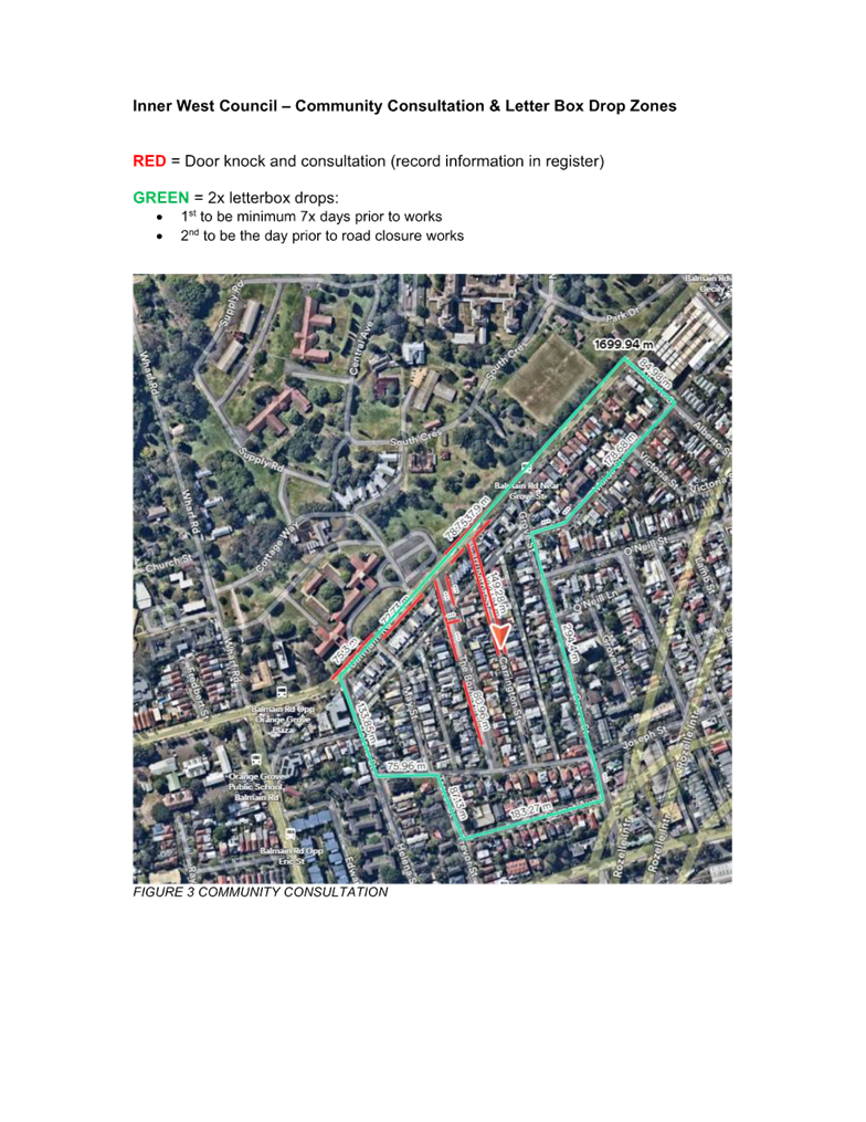
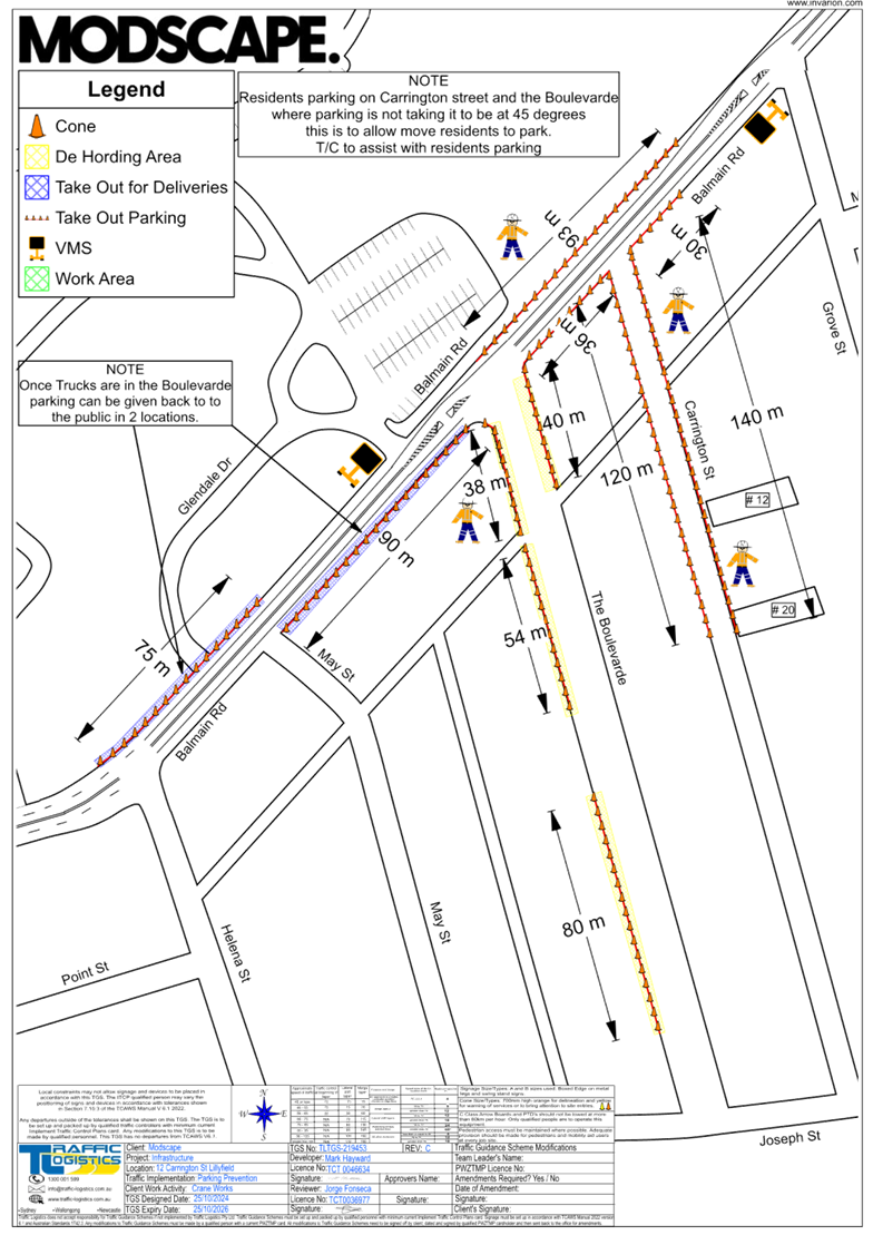
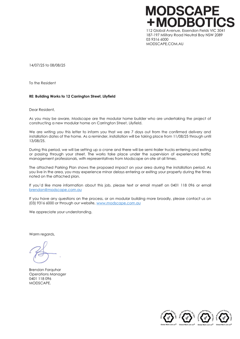
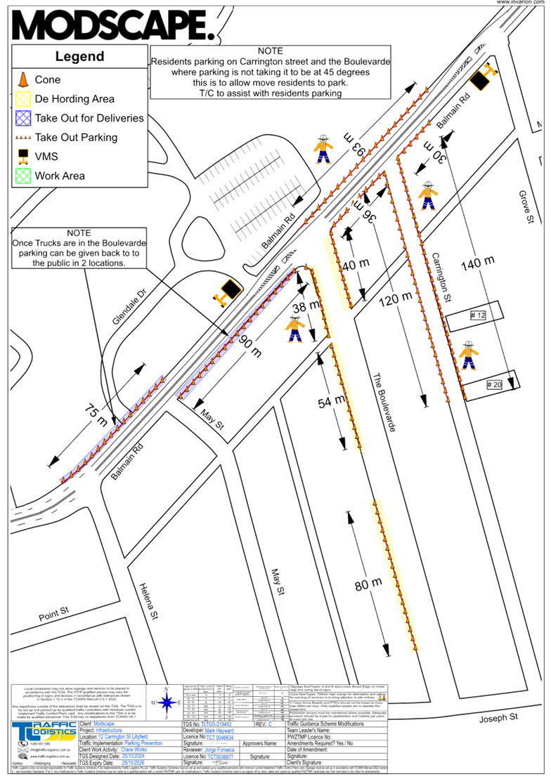
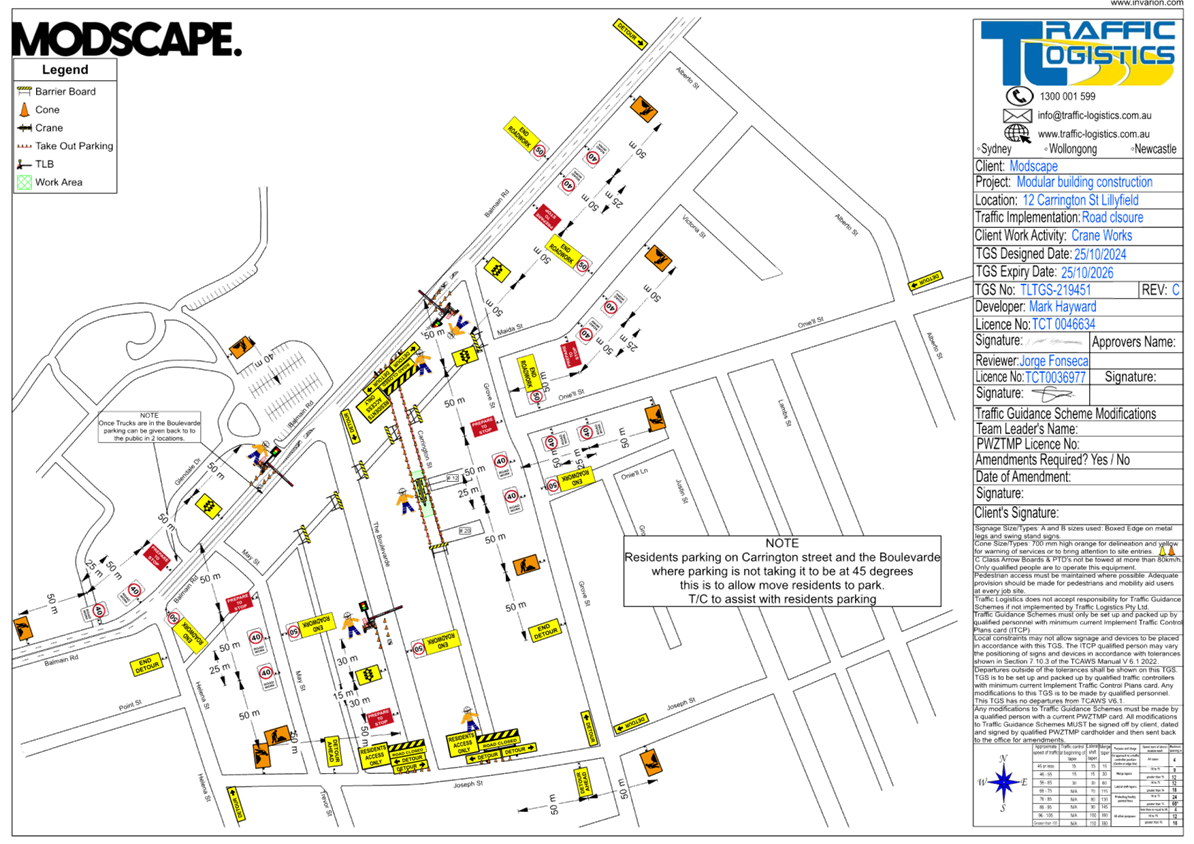
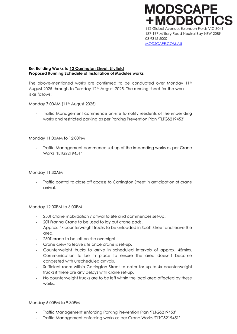
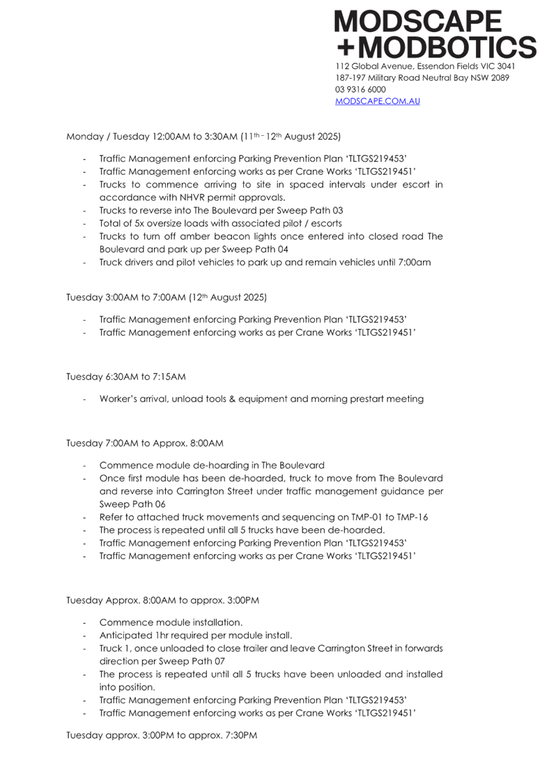
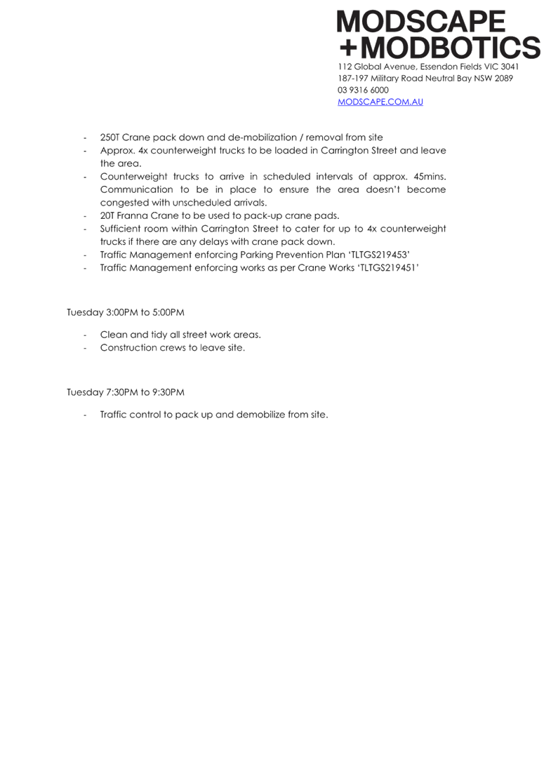
Subject: Carrington Street, Lilyfield - Temporary full road closure and associated construction Traffic Management Plan (Baludarri-Balmain Ward/Balmain Electorate/Leichhardt PAC)
Prepared By: Amir Falamarzi - Traffic Engineer
Authorised By: George Tsaprounis - Acting Traffic and Transport Planning Manager
|
RECOMMENDATION
That the temporary full road closure of Carrington Street (between Joseph Street and Balmain Road), The Boulevarde (between Joseph Street and Balmain Road) and partial temporary on-street parking removal along Balmain Road (between Helena Street and Grove Street), be approved for the purpose of the installation of a modular building at No.12 Carrington Street, Lilyfield for a two-day period in the week commencing 11 August 2025, with a four week contingency period, subject to the following conditions and all standard Council conditions for temporary full road closures:
a) A Road Occupancy License application be obtained from the Transport Management Centre for road closure on Balmain Road.
b) Temporary parking arrangements must be provided for the existing disabled parking bays on Balmain Road, Carrington Street and The Boulevarde which will be affected during the work and should be located as close as possible to their original locations.
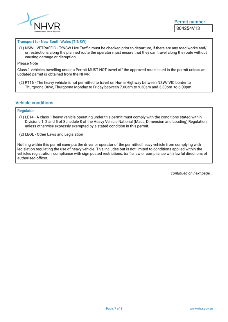
c) NHVR permit to be obtained prior to the work.
d) Notice of the proposed event be forwarded to the NSW Police Local Area Commander, Transit Systems, the NSW Fire Brigades and the NSW Ambulance Services.
e) All residents and businesses in and around the affected area are to be notified of the temporary road closure in writing by the applicant in advance (at least 7 days prior to the event) with the applicant making reasonable provision for stakeholders.
f) On-street parking to be maintained for residents along the east side of The Boulevarde (between Joseph Street and the laneway south of Balmain Road).
g) Vehicular access to the laneway south of Balmain Road to be maintained within the road closure zone.
h) Authorised pilot vehicles to accompany and manage the trucks at major intersections including City West Link Road at Balmain Road, Balmain Road at Perry Street, Balmain Road at The Boulevarde and Balmain Road at Carrington Road
|
STRATEGIC OBJECTIVE
This report supports the following strategic directions contained within Council’s Community Strategic Plan:
|
2: Liveable, connected neighbourhoods and transport |
EXECUTIVE SUMMARY
Inner West City Council has received a Temporary Road Closure and Traffic Management Plan (TMP) application from Modscape (Attachment 1) seeking an approval for delivering a modular building to No.12 Carrington Street, Lilyfield in the week commencing 11 August 2025. As part of this road closure, there will be full road closure on Carrington Street (between Joseph Street and Balmain Road), The Boulevarde (between Joseph Street and Balmain Road) and partial temporary on-street parking removal along Balmain Road (between Helena Street and Grove Street).
This TMP and road closure application was previously considered and approved by the Local Traffic Committee on 18 November 2024.
BACKGROUND
Modscape on behalf of its client are in the final stages of planning for a proposed new dwelling at 12 Carrington Street, Lilyfield NSW. The proposed structure is to be a prefabricated building constructed off-site. The proposed building methodology is a full welded steel structure which comprises 6 modules in total. Each module will be independent when fabricated off-site and transported individually, but upon installation on-site, the dwelling will be welded and bolted together to form one complete diaphragm.
The applicant has indicated that they have not implemented the road closures and TMP previously approved for 24 March 2025 and have amended the dates for the week commencing 11 August 2025.
DISCUSSION
Site and the proposed development
The Site is Lot 12 of DP1063821 which occupies a rectangular shaped block of approximate 271.9m² with a street frontage to 12 Carrington Street, Lilyfield NSW. It is proposed to demolish the existing house and construct a new single dwelling on the property. The site is adjoined by residential dwellings, while there are several parks, school, playgrounds, early centers and other types of accommodation in the surrounding area.
Construction vehicle route
All trucks involving the delivery of the work will follow the proposed route to Carrington Street including City West Link, Balmain Road, The Boulevarde (temporary truck standby zone) and Carrington Street. As part of this route:
· Authorised pilot vehicles will accompany and manage the trucks at major intersections including City West Link Road at Balmain Road, Balmain Road at Perry Street, Balmain Road at The Boulevarde and Balmain Road at Carrington Road.
· It is proposed that the laydown area for the articulated trucks is along The Boulevarde which has been selected to minimize disruption to traffic on Balmain Road and its width to enable module de-hoarding.
· Modscape has confirmed that a swept path assessment has been undertaken and was deemed achievable.
Traffic and Parking management plans
The proposed traffic and parking management plans include:
1. Work area and where the crane will be located.
2. Full road closure on Balmain Road between May Street and Grove Street.
3. Full road closure on Carrington Street between Balmain Road and Joseph Street.
4. Full road closure on The Boulevarde between Balmain Road and Joseph Street.
5. Detour plan
6. Parking removal along north side of Balmain Road between Helena Street and May Street.
7. Parking removal along south side of Balmain Road between May Street and The Boulevarde.
8. Partial parking removal on both sides of Balmain Road between The Boulevarde and Grove Street.
9. Partial parking removal along west side of The Boulevarde between Joseph Street and Balmain Road.
10. Parking removal along east side of The Boulevarde between Balmain Road and the laneway south of Balmain Road.
11. Parking removal on both sides of Carrington Street between Balmain Road and No.22 Carrington Street.
Pedestrian management
Pedestrian access will be provided with the assistance of licensed traffic controllers.
Impact on public transport and other modes of transport
Consultation with residents within the works zones will be undertaken to ensure plans, times and level of impact is clearly articulated to affected residents.
Initially will undertake a door knock for the more severely affected residents and neighbours to allow questions and introduce a point of contact for the works. This is normally undertaken once site has been established.
Modscape typically will undertake a minimum of 2x letterbox drops with in a drop zone determined by council. These being 7x day prior to road closures and another the day prior to road closure.
Work schedule
The above-mentioned works are confirmed to be conducted over Monday 11 August 2025 through to Tuesday 12 August 2025. The running sheet for the work is as follows:
Monday 7:00AM
· Traffic Management commence on-site to notify residents of the impending works and restricted parking as per Parking Prevention Plan ‘TLTGS219453’
Monday 11:00AM to 12:00PM
· Traffic Management commence set-up of the impending works as per Crane Works ‘TLTGS219451’
Monday 11:30AM
· Traffic control to close off access to Carrington Street in anticipation of crane arrival
Monday 12:00PM to 6:00PM
· 250T Crane mobilization / arrival to site and commences set-up
· 20T Franna Crane to be used to lay out crane pads
· Approx. 4x counterweight trucks to be unloaded in Carrington Street and leave the
· area.
· 250T crane to be left on site overnight
· Crane crew to leave site once crane is set-up
· Counterweight trucks to arrive in scheduled intervals of approx. 45mins
· Communication to be in place to ensure the area doesn’t become congested with unscheduled arrivals
· Sufficient room within Carrington Street to cater for up to 4x counterweight trucks if there are any delays with crane set-up
· No counterweight trucks are to be left within the local area affected by these works
Monday 6:00PM to 9:30PM
· Traffic Management enforcing Parking Prevention Plan ‘TLTGS219453’
· Traffic Management enforcing works as per Crane Works ‘TLTGS219451’
Monday / Tuesday 12:00AM to 3:30AM
· Traffic Management enforcing Parking Prevention Plan ‘TLTGS219453’
· Traffic Management enforcing works as per Crane Works ‘TLTGS219451’
· Trucks to commence arriving to site in spaced intervals under escort in accordance with NHVR permit approvals
· Trucks to reverse into The Boulevarde per Sweep Path 03
· Total of 5x oversize loads with associated pilot / escorts
· Trucks to turn off amber beacon lights once entered into closed road The Boulevarde and park up per Sweep Path 04
· Truck drivers and pilot vehicles to park up and remain vehicles until 7:00am
Tuesday 3:00AM to 7:00AM
· Traffic Management enforcing Parking Prevention Plan ‘TLTGS219453’
· Traffic Management enforcing works as per Crane Works ‘TLTGS219451’
Tuesday 6:30AM to 7:15AM
· Worker’s arrival, unload tools & equipment and morning prestart meeting
Tuesday 7:00AM to Approx. 8:00AM
· Commence module de-hoarding in The Boulevarde
· Once first module has been de-hoarded, truck to move from The Boulevarde and reverse into Carrington Street under traffic management guidance per Sweep Path 06
· Refer to attached truck movements and sequencing on TMP-01 to TMP-16
· The process is repeated until all 5 trucks have been de-hoarded.
· Traffic Management enforcing Parking Prevention Plan ‘TLTGS219453’
· Traffic Management enforcing works as per Crane Works ‘TLTGS219451’
Tuesday Approx. 8:00AM to approx. 3:00PM
· Commence module installation
· Anticipated 1hr required per module install
· Truck 1, once unloaded to close trailer and leave Carrington Street in forwards direction per Sweep Path 07
· The process is repeated until all 5 trucks have been unloaded and installed into position
· Traffic Management enforcing Parking Prevention Plan ‘TLTGS219453’
· Traffic Management enforcing works as per Crane Works ‘TLTGS219451’
Tuesday approx. 3:00PM to approx. 7:30PM
· 250T Crane pack down and de-mobilization / removal from site
· Approx. 4x counterweight trucks to be loaded in Carrington Street and leave
the area
· Counterweight trucks to arrive in scheduled intervals of approx. 45mins
· Communication to be in place to ensure the area doesn’t become congested with unscheduled arrivals
· 20T Franna Crane to be used to pack-up crane pads
· Sufficient room within Carrington Street to cater for up to 4x counterweight trucks if there are any delays with crane pack down
· Traffic Management enforcing Parking Prevention Plan ‘TLTGS219453’
· Traffic Management enforcing works as per Crane Works ‘TLTGS219451’
Tuesday 3:00PM to 5:00PM
· Clean and tidy all street work areas
· Construction crews to leave site
Tuesday 7:30PM to 9:30PM
· Traffic control to pack up and demobilise from site
COMMUNITY CONSULTATION
Consultation with residents within the works zones will be undertaken to ensure plans, times and level of impact is clearly articulated to affected residents.
Initially will undertake a door knock for the more severely affected residents and neighbors to allow questions and introduce a point of contact for the works. This is normally undertaken once site has been established.
Modscape typically will undertake a minimum of 2x letterbox drops with in a drop zone determined by Council. These being seven days prior to road closures and another the day prior to road closure.
It is requested that a complaints/feedback register be created for post event review.
Notice of the temporary full road closure has been advertised in accordance with the Roads Act.
FINANCIAL IMPLICATIONS
There are no financial implications associated with the implementation of the proposed recommendations outlined in the report.
|
1.⇩ |
Construction Vehicle and Pedestrian Plan of Management |
|
Local Traffic Committee Meeting 21 July 2025 |
Subject: College Street, Balmain - Proposed One Way Restriction (Baludarri-Balmain Ward/Balmain Electorate/Leichhardt PAC)
Prepared By: Charbel El Kazzi - Traffic Engineer
Authorised By: George Tsaprounis - Acting Traffic and Transport Planning Manager
|
RECOMMENDATION
That the proposed one-way westbound traffic in College Street, Balmain between Cameron Street and Curtis Road, be supported in-principle, subject to Transport for NSW approval of the Traffic Management Plan. |
STRATEGIC OBJECTIVE
This report supports the following strategic directions contained within Council’s Community Strategic Plan:
|
2: Liveable, connected neighbourhoods and transport |
EXECUTIVE SUMMARY
Council has received concerns from several residents about the narrow road width with frequent reports of near miss incidents in College Street between Cameron Street and Curtis Road. In response investigation and consultation was undertaken for a one-way westbound traffic flow, including associated signage and line marking in College Street, between Cameron Street and Curtis Road as illustrated in Attachment 1.
BACKGROUND
College Street is a local road consisting of a 5.9m width between kerbs, surrounded by predominantly residential houses, a playground, a commercial property at its eastern end, including the Dry Dock Hotel. Due to its narrow width and parking being permitted on both sides of the street, in some situations this may leave inadequate road space for passing traffic. Historically, vehicles have been known to be parked partially on the footpath to provide sufficient passing space.
In December 2024, Council staff held a site meeting with residents in College Street, Balmain who expressed concerns regarding the narrow carriageway width and safety issues which arise as a result. To alleviate these issues, investigation work was undertaken for a one-way westbound traffic flow. This proposal can be seen within Attachment 1.
Mid-block traffic count data was collected in College, Mort and Church Streets in March 2025 and the results were assessed as part of the investigation for College Street. The findings show an average of 227 vehicles travelling eastbound and 118 vehicles westbound each day in College Street. A summary of the average traffic volumes in College Street and the neighboring Church and Mort Streets can be seen below. Based on these numbers, any potential diversion of traffic to nearby streets is not expected to be significant.
|
Site |
Eastbound Avg Volume |
Westbound Avg Volume |
|
College Street |
227 |
118 |
|
Mort Street |
653 |
834 |
|
Church Street |
672 |
540 |
![]()
Council is also currently investigating a 10km/h Shared Zone proposal in College Street as part of the Balmain East/Birchgrove Local Area Traffic Management (LATM) study currently underway.
DISCUSSION
A consultation letter outlining the proposed one way was issued to properties below for feedback on the proposal. The outcomes of the consultation have been summarised below in Table 2 and Table 3. It should be noted that for traffic management proposal to be considered, a response from 20% of properties within the subject section is required with at least 60% support from respondents.
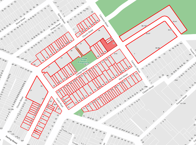
![]()
|
Outcomes in College Street between Cameron Street and Curtis Road |
|||||
|
Total Number of Properties |
Total in Support |
Total in Objection |
Response Rate |
Response Support Rate |
Response Objection Rate |
|
43 |
23 |
2 |
58% |
92% |
8% |
![]()
|
Outcomes in surrounding sections (College, Church and Mort Streets) |
|
|
Total in Support |
Total in Objection |
|
8 |
4 |
![]()
Based on the above results, sufficient support has been received from residents within the subject section to proceed with implementation of the proposal. Comments in response to this proposal have been summarised within the table below.
|
Resident Concerns |
Officer Feedback |
|
It is physically impossible for two-way traffic to share this narrow street and converting it to one-way will go a considerable way to making it a more navigable and less terrifying passageway (5 similar comments). |
Council has noted residents’ safety concerns regarding the road width. The proposed one way will assist in alleviating these issues. |
|
The safety issue is the speed at which cars travel in our street. This is due to inadequate signage of the speed limit, inadequate signage notifying drivers to the presence of a playground, an increase in traffic due to the Dry Dock re-opening. A one way street will not increase the safety, however a shared 10km pedestrian zone with clear signage will by reducing traffic speed. Can you please explain why this option has not been considered, as it was discussed at the meeting. (2 similar comments)
In addition, parking is already a massive issue, a one way street will mean extra traffic as we all do multiple loops of the block looking for a spot anywhere near our house. Furthermore, due to the nature of the deep gutters and slope of the pavement. Those that live in the even numbered, Curtis St end, will be unable to exit their car if they park outside their houses. |
Council is currently developing a Local Area Traffic Management (LATM) plan for the Balmain East/Birchgrove precincts and examining a 10km/hr Shared Zone within College Street including traffic calming devices to provide a low speed road environment. The proposed one way restriction will assist in alleviating issues pertaining to the narrow carriageway width along with reducing vehicle volume within this section of College Street by restricting eastbound traffic.
A resident parking scheme is currently in place to address long-term non-residential parking in the street. The kerb profile is the same on both sides of the street and is expected to remain unchanged from the one way parking arrangement. |
|
Any proposal to funnel some traffic into this street can only make the situation worse. I can't see that the proposal makes things safer in Church Street which your headline " making traffic safer for local residents" suggests would be the case. While I acknowledge Mort Street is a wider street than College Street, cars are typically parked on either side of Mort Street creating a narrower passageway. It is not uncommon for cars traveling in opposite directions, at the same time, needing to stop to allow the other car to pass. An increase in traffic on Mort Street will further exacerbate this creating a safety issue for residents entering their cars as traffic passes in very close proximity to parked vehicles. This is particularly concerning for residents with young families, including my own, who are required to place their children in car seats and are left exposed to traffic passing by. |
It is expected approximately 227 vehicles will be diverted into the neighbouring streets which will primarily include Church and Mort Streets. These increase in volumes in Church and Mort Street is not considered significant. Church and Mort Streets have a kerb to kerb width of 9.8m and Mort Street has 9.75m respectively. Both streets have a more appropriate width to accommodate parking and two-way traffic than College Street.
Additionally, Church and Mort Streets have no reported crashes within the last five years to raise concerns regarding the existing arrangements. |
|
A good follow up step would be to only have parking allowed on one side of the street at a time, alternating along the length of the street. This street is too narrow for double sided parking, and cars end up parked on the footpath, blocking pedestrian access. (1 similar comment) |
This suggestion would result in a significant loss of parking and lead to an increase in parking demand within neighbouring streets to accommodate. As parking is in demand in Balmain and residents have expressed difficulty in finding parking, this would not be supported by impacted residents. |
|
If College Street is to be made one-way, it should be in the direction taken by the majority of current traffic on that street. If currently an average of 227 vehicles travel eastbound and 118 vehicles westbound, then surely any change should be to make College Street one-way eastbound. That would at least minimise the amount of traffic being diverted to neighbouring streets. (3 similar comments) |
The westbound restriction was supported by residents as it is an uphill direction which will assist in slowing vehicle speeds and receives the least volume will also reduce safety issues associated with the narrow width. The overall volumes are low and expected to have minimal impact on neighbouring streets. |
|
The proposal favours residents in one street at the expense of residents in other nearby streets. If successful, this proposal may also create a precedent for residents in other streets to apply to become one-way.
Narrow two-way streets have long been a part of living in Balmain. Moreover, College Street is in a privileged position to many comparable streets in the suburb in that the College Street Park takes up approximately one third of the western side meaning there are less houses on the street between Curtis and Campbell Streets and therefore less resident traffic.
While the refurbishment of the Dry Dock has increased traffic on College Street, it is not a new venue. Residents who have acquired homes in the street, have done so knowingly that a hotel in close proximity may translate to an increase in traffic along the street. |
Comments noted. Council generally only considers one-way restrictions for streets with genuine safety concerns, insufficient widths to accommodate two-way traffic, area wide traffic volumes impacts along with resident support.
Whilst College Street comparatively exhibits less traffic than neighbouring streets, the primary issue is regarding its insufficient carriageway to accommodate a two-way traffic arrangement. This has led to safety concerns reported from residents. |
FINANCIAL IMPLICATIONS
The proposed works are to be funded under Council’s signage and linemarking budget.
|
1.⇩ |
College Street, Balmain - One Way Proposal Plan |
|
|
Local Traffic Committee Meeting 21 July 2025 |
Subject: Percival Road and Temple Street, Stanmore – Temporary full road closure for Stanmore Music Festival – Saturday 15 November 2025 (Damum-Stanmore Ward / Newtown Electorate / Inner West PAC)
Prepared By: Jennifer Adams - Traffic Engineer
Authorised By: George Tsaprounis - Acting Traffic and Transport Planning Manager
|
RECOMMENDATION
1. That the proposed temporary full road closure of Percival Road, between Salisbury Road and Myrtle Street, and Temple Street between Percival Lane West and Percival Road, Stanmore be APPROVED for the purpose of holding the ‘Stanmore Music Festival’ Event on Saturday 15 November 2025 between 6.00am and 9.30pm as per the submitted TMP and TGSs and subject to the following conditions and all standard Council conditions for temporary full road closures:
2. That a Road Occupancy License application be obtained from the Transport Management Centre.
3. That notice of the proposed event be forwarded to the NSW Police Local Area Commander, Transit Systems, the NSW Fire Brigades and the NSW Ambulance Services.
4. That all residents and businesses in and around the affected area are to be notified of the temporary road closure in writing by the applicant in advance (at least 7 days prior to the event) with the applicant making reasonable provision for stakeholders.
5. That a minimum four (4) metre unencumbered passage be available for emergency vehicles through the closed sections.
6. That the occupation of the road carriageway must not occur until the road has been physically closed.
|
STRATEGIC OBJECTIVE
This report supports the following strategic directions contained within Council’s Community Strategic Plan:
|
2: Liveable, connected neighbourhoods and transport |
EXECUTIVE SUMMARY
Inner West Council is presenting Stanmore Music Festival on Saturday 15 November 2025 from 12:00noon until 7:00pm. To facilitate the event there will be a temporary full road closure of Percival Road, between Salisbury Road and Myrtle Street and Temple Street between Percival Lane West and Percival Road, Stanmore (ENRC/202/0041). This will require some road detours in surrounding streets. Road closure and event bump in will occur from 6:00am and bump out will conclude by 9:30pm.
BACKGROUND
Stanmore Music Festival is a celebration of live music in the Inner West. The event will run on Saturday 15 November 2025 from 12noon to 6pm and will feature multiple outdoor live music stages across the festival site. This will be the fifth Stanmore Music Festival.
OFFICER COMMENTS
The event area will be on Percival Road between Salisbury Road and Myrtle Street and Temple Street between Percival Lane West and Percival Road, Stanmore (refer to the site map below – Stanmore Music Festival Area).
Site map
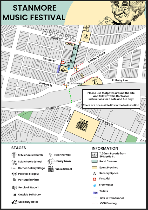
Authorised traffic controllers will implement intermittent stop/slow traffic control on Myrtle Street to allow participants of the parade to gather on the northern footpath of Myrtle Street and then cross safely into the event area once traffic has been held.
Access around the event site will be maintained by a detour. The detour loop will include Douglass Street, Salisbury Road, Myrtle Street and Bruce Street.
No special event clearways will be installed for this event. Inner West Council will instead install
‘No Stopping’ signage throughout the event precinct prior to the event. Any remaining vehicles will be towed and parked in a nearby location on the morning of the event. To help inform road users in the lead-up to the festival, temporary message signage will be installed by Inner West Council in prominent locations. These will display the road closure information and serve as an early warning for the community.
Adequate vehicular traffic control shall be provided for the protection and convenience of pedestrians and motorists including appropriate signage and flagging. Workers shall be specially designated for this role (and carry appropriate certificates), as necessary to comply with this condition. This is to be carried out in accordance with the Australian Standard AS 1742.3 - Traffic Control Devices for works on roads.
Traffic Management Plan and Traffic Guidance Schemes
A Traffic Management Plan has been provided and is attached at the end of this report. The three associated Traffic Guidance Schemes are reproduced below along with the detour plan.
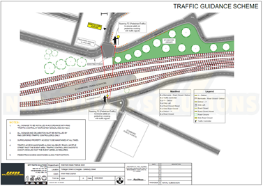
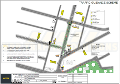
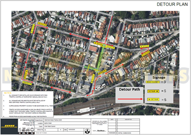
Traffic management for the event will be overseen by an accredited Traffic Manager from NPP Traffic Solutions Pty Ltd, who will coordinate the implementation of all approved Traffic Guidance Schemes, including road closures, signage, and barriers.
The Traffic Management Plan is to be submitted to TfNSW for consideration and approval and a Road Occupancy License application is to be submitted to the Transport Management Centre by NPP Traffic Solutions Pty Ltd.
All traffic control measures will be installed in accordance with Transport for NSW (TfNSW) and SafeWork NSW requirements. Accredited traffic controllers holding current “Implement Traffic Control Plan”, and “Traffic Controller” certification will be deployed for all stop/slow operations and onsite traffic direction.
Impacts on buses
Transit Systems service 412 uses Douglas Street and Salisbury Road through Stanmore, and this service will not be impacted.
Impacts on pedestrians and cyclists
There will be no major effect to pedestrians in the area. Pedestrians will be able to use the existing pedestrian paths outside of and within the event area.
There are no cycleways directly impacted by this event. Cyclists entering the event site will be requested to dismount.
The closest train station is Stanmore Station. It is approximately 120 metres walk from the event precinct. Currently the TfNSW Trackworks schedule for event day shows no scheduled track works for the T2 Inner West and Leppington Line. https://transportnsw.info/
Impacts on Parking
Inner West Council will temporarily cover existing parking signage within the precinct and replace it with “No Stopping” notices to support vehicle clearance. This will take place ahead of the event day. Any remaining parked vehicles will be relocated by authorised towing services to a nearby temporary holding area.
Parking will only be available in surrounding residential streets and a few small public carparks around the event site. Parking will as such be limited, and the event organiser will be recommending public transport to all event patrons.
Impacts on traffic
The traffic generated as a result of the proposed festival should not have a major impact on the surrounding traffic network. The arrival and departure of attendees of the festival is expected to be staggered.
At present, there is no indication of construction works that will be impact the event. There are no traffic calming devices or traffic generating developments along the route.
Heavy vehicles may experience slight delays due to increased traffic around the event precinct. Heavy vehicles should follow signposted detours.
A minimum four (4) metre emergency lane will be maintained along the entire closure. Traffic controllers will be onsite to assist emergency vehicles through the closure points.
Hostile Vehicle mitigation strategies may be undertaken within the road closure in accordance with the event risk assessment and NSW Police direction.
PUBLIC CONSULTATION
The proposed temporary full road closures have been advertised in accordance with the Roads Act 1993.
Advice of the proposed event must be forwarded to all the appropriate groups, including emergency services. A copy of the draft notification letter is attached at the end of this report.
FINANCIAL IMPLICATIONS
Funding of $25,000 has been allocated by Council for organising the Stanmore Music Festival event from Council’s Events operational budget.
CONCLUSION
It is recommended that Council agree to the temporary full road closures on Saturday 15 November 2025 subject to complying with the recommendations stated in this report along with all standard conditions for temporary full road closures.
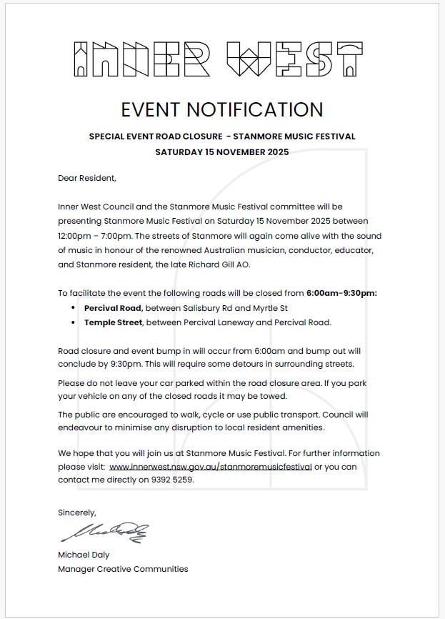
|
1.⇩ |
NPP - IWC - Stanmore Music Festival 2025 - TMP TGS v2 |
|
|
Local Traffic Committee Meeting 21 July 2025 |
Subject: London Street and Simmons Street, Enmore - Updated Report for the Proposed Temporary Road Closure and Part Road Closure (Damun-Stanmore Ward / Newtown Electorate / Inner West PAC)
Prepared By: Daniel Li - Student/Graduate Traffic Engineer
Authorised By: George Tsaprounis - Acting Traffic and Transport Planning Manager
|
RECOMMENDATION
1. That Council note the approval of the Traffic Management Plan by Transport for NSW.
2. That Council approve the implementation of the proposed temporary road closure at London Street and the temporary part road closure at Simmons Street for a trial period of 6 months.
3. That the amended signs and linemarking plan for London Street (Parking changes plan) be approved.
4. That the amended signs and linemarking plan for Simmons Street (Parking changes plan) be approved.
|
STRATEGIC OBJECTIVE
This report supports the following strategic directions contained within Council’s Community Strategic Plan:
|
2: Liveable, connected neighbourhoods and transport |
|
|
EXECUTIVE SUMMARY
On 18 March 2024, a Local Traffic Committee report was submitted to Council for the proposed temporary road closure and part road closure of London Street and Simmons Street, Enmore. Council’s decision at the time included the deferral of approval of the closures subject to the approval of the Traffic Management Plan (TMP) was by Transport for NSW for full/part road closure London Street and Simmons Street, Enmore.
Since the adoption of the Traffic Committee recommendation in March 2024, Transport for NSW has provided their approval for Council’s proposed temporary road closure and part road closure for London Street and Simmons Street, Enmore. Council has addressed the further requirements that were provided as a condition of the TfNSW approval. Therefore, Council officers are proposing to undertake the implementation of the road closure trial with a Council officer being nominated for any community enquiries during the notification and work period.
BACKGROUND
This report provides an update in response to Council’s resolution at the 9 April 2024 Council Meeting which has received and adopted the recommendations of the LTC meeting held on the 18 March 2024, subject to the following amendment:
a) London Street and Simmons Street, Enmore – Proposed Temporary Road Closure and partial Road Closure to be deferred until the approval of a Traffic Management Plan by TfNSW, that this Plan address the potential increase to traffic in neighboring residential streets and associated safety concerns, and that communication regarding the trial period and a contact for residents to provide feedback directly to Council be letterboxed and displayed on the Council website.
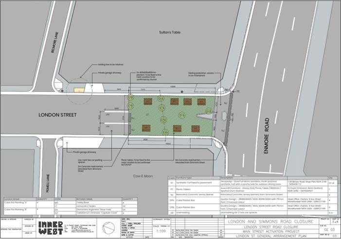
Figure 1 – Updated proposal for London Street closure
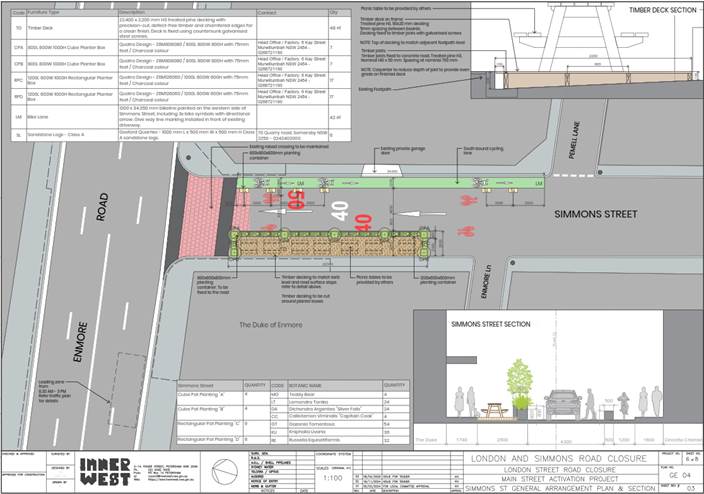
Figure 2 – Updated proposal for Simmons Street part closure and one-way
DISCUSSION
Six-month trial:
It is proposed that both temporary road closures will be trialed for a 6-month period from approximately October 2025 to May 2026. At least two months after the commencement of the trial, Council will undertake a new count of vehicle movements on local streets in the area to get accurate data on the extent of changes to local streets. Council will review this new data when preparing a new Local Area Traffic Management study for the area to identify opportunities to prevent rats running through the area and to inform a decision at the end of the six-month trial period to either extend or conclude the London and Simmons Street Road closure trials.
Impacts to Parking
As indicated in the March 2024 LTC report, the proposals in this report will result in changes to on-street parking in the affected sections of London Street and Simmons Street.
Initially, in London Street, it was identified that there would be no net loss in carparking due to the proposed addition of 4 parking spaces on Enmore Road subject to TfNSW approval and 2 angled spaces in London Street. In March 2025, as part of the TfNSW Conditions of Approval for the road closure in London Street, Council was unable to receive approval from Transport for NSW regarding the proposed parking arrangements on Enmore Road. As such, the current proposal for a full road closure at London Street will result in a net loss of 4 on-street parking spaces (refer to figure 3 below).
In comparison, there will not be any further changes to on-street parking in Simmons Street. apart from the loss of ‘No Parking’ on the eastern side of the roadway, the loss of motorcycle parking (1 car parking space in length) and two unrestricted parking spaces as per the initial proposal (refer to figure 4 below).
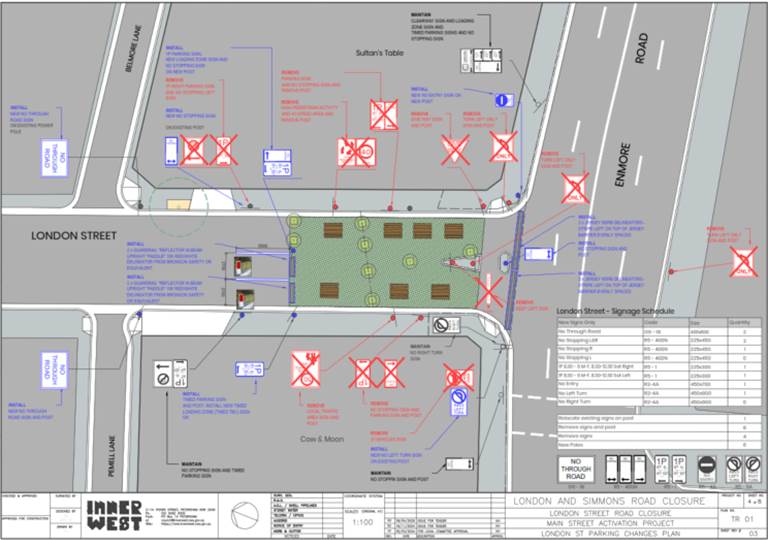
Figure 3 – Updated traffic sign plan for London Street closure
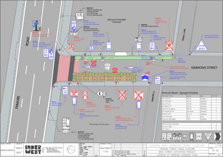
Figure 4 – Updated traffic sign plan for Simmons Street part road closure and one-way
Transport for NSW Conditions for approval:
In March 2025, approval from Transport for NSW for the permanent closure of London Street and partial closure of Simmons Street, Enmore was received (refer to Attachment 5). The approval was subject to the following conditions and Council responses:
|
Transport for NSW Conditions of Approval |
Council’s Response |
|
Cambridge Street traffic being monitored before and after the six-month trial period and changes reported back to the Traffic Committee. |
Council provided a report to the Local Traffic Committee on the 18 March 2024 advising on the existing conditions. A further report will be provided after the trial advising on the findings of the trial. |
|
A review of the bus stop west of Cambridge Street be undertaken to determine safety and possible queue length of vehicles to confirm that the proposed recommendation does not significantly impact the bus stop. |
Council has undertaken a review of the bus stop west of Cambridge Street. Council officers observed vehicle movements in the morning peak, between 8.00-9.00am on Tuesday 6 May 2025, Councils previous survey found the maximum number of existing vehicle movements occur at this site (7-day survey conducted in June 2023). The findings are that the intersection is not busy with only low numbers of vehicles turning in or out at any time. Videos taken by Council indicate a maximum of 2 vehicles overtaking a bus at the bus stop and turning into Cambridge Street on two occasions; and a maximum of 3 vehicles coming out of Cambridge Street when the bus was stopped over the identified period. On this basis, Council officers not believe that the proposed changes, will negatively impact the safety of bus movements at this intersection. |
|
The barricades on Enmore Road be amended so that the barricades are set back from the state road. |
Council officers have amended the design to setback the barriers as indicated in the plan below. |
|
An addition to parking on Enmore Road will require Transport for NSW review and approval. |
Council officers amended the proposal to exclude any changes to the existing parking controls on Enmore Road. |
Public Consultation:
Public consultation was undertaken in the traffic report submitted to the March 2024 LTC (Refer to Attachment 2 – Engagement Report). As there are no major changes to the proposal, no further consultation was undertaken. However, it should be noted that a notification letter and website information on the above proposals will be provided to the community which will include a Council Officer being nominated for any community enquiries during the notification and works period.
Conclusion:
As a result of this proposal being subjected to conditions of approval by Transport for NSW, Council Officers have made several changes to the previous proposal including the following:
London Street
· Removal of on-street parking spaces at Enmore Road and installation of a ‘No Stopping’ sign at the pedestrian refuge.
· Barricades setback from the state road; and
· Removal of 3T vehicles sign on London Street.
Simmons Street
· Addition of ‘Bicycles Excepted’ signage below the regulatory signage on Simmons Street facing Enmore Road.
· Addition of a chevron sign at the outdoor space facing Simmons Street; and
· Installation of give-way signage and linemarking at Pemell Lane to improve safety for cyclists.
In conclusion, it is proposed that the temporary full closure of London Street between Enmore Road and Belmore Lane and the part closure of Simmons Street between Enmore Road and Enmore Lane with one-way northbound traffic be supported as a 6-month trial, to improve the vibrancy of public spaces and local streets.
FINANCIAL IMPLICATIONS
The proposals within this report are funded through Council’s Mainstreet Local Place Making budget.
|
1.⇩ |
London Street and Simmons Street Road closure design plan |
|
2.⇩ |
Engagement Outcomes Report |
|
3.⇩ |
March 2024 LTC Report |
|
4.⇩ |
Stantec TMP |
|
5.⇩ |
TMP Approval by Transport for NSW |
|
|
Local Traffic Committee Meeting 21 July 2025 |
Subject: Salisbury Road, Stanmore - Request for a residential parking scheme (Damum-Stanmore Ward / Newtown Electorate / Inner West PAC)
Prepared By: Jennifer Adams - Traffic Engineer
Authorised By: George Tsaprounis - Acting Traffic and Transport Planning Manager
|
RECOMMENDATION
That the proposal to implement Resident Parking Scheme restrictions ‘2P 8.30am to 6pm Monday – Friday Permit Holders Excepted Area M15’ in Salisbury Road, Stanmore on the southern side between No.75 and No.101 Salisbury Road not be supported at this time due to insufficient resident support.
|
STRATEGIC OBJECTIVE
This report supports the following strategic directions contained within Council’s Community Strategic Plan:
|
2: Liveable, connected neighbourhoods and transport |
EXECUTIVE SUMMARY
Upon receiving a petition from residents of Salisbury Road, Stanmore Council initiated an investigation for implementing residential parking restrictions on the southern side of Salisbury Road, between properties No.75 and No.101 Salisbury Road. Recent parking occupancy surveys conducted by Council Officers have indicated a high parking demand in the above-mentioned section of Salisbury Road during peak hours of the day.
This report provides the results of the recent resident parking scheme investigation in Salisbury Road, Stanmore.
BACKGROUND
Council received a petition from a number of households on Salisbury Road (on the south side and west of Durham Street) requesting for the consideration of a resident permit parking scheme to relieve the parking problem during the day as they did not have access to any off-street parking facilities.
Council officers subsequently completed a parking occupancy survey on both sides of Salisbury Road between Northumberland Avenue and Percival Road on 31 October 2024 to assess parking utilisation in the area. The average overall parking occupancy rate recorded for both sides was 78 per cent (between 7.00am and 6.00pm) and overall was less than the 85 per cent threshold required for consideration to introduce a resident permit parking scheme. Accordingly, introducing a resident permit parking scheme on the southern side of Salisbury Road was not supported at that time.
Further correspondence was received from residents in the subject area and the parking occupancy survey was repeated in early 2025 during the day when ‘2P’ restrictions if introduced would operate. The results of this parking occupancy survey showed that the south side of Salisbury Road between Northumberland Street and Percival Road had an average overall occupancy of 88% which exceeds Council’s 85% threshold for parking occupancy for consideration for implementation or extension of a residential parking scheme.
Subsequently, a Resident Parking questionnaire survey was undertaken in Salisbury Road to gauge resident’s support to the introduction of a residential parking scheme in Salisbury Road, Stanmore on the southern side between No.75 and No.101 Salisbury Road.
Council proposed to implement the below restrictions detailed below and illustrated below:
‘2P 8.30am to 6pm Monday – Friday Permit Holders Excepted Area M15’ restrictions on the southern side of Salisbury Road, Stanmore between properties No.75 and No.101 Salisbury Road, Stanmore.
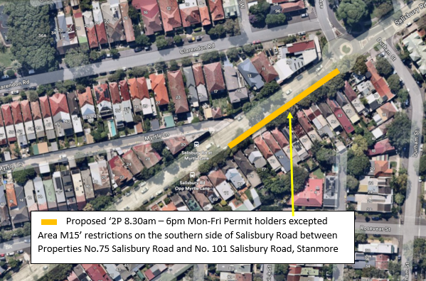
This report details the results of the recent parking utilisation surveys and Resident Parking survey.
DISCUSSION
Salisbury Road is classified as a Regional Road and caries around 17,000 vehicles per day. At present, unrestricted parking is permitted on both sides of Salisbury Road between Northumberland Avenue and Percival Road, Stanmore.
Various Resident Parking Schemes are in place north (M15), south (M17) and east (M1 and M3) of the subject section of Salisbury Road however not in the immediate area. It is noted that the subject section of Salisbury Road (No.101 to No.75) do not back onto another road or laneway and thus do not have access to off-street parking facilities unlike many other residences along Salisbury Road.
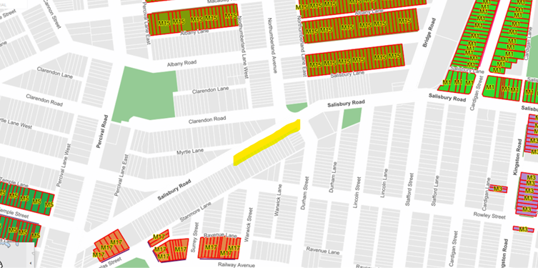
A parking utilisation survey was undertaken in Salisbury Road, Stanmore between Northumberland Street and Percival Road on a typical weekday in October 2024 (between 7.00am and 6.00pm) to gauge current on-street parking utilisation. The results of the survey are summarised in the following table:
On-street parking survey results (weekday) – 31 October 2024
|
Street Name (Section & side) |
No. parking spaces |
Parking Utilisation Rate |
||||
|
7.00 AM
|
11.00 AM
|
2.00 PM
|
6.00 PM
|
Average utilisation rate |
||
|
Salisbury Road, Stanmore |
||||||
|
Northumberland Avenue to Percival Road (east side)
|
46 |
56.5% |
84.2% |
78.3% |
76.1% |
74% |
|
Percival Road to Northumberland Avenue (west side)
|
34 |
76.5% |
88.2% |
85.3% |
79.4% |
82% |
|
Average utilisation rate
|
67%
|
86%
|
82%
|
78%
|
|
|
(Average overall rate = 78%) Average day rate = 84%
Another parking utilisation survey was undertaken in Salisbury Road, Stanmore between Northumberland Street and Percival Road on a typical weekday in February 2025 (at 11am and 2pm) to check daytime on-street parking utilisation. The results of the survey are summarised in the following table:
On-street parking survey results (weekday) – 6 February 2025
|
Street Name (Section & side) |
No. parking spaces |
Parking Utilisation Rate |
||||
|
|
10.00 AM
|
2.00 PM
|
|
Average utilisation rate |
||
|
Salisbury Road, Stanmore |
||||||
|
Northumberland Avenue to Percival Road (east side)
|
46 |
|
89.3% |
87.2% |
|
88% |
|
Percival Road to Northumberland Avenue (west side)
|
34 |
|
94.1% |
79.4% |
|
87% |
|
Average utilisation rate
|
|
92%
|
83%
|
|
|
|
Average day rate = 87%
Council Policy/Guidelines
Council's adopted Policy for the introduction or extension of a Permit Parking Area states, "that before implementing a resident parking scheme in any area, a survey of residents be undertaken to ascertain the level of support for such a scheme and that such support should be in excess of 65% of submissions received provided that rate of return of submissions is reasonable (higher than 30%)".
PUBLIC CONSULTATION
A total of 39 consultation letters were sent out to owners and residents of Salisbury Road between No.101 and No.31 and 3 residences in Durham Street, Stanmore on 3 June 2025. Submissions closed on Friday 27 June 2025.
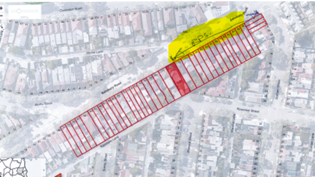
At the end of the survey period seven (7) responses were received. Two (2) were neutral noting that any restrictions would have a knock-on effect just moving demand to the western end of Salisbury Road; three (3) were in support of the proposal and two (2) opposed the proposal. The overall response rate was 18%, and of that 29% were either neutral or opposed the proposal while 42% supported it.
Number of properties - 39
Number of properties responded - 7
Number of properties supported - 3
Response Rate - 18%
Support Rate - 42%
The table below reveals some of the comments raised by the residents.
|
Resident’s comments
|
Officer’s response |
|
SUPPORT |
|
|
Thank you for your consideration of an RPS on Salisbury Road in Stanmore. My family and I fully support this proposal. |
Support noted |
|
This proposal is a great idea and long overdue, the parking is getting more and more difficult |
Support noted |
|
I support parking restrictions, however, would like them to
be further extended to cover properties up to and including 35 Salisbury Road
– i.e. restrictions should cover 35 to 101 Salisbury Road Stanmore. |
Support noted. At this time the restrictions proposed were to accommodate those residents who did not have any access to off-street facilities at their property. |
|
NEUTRAL |
|
|
I would ask the council to consider the knock-on effect of this change, noting that as a resident of Durham Street, we too are subject to significant non-residential parking as people attend activities on Parramatta Road, catch the bus to town, or commute to RPA via the 412 bus.
We also have a number of apartment dwellers nearby, who have allocated parking in their complexes, but either have multiple vehicles, or a preference for street parking, who also park in Durham Street, thus increasing pressure on the number of spots available for residents without parking.
If parking restrictions are placed along this section of Salisbury Road, it is likely those who normally park there who might not be entitled to a permit, will simply pop around the corner into Durham Street instead, and I ask the Council to give due consideration to this possibility when considering the change. |
It is acknowledged that parking demand can also increase in/along streets adjacent to areas in which schemes are introduced. Because there can be knock-on effects or unintended impacts it is appropriate that these adjacent streets be reviewed once any new parking patterns in the area are established. Generally, this is achieved with some certainty after approximately six months operation and if required Council may arrange a parking survey review in these streets at that time. |
|
We understand the issue for the occupants of 75 - 101 Salisbury Rd. However, it seems the solution is to transfer the high parking demand to another part of Salisbury Rd.
Is this more a temporary band-aid rather than a long-term solution. |
Generally, the provision of any introduced RPS to one side of the street is intended to minimise the knock-on effect to parking along or onto other streets. |
|
OPPOSE |
|
|
We are long time owner-occupied residents on the western
side of Salisbury Road, opposite Myrtle Street. Whilst all residents have
noticed an increase in street parking in recent years, we are concerned about
the impact this proposed parking restriction will have on surrounding areas.
The western end already has a higher number of cars during the day due with
commuter parking being closer to the train station. In addition, there is
already no parking between No.64 and No.71 due to the bus zone plus a driveway
at No.73. |
Option of having no parking restrictions in the street is noted. As noted, at this time the restrictions proposed were to accommodate those residents who did not have any access to off-street facilities at their property. |
|
We live in the directly impacted area and strongly opposed to the proposed parking restrictions and would like it to remain unrestricted parking as is the current situation. This is for several reasons: 1. We do not want to have to buy a parking permit to park in front of our house, although we do not have any off-street parking on our property, we do not find it difficult to get a park the vast majority of the time within 50 m of our front door (and 90% of the time within 10 m). 2. More street signs to display these new restrictions would be an eyesore, particularly as this is a heritage preservation area we feel that more signs would detract from the aesthetic appeal of the area. 3. We find that one of the most difficult times to park is on Sunday evenings when most of the spaces are likely taken by residents of the area, while during the working hours on weekdays especially in the afternoons before 5 pm there are plenty of spaces…. The most difficult time to find a park is on mornings, particularly Saturday and Sunday mornings due to the popular café opposite this stretch of Salisbury Road because of the patrons of this café, and so having a 2-hour parking restriction would also not help with this situation. |
Option of having no parking restrictions in the street is noted.
|
FINANCIAL IMPLICATIONS
There are no financial implications associated with the implementation of the proposed recommendations outlined in the report.
CONCLUSION
ATTACHMENTS
Nil.
|
|
Local Traffic Committee Meeting 21 July 2025 |
Subject: Baltic and Bedford Streets, Newtown- Proposed 'No Stopping' restrictions (Damun-Stanmore Ward/Inner West PAC/Newtown Electorate)
Prepared By: James Nguyen - Traffic Engineer
Authorised By: George Tsaprounis - Acting Traffic and Transport Planning Manager
|
RECOMMENDATION
1. That the proposed ‘No Stopping’ restrictions on both sides of Baltic Street, 6 metres north from the intersection of Bedford Street be approved subject to the completion risk assessment by Council and approval of a risk assessment by TfNSW.
2. That the proposed ‘No Stopping’ restriction on the northern side of Bedford Street, 6 metres west of Bedford Street be approved, subject to the completion risk assessment by Council and approval of a risk assessment by TfNSW.
3. That the ‘No Stopping’ restriction on the northern side, east of Bedford Street be approved
|
STRATEGIC OBJECTIVE
This report supports the following strategic directions contained within Council’s Community Strategic Plan:
|
2: Liveable, connected neighbourhoods and transport |
EXECUTIVE SUMMARY
This report outlines a ‘No Stopping’ restriction proposal to improve access to Baltic Street at the intersection of Bedford Street. The proposal will improve parking compliance and ensure vehicles park away from the intersection. Community consultation revealed strong objection to the proposal due to loss of parking. Accordingly, Council officers are proposing a reduced 6-metre ‘No Stopping’ restriction which will require the completion of a risk assessment, that will subsequently be referred to Transport for NSW for approval.
BACKGROUND
Council has received a request to review the intersection of Baltic and Bedford Streets, Newtown due to concerns that parked vehicles are being damaged. A traffic island and partial road closure was requested for consideration.
DISCUSSION
Baltic Street is a 7-metre-wide local road, with low traffic volumes. There are no recorded accidents at the intersection of Bedford and Baltic Streets within the last five (5) years. Traffic facilities such as partial road closures are generally considered at locations to mitigate rat-running or prevent unsafe turning movements. Accordingly, a partial road closure or traffic facility on Baltic Street at the intersection of Bedford Street is not recommended.
Council officers completed a site inspection to assess the intersection further. The intersection does not have any existing ‘No Stopping’ signs. There are also no existing timed permit parking restrictions installed on Baltic Street. It was found there were vehicles parked close to the intersection. A review of the aerial images also suggest vehicles may park within 10 metres of the intersection. Council’s parking officers have also advised there have been some infringements issued to vehicles parking within 10 metres of the intersection.
Due to the narrow width of Baltic Street, vehicles parking too close to the intersection may affect access and side swiping may occur. Furthermore, sight lines of vehicles on Bedford Street may be compromised. Accordingly, Council officers developed a proposal to install ‘No Stopping’ restrictions on both sides of Baltic Street, north of Bedford Street, and on the northern side of Bedford Street, east and west of Baltic Street to rectify the issues that have been identified. The proposal is shown in Figure 1 below.
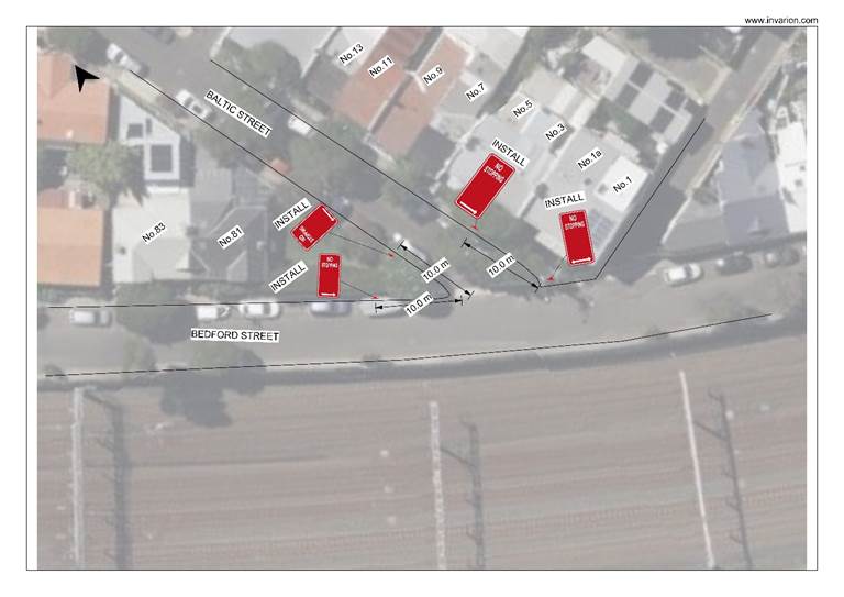
Figure 1 - Consultation plan
PUBLIC CONSULTATION
Council consulted with affected residents on the proposal between Thursday 8 May 2025 and Friday 23 May 2025. There were 15 letters sent with no responses supporting the proposal and five (5) responses opposing the proposal. One (1) of the five (5) responses opposing the proposal was a petition signed by eight (8) households.
|
Residents’ Comments |
Officer Comments |
|
The ‘No Stopping’ restrictions would help as the turn into Baltic Street from Bedford Street is tight. |
Noted. Council officers will consider a reduction in the regulatory ‘No Stopping’ distance from 10 metres to 6 metres and complete a risk assessment to consider potential road safety and network efficiency issues that may arise by reducing the “No Stopping” distance below the statutory minimum. |
|
Concerns were raised about removing more parking in an area with already limited parking. |
Council officers will consider a reduction in the regulatory ‘No Stopping’ distance from 10 metres to 6 metres and complete a risk assessment to consider potential road safety and network efficiency issues that may arise by reducing the “No Stopping” distance below the statutory minimum. |
|
Council have already installed ‘No Stopping’ restrictions at the intersection of Baltic and Albemarle Streets that removed parking. This proposal will make parking issues worse. |
Council officers will consider a reduction in the regulatory ‘No Stopping’ distance from 10 metres to 6 metres and complete a risk assessment to consider potential road safety and network efficiency issues that may arise by reducing the “No Stopping” distance below the statutory minimum. |
|
A submission was raised noting
that the proposal lacks a bespoke solution that is suitable for the dense
urban environment of Newtown with already limited parking for households and
visitors. A site specific solution must be considered that does not apply
blanket controls that are not suitable for the Inner City environment. It was noted that the lines of sight and visibility would not be impacted by a reduced ‘No Stopping’ zone on the eastern side of Baltic Street outside no.3 and 5.
It was noted that the 10 metre restriction on the western side of Baltic and Bedford Street is required as visibility is impacted by parking within this area
It was noted that the removal of further parking will increase parking pressure on the street.
It was noted that Baltic Street is also used by commuters to access the train station.
Council is urged to consider an integrated approach to traffic planning, if ‘No Stopping’ restrictions are considered, and that it is not done in isolation.
|
The Newtown and Enmore Parking Study will propose parking changes that address the precinct wide parking issues.
The proposed ‘No Stopping’ restrictions seek to improve access into and out of Baltic Street.
Council officers will consider a reduction in the regulatory ‘No Stopping’ distance from 10 metres to 6 metres and complete a risk assessment to consider potential road safety and network efficiency issues that may arise by reducing the “No Stopping” distance below the statutory minimum. |
|
A submission noted the 10 metres on each corner is too much and will remove the majority of resident’s parking spaces.
It was suggested that a traffic island to block the possibility of turning left into Baltic Street from Bedford Street be considered.
It was noted that removing the issue with the dangerous corner and providing residents with a safer street, maintain the parking ratio to residents, and provide greening of the streetscape. |
|
|
The petition signed by eight (8) households noted the following:
· Council’s proposal has not taken into consideration the sidewalk projection on the right hand side of the street · Residents who are directly affected by this are not in favour of losing 20 metres of parking as it is already hard to find parking for residents and visitors · Baltic Street is one of the widest streets compared to other streets towards King Street which have no existing restrictions · The ‘switch back turn’ is a hard turn to make. A 2-metre ‘no Stopping’ restriction on Bedford Street at the entrance of Baltic Street should be considered. There should be no change to the right hand side of Baltic Street as there is already a projected sidewalk that is 4.6 metres long. |
Council officers will consider a reduction in the regulatory ‘No Stopping’ distance from 10 metres to 6 metres and complete a risk assessment to consider potential road safety and network efficiency issues that may arise by reducing the “No Stopping” distance below the statutory minimum. |
A reduction of the ‘No Stopping’ restriction from 10 metres to 6 metres, as shown in Figure 2 below, will be investigated further by Council officers. A risk assessment will be completed to consider potential road safety and network efficiency issues that may arise by reducing the ‘No Stopping’ distance below the statutory minimum. The risk assessment will be referred to Transport for NSW for consideration once complete.
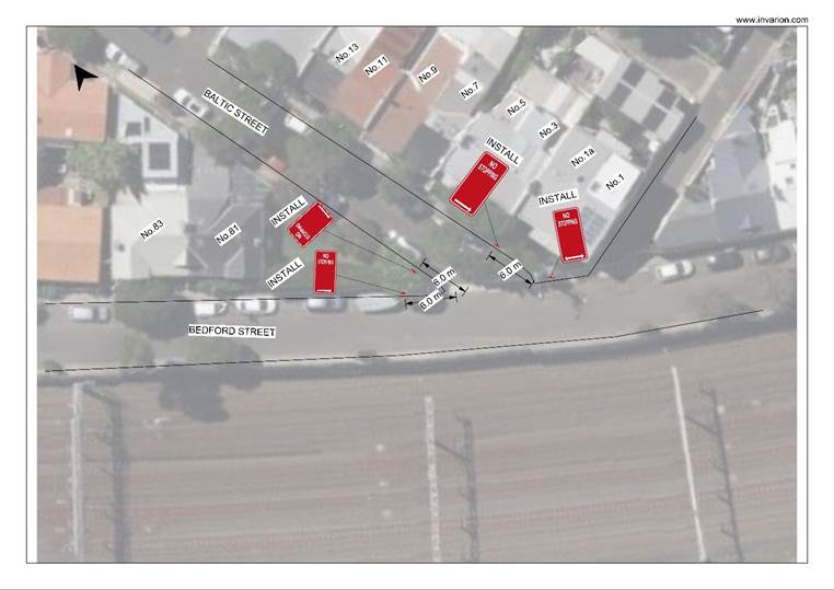
Figure 2 - Amended proposal - Reduced 6 metre 'No Stopping' restrictions
FINANCIAL IMPLICATIONS
There are no financial implications associated with the implementation of the proposed recommendations outlined in the report.
Nil.
|
|
Local Traffic Committee Meeting 21 July 2025 |
Subject: Allen Street, Leichhardt - Safety at Driveway of 141-143 Allen Street (Gulgadya-Leichhardt Ward/Balmain Electorate/ Leichhardt PAC)
Prepared By: Charbel El Kazzi - Traffic Engineer
Authorised By: George Tsaprounis - Acting Traffic and Transport Planning Manager
|
RECOMMENDATION
1. That Council write to the Strata Management at 141-143 Allen Street, Leichhardt advising of the outcome of this report and requesting the Strata Management to consider the installation of a speed hump inside the property boundary with ‘Giveway to Pedestrians’ and ‘Stop’ signage leading up to and at the exit of the driveway.
2. That the existing ‘2P 8am-6pm Permit Holders Excepted Area L1’ (L) signage north of the driveway be relocated south by approximately 3.9m.
|
STRATEGIC OBJECTIVE
This report supports the following strategic directions contained within Council’s Community Strategic Plan:
|
2: Livable, connected neighbourhoods and transport |
EXECUTIVE SUMMARY
The strata management of 141-143 Allen Street, Leichhardt has reported that drivers exiting the site driveway located in Flood Street, Leichhardt are having difficulty exiting the driveway as sight lines are obstructed due to parked vehicles. They further requested 4-5m sections of ‘No Parking’ restrictions each side of the driveway which result in a loss of two (2) on-street parking spaces.
A review has been undertaken on the subject driveway at Flood Street. As on-street parking is highly utilised and valued by the community, the installation of parking restrictions is not supported. Alternate possible measures to improve safety would be to install a speed hump inside of the property boundary, and additional signs for vehicles exiting the ramp and driveway would be recommended, which is a standard measure undertaken at other similar driveways within the Inner West. It is also recommended to relocate the existing ‘2P 8am-6pm Permit Holders Excepted Area L1’ (L) sign located approximately 4.5m north of the subject driveway closer to this driveway to prevent vehicles partially obstructing the driveway and attempting to park within the unrestricted section.
BACKGROUND
Council has received safety concerns from the strata committee of 141-143 Allen Street, Leichhardt and requested ‘No Stopping’ zones be placed 4-5m on each side of the driveway. A review of the Traffic Impact Assessment (TIA) report for the development at 141 Allen Street confirms that the driveway design generally complies with Australian Standards AS2890.1. The driveway is located on Flood Street between Allen Street and Kalgoorlie Street, Leichhardt featuring a road configuration outlined in the table below.
|
Street Name |
Flood Street (between Allen and Lyall Streets) |
|
Kerb to Kerb Width (m) |
12.7m |
|
Carriageway Type |
Two-way, one travel lane each direction Bicycle shoulder lanes on both directions |
|
Classification |
Local Road |
|
Speed Limit |
50km/h |
|
85th Percentile Speed |
No recent data in past 5 years |
|
Average Traffic Volume |
Estimated 4,500vpd (bidirectional) |
|
Available TfNSW recorded crash history last 5 years (2018-2023) |
No reported crashes |
|
Parking Arrangements |
Parking permitted on both sides |
DISCUSSION
Council has received concerns that drivers exiting the property at 141-143 Allen Street, Leichhardt are having difficulty exiting the driveway as sight lines are obstructed due to parked vehicles. The property strata management requested the installation of 4-5m of ‘No Stopping’ zones on both sides of the driveway which would result in a loss of two (2) parking spaces. Typically, ‘No Stopping’ restrictions are generally not used to define and improve sight distance at driveways. A diagram of the driveway configuration can be seen below.
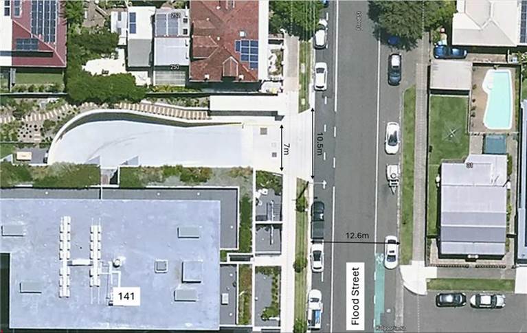
Figure 1: Diagram of driveway of 141-143 Allen Street at Flood Street, Leichhardt
The property has approximately 7m width at the property boundary for two-way vehicular access and built with a 10.5m wide driveway layback. Comparison with other residential flat buildings within the Inner West such as 272 Flood Street indicate a smaller driveway layback width of 7.2m as shown in Figure 2. These types of driveways are common and prevalent in urban areas requiring a degree of caution by drivers entering the road and is not practical to restrict parking adjacent to every such driveway.
The wider width allows drivers a broader angle when entering or exiting and allow improved visibility by carefully approach the boundary of the bike lane and traffic lane before completing their turn. Flood Street has a straight road alignment without horizontal curves or adverse grade. Vehicles are able to enter and leave the site in a forward direction.
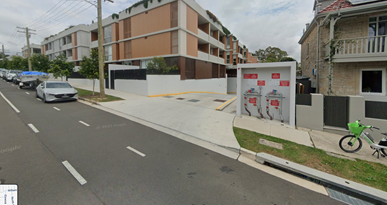
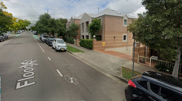
Figure 2: Comparison of driveway for 141 Allen Street (located on Flood Street) and driveway for 272 Flood Street
Council’s InnerWest@40 project is a study based on data-driven evidence base to support reduced speed limits within the Inner West area. One of the key action plans to implement a blanket 40km/h local speed limit for all local roads in the Leichhardt area. Once implemented, this will provide safety improvements in Flood Street and will be a key component to reducing deaths and serious injuries on public roads.
With the high demand of on-street parking in Flood Street and surrounding streets, and with the community highly utilising and valuing street parking, a proposal to remove parking space by 'No Stopping’ zones adjacent to the subject driveway is not supported.
Several alternate recommendations to improve safety for vehicles and pedestrians exiting the driveway include the installation of signage leading up to the exit including a ‘Give way to pedestrians’ sign and a ‘Stop sign’ at the exit. Additionally, a speed hump could also be installed inside of the property to slow vehicles entering and exiting the driveway as the exceptional width of the ramp could contribute to higher speeds.
It is also recommended to relocate the existing ‘2P 8am-6pm Permit Holders Excepted Area L1’ (L) sign as per figure 3 to the edge of the driveway. This will prevent vehicles overhanging into the driveway attempting to park within the 3.9m unrestricted section, which is currently inadequate to fit a standard sized vehicle.
![]()
![]()
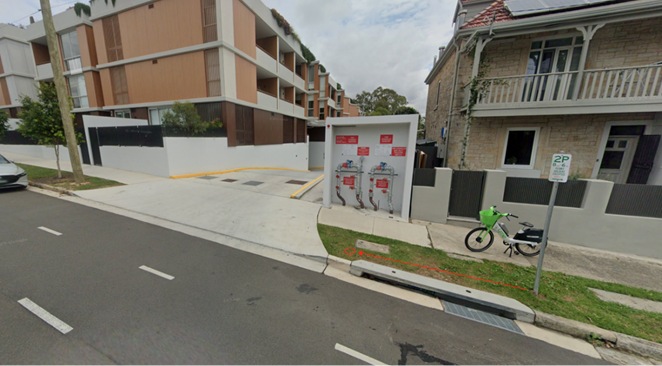
Figure 3: Proposed relocation of 2P signage to remove unrestricted section and prevent obstruction of driveway
FINANCIAL IMPLICATIONS
The relocation of the sign will be funding from Councils signs and line marking budget.