|
AGENDA R |

Extraordinary Local Transport Forum Meeting
MONDAY 1 SEPTEMBER 2025
11:00 AM
|
|
Extraordinary Local Transport Forum Meeting 1 September 2025 |
Function of the Local Transport Forum
Background
Transport for NSW (Transport) is legislated as the Authority responsible for the control of traffic on all NSW Roads. Transport has delegated certain aspects of the control of traffic on local roads to councils.
Transport’s (2025) Authorisation and Delegation Instrument authorises councils to use prescribed traffic control devices under s122 of the Road Transport Act 2013 and delegates Transport’s power under s115 of the Roads Act 1993 to regulate traffic for any purpose.
The (2025) Authorisation and Delegation Instrument revokes and replaces both the (2011) Delegation to Councils and the (2023) Temporary Delegation to Councils No.2.
One of the conditions of the Instrument is that councils establish a Local Transport Forum (LTF - formerly known as Local Traffic Committee). The LTF provides advice, technical review, and coordination of works and events. It does not vote, issue approvals, or make decisions.
Role of the Local Transport Forum
The LTF is primarily a technical review and advisory forum which considers the technical merits of proposals and ensures that current technical guidelines are considered. It provides advice to Council on traffic and parking control matters and on the provision of traffic control facilities and prescribed traffic control devices for which Council has delegated authority. These matters are dealt with under Part A of the agenda.
In addition to its formal role as the LTF, Forum members may also be requested to provide informal traffic engineering advice on traffic matters not requiring Council to exercise its delegated function at that point in time, for example, advice to Council’s Development Assessment Section on traffic generating developments. These matters are dealt with under Part C of the agenda and are for information or advice only and do not require Council to exercise its delegation.
LTF Delegations
The LTF has no decision-making powers. Council must refer all relevant traffic related matters to the LTF prior to exercising its delegated functions. Matters related to State Roads or functions that have not been delegated to Council must be referred directly to the Transport or relevant organisation.
The LTF provides advice to Council. Where Transport has concerns about a proposal and the concerns are not resolved in discussion, Transport may inform the LTF that it intends to issue a Statement of Concern (SoC) within seven days.
Forum Membership
The LTF comprises the following Members:
· one representative of Council as nominated by Council;
· one representative of the NSW Police from each Local Area Command (LAC) within the LGA, being Newtown, Marrickville, Leichhardt and Ashfield LAC’s.
· one representative from Transport for NSW ; and
· State Members of Parliament (MP) for the electorates of Summer Hill, Newtown, Heffron, Canterbury, Strathfield and Balmain or their nominees.
· Operator of any public passenger service likely to be affected by the proposal.
Informal advisors from within Council or external authorities may also attend the LTF to provide expert advice.
LTF Chair
Council’s representative will chair the meetings.
Public Participation
Members of the public or other stakeholders may address the LTF on agenda items to be considered by the Members. The format and number of presentations is at the discretion of the Chairperson and is generally limited to 3 minutes per speaker. LTF debate on agenda items is not open to the public.
|
|
Extraordinary Local Transport Forum Meeting 1 September 2025 |
|
AGENDA |
1 Apologies
2 Disclosures of Interest
3 Matters Arising from Council’s Resolution of Minutes
4 Part A – Items Where Council May Exercise Its Delegated Functions
Traffic Matters
ITEM Page
LTF0925(1) Item 1 Traffic Signals at Old Canterbury Road (MR652) and Edward Street, Summer Hill – Detailed Design Plans TCS4799 (Djarrawunang – Ashfield Ward / Summer Hill Electorate / Ashfield & Inner West PAC) 4
Parking Matters
Nil at the time of printing.
Late Items
Nil at time of printing.
5 Part B - Items for Information Only
Nil at the time of printing.
6 Part C - Items for General Advice
Nil at the time of printing.
7 General Business
|
|
Extraordinary Local Transport Forum Meeting 1 September 2025 |
Subject: Traffic Signals at Old Canterbury Road (MR652) and Edward Street, Summer Hill – Detailed Design Plans TCS4799 (Djarrawunang – Ashfield Ward / Summer Hill Electorate / Ashfield & Inner West PAC)
Prepared By: Jennifer Adams - Traffic Engineer
Authorised By: Manod Wickramasinghe - Traffic and Transport Planning Manager
|
RECOMMENDATION
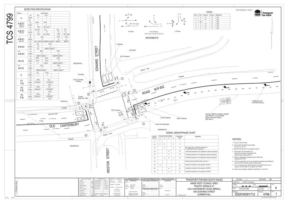
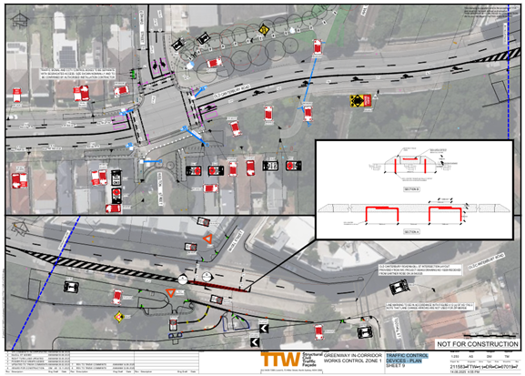
That the detailed design plans of the proposed traffic control signal installation and associated signs and line markings at the intersection of Old Canterbury Road and Edward Street, Dulwich Hill (as per plan No.DS2016/001713-TCS4799 and Traffic Control Devices - Plan 211583-TTW-11-DR-CI-07019-7) be endorsed, subject to Transport for NSW approval of the TCS design and changes to Old Canterbury Road (State Road).
|
STRATEGIC OBJECTIVE
This report supports the following strategic directions contained within Council’s Community Strategic Plan:
|
2: Liveable, connected neighbourhoods and transport |
EXECUTIVE SUMMARY
Detailed design plans have been prepared for the signalisation of Old Canterbury Road, Weston Street and Edward Street, Dulwich Hill. Consultation was undertaken with owners and occupiers of properties regarding the options during the concept design stage in 2018 when it was recommended that detail design of the traffic signals and intersection of Old Canterbury Road, Weston Street and Edward Street proceed based on a road closure to traffic at Weston Street. Since that time Council has developed a signal design and engaged key stakeholders. It is recommended that the detail design plans are approved for construction.
BACKGROUND
As part of the development of the Summer Hill Flour Mills at 2-32 Smith Street, Summer Hill, the developer was required to install traffic signals at the intersection of Old Canterbury Road, Weston Street and Edward Street. In July 2017 Council undertook preliminary engagement regarding the traffic control signals and at the September 2017 Local Traffic Committee meeting the committee endorsed the signals’ concept design.
Concurrent with planning for the proposed new signals, Council was also developing the Greenway Master Plan. This included a walking and cycling route along Weston Street. The development of the Master Plan provided Council with an opportunity to consider new options for the intersection (beyond that endorsed in 2017) which would best meet the needs of residents and were compatible with the Greenway Master Plan.
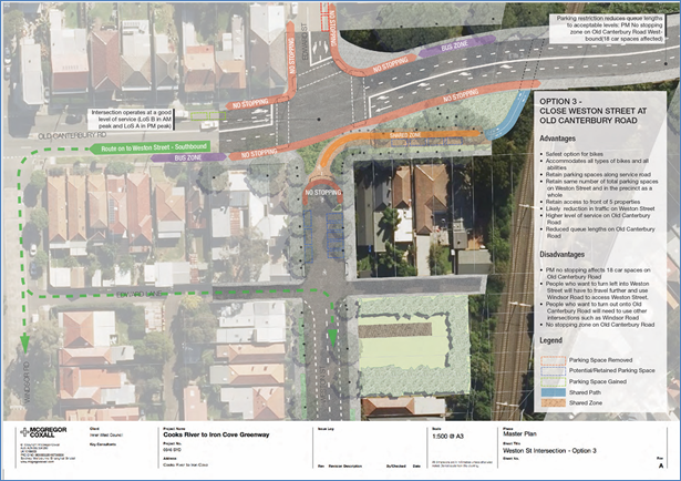
Council undertook traffic counts and modelling in February 2018 and developed three options for the signalisation of the intersection. Following consideration of the analysis and the outcomes from the community consultation process, a report was submitted to Local Traffic Committee meeting on 1 May 2018 detailing this investigation and it was recommended that:
1. The concept design of the traffic signals and intersection of Old Canterbury Road, Weston Street and Edward Street based on a full road closure to traffic at Weston Street as shown in Option 3, be APPROVED, and inform the detailed design;
2. Specific measures to improve traffic safety at the intersection of Old Canterbury Road and Windsor Road and in Edward Lane be considered in tandem with the detailed design and be presented to a future Local Traffic Committee for consideration with the detailed design plans for the signalised intersection; and
3. The detailed design plans be forwarded to the Roads & Maritime Services for consideration and approval.”
At Council’s meeting on 22 May 2018, Council deferred consideration of the Local Traffic Committee recommendation for the selection of a concept option for the signalisation of the Old Canterbury Road/ Edward Street/ Weston Street intersection, Dulwich Hill, pending a site inspection by Councillors. A site inspection was held on Thursday 31 May 2018. The recommendation of the Local Traffic Committee meeting held on 1 May 2018 was resubmitted for Council determination:
THAT the recommendation of the Local Traffic Committee for Item LTC0518 Item 2, Old Canterbury Rd, Dulwich Hill – Proposed Traffic Signals Concept Design Plans, be adopted.
Recognising that no one option resolved all the desired outcomes from the signalisation project, the Traffic Committee, on balance, recommended Option 3 given it:
· Provides the best operational performance for the intersection
· Maintains resident access to properties in the Old Canterbury Road service road
· Has no net loss in parking spaces in the residential streets
· Has the least impact arising from traffic re-distribution
· Is safest for the volume of pedestrians and cyclists being directed into Weston St from the Greenway.
The Committee recognised that the major disadvantage of Option 3 was that it does not provide a signalised environment for motorists to exit the Dulwich Hill neighbourhood (south of Old Canterbury Road) onto Old Canterbury Road.
To ameliorate this issue the Committee recommended investigation of a suite of measures to improve the traffic safety of the Windsor Road and Old Canterbury Road intersection including:
· Removal of the existing pedestrian refuge in Old Canterbury Road to encourage pedestrians to use the proposed signals at Edward Street or existing signals at Junction Road
· Installation of extended “No Stopping” zone on Old Canterbury Road at Windsor Road to provide improved sight lines when exiting from Windsor Road.
· Installation of “No Right Turn” signage on Old Canterbury Road for west bound lanes at Spencer Street to reduce the turning movements at the Old Canterbury, Windsor and Spencer Street intersection (subject to RMS approval of a Traffic Management Plan)
· Installation of “Keep Clear” pavement marking in the east bound lanes on Old Canterbury Road at Windsor Road to facilitate easier vehicle entry into queueing traffic.
· Coordination of traffic signal controls on Old Canterbury Road at Edward Street and Junction Road to maximise gaps in traffic between platooning vehicles.
It is noted that Old Canterbury Road is a State Road and under the jurisdiction of TfNSW and matters on the state road were referred previously for consideration.
The installation of extended “No Stopping” zones on Old Canterbury Road at Windsor Road to provide improved sight lines when exiting from Windsor Road were considered at Local Traffic Committee at its November 2018 meeting. The report covered installation of ‘No Stopping’ restrictions being installed at various intersections within and surrounding the Flour Mill development in Summer Hilldue to obstructed sight lines and manoeuvring space. This included the intersection of Old Canterbury Road at Windsor Road and Spencer Street where it was recommended that 10m ‘No Stopping’ zones be installed:
· On the western side of Spencer Street, north of Old Canterbury Road.
· On the eastern side of Spencer Street, north of Old Canterbury Road.
· On the southern side of Old Canterbury Road, east of Windsor Road.
DISCUSSION
Detailed design plans have been prepared for the signalisation of Old Canterbury Road, Weston Street and Edward Street, Dulwich Hill which are consistent with the adopted concept. Council is currently awaiting TfNSW approval of this traffic signal (TCS) plan.
This report details the design plans of the proposed traffic control signals and the associated signs and line markings at the intersection of Old Canterbury Road and Edward Street, Dulwich Hill. The report also includes an associated swept path analysis and Stopping Sight Distance assessment.
Site location & road network
The intersection of Old Canterbury Road, Weston Street and Edward Street currently operates as a priority-controlled intersection with Old Canterbury Road functioning as a major east-west arterial road, and Weston and Edward Streets as minor local roads.
|
Street Name |
Old Canterbury Road |
Weston Street |
Edward Street |
|
Section |
Between Spencer Street and McGill Street |
Between Old Canterbury Road and Edward Lane |
Between Old Canterbury Road and Wellesley Street |
|
Carriageway Width (m) |
12.8 |
12.8 |
10.2 |
|
Carriageway Type |
Two-way road with one travel lane in each direction, in addition to kerbside parking lanes. |
Two-way road with one travel lane in each direction, in addition to kerbside parking lanes. |
Two-way road with one travel lane in each direction, in addition to kerbside parking lanes. |
|
Classification |
State |
Local |
Local |
|
85th Percentile Speed (km/h) |
- |
46.8 |
56.4 |
|
Vehicles Per Day (vpd) |
- |
239 |
1,771 |
|
Reported Crash History |
1x Serious Injury – overtake turning, 1x Towaway – right near 1x Minor/Other Injury - leaving parking) |
No crashes recorded. |
No crashes recorded. |
|
Heavy Vehicle Volume (%) |
- |
3.0 |
4.1 |
|
Parking Arrangements |
Unrestricted parking along both sides of the road. |
Unrestricted parking along both sides of the road. |
Unrestricted parking on the eastern side of the road and permit parking restrictions on the western side of the road |
Signalisation of Old Canterbury Road, Weston Street and Edward Street
The detailed design plan for the traffic control signal installation and associated signs and line markings plan are shown below and also reproduced at a larger scale at the end of this report.
Key features of the design include:
· Closure of Weston Street at Old Canterbury Road with supporting parking restrictions to allow vehicles to manourvre.
· Signalization of the intersection of Old Canterbury Road and Edward Street
· Extended right turn only lane replacing right/through lane on the westbound approach to the intersection
· Installation of median island on Old Canterbury Road at Mcgill Street
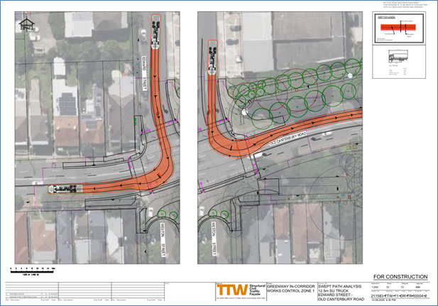
Swept path diagrams
Swept path analysis has been completed to assess the turning movements of a design vehicle – 8.8m medium rigid vehicle (MRV) and Checking Vehicle – 12.5m heavy rigid vehicle (HRV) and are reproduced below.
Swept Path Analysis - 8.8m Service Vehicle - Old Canterbury Road - Edward Street
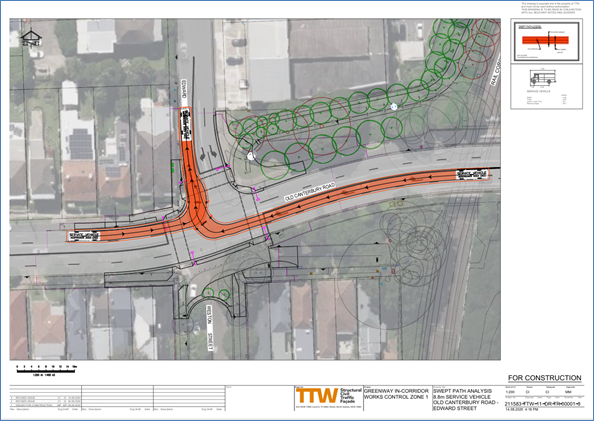
Swept Path Analysis - 8.8m Service Vehicle - Edward Street
- Old Canterbury Road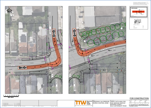
Swept Path Analysis - 12.5m Su Truck - Old Canterbury Road - Edward Street
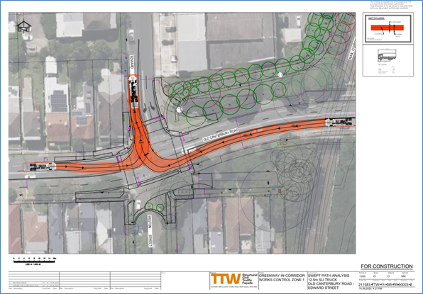
Swept Path Analysis - 12.5m Su Truck - Edward Street - Old Canterbury Road
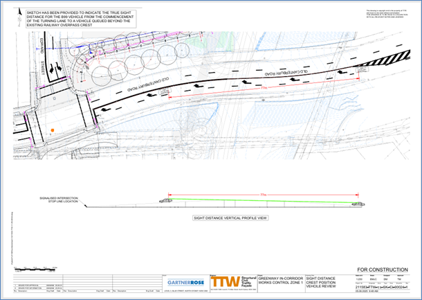
Stopping Sight Distance assessment
Based on the existing vertical geometry along the eastern approach. There was potential that motorists would have limited visibility to the vehicles on the westbound approach, once vehicles queue just prior to the existing crest, accordingly, a Stopping Sight Distance assessment was undertaken to ensure drivers have clear visibility to the rear of the vehicles if they are stationary prior to the crest to eliminate potential rear end incidents and if the right turn vehicles queue out and encroach into the through lane.
Initially an option to ban the right turn into Edward Street was proposed by TfNSW due to the concerns of sight lines on approach to the traffic signals. However, Council did not support this option as it would result in a large transfer of vehicles to Spencer Street via a right turn from Old Canterbury Road.
Council has therefore provided an extended right turn bay proposal as shown in the diagrams above as it mitigates the risk associated with the crest whilst maintaining existing access into Edward Street as well as eliminating the potential transfer of traffic to Spencer Street. However, it is recognized that it will remove parking on Old Canterbury Road in the vicinity of the bridge and bridge approaches which will affect a number of people which use this area to park.
As part of the design, it was also required that a median be installed on Old Canterbury Road at McGill Street to simplify movements on the westbound approach to the new signalized intersection. This will result in both McGill Street and the local road section of Old Canterbury Road being limited to left-in and left-out movements only.
FINANCIAL IMPLICATIONS
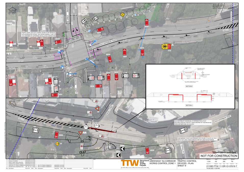
The detailed design and construction of the intersection and traffic signals is to be funded by the developers. Works outside the intersection associated with the Greenway would be funded by the Greenway Capital Budget and implemented in coordination with the traffic signals.
CONSULTATION
The closure of Weston Street to motorised traffic has been included in all the GreenWay community engagement. This includes community engagement for the GreenWay Masterplan in 2018, the Concept Design in 2019, the Review of Environmental Factors in 2021 and the GreenWay Draft Design Plan in 2023.
These can be found on Council’s website at: GreenWay Masterplan - Inner West Council.
More detailed information about the GreenWay community consultation process, can be found on Council’s your say page at: GreenWay Missing Links | Your Say Inner West
Notification letters will be issued following the approval of the final TCS design by TfNSW.
CONCLUSION
It is recommended that the detailed design plans of the proposed traffic control signal installation and associated signs and line markings at the intersection of Old Canterbury Road and Edward Street, Dulwich Hill (as per plan No.DS2016/001713-TCS4799 and Traffic Control Devices - Plan 211583-TTW-11-DR-CI-07019-7) be endorsed.
ATTACHMENTS
|
1.⇩ |
Detailed Design - VV4799_1A_DES |
|
2.⇩ |
Traffic Devices Plan - 211583-TTW-11-DR-CI-07019-7 |