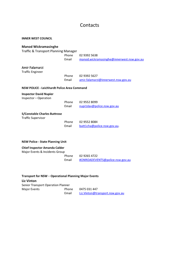
|
AGENDA R |

Local Transport Forum Meeting
MONDAY 15 SEPTEMBER 2025
11:00 AM
|
|
Local Transport Forum Meeting 15 September 2025 |
Function of the Local Transport Forum
Background
Transport for NSW (Transport) is legislated as the Authority responsible for the control of traffic on all NSW Roads. Transport has delegated certain aspects of the control of traffic on local roads to councils.
Transport’s (2025) Authorisation and Delegation Instrument authorises councils to use prescribed traffic control devices under s122 of the Road Transport Act 2013 and delegates Transport’s power under s115 of the Roads Act 1993 to regulate traffic for any purpose.
The (2025) Authorisation and Delegation Instrument revokes and replaces both the (2011) Delegation to Councils and the (2023) Temporary Delegation to Councils No.2.
One of the conditions of the Instrument is that councils establish a Local Transport Forum (LTF - formerly known as Local Traffic Committee). The LTF provides advice, technical review, and coordination of works and events. It does not vote, issue approvals, or make decisions.
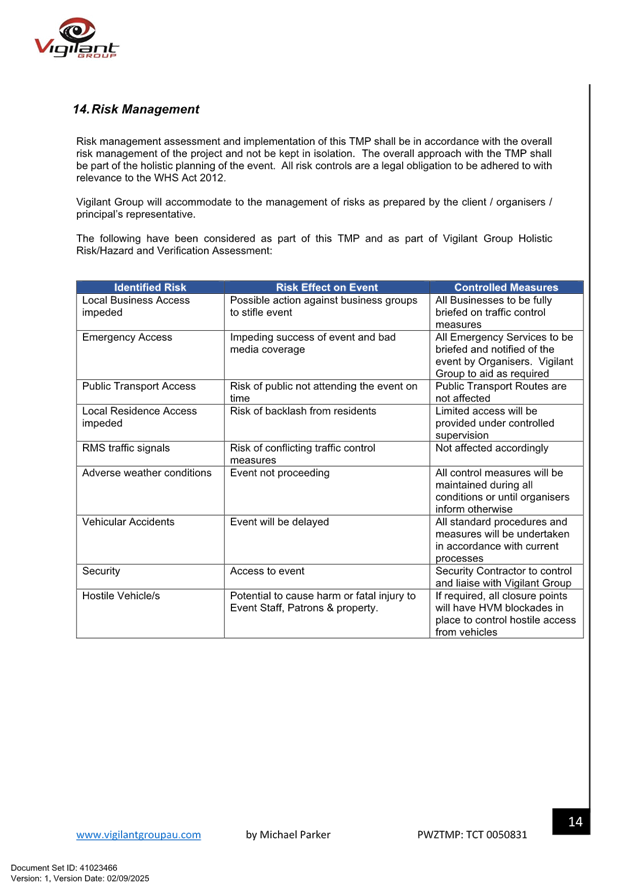
Role of the Local Transport Forum
The LTF is primarily a technical review and advisory forum which considers the technical merits of proposals and ensures that current technical guidelines are considered. It provides advice to Council on traffic and parking control matters and on the provision of traffic control facilities and prescribed traffic control devices for which Council has delegated authority. These matters are dealt with under Part A of the agenda.
In addition to its formal role as the LTF, Forum members may also be requested to provide informal traffic engineering advice on traffic matters not requiring Council to exercise its delegated function at that point in time, for example, advice to Council’s Development Assessment Section on traffic generating developments. These matters are dealt with under Part C of the agenda and are for information or advice only and do not require Council to exercise its delegation.
LTF Delegations
The LTF has no decision-making powers. Council must refer all relevant traffic related matters to the LTF prior to exercising its delegated functions. Matters related to State Roads or functions that have not been delegated to Council must be referred directly to the Transport or relevant organisation.
The LTF provides advice to Council. Where Transport has concerns about a proposal and the concerns are not resolved in discussion, Transport may inform the LTF that it intends to issue a Statement of Concern (SoC) within seven days.
Forum Membership
The LTF comprises the following Members:
· one representative of Council as nominated by Council;
· one representative of the NSW Police from each Local Area Command (LAC) within the LGA, being Newtown, Marrickville, Leichhardt and Ashfield LAC’s.
· one representative from Transport for NSW ; and
· State Members of Parliament (MP) for the electorates of Summer Hill, Newtown, Heffron, Canterbury, Strathfield and Balmain or their nominees.
· Operator of any public passenger service likely to be affected by the proposal.
Informal advisors from within Council or external authorities may also attend the LTF to provide expert advice.
LTF Chair
Council’s representative will chair the meetings.
Public Participation
Members of the public or other stakeholders may address the LTF on agenda items to be considered by the Members. The format and number of presentations is at the discretion of the Chairperson and is generally limited to 3 minutes per speaker. LTF debate on agenda items is not open to the public.
|
|
Local Transport Forum Meeting 15 September 2025 |
|
AGENDA |
1 Apologies
2 Disclosures of Interest
3 Confirmation of Minutes Page
Minutes of 18 August 2025 Local Transport Forum 5
Minutes of 1 September 2025 Extraordinary Local Transport Forum 15
4 Matters Arising from Council’s Resolution of Minutes
5 Part A – Items Where Council May Exercise Its Delegated Functions
Traffic Matters
ITEM Page
LTF0925(2) Item 1 Murray Street at Smidmore Street, Marrickville – Proposed raised pedestrian crossing and Refuge islands - Design Plan 10344-A (Midjuburi-Marrickville Ward / Summer Hill Electorate / Inner West PAC) 18
LTF0925(2) Item 2 Gannon Street, Tempe – Pedestrian Crossing Review (Midjuburi-Marrickville Ward /Summer Hill Electorate /Inner West LAC) 25
LTF0925(2) Item 3 Saywell Street, Marrickville – Temporary full road closure for Heaps Gay Street Festival 2025 – Saturday 29 November 2025 (Midjuburi-Marrickville Ward / Summer Hill Electorate / Inner West PAC) 33
LTF0925(2) Item 4 Wellington Street and Terry Street, Rozelle - Proposed New Raised Pedestrian Crossing (Baludarri-Balmain Ward/ Balmain Electorate/ Leichhardt PAC) 60
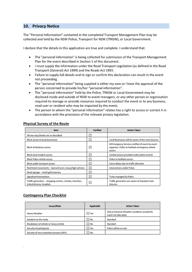
LTF0925(2) Item 5 Traffic Management Plan for the 2025 Balmain New Year's Eve Event (Baludarri-Balmain Ward/ Balmain Electorate/ Leichhardt PAC) 64
LTF0925(2) Item 6 Shaw Street at Belgrave Street, Petersham - Proposed 'STOP' control and kerb extensions/blisters (Damun-Stanmore Ward/Newtown Electorate/Inner West PAC) 106
Parking Matters
ITEM Page
LTF0925(2) Item 7 Newtown Enmore Parking Review Study 114
LTF0925(2) Item 8 Holbeach Avenue, Tempe - Proposed timed parking restrictions (Midjuburi-Marrickville Ward/Heffron Electorate/Inner West PAC) 176
LTF0925(2) Item 9 Unnamed laneway (rear of Church Street and Warren Road), Marrickville (Midjuburi-Marrickville Ward/Summer Hill Electorate/Inner West PAC) 179
LTF0925(2) Item 10 Sydenham Station Parking Study 183
Late Items
Nil at time of printing.
6 Part B - Items for Information Only
Nil at the time of printing.
7 Part C - Items for General Advice
Nil at the time of printing.
8 General Business
9 Close of Meeting
|
|
Local Transport Forum Meeting 15 September 2025 |
Minutes of Meeting held on 18 August 2025
Meeting commenced at 11:00 AM
ACKNOWLEDGEMENT OF COUNTRY BY CHAIRPERSON
I acknowledge the Gadigal and Wangal people of the Eora nation on whose country we are meeting today, and their elders past and present.
FORUM REPRESENTATIVES PRESENT
|
Liz Atkins |
Councillor – Damun - Stanmore Ward (Chair) |
|
Bill Holliday |
Representative for Kobi Shetty MP, Member for Balmain |
|
Graeme McKay |
Representative for Jo Haylen MP, Member for Summer Hill |
|
Miriama Tamata |
Representative for Jenny Leong MP, Member for Newtown |
|
Vinoth Srinivasan |
Transport for NSW (TfNSW) |
|
Anthony Mifsud |
Transport for NSW (TfNSW) |
|
Van Le |
Transport for NSW (TfNSW) |
|
Colin Jones |
Representative for Inner West Bicycle Coalition (IWBC) |
|
Julius Villanueva |
Representative for Transit Systems |
|
Manod Wickramasinghe |
IWC’s Traffic and Transport Planning Manager |
|
Sunny Jo |
IWC’s Coordinator Traffic Engineering Services (North) |
|
George Tsaprounis |
IWC’s Coordinator Traffic Engineering Services (South) |
|
Christy Li |
IWC’s Business Administration Officer |
|
|
|
|
VISITORS |
|
|
|
|
|
Vesna Kerr |
Public Speaker – Item 9 |
|
Murray Kerr |
Public Speaker – Item 9 |
|
|
|
|
APOLOGIES: |
|
|
|
|
|
Victor Macri |
Councillor –Midjuburi - Marrickville Ward (Chair) |
|
Todd Leach |
NSW Police – Inner West Police Area Command |
|
Ben Simpson |
NSW Police – Inner West Police Area Command |
DISCLOSURES OF INTERESTS:
Nil.
CONFIRMATION OF MINUTES
|
That the Minutes of the Local Transport Forum held on Monday, 21 July 2025 be confirmed. |
MATTERS ARISING FROM COUNCIL’S RESOLUTION OF MINUTES
Nil.
|
LTF0825(1) Item 3 Junction Road (at Moonbie Street), Summer Hill - Proposed upgrade to new raised pedestrian crossing (Djarrawunang-Ashfield Ward/Summer Hill Electorate/Burwood PAC) |
|
Council is planning to improve safety for pedestrians in Junction Road at Moonbie Street, Summer Hill by converting the existing road level pedestrian crossing to a raised pedestrian crossing together with landscaped kerb blister islands and associated drainage works. The proposal aims to improve pedestrian and motorist safety by better defining safe pedestrian crossing points, improving sight distances, reducing traffic speeds and conflicts with traffic movements at this location.
Officers Recommendation:
That the detailed design plan (10343) to up-grade an existing road level crossing to a proposed new raised pedestrian crossing, with associated kerb blister islands, drainage works, signs and line marking in Junction Road at Moonbie Street, Summer Hill (as shown in Attachment 1) be approved.
DISCUSSION:
No advice provided by LTF members.
RECOMMENDATION:
That the detailed design plan (10343) to up-grade an existing road level crossing to a proposed new raised pedestrian crossing, with associated kerb blister islands, drainage works, signs and line marking in Junction Road at Moonbie Street, Summer Hill (as shown in Attachment 1) be approved.
|
General Business
|
Item 10 – Changes to the Local Traffic Committee to the Local Transport Forum |
|
A Representative for Transport for NSW (TfNSW) Anthony Mifsud came to provide the forum members with a presentation of the changes to the Local Transport Forum.
It was noted that • The 2025 Instrument replaces the 2011 Delegation to Councils and the 2023 Temporary Delegation • Councils have more options when regulating traffic and using prescribed traffic control devices • Councils can simplify their practices if (and when) they choose • ‘Local Traffic Committee’ is replaced by ‘Local Transport Forum’
Key changes from the 2011 Delegation to Councils • Local Traffic Committee is renamed Local Transport Forum (LTF) to better reflect its purpose/function • In many cases, councils can manage their network (unclassified roads and all regional roads), including for events, without prior LTF review • Councils can sub-delegate functions to staff • Traffic Management Plans are no longer required at LTF • Regional Traffic Committee has been discontinued • Restrictions relating to ‘nominated’ train stations have been discontinued • Simplified rules for use of portable traffic control lights and roadwork speed limit signs • Pre-approvals or advance expressions of support are not required from Council in order to refer to LTF
Consultation and referral of proposals • Generally, Council may decide which proposals to send to the LTF for advice or coordination • Prior referral to the LTF is only required where: - regulation of traffic exceeds 6 months in duration - public transport is negatively affected for more than 24 hours • For proposals affecting buses, consultation with bus operators is required • Transport and NSW Police must be given 7 days’ notice of on-road public events
Local Transport Forum (LTF) • Core membership is unchanged: Council, Transport, Police, local Member(s) of NSW Parliament • Bus operators may be given a standing invite or invited where relevant proposals are on agenda • Council has discretion to invite any others as observers or participants • There is no voting and no requirement for unanimity
Resolving disagreement • Councils are responsible for decisions on their network • Transport may issue a ‘Statement of Concern’ following discussion at the LTF; this will document risks and make time (up to 14 days) for further discussion • In rare cases, serious disagreements can be managed under existing legislation |
|
Item 11 – Update on the safety review on College Street, Balmain to determine whether a ‘Bicycles excepted’ sign could be implemented into the One-way proposal. |
|
The Representative for the Member for Balmain requested an update on the safety review on College Street, Balmain to determine whether a ‘Bicycles excepted’ sign could be implemented into the One-way proposal. Council Officers advised that the minutes are waiting for Council decision at the upcoming Council meeting, and that should Council adopt the recommendations, Council Officers will be able to undertake the safety review.
|
|
Item 12 – Lighting at pedestrian crossings |
|
The Representative for the Inner West Bicycle Coalition questioned if there were any mandates for minimum lighting at pedestrian crossings as he noticed that at night, the visibility of pedestrians using the crossings are diminished especially when pedestrians wear darker coloured clothing. Council Officers advised that there are requirements for pedestrian crossing to be floodlit on each approach and that Council usually review this when upgrading the pedestrian crossing. Council Officers requested that the Representative for the Inner West Bicycle Coalition forward the locations of the pedestrian crossings of concern for Council to investigate.
|
|
Item 13 – Review of ‘Bicycles Excepted’ signs on ‘One Way’ streets in the LGA. |
|
The Representative for the Member of Balmain requested that a review of ‘Bicycle Excepted’ signs on ‘One Way’ streets in the LGA be undertaken. Council Officers requested the Representative for the Member of Balmain to send through a list of streets he would like Council to review for potential ‘Bicycles Excepted’ signs.
|
Meeting closed at 12.19pm.
CHAIRPERSON
Councillor Liz Atkins
|
|
Local Transport Forum Meeting 15 September 2025 |
Minutes of Meeting held on 1 September 2025
Meeting commenced at 11:02 AM
ACKNOWLEDGEMENT OF COUNTRY BY CHAIRPERSON
I acknowledge the Gadigal and Wangal people of the Eora nation on whose country we are meeting today, and their elders past and present.
FORUM REPRESENTATIVES PRESENT
|
Victor Macri |
Councillor –Midjuburi - Marrickville Ward (Chair) |
|
Vinoth Srinivasan |
Transport for NSW (TfNSW) |
|
Van Le |
Transport for NSW (TfNSW) |
|
Bushara Gildies |
Representative for Transdev John Holland |
|
Colin Jones |
Representative for Inner West Bicycle Coalition (IWBC) |
|
Manod Wickramasinghe |
IWC’s Traffic and Transport Planning Manager |
|
George Tsaprounis |
IWC’s Coordinator Traffic Engineering Services (South) |
|
Jason Scoufis |
IWC’s Coordinator Traffic Investigations & Road Safety |
|
Christy Li |
IWC’s Business Administration Officer |
|
|
|
|
VISITORS |
|
|
|
|
|
Nil. |
Nil. |
|
|
|
|
APOLOGIES: |
|
|
|
|
|
Liz Atkins |
Councillor – Damun - Stanmore Ward |
|
Todd Leach |
NSW Police – Inner West Police Area Command |
|
Miriama Tamata |
Representative for Jenny Leong MP, Member for Newtown |
|
|
|
DISCLOSURES OF INTERESTS:
Nil.
CONFIRMATION OF MINUTES
|
That the Minutes of the Local Transport Forum held on Monday, 18 August 2025 be confirmed. |
MATTERS ARISING FROM COUNCIL’S RESOLUTION OF MINUTES
Nil.
General Business:
|
Item 2: Request for angled parking in Dickson Street, Newtown. |
|
The Chairperson raised concerns from residents regarding the lack of parking in Dickson Street, Newtown, and the surrounding streets and requested a review of angled parking on Dickson Street. Council Officers advised that a report regarding the Newtown, Enmore Parking Study is being submitted to the September LTF for advice and that in the report, one of the recommendations is to implement 90-degree angled parking in Dickson Street, Newtown subject to consultation.
|
|
Item 3: Request for ‘No Parking’ in Homewood Lane, Newtown. |
|
The Chairperson raised concerns from a resident regarding difficulty accessing their property due to cars parked across their driveway in Homewood Lane, Newtown. Council Officers advised that they will investigate the matter and consult the neighbouring properties regarding a proposed ‘No Parking’ zone near the affected property.
|
|
Item 4: Parking Studies for Summer Hill |
|
The Representative for the Inner West Bicycle Coalition questioned if there were plans to review parking in Summer Hill and noted there was a lack of high-turnover parking for residents and customers wishing to stop by the post office or run errands. Council Officers advised that as the shopping centre in Summer Hill is moderately sized, the current one-hour parking restrictions would be more suitable compared to half-hour parking, as people often make multiple stops within the shopping centre.
|
Meeting closed at 11.23 am.
CHAIRPERSON
Councillor Victor Macri
|
|
Local Transport Forum Meeting 15 September 2025 |
Subject: Murray Street at Smidmore Street, Marrickville – Proposed raised pedestrian crossing and Refuge islands - Design Plan 10344-A (Midjuburi-Marrickville Ward / Summer Hill Electorate / Inner West PAC)
Prepared By: Jennifer Adams - Traffic Engineer
Authorised By: Manod Wickramasinghe - Traffic and Transport Planning Manager
|
RECOMMENDATION
That the detailed design plan for the proposed raised pedestrian crossing and refuge islands in Murray Street at Smidmore Street, Marrickville and associated signs and line markings (as per Design Plan No.10344-A) be APPROVED. |
STRATEGIC OBJECTIVE
This report supports the following strategic directions contained within Council’s Community Strategic Plan:
|
2: Liveable, connected neighbourhoods and transport |
EXECUTIVE SUMMARY
Council is planning to improve safety for pedestrians and motorists in Murray Street and Smidmore Street, Marrickville by converting the existing at-grade pedestrian crossing in Murray Street to a raised pedestrian crossing and reinstate various refuge islands and new kerb blisters in Murray Street and Smidmore Street. The proposal aims to improve pedestrian and motorist safety by better defining safe pedestrian crossing points, improve sight lines, reduce traffic speeds and conflicts with traffic movements at this location.
BACKGROUND
This report details the design plan for the improvement works and its related consultation results. It is noted that the original community consultation plan has subsequently been slightly amended by widening the raised pedestrian crossing and amending sign locations from the mountable islands. These works are programmed and envisaged to be constructed in the 2025/2026 financial year, subject to funding.
FINANCIAL IMPLICATIONS
The project is listed on Council’s 2025/2026 PAMP Capital Program for construction and estimated cost is $90,000. Project number is 303563.
OTHER STAFF COMMENTS
The following works are proposed and are illustrated on the attached Consultation Plan (Plan No. 10334). The proposed works aim to improve pedestrian safety by better defining the safe pedestrian crossing points and addresses concerns for pedestrian safety and driver behaviour at this location.
Specifically, the proposed scope of work includes the following:
· Construct a new raised concrete pedestrian crossing, with “gutter bridges” comprising heel safe grating to provide safe access over existing kerb and guttering to the new raised pedestrian crossing. Tactile indicators will also be provided either side of the new raised pedestrian crossing;
· Construct landscaped kerb blister islands on both sides of the road (Murray Street) adjacent to the new raised pedestrian crossing. Landscaping to be a suitable species of native grasses (subject to final design);
· Reinstate existing concrete refuge islands in Murray Street and Smidmore Street as shown on the plan;
· Demolish existing median island in Murray Street and construct new concrete mountable median as shown on the plan;
· Construct new landscaped kerb blisters islands in Murray Street and Smidmore Street (at intersection) to provide safe pedestrian crossing around existing kerb ramps and refuge islands as shown on the plan;
· Reconstruct sections of damaged asphalt with new asphalt at intersection and around raised pedestrian crossing (as shown on the plan);
· Remove existing kerb ramps near new pedestrian crossing in Murray Street and reinstate with concrete footpath;
· In Murray Street and Smidmore Street: adjust the existing signs ‘No Stopping’, ‘Pedestrian Crossing’, Keep Left’, ‘Roundabout’ and ‘Buses No Entry’; provide new ‘Keep Left’ signs and Chevron signs (refer to the plan);
· Install signage and line marking associated with the works as required and where shown on the Plan.
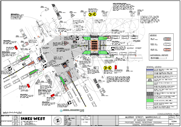
The community consultation plan was subsequently slightly amended by making the pedestrian crossing wider and removing signage from the mountable median islands.
Amendments to original Design Plan 10344 made are detailed and illustrated below (Plan – 10344-A):
· Raised pedestrian crossing made wider from 6.8 metres to 7.4 metres to accommodate more width for heavy vehicle access
· ‘Keep Left’ signage removed from mountable island for safety reasons
· ‘Buses No Entry’ sign relocated from mountable island for safety reasons.
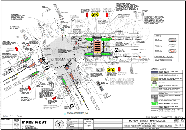
Parking changes
The works include adjusting the existing ‘No Stopping’ signs in Murray Street and Smidmore Street to accommodate implementation of the new raised pedestrian crossing and reinstatement of the prior refuge islands. Three existing on-street parking spaces will be lost in Murray Street and one on-street space will be lost in Smidmore Street. Thus, a total of 4 on-street parking spaces will be lost with the new works. The remainder of the works will generally be within the existing ‘No Stopping’ zones in Murray Street and Smidmore Street as indicated on the design plan.
Streetlighting
The existing street lighting at the location is deemed adequate for the raised pedestrian crossing. Therefore, no changes are proposed to the existing street lighting due to the works.
PUBLIC CONSULTATION
Consultation was conducted between 24 July 2025 and 15 August 2025. A letter along with a copy of the design plan was sent to residents / businesses in the immediate locality. A total of 28 letters were distributed.
There was one response. The resident complained that there are large, articulated trucks, lorries, and semi-trailers that use Murray Street on an hourly basis for loading dock (2) at the Marrickville Metro and that these are a constant presence, and hindrance to safety for pedestrians at the existing at-grade pedestrian crossing. Noting that when trucks double parked sightlines for pedestrians at the crossing were restricted and when trucks do 3 point turns in the street safety issues are compounded. The resident queried the cost effectiveness of raising the pedestrian crossing and losing valuable on-street parking and also requested better measures to be put into place for the parking of delivery lorries and trucks on the street.
Council’s Design Engineer separately responded to the resident’s comments and concerns noting that the proposed works to provide a raised pedestrian crossing together with landscaped kerb blister islands will improve safety for pedestrians by slowing traffic speeds, improving visibility and narrowing the overall crossing distance in the road. This together with the improved pedestrian refuge islands at the roundabout will have a positive impact overall on safety for pedestrians. Also, that some issues raised were compliance issues and out of the scope of the project.
CONCLUSION
It is recommended that the detailed design plan of the proposed raised pedestrian crossing and reinstatement of various refuge islands and new kerb blisters in Murray Street and Smidmore Street, Marrickville and associated signs and line markings be supported to improve road safety at this location.
|
1.⇩ |
303563-10344-A - Murray Street at Smidmore Street Marrickville |
|
Local Transport Forum Meeting 15 September 2025 |
Subject: Gannon Street, Tempe – Pedestrian Crossing Review (Midjuburi-Marrickville Ward /Summer Hill Electorate /Inner West LAC)
Prepared By: Jennifer Adams - Traffic Engineer
Authorised By: Manod Wickramasinghe - Traffic and Transport Planning Manager
|
RECOMMENDATION
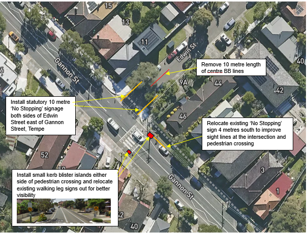
1. That the installation of small kerb blisters either side of the Gannon Street, Tempe pedestrian crossing be supported in principle and included in Council’s Traffic Facilities Forward Works Program.
2. That statutory 10 metre ‘No Stopping’ restrictions be installed on both sides of Edwin Street east of Gannon Street, Tempe
3. That the existing 10 metre length of BB-lines in Edwin Street east of Gannon Street, Tempe be removed.
4. That the existing ‘No Stopping’ sign on the northern side of Gannon Street just east of the existing raised pedestrian crossing be relocated 6 metres southward so as to be compliant with the 10 metre ‘No Stopping’ zone after the crossing (departure side) in accordance with relevant Australian Standards, Austroads Guides and TfNSW Standard Supplements and Technical Directions to maintain clear visibility for pedestrians and motorists.
5. That Council’s Public Trees team be requested to investigate whether the tree outside No.40 Gannon Street, Tempe requires pruning to improve sightlines for both motorists and pedestrians at the existing raised pedestrian crossing.
|
STRATEGIC OBJECTIVE
This report supports the following strategic directions contained within Council’s Community Strategic Plan:
|
2: Liveable, connected neighbourhoods and transport |
EXECUTIVE SUMMARY
At the Council Meeting held 20 May 2025 a Notice of Motion (NoM) regarding the Gannon Street Pedestrian Crossing was considered. It noted that the raised pedestrian crossing on Gannon Street at Edwin Street, Tempe continues to pose a significant risk to pedestrians and requested that a review of safety at the crossing be conducted and that further ways to improve pedestrian and road user safety at the crossing be considered. This report provides the outcome of the review and recommends various regulatory signage changes and works in addition to possible pruning works.
BACKGROUND
At the Council meeting held on 20 May 2025, Council resolved the following:
1. That Council note the raised pedestrian crossing on Gannon Street at Edwin Street continues to pose a significant risk to pedestrians.
2. That Council review safety at the crossing and consider further ways to improve pedestrian and road user safety at the crossing.
3. That Council report back to the Inner West Council Local Traffic Committee no later than September 2025 with options to improve pedestrian safety at this location.
This report provides an outcome of the requested review of safety at the subject pedestrian crossing.
DISCUSSION
Local road network
Gannon Street is a local road which functions similarly to a regional road. It has an average daily traffic volume of around 13,000 vehicles per day. Light thoroughfare restrictions apply in the street. Two speed humps are present in the street in addition to the raised pedestrian crossing which slows vehicle speeds and the 85th percentile speed averages around 44 km/h.
Although Gannon Street, between Princes Highway and Unwins Bridge Road, carries in excess of 10,000 vehicles per day, there are no recorded incidence of crashes occurring in the vicinity of the subject crossing or at the intersection of Gannon Street and Edwin Street, Tempe in the last five years of TfNSW recorded crash data.
Crash history / road safety investigation
The most recent TfNSW recorded crash data map (reproduced below) reveals no crashes in Gannon Street at Edwin Street, Tempe and one motorcycle incident in 2021 at the bend in Gannon Street when the vehicle lost control while travelling eastward at the speed hump.
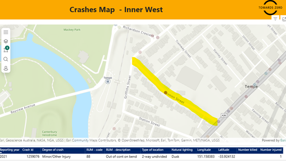
It is noted that in 2014 one injury crash did occur near the vicinity of the crossing. It was a rear end incident when two vehicles travelling east impacted, possibly when a pedestrian was on or approaching the crossing. Nonetheless, Council has often been approached regarding pedestrian safety at the crossing.
Pedestrian crossing facility history
The subject pedestrian crossing on Gannon Street, Tempe south of its junction with Edwin Street has been in place since 1997. In 2012 the previous ‘at-grade road level’ marked pedestrian crossing was replaced with a raised platform to enhance the crossing. The height of the platform was limited by the need for buses to traverse Gannon Street. It should be noted also that Council did consider the use of kerb blisters and a central refuge for the site to reduce the crossing distance and provide a central storage area however, driveways and other site constraints prevented the implementation of these features.

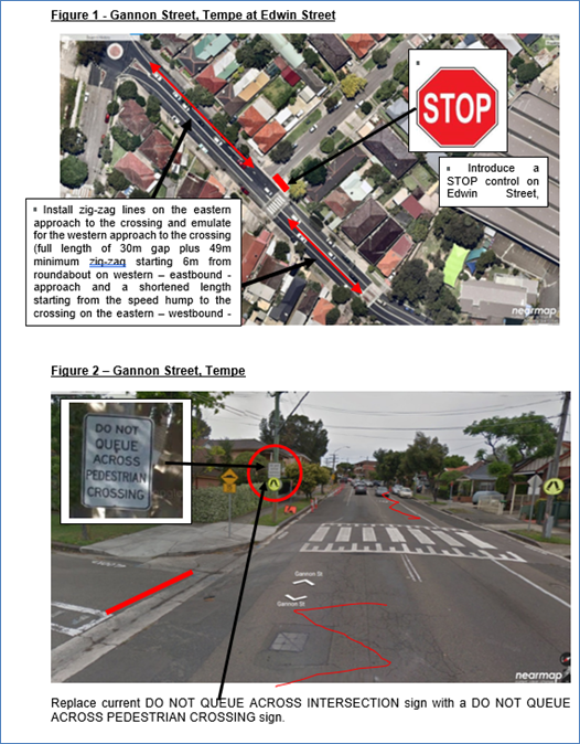
In 2016 concerns were raised regarding the incidences of motorists failing to observe the pedestrian crossing on Gannon Street, Tempe adjacent to Edwin Street. The safety concerns were investigated, and in a report to the Local Traffic Committee (10 March 2016 – Item A1.1) it was proposed that ‘zig-zag’ lines be installed on both approaches to the crossing in an effort to provide additional warning to approaching motorists and that a Stop control be installed on Edwin Street at Gannon Street to deter motorists exiting the street at speed and compromising pedestrian safety at the crossing.
Also, other minor changes to existing signage were identified to be undertaken to further enhance pedestrian safety at the existing raised zebra pedestrian crossing. These changes are identified in Figure 1 and 2 reproduced below.
It was determined that the introduction of a STOP control on Edwin Street, Tempe at its intersection with Gannon Street will help in reducing the incidence of motorists exiting Edwin Street at speed. On site it was observed that turning motorists tended to focus their vision/attention to the west in order to judge gaps in the westbound traffic flow on Gannon Street and by doing so, they may fail to notice pedestrians on or entering the crossing.
The introduction of zig-zag marking on both approaches to the subject crossing alerts motorists to expect to encounter pedestrians and aid in reducing motorists’ speeds as they approach the crossing.
2025 Safety Review
Recent site inspections have confirmed that all signage for the crossing complies with appropriate standards and is considered satisfactory. Renewal of crossing markings have recently been completed providing much improved delineation.
However, travelling westward (down-hill) from Princes Highway to Unwins Bridge Road a large tree outside No.40 Gannon Street on the southern side blocks the pedestrian sign at the crossing until a motorist is literally 15 metres from the crossing itself.
|
|
|
|
|
|
|
|
The tree’s location poses a safety risk in obstructing visibility at the pedestrian crossing for both motorists and pedestrians and Council’s Public Trees team will be requested to investigate the extent of any pruning necessary at the location (the tree outside No.40 Gannon Street, Tempe). Regular maintenance and pruning of trees around pedestrian crossings is crucial to ensure signs remain visible and unobstructed.
A further site visit by Council’s Traffic Manager and Officers revealed that if the signage were relocated into the line of sight more the situation would be improved. Prior to the raised crossing being installed in 2012 the previous at-grade pedestrian crossing had kerb blisters which allowed the pedestrian signage to be further out in the line of sight for motorists travelling in either direction. Refer to the diagrams below.
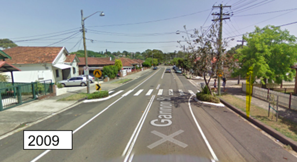
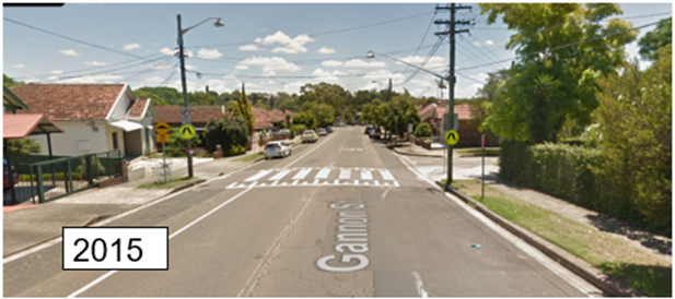
The installation of small kerb blisters either side of the pedestrian crossing is considered feasible and would enable the existing walking leg signs to be relocated out for better visibility.
The site inspection also raised the question of whether statutory 10 metre ‘No Stopping’ restrictions should be signposted in Edwin Street at its junction with Gannon Street, Tempe. At present there is a raised median treatment on Edwin Street and then a 10-metre length of BB-lines. A number of cars were parked contrary to the Road Rules by being within 3 metres of the BB-lines. Installing the ‘No Stopping’ signage and removing the length of BB—lines would improve the safety at the intersection.
The site inspection also revealed that the existing ‘No Stopping’ sign on the northern side of Gannon Street just east of the existing raised pedestrian crossing is 4 metres from the crossing and needs to be relocated 6 metres southward so as to be compliant with the 10 metre ‘No Stopping’ zone after the crossing (departure side) in accordance with relevant Australian Standards, Austroads Guides and TfNSW Standard Supplements and Technical Directions to maintain clear visibility for pedestrians and motorists.
Specifically, Transport for New South Wales Technical Directions for Stopping and Parking restrictions at intersections and crossings TDT 2002/12c requires the implementation of No Stopping restrictions 20 metres on approach to the crossing and 10 metres on departure.
After various options at the pedestrian crossing were considered, local residents were subsequently notified of the above suggested changes, and their feedback is summarised below.
PUBLIC CONSULTATION
A consultation letter was sent out on 21 August 2025 to owners and occupiers of properties in the local area regarding the proposal of several road safety improvements for pedestrians and motorists at the intersection of Gannon Street at Edwin Street, Tempe. Refer to the diagram below. The closing date was 5 September 2025. Fifty (50) letters were distributed.
Resident Survey findings
A total of two (2) responses were received both generally in support of the road safety improvements.
One resident in support noted that if feasible could the speed humps and pedestrian crossing be painted different colours to distinguish between them. Both types of traffic facility devices are regulated by design standards, so this is not an option. The resident also queried whether the previous ‘KEEP CLEAR’ markings at Unwins Bridge Road and Tramway Street, Tempe can be reinstated. Reinstatement is not feasible as due to operational issues at the signalised intersection of Unwins Bridge Road / Richardsons Crescent the “KEEP CLEAR” at Edgar Street only was retained as per the approved plan and recommendation by Council and RMS in 2016.
The other resident was pleased to hear Council was improving safety around that pedestrian crossing. However, noted that the proposed 10 metre ‘No Stopping’ restrictions in Edwin Street were “excessive” and requested that they be reduced to 3-4 metres. In response it is noted that the proposal illustrates the inclusion of statutory ‘No Stopping’ restrictions at the intersection of Edwin Street east of Gannon Street, Tempe in order to deter illegal parking, improve access for turning motorists and increase safety. This does not result in the loss of any legal on-street parking spaces in Edwin Street and is in line with the statutory ‘No Stopping’ zones at intersections as per the requirements of NSW Road Rules. This rule is in place for road safety to ensure clear sightlines and access, and it applies automatically unless a specific parking control sign permits otherwise.
The resident also requested the removal of the ‘No Right Turn’ restriction from Gannon Street into Edwin Street, Tempe. The ‘No Right Turn’ restriction has been in place prior to 2000s and was relocated to the northern side of Gannon Street from the southern side in 2016 after an independent Road Safet Audit was conducted at the crossing. It is recommended that the restriction stays in place as there are alternative routes residents can access the street.
FINANCIAL IMPLICATIONS
The costs of installing ‘No Stopping’ signage in Edwin Street, removal of the existing BB-lines in Edwin Street and the and relocation of the existing ‘No Stopping’ sign in Gannon Street can be funded from Council’s signs and line marking budget.
The installation of small kerb blisters at the crossing will be listed for funding in Council’s forward traffic facilities program.
CONCLUSION
Whilst all essential signage and road markings are in position, it is recommended that minor adjustments be made at the location to improve road safety for all road users. This includes installing two small kerb blisters either side within the raised pedestrian crossing platform to relocate the pedestrian crossing signage further out into the line of sight for motorists. Installing statutory 10 metre ‘No Stopping’ restrictions in Edwin Street at Gannon Street and also relocating the existing ‘No Stopping’ sign on the northern side of Gannon Street just east of the existing raised pedestrian crossing 6 metres southward so as to be compliant with relevant Standards. Council’s Tree Section will be requested to undertake a site inspection and arrange for the tree outside No.40 Gannon Street, Tempe to be pruned as necessary to improve sightlines for both motorists and pedestrians at the existing raised pedestrian crossing.
Nil.
|
|
Local Transport Forum Meeting 15 September 2025 |
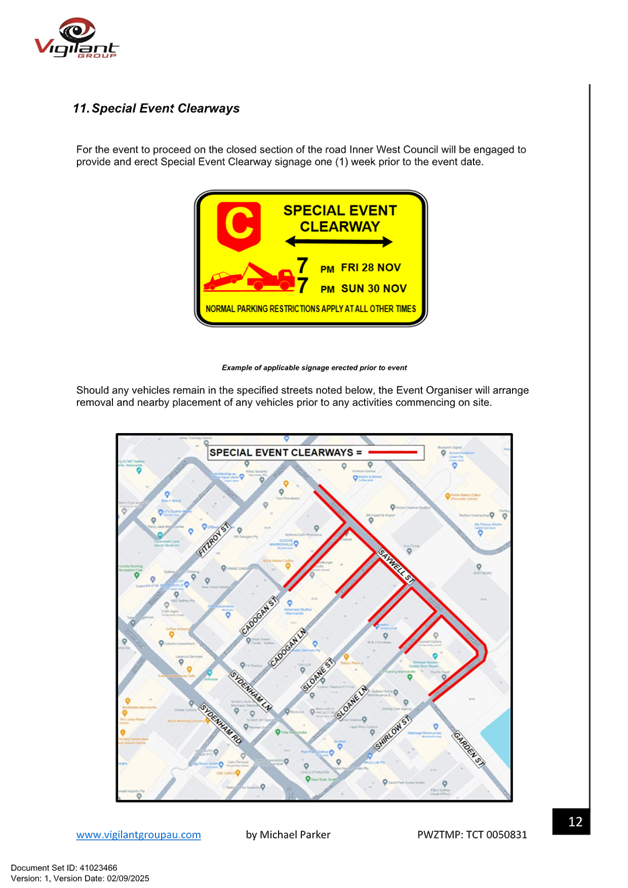
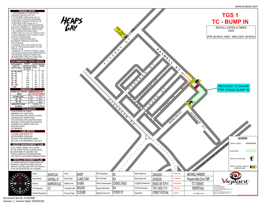
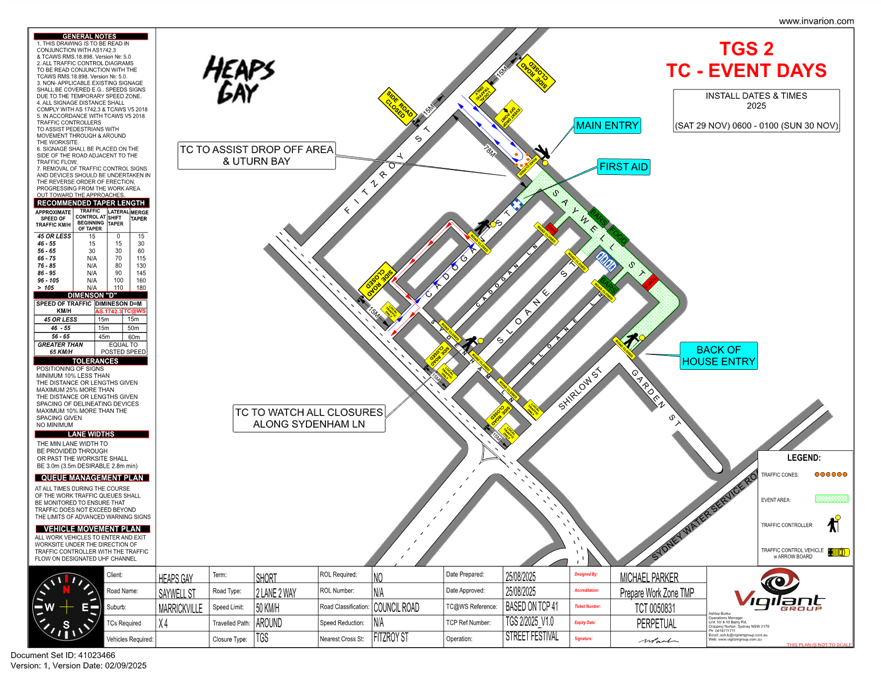
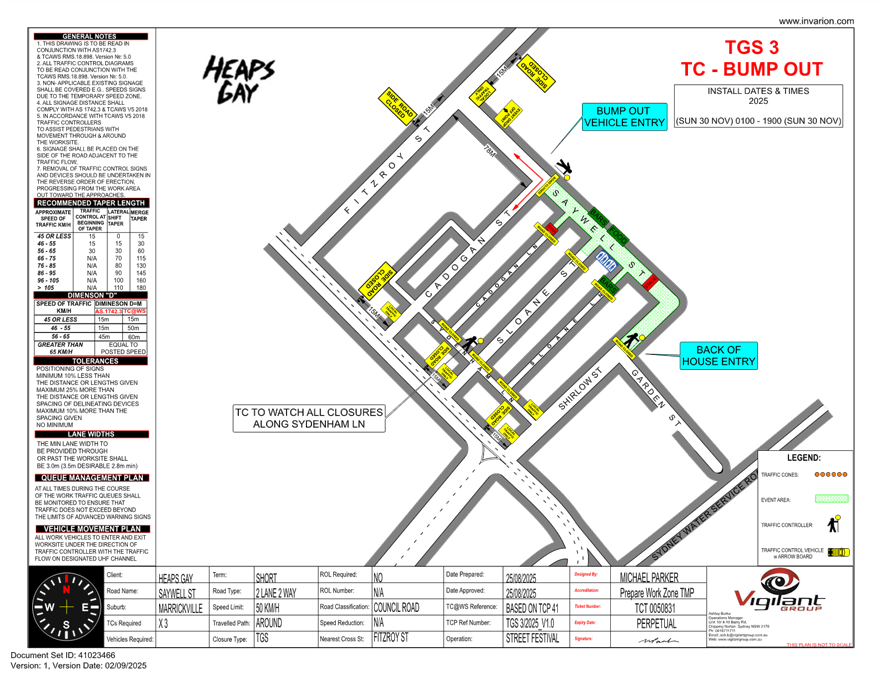
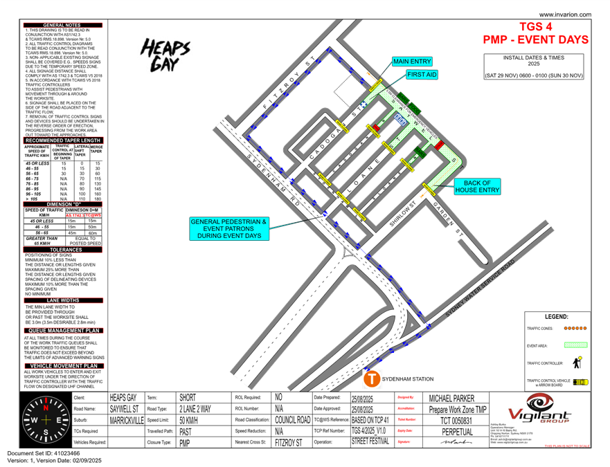
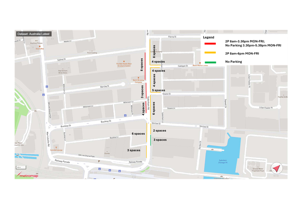
Subject: Saywell Street, Marrickville – Temporary full road closure for Heaps Gay Street Festival 2025 – Saturday 29 November 2025 (Midjuburi-Marrickville Ward / Summer Hill Electorate / Inner West PAC)
Prepared By: Jennifer Adams - Traffic Engineer
Authorised By: Manod Wickramasinghe - Traffic and Transport Planning Manager
|
RECOMMENDATION
That the proposed temporary full road closure (permitting local access where possible) of Saywell Street between Cadogan Street and Shirlow Street, Marrickville from 7.00pm Friday 28 November to 7pm Sunday 30 November 2025 be APPROVED, subject to the approval of the S68 Application and the applicant complying with, but not limited to, the following conditions:
a) All affected residents and businesses, including NSW Police Local Area Commander, Transit Systems, Fire and Rescue NSW and NSW Ambulance Services, shall be notified in writing by the applicant of the proposed temporary road closure at least 7 days prior to the event, with the applicant making reasonable provision for residents and businesses;
b) A minimum four (4) metres unencumbered passage be available for emergency vehicles through the closed sections;
c) The occupation of the road carriageway must not occur until the road has been physically closed; and
d) The applicant be advised in terms of this report and that all costs for the event and implementation of the road closure are to be borne by the applicant.
|
STRATEGIC OBJECTIVE
This report supports the following strategic directions contained within Council’s Community Strategic Plan:
|
2: Liveable, connected neighbourhoods and transport |
EXECUTIVE SUMMARY
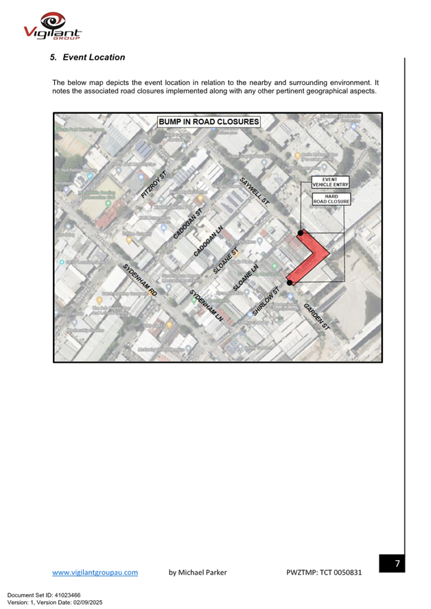
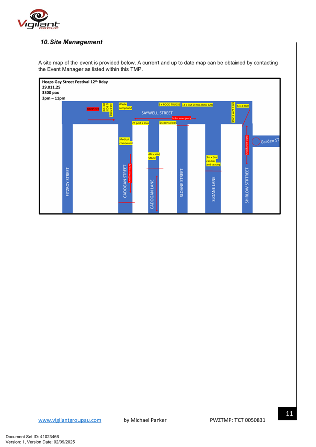
Council has received an application under Section 68 of the Local Government Act 1993 to use Saywell Street, Marrickville to hold a street party style event for the community, known as ‘Heaps Gay Street Festival', on Saturday 29 November 2025 between the hours of 2pm and 11pm. The erection of the stage, stalls and associated works will include the temporary full-road closures of Saywell Street, Marrickville between Cadogan Street and Shirlow Street from 7:00pm Friday 28 November 2025 to 7pm Sunday 30 November 2025. The closure includes partial closure of adjoining streets also including Cadogan Lane, Sloane Street and Sloane Lane and a Drop off loop via Fitzroy Street.
It is recommended that Council endorse the temporary full road closure of Saywell Street, Marrickville between Cadogan Street and Shirlow Street from 7:00pm Friday 28 November 2025 to 7pm Sunday 30 November 2025 subject to the applicant complying with the conditions within this report; and advice of the proposed event being forwarded to the appropriate stakeholders and authorities including emergency services.
BACKGROUND & DISCUSSION
Council has received an application under Section 68 of the Local Government Act 1993 to use Saywell Street, Marrickville to hold a street party style event for the community, known as ‘Heaps Gay Street Festival', on Saturday 29 November 2025 between the hours of 2pm and 11pm.
The erection of the stage, stalls and associated works will include the temporary full-road closures of Saywell Street, Marrickville between Cadogan Street and Shirlow Street from 7:00pm Friday 28 November 2025 to 7pm Sunday 30 November 2025.
The ‘Heaps Gay Street Festival’ is a community event with family friendly music and entertainment and a number of licenced food and beverage stalls. The event will aim to attract approximately 3,000 attendees, staff and performers to the area on the day.
OFFICER COMMENTS
Site location & road network
|
Street Name |
Saywell Street |
Shirlow Street |
|
Section |
Shirlow Street to Cadogan Street |
Saywell Street to Garden Street |
|
Carriageway Width (m) |
7.3 |
5.5 |
|
Carriageway Type |
Two-way road with one travel lane in each direction, in addition to kerbside parking lanes. |
One-way road with one travel lane with north-eastbound traffic flow. |
|
Classification |
Local |
Local |
|
85th Percentile Speed (km/h) |
- |
33.1 |
|
Vehicles Per Day (vpd) |
- |
492 |
|
Reported Crash History (July 2019 – June 2024) |
No crashes recorded |
No crashes recorded. |
|
Heavy Vehicle Volume (%) |
- |
13.8 |
|
Parking Arrangements |
Both sides of the road consist of unrestricted parking. |
North side of the road consists of unrestricted parking. South side has ‘No Parking’ restrictions. |
The Applicant has advised that Saywell Street will be closed to traffic thoroughfare (permitting local access where possible) so the event can successfully occur and has supplied a TMP. (Attachment 1).
Primary Traffic Control
The following traffic control measures are diagrammatically shown and detailed in the Traffic
Guidance Scheme (TGS) titled:
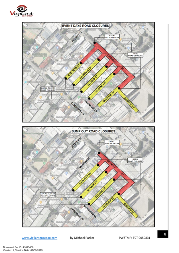
• TGS 1 - Bump In - Friday 28 November 2025 Saturday 29 November 2025 (1900) to (0600) - Road closure of Saywell Street (Between Sloane Lane and Shirlow Street):
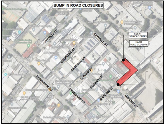
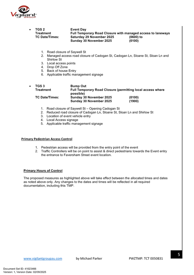
• TGS 2 - Event Day - Saturday 29 November 2025 Sunday 30 November 2025 (0600) to (0100) - Road closure of Saywell Street. Managed access road closure of Cadogan Street, Cadogan Lane, Sloane Street, Sloan Lane, Shirlow Street Local access points drop off zone.
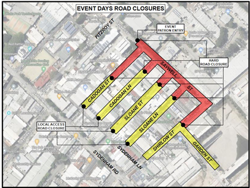
• TGS 3 - Bump Out - Sunday 30 November 2025 Sunday 30 November 2025 (0100) (1900) - Road closure of Saywell Street – Opening Cadogan Street, reduced road closure of Cadogan Lane Sloane Street, Sloan Lane and Shirlow Street.
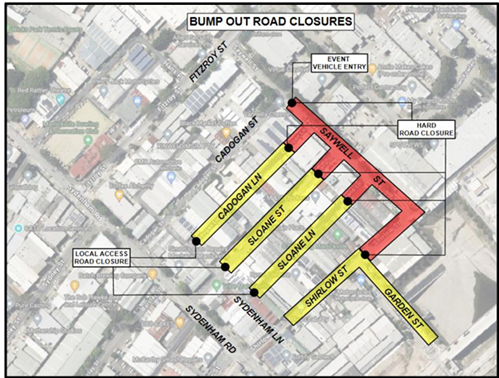
The applicant will liaise closely with the businesses on Saywell Street to ensure they will not require access over the proposed weekend. However, if they do require access, the applicant can facilitate this between the hours of 6am and midday via Saywell on any days required.
Site layout will be as shown in the diagram reproduced below:
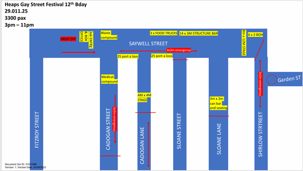
The main entrance to the event site for attendees will be from Fitzroy Street. Emergency access will be from both Saywell and Shirlow Streets. All emergency routes will be manned by security, regularly checked for obstructions and will be lit in periods of darkness.
Directional signage to the event will be provided in the surrounding streets and at Sydenham train station. The event site and all access pathways will be illuminated in periods of darkness for safety and security reasons. All contractors will be given a schedule for arrival and departure in order to prevent congestion on site and ensure the smooth running of the work program.
A 4-metre wide emergency vehicle access must be maintained through the closed road areas during the course of the event. Special Event advance notice signs will be strategically installed at least two (2) weeks prior to the event to alert motorists of the proposed closures. In addition, 'No Parking - Special Event' signs will be affixed over all existing parking signs within the area of the event on the evening of the day prior to the event date.
Impacts on Parking and Vehicular access
The proposed road closure will have an impact on approximately 60 plus on-street carparking spaces along both sides of Saywell Street during the event. Given that Saywell Street abuts mainly industrial/commercial properties the on-street parking demand on the weekends is significantly lower than weekdays. It should be noted that there are three residential properties in Shirlow Street, and these properties will have access during the temporary road closure period. Access through the rear of these properties in Sloane Lane will still be retained during that weekend. In September 2019 all adjoining residential and commercial properties have been notified by the applicant of the proposed event and regarding parking and access needs to their properties so they can be accommodated by the applicant.
Impacts on traffic
Saywell Street carries a low volume of traffic and therefore the diverted traffic will have no major impacts on the surrounding road network. The event will be held on the weekend when lower than weekday traffic volumes are expected.
Public Transport
Saywell Street is not a bus route. The subject site has access to public transport services, with Sydenham Railway Station being located within a 200-metre radius of the site and bus routes (Route M30, 418, 425) operating along Marrickville Road, Railway Parade and Gleeson Avenue.
FINANCIAL IMPLICATIONS
All works and costs of implementation will be borne by the applicant.
PUBLIC CONSULTATION
The applicant is to notify all affected residents and businesses in writing at least 7 days prior to the commencement of work. A draft copy of the notification letter is attached at the end of this report.
The proposed road closures have been advertised on Council’s website in accordance with the Roads Act 1993.
|
1.⇩ |
ENPY/2025/0004,ENRC/2025/0058 - - TMP - Heaps Gay - Marrickville 2025 |
|
Local Transport Forum Meeting 15 September 2025 |
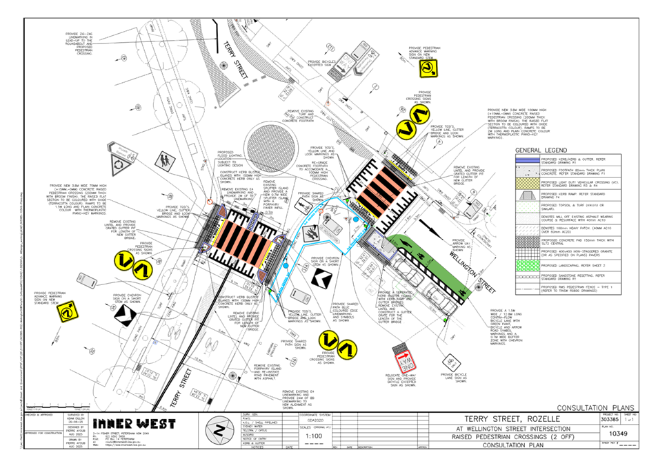
Subject: Wellington Street and Terry Street, Rozelle - Proposed New Raised Pedestrian Crossing (Baludarri-Balmain Ward/ Balmain Electorate/ Leichhardt PAC)
Prepared By: Charbel El Kazzi - Traffic Engineer
Authorised By: Manod Wickramasinghe - Traffic and Transport Planning Manager
|
RECOMMENDATION
That the attached detailed design plan (Design Plan 10349) for the raised pedestrian crossings and bicycle lane at the intersection of Wellington and Terry Street, Rozelle be approved.
|
STRATEGIC OBJECTIVE
This report supports the following strategic directions contained within Council’s Community Strategic Plan:
|
2: Livable, connected neighborhoods and transport |
EXECUTIVE SUMMARY
This proposal will not have an impact on existing parking arrangements in the street.
BACKGROUND
The need for this project was identified in the Rozelle North Local Area Traffic Management Study in 2022. The swimming school located at the intersection of Terry and Wellington Street generates significant pedestrian traffic with desired lines as shown in Figure 1. The intersection currently has inadequate pedestrian access, which does not provide suitable protection for pedestrians crossing the road. Further to this, the pedestrian flow is not organised and potentially creates obstacles to a high number of vehicular movements in this area. The current layout of this intersection has been a source of concern from the community with the risk of pedestrian and vehicle incidents from all approaches of the intersection.
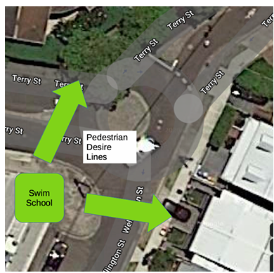
Figure 1: Swimming School and Pedestrian Desire Lines at Terry and Wellington Streets, Rozelle
The detailed design plan shown in Attachment 1 outlines the proposed works on Wellington and Terry Street, Rozelle and includes the following:
· Construct new raised concrete pedestrian crossings with “gutter bridge” crossings and concrete kerb blister islands
· Construct a median island attached to the new raised pedestrian crossing in Terry Street
· Modify the existing kerb blister island in Wellington Street to accommodate the new pedestrian crossing
· Replace existing lintels with elongated gutter grates where applicable, to accommodate the new gutter bridges
· Install a new green contraflow on-road bicycle lane with bicycle and arrow symbols
· Construct a separated kerb blister island with integrated kerb ramp
· Provide blue shared path linemarking and symbols as shown on the plans
· Install Zig-zag linemarking in Terry Street on approach to the new pedestrian crossings
· Install and relocate associated signage and road markings associated with the works as required.
DISCUSSION
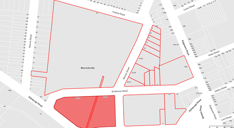
A letter outlining the proposal was issued to the properties shown within the below distribution map below. At the time of this report no submissions were received in response to this proposal.
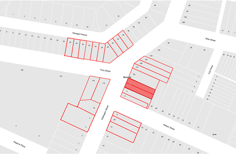
Figure 2: Distribution Map
FINANCIAL IMPLICATIONS
The works are expected to cost approximately $130,000 and are to be funded under Council’s Capital Works Program to be completed in the 2025/26 financial year.
|
1.⇩ |
Terry and Wellington Street, Rozelle - Detailed Design Plan |
|
|
Local Transport Forum Meeting 15 September 2025 |
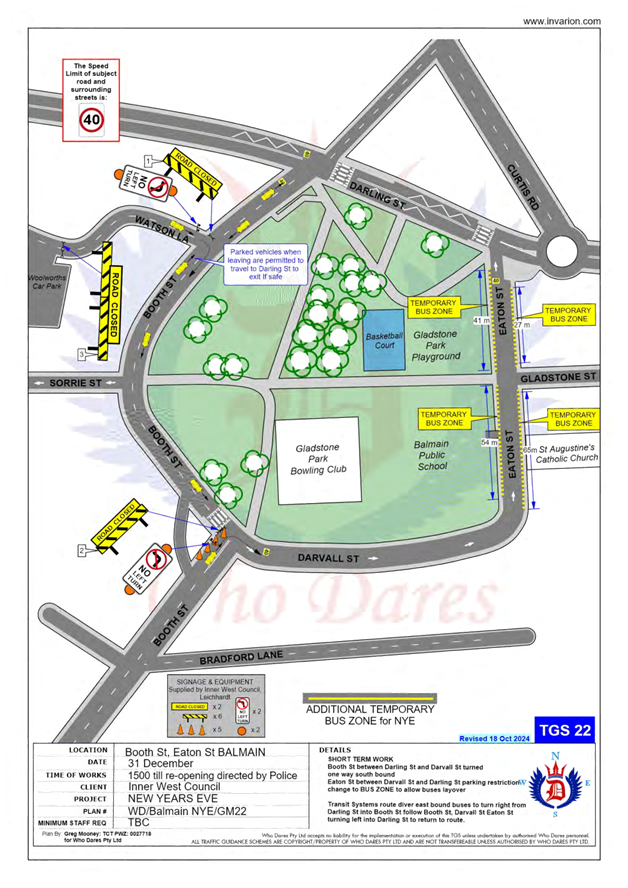
Subject: Traffic Management Plan for the 2025 Balmain New Year's Eve Event (Baludarri-Balmain Ward/ Balmain Electorate/ Leichhardt PAC)
Prepared By: Amir Falamarzi - Traffic Engineer
Authorised By: Manod Wickramasinghe - Traffic and Transport Planning Manager
|
RECOMMENDATION
1. That the Traffic Management Plan (Attachment 1) detailing the traffic arrangements for the 2025 Balmain New Year’s Eve be supported.
2. That the Traffic Management Plan (Attachment 1) be forwarded to Council’s Parks and Streetscapes Coordinator, Transport Management Centre and the Major Events & Incidents Group (NSW Police).
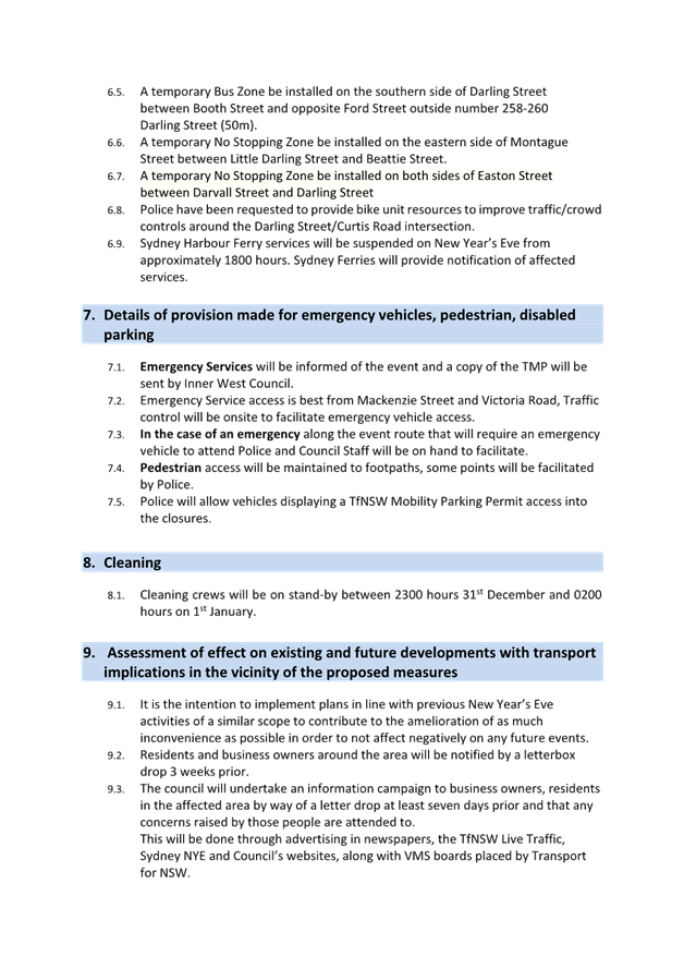
3. That a temporary ‘No Stopping’ zone be installed on the eastern side of Montague Street between Darling Street and Beattie Street, Balmain.
4. That the following temporary modifications to bus stops be approved:
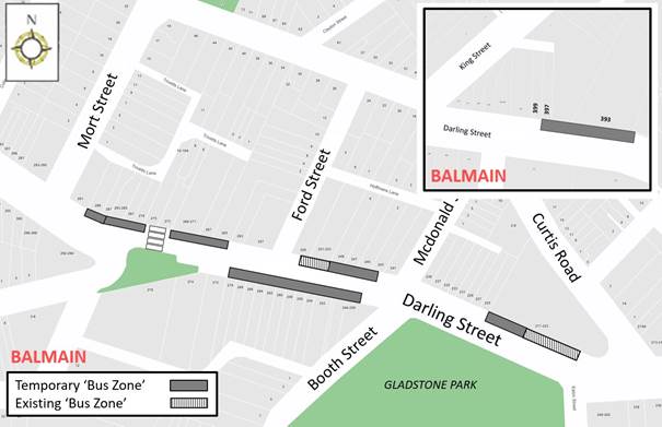
a) On the northern side of Darling Street: i. Install temporary ‘Bus Zones’ between Mort Street and Ford Street. ii. Extend the ‘Bus Zone’ between Ford Street and McDonald Street. iii. Extend the ‘Bus Zone’ between McDonald Street and Curtis Road, outside Nos.217-223 Darling Street.
b) On the southern side of Darling Street: i. Install a temporary ‘Bus Zone’ between Booth Street and Beattie Street, outside No. 244-270 Darling Street.
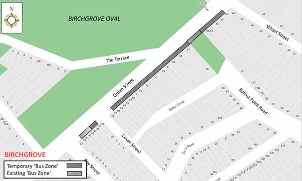
c) On the eastern side of Grove Street: i. Install a temporary ‘Bus Zone’ between Wharf Road and Bay Street, Birchgrove.
d) on Eaton Street i. Install a temporary 27m and 41m length ‘Bus Zone’ between Darling Street and Gladstone Street on the east and west side respectively; ii. Install a temporary 65m and 54m length ‘Bus Zone’ between Gladstone Street and Darvall Street on the east and west side respectively;
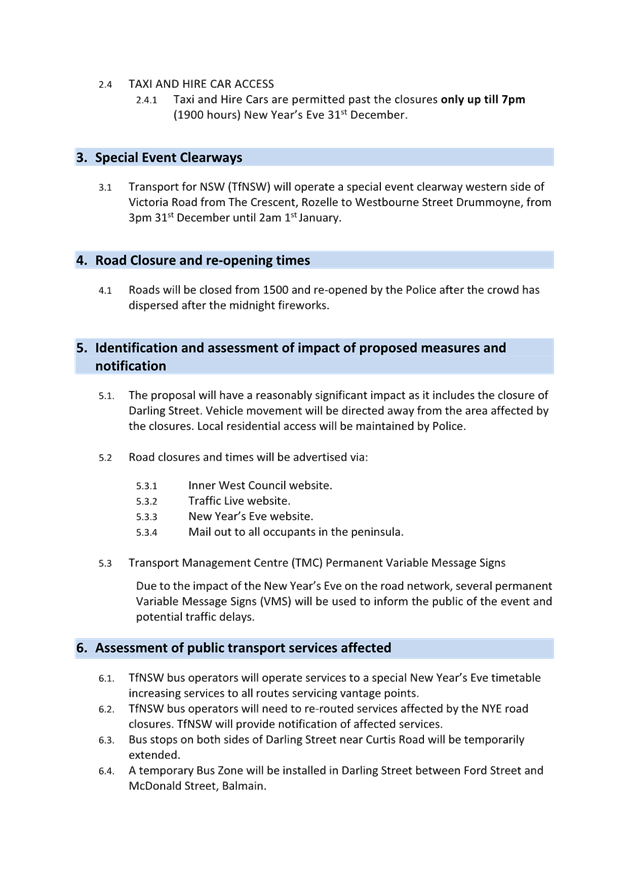
5. That it be noted that taxi / hire car access to the Peninsula will be restricted from 7:00pm.
6. That the NSW Taxi Council be advised of the Committee’s recommendation. |
STRATEGIC OBJECTIVE
This report supports the following strategic directions contained within Council’s Community Strategic Plan:
|
2: Liveable, connected neighbourhoods and transport |
EXECUTIVE SUMMARY
This report outlines the traffic management plan for the 2025 New Year’s Eve event.
BACKGROUND
As part of the annual New Year’s Eve celebrations, Inner West Council implements a Traffic Management Plan to support NSW Police operations in the Balmain Peninsula.
Matters that were addressed last year:
|
Stakeholders Comments |
Officer Comments |
|
Lack of an emergency access route during the Balmain NYE was highlighted by NSW ambulance during a joint meeting with the stakeholders involved in Balmain NYE.
It was raised that emergency vehicles to access the Balmain Peninsula need to use the roads manned by NSW Police officers. As a result, these vehicles have to queue along the above roads with other vehicles, which can significantly affect their response time.
|
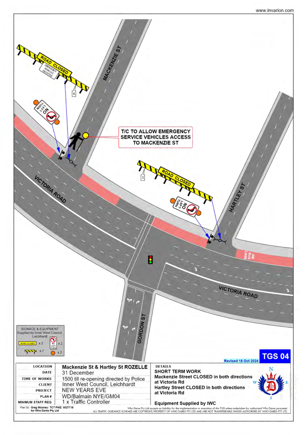
To address the issue a meeting was held with representatives from Council’s Traffic Team, Council’s Event Team, NSW Police, NSW Ambulance.
It was proposed that emergency vehicles access the Balmain Peninsula via Mackenzie Street, turning right into Mansfield Street and then turn left into Mullens Street. As part of Balmain NYE traffic management plan, the intersection of Mackenzie Street and Victoria Road will be barricaded.
In this regard, a traffic controller will be stationed at the intersection of Mackenzie Street and Victoria Road to maintain the access of emergency vehicles. In addition, the existing Traffic Guidance Scheme (TGS) at the above intersection was modified to include a traffic controller and an ‘EMERGENCY VEHICLES EXCEPTED’ sign will be installed on the existing road barricade. |
|
NSW Police and Transit Systems raised safety issues with crowds conflicting with buses turning around at the roundabout at Darling Street and Curtis Road. |
To address the issue, the existing TGS was modified and as part of that it was proposed to utilise Booth Street, Darvall Street and Eaton Street as a turning route back to Darling Street. In this regard, traffic on Booth Street between Darling Street and Darvall Street, will be temporarily adjusted to discourage northbound movements
In addition, on-street parking spaces on both sides of Eaton Street, between Darling Street Darvall Street, will be temporarily replaced by Bus Zone restrictions from 3pm New Year’s Eve until 3am New Year’s Day. |
DISCUSSION
Traffic Management
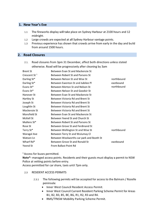
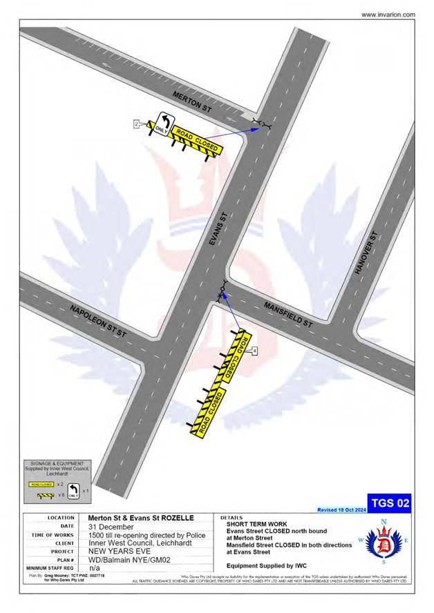
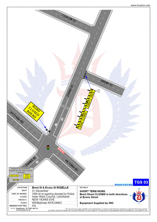
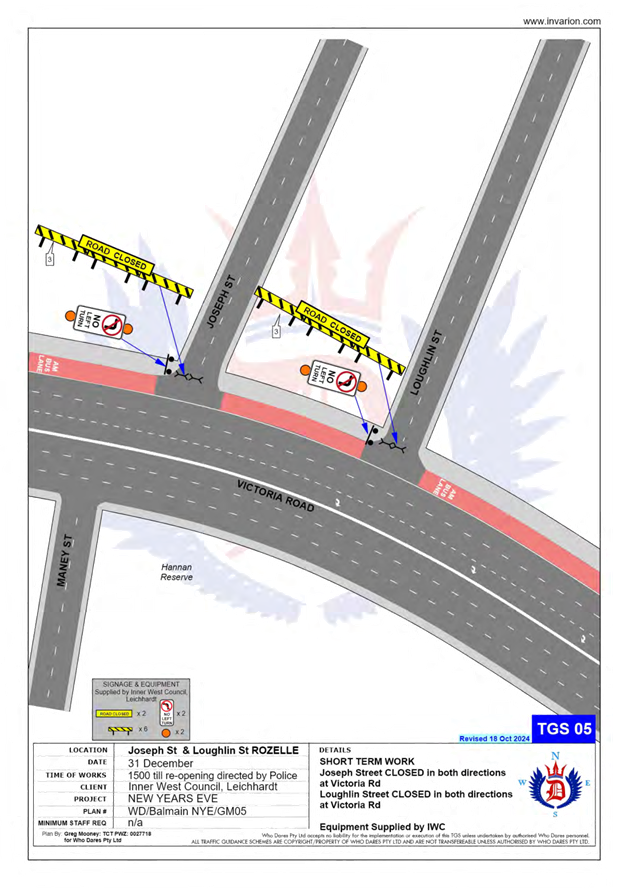
The following roads will be closed to all vehicular traffic between 3:00pm Wednesday, 31 December 2025 and 12:00am on Thursday, 1 January 2026 to cater for the New Year’s Eve celebrations:
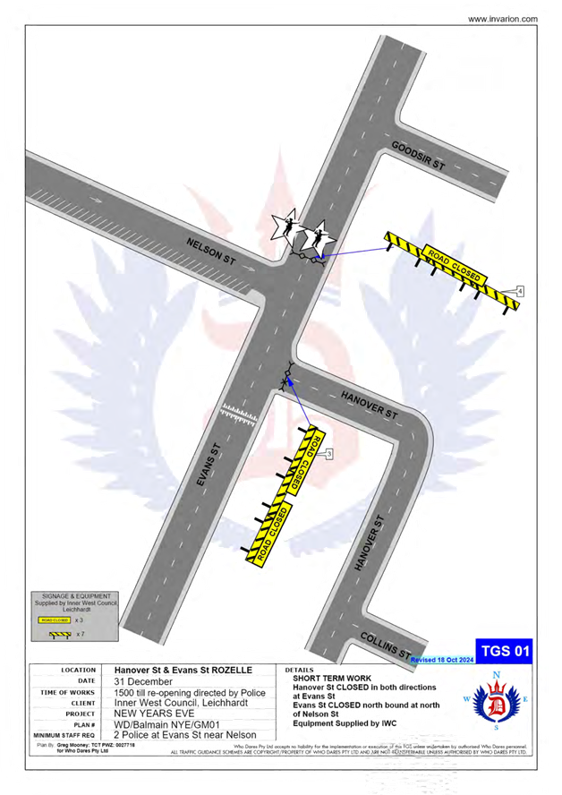
· Brent Street at Evans Street intersection, Rozelle (both directions).
· Mansfield Street at Evans Street intersection, Rozelle (both directions).
· Hanover Street at Evans Street intersection, Rozelle (both directions).
· Mackenzie Street at Victoria Road intersection, Rozelle (both directions).
· Hartley Street at Victoria Road intersection, Rozelle (both directions).
· Joseph Street at Victoria Road intersection, Rozelle (both directions).
· Loughlin Street at Victoria Road intersection, Rozelle (both directions).
· Crescent Street at Robert Street intersection, Rozelle (both directions).
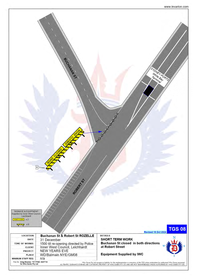
· Buchanan Street at Robert Street intersection, Balmain (both directions).
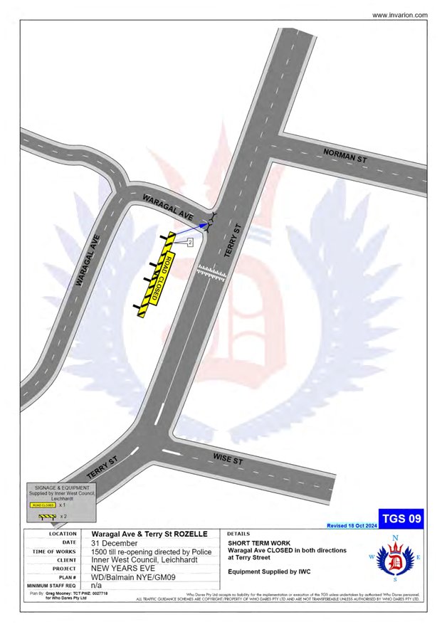
· Waragal Avenue at Terry Street intersection, Rozelle (both directions).
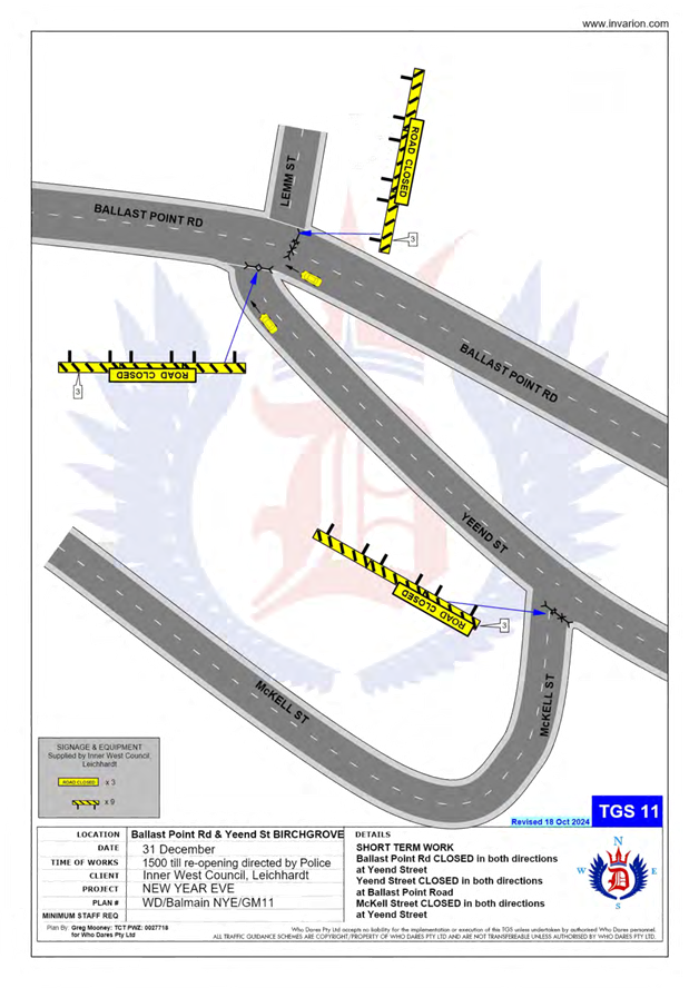
· McKell Street at Yeend Street intersection, Birchgrove (both directions).
In addition, the following roads will be closed to all vehicular traffic except State Transit Authority/Transit Systems buses, Taxis, Hire Cars and Balmain Access Permit holders and will be manned by NSW Police officers between 3:00pm Wednesday, 31 December 2025 and 12:00am on Thursday, 1 January 2026:
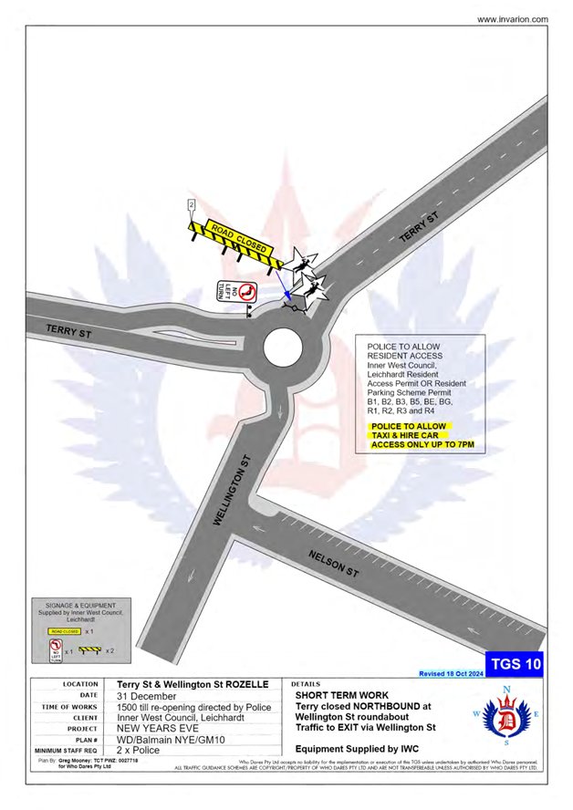
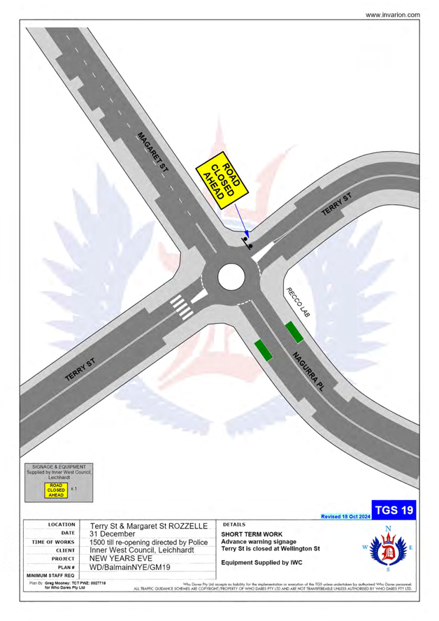
· Terry Street at Wellington Street intersection, Rozelle (northbound direction).
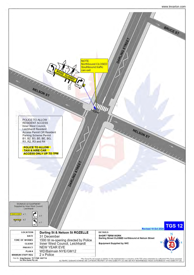
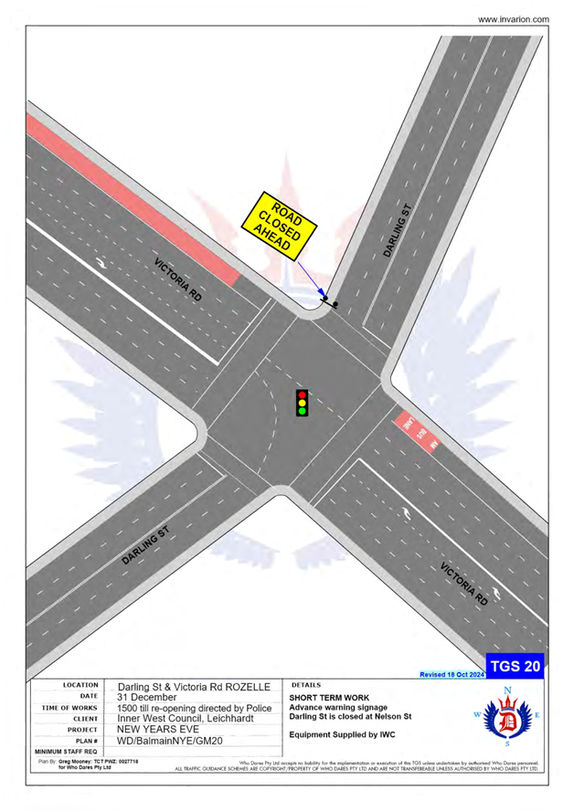
· Darling Street at Nelson Street intersection, Rozelle (northbound direction).
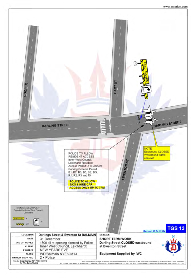
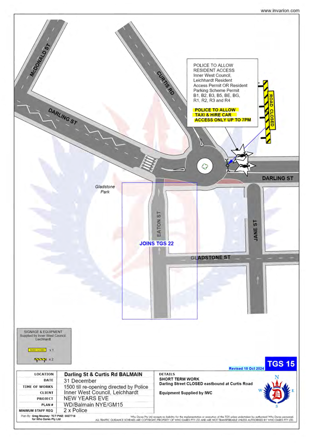
· Darling Street at Ewenton Street intersection, Balmain (eastbound direction).
· Evans Street at Merton Street intersection, Rozelle (northbound direction).
· Evans Street at Nelson Street, Rozelle (both directions).
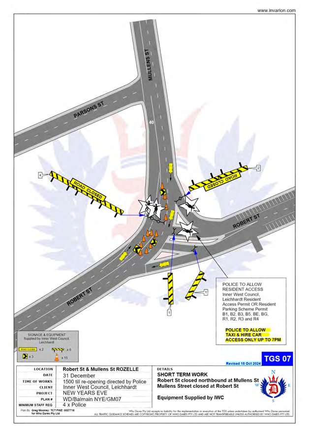
· Mullens Street at Robert Street intersection, Rozelle (both directions).
· Ballast Point Road at Lemm Street-Yeend Street intersection, Birchgrove (south and eastbound directions).
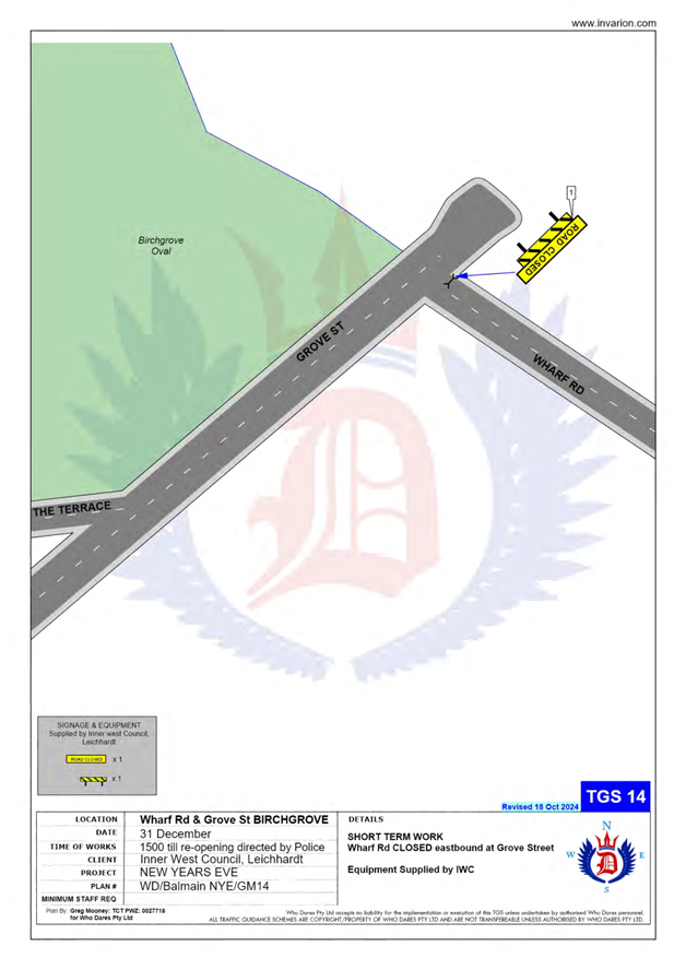
· Wharf Road at Grove Street intersection, Birchgrove (eastbound direction).
· Robert Street at Crescent Street, Rozelle (northbound direction).
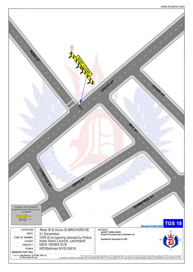
· Grove Street at Rose Street, Birchgrove (eastbound direction).
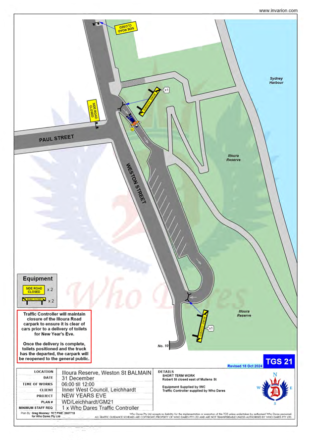
The following plan indicates the road closure points:
A Traffic Management Plan including Traffic Control Plans outlining the above road closures and the bus route changes is attached in Attachment 1.
Taxi and Hire Car Access
As per previous years, taxi and hire car access will be restricted after 7pm to minimise traffic congestion in the peninsula and improve pedestrian safety. Taxis and hire cars will therefore need to use the following drop-off point locations:
· Entering Terry Street - In the unrestricted parking on the eastern side of Terry Street or ‘Bus Zone’ and timed kerbside parking along Wellington Street.
· Entering Darling Street - In the ticket parking areas along Darling Street and Nelson Street.
· Entering Robert Street – In the restricted parking area and ‘Bus Zone’.
Public Transport Access
Transit Systems will be scheduling additional services into the Balmain peninsula to cater for the New Year’s Eve celebrations.
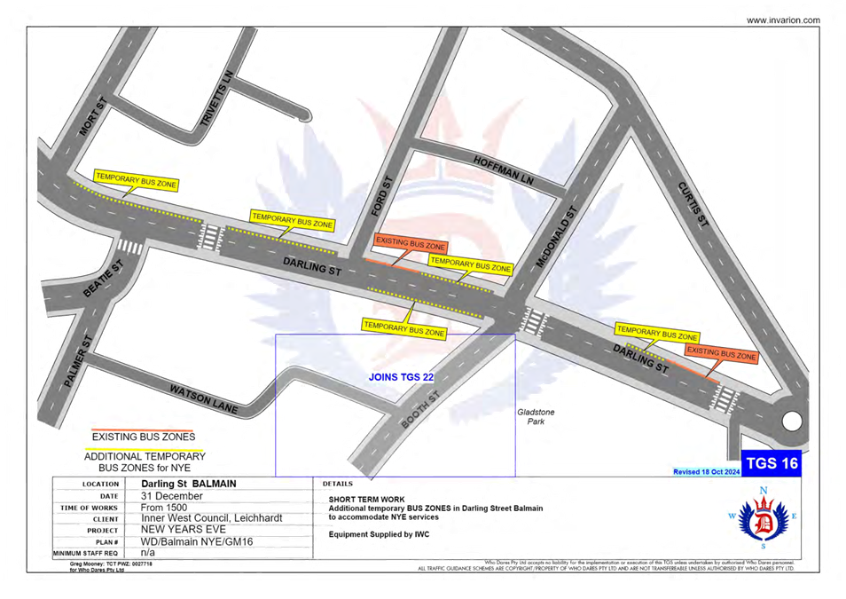
As such, temporary ‘Bus Zones’ will be installed at the following locations:
· Darling Street and the existing ‘Bus Zones’ on Darling Street between Mort Street and Curtis Road, Balmain.
· Eastern side of Grove Street between Wharf Road and Bay Street, Birchgrove.
The ‘Bus Zones’ on Grove Street will be used by Transit Systems and the Police to store buses on New Year's Eve. This is required for the safe bump out of the general public from Birchgrove as identified from a debrief from a previous New Year's Eve event conducted in the Balmain Peninsular.
The signs defining the temporary restrictions be in place after 12 Noon on 31 December 2025 and will be removed the following day.
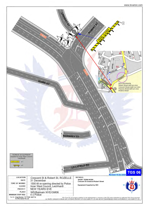
In addition, to avoid delays at the Robert Street/Mullens Street intersection (which is a Police check point), buses entering Robert Street from Victoria Road are proposed to use Crescent Street and Parsons Street to access Mullens Street (see TCP 06/07 in Attachment 1).
It should be noted that Council will install variable message signs (“Balmain Peninsula is closed”) on the main access roads into Balmain Peninsula a few days in advance of the event;
Bus loop utilising Booth Street and Eaton Street
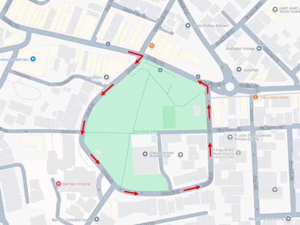
Feedback received from Transit Systems and NSW Police from earlier years indicated that there were some safety concerns at the roundabout of Darling Street and Curtis Road.
Previously buses utilised the roundabout for bus turnarounds during the Balmain New Year’s Eve. Due to the large crowds egressing the peninsula, it was deemed difficult to control crowds from spilling onto the roadway and obstructing buses. Transit Systems and Transport for NSW have advised that this has affected service times and the ability to efficiently move large crowds out of the area.
To address this issue, it was proposed to utilise Booth Street, Darvall Street and Eaton Street as a turning route back to Darling Street. The TGS was modified to temporarily prevent northbound traffic flow in Booth Street at Darvall Street to ensure that Buses can freely circulate without opposing vehicle movements in Booth Street. The route around Gladstone Park is outlined below:
The proposed bus loop arrangement will feature the following:
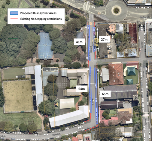
· On-street parking spaces on both sides of Eaton Street, between Darling Street Darvall Street, will be temporarily replaced by Bus Zone restrictions from 3pm New Year’s Eve until 3am New Year’s Day.
· Temporary on-street Bus Zones in Darling Street, between McDonald Street and Mort Street, will continue unchanged to the previous year’s arrangement.
· Traffic on Booth Street between Darling Street and Darvall Street, will be temporarily adjusted to discourage northbound movements in order to improve bus movements. This will include changes at Watson Lane and Booth Street.
· It is estimated that approximately 31 on-street parking spaces on Eaton Street will be temporarily changed to a Bus Zone.
The parking changes in Eaton Street is outlined in the diagram below:
A trial of the bus loop arrangement was undertaken during the last year’s event and no major issues were identified from Transit Systems and NSW Police.
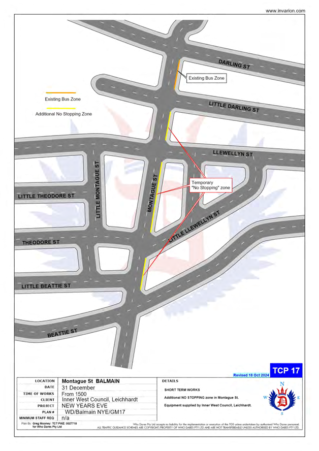
Temporary ‘No Stopping’ Restrictions
Following a previous year’s event, the Sydney Buses representative advised that several vehicles parked on Montague Street out from the kerb thus narrowing the carriageway and preventing buses from passing each other. Therefore, it is proposed to install temporary ‘No Stopping’ zone on the eastern side of Montague Street between Darling Street and Beattie Street. The residents will be advised of this arrangement in advance of the event.
Resident Access
To ensure resident access is maintained, the following permits will be accepted for access to the Balmain / Rozelle peninsula:
· Inner West Council Resident Access Permit.
· Inner West Council current Resident Parking Scheme Permit for Areas; B1, B2, B3, B5, BE, BG, R1, R2, R3 & R4.
· Australian Mobility Parking Scheme permit
NOTIFICATION
The proposed road closures are currently being advertised on Council’s website in accordance with the Roads Act 1993 for a period of 28 days from 1 September 2025 to 29 September 2025. No comments have been received to date.
In December, the details of these traffic arrangements will be re-advertised on Council’s website and via a mail out to all occupants in the Balmain peninsula.
The road closures and other event information will also be available on the Sydney New Year’s Eve Event website.
FINANCIAL IMPLICATIONS
Funding for costs associated with New Year’s Eve including traffic control, notifications and permits have been budgeted for in the 2025-26 operational plan.
|
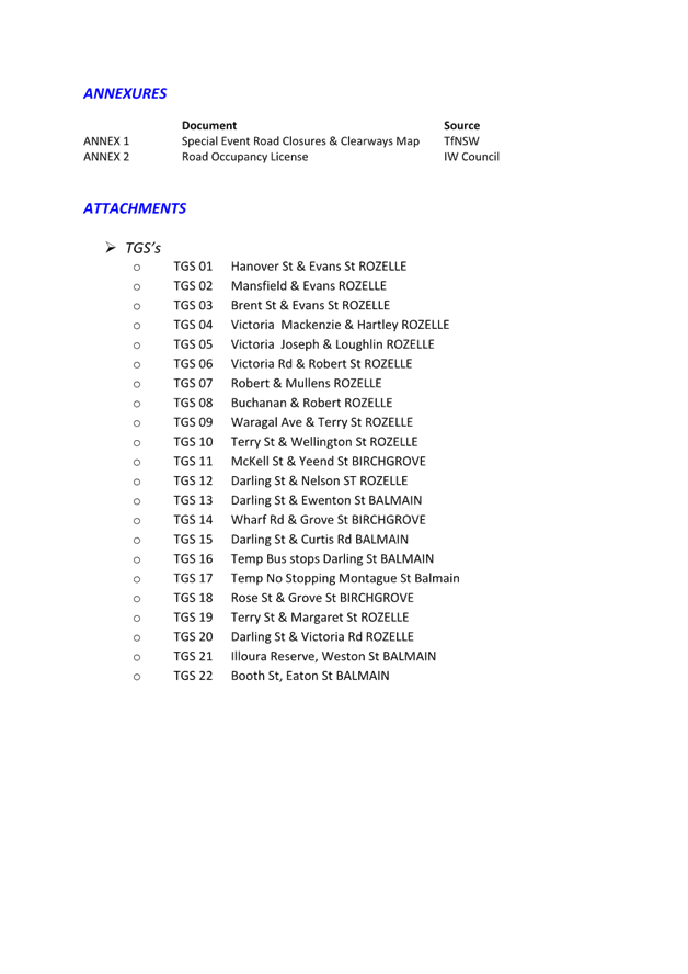
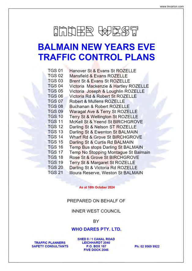
1.⇩ |
New Year's Eve Fireworks. Balmain Peninsular Traffic Management 2025 (version 24.0) |
|
Local Transport Forum Meeting 15 September 2025 |
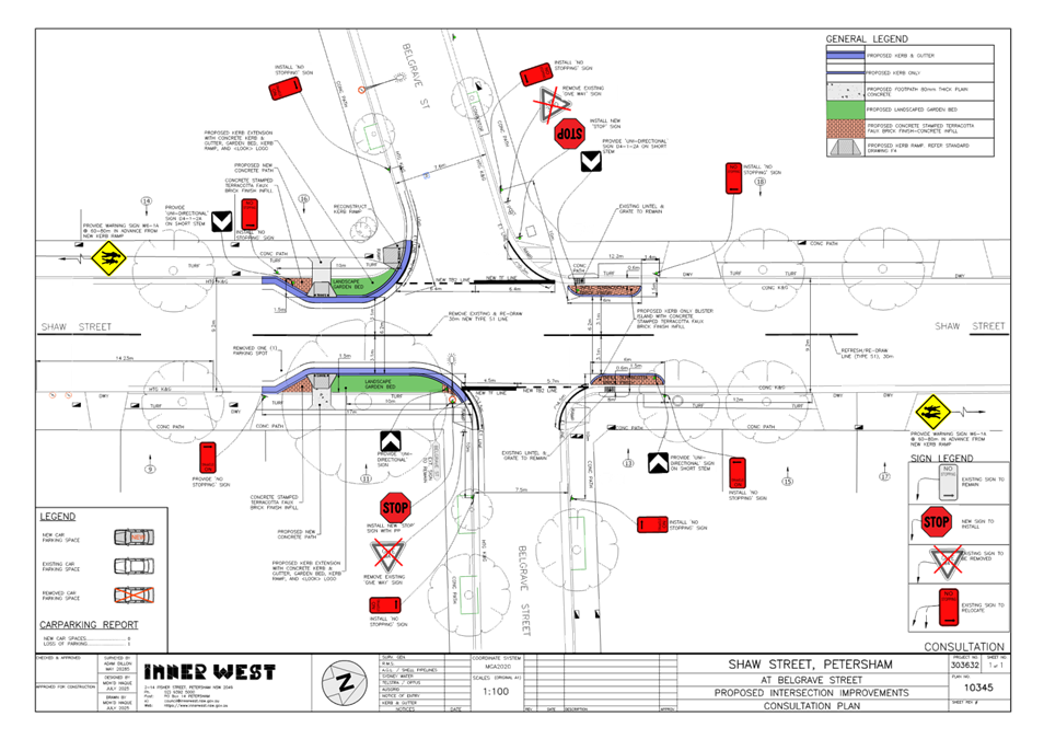
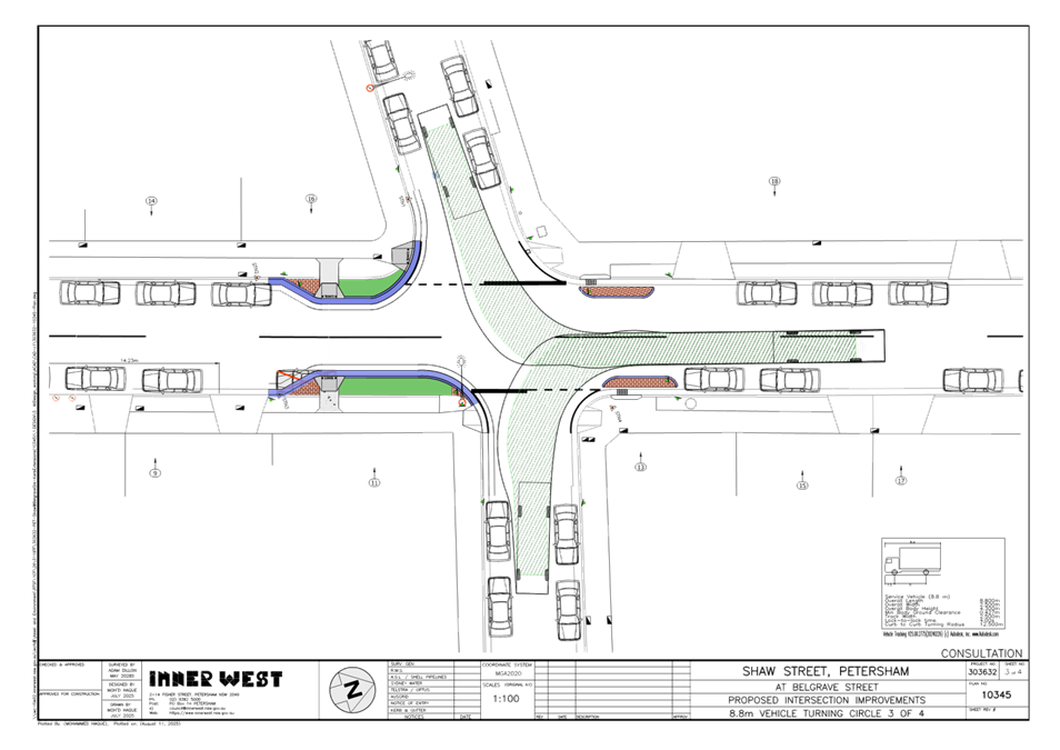
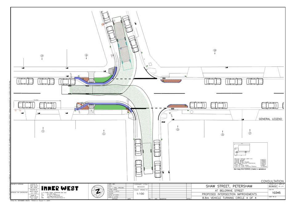
Subject: Shaw Street at Belgrave Street, Petersham - Proposed 'STOP' control and kerb extensions/blisters (Damun-Stanmore Ward/Newtown Electorate/Inner West PAC)
Prepared By: James Nguyen - Traffic Engineer
Authorised By: Manod Wickramasinghe - Traffic and Transport Planning Manager
|
RECOMMENDATION
That the detailed design plan for the proposed ‘STOP’ control, kerb extensions, kerb blisters, kerb ramps, associated signs and line markings on Belgrave and Shaw Streets, Petersham (as per Design Plan No.10345) be approved. |
STRATEGIC OBJECTIVE
This report supports the following strategic directions contained within Council’s Community Strategic Plan:
|
2: Liveable, connected neighbourhoods and transport |
EXECUTIVE SUMMARY
Council is planning to improve safety on Shaw Street, Petersham at Belgrave Street by converting the existing ‘GIVE WAY’ control to ‘STOP’ control and constructing kerb extensions and blisters to reduce vehicle speeds due to a history of crashes at this intersection. There are also new kerb ramps proposed within the kerb extensions to provide a pedestrian facility to cross Shaw Street. This proposal has received construction funding from Transport for NSW under the 2025/2026 Australian Blackspot Program.
BACKGROUND
Council officers have identified a number of similar accidents at the intersection of Belgrave and Shaw Streets, Petersham. Accordingly, a Blackspot funding application was submitted in 2024 to convert an existing ‘GIVE WAY’ control to a ‘STOP’ control and install kerb extensions at the intersection of Shaw Street and Belgrave Street, Petersham due to a reoccurrence of crashes at this intersection at the intersection. Transport for NSW have endorsed Council’s application.
DISCUSSION
The intersection of Belgrave Street at Shaw Street is currently a ‘GIVE WAY’ control treatment, that requires east and westbound motorists on Belgrave Street to yield to motorists on Shaw Street. Shaw Street between New Canterbury Road and Addison Road is a north-south road with high traffic volumes (approximately 10,000 vehicles per day) and has a longitudinal gradient of 10% (sloping downwards in the southbound direction).
Between 1 July 2018 and 30 June 2023 there were six (6) recorded crashes at this intersection, of which four (4) were injury crashes and two (2) were tow-away crashes. Of the four (4) injury crashes, three (3) were cross traffic crashes (RUM 10). These crashes involved motorists travelling eastbound on Belgrave Street colliding with a southbound traffic on Shaw Street.
A Blackspot funding application was submitted in 2024 to convert an existing ‘GIVE WAY’ control to a ‘STOP’ control and install kerb extensions at the intersection of Shaw Street and Belgrave Street, Petersham due to a reoccurrence of crashes at this intersection.
Transport for NSW have endorsed this funding application, and a concept design has been developed by Council’s design engineers. This report details the design plan for those improvement works and its related consultation results.
The following works are proposed and are illustrated on the attached Consultation Plan (Plan No. 10345). The proposed works aim to improve road safety by ensuring motorists ‘STOP’ on Belgrave Street at the intersection of Shaw Street to check for approaching vehicles before crossing the intersection.
Specifically, the proposed scope of works includes the following:
· Convert ‘GIVE WAY’ control sign to a ‘STOP’ control sign (including removal of the give way line and installation of a solid ‘STOP’ line).
· Construct new kerb blisters and kerb extensions on Shaw Street to reduce vehicle speeds and provide a buffer for vehicles on Belgrave Street.
· Install new two (2) new kerb ramps on the proposed kerb extensions on the southern side of Shaw Street to provide a pedestrian facility to cross Shaw Street.
· ‘No Stopping’ restrictions at all corners of the intersection of Shaw and Belgrave Streets.
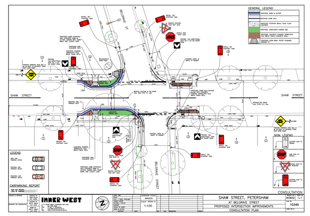
Figure 1 - Concept plan (Plan no.10345)
Parking implications
The proposal will result in the loss of one (1) on-street parking space on the eastern side of Shaw Street, south of Belgrave Street, outside the property of no.11 Shaw Street, Petersham.
Street lighting
The preliminary investigation revealed that there is sufficient intensity of light due to the existing streetlights in the vicinity, therefore no additional streetlights have been proposed. Additional lights will result lighting spillages to the adjacent properties.
PUBLIC CONSULTATION
Consultation was conducted between 31 July 2025 and 22 August 2025. A letter along with a copy of the design plan was sent to residents / businesses in the immediate locality. A total of 17 letters were distributed. There were five (5) responses received, all supporting the proposal.
FINANCIAL IMPLICATIONS
The project is listed in Council’s Traffic Facilities Capital Works budget for 2025/2026 and Blackspot funding of $36,000 has been received for this project.
|
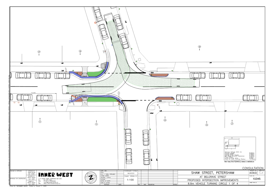
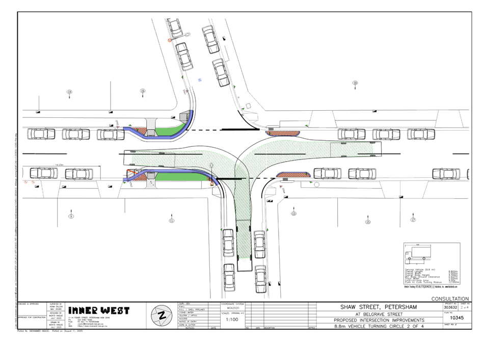
1.⇩ |
Concept plan - Plan no.10345 |
|
2.⇩ |
Swept paths - Plan no.10345 |
|
|
Local Transport Forum Meeting 15 September 2025 |
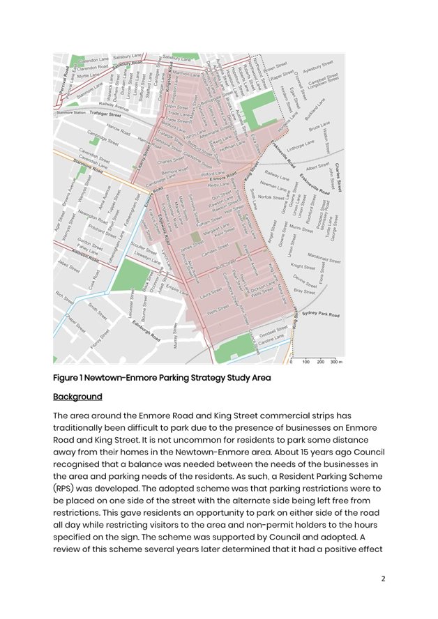
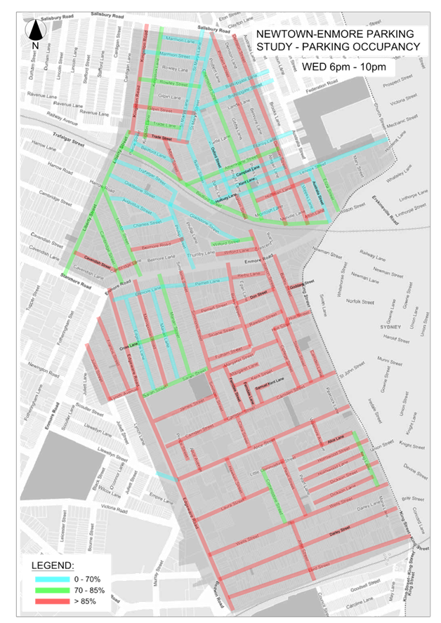
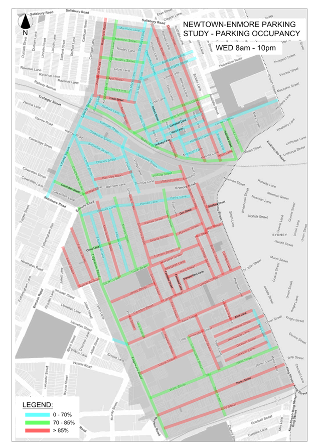
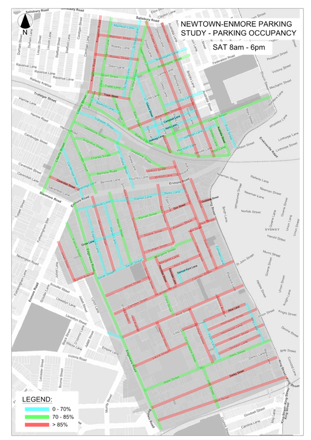
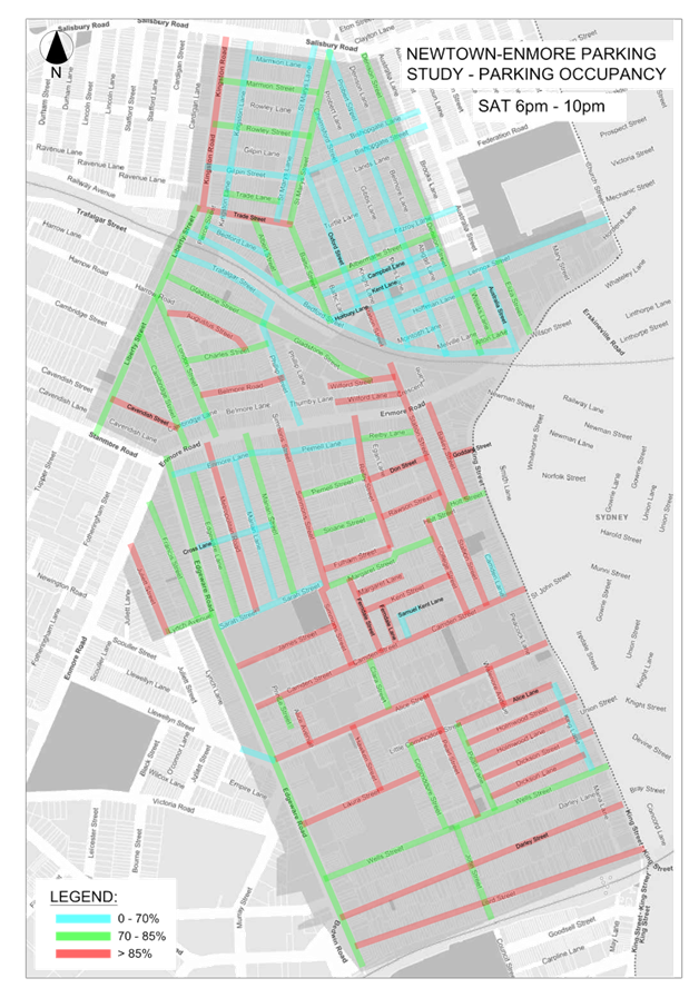
Subject: Newtown Enmore Parking Review Study
Prepared By: Jason Scoufis - Coordinator Traffic Investigations and Road Safety
Authorised By: Manod Wickramasinghe - Traffic and Transport Planning Manager
|
RECOMMENDATION
1. That the Newtown Enmore Parking Review Study be received and noted.
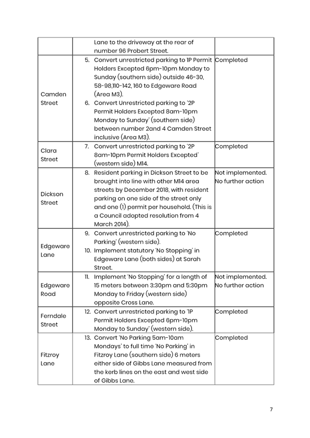
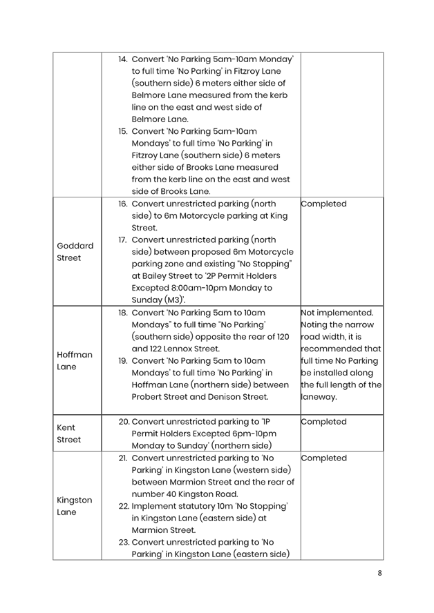
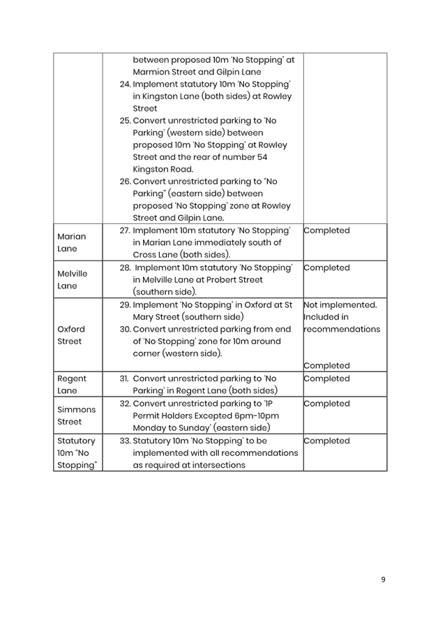
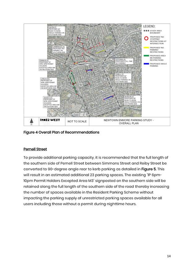
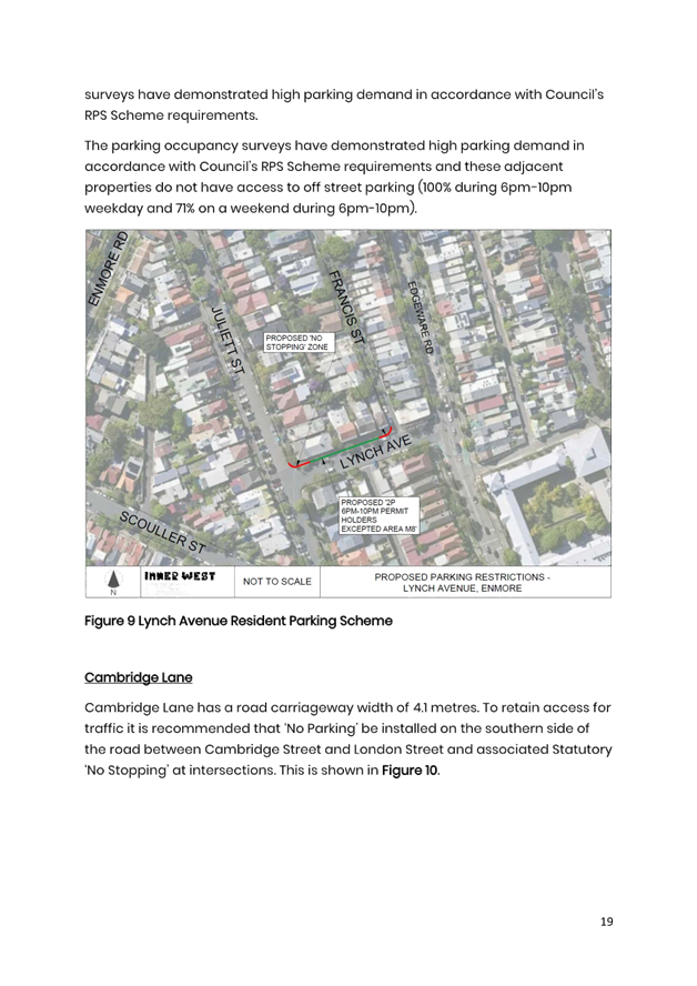
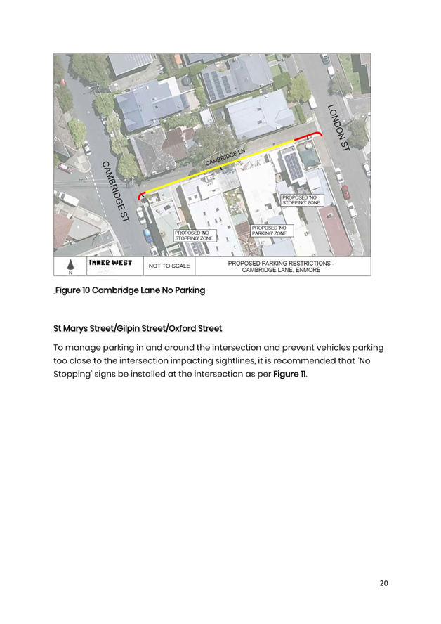
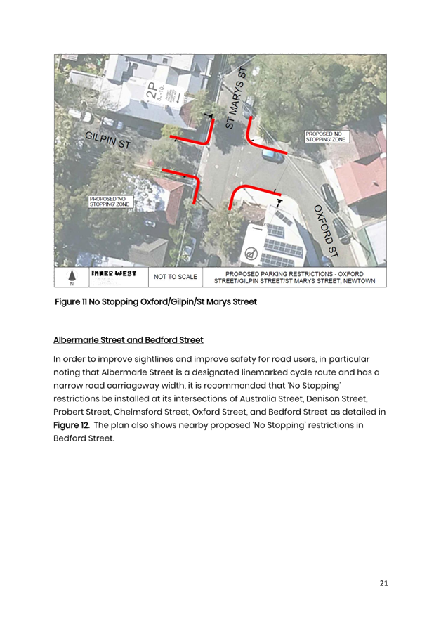
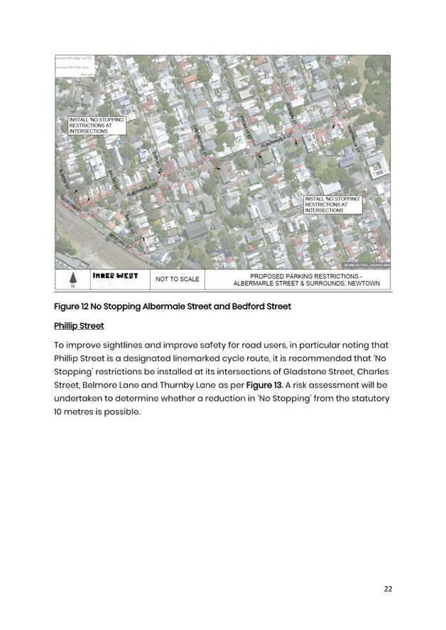
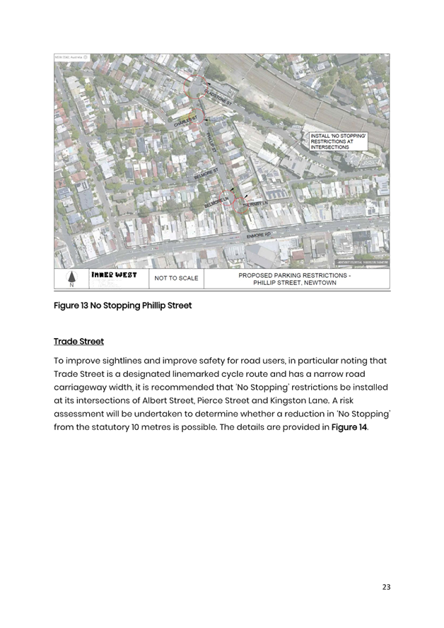
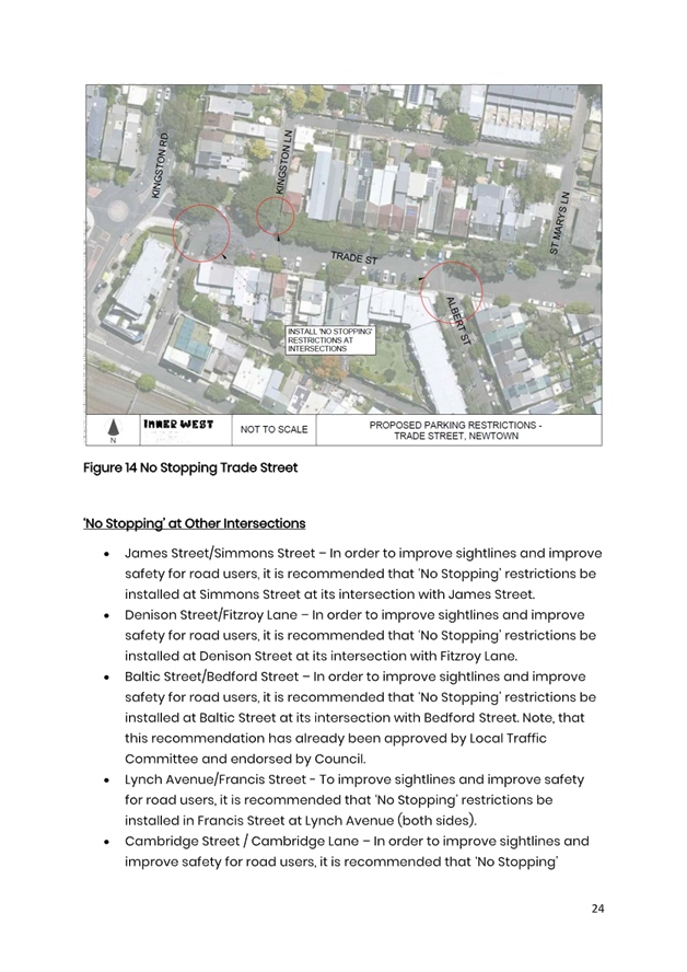
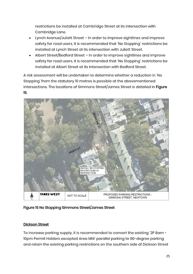
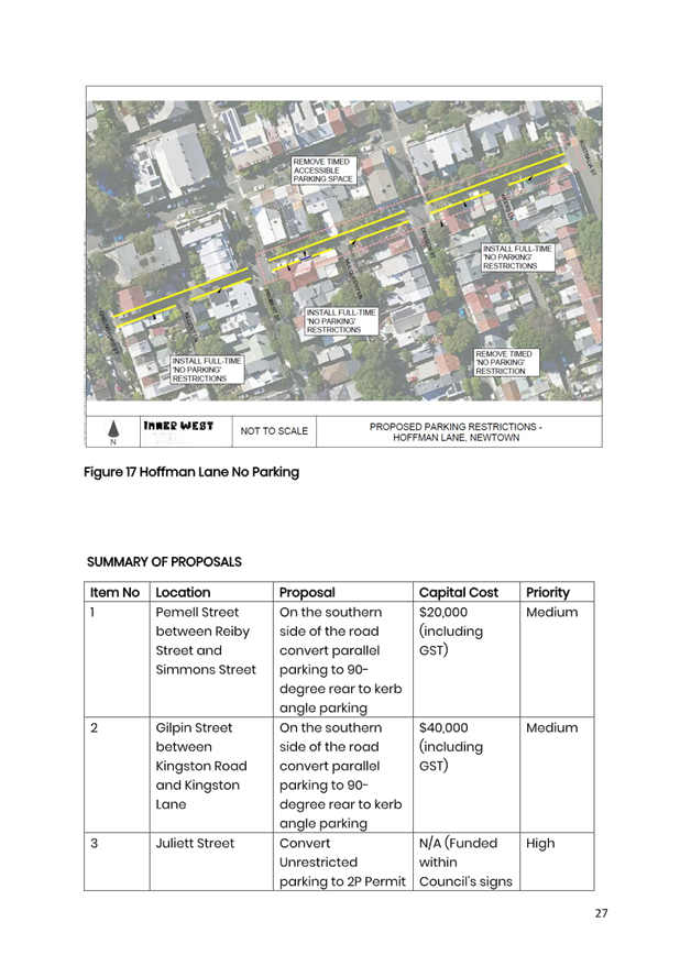
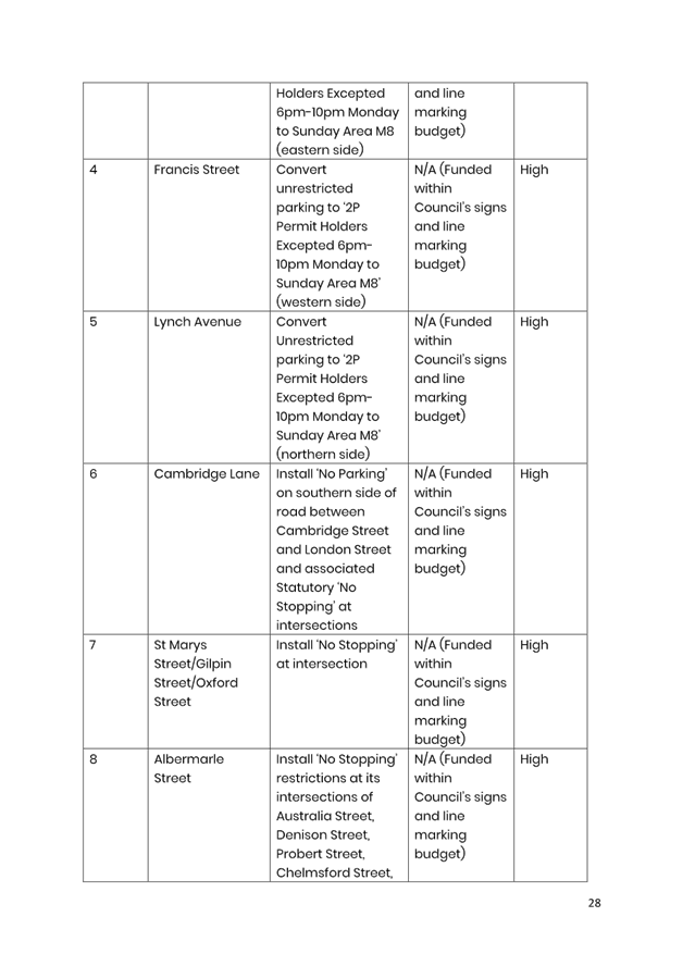
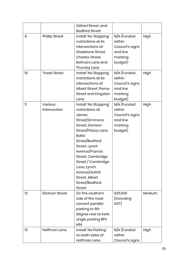
2. That further consultation be undertaken into installing ‘No Stopping’ restrictions at the intersections detailed below with a risk assessment to determine the length of ‘No Stopping’: a) St Marys Street/Gilpin Street/Oxford Street b) Albermarle Street/Australia Street c) Albermarle Street/Denison Street d) Albermarle Street/Probert Street e) Albermarle Street/Chelmsford Street f) Albermarle Street/Oxford Street g) Albermarle Street/Bedford Street h) Phillip Street/Gladstone Street i) Phillip Street/Charles Street j) Phillip Street/Belmore Lane k) Phillip Street/Thurnby Lane l) Trade Street/Albert Street m) Trade Street/Pierce Street n) Trade Street/Kingston Lane o) James Street/Simmons Street p) Denison Street/Fitzroy Lane q) Baltic Street/Bedford Street r) Lynch Avenue/Francis Street s) Cambridge Street/Cambridge Lane t) Lynch Avenue/Juliett Street u) Albert Street/Bedford Street
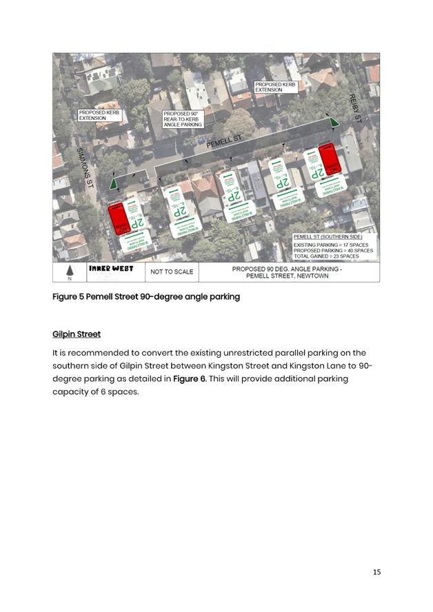
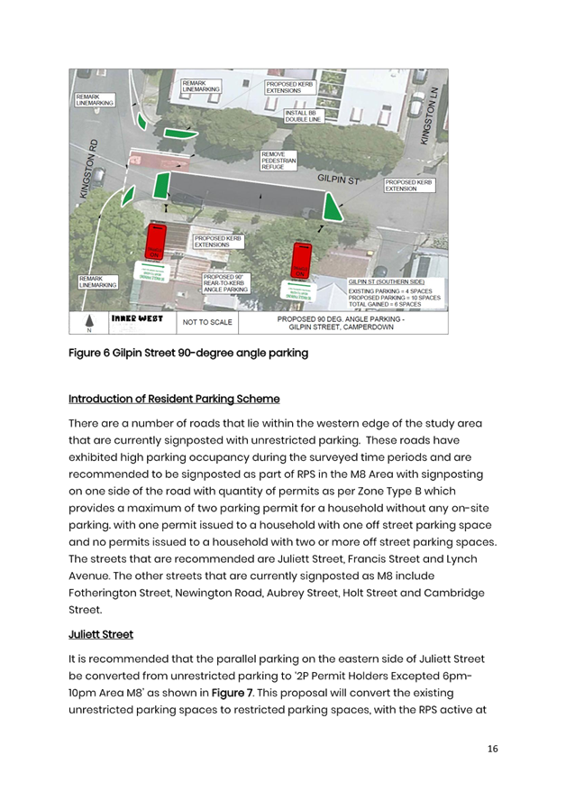
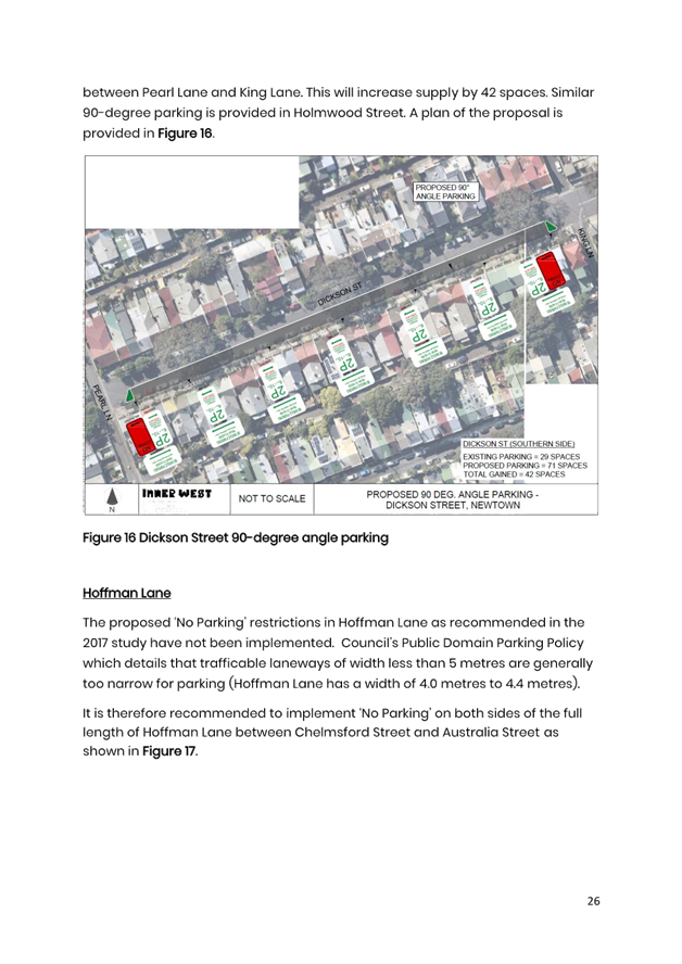
3. That ‘90 degree angle parking vehicles under 6 metres only’ signposting with associated kerb extensions be supported at the following locations and they be listed for consideration in Council’s Traffic Facilities Program subject to consultation: a) on the southern side of Pemell Street between Reiby Street and Simmons Street b) on the southern side of Gilpin Street between Kingston Road and Kingston Lane c) on the southern side of Dickson Street between Pearl Lane and King Lane
4. That ‘No Parking’ and associated ‘No Stopping’ restrictions at intersections be installed at the following locations subject to consultation: a) the southern side of Cambridge Lane between Cambridge Street and London Street b) both sides of Hoffman Lane between Chelmsford Street and London Street
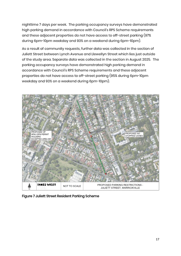
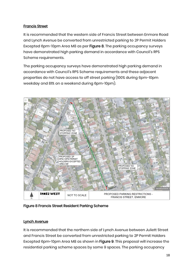
5. That ‘2P 6pm-10pm Permit Holders Excepted Area M8’ signposting restrictions be installed in the following streets subject to consultation: a) western side of Francis Street between Enmore Road and Lynch Avenue b) eastern side of Juliett Street between Enmore Road and Lynch Avenue c) northern side of Lynch Avenue between Juliett Street and Francis Street
|
STRATEGIC OBJECTIVE
This report supports the following strategic directions contained within Council’s Community Strategic Plan:
|
2: Liveable, connected neighbourhoods and transport |
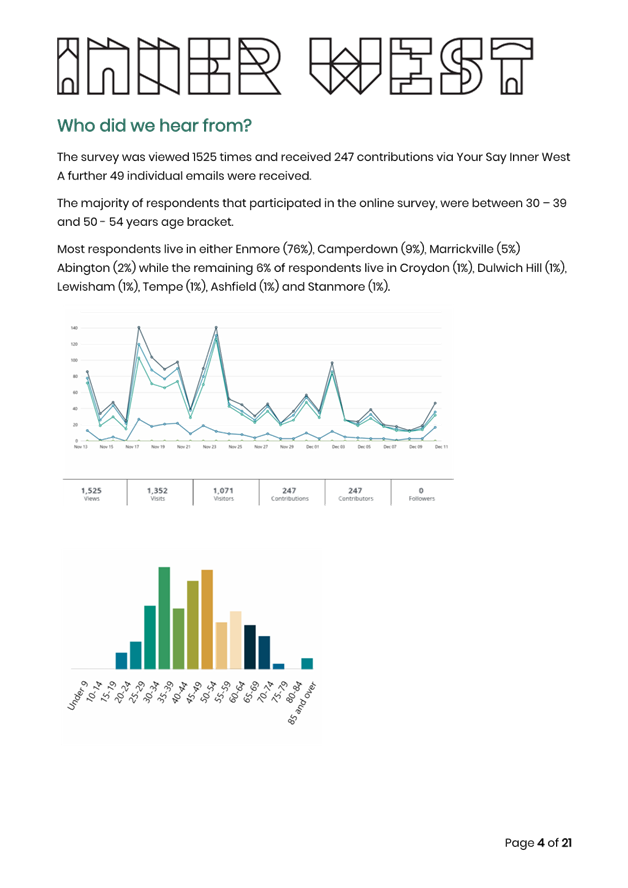
EXECUTIVE SUMMARY
Council has undertaken a Parking Review Study to improve parking in Newtown and Enmore.
The study has detailed a number of recommendations to improve conditions in laneways and intersections and extension of existing M8 resident parking scheme into the additional roads of Juliett Street, Francis Street and Lynch Avenue.
There are also a number of recommendations that increase parking capacity by introducing 90 degree angle parking in select local roads of Pemell Street, Gilpin Street and Dickson Street.
Other recommendations include the introduction of ‘No Stopping’ at intersections and ‘No Parking’ in laneways. The Parking Review Study report including recommendations is provided in Attachment 1 with appendix detailed in Attachment 2.
BACKGROUND
On 28 April 2023, the NSW government gave Council approval to progress the proposal to designate Enmore Road as a Special Entertainment Precinct (SEP) on a permanent basis. Special entertainment precincts allow councils to manage amplified noise from licensed premises in a different way. Enmore Road has been operational as a SEP since 8 December 2023.
Council noted local resident parking concerns and resolved to undertake a parking review for the precinct area which has resulted in the preparation of this parking review.
Council has undertaken a Parking Review Study to improve parking in Newtown and Enmore. The study area is generally bounded by Liberty Street, Kingston Road, Denison Street, Lennox Street, Church Street, King Street, Lord Street and Edgeware Road, including the Enmore Road Special Entertainment Precinct as detailed on the attached map.
The aim of the study is to:
· Understand the current parking situation and issues
· Consider the needs of the community to manage parking
· Develop an effective parking management strategy
Identified Community Issues
Council undertook an initial survey through Council’s Yoursay website in November/December 2023 and the outcomes are detailed in an Engagement Outcomes Report as per Attachment 3.
The engagement revealed that the residents of Newtown Enmore generally find it challenging to locate parking in their street, since the establishment of the Special Entertainment Precinct.
The respondents urge Council to give priority to improving and promoting active transport, cycling and public transport, in and around the Newtown Enmore precinct. Respondents believe that if Council made improvements to public transport links and promoted minimal car usage, it would ease parking competition between residents and visitors. Residents have suggested potential sites which may be improved to accommodate parking for visitors to the precinct.
Results revealed that the primary concerns include long stay vehicles, requests to extend Resident Parking Scheme (RPS) to reflect both sides of the Street, dangerous driving, and parking near intersections.
It further revealed that residents are becoming impatient with local businesses (Mechanics and Smash Repair businesses) utilising unrestricted parking to house their vehicles, taking up valuable resident and visitor parking.
The survey revealed large support to enforce parking in laneways or parking across driveways in laneways, due to safety concerns.
Respondents raised concerns with Francis Street, Reiby Street, Juliett Street, Lord Street, Alice Street and Alice Lane, Marian Street and Marian Lane and Edgeware Road and Edgeware Lane. There are concerns about car speeds, lack of signage and enforcement, blocked driveways, long stay vehicles, rat running and requests for introduction of Resident Parking Scheme (RPS) or to extend existing Resident Parking Scheme (RPS), to reflect both sides of the street.
DISCUSSION
A resident parking scheme is in place throughout the study area. These have generally been implemented on one side of the road only where parking is time-restricted for 1 or 2 hours with permit holders excepted. Standard parking restrictions in the area are as follows:
· 1P 6pm–10pm 7 days, Permit Holders Excepted Area M3
· 2P 6pm–10pm 7 days, Permit Holders Excepted Area M3
· 2P 8am–10pm 7 days, Permit Holders Excepted Area M3
· 2P 8am–10.30pm 7 days, Permit Holders Excepted Area M1
· 2P 8.30am–10pm Mon-Fri, Permit Holders Excepted Area M14
· 2P 8am–10pm 7 days, Permit Holders Excepted Area M14
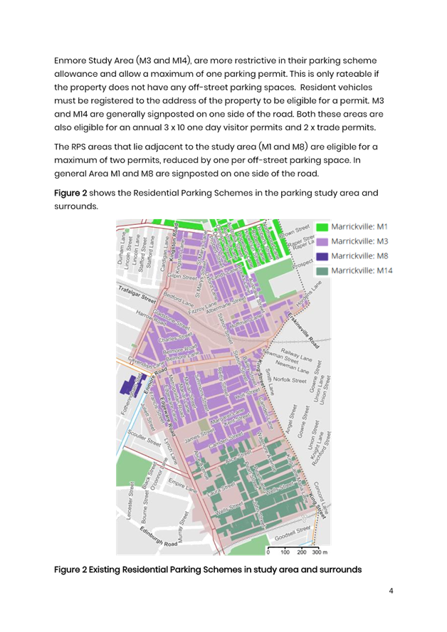
The former Marrickville Council, where the Newtown Enmore Study area lies, consists of 19 permit parking zones. The two zones that lie within the Newtown Enmore Study Area (M3 and M14), are more restrictive in their parking scheme allowance and allow a maximum of one parking permit, and only if the rateable property does not have any off-street parking spaces. Resident vehicles must be registered to the address of the property to be eligible for a permit. M3 and M14 are generally signposted on one side of the road. Both these areas are also eligible for an annual 3 x 10 one day visitor permits and 2 x trade permits.
The RPS areas that lie adjacent to the study area (M1 and M8) are eligible for a maximum of two permits, reduced by one per off-street parking space. In general Area M8 has a RPS signposted on one side of the road whilst M8 is signposted on both sides of the road.
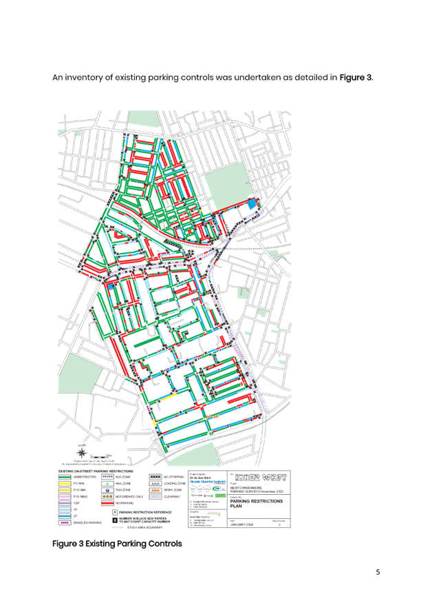
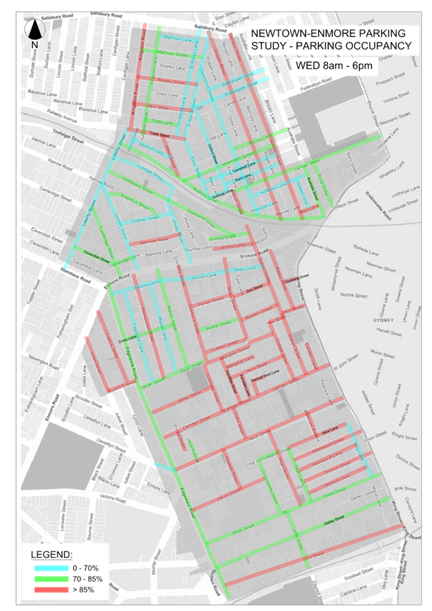
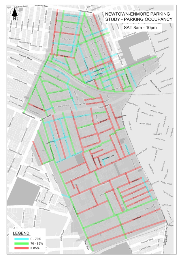
Parking Surveys
On site parking surveys as detailed in Attachment 2 were undertaken in November/December 2023. The parking surveys extent covered the study area. The days of the surveys were as follows:
· Wednesday 8am -10pm 29th November 2023
· Saturday 8am-10pm 2nd December 2023
The overall parking occupancies for each of the time periods are detailed below:
|
Parking Survey Period |
Parking Occupancy |
|
Wednesday 8am-10pm |
82%
|
|
Wednesday 8am-6pm |
81%
|
|
Wednesday 6pm-10pm |
82%
|
|
Saturday 8am-10pm |
81%
|
|
Saturday 8am-6pm |
83%
|
|
Saturday 6pm-10pm |
78%
|
The results indicate that overall occupancy rates fall into the 70% to 85% where it is considered that there is a high degree of parking utilisation, however there are enough spaces to find a parking space. There are however a significant number of streets with a high parking occupancy (greater than 85%) where it would be difficult to find a parking space.
FINANCIAL IMPLICATIONS
The estimated cost of the proposed treatments that require capital expenditure is $80,000 (including GST) and will be listed for consideration in the Traffic Facilities program. Minor changes to signs and linemarking will be funded out of Council’s Operational Budgets.
|
1.⇩ |
Final Report Newtown Enmore Parking Review Study |
|
2.⇩ |
Appendix A Parking Surveys |
|
3.⇩ |
Newtown Enmore Parking Review Study -Engagement Outcomes Report |
|
Local Transport Forum Meeting 15 September 2025 |
Subject: Holbeach Avenue, Tempe - Proposed timed parking restrictions (Midjuburi-Marrickville Ward/Heffron Electorate/Inner West PAC)
Prepared By: James Nguyen - Traffic Engineer
Authorised By: Manod Wickramasinghe - Traffic and Transport Planning Manager
|
RECOMMENDATION
1. That the proposed ‘6P 8am-6pm Mon-Fri, vehicles under 6 metres only’ on the eastern side of Holbeach Avenue adjacent to Tempe Reserve be approved.
2. That timed angle or unrestricted parking spaces at the existing ‘Bus Zone’ on Holbeach Avenue opposite Tempe Reserve be investigated.
|
STRATEGIC OBJECTIVE
This report supports the following strategic directions contained within Council’s Community Strategic Plan:
|
2: Liveable, connected neighbourhoods and transport |
|
|
EXECUTIVE SUMMARY
This report outlines existing parking issues on Holbeach Avenue immediately adjacent to Tempe Reserve and proposes timed parking restrictions (6P 8am-6pm Mon-Fri, vehicles under 6 metres only) to reduce long-term parking usage whilst balancing parking needs for field users, nearby businesses and residents.
BACKGROUND & DISCUSSION
Council has received feedback from community during a community meeting held in April 2025 about long-term parked vehicles and trailers at Tempe Reserve at Holbeach Avenue.
Council officers subsequently conducted parking surveys to assess the utilisation of the car parks surrounding Tempe Reserve. It was found the car parks furthest from Holbeach Avenue were underutilised. Accordingly, Council officers have recently installed wayfinding car park signs at Tempe. Reserve to guide motorists to the multiple car parks surrounding Tempe Reserve, to increase utilisation of these car parks.
In addition, there are approximately 17 unrestricted angle parking spaces on Holbeach Avenue, Tempe (adjacent to Tempe Reserve). Council officers have received feedback from community members about long-term parked trailers and vehicles at this location, which subsequently affects park-user access adjacent to Tempe Reserve, with some parking spill over to nearby residential streets. Community members have also provided photos showing trailers and boats occupying these spaces.
To reduce long-term parking usage whilst balancing parking needs for field users, nearby businesses and residents, Council officers propose to install timed parking restrictions signposted as ‘6P 9.30am-6pm Mon-Fri’, as shown in Figure 1 below.
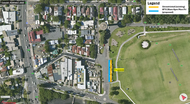
Figure 1 - Proposed parking changes
PUBLIC CONSULTATION
Council consulted with affected residents on the proposal between Friday 18 July 2025 and Monday 18 August 2025. There were 106 letters sent with two (2) responses supporting the proposal.
|
Residents’ Comments |
Officer Comments |
|
The bus zone opposite Tempe Reserve on Holbeach Avenue should be converted to angle parking spaces to provide more parking as it would allow businesses to use these spaces instead of the park frontage.
|
Council officers will investigate this further |
|
A company called “Active Tree Services” and/or Suburban tree Services have been using between 1 and 5 parking spot 365 days a year for the last few years. They are able to claim those parking spots permanently as the work vehicles (large trucks) are parked at Tempe reserve overnight and on weekends.
The employees pick up the work vehicles and park their personal vehicles while the trucks are being used during working hours.
Given they switch the trucks for cars between 5 and 6 in the morning and switch the cars for trucks between 2 and 3 in the afternoon, the proposed restrictions will allow then to keep on claiming those parking spots permanently.
Having 4P 8:30am-6pm Mon-Fri or alternatively keeping the proposed 6p 9:30am-6pm Mon-Fri, but restricting those parking spots to vehicles under 3T. |
The angle parking signs will be modified to include ‘vehicles under 6 metres only’. |
|
Consider timed parking restrictions further along east Holbeach Avenue, on the nature strip parallel to Old Street, as the timed parking spaces adjacent to the park will transfer the problem further along the road. |
Timed parking restrictions at this location is not recommended at this stage as it may transfer more parking into residential streets. |
|
Vehicles are parking at the intersection on the western side of Bay Street, north of Holbeach Avenue blocking visibility when trying to turn right onto Holbeach from Bay Street. Consider ‘No Stopping’ restrictions. |
Council officer’s will investigate this further. |
FINANCIAL IMPLICATIONS
The cost of the signage is to be funded by the signs and linemarking budget.
Nil.
|
|
Local Transport Forum Meeting 15 September 2025 |
Subject: Unnamed laneway (rear of Church Street and Warren Road), Marrickville (Midjuburi-Marrickville Ward/Summer Hill Electorate/Inner West PAC)
Prepared By: James Nguyen - Traffic Engineer
Authorised By: Manod Wickramasinghe - Traffic and Transport Planning Manager
|
RECOMMENDATION
That the relocation of the ‘No Parking’ restriction a further 2-metres north in the laneway at the rear of Church Street and Warren Road, Marrickville be approved.
|
STRATEGIC OBJECTIVE
This report supports the following strategic directions contained within Council’s Community Strategic Plan:
|
2: Liveable, connected neighbourhoods and transport |
|
|
EXECUTIVE SUMMARY
This report outlines existing parking challenges within a laneway at the rear of Church Street and Warren Road, Marrickville. It proposes an adjustment to the existing ‘No Parking’ restriction which seeks to balance access and parking needs for affected residents.
BACKGROUND
Council has received a request to relocate an existing ‘No Parking’ restriction to improve driveway access in the laneway behind Church Street and Warren Road, Marrickville.
DISCUSSION
The existing ‘No Parking’ restriction on the southern side of the laneway is 27 metres long and extends to the rear of no.43 Warren Road. The ‘No Parking’ (L) sign has been installed approximately 2 metres from the rear garage doorway of no.43 Warren Road and is shown in Figure 1 below.
Council has received feedback that the current location of the ‘No Parking’ (L) sign causes issues for the household at no.12 Church Street, Marrickville, when vehicles are parking adjacent (just north) of the sign, across the garage doorway and driveway. It is understood that access to the driveway can be made from one direction, when in the southbound direction in the laneway.
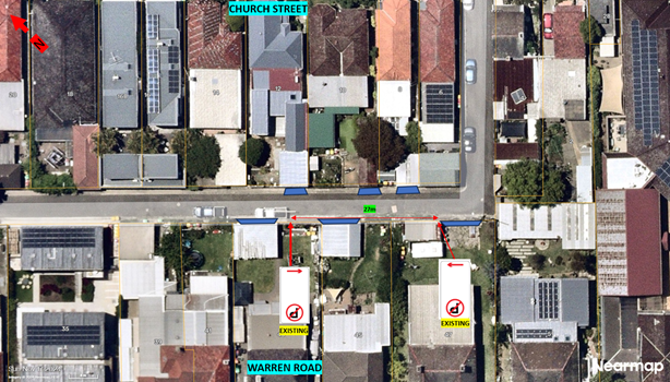
Figure 1 - Existing arrangement
To improve turning access in the when travelling in the northbound direction, into the driveway of no.12 Church Street the ‘No Parking’ restriction is proposed to be shifted further approximately 2 metres north of the current location, as shown in Figure 2 below. This will ensure the ‘No Parking’ sign extends to the full length of the kerb, to delineate the area where parking is not permitted. Extending this sign further across the driveway is not recommended as ‘No Parking’ restrictions are not typically installed across sole driveways.

Figure 2 - Proposed 'No Parking' restriction adjustment
PUBLIC CONSULTATION
Council notified the affected households of the proposal. There were two (2) responses received, with one (1) response supporting (with amendments) to the proposal and one (1) response opposing the proposal.
|
Residents’ Comments |
Officer Comments |
|
· The ‘No Parking’ restriction needs to be extended to the right (further north) to have adequate access.
· Access to the garage has been restricted to one way from Moyes Street only. Large vehicles are parked to the edge and sometimes over the ‘No Parking’ sign.
· Access to the laneway can only be sometimes made via Church Street, which requires access to the driveway from the other direction, which is currently blocked when a vehicle parks adjacent to the ‘No Parking’ sign.
· Vehicles that are parking adjacent to this sign have off-street parking
· Vehicles are parking across their own driveway is against the NSW Road Rules. Apparently, there is a local agreement with Council allowing them to park without being booked. However, this is applied inconsistently, as neighbours next door have parked across their own drive & been booked
· Vehicles are also parking within the 27 metre ‘No Parking’ area which blocks access to the driveway as well.
· Requesting for the ‘No Parking’ restriction to be extended further past the rear driveway of no.43 Warren Road to allow for two-way driveway access.
|
The proposed relocation of the ‘No Parking’ restriction, 2 metres north, will improve access to the driveway coming in from Church Street.
Council does not typically signpost ‘No Parking’ restrictions across driveways, as the NSW Road Rules already make it illegal to block driveway access.
|
|
· Warren Road is a narrow road and the laneway is a safer parking option for households that reside on Warren Road. Households that have multiple cars rely on the laneway for safe and guaranteed parking. It is requested to keep the ‘No Parking’ restriction where it is.
· Prior to the opposing driveway on Church Street being relocated, it was possible to park two vehicles along the kerb line at the rear of the property (no.43 Warren Road), which has now been removed since the relocation of the driveway |
The proposal to relocate the ‘No Parking’ sign 2 metres north seeks to improve the turning movement into the driveway in the northbound direction of the laneway (coming in from Church Street), without impeding the doorway and driveway.
‘No Parking’ restrictions are installed along the extent of the kerb line with driveways left unimpeded. |
FINANCIAL IMPLICATIONS
The installation of the signs can be funded through the signs and linemarking budget.
Nil.
|
|
Local Transport Forum Meeting 15 September 2025 |
Subject: Sydenham Station Parking Study
Prepared By: James Nguyen - Traffic Engineer
Authorised By: Manod Wickramasinghe - Traffic and Transport Planning Manager
|
RECOMMENDATION
1. That the existing ‘2P 8.30am-6pm Mon-Fri Permit Holders Excepted Area M4’ signposting restrictions be replaced with ‘2P 8am-10pm Permit Holders Excepted Area M4’, subject to consultation being undertaken in the following streets:
· Northern side of Bridge Street, west of Unwins Bridge Road · Eastern side of Leslie Street, south of Bridge Street · Northern side of Terry Street, between Unwins Bridge Road and Henry Street · Both sides of Park Road, between Rowe Lane and Henry Street · Western side of Henry Street, between Park Road and Park Lane · Southern side of Park Road between Henry Street and Stewart Lane · Southern side of Rowe Lane between Railway Road and Reilly Lane · Northern side of George Street between Unwins Bridge Road and Lee Lane · Northern side of Yelverton street between Unwins Bridge Road and Princes Highway · Northern side of Frederick Street between Unwins Bridge Road and Princes Highway · Southern side of Frederick Street between Unwins Bridge Road and Henry Street · Northern side of Sutherland Street between Unwins Bridge Road and Princes Highway · Southern side of Sutherland Street between Unwins Bridge Road and Henry Street · Eastern side of Henry Street between Sutherland Street and Grove Street · Southern side of Grove Street between Unwins Bridge Road and Princes Highway
2. That consultation be undertaken into installing new ‘2P 8am-10pm Permit Holders Excepted Area M4’s restrictions in the following streets:
· Southern side of Sutherland Street between Unwins Bridge Road and Henry Street · Southern side of Terry Street between Henry Street and Princes Highway · Southern side of George Street between Henry Street and Princes Highway
3. That consultation be undertaken into installing new ‘1P 8.30am-5pm Mon-Fri; 8.30am-12.30pm Sat’ restrictions on both sides of Park Road between Unwins Bridge Road and Rowe Lane
4. That consultation be undertaken into installing, 2P 8am-6pm Mon-Fri’ restrictions on the northern side of Sydenham Road between Fitzroy Street and Cadogan Street, and on the southern side of Sydenham Road between Railway Parade and Buckley Lane, and ‘No Parking’ restrictions on the northern side of Sydenham Road, east of Shirlow Street subject to Transport for NSW approval. |
STRATEGIC OBJECTIVE
This report supports the following strategic directions contained within Council’s Community Strategic Plan:
|
2: Liveable, connected neighbourhoods and transport |
EXECUTIVE SUMMARY
This report outlines the investigation completed in the residential and industrial streets surrounding Sydenham Station to assess parking impacts due to the opening of the Metro at Sydenham Station and closure of the T3 Bankstown Line. It provides an assessment of parking occupancy rates, and proposes adjustments to existing timed permit parking restrictions, and new timed (both permit and non-permit) parking restrictions to better support residents and businesses on streets north and south of Sydenham Station.
BACKGROUND
At the Council meeting held on 22 October 2024, Council resolved the following:
That Council urgently undertake parking studies in suburbs around Tempe, St Peters and Sydenham stations with the view to implementing parking controls to better support residents facing additional parking pressures with the opening of the Metro to Sydenham and closure of the T3 Bankstown Line.
DISCUSSION
Area A – Sydenham Station (residential side)
The parking study assessed parking utilisation on a weekday and weekends on residential streets near Sydenham Station as shown in Figure 1 below, with a 600 metre radius nominated for the extent of the study.
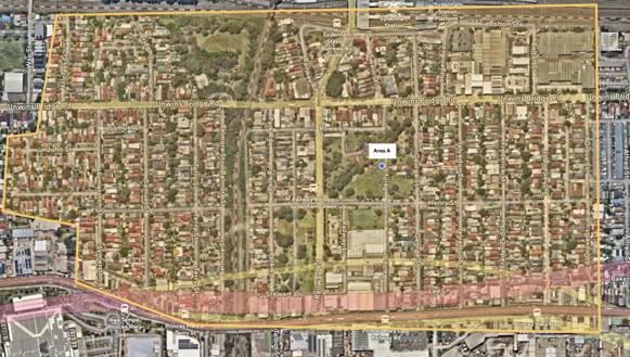
Figure 1 - Sydenham Station Parking Study Area (residential side)
Most of the streets within the residential side (south of Unwins Bridge Road) have timed permit parking restrictions on one-side of the street, with the other side left unrestricted for longer term parking. The current timed permit parking restrictions installed consist of ‘2P 8am-10pm Permit Holders Excepted Area M4’ for streets north of Unwins Bridge Road, and ‘2P 8.30am-6pm Mon-Fri Permit Holders Excepted Area M4’ for streets south of Unwins Bridge Road.
Council officer’s assessed the parking occupancy and duration of stay of these unrestricted parking and timed permit parking spaces (south of Unwins Bridge Road) to determine if they were in excess of 80 per cent, that would warrant consideration of extending timed permit parking restrictions to both sides of the street on a weekday and on weekends (Saturday and Sunday).
Weekday parking assessment
Parking surveys were completed on these streets on Wednesday 2 April between 6am and 10am to assess occupancy and duration of stay to determine if there are high levels of commuter parking in the unrestricted spaces. Commuter parking generation is generally at its highest during 7am-9am, with maximum peak saturation estimated to occur at 10am.
For the weekday assessment, 10am was prescribed as the hour which commuter parking has reached maximum peak saturation (additional commuter parking after this period is likely to be low).
Four (4) key indicators were used to assess whether it is warranted to install or extend timed permit parking spaces:
1. The midblock section of the street where the parking restriction is to be installed must be within 400 metres walking distance to Sydenham Station.
2. For streets where both sides are unrestricted, the occupancy rate on both sides of the section of street must be greater than 85% at 10am.
3. For streets where one (1) side is time permit parking restricted (2P 8.30am-6pm Mon-Fri), the occupancy rate on both sides of the section of street must be greater than 85% at 10am.
4. There must be a low percentage of vehicles recorded on the section of street, with a duration of stay of greater than 4 hours (stayed within the same parking space between 6am and 10am, are likely to be resident parked vehicles).
The parking occupancy rates recorded for the unrestricted parking and timed permit parking spaces in residential streets are shown in Figure 2 below:
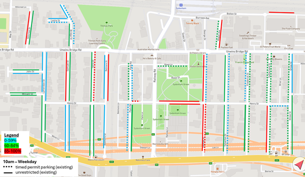
Figure 2 - Parking occupancy rates - Unrestricted parking spaces
Only George Street recorded high occupancy rates (greater than 85 per cent) on both the unrestricted and time permit parking restricted sides.
The duration of stay results on the unrestricted parking spaces which have greater than 85% utilisation is shown below in Figure 3:
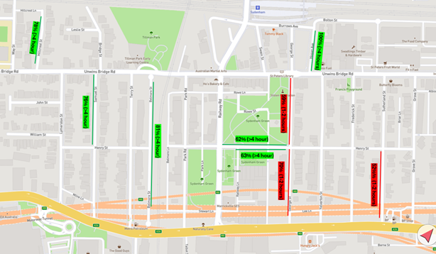
Figure 3 - Duration of stay results - Unrestricted parking spaces with occupancy rates greater than 85%
Figure 3 above categorises the duration of stay surveys into two classifications:
· >4 hours; vehicles that were parked in the same space between 6am-10am and did not move. Vehicles within this category are likely to be residential vehicles which did not move at 6am (before the start of commuter parking generation) and remained within the same space until 10am (the end of the survey)
· 1-2 hours; vehicles that were parked within the space for 1-2 hours and could either be resident vehicles leaving the space, commuters, or industrial workers parking in the space between 8am and 10am.
Only George and Sutherland Streets recorded lower percentages of vehicles with a duration of stay of greater than 4 hours (stayed within the same parking space between 6am and 10am, are likely to be resident parked vehicles). George Street may be more likely to experience commuter parking as it is more direct to Sydenham Station. High utilisation on Sutherland Street may be attributed to nearby industrial workers on Princes Highway.
Accordingly, consideration of extending timed permit parking restrictions to the southern side of George Street between Henry Street and Princes Highway on a weekday should be considered to maintain parking opportunities for households on the southern side of George Street.
Weekend parking assessment
Parking surveys were completed in the study area (Figure 1) on Saturday 5 April between 8am and 6pm, and Sunday 6 April between 8am and 6pm at 1-hour intervals, to assess parking utilisation on residential streets near Sydenham Station.
The survey seeks to assess whether there is a need to extend the existing timed permit parking restrictions that are signposted as ‘2P 8.30am-6pm Mon-Fri Permit Holders Excepted Area M4’ to include Saturdays and Sundays.
To extend the existing permit parking restrictions to weekends, a high parking occupancy rate greater than 85% for either Saturday or Sunday must be recorded within the existing timed permit parking restriction. The parking occupancy rates used are averages of the 1-hour intervals between 11am-2pm. Council officer’s also assessed whether the midblock section of the street is approximately 400 metres from Sydenham Station.
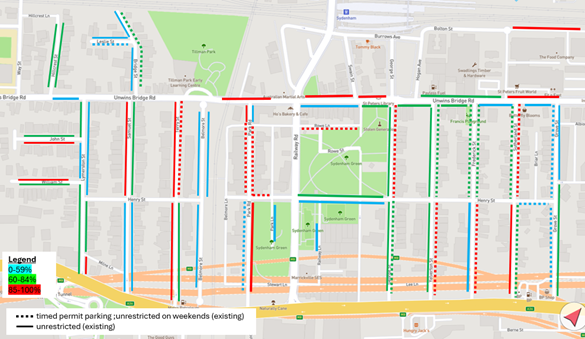
Figure 4 - Parking utilisation rates – Saturday
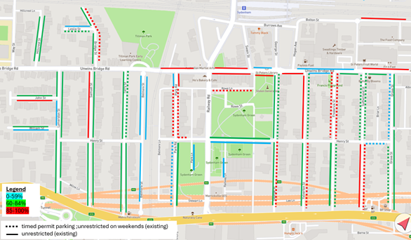
Figure 5 - Parking utilisation rates – Sunday
Table 1 below summarises the weekend parking survey results on streets with existing timed permit parking restrictions and provides a recommendation:
|
|
Local Transport Forum Meeting 15 September 2025 |
Table 1 - Weekend survey results and recommendation
|
Street |
Section |
Side |
>85% occupancy rate (Saturday) |
>85% occupancy rate (Sunday) |
Walking distance |
Recommendation |
|
Leslie Street |
West of Bridge Street |
Southern |
No |
No |
580 metres |
Extend to weekends (to prevent spill-over to Leslie Street from weekend limits on Bridge Street, Terry Street and Samuel Street) |
|
Bridge Street |
North of Unwins Bridge Road |
Eastern |
No |
Yes |
480 metres |
Extend to weekends (to prevent spill-over to Samuel and Terry Streets) |
|
Terry Street |
Unwins Bridge Road and Henry Street |
Eastern |
Yes |
No |
450 metres |
Extend to weekends due to high utilisation and consider new RPS proposal on western side of Terry Street, between Henry Street and Princes Highway to prevent spill over. |
|
Park Road |
Unwins Bridge Road and Henry Street |
Both sides |
Yes |
Yes |
330 metres |
Extend to weekends due to high utilisation |
|
Park Road |
Henry Street and Stewart Lane |
Western |
No |
No |
530 metres |
Extend to weekends (due to extension of section between Unwins Bridge Road and Henry Street) |
|
Henry Street |
Park Road and Park Lane |
Northern |
Yes |
Yes |
420 metres |
Extend to weekends due to high utilisation |
|
Rowe Lane |
Railway Road and Reily Lane |
Southern |
Yes |
Yes |
250 metres |
Extend to weekends due to high utilisation |
|
George Street |
Unwins Bridge Road and Henry Street |
Eastern |
Yes |
No |
250 metres |
Extend to weekends due to high utilisation |
|
George Street |
Henry Street and Princes Highway |
Eastern |
No |
Yes |
400 metres |
Extend to weekends (due to extension of section between Unwins Bridge Road and Henry Street) |
|
Yelverton Street |
Unwins Bridge Road and Henry Street |
Eastern |
No |
No |
300 metres |
Extend to weekends (due to potential transfer of parking from George Street) |
|
Yelverton Street |
Henry Street and Princes Highway |
Eastern |
Yes |
Yes |
450 metres |
Extend to weekends (due to extension of section between Unwins Bridge Road and Henry Street) |
|
Frederick Street |
Unwins Bridge Road and Henry Street |
Eastern |
No |
Yes |
350 metres |
Extend to weekends due to high utilisation |
|
Frederick Street |
Unwins Bridge Road and Henry Street |
Western |
No |
Yes |
350 metres |
Extend to weekends due to high utilisation |
|
Frederick Street |
Henry Street and Princes Highway |
Eastern |
Yes |
No |
550 metres |
Extend to weekends (due to extension of section between Unwins Bridge Road and Henry Street) |
|
Sutherland Street |
Unwins Bridge Road and Henry Street |
Eastern |
Yes |
No |
450 metres |
Extend to weekends due to high utilisation |
|
Sutherland Street |
Unwins Bridge Road and Henry Street |
Western |
No |
No |
450 metres |
Extend to weekends to ensure consistency with timed permit parking restrictions Sutherland Street |
|
Sutherland Street |
Henry Street to Princes Highway |
Eastern |
No |
Yes |
600 metres |
Extend to weekends (due to extension of section between Unwins Bridge Road and Henry Street) |
|
Grove Street |
Unwins Bridge Road and Henry Street |
Western |
No |
No |
480 metres |
Extend to weekends to ensure consistency with timed permit parking restrictions on other adjacent streets |
|
Grove Street |
Henry Street and Princes Highway |
Western |
No |
No |
680 metres |
Extend to weekends to ensure consistency with timed permit parking restrictions on other adjacent streets |
|
Henry Street |
Sutherland Street and Grove Street |
Southern |
No |
No |
530 metres |
Extend to weekends to ensure consistency with timed permit parking restrictions on other adjacent streets
|
|
|
Local Transport Forum Meeting 15 September 2025 |
Figure 6 - Proposed parking changes
Figure 6 above proposes the following:
· Consult on the conversion of the unrestricted parking spaces on both sides of Park Road between Unwins Bridge Road and Rowe Lane to ‘1P 8.30am-5pm Mon-Fri; 8.30am-12.30pm Sat’
· Consult on the extension of all existing ‘2P 8.30am-6pm Mon-Fri Permit Holders Excepted Area M4’ restrictions to ‘2P 8am-10pm Permit Holders Excepted Area M4’ to match the existing timed permit parking restrictions north of Unwins Bridge Road.
· Consult on the extension of timed permit parking restrictions to the western side of Samuel Street between Unwins Bridge Road and Henry Street due to high utilisation on the weekend, proximity to Sydenham Station, and prevent spill over from extensions on Terry Street.
· Consult on the extension of the timed permit parking restrictions to the western side of Terry Street between Henry and Princes Road due to high utilisation on Saturday and prevent spill over from nearby extension on Terry Street between Unwins Bridge Road and Henry Street.
· Consult on the extension of timed permit parking restrictions to the western side of George Street between Henry Street and Princes Highway due to the likelihood of commuter parking usage on weekday and Saturday and prevent spill-over of parking from extensions of nearby permit parking restrictions.
Area B – Sydenham Station (industrial side)
The parking study assessed parking utilisation on a weekday and weekends on residential streets near Sydenham Station as shown in Figure 1 below, with a 500 metre radius nominated for the extent of the study. This parking study is intended to support the existing reVITALise Sydenham Station (Sydenham Road Strategy)
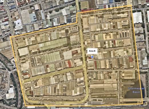
Figure 7 - Study area (industrial)
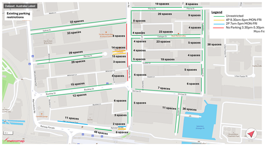
Figure 8 - Existing parking restrictions
Figure 8 above shows most of the parking spaces north of Sydenham Station surrounding the industrial precinct to be unrestricted for parking. There are 2P and 4P timed parking restrictions on Railway Parade, and 4P parking in an existing off-street car park on Barclay Street, west of Sydenham Road. There are also unrestricted parking spaces in the laneways, which is not shown on the plan below. In addition, there are businesses which have off-street parking which allow for deliveries, staff or visitor parking.
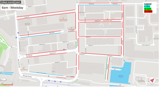
Figure 9 - Parking occupancy rates at 6am
Figure 9 above assesses parking occupancy rates at 6am and shows the following trends:
· Most of the on-street parking spaces within the industrial side of Sydenham to be highly occupied at 6am.
· Some unrestricted parking spaces still available on Barclay, Fitzroy, and Garden Streets, and Railway Parade (north).
· Parking utilisation is likely to be occupied by industrial business employees or commuter parking. At 6am, commuter parking demand is likely to be lower compared to industrial employee parking demand.
Figure 10 below assesses parking occupancy rates at 10am and shows the following trends:
· Most of the on-street parking spaces within the industrial side of Sydenham to be highly occupied at 10am,
· Increase in utilisation of parking spaces on Fitzroy, Garden and Railway Parade (north) from 6am.
· Barclay Street and Sydenham Road (between Wilkinson Lane and Barclay Street) has a slight reduction in parking utilisation, indicating businesses or employee parking may be turning over.
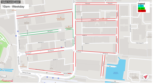
Figure 10 - Parking occupancy rates at 10am
Figures 9 and 10 indicates high parking utilisation at 6am and 10am with demand likely due to industrial employees and commuter parking. It is likely industrial employee/business parking will occupy a higher percentage of these parking spaces compared to commuter parking, as parking demand is likely higher at 6am for industrial businesses.
Figure 11 below assesses parking occupancy rates, averaging the hourly peak period between 11am and 2pm on Saturday and shows the following trends:
· Available parking capacity on Garden Street indicating commuter parking to be confined near the station, and spill over may be low to nearby streets such as Sydenham Road south of Shirlow Street.
· Available parking capacity in the 4P car park on Barclay Street, west of Sydenham Road.
· Available parking capacity in Fitzroy, Sydney, Barclay and Sloane Streets.
Figure 11 - Parking occupancy rates (Saturday)
Figure 12 below assesses parking occupancy rates, averaging the hourly peak period between 11am and 2pm on Sunday and shows the following trends:
· Parking capacity increases on Sunday compared to Saturday, with more parking spaces available in Saywell, Barclay and Cadogan Streets, and Railway Parade North.
· Parking occupancy rates on Garden Street remain similar to Saturday, with commuter parking to be confined near the station, and spill over may be low to nearby streets such as Sydenham Road south of Shirlow Street.
· More parking capacity in the 4P car park on Barclay Street, west of Sydenham Road, compared to Saturday.

Figure 12 - Parking occupancy rates (Sunday)
Whilst the parking in this area may be predominantly business/employee vehicles, there is a high level of on-street unrestricted parking. Some businesses have off-street parking for their vehicles or staff parking; however, it is likely off-street parking cannot accommodate all the demand.
The current number of unrestricted parking may have low turnover of parking which could otherwise be used for visitors or customers needing access to the nearby businesses. However, it is also acknowledged some businesses may require longer term parking for their staff, and it is important to balance both competing needs.
Accordingly, a short-term and long-term parking proposal have been developed for consideration.
Key opportunities that can be considered are as follows:
· Consider short term timed parking restrictions (1P or 2P) along Sydenham Road between Railway Parade and Fitzroy Street to improve parking opportunities along the main road and reduce circulating traffic within the perpendicular streets.
· Short-term 2P parking on some corners off the side streets
· Additional kiss and drop zones on Sydenham Road near Sydenham Station
Figure 13 - Proposed parking restrictions (short-term)
The short-term proposal shown in Figure 13 seeks to provide timed parking restrictions along Sydenham Road whilst maintaining unrestricted parking for business or staff parking. The parking restrictions have been proposed outside of businesses that may require turnover of parking.
Figure 14 - Proposed parking restrictions (long-term)
The long-term proposal shown in Figure 14 considers a scenario where timed parking restrictions are considered along Sydenham Road between Railway Parade and Fitzroy Street, and some side streets.
FINANCIAL IMPLICATIONS
There are no financial implications associated with the implementation of the proposed recommendations outlined in the report.
|
1.⇩ |
Final parking plan (residential side) |
|
2.⇩ |
Final parking plan industrial side (short-term) |
|
3.⇩ |
Final parking plan industrial side (long-term) |
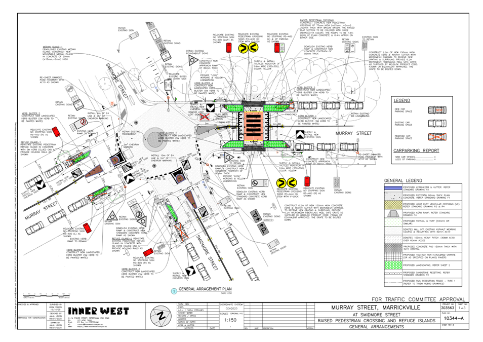
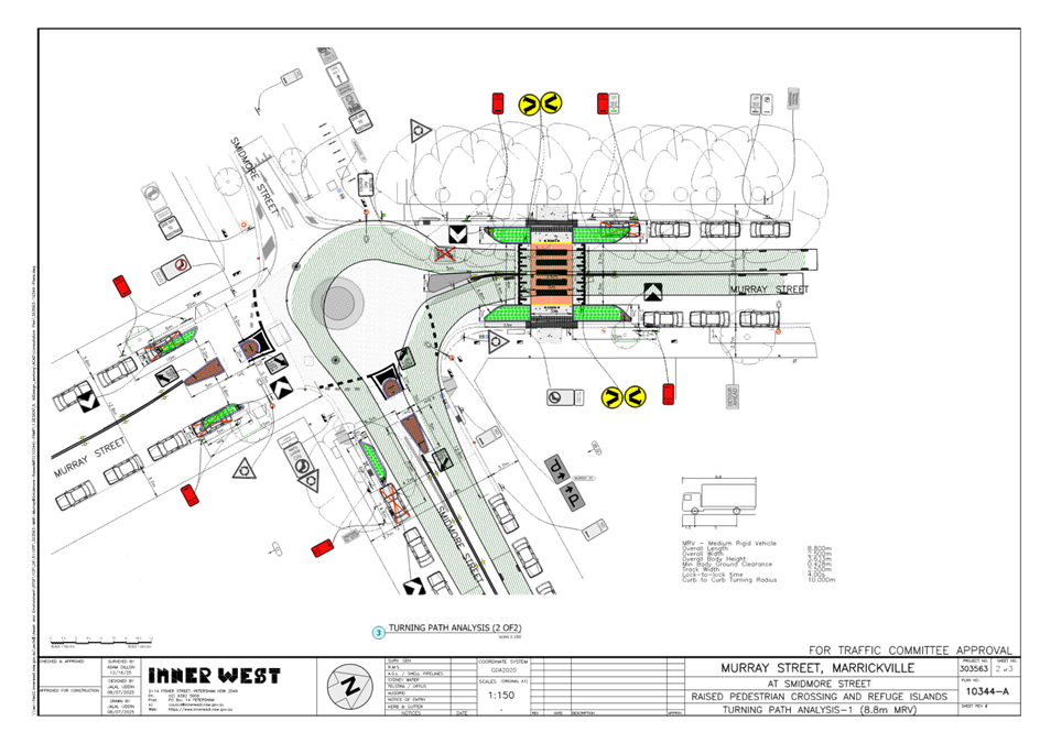
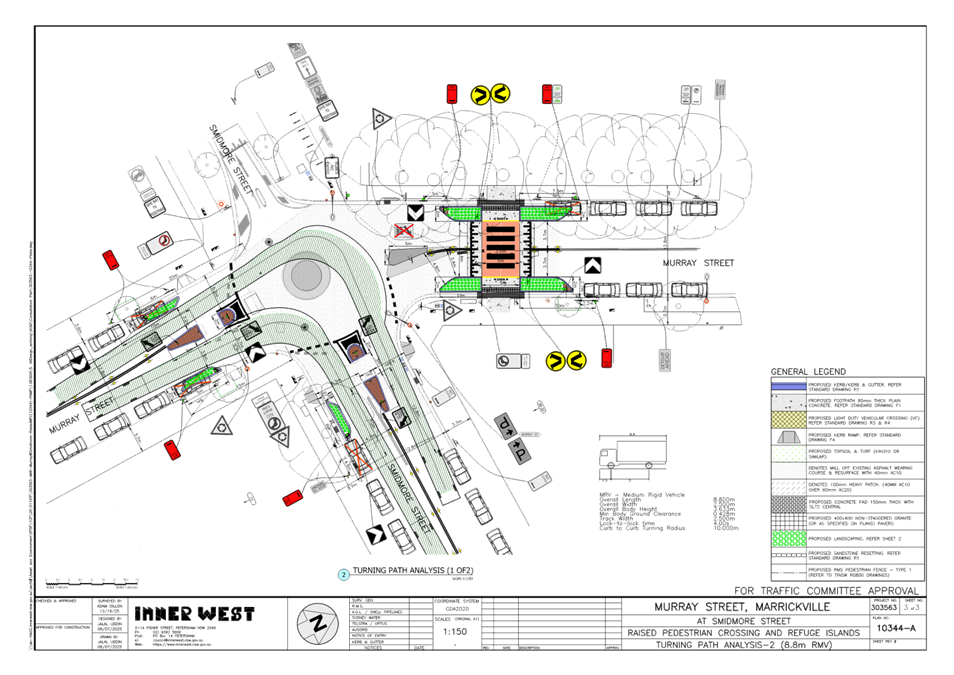
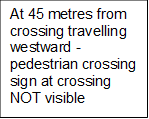
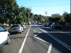 Pedestrian sign at
crossing not visible
Pedestrian sign at
crossing not visible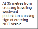
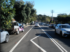 Pedestrian sign at
crossing not visible
Pedestrian sign at
crossing not visible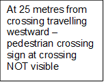
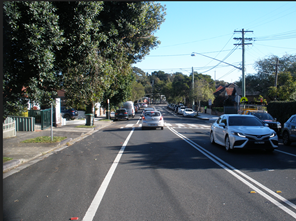 Pedestrian sign at
crossing not visible
Pedestrian sign at
crossing not visible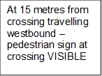
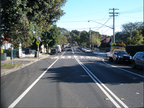 Pedestrian sign at crossing
visible
Pedestrian sign at crossing
visible