|
AGENDA R |

Local Transport Forum Meeting
MONDAY 16 MARCH 2026
11:00 AM
|
|
Local Transport Forum Meeting 16 March 2026 |
Function of the Local Transport Forum
Background
Transport for NSW (Transport) is legislated as the Authority responsible for the control of traffic on all NSW Roads. Transport has delegated certain aspects of the control of traffic on local roads to councils.
Transport’s (2025) Authorisation and Delegation Instrument authorises councils to use prescribed traffic control devices under s122 of the Road Transport Act 2013 and delegates Transport’s power under s115 of the Roads Act 1993 to regulate traffic for any purpose.
The (2025) Authorisation and Delegation Instrument revokes and replaces both the (2011) Delegation to Councils and the (2023) Temporary Delegation to Councils No.2.
One of the conditions of the Instrument is that councils establish a Local Transport Forum (LTF - formerly known as Local Traffic Committee). The LTF provides advice, technical review, and coordination of works and events. It does not vote, issue approvals, or make decisions.
Role of the Local Transport Forum
The LTF is primarily a technical review and advisory forum which considers the technical merits of proposals and ensures that current technical guidelines are considered. It provides advice to Council on traffic and parking control matters and on the provision of traffic control facilities and prescribed traffic control devices for which Council has delegated authority. These matters are dealt with under Part A of the agenda.
In addition to its formal role as the LTF, Forum members may also be requested to provide informal traffic engineering advice on traffic matters not requiring Council to exercise its delegated function at that point in time, for example, advice to Council’s Development Assessment Section on traffic generating developments. These matters are dealt with under Part C of the agenda and are for information or advice only and do not require Council to exercise its delegation.
LTF Delegations
The LTF has no decision-making powers. Council must refer all relevant traffic related matters to the LTF prior to exercising its delegated functions. Matters related to State Roads or functions that have not been delegated to Council must be referred directly to the Transport or relevant organisation.
The LTF provides advice to Council. Where Transport has concerns about a proposal and the concerns are not resolved in discussion, Transport may inform the LTF that it intends to issue a Statement of Concern (SoC) within seven days.
Forum Membership
The LTF comprises the following Members:
· one representative of Council as nominated by Council;
· one representative of the NSW Police from each Local Area Command (LAC) within the LGA, being Newtown, Marrickville, Leichhardt and Ashfield LAC’s.
· one representative from Transport for NSW ; and
· State Members of Parliament (MP) for the electorates of Summer Hill, Newtown, Heffron, Canterbury, Strathfield and Balmain or their nominees.
· Operator of any public passenger service likely to be affected by the proposal.
Informal advisors from within Council or external authorities may also attend the LTF to provide expert advice.
LTF Chair
Council’s representative will chair the meetings.
Public Participation
Members of the public or other stakeholders may address the LTF on agenda items to be considered by the Members. The format and number of presentations is at the discretion of the Chairperson and is generally limited to 3 minutes per speaker. LTF debate on agenda items is not open to the public.
|
|
Local Transport Forum Meeting 16 March 2026 |
|
AGENDA |
1 Apologies
2 Disclosures of Interest
3 Confirmation of Minutes Page
Minutes of 16 February 2026 Local Transport Forum 5
4 Matters Arising from Council’s Resolution of Minutes
5 Part A – Items Where Council May Exercise Its Delegated Functions
Traffic Matters
ITEM Page
LTF0326(1) Item 1 Inner West LGA - Proposal for Flexicar car share parking spaces (All wards, all electorates, all PACs) 25
LTF0326(1) Item 2 Victoria Street, Ashfield - Proposed Raised Pedestrian Crossing (Djarrawunang - Ashfield Ward / Summer Hill Electorate / Burwood PAC) 38
LTF0326(1) Item 3 Oxford Street & Park Street, Rozelle - Proposed One-Way Traffic Proposal (Baludarri-Balmain Ward/ Balmain Electorate/ Leichhardt PAC) 43
LTF0326(1) Item 4 Spring Street, Birchgrove - Revised 'No Stopping' Zones (Baludarri-Balmain Ward/ Balmain Electorate/ Leichhardt PAC) 51
LTF0326(1) Item 5 Drynan Street at Prospect Road, Summer Hill – Proposed Raised Pedestrian Crossing – Design Plan 10377 (Djarrawunang-Ashfield Ward / Summer Hill Electorate / Burwood PAC) 55
LTF0326(1) Item 6 Marrickvile Road East, Marrickville - Cycle Path (Midjuburi - Marrickville Ward / Summer Hill Electorate / Inner West PAC) 60
LTF0326(1) Item 7 Curtis Road and McDonald Street, Balmain - Proposed Pedestrian Crossing, Continuous Footpath and One-Way Treatment (Baludarri-Balmain Ward/Balmain Electorate/Leichhardt PAC) 112
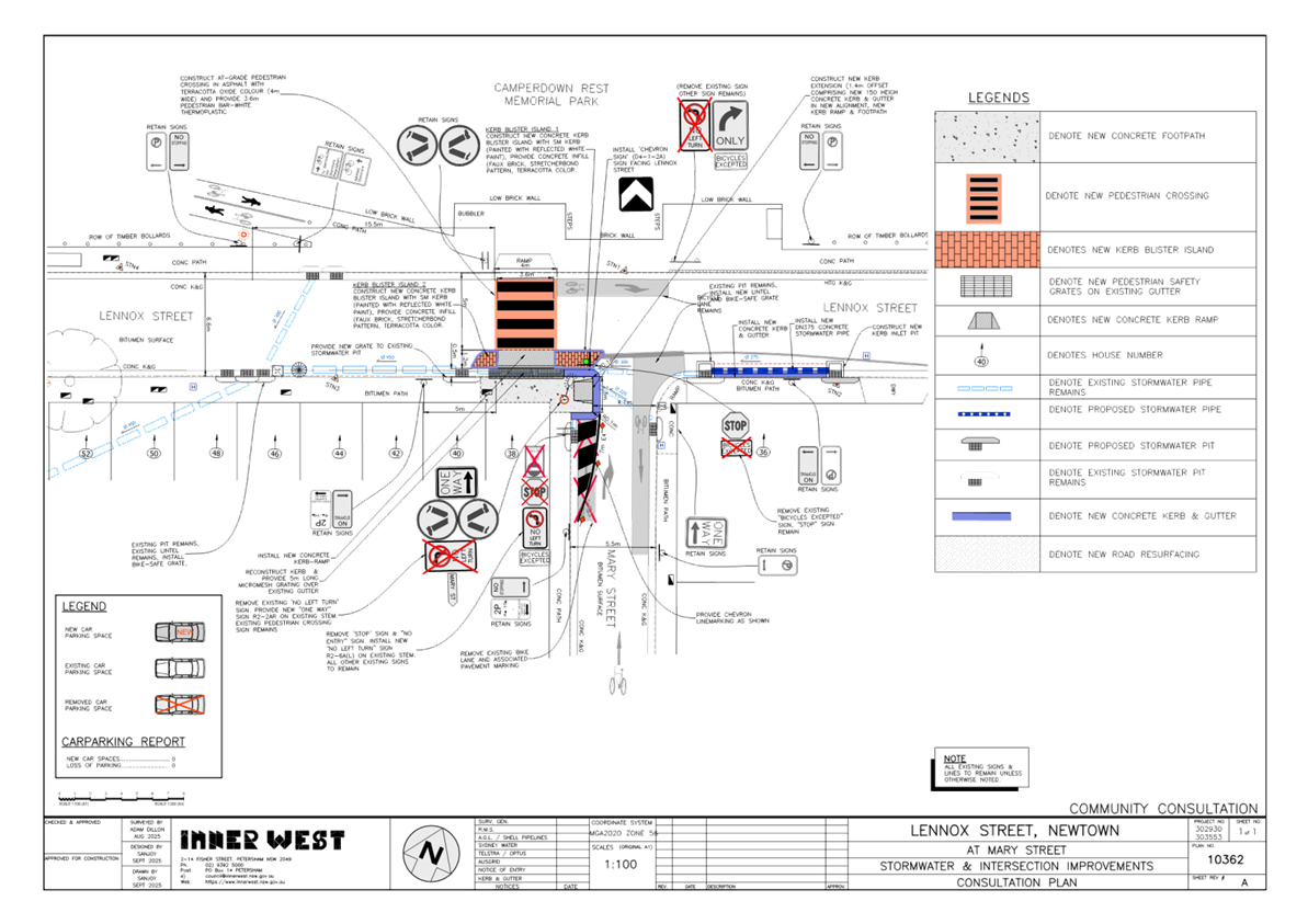
LTF0326(1) Item 8 Lennox Street, Newtown – Proposed Pedestrian Safety and Stormwater Improvement Works – Design Plan 10362A (Damum-Stanmore Ward / Newtown Electorate / Inner West PAC) 117
LTF0326(1) Item 9 Curtis Road, Balmain - Proposed Pedestrian (zebra) Crossing (Baludarri-Balmain Ward/Balmain Electorate/Leichhardt PAC) 122
Parking Matters
ITEM Page
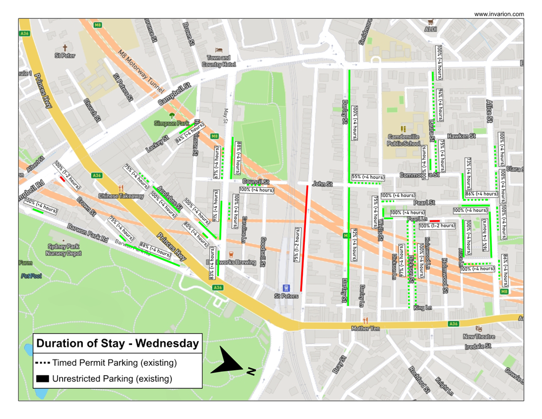
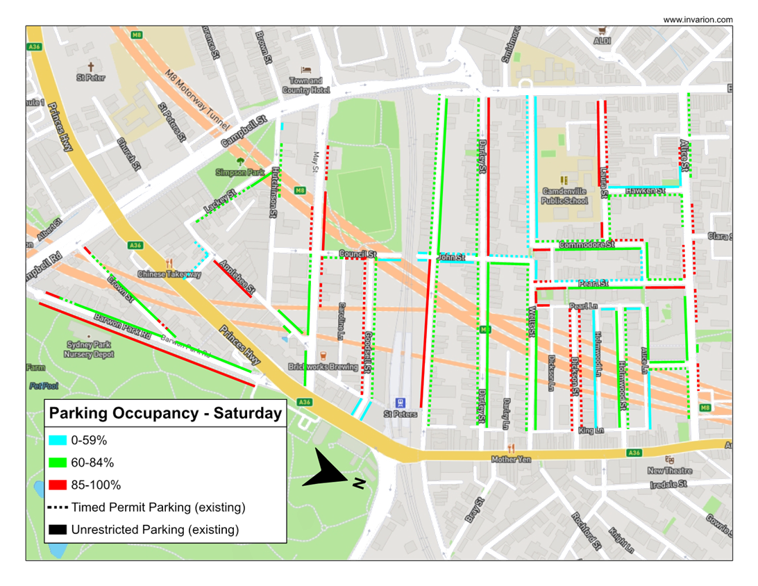
LTF0326(1) Item 10 St Peters Station Parking Study (Midjuburi-Marrickville and Damun-Stanmore Wards / Newtown & Heffron Electorates / Inner West PAC) 126
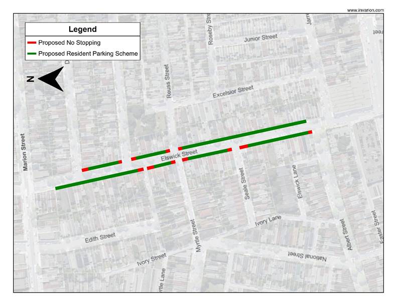
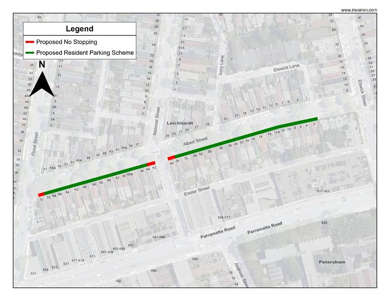
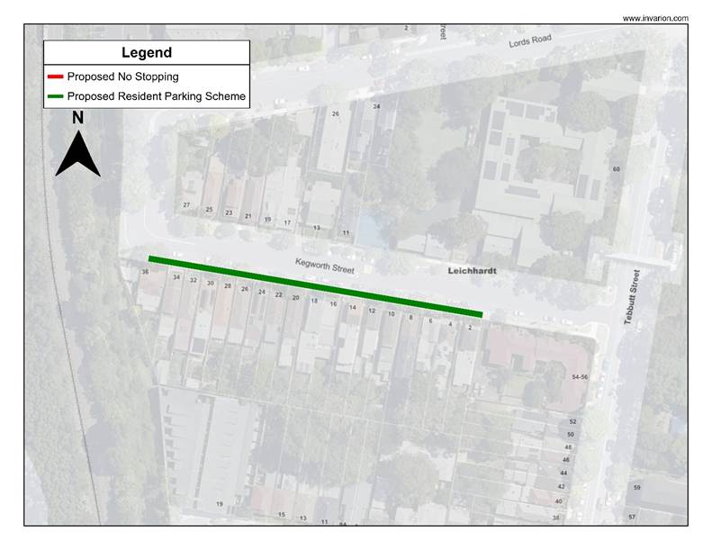
LTF0326(1) Item 11 Leichhardt West Stage 2 Marketplace and Stage 3 Taverners Hill Precinct - Resident Parking Scheme Gulgadya-Leichhardt Ward/Balmain Electorate/Leichhardt PAC) 137
Late Items
Nil at time of printing.
6 Part B - Items for Information Only
Nil at the time of printing.
7 Part C - Items for General Advice
Nil at the time of printing.
8 General Business
9 Close of Meeting
|
|
Local Transport Forum Meeting 16 March 2026 |
Minutes of Meeting held on 16 February 2026
Meeting commenced at 11:01 AM
ACKNOWLEDGEMENT OF COUNTRY BY CHAIRPERSON
I acknowledge the Gadigal and Wangal people of the Eora nation on whose country we are meeting today, and their elders past and present.
FORUM MEMBERS PRESENT
|
Clr Victor Macri |
Councillor –Midjuburi - Marrickville Ward (Chair) |
|
Clr Liz Atkins |
Councillor – Damun - Stanmore Ward |
|
Rebecca Fernandez |
Representative for Kobi Shetty MP, Member for Balmain |
|
Graeme McKay |
Representative for Jo Haylen MP, Member for Summer Hill |
|
Colin Jones |
Representative for Inner West Bicycle Coalition (IWBC) |
|
Vinoth Srinivasan |
Transport for NSW (TfNSW) |
|
Manod Wickramasinghe |
IWC’s Traffic and Transport Planning Manager |
|
Sunny Jo |
IWC’s Coordinator Traffic Engineering Services (North) |
|
George Tsaprounis |
IWC’s Coordinator Traffic Engineering Services (South) |
|
Jason Scoufis |
IWC’s Coordinator Traffic Investigations & Road Safety |
|
Christy Li |
IWC’s Business Administration Officer |
|
|
|
|
VISITORS |
|
|
|
|
|
Kim Shi |
Public Speaker – Item 2 |
|
Gino Odelli |
Public Speaker – Item 17 |
|
Stephen Odelli |
Public Speaker – Item 17 |
|
|
|
|
APOLOGIES: |
|
|
|
|
|
Miriama Tamata |
Representative for Jenny Leong MP, Member for Newtown |
|
|
|
DISCLOSURES OF INTERESTS:
Nil.
CONFIRMATION OF MINUTES
|
That the Minutes of the Local Transport Forum held on Monday, 8 December 2025 be confirmed. |
MATTERS ARISING FROM COUNCIL’S RESOLUTION OF MINUTES
The Minutes of the Local Transport Forum held on 17 November 2025 were adopted at Council’s meeting held on 09 December 2026 with the following amendments:
a) An additional point 4 be added to the recommendations for Item 3: St Peters Triangle- Proposed reversal of traffic flows at Applebee Street and Lackey Street, St Peters that reads, “The General Manager seek an urgent meeting with the NSW Secretary for Transport expressing significant concern at the removal of the right hand turn from Princes Highway to May Street, outlining the adverse impacts for residents in St Peters, and demanding an urgent review that balances road safety improvements with resident access to their neighbourhood.”
b) An additional point 5 be added to the recommendations for Item 4: Schwebel Street - Proposed one-way eastbound treatment at Schwebel Street between Station Street/Leofrene Avenue and Junction Road, that reads, “That Council investigate and consult with residents and businesses about installing angle parking on the north side of Schwebel Street between Station Street and Leofrene Avenue and report back to a future Local Transport Forum.”
|
LTF0226(1) Item 9 Hardie Avenue (at
Smith Street), Summer Hill-Proposed upgrade of an existing at level road
crossing to a new raised pedestrian crossing. |
|
Council is planning to improve safety in Hardie Avenue, Summer Hill by constructing a new Raised Pedestrian Crossing near Smith Street to replace the existing ‘at-grade’ flat pedestrian crossing. The proposal aims to improve pedestrian and motorist safety by better defining safe pedestrian crossing points and addresses pedestrian safety and driver behaviour at this location.
Officers Recommendation:
That the detailed design plan (10335) to up-grade an existing road level crossing to a proposed new raised crossing, with associated signs and line marking in Hardie Avenue at Smith Street, Summer Hill be approved.
LTF Advice:
No advice provided by LTF members.
RECOMMENDATION:
That the detailed design plan (10335) to up-grade an existing road level crossing to a proposed new raised crossing, with associated signs and line marking in Hardie Avenue at Smith Street, Summer Hill be approved.
|
General Business
|
Item 18: Rat Running on Illawarra Road (northern part), Marrickville |
|
The Chairperson noted that many residents have raised concerns regarding rat running and safety issues on Illawarra Road (northern section), noting that cars often get swiped due to the narrowness of the road. It was noted that the resident would like Council to consider putting in parklets on the northern part of Illawarra Road to reduce traffic volumes and alleviate the current issues. Council Officers advised that they would investigate the matter noting that a supporting traffic study would be required to consider the impacts of such a proposal. |
|
Item 19: Investigate the potential for a footpath on South Street, Tempe |
|
The Chairperson noted that there is currently no footpath on South Street that leads to the Tempe Recreation Reserve. It was noted that South Street is quite a narrow street, and that with the upcoming opening of the Bunnings Tempe store, traffic in the area is likely to increase which may create a safety risk for pedestrians in the area. It was also noted that there are some large trees that impede the access of people wanting to walk on the grass verge. Council Officers advised that they would investigate the matter. |
|
Item 20: Electricity pillar on Union Street, Tempe impeding footpath access |
|
The Chairperson advised that an electrical pillar has recently been installed on Union Street, Tempe, blocking access for pedestrians to walk past on the footpath safely. Council Officers advised that they have written to the relevant stakeholder. It was noted that once the area gets redeveloped, Council will write to the developer to seek to get some land dedicated back to Council so that the footpath can be widened. |
|
Item 21: Request for Red Light Camera on Princes Highway, Tempe |
|
The Representative for the Member of Balmain queried if a ‘Red light camera’ could be installed on Princes Highway, Tempe as there was a recent fatality in the area. The Representative for Transport for NSW advised that community members can make a submission to the Centre of Road Safety for review and consideration. |
|
Item 22: Investigate the potential for a pedestrian crossing on Anthony Street at Edwin Street, Croydon |
|
The Representative for the Inner West Bicycle Coalition requested that Council investigate the potential of a pedestrian crossing on Anthony Street at the intersection of Edwin Street, Croydon, in light of the recently adopted ‘Pedestrian Crossing Warrant Policy.’ The Member for the Inner West Bicycle Coalition noted that motorists often use Anthony Street as a rat run. Council Officers advised that they would investigate the matter. |
|
Item 23: Review of ‘One Way Bicycles Excepted’ signage on John Street, Colgate Street and Little Darling Street, Balmain |
|
The Representative for the Inner West Bicycle Coalition requested the Council review the suitability of implementing ‘One Way Bicycles Excepted’ restrictions on John Street, Colgate Street and Little Darling Street, Balmain. Council Officers advised they would investigate this matter. |
|
Item 24: Review of the footpath on Victoria Road, between Quirk Street and Robert Street, Rozelle |
|
The Representative for the Member of Balmain raised concerns from a resident regarding the safety of the footpath on Victoria Road, between Quirk Street and Robert Street, Rozelle and questioned if anything can be done to improve the safety of the area such as trimming vegetation. The Representative for Transport for NSW advised the Representative for the Member of Balmain to forward the details to him so he can pass on the information to the relevant team to review. |
|
Item 25: Advertisement flag blocking pedestrian sightlines in Ramsay Street, Haberfield |
|
The Representative for the Member of Summer Hill noted that at the intersection of Ramsay Street and Kingston Street, Haberfield, a business has put up an advertisement feather flag in one of the planter boxes on the road and that it is impeding pedestrian sightlines. The Representative for the Member of Summer Hill requested that Council review the signage and request that it be removed. Council Officers advised that they would pass on the information to the relevant team to review. |
Meeting closed at 12.41pm.
CHAIRPERSON
Clr Victor Macri
|
|
Local Transport Forum Meeting 16 March 2026 |
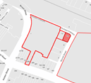
Subject: Inner West LGA - Proposal for Flexicar car share parking spaces (All wards, all electorates, all PACs)
Prepared By: Jennifer Adams - Traffic Engineer
Authorised By: Manod Wickramasinghe - Traffic and Transport Planning Manager
|
RECOMMENDATION
That the following ‘No Parking Authorised Car Share Vehicle Expected, Area FLEXICAR’ restrictions be approved:
1. A 5.5m restriction in the first parking space after the 10m ‘No Stopping’ zone (near turning area) on the northern side of Orchard Crescent west of Murrell Street, Ashfield.
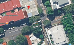
2. A 5.5m restriction in the first parking space after the existing ‘No Stopping’ restriction on the northern side of Salisbury Road outside No.182-184 Salisbury Road east of Mallett Street, Camperdown.
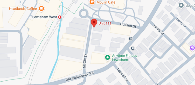
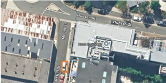
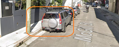
3. A 5.5m restriction on the eastern side of McGill Street (after the driveway to No.1-3 McGill Street) south of Hudson Street, Lewisham.
4. A 5.5m restriction in the first parking space (after the ‘No Parking’ sign) on the eastern side of Livingstone Road north of Marrickville Road, Marrickville outside No.178-180 Livingstone Road.
5. A 6m restriction in the first parking space between the garden beds on the southern side of Nagurra Place (east of the speed hump and outside the playground), Rozelle.
6. A 5.5m restriction in first parking space after the ‘No Stopping’ sign on the eastern side of Edward Street south of Flour Mill Way, Summer Hill.
|
STRATEGIC OBJECTIVE
This report supports the following strategic directions contained within Council’s Community Strategic Plan:
|
2: Liveable, connected neighbourhoods and transport |
|
|
EXECUTIVE SUMMARY
A request has been received from Flexicar to install 6 on-street dedicated ‘Car Share’ parking spaces for existing floating car share vehicles around the Inner West.
BACKGROUND
Car sharing has been well established in the Inner West and provide an additional transport option for the growing population in the Inner West LGA.
One of the benefits of a car share scheme is that one shared vehicle can replace several private vehicles that would otherwise compete for local parking. The scheme also reduces overheads for residents who don't need to own a car. Other benefits align to Council’s Integrated Transport Strategy by supporting sustainable transport as a part of its drive to:
· Reduce greenhouse gas emissions;
· Reduce on-street parking demand;
· Reduce congestion and the competition for parking spaces; and
· Encourage active lifestyles by reducing dependency on private cars.
Users of car share schemes in the Inner West report reduced car ownership and greater use of other transport options including public transport, walking and cycling.
The following hierarchy of preferred locations for designated car share spaces has been applied when assessing suitability of locations:
a) Within immediate proximity to public transport services such as a rail/metro station/stop;
b) Adjacent to public land such as a park;
c) Adjacent to a public facility such as a leisure centre or library;
d) Within high/medium density residential areas;
e) In or immediately adjacent to retail / commercial streets;
f) Adjacent to the side boundary of single dwellings;
g) Other locations.
It should be noted that car share parking spaces located in front of single dwellings are given low priority and avoided in most circumstances. Consultations are also carried out with residents and businesses in the immediate vicinity of the proposed parking space.
Council reserves the right to reject, or determine by refusal, any application for a car share parking space.
DISCUSSION
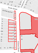
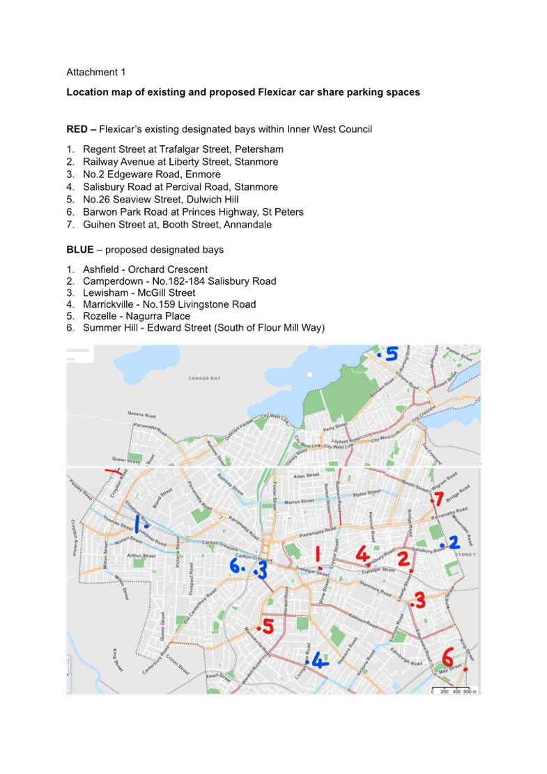
A report went to Local Traffic Committee at its 16 June 2025 meeting detailing 8 locations for dedicated Flexicar car share parking spaces, 7 locations were recommended by the Committee and installed in late 2025. Those locations were:
1. Regent Street at Trafalgar Street Petersham
2. Railway Avenue at Liberty Street Stanmore
3. 2 Edgeware Road Enmore
4. Salisbury Road at Percival Road Stanmore
5. 26 Seaview Street Dulwich Hill
6. Barwon Park Road at Princes Highway St Peters
7. Guihen Street at Booth Street Annandale
Proposed new Locations
A request has been received from Flexicar for the installation of on-street dedicated car share parking spaces within Inner West. The locations given are:
1. Ashfield - Orchard Crescent
2. Camperdown - 182-184 Salisbury Road
3. Lewisham - McGill Street
4. Marrickville - 159 Livingstone Road
5. Rozelle - Nagurra Place
6. Summer Hill - Edward Street (South of Flour Mill Way)
The nominated Flexicar locations are detailed below:
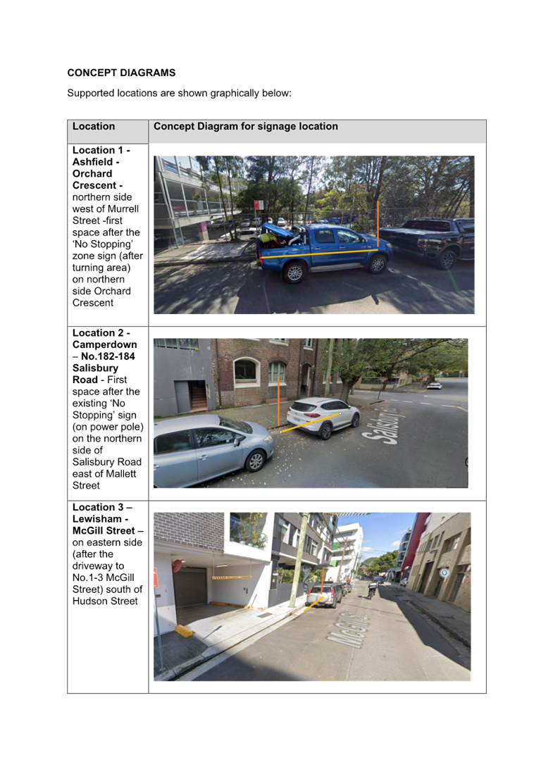
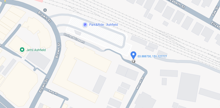
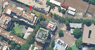
1. Ashfield - Orchard Crescent
First ‘1P 8.30am-6pm Mon-Fri 8.30am-12.30pm Sat’ space after the ‘No Stopping’ zone sign (after turning area) on northern side Orchard Crescent west of Murrell Street (-33.8887, 151.127716). Currently there is no data for usage in Ashfield for the 24 local members.
2. Camperdown - 182-184 Salisbury Road
First unrestricted space after the existing ‘No Stopping’ zone sign (on power pole) on the northern side of Salisbury Road east of Mallett Street (-33.891202, 151.178193). Provided data indicates that there are 7 members in postcode 2048 with an average of 2 bookings per month.


3. Lewisham - McGill Street
Unrestricted parking space on the eastern side (after the driveway to No.1-3 McGill Street) south of Hudson Street (-33.894190, 151.143956). There are 19 members in the postcode 2049 and no data for average bookings per month in the locality.
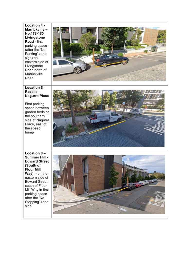
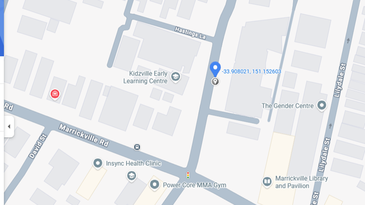
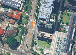
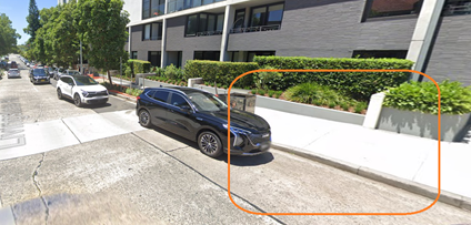
4. Marrickville – No.178-180 Livingstone Road
First unrestricted parking space (after the ‘No Parking’ zone sign) on eastern side of Livingstone Road north of Marrickville Road (-33.908021, 151.152603). There are 26 members listed for postcode 2204 and no data on bookings in the area.
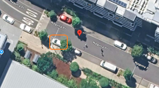
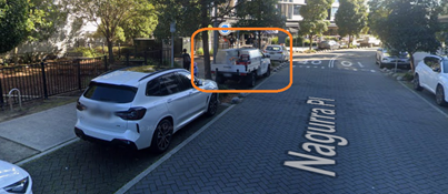
5. Rozelle - Nagurra Place
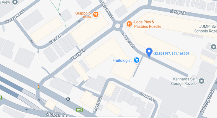
First ‘2P 8am-10pm Mon-Fri’ parking space (between garden beds) on the southern side of Nagurra Place east of the speed hump (-33.861297, 151.168269). There is no data for usage for the 8 members in postcode 2039
6. Summer Hill - Edward Street (South of Flour Mill Way)
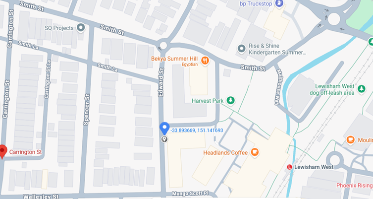
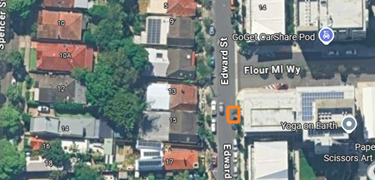
Unrestricted parking space on the eastern side of Edward Street south of Flour Mill Way in first parking space after the ‘No Stopping’ zone sign (-33.893669, 151.141693). There are 7 members in the postcode 2130 and no data for average bookings per month in the locality.
OFFICERS COMMENTS
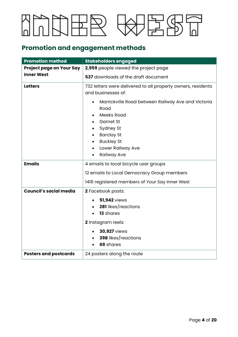
Community consultation was led by Flexicar representatives between 7 August and 31 October 2025. Letters were distributed to local residents within 100 metres of each proposed space.
A summary of each location is presented below.
|
|
Location |
Letters sent - Responses |
Resident comments |
Supported / not supported |
|
1 |
Ashfield - Orchard Crescent - northern side Orchard Crescent west of Murrell Street -33.8887 151.127716
Currently ‘1P 8.30am-6pm Mon-Fri 8.30am-12.30pm Sat’ restrictions |
Consultation 1-26 September 2025
98 letters sent
0 responses
Response rate = 0%
|
|
Proposed site meets Council’s car share Policy – Within immediate proximity to public transport services such as a rail/metro station/stop and within medium high density residential area
Supported – first space after the ‘No Stopping’ sign (after turning area) on northern side Orchard Crescent west of Murrell Street |
|
2 |
Camperdown - 182-184 Salisbury Road
-33.891202 151.178193
Currently unrestricted |
Consultation 1-26 September 2025
124 letters sent
0 responses
|
|
Proposed site meets Council’s car share Policy – within medium density residential area
Supported - First space after the existing “No Stopping’ sign (on power pole) on the northern side of Salisbury Road east of Mallett Street |
|
3 |
Lewisham - McGill Street
-33.894190 151.143956
Currently unrestricted |
Consultation 7-31 August 2025
210 letters sent
1 response
1 objection (100%)
|
does not think the proposed car share space is a good idea and viable option for the long term prospects of the neighbourhood as parking on McGill is already incredibly sparse. The installation of a car space would be taking away from some residents ability to park (not all of the residents living in apartments have designated car spaces) and with the building of more apartments on McGill st, the parking is only going to get more limited in the not-too-distant future. |
Proposed site meets Council’s car share Policy – within medium high density residential area
Supported - First space on eastern side (after the driveway to 1-3 McGill Street) south of Hudson Street |
|
4 |
Marrickville – 178-180 Livingstone Road
-33.908021 151.152603
Currently unrestricted |
Consultation 7-31 October 2025
252 letters sent
4 responses
1 support (25%)
3 objections (75%)
|
this space is already used by vehicles to park illegally; it is the apartment bin collection area; line of sight will be affected for left turning vehicles;busy imntersection;already GoGet spaces nearby; better situated at Robert Street in order not to impede on an intersection
Location is not suitable for carshare;location is currently the buildings rubbish pick up and deliveries;car spaces are limited;already 2 x GoGet spaces in library parking along with uber and lime bikes;too close to driveway; suggest to relocate to centre of Marrickville with lots of open car spaces
The proposal is in the same location as a former 'no'parking' sign, yet to be replaced.The proposal does not provide a benefit for everyone;resident is disabled and unable to drive and required these zones for pick up |
Proposed site meets Council’s car share Policy – Adjacent to a public facility such as a leisure centre or library and within medium high density residential area. The location will not be within the existing ‘No Parking’ area.
Supported – The location will be the first legal parking space (after the ‘No Parking’ sign) on eastern side of Livingstone Road north of Marrickville Road |
|
5 |
Rozelle - Nagurra Place
-33.861297 151.168269
Currently ‘2P 8am-10pm Mon-Fri’ restrictions |
Consultation 7-31 August 2025
108 letters sent
5 responses
1 support (20%)
1 support but in alternative location (20%)
3 objections (60%)
|
I encourage the Inner West Council to approve and actively support the rollout of Flexicar and Carshare services within Rozelle.
The proposed space in my view is permissible in Nagurra Place however the selected space is in the wrong location….position selected is adjacent to the playground and this specific carspace is excellent for parents, young children and strollers.
Parking is difficult enough for the shop, cafe, children’s playground, and restaurants in the street without taking up a permanent place for a car share veichcle which would be better suited in Terry St, maybe closer to the corner of Victoria Rd.
Does not support car share spaces as parking is an absolute premium on Nagurra Place given the retail and residential density. The retail relies on turn over of the parking spaces. There are only 20 limited time parking spaces in the street. (2 similar comments)
|
Proposed site meets Council’s car share Policy – Adjacent to public land such as a park and within medium high density residential area.
Supported - First parking space in between garden beds on the southern side of Nagurra Place east of the speed hump |
|
6 |
Summer Hill - Edward Street (South of Flour Mill Way)
-33.8887 151.127716
Currently ‘1P 8.30am-6pm Mon-Fri 8.30am-12.30pm Sat’ restrictions
|
Consultation 7-31 August 2025
75 letters sent
4 responses
1 support but in alternative location (25%)
3 objections (75%)
|
..prefer if the spot was on the other side of the street where it has a 2hr parking limit, not on the all day parking side. It’s hard enough to park in Summer Hill. Around the Flour Mill precinct there is already car share parking. (2 similar comments)
The chosen proposed space…on the wrong side of the Street to begin with. It needs to be on the opposite side of the street being the Mon-Fri 8am-5pm restriction. The proposed space dedicated to a Flexicar would then not reduce the long term parking space that is currently proposed……. placement of the flexi-car spot would be more suitable in the existing 2-hour times spots of which there are many.
Does not support car share spaces as parking in Edward Street is often impossible, particularly on those Sunday mornings when markets are held on the old Flour Mill’s… Contributing to the problem during the week is the scarcity of patrols by Council’s parking officers, and the apparent impunity with which some business vehicles regularly park in the parking permit areas for well in excess of the 2 hours limit. …parking permits are of limited utility under current parking rules…. There is no need for additional parking reservation for car share businesses, as there are two sites in Flour Mill Drive …. We believe the onus for finding car hire/share sites is the responsibility of the car share business, not council, and certainly not at the expense and inconvenience of residents…. To improve the parking situation in Edward Street, Council should consider making changes to improve resident parking, and two suggestions are put forward • Council to extend the permit area hours for Area 13 to operate 24 hours a day, 7 days a week. • Council to increase regular parking patrols . |
Proposed site meets Council’s car share Policy – on side boundary and within medium density residential area.
There are two other car share spaces in the locality one in Flour Mill Way and the other in Wellesley Street.
Supported – first space after statutory 10m ‘No Stopping’ sign on the eastern side of Edward Street south of Flour Mill Way
|
A location map of existing and proposed Flexicar car share parking spaces is provided in Attachment 1.
Concept diagrams of the proposed nominated locations are provided in Attachment 2.
FINANCIAL IMPLICATIONS
Costs associated with the installation, removal, maintenance and administration of dedicated car share bays/spaces including non-statutory features such as painted road markings will be met by the relevant car share company in accordance with the Schedule of Fees and Charges.
|
1.⇩ |
Location map of existing and proposed Flexicar car share parking spaces |
|
2.⇩ |
Concept diagrams of the proposed car share parking locations |
|
Local Transport Forum Meeting 16 March 2026 |
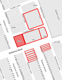
Subject: Victoria Street, Ashfield - Proposed Raised Pedestrian Crossing (Djarrawunang - Ashfield Ward / Summer Hill Electorate / Burwood PAC)
Prepared By: Daniel Li - Student/Graduate Traffic Engineer
Authorised By: Manod Wickramasinghe - Traffic and Transport Planning Manager
|
RECOMMENDATION
That the detailed design plan (10376) for a proposed raised pedestrian crossing treatment on Victoria Street intersecting with Robert Street, Ashfield be approved. |
STRATEGIC OBJECTIVE
This report supports the following strategic directions contained within Council’s Community Strategic Plan:
|
2: Liveable, connected neighbourhoods and transport |
|
|
EXECUTIVE SUMMARY
Council is planning to improve safety for pedestrians in Victoria Street at Robert Street, Ashfield by converting the existing splitter island and kerb blister crossing to a raised pedestrian crossing. The proposal aims to improve pedestrian and motorist safety by better defining safe pedestrian crossing points, improving sight distances, reducing traffic speeds and conflicts with traffic movements at this location.
BACKGROUND
Council has been investigating pedestrian safety improvements on streets surrounding the Cardinal Freeman Retirement Village. The investigation identified the intersection of Victoria Street and Robert Street as a location of interest to improve pedestrian accessibility near Cardinal Freeman Village. An initial concept design for this was submitted to the December 2023 Local Traffic Committee which was later approved in principle at the March 2024 Council meeting.
DISCUSSION
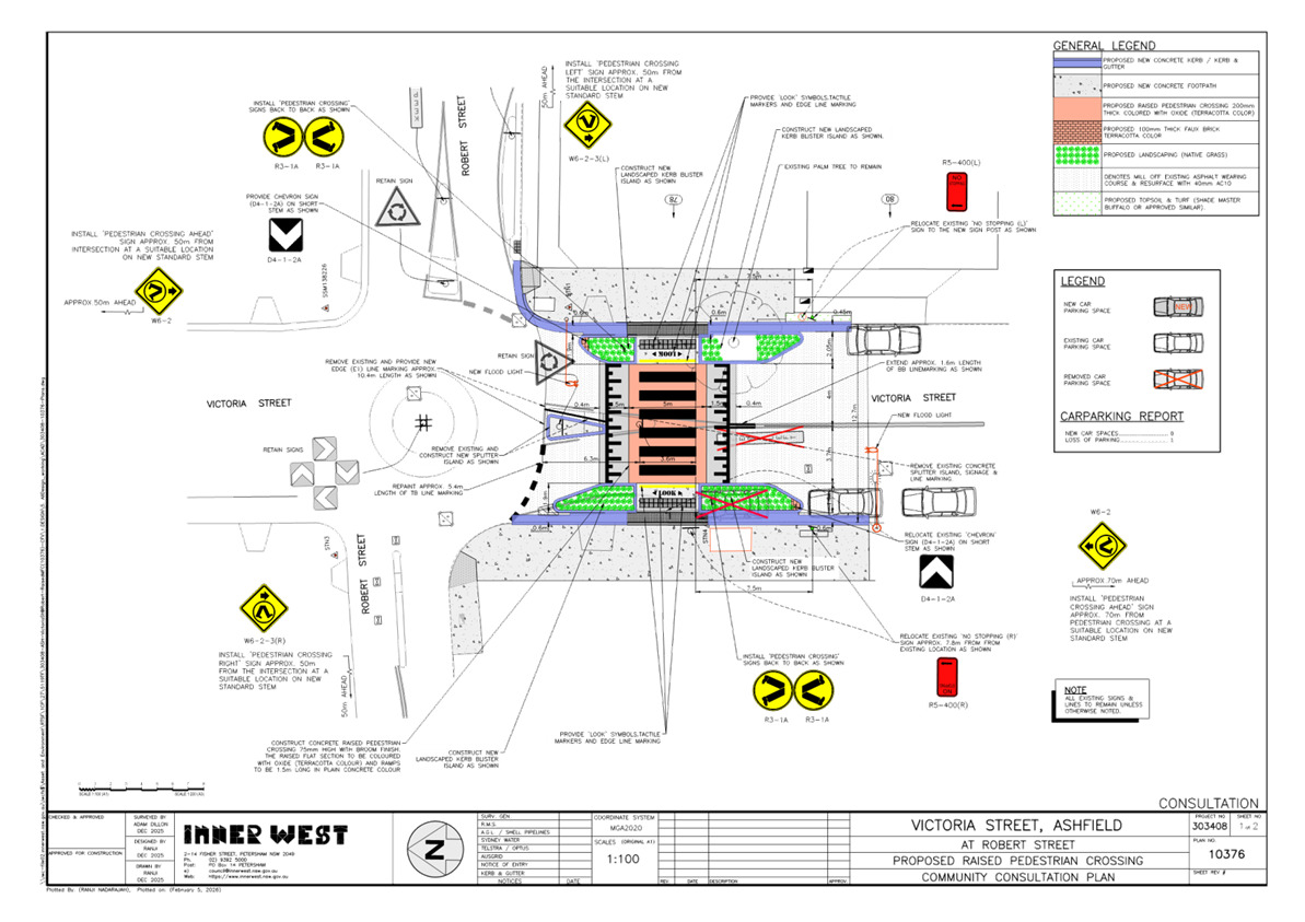
The Plan:
Council proposes to undertake the following works in Victoria Street, Ashfield (Plan No. 10376)
· Construct a new raised concrete pedestrian crossing with ‘gutter bridge’ crossings. Tactile indicators will be installed on both sides of the new raised pedestrian crossing;
· Reconstruct kerb and gutter with new concrete kerb and gutter (generally where shown on the plans);
· Remove existing kerb ramps and provide concrete footpath;
· Reconstruct two kerb ramps and some sections of the damaged concrete footpath with new concrete footpath;
· Undertake some minor returfing works in the grass verge area to match new works;
· Resurface the road pavement with new asphalt as shown in the plan (final extent of any resurfacing will be subject final funding allocations);
· Install signage and line marking associated with the works as required and where shown on Plans.
Parking Changes:
New ‘No Stopping’ zones will be provided adjacent to the new raised pedestrian crossing to enable its construction. This will result in the loss of one (1) existing on-street parking space in Victoria Street.
Streetlighting:
The new pedestrian crossing will require new lighting for it to meet the minimum lighting safety and compliance standards. This may involve either 1 or 2 new flood lights provided on either side each of the new raised pedestrian crossings (on either existing or new power poles). The attached plan indicatively shows the locations of the proposed new flood lights and power poles, with the final location to be confirmed during the lighting design development phase of the project by qualified Electrical Consultant.
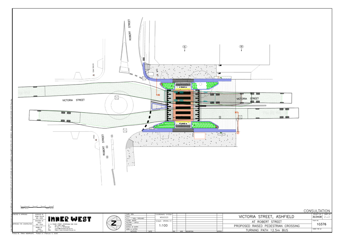
Transit Buses:
Victoria Street has been identified as a bus route for the 406 Five Dock to Hurlstone Park service. A swept path as shown in Attachment 2 has been provided to Transit Systems and indicates that the bus movements are not affected by the proposed crossing. As such, Transit Systems has not raised any objections to the proposal.
Consultation:
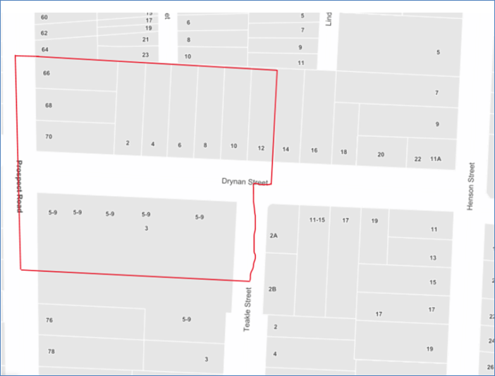
A letter outlining the above proposal was distributed to the directly affected properties (11 properties) in Victoria Street and Roberts Street as shown in Figure 2. Two (2) responses were received in relation to this proposal with one (1) support from Transit Systems and one (1) response opposing the pedestrian crossing. The comments raised by the resident can be seen below:
|
Resident Comments |
Officers Response |
|
1. Resident claims that this proposal is not an optimal use of resources and will have minimal impact in improving the safety for pedestrians on Victoria Street. 2. This intersection is safe and Council should focus on having a raised pedestrian crossing at the intersection of Victoria Street and Norton Street. 3. There is high parking demand due to the nearby hospital, and the proposal will result in a loss of parking. 4. If possible, the pedestrian crossing should be relocated closer to the Cardinal Freeman Village as opposed to in front of the residents property. |
1. This pedestrian crossing acts as a traffic calming device and improves pedestrian access from the Sydney Private Hospital to Bus Stop(s) on the eastern side of Victoria Street. 2. The suggested location is outside the current scope of works and would need to be separately considered. 3. It is acknowledged that new pedestrian crossing or traffic calming devices will often result in a loss of parking, however, this loss of parking is required to maintain adequate sightlines in accordance with TfNSW guidelines. Kerb blisters have been provided to reduce the loss in parking. 4. The proposed crossing is part of a series of pedestrian crossings being provided within walking distance of Cardinal Freeman Village but also improves access for local residents and businesses. |
Table 1. Consultation comments
![]()
![]()
![]()
![]()

Figure 1. Consultation area
FINANCIAL IMPLICATIONS
The project is estimated to be around $158,900 and will be listed for construction as part of the 2026/2027 Traffic Facilities Capital Program.
|
1.⇩ |
Detailed Design Plan (10376) |
|
2.⇩ |
Swept Path Diagrams |
|
|
Local Transport Forum Meeting 16 March 2026 |
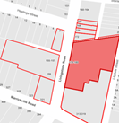
Subject: Oxford Street & Park Street, Rozelle - Proposed One-Way Traffic Proposal (Baludarri-Balmain Ward/ Balmain Electorate/ Leichhardt PAC)
Prepared By: Amir Falamarzi - Traffic Engineer
Authorised By: Manod Wickramasinghe - Traffic and Transport Planning Manager
|
RECOMMENDATION
That the proposed signage and linemarking plan for the one-way (bicycles excepted) northbound traffic on Park Street, Rozelle and one-way (bicycles excepted) southbound traffic on Oxford Street, Rozelle between Darling Street and Moodie Street be approved.
|
STRATEGIC OBJECTIVE
This report supports the following strategic directions contained within Council’s Community Strategic Plan:
|
2: Liveable, connected neighbourhoods and transport |
|
|
EXECUTIVE SUMMARY
On 17 February 2026, Council adopted the Iron Cove Traffic Review which included the introduction of one-way traffic on Park Street and Oxford Street, Rozelle. This proposal received strong levels of support during the community engagement undertaken in 2025. Following Council’s approval, a detailed signage and linemarking plan for the one-way traffic arrangement has been prepared for approval and implementation.
BACKGROUND
Council adopted the Iron Cove Traffic Review on 17 February 2026, which included several treatments including the introduction of one-way traffic on Park Street and Oxford Street, Rozelle. This proposal received strong levels of support during the community engagement undertaken between June and July 2025.
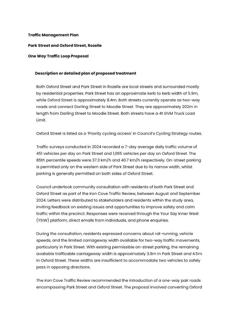
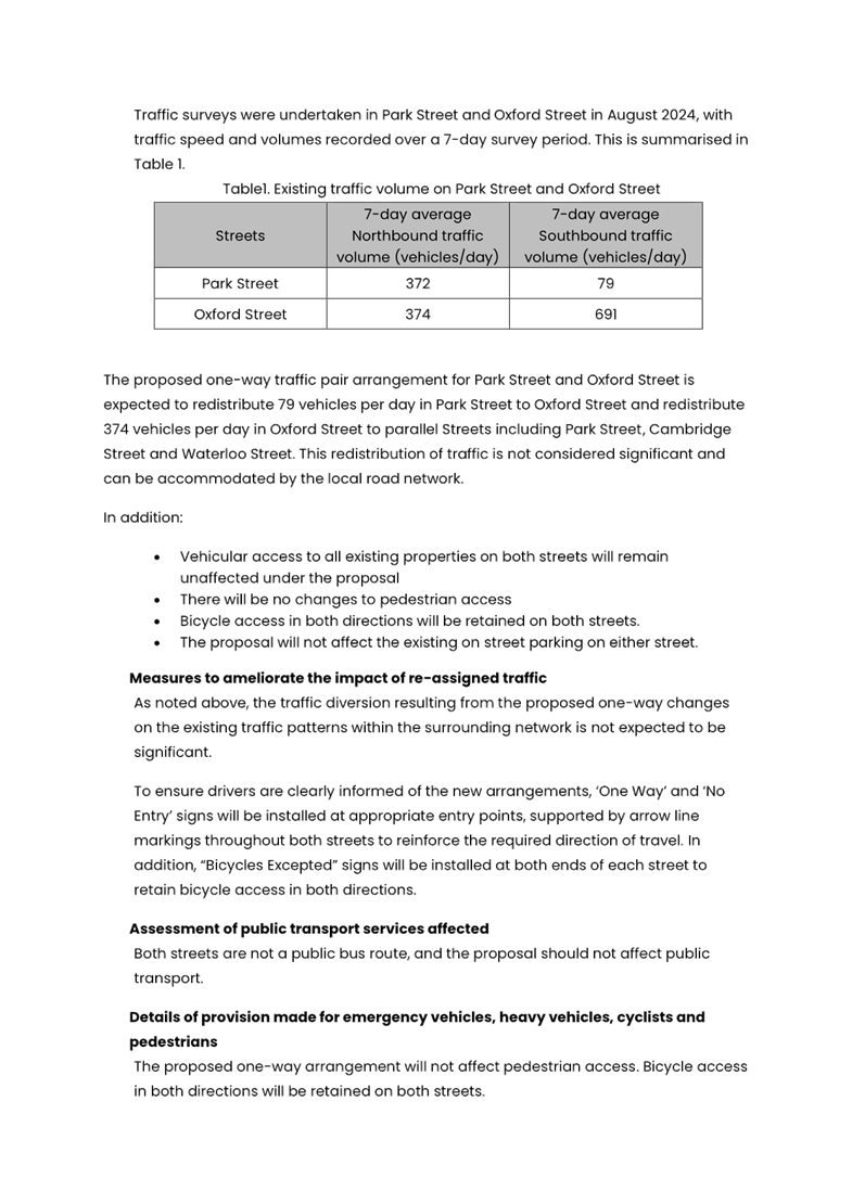
Both Oxford Street and Park Street, Rozelle are local streets and are surrounded mostly by residential properties. Park Street and Oxford Street have an approximate kerb to kerb width of 5.9m and 8.4m respectively. Both streets currently operate as two-way roads and are approximately 200m in length from Darling Street to Moodie Street. Oxford Street is listed as a ‘Priority cycling access’ road in Council’s Cycling Strategy routes.
Traffic surveys conducted in 2024 recorded a 7-day average daily traffic volume of 451 vehicles on Park Street and 1,065 vehicles on Oxford Street. The 85th percentile speeds were 37.3 km/h and 40.7 km/h respectively. On-street parking is permitted only on the western side of Park Street due to its narrow width, whilst parking is generally permitted on both sides of Oxford Street.
DISCUSSION
Council undertook initial community consultation with residents of both Park Street and Oxford Street as part of the Iron Cove Traffic Review between August and September 2024. During the initial consultation, residents expressed concerns about rat-running, vehicle speeds, and the limited carriageway width available for two-way traffic movements, particularly in Park Street.
With existing permissible on-street parking, the remaining available trafficable carriageway width is approximately 3.9m in Park Street and 4.4m in Oxford Street. These widths are insufficient to accommodate two vehicles to safely pass in opposing directions without the use of driveways or vacant parking spaces as passing bays.
The Iron Cove Traffic Review recommended the introduction of a one-way pair road system encompassing Park Street and Oxford Street. The proposal involved converting Oxford Street to one-way southbound traffic, and Park Street to one-way northbound traffic.
The proposed one-way traffic pair arrangement for Park Street and Oxford Street is expected to redistribute 79 vehicles per day in Park Street to Oxford Street and redistribute 374 vehicles per day in Oxford Street to parallel streets including Park Street, Cambridge Street and Waterloo Street. This redistribution of traffic is not considered significant and can be accommodated by the local road network.
The draft plan for the Iron Cove Traffic Review was exhibited for public feedback between June and July 2025. Engagement outcome indicated support for the one-way proposal in Park Street and Oxford Street, with 52% of respondents from the Iron Cove precinct supporting the one-way proposal. Support levels in Park Street and Oxford Street were higher at 75% and 82% respectively.
It should be noted that the original proposals under the Iron Cove draft plans to introduce two speed humps near No.22 Park Street and No.18 Oxford Street were excluded in the final recommendations due to low level of community support.
In February 2026 Council reached out to residents of both streets as well as Moodie Street, Manning Street and Cambridge Street regarding one-way changes in Park Street and Oxford Street as shown in Figure 1.
The proposed changes includes:
· Installation of ‘One Way’, and ‘No Entry’ signs at each end of Park Street and Oxford Street
· Installation of ‘Bicycles Excepted’ signs at both ends of each street to retain bicycle access in both directions.
· Road pavement arrows reinforcing the one-way direction
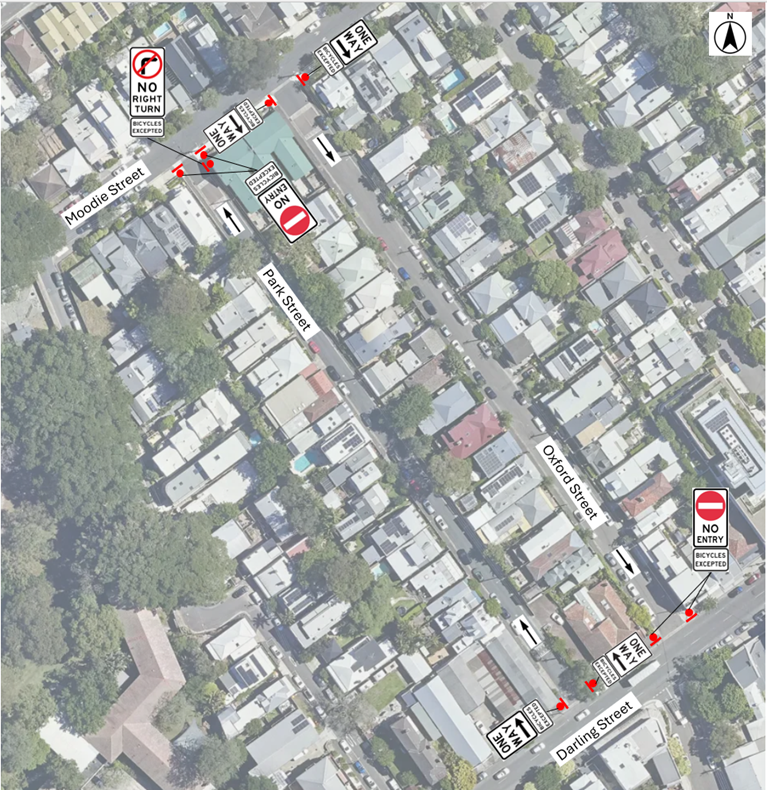
Figure 1. One-Way Traffic Proposals in Park Street and Oxford Street, Rozelle
Bicycle access in both directions will be retained on both streets.
On-street parking on both streets will not be impacted by the proposed changes.
A copy of the Traffic Management Plan outlining the proposed one-way changes is provided in Attachment 1.
A total of 272 letters were distributed to properties shown in the distribution map below.
Resident comments and officer feedback are outlined in Table 1:
Table1. Community comments and officer feedback on One Way proposal in Park Street and Oxford Street, Rozelle
|
Resident comment |
Officer feedback |
|
I support the changes however I request additional signage, in addition to the “One Way” signs, there should be “Local Traffic Only” signs. This is because this is a well known rat run and there should be discouraging signs and measures such as speed bumps, kerb adjustments, lower speed limits and signs to prevent this.
|
The proposed speed humps on Park Street and Oxford Street were excluded from the final recommendations in the Iron Cove Traffic Review due to a low level of community support. In addition the Review proposes Continuous Footpath Treatments have been proposed at the intersections of Park Street and Oxford Street with Darling Street to improve pedestrian visibility and reduce vehicle speeds at pedestrian crossing points. Park Street and Oxford Street are also part of Council’s InnerWest@40 program which will include the introduction of ‘40 Local Traffic Area signs’ in local streets. |
FINANCIAL IMPLICATIONS
Installation of the proposed signage and pavement markings will be funded from Council’s signs and line marking budget.
|
1.⇩ |
Oxford Street & Park Street, Rozelle Proposed One-Way Traffic Management Plan |

|
Local Transport Forum Meeting 16 March 2026 |
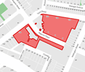
Subject: Spring Street, Birchgrove - Revised 'No Stopping' Zones (Baludarri-Balmain Ward/ Balmain Electorate/ Leichhardt PAC)
Prepared By: Amir Falamarzi - Traffic Engineer
Authorised By: Manod Wickramasinghe - Traffic and Transport Planning Manager
|
RECOMMENDATION
1. That the existing ‘No Stopping’ zone on the northern side of Spring Street west of Thomas Street, Birchgrove be reduced to 6.4m.
2. That the existing ‘No Stopping’ zones on the northern side of Spring Street east of Thomas Street, Birchgrove be reduced to 5m. |
STRATEGIC OBJECTIVE
This report supports the following strategic directions contained within Council’s Community Strategic Plan:
|
2: Liveable, connected neighbourhoods and transport |
|
|
EXECUTIVE SUMMARY
Council has received requests to review the recent installation of 10m ‘No Stopping’ zones in Spring Street, west and east of Thomas Street, with a view to improving on-street parking opportunities in the area.
A risk assessment has been undertaken at this location, and reduced 6.4m and 5m ‘No Stopping’ zones are proposed on Spring Street, west and east of Thomas Street respectively. This provides appropriate sight distances for drivers exiting Thomas Street while also retaining some kerbside parking for the local community. This proposal was consulted with the affected residents in January and February 2026, with the feedback outlined in Table 1.
BACKGROUND
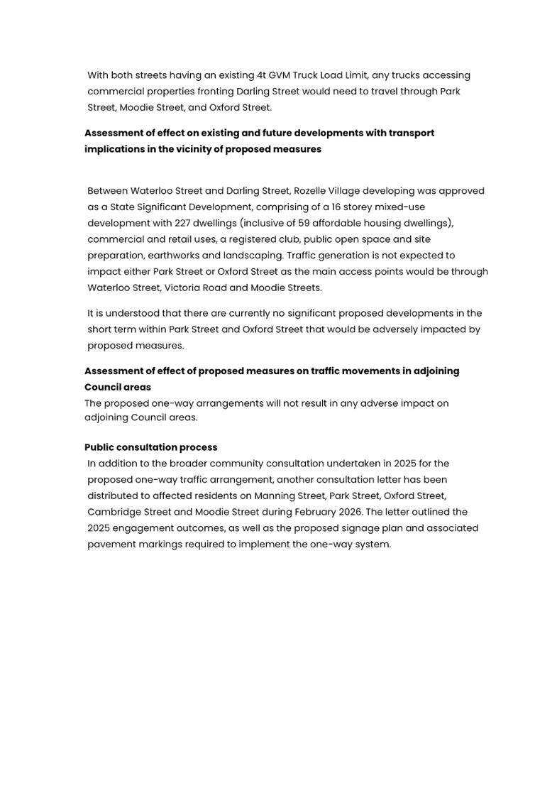
In July 2025, Council consulted nearby residents and introduced ‘No Stopping’ zones on the north side of Spring Street 10m east and west of Thomas Street, Birchgrove, to address visibility concerns, shown in Figure 1.
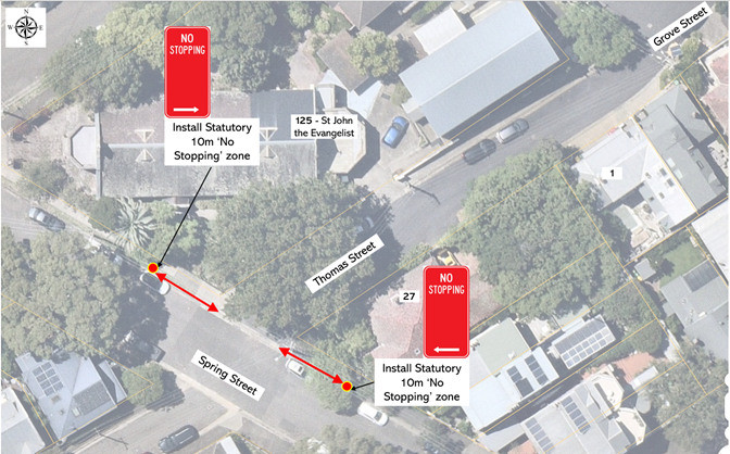
Figure 1: Existing 10m Statutory ‘No Stopping’ zones on Spring Street
Following installation of these restrictions a request was received to review the ‘No Stopping’ with a view to improving on-street parking opportunities in the area.
DISCUSSION
A risk assessment was undertaken at the subject intersection, taking into consideration prevailing road and traffic conditions and recommended that the existing ‘No Stopping’ zones west and east of Spring Street could be reduced to 6.4m and 5m respectively. It was noted that the prevailing traffic speeds in Spring Street were observed to be low provided suitable visibility for drivers exiting Thomas Street.
In late January 2026, 46 letters proposing reduced ‘No Stopping’ zones as shown in Figure 2 was sent to the affected residents as shown in the distribution area map in Figure 3.
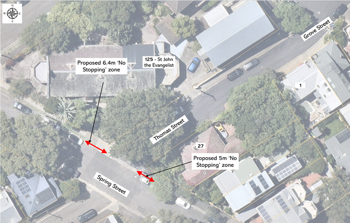
Figure 2: Revised ‘No Stopping’ zones on Spring Street at Thomas Street
Figure 3: Distribution area map for the revised No Stopping Zones
At the close of the consultation, four (4) comments were received, and outlined along with the officer’s responses in Table 1:
Table 1: Community feedback with officer responses
|
Resident concerns |
Officer responses |
|
The priority should be toward the installation of ‘No Stopping’ zone on the east side of Thomas Street along the side boundary of 27 Spring Street where high fence is installed and vegetations are overgrown. |
The eastern side of Thomas Street at Spring Street feature a high fence close to the intersection that obstructs visibility. As such, restricting parking along the side of Thomas Street would not provide additional safety benefits. |
|
With reference to the revised no stopping zones on Spring Street at Thomas Street Birchgrove, I would like to suggest that it would make more sense to make Thomas Street between Spring Street and Cove Street a one-way street going down the hill. This would solve most of the problems, as well as making that part of Thomas Street safer for everybody. |
An ongoing Balmain East & Birchgrove Local Area Traffic Management studies will consider this. |
|
We’re concerned about Council’s proposal to reduce the existing 10‑metre ‘No Stopping’ zones at Spring and Thomas Streets, because the conditions that justified those controls in July 2025 haven’t changed. Parked cars still affect visibility, and the intersection’s geometry, traffic patterns, and sightlines remain exactly the same. Before any reduction is made, we believe Council should provide clear, updated engineering analysis showing that safety will not be compromised. This submission requests that reasoned analysis be visible to those most directly affected, allowing prudence to guide the exercise of discretion without rendering safety provisional.
|
The proposed amendment maintains an appropriate level of safety while enabling the retention of additional on-street parking for the benefit of the local community. A risk assessment was undertaken to determine the appropriate ‘No Stopping’ distances. |
|
Residents still do not believe any No Stopping zones are needed here. They say there was no evidence of a safety problem to justify removing long‑standing parking. Some nearby intersections have new No Stopping zones, others do not. Residents have relied on this parking for years. No crash history or traffic data has been shared to justify the change. |
This installation of the ‘No Stopping’ zones were instigated by resident requests, to remove illegal parking at the intersection. It should be noted that it is illegal to park within 10m of an unsignalized intersection unless otherwise signposted. |
FINANCIAL IMPLICATIONS
There are no financial implications associated with the implementation of the proposed recommendations outlined in the report.
Nil.
|
|
Local Transport Forum Meeting 16 March 2026 |
Subject: Drynan Street at Prospect Road, Summer Hill – Proposed Raised Pedestrian Crossing – Design Plan 10377 (Djarrawunang-Ashfield Ward / Summer Hill Electorate / Burwood PAC)
Prepared By: Jennifer Adams - Traffic Engineer
Authorised By: Manod Wickramasinghe - Traffic and Transport Planning Manager
|
RECOMMENDATION
That the detailed design plan for the proposed Raised Pedestrian Crossing in Drynan Street at Prospect Road, Summer Hill and associated signs and line markings (as per Design Plan No.10377) be approved. |
STRATEGIC OBJECTIVE
This report supports the following strategic directions contained within Council’s Community Strategic Plan:
|
2: Liveable, connected neighbourhoods and transport |
|
|
EXECUTIVE SUMMARY
Council is planning to improve safety for pedestrians in Drynan Street at Prospect Road, Summer Hill by providing a raised pedestrian crossing approximately 6.3m away from the intersection. The proposal aims to improve pedestrian and motorist safety by better defining safe pedestrian crossing points, improving sight distances, reducing traffic speeds and conflicts with traffic movements at this location.
BACKGROUND
Council at its meetings on the 18 March 2024 approved in principle, subject to detailed design, a series of proposed pedestrian (zebra) crossings and kerb extension treatments (under concept) for improved pedestrian and road safety around and near to the Cardinal Freeman (Retirement) Village, Ashfield.
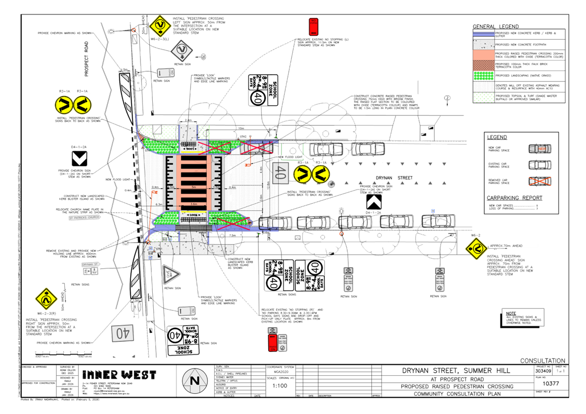
This report focuses on the prepared detailed design plan of
one of the proposed treatments, i.e. “Install
new raised pedestrian (zebra) crossing in Drynan Street, east of
Prospect Road. This will result in loss of approximately 1-2 parking spaces to
the north side of Drynan Street, and loss of 1-2 spaces to relocate part of the
‘No Parking’ (school times) drop-off and pick up zone towards the
east.”
This report details the design plan for the improvement works and its related consultation results. These works are programmed and envisaged to be constructed in the 2025/2026 financial year, subject to funding.
FINANCIAL IMPLICATIONS
The project is listed on Council’s Traffic Facilities Capital Works budget for works to be carried out in 2025/2026, subject to funding. The work is estimated to be around $144,862.
OTHER STAFF COMMENTS
The following works are proposed for Drynan Street at Prospect Road, Summer Hill and are illustrated on the attached Consultation Plan (Plan No. 10377). The proposed works aim to improve pedestrian safety by better defining and prioritising pedestrian movements across Authur Street whilst also reducing traffic speeds.
Specifically, the proposed scope of work includes the following:
· Construct a new raised concrete pedestrian crossing comprising landscaped kerb blister islands with a ‘gutter bridge’ and landscaped kerb extensions together with lead in footpaths to the new raised crossing. Tactile indicators will be installed on both sides of the new raised pedestrian crossing;
· Reconstruct kerb and gutter with new concrete kerb and gutter (generally where shown on the plan);
· Provide concrete footpaths to match gutter bridge and kerb extension;
· Install chevron line markings on Prospect Road and relocate the holding line to improve sight distance for vehicles on Drynan Street;
· Remove existing kerb ramps and install turf;
· Undertake some minor returfing works in the grass verge area to match new works;
· Resurface the road pavement with new asphalt as shown in the plan (final extent of any resurfacing will be subject final funding allocations);
· Install signage and line marking associated with the works as required and where shown on the Plan.
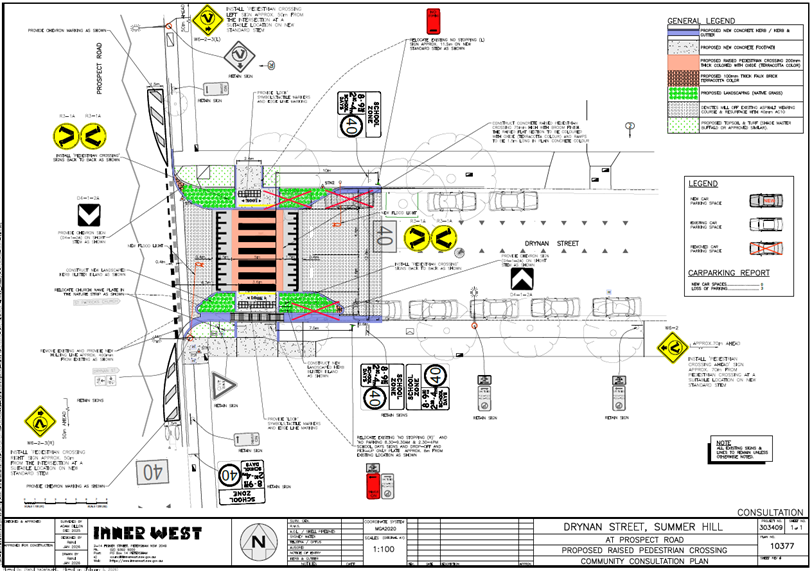
Parking changes
New ‘No Stopping’ zones will be provided adjacent to the new raised pedestrian crossing to enable its construction. This will result in loss of three (3) existing on-street parking space in Drynan Street. Please refer to the attached plan.
Streetlighting
The new pedestrian crossing will require new lighting for it to meet the minimum lighting safety and compliance standards. This may involve either 1 or 2 new flood lights provided on either side each of the new raised pedestrian crossings (on either existing or new power poles). The attached plan indicatively shows the locations of the proposed new flood lights and power poles, with the final location to be confirmed during the lighting design development phase of the project by qualified Electrical Consultant.
PUBLIC CONSULTATION
Consultation was conducted between 5 February 2026 and 25 February 2026. A letter along with a copy of the design plan was sent to residents / businesses in the immediate locality. A total of 13 letters were distributed.
There was one response.
|
Resident’s Comments |
Officer’s response |
|
The crossing is a bit close to the intersection and should be shifted a bit further away from Prospect Road down Drynan Street. The resident mentioned that Prospect Road is often busy so vehicles could be held up on the approaching side from Prospect Road while waiting for pedestrians to pass on the crossing. He suggests having longer space for more than one waiting vehicle on the approaching side of the crossing from Prospect Road. |
This new crossing requires ‘No Stopping’ zones (on the eastern side of the crossing) for sight view of pedestrians and traffic in accordance with TfNSW guidelines /technical directions. Shifting the crossing east down Drynan Street will result in additional loss of parking space and move the crossing away from the pedestrian desire line. It should be noted that this proposal allows a vehicle to wait on the approaching side of the crossing from Prospect Road. |
CONCLUSION
It is recommended that the detailed design plan of the proposed traffic treatment and associated signs and line markings be supported to improve pedestrian safety at this location.
|
1.⇩ |
303409-10377-ConsultationPlan |
|
|
Local Transport Forum Meeting 16 March 2026 |
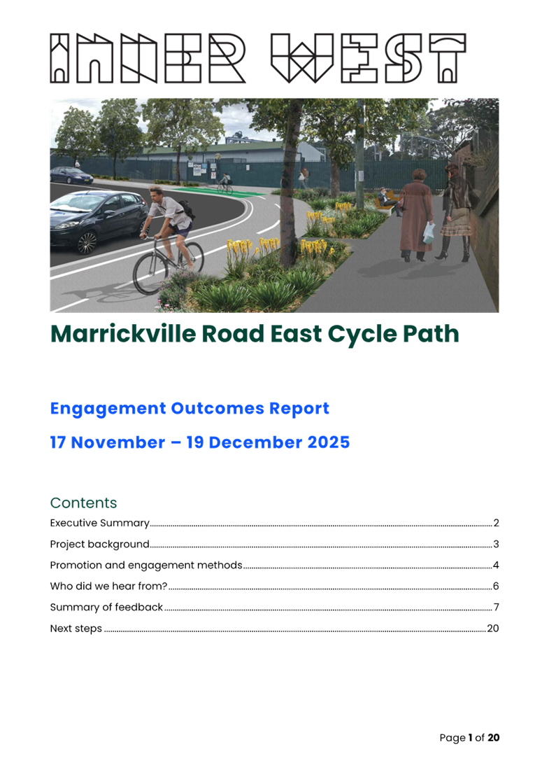
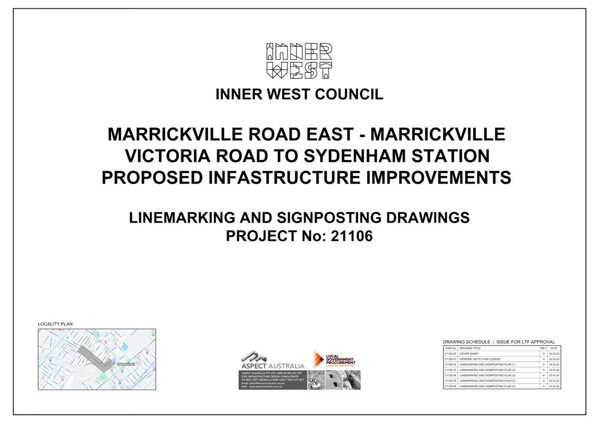
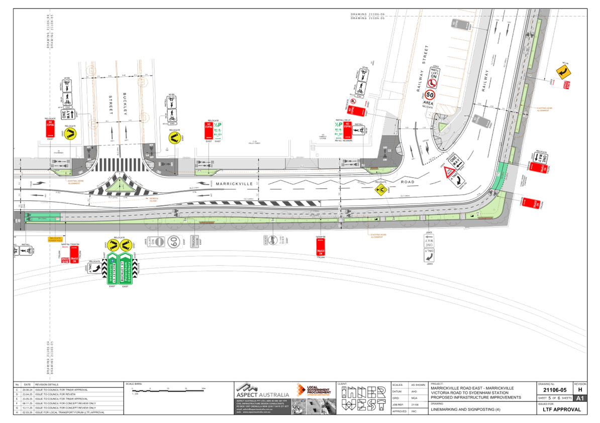
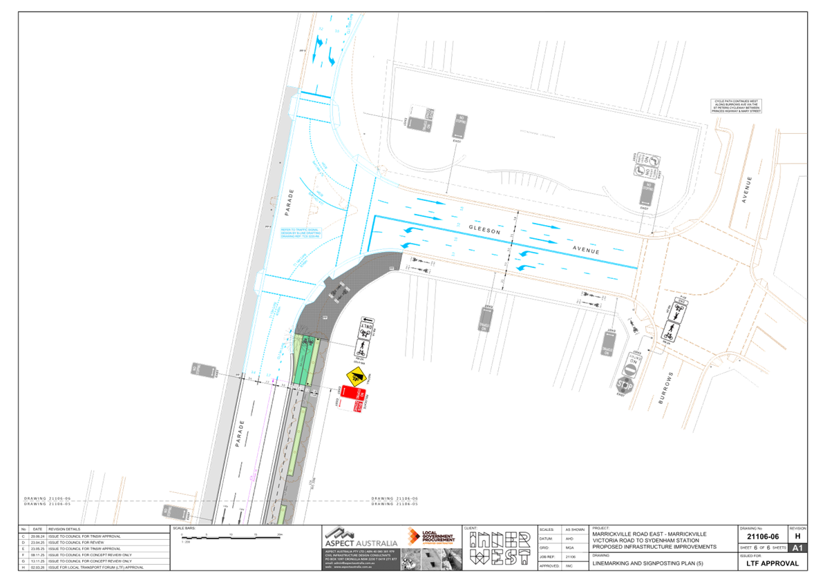
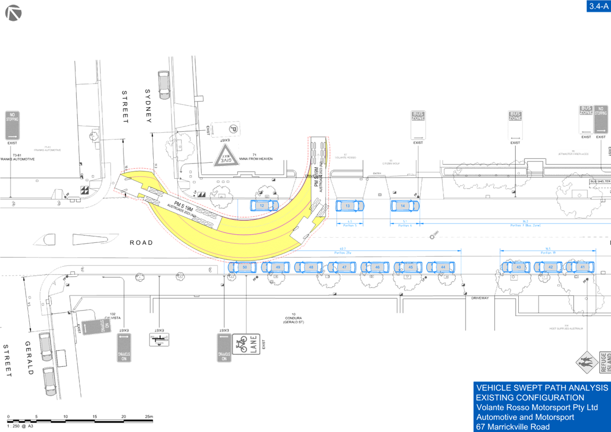
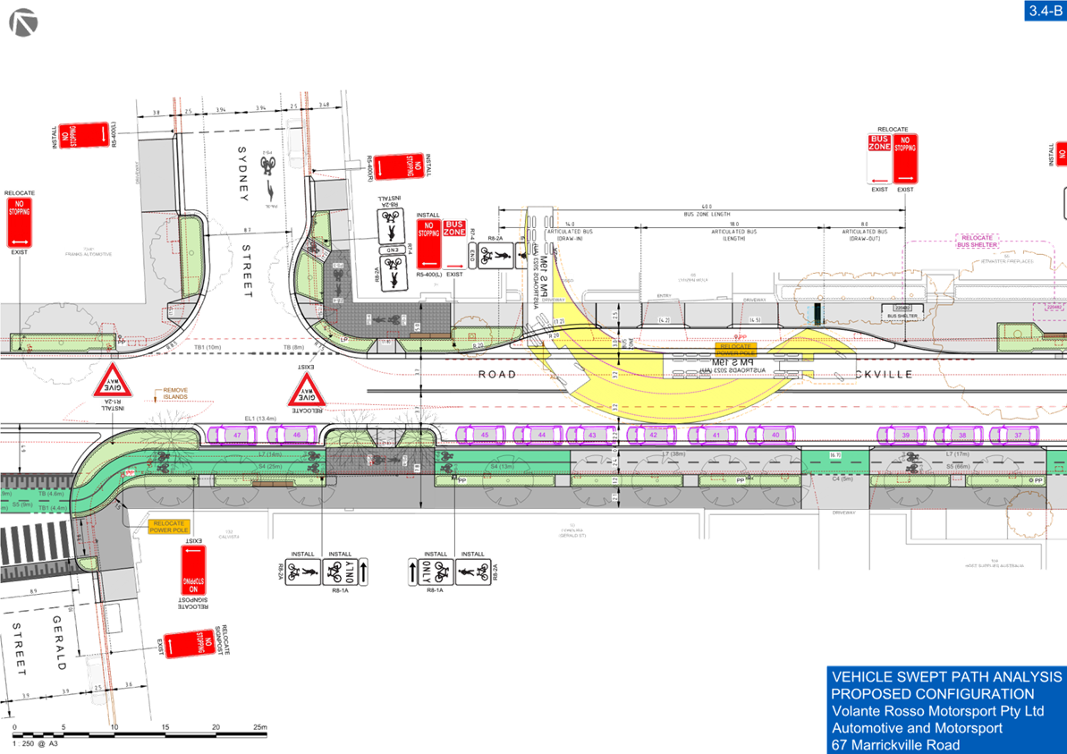
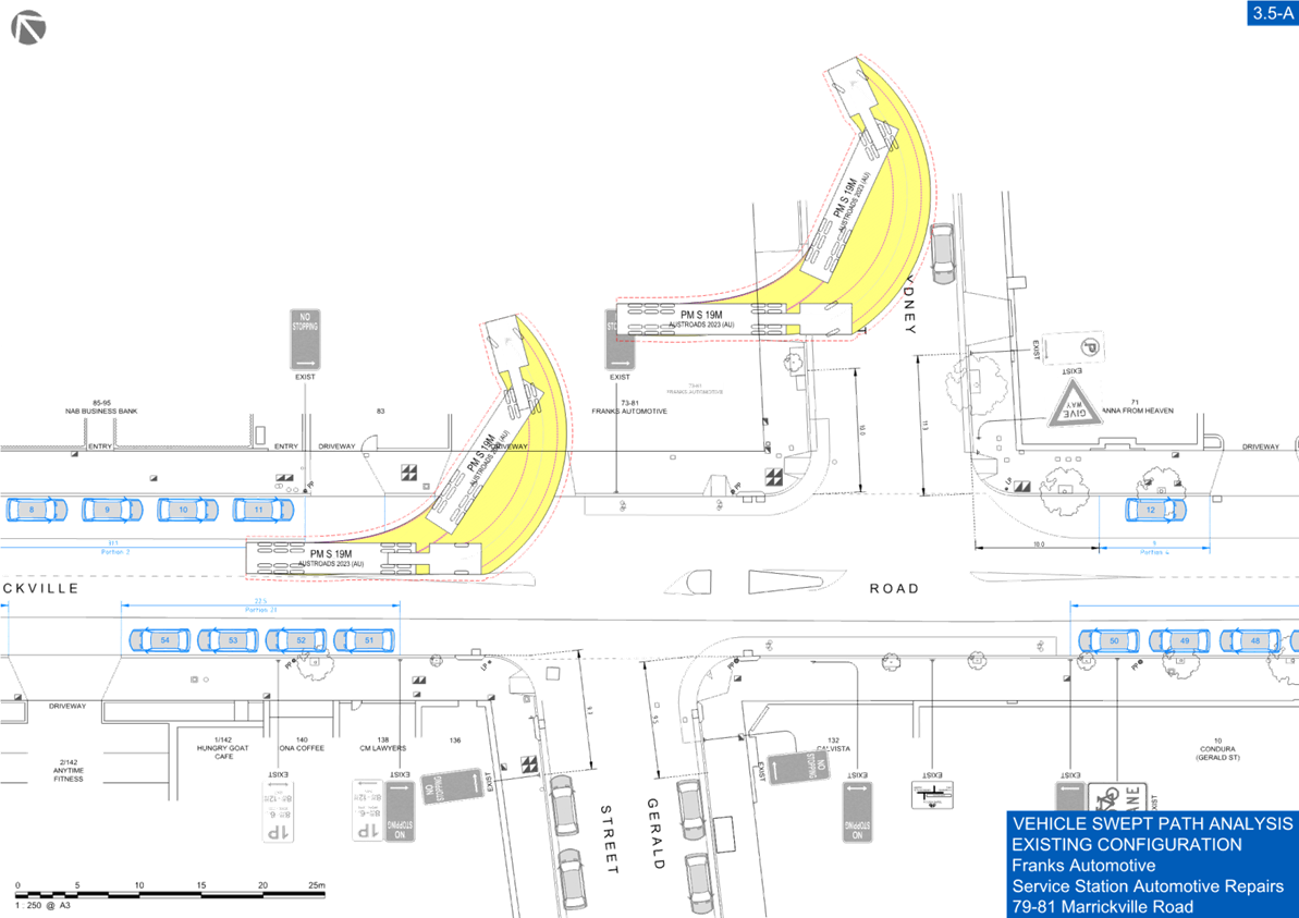
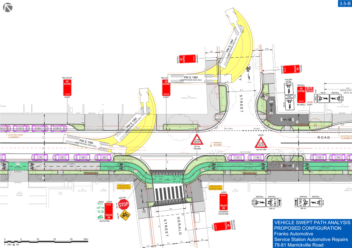
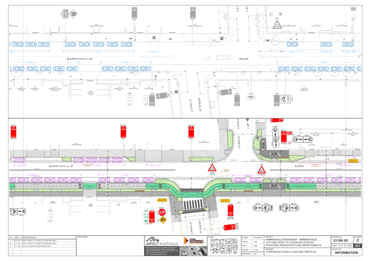
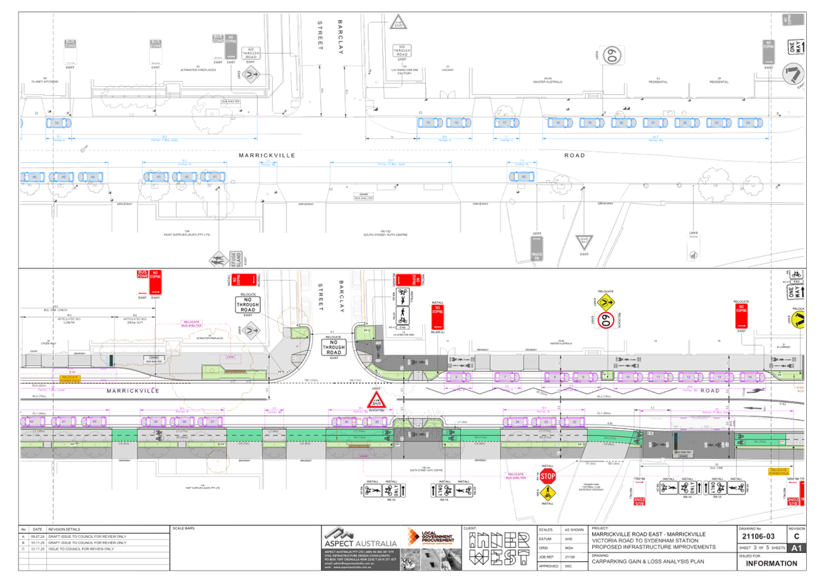
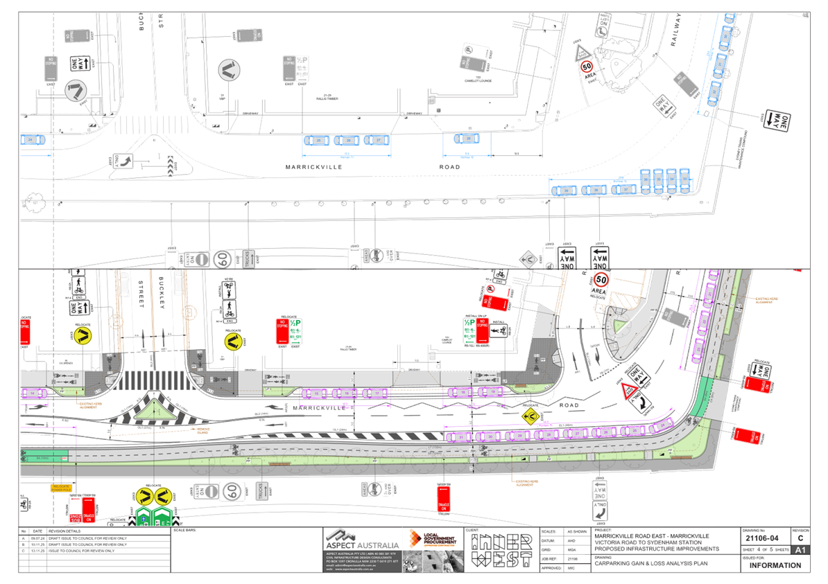
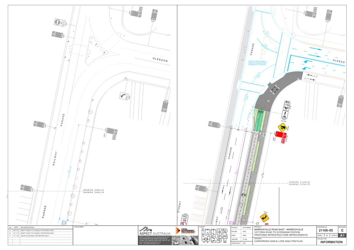
Subject: Marrickvile Road East, Marrickville - Cycle Path (Midjuburi - Marrickville Ward / Summer Hill Electorate / Inner West PAC)
Prepared By: Jackie Ng - Traffic Engineer
Authorised By: Manod Wickramasinghe - Traffic and Transport Planning Manager
|
RECOMMENDATION
1. That the detailed concept design drawings (drawing no.s 21106-01 to 21106-06 revision H) for the Marrickville Road East Cycle Path between Sydenham Station and Meeks Road be approved.
2. That Council write Transport for NSW to remove the bus zone along Railway Parade between Gleeson Avenue and Marrickville Road following the completion of the Sydenham to Bankstown Metro project.
|
STRATEGIC OBJECTIVE
This report supports the following strategic directions contained within Council’s Community Strategic Plan:
|
2: Liveable, connected neighbourhoods and transport |
|
|
EXECUTIVE SUMMARY
This report outlines the Marrickville Road East Cycle Path project including the findings of the community engagement report. As part of the Marrickville Road East Masterplan, the Marrickville Road East Cycle Path is a project aimed to provide an integrated streetscape which is highly functional, well designed, visually appealing, accessible to all, safe and sustainable.
Council undertook public consultation on the Marrickville Road East Cycle Path through YourSay Inner West between 17 November to 19 December 2025 and the response results indicate that a majority of the community supported the proposed changes.
Detailed design is scheduled for completion by mid-2026, with construction expected to commence in late 2026 and finish by mid-2027, subject to funding approval.
BACKGROUND
The Marrickville Road East Cycle Path between Gleeson Avenue (Sydenham Station) and Meeks Road was publicly exhibited by Council in 2018 as part of the Marrickville Road East Masterplan. Through consultation with the relevant authorities, stakeholders and the community, a detailed concept design has been produced.
The aim of the Marrickville Road East Cycle Path is to provide an integrated streetscape which is highly functional, well designed, visually appealing, accessible to all, safe and sustainable. Once completed, cyclists and pedestrians will have a continuous and safe route to travel along Marrickville Road between Sydenham Station and Meeks Road that is separated from traffic, while managing, access, traffic and parking needs for surrounding businesses and residents.
The path links to the St Peter’s Cycle Path to the east and Regional route 5 plus the proposed South West Active Transport Link to the north as well as the proposed South West Active Transport Link to the south via Meeks Road to Dulwich Hill and Bankstown.
DISCUSSION
Marrickville Road between Gleeson Avenue and Buckley Street is a state road and between Buckley Street and Meeks Road is a regional road. Marrickville Road has a road width that is approximately 12.8m with an average daily traffic volume of 14,164 vehicles per day (2024) comprising of 88.6% light vehicles and 11.4% heavy vehicle, and 85th percentile speed of 42.8km/h (2024) along this section.
The following works are proposed and are illustrated on the attached detailed concept plan (Project No. 21106). The proposed works aim to provide integrated streetscape, which is highly functional, well designed, visually appealing, accessible to all, safe and sustainable.
Generally, the proposed scope of the works (Attachment 2) includes the following:
· Two-way separated cycle path along the southern side of Marrickville Road between Gleeson Avenue (Sydenham Station) and Meeks Road, Marrickville.
· Pavement to be marked in green with bicycle logos at transition points, driveways and intersections along the cycle path on the southern side.
· Separation kerb to be provided along the cycle path on the southern side between the parking lane and cycle path.
· Parking lanes are to be provided on both sides of the road, 2.2m on the southern side, 2.3m on the northern side, and 3.0m for bus zones.
· Shared path along the northern side of Marrickville Road between Railway Street and Barclay Street.
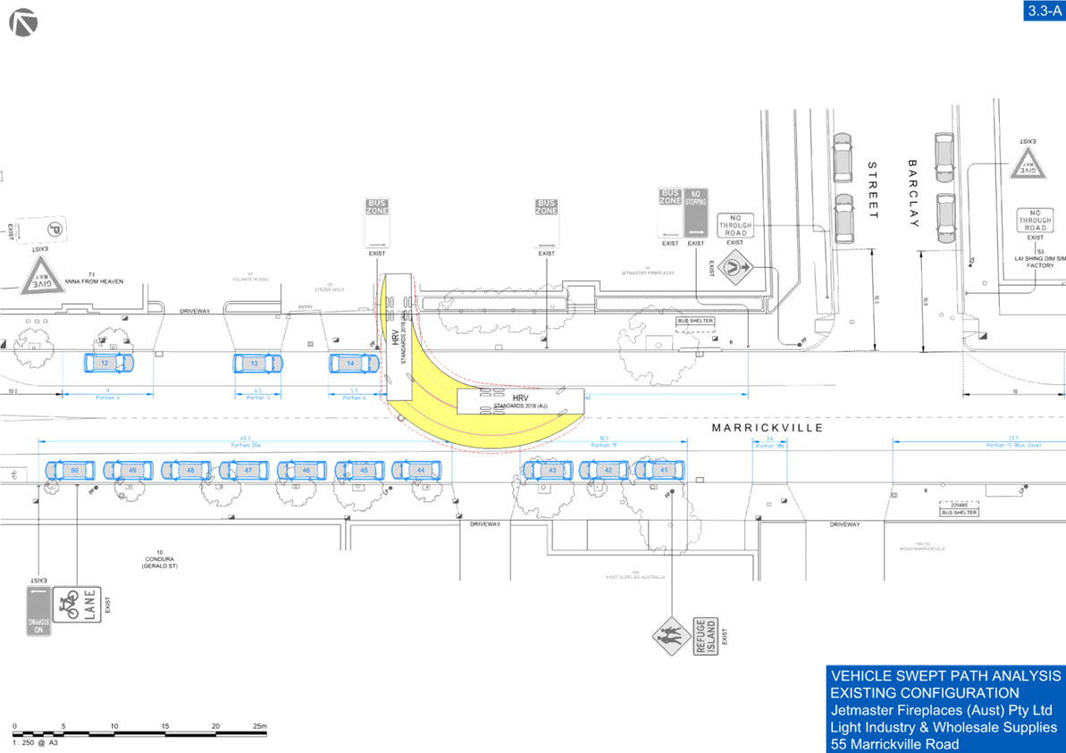
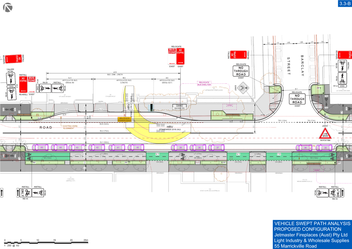
· New raised pedestrian crossing approximately 75mm in height with landscaped kerb blisters on Gerald Street. This design will cater for truck movements.
· Landscaped kerb extensions approximately 150mm in height at Marrickville Road, Meeks Road, Sydney Street, Gerald Street, Barclay Street, Railway Street, and Railway Parade.
· Shared path areas within the kerb extensions/footpaths at Meeks Road, Sydney Street, Barclay Street, Buckley Street, Railway Street, and Railway Parade.
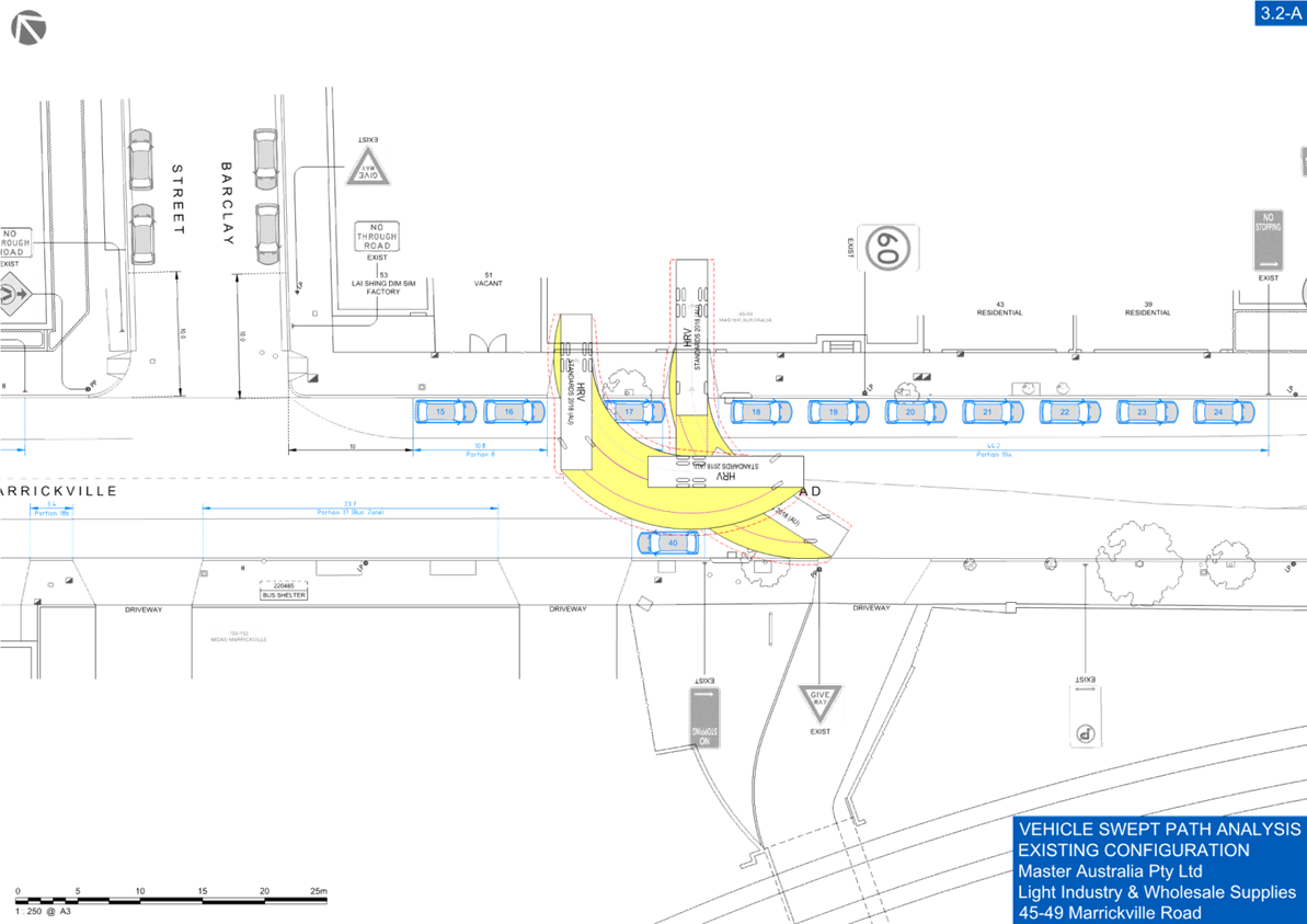
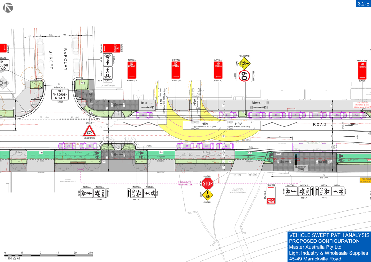
· Proposed motorcycle parking arrangement along the frontage of 45-49 Marrickville Road, to address access issues to the property and to cater for loading and unloading movements.
· Widening of laybacks as required and where necessary to cater for large vehicle movements into properties.
· New trees and planting to be provided in landscaped kerb extensions.
· Installation of signage and linemarking associated with the works as required and where shown on the plans.
ADDITIONAL RAISED PEDESTRIAN CROSSING
An investigation on the merit of a proposed raised pedestrian crossing on Marrickville Road at Sydney Street was undertaken based on feedback received by the community. The numerical warrants of Council’s Pedestrian Crossing Warrant have been met and subsequently a concept design has been completed. A separate community consultation will be completed for the proposed raised pedestrian crossing on Marrickville Road and will be brought back to a future Local Transport Forum. The proposed height of the crossing will be approximately 75mm designed for buses and trucks.
PARKING CHANGES
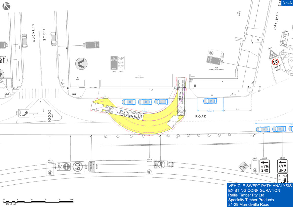
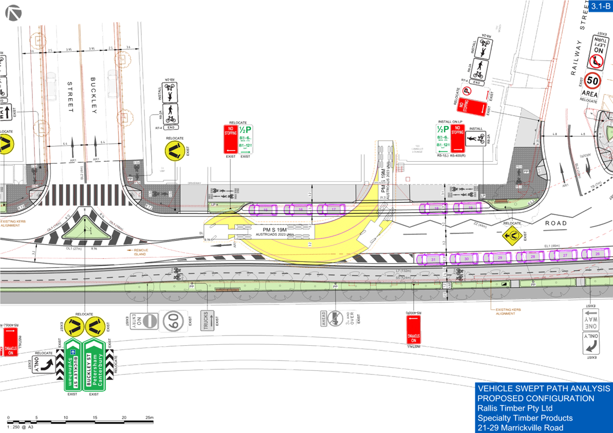
Initially there was a total loss of three (3) parking spaces along the length of the Marrickville Road East Cycle Path project. Further analysis of vehicle swept paths for large vehicles entering and exiting businesses was conducted due to concerns raised about delivery and access. There was an additional loss of two (2) parking spaces as a result of associated driveway widening.
Council has requested external designers to modify the plans to include a proposed section of motorcycle parking along the frontage of 45-49 Marrickville Road, Marrickville to minimise the loss of parking.
Additionally, Council will approach Transport for NSW to remove the bus zone along Railway Parade between Gleeson Avenue and Marrickville Road following the completion of the Sydenham to Bankstown Metro project. The bus zone was a temporary arrangement installed to accommodate layover of buses servicing the Sydney Metro buses. It should be noted that a new bus layover area has been constructed in Railway Parade accommodating up to six (6) buses. In this respect, Council will write to Transport for NSW, requesting that the bus zone between Gleeson Avenue and Marrickville Road be returned back to parking to reduce the loss of parking as a result of this project and the bus layover project. There will be a neutral change in parking spaces subject to agreement for the removal of the temporary bus zone from Transport for NSW.
The proposal for a pedestrian crossing on Marrickville Road at Sydney Street (if adopted in future), will result in a loss of an additional two (2) spaces.
STREETLIGHTING
The new raised pedestrian crossing will require new lighting for it to meet the minimum lighting safety and compliance standards. This may involve either 1 or 2 new flood lights provided on either side of the new raised pedestrian crossing (on either existing or new power poles). The final location of poles and lights will be confirmed during the lighting design development phase of the project by a Lighting Design Consultant.
PUBLIC CONSULTATION
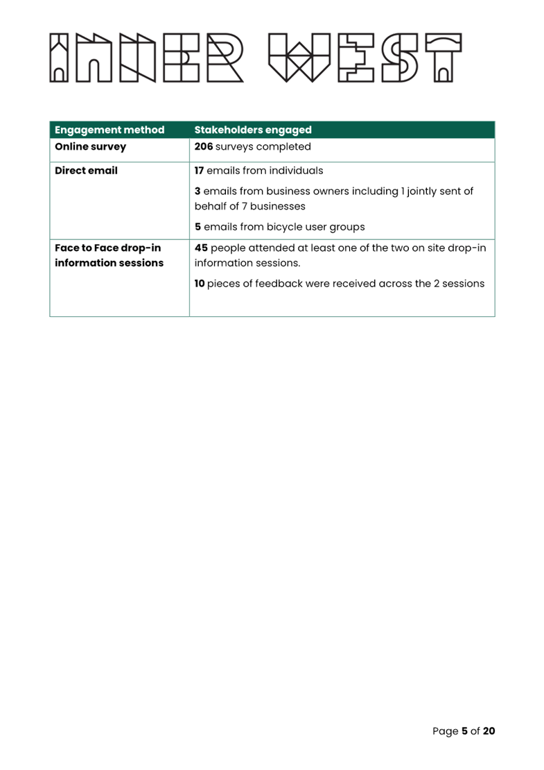
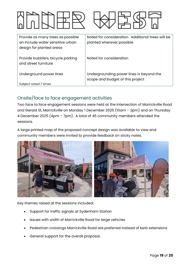
Council undertook public consultation through Council’s YourSay website, two face to face drop-in sessions, emails, letters and social media with invitation letters mailed out to stakeholders and residents within the study area in November 2025.
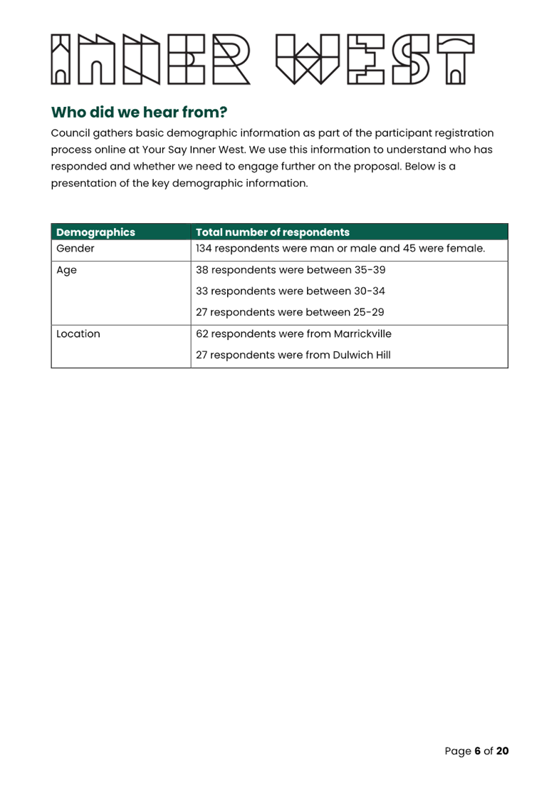
Some 732 letters were delivered to all property owners, residents and businesses of Marrickville Road between Railway Ave and Victoria Road, Meeks Road, Garnet St, Sydney St, Barclay St, Buckley St, Lower Railway Ave and Railway Ave. Emails were sent to local bicycle user groups, Local Democracy Group members and 1416 registered members of Your Say Inner West as well as 537 downloads on YourSay and 206 online survey competed. It should be noted that the two face-to-face engagement sessions were also held at the intersection of Marrickville Road and Gerald Street, Marrickville on Monday 1 December 2025 (10am – 2pm) and on Thursday 4 December 2025 (4pm – 7pm) with 45 community members attending the sessions.
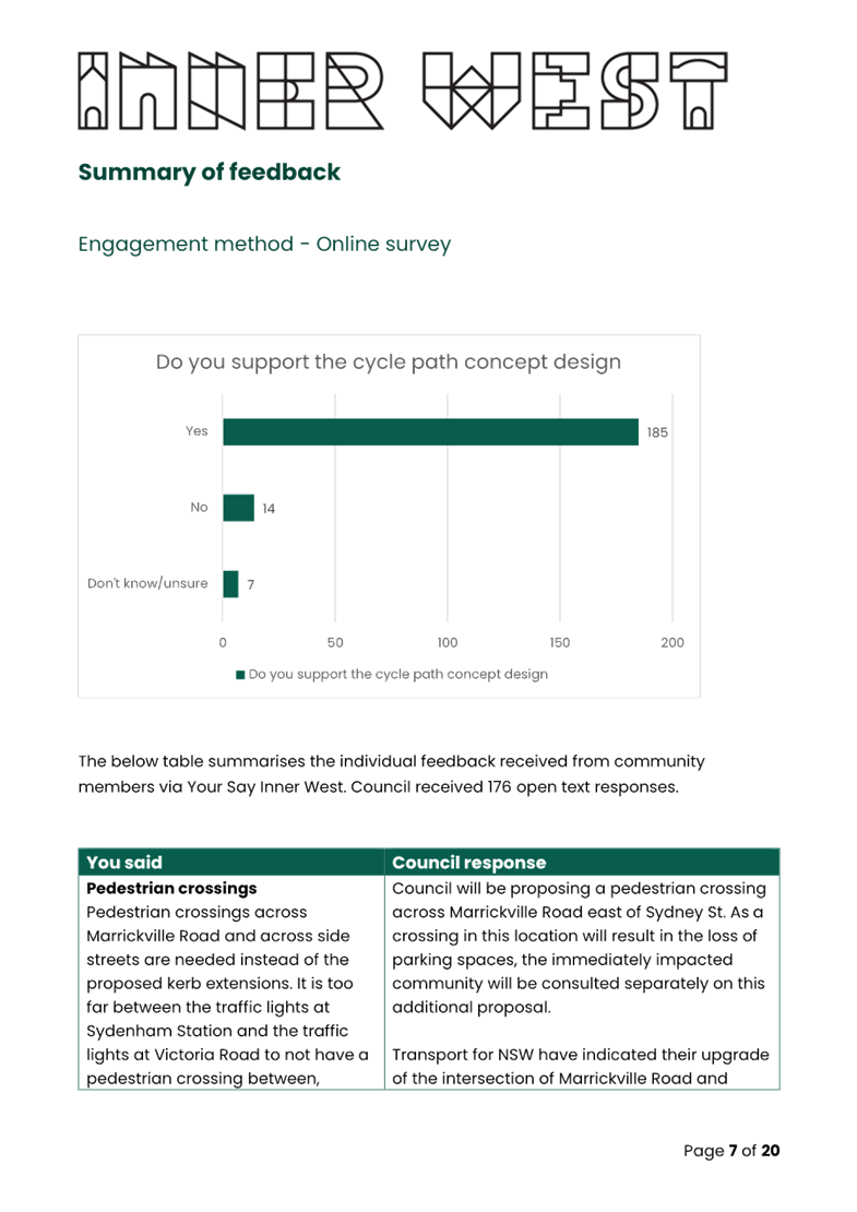
A total of 231 participants provided feedback through the YourSay project page or via email. Majority of the participants (210) supported the proposed cycle path, 14 participants opposed and 7 were unsure or didn’t know.
Key suggestions/feedback raised from the community engagement are listed in the table below. A Council officer response is also provided to the suggestions/feedback.
|
Community feedback provided |
Council Officer response |
|
Addition of pedestrian crossings, particularly across Marrickville Road. |
Council will be proposing a pedestrian crossing across Marrickville Road east of Sydney St. As a crossing in this location will result in the loss of parking spaces, the immediately impacted community will be consulted separately on this additional proposal.
Council has also requested a further pedestrian crossing across Marrickville Road at Buckley Street. However, as this intersection is within a State Road the decision to proceed and the timing to do so is a Transport for NSW matter. Council has advised Transport for NSW of the community’s desire for a crossing in this location.
Council is prioritising pedestrian and cyclist movements along the southern side of Marrickville Road where there are fewer side streets for pedestrians and cyclists to cross and where a direct connection can be provided to Sydenham Station rather than prioritising these movements on the northern side of where there are more streets to cross, and these side streets experience higher heavy vehicle volumes, including the very busy intersection of Buckley St. The southern side of Marrickville Road in contrast has one street to cross between Sydenham Station and Meeks Road whereas the northern side of Marrickville Road has four (Sydney St, Barclay St, Buckley St and Lower Railway Parade).
|
|
Amending the design as needed to ensure continuation of industrial vehicle access to existing businesses along Marrickville Road.
|
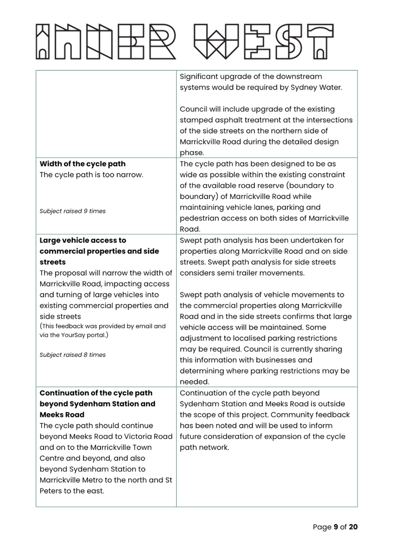
Swept path analysis has been undertaken for properties along Marrickville Road and on side streets. Swept path analysis for side streets considers semi-trailer movements. Swept path analysis of vehicle movements to the commercial properties along Marrickville Road and in the side streets confirms that large vehicle access will be maintained. Some adjustment to localised parking restrictions may be required. Council is currently sharing this information with businesses and determining where parking restrictions may be needed. |
|
Continuing the cycle path further along Marrickville Road into Marrickville Town Centre and amending the cycle path design at Meeks Road accordingly. |
Continuation of the cycle path beyond Sydenham Station and Meeks Road is outside the scope of this project. Community feedback has been noted and will be used to inform future consideration of expansion of the cycle path network. |
|
Widening the cycle path. |
The cycle path has been designed to be as wide as possible within the existing constraint of the available road reserve (boundary to boundary) of Marrickville Road while maintaining vehicle lanes, parking and pedestrian access on both sides of Marrickville Road. |
|
Reconsider the amount and use of shared areas and Removal of the shared areas from the northern side of Marrickville Road. |
The extent of shared paths has been minimised as much as possible within the constraints of the built surrounds and fixed infrastructure. This condensed urban area creates limited options to provide separation at all locations, and a shared facility is considered acceptable at the bus stop as this is not a high-frequency bus route. At the kerb extension crossing points near Sydney Street and Barclay Street the design will be amended to remove the shared path area, continue the cycle path and give priority to pedestrians crossing the bicycle path through installation of a pedestrian crossing across the cycle path. The shared path on the northern side of Marrickville Road between Lower Railway Parade and Barclay St provides connection between the existing shared path in Lower Railway Parade and the proposed cycle path on the southern side of Marrickville Road. The overall width of the road reserve precludes construction of a separated cycle path on the northern side of Marrickville Road. Should Transport for NSW’s upgrade of the intersection of Marrickville Road and Buckley Street include installation of a crossing across Marrickville Road, the extent of shared path on the northern side of Marrickville Road can be reconsidered. |
|
Reduce the speed limit in Marrickville Road |
The speed limit on all local road within the Inner West Council LGA is being reduced to 40kph as part of the InnerWest@40 project. Council will continue discussions with TfNSW on speed limit reductions on Marrickville Road with TfNSW noting this has sections road classified as regional and state. |
|
Longitudinal design of the cycle path, particularly at driveways |
The detailed design will investigate and implement as much as possible methods to smooth the cycle path longitudinally, while recognising that access to properties needs to be maintained. |
The results of the consultation are included in the Engagement Outcome Report as provided in Attachment 1.
FINANCIAL IMPLICATIONS
The cost of the works is initially estimated at $3,900,000 and a component of funding has been included in Council’s 2026/2027 Capital Work budget for initial works. The project has also been summitted for State Government funding (TfNSW) through the Get NSW Active program.
|
1.⇩ |
Marrickville Road East Cycle Path - Engagement Outcome Report |
|
2.⇩ |
Marrickville Road East Cycle Path - Detailed Concept Design |
|
3.⇩ |
Marrickville Road East Cycle Path - Swept Path Analysis |
|
4.⇩ |
Marrickville Road East Cycle Path - Parking Comparison |
|
Local Transport Forum Meeting 16 March 2026 |
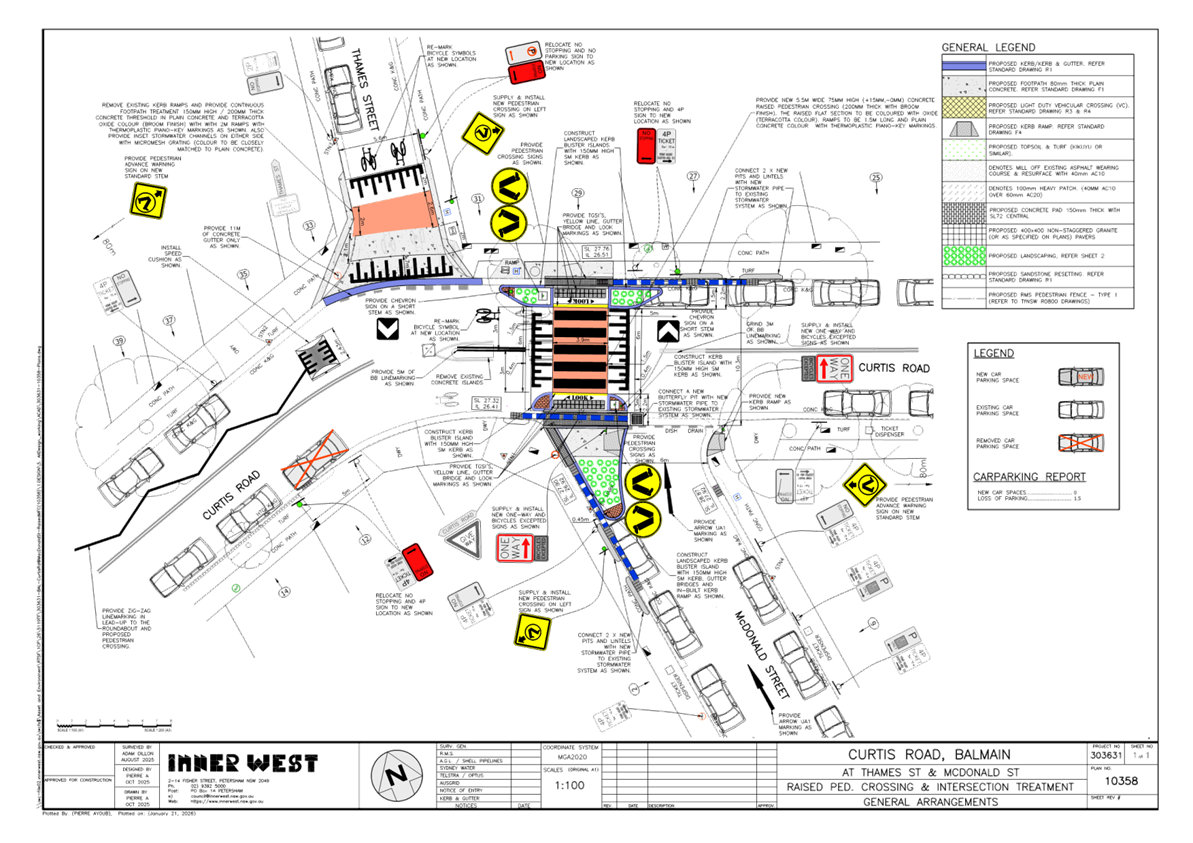
Subject: Curtis Road and McDonald Street, Balmain - Proposed Pedestrian Crossing, Continuous Footpath and One-Way Treatment (Baludarri-Balmain Ward/Balmain Electorate/Leichhardt PAC)
Prepared By: Charbel El Kazzi - Traffic Engineer
Authorised By: Manod Wickramasinghe - Traffic and Transport Planning Manager
|
RECOMMENDATION
That installation of an additional speed cushion on Curtis Road west of Thames Street and extended ‘No Stopping’ zone on the south side of Curtis Road, west of McDonald Street, Balmain as shown in the attached detailed design plan (No.10358) be approved.
|
STRATEGIC OBJECTIVE
This report supports the following strategic directions contained within Council’s Community Strategic Plan:
|
2: Liveable, connected neighbourhoods and transport |
|
|
EXECUTIVE SUMMARY
The Local Transport Forum previously considered the detailed design and consultation outcomes of a proposed pedestrian crossing and continuous footpath in Curtis Road, Balmain, including a partial road closure and one way in McDonald Street, Balmain. This design was supported by the Local Transport Forum in December 2025 and adopted by Council at its meeting held in February 2026.
Following further review, changes to the initial design plan have been proposed to enhance the safe operation of the pedestrian crossing. This includes a speed cushion on the western approach to the crossing and the relocation of a ‘No Stopping’ sign on the southern side of Curtis Road by approximately 5m to improve sightlines, which will result in the loss of one existing parking space.
The changes are shown within the attached plan.
BACKGROUND
Council has received Get NSW Active Funding from Transport for NSW to improve safety at the intersection of Curtis Road and McDonald Street by constructing a raised pedestrian crossing, continuous footpath treatment and implementing a partial One-Way Treatment northbound restriction in McDonald Street between Hoffmans Lane and Curtis Road, Balmain. The proposal aims to improve pedestrian and motorist safety by better defining safe pedestrian crossing points and addressing pedestrian safety and driver behaviour at this location. The crossing will also replace the existing pedestrian refuge island at this location.
A detailed design plan for a raised pedestrian crossing, continuous footpath treatment and partial one way was developed, with community engagement outcomes reported to the Local Transport Forum (LTF) on 8 December 2025 and subsequently adopted by Council.
Since December 2025, further review has been undertaken based on resident concerns received and additional changes were made to the detailed design plan to better support the safe operation of the pedestrian crossing. The changes comprise of the following:
· Addition of speed cushion on western approach to pedestrian crossing
· Extension of the No Stopping zone on south side of Curtis Road by 5m to improve visibility to the proposed pedestrian crossing
The updated detailed design plan shown in Attachment 1 outlines the proposed works at the intersection of Curtis Road and McDonald Street, Balmain.
DISCUSSION
A letter outlining the changes to the initial plan was issued to the properties shown in the distribution map in Figure 1. Four (4) comments have been received in response to the changes in the proposal and this has been summarised within the table below. Two (2) comments were opposed the proposed changes and two (2) submissions were directed towards the pedestrian crossing which has already been approved by Council.
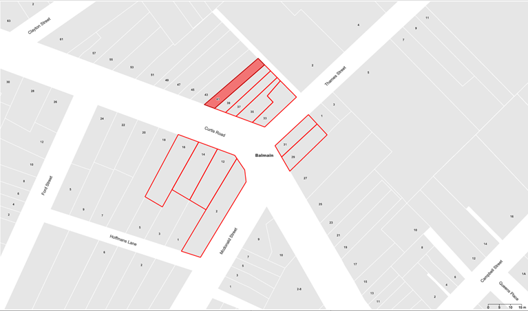
Figure 1: Letter distribution map for the proposed changes to the Pedestrian Crossing design
|
Resident Concerns |
Officer Feedback |
|
The proposed crossing would position pedestrians directly outside our primary living spaces. pedestrian traffic waiting, gathering, and crossing immediately outside our windows will substantially diminish our privacy.
Raised pedestrian crossings generate unavoidable noise from vehicles braking, accelerating, and mounting the platform. Without acoustic glazing, this noise will be intrusive, particularly in early mornings and late evenings. The installation of a raised crossing directly in front of our home is also likely to negatively affect its future saleability and value.
Furthermore, the installation of a raised pedestrian crossing near an uphill bend with two merging side streets (Thames Street and McDonald Street) compromises the safety of pedestrians as this location presents constrained sight distances, complex vehicle movements, and increased collision risk.
We request that council reconsider the proposed location and fully assess the disproportionate impact on our household. We ask that Council explore alternative design solutions (including modification of the existing island) that achieve pedestrian safety outcomes without causing significant private detriment. |
Consultation for the pedestrian crossing has already been undertaken and considered in December 2025 LTF and Council meetings in February 2026. The current proposal only relates to the proposed speed cushion and ‘No Stopping’ changes as shown within the enclosed plan which are intended to support the safe operation of the crossing.
|
|
I believe the removal of this parking space is unnecessary and indeed would also have a negative additional impact.
Driving up Curtis Road towards the proposed crossing from the west, I observe there is actually good visibility of the full width of the proposed works well before a vehicle reaches the crossing, even when a car is parked outside my house.
An existing issue is that many vehicles accelerate rapidly down Curtis Road heading west, after passing the McDonald turnoff. The removal of the car space would open up the full width of the road and encourage vehicles to accelerate earlier and drive faster than they do now.
|
Council has previously received concerns regarding visibility at this intersection. This is primarily due to the road gradient, bend, on-street parking and nearby intersecting streets and driveways.
The proposed No Stopping restriction is intended to improve safety by increasing sightline by the removal of parking. By keeping the area adjacent to the crossing clear, pedestrians and motorists will have improved visibility at the crossing.
In addition, removing parking at this location will improve the operating width of the carriageway near the crossing. This will reduce situations where vehicles encroach over the centreline when passing parked vehicles, which can create conflicts with oncoming traffic.
|
|
I am opposed to the proposed changes to the plan as they would result in a significant loss of functionality and amenity for nearby residents.
As you are no doubt aware, parking is very difficult/limited and the proposed reduction in parking would only make that worse. I frequently need to carry heavy objects to my car and find it difficult when my car is in a remote location. There are only a small number of parking spaces in the block between Ford St and MacDonald Street and we can’t really afford to give them up. In addition, I note that the location of the pedestrian crossing is elevated relative to the roadway in front of 12-16 Curtis Rd which provides for good visibility to/from the crossing location even with that parking space retained.
I believe that the speed cushion could have some utility in helping to keep road users at a lower speed by encouraging them to be centred in their lane. At present many cars tend to ‘cut the corner’ when heading east towards the new crossing which enables them to travel faster than they would otherwise be able to if keeping within their lane. However, I am strongly opposed to the introduction of a speed cushion that would result in all east bound cars striking or passing over an object that results in an impulsive noise and the constant sound of cars accelerating away from the obstruction. The front rooms of our houses are only a few meters from the proposed speed cushion and a significant increase in noise, particularly an intrusive / impulsive noise would result in a significant and unreasonable loss of amenity. |
Concerns regarding the loss of parking in the area and the potential impact on nearby residents is noted.
The removal of parking in the immediate vicinity of the crossing is expected to provide safety benefits by significantly improving sight distances between road users.
The purpose of the proposed speed cushion is to encourage lower approach speeds and decrease the chance of conflicts and severity of crashes at the crossing.
Whilst noise concerns are noted, it is important to manage vehicle speeds and improve road safety for vulnerable road users. The speed cushion proposed will allow vehicles to straddle the device which will generate less noise than a full-width speed cushion.
|
FINANCIAL IMPLICATIONS
The project changes are to be completed as part of the overall project which will be funded through the Get NSW Active Funding program.
|
1.⇩ |
Curtis Road and McDonald Street, Balmain - Detailed Design Plan No.10358 |
|
|
Local Transport Forum Meeting 16 March 2026 |
Subject: Lennox Street, Newtown – Proposed Pedestrian Safety and Stormwater Improvement Works – Design Plan 10362A (Damum-Stanmore Ward / Newtown Electorate / Inner West PAC)
Prepared By: Jennifer Adams - Traffic Engineer
Authorised By: Manod Wickramasinghe - Traffic and Transport Planning Manager
|
RECOMMENDATION
That the detailed design plan for the proposed pedestrian safety and stormwater improvement works in Lennox Street at its intersection with Mary Street, Newtown and associated signs and line markings (as per Design Plan No.10362A) be approved. |
STRATEGIC OBJECTIVE
This report supports the following strategic directions contained within Council’s Community Strategic Plan:
|
2: Liveable, connected neighbourhoods and transport |
Council is planning to improve pedestrian safety and stormwater drainage in Lennox Street, Newtown, by modifying the existing at-grade pedestrian crossing and installing additional stormwater pits and pipes. The proposal aims to enhance safety for pedestrians, cyclists and motorists, address concerns regarding pedestrian safety, cyclists and driver behaviour in the area and improve overall stormwater management.
BACKGROUND
The project originated as a stormwater project. The original scope was to install a new stormwater pipe network however due to a significant Ausgrid underground asset works were reduced in scale and scope. Further, it was noted that a Ausgrid pole was relocated to the middle of the existing ramp. Subsequently, to accommodate the pole relocation the consultation plan proposed the kerb and footpath extension with a new parm-ramp to accommodate Ausgrid’s pole relocation. Refer to the pictures below.
The Pedestrian Access and Mobility Plan (PAMP) had also identified an opportunity to upgrade the pedestrian crossing, and tentative plans were to raise the crossing, however, due to the presence of Ausgrid’s HV Line at shallow depth, no safe excavation option was possible.
This report details the design plan for the improvement works and its related consultation results. It is noted that the original community consultation plan has been slightly amended by adding E4 line marking and chevron marking at Mary Street for a smoother traffic flow.
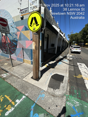
FINANCIAL IMPLICATIONS
The project is listed on Council’s Capital Works Program 2026/27 for construction and estimated cost is $50,000.
OTHER STAFF COMMENTS
The following works were proposed and are illustrated on the attached Consultation Plan (Plan No. 10362). The proposed works aim to improve pedestrian safety and stormwater drainage in Lennox Street, Newtown, by modifying the existing at-grade pedestrian crossing and installing additional stormwater pits and pipes.
Specifically, the proposed scope of works includes the following:
· Install a new 375 mm diameter stormwater pipe and construct one new stormwater inlet pit, connecting the new pipe to the existing pit.
· Construct new concrete kerb and gutter as shown on the attached plan.
· Modify existing at-grade pedestrian crossing as shown on the attached plan.
· Construct two new kerb blister island as shown on the attached plan.
· Reconstruct sections of concrete footpath and construct two new kerb ramps at the intersection of Lennox Street and Mary Street.
The community consultation plan was slightly amended to accommodate E4 line marking and chevron marking at May Street for smoother traffic flow.
The original Design Plan 10362 and updated Design Plan 10362A are illustrated below.
Design Plan 10362
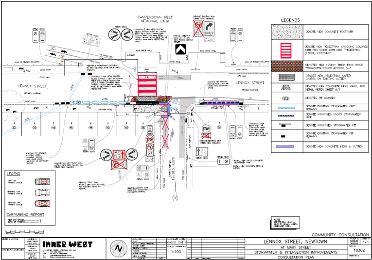
Design Plan 10362A
![]()
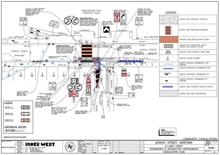
Parking changes
No parking changes are proposed to the existing street parking. Therefore, the proposal will
not change existing on-street parking arrangements except on a temporary basis to facilitate
construction works.
Streetlighting
The existing street lighting is considered adequate to meet the required safety standards for
pedestrian crossings. The attached plans indicate the locations of the existing floodlights and
power poles.
PUBLIC CONSULTATION
Consultation was conducted between 14 January 2026 and 30 January 2026. A letter along with a copy of the design plan was sent to residents / businesses in the immediate locality. A total of 24 letters were distributed. There were no responses.
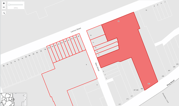
CONCLUSION
It is recommended that the detailed design plan for the proposed pedestrian safety and stormwater improvement works and associated signs and line markings be supported to improve road safety and storm water drainage at this location.
|
1.⇩ |
302930-10362-LennoxSt-Consultation Plan-A |
|
|
Local Transport Forum Meeting 16 March 2026 |
Subject: Curtis Road, Balmain - Proposed Pedestrian (zebra) Crossing (Baludarri-Balmain Ward/Balmain Electorate/Leichhardt PAC)
Prepared By: Charbel El Kazzi - Traffic Engineer
Authorised By: Manod Wickramasinghe - Traffic and Transport Planning Manager
|
RECOMMENDATION
That the attached detailed design plan (No.10390) for the proposed raised pedestrian (zebra) crossing in Curtis Road near the intersection of Darling Street, Balmain be approved.
|
STRATEGIC OBJECTIVE
This report supports the following strategic directions contained within Council’s Community Strategic Plan:
|
2: Livable, connected neighbourhoods and transport |
|
|
EXECUTIVE SUMMARY
Council is planning to improve pedestrian safety in Curtis Road north of Darling Street, Balmain by constructing a new raised pedestrian (zebra) crossing. The proposal aims to improve pedestrian safety and address concerns about pedestrian safety and driver behaviour in the area.
The proposal will not make any changes to the existing parking signs and parking spaces in this section of Curtis Road and result in no loss of parking.
BACKGROUND
Council has received Get NSW Active Funding from Transport for NSW to improve safety at the intersection of Curtis Road and Darling Street by constructing a raised pedestrian crossing. proposal aims to improve pedestrian safety and address concerns about pedestrian safety and driver behaviour in the area.
The detailed design plan shown in Attachment 1 outlines the proposed works on Curtis Road, Balmain and includes the following:
· Construct a new raised concrete pedestrian crossing (approximately 60mm high) as shown on the attached plan.
· Construct kerb ramps on both sides of the proposed pedestrian crossing.
· Demolish the existing splitter island in Curtis Road and construct a new central splitter island with mountable kerb and coloured concrete infill.
· Construct a concrete kerb blister island outside No.1A Curtis Road as shown on the attached plan.
· Reconstruct damaged sections of the asphalt footpath with new asphalt footpath on the eastern side of the proposed pedestrian crossing.
· Provide tactile ground surface indicators at both ends of the crossing.
· Provide new flood lighting by installing up to two new floodlights power poles to be compliant with the standards for pedestrian crossings. The final location and configuration of these lighting assets are subject to an electrical design to be carried out.
· Reinstate the existing damaged turf on the western side of the crossing as shown on the plan.
· Install signs and line markings associated with the works and as shown on the attached plan.
DISCUSSION
A letter outlining the proposal was issued to the properties shown within the distribution map below. Two (2) submissions were received in response to this proposal with both in support. Comments received have been summarised within the table below.
|
Resident Concerns |
Officer Feedback |
|
I am totally supportive of this, however I would like to share this observation in case it can be included.
With the laundry immediately next to me, people are parking across my driveway and on the footpath to drop off their laundry. Could the council please consider installing some bollards to prevent this from happening.
Not only is this a nuisance to us as residents, it creates a traffic hazard and a pedestrian issue with people often needing to progress down the footpath via the road.
I note that you are installing some ‘no parking lines’ but this I won’t stop people from parking illegally, either over the pedestrian crossing, or, across my drive…this is why the pavement is cracked as heavy delivery vehicles (courier vans, light trucks and so on) use it all the time. |
The raised concerns and support are noted. The proposed works will have an effect to deter illegal parking at the driveway with the installation of the signage, chevron markings and the crossing location. The proposed new timber pole to support the new lighting needed for the pedestrian crossing will also provide an additional barrier to prevent illegal parking.
Council will reconstruct the damaged driveway as part of the works to better define its presence and to repair any damage that may affect pedestrians as they walk along the footpath towards the new semi-raised pedestrian crossing.
Illegal parking can be reported to Council’s Compliance to initiate enforcement action and deter illegal parking behaviours. |
|
I am writing on behalf of Balmain Public School and the parent community to raise significant and ongoing pedestrian safety concerns at the intersection of Darling Street and Curtis Road, near St Andrews Church. Our parent community has expressed grave concerns regarding the lack of a safe pedestrian crossing at this roundabout. This intersection is a well-used route for children attending Balmain Public School, particularly during morning drop-off and afternoon pick-up times.
Visibility at this location is extremely limited for both pedestrians and vehicles approaching from Curtis Road. Vehicles frequently travel at speed around the Darling Street curve and do not always anticipate young children attempting to cross. The current conditions create an environment that feels unsafe and presents a clear risk to school-aged pedestrians.
We respectfully request Council’s consideration the raised pedestrian crossing at the roundabout. |
Council has noted residents and Balmain Public School’s concerns regarding pedestrian safety at this intersection along with support for a pedestrian crossing.
The proposed pedestrian crossing will better define pedestrian crossing points and improve safety for children attending Balmain Public School. |
FINANCIAL IMPLICATIONS
The works are expected to cost approximately $80,000 and are to be funded by the Get NSW Active grant.
|
1.⇩ |
Curtis Road, Balmain - Proposed Pedestrian Crossing Detailed Design 10390 |
|
|
Local Transport Forum Meeting 16 March 2026 |
Subject: St Peters Station Parking Study (Midjuburi-Marrickville and Damun-Stanmore Wards / Newtown & Heffron Electorates / Inner West PAC)
Prepared By: Jackie Ng - Traffic Engineer
Authorised By: Manod Wickramasinghe - Traffic and Transport Planning Manager
|
RECOMMENDATION
That Council receive and note the report of the St Peters Station Parking Study.
|
STRATEGIC OBJECTIVE
This report supports the following strategic directions contained within Council’s Community Strategic Plan:
|
2: Liveable, connected neighbourhoods and transport |
|
|
EXECUTIVE SUMMARY
This report outlines the investigation completed in the residential streets surrounding St Peters Station to assess parking impacts due to the opening of the Metro at Sydenham Station and closure of the T3 Bankstown Line. It provides an assessment of parking occupancy rates on a typical weekday and weekends, and if any further restrictions in the area are required.
BACKGROUND
At Council meeting held on 22 October 2024, Council resolved the following:
That Council urgently undertake parking studies in suburbs around Tempe, St Peters and Sydenham stations with the view to implementing parking controls to better support residents facing additional parking pressures with the opening of the Metro at Sydenham and closure of the T3 Bankstown Line.
The study has been split into areas of investigation, with Area A (Sydenham Station residential side) and Area B (Sydenham Station industrial side) undertaken initially and reported to the Local Transport Forum meeting held on 15 September 2025.
Subsequently, Area C (Tempe Station) and Area D (St Peters Station) were reviewed. This report provides the outcome to the Area D investigation.
DISCUSSION
Area D – St Peters Station
The study assessed parking utilisation on a weekday and weekend on residentials streets near St Peters Station as shown in Figure 1 below, with a 600-metre radius nominated for the extent of the study.
 Figure 1 – St Peters
Station Parking Study Area
Figure 1 – St Peters
Station Parking Study Area
It is noted that most of the streets within the study area have a mixture of timed permit parking, unrestricted parking and other restrictions (e.g., part-time no parking). The current timed permit parking restriction installed consist of ‘2P, 8.30am-6pm, Mon-Fri, Permit Holders Excepted, Area M12’ for streets south of St Peters Station and ‘2P, 8am-10pm, Permit Holders Excepted, Area M14’ for streets north of St Peters Station.
The parking occupancy and duration of stay of these unrestricted parking and timed parking spaces were assessed to determine if these parking spaces were in excess of 85% utilization that would warrant consideration of expanding the existing permit parking schemes - including extension of existing restrictions to include weekends, extending times to include evenings and installing restrictions on both sides of the street.
Weekday parking assessment
Parking surveys were completed on these streets on Wednesday 2 April 2025 between 6am and 10am to assess occupancy and duration of stay to determine if there are high levels of commuter parking in the unrestricted spaces. Commuter parking generation is generally at its highest during 7am-9am, with maximum peak saturation estimated to occur at 10am.
For the weekday assessment, 10am was prescribed as the hour which commuter parking has reached maximum peak saturation (additional commuter parking after this period is likely to be low).
Two (2) key indicators were used to assess whether it is warranted to extend existing timed permit parking spaces:
1. For streets where there are existing timed permit parking restrictions (2P, 8.30am-6pm, Mon-Fri, Permit Holders Excepted, Area M12 and 2P, 8am-10pm, Permit Holders Excepted, Area M14),), the occupancy rate on both sides of the street must be greater than 85% at 10am.
2. There must be a low percentage of vehicles recorded on the section of street, with a duration of stay greater than 4 hours (noting vehicles that stayed within the same parking space between 6am and 10am are likely to be resident parked vehicles).
The parking occupancy rates recorded for the unrestricted and timed permit parking spaces in residential streets are shown in Figure 2 below:
 Figure 2 –
Parking occupancy in unrestricted and timed permit parking areas –
Wednesday
Figure 2 –
Parking occupancy in unrestricted and timed permit parking areas –
Wednesday
Figure 2 above indicates
that parking occupancy rates in streets with both unrestricted and restricted
parking exhibit higher occupancy on the unrestricted side. However, the data
also indicates that there is generally still on-street parking available along
the timed permit restriction side. Streets with short sections of timed permit
parking also experience a high level of parking occupancy but this is expected
due to the supply being low.
Streets with parking occupancy rates greater than 85% in Figure 2 have been further analysed to indicate the duration of stay and determine if the long-term parking is caused by residents or commuters. This is shown in Figure 3 below:
 Figure 3 – Duration of
stay in unrestricted and timed parking spaces with occupancy greater than 85%
Figure 3 – Duration of
stay in unrestricted and timed parking spaces with occupancy greater than 85%
Figure 3 above categories the duration of stay surveys into two classifications:
· >4 hours; vehicles that were parked in the same space between 6am-10am and did not move. Vehicles within this category are likely to be residential vehicles which did not move at 6am (before the start of commuter parking generation) and remained within the same space until 10am (the end of the survey).
· 1-2 hours; vehicles that were parked within the space for 1-2 hours and could either be resident vehicles leaving the space, commuters, or other works parking in the space between 8am-10am.
Data collected shows that the southern side of Lord Street between John Street and Princes Highway is the only street that receives any significant volume of commuter traffic. 75% of the vehicles parked at this location at 10am is expected to be commuter parking and correlates to the surrounding land use being directly adjacent to St Peters Station.
Weekend parking assessment
Parking surveys were completed in the study area (Figure 1) on Saturday 5 April 2025 between 8am and 6pm, and Sunday 6 April 2025 between 8am and 6pm at 1-hour intervals, to assess parking utilisation on residential streets near St Peters Station.
The survey seeks to assess whether there is a need to extend existing and new timed permit parking restrictions that are sign posted as ‘2P, 8.30am-6pm, Mon-Fri, Permit Holders Excepted, Area M12’ for streets south of St Peters Station and ‘2P, 8am-10pm, Permit Holders Excepted, Area M14’ for streets north of St Peters Station.
To consider the extension of the permit parking restrictions to weekends and on both sides of the street, a high occupancy rate greater than 85% for either Saturday or Sunday must be recorded within the existing unrestricted and timed permit parking restrictions. The parking occupancy rates used are averages of the 1-hour intervals between 11am-2pm.
 Figure 4 –
Parking occupancy in unrestricted and timed permit parking areas –
Saturday
Figure 4 –
Parking occupancy in unrestricted and timed permit parking areas –
Saturday
 Figure 5 – Parking
occupancy in unrestricted and timed permit parking areas – Sunday
Figure 5 – Parking
occupancy in unrestricted and timed permit parking areas – Sunday
Data collected on the weekends indicates that residential streets near St Peters Station has not experienced a significant increase in parking due to the opening of the Metro at Sydenham and closure of the T3 Bankstown Line. It is noted that residential streets north of St Peters Station have different restrictions those streets south of the station. The northern restrictions (2P, 8am-10pm, Permit Holders Excepted, Area M14) encompasses all days and late evenings, whilst the southern restrictions (2P, 8.30am-6pm, Mon-Fri, Permit Holders Excepted, Area M12) only cover weekdays and early evenings.
It is also noted that Goodsell Street has recently been updated and are signposted as the following:
· ‘2P, 8am-10pm, Permit Holders Excepted, Area M12’ on the northern side between Council Street and No.1 Goodsell Street, St Peters.
· ‘2P, 8am-6pm, Permit Holders Excepted, Area M12’ on the northern side between No.1 Goodsell Street and May Lane, St Peters.
· ‘2P, 8am-10pm, Permit Holders Excepted, Area M12’ on the southern side between Council Street and May Lane, St Peters.
CONCLUSION
In conclusion, the parking occupancy and duration of stay surveys collected on a typical weekday and weekends near St Peters Station suggests that the opening of the Metro at Sydenham and closure of the T3 Bankstown Line has had no significant impact on the parking conditions in the study area. It is recommended that Council notes the results of the St Peters Parking Study with no changes to parking controls in the area.
FINANCIAL IMPLICATIONS
There are no financial implications associated with the implementation of the proposed recommendations outlined in the report.
|
1.⇩ |
St Peters Station Parking Study - Parking Occupancy Wednesday |
|
2.⇩ |
St Peters Station Parking Study - Duration of Stay Wednesday |
|
3.⇩ |
St Peters Station Parking Study - Parking Occupancy Saturday |
|
4.⇩ |
St Peters Station Parking Study - Parking Occupancy Sunday |
|
|
Local Transport Forum Meeting 16 March 2026 |
Subject: Leichhardt West Stage 2 Marketplace and Stage 3 Taverners Hill Precinct - Resident Parking Scheme Gulgadya-Leichhardt Ward/Balmain Electorate/Leichhardt PAC)
Prepared By: Jackie Ng - Traffic Engineer
Authorised By: Manod Wickramasinghe - Traffic and Transport Planning Manager
|
RECOMMENDATION
That ‘2P 8am-6pm Mon-Fri, Permit Holders Excepted, Area L1’ be installed in the following streets:
1. both sides of Elswick Street, between Marion Street and Parramatta Road, Leichhardt as shown in Attachment 1.
2. southern side of Albert Street, between Flood Street and Elswick Street, Leichhardt as shown in Attachment 2.
3. southern side of Kegworth Street, between Lords Road and Tebbutt Street, Leichhardt as shown in Attachment 3. |
STRATEGIC OBJECTIVE
This report supports the following strategic directions contained within Council’s Community Strategic Plan:
|
2: Liveable, connected neighbourhoods and transport |
|
|
EXECUTIVE SUMMARY
This report outlines the investigation and community engagement undertaken on Stage 2 (Marketplace) and Stage 3 (Taverners Hill) precincts of the Leichhardt West Resident Parking Scheme (RPS) area. Previously, Stage 1 (Allen Street) was implemented in October 2023, and following further community requests to expand the RPS, the scheme was expanded further south to Marion Street in March 2025.
As part of the work for Leichhardt West RPS Stage 2 and 3, Council collected parking occupancy surveys, which showed consistently high parking utilisation across most streets in the proposed Stage 2 and 3 areas. In response, Council undertook community engagement on expanding the ‘2P 8am-6pm, Mon-Fri, Permit Holders Excepted, Area L1’ restrictions through Council’s YourSay Inner West webpage. Feedback received from the community was considered for each street and helped develop recommendations to manage parking in the Marketplace and Taverners Hill precincts.
BACKGROUND
Under the proposed schedule for the Leichhardt West Parking Study, the following was undertaken to date:
· Stage 1 (Allen Street) Leichhardt West Resident Parking Scheme comprised of a ‘2P 8am-6pm Mon-Fri, Permit Holders Excepted Area L1’, implemented on a number of streets in October 2023.
· Stage 1 RPS post-implementation review and expansion to Marion Street, implemented in March 2025.
Detailed assessment and consultation work was recently completed for the Stage 2 (Marketplace) and Stage 3 (Taverners Hill) precincts of the Leichhardt West Resident Parking Scheme (RPS) areas. As part of the investigation work, parking data was collected for both Stage 2 and 3 areas. Parking data showed consistently high levels of parking during different times and days. A map of the staged areas is shown in Figure 1.
Figure 1 – Stages 1-3 of the Leichhardt West Resident Parking Scheme
DISCUSSION
During October 2025 and November 2025, Council undertook community engagement inviting residents to provide feedback on the proposed expansion of the Leichhardt West RPS to streets within Stage 2 and 3 areas. Letters were distributed to occupiers and owners within the area inviting to participate in an online survey through Council’s YourSay Inner West webpage.
The community engagement ended with response rates of less than 50% of properties for the majority of streets, and whilst it did not strictly achieve the response and support level required for the former Leichhardt Resident Parking Scheme Policy, some streets met the requirements for the Inner West Public Domain Parking Policy and showed a high support rate for the parking changes.
|
Street Name |
Response Rate |
Support Rate |
Met required community support level |
|
Albert Street |
34% |
76% |
Yes |
|
Beeson Street |
2% |
0% |
No |
|
Davies Street |
27% |
86% |
No |
|
Edith Street |
20% |
44% |
No |
|
Elswick Street |
41% |
72% |
Yes |
|
Flood Street (north of Marion Street) |
14% |
62% |
No |
|
Flood Street (south of Marion Street) |
23% |
19% |
No |
|
Foster Street |
17% |
0% |
No |
|
George Street |
3% |
9% |
No |
|
Hathern Street |
0% |
0% |
No |
|
Ivory Lane |
17% |
50% |
No |
|
Ivory Street |
0% |
0% |
No |
|
Kegworth Street |
35% |
78% |
Yes |
|
Lords Road |
36% |
30% |
No |
|
Marion Street |
6% |
71% |
No |
|
Myrtle Lane |
60% |
33% |
No |
|
Myrtle Street |
33% |
60% |
No |
|
National Street |
32% |
50% |
No |
|
Parramatta Road |
4% |
0% |
No |
|
Seale Street |
26% |
50% |
No |
|
Tebbutt Street |
5% |
0% |
No |
|
Upward Street |
5% |
14% |
No |
Table 1 – Response rate and support rate in the stage 2 and stage 3 study area
Table 1 categorises individual streets with their corresponding support and response rates, and whether it meets the Inner West Public Domain Parking Policy which requires a minimum 30% response rate and 65% support rate, with the following definitions:
· Response rate is defined as the number of valid votes compared to the number of properties for the section of street expressed as a percentage.
· Support rate is defined as the number of valid votes that support the proposal compared to the number of responses received for the section of street expressed as a percentage.
Due to the high support rate from those who responded to the consultation, it is recommended that the ‘2P 8am-6pm, Mon-Fri, Permit Holders Excepted, Area L1’ be installed in the following sections:
· Both sides of Elswick Street, between Marion Street and Parramatta Road, Leichhardt as shown in Attachment 1.
· Southern side of Albert Street, between Flood Street and Elswick Street, Leichhardt as shown in Attachment 2.
· Southern side of Kegworth Street, between Lords Road and Tebbutt Street, Leichhardt as shown in Attachment 3.
It should be noted that the RPS is only being recommended on one side of Albert Street and Kegworth Street due to a higher response and support rate to the proposal from properties on the southern side of the streets. Residents from both sides of Albert Street and Kegworth Street may apply for permits, subject to eligibility criteria outline in Council’s Parking Policy.
A summary of comments from the community engagement has been tabled below.
|
Resident comments |
Council response |
|
Existing Off-Street Parking
There is existing off-street parking on our property, and it seems unfair that our allocation is reduced based on that fact.
Residents should have at least 2 permits regardless of off-street parking arrangement. |
Council’s Resident Parking Permits Schemes must balance the number of permits issued to on-street parking available. Permit limits are required to achieve this with priority being provided to residents who do not have off-street parking opportunities. The reduced allocation of parking permits based on off-street parking is a feature of all parking schemes across the Inner West Council. |
|
Long-term Parking
There is a lot of long-term commuters parking in the area that catch the light rail and bus. It is extremely difficult to find parking on my street.
There are also a lot of smash repair businesses parking their customer vehicles in our street taking away parking for residents. |
The resident parking scheme aims to address long-term commuter parking in residential areas, which may provide more availability and opportunities for residents and visitors to park near their homes during the day. |
|
Visitor Parking
The parking scheme will reduce the ability for visitors to park and will not be beneficial for people with family and friends visiting the area. |
The resident parking scheme allocates one (1) visitor permit for each property subject to eligibility criteria of Council’s resident parking policy. This permit is transferable and can be used for any vehicle visiting the area.
The proposed 2P 8am-6pm Mon-Fri restriction provides parking opportunities by allowing visitors without permits to stay after 4pm until 10am next day on weekdays. Parking on weekends will remains unrestricted. |
|
No Parking in Laneways
The laneways are narrow and parked with cars blocking access to garages and waste vehicles. The plans should include no parking in the laneways. |
Parking restrictions within laneways are currently not being considered as part of the resident parking scheme proposal.
Further parking controls within laneways can be investigated separately if these are submitted to Council in writing. |
|
Unattended Vehicles
There are many trailers, boats and caravans taking up on-street parking long-term making it difficult to park in our street. They should be subjected to the same restrictions as normal vehicles. |
Under the Public Spaces (Unattended Property) Act 2021, Council can remove unattended vehicles from local streets. More information can be found on Council’s website under “Unattended Vehicles”. |
|
Effect on Businesses
The proposal will negatively affect local workers who rely on street parking, and risk pushing businesses out of the area. |
Commuters and employees seeking to park in local streets, have a lower priority as local residents and their visitors without off-street parking should be given a higher priority. Businesses located within a street with a RPS may apply for a business parking permit to vehicles registered to the business, subject to the eligibility criteria in Council’s parking policy. |
FINANCIAL IMPLICATIONS
The cost of installation of new restrictions as recommended can be funded within Council’s signs and line market budget.
|
1.⇩ |
Elswick Street - Proposed Resident Parking Scheme |
|
2.⇩ |
Albert Street - Proposed Resident Parking Scheme |
|
3.⇩ |
Kegworth Street - Proposed Resident Parking Scheme |